Embed Size (px)
Citation preview
Mediterranean Summer Climate and the Importance of Middle East Topography*
ISLA R. SIMPSON, RICHARD SEAGER, TIFFANY A. SHAW, AND MINGFANG TING
Lamont-Doherty Earth Observatory, Columbia University, Palisades, New York
(Manuscript received 22 April 2014, in final form 19 November 2014)
ABSTRACT
In summer, the atmospheric circulation over the Mediterranean is characterized by localized intense
subsidence and low-level northerlies over the central to eastern portion of the basin. Here, simulations with
the Community Atmosphere Model, version 5 are used to investigate the influence of the elevated terrain of
North Africa and the Middle East on this summertime circulation. This builds on previous work that rec-
ognized a role for North African topography in localizing the Mediterranean subsidence.
By flattening the two regions of elevated terrain in the model, it is demonstrated that, while they both
conspire to produce about 30%of the summertime subsidence, contrary to previous work, themountains of the
Middle East dominate in this topographic contribution by far. This topography, consisting primarily of the
Zagros mountain range, alters the circulation throughout the depth of the troposphere over theMediterranean
and farther east. The model results suggest that about 20% of theMediterranean summertimemoisture deficit
can be attributed to this mountain-induced circulation. This topography, therefore, plays an important role in
the climate of the Mediterranean and the large-scale circulation over the rest of Eurasia during the summer.
Further stationary wavemodeling reveals that themountain influence is produced viamechanical forcing of
the flow. The greatest influence of the topography occurs when the low-level incident flow is easterly, as
happens during the summer, primarily because of the presence of condensational heating over Asia. During
other seasons, when the low-level incident flow is westerly, the influence of Middle East topography on the
Mediterranean is negligible.
1. Introduction
The climate of theMediterranean is influenced by awide
range of processes. Bound to the south by the arid deserts of
NorthAfrica and to the north bymoist, temperate northern
Europe, it lies at the boundary between two very different
climate regimes. While Mediterranean-type climate zones,
characterized by mild, wet winters and hot, dry summers,
are found throughout the subtropics of each hemisphere,
the climate of the Mediterranean itself is somewhat unique
among these in the variety of large-scale dynamical factors
that influence it, ranging from the North Atlantic storm
track to the remote effects of the Asian monsoon (e.g.,
Hurrell 1995; Rodwell and Hoskins 1996, hereafter RH96).
Together with the complicated orography of the region, this
makes it a climate that depends on many complex in-
teractions between different components of the climate
system (Lionello et al. 2006).
Global climatemodels predict that theMediterranean
will undergo pronounced hydroclimate and circulation
changes in the future under increasing greenhouse gas
concentrations (Evans 2009; Black et al. 2011; Hoerling
et al. 2012; Zappa et al. 2013; Seager et al. 2014; Simpson
et al. 2014). Indeed, theMediterranean is often referred to
as a climate change ‘‘hotspot’’ since it exhibits larger
changes thanmany other regions of the globe (Giorgi 2006;
Giorgi and Lionello 2008). Given the vulnerability of
Mediterranean populations to climate change and associ-
ated changes in water resources, it is important that we
have faith in thesemodel predictions. This can be achieved
through a complete understanding of the processes that
govern Mediterranean climate, both in the current climate
and under future climate change.
Land areas in the Mediterranean receive their mois-
ture during the winter (Mariotti et al. 2002; Seager et al.
2014), when the region has an active local storm track
over the Mediterranean sea and is also under the
* Lamont-Doherty EarthObservatoryContributionNumber 7863.
Corresponding author address: Isla Simpson, Lamont-Doherty
Earth Observatory, P.O. Box 1000, 61 Route 9W, Palisades, NY
10964-1000.
E-mail: [email protected]
1 MARCH 2015 S IM P SON ET AL . 1977
DOI: 10.1175/JCLI-D-14-00298.1
� 2015 American Meteorological Society

influence of midlatitude storm systems that propagate
along the Atlantic storm track (Hurrell 1995; Quadrelli
et al. 2001; Fernández et al. 2003). The storm systems that
are generated within the Mediterranean basin itself are
substantially influenced by the complex orography of the
region and they feed on moisture and gain energy from
the Mediterranean Sea to form the local Mediterranean
storm track (Alpert et al. 1990; Trigo et al. 1999).
In transitioning to the summer season, this mild, wet,
variable climate gives way to hot, dry, semiarid conditions
as localized, intense subsidence is set up over much of the
basin (RH96). While, like all other Mediterranean-type
climate zones in the world, the western edge of the Med-
iterranean is under the influence of the vast subtropical
anticyclone in the ocean basin to its west (Rodwell and
Hoskins 2001, hereafter RH01) (i.e., the Atlantic) dur-
ing the summertime, the pioneering work of RH96 has
demonstrated that the subsidence over the central to
eastern Mediterranean owes its existence primarily to
the large-scale circulation patterns set up by the diabatic
heating of the Asian monsoon (see also Tyrlis et al.
2013). This makes the Mediterranean somewhat unique
among the Mediterranean climate zones of the world in
terms of the dynamics that influence it.
The present study is motivated by the results of RH96,
and so we now briefly summarize their analysis. Using
a nonlinear, time-dependent primitive equation model,
they performed idealized experiments to isolate the role
of diabatic heating in the Asian monsoon region in con-
tributing to Saharan and Mediterranean subsidence dur-
ing the summer months. The model was initialized with
Earth’s orography and a zonal mean basic state derived
from a 6-yr (1983–88) European Centre for Medium-
Range Weather Forecasts (ECMWF) initialized analysis.
Diabatic heating perturbations were imposed and the
circulation response examined in the following days, be-
fore the model went unstable with baroclinic instability.
They found that the imposition of diabatic heating in the
Asian monsoon region alone gave rise to subsidence to
the west through the following mechanism: the monsoon
diabatic heating and associated upper-level divergence
leads to the generation of a Gill-type Rossby wave to the
west of the heating (Gill 1980), consisting of a low-level
cyclone and an upper-level anticyclone. This results in
a warm thermal anomaly stretching to the west of the
Monsoon heating, across the Middle East. The mid-
latitude westerlies then interact with this thermal struc-
ture, and the flow descends adiabatically down the
isentropes that have been steepened by it. This subsidence
of clear air was then hypothesized to result in a further
diabatic enhancement of the subsidence. Building on this
work,RH01 provided further evidence for the importance
of this local diabatic enhancement and also demonstrated
that the other monsoons of the world had a similar in-
fluence, resulting in downwelling and therefore closing off
the eastern portion of the subtropical anticyclone in the
ocean basin to their west. The Asian monsoon influence
on the circulation and resulting subsidence to the west,
identified by RH96, was termed the ‘‘monsoon–desert’’
mechanism and is clearly an integral component of the
climate of the Mediterranean during summer.
In addition to proposing the monsoon–desert mech-
anism, RH96 also noted the importance of topography
in localizing the regions of subsidence. In their model,
removal of the North African topography, pre-
dominantly the Atlas Mountains, altered the structure
of Mediterranean subsidence (cf. Figs. 11a,c of RH96).
The circulation induced by these mountains acted to
enhance the subsidence over the central to eastern
Mediterranean. They also found that removal of Middle
East mountains, primarily the Zagros mountain range,
had little influence on the subsidence over the Medi-
terranean but that these mountains acted to enhance the
subsidence farther east, to the south of the Aral Sea, in
the Uzbekistan/Turkmenistan region. The mechanisms
proposed by RH96 to explain this topographic influence
can be summarized as follows: assuming westerly in-
cident flow, an anticyclonic circulation is generated over
both the Atlas and the Zagros mountain ranges with
associated subsidence on its eastern flank, because of the
adiabatic equatorward flow.Of relevance for the present
study is that the topography had little influence to its
west and it was assumed that the circulation anomalies
were induced by westerly incident flow (see RH96,
p. 1399).
Here, we revisit the role of topography in shaping the
summertime atmospheric circulation and climate of the
Mediterranean through experiments with a comprehen-
sive global climate model (GCM). The primary focus is
June–August (JJA), which, as will be shown, is the
season when the topography has the greatest influence.
In addition to improving our general scientific un-
derstanding of the factors that govern the climate of the
Mediterranean, there is particular motivation to un-
derstand the dynamics of the region as we move toward
a warmer climate. Our goal is to revisit the conclusions
of RH96 using a comprehensive GCM. As will be shown
below, the GCM simulations lead to different conclu-
sions to those of RH96, in terms of the topographic in-
fluence, and highlight the importance of mountains of
the Middle East in contributing to the central to eastern
Mediterranean subsidence during the summer. We
subsequently clarify certain aspects of themechanism by
which this topographic influence is realized: in particu-
lar, that the incident flow on the mountains is easterly,
not westerly, and the subsidence in the middle to upper
1978 JOURNAL OF CL IMATE VOLUME 28

troposphere is not simply a result of the anomalous
meridional flow set up by the mountains but involves
interaction of the mountain-induced circulation with the
midlatitude westerlies. The way in which the mountains
exert their influence is, therefore, somewhat different to
that hypothesized by RH96. We highlight the impor-
tance of theMiddle Eastmountains, consisting primarily
of the Zagros mountain range, for the large-scale cir-
culation throughout the depth of the troposphere over
the Mediterranean as well as farther to the east over
Asia. Further, we identify the influence of themountains
on climatic quantities such as precipitation and evapo-
ration, which were not considered in the idealized dry
dynamical model simulations of RH96.
In section 2, we summarize the data used and model
experiments performed. This is followed by validation
of the model climatology over the Mediterranean in
section 3 and a diagnosis of the mountain influence in
the summer months in section 4. In section 5, additional
idealized stationary wavemodel experiments are used to
demonstrate the mechanical influence of the mountains
on the flow and the dynamical mechanism of this in-
fluence is discussed. In section 6, it is demonstrated that
the Middle East topography only has a substantial in-
fluence on circulation during the summer, when the in-
cident low-level flow is easterly, and section 7 then
examines the cause of this summertime low-level east-
erly incident flow. Overall discussion and conclusions
are provided in section 8 and 9.
2. Model experiments and data
We use the Community Earth SystemModel (CESM)
(Hurrell et al. 2013) run in stand-alone Community
Atmosphere Model (CAM) mode with CAM5 physics
and the finite volume dynamical core at 1.98 3 2.58horizontal resolution with 30 levels in the vertical up to
around 3hPa (hereafter referred to as CAM5). While
we make use of CAM5 physics, since we found this to
have a better representation of the circulation in the
Mediterranean region than previousmodel versions, our
simulations do not include the CAM5prognostic aerosol
package. This is computationally cheaper without deg-
radation to the circulation over the Mediterranean.
Each model experiment is run with year 2000 green-
house gas concentrations and prescribed 1981–2001 cli-
matological sea surface temperatures (SSTs) and sea ice,
as provided for the standard NCAR F_2000_CAM5
component set. Model output is compared with the
ERA-Interim reanalysis climatologies from 1979 to 2012
(Dee et al. 2011).
Our interest here is on the topographic influence
on Mediterranean circulation and, in particular, on the
influence of the elevated terrain of northwest Africa
and the Middle East. The dominant mountain ranges of
these regions, the Atlas Mountains and the Zagros
Mountains, are highlighted in the real-world topography
shown inFig. 1a. This real-world topography, on a 0.258 30.258 grid,1 can be comparedwith theCAM5 topography
at 1.98 3 2.58 resolution in Fig. 1b. Clearly, the topog-
raphy is smoothed on the model grid. The Zagros
Mountains have many peaks over 4 km and Fig. 1a
demonstrates a mean height of over 2km, whereas the
model topography does not reach much over 1.5 km. A
similar smoothing of the Atlas Mountains also occurs.
Despite this, it will be shown that the model does well at
FIG. 1. (a) Real-world topography (0.258 3 0.258 resolution) and(b) CAM5 CTRL topography (1.98 3 2.58 resolution). The dashed
lines in (b) encompass the two boxes in which topography is flat-
tened in each of the experiments. Note that shading is saturated for
topographic heights above 3 km.
1 Topography datawere obtained from JISAOat theUniversity of
Washington (http://www.jisao.washington.edu/datasets/elevation/).
1 MARCH 2015 S IM P SON ET AL . 1979

simulating the basic large-scale features of the Medi-
terranean circulation.
We use CAM5 to investigate the influence of regions
of elevated terrain on Mediterranean circulation. Con-
sider the two boxed regions depicted in Fig. 1b. The first
(box 1) extends from 288 to 608E and from 258 to 458Nand covers the Zagros Mountains as well as the Ana-
tolian plateau to their northwest, the northern part of
theHejazMountains of Saudi Arabia to their southwest,
and a portion of the Iranian plateau to their southeast.
This is the Middle East topography considered. A sen-
sitivity experiment in which only the smaller-scale to-
pography over Saudi Arabia, Syria, and Iraq is flattened
reveals that the influence of the topography is primarily
due to the higher-altitude meridionally elongated
mountain range that consists of the Zagros Mountains,
ending in the Anatolian plateau in the north. Since the
Zagros Mountains are the dominant feature of this re-
gion of elevated terrain, this will be referred to as the
Zagros Mountain influence throughout. The second
(box 2) extends from 178W to 158E and from 178 to 408Nand covers the North African topography, in particular
the Atlas Mountains but also the Ahaggar range to the
southeast and part of the elevated terrain of Spain. The
Atlas Mountains are the dominant feature of this region
and so this will be referred to as the Atlas Mountain
influence throughout.
The following four experiments were each initialized
from default F_2000_CAM5 component set initial con-
ditions and run for 100 yr after disregarding the first 3 yr:
d CTRL 5 a control experiment with the default
topography boundary conditions;d BOTHFLAT 5 both boxes 1 and 2 are flattened;d ZAGFLAT 5 box 1 is flattened; andd ATFLAT 5 box 2 is flattened.
The nomenclature refers to the dominant mountain
range being flattened: Zagros (ZAG), Atlas (AT), or
both (BOTH). In the flattened regions, the elevated
terrain is reduced to 100m, while leaving the standard
deviation of topography (an input to the orographic
gravity wave drag parameterization scheme) unaltered.
These experiments were originally performed with an
older model (CAM3) with a slab ocean and a spectral
dynamical core at T42 resolution and all conclusions to
be presented here are valid for those simulations as well,
lending support to their robustness.
In sections 5 and 7, these comprehensive GCM ex-
periments are complemented with idealized simulations
with a stationary wave model. This model, described in
detail in Ting and Yu (1998), is a fully nonlinear, time-
dependent baroclinic model with 14 sigma levels in the
vertical and spectral R30 horizontal resolution. It solves
the nonlinear primitive equations for deviations from
a prescribed basic state to obtain the equilibrium re-
sponse to given forcings. We will refer to this as the
stationary wave model. Rayleigh friction is applied on
the lowest four levels with time scales of (1, 0.5, 0.25,
0.15) days (shortest time scale at the surface). A New-
tonian relaxation of the temperature field toward the
prescribed basic state is applied on pressure surfaces
with a time scale of 15 days and biharmonic diffusion is
applied with a coefficient of 13 1017 in order to suppress
baroclinic instability. The zonal wind, meridional wind
and temperature (after linear interpolation onto the
stationary wave model sigma coordinates), and surface
pressure from the comprehensiveGCMexperiments are
used to define the basic state and the response to the
presence of topography and/or diabatic heating is ex-
amined. The model reaches a quasi-steady state by
around day 20 and the average solution from days 30–80
is used.
3. Validation of the CAM5 Mediterraneancirculation
Before proceeding to examine the influence of the
mountains in CAM5, the climatological circulation in
the model is first validated against that of ERA-Interim.
Figure 2 compares various aspects of the model simu-
lation with ERA-Interim for the JJA climatology, which
is our primary season of interest. The fields shown are
those that will be used throughout the following to assess
the mountain influence.
Figures 2a,b show 500-hPa vertical velocity for ERA-
Interim and CTRL, respectively (close to the level used
to diagnose subsidence in RH96, which was 477hPa).
Three prominent regions of subsidence can be seen. In
the west, the subsidence on the eastern flank of the
Atlantic subtropical anticyclone is a bit too strong in the
model. Farther to the east, there is a region of strong
localized subsidence in the central to eastern Mediter-
ranean, which is our main feature of interest and is well
represented by themodel. Another region of subsidence
is located to the east of the Zagros Mountains and again
compares relatively well between ERA-Interim and the
model. These three regions of subsidence are separated
by regions of weak ascent that coincide roughly with the
Atlas and Zagros Mountains.
Throughout the following, the wind fields will be ex-
amined on the 300- and 700-hPa levels. The 300-hPa
level is representative of the behavior in the upper tro-
posphere, and the 700-hPa level is representative of the
behavior in the lower troposphere but is a level that does
not intercept the topography. In the upper-tropospheric
meridional wind (Figs. 2c,d), wave structures can be
1980 JOURNAL OF CL IMATE VOLUME 28

seen across the region. Much like for the vertical ve-
locity, the northerlies in the eastern Atlantic are larger
magnitude in CAM5 than in ERA-Interim. The north-
erlies over Italy are a bit weaker in the model and the
southerlies to their east are less meridionally elongated
but, overall, the model exhibits very similar features to
ERA-Interim. The lower-tropospheric meridional wind
at 700hPa in Figs. 2e,f also compares well between
CAM5 and ERA-Interim. Alternating regions of
southerly and northerly winds occur across the region.
FIG. 2. Climatological JJA season averages for (left) ERA-Interim and (right) the CAM5 CTRL simulation:
(a),(b) 500-hPa vertical (pressure) velocity; (c),(d) 300-hPa meridional wind; (e),(f) 700-hPa meridional wind; and
(g),(h) 700-hPa wind vectors. Gray shading denotes regions that are below the surface. The green line in (g),(h)
shows the 1.2-km topography contour.
1 MARCH 2015 S IM P SON ET AL . 1981

Strong, low-level northerlies exist in the central to
eastern Mediterranean and eastern North Africa, which
are separated from northerlies over the east Atlantic
and east of the Caspian Sea by southerlies that approx-
imately coincide with the Atlas and Zagros Mountains.
In addition, an overall view of the lower-tropospheric
flow is given by the 700-hPa wind vectors in Figs. 2g,h.
This should not be considered the incident flow on the
mountains as it is at a pressure level above the topog-
raphy and includes themodification of the circulation by
the presence of the mountains. The incident flow on the
mountains is discussed in section 5 and Figs. 2g,h are
simply used to illustrate the lower-tropospheric circu-
lation in the presence of the mountains. The model
captures the low-level circulation relatively well, in-
cluding the anticyclonic circulation to the east of the
Zagros Mountains. The flow over Mesopotamia/Saudi
Arabia is not well represented in the model. In ERA-
Interim, relatively strong westerlies are seen over
northern Saudi Arabia, which turn southward toward
the Indian Ocean, and in CAM5 the winds there are
weak. This aspect of the circulation is improved with
a higher (0.98 3 1.258) resolution (not shown) but be-
cause of computational constraints it was not possible to
perform all the experiments here at that resolution.
However, some shorter sensitivity tests with this reso-
lution were performed and these suggest that the same
conclusions as to the topography influence on the large-
scale circulation will hold at a higher resolution.
In summary, CAM5 at 1.98 3 2.58 resolution exhibits
a good representation of the main features of the large-
scale circulation over the Mediterranean and so we
can proceed to use it to investigate the topographic
influence.
4. The mountain influence
a. The influence on the large-scale circulation
We begin by assessing the influence of topography on
500-hPa vertical velocity in Fig. 3. Significance has not
been plotted here, or in the subsequent figures, but it has
FIG. 3. JJA averaged vertical (pressure) velocity at 500 hPa for (a) CTRL, (b) BOTHFLAT, (c) ZAGFLAT, (d)ATFLAT, (e) CTRL2BOTHFLAT, (f) CTRL2 ZAGFLAT, and (g) CTRL2ATFLAT. The green lines depict the approximate locations of the Zagros and
Atlas mountain ranges (see Fig. 1 for the actual topography).
1982 JOURNAL OF CL IMATE VOLUME 28

been tested and anomalies to which we refer are statis-
tically robust, beyond the 99% level. Beginning with the
BOTHFLAT simulation, it is clear by comparison of
Figs. 3a,b that the presence of the topography has
a substantial influence on the midtropospheric sub-
sidence. The subsidence that can be attributed to the
topographic influence (i.e., the difference between
CTRL and BOTHFLAT) is shown in Fig. 3e. The to-
pography enhances the subsidence center over the
central to eastern Mediterranean, and these model re-
sults suggest that, if these mountain ranges were not
there, the strength of this subsidence center would be
weaker on average by roughly 30%. Without the
mountains (Fig. 3b), we are left with maximum sub-
sidence over the Zagros location, which extends into
a broad region of subsidence over the eastern and cen-
tral Mediterranean. This is presumably the subsidence
induced by the RH96 monsoon–desert mechanism,
which, in the model with full topography and in the real
atmosphere, has a substantially altered structure over
both theMediterranean andMiddle East, because of the
topography.
Looking more closely at the Zagros Mountain in-
fluence (Figs. 3c,f), they induce a tripole vertical velocity
pattern that is apparent throughout the depth of the
troposphere (not shown). The Zagros Mountains result
in ascent at their location and enhanced subsidence to
their east (in agreement with RH96), but they also
contribute to a substantial fraction of the subsidence to
their west, over the central to eastern Mediterranean.
This important role for the Zagros Mountains in con-
tributing to central to easternMediterranean subsidence
is in contrast to the results of RH96. The Atlas Moun-
tains (Figs. 3d,g) have a generally weaker influence, but
they also result in a tripole vertical velocity pattern,
similar to the Zagros, with enhanced subsidence to their
west and east and ascent over their location. Given this
tripole response and the spacing of the Atlas and the
Zagros Mountains, both mountain ranges conspire to
produce subsidence over the same location (around
Greece). However, in contrast to RH96, the contribu-
tion from the Zagros Mountains dominates in this re-
gion. The CTRL2 ZAGFLAT and CTRL2ATFLAT
differences approximately add up to the CTRL 2BOTHFLAT difference, indicating that the effects of
the two mountain ranges are approximately linearly
additive with nonlinear interaction between the re-
sponses to the individual mountain ranges playing only
a minor role.
For brevity, since the Zagros Mountains are the
dominant contribution here to the topographic influence
on central to eastern Mediterranean summertime sub-
sidence, we will continue to focus primarily on their
influence. Figure 4 demonstrates the influence of the
Zagros Mountains on lower-tropospheric (700 hPa) and
upper-tropospheric (300hPa)winds. Themeridional wind
in the absence of the Zagros Mountains in Figs. 4a,d can
be compared with the full topography case in Figs. 2f,d.
In the lower troposphere (Fig. 4b), the Zagros Moun-
tains induce a tripole pattern of meridional wind, with
southerlies along their axis and northerlies to their west
and east. A similar but weaker tripole meridional wind
pattern is produced by the Atlas Mountains (not shown)
and the spacing of the two mountain ranges is actually
such that both act to produce northerlies over the central
to eastern Mediterranean and North Africa, with the
Zagros Mountains being more important to the north
over the Mediterranean but the Atlas Mountains being
of comparable importance over North Africa.
At upper levels, in the absence of the Zagros Moun-
tains (Fig. 4d), themeridional wind over theMiddle East
is characterized by a broad region of southerlies, which
lie on the western flank of the upper-level anticyclone,
associated with the Asian monsoon. It is clear from
Fig. 4e and comparison of Figs. 4d and 2d that the Za-
gros Mountains play an important role in shaping the
upper-tropospheric meridional wind structure over
Eurasia. The mountains result in a wave train that ex-
tends toward the east along the Asian jet (Fig. 4e) and,
over the Middle East, the presence of this wave train
actually causes the upper-level meridional wind to
change sign from about 4ms21 southerly to 4m s21
northerly. In addition to this large-amplitude wave train
along the Asian jet, there is a secondary, weaker wave
train that extends toward the east over northern Europe.
Again, the Atlas Mountains produce a similar but
weaker upper-tropospheric wave train that extends to-
ward the east over the Mediterranean (not shown).
The overall structure of the circulation induced by the
Zagros Mountains is further demonstrated by the wind
vectors in Figs. 4c,f, indicating that the mountains pro-
duce a low-level anticyclonic circulation to the east of
the range and a cyclonic circulation to the west, along
with the upper-level tilted wave train that extends
toward the east along the Asian jet.
b. The influence on the summer hydroclimate of theMediterranean
Here, the Zagros Mountain influence on quantities of
hydroclimatic relevance over the Mediterranean basin,
precipitation (P) and evaporation (E), will be discussed.
In the summer, the Mediterranean region is in moisture
deficit with very little precipitation (Fig. 5a), substantial
evaporation (Fig. 5c), and therefore an overall negative
P 2 E (Fig. 5e). The contribution of the Zagros Moun-
tains to this, determined from the CTRL 2 ZAGFLAT
1 MARCH 2015 S IM P SON ET AL . 1983

difference, is shown in Figs. 5b,d,f. The large anomalies
centered around 408N, 408E are in the region where to-
pography has been changed, and so they are a direct local
consequence of the flattened topography. However,
anomalies over the Mediterranean to the west are also
seen, associated with the Zagros-induced circulation.
Over the Mediterranean basin the Zagros Mountains
have very little influence onP (Fig. 5b). The only regions
where P does change are those where climatologically
there is some summertime precipitation, such as over
the Balkans and northeastern Spain. In these regions the
Zagros Mountain–induced subsidence acts to suppress
precipitation. However, the greatest influence of the
mountains is on evaporation (Fig. 5d). They act to
enhanceE overmuch of the basin and therefore result in
an overall enhancement of the moisture deficit of the
region. For P 2 E, in most places where red shading is
present in Fig. 5f, the magnitude is roughly 20% of the
climatology.
In the presence of the Zagros Mountains, the en-
hanced subsidence and associated low-level di-
vergence result in an enhanced divergence of
moisture away from the Mediterranean. This is par-
tially offset by the enhanced northerly flow that ad-
vects moister air from the north, but the subsidence
effect wins out to produce a net moisture flux di-
vergence by the large-scale flow that balances the in-
creased excess of E over P.
FIG. 4. (a) ZAGFLAT 700-hPa meridional wind and (b) the influence of the Zagros Mountains on 700-hPa
meridional wind (i.e., CTRL 2 ZAGFLAT). (c) As in (b), but showing wind vectors. (d)–(f) As in (a)–(c), but at
300 hPa. The green points in (b)–(f) indicate the position of the Zagros Mountains by showing grid points in the
region that are above 1.2 km, and gray shading denotes regions that are below the surface.
1984 JOURNAL OF CL IMATE VOLUME 28

Evaporation depends on the near surface wind mag-
nitude and near surface specific humidity and so changes
in E can be caused by anomalies in either of these
quantities. The enhanced E in the eastern side of the
basin is primarily driven by an increase in the near sur-
face wind magnitude (not shown) as the Zagros Moun-
tains induce low-level northerlies that enhanced the
climatological northerly winds there (as seen at 700hPa
in Fig. 4b). Near the surface, the enhanced northerlies
maximize around the longitude of Crete, resulting in the
local maximum in enhanced E in that region, although
the coarse model resolution means this is dominated by
only a few grid points and so caution should be used
when interpreting these regional features. In addition to
this, there is a reduced near surface specific humidity
over much of the basin and the land to the north (not
shown) due to the subsiding drier air. This results in
enhanced evaporation and dominates to thewest of Italy
but is of secondary importance compared to the en-
hanced surface winds in the eastern part of the basin.
Overall, on the basinwide scale, roughly 20% of the
moisture deficit over the Mediterranean in the summer
months can be attributed to the Zagros-induced circu-
lation that acts to enhance the low-level divergence of
moisture away from the region, which balances en-
hanced evaporation. Here, SSTs have been prescribed,
and it could be expected that the Zagros influence on E
may be modified if the SSTs were allowed to respond.
However, the slab ocean experiments with the older
model, CAM3, produced very similar E anomalies (not
shown) and so the limitation of prescribed SSTs is un-
likely to impact on these conclusions.
FIG. 5. Precipitation, evaporation, and precipitation 2 evaporation in units of millimeters per day. (a),(c),(e)
Values for the CTRL JJA climatology and (b),(d),(f) values for the CTRL2 ZAGFLAT JJA climatology: that is,
the influence of the Zagros Mountains. Color bars are in the sense that moistening is blue and drying is red. The
contour interval for the anomalies is 20% of the contour interval of the CTRL climatology; for plotting purposes,
on this more regional scale, model output has been interpolated onto a finer (0.58) grid using a cubic spline
interpolation.
1 MARCH 2015 S IM P SON ET AL . 1985
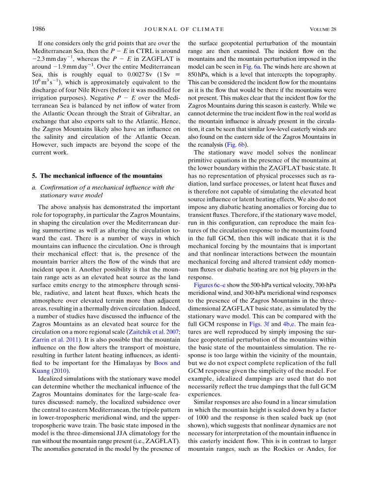
If one considers only the grid points that are over the
Mediterranean Sea, then the P 2 E in CTRL is around
22.3mmday21, whereas the P 2 E in ZAGFLAT is
around 21.9mmday21. Over the entire Mediterranean
Sea, this is roughly equal to 0.0027Sv (1 Sv [106m3 s21), which is approximately equivalent to the
discharge of four Nile Rivers (before it was modified for
irrigation purposes). Negative P 2 E over the Medi-
terranean Sea is balanced by net inflow of water from
the Atlantic Ocean through the Strait of Gibraltar, an
exchange that also exports salt to the Atlantic. Hence,
the Zagros Mountains likely also have an influence on
the salinity and circulation of the Atlantic Ocean.
However, such impacts are beyond the scope of the
current work.
5. The mechanical influence of the mountains
a. Confirmation of a mechanical influence with thestationary wave model
The above analysis has demonstrated the important
role for topography, in particular the ZagrosMountains,
in shaping the circulation over the Mediterranean dur-
ing summertime as well as altering the circulation to-
ward the east. There is a number of ways in which
mountains can influence the circulation. One is through
their mechanical effect: that is, the presence of the
mountain barrier alters the flow of the winds that are
incident upon it. Another possibility is that the moun-
tain range acts as an elevated heat source as the land
surface emits energy to the atmosphere through sensi-
ble, radiative, and latent heat fluxes, which heats the
atmosphere over elevated terrain more than adjacent
areas, resulting in a thermally driven circulation. Indeed,
a number of studies have discussed the influence of the
Zagros Mountains as an elevated heat source for the
circulation on amore regional scale (Zaitchik et al. 2007;
Zarrin et al. 2011). It is also possible that the mountain
influence on the flow alters the transport of moisture,
resulting in further latent heating influences, as identi-
fied to be important for the Himalayas by Boos and
Kuang (2010).
Idealized simulations with the stationary wave model
can determine whether the mechanical influence of the
Zagros Mountains dominates for the large-scale fea-
tures discussed: namely, the localized subsidence over
the central to easternMediterranean, the tripole pattern
in lower-tropospheric meridional wind, and the upper-
tropospheric wave train. The basic state imposed in the
model is the three-dimensional JJA climatology for the
runwithout themountain range present (i.e., ZAGFLAT).
The anomalies generated in the model by the presence of
the surface geopotential perturbation of the mountain
range are then examined. The incident flow on the
mountains and the mountain perturbation imposed in the
model can be seen in Fig. 6a. The winds here are shown at
850hPa, which is a level that intercepts the topography.
This can be considered the incident flow for themountains
as it is the flow that would be there if the mountains were
not present. This makes clear that the incident flow for the
Zagros Mountains during this season is easterly. While we
cannot determine the true incident flow in the real world as
the mountain influence is already present in the circula-
tion, it can be seen that similar low-level easterly winds are
also found on the eastern side of the Zagros Mountains in
the reanalysis (Fig. 6b).
The stationary wave model solves the nonlinear
primitive equations in the presence of the mountains at
the lower boundary within the ZAGFLAT basic state. It
has no representation of physical processes such as ra-
diation, land surface processes, or latent heat fluxes and
is therefore not capable of simulating the elevated heat
source influence or latent heating effects.We also do not
impose any diabatic heating anomalies or forcing due to
transient fluxes. Therefore, if the stationary wavemodel,
run in this configuration, can reproduce the main fea-
tures of the circulation response to the mountains found
in the full GCM, then this will indicate that it is the
mechanical forcing by the mountains that is important
and that nonlinear interactions between the mountain
mechanical forcing and altered transient eddy momen-
tum fluxes or diabatic heating are not big players in the
response.
Figures 6c–e show the 500-hPa vertical velocity, 700-hPa
meridional wind, and 300-hPa meridional wind responses
to the presence of the Zagros Mountains in the three-
dimensional ZAGFLAT basic state, as simulated by the
stationary wave model. This can be compared with the
full GCM response in Figs. 3f and 4b,e. The main fea-
tures are well reproduced by simply imposing the sur-
face geopotential perturbation of the mountains within
the basic state of the mountainless simulation. The re-
sponse is too large within the vicinity of the mountain,
but we do not expect complete replication of the full
GCM response given the simplicity of the model. For
example, idealized dampings are used that do not
necessarily reflect the true dampings that the full GCM
experiences.
Similar responses are also found in a linear simulation
in which the mountain height is scaled down by a factor
of 1000 and the response is then scaled back up (not
shown), which suggests that nonlinear dynamics are not
necessary for interpretation of themountain influence in
this easterly incident flow. This is in contrast to larger
mountain ranges, such as the Rockies or Andes, for
1986 JOURNAL OF CL IMATE VOLUME 28

which RH01 found that nonlinear dynamics had to be
considered to understand their influence on the circu-
lation during the summer.
In summary, this stationary wave model experiment
demonstrates that it is the mechanical forcing of the flow
by the mountain range that is responsible for these large-
scale circulation features and, while the mountain in-
fluence on transient eddies or diabatic heatingmaymodify
the response slightly or may be important on a more re-
gional scale (Zaitchik et al. 2007; Tyrlis et al. 2013), these
effects are not key to the features of interest here.
b. Understanding the mechanical influence of themountains on the circulation
In light of the above stationary wavemodel results, we
now proceed to discuss the dynamics of the mountain
influence by considering how the presence of the
mountain in the mountainless basic state results in the
response. The influence of topography on the large-scale
flow is a topic that has received considerable attention,
dating back to Charney and Eliassen (1949). Much
of this attention has been focused on large-scale,
midlatitude mountain ranges in westerly flow, such as
the Rockies and the Himalayas (Dickinson 1978; Grose
and Hoskins 1979; Hoskins and Karoly 1981; Trenberth
andChen 1988; Cook andHeld 1992; Valdes andHoskins
1991; Ringler and Cook 1997), while Semazzi (1980) dis-
cussed the response to topography in the tropics and
RH01 discussed the flow over subtropical topography
that is influenced by both the midlatitude westerlies and
the lower-latitude easterly trade winds.
In general, the commonly studied case of westerly
flow over large-scale midlatitude topography tends to
produce an upstream anticyclonic circulation associated
with vortex compression on the upslope and a down-
stream cyclonic circulation associated with vortex
stretching on the downslope (e.g., Hoskins and Karoly
1981; Ringler and Cook 1997; Held et al. 2002), with the
exact location of the anomalies influenced by dissipation
(Hoskins and Karoly 1981). This is indeed the response
predicted when considering the simple case of shallow-
water westerly flow over a mountain range, as discussed
by Holton (2004) (see their Fig. 4.9). This is also similar
to the response we find here to easterly flow that
FIG. 6. (a) ZAGFLAT wind vectors at 850 hPa: that is, the low-level winds of the basic state used for the stationary wave model
experiments in section 5a. Shading denotes the topography perturbation imposed in the stationary wave model experiment. (b) The 850-hPa
wind vectors for ERA-Interim. The stationary wavemodel response in (c) 500-hPav, (d) 700-hPa y, and (e) 300-hPa y to the presence of the
ZagrosMountains in the ZAGFLAT basic state. These can be compared with Figs. 3f and 4b,e. Gray shading denotes regions that are below
the surface.
1 MARCH 2015 S IM P SON ET AL . 1987
produces an anticyclonic circulation upstream and a cy-
clonic circulation downstream of the mountain. How-
ever, the dynamics involved for easterly incident flow
has received much less attention and the shallow-water
arguments of Holton (2004) (their Fig. 4.10) suggest an
asymmetry between westerly and easterly flow induced
by the beta effect with easterly flow producing a high
centered over the mountain range. The response de-
scribed in Holton (2004) does not include the effects of
baroclinicity, which are key to the response to the Za-
gros Mountains, as discussed below. The basic state in-
cident flow, the size and shape of the mountain, and
whether linear or nonlinear or barotropic or baroclinic
theory is considered can lead to diversity in the circu-
lation response and so we proceed to discuss the details
for our particular mountain situation. As will be shown,
this involves consideration of a meridionally elongated
mountain range in a baroclinic atmosphere, where the
low-level incident flow on the mountains is easterly and
transitions to westerlies above. Again, this will be dis-
cussed from the perspective of the Zagros Mountain
influence, but a similar interpretation holds for the Atlas
Mountains, which also experience easterly incident flow
during the summer.
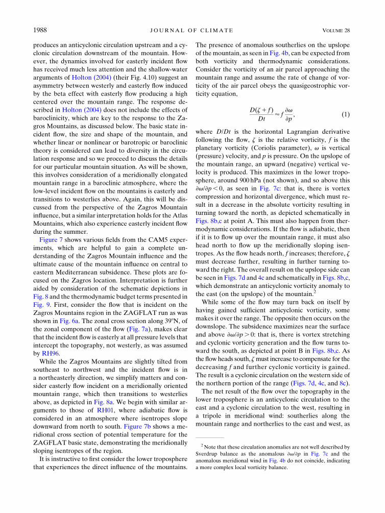
Figure 7 shows various fields from the CAM5 exper-
iments, which are helpful to gain a complete un-
derstanding of the Zagros Mountain influence and the
ultimate cause of the mountain influence on central to
eastern Mediterranean subsidence. These plots are fo-
cused on the Zagros location. Interpretation is further
aided by consideration of the schematic depictions in
Fig. 8 and the thermodynamic budget terms presented in
Fig. 9. First, consider the flow that is incident on the
Zagros Mountains region in the ZAGFLAT run as was
shown in Fig. 6a. The zonal cross section along 398N, of
the zonal component of the flow (Fig. 7a), makes clear
that the incident flow is easterly at all pressure levels that
intercept the topography, not westerly, as was assumed
by RH96.
While the Zagros Mountains are slightly tilted from
southeast to northwest and the incident flow is in
a northeasterly direction, we simplify matters and con-
sider easterly flow incident on a meridionally oriented
mountain range, which then transitions to westerlies
above, as depicted in Fig. 8a. We begin with similar ar-
guments to those of RH01, where adiabatic flow is
considered in an atmosphere where isentropes slope
downward from north to south. Figure 7b shows a me-
ridional cross section of potential temperature for the
ZAGFLAT basic state, demonstrating the meridionally
sloping isentropes of the region.
It is instructive to first consider the lower troposphere
that experiences the direct influence of the mountains.
The presence of anomalous southerlies on the upslope
of themountain, as seen in Fig. 4b, can be expected from
both vorticity and thermodynamic considerations.
Consider the vorticity of an air parcel approaching the
mountain range and assume the rate of change of vor-
ticity of the air parcel obeys the quasigeostrophic vor-
ticity equation,
D(z1 f )
Dt’ f
›v
›p, (1)
where D/Dt is the horizontal Lagrangian derivative
following the flow, z is the relative vorticity, f is the
planetary vorticity (Coriolis parameter), v is vertical
(pressure) velocity, and p is pressure. On the upslope of
the mountain range, an upward (negative) vertical ve-
locity is produced. This maximizes in the lower tropo-
sphere, around 900 hPa (not shown), and so above this
›v/›p, 0, as seen in Fig. 7c: that is, there is vortex
compression and horizontal divergence, which must re-
sult in a decrease in the absolute vorticity resulting in
turning toward the north, as depicted schematically in
Figs. 8b,c at point A. This must also happen from ther-
modynamic considerations. If the flow is adiabatic, then
if it is to flow up over the mountain range, it must also
head north to flow up the meridionally sloping isen-
tropes. As the flow heads north, f increases; therefore, z
must decrease further, resulting in further turning to-
ward the right. The overall result on the upslope side can
be seen in Figs. 7d and 4c and schematically in Figs. 8b,c,
which demonstrate an anticyclonic vorticity anomaly to
the east (on the upslope) of the mountain.2
While some of the flow may turn back on itself by
having gained sufficient anticyclonic vorticity, some
makes it over the range. The opposite then occurs on the
downslope. The subsidence maximizes near the surface
and above ›v/›p. 0: that is, there is vortex stretching
and cyclonic vorticity generation and the flow turns to-
ward the south, as depicted at point B in Figs. 8b,c. As
the flow heads south, zmust increase to compensate for the
decreasing f and further cyclonic vorticity is gained.
The result is a cyclonic circulation on the western side of
the northern portion of the range (Figs. 7d, 4c, and 8c).
The net result of the flow over the topography in the
lower troposphere is an anticyclonic circulation to the
east and a cyclonic circulation to the west, resulting in
a tripole in meridional wind: southerlies along the
mountain range and northerlies to the east and west, as
2 Note that these circulation anomalies are not well described by
Sverdrup balance as the anomalous ›v/›p in Fig. 7c and the
anomalous meridional wind in Fig. 4b do not coincide, indicating
a more complex local vorticity balance.
1988 JOURNAL OF CL IMATE VOLUME 28

seen in Fig. 4b. The thermodynamic balance of the
anomalous low-level (700hPa) circulation confirms that
the flow is approximately adiabatic with meridional
advection balancing adiabatic warming/cooling. In a
steady state and without changes in the diabatic heating
and transients, the thermodynamic balance of the
anomalies in the presence of the mountain is given by
052D
u
a cosf
›T
›l
����p
!2D
y
a
›T
›f
����p
!2D
"�p
po
�k
v›u
›p
#,
(2)
where D refers to the CTRL2ZAGFLAT difference in
climatologies; u, y, T, u, and v are the zonal wind, me-
ridional wind, temperature, potential temperature, and
pressure vertical velocity at pressure level p; po is a ref-
erence pressure (1000 hPa); and l, f, and a are longi-
tude, latitude, and radius of Earth, respectively. The
three terms represent zonal advection, meridional ad-
vection, and vertical advection (or adiabatic warming/
cooling) of temperature, respectively. Figures 9a–c show
these three components at 700 hPa. They balance well
and the dominant balance is between themeridional and
FIG. 7. Various fields that aid in the interpretation of the Zagros Mountain response: (a) a zonal cross section of
zonal wind along 398N and (b) a meridional cross section of potential temperature along 458E for the basic state
(i.e., the ZAGFLAT simulation). Green lines show the CTRL surface pressure. CTRL 2 ZAGFLAT anomalies
(i.e., the Zagros Mountain influence) with green points indicating grid points where the surface is above 1.2 km,
(c) ›v/›p at 700 hPa (contour interval 5 6 3 1027 s21), (d) relative vorticity at 700 hPa (contour interval 5 4 31026 s21), and (e) the anomalous pressure of the 330-K isentrope in hectopascals. (f) A zonal cross section of CTRL2ZAGFLAT geopotential height anomalies along 398N. Gray shading denotes regions where the pressure level is
below the surface. Note that the Zagros Mountains in (a),(b) are located where gray shading is absent under the
green contour.
1 MARCH 2015 S IM P SON ET AL . 1989

vertical advection terms. The linearized version of (2)
(not shown) indicates that the dominant balance at low
levels is
0’2y0
a
›T
›f2
�p
po
�kv0›u›p
, (3)
where (�)0 represents the CTRL 2 ZAGFLAT anoma-
lies and (�) represents the ZAGFLAT basic state. This
confirms that, for the most part, the anomalous flow in
the lower troposphere is gliding adiabatically along the
meridionally sloping isentropes with equatorward flow
and cold advection balanced by adiabatic subsidence
and warming. The anomalous subsidence over the
central to eastern Mediterranean in the lower tropo-
sphere is, therefore, a consequence of the anomalous
meridional flow that is set up by the Zagros Mountains.
In the upper troposphere, Figs. 9d–f reveal a more
complicated thermodynamic balance. The anomalous
poleward meridional wind along the Zagros range is
present in the upper troposphere as well but is more
localized to the northern most edge of the range
(Fig. 4e). The meridional warm advection associated
with this flow is balanced, to some extent, by vertical
advection. However, this balance is incomplete, and the
zonal advection term is now playing an important role
(Fig. 9d). A warm anomaly develops to the northwest of
the mountains (not shown) with resultant anomalies in
the zonal advection term as the midlatitude westerlies
interact with it, and the dominant balance of terms
here is
0’2u
a cosf
›T 0
›l2
y0
a
›T
›f2
�p
po
�k
v0›u›p
. (4)
The upper-tropospheric subsidence over the Mediter-
ranean is related to the interaction of the climatological
midlatitude westerly flow with the mountain-induced
temperature anomaly. The warm thermal anomaly re-
sults in an increased sloping of the isentropes as can be
seen in Fig. 7e, which shows the Zagros Mountains in-
fluence on the pressure of the 330-K isentrope. Clima-
tologically, this isentrope slopes meridionally down
toward thewarmAsianmonsoon region. In the presence
of the mountains, the pressure level of this isentrope is
lowered over the central to eastern Mediterranean and,
as a result, the isentropic slope to the north of this has
been steepened. Therefore, the midlatitude westerlies
will experience enhanced subsidence as they flow along
these steeper isentropes. This is the same as the argu-
ments of RH96 for widespread monsoon-induced Medi-
terranean and Saharan subsidence, but here an additional
thermal anomaly is generated in the presence of the
mountains, which steepens the isentropes over the region
further. So, while the Zagros Mountains result in a some-
what vertically coherent enhanced subsidence over the
central to eastern Mediterranean, the subsidence anom-
alies in the upper and lower troposphere are produced for
slightly different reasons with the balance of terms grad-
ually transitioning between the regime found in the lower
troposphere to that found in the upper troposphere.
Figure 7f shows a longitude–pressure cross section of
the geopotential height anomalies induced by the Zagros
Mountains along 398N. The negative and positive anom-
alies on either side of themountains exhibit awestward tilt
with height indicating vertical Rossby wave propagation.
While the incident flow on the mountains is easterly, this
FIG. 8. Schematic depiction of the influence of the Zagros
Mountains on the circulation. (a) The basic state zonal flow in-
cident on themountains from above and from the south. (b)A view
from the south of the mountain influence. Black arrows show the
flow; blue and red shading show upward and downward vertical
velocity, respectively; and blue and red arrows show anticyclonic
and cyclonic vorticity, respectively. Circle and crosshairs indicates
southerly flow along the axis of the range. (c) A view from above
of the mountain influence. Blue is on the upslope, and red is on
the downslope. See text for the meaning of points A–C.
1990 JOURNAL OF CL IMATE VOLUME 28

transitions to westerlies within the lower troposphere
(Fig. 7a), which provides favorable conditions for the
vertical propagation of the wave activity induced at low
levels into the upper troposphere, resulting in the upper-
tropospheric Rossby wave structures that are then ad-
vected toward the east along the Asian jet.
6. The topography influence in other seasons
The focus so far has been on the summer (JJA)
months as this is the season when subsidence over the
Mediterranean is strong, because of the Asian monsoon
influence (RH96). This is also the season when the
mountains have the greatest effect on Mediterranean
subsidence, as can be seen in Fig. 10. In the winter
[December–February (DJF)], the 500-hPa subsidence
over the region is fairly longitudinally symmetric and
shifted south compared to JJA (not shown). It is no
longer strong over the Mediterranean and primarily
represents the subsiding branch of the Hadley cell. The
low-level winds that are incident on the Zagros Moun-
tains in this season are westerly (Fig. 10a).
Figure 10b shows the 500-hPav response to the presence
of the Zagros Mountains in DJF: that is, the CTRL 2ZAGFLAT anomalies. The Zagros Mountains have very
little influence on subsidence over the Mediterranean in
this season and also do not produce the large-amplitude
upper-level wave train that extends to the east (not shown).
Instead, the influence of the Zagros Mountains is largely
restricted to the local region in which the topography is
flattened. While noisy, there is an indication of enhanced
southerly ascending flow on the western slopes and sub-
siding northerly flow on the eastern slopes (see Fig. 10b for
v). This is what would be expected from adiabatic flow
from the west going up and over the mountains in the
presence of the meridional temperature gradient.
The seasonal cycle of daily mean vertical velocity at
500hPa averaged over the central to eastern Mediterra-
nean, where in JJA the Zagros Mountains have the
greatest influence on subsidence, is shown in Fig. 10c for
CTRL and ZAGFLAT. This demonstrates that the Za-
gros Mountains only have a significant influence on
Mediterranean subsidence during the summer months,
from June until the end of September. Furthermore,
Fig. 10d shows the low-level (850hPa) zonal wind over
the location of the Zagros Mountains for the ZAGFLAT
simulation: that is, the winds that would be incident on
the mountains if the mountains were not there. Com-
parison of this with Fig. 10c indicates that the Zagros
Mountains only have a substantial influence on Medi-
terranean subsidence when the low-level winds incident
on them are from the east (i.e., the summer). A perfect
correspondence between the enhanced v and the mag-
nitude of the easterlies is not necessarily expected be-
cause the v anomalies also involve interaction between
the mountain-induced circulation and the midlatitude
westerlies, which have a seasonal variation themselves.
However, it is clear that it is onlywhen the incident flow is
easterly that enhanced Mediterranean subsidence is
produced. The winter westerlies, which are of a similar
magnitude, do not result in a visible influence on Medi-
terranean subsidence via topographic interaction.
FIG. 9. CTRL2 ZAGFLAT difference for the three thermodynamic budget terms in (2) at (a)–(c) 700 and (d)–(f) 300 hPa. Green points
indicate Zagros grid points that are above 1.2 km, and gray shading denotes regions that are below the surface.
1 MARCH 2015 S IM P SON ET AL . 1991

7. The role of condensational heating in generatingthe summertime incident easterly flow on theZagros Mountains
The above analysis suggests that the presence of
easterly incident flow during the summer is key to pro-
ducing the Zagros Mountain influence on the Mediter-
ranean. This then raises the question, what is responsible
for the easterly incident flow on the Zagros Mountains
during the summer? In Fig. 11, additional experiments
with the stationary wavemodel are shown to address this
question. Rather than imposing the Zagros Mountains
in the 3D ZAGFLAT basic state, as done in section 5a,
the stationary wavemodel is used to build up the 3D flow
from scratch. The first experiment uses the ZAGFLAT
zonal mean basic state and the ZAGFLAT diabatic
heating; ZAGFLAT topography; and ZAGFLAT tran-
sient vorticity, divergence, and heat fluxes are imposed.
The 850-hPa wind vectors of the resulting flow are
shown in Fig. 11a. This can be compared with the actual
ZAGFLAT low-level winds in Fig. 6a. Thewinds are not
perfectly reproduced, because of the idealized nature of
the experiments but the low-level easterly flow that is
incident on the Zagros Mountains is reproduced rather
well, albeit a little too strong. A second experiment is
then performed imposing ZAGFLAT diabatic heating,
CTRL topography, and ZAGFLAT transient fluxes:
that is, the only difference between the second and first
experiments is the presence of the Zagros Mountains.
The difference between these experiments reproduces
the Zagros Mountain influence rather well, as can be
seen by comparison of the 700-hPa meridional wind
anomalies in Fig. 11b with those in Fig. 6d. Since
building the stationary wave model circulation from
scratch in this manner reproduces the summertime in-
cident easterlies and the Zagros response, it can be used
to identify what is responsible for these.
Two additional experiments are performed, equiva-
lent to the previous ones except that the condensa-
tional heating (QCOND) over Asia, the Indian Ocean,
and the western Pacific (608–1508E, 08–608N) is
removed.3 Figures 11c,d show the influence of the
FIG. 10. (a) DJF averaged 850-hPa wind vectors with the red box denoting the region used for averaging 500-hPa
v in (c) and the black box denoting the region for averaging 850-hPa u in (d). (b) The Zagros influence (CTRL2ZAGFLAT) on 500-hPa v during DJF. (c) The seasonal evolution of daily 500-hPa v averaged over the red box in
(a). (d) The seasonal evolution of 850-hPa u averaged over the black box in (a).
3 Condensational heating was not removed in the lowest two
sigma levels because the CAM5 diabatic heating output consists of
large negative condensational heating values at the surface that
largely balance a warming tendency because of vertical diffusion.
1992 JOURNAL OF CL IMATE VOLUME 28

Asian QCOND on the flow (i.e., the difference between
the experiments with the full heating and those with the
Asian QCOND omitted). Figure 11c shows that the
Asian QCOND is largely responsible for the easterlies
that are incident on the Zagros Mountains, which is in
agreement with similar idealized experiments per-
formed by Liu et al. (2007). The incident easterlies are
part of the low-level cyclonic circulation set up by the
heating over Asia. Figure 11d demonstrates that much
of the Zagros Mountain–induced tripole in 700-hPa y is
only produced when the Asian QCOND heating is
present.
Additional experiments performed with the Asian
topography removed (not shown) further indicate that
the influence ofQCOND on the low-level flow is modified
by the presence of the Asian topography. With the
Asian topography removed, the low-level cyclone is
confined toward the south and no longer results in in-
cident easterlies for the Zagros Mountains.
8. Discussion
The earlier idealized modeling experiments of RH96
noted a role for the Atlas Mountains in localizing
Mediterranean subsidence during the summer but found
that the Middle East mountains only had an effect to
their east, with very little impact on the Mediterranean.
In contrast, the results presented here, using a full GCM,
demonstrate an important influence of Middle East to-
pography (primarily the Zagros mountain range) on the
subsidence over the Mediterranean during the summer,
with a relatively minor contribution from the Atlas
Mountains.
Here, the mountain influence was demonstrated using
a comprehensive GCM but the Zagros Mountains in-
fluence was also reproduced in a stationary wave model
using a similar methodology to RH96 (see section 7),
and it is not clear why our stationary wave model results
should differ. A similar influence of the mountains was
FIG. 11. The result of stationary wave model experiments described in section 7: (left) 850-hPa wind vectors in
simulations with the ZAGFLAT topography and (right) 700-hPa meridional wind difference between simulations
with CTRL topography and simulations with ZAGFLAT topography (i.e., the Zagros Mountain influence). All
simulations are run with the prescribed zonal mean basic state of the ZAGFLAT simulation and ZAGFLAT
transient vorticity fluxes. (top) The full ZAGFLAT diabatic heating is imposed. (bottom) The difference between
(top) and equivalent experiments in which the condensational component of the heatingQCOND was removed from
608 to 1508E and 08 from 608N. The shading in (left) is the CTRL 2 ZAGFLAT topography, and gray shading
denotes regions below the surface.
1 MARCH 2015 S IM P SON ET AL . 1993

also produced in our stationary wave model when the
imposed diabatic heating was calculated as a residual
from ERA-Interim. The RH96 discussion assumed that
the incident flow on the mountain ranges was westerly,
although this was not explicitly shown and so it is unclear
whether this was indeed the case. The flow in their
simulation with the mountains present does, however,
exhibit easterlies at the Zagros location (RH96, their
Fig. 3a), and RH01 (their Fig. 9) and Liu et al. (2007)
(their Fig. 2f) demonstrated, with the same model, that
Asian monsoon heating also produces low-level easter-
lies over the Zagros location in that model too. We can
only speculate that the results differ because of differ-
ences in the stationary wave model setup or differences
in the input forcings. RH96’s heating and basic state
were obtained from a much shorter period, and it is
possible that this produced different incident flows, re-
sulting in a difference in the relative importance of the
Atlas Mountains as compared to the Zagros Mountains.
Indeed, the CAM5 results indicate that both mountain
ranges are capable of inducing subsidence in the central
to eastern Mediterranean during the summer when they
both experience easterly incident flow. In fact, by
chance, the two mountain ranges are separated in lon-
gitude by just the right amount that they both conspire
to intensify subsidence and low-level northerly winds in
a similar location. It is conceivable that under a different
basic state the Atlas Mountains could dominate.
The results presented here are only for one compre-
hensive GCM, but it is one that reproduces the main
features of the Mediterranean circulation, as well as the
upper-level wave train that extends to the east of the
Zagros Mountains. One aspect of the model fidelity that
could be of concern is the fact that the low-level flow
overMesopotamia/Saudi Arabia is poorly simulated (cf.
Figs. 2g,h). This aspect of the circulation is much im-
proved in CAM5 at 0.98 3 1.258 resolution, and pre-
liminary investigation at that resolution indicates that
the same conclusions as to the Middle East topography
influence on the large-scale circulation can be drawn
(not shown). This discrepancy in the flow therefore
likely does not represent a discrepancy in the incident
flow for the mountains but rather a discrepancy in the
responding flow in the lee of the mountains on this more
regional scale where the topography is poorly resolved.
Given this and the fidelity of the lower-resolution model
circulation both over the Mediterranean and toward the
east over Eurasia, we expect that the results are relevant
for the real atmosphere.
It has been demonstrated that the mountains exert
their influence primarily through their mechanical effect
on the mean flow and a discussion of the mechanism by
which this effect is realized has been provided. In
particular, we have clarified that, contrary to what is
often assumed when discussing the topographic in-
fluence of the region (e.g., RH96; Tyrlis et al. 2013), the
relevant low-level incident mean flow to consider in
summer is actually easterly. It is important to consider
the incident flow as being the flow without the mountain
influence already in it, which obviously cannot be as-
sessed completely in the real world. The presence of
easterly incident flow appears to be key for producing
the mountain influence and, for the case of the Zagros
Mountains, this is set up during the summertime by the
presence of enhanced condensational heating over Asia
with additional modification by the Asian topography.
The result is easterly winds that skirt the northern flank
of the Tibetan plateau (Fig. 11c) before hitting the Za-
gros Mountains.
It is worth contrasting the influence of these smaller
subtropical mountain ranges with the larger mountain
ranges that exist in the midlatitudes, such as the Rockies
and the Andes. RH01 suggest that the influence of these
larger mountain ranges is greater during the winter,
when stronger westerly winds are incident on them.
They also found that nonlinear dynamics need to be
considered (i.e., the blocking of the flow by the moun-
tains) to explain their influence. In contrast, for the
Zagros Mountains, their influence is greatest during the
summer when the low-level incident flow is easterly, and
nonlinear dynamics is not necessary to explain their ef-
fect during the summer. It is also worth noting that,
while RH01 (their Fig. 10c) suggest that during the
winter topography also results in a bull’s-eye of sub-
sidence over the eastern Mediterranean, their topogra-
phy influence was inferred by placing the topography in
the zonal mean basic state. To infer the true influence of
topography, it is necessary to place the topography in
the incident flows that are set up by the diabatic
heating and transient vorticity fluxes, and in this case,
as shown here with the comprehensive GCM, the Za-
gros Mountains have very little influence on Mediter-
ranean subsidence during the winter and only results in
small vertical velocity anomalies in the vicinity of the
mountains.
When easterly mean flow impinges on the Zagros
Mountains, a low-level anticyclone is produced on the
upslope and a low-level cyclone is produced on the
downslope, resulting in a tripole pattern in low-level
meridional wind and vertical velocity, centered on the
longitude of the mountain range. The same is also true
for the Atlas Mountains, which also experience easterly
incident flow in summer, and Semazzi and Sun (1997)
already recognized such a pattern for this range. The
perturbations induced by the mountains in these low-
level easterlies appear to be substantial enough to
1994 JOURNAL OF CL IMATE VOLUME 28

produce a vertically propagating Rossby wave structure
and an associated wave train that extends toward the
east. For the case of the Zagros Mountains, in the upper
troposphere, the interaction of the midlatitude west-
erlies, with the warm anomaly associated with the
mountain-induced circulation, contributes to the Medi-
terranean subsidence. This discussion adds to an already
extensive body of literature on the subject of the in-
fluence of mountain ranges on the mean flow.
The fact that the Zagros Mountains only appear to
exert a substantial influence on the large-scale mean
flow when the low-level incident flow is easterly is
somewhat surprising, and it is not obvious why there
should be this asymmetry. While the beta effect in-
troduces some asymmetry between westerly and east-
erly incident flow, it is likely that the most important
factor in breaking the symmetry for the Zagros Moun-
tains is the presence of the meridional temperature
gradient. For easterly incident winds, the upslope vortex
compression encourages the northward movement of
the flow, which is also required by thermodynamic
considerations if it is to go up and over the mountains
adiabatically. For westerly flow, vorticity arguments
would predict turning toward the south on the upslope
but thermodynamic arguments would require adiabatic
upward motion to flow north. It may be that, for easterly
flow, these two factors work together to produce a much
stronger response than for westerly flow where they are
conflicting. However, the details of this asymmetry and
the sensitivity to incident flows and mountain size and
shape are something that warrants further investigation
with idealized experiments.
9. Conclusions
As we head toward a warmer climate in which the
Mediterranean is predicted to undergo substantial
change, it is important that we have a complete un-
derstanding of the dynamical processes that govern the
climate of the region. This motivates better un-
derstanding of the topographic influence on the circu-
lation and climate of the Mediterranean. These
comprehensive GCM experiments demonstrate that
both the topography of the Middle East and North
Africa conspire to produce about 30% of the summer-
time subsidence over the central to eastern Mediterra-
nean in the current climate but it is the contribution
from the Middle East topography that dominates in this
topographic influence by far. This topography, primarily
the Zagros mountain range, influences the large-scale
circulation throughout the depth of the troposphere and
affects the upper-level circulation across the whole of
the Eurasian continent during the summer, when the
incident flow is easterly. In contrast, during the winter,
when the incident flow is westerly, these mountains have
very little impact on the large-scale circulation.
The use of a comprehensive GCM has allowed us to
make some statements as to the climatological impact of
the mountains on the Mediterranean. Semiarid condi-
tions are found in theMediterranean during the summer
with a moisture deficit associated with substantial
evaporation and very little precipitation. The model
results suggest that on average, around 20% of this
moisture deficit—and in some regions more—can be
attributed to the presence of the Zagros Mountains and
the circulation they induce. The effect of the Zagros
Mountains on the circulation is therefore an important
contributor to the climatological conditions of the
Mediterranean during the summer.
Finally, one question that the results raise is, given the
importance of thesemountains for the current climate of
the Mediterranean, do they contribute substantially to
future predicted changes in Mediterranean circulation
under increasing anthropogenic greenhouse gas emis-
sions? TheMediterranean is often identified as a climate
change ‘‘hotspot,’’ referring to the fact that it is pre-
dicted to undergo larger hydroclimate and circulation
changes in the future than many other regions of the
globe (Giorgi 2006; Giorgi and Lionello 2008; Seager
et al. 2014; Simpson et al. 2014). It is possible that
interaction between the altered mean flow and the
mountains plays a role in future circulation changes in
the region and this is a subject that is under current
investigation.
Acknowledgments. IRS is grateful to Dr. Gus Correa
for advice in the setup of the CAM5 simulations and to
Dr. Naomi Henderson for advice in the setup of the
stationary wavemodel. IRSwas supported by a Lamont-
Doherty Earth Observatory Postdoctoral Fellowship
and NSF Award AGS-1317469. RS and MT were sup-
ported by NOAA Award NA10OAR4310137 (‘‘Global
decadal hydroclimate variability and change’’) and
DOE Award DE-SC0005107. TAS is supported by NSF
Award AGS-1255208 and the David and Lucile Packard
Foundation.Wewould also like to thank two anonymous
reviewers for helpful comments on this manuscript.
REFERENCES
Alpert, P., B. U. Neeman, and Y. Shay-El, 1990: Climatological
analysis of Mediterranean cyclones using ECMWF data. Tel-
lus, 42A, 65–77, doi:10.1034/j.1600-0870.1990.00007.x.
Black, E., D. Brayshaw, J. Slingo, and B. J. Hoskins, 2011: Future
climate of the Middle East. Water, Life and Civilisation: Cli-
mate, Environment and Society in the Jordan Valley, S. Mithen
and E. Black, Eds., Cambridge University Press, 51–62.
1 MARCH 2015 S IM P SON ET AL . 1995

Boos, W. R., and Z. Kuang, 2010: Dominant control of the South
Asian monsoon by orographic insulation versus plateau
heating. Nature, 463, 218–222, doi:10.1038/nature08707.
Charney, J. G., and A. Eliassen, 1949: A numerical method for
predicting the perturbations of the middle latitude westerlies.
Tellus, 1, 38–54, doi:10.1111/j.2153-3490.1949.tb01258.x.
Cook, K. H., and I. M. Held, 1992: The stationary response to
large-scale orography in a general circulation model and
a linear model. J. Atmos. Sci., 49, 525–539, doi:10.1175/
1520-0469(1992)049,0525:TSRTLS.2.0.CO;2.
Dee, D. P., and Coauthors, 2011: The ERA-Interim reanalysis:
Configuration and performance of the data assimilation sys-
tem. Quart. J. Roy. Meteor. Soc., 137, 553–597, doi:10.1002/
qj.828.
Dickinson, R. E., 1978: On planetary waves. The General Circu-
lation: Theory, Modeling and Observations: Notes from
a Colloquium, Summer 1978, M. L. Blackmon and R. Gall,
Eds., National Center for Atmospheric Research, 59–82.
Evans, J. P., 2009: 21st century climate change in the Middle East.
Climatic Change, 92, 417–432, doi:10.1007/s10584-008-9438-5.
Fernández, J., J. Sáenz, and E. Zorita, 2003: Analysis of wintertime
atmospheric moisture transport and its variability over
southern Europe in the NCEP reanalysis. Climate Res., 23,195–215, doi:10.3354/cr023195.
Gill, A. E., 1980: Some simple solutions for heat-induced tropical
circulation.Quart. J. Roy.Meteor. Soc., 106, 447–462, doi:10.1002/qj.49710644905.
Giorgi, F., 2006: Climate change hot-spots.Geophys. Res. Lett., 22,
L08707, doi:10.1029/2006GL025734.
——, and P. Lionello, 2008: Climate change projections for the
Mediterranean region. Global Planet. Change, 63, 90–104,
doi:10.1016/j.gloplacha.2007.09.005.
Grose,W. L., andB. J. Hoskins, 1979: On the influence of orography
on large scale atmospheric flow. J. Atmos. Sci., 36, 223–234,doi:10.1175/1520-0469(1979)036,0223:OTIOOO.2.0.CO;2.
Held, I. M., M. Ting, andH.Wang, 2002: Northern winter stationary
waves: Theory and modeling. J. Climate, 15, 2125–2144,
doi:10.1175/1520-0442(2002)015,2125:NWSWTA.2.0.CO;2.
Hoerling, M., J. Eischeid, J. Perlwitz, X. Quan, T. Zhang, and
P. Pegion, 2012: On the increased frequency of Mediterranean
drought. J. Climate, 25, 2146–2161, doi:10.1175/JCLI-D-11-00296.1.
Holton, J. R., 2004: An Introduction to Dynamic Meteorology. 4th
ed. Academic Press, 535 pp.
Hoskins, B. J., and D. J. Karoly, 1981: The steady linear response of
a spherical atmosphere to thermal and orographic forcing. J. At-
mos. Sci., 38, 1179–1196, doi:10.1175/1520-0469(1981)038,1179:
TSLROA.2.0.CO;2.
Hurrell, J. W., 1995: Decadal trends in the North Atlantic Oscil-
lation: Regional temperatures and precipitation. Science, 269,676–679, doi:10.1126/science.269.5224.676.
——, and Coauthors, 2013: The Community Earth System Model:
A framework for collaborative research. Bull. Amer. Meteor.
Soc., 94, 1339–1360, doi:10.1175/BAMS-D-12-00121.1.
Lionello, P., and Coauthors, 2006: The Mediterranean climate: An
overview of the main characteristics and issues.Mediterranean
Climate Variability, P. Lionello, P. Malanotte-Rizzoli, and
R. Boscolo, Eds., Elsevier, 1–26.
Liu, Y., B. Hoskins, and M. Blackburn, 2007: Impact of Tibetan
orography and heating on the summer flow over Asia. J. Me-
teor. Soc. Japan, 85B, 1–19, doi:10.2151/jmsj.85B.1.
Mariotti, A., M. V. Struglia, N. Zeng, and K.-M. Lau, 2002: The
hydrological cycle in the Mediterranean region and implica-
tions for the water budget of the Mediterranean Sea.
J. Climate, 15, 1674–1690, doi:10.1175/1520-0442(2002)015,1674:
THCITM.2.0.CO;2.
Quadrelli, R., V. Pavan, and F. Molteni, 2001: Wintertime vari-
ability of Mediterranean precipitation and its links with
large scale circulation anomalies. Climate Dyn., 17, 457–466,
doi:10.1007/s003820000121.
Ringler, T.D., andK.H.Cook, 1997: Factors controlling nonlinear in
mechanically forced stationary waves over orography. J. Atmos.
Sci., 54, 2612–2629, doi:10.1175/1520-0469(1997)054,2612:
FCNIMF.2.0.CO;2.
Rodwell, M. J., and B. J. Hoskins, 1996: Monsoons and the dy-
namics of deserts.Quart. J. Roy. Meteor. Soc., 122, 1385–1404,doi:10.1002/qj.49712253408.
——, and——, 2001: Subtropical anticyclones and summermonsoons.
J. Climate, 14, 3192–3211, doi:10.1175/1520-0442(2001)014,3192:
SAASM.2.0.CO;2.
Seager, R., H. Liu, N. Henderson, I. R. Simpson, C. Kelley, T. A.
Shaw, Y. Kushnir, and M. Ting, 2014: Causes of increasing
aridification of the Mediterranean region in response to rising
greenhouse gases. J. Climate, 27, 4655–4676, doi:10.1175/
JCLI-D-13-00446.1.
Semazzi, F. H. M., 1980: Stationary barotropic flow induced by
a mountain over a tropical belt.Mon.Wea. Rev., 108, 922–930,doi:10.1175/1520-0493(1980)108,0922:SBFIBA.2.0.CO;2.
——, and L. Sun, 1997: The role of orography in determining the
Sahelian climate. Int. J. Climatol., 17, 581–596, doi:10.1002/
(SICI)1097-0088(199705)17:6,581::AID-JOC134.3.0.CO;2-E.
Simpson, I. R., T. A. Shaw, and R. Seager, 2014: A diagnosis of the
seasonally and zonally varying midlatitude circulation response
to global warming. J. Atmos. Sci., 71, 2489–2515, doi:10.1175/JAS-D-13-0325.1.
Ting, M., and L. Yu, 1998: Steady response to tropical heating
in wave linear and nonlinear baroclinic models. J. Atmos.
Sci., 55, 3565–3582, doi:10.1175/1520-0469(1998)055,3565:
SRTTHI.2.0.CO;2.
Trenberth, K. E., and S.-C. Chen, 1988: Planetary waves
kinematically forced by Himalayan orography. J. Atmos.
Sci., 45, 2934–2948, doi:10.1175/1520-0469(1988)045,2934:
PWKFBH.2.0.CO;2.
Trigo, I. F., T. D. Davies, and G. R. Bigg, 1999: Objective
climatology of cyclones in the Mediterranean region. J. Cli-
mate, 12, 1685–1696, doi:10.1175/1520-0442(1999)012,1685:
OCOCIT.2.0.CO;2.
Tyrlis, E., J. Lelieveld, and B. Steil, 2013: The summer circulation
over the eastern Mediterranean and the Middle East: In-
fluence of the South Asian monsoon. Climate Dyn., 40, 1103–
1123, doi:10.1007/s00382-012-1528-4.
Valdes, P. J., andB. J.Hoskins, 1991:Nonlinear orographically forced
planetary waves. J. Atmos. Sci., 48, 2089–2106, doi:10.1175/1520-0469(1991)048,2089:NOFPW.2.0.CO;2.
Zaitchik, B. F., J. P. Evans, and R. B. Smith, 2007: Regional impact
of an elevated heat source: The Zagros Plateau of Iran.
J. Climate, 20, 4133–4146, doi:10.1175/JCLI4248.1.
Zappa, G., L. C. Shaffrey, K. I. Hodges, P. G. Sansom, and D. B.
Stephenson, 2013: A multimodel assessment of future pro-
jections of North Atlantic and European extratropical cy-
clones in theCMIP5 climatemodels. J. Climate, 26, 5846–5862,
doi:10.1175/JCLI-D-12-00573.1.
Zarrin, A., H. Ghaemi, M. Azadi, A. Mofidi, and E. Mirzaei,
2011: The effect of the Zagros Mountains on the forma-
tion and maintenance of the Iran anticyclone using
RegCM4. Meteor. Atmos. Phys., 112, 91–100, doi:10.1007/
s00703-011-0134-z.
1996 JOURNAL OF CL IMATE VOLUME 28