Embed Size (px)
Citation preview

Medieval Environmental Impacts and
Feedbacks: The Lowland Floodplains
of England and Wales
John Lewin*
Institute of Geography and Earth Sciences, Aberystwyth University,
SY23 3DB, U.K.
Because of their varying channel styles (braided, meandering, and anastomosing) medieval low-land floodplains in England and Wales provided varying opportunities for defense, settlement,river crossing, and resource exploitation. In turn, these activities altered the character of chan-nels and floodplains, with medieval and later development obscuring the former variety offloodplains themselves. The changing nature of river floodplains is reviewed using archaeo-logical, documentary, and geomorphological evidence. Anastomosing channels and floodplain wet-lands have now all but disappeared but were formerly of considerable significance; also discussedare interactions involving flooding, fording, bridging, modifications to channels and their dimen-sions, and those arising from accelerated soil erosion—most of which peaked in the medievalperiod when floodplains were significantly transformed. Deliberately or inadvertently, dynamicfloodplain landforms were interactively involved with human development during a critical timeperiod in a totality of ways not previously fully identified. © 2010 Wiley Periodicals, Inc.
INTRODUCTION
The lowland landscapes of England and Wales were a focus for change in themedieval period. At the time the population probably trebled and towns were grow-ing apace; improving transport and a range of technological innovations supporteda growing commercial and agrarian economy. Landscapes designed for impressiveappearances, including parks and building surrounds (so-called “elite landscapes”),were also becoming more common. The physical environment of rivers and valleysin which these changes were set has often been viewed as a relatively passive back-drop to human enterprise, appearing then much as now, but without the intentionalconstructions and manipulations involved in such activities as extending crop culti-vation, wetland reclamation, river bridging, channel engineering for milling and trans-port, and urban growth. But, then as now, geomorphological processes were bothactive and variable, and they operated in parallel with development. The passage of
Geoarchaeology: An International Journal, Vol. 25, No. 3, 267–311 (2010)© 2010 Wiley Periodicals, Inc.Published online in Wiley Interscience (www.interscience.wiley.com). DOI:10.1002/gea.20308
*Corresponding author; E-mail: [email protected].
Geoarchaeology Review Paper

time and later rural and urban change may have obscured the evidence, but at the timefluvial transformations must have affected decision making, with quasi-naturalprocesses also being affected by what was happening.
Today there is much more urgent concern with human–environment linkages andthe impacts which current economic development may involve—whether in theform of industrial pollution, through responses to rising water demand and waste dis-posal needs, or following the impact of energy use on climatic change. Decisionmaking and action take place in what is also known to be an environment undertransformation, whether or not the causal linkages and consequences involved arefully understood. Although the nature and degree of environmental interaction maybe dissimilar, and at the time knowledge about the matter was very much less assured,two-way interactions between human enterprise and environmental change are alsolikely to be true of long-past periods of development.
In this context, this paper focuses on the medieval floodplains of lowland Englandand Wales (Figure 1). Larger river floodplains are found below 200 m both marginal tothe uplands of Wales, the Pennines, and in the southwest, and in the gentler topogra-phy of the southeast. Table I ranks the ten largest rivers; none of them actually is largeby European standards, let alone in global terms, but their channels and floodplainsand those of smaller rivers were highly significant for medieval activities. Major coastalwetlands like the Fenlands, Somerset Levels, or Humber Wetlands were also signifi-cant, but are not here reconsidered in detail (for recent surveys, see Van de Noort,2004; Blair, 2007). The timespan discussed (ca. A.D. 800–1500) relates to available evi-dence for, or pertinent to, the period from Saxon times up until the Tudor period.
As crucial human resources, medieval rivers and floodplains became inadver-tently self-modified as intentional developments proceeded. Catchment, river, andfloodplain were parts of variable, dynamic, linked, and interactive systems whichwere simultaneously adjusting, in different ways and to different degrees, to theeffects of human actions. The assumption that, shaved of their built environmentelements, floodplains and river channels at the time had much their present form hasto be questioned. The paper also examines whether their systematic variety at thetime (now much concealed and overlain) played an important role in medieval devel-opment, and whether unintended environmental impacts had significant feedbackeffects on intentional development activities themselves. The approach is virtuallythe reverse of that usually central to medieval archaeology and history, that of need-ing to interpret the past as people at the time would have seen it. Instead, a richbody of archaeological, historical, and geomorphological research is synthesized tosupport a modern geoscience perspective on evolving floodplains in the medievalperiod, something that would at best have been differently and only tangentiallyappreciated at the time.
FLOODPLAIN AND RIVER CHANNEL STYLES
Rivers and their floodplains have been characterized in terms of a number of pro-totypes which relate to their discharge regimes, their available energy, and their bedmaterial and finer sediment loads (Schumm, 1977; Brice, 1984; Ferguson, 1987;
LEWIN
GEOARCHAEOLOGY: AN INTERNATIONAL JOURNAL, VOL. 25, NO. 3268

Knighton & Nanson, 1993; Miall, 1996; Nanson & Croke, 1992; Nanson & Knighton,1996). Qualitatively, the now rather large number of recognized floodplain styles maybe allocated to 16 fluvial models (Miall, 1996) or 15 orders and suborders (Nanson &Croke, 1992), with six styles of anabranching river alone (Nanson & Knighton, 1996).With increasing knowledge, the number of prototypes has proliferated, as have the
GEOARCHAEOLOGY: AN INTERNATIONAL JOURNAL, VOL. 25, NO. 3
MEDIEVAL ENVIRONMENTAL IMPACTS AND FEEDBACKS
269
Figure 1. Major lowland rivers with floodplains in England and Wales. Additional places cited in thetext: 1: Abingdon; 2: Bewdley; 3: Boroughbridge; 4: Burton-on-Trent; 5: Huntingdon; 6: Maidenhead; 7:Ruddlan; 8: Staines. Additional rivers: A: Arrow; Co: Colne; De: Derwent; Do: Dove; Fr: Frome; K: Kennet;L: Lea; Lu: Lugg; So: Soar; St: Stour; Te: Teme; V: Vyrnwy; We: Weaver; Wy: Wylye.

factors believed to make a difference in determining the styles observed. Now includedare the presence of riparian trees and aquatic vegetation, river bank composition andstability, and the activity rates for the separable river processes which underlie thedevelopment of what are composite prototype assemblages. These involve the vari-able degrees and types of lateral channel mobility through bank erosion and deposi-tion, vertical river incision or sediment accretion, channel bar formation, cutoffs andavulsions, levee development, overbank sedimentation, and organic wetland changes.
The provision of simple quantitative causative criteria for forecasting and dis-criminating between the domains of the main observed channel patterns has beenfrequently attempted, though not with the greatest of reliability (Ferguson, 1987;Lewin & Brewer, 2001; Latrubesse, 2008). Further complexity is provided by the factthat channels and their floodplains are historically contingent: Channel patterns canchange within an inherited floodplain form, as in the case of parts of the VistulaRiver system in Poland, at first braided and then incised in the 18th to the 20th cen-turies, but all set within a dominantly meandering Holocene alluvial system (Starkel,1982). In England and Wales, evidence suggests that soil erosion has flooded sys-tems with fine sediment, creating tabular floodplains on top of a former, more var-ied topography of channel bars, levees, cutoffs, and wetlands (Brown, 1983; Robinson &Lambrick, 1984; Parker et al., 2008; Jones, Macklin, & Lewin, in press).
In this kind of context, medieval people would, of course, have been concernedwith practicalities—possibilities for defense, the depth of river crossings and theease of passage across floodplains, bridge building and the maintenance of structuresonce installed, mill siting, and the quality of floodplain agricultural land. Addressingthese past practicalities directly, even with the benefits of science and hindsight, isnot entirely straightforward, although there is some guidance to be had from consid-eration of the variable alluvial styles that were present at the time, together with thefactors that were affecting them.
Table II presents a simplified four-category approach to channels and floodplainstyles relevant to the medieval exploitation of lowland environments of England and
LEWIN
GEOARCHAEOLOGY: AN INTERNATIONAL JOURNAL, VOL. 25, NO. 3270
Table I. The largest rivers in England and Wales in terms of length, catchment area and mean annual dis-charge. The top ten rivers are listed in order according to the sum of their ranks by each criterion (datafrom Ward, 1981).
River Length (km) Area (km2) Mean Annual Discharge (m3 s�1)
1. Thames 239 9950 67.402. Trent 149 7490 82.213. Wye 225 4040 71.414. Severn 206 4330 62.705. Yorkshire Ouse 117 3320 40.456. Aire 114 1930 36.897. Tyne 89 2180 43.458. Dee 116 1370 35.709. Eden 102 1370 31.02
10. Ribble 94 1140 31.72

GEOARCHAEOLOGY: AN INTERNATIONAL JOURNAL, VOL. 25, NO. 3
MEDIEVAL ENVIRONMENTAL IMPACTS AND FEEDBACKS
271
Table II. Lowland river channel and floodplain styles.
A. Braided
Unstable, high-energy (or steep-gradient), large width–depth (W/D) ratio branching systems with islandsand mid-channel bars of coarser bed material which evolve by lateral growth/erosion; bars may alsomigrate downstream. High proportion of sediment load moving as (coarser) bed load. Courses change fromflood to flood, including avulsion, bifurcation, and lateral migration. Generally one or two main active chan-nels at any one time, but also extensive spreads of bed sediment with dormant channels which may bere-occupied in flood flows. Complex floodplain relief of old channels and bars. Relatively easy to crossat low flow, with a firm bed and without deep banks, but hazardous at high flows, with high water veloc-ities and a changing bed. Absent from contemporary U.K. lowland environments. Some formerly activesites, otherwise most commonly present as Pleistocene gravels at base and margins of medieval flood-plains.
B. Active meandering
Single channels in some ways similar to the above, but with lower stream power and W/D ratios. Mobilechannels shift laterally with loop development, cutoffs, and other realignments. Channel morphologyvaried at the reach scale. Steep cut-bank profiles with pools at bends, and gentler, sedimenting point-and side-bar locations. Some slack-water margins. Shallows between bends (riffles) may be crossable andremain relatively fixed in position for a matter of years. Occasional islands, and floodplain relief reflect-ing former channel courses (cutoff channels and ridges and scrolls). Old channels may temporarily remainwater-filled or as small-scale wetlands. Levees not prominent because of the shifting channel, which maysweep across and relocate anywhere on the floodplain on a timescale of decades to centuries. Commonin higher relief upland-transition environments. Active zone may form part only of the total floodplain.
C. Inactive meandering
Sinuous courses with narrower and deeper channels (Brice, 1984, called them “canaliform”). Lowerstream powers and a high proportion of suspended sediment load. Remain in approximately the same loca-tion. Floodplains commonly blanketed with fine overbank flood sediments, with levees along the chan-nel where there is a sandy component to the sediment load. Where there is channel-zone aggradation, riverand levee may be elevated above general floodplain levels, producing valley-margin wetlands. Very com-mon in modified form, following accelerated soil erosion, in present-day U.K. lowlands.
D. Anastomosing
Low-gradient, low W/D ratio, aggrading and generally stable branching systems transporting fine sediment(sand to clay). May have aggrading channel margins with sandy levees, and new channels formed by avul-sion, though this happens rarely. Interchannel wetlands. Individual channel branches may be meander-ing (with bend radii proportional to channel size) or of relatively low sinuosity. Especially vulnerable toblockage by trees and macrophyte plants which trap sediment leading to channel change. Rare in U.K.today, particularly because of human modification, but common in major wetlands and in valley flood-plains historically, possibly in partly fossilized form in medieval times.
Wales. The objective here is to provide a minimal framework for considering envi-ronmental opportunities and impacts in the context of the societal transformationstaking place. Fuller detail of alluvial styles is well presented in Brown (1997). Figure 2gives graphic illustrations, while Figure 3 and Table III distill system elements andmeasures that were likely to have been of practical medieval significance. The impor-tant point to appreciate is the variety of lowland riverine environments, each presenting different challenges and opportunities. At least in part, these were them-selves then liable to change as a result of human activities.

LEWIN
GEOARCHAEOLOGY: AN INTERNATIONAL JOURNAL, VOL. 25, NO. 3272
Active sediment
Organic wetlands
Former courses
(a) (b)(b)
(c) (d)
Figure 2. River channel styles: (a) braided, (b) active meandering, (c) inactive meandering, (d) anasto-mosing (see also Table I).
I.The channel(s) II. Channel margins III. The floodplain(a) Fast-flowing or deep water(b) Slackwater zones in main or separate channels(c) Stable crossing points/emergent bedforms (riffles, mid-channel, side and point bars)(d) Divided channels
(a) High and steep bank profiles(b) Natural levees(c) Actively eroding banks
(a) Overbank fine sediment cover and cultivable soil(b) Relict bedform relief(c) Abandonned channels and their fills(d) Organic wetlands and ponds
Figure 3. Channel and floodplain elements affecting human use and passage.
Table III. Representative measures for present-day channel characteristics.
Gradient/Specific Dominant FeaturesW/D Ratio Streampower Bed Material (see Figure 3)
A. Braided �20 �5m km�1, �100 W m2 gravel Ia, b, c, d, IIc, IIIb, cB. Active meandering 5–20 �2m km�1, 10–100 W m2 sand/gravel Ia, b, c, IIc , IIIa, cC. Stable meandering �15 �3m km�1, �50 W m2 sand/gravel Ia, IIa, b, IIIa, dD. Anastomosing �15 �2.5m km�1, �20 W m2 sand/gravel Ib, d, IIb, IIIc, d
GEOARCHAEOLOGY: AN INTERNATIONAL JOURNAL, VOL. 25, NO. 3
MEDIEVAL ENVIRONMENTAL IMPACTS AND FEEDBACKS
273
THE MEDIEVAL GEOGRAPHY OF LOWLAND FLOODPLAINS
The four alluvial styles above may, at least theoretically, be found in sequencedown valley as gradient and streampower decline and sediments become finer.Braided channels are not now to be found in lowland valleys in Britain; they werepresent in upland valleys in the 19th century and earlier (Passmore et al., 1993),while lowland valleys are underlain by partially buried Pleistocene gravels whichare commonly believed to have been the product of cold-climate braided rivers.These remain at the surface in the form of terraces, paleochannels, and upstanding“islands” (former bar complexes) partly submerged by later sediments. These oftenformed the basis for early settlements and “stepping stones” for river and wetlandcrossing (Booth et al., 2007). The gravelly channel of the middle Trent may excep-tionally have been braided in medieval times (Brown et al., 2001); to judge from his-torical maps, some active channel shifting continued on through the 19th century atriver junctions (Trent/Dove, Trent/Derwent, and Trent/Soar; see Figure 1). An ongo-ing history of channel scour and fresh gravel deposition on the Trent before it wasregulated is supported by biological and documentary evidence (Challis, 2004;Greenwood & Smith, 2005).
Active meandering is (and probably was in medieval times, if not converted tobraiding) generally characteristic of upland valleys, though extending into lowlandenvironments along rivers like the Dove; the Bollin, and the Dane coming from thePennines to join the Mersey; the rivers draining the eastern Pennines to join the Yorkshire Ouse; or the Severn, Vyrnwy, Wye, Teme, Lugg, and Arrow in the WelshMarches. Higher-energy streams draining Exmoor and Dartmoor were the equivalentin the southwest, while some chalkland streams like the Frome in Dorset continueto be laterally active today. These rivers may shift at the rate of a meter or more ayear today, and the medieval channels did likewise, and so may have been consid-erably distant from their present positions.
But most truly lowland medieval rivers appear to have been either inactively
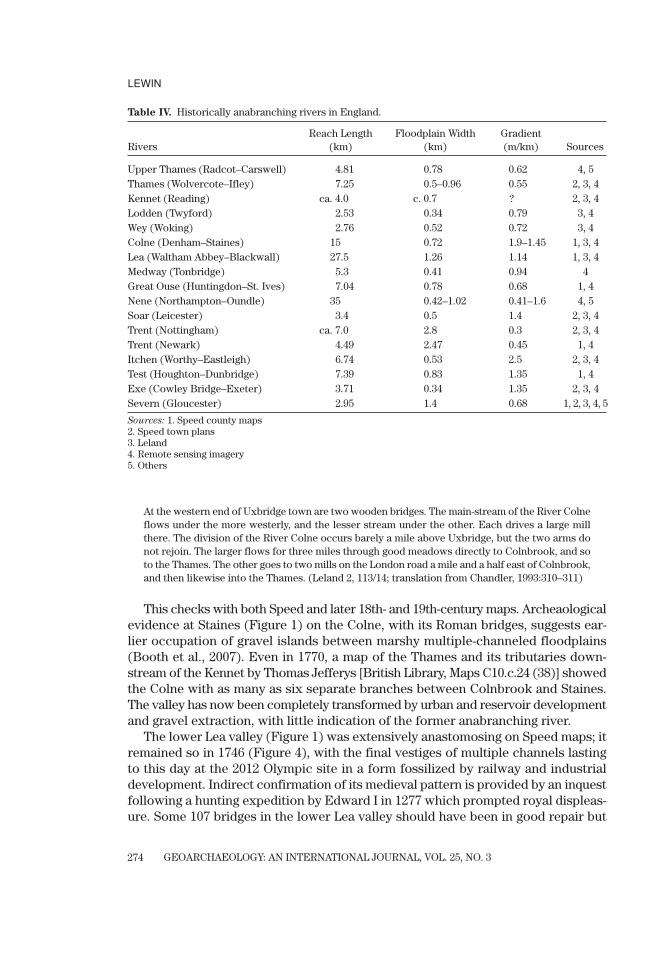
meandering or anastomosing. There is much hitherto uncollated evidence to sug-gest that the last multichannel (anabranching) style was of far greater significancethen than now, though different from much more active braided channels in steepervalleys. Tudor maps are about the earliest cartographical source at an appropriatescale that we have (Harvey, 1993; Delano-Smith & Kain, 1999), but there seems nogreat reason to doubt that what they depicted had survived from the late medievalperiod. The same applies to Speed’s (1611–12) county maps and town plans, somerepeating the detail of Saxton and other earlier cartographers (Ravenhill, 1992).These show many anabranching rivers and reaches that can be related to Leland’searlier descriptions, to later maps, and to relict channels still visible in contempo-rary remote sensing imagery (Table IV).
Along the Lower Thames, tributary rivers characteristically had multi-branchinglower reaches, sometimes quite extensive, where their gradients dropped under theinfluence of the main river. Not to be unexpected geomorphologically, this led toanastomosis. Leland described the River Colne (after a journey probably undertakenin 1549):
At the western end of Uxbridge town are two wooden bridges. The main-stream of the River Colneflows under the more westerly, and the lesser stream under the other. Each drives a large millthere. The division of the River Colne occurs barely a mile above Uxbridge, but the two arms donot rejoin. The larger flows for three miles through good meadows directly to Colnbrook, and soto the Thames. The other goes to two mills on the London road a mile and a half east of Colnbrook,and then likewise into the Thames. (Leland 2, 113/14; translation from Chandler, 1993:310–311)
This checks with both Speed and later 18th- and 19th-century maps. Archeaologicalevidence at Staines (Figure 1) on the Colne, with its Roman bridges, suggests ear-lier occupation of gravel islands between marshy multiple-channeled floodplains(Booth et al., 2007). Even in 1770, a map of the Thames and its tributaries down-stream of the Kennet by Thomas Jefferys [British Library, Maps C10.c.24 (38)] showedthe Colne with as many as six separate branches between Colnbrook and Staines.The valley has now been completely transformed by urban and reservoir developmentand gravel extraction, with little indication of the former anabranching river.
The lower Lea valley (Figure 1) was extensively anastomosing on Speed maps; itremained so in 1746 (Figure 4), with the final vestiges of multiple channels lastingto this day at the 2012 Olympic site in a form fossilized by railway and industrialdevelopment. Indirect confirmation of its medieval pattern is provided by an inquestfollowing a hunting expedition by Edward I in 1277 which prompted royal displeas-ure. Some 107 bridges in the lower Lea valley should have been in good repair but
LEWIN
GEOARCHAEOLOGY: AN INTERNATIONAL JOURNAL, VOL. 25, NO. 3274
Table IV. Historically anabranching rivers in England.
Reach Length Floodplain Width Gradient Rivers (km) (km) (m/km) Sources
Upper Thames (Radcot–Carswell) 4.81 0.78 0.62 4, 5Thames (Wolvercote–Ifley) 7.25 0.5–0.96 0.55 2, 3, 4Kennet (Reading) ca. 4.0 c. 0.7 ? 2, 3, 4Lodden (Twyford) 2.53 0.34 0.79 3, 4Wey (Woking) 2.76 0.52 0.72 3, 4Colne (Denham–Staines) 15 0.72 1.9–1.45 1, 3, 4Lea (Waltham Abbey–Blackwall) 27.5 1.26 1.14 1, 3, 4Medway (Tonbridge) 5.3 0.41 0.94 4Great Ouse (Huntingdon–St. Ives) 7.04 0.78 0.68 1, 4Nene (Northampton–Oundle) 35 0.42–1.02 0.41–1.6 4, 5Soar (Leicester) 3.4 0.5 1.4 2, 3, 4Trent (Nottingham) ca. 7.0 2.8 0.3 2, 3, 4Trent (Newark) 4.49 2.47 0.45 1, 4Itchen (Worthy–Eastleigh) 6.74 0.53 2.5 2, 3, 4Test (Houghton–Dunbridge) 7.39 0.83 1.35 1, 4Exe (Cowley Bridge–Exeter) 3.71 0.34 1.35 2, 3, 4Severn (Gloucester) 2.95 1.4 0.68 1, 2, 3, 4, 5
Sources: 1. Speed county maps2. Speed town plans3. Leland4. Remote sensing imagery5. Others

were not: Two were supposed to be 30 feet long, one 20 feet, but most under 10 feet(Cooper, 2006). Harrison called these streams “tributaries” (Harrison, 2004), butanastomosing distributaries within the hunting and hawking marshlands seems alikely technical description, considering both their dimensions and number.
Other larger lowland rivers like the Great Ouse, Soar, Upper Thames, and Trenthad some divided reaches. Between Nottingham and Newark (Figure 1), the Trentwas anastomosing in Tudor times (British Library, Cotton MS Augustus I.i.65), as it was still in 1646 at the time of the Civil War [British Library, Maps *4670 (1.); see
GEOARCHAEOLOGY: AN INTERNATIONAL JOURNAL, VOL. 25, NO. 3
MEDIEVAL ENVIRONMENTAL IMPACTS AND FEEDBACKS
275
Figure 4. The anastomosing course of the River Lea (National Grid reference TQ 3883) in 1746, show-ing multiple channels and the causeway and bridges at Stratford. From John Rocque’s “Survey of London,Westminster, and Southwark and the Country near Ten Miles Round.” The lower part of the map showsthe confluence of the Lea and the River Thames.

also Salisbury, 1984]. This same reach had been the subject of dispute in 1346 whenthe passage of boats to Nottingham was impeded by alleged illicit diversion of flowdown the Averham branch of the river (Calendar of Patent Rolls, Edward III iii Nov.20, 1346). The long history of modification and adaptation of an already existingmultichannel system has been described at Burton-on-Trent (Tringham, 2003), whilelater views of the Trent at Burton in 1732 and the Thames at Oxford in 1731 (Hyde,1994) still show the anabranching channels known to have existed earlier (Dodd,2003; Tringham, 2003). Maps of the Great Ouse (British Library, Cotton MS AugustusI i 78, and Maps K.Top.1641.1) show channel reaches that were divided in Tudortimes through to 1768, as some still are.
The Nene appears to have had extensive anastomosis, to judge from both earlysurvey and archaeological excavation (Jenkins, 1992; Brown, 2009). Leland describedhis approach to Oundle across a causeway and 16-arch bridge, and he left on anothersimilar structure crossing the Nene further downstream. Despite the fact that chan-nels here were engineered for milling (below Northampton and as far as Oundle, 25Domesday mills were recorded for valley settlements at an average spacing down val-ley of 1.6 km), and the main channel was subsequently altered (with locks) for nav-igation (the engineered waterway opened in 1761), the low-gradient divided coursestill had a semi-natural anastomosing appearance in the early 19th century, withlengthy split reaches, each with meander loops proportional to their size. There isno reason why natural-looking bends and so many long bifurcated reaches shouldall have been deliberately engineered. Medieval people, like the Romans before them,could and did engineer new channels (Blair, 2007), but in many instances they didnot have to: They adjusted and modified, as appears to have been the case on theNene.
Another group of former anastomosing channels is to be found in southernEngland, where proximity to the sea was marked by low valley gradients (Table II),though with single “funnel” channels where dominated by two-way tidal flows (cf.also the lower meandering course of the tidal Lea). Some of these again have beenmuch altered, for example, for water meadow irrigation from the 17th century onward(Cook & Williamson, 2007). Major wetlands and perimarine, tidally influenced envi-ronments are not discussed here, but it should be noted that transformation applieson a grand scale to the river systems of the Fenlands and the Humberhead, Somerset,and Severn Levels (Figure 1), following engineering for waterways, land reclamation,and drainage over a very long period (Darby, 1966; Cook & Williamson, 1999; Blair, 2007; Van de Noort, 2004). Here narrow sandy ridges between extensive organic wetlands mark the extensive fossil levees and networks of former anastomosingsystems.
To summarize, most larger medieval lowland rivers in England seem to have beeninactively meandering or anastomosing; the latter, with multiple courses and wetlandsbetween, have now all but disappeared from the scene. The same also applies tomuch smaller streams, as at Bordesley Abbey, on the headwaters of the Arrow inWorcestershire, where building over a defunct anastomosing channel system provideda succession of foundation problems for the Cistercians (Astill, 1993). Marginal flood-plain fenland along valleys was much more extensive, with marshy reedswamps and
LEWIN
GEOARCHAEOLOGY: AN INTERNATIONAL JOURNAL, VOL. 25, NO. 3276
GEOARCHAEOLOGY: AN INTERNATIONAL JOURNAL, VOL. 25, NO. 3
MEDIEVAL ENVIRONMENTAL IMPACTS AND FEEDBACKS
277
minor channels (Booth et al., 2007), making whole valley floors much more difficultto cross than is now apparent. These riverside wetlands were areas of high biologi-cal productivity; prehistoric sites appear to have favored them rather than the majorextensive peatlands (Van de Noort & O’Sullivan, 2006:36–39). As a resource, theywould have formed part of a mosaic of “taskscapes” in medieval times (for discus-sion of floodplain wetlands and ecology, see Brown, 1997:Chapter 4). In-channel andchannel-edge vegetation is also likely to have steered channel development, althoughit can be difficult to know retrospectively what channel vegetation in medieval timeswas like at many sites. At some locations, relict Pleistocene braid bars formed drierislands between, or marginal to, narrower anastomosing belts or meandering val-ley-floor systems. So floodplains themselves represented a combination of systems,some inherited and overlain, and others laid out side-by-side in tributary or adjunctsystems next to main rivers. In some places at least, active meandering or even braid-ing was more important than is now apparent where rivers have been regulated.Channel mobility would also have been more likely in the absence of so thick a unitof overbank fine sediment, a point that will be returned to later. What all this providedwas significantly more varied site opportunities for use and for crossing than wenow see, and the need for different tactical approaches from medieval people.
MEDIEVAL FLOODS AND FLOODPLAIN DYNAMICS
Floodplains evolve mainly under the influence of extreme river discharges; chan-nels do most erosion and deposition as the channel gets at least near full, while over-bank deposition requires even greater discharges. Systems as a whole also changewhen flood frequencies and magnitudes change, or sediment supply is altered.Archaeological evidence suggests that fluctuations occured in Roman times and sub-sequently. Plant, beetle, and molluscan evidence points to varying degrees of flood-plain wetness, while overbank sedimentation from the influx of soil-derived sedimentpeaked in Roman and later medieval periods (Booth et al., 2007). In paleoclimaticterms, the present concern is mostly with what happened in what has been called theMedieval Warm Period (ca. A.D. 900–1400). Warmth is evidenced by vineyard produc-tion, upland cultivation limits, glacier extents, dendrochronology, and ice-core data(Lamb, 1995). The proxy climatic evidence is not always in agreement, but the periodA.D. 1200–1350 may have had rapid fluctuations and both hot summers and cold oreven severe winters (Ogilvie & Farmer, 1997; Glaser & Riemann, 2009).
Definitive and direct river evidence for runs of extremes—climatically inducedlarge discharges and flooding, or distinctive floodplain and channel processes andchange—is difficult to establish, and the Warm Period appears to have been lessglobally synchronous and continuous than once was thought (Hughes & Diaz, 1994;Ogilvie & Farmer, 1997; Glaser & Riemann, 2009). In England, for example, extremeevents were recorded during the Warm Period in the Anglo-Saxon Chronicles in1085, 1095, 1109, 1111, 1115, and 1117 (Swanton, 2000), together with crop failuresand pestilences that may well have been weather-related. The Great Famine(1315–1317) was associated with a period of severe winters and wet summers (Jordan,1996:Chapters 1, 2), while ice-floe bridge damage could be significant in winter floods

LEWIN
GEOARCHAEOLOGY: AN INTERNATIONAL JOURNAL, VOL. 25, NO. 3278
(Watson, Brigham, & Dyson, 2006). On a local scale, bridges at Burton-on-Trent wereflood damaged in 1255, 1284, 1380, 1402, and 1574 (Tringham, 2003). Nationally, pon-tage grants for bridge repair increased between 1228 and 1400, but there were peaksin the early 1300s, 14 in the years 1334–1335 alone, and these on significant rivers androutes (listings in Cooper, 2006, Appendix 2). There was a lull for around threedecades after ca. 1340. These data must be treated cautiously because the incidenceand timing of bridge maintenance have social and economic as much as physicalcauses. Thus, Worcester’s suit in 1328 arose because of destruction in war, while theBlack Death (1348–1350) caused social havoc and economic disruption, withincreased labour costs, difficulties in raising capital, and a decreased demand fortransport services. Other extreme event records can be quite precise: Langdon(2004:27) noted four watermills destroyed by a flood at Warwick on October 17,1315. At that time of year, the flood is not likely to have involved ice or frozen ground,nor an intense but localized summer convection storm, but more likely the passageof a slow-moving autumn depression.
In the round, these records are temporally and regionally fragmented, but at pres-ent it does rather look as if runs of wetter weather on a decadal timescale (as in theearly 14th century) could be significant in geomorphological terms, although extremeevents also produced extreme results on occasion throughout the medieval period.Contrasted weather types give rise to exceptional floods in different ways. Thereare floods caused both by winter snow and ice melt (or rain on frozen and snow-covered ground, as in the 1947 floods) and by slow-moving depressions involving largewarm and moist air masses, facilitated by prior ground saturation. These floods areregional (�ca. 10,000 km2) in scale, with high-intensity rainfall cells within them.Small catchments are at risk from more localized (�ca. 100 km2) convective down-pours in summer. It is quite likely that runs of individual floods of a particular typeand spatial scale occurred more often at certain periods, but this is not directlyrevealed by the annual or decadal averages to which crop cultivation limits, glacierfluctuations, and seasonal surrogate indices bear witness. If available, flood levelepigraphic records can be coupled with reconstructed floodplain topography andhydraulic roughness to give discharge estimates for extreme floods. Herget and Meurs (2010) have used such an approach for Cologne, where a disastrous floodon the Rhine in 1372 overtopped the city walls. Such evidence has yet to be foundor exploited for the medieval period in England and Wales.
More persistent floodplain wetness (rather than individually large floods), as indi-cated from Roman times onward by biological evidence, later coupled with sedi-mentation (Booth et al., 2007), appears especially to have been brought about bypurposeful human activities exploiting an agricultural landscape and modifying thevariety of river and floodplain styles as seemed appropriate at the time. It is reason-able to argue that at this time these were more significant than externally deter-mined climatic fluctuations in achieving medieval change to the physical environmentitself—even though this was mainly achieved through the medium of high-flow events(Macklin, Jones, & Lewin, 2010). How rivers and floodplains suited, or got in theway of, medieval purposes will next be re-examined in this light.
GEOARCHAEOLOGY: AN INTERNATIONAL JOURNAL, VOL. 25, NO. 3
MEDIEVAL ENVIRONMENTAL IMPACTS AND FEEDBACKS
279
RIVER ENVIRONMENTS FOR DEFENSE
Medieval towns and defended places had varied origins and strategic sitings involv-ing, for example, contrasts between those inheriting and refurbishing dry sites on riverterraces, like that of Roman Gloucester, and others with wetland locations, notablyof some Saxon burhs (Schofield & Vince, 2003; Creighton & Higham, 2005).Canterbury and Winchester, initially Roman sites, both occupied anastomosing riversites, one river branch passing within the medieval walls and another without. SimilarEuropean sites (including ones which later became major cities, like Hamburg orCork) are quite common as post-Roman settlements.
Wetland and bank and ditch combinations preceded walling as defensive meansfor most nascent towns and the later Norman castles that were implanted to domi-nate them. In practice, later town “defenses” turn out to have been highly varied,many being discontinuous barriers and without masonry walls, with staged exten-sions and suburbs beyond (Creighton & Higham, 2005). Many towns that later pros-pered were also on large navigable rivers, some (like York and Bristol) extending theirwalls to incorporate land on either side. In general it was a combination of factorsthat probably mattered: A major river could be important for both transport anddefense, while a ford or bridging location controlled traffic on both road and river.Not that fording points were necessarily that rare; Eckwall (1960) listed 550 Englishplace names involving “ford,” and only a few grew to be large towns. It was largerrivers and the barrier of extensive wetlands that provided strategic opportunity.
Wetlands as well as walls were a considerable defense asset when required, makingassault difficult and mining locally impossible in waterlogged ground. In a violent age,as in the 12th century in particular (Bisson, 2009), both defense and intimidation wereinvolved. Contemporary accounts of actual sieges (Warner, 2004) were quick to reporton the advantages of watery defense, as in the siege of Oxford in 1141 or of Crickladein 1142 in the reign of King Stephen. Radcot Castle on the upper Thames was so sur-rounded by marsh as to be thought inaccessible, a very different situation from thestate of the floodplain site today. The marches and armed encounters of this period ofconflict and in the Wars of the Roses both suggest that floodplains of even quite smallrivers were much more of a soggy barrier than their present topographies suggest.
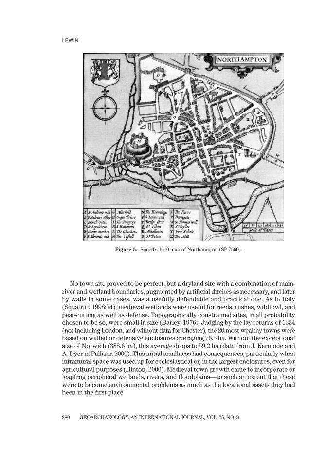
For towns, a strong “promontary” site could include a river on one side joined bya wetland stream on another, the latter providing water for everyday purposes andmilling as well, as at Northampton (Figure 5). The site well illustrates on a smallscale the tributary/main river combination of channel pattern seen on the LowerThames and its tributaries. At the comparable site of Worcester, initially a defend-able burh beside its cathedral church to which extentions were made and a Normancastle insensitively added in the monks’ graveyard (Baker & Holt, 2004), the Severnwas joined by the insignificant but defensively useful and marshy Frog Brook (withits mill). The stream was of limited other use. The monks later had to bring clean waterin an aqueduct from across the Severn itself. To avoid contamination, town ordi-nances from the reign of Edward IV specified the different parts of the main riverbanks which were to be used for what would otherwise be conflicting purposes(translation in Mortimer, 2008:229–232).
LEWIN
GEOARCHAEOLOGY: AN INTERNATIONAL JOURNAL, VOL. 25, NO. 3280
Figure 5. Speed’s 1610 map of Northampton (SP 7560).
No town site proved to be perfect, but a dryland site with a combination of main-river and wetland boundaries, augmented by artificial ditches as necessary, and laterby walls in some cases, was a usefully defendable and practical one. As in Italy(Squatriti, 1998:74), medieval wetlands were useful for reeds, rushes, wildfowl, andpeat-cutting as well as defense. Topographically constrained sites, in all probabilitychosen to be so, were small in size (Barley, 1976). Judging by the lay returns of 1334(not including London, and without data for Chester), the 20 most wealthy towns werebased on walled or defensive enclosures averaging 76.5 ha. Without the exceptionalsize of Norwich (388.6 ha), this average drops to 59.2 ha (data from J. Kermode andA. Dyer in Palliser, 2000). This initial smallness had consequences, particularly whenintramural space was used up for ecclesiastical or, in the largest enclosures, even foragricultural purposes (Hinton, 2000). Medieval town growth came to incorporate orleapfrog peripheral wetlands, rivers, and floodplains—to such an extent that thesewere to become environmental problems as much as the locational assets they hadbeen in the first place.

GEOARCHAEOLOGY: AN INTERNATIONAL JOURNAL, VOL. 25, NO. 3
MEDIEVAL ENVIRONMENTAL IMPACTS AND FEEDBACKS
281
FORDS AND BRIDGES
The earliest English topographic maps available (including Matthew Paris’s mapsof Britain and the Gough map of the 13th and 14th centuries) are dominated by townsand the rivers that were to be visited and crossed. A choice of route can be regardedas a choice of river crossings (Cooper, 2006:2). However, routes imply a destination,with travellers being driven by a variety of purposes including governance, pilgrim-age, and commerce. It could be argued that “bridging points” represent a compro-mise between site suitability (in terms of available technology) and local or nationalconnectivity frameworks (Hindle, 1982), with the growing commercialization of theMiddle Ages driving a supralocal community hierarchical communications networkof increasing density. However, the physical variability of ford and bridge sitings hashardly been considered at all.
A few difficult sites were critical for long-distance travel (for example, the Thamesat London and Staines, the Trent at Nottingham, the Nene near Peterborough andWansford, the Great Ouse at Huntingdon, and the Yorkshire Ouse and its large trib-utaries; see Figure 1). Elsewhere, and to judge by early English place names thathave survived, there was probably no shortage of viable low-flow crossing places.Eckwall’s many “ford” name elements (Eckwall, 1960) may be further qualified byreference to type, as in Bradford (broad-), Fulford (foul-), or Langford (long-) (Gelling,1984). Many lowland rivers were gravel-bedded at known crossing sites, affording agood cobbled roadbed for fording traffic, although following the later narrowingand deepening of urban rivers (see below) this may not now be apparent. This wasnot true of the sand-bed channels of both the major wetlands and the lower reachesof anastomosing rivers. These would have been both relatively deep and narrow andespecially treacherous for wheeled vehicles sinking into the river bed if the passage-way was not stone-lined and well marked. Valley wetlands between channels werethemselves also difficult to cross. Unsurprisingly, medieval road-based traffic gen-erally kept a little upstream of the lowest reaches of the anastomosing Thames trib-utaries, and national itineraries as far as possible kept away from crossing majorlow-gradient sand-bed channels—as well as, of course, keeping clear of the major wet-lands themselves. Nevertheless, sets of divided channels have the one obvious advan-tage that smaller channels are individually easier to bridge or even to walk across ifsmall enough. Particularly helpful would have been gravel islands (the remnantPleistocene river braiding features) sticking up through the shallow anastomosingsystems of the Holocene.
At least at low flows in summer, shallower actively meandering or braided chan-nels had banks and beds that allowed them to be forded much more easily. Summerspates could nevertheless create concealed scour holes in which it was possible todrown (Challis, 2004). Fording layouts differed in detail. Typically on actively mean-dering channels, the shallows associated with gravel bars or riffles (for this is whatprovides the fording opportunity) occur at crossover points between bends or evenmore frequently, with the outer bends themselves being associated with steep cutbanks and deep pools and therefore best avoided. To ford the river, a track could makeits way down a valley side onto a relatively dry point bar, but then reorient up- or

LEWIN
GEOARCHAEOLOGY: AN INTERNATIONAL JOURNAL, VOL. 25, NO. 3282
0 50m
0 50m
PoolBarSubmerged barOlder exposed gravelVegetated surfaceFlow directionFording route
0 50m
(a)
(b)
(c)
Figure 6. Illustrations of shallow-water river crossing potential: (a) a meandering reach (River Fromein Dorset, SY 8987); (b) a braided reach (Afon Ystwyth in Ceredigion, Wales, SN 7473); and (c) a straightreach with long diagonal bar (Afon Tywi in Carmarthen, Wales, SN 74303).
down-valley to cross the channel at the shallowest point, reorienting again when theriver was crossed (Figure 6a). Because the meandering channel itself shifts over amatter of decades, the ford track shifts with it, becoming overtaken and buried underlater (point bar) sediments.
This seems to be confirmed by historical evidence for larger rivers that were sub-sequently re-engineered for navigation. There are around ten bends between Bewdleyand Upton on the Severn, some being less well developed and confined by river

GEOARCHAEOLOGY: AN INTERNATIONAL JOURNAL, VOL. 25, NO. 3
MEDIEVAL ENVIRONMENTAL IMPACTS AND FEEDBACKS
283
terraces. In 1858 it was reported that there had been 20 “fords” (as they were actu-ally called) before the locks were built and the channel modified (Trinder, 2005:9).On the Trent between Twyford and Cavendish Bridge, a mid-18th-century survey[British Library, Maps C10.c.24 (7)] shows pairs of named “shoals” at the cross-oversbetween bends (“Oven Mouth” and “Norman’s Friend,” “Kingsmill” and “Old Barn,”and “Mill” and “Folly” shoals). These were clearly as well known to navigators thenas pools and riffles are to fishermen today. Use (or attempted use) of 14 fords fur-ther downstream in the Trent valley, in an area centered around Nottingham andNewark, is demonstrated by drownings recorded in coroners’ inquests between 1485and 1558 (Challis, 2004). There were many more active fords than place name evi-dence is able to confirm. In a regional sense, ford settlement names do concentratealong meandering rivers—such as the Upper Thames in Oxfordshire, the Wylye inWiltshire, the Frome in Dorset, and the Great Ouse in Bedfordshire—where cobblyor stony channel-bed conditions for fording rivers look to have been good. The chalk-lands of southern England are particularly distinctive. Chalk itself provides littlefine sediment, and larger particles are rapidly broken down by abrasion (Lewin &Brewer, 2002), but the flint nodules the rock contains are very resistant, and theresult is clear-water cobble-bed streams.
With braided reaches, multiple shifting bars may appear less systematicallyarranged, but low-flow crossing of shallow channels may not be difficult, even thoughthe fording line may need to zig-zag to cross several active and “dead” channels andbars, which get rearranged from one high flow period to the next (Figure 6b). Butagain the place name evidence does not reveal this, and it is unlikely that there weremany braided reaches in lowland England and Wales in any case.
Where there are longer straight reaches without major bends, bed sediment accu-mulation may occur especially at the downstream end of longer “glides.” Rivers mayhave a long but shallow diagonal crossing of the actual stream bed (Figure 6c). Werethese the “long-fords” of early place names as Gelling tentatively suggested (Gelling,1984:69)? Unfortunately, the answer is probably not: The bulk of place names thatshe listed as ford related, including the 26 that were “long” or “broad,” are on quitesmall streams. Two of the eight Twyfords (“two fords”) are plausibly on what wereanabranching rivers, one on the Itchen in Hampshire and the other on the Loddonnear Reading. The settlement of Langford on the Colne (a river now only visible in mutilated form between Heathrow Airport, the M4, and the M25) was also acrossan anastomosing system. Possibly the Twyford on the Trent, with no bridge still buta later ferry, recorded fords at the upstream and downstream ends of a meander bend.
Anastomosing channels were a mixed blessing: The larger ones could be difficultto ford but possible to bridge, branch by branch. The wetlands between channelsmight need to be bridged too. Wooden trestle bridges with “earth-fast” piling in softsediment would not have been as difficult as attempting piling through gravel, and thisis a supplementary explanation for the greater frequency of timber bridges which hasbeen noted on the lower Thames and its tributaries through to Tudor times (Harrison,2004). Even in 1729, the new Putney Bridge was a timber one and the “wooden zig-zag,” as it was called, lasted until 1886 (Matthew, 2008). The relatively fixed locationof the channel meant that bridge abutments did not have to survive any great
LEWIN
GEOARCHAEOLOGY: AN INTERNATIONAL JOURNAL, VOL. 25, NO. 3284
tendency for lateral erosion, although bridge structures might be swept away inextreme floods or be damaged by traffic passing across or beneath. In the absence offordable shallows, the larger canaliform channels (inactive meandering or anasto-mosing) would have needed ferries or bridges. Rackham (1986) noted that pre-Conquest (before 1066) English charters mentioned 666 bridge and ford crossings,one-sixth being bridges. The latter were uncommon on gravel-bed chalk streams andin Devon, but dominant in the Fenland. This fits neatly with the nature of the channels.
An early geographical differentiation between fording and bridging potential atboth the site and the regional scale began to change as bridges replaced fords at a paceaccelerating after ca. A.D. 800 (Cooper, 2006). The number of bridges peaked in themedieval period and remained roughly stable until the 18th century (Harrison, 2004).The precise location and orientation of “lost” fords could well have differed fromlater bridges (the fords themselves may have shifted anyway as the river bed changed),as has been suggested in the case of St. Ives (Beresford & St. Joseph, 1958). With sta-ble channels, bridges could use old ford sites to lay good foundations in shallow water(Simco & McKeague, 1997:105). But bridges are greatly at risk from shifting chan-nels, actively meandering or braided, with pier undermining and new channels likelyto develop across and destroy bridge approaches on the floodplain. If the bridge can-not quasi-permanently constrain and fix the channel location, the river “fixes” thebridge in another sense, by destroying it. These problems are well illustrated by the Trent bridges at Hemington upstream of Nottingham, with many medieval rebuild-ings on shifting channel courses (Salisbury, 1992; Brown et al., 2001; Cooper, 2003;Brown, 2008). Also on the Trent, the bridge at Nottingham itself (known as HethbethBridge) caused persistent problems (Cooper, 2006). In brief, fording works wellenough with shifting shallows, but bridging benefits from stable narrows.
So when bridges replaced fords, this could involve a local shift in location, as atNorthampton and Peterborough (Steane, 1974). Channel crossing lines were moredirect than those exploiting the shallowest path (Figure 6). Alberti, writing in the15th century (Alberti, 1755), cautioned against bridges on bends. But outer bends upagainst more stable valley floor margins (terraces or bedrock) might be different; theycould provide a stable abutment at least on one bank, although abutments and pierfoundations needed to be deep where adjacent to scour pools, and a set of landarches might be needed to bring the roadway down to floodplain level on the flood-plain side. In the valleys of lowland England, rivers are commonly confined withinvalley meanders and by earlier gravel terraces, on some of which towns had beenfounded. Even though the rivers when unconfined would be well capable of lateralerosion, the confining valley side “steers” the channel into adopting a relatively sta-ble location against the outer bends of valley-floor margins (Lewin & Brindle, 1977).This means that the active channel quasi-permanently hugs the outer valley bend.There might have been an over-deepened pool on the bend to cross (which could beuseful for river passage and mooring close in, as on many outer-bend medieval townquays), but at least a lesser chance of lateral channel shift. If a high-level bridge was constructed it could lead into town on the level rather than requiring a gentledescent right down to ford level, the ford itself being away from the probable pool
GEOARCHAEOLOGY: AN INTERNATIONAL JOURNAL, VOL. 25, NO. 3
MEDIEVAL ENVIRONMENTAL IMPACTS AND FEEDBACKS
285
and undercut terrace slope. The terrace base became the town quay—but none ofthis was where the old ford would have been found.
To summarize, the domains of larger stable meandering and anastomosing chan-nels were not so easy to ford, though the latter in particular might be easier to bridgeincrementally in a series of bridges and causeways. For fording, the detailed pas-sage across floodplain and river varied according to the style of river, but fords wereliable to shift as channel beds changed, so that it is not surprising that fords have nowbecome lost. Rivers have also been dredged and modified for navigation, as on thelower Severn in the 19th century. At Worcester a minimum depth of 10 feet (3.05 m)was created, thus putting paid to previous summer fording opportunities (Carver,1980:19–20, 308). As the history of bridge repair following persistent destructiondemonstrates (Harrison, 2004; Cooper, 2006), the greatest bridging difficultiesoccurred with the actively mobile middle reaches of large rivers like the Trent, Tyne,and Severn—upstream of inactive low-gradient sections where the more stable butdeep and wide rivers would, of course, be difficult to cross other than by boat inany case. Broadly speaking, the size of a river is proportional to its catchment area,and the lower reaches of major English rivers were a problem for crossing becauseof their sheer size. Only the greatest strategic and commercial need, and expenditure,could here lead to bridge development, as in the case of old London Bridge (Watson,Brigham, & Dyson, 2006).
When bridges replaced fords, site requirements could shift toward a need forchannel stability. In addition to avoiding ancient upkeep commitments (Cooper,2006), there were physical reasons for some crossing sites to be moved—to find sta-ble abutments and beds, with a different entry into towns. A deeper pool could nowbe less of a problem, and useful for river traders. Finally, it should be clear that therewas no such thing as “the bridging point”; the crossing of rivers depended on tech-nology, site opportunity, and intent, and these varied over time. Sometimes new set-tlements grew around new bridges, as at Boroughbridge, Fenny, and Stony Stratford,and the remarkable Stockbridge on the Itchen floodplain in Hampshire, with no lessthan seven bridges with burgage plot layouts following the streams (Beresford, 1967).But once settlements were established, it was they that determined, at a later date,the bridge location (possibly in challenging circumstances, as on the Trent atNottingham) rather than the other way round. The transition from ford or ferry tobridge was frequently a matter of continuing expense.
MULTICHANNEL USE
Besides being helpful for bridging, the presence and stability of anastomosingchannels also lent itself to easier use for milling or water-access purposes whichwould be more hazardous on single large channels with deep water or steep banks.For access, both flood-stage hazards and low-stage muddy margins on single largerivers were best avoided. If multiple low-energy channels were re-engineered or newones added, they would also be likely to remain stable. This was a considerable advan-tage. From the milling point of view as well, the entire low-flow summer discharge
LEWIN
GEOARCHAEOLOGY: AN INTERNATIONAL JOURNAL, VOL. 25, NO. 3286
could be diverted into the mill channel by temporarily damming others or the mainchannel (as is well illustrated in Hooker’s ca. 1587 plan of Exeter; British Library,Maps C.5.a.3), while winter floods could mostly be taken by the main channel. Powerfulundivided rivers like the Severn were less suitable for milling; Domesday mills are clus-tered along safer and more manageable tributaries rather than along the river itself(Darby & Terrett, 1971:259–261). Channel division was also helpful: At Chertsey, wherethe channel of the Thames was split, one arm was used for mills as a mid- to late-15th-century plan shows (PRO E164/25,f.222r), as was the Trent downstream fromNottingham to Newark in the early- to mid-16th century (British Library, Cotton MS,Augustus I.i 65). Channel engineering and division was involved in some cases, as atAbingdon (Bond, 2007).
No two sites are identical, but the now-obscured significance of multiple channelsystems receives emphasisis in the case of Reading (Figure 1), which developed onthe lower reaches of the Kennet rather than the adjacent Thames. Site advantagesare clear from Leland’s description from 1542:
The River Kennet passes through the centre of Reading, but divides into two main streams, the largerof which flows under a great wooden bridge on the south side of the town. The other channel isgenerally known in the town as the Hallowed Brook. It leaves the main stream of the Kennetupstream from Reading to the WSW, near the Bere, where the Abbot of Reading had a fine brickmanor house. Then it flows down through meadows towards Reading, running through part ofthe abbey and washing away its filth. A little below this it rejoins the main stream, and the reunitedRiver Kennet flows into the Thames a little further down. The River Thames comes within half amile of Reading on the ENE side. In the lower part of the town, where the two Kennet streams runclose together, I noticed a number of little channels branching out of them and creating smallislands, whch are approached over various wooden bridges. These channels are very suitable fordyeing and many dyers are settled there, since Reading’s mainstay is its cloth industry. (Leland1/108–11; Chandler, 1993:28–29)
THE BUILT ENVIRONMENT AND UNINTENDED IMPACTS
Desirably situated towns, formerly small-sized settlements, greatly developed theircommercial activities and outgrew their originating site advantages during medievaltimes. Defense in post-Conquest towns seems to be far less important a factor than itwas in continental Europe. Walled enclosure was in some cases very limited, in oth-ers symbolic, and in others embraced only privileged parts of the urban townscape(Creighton, 2007). In many instances, confinment by walls, ditches, marshes, and riversled to extramural growth in “dryland” suburbs, but also a spread onto floodplains andwetlands (Table V). Some walled towns were large in area (for example, Norwich and Lynn) but others simply spread beyond the enclosures that also regulated commer-cial access. The strategically situated riverside sites were often the most confined, andmany extended out onto their river floodplains right next to the town (E in Table V), astranspontine extensions on the other side of the river (T) and along causeways (C).Growth of a secondary settlement on the far side of the floodplain was another pos-sibility (e.g., Gateshead on the River Tyne, Godmanchester on the Great Ouse). Bridgesand their approaches had clear locational advantages for building: proximity to thetown center, a captive clientele having to go past the door, and at least on causeways
GEOARCHAEOLOGY: AN INTERNATIONAL JOURNAL, VOL. 25, NO. 3
MEDIEVAL ENVIRONMENTAL IMPACTS AND FEEDBACKS
287
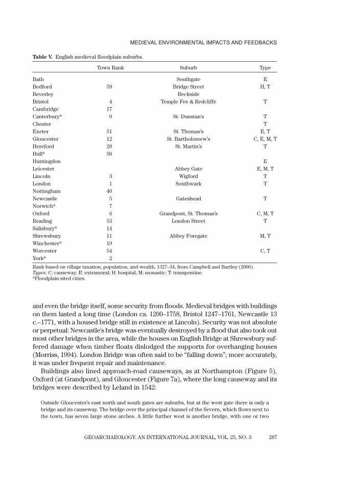
Table V. English medieval floodplain suburbs.
Town Rank Suburb Type
Bath Southgate EBedford 59 Bridge Street H, TBeverley BecksideBristol 4 Temple Fee & Redcliffe TCambridge 17Canterbury* 9 St. Dunstan’s TChester TExeter 51 St. Thomas’s E, TGloucester 12 St. Bartholomew’s C, E, M, THereford 20 St. Martin’s THull* 50Huntingdon ELeicester Abbey Gate E, M, TLincoln 3 Wigford TLondon 1 Southwark TNottingham 40Newcastle 5 Gateshead TNorwich* 7Oxford 6 Grandpont, St. Thomas’s C, M, TReading 53 London Street TSalisbury* 14Shrewsbury 11 Abbey Foregate M, TWinchester* 19Worcester 54 C, TYork* 2
Rank based on village taxation, population, and wealth, 1327–34, from Campbell and Bartley (2006).Types: C: causeway; E: extramural; H: hospital; M: monastic; T: transpontine.*Floodplain-sited cities.
and even the bridge itself, some security from floods. Medieval bridges with buildingson them lasted a long time (London ca. 1200–1758, Bristol 1247–1761, Newcastle 13c.–1771, with a housed bridge still in existence at Lincoln). Security was not absoluteor perpetual: Newcastle’s bridge was eventually destroyed by a flood that also took outmost other bridges in the area, while the houses on English Bridge at Shrewsbury suf-fered damage when timber floats dislodged the supports for overhanging houses(Morriss, 1994). London Bridge was often said to be “falling down”; more accurately,it was under frequent repair and maintenance.
Buildings also lined approach-road causeways, as at Northampton (Figure 5),Oxford (at Grandpont), and Gloucester (Figure 7a), where the long causeway and itsbridges were described by Leland in 1542:
Outside Gloucester’s east north and south gates are suburbs, but at the west gate there is only abridge and its causeway. The bridge over the principal channel of the Severn, which flows next tothe town, has seven large stone arches. A little further west is another bridge, with one or two

LEWIN
GEOARCHAEOLOGY: AN INTERNATIONAL JOURNAL, VOL. 25, NO. 3288
arches which at certain times serve to drain the meadows. Not far away another bridge, of five large arches, stands close to the west gate, and from it a great stone causeway, a quarter-mile long,has been thrown up across the low-lying meadows by the Severn. This causeway has a number ofdouble-arched bridges which drain the meadows when flooded, and at the far end there is anothereight-arched bridge which is not yet finished. (Leland 2/53–64; Chandler, 1993:177)
The inter-channel causeway near the town (Westgate Island, or in the medievalperiod “inter pontes”) was lined with buildings, as shown on Speed’s 1610 town plan.Many other raised medieval causeways existed (Table VI), not all of them urban.These varied in design, some with roads on embankments with bridging sectionscrossing both single or anastomosing channels, and others, like the impressiveviaduct at Burton, with continuous runs of arching to make allowance both for theriver and for flood drainage across the floodplain itself (Figure 7b). Anastomosingsystems had advantages as well as disadvantages for floodplain siting, both for long-established (Winchester, Canterbury) and new (Stockbridge) medieval towns as wellas suburbs. These included multiple mill sites and water access, as well as ease ofconstruction and stability for modified channels and bridged-causeway construc-tion in soft sediments. But flooding remained a problem.
Urban waterfront development on major rivers commonly led to marginal chan-nel infilling and channel narrowing, as at Gloucester, Bristol, and Newcastle, and toa lesser extent at Worcester (Hinton, 2000; Baker & Holt, 2004 ), but particularly inLondon, where the archaeology of development on both sides of the tidal river hasbeen well established (Milne, 2003; Watson, Brigham, & Dyson, 2006). The city pushedout into the river by some hundred meters. A riverside location was clearly desirablefor water trade, and might be accompanied by boat building and rope or sail mak-ing. Other trades also benefited from river proximity, including dyers, fullers, tanners,potters, and tilers (Dyer, 2003). There was also the remarkable extramural tradingsuburb of Wigford at Lincoln, with its 12 churches and gated entrance, still liable toflood in Defoe’s day (Defoe, 1724–6:410). Designed landscapes for the elite—kings,bishops, abbots, and manorial estate holders—also modified many smaller valleyfloors with embankments, ponds, and water gardens. More rarely these affectedmajor floodplains, as in the large King’s Pool on the Foss at York (dating from 1086),or the pleasure gardens at Peterborough Abbey on the Nene floodplain (Creighton,2009).
Floodplain suburb development was often associated with (though not necessar-ily founded because of) hospitals and religious establishments (Table V, M and H).On the floodplain, these included: St. Bartholomew’s Hospital at Gloucester; LeicesterAbbey; Osney Abbey, Blackfriars, and St. Thomas’s at Oxford; and Shrewsbury Abbeyand the Abbey Foregate suburb (a separate borough). While friaries had an urbanfocus, enough space for monastic enclosures was often most readily available atextramural floodplain sites, and water provision (for domestic purposes and fish-ponds) was integral to monastic design. Abbeys like Peterborough (founded asMedeshamstede in 655–656) and Abingdon (of similar date) were in riverside loca-tions where towns later grew up around them. Much later on, Cistercians wereenjoined both to use water resources and to be in rural locations; their impact from

GEOARCHAEOLOGY: AN INTERNATIONAL JOURNAL, VOL. 25, NO. 3
MEDIEVAL ENVIRONMENTAL IMPACTS AND FEEDBACKS
289
Table VI. Raised causeways in medieval England. Major wetland and tidal causeways are not included.
Width General Character and Date if Specified
Thames River System
Banbury5 740 mLower Heyford8 460 mFaringdon, Radcot8 520 mNewbridge1,8 6 arch bridge, stone causeway stone bridge,
1070–1100, 42 causeway archesOxford–Grandpont4,8,9
Oxford–Magdalene5 460 m 20 arches, replaced 1772–82 causeway to ferryOsney–Hinksey1,11
Abingdon, Marcham1,8 1230 m 1416–22, 14 & 7 arch bridgesDorchester, Oxon1
Stratford, London7,11,13 1360 m 12 c., 5 bridges & causeway, Bow 7 arches?
Severn River System
Worcester 3 400 m pontage 1272Chesford, Warwks.Avon8
Stratford on Avon1,8 late 15 c. by Sir Hugh CloptonGloucester1,3,8,9 1300 m a bridge 1119, fortified 1264. Bucks9 show river
bridges and floodplain culvertsTrent River System
Tamworth1 16 arch bridge & divided riverBurton on Trent8,9,14 500 m 36 arches, demolished in 19 c.Swarkeston7,8 1000 m 13 c., bridge renewed after 1795 floodHarrington Bridge8
Nottingham6,7,9 19 arch bridgeNewark–Muskham8 2570 m
Nene and Great Ouse
Bromham12 13 c., long horse and foot bridge of 20 archesIrthlingborough8 90 m 19 arch bridge Stony Stratford11 removed 1834Harrold-Chellington11,12 causeway & 9 flood arches; 20-arch foot causewayGreat Barford 8 200 m 17 archesSt.Neots10 370 m 43 wooden arches & 29 “on a wall” in 1588St Ives9
Huntingdon-Godmanchester3,11 causeway added 1331–2Oundle1,8 two causeways with multi-arched bridges
Others
Chester4 late 14 c. in association with new bridge, earlierRoman causeway and bridge
Hull1 3250 mHolland Causeway4,8 5740 m 32 pontage grants 1349–99Ferrybridge1 ca. 1500 m 14 c. bridge
Sources: 1 Leland (ca. 1540); 2 Fiennes (1697–1698); 3 Baker and Holt (2004); 4 Cooper (2006); 5 Dodd (2003); 6 Defoe;7 Heath (1994); 8 Harrison (2004); 9 Hyde; 10 Jervoise (1930); 11 Jervoise (1932); 12 Simco and McKeague (1997); 13
VCH Essex; 14 VCH Stafford.

LEWIN
GEOARCHAEOLOGY: AN INTERNATIONAL JOURNAL, VOL. 25, NO. 3290
Figure 7. Medieval raised causeways as still existing in 1734: (upper image) at Gloucester (SO 8318), and(lower image) at Burton-on-Trent (SK 2523). The structure at Gloucester has been substantially builtover, while that at Burton was dismantled after a new bridge was opened in 1864. From Town Panoramasby Samuel and Nathaniel Buck (see Hyde, 1994).
the 12th century onward was at isolated rural sites, where they transformed thefloodplains of small valleys (Aston, 2000). The cathedral close in the new foundationof Salisbury (1223 onward) was also on the floodplain, and the whole city benefitedfrom a river-fed system of open-water channels along its rectangular street layout,as is faithfully illustrated in Speed’s later town plan. At an even later date (ca. 1720),Defoe was not impressed with the water flowing everywhere: “It keeps the streetsalways dirty, full of wet and filth, and weeds, even in the middle of summer” (Defoe,1724–6:194).
GEOARCHAEOLOGY: AN INTERNATIONAL JOURNAL, VOL. 25, NO. 3
MEDIEVAL ENVIRONMENTAL IMPACTS AND FEEDBACKS
291
The degree of overbank flood-flow constriction and back-ponding caused by allthese building developments is difficult to gauge, but it was bound to have occurredat crossing restrictions and urban “pinch-points” like Grandpont at Oxford, wherecauseway and suburb blocked the floodway. The consequence would have beenincreased inundation and floodwater storage upstream, raised flood level in the nar-rowed floodflow channel, and a flattened and extended flood peak downstream asthe floodwaters were delayed. Defoe acutely observed of Worcester:
There is a good old stone bridge over the Severn which stands exceeding high from the surface ofthe water. But as the stream of the Severn is contracted here by the buildings on either side, thereis evident occasion sometimes for the height of the bridge, the waters rising to an incredible heightin the winter-time. (Defoe,1724–6:368)
Defoe was writing in the early 18th century, but the bridge at that time was stillthe medieval one. The environmental impact of more isolated monastic and mano-rial establishments, with mills, fishponds, and engineered channels, was local but con-siderable (Aston, 2000). On urban floodplains, religious establishments in particularjoined with the buildings clustering around them to modify floodwater flow.
Similar considerations apply to bridge design and in-channel flow. London’s greatmasonry bridge had around 20 small arches (initially built 1176–1209) and large “star-lings” (timber piling with rubble fill) protecting the piers. The piers considerablyconstricted flow (Milne, 2003; Watson, Brigham, & Dyson, 2006), producing backwa-ter ponding above, rapids and scour beneath, and scour downstream—and therewere two-way tidal effects. The massive piers of Bristol Bridge over the River Avontook up nearly half the width of the river; the corresponding figure for Newcastle onthe Tyne was about one-third, though the bridge here also had wide starlings and theflow between them amounted to only about half the river width (Ruddock, 1979).Simco and McKeague (1997:110) showed that for the multi-arched medieval riverbridges at Harrold and Bromham in Bedfordshire, the ratio of pier to aperture wasaround 1:1. Before wider segmental arches came into use, the ratio of aperture to pierwas generally quite small. This was an advantage in construction (wooden formerscould be used repeatedly, and small arches constructed or repaired independentlyone by one), but a considerable obstruction for flood flows. Additionally, somebridges became greater barriers because of larger piers involving gatehouses, chapels,and chantries, while mills took advantage of flow constriction by being sited withinthe bridge arches themselves. Bridge repairs nationally, and who was responsible,proved highly vexatious in medieval England (Cooper, 2006). They were damaged byboth river and road traffic, by war, and through their own structural or design weak-nesses (Harrison, 2004; Cooper, 2006)—but especially by extreme floods, pier under-mining, and the impact of floating ice blocks and debris jams (Watson, Brigham, &Dyson, 2006:138).
Channel constriction at major cities and flood-flow restriction out on floodplainswas only beginning to produce effects in medieval times, locally hazardous to thosewho had put themselves in harm’s way, but not on the scale of the very much greaterimpact on flood hydraulics caused by the blanketing spread of floodplain housing,industry, and railway development in the 19th century. But multi-arched bridges with
LEWIN
GEOARCHAEOLOGY: AN INTERNATIONAL JOURNAL, VOL. 25, NO. 3292
restricted apertures created greater floodwater ponding upstream than wider-aper-ture bridges designed at a later date. Urban waterfront development also alteredchannel forms and dimensions, making the present-day appearance of canal-likerivers very different from the shallower profile of many in earlier medieval times.Channel banks, ditches, and wetlands became waste dumping grounds, to the laterbenefit of urban archaeologists. A probable raising of flood levels by urban floodwayconstriction was in part counteracted in terms of flood avoidance by made-groundvertical accretion in built-up areas with successive phases of building development.
CHANNELWAY ENGINEERING
In-channel flows were modified by the redesign of floodplain channels to facili-tate navigation, milling, and fisheries. Major canalization of river channels was yetto come, with weirs and gated locks on larger rivers like the Thames, Severn, Weaver,Lea, Stour, Nene, and Trent. But nevertheless medieval channel excavation and redi-rection did take place at many sites, as a great deal of recent research using a widevariety of evidence has shown (Blair, 2007). Many works were undertaken by monas-tic foundations to assist in the transport of building materials (see Bond, 2007, andthe listing in his Table 9), though one of the largest was the ca. 4.5 km canalizationof the Afon Clwyd at Rhuddlan in 1277 by Edward I. What amounted to major engi-neering works at Bristol in the later medieval period reorganized the courses of theFrome and Avon, while Bishop Godney of Winchester transformed the floodplainof the Itchen at New Alresford (Beresford, 1967:442). More generally, the widespreaduse of major rivers for transport involved at least local modifications (at landingplaces or loading wharves, or for passage maintenance), though it seems unlikely thatthis disrupted floodplain river systems unduly away from the major wetlands.
Mills were another matter; there were well over 6000 at Domesday and possibly10,000 by 1300 (Langdon, 2004). Many of these were on small streams, but the poten-tial of lowland floodplain rivers like the Nene was also distinctive and considerable.Of the 326 settlements recorded in Domesday for Northamptonshire, 155 had theirown mills; of these, 48 were on low-gradient main rivers where the locations of mostcan still be identified. With gradients of 1.6 m km�1 or less, these mills were run-of-river in type, exploiting one channel and using another as a bypass at high flow andprobably damming it when needed at low flow. Flow could also be regulated bysluices, as at Newark on the Trent (British Library, Cotton MS Augustus I.i.65). Valley-side leats were impracticable (and not in evidence) at such low gradients, and it wasonly later in the 18th century that channels were cut across one or two of the valleymeanders, installing locks at the gradient drop accordingly. Mill power was derivedfrom the depth and velocity of flowing water rather than having a large vertical drop,conditions favoring undershot rather than overshot wheels for which the powermechanics (and greater mechanical efficiency) are different. On the Thames betweenOxford and Maidenhead (Figure 1), 25 places with mill weirs have been identified(Perberdy, 1996). Although stylized, illustrations of the Thames at Chertsey (PROE164/25,f.222r) and the Trent near Newark (British Library, Cotton MS AugustusI.i.65) show undershot run-of-river millwheels on these large divided rivers.

GEOARCHAEOLOGY: AN INTERNATIONAL JOURNAL, VOL. 25, NO. 3
MEDIEVAL ENVIRONMENTAL IMPACTS AND FEEDBACKS
293
Another advantage of larger rivers was that mills there could grind at times whensmaller streams dried up. This was made clear in a later dispute reported in anInquisition of 1576 by the inhabitants of Newark, who complained that their mills werein disrepair and water was being diverted into the alternative branch of the Trent atAverham (Brown, 1904). But their mills, they said, could grind at times of flood, lowwater, or freezing when others could not. Dual-purpose requirements for navigationand milling, and navigation and fisheries, led to other disputes, and some of these wereresolvable by channel engineering, for example, the construction of “barge gutters”on the Severn to bypass fisheries and Orderic’s Canal built in the 1050s for naviga-tion at Abingdon on the Thames (Blair, 2007). Manorial and monastic fish pondswere common, generally in smaller valleys with associated diversions and floodchannels (Aston, 1988). Fishweir construction on larger rivers has been studied insome detail on the Severn and following excavations on the Trent (Pannett, 1988;Cooper, 2003). This could involve oak piling, wattle sheeting, and stone infilling tocreate narrow apertures for fish traps. The extent of Domesday fisheries and thestructures themselves suggests that these must have considerably impeded riverflow. Removal of fishweirs on the Thames and Medway merited specific mention asa grievance to be righted in the Magna Carta. Conflict was inevitable because oper-ating ambitions differed (Blair, 2007:263–264). Navigation required an open deepchannel. Mill owners wanted waters to go their way, and for high levels to be main-tained in their channels in summer; this produced waterlogged meadows, andstranded vessels in other channel branches. Millers were not popular for this as wellas other reasons.
In places, industrial processes were also beginning to make their mark, even onfloodplains. Higham (1989) has described flax-retting pools associated with fulling-mill sites on the floodplain of the Ribble. Sheffield metal forges were active at an earlydate in the Don valley (a tributary of the Ouse system), supplying thousands of arrow-heads to the constable of Chester Castle faced with the threat of Owain Glyn Dwrfrom Wales at the beginning of the 15th century (Hey, 1998:23–24). Wastes from earlyupland metal mining were being disposed of down the floodplains of Wales, thePennines, and the southwest (Lewin, Davies, & Wolfenden, 1977; Hudson-Edwardset al., 1999; Thorndycraft, Pirrie, & Brown, 2003). For the most part this all involvedupland rather than lowland rivers, but problems with the quality of floodplain sedi-ments had started to spread.
It may again be helpful to view all this through a fluvial-processes prism. For exam-ple, if a channel is dammed and its gradient decreased, or flow is restricted by in-channel structures, then a higher rate of sedimentation in lower energy conditions isto be expected. Augmentation of flow in one channel at the expense of another maylead to responsive enlargement of the one and shrinkage of the other, not just in termsof flows but also more permanently by enlargement or decrease in channel dimensions.Viewed in this light, the consequences for multipurpose and multichannel use (in theextreme case, one river branch for milling, another for a weir and fishery, and a thirdfor transport) and the ensuing and persistent disputes may seem more understand-able. Channel deterioration did not necessarily all arise from underhand behavior,though the documentary record might lead one to suppose that this was the case,

LEWIN
GEOARCHAEOLOGY: AN INTERNATIONAL JOURNAL, VOL. 25, NO. 3294
and disputants at the time may have believed that it was. Preemptive use of the wateritself on single or multiple channels (e.g., water retention in expanded mill channelsrather than as in-channel flow for boat passage) was, of course, a matter of disputedor agreed rights. Thus on the upper Thames, it was reported that the meadows atEaton and Radcot were flooded because the Abbot of Beaulieu’s mill weir was raisedso high (Flower, 1915:4). On the Severn, there were 13 fishweirs between Tewkesburyand Gloucester (Figure 1), an 18-foot gap supposedly being “always reserved for thepassage of boats” (Flower, 1915:154–155). But in the long run, the effect of weirs,millponds, and the blocking of flows by the mills themselves (especially if they werenot cleanly maintained) would be for selective channel sedimentation to take place,aided by plant growth. Head and stream energy loss for overshot wheels are concentrated in the fall of water at the millwheel, not along the channel, and the sub-stitution of overshot for undershot wheels on efficiency grounds, with ponds or low-gradient leats, could carry an environmental penalty in the form of upstream sed-imentation. Ultimately, this led to mill-channel shrinkage and the infilling especiallyof formerly managed binary channel systems which became neglected.
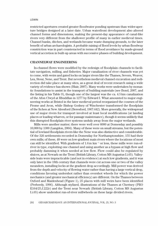
SOIL EROSION AND FLOODPLAIN SEDIMENTATION
An almost ubiquitous impact of medieval human activity on floodplains in Britainwas the accelerated input of soil erosion materials. This formed part of a transfer sys-tem also involving hillslope erosion and gullying, and considerable colluvial accumu-lation in footslopes and headwaters (cf. Lang & Bork, 2006). The process would notexactly have been unknown to medieval people; Davies (1968:47) cites BartholomaeusAnglicus, an English Franciscan writing ca. 1250, as an early proponent of denuda-tion concepts. While a decrease in crop yields in medieval times has been reported,direct measures of soil loss on hillslopes are not easy to come by, though thin soilsand linear rill patterns conforming to the patterns of ridge and furrow systems canbe observed in places on imagery obtained under drought conditions. Brown (2009)has reported on truncated soil profiles on valley slopes together with thicknesses ofcolluvial materials and minor valley fills in a relatively low-relief area nearNorthampton at Raunds. Here there has been extensive archaeological field surveyand excavation (Parry, 2006). On the “champion” plowlands of the English Midlands,such plowing is believed to have had a deliberate drainage role. But drainage alsomeant erosion, particularly on steeper slopes. What amounted to an artificial exten-sion of rill and headwater networks could be very large scale. Ridges could rise ameter higher than furrows, with individual strips averaging 7 by 180 meters in theMidlands, with examples that were much longer. They could run up and down slopeunless the slope was very steep, draining directly into watercourses or assisted byditches and trenching (Hall, 1982, 1999).
Arable cultivation came to extend without much of a break across many rurallandscapes. Extra ploughland was added through woodland assarting in previouslymarginal terrain, while the frequency of cultivation (and so the amount of soil expo-sure after plowing) also appears to have increased through the medieval period untilthe early 1300s. It is not easy to determine the exact extent and timing of clearance,

GEOARCHAEOLOGY: AN INTERNATIONAL JOURNAL, VOL. 25, NO. 3
MEDIEVAL ENVIRONMENTAL IMPACTS AND FEEDBACKS
295
and there is evidence both of woodland management and of areas of extensive wild-wood remaining (Rackham, 1986). But what has been described as “the coloniza-tion of Northamptonshire” involving extensive assarting was incidentally recordedin post-Conquest documents from Peterborough Abbey (King, 1973:Chapter 4).Similar clearance and cultivation took place on the extensive estates of the Bishopricof Worcester (Dyer, 1980:Chapter 4). Here and elsewhere this was being achieved byox-drawn mould-board plow teams that had considerably more impact than the ear-lier scratch (ard) plow. A review of what are often debatable matters concerningthe nature and timing of settlement and cultivation practices in the medieval periodis provided by Williamson (2003), with a pertinent consideration of marginal culti-vation by Hatcher and Bailey (2001:33–43). “Marginality” is generally viewed inremoteness and fertility terms, but land colonization also came to involve moreerodible terrains, with direct topsoil loss being a likely additional factor in fertilitydecline.
The amount of sediment reaching larger floodplains depended on the sediment-transfer coupling between eroding slopes, colluvial and minor valley deposition, andthe major floodplains themselves (Brown, 1987b; Hoffmann et al., 2009). Mills and fishponds on small tributary streams appear to have trapped a proportion oferoded materials. On major floodplains, overbank sedimentation was under way inthe earlier Holocene (Brown, 1983, 1987a; Brown & Keough, 1992; Lewin, Macklin, &Johnstone, 2005), but recent research suggests that in many places the bulk of itcame much later. Following earlier work (Robinson & Lambrick, 1984), Robinson sug-gested for the Upper Thames an average of 0.5 mm yr�1 of floodplain deposition inthe Roman period, slackening to 0.2 mm yr�1 between A.D. 400 and about A.D. 800,and then rising again to perhaps 0.5 mm yr�1 again until 1400 or so (Robinson, 1992;Booth et al., 2007). In the Nene valley medieval deposition was also extreme, with2 m of alluvial clay over Late Saxon or early medieval ridge-and-furrow (Robinson,1992). Alluvial clay content was probably exacerbated in the Midlands north ofAnglian/Wolstonian glaciation limits. Glacial clay deposits from early glaciationextended south to the London Basin, but because of later valley incision (thoughlong before the Holocene) they are now found capping upper slopes and interfluves.These steeper fringes, the ones later settled and plowed, were greatly affected bymedieval woodland assarting. It was the accelerated transfer from these marginal ter-rains to floodplains that was probably most responsible for their volume and clay con-tent as well as the input of finer components from upper soil horizons in general. Itis ironic that the colonizing Cistercians, energetically extending their plowlands andassarting woodlands, probably had to live with some of the sedimentation conse-quences at their monastic precincts in valley-bottom locations. Elsewhere, the newlyassarted claylands were in valley-floor lowlands, on Lias, Oxford, Wealden, Gault, orLondon Clays, and at lower slope angles may have been less of an erosion problem.
A broad-scale recent survey (Figure 8) suggests widespread and rapid medieval(11th to 14th centuries) sedimentation at rates that could be ten times earlier Holocenerates (Macklin, Jones, & Lewin, 2010). Overall, a suggested medieval peak for Holocene soil:alluvium transfer in Britain is consistent with many European studies (Becker &Schirmer, 1977; Schirmer, 1995; Coltori, 1997; Bertram, 2004; Lang & Bork, 2006;
Dotterweich, 2008; Enters, Dörfleer, & Zolitchka, 2008; Hoffmann et al., 2009), somedemonstrating distinct sedimentation units, as in the Older Meadow Loam ofHagedorn and Rother (1992). An order-of-magnitude increase in sedimentation hassimilarly been suggested following the introduction of Euro-American cultivationin 19th-century America (Trimble, 1983, 1999; Knox, 2006). Walter and Merritts (2008)attributed the trapping of such sediment in the narrow valleys of the eastern UnitedStates to valley-wide mill dams, which accumulated a wedge of sediment behindthem. This may apply in narrow valleys in Europe, but on floodplains dams werenot valley-wide, and the system of water control in larger valleys was different.Walter and Merritts recognize but place lesser emphasis on accelerated soil erosionas the source of sediment in the first place. Elimination of wetlands by overbanksedimentation in Europe (at an earlier date) does, however, appear to have achievedmuch the same effect. This significant change had a considerable impact on thephysical landscape and the purposes for which it could be used.
Modern studies for predicting soil erosion loss range from empirically based tophysical models (Lane, Shirley, & Singh, 1988), but probably the most used still areversions of the empirical Universal Soil Loss Equation, which expresses loss (A) interms of rainfall/runoff (R), soil erodibility (K), slope length (L) and steepness (S),the vegetation cover (C), and cropping practice (P):
A � RKLSCP
Conceived in such multifactorial terms, medieval soil loss is likely to have variedconsiderably given the range in soil materials, slopes, and agricultural practices
LEWIN
GEOARCHAEOLOGY: AN INTERNATIONAL JOURNAL, VOL. 25, NO. 3296
00
2
4
6
8
10
12
14
2000 4000 6000
Age of dated sample (cal. BP)
y � 216.8582x �0.7044
R2 � 0.4429y � 326.8748x �0.7940
R2 � 0.8384
Dated samples from upland glaciated catchmentsDated samples from lowland unglaciated catchmentsRegression on upland glaciated dataRegression on lowland unglaciated data
Mea
n se
dim
enta
tion
rate
(m
m y
r�1 )
8000 10000 12000
Figure 8. Mean sedimentation rates based on 14C-dated overbank sediment depth (modified from Macklin,Jones, & Lewin, 2010).
GEOARCHAEOLOGY: AN INTERNATIONAL JOURNAL, VOL. 25, NO. 3
MEDIEVAL ENVIRONMENTAL IMPACTS AND FEEDBACKS
297
involved. The thinner, calcareous, and stonier soil sources of chalk and limestone ter-raines contrast with the glacial clay “champion” plowlands of the Midlands, and thegentler slopes on sandy tills and other glacial deposits in Norfolk. In this respect itis interesting to note that Williamson (2003), in his terrain-based consideration of set-tlements and agriculture in eastern England, remarked on the distinctly peaty valleyfloors of East Anglia. Earlier wetlands here do not appear to have been so thickly blan-keted by deposits from medieval soil erosion, despite the dense settlement and cultivation of clay and loam soils around them (for the larger-scale Norfolk Broadpeatlands, see also Lambert et al., 1960). This contrasts with the situation in theThames valley (Dodd, 2003; Booth et al., 2007; Parker et al., 2008). Chalk downlandselsewhere, although showing evidence of earlier anthropogenic soil erosion and col-luvial deposition, unsurprisingly do not appear later on to have delivered the markedacceleration in alluvial deposition arising elsewhere from medieval arable cultivation(Favis-Mortlock, Boardman, & Bell, 1997; French & Lewis, 2005; Collins et al., 2006).Catchments with a capping of loess, a wind-blown sediment that carpeted southernEngland during the last glaciation (Catt, 1977), produced more permeable soils andthicker silty floodplain materials (Burrin & Scaife, 1984), some the so-called brick-earths. Redeposited loess in alluvial silts, much from an earlier period, may alsohave eroded soil and till components as well (Gibbard, Wintle, & Catt, 1987; Rose et al., 1999). But the most liable to medieval erosion must surely have been theMidlands plateau and valley-crest pelosols (slowly permeable clayey soils)—onsteeper slopes, not lacking in nutrients but liable to waterlogging, and surface-drained by the ridge and furrow systems created across slopes by cumbersomeeight-ox plow teams extending tillage to the limits. The plowing could require care-ful timing: not when the ground was waterlogged, nor set hard when dry. The his-tory of settlement in this region is presented by Lewis, Mitchell-Fox, and Dyer(2001), while clay soil variability and cultivation is fully discussed by Williamson(2003), though neither discusses erosion and sediment transfer. In the context ofmeadow land availability, Williamson (2003:169–173) has emphasized the regionalvariability of English floodplains and their soils. These range from broad Midlandvalleys with seasonally waterlogged conditions, to narrower and sometimes driervalley floors, to the peaty and channel-divided floodplains of East Anglia and theLondon Basin, where little alluvial meadowland was available at all. Environmentalcontrasts were present long before the medieval period, but the suggestion madehere is that modified characteristics emerged following agricultural activities withinthe medieval period itself.
Modern studies of floodplain deposition show spatially variable rates, which areespecially high on levee backslopes (near the channel) and in pond depressions(Simm, 1995), while channel-edge fine-grained vertical accretion can be higher still(Rumsby, 2000). Given the easy overbank dispersal of fine soil-derived materials,the general tendency was to even out floodplain relief, as in the case of infilled deadchannels and wetlands, depositing any slightly coarser materials alongside the chan-nels, as in the inactive meandering model of Table II. The detail of medieval flood-plain relief at specific times is difficult to assess. The bounds given in Anglo-Saxoncharters commonly rely on landscape elements, and among these are rare mentions

LEWIN
GEOARCHAEOLOGY: AN INTERNATIONAL JOURNAL, VOL. 25, NO. 3298
of floodplain marsh, river cliff, pools, and islands as well as weirs and fords (Hooke,1990). But these tend to be more specific away from main rivers, along whichboundaries were clear enough. For the large Yorkshire Ouse, the only way to getfrom Airmyn to Ousefleet during floods in 1362 was along the river bank (Beresford,1967:521), which implies a levee of some kind. Sedimentological evidence is moregeneral. Overall on the lower Severn, alluvial soil types show a gradation fromsilty levee sediments to clay gleys, waterlogging in ponded areas, and a topographicgradient away from the river (Lewin, 1982). On the upper Severn near Welshpoola considerable thickness of fine sediment accumulated quite widely (Jones, Macklin,& Lewin, in press). This contrasts with domination by narrower mineral-sediment raised levees in the major wetlands where river sedimentation was relativelyrestricted laterally.
Contemporary process studies combine direct observations from sediment trapsand post-flood survey with the use of recent marker horizons involving metal pollu-tants and radioactive fallout (Walling, He, & Nicholas, 1996; see Rumsby, 2000:TableI, for comparative figures). Data for Figure 8 covering a longer period derive fromsingle-site 14C-dated buried organic materials. This means that the figures have tobe treated with some caution because dated organic materials are best preserved inpondage locations where sedimentation rates are high. Nevertheless, the quite evenspread and thickness of post-Saxon overbank sediments is considerable, and thistransformed floodplain morphology. Some indication of this is provided by the half-buried appearance of the earliest arches (many were later raised) of some survivingmedieval bridges (Table VII). Other early bridges have, of course, been lost or mod-ified, while some (especially in northern England) had high arches, but in the EastMidlands a combination of longevity, design, and post-construction soil erosion anddeposition seems likely to have contributed to present-day sunken appearances.Deposited material was also transferred beyond river valleys out across fenland mar-gins (French & Heathcote, 2003) and into the major saline estuarine environmentsof southern England (the Thames, Severn, Humber, and Wash), where early reclaimedland may be found buried under alluvium (Cook & Williamson, 1999).
Figure 9 summarizes the floodplain transformations that occurred. Where it hap-pened, sedimentation smoothed floodplain relief, up to a point improving floodplainsoils and meadow (with a greater depth of fine material, and nutrient input), butparticularly with clay sediments also retaining flood inundation and ponding rightacross floodplain surfaces rather than having a paleochannel network available fordrainage. While organic wetlands got buried, the soil itself showed increased water-logging and gleying where clay sediments were involved. The amount of floodplaindeposition varied regionally (because of catchment slope and soil conditions, catch-ment size, and the nature of cultivation), but further data allowing standardizedquantitative comparison is required. It is perhaps also worth noting that meadowlandwas often in short supply, but that what may be called floodplain meadows wereactually on floodplain (terrace) gravels, as at Yarnton near Oxford, rather than strictlyon the wetlands and fine alluvial fills of the bottomlands (see, for example, Booth et al., 2007). In this context, soil redeposition was a significant means of

GEOARCHAEOLOGY: AN INTERNATIONAL JOURNAL, VOL. 25, NO. 3
MEDIEVAL ENVIRONMENTAL IMPACTS AND FEEDBACKS
299
Table VII. Surviving medieval bridges in the East Midlands.
Grid Ref. Date General Character
Nene
Ditchford* SP9368 early 14 c. 6 arches, 3 more in both approachesIrthlingborough SP9570 14c. 19 arches, later widened, insc. “1668”Thrapston* SP9978 ? 9 arches (Leland 8), damaged in 1795 flood.
Pontage 1369, 1373, 1377, 1382, 1385, 1388, 1392.Wansford* TL 0999 14 c. 12 arches, semicircular, insc. “PM1577.” 3 rebuilt
1672–4. Hollinshead reported 3 arches destroyedin 1571 tempest. Pontage 1333, 1334, 1337, 1340,1357, 1363, 1369.
Welland
Wakerley* SP9599 5 arches, widened, 18 c. insc. “TS 1793”Duddington* SK9900 4 pointed arches
Great Ouse
Huntingdon TL2471 c.14 c. 6 arches, 1 earlier* (bridge present in 1194).Pontage 1279, 1344, 1356.
St.Ives TL3271 c.14 c. 6 arches, 1 pointed Great Barford* TL1452 ca. 1440 15 arches, later widened* Buried arch springers.Sources: Jervoise (1932); Harrison (2004); Pevsner (1973); Cooper (2006).
Increased finesediment input
Channeldimension change
Capacitydecrease
W/D ratiochange
Accelerated overbanksedimentation
Relief infillingwith a diffuse
inundation pattern
Increased flooding.Flood embankments.
Continuous causeways.
Crossing/bridge design change.Single, deeper channels.
Ford submergence.
Channelpattern change
Single, morestable channels
Figure 9. The impacts of accelerated soil erosion on floodplain environments.
meadowland extension into valley-floor wetlands that were not so suited in earliestmedieval times.
Soil redeposition had other effects. Channel dimensions were also likely to havechanged, with deeper narrower channels (Brown & Keough, 1992), as would beexpected with this change in bank materials. It is also possible that channel dimensions

LEWIN
GEOARCHAEOLOGY: AN INTERNATIONAL JOURNAL, VOL. 25, NO. 3300
20 10
Distance above Severn confluence (km)
Recurrence interval (years)
of flood discharges at Llanymynech
0
10
5
3
2 1.51.01
0
100
200
300
Est
imat
ed c
hann
el fu
ll di
scha
rge
(m3
s�1 )
434Williams (1978) equation
Manning equation (n � 0.03)
Figure 10. Down-channel decrease in channel discharge capacity on the River Vyrnwy (SJ 31) (fromLewin, 1987).
adjusted to take a smaller proportion of extreme flood discharges (Hey, 1975; Lewin,1987). Both on the Severn and on the lower Vyrnwy (Figure 10), channel capacity fallsdownstream without effective change in discharge as bank materials get finer and val-ley gradient declines, an effect that is also seen elsewhere (Lewin, 1989). All this couldactually have led to increased overbank flooding as channels and floodplains weretransformed, even without any change in climatically determined flood regime.
Discussions of a probable later medieval decline in the navigability of Englishrivers have explored the contrasting pictures gained from different documentarysources. Explanations for decline have reasonably focused on obstruction by mills,weirs, and fisheries (Edwards & Hindle, 1991; Langdon, 1993; Jones, 2000; Booth et al., 2007). It does seem unlikely that the major navigable rivers were seriouslytroubled by an extra clay and silt load. Yet it is interesting that medieval sedimenta-tion or the need for “cleansing” was reported from the Lea, Foss Dyke, and Nene atStamford, while early development and use of the upper Thames for navigation(including the excavation of canals) seems to have declined (Jones, 2000; Blair,2007). In Nottinghamshire in the early 14th century, tributaries of the Trent alsoneeded “to be cleaned out, as the lands of the king, and of others in those parts, arefrequently flooded” (Calendar of Patent Rolls, Edward II ii, Feb. 20, 1316). The evi-dence does not suggest that sedimentation was overall a major cause for a declinein navigability on larger rivers, but an increased fine sediment load cannot havehelped on smaller low-energy ones, especially when trapped behind weirs and thelike. Low-energy river channels are especially liable to blockage by trees, logjams,and macrophyte plants which trap sediment (Gurnell et al., 2009; Sear et al., 2009).Sedimentation was also a major problem in low-energy tidally dominated rivers with

GEOARCHAEOLOGY: AN INTERNATIONAL JOURNAL, VOL. 25, NO. 3
MEDIEVAL ENVIRONMENTAL IMPACTS AND FEEDBACKS
301
a consequent relocation of harbors and the development of outports, as in coastalKent and Sussex, or at Chester.
A final effect, in addition to changes in flooding and floodplain relief and of chan-nel dimensions, concerns channel patterns. A gradual Holocene decline in the num-ber of anabranches has been reported by Brown and Keough (1992), and a moreabrupt pattern transformation from anastomosing to single-channel meandering byJones, Macklin, and Lewin (in press). We have seen that anastomosing patterns per-sisted in lowland locations right through the medieval period, but clearly minorslack-water channels and wetlands were impacted by deposition from high sus-pended sediment inputs, and liable to infilling (Brown, 2009). As has been discussedabove, where such channels were being used, and flows impeded, there would beadditional channel maintenance problems caused by higher fine sediment loads.Ultimately, and possibly inadvertently, this use contributed to the increasing domi-nance of single- rather than multichannel (anastomosing) systems. Similar post-settlement channel change patterns in more recent times have been reported post-1820 in Australia (Johnston & Brierley, 2006) and since the 1600s in the UnitedStates (Walter & Merritts, 2008). Geomorphological contexts do vary: Accelerated soilerosion in medieval Italy led to a change from meandering to braided channel styleon actively incising rivers (Coltori, 1997), and also to braiding on Polish rivers in thelast two centuries prior to channel control (Starkel, 1982).
COPING WITH CONSEQUENCES
For practical travel, there are three levels of challenge in crossing rivers and flood-plains. Can the channel be forded at lower flows, can it be bridged at all but over-bank flood times, and is it possible to traverse the wider floodplain without gettingbogged down? Fording would have been affected not just by more frequent high-flow conditions, but also by changes to channel dimensions (narrowing and deep-ening), and by increasingly muddy waters. Fine sediment gets deposited in-channelas floodwaters recede, and this can leave a slippery and treacherous surface at chan-nel margins until washed away by rain into the riverbed or until it dries out. Givenalso a medieval shift from oxen to the use of more vulnerable carts and horses(Langdon, 1986), fording must have become increasingly impractical—because of themud, and not just because of floods. The mud may also have been a factor in delay-ing the use of horses for plowing and haulage in vulnerable terrains (see Langdon,1986:255–257), as well as affecting aquatic ecosystems and fish stocks throughincreased stream turbidity (Hoffman, 1996).
For river crossing, and despite the cost of building and maintenance, bridgingcertainly became the preferred alternative from late Saxon times onward (Harrison,2004). Increasing prosperity and trade, and resources for arch-bridge technology instone as well as timber construction, made this desirable and possible for year-longpassage. Surviving structures show that medieval bridges were widened and raised,largely to cope with both road and river traffic, but possibly in some cases alsobecause of partial submergence in sediment.
LEWIN
GEOARCHAEOLOGY: AN INTERNATIONAL JOURNAL, VOL. 25, NO. 3302
But why was raised floodplain causeway bridging (Figure 7, Table VI) seen asdesirable? Though variable, overbank flows are usually taken to occur about onceevery year or two (Lewin, 1989), and this should not have been disabling if theroadbed was firm or paved or there was a Roman-style agger. There are records ofmaintenance being done, for example, to the causeway on the River Lea between Bowand Stratford “to take sand and gravel at certain places in the said highway and tocarry the same to other places less deep and therein to make a dry way for those pass-ing” (Calendar of Patent Rolls, Edward II ii, Jan. 3, 1317). “Caused ways” of this kindwere commonplace, and not all of them were raised or major feats of medieval engi-neering. But we should perhaps think of earlier floodplains as more like permanentwetlands in which it was not only a single channel that needed to be crossed. At thebeginning of the medieval period, many lowland floodplains were not “plains” butpatchworks of drier gravel islands (bar complexes from prior Pleistocene braidedrivers) between multiple-channel anastomosing river belts with reed beds in oldchannels and swampy interchannel and valley-margin depressions. Timber crossingstructures in early river wetlands are being discovered in increasing numbers (e.g.,Siddell, 2003). Things became different but not necessarily an unalloyed improvementif the floodplain became more impermeable and blanketed with clay-rich sedimentso that waters did not drain, and if overbank inundation became much more fre-quent. If medieval floodplains were being submerged more persistently by pondedand flowing water than previously (or under present-day conditions), then the needfor high-rise causeways becomes clearer. The clay content of Midland floodplainsderived from eroded glacial deposits has already been noted. It may be suggested,therefore, that an extra impetus was added to commercial expansion for both bridgebuilding and raised causeway construction. This came partly from a floodplain topog-raphy no longer visible to us, and partly from the transformations previously broughtabout—a narrowing of channels and the floodplain deposition of eroded soil mate-rial. The positive advantage of this for later generations was the increased potentialof flatter floodplains with deep soils for summer hay pasture and watermeadows, par-ticularly if erosion intensity and inundation frequency eased.
Buildings on floodplains for the most part simply had to put up with flooding oradapt in relatively minor ways, as in the case of raising the floor of Bordesley Abbey(Aston, 2000). By contrast, Abbot Martin at Peterborough shifted his dependent set-tlement from a flood-prone site to a location on the west of the abbey in the 12th cen-tury, while Abbot Godfrey had a bridge built over the Nene in 1308 at the hythe,which was a distance from the former crossing (Steane, 1974). In modern termsthese could come under the heading of alternative strategies for flood mitigation.Some monasteries relocated because of flood problems (Williams, 1998:146, 182).Complaints about medieval flooding have been commonly recorded; this was seenas a manifestation of divine judgment, and sometimes personal misfortune or culpa-bility, as much as anything else. Medieval flood embankments do not appear to havebeen systematically studied for their own sake, but many monastic precincts hadbanks that were extra to their fishpond, moat, and ditch systems, and it would be inter-esting to know how much of this was in response to a developing need for flood

GEOARCHAEOLOGY: AN INTERNATIONAL JOURNAL, VOL. 25, NO. 3
MEDIEVAL ENVIRONMENTAL IMPACTS AND FEEDBACKS
303
defense. Mills, monastic or otherwise, were particularly vulnerable, as would beexpected.
Some of the problems associated with medieval floodplains were inadvertentlysolved in the years after the Black Death (1348–1350, with subsequent fresh out-breaks). Rural depopulation, a lessening in cultivation intensity, the conversion ofarable land to pasture, and field enclosure—these all amounted to soil conservationpractices. Soil accumulation behind post-enclosure hedges and banks bears wit-ness to the fact that, while some soil erosion continued, sediment delivery to flood-plain rivers was being impeded. Given a decline in sediment yield, it is likely thatriver incision rather than sedimentation took place, as has happened in the more fullydocumented aftermath of Euro-American agricultural impact in the United States(Trimble, 1999; Knox, 2006). There is evidence of post-medieval incision on uplandrivers in Britain (Macklin & Lewin, 1986; Hooke et al., 1989; Taylor & Lewin, 1996;Howard et al., 1999; Rumsby, 2000). Here a thicker unit of medieval deposition capsthe sediments of terraces now at a higher level than actively migrating rivers.Possible post-medieval channel enlargement in lowland England or Wales has yetto be fully investigated. When rivers do incise, this may decrease the frequency ofoverbank inundation, with feedback effects involving increased in-channel veloci-ties and scour of a deepening channel (Wyzga, 2001). In the United States, laterincision through thick fine-sediment units retained by cross-valley mill dams has beensuggested as a means of enhancing stream power in the deepening channels, thuseroding right through to earlier Pleistocene gravels beneath (Walter & Merritts,2008). In such circumstances in Europe, new but now less frequently inundatedtabular floodplain fills could be used and crossed with greater impunity in post-medieval times. The next widespread perturbation to affect lowland floodplainswas perhaps less the responsibility of human activity and more the effect of floodsand icing related to the climates of the so-called Little Ice Age (Rumsby & Macklin,1996, Macklin & Rumsby, 2007).
CONCLUSIONS
This paper has examined the workings of the “natural” floodplain environmentsin which medieval people lived, built, and worked. Even in lowland England, theseprovided quite variable opportunities for human use—whether for defendable urbansites, as terrains to get across, as single or multiple channels to use, or as land to cul-tivate. It is suggested that urban and agrarian entrepreneurial activities impactedand transformed the floodplain environments that were being made use of—not justintentionally, but also inadvertently and in several different respects. Economic andsocial development had interactive effects on river systems, and these in turnimpacted on development requirements (Figure 11). Medieval conditions have beenphysically obscured and overlain by later developments, and perhaps conceptuallybecause of a limited awareness of the variability and dynamics of the physical envi-ronment. The challenges and opportunities that were presented in medieval timesneed to be teased out for what they once were. And even then, rivers and floodplains

LEWIN
GEOARCHAEOLOGY: AN INTERNATIONAL JOURNAL, VOL. 25, NO. 3304
Economic/socialdevelopment
Developmentresponses
• Suburban extension• Monastic building• Elite landscaping• Agricultural intensification• Mill construction• Navigation and fisheries development• Transport and travel
• Bridges• Flood embankments• Flood plain causeways• Channel engineering• Floodplain meadowland exploitation
The catchment
The channeland floodplain
• Soil erosion, accelerated sediment yield• Runoff increase (from field drainage)• Wetland reclamation
• Flow-constricting structures• Ford submergence• Enhanced overbank sedimentation• Increased flooding• Channel capacity and W/D change• Channel activity and pattern change• Pool and channel excavation• Meadowland extention
Unintendedimpacts
Figure 11. Interrelationships between medieval economic and social development and fluvial systems.
were far from “natural”; they were on the change, responding to the pursuits of urbanand agrarian societies.
Emphasis has also been placed on rivers and floodplains as being sediment-conveying as well as water-discharging systems. It is the combination which determinesfloodplain and channel styles, including the dimensions and number of channels, thequality of fords, and the ease with which floodplains can be crossed or cultivated.Sediments are crucial, and it is too simple to think of floodplains as places passivelyliable to floods which just might be more or less frequent on average over centuries-long climatic “periods.” It was into quite complex spatial and temporal fluvial sys-tems that medieval activities entered, in turn producing transformations throughurban and roadway building, channel engineering, and agricultural activity. Whatwe now see by way of rivers and wetlands is not what medieval people saw, anymore than contemporary riverside perceptions involving summer recreation andwinter hazard get near appreciating the multifaceted resource and challenge riversand floodplains represented in medieval times.
Clearly, human endeavors have many causes which may be viewed historicallyfrom a variety of social, economic, political, and technical perspectives. Using his-torical and archaeological evidence, past human activities have been extensivelyexplored in such ways, and archaeologists have understandably recoiled from the

GEOARCHAEOLOGY: AN INTERNATIONAL JOURNAL, VOL. 25, NO. 3
MEDIEVAL ENVIRONMENTAL IMPACTS AND FEEDBACKS
305
cruder horrors of environmental determinism in interpreting designed landscapes andtheir contents. This paper has sought to supplement (not to replace) these interpre-tations with a parallel geomorphological perspective, figuratively speaking explor-ing what happened following the spread of mud and mortar into a dynamic geomorphological environment. Environmental processes were altered by the devel-opments that took place, varying opportunities were provided, and with transfor-mations further innovations and changes were instigated.
In a pious age, this would all have been viewed very differently. People commonlybelieved that in a decayed world they were (to use an interesting word) “reclaiming”wilderness back into its previous and properly cultivated state, as it had been beforethe Fall. It was wild savagery that was thought to have pushed back the boundaryof the cultivated world, not the other way round. But at the same time, and althoughfloodplains as a resource were appraised differently, what happened to them alsoinvolved harbingers of modernity, which has its own level of environmental insou-ciance, with embankment-protected urban landscapes linked by communicationlines cobwebbing indifferently across the intervening workspace of an industrial-ized agriculture. For contrasting reasons in both the medieval and the modern, regardfor the consequences and hazards involved in development across variably dynamicenvironments has been patchy. This is a (post)modern perspective, but the themesof site adaptation, and environmental impact and feedback, do sit comfortably withwhat is now known actually to have happened to the medieval floodplains of low-land England and Wales.
I thank Antony Smith (Aberystwyth) and Nick Scarle (Manchester) for producing the figures, and MarkMacklin for constructively reading the text and many conversations on its theme. I am grateful to JamieWoodward and the external reviewers, Andy Howard and Evan Jones, who improved the paper withmany useful suggestions.
REFERENCES
Alberti, L.B. (1755). The ten books of architecture (J. Leoni, Trans., 1987). New York: Dover.Astill, G.G. (1993). A medieval industrial complex and its landscape: The metalworking watermills and
workshops of Bordesley Abbey. York: CBA Research Report 92.Aston, M. (Ed.). (1988). Medieval fish, fisheries and fishponds in England. Oxford: British Archaeological
Reports, British Series, No. 182.Aston, M. (2000). Monasteries in the landscape. Stroud: Tempus Publishing.Baker, N., & Holt, R. (2004). Urban growth and the medieval Church: Gloucester and Worcester. Aldershot:
Ashgate.Barley, M.W. (Ed.). (1976). The plans and topography of medieval towns in England and Wales. CBA
Research Report No. 14.Becker, B., & Schirmer, W. (1977). Palaeoecological study on the Holocene valley development of the
River Main, southern Germany. Boreas, 6, 303–321.Beresford, M. (1967). New towns in the Middle Ages. London: Lutterworth Press.Beresford, M.W., & St. Joseph, J.K.S. (1958). Medieval England: An aerial survey. Cambridge: Cambridge
University Press.Bertram, P. (2004). Soil erosion in small catchments of the Quercy region (southwest France) during the
Holocene. The Holocene, 14, 596–606.Bisson, T.N. (2009). The crisis of the twelfth century. Princeton, NJ: Princeton University Press.

LEWIN
GEOARCHAEOLOGY: AN INTERNATIONAL JOURNAL, VOL. 25, NO. 3306
Blair, J. (Ed.). (2007). Waterways and canal-building in medieval England. Oxford: Oxford University Press.Bond, J. (2007). Canal construction in the early Middle Ages: An introdutory review. In J. Blair (Ed.),
Waterways and canal-building in medieval England (pp. 254–286). Oxford: Oxford University Press.Booth, P., Dodd, A., Robinson, M., & Smith, A. (2007). The Thames through time: The archaeology of the
gravel terraces of the Upper and Middle Thames. Oxford: Oxford Archaeology, Thames Valley LandscapeMonograph No. 27.
Brewer, P.A., & Lewin, J. (1998). Planform cyclicity in an unstable reach: Complex fluvial response toenvironmental change. Earth Surface Processes and Landforms, 23, 989–1008.
Brice, J.C. (1984). Planform properties of meandering rivers. In C.M. Elliott (Ed.), River meandering (pp. 1–15). New York: American Society of Civil Engineers.
Brown, A.G. (1983). Floodplain deposits and accelerated sedimentation in the lower Severn basin. In K.J.Gregory (Ed.), Background to palaeohydrology (pp. 375–397). Chichester: Wiley.
Brown, A.G. (1987a). Holocene floodplain sedimentation and channel response of the lower River Severn,United Kingdom. Zeitschrift für Geomorphologie, NF 31, 293–310.
Brown, A.G. (1987b). Long-term sediment storage in the Severn and Wye catchments. In K.J. Gregory, J. Lewin, & J.B. Thornes (Eds.), Palaeohydrology in practice (pp. 307–332). Chichester: Wiley.
Brown, A.G. (1997). Alluvial geoarchaeology. Cambridge: Cambridge University Press.Brown, A.G. (1998). Fluvial evidence of the Medieval Warm Period and the Late Medieval climatic dete-
rioration in Europe. In G. Benito, V.R. Baker, & K.J. Gregory (Eds.), Palaeohydrology and environ-mental change (pp. 43–52). Chichester: Wiley.
Brown, A.G. (2008). Geoarchaeology, the four dimensional (4D) fluvial matrix and climatic causality.Geomorphology, 101, 278–297.
Brown, A.G. (2009). Colluvial and alluvial response to land use change in Midland England: An integratedgeoarchaeological approach. Geomorphology, doi:10.1016/j.geomorph.2007.12.021.
Brown, A.G., & Keough, M.K. (1992). Holocene floodplain metamorphosis in the Midlands, United Kingdom.Geomorphology, 4, 433–445.
Brown, A.G., Cooper, L., Salisbury, C.R., & Smith, D.N. (2001). Late Holocene channel changes of the mid-dle Trent: Channel response to a thousand year flood record. Geomorphology, 39, 69–82.
Brown, C. (1904). A History of Newark-on-Trent (republished 1995). Nottingham, UK: NottinghamshireCounty Council.
Burrin, P., & Scaife, R. (1984). Aspects of the Holocene valley sedimentation and floodplain developmentin southern England. Proceedings of the Geologists’ Association, 95, 81–96.
Campbell, B.M.S., & Bartley, K. (2006). England on the eve of the Black Death: An atlas of lay lordship,land and wealth, 1300–49. Manchester: Manchester University Press.
Carver, M.O.H. (Ed.). (1980). Medieval Worcester: An archaeological framework. Worcester:WorcesterArchaeological Society, Third Series, No. 7.
Catt, J.A. (1977). Loess and coversands. In F.W. Shotton (Ed.), British Quaterary studies (pp. 222–229).Oxford: Oxford University Press.
Challis, K. (2004). Drowned in “a whyrlepytte”: The River Trent in the Nottinghamshire coroners’ inquestsof 1485–1558. Transactions of the Thoroton Society of Nottinghamshire, 108, 115–123.
Chandler, J. (1993). John Leland’s itinerary: Travels in Tudor England. Stroud: Sutton Publishing.Collins, P.E.F., Worsley, P., Keith-Lucas, D.M., & Fenwick, I.M. (2006). Floodplain environmental change
during the Younger Dryas and Holocene in Northwest Europe: Insights from the lower Kennet Valley,south central England. Palaeogeography, Palaeoclimatology, Palaeoecology, 233, 113–133.
Coltori, M. (1997). Human impacts in the Holocene fluvial and coastal evolution of the Marche region,Central Italy. Catena, 30, 311–335.
Cook, H., & Williamson, T. (1999). Water management in the English landscape. Edinburgh: EdinburghUniversity Press.
Cook, H., & Williamson, T. (2007). Watermeadows. Windgather Press: Macclesfield.Cooper, A. (2006). Bridges, law and power in medieval England 700–1400. Woodbridge: Boydell Press.Cooper, L.P. (2003). Hemington Quarry, Castle Donington, Leicestershire, UK: A decade beneath the allu-
vium in the confluence zone. In A.J. Howard, M.G. Macklin, & D.G. Passmore (Eds.), Alluvial archae-ology in Europe (pp. 27–41). Lisse: Bakema.

GEOARCHAEOLOGY: AN INTERNATIONAL JOURNAL, VOL. 25, NO. 3
MEDIEVAL ENVIRONMENTAL IMPACTS AND FEEDBACKS
307
Creighton, O. (2007). Town defences and the making of urban landscapes. In M. Gardiner & S. Rippon(Eds.), Medieval landscapes (pp. 43–56). Macklesfield: Windgather Press.
Creighton, O. (2009). Designs upon the land. Elite landscapes of the Middle Ages. Woodbridge, Suffolk:Boydell Press.
Creighton, O., & Higham, R. (2005). Medieval town walls. Stroud: Tempus Publishing.Darby, H.C. (1966). The drainage of the Fens, 2nd ed. Cambridge: Cambridge University Press.Darby, H.C., & Terrett, I.B. (Eds.). (1971). The Domesday geography of Midland England. Cambridge:
Cambridge University Press.Davies, G.L. (1968). The earth in decay. London: Macdonald Technical and Scientific.Defoe, D. (1724–6). A tour through the whole Island of Great Britain (P. Rogers, Ed., 1971). London:
Penguin.Delano-Smith, C., & Kain, R.J.P. (1999). English maps: A history. London: The British Library.Dodd, A. (Ed.). (2003). Oxford before the university. Oxford Archaeology: Oxford.Dotterweich, M. (2008). The history of soil erosion and fluvial deposits in small catchments of central
Europe: Deciphering the long-term interactions between humans and the environment: A review.Geomorphology, 101, 192–208.
Dyer, C. (1980). Lords and peasants in a changing society: The estates of the bishopric of Worcester680–1540. Cambridge: Cambridge University Press.
Dyer, C. (2003). Making a living in the Middle Ages: The people of Britain 850–1520. London: Penguin.Eckwall, E. (1960). The concise Oxford dictionary of English place-names, 4th ed. Oxford: Oxford
University Press.Edwards, J.F., & Hindle, B.P. (1991). The transportation system of medieval England and Wales. Journal
of Historical Geography, 17, 123–134.Enters, D., Dörfleer, W., & Zolitchka, B. (2008). Historical soil erosion and land-use change during the
last two millenium recorded in lake sediments of Frickenhauser See, northern Bavaria, central Germany.The Holocene, 18, 243–254.
Favis-Mortlock, D., Boardman, J., & Bell, M. (1997). Modelling long-term anthropogenic erosion of a loesscover: South Downs UK. The Holocene, 7, 79–89.
Ferguson, R.I. (1981). Channel form and channel changes. In J. Lewin (Ed.), British rivers (pp. 90–125).London: Allen and Unwin.
Ferguson, R.I. (1987). Hydraulic and sedimentary controls of channel pattern. In K. Richards (Ed.), Riverchannels: Environment and process (pp. 130–157). Oxford: Blackwell.
Flower, C.T. (Ed.). (1915). Public works in medieval law, Vol. 1. London: Seldon Society.French, C., & Lewis, H. (2005). New perspectives on Holocene landscape development in the southern
English Chalklands: The Upper Allen Valley, Cranbourne Chase, Dorset. Geoarchaeology, 20, 109–134.French, C.A.I., & Heathcote, J. (2003). Holocene landscape change in the lower Great Ouse valley,
Cambridgeshire, England. In A.J. Howard, M.G. Macklin, & D.G. Passmore (Eds.), Alluvial archaeol-ogy in Europe (pp. 81–92). Lisse: Balkema.
Gelling, M. (1984). Place-names in the landscape. London: Dent.Gibbard, P.L., Wintle, A.G., & Catt, J.A. (1987). Age and origin of clayey silt “brickearth” in west London,
England. Journal of Quaternary Science, 2 , 3–9.Glaser, R., & Riemann, D. (2009). A thousand-year record of temperature variations for Germany and
Central Europe based on documentary data. Journal of Quaternary Science, 24, 437–449.Gomez, B., Eden, D.N., Hicks, D.M., Trustrum, N.A., Peacock, D.H., & Wilmshurst, J. (1999). Contribution
of floodplain sequestration to the sediment budget of the Waipaoa River, New Zealand. In S.B. Marriott& J. Alexander (Eds.), Floodplains: Interdisciplinary approaches (pp. 69–83). London: GeologicalSociety of London Special Publications No. 163.
Greenwood, M., & Smith, D. (2005). Changing fluvial conditions and landscapes in the Trent valley: A review of palaeoentomological evidence. In D.M. Smith, M.B. Brickley, & W. Smith (Eds.), Fertileground: Papers in honour of Susan Limbrey (pp. 53–67). Oxford: Oxbow.
Gurnell, A.M., O’Hare, J.M., O’Hare, M.T., Dunbar, M.J., & Scarlett, P.M. (2009). An exploration of associ-ations between assemblages of aquatic plant morphotypes and channel geomorphological propertieswithin British rivers. Geomorphology, doi:10.1016/j.geomorph.2009.10.014.

LEWIN
GEOARCHAEOLOGY: AN INTERNATIONAL JOURNAL, VOL. 25, NO. 3308
Hagedorn, J., & Rother, N. (1992). Holocene floodplain evolution of small rivers in the uplands of LowerSaxony. Geomorphology, 4, 423–432.
Hall, D. (1982). Medieval fields. Ailsbury: Shire.Hall, D. (1999). The drainage of arable land in medieval England. In H. Cook & T.Williamson (Eds.), Water
management in the English landscape (pp. 28–40). Edinburgh: University Press.Harrison, D. (2004). The bridges of medieval England. Oxford: Clarendon Press.Harvey, P.D.A. (1993). Maps in Tudor England. London: Public Record Office & British Library.Hatcher, J., & Bailey, M. (2001). Modelling the Middle Ages. Oxford: University Press.Heath, G.R. (1994). Swarkestone Bridge and the Stanton Causeway. Derby: Wye Valley Press.Herget, J., & Meurs, H. (2010). Reconstructing peak discharges for historic flood levels in the city of
Cologne, Germany. Global and Planetary Change, doi:10.1016/j.gloplacha.2009.11.011.Hey, D. (1998). A history of Sheffield. Lancaster: Carnegie Publishing.Hey, R.D. (1975). Design discharges for natural channels. In R.D. Hey & T.D. Davies (Eds.), Science,
Technology and Environmental Management (pp.73–88). Farnborough, UK: Saxon House.Higham, M.C. (1989). Some evidence for 12th- and 13th-century linen and woollen textile processing.
Medieval Archaeology, 33, 38–52.Hindle, B.P. (1982). Medieval roads. Princes Risborough: Shire Publications.Hinton, D.A. (2000). The large towns 600–1300. In D.M.Palliser (Ed.), The Cambridge urban history of
Britain, Vol. 1: 600–1540 (pp. 217–243). Cambridge: Cambridge University Press.Hoffman, R.C. (1996). Economic development and aquatic ecosystems in Medieval Europe. American
Historical Review, 101, 630–669.Hoffmann, T., Erkins, G., Gerlach, R., Klostermann, J., & Lang, A. (2009). Trends and controls of Holocene
floodplain sedimentation in the Rhine catchment. Catena, 77, 96–106.Hooke, D. (1990). Worcestershire Anglo-Saxon charter-bounds. Woodbridge: Boydell Press.Hooke, J.M., Harvey, A.M., Miller, S.Y., & Redmond, C.E. (1989). The chronology and stratigraphy of the
alluvial terraces of the River Dane valley, Cheshire, NW England. Earth Surface Processes andLandforms, 15, 717–737.
Houben, P. (2008). Scale linkage and contingency effects of field-scale and hillslope-scale controls oflong-term soil erosion: Anthropogeomorphic sediment flux in agricultural loess watersheds of SouthernGermany. Geomorphology, 101, 172–191.
Howard, A.J., Macklin, M.G., Black, S., & Hudson-Edwards, K.A. (1999). Holocene river development andenvironmental change in Upper Wharfedale, Yorkshire Dales, England. Journal of Quaterary Science,15, 239–252.
Hudson-Edwards, K.A., Macklin, M.G., Finlayson, R., & Passmore, D.G. (1999). Medieval lead pollutionin the River Ouse at York, England. Journal of Archaeological Science, 26, 809–819.
Hughes, M.K., & Diaz, H.F. (1994). Was there a “medieval warm period,” and if so, where and when?Climatic Change, 26, 109–142.
Hyde, R. (1994). A prospect of Britain: The town panoramas of Samuel and Nathaniel Buck. London:Pavilion.
Jenkins, H.J.K. (1992). A survey of the River Nene in the reign of James I. Northamptonshire Past andPresent, 8, 2–28.
Jervoise, E. (1930). The ancient bridges of the south of England. London: Architecture Press.Jervoise, E. (1932). The ancient bridges of mid and eastern England. London: Architecture Press.Johnston, P., & Brierley, G. (2006). Late Quaternary river evolution of floodplain pockets along Mulloon
Creek, New South Wales, Australia. The Holocene, 16, 661–674.Jones, A., Macklin, M.G., & Lewin, J. (in press). Towards a run-of-floods UK Holocene alluvial history. The
Holocene.Jones, E.T. (2000). River navigation in medieval England. Journal of Historical Geography, 26, 60–82.Jordan, W.C. (1996). The Great Famine. Princeton, NJ: Princeton University Press.Keevill, G.D. (1992). Life on the edge: Archaeology and alluvium at Redlands Farm, Stanwick, Northants.
In S. Needham & M.G. Macklin (Eds.), Alluvial archaeology in Britain (pp. 177–183). Oxford: Oxbow.King, E. (1973). Peterborough Abbey 1086–1310: A study in the land market. Cambridge: Cambridge
University Press.

GEOARCHAEOLOGY: AN INTERNATIONAL JOURNAL, VOL. 25, NO. 3
MEDIEVAL ENVIRONMENTAL IMPACTS AND FEEDBACKS
309
Knighton, A.D., & Nanson, G.C. (1993). Anastomosis and the continuum of channel pattern. Earth SurfaceProcesses and Landforms, 18, 613–625.
Knox, J.C. (2006). Floodplain sedimentation in the upper Mississippi Valley: Natural versus human accel-erated. Geomorphology, 79, 286–310.
Lamb, H.H. (1995). Climate, history and the modern world, 2nd ed. Abingdon: Routledge.Lambert, J.M., Jennings, J.N., Smith, C.T., Green, C., & Hutchinson, J.N. (1960). The making of the Broads.
London: Royal Geographical Society.Lambrick, G. (1992). Alluvial archaeology of the Holocene in the Upper Thames Basin 1971–1991. In
S. Needham & M.G. Macklin (Eds.), Alluvial archaeology in Britain (pp. 209–226). Oxford: Oxbow.Lane, L.J., Shirley, E.D., & Singh, V.P. (1988). Modelling erosion on hillslopes. In M.G. Anderson (Ed.),
Modelling geomorphological systems (pp. 287–308). Chichester: Wiley.Lang, A., & Bork, H.-R. (2006). Past soil erosion in Europe. In J. Boardman & J. Poesen (Eds.), Soil
erosion in Europe (pp. 465–476). Chichester: Wiley.Langdon, J. (1986). Horses, oxen and technological innovation: The use of draught animals from 1066 to
1500. Cambridge: Cambridge University Press.Langdon, J. (1993). Inland water transport in medieval England. Journal of Historical Geography, 19,
1–11.Langdon, J. (2004). Mills in the medieval economy. Oxford: Oxford University Press.Large, A.R.G., & Petts, G.E. (1996). Historical channel-floodplain dynamics along the River Trent. Applied
Geography 16, 191–209.Latrubesse, E.M. (2008). Patterns of anabranching channels: The ultimate end-member adjustment of
mega rivers. Geomorphology, 101, 130–145.Lewin, J. (1982). British floodplains. In B.H. Adlam, C.R. Fenn, & L. Morris (Eds.), Papers in earth stud-
ies (pp. 21–37). Norwich: Geobooks.Lewin, J. (1987). Historical river channel changes. In K.J. Gregory, J. Lewin, & J.B. Thornes (Eds.),
Palaeohydrology in practice (pp. 161–175). Chichester: Wiley.Lewin, J. (1989). Floods in fluvial geomorphology. In K. Beven & P. Carling (Eds.), Floods: Hydrological,
sedimentological and geomorphological implications (pp. 265–284). Chichester: Wiley.Lewin, J., & Brewer, P.A. (2001). Predicting channel patterns. Geomorphology, 40, 329–339.Lewin, J., & Brewer, P.A. (2002). Laboratory simulation of clast abrasion. Earth Surface Processes and
Landforms, 27, 145–164.Lewin, J., & Brindle, B.J. (1977). Confined meanders. In K.J. Gregory (Ed.), River channel changes
(pp. 221–233). Chichester: Wiley.Lewin, J., Davies, B.E., & Wolfenden, P. (1977). Interaction between channel change and historic mining
sediment. In K.J. Gregory (Ed.), River channel changes (pp. 358–367). Chichester: Wiley.Lewin, J., Macklin, M.G., & Johnstone, E. (2005). Interpreting alluvial archives: Sedimentological factors
in the British Holocene record. Quaternary Science Reviews, 24, 1873–1889.Lewis, C., Mitchell-Fox, P., & Dyer, C. (2001). Village, hamlet and field: Changing medieval settlements in
central England. Macclesfield: Windgather Press.Macklin, M.G., & Lewin, J. (1986). Terraced fills of Pleistocene and Holocene age in the Rheidol Valley,
Wales. Journal of Quaternary Science, 1, 21–34.Macklin, M.G., & Lewin, J. (2008). Alluvial response to the changing earth system. Earth Surface Processes
and Landforms, 33, 1374–1395Macklin, M.G., & Rumsby, B.T. (2007). Changing climate and extreme floods in the British uplands.
Transactions of the Institute of British Geographers, NS 32, 168–186.Macklin, M.G., Jones, A.F., & Lewin, J. (2010). River response to rapid Holocene environmental change:
Evidence and explanation in British catchments. Quaternary Science Reviews, doi:10.10.16/j.quascirev.2009.06010 (in press).
Makaske, B. (2001). Anastomosing rivers: A review of their classification, origin and sedimentary prod-ucts. Earth Science Reviews, 53, 149–196.
Matthew, P. (2008). London’s bridges. Oxford: Shire Publications.Miall, A.D. (1996). The geology of fluvial deposits. Berlin: Springer-Verlag.Milne, G. (2003). The port of medieval London. Stroud: Tempus Publishing.
LEWIN
GEOARCHAEOLOGY: AN INTERNATIONAL JOURNAL, VOL. 25, NO. 3310
Morriss, R.K. (Ed.). (1994). The Shropshire Severn. Shrewsbury: Shropshire Books.Mortimer, I. (2008). The time traveller’s guide to medieval England. London: Bodley Head.Nanson, G.C., & Croke, J. (1992). A genetic classification of floodplains. Geomorphology, 4, 459–486.Nanson, G.C., & Knighton, A.D. (1996). Anabranching rivers: Their cause, character and classification. Earth
Surface Processes and Landforms, 21, 217–239.Needham, S. (1992). Holocene alluviation and interstratified settlement evidence in the Thames valley at
Runnymeade Bridge. In S. Needham & M.G. Macklin (Eds.), Alluvial archaeology in Britain (pp. 249–260). Oxford: Oxbow.
Ogilvie, A., & Farmer, G. (1997). Documenting the medieval climate. In M. Hulme & E. Barrow (Eds.),Climates of the British Isles (pp. 112–133). London: Routledge.
Palliser, D.M. (Ed.). (2000). The Cambridge urban history of Britain, Vol. 1: 600–1540. Cambridge: CambridgeUniversity Press.
Pannett, D.J. (1988). Fish weirs of the River Severn with particular reference to Shropshire. In M. Aston(Ed.), Medieval fish, fisheries and fishponds in England (pp. 371–375). Oxford: British ArchaeologicalReports, British Series, No. 182.
Parker, A.G., Lucas, A.S., Walden, J., Goudie, A.S., Robinson, M.A., & Allen, T.G. (2008). Late Holocene geoar-chaeological investigations of the Middle Thames floodplain at Dorney, Buckinghamshire, UK: Anevaluation of the Bronze Age, Iron Age and Saxon landscapes. Geomorphology, 101, 471–483.
Parry, S. (Ed.). (2006). Raunds area survey: An archaeological study of the landscape of Raunds,Northamptonshire 1985–94. Oxford: Oxbow Books.
Passmore, D.G., Macklin, M.G., Brewer, P.A., Lewin, J., Rumsby, B.T., & Newson, M.D. (1993). Variabilityof late Holocene braiding in Britain. In J.L. Best & C. Bristow (Eds.), Braided rivers (pp. 205–229).London: Geological Society of London, Special Publication No. 75.
Perberdy, R. (1996). Navigation on the river Thames between London and Oxford in the Late Middle Ages:A reconsideration. Oxoniensis, 61, 311–340.
Pevsner, N. (1973). Northamptonshire, 2nd ed. (B. Cherry, Rev. Ed.). Newhaven: Yale University Press.Powell, W.R. (Ed.). (1973). West Ham: River bridges, wharfs and docks. In A history of the County of
Essex, Vol. 6 (pp. 57–61). London: Victoria County History.Rackham, O. (1986). The history of the countryside. London: Dent.Ravenhill, W. (1992). Christopher Saxton’s 16th century maps. Shrewsbury: Chatsworth Library.Robinson, M. (1992). Environment, archaeology and alluvium on the river gravels of the South Midlands.
In S. Needham & M.G. Macklin (Eds.), Alluvial archaeology in Britain (pp. 197–208). Oxford: Oxbow.Robinson, M.A., & Lambrick, G.H. (1984). Holocene alluviation and hydrology in the Upper Thames basin.
Nature, 308, 809–814.Rose, J., Lee, J.A., Moorlock, B.S.P., & Hamblin, R.J.O. (1999). The origin of the Norwich brickearth:
Micromorphological evidence for pedological alteration of sandy Anglian till in northeast Norfolk.Proceedings of the Geologists’ Association, 110, 1–8.
Ruddock, T. (1979). Arch bridges and their builders 1735–1835. Cambridge: Cambridge University Press.Rumsby, B. (2000). Vertical accretion rates in fluvial systems: A comparison of volumetric and depth-
based estimates. Earth Surface Processes and Landforms, 25, 617–631.Rumsby, B.T., & Macklin, M.G. (1996). River response to the last Neoglacial cycle (the “Little Ice Age”) in
northern, western and central Europe. In J. Branson, A.G. Brown, & K.J. Gregory (Eds.), Global con-tinental changes: The context of palaeohydrology (pp. 217–233). London: Geological Society of London,Special Publication No. 115.
Salisbury, C.R. (1984). An early Tudor map of the River Trent in Nottinghamshire. Transactions of theThoroton Society of Nottinghamshire, 87, 54–59.
Salisbury, C.R. (1992). The archaeological evidence for palaeochannels in the Trent valley. In S. Needham &M.G. Macklin (Eds.), Alluvial archaeology in Britain (pp. 155–162). Oxford: Oxbow.
Schirmer, W. (1995). Valley bottoms in the late Quaternary. Zeitschrift für Geomorphologie, N.F., Suppl.Bd. 100, 27–51.
Schofield, J., & Vince, A. (2003). Medieval towns: The archaeology of British towns in their European set-ting. London: Equinox.

GEOARCHAEOLOGY: AN INTERNATIONAL JOURNAL, VOL. 25, NO. 3
MEDIEVAL ENVIRONMENTAL IMPACTS AND FEEDBACKS
311
Sear, D.A., Millington, C.E., Kitts, D.R., & Jeffries, R. (2009). Logjam controls on the channel: Floodplaininteractions in wooded catchments and their role in the formation of multi-channel patterns.Geomorphology, doi:10.1016/j.geomorph.2009.11.022.
Sidell, J. (2003). The London Thames: A decade of research into the river and its floodplain. In A.J. Howard,M.G. Macklin, & D.G. Passmore (Eds.), Alluvial archaeology in Europe (pp. 133–143). Lisse: Bakema.
Simco, A., & McKeague, P. (1997). Bridges of Bedfordshire. Bedfordshire Archaeology Monograph No 2.Bedfordshire County Council.
Simm, D.J. (1995). The rates and patterns of overbank deposition on a lowland floodplain. In I.D.L. Foster,A.M. Gurnell, & B.W. Webb (Eds.), Sediment and water quality in river catchments (pp. 247–264).Chichester: Wiley.
Schumm, S.A. (1977). The fluvial system. New York: Wiley.Speed, J. (1611–12). The counties of Britain: A Tudor Atlas by John Speed (1988 edition). London: Pavilion
Books.Squatriti, P. (1998). Water and society in early medieval Italy AD 400–1000. Cambridge: Cambridge
University Press.Starkel, L. (Ed.). (1982). Evolution of the Vistula River valley during the last 15000 years, Vol. 1. Warsaw:
Polish Academy of Sciences.Steane, J. (1974). The Northamptonshire landscape. London: Hodder and Stoughton.Swanton, M. (2000). The Anglo-Saxon chronicles (M. Swanton, Trans., Ed.). London: Phoenix.Taylor, M.P., & Lewin, J. (1996). River behaviour and Holocene alluviation: The River Severn at Welshpool,
mid-Wales, U.K. Earth Surface Processes and Landforms, 21, 77–91.Thorndycraft, V.R., Pirrie, D., & Brown, A.G. (2003). Alluvial records of medieval and prehistoric tin min-
ing on Dartmoor, southwest England. Geoarchaeology, 19, 219–236.Trimble, S.W. (1983). A sediment budget for Coon Crook basin in the Driftless Area, Wisconsin, 1852–1977.
American Journal of Science, 283, 454–474.Trimble, S.W. (1999). Decreased rates of alluvial sediment storage in the Coon Creek Basin, Wisconsin
1975–1993. Science, 285, 1244–1246.Trinder, B. (2005). Barges and bargemen: A social history of the Upper Severn navigation 1660–1900.
Chichester: Phillimore.Tringham, N.J. (Ed.). (2003). Burton-upon-Trent: Communications. In A history of the County of Stafford,
Vol. 9 (pp. 22–31). London: Victoria County History.Van de Noort, R. (2004). The Humber wetlands. Macclesfield: Windgather Press.Van de Noort, R., & O’Sullivan, A. (2006). Rethinking wetland archaeology. London: Duckworth.Walling, D.E., He, Q., & Nicholas, A.P. (1996). Floodplains as suspended sediment sinks. In M.G. Anderson,
D.E. Walling, & P.D. Bates (Eds.), Floodplain processes (pp. 397–440). Chichester: Wiley.Walter, R.C., & Merritts, D.J. (2008). Natural streams and the legacy of water-powered mills. Science, 319,
299–304.Ward, R.C. (1981). River systems and river regimes. In J. Lewin (Ed.), British rivers (pp. 1–33). London:
Allen & Unwin.Warner, P. (2004). Sieges of the Middle Ages, reprinted ed. Barnsley: Pen and Sword.Watson, B., Brigham, T., & Dyson, T. (2006). London Bridge: 2000 years of a river crossing. London:
Museum of London Archaological Service Monograph No. 8.Williams, D.H. (1998). The Cistercians in the early Middle Ages. Tewkesbury: Gracewing.Williamson, T. (2003). Shaping medieval landscapes: Settlement, society, environment. Macclesfield:
Windgather Press.Wyzga, B. (2001) Impact of the channelization-induced incision of the Skawa and Wisloka River, Southern
Poland, on the conditions of overbank deposition. Regulated Rivers: Research and Management, 17,85–100.
Received 3 December 2009Accepted for publication 17 January 2010Scientific editing by Jamie Woodward