Embed Size (px)
Citation preview

MEDIEVAL COMMERCIAL SITES: AS SEEN THROUGHPORTABLE ANTIQUITIES SCHEME DATA
Eljas Oksanen, FSA and Michael Lewis, FSA
Eljas Oksanen, Helsinginkatu 17 A 4, 00500 Helsinki, Finland. Email: [email protected]
Michael Lewis, British Museum, Great Russell Street, London WC1B 3DG, UK. Email: [email protected]
This paper explores some 220,000 medieval objects recorded in the Portable Antiquities Scheme(PAS) online database of archaeological small finds through Geographic Information Systemanalysis of their relationship with contemporary market sites. First, an overview of the contentsof the PAS database is presented in terms of its spatial and ‘object type’ distribution. Second,the relationship of the medieval finds data against documentary evidence of commercial activityis investigated at a national level. Finally, PAS data is contextualised in its historical landscapecontext through case studies. It is argued that the distribution of PAS finds on the national scalecan be linked with patterns of commercial activity, and that while rural and urban finds scattershave distinguishing trends, the countryside population enjoyed access to a range of sophisticatedmetalwork culture; also, that certain assemblages can be analysed statistically to yield new dataand perspectives on local historical development.
Keywords: aoristic analysis; small finds; coins; assemblages; markets; metal-detecting
INTRODUCTION
The Portable Antiquities Scheme (PAS), managed (in England) by the British Museumand (in Wales) by the National Museum Wales, was established in with the aimof recording archaeological finds made by the public, most found through hobby metal-detecting (that is, outside controlled archaeological survey or excavation). The data isrecorded by locally based archaeologists, known as finds liaison officers (FLOs), internsand volunteers. As of June , when the data for this study was downloaded,,, archaeological items within , finds records had been entered into thePAS database (PASd). By broad historical period, the medieval (AD –) portionof the database is the second largest after the Roman (AD –); the PAS is selective inrecording post-medieval finds. Despite important studies elucidating the character ofRoman and early medieval (AD –) finds recorded by the PAS, that have also shedlight into patterns that govern the character and organisation of the database as a whole,
this medieval dataset has not previously been comprehensively assessed.
. Lewis , . The PAS covers only England and Wales; see Lewis , –.. PAS –ongoing (accessed Apr ). Owing to different recovery and recording condi-
tions, the data presented here excludes , Iron Age and Roman numismatic records addedfrom the Celtic Coin Index and the Iron Age and Roman Coins of Wales databases on Mar .
. For example, Richards et al ; Brindle ; Daubney .
The Antiquaries Journal, , pp – © The Society of Antiquaries of London, doi:./S

The project ‘Understanding Medieval Commercial Developments through PAS Data’aimed to characterise the PAS dataset and to test on it a range of analytical digital human-ities methods to demonstrate its viability as a powerful and complex source of evidence onmedieval material culture. A preliminary survey of the spatial, temporal and object typebreakdowns of the medieval material was published near the outset of the project.
Following on from the initial research, this paper now aims to create a deeper understand-ing of the PAS medieval data, how it informs us of historical activity with a particular focuson local commercial developments, and to explore its spatial relationship with known sitesof formal commercial exchange in the Middle Ages: settlements with regular weeklymarkets. After an introduction to the contents, distribution and biases inherent in the data,the paper seeks to contextualise the finds at the national level among broad patterns ofcommercial activity and wealth, then to identify relationships between PAS assemblagesand commercial centres through ‘object category’ analysis, and finally to examine specificPAS assemblages in their historical landscape context.
English documentary sources dated between the late eleventh and the thirteenthcenturies bear witness to the development of a dense national network of hundreds of localmarket events. While much work has been done on the role of urban centres as catalysts ofeconomic development during the Central Middle Ages, the importance of markets – aswell as of informally conducted local trade – to individual peasant economies has asomewhat sparser pedigree. Earlier studies of the structure of marketing tended to focuson understanding it at a regional or county scale. Or, as was argued in an influential articleby Richard Britnell, these events could be viewed as serving primarily local needs withlimited contribution to the broader currents of trade and commerce. The participationof peasant households, and their importance to England’s far-flung foreign trade, remainedpoorly understood until James Masschaele’s work. Largely basing his thesis on financialsources produced by the royal administration, Masschaele located rural markets withinwider urban networks, and demonstrated the rural population’s participation in inter-regional and international trade through these local commercial nodes. This conceptualshift was followed a few years later by an important digital humanities project carried out bySamantha Letters that, through a careful investigation of documentary and narrativesources, created a Geographic Information System (GIS) database of thousands ofmedieval market and fair events in England andWales.These qualitative and quantitativemilestones have now informed a generation of scholarship on medieval economy withfurther advances made in, for example, situating commercial centres within broaderlandscapes of national economy through GIS analysis, as well as tracing their spheresof interaction within the rural hinterlands.
Despite the potential offered by new digital humanities techniques, there has been nosubstantive attempt to correlate the pattern of market sites with archaeological evidence ata national scale. At the local level, the character and long-term histories of many individual
. See interim project report by Oksanen and Lewis .. Dyer .. For example, Coates ; Britnell a, .. Britnell b, –.. Masschaele .. Ibid.. Letters a, b, .. Campbell and Bartley ; Oksanen , ; Brookes and Huynh .. Dyer ; ; Giles and Dyer .
THE ANTIQUARIES JOURNAL

market sites appear impenetrably obscure. This is particularly so for small rural settlementswhere, though potentially the focus of formal commercial activity for generations, themarket may be attested only by a foundation charter and a handful of passing references.In response to these challenges, it is proposed that PAS data offers new and unique oppor-tunities for creating new information at multiple scales of analysis. Its value for studyingmedieval economic developments lies in its status as possessing a unique combination ofmaterial culture complexity, geographical breadth and chronological depth. As will bediscussed, on the national level this data – especially when deployed together with otherdocumentary and archaeological datasets – sheds new light on regional differences incommercial development. On a smaller scale, PAS data can produce unprecedentedinformation about small localities. This paper discusses PAS assemblages recovered inthe vicinity of three areas dominated by market sites, demonstrating different recoverybiases (often specific to the locale) that must be borne in mind when analysing the finds,showcasing approaches applied to the data, and discussing how the finds enrich knowledgeof these settlements’ complex histories. Evidence shows that, though there are differencesin urban and rural artefact assemblages, the medieval population at large had access to awide and sophisticated variety of metalwork objects. This supports a picture of close inter-actions and exchanges between the rural peasant population and commercial centres thathas emerged over the preceding two decades.
UNDERSTANDING THE PAS DATASET
The division of PAS finds into ‘object types’, following the FISH (Forum on InformationStandards in Heritage) ‘archaeological objects thesaurus’, provides a way in whichresearchers can best understand the nature of the material culture recorded. This shows, different object types in the PASd, demonstrating the rich variety of material culturethat is the substantial strength of the dataset. In terms of absolute numbers of finds,however, a relatively small selection dominates. This structural character of the data ispresent across all chronological periods and is well illustrated by the composition of themedieval dataset. Altogether, the assessed data contained , medieval objects in, records, divided among object types. Of these, only seventy-four types hadmore than finds.
Coins are the single largest category by far (fig ), representing a third of the PASmedieval dataset. The prevalence of numismatic items no doubt reflects the importanceof coin use in the Middle Ages and the ease by which coins can be identified by detectoristsas items of archaeological (and undoubtedly monetary) value. A further sixteen objecttypes each contribute more than per cent towards the total, together accounting for. per cent of all medieval finds. Various depositional, recovery and recording biases thataccount for the composition of the PASd have been examined by previous studies. Mostobviously these finds are overwhelmingly composed of non-ferrous metals – lead, copperalloys and silver being the most common – which generally survive well in the ground.There is a recovery bias against iron objects as most detectorists set their detectors to ignoreiron signals to avoid modern metal items, such as farm equipment. A more ambiguous, butno less important factor, is the subjective view of what items finders consider to be
. See Heritage Data n.d.
MEDIEVAL COMMERCIAL SITES AND PAS DATA

important or interesting. The positive recovery biases affecting coins are likely thereforeto contribute to the significant numbers of other numismatica recovered, such as tokens(. per cent) and jettons ( per cent). Seal matrices ( per cent) and harness pendants( per cent) commonly possess inscriptions and/or pictorial devices identifying theiroriginal owners, and therefore are also easily recognised as being of interest. Buckles( per cent), finger-rings (. per cent), brooches ( per cent), strap-ends ( per cent)and strap-fittings ( per cent), keys (. per cent) and some mounts ( per cent) aresimilarly identifiable as having archaeological value, especially when substantiallycomplete, as are some ornamental or household objects. As a group these items cometogether to represent typical detector finds. However, in large-scale analysis of multiplefinds scatters, this small handful of numerically important object types, combined withthe deep object type fragmentation of the rest of the PASd, means that there are realpractical challenges in understanding historical deposition patterns based on the recovereditems.
The distribution of these finds is shaped by multiple factors and biases such as topog-raphy and the influence of historical geography (fig ). There is a relative scarcity of finds inregions – such as the Cambridgeshire and Lincolnshire Fenlands, the Weald (of south-eastEngland), the Pennines (dividing the east and west of northern England) and the interior ofWales – that were covered by sparser networks of settlements, in turn reflecting the naturallandscape of these places. High finds densities for the medieval period can be associatedwith regions of known high population density from documentary sources, such asDomesday Book, or from other proxies of human activity, including the distribution ofparish churches.
Since most finds (. per cent in ) were made while using metal-detectors,
detecting practices are of key importance for understanding the PAS finds distribution.
Fig . Most common (> per cent) medieval (–) object types in the PAS database (objectswith findspot data only). Source: PASd.
. On recovery biases, see Robbins , –, – and n .. Bevan , –; Donnelly et al , –.. Lewis , .
THE ANTIQUARIES JOURNAL

In addition to detectorist preferences (for example, of where to search, what to recover,keep and record), spatial constraints powerfully influence the recovery process. Somemodern factors are more apparent than others, such as that detecting is impractical in mostbuilt-up areas. This manifests both in the impressive lacuna of finds around centralLondon and the intense string through the middle of the modern city representingdiscoveries made by ‘mudlarks’ (traditionally, people who search the river mud for itemsof value) and others searching the Thames foreshore. Factors that also guide detectingactivity include the availability of the types of terrain and land cover best suited for detect-ing (normally, cultivated farmland), possible preference to detect near known archaeolog-ical sites (including Scheduled Monuments) and how far individual detectorists typicallytravel for searching (which can be significant in some areas). On the other hand, land-owners may restrict this activity on their land. Neither is it permitted on ScheduledMonuments and other protected sites, though the boundaries of these are not always clearon the ground. At a local level, the particular interests of individual detectorists, such asthe desire to detect on particular sites of known or suspected historical importance, orwhich have been previously productive in terms of finds, influence recovery of items.These complex sets of modern factors have a direct relationship with the overall patternof PAS finds recovery. It is the unique contribution of metal-detecting to archaeologythat most of these finds are from cultivated rural landscapes which were unlikely to be
Fig . PAS distribution: (a) findspots in England and Wales; (b) kernel density estimate surfaceshowing findspot intensity (bandwidth km). Source: PASd.
. Explored by Robbins , –, –, and , –; Brindle , –, –,–; Daubney , –; Cooper and Green .
MEDIEVAL COMMERCIAL SITES AND PAS DATA

otherwise surveyed or excavated by archaeologists, therefore providing evidence ofpreviously unknown human activity. Most of these finds have been brought to thesurface by agriculture, so that their recovery also allows archaeologists to understand sitesat risk.
PAS AND THE LANDSCAPE OF MEDIEVAL MARKETS
In order to understand how the finds material reflects historical activity at the nationallevel, the distribution of medieval finds against indicators of commercial activity and wealthhas been investigated across the historical landscape of England and Wales as a whole, andwithin the specific vicinity of commercial centres. This paper attempts to utilise the bestqualities of PAS data, which is wide-ranging in terms of being present in the majority oflocalities in lowland England and Wales, yet patchy and often concentrated on specificfields accessible to detectorists when examined at parish level. Though there is theoreticalpotential to identify individual marketplaces from local assemblages, that is not soughthere. Rather, the paper examines how the object structure of PAS scatters recovered inthe vicinity of medieval commercial centres, as well as settlements in general, can be linkedto material culture development and the commercialisation of the medieval society.
The particular focus of this paper lies between the late eleventh and fourteenthcenturies, a period that witnessed significant development of the economy. For individ-ual settlements it resulted in, and was driven by, the flourishing of weekly market events.Many of the most successful and longest-lasting were established in nascent urban centres,but hundreds of markets were founded in the countryside and provided the rural peasantrywith crucial access to a growing economy and material wealth. Samantha Letters lists known markets by . At the eve of the Black Death () the total number of attestedor chartered markets had risen to ,. By then, the age of market foundations was largelyover: only new charters or attestations are recorded between and . It shouldbe noted that a large but unspecified number of charter grants of weekly markets was givenas tokens of royal patronage. These may have been speculative without a resultingfoundation or established for social and political reasons without a significant commercialimpact. A useful comparison is found in the Index Villaris list of only some market settlements in England and Wales, indicating that a realistic estimate for apre-industrial network of active markets is unlikely to have greatly exceeded at any one timesome thousand events.
. Brindle , –, has shown that concentrations of Roman finds in the PASd may identifynew archaeological sites. In recent years the Roman site of Ipplepen (Devon), as well as thehigh-status Anglo-Saxon sites of Little Carlton (Lincolnshire) and Rendlesham (Suffolk), areexamples of locations excavated by archaeologists that were first brought to light throughmetal-detecting: Daubney , –; Chapman et al , .
. Such as those by Richards et al and Hadley and Richards for understanding VikingAge productive sites and Viking over-wintering sites (respectively).
. Hallam ; Farmer ; Britnell ; Britnell and Campbell . Recently reassessedagainst a variety of indicators in Broadberry et al .
. Letters a, b.. Ibid.. Masschaele , –, –; Letters , –; Jamroziak , –.. Adams .
THE ANTIQUARIES JOURNAL

A second important economic institution in the Middle Ages was the annual fair, often,if not always, connected to a market franchise. The archaeological imprint of a fair and itsimpact on the broader material culture of settlements, however, is difficult to determine.
A small handful of great fairs such as those of Boston (Lincolnshire), Bury St Edmunds(Suffolk), St Ives (Cambridgeshire) and Stamford (Lincolnshire) flourished in the latetwelfth and thirteenth centuries. These might attract customers from overseas and couldrun for weeks, but most fair events lasted for just three days or less. As a short once-yearly event, a fair’s metalwork signature is likely to be elusive. This is especially so outsidethe specific boundaries of the fair site itself, which in turn is either rarely known or associ-ated with otherwise archaeologically productive sites such as manors. This study focuseson settlements with weekly markets as regular events recurring continuously through theyear that express a heightened level of commercial activity and formal economic exchangeat and near a settlement site.
The aggregate patterns of markets can be seen as highlighting, if not the strict reality at agiven point in time, then regional potential and interest for commercial exchange (fig a).This distribution suggests that many local events were fully connected to wider networks ofinter-regional trade. Major concentrations occurred near the intersections of major long-distance transport routes and transhipment points, such as the Thames near London or thejunctions of the Icknield Way, Watling Street and the Great North Road in the easternMidlands. In various parts of the country, different agricultural and economic regimesprevailed, of course, with an impact on the distribution and character of markets. TheNonae Rolls of −, a set of tax returns partially based on an assessment of localmerchant and market activity, indicate regional variances in the organisation of the smallernon-urban commercial centres. Along with local transport and terrain conditions, the levelof diversity in economic production is likely to have been a major contributing factor. Thiswill have influenced production and consumption patterns of peasant households, whichwere substantially engaged with market activities in towns and villages. Varied terrains andhigher degree of agrarian specialisation contributed to marketplace fragmentation in partsof the country, giving rise to larger numbers of individually less important local centres.But in the Midlands a flat landscape and relative uniformity in terms of agriculturalproduction resulted, it has been argued, in a different profile of marketplaces. Here a smallnumber of high-value market towns sufficed to serve as the region’s commercial nexus.
This data can be compared with other indicators of economic activity. An importantsource for understanding the distribution of wealth before the Black Death is the
lay subsidy, which assessed tax vills in England by the value of their movable goods(fig b). While the accuracy of the economic landscape the assessment creates shouldbe taken with caution (evasion must be assumed, and it appears to have excluded wool,
. Arthur , –.. Moore , –.. That is, two-thirds of recorded fairs with known duration, although (as noted above) it is difficult
to assess what the precise number would have been for fairs that were actually established (datadrawn from Letters b).
. See Letters b for numerous examples.. Oksanen , –, and , –.. Masschaele , –; Dyer .. Glasscock . GIS analysis of the lay subsidy in this paper is based on the unpublished
database of the lay subsidy by Barry et al n.d. (the authors are very grateful to the creators ofthis resource for their generosity in making it available).
MEDIEVAL COMMERCIAL SITES AND PAS DATA

coin and credit, and therefore downplayed the importance of urban and industrialgrowth), the subsidy presents a broadstrokes picture of the disposition of wealth in con-temporary rural England.
Figures a and b contrast a kernel density surface of the distributional intensity of laysubsidy tax vills adjusted by their assessed wealth, and a point density surface based onsettlements granted a market charter by . The kernel density map of tax vills canbe thought of as a contoured topography of the regional economy of England, with peaksof relative concentrations of wealth and population (high values in warm colours) andvalleys of relative poverty or dispersed settlement patterns (low values in cool colours).By contrast, the point density map can be thought of as a mosaic composed of individualpieces (map cells), where the colour of each relates to the total number of marketplaceslaying within a radius of km from it. Consequently, it signals how well each region
Fig . (a) Point density surface of markets attested or chartered by (bandwidth km).(b) Weighted kernel density surface of movable wealth per tax vill in England assessed in the laysubsidy, excluding Cheshire, Durham and Kent (bandwidth km). Source: Barry et al n.d.; Letters
b. Medieval borders and coastline courtesy of Stuart Brookes.
. Nightingale .. Campbell and Bartley , –.. Kernel and point density calculations are different ways of analysing spatial data. A kernel
density estimate is a data smoothing technique that uses a quadratic equation to calculate a valuerepresenting the intensity of features (in this case, point locations representing tax vills or set-tlements) within specified areas, and expresses the results as a continuous surface (O’Sullivanand Unwin , –). In contrast, an ArcGIS point density map calculates the density ofpoints around each area (map cell) within a specified radius: see the manual, https://pro.arcgis.com (accessed Apr ).
THE ANTIQUARIES JOURNAL

was situated in relation to multiple, possibly competing, nodes of economic exchange.Combined, this information brings to focus regions of both significant wealth and interestin marketing activity, and highlights the economic predominance of England below animaginary line from the Severn to the Wash.
COIN FINDS AND ECONOMIC ACTIVITY
Almost one-fifth (. per cent) of all medieval finds in England have been made withinkm of a marketplace or a settlement granted a market charter by , representing only. per cent of the total land area of the country. This suggests that the PAS data providesa unique source of integrated, national-scale archaeological evidence on the growth anddevelopment of material culture, which can be used to either corroborate or challengethe existing knowledge on medieval economic activity. Yet simply comparing independentdatasets, such the distribution of PAS finds and market records, directly against each otheris unsatisfactory: inherent regional biases such as the varying level of detecting (highlightedabove) and recording activity (that is, whether finds are actually offered for recording)influence the data.
A deeper understanding of the composition and structure of the PAS data is necessaryto draw out features relevant to the medieval economy. One way by which this can be doneis through a powerful technique that involves calculating a density-ratio – or relative risksurface – of a sub-set of events as contextualised within its parent dataset. Whereas, forexample, a standard kernel density ‘intensity’ surface of findspots expresses variance inthe distribution of all mapped locations, a relative risk surface can express the regional pro-portion of findspots belonging to a sub-set (such as a specific object type) against the wholedata. Originally developed for epidemiological research, the technique has since foundapplications in a wide range of disciplines. In the context of investigating PAS data, italleviates the problem of cross-regional comparison of finds frequency. For example, findsof medieval spindle whorls are slightly more numerous in Norfolk () than in the areacovered by the Cheshire, Greater Manchester and Merseyside FLO (). This is unsur-prising, since Norfolk is the most productive region in terms of recorded finds. Yet, inthe Cheshire region spindle whorls represent a far higher portion of all medieval finds(. per cent) than in Norfolk (. per cent), which may indicate the increased importanceof spinning to the local peasant society. A relative risk analysis can represent thisas a finely grained surface, and allows more precisely located determinations on materialculture variation.
Here single finds of coins provide an important dataset for examining both the characterof the PAS database and recovering information on economic change. Single coin findspossess several highly relevant virtues: they are numerous (. per cent of all medievalfinds), almost uniquely datable, and inform of patterns of money use and the
. For indicators of the persistence of a higher level of regional economic activity in the south-east,see Darby , –; Campbell and Bartley ; Campbell ; Bevan , –;Oksanen , –.
. Oksanen and Lewis , .. Bevan , –; Davies et al .. Standley , –.. North lists the main types of medieval coinage from England.
MEDIEVAL COMMERCIAL SITES AND PAS DATA
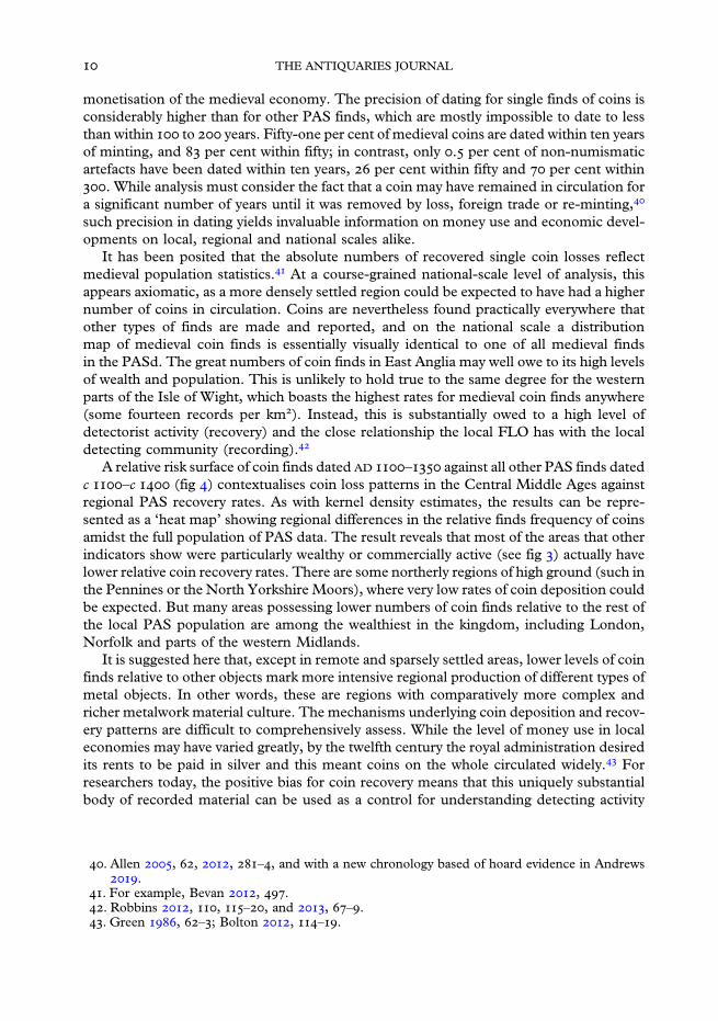
monetisation of the medieval economy. The precision of dating for single finds of coins isconsiderably higher than for other PAS finds, which are mostly impossible to date to lessthan within to years. Fifty-one per cent of medieval coins are dated within ten yearsof minting, and per cent within fifty; in contrast, only . per cent of non-numismaticartefacts have been dated within ten years, per cent within fifty and per cent within. While analysis must consider the fact that a coin may have remained in circulation fora significant number of years until it was removed by loss, foreign trade or re-minting,
such precision in dating yields invaluable information on money use and economic devel-opments on local, regional and national scales alike.
It has been posited that the absolute numbers of recovered single coin losses reflectmedieval population statistics. At a course-grained national-scale level of analysis, thisappears axiomatic, as a more densely settled region could be expected to have had a highernumber of coins in circulation. Coins are nevertheless found practically everywhere thatother types of finds are made and reported, and on the national scale a distributionmap of medieval coin finds is essentially visually identical to one of all medieval findsin the PASd. The great numbers of coin finds in East Anglia may well owe to its high levelsof wealth and population. This is unlikely to hold true to the same degree for the westernparts of the Isle of Wight, which boasts the highest rates for medieval coin finds anywhere(some fourteen records per km). Instead, this is substantially owed to a high level ofdetectorist activity (recovery) and the close relationship the local FLO has with the localdetecting community (recording).
A relative risk surface of coin finds dated AD – against all other PAS finds datedc –c (fig ) contextualises coin loss patterns in the Central Middle Ages againstregional PAS recovery rates. As with kernel density estimates, the results can be repre-sented as a ‘heat map’ showing regional differences in the relative finds frequency of coinsamidst the full population of PAS data. The result reveals that most of the areas that otherindicators show were particularly wealthy or commercially active (see fig ) actually havelower relative coin recovery rates. There are some northerly regions of high ground (such inthe Pennines or the North Yorkshire Moors), where very low rates of coin deposition couldbe expected. But many areas possessing lower numbers of coin finds relative to the rest ofthe local PAS population are among the wealthiest in the kingdom, including London,Norfolk and parts of the western Midlands.
It is suggested here that, except in remote and sparsely settled areas, lower levels of coinfinds relative to other objects mark more intensive regional production of different types ofmetal objects. In other words, these are regions with comparatively more complex andricher metalwork material culture. The mechanisms underlying coin deposition and recov-ery patterns are difficult to comprehensively assess. While the level of money use in localeconomies may have varied greatly, by the twelfth century the royal administration desiredits rents to be paid in silver and this meant coins on the whole circulated widely. Forresearchers today, the positive bias for coin recovery means that this uniquely substantialbody of recorded material can be used as a control for understanding detecting activity
. Allen , , , –, and with a new chronology based of hoard evidence in Andrews.
. For example, Bevan , .. Robbins , , –, and , –.. Green , –; Bolton , –.
THE ANTIQUARIES JOURNAL
against which the frequency of other finds can be assessed. In its broad structure, especiallyin the concentration of activity in the South West and East Anglia, the relative risk surfacemap of high medieval coin finds reflects the distribution of markets and assessed wealth inthe fourteenth century. What this may reveal is a picture of the overall production of non-numismatic metalwork culture that is more finely contextualised within the biases of thePASd than a simple distribution map of findspots.
Diachronic approaches similarly provide more nuanced and localised insights into rel-ative regional levels of economic prosperity. As the only large coin database coveringEngland andWales through the entirety of the Middle Ages, the PAS dataset offers uniqueopportunities for studying the development of regional coin economies across long periodsof time. From the late Anglo-Saxon period until the Black Death, the number of coinsminted in England grew substantially, from an estimated seven million silver pennies in, to some million in , and reaching a high of over million in the earlydecades of the fourteenth century. This reflected economic growth, increase in overseastrade that brought silver into the country, and the growing prevalence of cash
Fig . Relative risk surface of PAS coin finds dated – against all other finds c −c (r= km), showing areas where single coin finds are more (warm colour) or less (cool colours)
frequent relative to the overall regional finds intensity. Source: PASd.
MEDIEVAL COMMERCIAL SITES AND PAS DATA

transactions. In the PASd, the increase from recovered coins from the lateAnglo-Saxon period (AD –) to the , long cross coins minted between the– and – national re-coinages attests to this great monetary development.
Yet, because of differing levels of detectorist activity, the absolute distribution of findsoffers a poor resource for comparing historical change between regions. Issues relating torecovery bias are more manageable if finds are compared not cross-regionally, but dia-chronically within specified regions. Figure a divides England and Wales into hexagonalregions with a maximum north−south diameter of km. The percentage of PAS coins thateach region contains out of the total for the late Anglo-Saxon period (–) and theLong Cross period (–) is separately calculated, and then the resultingvalues compared to determine whether there was a relative increase or a decrease perhexagon from the eleventh century to the thirteenth. This comparative assessmentreveals that the most significant relative increase was in the northern and western partsof England.
Fig . (a) Comparing relative increase (positive) or decrease (negative) in the proportion of coins perhexagonal region out of the total national number between the late Anglo-Saxon (–) andLong Cross (–) coin periods. Darkest red indicates areas where no Anglo-Saxon coins havebeen found; white indicates either no data or only one coin of either period. (b) Relative risk surfaceof markets chartered or founded – out of all markets by (bandwidth km), showingareas of most new market foundations relative to the number of existing local markets in red. Source:
Letters b, PASd.
. Allen , –, , –, , and , ; Bolton , –.. On the development of coinage in this period, see Allen , –; Kelleher , –;
Naismith , –.
THE ANTIQUARIES JOURNAL

The numismatic data reflects information on the regional intensity of new market foun-dations or grants made between and , as shown by a relative risk surface (fig b).Correlation is noticeable in northern England and theWelsh borders, where the number ofknown market events before the thirteenth century had been low. It can be seen in growthin the commercially active north-eastern Norfolk as well as in the relative lack of new mar-kets along the south-eastern coast, where a network of sites had already been in place by theDomesday survey. The relative increase in number of markets regionally appears to beara relationship with modern recovery through hobby metal-detecting, and thereby historicalcirculation and deposition patterns.
RURAL AND URBAN ASSEMBLIES
Previous research on metalwork finds, often working on the basis of local collections, hasstruggled to differentiate urban and rural assemblages. A mass statistical analysis ofmedieval PAS finds recovered in the immediate vicinity of market settlements, however,shows aggregate patterns that separate these from rural scatters. As land is unequallycovered by metal-detecting activity, the following technique has been used to understandthe density of PAS finds. All medieval PAS finds made in England and recorded with atleast a six-figure National Grid Reference (NGR; , or . per cent of medievalfinds) were taken and a circle with m radius (the distance between two opposite cornersof a m× m NGR square) was calculated around each co-ordinate location.Overlapping circles were merged, and spaces excluded from metal-detecting (the sea,modern build-up areas and within the boundaries of protected/restricted sites) removedfrom the surface. The resulting area covers ,km and can be taken as a generous proxyfor the landscape area from which medieval finds have been made and reported. The av-erage density of all medieval finds within this space is . per km.
The particular value of PAS data lies in opening up new possibilities for examiningtrends in different socio-economic environments at a national scale. In order to considervariation in finds density between areas with different levels of habitation, medieval finds inEngland were divided into three non-overlapping datasets. The first set consists of findsrecovered within km of known medieval market sites by (, finds, with anaverage density of . finds per km). The second consists of finds recovered withinkm of medieval settlements, as indicated by tax vills in lay subsidy (, finds,or . per km). The third and final set consists of all remaining finds (, finds,or . per km). In order to enhance the possible contrast between assemblages recovered
. Darby , –.. Egan , .. Robbins , –, , –. Protected sites (as ‘hard constraints’ that strictly limit metal-
detecting) include Countryside Rights of Way, Forestry Commission boundaries, ScheduledMonuments and Sites of Special Scientific Interest (Robbins , –).
. Limited to ‘prescriptive’ (commercial activity supported by non-charter evidence) sites; seeLetters b. Given the considerable uncertainties in dating non-coin artefacts, discussedabove, the full medieval dataset was used. Eighty-one per cent calculated by aoristic sum(see below) of it in any case falls into the period –, when these sites could be expectedto be developing or active.
. Kent, Durham and Cheshire excluded from the region of analysis. Glasscock ; Barry et al n.d.
MEDIEVAL COMMERCIAL SITES AND PAS DATA

near market/urban and non-market sites, finds that fell within km radius of marketplacesactive in were also removed from the two latter sets; while chosen arbitrarily, thisfigure is approximately the averaged distance between a tax vill and its most immediateneighbours in the lay subsidy. It is clear that finds frequency of medieval objectsincreases substantially as one moves from the non-village regions towards settlements(. per cent increase), and even more so as one moves towards market and urban sites(. per cent increase, see table ). As noted, previous works have established that thegross distribution of small finds reflects estimated population density at a national scale.
Here the medieval PAS data appears also to reflect wealth and economic activity even atmore narrowly defined ranges.
On this basis, distinctions in the composition of PAS assemblages between market andnon-market settlements can now be studied, in order to better understand how this body ofevidence informs us of differences in the material culture between commercial centres andthe broader countryside. The complexity and heterogeneity of the PAS data, however,comprising different medieval object types, creates a challenge for understandingpatterns within the database. To enable a meaningful analysis, the finds have been consol-idated into nine broad artefact categories (shown in fig ): () commerce (including coins,weights for coins, cloth seals, purse elements, tumbrels, etc); () domestic (householdfurnishings, items associated with food and drink, and pastimes and entertainment,including toys); () dress (badges, brooches, buckles, pendants, strap-fittings, etc);() literacy (book fittings, seal matrices, writing implements, etc); () personal care(combs, chatelaines, mirrors, etc); () religion (ampullae, bullae, religious figures,monumental brasses, pilgrim badges, etc); () tools (axes, die stamps, moulds, spindle
Table 1. Contrasting data from three non-overlapping populations of PAS finds in England:finds recovered within 1km of market/urban sites by 1334 (markets), finds recovered near allother settlements (vills), and all other finds (rural). The table gives the increase in PAS findsfrequency per km2 as a percentage figure as one moves from rural areas to non-marketsettlements (column 1), from rural areas to urban/market sites (column 2), and from non-market settlements to urban/market sites (column 3). Source: Barry et al n.d.; Letters 2002b; PASd.
Category() rural v km of
vills() rural v km of
markets() vills vmarkets
All medieval PAS % % %Commerce % % %
artefact % % %
coin % % %
Domestic % % %
Dress % % %
Literacy % % %
Personal care % % %
Religion % % %
Tools % % %
Transport % % %
Warfare % % %
Other % % %
. See n .
THE ANTIQUARIES JOURNAL

whorls, needles, thimbles, querns, etc); () transport (horseshoes and harness fittings,stirrups, etc); () warfare (arrowheads, armour, daggers, hunting equipment and swordchapes, etc). Miscellaneous object types with fewer than fifty finds not included aboveaccount for a final . per cent (other). Coins (. per cent) have been further separatedfrom other commerce objects (. per cent) due to their large numbers. These groupingshave been tested and appear robust, though invariably some artefact types might fit intomore than one category (for example, knives could be used as domestic items, toolsand/or weapons). In general they reflect the main uses of objects, but also might beassociated with site types. For example, domestic items are likely to be from habitationsites, whereas dress accessories are more likely to be lost wherever people might havelived, worked or roamed.
Table gives the variations among the different finds categories between the threespatially determined datasets described above. Each column gives the percentage figureby which the density of finds in the object categories rises as one moves to a more denselysettled area. The results of the analysis are therefore interpreted as contrasting theaggregate character of the PAS object categories between non-settled (or non-nucleatedrural), settled (vill) and urban/market (market) regions. Given the size of the datasetsand the variety of environments they are collected from, too much cannot be read intosmall differences in the values; but a number of trends do appear. When moving fromthe deep countryside to village environment (column ) the higher than average resultsfor dress ( per cent), literacy ( per cent), personal care ( per cent) and religion( per cent) objects suggest that they are more likely than others to be used, lost anddiscarded around settled, possibly nucleated, village environments.
These trends are heightened when moving from rural to urban/commercial sites(column ). Among the scatters found within km of markets, increases in the frequencyof finds relating to literacy ( per cent), personal care ( per cent) and religion ( percent) are particularly high, although this is somewhat inflated by the substantial numbers of
Fig . PAS medieval object categories. Source: PASd.
. Leahy and Lewis , , –; for this principle, see also Briand et al .. Though practices such as refuse disposal, or manuring rural fields with urban night-soil,
are an example of how local context may influence the dispersal of PAS objects: Daubney, –.
MEDIEVAL COMMERCIAL SITES AND PAS DATA
these items recovered along the London foreshore. They may be particularly associatedwith the rich material culture of the metropolis, or the fact that certain finds types (suchas lead-alloy badges) survive well in the anaerobic conditions of the Thames mud. Evenexcluding London finds from the market dataset, these objects are still particularlyfrequent (respectively per cent, per cent and per cent). Dress objects donot stand out proportionally ( per cent). This indicates that as a broad category theseare not, in proportional terms, especially urban or commercial.
It appears that what differentiates the aggregate urban/market scatters from finds madenear all other settlements (column ) most clearly are objects associated with literacy(mostly seal matrices) and religion (mostly pilgrim souvenirs). The statistically highfrequency, though relatively small number (altogether a little over one hundred), of per-sonal care and miscellaneous ‘other’ objects recovered in the vicinity of urban sites perhapssimply attest to their expected greater complexity of metalwork material culture.Conversely, the lower results for dress, tools, transport and warfare suggests that as broadcategories they are less stringently associated with specifically urban and formal commer-cial environments.
It is surprising that commerce objects are not proportionally more frequent near marketsites than other object types. The relatively even distribution of coins across the countryshows their abundance and use outside towns and nucleated settlements. It is striking thatfinds frequency of commerce artefacts increases the least (by only half the average) betweenthe ‘rural’ countryside and villages. There is a significant increase only near markets andtowns. Jettons and tokens, and elements of the purses that would have contained these, aswell as coins, however, account for per cent of these urban finds. The observation thattheir recovery rate (and by implication their use and deposition) is significant only nearmarkets and towns supports the notion they were used mostly in larger, more populousand economically more complex environments. These national-scale figures indicate boththe scope in the use of cash use for transactions, and the limits of other complex forms oftransaction.
LOCAL CONTEXTS
To assess the relationship between PAS data and sites of medieval markets, six casestudy areas were considered for greater analysis, allowing the potential to investigate rela-tionships between artefact types within a landscape context. These were areas falling withinkm of Kingston Deverill (Wiltshire), Wantage (Oxfordshire), Litchfield (Staffordshire),Stamford Bridge (East Yorkshire) and the coastal region between New Romney (Kent)and Winchelsea (Sussex), as well as a comparative dataset of finds made within kmof the London−Exeter road between the market towns of Stockbridge and Alton and pass-ing through Winchester (Hampshire). These areas were chosen on the basis of having agood quantity and quality of PAS data with a potential correlation with market sites,and varying geographical and topographical locations. Although the finds compositionof the six areas will be contrasted, it is apparent that three of them (Kingston Deverill,Wantage and New Romney−Winchelsea) better demonstrate the relationship of PAS datato market sites, and therefore provide more meaningful results. It is these three sites thatprovide the focus here.
. On the use and typology of tokens and jettons, see Mitchiner and Skinner , ; Mernickand Algar , –.
THE ANTIQUARIES JOURNAL

Kingston Deverill (Wiltshire)
While one must be mindful of the biases and inaccuracies inherent in medieval nationalwealth assessments, the Domesday Book and the lay subsidy provide helpful snap-shots to local landscapes of wealth. In , the manor of Kingston Deverill was valuedat £ s, with a further £ s assessed to the vill of Deverill. As such, the vill stoodout as being particularly wealthy in western Wiltshire, with only six other vills (out of )within a km radius being assessed higher. In , the value of movable goods there wasassessed at £ and it remained wealthy in the local context, although its ranking had bynow fallen to twenty-eight out of nearby vills. A market had been established atKingston Deverill before when the franchise was noted as being owned by NetleyAbbey (Hampshire). The market may have been ancient. In the Early Middle Ages,Kingston Deverill was well connected in terms of transport routes, which will have empow-ered its prosperity. It was located at an intersection of medieval salt routes and a formerRoman road travelling east−west. This road connected Winchester and the south coastwith the Fosse Way, and beyond it Bath and Gloucester, and was still used in the MiddleAges. The former Roman road appears to have crossed through an area north of the set-tlement (see below), which has been extensively searched by detectorists. The modernroad network, however, is noticeably different. The Ogilby map of gave no roadsthrough Kingston Deverill; the two main routes in southern Wiltshire passed east−westthrough Warminster to the north and Shaftesbury to the south. It is possible that therehad been a re-alignment of the regional network of key travel routes in the later medievalperiod, perhaps in concert with the changing landscape of economic wealth in the region.The PAS data would appear to support this thesis.
The historic landscape around Kingston Deverill has been explored by two detectorists(Val Macrae and Brian Read). It is important to appreciate the distinction between hobbymetal-detecting carried out by local people, who have a direct interest in and appreciationof the historic landscape, and that carried out by significant numbers of people (such aspart of a commercial metal-detecting rally) where no particular affinity can be assumed.The , finds recorded from within km of Kingston Deverill (fig ) are of multi-period date. This is typical in regions of the country with a long settlement history, thoughthey are predominately Roman (, finds) followed by those of medieval date (). Thelatter are particularly concentrated in a field area north of modern Kingston Deverill that isassociated with the Roman and medieval road. This clustering might only reflect the focusof detecting, but it could represent commercial activity, especially since iron ore and slaghave also been recovered. Local enquiries have revealed little more information, andneither is further evidence revealed through the local Historic Environment Record.
Out of the medieval objects found at Kingston Deverill and analysed as part of thisstudy, those associated with commerce are the most common ( per cent at objects).
. Williams and Erskine –, fols v, v, v, , v, .. Palmer ; Barry et al n.d.. Calendar of Close Rolls Richard II –, ; Letters b, ‘Kingston Deverill’.. Margary , b.. Brookes n.d.. Ordnance Survey .. The authors would like to thank, in particular, Jörn Schuster and Brian Read, who have outlined
their local knowledge of the area and plans for further investigations; see also Henry .
MEDIEVAL COMMERCIAL SITES AND PAS DATA

This is typical of the six areas examined, which (apart from the region around Winchester)show a loss of commercial items slightly above the national average. These finds are mostlycoins (), but also include jettons () and tokens, as well as weights and metal pursefittings. The next largest category are dress accessories ( per cent at finds). This groupis very mixed, though a good proportion of finds are buckles (), followed by strap-endsand strap-fittings (), brooches () and finger-rings (). Following are domestic objects( per cent at records). Most common are keys and padlocks (), mounts () andvessel fragments (). A significant number of items () are associated with transport.All but one of these items are associated with the medieval horse; they include harnessgear () and stirrup elements (). Of the fifteen items associated with literacy, all butfour are seal matrices. There are only nine religious objects, of which five are pilgrimsouvenirs.
Fig . Distribution of medieval PAS finds near Kingston Deverill, Wiltshire. Source: PASd.
THE ANTIQUARIES JOURNAL

It might be expected that broad trends relating to historical activity could be drawn outfrom the mass of PAS finds made around a site. Temporal uncertainty inherent in thePASd (simply because most objects are impossible to date as precisely as coins) poseschallenges to representing and analysing the finds data. One powerful and straightforwardtechnique for understanding the temporal distribution of such ‘fuzzily’ dated PAS finds isaoristic analysis. This technique has been used (for example) by criminologists for estimat-ing peak offence times (such as, variability in the frequency of thefts in a certainarea over the course of a day), and through new digital humanities techniques has beensuccessfully adopted for investigating archaeological and historical datasets. Calculatingthe aoristic sums of a group of finds makes it possible to model change in the weight ofdeposition activity. Due to object dating uncertainty, the results are probabilistic ratherthan absolute. It is therefore more representative to display a range of probabilities throughMonte Carlo simulation that creates an envelope of results – a region within which the realresult is likely to fall with a high ( per cent) degree of confidence. Such analysis enablesus to examine broad patterns in the distribution of finds data across long periods, andindicate how both historical trends and modern biases operate in the PASd.
Narrowing down to within just km of Kingston Deverill, an analysis of single-lost coinsindicates that most were deposited in late twelfth to early thirteenth centuries (fig a). Themajority (thirty-nine out of eighty-three) was found on the productive area north of thesettlement. In isolation, local coin finds only indicate how coin loss rises or falls, for whichthere may be reasons that are not strictly related to the increase or decrease of local com-mercial exchange. A classic example is changes in the overall level of currency in circula-tion. If located within a wider geographical context or compared against assemblagesfrom other sites, however, finds in the study area may inform of local peculiarities. Thecomposition of single-lost coins in the PASd as a whole broadly approximates variationin the size of English silver currency estimated from mint and hoard evidence. As notedabove, this increased until the first half of the fourteenth century, thereafter falling to aquarter of its former size in the second half and not substantially recovering until the earlymodern period. Up to mid-thirteenth century Kingston Deverill finds roughly follow thispattern, but then flatline to below the national mean. It is not known if the northern site wasabandoned, but coin loss frequency in the whole settlement area declined.
Other object finds, necessarily dated more imprecisely (as explained above), increasesteadily through to the end of the fourteenth century with a drop after . In both instan-ces the major phase of depositions is during the Central Middle Ages and the numbers donot substantially recover in the later period. This stands in clear contrast to the broaderregional picture as slightly more post-medieval (,) than medieval (,) finds havebeen recovered within a ring of −km out from Kingston Deverill. It is suggested that
. In essence, basic aoristic analysis takes the dating range of a record (say AD –), assignsthis full range a value (typically ), and then splits the value between temporal bins of set length(in these case studies -year bins were used, so a value of /th would be entered into each bin).The process is run through every record in the study, and the values in the respective bins areadded together to create an overall statistical picture of the temporal distribution of records.
. Ratcliffe ; Crema ; Orton et al . The wider the envelope, the more loosely findswere dated; note how the graphic denoting coin records is invariably narrower than that ofartefact records (figs a–d).
. See Reece for a discussion in the Roman single finds context.. Kelleher , –.. Allen , –, , .
MEDIEVAL COMMERCIAL SITES AND PAS DATA
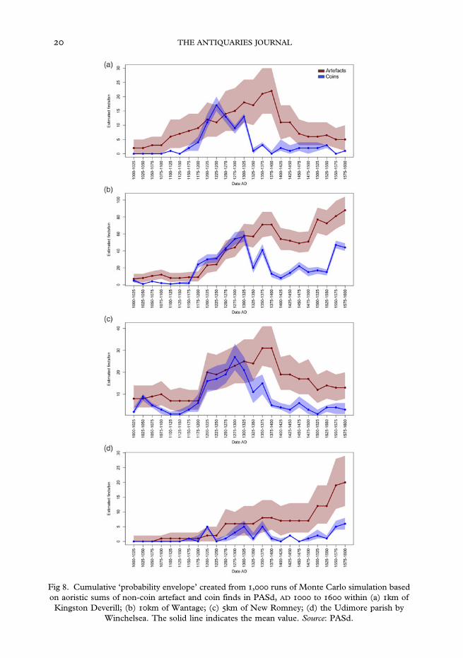
Fig . Cumulative ‘probability envelope’ created from , runs of Monte Carlo simulation basedon aoristic sums of non-coin artefact and coin finds in PASd, AD to within (a) km ofKingston Deverill; (b) km of Wantage; (c) km of New Romney; (d) the Udimore parish by
Winchelsea. The solid line indicates the mean value. Source: PASd.
THE ANTIQUARIES JOURNAL

this decline in the consumption of metalwork objects is situated in the context of competi-tion from nearby economic centres. Between and markets were granted toSutton Vene, Maiden Bradley and Mere, all within just −km of Kingston Deverill tothe north, east and south. By a total of seven other settlements within km ofKingston Deverill possessed market rights. This would reflect a re-arrangement of theregional landscape of transport and travel, which eventually led to the dislocation ofKingston Deverill as a commercial hub and a decline in the quantity of material culturedeposited.
Wantage (Oxfordshire)
Commercially more powerful than Kingston Deverill, Wantage prospered as a local centrethroughout the Middle Ages. In , manorial wealth at Wantage was valued at £ s; in, its movable wealth was assessed at £ s d. Originally a Roman settlement, itbecame a royal West Saxon vill and was held in royal demesne until . Its status nodoubt laid the foundations of economic growth, fostered by early market and fair events.Wantage had a Sunday market before – and a fair before , probably held inOctober; a second three-day fair, to be held in early July, was granted in . Thesefranchises survived the economic turbulences of the fourteenth century and still existedin the early fifteenth. Although valued in approximately the same as KingstonDeverill, Wantage belonged to a more densely occupied and economically prosperouslandscape. The fragmentary and lay subsidy returns, which list the assessedwealth of individual tax-payers, reveal in western Berkshire a denser concentration of villswith a high wealth per capita ratio than anywhere else.
Favourable agricultural landscape factors, such as the prevalence of meadow, willhave underlain regional wealth. Economic prosperity is likely to have been advancedby significant transport connections. The Icknield Way (or Ridgeway) passes south ofWantage along the edge of the escarpment, making this historically an important east−westcross-country travel intersection. It is at a terminus of a Roman road coming down fromOxford still in use in the nineteenth century. The town is only km away from the Thamesby Abingdon and further to the south, on the other side of the Downs, there was an im-portant nexus of cross-country routes, including the London−Bath road marked out in theGough Map of c .
The finds recovery context at Wantage offers a contrast to that at Kingston Deverill.Because of the modern built-up environment around the site, only two dozen medievalfinds from within the immediate km vicinity of the historic settlement centre have beenrecorded. As mass analysis of objects adhering closely to the settlement itself is thereforeimpossible, we consider the broader historical landscape by extending the range to a kmradius. Here the total number of medieval finds rises to almost , (fig ). The largestcategory of objects is commerce ( per cent at records). Besides coins (), there are
. ‘Maiden Bradley’ (), ‘Mere’ (), ‘Sutton Vene’ (): Letters b.. Glasscock , ; Williams –, fol .. Page and Ditchfield , IV, –; Holbrook and Thomas , –.. Letters b, ‘Wantage’; Inquisitions Post Mortem n.d., eCIPM –, –, –.. Campbell and Bartley , , –.. As in the Domesday inquest; see Darby , .. Kings College London .
MEDIEVAL COMMERCIAL SITES AND PAS DATA

also considerable numbers of tokens (), followed by weighing equipment (), jettons(), purse elements () and cloth seals (). Items of dress number objects ( percent), of which there are represented buckles (), strap-ends and strap-fittings (),brooches () and finger-rings (). Of the domestic items ( per cent at records) thereare relatively high numbers of vessel fragments () and mounts (), also keys () andspoons (). Most transport finds ( per cent at eighty-three records) are associated with thehorse, consisting of harness fittings of various types (), stirrup fittings (),bridle bits () and two horseshoes and two spurs. Also recorded are a number of bellsfor livestock (). Nearly all tools ( per cent at thirty-nine records) are associated withthe cloth trade, including thimbles (), spindle whorls () and a single needle. Ofthe items identified with literacy ( per cent at twenty-nine records), all but six areseal matrices. Religion accounts for fourteen finds ( per cent), consisting of ampullae ()
Fig . Distribution of medieval PAS finds near Wantage, Oxfordshire, overlain with a relative risksurface comparing major medieval and post-medieval scatters against Roman and Iron Age scatters.
Source: PASd.
THE ANTIQUARIES JOURNAL

pilgrim badges () and three bullae. There are only thirteen weapons ( per cent), of whichten are bladed weapon parts.
The metal-detecting data is unusually large and complex because the area has been thefocus of metal-detecting rallies: usually one- to three-day events that have attracted manyhundreds of individuals. Of different finders who have recorded their finds, none hasrecorded more than forty items. Therefore, while the small finds data is rich, it is poten-tially much less than the actual (now substantially lost) archaeological resource of the area,highlighting the potential damage caused to archaeology by large-scale metal-detecting,even if well organised. Quantity, however, does have a certain quality of its own, andthe richly multi-period character of the local PAS data may capture long-term trends.Strong continuity in metalwork material culture across the medieval period is shown byaoristic analysis of the PAS finds. In clear contrast to Kingston Deverill, artefact depositionrate declined only slightly after , and more than recovered in the Later MiddleAges (see fig b). Indeed, while the artefact finds pattern follows the PAS national average,post-Black Death change is shallower (an average of per cent as opposed to per centdecline from the high mark to the low by aoristic sum in -year bins), similarly echoed inthe single coin finds sequence.
Spatially, the main concentration of finds is immediately to the south ofWantage, wherethe majority are Roman (,), followed by post-medieval () then medieval () andIron Age () finds. A relative risk surface analysis shows that medieval and post-medievalfinds are concentrated within − km of Wantage itself, with Iron Age and Roman findshaving a wider dispersion pattern that includes a concentration on the higher ground cutthrough by the Ridgeway. The data is only suggestive, but could indicate a comparativelymore concentrated settlement pattern in the medieval period, as well as a local commu-nications network in which the old Ridgeway now played a less important role.
New Romney (Kent) and Winchelsea (Sussex)
The area around New Romney and Winchelsea is of interest because it was to become animportant maritime hub in the Middle Ages. Historically, much of the region was coveredby the coastal Romney and Walland Marshes. Land reclamation largely took place in theMiddle Ages, with the largest settlements clinging to promontories of higher ground abovethe flood plain. The region was ideally situated for travel over the English Channel coast,with New Romney, Winchelsea and the neighbouring town of Rye being members of theCinque Ports. The Rother and Brede rivers were navigable until the mid-fourteenth cen-tury, and the coastal route from Canterbury towards Southampton seen in the GoughMap of c passed through Appledore, Rye and Winchelsea.
The port settlement of Romenel, now associated with New Romney but possibly incor-porating Old Romney further west, was a borough in the Domesday survey of . It is
. Estimated participation numbers for large rallies since : King Alfred the Great rally ,c participants; Chain Hill rally , c ; Lattin Down rally , c ; West Hanneyrally () , c ; West Hanney rally () , c ; Letcombe Bassett rally , c ;East Challow rally , c ; Segsbury rally , c . There have also been several smallerrallies of c participants around Wantage (Anni Byard, formerly Oxfordshire FLO,pers comm, Apr ).
. For overviews of the history and palaeogeography of the area, see Eddison ; Long et al .. See Oksanen .. Kings College London .
MEDIEVAL COMMERCIAL SITES AND PAS DATA

likely to have hosted a market by then, although one is first attested only in –.
During the fourteenth century, New Romney sustained specialist markets for hemp, but-ter, poultry and meat. The early origins of Winchelsea are more obscure, but it had aweekly market before with a second granted in . Old Winchelsea, which hadgrown by the thirteenth century into a busy port, was destroyed by incursions of thesea between and . The precise site of the old town is unknown and may nowbe under the sea. New Winchelsea was laid out in , acquiring liberties of the formertown including its market and three-dayMay fair. The region was commercially active. Aborough was established in Lydd (Kent) between and . Appledore (also inKent) held an August fair before and was granted a market and a May fair in. Rye (Sussex), a borough in , held two autumn fairs from the thirteenth centuryand markets onWednesdays and Fridays from before . Despite this economic prom-ise, the heyday of the Cinque Ports was over by the Later Middle Ages. Winchelsea, NewRomney and Rye declined in importance during the fourteenth century due to raids fromFrance and the silting up of the coastal estuaries. All have survived as market towns to themodern times.
The area encompassing these settlements, here defined as falling within km of thecoastal intersection of Guestling Hundred and Goldspur Hundred between Winchelseaand New Romney (fig ), is rich in finds (,), most of which are medieval (,).Metal finds of all periods made at New Romney by have been previously discussedby Geoff Egan, who noted that the general character of the assemblages showed both thepresence of fishing industry as well as the town’s connections to long-distance exchange.
In contrast, a assessment of excavated finds made in Winchelsea noted that the mereseventeen coins, tokens and jettons recovered was a surprisingly small number for animportant commercial centre, and speculated that this was due to the non-use ofmetal-detectors and wet-sieving.
This highlights the importance of the PAS as a complementary source of archaeologicaldata, as almost a half ( per cent at records) of PAS finds in the broader region areassociated with commerce. Coins are common (), followed by tokens () and jettons(). Also found are a significant number of weights (), two balances and twelve purseelements. Dress accessories ( per cent at records) comprise buckles () as well asstrap-ends and other strap-fittings (), finger-rings () and brooches (). Includedamongst domestic items ( per cent at records) are vessel parts (), mounts (), keys() and items of lighting equipment (). Items related to transport ( per cent at seventyrecords) are again associated with the horse, including bridle and harness fittings () – ofwhich twenty are harness pendants – and stirrup () and spur () elements. Of tools( per cent at thirty-two records), all but one are thimbles. Fourteen of the religious objects( per cent at twenty-four records in total) are ampullae, the rest more various. Includedamong the items of warfare/hunting ( per cent at thirteen records) are nine scabbardelements; the other objects are from the bladed part of weapons. Items associated with
. Letters b, ‘New Romney’; Draper and Meddens , –.. Murray , xxxvii.. Letters b, ‘New Winchelsea’, ‘Old Winchelsea’. Also, Martin and Martin .. Beresford and Finberg , .. Letters b, ‘Appledore’, ‘Rye’.. Eddison , –.. Egan , .. Martin and Rudling , –.
THE ANTIQUARIES JOURNAL

literacy ( per cent at eighty-three records) are twice as well represented in the data as thenational average. Apart from ten book fittings, all are seal matrices. An effort was made inthe autumn of by one of the authors (Lewis), then the FLO for Kent, to encouragefinders to bring such items for recording, resulting in twenty-four new entries. Evendiscounting this spike (a good example of local recording bias), the high number of sealmatrices may reflect their level of historical prevalence and use. A relative risk surfaceanalysis does show these objects are, adjusted to the total finds population, more commonin Kent than in any other county.
About finders have recorded medieval finds from the New Romney−Winchelseaarea, the most prolific being Alan Charman (), around Winchelsea and west ofAppledore, and Dale Smith (), immediately around New Romney. In general,most finders are local, and are therefore perhaps more likely to identify with the historical
Fig . Distribution of medieval PAS finds in New Romney−Winchelsea area, showingreconstructed coastline c . Source: EDINA Geology Digimap Service, Long et al , PASd.
MEDIEVAL COMMERCIAL SITES AND PAS DATA

landscape. The area’s largest medieval scatter () lies mostly to the west of NewRomney, encompassing an area some .km in radius towards Old Romney. The medievalcoin evidence, datable more closely, shows a longer history of deposition activity beginningbefore the Norman Conquest, and peaking in the thirteenth and fourteenth centuries withno recovery to the high medieval maximum (see fig c). By Winchelsea, the main concen-tration of medieval finds appears immediately to the north-west in the parish of Udimore(). In contrast to the neighbouring New Romney, the main deposition period herebegins only in the latter part of the thirteenth century (see fig d). This coincides withthe period when New Winchelsea was laid down, and may also reflect increase in humanactivity brought by farming and land reclamation efforts in the Brede river valley.
Among artefact finds, these very local patterns stand in contrast to those of KingstonDeverill and Wantage. They appear to reflect both the relocation of Winchelsea and thedevelopment of its hinterland, as well the loss of New Romney’s haven due to silting bythe mid-fifteenth century. The temporal sequence of single-lost coins datedc –c at New Romney fits this picture, with a significant decline in numbers fromthe late-thirteenth century and without growth in the early modern period. The sequencerecovered by Winchelsea is more flattened, though this may be due to a less significantsample of only thirty-eight coins. Interestingly, however, non-coin artefact finds atUdimore increase steadily through the Later Middle Ages. Winchelsea remained a region-ally important port longer than Romney, but this also shows that PAS finds should not beincautiously taken as a direct proxy of changing levels of the local economic prosperity. Thediffering temporal patterns may also reflect the character of the landscape. The finds byNew Romney are made on low-lying ground prone to flooding and soil movement.Scatters from various sites of historical activity may have therefore been buried beyondrecovery by metal-detecting, leaving behind a particularly incomplete picture. Half ofthe objects near New Romney were recovered west of the modern town, much of whichwas under water until silting in the thirteenth century, and therefore resulting in a local biastowards later finds. Conversely, the scatter concentrated at Udimore is on high ground,less prone to disturbance from soil movement and consequently likely to yield a fullerchronology of depositions. Historical activity, post-deposition processes and modern con-straints all contribute to produce the contents of the PAS database.
CONCLUSION
This paper owes itself to the growing wealth of evidence that the PAS data provides uniquearchaeological insights on scales ranging from the national to the local level. As the singlelargest unified archaeological dataset of public finds, the contents of the PASd reflectinformation on varying levels of past human activity across England and Wales. The findsdata describes trends in material culture production and use that are directly relevant tosocio-economic history and can successfully be used alongside other repositories of archae-ological and historical evidence in ‘big data’ analysis. Different historical and modernbiases governing the deposition, recovery and recording of finds must be sensiblyaccounted for, as shown above. Given that the PAS has been operating for over twenty
. Jo Ahmet, Kent FLO, pers comm, Mar .. Gardiner , –.. Eddison , , .
THE ANTIQUARIES JOURNAL

years, it is often still possible to correspond with heritage professionals and finders whohave been involved with data creation – a good example of citizen science. Especiallyfor local studies, this may provide unexpected insights into the landscape that are vitalfor a nuanced understanding of finds recovery contexts.
The diversity of objects in the PASd naturally presents both opportunities and prob-lems. Here it is suggested consolidating finds by function into broad categories in orderto uncover wider patterns. The spatial distribution of medieval PAS finds reflects humanactivity across the historical landscape, sketching out both tendencies and identifying thecharacteristics of material culture near urban and commercial centres. Temporal analysisof specific local scatters further informs us on the historical fortunes of their related sites,and demonstrates the value of the PAS data as an independent source for understandingmaterial culture and long-term economic development; one that is particularly significantfor the hundreds or thousands of rural settlements that have enjoyed few references in writ-ten sources or hosted formal archaeological excavations. More specifically, the study showsthat PAS finds can be linked with patterns of commercial activity that can be tested andproven to reflect information gathered from independent data. It is the case that medievalPAS finds are more likely to be found closer to commercial sites, including urban areas,even though the data is mostly gleaned from cultivated land in rural areas.
To this end, fig gives the percentage proportions of PAS finds as collected into broadcategories in the six case study areas covered by the project. At a first glance there is a sur-prising degree of similarity between the individual scatters and the PAS parent dataset.This suggests that (in very general terms) the deposition and recovery patterns of differentartefact types across long periods of time and in various parts of the country are analogous,usually falling within a margin of some per cent. Although there are differences in thelocal profile of medieval sites and a clear intensity (in terms of the quantity of items) nearermarket and urban areas, it is apparent that across the country people availed to much thesame material culture. Indeed, it is worth emphasising that already by the mid-thirteenthcentury some two-thirds of English vills were within km (a day’s easy return journey)of at least one borough and multiple market sites. While there appears to have beenurban−rural delineations with regard to certain object types (such as jettons and badges),the study shows that there is growing evidence that people in the country did have access tothe same items used in towns. This was no doubt due to the widespread distribution ofcommercial sites and the transport networks that joined them.
A closer look, however, shows there are distinguishing trends between places and sites atthe local level. In terms of commercial items, these areas – hypothesised as areas ofcommerce – seem to be more productive than the national average ( per cent, addingcoins and other commercial objects together). The New Romney and Winchelsea area hasthe highest percentage of these finds ( per cent in total), followed by Stamford Bridge (per cent) and Litchfield ( per cent). Only in the region centred on the overland routebetween Stockbridge and Alton that travels through Winchester ( per cent) does this fallbelow the national average. As this area between Stockbridge and Alton encompasses abroader section of the rural countryside than the other regions, commerce objects – other-wise associated with nearness to settlements – are indeed expected to be lessfrequently represented. As such, it suggests how the PAS evidence could be significantin terms of profiling sites across the country. Given the difficulties associated with preciselydating most metal artefacts, it is also of note that, if carefully used, coins provide a useful
. Derived from Barry et al, n.d.; Letters b; Palmer .
MEDIEVAL COMMERCIAL SITES AND PAS DATA

‘control’ for understanding assemblage chronologies. Moreover, it appears that low levelsof coin finds, relative to others, may suggest a more complex and abundant metalworkmaterial culture than previously thought.
The use of PAS data to explore commercial sites shows that some of these places can bemore meaningfully explored than others. To some degree this depends on how the data iscollected (in terms of detecting practice) and recorded (including information on howcompletely PAS data represents known local metal-detecting activity); therefore, perhapsthose in PAS can become ‘more intelligent’ in how finds are recorded to mitigate againstthese biases. The contents of the PASd at a specific locale are directly influenced not onlyby the amount of metal-detecting activity conducted there, but by the form it may havetaken: whether conducted by an individual or a small number of dedicated hobbyists witha strong understanding of historical metalwork and the landscape, a larger number of moreincidental finders, or, at the other end of the scale, a commercial mass rally. Nonetheless, itis the case that artefact assemblages, and the groupings of these by type and function, helpsto profile sites, suggesting how they developed, grew or declined over time. It is, of course,the case that these analytical tools can be applied to other sets of data – using PAS finds ornot – and this is what is hoped will be the real legacy of this paper.
ACKNOWLEDGEMENTS
The authors thank Murray Andrews, Stuart Brookes and Rob Webley, who have readand commented on an earlier version of this paper. The authors are also grateful forthe comments of the anonymous reviewers. All mistakes remain the authors’.
ABBREVIATIONS AND BIBLIOGRAPHY
Abbreviations
FLO Finds Liaison OfficerGIS Geographic Information SystemPAS Portable Antiquities SchemePASd Portable Antiquities Scheme database https://finds.org.uk/database (accessed 7
April 2020)
Fig . Proportions of finds by object category in the six case study areas. Source: PASd.
THE ANTIQUARIES JOURNAL

Bibliography
Primary sources
Adams, J . Index Villaris, A Godbid & JPlayford, London
Barry, L, Bartley, K, Campbell, B andGlasscock, R E n.d. Database of EnglishLay Subsidies //, unpublisheddatabase, Queen’s University, Belfast
Brookes, S n.d. Early Medieval Routeways inEngland, unpublished database, UniversityCollege London
Calendar of Close Rolls Richard II –,preserved in the Public Record Office−, Public Record Office, London
Inquisitions Post Mortem n.d. ‘Places,people, and properties in the InquisitionsPost Mortem’, Mapping the MedievalCountryside, University of Winchester andKings College London, http://www.inquisitionspostmortem.ac.uk (accessed May )
Kings College London . LinguisticGeographies: The Gough Map of Great Britain,Queen’s University Belfast, University ofOxford and King’s College London, http://www.goughmap.org (accessed May )
Secondary sources
Allen, M . ‘The volume of the Englishcurrency, –’, Economic Hist Rev,new ser, , –
Allen, M . ‘The interpretation of single-finds of English Coins, –’, BritNumismatic J, , –
Allen, M . Mints and Money in MedievalEngland, Cambridge University Press,Cambridge
Allen, M . ‘Revised estimates of the Englishsilver currency, –’, Brit Numismatic J,, −
Andrews, M . ‘Coin hoards and societyin medieval England and Wales, AD c –
’, unpublished PhD thesis, UniversityCollege London
Arthur, P .Medieval fairs: an archaeologist’sapproach’, inABuko andPUrbanczyk (eds),Archeologia w teorii i w praktyce, –,Festschift Stanilas Tabaczynski, Warsaw
Beresford, M and Finberg, H R P . EnglishMedieval Boroughs, David & Charles,Newton Abbot
Bevan, A . ‘Spatial methods for analysinglarge-scale artefact inventories’, Antiquity,, –
Bolton, J L . Money in the MedievalEconomy: –, Manchester UniversityPress, Manchester
Briand, A, Dubreucq, É, Ducreux, A,Feugère, M, Galtier, C, Girard, B, Josset, D,
Mulot, A, Taillandier, T and Tisserand, N. ‘Lemobilier métallique et l’instrumen-tum : approches méthodologiques’, Lesnouvelles de l’archaéologie, , −, –
Brindle, T . The Portable Antiquities Schemeand Roman Britain, British Museum,London
Britnell, R a. ‘Essex markets before ’,Essex Archaeol Hist, rd ser, , –
Britnell, R b. ‘The proliferation of marketsin England, −’, Economic Hist Rev,nd ser, , –
Britnell, R . The Commercialisation ofEnglish Society, –, CambridgeUniversity Press, Cambridge
Britnell, R . ‘Boroughs, markets andtrade in northern England, –’, inR Britnell and J Hatcher (eds), Progressand Problems in Medieval England: essays inhonour of Edward Miller, –, CambridgeUniversity Press, Cambridge
Britnell, R and Campbell, B (eds) .A Commercialising Economy: England to c , Manchester University Press,Manchester
Broadberry, S, Campbell, B, Klein, A, Overton,M and van Leeuwen, B . BritishEconomic Growth, −, CambridgeUniversity Press, Cambridge
Brookes, S and Huynh, N . ‘Transportnetworks and towns in Roman and early
MEDIEVAL COMMERCIAL SITES AND PAS DATA

medieval England: an application ofPageRank to archaeological questions’,J Archaeol Sci: Reports, , –
Campbell, B . ‘Benchmarking medievaleconomic development: England, Wales,Scotland, and Ireland, c ’, EconomicHist Rev, new ser, , –
Campbell, B and Bartley, K . England onthe Eve of the Black Death: an atlas of laylordship and wealth, –, ManchesterUniversity Press, Manchester
Chapman, E M, Hunter, F, Wilson, P, Booth,P, Pearce, J, Worrell, S and Tomlin R S O. ‘Roman Britain in ’, Britannia,, –
Coates, B . ‘The origin and distribution ofmarkets and fairs in medieval Derbyshire’,Derbyshire Archaeol J, , –
Cooper, A and Green, C . ‘Big questionsfor large, complex datasets: approachingtime and space using composite objectassemblages’, Internet Archaeol, , https://doi.org/./ia.. (accessed May)
Crema, E . ‘Modelling temporal uncer-tainty in archaeological analysis’,J Archaeol Method Theory, , –
Darby, H C . Domesday England,Cambridge University Press, Cambridge
Daubney, A . ‘Portable antiquities,palimpsests, and persistent places inLincolnshire, with particular reference tothree Middle Saxon case studies’, unpub-lished PhD thesis, University of Leicester
Davies T, Marshall J and Hazelton, M .‘Tutorial on kernel estimation of continu-ous spatial and spatiotemporal relative riskwith accompanying instruction in R’, StatMed, , –
Donnelly, V, Green, C and TenHarkel, L .‘English landscapes and identities. Theearly medieval landscape: methods andapproaches’, Medieval Settlement Res, ,–
Draper, G and Meddens, F . The Sea andthe Marsh: the medieval Cinque Port ofNew Romney revealed through archaeologicalexcavations and historical research, Pre-Construct Archaeology, London
Dyer, C . ‘The hidden trade of the MiddleAges: evidence from the West Midlands ofEngland’, J Hist Geogr, (), –
Dyer, C . ‘Small places with large conse-quences: the importance of small towns inEngland, –’, Hist Res, , –
Dyer, C . ‘Did peasants need markets andtowns? The experience of late medieval
England’, in M Davies and J Galloway(eds), London and Beyond: essays inhonour of Derek Keene, –, University ofLondon, London
Eddison, J . Romney Marsh: survival on afrontier, Tempus, Stroud
Egan, G . ‘Urban and rural finds: materialculture of country and town, c −’,in Giles and Dyer , –
Egan, G . ‘The metal finds’, in Draper andMeddens , –
Farmer, D . ‘Marketing the produce of thecountryside, –’, in E Miller (ed),The Agrarian History of England and Wales:volume III, –, –, CambridgeUniversity Press, Cambridge
Gardiner, M . ‘Medieval farming andflooding in the Brede Valley’, in J Eddison(ed), Romney Marsh: the debatable ground,–, Oxbow, Oxford
Giles, K and Dyer, C (eds) . Town andCountry in the Middle Ages: contrasts, contactsand interconnections, –, Maney, Leeds
Glasscock, R (ed) . The Lay Subsidy of ,Oxford University Press, Oxford
Green, J . The Government of Englandunder Henry I, Cambridge UniversityPress, Cambridge
Hadley, D M and Richards, J D . ‘Thewinter camp of the Viking Great Army,AD –, Torksey, Lincolnshire’, Ant J,, –
Hallam, H E (ed) . The Agrarian History ofEngland and Wales: volume II, –,Cambridge University Press, Cambridge
Henry, R . ‘Using the Wiltshire andSwindon Historic Environment Record forarchaeological research in southwestWiltshire’, Wilts Archaeol & Nat Hist Mag,, –
Heritage Data n.d. Linked Data Vocabularies forCultural Heritage: historic England, http://thesaurus.historicengland.org.uk (accessed May )
Holbrook, N and Thomas, A . The Romanand Early Saxon Settlement at Wantage,Oxfordshire: excavations at Mill Street/, Cotswold Archaeology, Cirencester
Jamroziak, E . ‘Networks of markets andnetworks of patronage in thirteenth-century England’, Thirteenth Cent England,, –
Kelleher, R . ‘Coins, monetisation andre-use in medieval England and Wales:new interpretations made possible by thePortable Antiquities Scheme’, unpublishedPhD thesis, Durham University
THE ANTIQUARIES JOURNAL

Leahy, K and Lewis, M . Finds Identified:an illustrated guide to metal detecting andarchaeological finds, Greenlight Publishing,Witham
Letters, S a. Gazetteer of Markets and Fairsin England and Wales to , vols, List andIndex Society Special Ser –, Kew
Letters, S b. Online Gazetteer of Marketsand Fairs in England and Wales to ,Institute of Historical Research, http://www.history.ac.uk/cmh/gaz/gazweb.html(accessed May )
Letters, S . ‘Markets and fairs in medievalEngland: a new resource’, Thirteenth CentEngland, , –
Lewis, M . ‘A detectorist’s Utopia?Archaeology and metal-detecting inEngland and Wales’, Open Archaeol, (),https://www.degruyter.com/view/j/opar...issue-/opar--/opar--.xml (accessed May )
Lewis, M . The Portable Antiquities SchemeAnnualReport,BritishMuseum,London
Lewis, M . The Portable Antiquities SchemeAnnual Report , British Museum,London
Long A, Martyn P and Plater A . ‘The lateHolocene evolution of the Romney Marsh/Dungeness foreland’, in A Long, P Martynand A Plater (eds), Dungeness and RomneyMarsh: barrier dynamics and marshlandevolution, Oxbow, Oxford
Margary, I D . Roman Roads in Britain, rdedn, John Baker, London
Martin, D and Martin, B (eds) . NewWinchelsea, Sussex: a medieval port town,Heritage Marketing and Publications,King’s Lynn
Martin,DandRudling,D(eds).Excavationsin Winchelsea, Sussex, −, HeritageMarketing and Publications, King’s Lynn
Masschaele, J . ‘The multiplicity ofmedieval markets considered’, J HistGeogr, , –
Masschaele, J . Peasants, Merchants andMarkets: inland trade in medieval England,−, St Martin’s Press, New York
Mernick, P and Algar, D . ‘Jettons orcasting counters’, in P Saunders (ed),Salisbury Museum Medieval Catalogue,–, iii, Salisbury and South WiltshireMuseum, Salisbury
Mitchiner, M and Skinner, A . ‘Englishtokens, c to ’, Brit Numismatic J,, –
Mitchiner, M and Skinner, A . ‘Englishtokens, c to ’, Brit Numismatic J,, –
Moore, E W . The Fairs of MedievalEngland: an introductory study, PontificalInstitute of Mediaeval Studies, Toronto
Murray, K M E (ed) . Register of DanielRough: common clerk of Romney, –,Kent Archaeological Society, Ashford
Naismith, R . Medieval European Coinage,with a Catalogue of the Coins in theFitzwilliam Museum, Cambridge. Vol. :Britain and Ireland c –, CambridgeUniversity Press, Cambridge
Nightingale, P . ‘The lay subsidies and thedistribution of wealth in medieval England,−’, Economic Hist Rev, , –
North, J J . English Hammered Coinage,Vol. : early Anglo-Saxon to Henry III,rd edn, Spink, London
Oksanen, E . ‘Trade and travel inEngland during the long twelfth century’,Anglo-Norman Stud, , –
Oksanen E . ‘Inland waterways andcommerce in medieval England’, J Post-classArchaeol, , –
Oksanen, E . Inland Navigation in Englandand Wales before : GIS database,Archaeology Data Service, https://archaeologydataservice.ac.uk/archives/view/inlandnav_lt_ (accessed May )
Oksanen, E and Lewis, M . ‘Medieval mar-kets and the Portable Antiquities Schemedata’, Medieval Settlement Res, , –
Ordnance Survey . Map of XVII CenturyEngland, OS, London
Orton D,Morris, J and Pipe, A . ‘Catch perunit research effort: sampling intensity,chronological uncertainty and the onset ofmarine fish consumption in historicLondon’, Open Quatern, (), –
O’Sullivan, D and Unwin, D . GeographicInformation Analysis, nd edn, John Wileyand Sons, New Jersey
Page, W and Ditchfield, P H (eds) .AHistory of the County of Berkshire, Volume ,Victoria County History of Berkshire –, St Catherine Press, London
Palmer, J . Electronic Edition of DomesdayBook: translation, databases and scholarlycommentary, , nd edn, UK DataService, http://doi.org/./UKDA-SN-- (accessed May )
PAS –ongoing. Portable Antiquities Scheme,https://finds.org.uk (accessed May )
MEDIEVAL COMMERCIAL SITES AND PAS DATA
Ratcliffe, J . ‘Aoristic analysis: the spatialinterpretation of unspecific temporalevents’, Int J Geogr Info Sci, , –
Reece, R . ‘Economic history of Romansite-finds’, in T Hackers and R Weiller(eds), Proceedings of the th InternationalCongress of Numismatics, –, Associa-tion Internationale des NumismatesProfessionnels, Louvain-la-Neuve
Richards, J, Naylor, J and Holas-Clark, C .‘Anglo-Saxon landscape and economy:using portable antiquities to study Anglo-Saxon and Viking Age England’, InternetArchaeol, , https://doi.org/./ia..(accessed May )
Robbins, K J . ‘Understanding theimpact of sampling bias data recordedby the Portable Antiquities Scheme’,
unpublished PhD thesis, University ofSouthampton
Robbins, K J . ‘Balancing the scales: ex-ploring the variable effects of collection biason data collected by the Portable AntiquitiesScheme’, Landscapes, , –
Robbins, K J . Portable Antiquities Scheme: aguide for researchers, Portable AntiquitiesScheme, London, https://finds.org.uk/documents/guideforresearchers.pdf (accessedMay )
Standley, E R . ‘Spinning yarns: thearchaeological evidence for hand spinningand its social implications, c AD −’,Medieval Archaeol, , –
Williams, A and Erskine, R W H (eds) –.Alecto County Edition of Domesday Book,
vols, Alecto Historical Editions, London
THE ANTIQUARIES JOURNAL