Embed Size (px)
Citation preview

SYDNEY, Australia
MEDIA RELEASE
LPI.ASX
3 April 2018
HIGHLY PROSPECTIVE WESTERN AUSTRALIA ASSETS TARGETED IN UPCOMING DRILLING AND DEVELOPMENT PROGRAM
• Lithium Power International Limited (LPI) is to start the drilling of its portfolio of highly
prospective lithium pegmatite assets in Western Australia (WA), as part of the first stage of
its development program.
• Drilling activities will commence in May 2019 and will continue over Q2 and Q3,
representing the first stage of the development program on the Tabba Tabba and Strelley
lithium properties, located in the Pilbara along the highly productive Tabba Tabba Shear
Zone.
• Positive preliminary sampling over the greenstone belts at Tabba Tabba demonstrate
elevated concentrations of lithium (up to 689 ppm) in addition to caesium, tantalum, tin
and beryllium - all indicators for productive LCT lithium pegmatites.
• The objective of these activities is to define an initial resource that can serve as the base for
a Scoping Study and PFS preparation.
• The Shear Zone hosts a significant recent lithium discovery by Fortescue Metals Group
(FMG) adjacent to LPI’s Tabba Tabba project. Li2O results of up to 1.2% have been recorded
in the belt containing the historical Tabba Tabba tantalum mine and Strelley pegmatites.
• Initial exploration program will consist of 4000 m of drilling, targeting greenstone lithologies
at Tabba Tabba hosting a 4.3 km long zone of elevated lithium, along with further drilling
on the extension of the greenstone belt north into Strelley.
• Exploration activities on LPI’s Greenbushes properties, adjacent to the world’s largest and
highest-grade hard rock lithium mine, will be ramped up once the final access permits are
granted.
• LPI continues to evaluate other lithium assets for acquisitions or potential partnerships to
further increase the scale of its WA projects.
For
per
sona
l use
onl
y
SYDNEY, Australia
Lithium Power International Limited (LPI or the Company) is pleased to provide an update on its
development program for the Company’s WA properties located in the Pilbara and Greenbushes areas
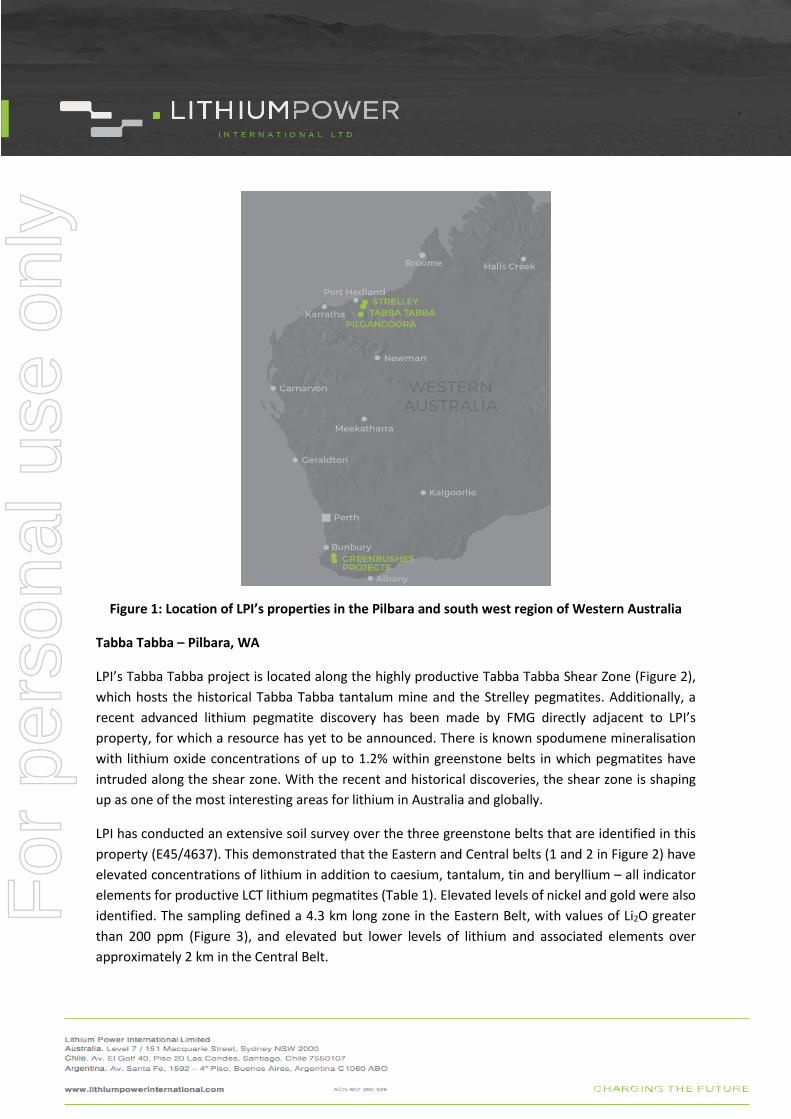
in the north and south-west of Western Australia (Figure 1).
A decision to expand activities on the Company’s WA properties resulted from positive preliminary
sampling results and the freeing up of resources following the lodgement of both the Environmental
Impact Assessment (EIA) and the Definitive Feasibility Study (DFS) of the Maricunga lithium brine
project in Chile. The Maricunga project now progresses through the Chilean environmental approval
process in parallel with discussions for off-take agreements and project finance with international
institutions.
The development of the WA properties advances the execution of the Company’s strategy of being a
diversified international lithium project developer, both in terms of geography and lithium source by
having hard rock and brine projects.
The WA properties, subject to little or no exploration for lithium in the past, have the potential to
create significant additional value for LPI as shown by the changes in market capitalisation of other
companies making attractive pegmatite discoveries in Western Australia.
The Company will direct further resources to this development process, with a new, expanded Perth
office and additional staff to supervise all activities. All WA properties are 100% owned by LPI and are
located a short distance from the ports of Port Hedland or Bunbury.
Lithium Power International’s Chief Executive Officer, Cristobal Garcia-Huidobro, commented:
“The Company’s properties in Western Australia are in highly prospective locations in the Pilbara or
adjacent to the world-class Greenbushes lithium mine in the south-west of the state and we are
mindful of the value the development of these assets can create for shareholders. We will be
increasing the staff and budget dedicated to these projects, looking to define resources as the first
stage of our development in Western Australia and undertaking assessments of project economics.
Following the successful completion of the Maricunga DFS, we are becoming a multi-project lithium
development Company with a very well diversified asset base. We view Western Australia as one of
the premier global locations for lithium development and look forward to developing a mine in this
jurisdiction.”
For
per
sona
l use
onl
y
SYDNEY, Australia
Figure 1: Location of LPI’s properties in the Pilbara and south west region of Western Australia
Tabba Tabba – Pilbara, WA
LPI’s Tabba Tabba project is located along the highly productive Tabba Tabba Shear Zone (Figure 2),
which hosts the historical Tabba Tabba tantalum mine and the Strelley pegmatites. Additionally, a
recent advanced lithium pegmatite discovery has been made by FMG directly adjacent to LPI’s
property, for which a resource has yet to be announced. There is known spodumene mineralisation
with lithium oxide concentrations of up to 1.2% within greenstone belts in which pegmatites have
intruded along the shear zone. With the recent and historical discoveries, the shear zone is shaping
up as one of the most interesting areas for lithium in Australia and globally.
LPI has conducted an extensive soil survey over the three greenstone belts that are identified in this
property (E45/4637). This demonstrated that the Eastern and Central belts (1 and 2 in Figure 2) have
elevated concentrations of lithium in addition to caesium, tantalum, tin and beryllium – all indicator
elements for productive LCT lithium pegmatites (Table 1). Elevated levels of nickel and gold were also
identified. The sampling defined a 4.3 km long zone in the Eastern Belt, with values of Li2O greater
than 200 ppm (Figure 3), and elevated but lower levels of lithium and associated elements over
approximately 2 km in the Central Belt.
For
per
sona
l use
onl
y
SYDNEY, Australia
Targets have been defined for an initial 3000 m drilling program in mid-2019, with drilling to test the
upper 100 m of the target. Positive drilling results would lead to resource definition, potentially to be
followed by a Scoping Study and additional resource drilling.
Field mapping has also identified that the zone of elevated soil geochemistry contains numerous
outcrops of coarse to fine grained pegmatite dykes (Figure 4). They vary in width and length and will
be mapped and sampled in more detail by the Company.
The soil program, completed over the three north-east trending greenstone belts (Figure 3),
comprised lines that were nominally on 200 m spacings, with samples taken every 25 m along lines. A
total of 1661 primary samples were taken during this program, with 184 duplicate samples taken and
analysed.
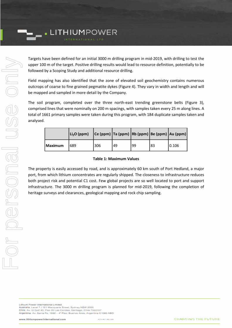
Table 1: Maximum Values
The property is easily accessed by road, and is approximately 60 km south of Port Hedland, a major
port, from which lithium concentrates are regularly shipped. The closeness to infrastructure reduces
both project risk and potential C1 cost. Few global projects are so well located to port and support
infrastructure. The 3000 m drilling program is planned for mid-2019, following the completion of
heritage surveys and clearances, geological mapping and rock chip sampling.
Li2O (ppm) Ce (ppm) Ta (ppm) Rb (ppm) Be (ppm) Au (ppm)
Maximum 689 306 49 99 83 0.106
For
per
sona
l use
onl
y

SYDNEY, Australia
Figure 2: Map showing the Tabba Tabba and Strelley projects on the regional Tabba Tabba Shear Zone and greenstone belts (mafic and ultramafic units in pale green and blue), surrounded by granite and gneiss units. The three greenstone belts along the shear zone are labelled 1 to 3
FMG advanced lithium drilling
1
2
3
1
Historical Tabba Tabba
Pegmatite
For
per
sona
l use
onl
y

SYDNEY, Australia
Figure 3: Li2O ppm results for the Tabba Tabba Project, E45/4637. Pink dots are for values of Li2O greater than 200 ppm
The Tabba Tabba Shear Zone is identified as an important regional fault, which has controlled intrusion
of lithium and tantalum-bearing pegmatites. It also hosts gold and base metal mineralisation further
to the south-west of the LPI project. The elevated lithium in soils is located 5 km north-east of the
historical Tabba Tabba tantalum mine, which is outside LPI’s property. Fortescue Metals Group has
recently conducted a significant drilling program on their project, to within 500 m SSW of the LPI
property, directly along the trend of LPI’s soil target.
For
per
sona
l use
onl
y

SYDNEY, Australia
Figure 4: Outcropping pegmatite in the Tabba Tabba property, in the area with elevated lithium in soil samples
Strelley – Pilbara, WA
The Strelley project has a similar structural setting to the Tabba Tabba project. It is located 15 km to
the north along the Tabba Tabba Shear Zone (Figure 2), where the greenstone belt with the highest
lithium in soil geochemistry on the LPI Tabba Tabba project continues. This area has shallow, wind-
blown sand cover. An initial 1000 m of systematic aircore drilling will be undertaken to obtain samples
for geochemistry and mapping of the rock type. Structures will be targeted in the greenstone belt that
are considered to potentially host pegmatites. The mineralised Tabba Tabba tantalum pegmatites are
located 5 km south-south-west of LPI’s Tabba Tabba property, and the Strelley pegmatites are located
between the two LPI properties. Drilling is planned for the project in 3Q19.
For
per
sona
l use
onl
y
SYDNEY, Australia
Pilgangoora – Pilbara, WA
The Pilgangoora project is approximately 110 km south-south-east of Port Hedland. The property
abuts and is immediately west of the mining properties held by Pilbara Minerals and Altura Mining,
where lithium is being mined from one of the world’s largest lithium pegmatite deposits. Pilbara
Minerals, has a resource base of 226 Mt of lithium mineralisation at 1.27% Li2O and a capitalisation of
$1.2 billion, having rapidly grown from an explorer to a developer and miner aiming to produce
330,000 tpa of lithium 6% concentrate. Altura Mining has a resource base of 50.5 Mt at 1.01% Li2O
and 41 Mt of reserves, with a capitalisation of $250 million. The Pilgangoora project is located within
1.5 hours drive of Port Hedland, from where lithium concentrates are currently being shipped.
To date LPI has conducted two soil sampling programs and drilled 35 reverse circulation holes. Further
evaluation of these results is planned prior to additional exploration on the property in 2019.
Greenbushes – South-west WA
The Greenbushes project is located 250 km south of Perth and comprises two properties located
immediately north and south of the block hosting the Greenbushes mine, which is owned by major
lithium producers Tianqi Lithium and Albemarle, multi-billion dollar public companies. The mine
supplies approximately 29% of global lithium supply and is undergoing an expansion to more than
double the current production. In 2012 the mine had Measured and Indicated resources of
approximately 118.5 Mt at 2.4% lithium oxide, the highest grade producing hard rock lithium mine
globally.
LPI’s properties are considered to be highly prospective for the discovery of lithium pegmatites along
the same geological units and faults as Greenbushes’ pegmatite. The properties E70/4763 and
E70/4774 cover extensive areas of forestry land, and LPI is seeking access to these areas for surface
geochemical sampling and subsequent drilling.
Project Acquisitions
LPI continues to evaluate third party projects that would be highly prospective additions to the WA
project portfolio. A number were evaluated in 2018 and more are being considered.
For further information, please contact:
Andrew G Phillips – Company Secretary Lithium Power International E: [email protected] Ph: +612 9276 1245 www.lithiumpowerinternational.com
For
per
sona
l use
onl
y
SYDNEY, Australia
Competent Persons Statement
The information in this report that relates to Exploration Results is based on, and fairly represents
information and supporting documentation prepared by Mr Ian Miles, a Competent Person who is a
member of The Australian Institute of Geoscientists. Mr Miles is a consultant to Lithium Power
International Limited. Mr Miles has more than five years’ experience which is relevant to the style of
mineralisation and type of deposit under consideration and to the activity which he is undertaking to
qualify as a Competent Person as defined in the 2012 Edition of the “Australasian Code for Reporting
of Exploration Results, Mineral Resource and Ore Reserves”. Mr Miles consents to the inclusion in this
report of the matters based on his information in the form and context in which it appears.
JORC Table 1 – Section 1 Sampling Techniques and Data (Criteria in this section apply to all succeeding sections.)
Criteria JORC Code explanation Commentary
Sampling techniques
• Nature and quality of sampling (eg cut channels, random chips, or specific specialised industry standard measurement tools appropriate to the minerals under investigation, such as down hole gamma sondes, or handheld XRF instruments, etc). These examples should not be taken as limiting the broad meaning of sampling.
• Include reference to measures taken to ensure sample representivity and the appropriate calibration of any measurement tools or systems used.
• Aspects of the determination of mineralisation that are Material to the Public Report.
• In cases where ‘industry standard’ work has been done this would be relatively simple (eg ‘reverse circulation drilling was used to obtain 1 m samples from which 3 kg was pulverised to produce a 30 g charge for fire assay’). In other cases more explanation may be required, such as where there is coarse gold that has inherent sampling problems. Unusual commodities or mineralisation types (eg submarine nodules) may warrant disclosure of detailed information.
• 1666 primary conventional soil samples were taken in the program on the Tabba Tabba project in E45/4637 referred to in this release
• Samples were taken from a point location on a grid 200 m x 25 m along the previously identified greenstone units which outcrop on a NE trend through the Tabba Tabba property
• Individual points were moved off the grid pattern to avoid sampling alluvial or colluvial material
• The samples were taken from pits dug to the approximate size of 500 x 500 mm in dimension and dug down to 200 mm
• The material taken from the pits were sieved (‐80 mesh (‐177 micron)) down to a final sample of 50 g
• To ensure that the correct location of each location was known a photo of the numbered sample bag, the sieved sample and the pit was taken
• Where insufficient material was encountered due to outcropping rocks, the point location was moved. The new location was recorded as the sample location
• Assays were untaken at the Nagrom
For
per
sona
l use
onl
y
SYDNEY, Australia
Criteria JORC Code explanation Commentary
laboratory in Perth
• Samples were dried at 105o C and pulverised to 95% passing 75μm
• Mixed Acid Digest with ICP finish for the following elements: Ag, As, Ba, Be, Bi, Cd, Ce, Co, Cr, Cs, Cu, La, Li, Mn, Mo, Nb, Nd, Ni, Pb, Rb, Sb, Sn, Ta, Th, U, W, Zn
• Fire Assay for Au was also completed
Drilling techniques
• Drill type (eg core, reverse circulation, open-hole hammer, rotary air blast, auger, Bangka, sonic, etc) and details (eg core diameter, triple or standard tube, depth of diamond tails, face-sampling bit or other type, whether core is oriented and if so, by what method, etc).
• No drilling was undertaken
Drill sample recovery
• Method of recording and assessing core and chip sample recoveries and results assessed.
• Measures taken to maximise sample recovery and ensure representative nature of the samples.
• Whether a relationship exists between sample recovery and grade and whether sample bias may have occurred due to preferential loss/gain of fine/coarse material.
• No drilling was undertaken
Logging • Whether core and chip samples have been geologically and geotechnically logged to a level of detail to support appropriate Mineral Resource estimation, mining studies and metallurgical studies.
• Whether logging is qualitative or quantitative in nature. Core (or costean, channel, etc) photography.
• The total length and percentage of the relevant intersections logged.
• A brief description of the soil sample and of any nearby outcrops was recorded
Sub-sampling techniques and sample preparation
• If core, whether cut or sawn and whether quarter, half or all core taken.
• If non-core, whether riffled, tube sampled, rotary split, etc and whether sampled wet or dry.
• For all sample types, the nature, quality and appropriateness of the sample
• Material collected from the pits was sieved using -80 mesh sieve to a sample of 50 g
• -80 mesh is appropriate for soil sampling
• Samples were photographed, bagged and dispatched to the laboratory
• Field duplicate samples were collected
For
per
sona
l use
onl
y
SYDNEY, Australia
Criteria JORC Code explanation Commentary
preparation technique.
• Quality control procedures adopted for all sub-sampling stages to maximise representivity of samples.
• Measures taken to ensure that the sampling is representative of the in situ material collected, including for instance results for field duplicate/second-half sampling.
• Whether sample sizes are appropriate to the grain size of the material being sampled.
approximately every 10th sample
• 184 duplicate samples were collected
• Samples were dried at 105o C and pulverised to 95% passing 75μm
• Mixed Acid Digest with ICP finish for the following elements: Ag, As, Ba, Be, Bi, Cd, Ce, Co, Cr, Cs, Cu, La, Li, Mn, Mo, Nb, Nd, Ni, Pb, Rb, Sb, Sn, Ta, Th, U, W, Zn
• Fire Assay for Au was also completed
Quality of assay data and laboratory tests
• The nature, quality and appropriateness of the assaying and laboratory procedures used and whether the technique is considered partial or total.
• For geophysical tools, spectrometers, handheld XRF instruments, etc, the parameters used in determining the analysis including instrument make and model, reading times, calibrations factors applied and their derivation, etc.
• Nature of quality control procedures adopted (eg standards, blanks, duplicates, external laboratory checks) and whether acceptable levels of accuracy (i.e. lack of bias) and precision have been established.
• The NAGROM laboratory in Perth is a well-established commercial laboratory
• An established ICP methodology was used for analysis for Lithium
• Field duplicate and laboratory duplicate samples were used in this program
• NAGROM undertook internal duplicate analysis and evaluation of laboratory standards, which shows acceptable sample repeatability
• LPI Duplicate samples show acceptable repeatability
Verification of sampling and assaying
• The verification of significant intersections by either independent or alternative Company personnel.
• The use of twinned holes.
• Documentation of primary data, data entry procedures, data verification, data storage (physical and electronic) protocols.
• Discuss any adjustment to assay data.
• Sampling was carried out by contract field personnel engaged by LPI and procedures were checked by the consultant engaged by LPI (CP) in the field
• Location and descriptive data were entered by field personnel in a digital format in the field, then imported, together with digital assay results into QGIS by the consultant
• The analytical data was reviewed by an alternative consultant engaged by LPI
• The sampling and significant intervals were validated by alternative consultant and the sampling results included full QA/QC analysis with duplicates analysed in comparison the primary
• No adjustment was made to assay data,
For
per
sona
l use
onl
y
SYDNEY, Australia
Criteria JORC Code explanation Commentary
apart from conversion of Li to Li2O by multiplying by 2.153
Location of data points
• Accuracy and quality of surveys used to locate drill holes (collar and down-hole surveys), trenches, mine workings and other locations used in Mineral Resource estimation.
• Specification of the grid system used.
• Quality and adequacy of topographic control.
• The samples were located with a hand-held GPS in the field and are accurate to +/- 5 m
• The location is in GDA94 Zone 50
Data spacing and distribution
• Data spacing for reporting of Exploration Results.
• Whether the data spacing and distribution is sufficient to establish the degree of geological and grade continuity appropriate for the Mineral Resource and Ore Reserve estimation procedure(s) and classifications applied.
• Whether sample compositing has been applied.
• Sampling was taken on 25 m intervals on north-east south-west lines with a 200 m northeast line spacing
• Individual points were moved off the grid pattern to avoid sampling alluvial or colluvial material
• Where insufficient soil material was encountered the sample location was moved and the site recorded
Orientation of data in relation to geological structure
• Whether the orientation of sampling achieves unbiased sampling of possible structures and the extent to which this is known, considering the deposit type.
• If the relationship between the drilling orientation and the orientation of key mineralised structures is considered to have introduced a sampling bias, this should be assessed and reported if material.
• Samples were collected on lines at approximately 90 degrees to the strike of lithological contacts
• Orientation of sample lines is not expected to contribute to sampling bias
Sample security
• The measures taken to ensure sample security.
• Samples were transported to the laboratory by a reputable contractor
Audits or reviews
• The results of any audits or reviews of sampling techniques and data.
• No audits or reviews have been conducted at this point in time
• The CP has reviewed the data and considers the data is appropriate for this style of mineralisation and sampling type
For
per
sona
l use
onl
y
SYDNEY, Australia
Section 2 - Reporting of Exploration Results
(Criteria listed in the preceding section also apply to this section.)
Criteria JORC Code explanation Commentary
Mineral tenement and land tenure status
• Type, reference name/number, location and ownership including agreements or material issues with third parties such as joint ventures, partnerships, overriding royalties, native title interests, historical sites, wilderness or national park and environmental settings.
• The security of the tenure held at the time of reporting along with any known impediments to obtaining a licence to operate in the area.
• The sampling was conducted on E45/4637 which is 100% owned by LPI
• The Tabba Tabba property is believed to be in good standing, with payments made to relevant government departments
Exploration done by other parties
• Acknowledgment and appraisal of exploration by other parties.
• No previous exploration for lithium on the project property is known
• Previous exploration was for a limited suite of base metals or gold
Geology • Deposit type, geological setting and style of mineralisation.
• The project is located on an Archean Greenstone belt
• The mineralisation targeted is rare metal pegmatite hosted mineralisation. The greenstone belts in the region are known to host lithium bearing pegmatites. The historical Tabba Tabba Tantalum Mine is located approximately 5 km to the south-west of E45/4637. The high grade Pilgangoora Lithium mine of Pilbara Minerals is located approximately 50 km to the south
Drill hole Information
• A summary of all information material to the understanding of the exploration results including a tabulation of the following information for all Material drill holes:
o easting and northing of the drill hole collar
o elevation or RL (Reduced Level – elevation above sea level in metres) of the drill hole collar
o dip and azimuth of the hole
o down hole length and interception depth
• No drill holes drilled
For
per
sona
l use
onl
y
SYDNEY, Australia
Criteria JORC Code explanation Commentary
o hole length.
• If the exclusion of this information is justified on the basis that the information is not Material and this exclusion does not detract from the understanding of the report, the Competent Person should clearly explain why this is the case.
Data aggregation methods
• In reporting Exploration Results, weighting averaging techniques, maximum and/or minimum grade truncations (eg cutting of high grades) and cut-off grades are usually Material and should be stated.
• Where aggregate intercepts incorporate short lengths of high grade results and longer lengths of low grade results, the procedure used for such aggregation should be stated and some typical examples of such aggregations should be shown in detail.
• The assumptions used for any reporting of metal equivalent values should be clearly stated.
• Samples relate to a point soil sample from which material is generally expected to be sourced from the immediate vicinity
• Data aggregation methods have not been applied
Relationship between mineralisation widths and intercept lengths
• These relationships are particularly important in the reporting of Exploration Results.
• If the geometry of the mineralisation with respect to the drill hole angle is known, its nature should be reported.
• If it is not known and only the down hole lengths are reported, there should be a clear statement to this effect (eg ‘down hole length, true width not known’).
• Only surface sampling has been conducted
Diagrams • Appropriate maps and sections (with scales) and tabulations of intercepts should be included for any significant discovery being reported These should include, but not be limited to a plan view of drill hole collar locations and appropriate sectional views.
• A plan of sample locations and a summary table is provided in report
Balanced reporting
• Where comprehensive reporting of all Exploration Results is not practicable, representative reporting of both low and high grades and/or widths should be practiced to avoid misleading reporting of
• A summary of results from reported program is Included
For
per
sona
l use
onl
y
SYDNEY, Australia
Criteria JORC Code explanation Commentary
Exploration Results.
Other substantive exploration data
• Other exploration data, if meaningful and material, should be reported including (but not limited to): geological observations; geophysical survey results; geochemical survey results; bulk samples – size and method of treatment; metallurgical test results; bulk density, groundwater, geotechnical and rock characteristics; potential deleterious or contaminating substances.
• No other data is available
Further work • The nature and scale of planned further work (eg tests for lateral extensions or depth extensions or large-scale step-out drilling).
• Diagrams clearly highlighting the areas of possible extensions, including the main geological interpretations and future drilling areas, provided this information is not commercially sensitive.
• LPI is planning further detailed field investigations to validate the pegmatite related mineralisation potential
• The Company will plan an RC drilling program for mid 2019, weather dependent. Once the location of the holes are confirmed, heritage surveys will be completed to allow drilling to proceed
For
per
sona
l use
onl
y


![HUIDOBRO - xn--pequeodios-x9a.clñodios.cl/wp-content/uploads/2016/11/breve_seleccion... · Huidobro, Vicente Breve selección de poemas [texto impreso] / Vicente Huidobro 1ª edición](https://img.dokumen.tips/doc/110x75/5ae7df0d7f8b9a08778eeb20/huidobro-xn-pequeodios-x9acl-vicente-breve-seleccin-de-poemas-texto-impreso.jpg)