Embed Size (px)
Citation preview

MEBANE COMMUNITY PARK: MASTER PLANSCALE 1”= 80’
0 40 80 160
N
OPEN LAWN (3.00 ac)
SOCCER SPECTATOR LAWNSEATING AREAS; TYP.
DOG PARK
MODIFIED POND /STORMWATER MANAGEMENT
SOCCER FIELDSOCCER FIELD
POSSIBLE FUTURE PARKING ADDITION
CONCESSIONS / RESTROOMS / STORAGE /OPEN AIR SEATING AREA
PLAYGROUND
PEDESTRIAN WALKWAY / SERVICE AND EMERGENCY VEHICLE ACCESS
OUTER LOOP WALKING TRAIL; 8’ MIN. WIDTH(.73 mi)
INNER LOOP WALKING TRAIL; 8’ MIN. WIDTH(.54 mi)
BERM AND VEGETATED BUFFER
POSSIBLE FUTURE30,000 SF RECREATION CENTER
WO
OD
LAWN
RD
CLAY ST EXT
PEDESTRIAN PROMENADE WITH SHADE STRUCTURES
SOCCER WARM UP AREA
MAINTENANCESHIELD
TURN AROUND /DROP OFF
DOG PARKSHADE STRUCTURE;WATER FOUNTAINS FOR PETS AND PET OWNERS TO BE PROVIDED IN THE VICINITY OF THE DOG PARK
PLAYGROUND SHADESTRUCTURE
POTENTIAL FUTURE AMPHITHEATER WITH BAND SHELL AND SEATINGGRADE SLOPE IN FIRST PHASE
FUTURE OPEN AIR PICNIC SHELTER LARGE DOG
AREA
SMALL DOG AREA
POTENTIAL FUTURESPLASH PAD
50 SPACES
102 SPACES
152 SPACES
POND PERIMETER FENCE
VEGETATED BERM
7 SPACES
BIORETENTION BASIN
W CENTER ST (US HWY 70)
SANITARY SEWER LIFT STATION
BIORETENTION BASIN
TOTAL PARKING COUNT ( FIRST PHASE): 209 SPACESTOTAL PARKING COUNT (FIRST PHASE + FUTURE PHASE) : 341 SPACES
POSSIBLE FUTUREPARKING
30 SPACES
PARKING LOT LIGHTING; TYP.
BERM AND VEGETATED BUFFER
FUTURE MULTI-USE PATH

MEBANE COMMUNITY PARK: LANDSCAPE SECTIONS
DOG PARK
SECTION CC
SECTION BB
SECTION AA
KEY PLAN
SCALE: 1”=6’
SCALE: 1”= 10’
PR
OP
ER
TY L
INE
4’-6’ HT
6’-8’ HT
EXISTING WOODED AREA
EXISTING 4’ HT FENCE
10’-0” EXISTING 4’ HT FENCE
EXISTING WOODED AREAPARKING LOT SIDEWALK
WIDTH VARIES
SCALE: 1”=6’
WALKING TRAIL P
RO
PE
RTY
LIN
E
WIDTH VARIES
10’-0”
ADJACENT RESIDENTIAL PROPERTY SOCCER WARM UP / OPEN LAWNWALKING TRAIL
EXISTING WOODED AREA
WIDTH VARIES
PR
OP
ER
TY L
INE
6’-8’ HT
SECTION CC
SECTIO
N AA
SECTIO
N BB
0 3’ 6’ 12’
0 3’ 6’ 12’
0 5’ 10’ 20’
10’-0”


151455/23/16
TSK
FKH3
9
SITEPLAN
PRELIMINARY
Firm's Engineering License No. F-0203
alley, williams, carmen & king, inc.ENGINEERS, ARCHITECTS & SURVEYORS
p.o. box 1179740 chapel hill roadburlington, n.c. 27215 336/226-5534
VICINITY MAP
SITE
PREPARER
ALLEY, WILLIAMS, CARMEN & KING INC.740 CHAPEL HILL ROAD, BURLINGTON, NC 27216
TROY KING, PE #35017336-226-5534
OWNER
CITY OF MEBANE106 EAST WASHINGTON STREET
MEBANE, NC 27302919-563-5901
31' B-B CURB & GUTTER44' B-B CURB & GUTTER
SECTION B-BSECTION A-A
SITE DATA
1. PARCEL ID: 165659; CITY OF MEBANE; DEED BOOK 3451, PAGE 104; PLATBOOK 77, PAGE 54, LOT 2
2. AREA = 31.694 AC.3. ZONING: R-20 AND B-24. THE PROPERTY DOES NOT LIE WITHIN A SPECIAL FLOOD HAZARD AREA AS
DETERMINED BY FEMA AS SHOWN ON PANEL NO. 3710981500J, EFFECTIVEDATE SEPTEMBER 6, 2006.
5. SUBJECT PROPERTY IS LOCATED WITHIN THE ETJ OF THE CITY OF MEBANE.6. BOUNDARY FOR PARCEL ID: 165659 DONE BY REGIONAL LAND
SURVEYORS, INC. ISSUED AND SEALED BY KIM R. LILLY, PLS, L-3612 ON4-1-2015.
7. TOPOGRAPHIC AND LOCATION DATA (INCL. HWY 70) SHOWN FOR PARCELID: 165659 DONE BY REGIONAL LAND SURVEYORS, INC. ISSUED ANDSEALED BY KIM R. LILLY, PLS, L-3612 ON 2-12-2015.
8. TOPOGRAPHIC AND BOUNDARY INFORMATION SHOWN FROM EASTBOUNDARY OF PARCEL ID: 165659 AT CLAY ST. CONTINUING EAST DOWNCLAY ST. BY AWCK USING CONTROL DATA PROVIDED BY REGIONAL LANDSURVEYORS, INC.
9. TOTAL DISTURBED AREA: 30 AC.10. IMPERVIOUS AREA: PROPOSED SITE - 11.33 AC. POSSIBLE FUTURE - 1.41 AC. PROPOSED R/W - 1.13 AC. COMPLETE MASTERPLAN BUILD-OUT IMPERVIOUS - 13.87 AC. A SPECIAL INTENSITY ALLOCATION WILL NEED TO BE REQUESTED FOR THIS PROJECT DUE TO THE PROPOSED IMPERVIOUS PERCENTAGE.11. MAXIMUM BUILT UPON AREA: 14.26 AC (45.0%)12. WATERSHED CLASSIFICATION: GENERAL WATERSHED OVERLAY DISTRICT
(GRAHAM-MEBANE LAKE WATERSHED BALANCE OF WATERSHED)13. MEBANE COMMUNITY PARK PROPERTY WILL BE ANNEXED IN THE FUTURE.14. MEBANE COMMUNITY PARK HOURS OF OPERATION: 6 AM - 11 PM.15. MEBANE COMMUNITY PARK ENTRANCE SIGNS SHALL HAVE A MAXIMUM
AREA OF 32 SF AND SHALL MEET CITY OF MEBANE SIGN ORDINANCE.
THE SITE PLANS AS PROVIDED ARE SUBJECT TO FURTHER REVISION ANDMODIFICATION DUE TO THE FOLLOWING:
A. FINAL DESIGN OF THE PROJECT ELEMENTS BEING COMPLETED.B. APPROVAL OF FINAL DESIGN PLANS BY THE PARK STEERING COMMITTEE.C. RECEIPT OF BIDS AND ANY RELATED BUDGETARY CONSTRAINTS.D. APPROVALS BEING SOUGHT FROM REVIEW AGENCIES (CITY OF MEBANE,
NCRR, NCDOT, USACE & NCDEQ).E. ANY CHANGES THAT MAY BE APPROVED BY CITY COUNCIL.
PARKING REQUIREMENTS
SPACES REQUIRED: ATHLETIC FIELDS (25/FIELD) = 50 SPACES FUTURE RECREATION CENTER (1/200 SF OF GROSS FLOOR AREA) = 150 SPACES TOTAL SPACES REQUIRED = 200 SPACES
SPACES PROVIDED: PHASE 1 (209 SPACES) FUTURE (132 SPACES) TOTAL (341 SPACES)

151455/19/16
TSK
FKH4
9
UTILITY &STORMWATERMANAGEMENT
Firm's Engineering License No. F-0203
alley, williams, carmen & king, inc.ENGINEERS, ARCHITECTS & SURVEYORS
p.o. box 1179740 chapel hill roadburlington, n.c. 27215 336/226-5534
VICINITY MAP
SITE
PLAN
PREPARER
ALLEY, WILLIAMS, CARMEN & KING INC.740 CHAPEL HILL ROAD, BURLINGTON, NC 27216
TROY KING, PE #35017336-226-5534
OWNER
CITY OF MEBANE106 EAST WASHINGTON STREET
MEBANE, NC 27302919-563-5901
THE SITE PLANS AS PROVIDED ARE SUBJECT TO FURTHER REVISION ANDMODIFICATION DUE TO THE FOLLOWING:
A. FINAL DESIGN OF THE PROJECT ELEMENTS BEING COMPLETED.B. APPROVAL OF FINAL DESIGN PLANS BY THE PARK STEERING COMMITTEE.C. RECEIPT OF BIDS AND ANY RELATED BUDGETARY CONSTRAINTS.D. APPROVALS BEING SOUGHT FROM REVIEW AGENCIES (CITY OF MEBANE,
NCRR, NCDOT, USACE & NCDEQ).E. ANY CHANGES THAT MAY BE APPROVED BY CITY COUNCIL.

20' TYPE 'B' SEMI OPAQUELANDSCAPE BUFFER
CLAY STREET EXTENSION
W CENTER STREET (U.S. HIGHWAY 70)
WO
OD
LAW
N RO
AD
TOTAL AREA39.478 ACRES(1,719,644 SF)
NORTH CAROLINA RAILROAD
40' BUFFER
40' BUFFER
40' B
UFF
ER
20' B
UFF
ER
40' BU
FFER
30' STREETSCAPES
30' BUFFER
30' BUFFER
30' BUFFER
W CENTER STREET (U.S. HIGHWAY 70)
WO
OD
LAW
N RO
AD
TOTAL AREA39.478 ACRES(1,719,644 SF)
NORTH CAROLINA RAILROAD
40' BUFFER
40' BUFFER
40' B
UFF
ER
30' B
UFF
ER
30' BUFFER
30' BUFFER
30' BUFFER
40' BU
FFER
40' BUFFER
Tract 33S.K. Scott Plat
17 1717
17
18
19
20
21
22
"S.K. Scott Heirs"PLAT BOOK 77 PAGE 267
100' TAPER
B
DROP-OFF ZONE
30' TYPE 'B' SEMI OPAQUELANDSCAPE BUFFER
40' TYPE 'B' SEMI OPAQUELANDSCAPE BUFFER
40' TYPE 'B' SEMI OPAQUELANDSCAPE BUFFER
40' TYPE 'B' SEMI OPAQUELANDSCAPE BUFFER
40' TYPE 'B' SEMI OPAQUELANDSCAPE BUFFER
30' TYPE 'B' SEMI OPAQUELANDSCAPE BUFFER
30' TYPE 'B' SEMI OPAQUELANDSCAPE BUFFER
STREET TREE; TYP.
EVERGREEN SHRUBS; TYP.WEEPING LOVE GRASS; TYP.
FESCUESEED; TYP.
20' TYPE 'B' SEMI OPAQUELANDSCAPE BUFFER (DUETO SEWER EASEMENT)
STREET TREE; TYP.
EVERGREEN SCREEN' 3" CAL. 8' MIN. HT ATINSTALLATION; EVERGREEN TREES PLANTEDAT 6' O.C.; LAYOUT TO BE COORDINATEDWITH ADJACENT PROPERTY OWNER
BIO-RETENTIONPLANTING; TYP.
BIO-RETENTIONPLANTING; TYP.
PARKING LOT PERIMETEREVERGREEN SHRUBS; TYP.
APPROXIMATE LOCATIONOF PARK ENTRANCE SIGNS
PROPOSEDPOND
POSSIBLE FUTUREBAND SHELLAND SEATING
BIORETENTION BASIN
POSSIBLE FUTURE30,000 SF RECREATIONCENTER
PLANTING LEGEND
DECIDUOUS CANOPY TREEMIN. 2.5" CAL. & 10' HT ATINSTALLATION
EVERGREEN SHRUBSMIN. 24" HT AT INSTALLATION
UNDERSTORY TREESMIN. 2.0" CAL. & 8' HT ATINSTALLATION
EVERGREEN CANOPY TREEMIN 2.5" CAL. @ 10' HT. ATINSTALLATION
WEEPING LOVE GRASS SEED(SLOPES GREATER 3:1)
FESCUE SEED
BIO-RETENTION PLANTING
FLOWERING TREE
1. EXISTING UTILITIES SHOWN ARE APPROXIMATE AND SHALL BE VERIFIED IN THEFIELD PRIOR TO BEGINNING WORK. CONTRACTOR SHALL CONTACT NC ONECALL CENTER AT 1-800-632-4949 FOR LOCATION OF EXISTING UTILITIES PRIOR TOBEGINNING CONSTRUCTION. THE CONTRACTOR SHALL EXERCISE CAUTIONWHEN WORKING AROUND EXISTING UTILITIES TO REMAIN.
2. PLANT LIST IS PROVIDED FOR CONVENIENCE ONLY. IN THE CASE OFDISCREPANCIES BETWEEN THE PLAN AND PLANT LIST QUANTITIES, THE PLANSHALL TAKE PRECEDENCE.
3. AFTER THE SITE IS STABILIZED AND FREE OF SEDIMENTATION, THE CONTRACTORSHALL REMOVE ALL TEMPORARY EROSION CONTROL DEVICES, SILT, RIP RAPAND TEMPORARY STONE STAGING AREAS FOR REPLACEMENT WITH PLANTINGSOIL. PROVIDE PLANTING ACCORDING TO THE LANDSCAPE PLAN.
4. TEMPORARY EROSION CONTROL SEED MUST BE FULLY REMOVED PRIOR TOPREPARATION OF PERMANENT SEED, SOD OR LANDSCAPE BEDS.
5. UNLESS OTHERWISE NOTED IN THE PLANT LIST, THE CONTRACTOR SHALL OBTAINAND INSTALL ONLY PLANT MATERIAL THAT IS GROWN ON ITS OWN ROOT -GRAFTED OR BUDDED PLANT MATERIAL WILL BE REJECTED.
6. ALL TREES SHALL BE OBTAINED FROM THE NURSERY WITH EXPOSED ROOTCROWNS. B&B MATERIAL DELIVERED TO SITE WITH BURIED OR RECENTLY BURIEDROOT CROWNS WILL BE REJECTED.
7. FURNISHED PLANT MATERIAL SHALL MEET THE MINIMUM HEIGHT OR MINIMUMSPREAD DIMENSIONS SHOWN IN THE PLANT LIST HEADINGS. THE CONTRACTORSHALL UTILIZE THE MOST STRINGENT DIMENSION SHOWN ON THE PLANT LIST.
8. DO NOT PLANT IN STORM WATER CONVEYANCE SWALES OR PROVIDE FINEGRADING THAT DISRUPTS FLOW OR CHANGES LONGITUDINAL SLOPES.
9. PLANT THE OUTER EDGES OF EACH PLANTING GROUP FOLLOWING THE BEDOUTLINE ACCORDING TO THE PLAN. ONCE A SATISFACTORY MATCHED OUTERSHAPE IS OBTAINED, FILL THE CENTER OF EACH AREA WITH PLANTS ACCORDINGTO THE PLAN AND SPACING NOTES.
10. THE PLANTING LAYOUT WITHIN PLANTING BEDS SHOULD BE SHIFTED TO MINIMIZECONFLICTS WITH EXISTING TREE ROOTS.
11. THE CONTRACTOR SHALL SEED ???? SOD ALL DISTURBED AREAS INCLUDINGCONSTRUCTION ACCESS OUTSIDE PROJECT LIMITS.
PLANTING NOTES
SCALE: 1" = 80'-0"
0 40 80 160
N151456/02/16
RW. JH
CB
15145 LAYOUTBASE.DWG
Firm's Engineering License No. F-0203
alley, williams, carmen & king, inc.ENGINEERS, ARCHITECTS & SURVEYORS
p.o. box 1179740 chapel hill roadburlington, n.c. 27215 336/226-5534
VICINITY MAP
SITE
59
SITELANDSCAPE PLAN
OVERALL

151455/23/16
ADL
JLP6
9
Firm's Engineering License No. F-0203
alley, williams, carmen & king, inc.ENGINEERS, ARCHITECTS & SURVEYORS
p.o. box 1179740 chapel hill roadburlington, n.c. 27215 336/226-5534
PRELIMINARYNOT FOR CONSTRUCTION
LIGHTING PLAN PREPARED BY:
OVERALL PARKINGLOT LIGHTING PLAN

59
CLAY STREET EXTENSION
W CENTER STREET (U.S. HIGHWAY 70)
WO
OD
LAW
N RO
AD
1
2
TOTAL AREA39.478 ACRES(1,719,644 SF)
NORTH CAROLINA RAILROAD
40' BUFFER
40' BUFFER
40' B
UFF
ER
20' B
UFF
ER
40' BU
FFER
30' STREETSCAPES
30' BUFFER
30' BUFFER
30' BUFFER
S2
S1
24 29 25 21 20 24 34 46
40 41 34 31 30 32 38 48
46 46 38 33 31 31 34 35
42 40 34 29 26 27 28 29
35 36 30 25 22 23 24 24
31 34 28 23 20 21 22 21
31 34 28 23 20 20 22 21
34 35 29 24 22 22 23 24
41 39 32 27 25 26 27 28
45 44 36 31 30 31 33 35
40 40 33 29 29 32 38 48
24 28 24 20 19 24 34 45
156'
140'
169'
214'
156'
140'
171'
215'
S3
S4
S6
S5
31 46 37 28 25 27 34 33
47 47 38 34 35 38 45 45
36 38 34 34 37 41 47 46
29 31 29 29 33 37 41 40
24 27 25 24 27 31 34 30
20 24 22 21 22 26 30 25
20 23 21 21 22 26 30 25
22 25 23 24 27 31 34 30
27 28 28 29 33 37 41 40
35 36 34 34 37 42 48 47
46 46 38 34 34 39 46 45
28 44 33 26 25 29 34 30
S3
S4
156'
140'
136'
214'
134'
215'
156'
140'
0.0 0.0 0.0 0.0 0.0 0.0 0.0 0.0 0.0 0.0 0.0
0.0
0.0
0.0
0.0
0.0
0.0
0.0
0.0
0.0
0.0
0.0
0.0
0.0
0.0
S6
S5
0.0
0.0
0.0
0.0
0.0
0.0
0.0
0.0
0.0
0.0
0.0
0.00.00.00.00.00.00.00.00.00.00.00.00.00.00.00.00.00.00.00.00.00.00.10.10.40.61.00.80.70.50.40.20.10.10.1
0.1
0.1
0.1
0.1
0.1
0.2
0.2
0.2
0.2
0.2
0.2
0.1
0.1
0.1
0.0
0.0
0.0
0.0
0.0
0.0
0.00.00.00.00.00.00.00.00.00.00.00.00.00.00.00.00.0
0.0
0.0
0.0
0.0
0.0
0.0
0.0 0.0 0.0 0.0 0.0 0.0 0.0 0.0 0.0 0.0 0.0 0.0 0.0 0.0 0.0 0.0 0.0 0.0 0.0 0.0 0.0 0.0 0.0 0.0 0.0 0.0 0.0 0.0 0.0 0.0 0.0 0.0 0.0 0.0 0.0 0.0 0.0 0.0 0.0 0.0 0.0 0.0 0.0 0.0 0.0 0.0 0.0 0.0 0.0 0.0 0.0
0.0
0.0
0.0
0.0
0.0
0.0
0.0
0.0
0.0
0.0
0.0
0.0
0.0
0.00.0
0.00.0
0.00.0
0.0
S3
S4
S2
S1
W CENTER STREET (U.S. HIGHWAY 70)
WO
OD
LAW
N RO
AD
TOTAL AREA39.478 ACRES(1,719,644 SF)
NORTH CAROLINA RAILROAD
40' BUFFER
40' BUFFER
40' B
UFF
ER
30' B
UFF
ER
30' BUFFER
30' BUFFER
30' BUFFER
40' BU
FFER
40' BUFFER
TracS.K. S
17
18
19
20
21
22
"S.K. Scott Heirs"PLAT BOOK 77 PAGE 267
100' TAPER
DROP-OFF ZONE
EQUIPMENT LIST FOR AREAS SHOWNPole Luminaires
QTY LOCATION SIZE GRADEELEVATION
MOUNTINGHEIGHT
LAMPTYPE
QTY /POLE
THISGRID
OTHERGRIDS
2 S1-S2 80' - 80' 1500W MZ 9 9 02 S3-S4 90' - 45'
90'LED 5700K - 75 CRI
1500W MZ2
1809
29
4 TOTALS 58 36 22
MY PROJECTName: Mebane Community Park Soccer
Loca on: Mebane, NC
GRID SUMMARYName: Soccer-1
Size: 360' x 225'Spacing: 30.0' x 30.0'Height: 3.0' above grade
MAINTAINED ILLUMINATIONSUMMARY HORIZONTAL FOOTCANDLES
En re GridGuaranteed Average: 30
Scan Average: 30.5Maximum: 48Minimum: 19Avg / Min: 1.57
Guaranteed Max / Min: 2.5Max / Min: 2.46
UG (adjacent pts): 1.7CU: 0.55
No. of Points: 96LUMINAIRE INFORMATION
Luminaire Type: Green Genera onDesign Usage Hours: 5,000 hours
Design Lumens: 134,000Avg Tilt Factor: 1.000
Add'l Non-Rec LLF: 1.000Recoverable LLF: 1.000
Total LLF: 1.000No. of Luminaires: 36
Avg KW: 56.3 (61.2 max)
Field Measurements: Illumina on measured in accordance with theIESNA RP-6-15 and CIBSE LG4. Individualvalues may vary. See the Warranty document for details.Electrical System Requirements:Refer to AmperageDraw Chart and/or theMusco Control System Summaryfor electrical sizing.Installa on Requirements:Results assume +/- 3%nominal voltage at line side of the ballast and structureslocated within 3 feet (1m) of design loca ons.
EQUIPMENT LIST FOR AREAS SHOWNPole Luminaires
QTY LOCATION SIZE GRADEELEVATION
MOUNTINGHEIGHT
LAMPTYPE
QTY /POLE
THISGRID
OTHERGRIDS
2 S3-S4 90' - 45'90'
LED 5700K - 75 CRI1500W MZ
218
09
29
2 S5-S6 80' - 80' 1500W MZ 9 9 04 TOTALS 58 36 22
MY PROJECTName: Mebane Community Park Soccer
Loca on: Mebane, NC
GRID SUMMARYName: Soccer-2
Size: 360' x 225'Spacing: 30.0' x 30.0'Height: 3.0' above grade
MAINTAINED ILLUMINATIONSUMMARY HORIZONTAL FOOTCANDLES
En re GridGuaranteed Average: 30
Scan Average: 32.8Maximum: 48Minimum: 20Avg / Min: 1.65
Guaranteed Max / Min: 2.5Max / Min: 2.41
UG (adjacent pts): 1.6CU: 0.59
No. of Points: 96LUMINAIRE INFORMATION
Luminaire Type: Green Genera onDesign Usage Hours: 5,000 hours
Design Lumens: 134,000Avg Tilt Factor: 1.000
Add'l Non-Rec LLF: 1.000Recoverable LLF: 1.000
Total LLF: 1.000No. of Luminaires: 36
Avg KW: 56.3 (61.2 max)
Field Measurements: Illumina on measured in accordance with theIESNA RP-6-15 and CIBSE LG4. Individualvalues may vary. See the Warranty document for details.Electrical System Requirements:Refer to AmperageDraw Chart and/or theMusco Control System Summaryfor electrical sizing.Installa on Requirements:Results assume +/- 3%nominal voltage at line side of the ballast and structureslocated within 3 feet (1m) of design loca ons.
MY PROJECTName: Mebane Community Park Soccer
Loca on: Mebane, NC
EQUIPMENT LAYOUTINCLUDES:· Soccer-1· Soccer-2
Electrical System Requirements:Refer to AmperageDraw Chart and/or the"Musco Control System Summary"for electrical sizing.Installa on Requirements:Results assume +/- 3%nominal voltage at line side of the ballast and structureslocated within 3 feet (1m) of design loca ons.
EQUIPMENT LIST FOR AREAS SHOWNPole Luminaires
QTY LOCATION SIZE GRADEELEVATION
MOUNTINGHEIGHT
LAMPTYPE
QTY /POLE
4 S1-S2S5-S6
80' - 80' 1500W MZ 9
2 S3-S4 90' - 45'90'
LED 5700K - 75 CRI1500W MZ
218
6 TOTALS 76
SINGLE LUMINAIRE AMPERAGE DRAW CHARTBallast Speci ca ons
(.90 min power factor)Line Amperage Per Luminaire
(max draw)
Single Phase Voltage 208(60)
220(60)
240(60)
277(60)
347(60)
380(60)
480(60)
1500 wa MZ 8.6 8.3 7.5 6.5 5.1 4.7 3.796 LED 2.5 2.3 2.1 1.9 1.5 1.4 1.1
EQUIPMENT LIST FOR AREAS SHOWNPole Luminaires
QTY LOCATION SIZE GRADEELEVATION
MOUNTINGHEIGHT
LAMPTYPE
QTY /POLE
THISGRID
OTHERGRIDS
2 S1-S2 80' - 80' 1500W MZ 9 9 02 S3-S4 90' - 45'
90'LED 5700K - 75 CRI
1500W MZ2
1809
29
4 TOTALS 58 36 22
MY PROJECTName: Mebane Community Park Soccer
Loca on: Mebane, NC
GRID SUMMARYName: Property Line Spill
Spacing: 30.0'Height: 3.0' above grade
MAINTAINED ILLUMINATIONSUMMARY HORIZONTAL FOOTCANDLES
En re GridScan Average: 0.041
Maximum: 1.0Minimum: 0.00
No. of Points: 212LUMINAIRE INFORMATION
Luminaire Type: Green Genera onDesign Usage Hours: 5,000 hours
Design Lumens: 134,000Avg Tilt Factor: 1.000
Add'l Non-Rec LLF: 1.000Recoverable LLF: 1.000
Total LLF: 1.000No. of Luminaires: 36
Avg KW: 56.3 (61.2 max)
Field Measurements: Illumina on measured in accordance with theIESNA RP-6-15 and CIBSE LG4. Individualvalues may vary. See the Warranty document for details.Electrical System Requirements:Refer to AmperageDraw Chart and/or theMusco Control System Summaryfor electrical sizing.Installa on Requirements:Results assume +/- 3%nominal voltage at line side of the ballast and structureslocated within 3 feet (1m) of design loca ons.
N151456/02/16
RW. JH
CB
15145 LAYOUTBASE.DWG
Firm's Engineering License No. F-0203
alley, williams, carmen & king, inc.ENGINEERS, ARCHITECTS & SURVEYORS
p.o. box 1179740 chapel hill roadburlington, n.c. 27215 336/226-5534
VICINITY MAP
SITE
79
SITEFIELD LIGHTING PLAN
OVERALL

151456/02/16
RW. JH
CB
15145 LAYOUTBASE.DWG
Firm's Engineering License No. F-0203
alley, williams, carmen & king, inc.ENGINEERS, ARCHITECTS & SURVEYORS
p.o. box 1179740 chapel hill roadburlington, n.c. 27215 336/226-5534
VICINITY MAP
SITE
89
DETAILSFIELD LIGHTING
2 31
45 6
GALVANIZED STEEL POLE- HID AND LED ELECTRICAL COMPONENTS ENCLOSURELIGHT-STRUCTURE GREEN LIGHTING SYSTEM
LUMINAIRE ASSEMBLYWIRE HARNESS PRECAST CONCRETE BASE- HID AND LED
7 96 LED LUMINAIRE AND DRIVER

151455/19/16
TSK
FKH9
9
STREET INTERSECTIONDETAILS
Firm's Engineering License No. F-0203
alley, williams, carmen & king, inc.ENGINEERS, ARCHITECTS & SURVEYORS
p.o. box 1179740 chapel hill roadburlington, n.c. 27215 336/226-5534
VICINITY MAP
SITE
PREPARER
ALLEY, WILLIAMS, CARMEN & KING INC.740 CHAPEL HILL ROAD, BURLINGTON, NC 27216
TROY KING, PE #35017336-226-5534
OWNER
CITY OF MEBANE106 EAST WASHINGTON STREET
MEBANE, NC 27302919-563-5901

Prepared for City of Mebane
Project Number: 160009Original: 02/26/2016Revised: 05/18/2016
Mebane Community ParkMebane, NC


5/18/2016 160009 Mebane Community Park – Executive Summary i
Mebane Community Park – Transportation Impact Analysis Prepared for City of Mebane Original: February 26, 2016 Revised: May 18, 2016 Executive Summary The City of Mebane is proposing a community park on US 70 (Center Street) between Woodlawn Road and NC 119 (2nd Street). The park is proposed to include two (2) soccer fields along with space for a future 30,000 square foot recreational center. This site is planned to access the proposed park with three access points: Center Street, Woodlawn Road and Clay Street Extension. A roundabout located on the eastern side of the site provides access to the main parking area via US 70 (Center Street) and Clay Street. A separate parking area on the western side is accessed by Woodlawn Road. DAVENPORT was retained to determine the potential traffic impacts of this development and to identify transportation improvements that may be required to accommodate the impacts of both background traffic and new development traffic. The following intersections were included in the study:
• US 70 (Center Street) at Woodlawn Road • NC 119 (2nd Street) at Clay Street • 5th Street at Clay Street • Center Street at Site Access 1 • Woodlawn Road at Site Access 2 • Internal roundabout
The above-mentioned intersections were analyzed for the following scenarios:
• 2016 Existing Conditions • 2018 Future No Build Conditions • 2018 Future Build-Out Conditions • 2018 Future Build-Out with Improvements (as necessary)
The build-out analysis year for this project was assumed to be 2018. The weekday PM (4-6 pm) and Saturday (11 am-2 pm) peaks were studied as these are anticipated to be the time periods of heaviest park usage. The City of Mebane and the North Carolina Department of Transportation (NCDOT) were contacted to obtain background information and to ascertain the elements to be covered in this Transportation Impact Analysis (TIA). Information regarding the property was provided by AWCK Inc.

5/18/2016 160009 Mebane Community Park – Executive Summary ii
Level of Service Results The results of the study are discussed by intersection below: US 70 (Center Street) at Woodlawn Road This unsignalized intersection currently operates at LOS C in the PM peak and LOS B in the Saturday peak. In 2018 future no build conditions, the analysis indicates LOS C in the PM peak and LOS B in the Saturday peak. With the addition of site traffic, this intersection is projected to operate at LOS C in the PM peak and LOS B in the Saturday peak. No improvements are recommended. NC 119 (2nd Street) at Clay Street This signalized intersection currently operates at LOS A in the PM and Saturday peaks. In 2018 future no build conditions, the analysis indicates LOS A in the PM and Saturday peaks. With the addition of site traffic, this intersection is projected to operate at LOS A in the PM and Saturday peaks. No improvements are recommended. 5th Street at Clay Street This unsignalized intersection currently operates at LOS B in the PM and Saturday peaks. In 2018 future no build conditions, the analysis indicates LOS B in the PM and Saturday peaks. With the addition of site traffic, this intersection is projected to operate at LOS B in the PM and Saturday peaks. No improvements are recommended. US 70 (Center Street) at Site Access 1 In 2018 future build conditions, LOS C is expected in the PM peak and LOS B in the Saturday peak. On the basis of the projected traffic volumes, auxiliary turn lanes are not warranted. However, both the City of Mebane and NCDOT support a left turn lane on US 70 into the site to promote safety by separating turning traffic from through traffic on this relatively high speed roadway. Therefore, an eastbound left turn lane on US 70 (Center Street) with 100 feet of storage and appropriate taper is recommended. The site plan indicates a separate left and right egress lane from the site access. With these improvements the LOS in the PM and Saturday Build conditions are expected to remain the same. Woodlawn Road at Site Access 2 In 2018 future build conditions, LOS B is expected in the PM peak and LOS A in the Saturday peak. The turning volumes into the site are very low and would not require an auxiliary lane. No improvements are recommended. Internal Roundabout An internal roundabout is proposed where Site Access 1 intersects Clay Street Extension. This single lane roundabout is expected to operate at LOS A in the PM and Saturday peaks. Per NCDOT standards, a 20-year future build analysis was also

5/18/2016 160009 Mebane Community Park – Executive Summary iii
prepared for the roundabout scenario; the results indicate a LOS A in the PM and Saturday peaks. Based on the flow-scale analysis failure is not expected within 20 years after build, results can be found in the appendix. Level of Service Summary Table A presents the summary of the level of service analysis.
Table A - Level of Service Summary
PM Peak 2016 Existing
2018 Future No Build
2018 Future Build
2018 Future Build with
Improvements
US 70 (Center Street) at Woodlawn Road
C (18.8) SB Approach
C (19.4) SB Approach
C (20.8) SB Approach
NC 119 (2nd Street) at Clay Street A (4.8) A (5.0) A (3.7)
5th Street at Clay Street B (11.9) EB Approach
B (12.0) EB Approach
B (12.5) EB Approach
US 70 (Center Street) at Site Access 1
C (16.8) SB Approach
C (16.4) SB Approach
Woodlawn Road at Site Access 2
B (10) WB Approach
Roundabout A (4.4)
Saturday Peak 2016 Existing
2018 Future No Build
2018 Future Build
2018 Future Build with
Improvements
US 70 (Center Street) at Woodlawn Road
B (12.8) SB Approach
B (13) SB Approach
B (13.1) SB Approach
NC 119 (2nd Street) at Clay Street A (3.6) A (3.7) A (3.7)
5th Street at Clay Street B (12.3) EB Approach
B (12.4) EB Approach
B (12.7) EB Approach
US 70 (Center Street) at Site Access 1
B (12.6) SB Approach
B (12.5) SB Approach
Woodlawn Road at Site Access 2
A (9.1) WB Approach
Roundabout A (4.3)
LOS (delay in seconds) Note for unsignalized conditions, LOS and delay indicates only minor street approach with longest delay

5/18/2016 160009 Mebane Community Park – Executive Summary iv
Summary and Conclusion The City of Mebane is proposing a community park on US 70 (Center Street) between Woodlawn Road and NC 119 (2nd Street). The park is proposed to include two (2) soccer fields along with space for a future 30,000 square foot recreational center. This site is planned to access the proposed park with three access points: Center Street, Woodlawn Road and Clay Street Extension. A roundabout located on the eastern side of the site provides access to the main parking area via US 70 (Center Street) and Clay Street. A separate parking area on the western side is accessed by Woodlawn Road. The trip generation indicates that based on the current site plan the proposed project is projected to generate a total of 1,158 trips per day. The analysis indicates that the study intersections are expected to operate at LOS C or better in the PM and Saturday peaks. The proposed internal roundabout will operate effectively as a single lane roundabout. All study intersections are expected to function without any improvements. However, at the intersection of US 70 (Center Street) at Site Access 1, it is desired by the City of Mebane and NCDOT that an eastbound left turn lane be constructed for safety on a high speed roadway. Therefore, it is recommended to provide an 100 foot storage with appropriate taper left turn lane. The site plan indicates a separate left and right egress lane from the site access. In conclusion, this analysis has been conducted based on NCDOT and City of Mebane guidelines and has determined the potential traffic impacts of this development. With the build-out of the site, the analysis indicates there will be adequate capacity to accommodate future traffic. Note that the site accesses should to be designed according to NCDOT standards as appropriate.
April 28, 2016
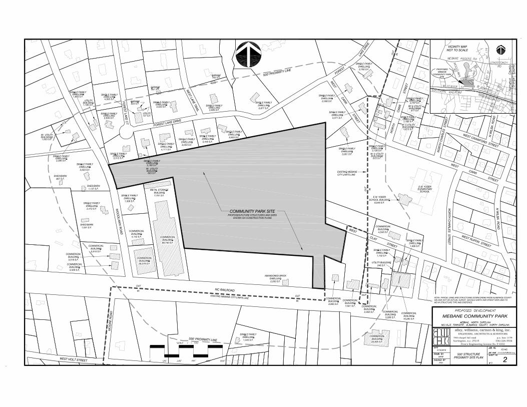
Mr. David Cheek City Manager City of Mebane 106 East Washington Street Mebane, NC 27302 RE: Special Use Permit for Proposed Mebane Community Park 31.561-Acre Vacant Tract Located at 627 West Center Street Mebane, NC 27302 Dear Mr. Cheek: The above captioned property is proposed for development by the City of Mebane with a community park that will include two soccer fields, possibly a future indoor pool, basketball and fitness building, as well as a potential amphitheater, a dog park, a concessions and restroom building, parking, maintenance building and a sewer lift station. The tract, which is addressed as 621 W. Center Street, Mebane, NC. (Tax Id. Number 165659), is 31.561 acres in size and is outside the city limits of Mebane, but is within its extraterritorial jurisdiction. As such, it is zoned R-20 (a residential classification) and the majority of the tract is within a General Watershed District associated with Mebane’s water supply. The purpose of this letter is to render an opinion about any impact that the park could have on adjoining and surrounding residential properties. To this end, we have conducted studies on several areas of Alamance County and adjoining Guilford County where there are existing athletic parks. The purpose of the studies is to review sales of adjoining residential properties in an effort to determine whether or not their proximity to the park and/or athletic facilities had a negative impact on their respective market values. For Alamance County, we have conducted studies involving the sale of five single-family residential properties located directly across from the athletic fields at Walter Williams High School. These sales are located on Tarleton Drive and Parkview Street and were utilized in a “matched” pair comparison analysis with similar properties from the neighborhood that sold during the same time frame (no more man than 12 months apart) not located across from the athletic fields.
305 Blandwood Avenue 2nd Floor Greensboro, NC 27401 Telephone 336-282-8088 Fax 336-282-9484
J Thomas Taylor, MAI, SRA William F. Hester, Jr. Rai Alexander Tanya Self Wes Rankin Chelsea Polk

Mr. David Cheek April 28, 2016 Page 2 This was done to see whether or not the athletic fields had an adverse effect on value to those sale properties located across from them. In addition to analyzing several sales from the neighborhood surrounding Walter Williams High School, we also compared two sales (via a matched pair analysis) from Graham on Oakgrove Drive that are located directly across from the athletic facilities associated with Graham High School, North Graham Elementary School and Town Branch Park. Similar to the previous analyses, these two sales were compared to similar properties not located across from the athletic fields/facilities that sold at about the same time. Also, a similar analysis was undertaken involving the sale of a property located at 1346 St. Marks Church Rd located directly across from a large park (Davidson Park) with athletic facilities located at the corner of Rural Retreat Road and St. Marks Church Rd. As was the case with the previous analyses, this property was then compared with two sales from the neighborhood located on Berkshire Road not located across from the park. In conclusion, eights sales involving single-family residential properties located within close proximity to athletic facilities were analyzed to see whether or not their proximity to these facilities had an adverse effect on their eventual sale prices. In all eight comparisons, after making necessary adjustments when required for differences regarding size, construction, quality, age, number of bedrooms and baths, whether or not they have garages or carports, etc., no discernible difference in value attributable to the sale property’s proximity to athletic fields and/or a park was evident. Further support of this conclusion is provided by a 2007 study conducted by this office regarding the proposed Proehlific Park in northwest Greensboro, NC. This facility has baseball fields, soccer fields and an approximate 60,000 square foot building to house indoor athletic facilities. In this study several areas of Guilford County where there are existing athletic parks were surveyed and sales of adjoining residential properties were studied in an effort to determine appreciation rates of the properties which had recently sold. To this end, we studied the area of Lindley Park along West Market Street, N. Eugene Street, which is near the New Bridge Baseball Park and the Montebello and Stonehaven neighborhoods near the YMCA on Horsepen Creek Road. Other areas were also studied, but these were the primary ones because of their location, levels of traffic, etc. In all cases we found that appreciation rates of surrounding homes continued to be consistent with appreciation rates in other neighborhoods of town, generally in the area of 2.5% to 3% per year. In other words, when appreciation rates around a specific use continue to be consistent with other neighborhoods of the city that are not exposed to that use, it indicates that there is no adverse impact as a result of the specific use being studied.

Mr. David Cheek April 28, 2016 Page 3 One additional study is referenced for support as well. This report was conducted in 2007 by Econsult Corporation and Greenways Incorporated for the Catawba Lands Conservancy. This studied involved a regional economic impact study regarding the Carolina Thread Trial, which is an approximate 500-mile trail across a 15-county region that includes parts of North and South Carolina. In short it was found that the trail with full community support and with the appropriate implementation, would provide a number of tangible and intangible economic benefits for the local communities throughout the region. In part, the study concluded the following:
• Enhanced property values and local tax revenues • Increased tourism • Increased economic benefits for the local economy generated by the investment to construct
the Trail • Enhanced Business Community through business expansion and economic development • Enhanced air and water quality • Increased Recreation Value for residents and tourists
While this study does not deal directly with the issue as to whether or not the proposed Mebane Community Park will adversely affect surrounding property values, it does demonstrate that greenways, trails and recreational type uses generally do not have a negative impact on adjoining and nearby uses. In conclusion, we are of the opinion that the proposed Mebane Community Park with its two soccer fields and other planned amenities will not injure the value of adjoining or abutting property. This is especially true given the specific configuration of the tract and the proposed site plan, which shows a large buffer area with a pond and a planted berm along the property’s northern property line to protect adjoining residential development in the Forest Lake neighborhood from light and noise. Furthermore, it is our understanding that while the soccer fields and parking areas will be illuminated, the lights for the soccer fields will have shields and the buffer area surrounding the parking areas should act as a shield as well. Also, it is noted that light industrial uses adjoin the property to the west, while mostly business-type uses adjoin it to the south. Further, we believe that this use would have less impact on surrounding residential properties than some other uses which could conceivably be developed on the tract. We further note that this letter is merely a summary of our conclusions and that the data relied upon for these opinions is retained in our files.

Mr. David Cheek April 28, 2016 Page 4 We appreciate the opportunity to be of service to you in this matter. If you have any questions or need additional information, please feel free to call. Respectfully Submitted,
J. Thomas Taylor, MAI, SRA William F. Hester, Jr.