Embed Size (px)
Citation preview

McGrath Boulevard Project Development Working Group Meeting #2
February 5, 2015 – East Somerville Community School

Agenda
• Review of the November meeting • 2040 Traffic Projections:
• No-Build Conditions • Build Conditions
• Evolving Bicycle and Pedestrian Accommodations
• Next steps

The November Working Group Session
Review and Key Themes

Key Elements I
• MassDOT committed to viaduct removal
• Our process builds on “Grounding McGrath”
• Opportunities associated with removal:
• Improve safety for all modes of transportation.
• Calm traffic.
• Provide east to west connections.
• Improve/create pedestrian and bicycle conditions.
• Take full advantage of benefits conferred by GLX.

Key Elements II
• Role of the working group: • Inform and advise the agency with local knowledge.
• Help the agency team develop a preferred alternative to take into the environmental process.
• Help develop design details for future discussion in the 25% design process.
• Study area
• Existing traffic conditions
• Bicycle and pedestrian methodologies

Where We Are

Where We Are - Description
• The previous slide showed a graphic of the general project timeline for the McGrath Boulevard Project Development.
• The project team is currently in the project development stage.
• There will be community involvement throughout the entirety of the project.

MassDOT Priorities
Improve Safety, Access & Connections for All Modes

MassDOT Priorities - Description The previous slide showed an image of MassDOT’s priorities which are to improve safety, access & connections for all modes while creating a context sensitive design. Sub-priorities include the following:
1. Improve Access and Mobility:
1. Improve regional/local travel time
2. Improve health of residents
3. Facilitate multi-modal transportation opportunities
4. Context sensitive design
2. Promote Connectivity:
1. Provide new connections
2. Improve urban form “place making”
3. Improve access to open space
4. Context sensitive design
3. Improve and Balance Functionality:
1. Enhance safety for all modes
2. Maintain regional travel capacity
3. Limit impacts on surrounding roadways
4. Context sensitive design
4. Provide Accountability:
1. Share benefits and burdens of changes
2. Limit impact to environment
3. Ensure long-term corridor maintainability
4. Context sensitive design
The bottom line is to achieve reasonable consensus on a concept design

Working Group Priorities
Improve Safety, Access & Connections for All Modes

Working Group Priorities - Description The previous slide showed an image of the Working Group’s priorities which are to improve safety, access & connections for all modes while creating a context sensitive design. Sub-priorities include the following:
1. Improve Access and Mobility:
1. Remove McCarthy Overpass
2. Calm traffic without inducing congestion
3. Increase/improve bus shuttle service
4. Fully leverage benefits of GLX Project
5. Enhance bicycle and pedestrian facilities
6. Context sensitive design
2. Promote Connectivity:
1. Reconnect Union Square, Brickbottom and Innerbelt neighborhoods
2. Create a unified corridor
3. Improve access to green space
4. Context sensitive design
3. Improve and Balance Functionality:
1. Enhance safety for all modes
2. Promote community development
3. Reduce impacts on neighborhoods
4. Minimize cut-thru traffic
5. Maintain neighborhood vibrancy
6. Context sensitive design
4. Provide Accountability:
1. Reduce environmental impacts and roadway exposures
2. Ensure long-term corridor livability
3. Include EJ population participation in public process
4. Consider abutting project(s) plans
5. Context sensitive design
The bottom line is to remove the viaduct to improve safety, reconnect neighborhoods and increase green space.

Shared Priorities
Improve safety for all modes: walking, cycling, driving, transit Remove McCarthy Overpass Context sensitive design or:
Increase connectivity of entire corridor (up & down, side-to-side)
Use Complete Streets guidelines to create inviting bicycle and pedestrian infrastructure
Coordinate with abutting projects Create new green space and landscaped boulevard
Consider overall public health in planning/conceptual design Calm traffic without inducing harmful local or regional congestion Protect the neighborhood during construction Maintain unique neighborhood vibrancy after construction

2040 No Build
Traffic Projections

Components of the Future Projections
• Travel Demand Model from the
Central Transportation Planning Staff (CTPS)
• Local Adjustments
• Future Trips
• Future Mode Share

CTPS Process
• Regional Travel Demand Model
• Demographic & Land Use Data Transportation Infrastructure
• Extensive Model
• Model Outputs

CTPS Process - Description
• The previous slide showed an image of the CTPS boundary within the state of Massachusetts.
• The CTPS process includes: a regional travel demand model based on an extensive computer program and based on 2040 traffic projections.

Five Step Travel Demand Model
1. Vehicle Ownership 2. Trip Generation 3. Trip Distribution 4. Mode Choice
• Highway • Transit • Non -motorized
5. Assignment • Highway • Transit

Five Step Travel Demand Model - Description
• The previous slide showed an image of the five step travel demand model used by CTPS.
• The model takes into account: • Vehicle ownership
• Trip generation
• Trip distribution
• Mode choice: highway, transit, and non-motorized.
• Based on these inputs the model generates and assigns future trips to highway or transit modes.

Local Development Areas
1a. Green Line Extension: Magoun Square 1b. Green Line Extension: Gilman Square 1c. Green Line Extension: Ball Square 2. Sullivan Square 3. River Green 4. Assembly Square 5. Beacon Street 6. Boynton Yards 7. Brickbottom/Inner Belt 8. East Somerville Gateway 9. Fabrication District 10. Union Square 11. North Point

Local Development Areas - Description
• The previous slide showed an image of development projects happening around the McGrath Boulevard Project area. These include: • Green Line Extension: Magoun Square, Gilman Square, Ball Square
• Sullivan Square
• River Green
• Assembly Square
• Beacon Street
• Boynton Yards
• Brickbottom/Inner Belt
• East Somerville Gateway
• Fabrication District
• Union Square
• North Point

Transportation Improvements
1. Green Line Extension/Union Square
2. Rutherford Avenue/ Sullivan Square
3. Russia Wharf Ferry Terminal

Transportation Improvements - Description
• The previous slide showed three significant transportation improvement projects happening around the McGrath Boulevard Project area. These include:
• Rutherford Avenue and Sullivan Square
• Russia Wharf Ferry Terminal
• Green Line Extension and Union Square

Understanding the CTPS Model
• Home-based Trip Generation
• Allocated study area developments:
• 100% of Residential Development
• 60% of Employment Development
• Additional Effect from Local Development:
• Employment
• Retail, entertainment, etc.

Mode Choice

Mode Choice - Description
• The previous slide showed the location of McGrath Highway in the context of Spring Hill, Winter Hill, East Somerville, Inner Belt/Brickbottom, and East Cambridge.
• The projected 2040 no build mode choices are broken down as follows:
- Auto: AM – 47%, PM – 51%
- Bike and Walk: AM – 26%, PM – 29%
- Transit: AM – 27%, PM – 20%

Mode Shift Goals
• GreenDOT
• Design a multi-modal transportation system
• Promote healthy transportation + livable communities
• Triple statewide bicycling, transit + walking mode share
• City of Somerville
• Increase active and alternative transportation options
• 10% Bicycle Mode Share by 2020
• 50% of New Trips via Transit, Bike, or Walking

Pedestrian and Bicycle Initiatives
• Community Path
• Hubway Expansion
• Beacon Street Expansion
• Increased Bicycle Parking
• Yearly Volume Counts
• On-going Education

Bicycle Initiative Implementation

Bicycle Initiative Implementation - Description
• The previous slide showed an image of the existing bicycle facilities in Somerville. Facilities are color-coded:
• Those in red were built prior to 2009
• Those in green were built in 2009
• Those in blue were built in 2010
• Those in yellow were built in 2011
• Those in purple were built in 2012

Planned Bicycle Initiatives

Planned Bicycle Initiatives - Description
The previous slide showed an image of the planned bicycle routes in Somerville:
• Those in dark purple represent existing off-road paths
• Those in light purple represent proposed off-road paths
• Those in dark green represent existing bicycle lanes
• Those in light green represent existing sharrows
• Those in dark blue represent planned bicycle lanes
• Those in yellow represents planned sharrows

The McGrath Gap
The McGrath Gap - Description
• The previous slide showed an image of the lacking bicycle infrastructure within the McGrath Highway corridor.
• While Somerville as a whole has substantial bicycle infrastructure, there is a significant gap around the McGrath Highway.
• This project aims to close that gap.

Types of Cyclists

Types of Cyclists - Description
• The previous slide described the four types of cyclist and the percentage of cyclists they represent:
- less than 1% feel strong and fearless
- 7% are enthused and confident
- 60% are interested but concerned
- 33% are unlikely ever to ride a bicycle
• This project attempts to capture that 60% through providing better facilities for them

Green Line Extension
Ridership Projections
• Based on FTA constraints
• Daily ridership - approximately 38,000
• Majority switch from bus to train
• 9,000 new transit trips per day

Green Line Extension contd.
Transit Capacity
• Primarily based on 2 car trains
• Peak hour capacity = 2,484 riders
• Capacity for an additional 800 riders in the peak hour
• Potential for greater capacity by utilizing 3 car trains

Mode Share and Local Model Adjustments
• Local Development Would Increase Overall Trips
• Model Includes Minimal Mode Shift
• Available Transit Capacity
• Improving Pedestrian and Bicycle Network
• Mode Shift Estimated to Offset Additional Development

AM Traffic Volumes

AM Traffic Volumes – Description
• The previous slide showed a side by side comparison of existing traffic volumes and 2040 no-build volumes for the A.M. peak hour along the McGrath Highway corridor.
• Generally speaking, 2040 volumes are higher than current volumes.

PM Traffic Volumes

PM Traffic Volumes – Description
• The previous slide showed a side by side of comparison of existing traffic volumes and 2040 no-build volumes for the P.M. peak hour for the McGrath Highway corridor.
• Generally speaking, 2040 volumes are higher than current volumes.

AM Traffic Volumes contd.

AM Traffic Volumes contd. – Description
• The previous slide showed a side by side comparison of existing traffic volumes and 2040 no-build volumes for the A.M. peak hour on roadways providing east-west connections across the McGrath Highway corridor.
• Generally speaking, 2040 volumes are higher than current volumes.

PM Traffic Volumes contd.

PM Traffic Volumes contd. – Description
• The previous slide showed a side by side comparison of existing traffic volumes and 2040 no-build volumes for the P.M. peak hour on roadways providing east-west connections across the McGrath Highway corridor.
• Generally speaking, 2040 volumes are higher than current volumes.

AM Growth from 2014 Existing to 2040 No Build

AM Growth from 2014 Existing to 2040 No Build – Description
• The previous slide showed an image of the A.M. peak period roadway volume change for the 2040 future year versus the 2014 base year.
• Roadways which have predicted traffic increases were designated with a green line.
• Roadways which have predicted traffic decreases were designated with a red line.
• The thicker the line, the greater the anticipated change.

PM Growth from 2014 Existing to 2040 No Build

PM Growth from 2014 Existing to 2040 No Build – Description
• The previous slide showed an image of the P.M. peak period roadway volume change for the 2040 future year versus the 2014 base year.
• Roadways which have predicted traffic increases were designated with a green line.
• Roadways which have predicted traffic decreases were designated with a red line.
• The thicker the line, the greater the anticipated change.

2040 Build Traffic Projections

Rutherford Avenue

Rutherford Avenue – Description
• The previous slide showed an aerial view of the Rutherford Avenue corridor in Charlestown.
• Called out are the intersections of:
• Sullivan Square
• Rutherford Avenue/Austin Street
• At present the City of Boston has plans to remove the grade separation at both intersections and generally redevelop Rutherford Avenue along complete streets lines as a boulevard.

McGrath Boulevard

McGrath Boulevard – Description
• The previous slide showed an aerial view of the McGrath Highway corridor.
• Called out is one of the boulevard designs from the concept plan.
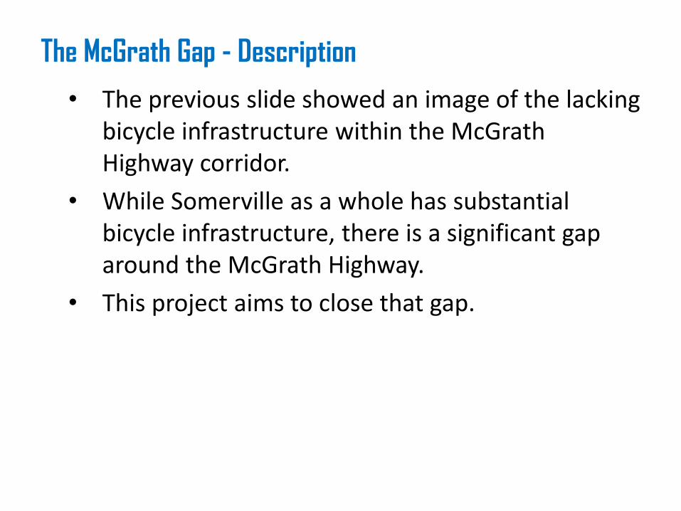
Build Scenarios 6 Lane without Rutherford Improvements

Build Scenarios – Description
• The previous slide showed a diagram of one of the possible build scenarios.
• This one includes:
• A six lane cross section on McGrath Boulevard.
• No changes on Rutherford Avenue.

Build Scenarios contd.

Build Scenarios contd. – Description
• The previous slide showed a diagram of one of the possible build scenarios.
• This one includes:
• A six lane cross section on McGrath Boulevard.
• The changes on Rutherford Avenue envisioned by the City of Boston.

Build Scenarios contd. 2

Build Scenarios contd. 2 – Description
• The previous slide showed a diagram of one of the possible build scenarios.
• This one includes:
• A four lane cross section on McGrath Boulevard.
• No changes on Rutherford Avenue.

Build Scenarios contd. 3

Build Scenarios – 3 – Description
• The previous slide showed a diagram of one of the possible build scenarios.
• This one includes:
• A six lane cross section on McGrath Boulevard.
• The changes on Rutherford Avenue envisioned by the City of Boston.

AM 6 Lane without Rutherford Improvements

AM 6 Lane without Rutherford Improvements – Description
• The previous slide showed a comparison between 2040 A.M. peak hour volumes for the following two scenarios:
• No-build.
• 6 lane McGrath Boulevard without Rutherford Avenue improvements.
• Generally speaking, volumes decrease all along McGrath Boulevard when the 6 lane approach is implemented.

PM 6 Lane without Rutherford Improvements

PM 6 Lane without Rutherford Improvements – Description
• The previous slide showed a comparison between 2040 P.M. peak hour volumes for the following two scenarios:
• No-build.
• 6 lane McGrath Boulevard without Rutherford Avenue improvements.
• Generally speaking, volumes decrease all along McGrath Boulevard when the 6 lane approach is implemented.

6 Lane without Rutherford - AM Diversions

6 Lane without Rutherford - AM Diversions – Description
• The previous slide assumes the following scenario for the A.M. peak period:
• No changes to Rutherford Avenue
• A six lane McGrath Boulevard
• Under this scenario traffic diverts away from the McGrath corridor and moves towards the following streets:
• School
• Somerville
• Hampshire
• Rutherford
• Alford

6 Lane without Rutherford - PM Diversions

6 Lane without Rutherford - PM Diversions – Description
• The previous slide assumes the following scenario for the P.M. peak period:
• No changes to Rutherford Avenue
• A six lane McGrath Boulevard
• Under this scenario traffic diverts away from the McGrath corridor and moves towards the following streets:
• School
• Somerville
• Hampshire
• Rutherford
• Alford

AM 6 Lane with Rutherford Improvements

AM 6 Lane with Rutherford Improvements – Description
• The previous slide assumes the following scenario for the A.M. peak period:
• Planned changes to Rutherford Avenue
• A six lane McGrath Boulevard
• Under this scenario: • Southbound traffic from Rutherford Avenue moves into the
McGrath Corridor
• Northbound volumes are generally constant.

PM 6 Lane with Rutherford Improvements

PM 6 Lane with Rutherford Improvements – Description
• The previous slide assumes the following scenario for the P.M. peak period:
• Planned changes to Rutherford Avenue
• A six lane McGrath Boulevard
• Under this scenario: • Both north and southbound traffic from Rutherford Avenue
moves into the McGrath Corridor

6 Lane with Rutherford AM - Diversions

6 Lane with Rutherford AM – Diversions – Description
• The previous slide assumes the following scenario for the A.M. peak period:
• Planned changes to Rutherford Avenue
• A six lane McGrath Boulevard
• Under this scenario traffic diverts away from the McGrath corridor and moves towards the following streets:
• School
• Somerville
• Hampshire
• Rutherford
• Alford
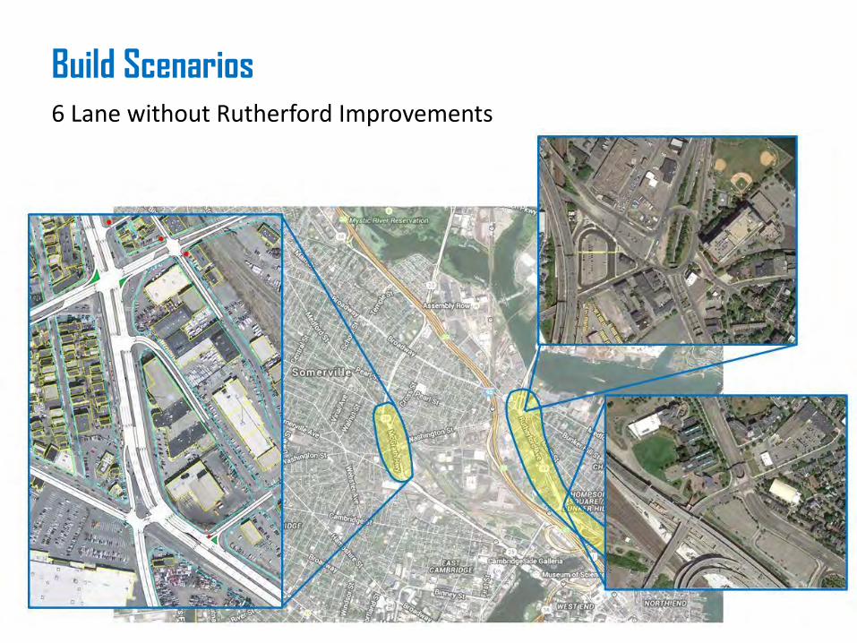
6 Lane with Rutherford PM - Diversions

6 Lane with Rutherford PM – Diversions – Description
• The previous slide assumes the following scenario for the P.M. peak period:
• Planned changes to Rutherford Avenue
• A six lane McGrath Boulevard
• Under this scenario traffic diverts away from the McGrath corridor and moves towards the following streets:
• School
• Somerville
• Hampshire
• Rutherford
• Alford

AM 4 Lane without Rutherford Improvements

AM 4 Lane without Rutherford Improvements – Description
• The previous slide assumes that no changes are made to Rutherford Avenue.
• It then compares the following two scenarios for the A.M. peak hour:
• A 6 lane McGrath Boulevard
• A 4 lane McGrath Boulevard
• The chief difference is that with the loss on one lane, southbound vehicles divert out of the McGrath Corridor and filter through local streets in Cambridge and Somerville.

PM 4 Lane without Rutherford Improvements

PM 4 Lane without Rutherford Improvements – Description
• The previous slide assumes that no changes are made to Rutherford Avenue.
• It then compares the following two scenarios for the P.M. peak hour:
• A 6 lane McGrath Boulevard
• A 4 lane McGrath Boulevard
• The chief difference is that with the loss on one lane, southbound vehicles divert out of the McGrath Corridor and filter through local streets in Cambridge and Somerville.

4 Lane without Rutherford AM - Diversions

4 Lane without Rutherford AM – Diversions – Description
• The previous slide assumes the following scenario for the A.M. peak period:
• No changes to Rutherford Avenue
• A four lane McGrath Boulevard
• Under this scenario traffic diverts away from the McGrath corridor and moves towards the following streets:
• School
• Somerville
• Hampshire
• Rutherford
• Alford

4 Lane without Rutherford PM - Diversions

4 Lane without Rutherford PM – Diversions – Description
• The previous slide assumes the following scenario for the P.M. peak period:
• No changes to Rutherford Avenue
• A four lane McGrath Boulevard
• Under this scenario traffic diverts away from the McGrath corridor and moves towards the following streets:
• School
• Somerville
• Hampshire
• Rutherford
• Alford

AM 4 Lane with Rutherford Improvements

AM 4 Lane with Rutherford Improvements – Description
• The previous slide assumes that planned changes are made to Rutherford Avenue.
• It then compares the following two scenarios for the A.M. peak hour:
• A 6 lane McGrath Boulevard
• A 4 lane McGrath Boulevard
• The chief difference is that with the loss on one lane, southbound vehicles divert out of the McGrath Corridor and filter through local streets in Cambridge and Somerville.

PM 4 Lane with Rutherford Improvements

PM 4 Lane with Rutherford Improvements – Description
• The previous slide assumes that planned changes are made to Rutherford Avenue.
• It then compares the following two scenarios for the P.M. peak hour:
• A 6 lane McGrath Boulevard
• A 4 lane McGrath Boulevard
• The chief difference is that with the loss on one lane, southbound vehicles divert out of the McGrath Corridor and filter through local streets in Cambridge and Somerville.

4 Lane with Rutherford AM - Diversions

4 Lane with Rutherford AM – Diversions – Description
• The previous slide assumes the following scenario for the P.M. peak period:
• Planned changes to Rutherford Avenue
• A four lane McGrath Boulevard
• Under this scenario traffic diverts away from the McGrath corridor and moves towards the following streets:
• School
• Somerville
• Hampshire
• Rutherford
• Alford

4 Lane with Rutherford PM - Diversions

4 Lane with Rutherford PM – Diversions – Description
• The previous slide assumes the following scenario for the P.M. peak period:
• Planned changes to Rutherford Avenue
• A four lane McGrath Boulevard
• Under this scenario traffic diverts away from the McGrath corridor and moves towards the following streets:
• School
• Somerville
• Hampshire
• Rutherford
• Alford

Diversion Summary
• Rutherford Avenue Diversions
• Broadway
• I-93
• Charlestown
• McGrath Highway Diversions
• School Street
• Beacon Street
• Somerville Avenue

Study Area Adjustments
• Previous Study Area
• Current Study Area
• Extended Study Area

Study Area Adjustments – Description
The previous slide showed an image of study area intersections.
• Intersections in a red circle were studied during the Grounding McGrath study.
• Intersections in a blue circle are within this project’s current study area.
• Intersections in a purple circle are part of a proposed, extended study area for this project.

Next Steps

Next Steps contd.
• Fully analyze each build scenario
• Pedestrian & Bicycle Operations
• Vehicle Operations
• Quantify Impacts of Diversions
• Pedestrian and Bike Infrastructure & Analysis

Schedule/Timeline
• Next working group session:
• April, 2015
• Stakeholder group briefings available upon request

Questions/Discussions