Embed Size (px)
Citation preview

APPENDIX J
Recreation Analysis

MCC South Quarry Expansion Recreation Analysis
Pacific Southwest Region San Bernardino National Forest
Anita Bueno, Landscape Architect Recreation Solutions, USDA Forest Service December 18, 2012

Recreation Report
2

3
Table of Contents 1.0 Introduction ........................................................................................................................................ 5
1.1 Proposed Action Project Description ................................................................................. 6
1.2 Scope of Analysis ................................................................................................................ 6
1.3 Indicators of Effects ............................................................................................................ 6
1.4 San Bernardino National Forest Management Direction ................................................... 6
1.8 Significance Criteria ............................................................................................................ 9
2.0 Effect Analysis ..................................................................................................................................... 9
2.1 Methodology ...................................................................................................................... 9
3.0 Alternative 1 – South Quarry Development (Proposed Action) ....................................................... 11
3.1 Direct and Indirect Effects ................................................................................................ 11
3.2 Cumulative Effects ............................................................................................................ 14
4.0 Alternative 2 – Partial Implementation ............................................................................................ 15
4.1 Direct, Indirect and Cumulative Effects ............................................................................ 15
5.0 Alternative 3 – Marble Canyon Haul Road Alternative ..................................................................... 15
5.1 Direct, Indirect and Cumulative Effects ............................................................................ 16
6.0 Alternative 4 – No Action .................................................................................................................. 16
6.1 Direct, Indirect and Cumulative Effects ............................................................................ 16
7.0 Summary of Effects – All Alternatives ............................................................................................... 16
7.1 Alternative 1 – South Quarry Development (Proposed Action) ....................................... 16
7.2 Alternative 2 – Partial Implementation ............................................................................ 17
7.3 Alternative 3 – Marble Canyon Haul Road Alternative .................................................... 17
7.4 Alternative 4 – No Action ................................................................................................. 17
8.0 References ........................................................................................................................................ 18
Appendix A: Recreation Opportunity Spectrum ..................................................................................... 19
Appendix B: Noise Terminology and Concepts ....................................................................................... 20

Recreation Report
4
List of Tables
Table 1: Acres of Land by ROS Class ............................................................................................................ 14
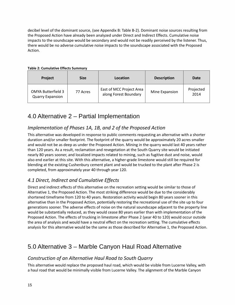
Table 2: Cumulative Effects Summary ......................................................................................................... 15
Table B-1: Comparative Noise Levels from Common Sources .................................................................... 20
Table B-2: Decibel Additions ....................................................................................................................... 21
List of Figures
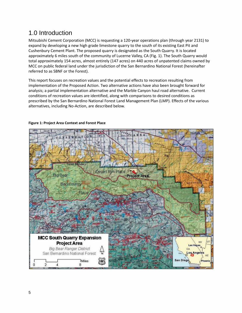
Figure 1: Project Area Context and Forest Place ........................................................................................... 5
Figure2: Recreational Opportunity Spectrum within the Area of Analysis; .................................................. 8
Figure 3: Noise Measurement Locations .................................................................................................... 10
5
1.0 Introduction Mitsubishi Cement Corporation (MCC) is requesting a 120-year operations plan (through year 2131) to expand by developing a new high grade limestone quarry to the south of its existing East Pit and Cushenbury Cement Plant. The proposed quarry is designated as the South Quarry. It is located approximately 6 miles south of the community of Lucerne Valley, CA (Fig. 1). The South Quarry would total approximately 154 acres, almost entirely (147 acres) on 440 acres of unpatented claims owned by MCC on public federal land under the jurisdiction of the San Bernardino National Forest (hereinafter referred to as SBNF or the Forest).
This report focuses on recreation values and the potential effects to recreation resulting from implementation of the Proposed Action. Two alternative actions have also been brought forward for analysis; a partial implementation alternative and the Marble Canyon haul road alternative. Current conditions of recreation values are identified, along with comparisons to desired conditions as prescribed by the San Bernardino National Forest Land Management Plan (LMP). Effects of the various alternatives, including No-Action, are described below.
Figure 1: Project Area Context and Forest Place

Recreation Report
6
1.1 Proposed Action Project Description The Mitsubishi Cement Corporation is proposing to develop and reclaim a new high grade limestone quarry (the South Quarry) to the south of its existing facilities. The South Quarry would total approximately 153.6 acres consisting of a 128 acre quarry, a 2.7 acre landscape berm, a 22.2 acre (1.8 mile) haul road and a temporary construction road of 0.7 acres. The South Quarry and haul road would be located almost entirely on unpatented claims owned by MCC on public federal land under the jurisdiction of the San Bernardino National Forest. This expansion may affect scenery, noise levels and the recreation setting on the Forest.
Limestone would be excavated at the South Quarry by standard open pit practices. Two to three loaders would load the broken rock into haul trucks to transport material down the new haul road to the existing primary crusher located near the cement plant. Limestone which does not meet cement quality specifications and other rock types encountered, would be pushed or hauled directly to waste rock stockpiles located within the footprint of the southeast portion of the quarry. In order to limit additional land disturbance and to reduce potential visual and erosion impacts, no new waste stockpiles would be developed outside the perimeter of the South Quarry.
Blasting operations would involve drilling along the mining face, placing of charges, and detonating of the charges by a licensed blaster. It is expected that an average of two blasts per week would be required for developing the South Quarry. Blasting would typically be conducted between the hours of 10:00 AM and 6:00 PM Monday through Saturday. During the initial construction of the new haul road, smaller and more frequent blasts would occur as often as once per day.
1.2 Scope of Analysis This report identifies recreation values and potential direct and indirect effects to the recreation setting on Forest lands within two miles of the project area (Fig. 2). Cumulative effects have been assessed for the whole of the Desert Rim Place (see Affected Environment – Sense of Place below). The area of analysis had been defined in this manner to fully evaluate effects on the surrounding recreation setting and to ensure recreation values are identified and preserved. Recreation values are closely linked to public access, the natural soundscape, and scenic quality. Scenic quality is analyzed in a separate report.
This report addresses issues associated with the removal of approximately 154 acres of Forest recreation land from public access and the potential impacts to the surrounding recreation setting caused by an expansion of active open pit mining. Recreation within the area of analysis primarily consists of dispersed camping, hiking, hunting, driving for pleasure and wildlife viewing.
1.3 Indicators of Effects Indicators used in this analysis include changes to recreation settings associated with restricted public access, noise levels, and consistency with the Recreation Opportunity Spectrum prescribed by the San Bernardino Land Management Plan.
1.4 San Bernardino National Forest Management Direction The San Bernardino Land Management Plan (LMP) was revised in 2005 under the 1982 Planning Rule. The revised plan includes the following management direction:
• REC 1- Recreation Opportunity Manage national forest land to achieve Recreation Opportunity Spectrum (ROS) classes (LMP Part 2, p. 144).

7
Recreation Opportunity Spectrum (ROS)
Recreation opportunities can be expressed in terms of three principle components: activities, setting and experience. Combinations of these three components have been organized in a classification framework called the Recreation Opportunity Spectrum (ROS). An ROS class is defined by size, setting, distance from roads, and likely recreational activities and experiences. A more detailed description of ROS classes is included in Appendix A. To ensure that there is a diversity of recreational settings for visitors to enjoy, the Recreation Opportunity Spectrum is divided into six classes which characterize the types of outdoor recreation opportunities available. These are:
1. Primitive 2. Semi-Primitive/Non-Motorized 3. Semi-Primitive/Motorized 4. Roaded/Natural 5. Rural 6. Urban
The area surrounding the proposed project is classified as semi-primitive, both non-motorized and motorized (Fig. 2). The semi-primitive setting is a predominantly natural or natural-appearing environment with a low concentration of users. The area is to be managed with a minimum of on-site controls and restrictions.
Affected Environment - Sense of Place The San Bernardino LMP divides the Forest into a series of geographical units called ‘Places.’ Each Place has its own unique landscape character and management directives. Landscape character refers to the overall visual and cultural impression of its landscape attributes. It includes the landscape’s physical appearance and the cultural context that gives the location a special identity and a unique ‘sense of place.’
The immediate project area is located within the Desert Rim Place. The Desert Rim Place is a remote and rugged high desert landscape formed by complex geological faulting. This is the location where the north slope of the San Bernardino Mountains links up with the Mojave Desert. Primitive and semi-primitive recreation experiences are found here. Popular activities include driving for pleasure, wildlife viewing, off-highway vehicle use, hiking, backpacking and hunting. No developed recreation sites are located within this Place. The Burned Flat area, located ½ mile south of the project area, is a popular dispersed camping location. Mining is part of the cultural history of this area. In the 1800’s small amounts of gold, silver and lead were extracted here. Today, the majority of the land is valued for the presence of large quantities of limestone mineral deposits used in the production of pharmaceuticals and cement. The two mile buffer that makes up the area of analysis for direct and indirect effects extends into the Big Bear Backcountry Place. This Place is known for its colorful mining history, prehistoric habitations and scenic character. It is extremely biologically diverse with important high desert, mountain meadow and conifer forest ecosystems. This Place offers a wide variety of dispersed recreation opportunities. The Pacific Crest Trail traverses almost its entire length, offering popular hiking and equestrian opportunities. Holcomb Valley was the location of southern California’s largest gold rush, and is now a popular mountain biking area. Other activities include wildlife viewing, driving for pleasure, rock climbing, cycling and cross-country skiing.

Recreation Report
8
The prescribed recreation settings are primarily divided between an ROS class of semi-primitive/ non-motorized and semi-primitive/ motorized, excluding State Road 18 which has a class of roaded/ natural (Fig. 2). No developed recreation areas are located within the area of analysis.
Figure 2: Recreational Opportunity Spectrum within the Area of Analysis
Existing Condition
The area of analysis typically accommodates low levels of public recreation activity. Backcountry activity along the Burnt Flat area and hunting activity by local residents range from low to moderate levels. The area generally contains natural-appearing recreation settings with low levels of traffic, few social encounters and visitor impacts, and minimal site management. Industrial intrusions such as the sights and sounds of mining activity intermittently reduce the area’s naturalness, solitude and feeling of remoteness. The existing recreation setting conditions are consistent with the project area’s Recreational Opportunity Spectrum thresholds as established by the LMP.

9
Desired Condition The LMP states the following desired conditions:
The Desert Rim Place is maintained as a modified to natural-appearing landscape that functions as a sanctuary for a large number of federally listed native plants and a highly valued area for limestone production. The valued attributes to be preserved over time are the Jeffrey pine, white fir and incense cedar in the shaded aspects of ridges and canyons (LMP Part 2, p.64).
The Big Bear Backcountry Place is maintained as a historic and natural-appearing landscape that functions as a recreation setting for backcountry rustic road-touring recreation experiences... The valued landscape attributes to be preserved over time are the stands of Joshua Trees and Pinyon juniper, the large montane meadow system and the open high-desert undeveloped character…. A wide variety of recreation uses are to be promoted where appropriate and environmentally sustainable (LMP Part 2, p.56).
1.8 Significance Criteria The NEPA analysis determines whether direct or indirect effects to recreation would result from the project and provides a comparison of effects by alternative. As defined by the Council on Environmental Quality, significance of an effect is determined by the context and intensity of the resulting change relative to the existing environment (40 CFR 1508.27). As applicable, impacts are discussed in terms of spatial extent, duration and intensity.
2.0 Effect Analysis
2.1 Methodology This report applies the latest “best science” in National Forest conservation to achieve the direction of the San Bernardino LMP. Due to the extended timeframe of the proposed action and the alternatives brought forward for analysis, the temporal scope of this evaluation is 0-20 years for short term effects and 20+ years for long term effects. Existing conditions refer to field observations and conditions observed in June/July, 2010 and January, 2011.
Information used in this analysis includes:
Field evaluations from access points to and around project area The San Bernardino National Forest’s GIS database including the prescribed Recreation Settings The Recreation Opportunity Spectrum Setting Indicators Soundscape data and decibel levels associated with mining activities sourced from various
reports, including an onsite Noise Impact Analysis released September 24, 2012
Soundscapes Natural quiet is increasingly being recognized as an important and scarce resource in natural recreation areas. For many people, the primary reason for visiting primitive and semi-primitive landscapes is to attain a sense of solitude and tranquility. The ability to hear the sounds of nature without distractions of human-caused noise can affect the quality of the recreational setting and experience. Studies have shown that human-caused noise affects the perceived naturalness of a landscape. Therefore, preservation of the natural soundscape is a necessary part of preserving the naturalness of an area.

Recreation Report
10
Sound can affect humans physically (occurring when sound is so loud that it causes hearing damage), and psychologically (occurring when sound annoys people). This report is principally concerned with the psychological effects of noise from mining activities on the recreation setting. The term ‘noise’ is used to describe loud, uncontrollable, unexpected or unwanted sound. To establish a baseline reference for comparison, representative decibel levels from common noise sources are listed in Appendix B.
Figure 3: Noise Measurement Locations. M1, M2, M3, M4 and M10 are locations on the San Bernardino National Forest. M5, M6 and M7 are representative noise samples taken from within the existing quarry.
The perception of noise can be variable, and a simple decibel measurement alone is insufficient to describe what is acceptable and unacceptable. Noise perception is affected by various factors, including the setting, the volume, and the listener’s expectations. For example, the sound of a motorcycle at 10 feet is acceptable in an off-highway vehicle staging area, but less acceptable in a wilderness area, even if it’s heard at a lower volume or from a greater distance.
Mine sites include a wide variety of equipment which generates a range of noise levels that can travel long distances. The basic concept of determining whether or not a noise source is causing an undesirable impact to the recreation setting is to compare ambient sound levels to the expected average of the

11
maximum sound levels. Ambient sound refers to the all-encompassing noise environment measured at a specified time, and is usually made up of many sounds from many sources and directions. When ambient sound levels are exceeded, generally by more than 5 dB, the noise level may have a negative effect on the soundscape.
Decibel levels used in this report were collected on May 15, 2012 and analyzed by Kunzman Associates, Inc. Ambient sound was measured at five representative locations on the SBNF. Measurements were averaged over recordings lasting 15 minutes each. Measurements were also taken at three locations within the existing operational mining plant. Onsite operational noise measurements were used to model the worst case scenario (i.e. blasting operations) from each representative location for both existing mine operation noise and the proposed mine expansion noise. Measurements and modeling was done in this way in order to better compare the existing worst case scenario with the proposed worst case scenario. The modeled decibel levels only take into account the spherical spreading loss of sound calculated uniformly in a direct-line-of-sight from the source travelling over soft terrain. Intervening topography and prevailing winds would cause additional decibel level modifications.
The representative noise measurements were focused on the select, dominant sources of noise present. Other noise sources were captured in the measurements, but they can be considered insignificant compared to the dominant source. Decibel levels recorded were compared for accuracy to measurements taken for two similar mining analyses; the Hope Mining Company EIS in Chugach National Forest, June 2010, and the Environmental Considerations Report for the Sunflower Quarry in De Soto Kansas, June 2003. Both are similar projects operating under similar conditions to this Proposed Action and have measured decibel levels for activities directly related to open pit mining and hauling.
3.0 Alternative 1 – South Quarry Development (Proposed Action)
Expansion of the Cushenbury Cement Plant into the South Quarry
3.1 Direct and Indirect Effects The Proposed Action could potentially result in some direct and indirect effects on recreation, including the following:
• Dust from mining operations
• Restricted public access and the resulting effects of displacement on surrounding sites
• Noise produced from active mining
Dust: Project design features for dust suppression are included in the MCC Plan of Operations. With the implementation of these design features, direct and indirect effects relative to dust are expected to be minimal, and are not expected to negatively affect the recreation setting in the short or long term.
Restricted public access: Safety requirements of implementing the Proposed Action would result in the direct effect of removing approximately 154 acres from public access. A 25 foot-wide safety berm is proposed to be built along the

Recreation Report
12
south perimeter of the quarry expansion area, restricting all public access to the project area. Potential indirect recreation effects include the displacement of recreation activities from the project area. However, visitor displacement is not expected to result in noticeable changes to the surrounding recreation setting because of the existing and expected low levels of recreation traffic, the minimal extent of visitor impacts, and because alternative settings are readily available nearby. Interaction between users at the nearby Burnt Flat recreation area is expected to remain at a low level, keeping the setting consistent with a semi-primitive ROS class. Recreational values, settings and activities associated with the Pacific Crest Trail (solitude, low levels of managerial control, evidence of humans’ distance from roads, etc.) would not be affected, due to its distance (greater than two miles) from the project area.
Noise: With regard to noise levels, the MCC Plan of Operations states the following proposed activity:
Blasting activities will be required to develop a series of benches and to break the rock into smaller pieces so that it can be removed… It is expected that an average of two blasts per week will be required for developing the South Quarry… Blasting [would be] designed to undercut the outside wall…
Blasting will typically be conducted twice each week at the South Quarry between the hours of 10:00 a.m. and 6:00 p.m. Monday through Saturday. Note that during the initial construction of the haul road, more numerous (up to once per day) but smaller blasts will occur.
Limestone will be excavated at the South Quarry by standard open pit practices… Controlled blasting will loosen the rock at a vertical benching interval of 45 feet. A dozer will push material and two to three loaders load the shot or broken rock into off-highway haul trucks. These trucks will transport material down the new haul road to the existing primary crusher located at the north end of the existing East Pit near the cement plant…The quarry will normally operate approximately 250 days per year round, five days per week, 10 hours per day.
The Proposed Action would have the direct effect of increasing industrial noise into the soundscape of the area of analysis. This includes drilling, blasting and noise associated with dozers, loaders and haul trucks. The intensity this impact would have on the larger recreation setting is analyzed by location below.
Location M1 (Holcomb Valley Road and FR 3N02): Ambient sound was measured to average 41.9 dB including the sound generated from a passing truck (74.8 dB) and the sound of birds and wind (49.4 dB). Ambient sound averaged significantly higher than the modeled existing and proposed worst case scenario noise levels from active mining (35.5 dB and 36.5 dB, respectively). Therefore, the Proposed Action would have a neutral impact on the existing soundscape at this distance from the project site (11,000 feet).
Location M2 (Intersection of FR 3N02 and FR 3N10): Ambient sound was measured to average 39.9 dB with the most dominant source of noise caused by wind. Again, ambient sound averaged higher than the modeled existing noise from blasting and mining activity (39.2 dB), meaning that the existing mining noise is not noticeable. However, noise from the Proposed Action was modeled to reach 40.9 dB, one decibel above the ambient sound level. Noise begins to have a negative effect on the soundscape when it exceeds ambient levels by more than 5 dB. Therefore, the Proposed Action is expected to have a neutral impact on the soundscape at this distance from the project site (6,000 feet).
Location M3 (Burnt Flat – Gate on 3N02): Forest Road 3N02 (the old Mohawk Mine Road) officially ends at a locked SBNF gate approximately 0.25 mile south of the site, which indicates the end of public access. The Burnt Flat area is a popular dispersed recreation area that has a natural-appearing setting, occasionally punctuated by noise from industrial mining activity. Although this intermittently reduces the area’s naturalness, solitude and feeling of remoteness,

13
it remains consistent with a semi-primitive ROS setting. Noise measurements taken from the Burned Flat area registered an average ambient sound level of 32.5 dB. However, during existing operations’ loudest activities (e.g. blasting), noise levels were modeled at 43.3 dB. Modeling for the worst case scenario of the Proposed Action shows sound levels averaging 46.1 dB, which is an increase of 2.8 dB from the loudest existing decibel levels. The average person does not perceive changes of less than 3 dB, therefore, the loudest noise produced by the Proposed Action is expected to sound about the same as the loudest existing mining activity.
During the initial construction of the haul road, more numerous (up to once per day), but smaller blasts are expected to occur. The temporary increased rate of smaller blasts may create a short-term, localized impact to the natural soundscape of the Burnt Flat area. However, due to the existing level of mining noise, the low level of recreational use, and the area’s long cultural history of mining, construction of the haul road would have an overall minor impact on the soundscape at this location.
Location M4 (South Quarry Property Line): The average ambient sound level on the proposed South Quarry property line is 42.4 dB, and the modeled existing operational level is 46.5 dB. Modeled noise levels for the worst case scenario of the Proposed Action would be 66.6 dB, noticeably higher than existing operations. The soundscape at this location would be dominated by noise from industrial mining activity. This is to be expected since this area would be as close as 100’ from the noise sources. This area would incur a major, long-term, adverse impact to the natural soundscape.
The impact would be localized to the area closest to the property line where public access would necessarily be restricted for safety reasons. The Plan of Operations calls for the construction of a steep berm that would tie into steeper slopes on the east and southwest to help restrict public access to the south quarry. Restricted access would discourage recreation activity close to the property line and therefore would result in displacement rather than an effect from noise. The effects from displacement are addressed above and in the cumulative effects analysis below.
Location M10 (Cactus Flats ORV Area): Although this location falls outside the area of analysis, noise measurements were taken from this location and are included for reference. Ambient sound was averaged at 45.6 dB including the sound generated from traffic on Highway 18. Ambient sound averaged noticeably higher than the expected worst case scenario noise from the Proposed Action (36.0 dB) and, therefore, the Proposed Action would have no impact on the existing soundscape at this distance (14,700 feet).
The modeled decibel levels only take into account the spherical spreading loss of sound calculated uniformly in a direct-line-of-sight from the source travelling over soft terrain. Blasting charges used to loosen rock are strategically placed to focus the energy released into the earth, where sound is absorbed, and not along the surface where sound travels outward. The decibel levels of the proposed active mining noise are expected to be further reduced due to natural topography and constructed obstructions, including the proposed constructed berm surrounding the project area.
No blasting or mining activities would take place between 6 PM and 10 AM, when sound levels are naturally at their lowest. In addition, the perception of noise associated with blasting is expected to be dampened because the peak level of loud sounds, such as explosives, has an extremely short duration (usually 1 millionth to 1 hundredth of a second) so it is not perceived as loud as a decibel measurement would indicate.
Recreation Report
14
Therefore it is reasonable to conclude that the modeled worst case scenario (blasting noise) from implementation of the Proposed Action would have a neutral to minor effect on the soundscape in areas within a .25 mile from the project property line, and would diminish as the distance increases. Changes to the natural soundscape would be minimally noticeable above existing operational sound levels from dispersed recreation sites within the Desert Rim Place and would not be noticeable from the Big Bear Backcountry Place.
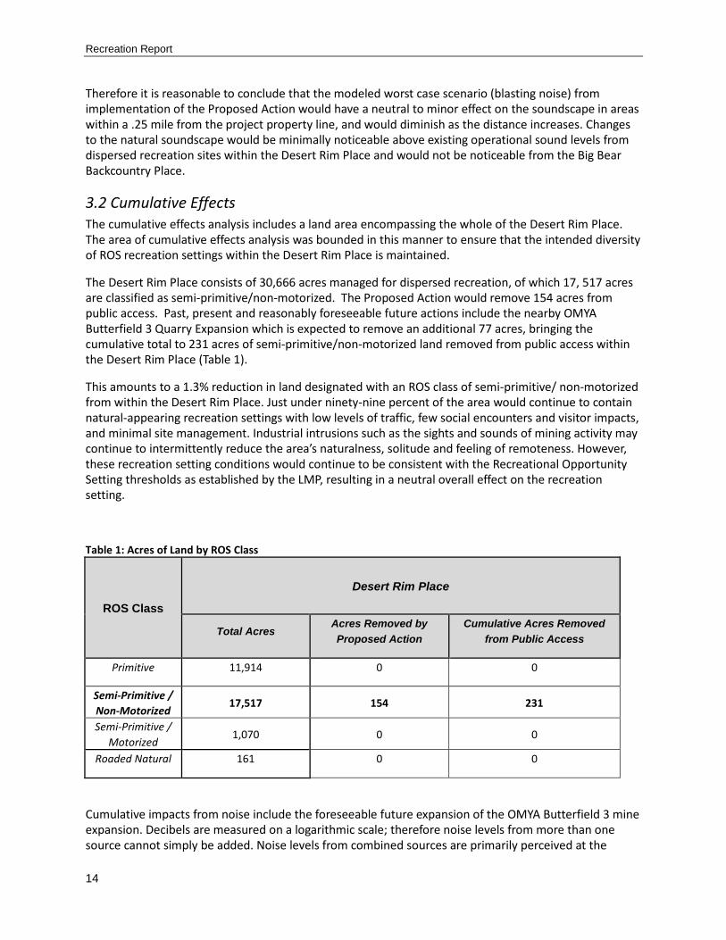
3.2 Cumulative Effects The cumulative effects analysis includes a land area encompassing the whole of the Desert Rim Place. The area of cumulative effects analysis was bounded in this manner to ensure that the intended diversity of ROS recreation settings within the Desert Rim Place is maintained.
The Desert Rim Place consists of 30,666 acres managed for dispersed recreation, of which 17, 517 acres are classified as semi-primitive/non-motorized. The Proposed Action would remove 154 acres from public access. Past, present and reasonably foreseeable future actions include the nearby OMYA Butterfield 3 Quarry Expansion which is expected to remove an additional 77 acres, bringing the cumulative total to 231 acres of semi-primitive/non-motorized land removed from public access within the Desert Rim Place (Table 1).
This amounts to a 1.3% reduction in land designated with an ROS class of semi-primitive/ non-motorized from within the Desert Rim Place. Just under ninety-nine percent of the area would continue to contain natural-appearing recreation settings with low levels of traffic, few social encounters and visitor impacts, and minimal site management. Industrial intrusions such as the sights and sounds of mining activity may continue to intermittently reduce the area’s naturalness, solitude and feeling of remoteness. However, these recreation setting conditions would continue to be consistent with the Recreational Opportunity Setting thresholds as established by the LMP, resulting in a neutral overall effect on the recreation setting.
Table 1: Acres of Land by ROS Class
ROS Class Desert Rim Place
Total Acres Acres Removed by Proposed Action
Cumulative Acres Removed from Public Access
Primitive 11,914 0 0
Semi-Primitive / Non-Motorized
17,517 154 231
Semi-Primitive / Motorized
1,070 0 0
Roaded Natural 161 0 0
Cumulative impacts from noise include the foreseeable future expansion of the OMYA Butterfield 3 mine expansion. Decibels are measured on a logarithmic scale; therefore noise levels from more than one source cannot simply be added. Noise levels from combined sources are primarily perceived at the
15
decibel level of the dominant source, (see Appendix B: Table B-2). Dominant noise sources resulting from the Proposed Action have already been analyzed under Direct and Indirect Effects. Cumulative noise impacts to the soundscape would be secondary and would not be readily perceived by the listener. Thus, there would be no adverse cumulative noise impacts to the soundscape associated with the Proposed Action.
Table 2: Cumulative Effects Summary
Project Size Location Description Date
OMYA Butterfield 3 Quarry Expansion
77 Acres East of MCC Project Area along Forest Boundary Mine Expansion Projected
2014
4.0 Alternative 2 – Partial Implementation
Implementation of Phases 1A, 1B, and 2 of the Proposed Action This alternative was developed in response to public comments requesting an alternative with a shorter duration and/or smaller footprint. The footprint of the quarry would be approximately 20 acres smaller and would not be as deep as under the Proposed Action. Mining in the quarry would last 40 years rather than 120 years. As a result, reclamation and revegetation at the South Quarry site would be initiated nearly 80 years sooner, and localized impacts related to mining, such as fugitive dust and noise, would also end earlier at this site. With this alternative, a higher-grade limestone would still be required for blending at the existing Cushenbury cement plant and would be trucked to the plant after Phase 2 is completed, from approximately year 40 through year 120.
4.1 Direct, Indirect and Cumulative Effects Direct and indirect effects of this alternative on the recreation setting would be similar to those of Alternative 1, the Proposed Action. The most striking difference would be due to the considerably shortened timeframe from 120 to 40 years. Restoration activity would begin 80 years sooner in this alternative than in the Proposed Action, potentially restoring the recreational use of the site up to four generations sooner. The adverse effects of noise on the natural soundscape adjacent to the property line would be substantially reduced, as they would cease 80 years earlier than with implementation of the Proposed Action. The effects of trucking in limestone after Phase 2 (year 40 to 120) would occur outside the area of analysis and would have a neutral effect on the recreation setting. The cumulative effects analysis for this alternative would be the same as those described for Alternative 1, the Proposed Action.
5.0 Alternative 3 – Marble Canyon Haul Road Alternative
Construction of an Alternative Haul Road to South Quarry This alternative would replace the proposed haul road, which would be visible from Lucerne Valley, with a haul road that would be minimally visible from Lucerne Valley. The alignment of the Marble Canyon

Recreation Report
16
haul road would begin at the southwestern edge of the proposed South Quarry and would travel approximately 1,670 feet through Marble Canyon before linking with the approved West Pit perimeter road. The Marble Canyon haul road would require the construction of approximately 700 additional linear feet than the Proposed Action haul road. The Marble Canyon haul road would tie into the West Pit perimeter road instead of the East Pit haul road to travel to/from the cement plant. This would increase the total distance for haul trucks to travel by approximately 6,758 linear feet longer than the Proposed Action.
5.1 Direct, Indirect and Cumulative Effects Direct and indirect effects of this alternative would be very similar to Alternative 1, the Proposed Action. The main difference would be the short term increase in construction noise due to the longer haul road construction time, and the barely perceptible, long term increase in noise from the operation of four additional haul trucks. Noise from the additional haul trucks would constitute secondary noise and would not considerably contribute to the dominant level of noise caused from blasting, loading and crushing. The cumulative effects analysis for this alternative would be the same as those described for Alternative 1, the Proposed Action.
6.0 Alternative 4 – No Action
6.1 Direct, Indirect and Cumulative Effects If the No Action Alternative is implemented, and the Cushenbury Cement Plant is not expanded into the South Quarry under this Plan of Operations, there would be no direct or indirect adverse effects on recreation. Recreation opportunities, activities and settings would continue to be very similar to existing conditions. No cumulative impacts to the ROS setting, recreational areas or activities would occur with implementation of the No Action Alternative.
7.0 Summary of Effects – All Alternatives
7.1 Alternative 1 – South Quarry Development (Proposed Action) The Proposed Action would result in the direct effect of removing approximately 154 semi-primitive/ non-motorized acres from public access. However, within the Desert Rim Place there remains 17,363 acres land with an ROS classification of semi-primitive/ non-motorized. Interaction between recreational users is expected to remain at a low level, keeping the setting consistent with a semi-primitive ROS class. The resulting effect of displacement on surrounding sites would be very minor, and would not result in changes to the ROS setting.
Project design features for dust suppression are included in the MCC Plan of Operations and, if followed, would not adversely affect the ROS setting. With regard to unwanted noise, the area adjacent to the project property line would incur a major, long-term, adverse impact to the natural soundscape due to blasting and other mining activities. This impact would be localized, and recreation access would in any case be restricted along the property line for safety reasons by the construction of a steep berm. In areas farther than .25 mile from the property line, including the Burnt Flat area, unwanted noise would have a neutral to minor effect on the existing soundscape and effects would diminish as the distance increases. Changes to the natural soundscape would be minimally noticeable above existing operational sound
17
levels from dispersed recreation sites within the Desert Rim Place and would not be noticeable from the Big Bear Backcountry Place.
Cumulative effects and foreseeable future actions on the recreation setting include the long term removal of 231 acres of ROS class semi-primitive/non-motorized land from public access within the Desert Rim Place. This amounts to a minor reduction of just over 1% of semi-primitive/non-motorized land from the Desert Rim Place, which would have a neutral effect on the recreation setting.
7.2 Alternative 2 – Partial Implementation The most striking difference from the Proposed Action would be due to the considerably shortened project timeframe from 120 to 40 years. Restoration activity would begin 80 years sooner, potentially restoring the recreational use of the site three to four generations sooner. The adverse effects of noise on the natural soundscape would be substantially reduced, as they would cease 80 years sooner than the Proposed Action. The effects of trucking in limestone after Phase 2 (year 40 to 120) would occur outside the area of analysis and would have a neutral effect on the recreation setting. The cumulative effects analysis for this alternative would be the same as those described for Alternative 1, the Proposed Action.
7.3 Alternative 3 – Marble Canyon Haul Road Alternative The main difference from the Proposed Action would be the short term increase in construction noise due to the longer haul road construction time, and the barely perceptible, long term increase in noise from the operation of four additional haul trucks. Noise from the additional haul trucks would constitute secondary noise and would not considerably contribute to the overall level of dominant noise caused by blasting, loading and crushing activities, resulting in a neutral effect to the recreation setting. The cumulative effects analysis for this alternative would be the same as those described for Alternative 1, the Proposed Action.
7.4 Alternative 4 – No Action If the No Action Alternative is implemented, and the Cushenbury Cement Plant is not expanded into the South Quarry under this Plan of Operations, there would be no direct or indirect effects on recreation. Recreation opportunities, activities and settings would continue to be very similar to existing conditions. No cumulative impacts to the ROS setting, recreational areas or activities would occur with implementation of this Alternative.

Recreation Report
18
8.0 References
AECOM. 2011. Final EIR Appendix F: Noise Impact Analysis, Los Angeles State Historical Park Master Development Plan. San Diego, CA. Retrieved October 18, 2012 from: http://www.parks.ca.gov/pages/22272/files/appendix%20f%20noise%20impact%20report.pdf
Council on Environmental Quality, 2012. National Environmental Policy Act. Retrieved November 15, 2012 from: http://ceq.hss.doe.gov/ceq_regulations/regulations.html
Decibel readings at MCC (A. Marshall, personal communication, June 7, 2011).
EDAW, Inc. Typical Outdoor Noise Levels. Retrieved July 12, 2011 from: http://www.bixby.org/parkside/documents/EIR/VolumeII/tableq.html
Hamby, William. 2004. Ultimate Sound Pressure Level Decibel Table. Retrieved June 6, 2011 from: http://www.makeitlouder.com/Decibel%20Level%20Chart.txt.
Harrison, Robin T., Clark, Roger N. and Stankey, George H. 1980. Predicting Impact of Noise on Recreationists. USDA Forest Service, San Dimas, CA.
Mace, Britton L., et. al. 1999. Aesthetic, Affective, and Cognitive Effects of Noise on Natural Landscape Assessment, Society & Natural Resources, 12: 225-242.
Manning, Robert. 2006. From Landscapes to Soundscapes: Understanding and Managing Natural Quiet in the National Parks. Retrieved June 8, 2011 from: http://nrs.fs.fed.us/pubs/gtr/gtr_nrs-p-14/79-manning-p-14.pdf
Pylant, Chris, Ballard, Carl and Kunzman, William. 2012. Mitsubishi Cement Corporation South Quarry Noise Impact Analysis. Kunzman Associates, Inc. Orange, CA.
State of Queensland Department of Environment and Resource Management. 1995. Noise Management. Retrieved June 6, 2011 from: http://www.derm.qld.gov.au/register/p01206ai.pdf
URS, Corp. 2003. Environmental Considerations, Sunflower Quarry, Desoto, Kansas. Retrieved June 7,
2011 from: http://planning.jocogov.org/staff_reports_other/Hunt%20Midwest%20Docs/Environmental%20Considerations%20Sunflower%20Quarry.pdf
US Environmental Protection Agency. 1979. Protective Noise Levels. Retrieved June 6, 2011 from: http://www.nonoise.org/library/levels/levels.htm
USDA Forest Service. 2010. Draft Environmental Impact Statement: Resurrection Creek Phase II Stream and Riparian Restoration Project and Hope Mining Company Proposed Mining Plan of Operations. R10-MB-724. Chugach National Forest, Seward Ranger District, Alaska.
USDA Forest Service. 2005. San Bernardino National Forest Land Management Plan. Washington, D.C.

19
Appendix A: Recreation Opportunity Spectrum
Table A-1: The Recreation Opportunity Spectrum
ROS Class Activity Setting Experience
Primitive
Viewing scenery, hiking, equestrian, camping, hunting, climbing, nature study
Essentially unmodified natural environment of fairly large size, low interaction between users
Extremely high probability of experiencing isolation from sights and sounds of humans
Semi-Primitive/ Non-Motorized
All of the above
Predominantly natural-appearing environment, moderate to large size, low interaction between users
High probability of experiencing isolation from sights and sounds of humans
Semi-Primitive/ Motorized
All of the above plus motorized travel
Predominantly natural-appearing environment, moderate to large size, low interaction between users
Moderate probability of experiencing isolation from sights and sounds of humans
Roaded Natural
All of the above plus picnicking, resort lodging, recreation cabins, gathering forest products, interpretive services
Predominantly natural-appearing environment, low to moderate interaction between users but with evidence of other users prevalent
Equal probability of experiencing affiliation with other user groups and of isolation from sights and sounds of humans
Rural
All of the above plus train/bus touring, trams, resort and commercial services
Substantially modified natural environment, sights & sounds of other users readily prevalent
Probability of experiencing affiliation with other user groups is prevalent, as is convenience of sites and opportunities
Urban All of the above
Substantially urbanized environment with natural elements, large numbers of other users expected onsite & nearby
Probability of experiencing affiliation with other user groups is prevalent, as is convenience of sites and opportunities

Recreation Report
20
Appendix B: Noise Terminology and Concepts
Sound travels out uniformly from a source in a direct line-of-sight unless it is blocked by a solid surface. Sound can occur from both point sources (e.g., stationary equipment) and line sources, such as a roadway with a large number of moving point sources (e.g., vehicles). Sound waves from line sources assume that the sources are moving in space over time and therefore appear to emanate from a line of spheres.
Sound transmission is affected by various factors including topography, climatic conditions and proximity. Placing a wall or hill between the listener and the sound source reduces the sound substantially. As sound travels, some of the sound energy is absorbed by surrounding molecules in the air, soil, etc., therefore, the sound level decreases (attenuates) as a listener moves away from a sound source.
The volume of sound, or sound pressure, is measured logarithmically in decibel units (dB). It is widely accepted that the average healthy ear can barely perceive changes of 3 dB while a change of 5 dB is readily perceptible, and an increase (decrease) of 10 dB sounds twice (half) as loud.
Locations on the SBNF are considered acoustically ‘soft’ sites, meaning they have an absorptive ground surface, such as soft soil and vegetation to dampen sound as it travels. Sound generated by a point source over ‘soft’ sites typically diminishes at a rate of 7.5 dB for every doubling of distance. Over acoustically “hard” sites, such as bare, hard ground, parking lots, or smooth bodies of water, sound attenuates 6.0 dB for each doubling of distance from the source.
Table B-1: Comparative Noise Levels from Common Sources
Source of Noise Average Decibel Level (dB)
Ordinary light bulb hum 13
Nighttime ambient noise in the desert (Absolute Quiet) 35
Whisper 40
Normal conversation 60
Haul truck or loader at 3 feet 80
Beginning of hearing damage 85
Rock drill at 3 feet 104
One ton of TNT at 100 feet 176

21
For combined noise source levels (all at the same measurement distance) the values in Table B-1 can be used. In using the values in the Table for the addition of more than two noise levels, consideration must be given to the difference between the lowest and the highest of the levels.
Table B-2: Decibel Additions
Difference between two decibel levels to be added
Amount to be added to the higher of the two values
0 to 1 3
2 to 3 2
3 to 9 1
10 or more 0