Embed Size (px)
Citation preview

Maud Rise revisited
R. D. Muench,1 J. H. Morison,2 L. Padman,1 D. Martinson,3 P. Schlosser,3
B. Huber,3 and Roland Hohmann3
Abstract. An oceanographic field program called the Antarctic Zone Flux experimentwas carried out in the eastern Weddell Sea during austral winter (July–September) 1994.Data from a drift buoy array were used in concert with shipboard observations to provideexceptionally high horizontal resolution of upper ocean hydrographic parameters nearMaud Rise. Chemical and tracer data were obtained from the ship. We identify a “warmpool” southwest of the rise as a dynamically necessary region of positive (cyclonic)vorticity that is associated with a Taylor column over the rise. Both a warm “halo”surrounding the Taylor column and the warm pool are associated with thermoclineshoaling that is a necessary condition for high upward heat fluxes to occur. These featuresextend the influence of Maud Rise bottom topography on upper ocean heat flux over aregion that is larger, by a factor of at least 2, than the area directly overlying the rise.Areal mean upward heat fluxes of about 25 W m22 are derived using both upper ocean T(“instantaneous”) values and tracer data (“integrated”) values. Fluxes derived over thewarm halo and pool regions using only upper ocean T exceeded 100 W m22 at specificsites. Elsewhere in the region, the T-derived heat fluxes varied widely from ,10 to .50 Wm22, whereas the tracer-derived heat fluxes showed a considerably more uniformdistribution. Our mean values are similar to those that have been previously reported.Historical ice cover data have shown that the geographical region encompassed by MaudRise and the warm pool area to the southwest is a preferred site for polynya formation,consistent with these findings. Time series analyses of the historical upper ocean data setsuggest that conditions conducive to polynya formation are correlated with climateprocesses remote from the Southern Ocean.
1. Introduction
Much of the initial mixing between ambient Weddell SeaWarm Deep Water (WDW) and Circumpolar Deep Water(CDW) that flows southwestward into the Weddell Sea fromthe Antarctic Circumpolar Current (ACC) occurs in the Wed-dell Sea near Maud Rise. The easternmost limb of the WeddellGyre between about longitudes 108W and 408E, where theACC is deflected southward in response to regional bathymet-ric trends, is where CDW first encounters the colder and lesssaline WDW that typifies the northern limb of the Weddellgyre. The ensuing combination of WDW and CDW, rich inmesoscale features and not yet well mixed, comprises thesource water that moves west-southwestward into the MaudRise region.
Vertical density gradients in the eastern Weddell Sea aresmall compared with those in most of the world ocean. Verti-cally averaged N2 for the uppermost 500 m, below which thereis very little vertical density gradient, is of order 1026 s22. Thecurrents are consequently strongly barotropic and influencedby bottom topography as shown, for example, in the observa-tions by Gouretski and Danilov [1993] of the ACC path east ofMaud Rise. Even the ice concentration appears to be influ-
enced by topography, as De Veaux et al. [1993] estimated that.50% of the variability in Antarctic sea ice concentrationcould be explained by topographic influences.
The combined WDW and CDW encounters Maud Rise, aseamount of order 100 km in diameter that extends upwardfrom the 5000 m deep abyssal plain to within 1600 m of the seasurface. The impingement of these waters upon Maud Riseinitiates a number of dynamic events. An isolated column ofwater becomes at least partially trapped over the rise and hasbeen characterized as a Taylor column [Ou, 1991; Alverson andOwens, 1996]. Water in this column, which blocks horizontalflow over the rise, is colder, less saline, and slightly denser thanthe surrounding waters. Regional southwestward flow is accel-erated around the periphery of the column, causing a ring-shaped closed circulation about the rise of the relatively warmand saline combined WDW and CDW. The closed circulationcell, which we will refer to as the Maud Rise halo or simply the“halo,” has a complex structure with sharp fronts and multiplewarm cores [Gordon and Huber, 1990; Bersch et al., 1992]. Thesurrounding regional flow continues southwestward past therise and contributes more or less continuously to a downstreamregion of water with elevated T that is situated southwest ofthe rise and that we will refer to as the “warm pool.”
The water column overlying Maud Rise, the halo, and thewarm pool downstream (west-southwest) from the rise eachlocally influence ocean processes. These features impact par-ticularly strongly the local upper ocean heat fluxes and associ-ated overlying air-sea exchanges [McPhee et al., 1996], andtheir integrated effect can be expected to influence stronglyregional upper ocean heat and ice budgets. Upward doming ofthe warm underlying core waters within individual mesoscale
1Earth & Space Research, Seattle, Washington.2Polar Science Center, Applied Physics Laboratory, Seattle, Wash-
ington.3Lamont-Doherty Earth Observatory, Palisades, New York.
Copyright 2001 by the American Geophysical Union.
Paper number 2000JC000531.0148-0227/01/2000JC000531$09.00
JOURNAL OF GEOPHYSICAL RESEARCH, VOL. 106, NO. C2, PAGES 2423–2440, FEBRUARY 15, 2001
2423
features, many of them probably eddies, enhances upward heatflux from the deep waters to the upper mixed layer [McPhee etal., 1996] and increases the quantity of heat available for melt-ing ice. Lateral advection, relative to deeper waters, of theupper layers overlying Maud Rise can lead to conditions fa-vorable to vigorous vertical mixing, which then locally en-hances upward heat flux from below the pycnocline to thesurface mixed layer (L. Padman et al., Cabbeling and low-density ratio diffusive convection in the Weddell Sea, submit-ted to Journal of Geophysical Research, 2000, hereinafter re-ferred to as Padman et al., submitted manuscript, 2000).
Heat flux results obtained during Antarctic Zone Flux(ANZFLUX) have been discussed on the basis of physicalobservations [McPhee et al., 1996, 1999; Padman et al., submit-ted manuscript, 2000]. A detailed discussion of the distributionof dissolved oxygen (DO) and helium (He) isotopes duringANZFLUX in terms of entrainment of WDW into the wintermixed layer and the related oceanic heat flux is given by R.Hohmann et al. (3He and dissolved oxygen in the upper watersof the Weddell Sea: Implications for oceanic heat fluxes, sub-mitted to Journal of Geophysical Research, 2000, hereinafterreferred to as Hohmann et al., submitted manuscript, 2000).Despite this recent work, however, we still do not understand
the physical mechanisms that apparently couple the local bot-tom topography with the high upper ocean heat fluxes. Neitherdo we know the impact of these mechanisms on the upperocean over the geographical region beyond the more obviouslocal effects of the topography. Finally, we do not have goodlarge area estimates of the regional upper ocean heat fluxes ortheir spatial distribution, areal mean, and maximum values.With these questions in mind, this paper focuses on the oceanfeatures that are associated with Maud Rise and assesses theirimpact upon the regional oceanography and the heat budget.
2. Data Collection and ProcessingThe ANZFLUX field program took place from the ice-
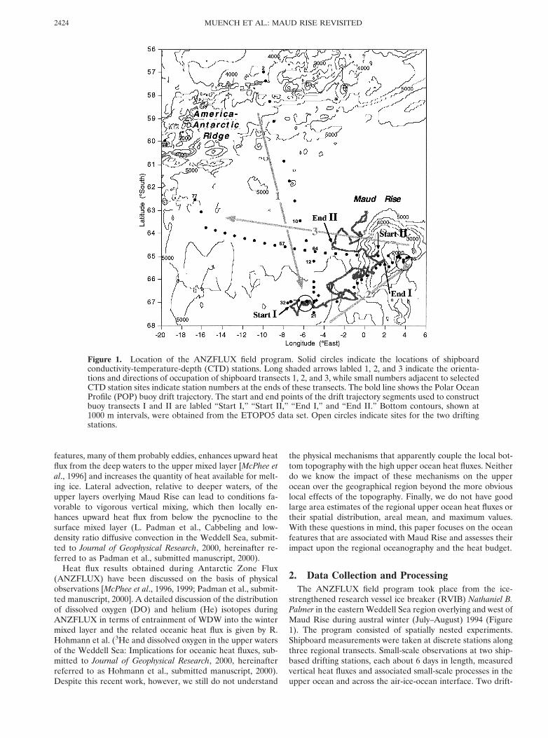
strengthened research vessel ice breaker (RVIB) Nathaniel B.Palmer in the eastern Weddell Sea region overlying and west ofMaud Rise during austral winter (July–August) 1994 (Figure1). The program consisted of spatially nested experiments.Shipboard measurements were taken at discrete stations alongthree regional transects. Small-scale observations at two ship-based drifting stations, each about 6 days in length, measuredvertical heat fluxes and associated small-scale processes in theupper ocean and across the air-ice-ocean interface. Two drift-
Figure 1. Location of the ANZFLUX field program. Solid circles indicate the locations of shipboardconductivity-temperature-depth (CTD) stations. Long shaded arrows labled 1, 2, and 3 indicate the orienta-tions and directions of occupation of shipboard transects 1, 2, and 3, while small numbers adjacent to selectedCTD station sites indicate station numbers at the ends of these transects. The bold line shows the Polar OceanProfile (POP) buoy drift trajectory. The start and end points of the drift trajectory segments used to constructbuoy transects I and II are labled “Start I,” “Start II,” “End I,” and “End II.” Bottom contours, shown at1000 m intervals, were obtained from the ETOPO5 data set. Open circles indicate sites for the two driftingstations.
MUENCH ET AL.: MAUD RISE REVISITED2424
ing buoys were deployed directly following completion of thefirst drifting station; they measured distributions of tempera-ture and salt along their irregular trajectories through thestudy region. Observations on the regional transects were lim-ited to the upper ocean from the surface down to 1500 m, to500 m in the case of the drift stations, and to 200 m for thedrifting buoys. These depth limitations were consistent withthe ANZFLUX experimental focus on upper ocean processes.
2.1. Regional Shipboard Transects
Stations were occupied from the ship along three regionaltransects (Figure 1). Transect 1 extended southward from nearthe America-Antarctic Ridge to the region southwest of MaudRise (stations 2–21). Transect 2 extended northeastward fromnear the southern end of transect 1 onto the rise (stations32–55). Transect 3 extended westward from the rise, finallyveering northward and exiting the study region (stations 55–77). Station spacing was about 100 km on transect 1 except inits more intensively sampled extreme southern portion, about25 km along most of transect 2, and about 50 km along transect3.
Vertical profiles of T , conductivity (C , subsequently used tocompute S) and DO were taken down to 1500 m at each shipstation using a SeaBird SBE-911 conductivity-temperature-depth (CTD) system. Upper layer current profiles were mea-sured using a hull-mounted 150 kHz RDI acoustic Dopplercurrent profiler (ADCP) that was operated at each CTD siteand continuously during the two drifting stations. The ensem-ble averaging period was 60 s, 8 m vertical bin sizes were used,and profiles were typically obtained to depths exceeding 300 m.
Each of the CTD casts on the regional transects was aug-mented by water samples obtained using a rosette sampler.Samples for DO analysis were collected from Niskin bottlesand analyzed using a modified Winkler titration based on anautomatic titrator with amperometric endpoint detection. Thecombined sampling and analytical error expressed as 1 stan-dard deviation derived from replicate samples is 0.04 mL L21.Water samples for noble gas analysis were collected from Ni-skin bottles and stored in sealed copper tubes. He and Neisotope measurements were conducted at the Noble Gas Lab-oratory (NGL) of the Lamont-Doherty Earth Observatory (fordetails, see Ludin et al. [1998]). Concentrations of 3He arereported as relative deviations of the measured helium isotoperatio (R 5 [3He]/[4He]) from that of air, d3He(R/Ratm 21)100%, with Ratm 5 1.384 3 1026 [Clarke et al., 1976]. Theprecision of d3He is about 60.2%. The helium isotope ratio ofwater in solubility equilibrium with the atmosphere is smallerthan that in the atmosphere (Req(21.878C, 34 psu) 5 1.359 31026; d3Heeq 5 21.8, Benson and Krause [1980]) since 3He isslightly less soluble than 4He.
2.2. Drifting Buoy Sections
Two instrumented buoys were deployed about 200 m aparton the same ice floe on July 30, 1994, and left to drift with theice, returning data and position information through the Argossatellite system. One of these, a Polar Ocean Profile (POP)buoy provided by the University of Washington, used SeaBirdSeaCat CTDs to measure water T and C (yielding S) every 12min at nominal depths of 10, 70, and 150 m. The POP buoysensors are accurate in typical applications to about 0.018C inT and 0.02 psu in S . This buoy drifted along an irregulartrajectory northeastward toward Maud Rise, veering north-ward and then slightly westward into open water around No-
vember 28, and ceased transmitting on December 6, 1994 (Fig-ure 1). A similar buoy provided by the Alfred WegenerInstitute was also deployed and returned a shorter record overa similar trajectory (not shown). The buoys were ice-mountedrather than drogued. Consequently, their trajectories reflectedwind-driven ice motion rather than underlying water move-ment.
The POP buoy data analysis utilized the cable motion causedby speed changes that were associated with the start and end ofperiods of rapid ice drift. As drift speed increased, the cableand sensors were deflected sideways and upward by frictionaldrag exerted by the relatively slow moving water column. Withdecreasing drift speed the cable returned to vertical, and thesensors deepened to their nominal depths. The three sensorsconsequently sampled over a range of depths shallower thantheir nominal depths. The data from 74 such vertical excur-sions, which we refer to as “castlets” to differentiate them fromconventional CTD casts, were averaged over 10 m depth binsto produce 0–150 m distributions of T and S that were mea-sured along the buoy trajectory. Segments of the trajectoryroughly paralleled the ship transects and lagged the transectsby weeks to months. This allowed comparison of upper oceanfeatures at two different times along buoy drift sections I andII that roughly paralleled shipboard CTD transect 2 and theeastern portion of transect 3, respectively (Figure 1).
3. Oceanic Features in the Eastern WeddellThe shipboard, POP buoy, and drifting station data allow a
more detailed description of the upper ocean features associ-ated with Maud Rise than could be constructed using solelyshipboard data. The ship data are presented in a vertical sec-tion as three deep transects (0–1500 m) showing distributionsof T , S , and density (Figures 2–4) and as shallow transects(0–200 m) showing the distributions of DO concentration andd3He value (Plate 1). The shipboard and POP buoy data arecombined in order to yield two intensively sampled upper layer(0–150 m) transects that focus on the area immediately west ofMaud Rise (Plates 2–3). The combined shipboard and buoydata are then used to construct horizontal maps of T and Sover the same restricted area (Plate 4).
3.1. Regional Features
Ship transect 1 illustrates the regional meridional distribu-tions of T , S , and density (Figure 2). Temperatures exceeding1.58C at 400 m depth mark the core of the ACC at the northend of the transect. The ACC water was bounded on its southby a frontal structure extending down to at least 1500 m (themaximum depth sampled). South of this structure lay a zone oforder 100 km in meridional extent (although the large stationspacing precludes a reliable estimate of its breadth) having thelowest maximum T (,0.58C) along the transect. This region oflow T was consistent with the presence of an eastward extend-ing remnant of the Weddell-Scotia Confluence (WSC) waterthat originates in the vicinity of the northern terminus of theAntarctic Peninsula and extends roughly along the America-Antarctic Ridge. Farther south, maximum T increased to atypical range of 0.58–0.758C, and parcels of water having T .0.98C and S . 34.69 psu were present at the south end of thetransect.
The remaining two deep transects show regional structure inthe zonal plane extending from Maud Rise to about 1000 kmwest from its crest (Figures 3–4). Maximum T was lower over
2425MUENCH ET AL.: MAUD RISE REVISITED

the Rise (about 0.68C) than farther west, as was S (by about0.02 psu). The western flank of the rise was overlain by apronounced warm saline feature (T . 1.08C and S . 34.7psu) that comprised the halo. Maximum warm core T graduallydecreased toward the west, though this decrease was inter-rupted at irregular intervals by warmer parcels, until the west-northwest extreme end of the transect (stations 74–77) wherethe warm-core T reached its lowest values (except for thoseoverlying Maud Rise and in the WSC water) of 0.58–0.758C.Mixed layer depths were about 110 m except overlying the haloand where associated with anomalous warm-core features.
The regional T and S distributions that were observed dur-ing winter 1994 qualitatively resembled those documented inearlier work [e.g., Gordon and Huber, 1990; Bersch et al., 1992].The warm regime was not well defined, and the cold regime asdefined by T , 0.58C was not encountered as core tempera-tures were always above 0.58C except in the WSC just south ofthe ACC, as noted above. Our failure to encounter the coldregime may reflect interannual variability in its extent and mayalso reflect warming in the WDW layer as reported for the pastseveral years by Fahrbach et al. [1998]. Gordon and Huber[1990] documented the upper 1000 m particularly well nearMaud Rise and observed maximum temperatures in 1986 of1.08–1.28C overlying the flanks of Maud Rise. We observedsimilar temperatures over the flanks of the rise in 1994. Thevertical extent of the warm halo was also about the same in
1994 as in 1986. The width of the feature in a direction radialfrom the center of Maud Rise was, however, only about 100 kmin 1994 compared with 200 km documented by Gordon andHuber [1990]. Their observations show what appear to be twoconcentric warm cores associated with the halo, consistent withour observations. The upper layer density that we observed inwinter 1994 was almost identical to values from previous years,reaching about s0 5 27.79 over the center of the rise. The totaldensity difference from the surface to 500 m in the easternportion was about 0.04 sigma units (N2 ' 1026 s22).
Ocean-ice-atmosphere interactions in the vicinity of MaudRise have been parameterized, in terms of upper ocean T , S ,and density distributions, by Martinson and Iannuzzi [1998] andare similar to those in the core of the Weddell Gyre fartherwest. In terms of mean winter heat flux the Maud Rise regionoccupies the extreme southwestern portion of a spatially co-herent region that extends northward to the boundary of thegyre and represents extremes in the climatological variablespresented by Martinson and Iannuzzi [1998].
The regional DO and d3He distributions in the upper 200 m,illustrated along ship transect 2, were typical of upper waters inthe central Weddell Sea during austral winter (Plate 1). WDWwas characterized by high d3He values (average 5 8.64 60.22%) and low DO (average 5 4.49 6 0.06 mL L21) concen-trations (Hohmann et al., submitted manuscript, 2000). En-trainment of 3He-rich and DO-poor WDW into the winter
Figure 2. Distributions of (a) T , (b) S , and (c) s0 along north-south regional shipboard transect 1, con-structed using data from shipboard CTD casts. Hatched regions correspond, for comparison purposes, to thehatched values shown on Figure 4 of Gordon and Huber [1990]. Solid triangles show station sites, and numbersalong the top axis are corresponding station numbers.
MUENCH ET AL.: MAUD RISE REVISITED2426

mixed layer starts with the onset of sea ice formation, as brinereleased to the water column causes convection and erosion ofthe pycnocline. This entrainment leads to an increase in d3Heand a decrease in DO concentration in the mixed layer duringwinter because gas exchange with the atmosphere is reducedby the ice cover.
3.2. Upper Ocean Features Associated With Maud Rise
The segments of the buoy drift along buoy sections I and IIroughly paralleled ship transects 2 and 3 (Figure 1). (Note thatRoman numerals refer to the buoy sections whereas Arabicnumerals refer to the ship transects.) The major oceanographicfeatures are apparent in both the ship’s CTD and the buoydata. To emphasize the persistent features, we have averagedthe shipboard CTD casts and buoy data together and interpo-lated over 0.058 longitude bins along the southern and north-ern transects (Plate 2 for northern section and Plate 3 for thesouthern section). Plates 2 and 3 show details of the T and Sdistributions from 0 to 150 m depth. To illustrate deviationsfrom the average hydrographic conditions, Plates 2 and 3 alsoshow the depth of the deepest temperature-conductivity sensor(sensor 3 at 155 m nominal depth) on the buoy and the differ-ences between the temperature and salinity measured at thatsensor (T3 and S3) and the average temperature and salinitygridded to that longitude and sensor depth (^T3& , ^S3&).Bottom depth is shown underlying each of the combined sec-tions.
The averaged buoy and ship data depict a similar and ap-parently continuous upper ocean structure between the north-ern and southern sections (Plates 2 and 3). The warm halo waspresent between 0.58E and 1.58–1.78W along both sections andwas associated with shoaling of the thermocline to depths asshallow as 65 m (Plates 2a and 3a). Less pronounced thermo-cline shoaling was present over the eastern and western innerflanks of Maud Rise, and the thermocline was slightly de-pressed over the center of the rise. Salinity was similarly dis-tributed (Plates 2b and 3b), with both the halocline depth andthe mixed layer S elevated over the central rise. The easternboundary of the halo was less well defined in S than elsewhere.The saline core of the halo appeared slightly narrower than inthe northern section, but this may have been due to closersampling along the southern than along the northern section,with consequent tighter spatial resolution.
A shoaling of T and S isolines occurred along both sectionsbetween 5.78 and 7.58W, about 270 km west of the halo. Thisfeature may, if it was in fact continuous between the twosections, reflect larger-scale banding of the halo. Alternatively,it may not have been continuous between the northern andsouthern sections and may have reflected the presence of ed-dies shed from the circulation features associated with MaudRise.
While the regional T and S features remained essentiallyunchanged over timescales up to months, the smaller-scalestructures differed between the buoy and the ship-based CTD
Figure 3. As for Figure 2 for the southernmost west-southwest to east-northeast regional shipboard transect2. Maud Rise underlies the eastern (right-hand) end of the transect, and its steep western flank underliesstations 39–44.
2427MUENCH ET AL.: MAUD RISE REVISITED

data. Along the northern section the warm core of the haloappeared, based on T3 2 ^T3& and S3 2 ^S3& (Plate 3), tohave bifurcated into two broad filaments at 3.28–1.68W and0.78W–08. Between 1.68 and 0.78W the instantaneous buoydata indicate anomalously cold, fresh conditions (T3 2 ^T3&and S3 2 ^S3& negative), and the buoy castlet in this bandsuggests that a gap was present in the halo structure. Con-versely, the buoy indicates anomalously warm, salty conditions(T3 2 ^T3& and S3 2 ^S3& positive) at 3.28–1.68W. The buoydata in this band indicate that the halo structure was present,though the ship-based CTD cast did not show the structure.
Similar features are evident along the southern sectionwhere the buoy and CTD data both show the narrow, lowtemperature gap in the halo near 1.08W (Plate 2). The instan-taneous anomalies T3 2 ^T3& and S3 2 ^S3& show that thebuoy recorded substantial variability west of the halo. The buoytraversed the region between 1.58 and 2.58W twice, once to thenorth and once to the south (Figure 1). The northern traversedetected warmer, saltier conditions than average, and thesouthern transit saw colder, fresher conditions. A warm-corefeature was present about 40 km southwest of the halo between2.98 and 3.78W, and numerous small features were presentbetween 4.58 and 7.58W. East of the halo, the buoy encoun-tered several small features with slightly elevated instanta-neous T and S that may reflect either meridional or temporalvariation in the halo boundary or eddy-like features that orig-inated from the halo.
Numerous warm-core features populated the region west of
the halo in the southern section and are indicated by high Tand S variability in the instantaneous buoy data T3 2 ^T3&and S3 2 ^S3&. About 10 such features, varying in size from 5to 20 km, were observed between 3.88 and 7.48W. They bringwarm water closer to the surface and allow substantial upwardturbulent heat flux in areas where the heat flux would other-wise be small [McPhee et al., 1999]. Their contribution will befurther discussed below.
The above discussion describes the distributions of T and Salong defined northern and southern sections; however, buoydata were obtained northeast of the northern section. Thesedata (not shown) indicated that the halo did not extend signif-icantly north of the northern section. Only a few warm-corefeatures 20–30 km across, which we interpret as warm-coreeddies, were observed along this northernmost portion of thebuoy drift.
The combined ship-based and buoy data were used to con-struct spatial maps of T and S at 100 and 70 m depths (Plate4). Various interpolation schemes were considered for thispurpose, and it was concluded that linear interpolation wasadequate given the data coverage and the desire to provide areasonable conceptualization of the conditions. The halo ap-pears as an elliptical 60 by 150 km warm (1.258) high S (34.7psu) pool over the southwest slope of the rise. The pool ta-pered at its northern and southern ends, but since no data wereobtained north-northeast of the rise, it was not possible todetermine the extent of the halo in that direction. The halo wasbetter defined at 70 m than deeper and showed the greatest
Figure 4. As for Figure 2 for the northernmost east-west regional shipboard transect 3. Maud Rise underliesthe eastern (right-hand) end of the transect, and its steep western flank underlies stations 59–61.
MUENCH ET AL.: MAUD RISE REVISITED2428

upbowing of isolines over the southwest margin of the rise(Plates 4c and 4d). The bifurcated structure of the southernportion of the halo is apparent (Plates 4a and 4b). The de-tached warm-core feature, described relative to the northern-most section of the buoy drift, is evident near 64.78S, 2.58W(Plates 4a–4d).
Vertical ADCP current profiles were measured during eachof the two drifting stations and were used to compute meanupper layer (50–300 m) currents. At the first site, in the warmregime the upper layer moved southwestward at about 3 cms21. Mean upper layer flow during the second drifting station,over Maud Rise, was about 2 cm s21 southwestward. Each ofthese records is about 6 days long and is subject to bias fromlocal and variable mesoscale activity and long-period tides. Themeasurements over eastern Maud Rise indicated that weakvertical shear observed across the pycnocline was due primarilyto semidiurnal band processes, probably either tides or near-inertial oscillations.
It is not possible to collect hull-mounted ADCP data from avessel that is underway in sea ice because ice particles andbubbles interfere with the acoustic signal. ADCP data were,however, obtained during the CTD stations that were takenapart from the drift sites. These data records were 2–3 hours inlength and were too short in duration, relative to tidal time-scales, to allow computation of statistically significant meancurrents. Two of these short-current time series did, however,show south-southwest upper layer mean speeds O(10) cm s21
associated with the halo over the western flank of the rise,
exceeding the regional tidal current speeds by a factor of 2. Forcomparison, south-southwest currents having speeds of 4–5 cms21 were reported by Bersch et al. [1992] in the region of thehalo southwest of the rise. Results from the 1/48 Parallel OceanClimate Model (POCM 4B) [Semtner and Chervin, 1992; Stam-mer et al., 1996], described in greater detail below, indicatelong-term mean southwestward regional current speeds of 2–3cm s21.
The tracer distributions, despite their relatively limited hor-izontal resolution, reinforce our description of the main fea-tures associated with Maud Rise (Plate 1). Southwest of therise, the halo and warm pool region coincides with a region ofhigh d3He (1.2–1.7%) and low DO (6.5–6.7 mL L21) values inthe winter mixed layer (stations 41, 43, and 45). Unfortunately,no tracer data are available at station 42, where T data suggestthe presence of either a cold band separating two warm halofilaments or a cold subsurface core.
A warm-core feature (T . 1.08C) between 100 and 200 mwas centered on transect 1 about 50 km from its southern end.The isopycnals show a cyclonic baroclinic circulation associ-ated with the feature, consistent with the presence of an eddy.The thermocline directly over the core of this feature waselevated to within 40 m of the surface, and the upper layer Tabove the warm core of this feature was elevated to more than21.258C, compared with upper layer temperatures below21.88C in the surrounding area. A DO concentration of 6.1–6.3 mL L21 and very high d3He values of 2.7–3.1% were ob-served in the winter mixed layer at stations 29 and 30. The
Plate 1. Distribution of (top) DO and (bottom) d3He in the upper 200 m along shipboard transect 2. Dotsindicate locations of the bottle data. Maud Rise underlies the right-hand end of the section.
2429MUENCH ET AL.: MAUD RISE REVISITED

chemical and tracer properties measured within the cell aresimilar to those found in the warm pool at stations 42 and 43,consistent with its location in the warm pool following advec-tion downstream from the halo. A more detailed description of
this eddy is provided by McPhee et al. [1996]. Similar featureswere present near the same site about 100 km from the westernend of transects 2 and II (Figure 3), and also near the center oftransect 3 (Figure 4). The core T and S properties of these
Plate 2. Distributions of upper ocean (a) T and (b) S as functions of depth and longitude constructed usingaveraged T and S data from northern buoy section II and CTD data from the eastern part of shipboardtransect 3. Contour intervals are 0.58C for T and 0.1 for S . White dots show the maximum depths sampled.Deviation between T (or S) measured by the deepest buoy sensor (nominal depth of 155 m) and averaged T(or S) at the same depth is shown on the middle panel. Underlying seafloor topography is shown on thebottom panel. Locations of the vertical sensor excursions (see text) and CTD stations are also indicated.
MUENCH ET AL.: MAUD RISE REVISITED2430

features identify them as similar to waters in the Maud Risehalo, and we presume that being downstream from the halo,they were at one time associated with it.
4. Discussion4.1. The Taylor Column Conceptualization
The hydrographic structure that is associated with MaudRise can be characterized as deriving from a Taylor columncentered atop the rise. A Taylor column can be simplisticallydescribed as follows. A steady current impinges on an isolatedtopographic feature such as a seamount. The fluid column iscompressed vertically on the upstream side of the feature andstretched on the downstream side, producing anticyclonic andcyclonic vortices that corotate about the seamount. If suffi-ciently strong, the steady current will flow over the seamountand sweep both vortices downstream. A weak current will carrythe cyclonic vortex downstream; however, the anticyclonic vor-tex remains trapped atop the seamount as a Taylor column.The region of fluid trapped inside the column is known as aTaylor cap.
A model of flow past a seamount by Goldner and Chapman[1997] incorporates both Taylor column formation and theresidual peripheral circulation associated with impinging deep-ocean tidal flows. They applied their model to FieberlingGuyot. Their results are, however, intended to have consider-able generality and can be applied with some confidence to theMaud Rise case. To this end a number of external parametersfor the two cases may be compared. Incident mean currentstrength is expressed in terms of the Rossby number R0 5U/fL , where U is the incident current speed, f is the Coriolisparameter, and L is the horizontal length scale of the feature.A Taylor column can be expected to form when R0 ,, 1. ForFieberling Guyot, R0 5 O(1022) [Brink, 1995] so that aTaylor column was formed. Maud Rise is broader than Fieber-ling Guyot, about 100 km compared to 20 km. The observa-tions presented in section 3.2 suggest a mean inflowing currentspeed of 1–2 cm s21. The resulting Rossby number for MaudRise is then R0 5 O(1023); thus we expect a Taylor columnto form. Fieberling Guyot extends farther up in the watercolumn than Maud Rise. As Goldner and Chapman [1997]point out, however, a number of recent models have suggestedthat in the case of small R0 a Taylor column will form over abroad range of seamount heights. Finally, stratification as ex-pressed by N is about a factor of 5 stronger at Fieberling Guyotthan over Maud Rise. We expect weaker stratification to facil-itate formation of a Taylor column, whereas stronger stratifi-cation would tend to decouple upper layer flow from thedeeper circulation.
Tidal currents impinging on Maud Rise probably generateslope-trapped peripheral mean currents. In the case of Fieber-ling Guyot, impinging tidal currents having speeds Ut ' 0.3cm s21 were amplified over the seamount by 50–100 timeswhen seamount-trapped waves were excited [Goldner andChapman, 1997]. A mean rectified current O(10) cm s21 wasgenerated that flowed anticyclonically around the seamountrim. Deep ocean tidal currents impinging on Maud Rise havebeen determined both from the current data referred to aboveand from a recent tidal model [Robertson et al., 1998] to be 1–2cm s21. Measurements made using the hull-mounted ADCPduring the ANZFLUX experiment, and results from thismodel show tidal current amplitudes of O(5) cm s21 over therise. The pertinent parameter in the Goldner and Chapman
[1997] model, Ut/fL , was varied over a range given as 1.1–5.6 3 1023. For Maud Rise, Ut/fL 5 7.5 3 1024–1.5 31023, at or below the low end of the range of values forFieberling Guyot. On the basis of this model we expect that aLagrangian mean tidal residual flow of O(1) cm s21 should bepresent over the cap of Maud Rise. Similar residual currentspeeds were reported by Padman et al. [1992] for the YermakPlateau, a topographic rise in the eastern Arctic Ocean that hasmany similarities to Maud Rise. However, the predicted rec-tified Eulerian currents decrease rapidly as water depth in-creases; thus the tide-induced circulation is too small to beobserved from the shipboard ADCP. Any rectified tidal circu-lation would be anticyclonic and would augment that flow dueto the Taylor column dynamics. As noted above, both ourshort-term observations and the 8-month means reported byBersch et al. [1992] show current speeds of 2–5 cm s21 in ananticyclonic sense along the 4000–4500 m isobath on the west-ern flank of the Rise. Mean current speeds did not vary sig-nificantly between about 1000 m depth and near-bottom in theBersch et al. [1992] data, which presumably incorporate boththe Taylor column and tidal rectification effects.
These results provide us with new kinematic and dynamicperspectives from which to interpret our field data. The halooverlying the rise and the warm pool to the southwest are bothconsistent with the presence of a Taylor column overlyingMaud Rise [e.g., Ou, 1991; Bersch et al., 1992]. Recent numer-ical model results are consistent with the foregoing. To dem-onstrate this, Lagrangian particle tracks based on predictedcurrents from POCM 4B [Semtner and Chervin, 1992; Stammeret al., 1996] in the region of Maud Rise are shown in Figure 5.For this exercise we tracked particles in model level 8 (layermiddepth of 310 m, roughly at the WDW maximum T), usingthe annual averaged model velocity field for 1994. We usedbicubic splines for interpolation. At each time step we calculatethe advection based on velocity at the previous time step, thenrecalculate the advection using the average of the interpolatedvelocities at the initial and final positions for that time step.The POCM 4B run was initialized from fields taken from aprevious model run covering a spin-up of over 40 years fromLevitus [1982] hydrography. The model incorporates theBarnier et al. [1995] heat flux climatology, in addition to relax-ing the surface T and S fields to the Levitus and Boyer [1994]and Levitus et al. [1994] climatology with a 30 day relaxationtimescale. Thus the velocity field is not entirely independent ofthe pre-ANZFLUX hydrographic database in this region.There is no sea ice in this version of POCM, so that any effectof ice on the penetration of wind stress into the ocean interioris not considered. Wamser and Martinson [1993] found that onthe average, ice cover in the eastern Weddell Sea lowered theair-sea momentum flux by about a third. Given the particularlythin and mobile nature of the regional pack ice that we ob-served during the ANZFLUX experiment, neglect of the icecover probably does not significantly impact our results. Thetracks show qualitatively what we expect from the ANZFLUXhydrography. The inflow of CDW and WDW westward pastMaud Rise bifurcates just east of the rise, consistent with anestimate by Fahrbach et al. [1998] that 14 Sv flows to the northand 4 Sv to the south of the rise. (Their estimate excluded theACC that is trapped along the coastal continental shelf andslope to the south of the rise.) Some of the northern branch,however, enters the Taylor column circulation southwest of therise and recirculates clockwise around the center of the rise(see the track originating at 64.58S, 108E in Figure 5). In this
2431MUENCH ET AL.: MAUD RISE REVISITED
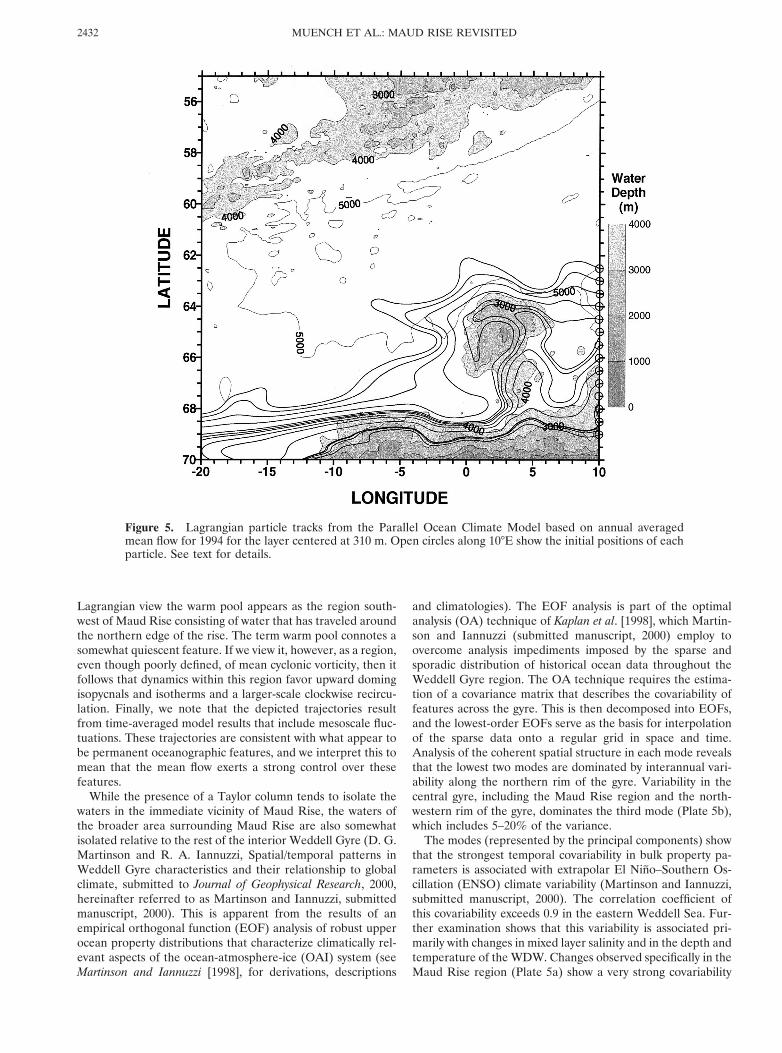
Lagrangian view the warm pool appears as the region south-west of Maud Rise consisting of water that has traveled aroundthe northern edge of the rise. The term warm pool connotes asomewhat quiescent feature. If we view it, however, as a region,even though poorly defined, of mean cyclonic vorticity, then itfollows that dynamics within this region favor upward domingisopycnals and isotherms and a larger-scale clockwise recircu-lation. Finally, we note that the depicted trajectories resultfrom time-averaged model results that include mesoscale fluc-tuations. These trajectories are consistent with what appear tobe permanent oceanographic features, and we interpret this tomean that the mean flow exerts a strong control over thesefeatures.
While the presence of a Taylor column tends to isolate thewaters in the immediate vicinity of Maud Rise, the waters ofthe broader area surrounding Maud Rise are also somewhatisolated relative to the rest of the interior Weddell Gyre (D. G.Martinson and R. A. Iannuzzi, Spatial/temporal patterns inWeddell Gyre characteristics and their relationship to globalclimate, submitted to Journal of Geophysical Research, 2000,hereinafter referred to as Martinson and Iannuzzi, submittedmanuscript, 2000). This is apparent from the results of anempirical orthogonal function (EOF) analysis of robust upperocean property distributions that characterize climatically rel-evant aspects of the ocean-atmosphere-ice (OAI) system (seeMartinson and Iannuzzi [1998], for derivations, descriptions
and climatologies). The EOF analysis is part of the optimalanalysis (OA) technique of Kaplan et al. [1998], which Martin-son and Iannuzzi (submitted manuscript, 2000) employ toovercome analysis impediments imposed by the sparse andsporadic distribution of historical ocean data throughout theWeddell Gyre region. The OA technique requires the estima-tion of a covariance matrix that describes the covariability offeatures across the gyre. This is then decomposed into EOFs,and the lowest-order EOFs serve as the basis for interpolationof the sparse data onto a regular grid in space and time.Analysis of the coherent spatial structure in each mode revealsthat the lowest two modes are dominated by interannual vari-ability along the northern rim of the gyre. Variability in thecentral gyre, including the Maud Rise region and the north-western rim of the gyre, dominates the third mode (Plate 5b),which includes 5–20% of the variance.
The modes (represented by the principal components) showthat the strongest temporal covariability in bulk property pa-rameters is associated with extrapolar El Nino–Southern Os-cillation (ENSO) climate variability (Martinson and Iannuzzi,submitted manuscript, 2000). The correlation coefficient ofthis covariability exceeds 0.9 in the eastern Weddell Sea. Fur-ther examination shows that this variability is associated pri-marily with changes in mixed layer salinity and in the depth andtemperature of the WDW. Changes observed specifically in theMaud Rise region (Plate 5a) show a very strong covariability
Figure 5. Lagrangian particle tracks from the Parallel Ocean Climate Model based on annual averagedmean flow for 1994 for the layer centered at 310 m. Open circles along 108E show the initial positions of eachparticle. See text for details.
MUENCH ET AL.: MAUD RISE REVISITED2432

with ENSO (r 5 0.94 for bulk stability, significant to within1%; r2 . 85%), consistent with enhanced winter cyclonicforcing during El Nino and diminished forcing during La Ninaconditions. These changes may reflect shifts in winter stormtracks. Analysis of the Goddard Institute of Space Studies(GISS) general circulation model (D. Rind et al., Latitudinaltemperature gradients and sea ice response, submitted to Jour-nal of Geophysical Research, 2000) reveals a mechanismwherein warm anomalies in the tropical Pacific increase theequatorward thermal gradient, invigorate the subtropical gyre,and shift the subtropical jet equatorward away from the sourceof available potential energy in the Antarctic. This leads to adecrease in cyclone activity in the Pacific sector of the subpolaroceans. The equatorial warming also alters the Walker cellcirculation, leading to a reduction in subsidence in the tropicalAtlantic. This reduction in turn alters the vertical meridionalcirculation in the Atlantic, introducing changes comparable tothose that would occur were the tropical Atlantic to cool andcreate a meridional temperature gradient opposite in sign tothat in the Pacific. This results, in the Atlantic, in a relaxationof the meridional circulation accompanied by a poleward shiftof the subtropical jet to a location nearer the Antarctic poten-tial energy sources. The result is increased storm intensity inthe Atlantic sector of the Southern Ocean and increased en-ergy input to the Weddell Gyre, consistent with the findingshere.
4.2. Heat Fluxes
A primary motivation for the ANZFLUX experiment was todetermine the ocean heat flux to the surface and its relation tothe regional oceanography. Modeling studies [e.g., Martinson,1990] have indicated that maintenance of the relatively thinWeddell Sea ice cover requires heat fluxes O(10–20) W m22.Observations of ice growth, elevation of T above freezing, andentrainment of geochemical tracers have tended to be consis-
tent with these values for the Weddell Sea [Wadhams et al.,1987; Gordon and Huber, 1984, 1990; Schlosser et al., 1990].The appearance of the Weddell Sea winter polynyas in themid-1970s occurred in the vicinity of Maud Rise and suggestthat it may be an area of particularly large heat flux.
During the ANZFLUX experiment, McPhee et al. [1999]measured instantaneous heat fluxes at the drift stations in thewarm pool and over Maud Rise (site locations shown schemat-ically on Figure 1) and found that average fluxes in theseregions were 52 and 23 W m22, respectively. They also derivedparametric relations among heat flux, ice drift speed, and watertemperature in the form ^w9T9& 5 CHu*dT , where ^w9T9& isthe turbulent heat flux, u* is the friction velocity related to(and roughly proportional to) the velocity of the ice over thewater, dT is the elevation of the mixed layer temperatureabove the freezing point, and CH is the heat transfer coeffi-cient. They found that u* could be determined from the icedrift velocity using a Rossby similarity relationship with param-eters similar to those for the Arctic pack ice if a roughnessscale ( z0 5 1–2 mm) 2 orders of magnitude smaller than thatin the Arctic was assumed for the Weddell Sea ice. The heattransfer coefficient was found to equal 0.0056, a value within10% of Arctic pack ice values. These measurements were car-ried out over a range of conditions that appeared to typify theregion during winter. These relationships were used with thePOP buoy drift speed and the temperature elevation abovefreezing at the 10 m sensor to estimate the heat flux over thefirst 76 days of the buoy drift, yielding an areal average flux of27 W m22.
McPhee et al. [1999] showed precisely how large the oceanheat flux could be and how to calculate it on the basis of localconditions. We expand upon their work by exploring variationsin the heat flux with regional ocean conditions. We start byconsidering variations in pertinent heat flux parameters during
Figure 6. Heat flux parameters during the buoy drift with (top) u* computed according to the McPhee et al.[1998] relationship to drift speed, (middle) dT equal to the elevation of the 10 m temperature above freezing,and (bottom) the resultant heat flux computed using CH 5 0.0056. T at 100 m depth, interpolated to thebuoy position from the ship CTD and buoy castlet averages, is also shown.
2433MUENCH ET AL.: MAUD RISE REVISITED

the buoy drift track (Figure 6). Maximum upward flux occurredover the halo and was nearly 200 W m22, while the flux aver-aged over the whole drift was 29 W m22. This average is higherthan that reported by McPhee et al. [1999] because it includesthe high heat flux periods near the end of the record (after day325) when the buoy neared the ice edge.
To assess the relations among heat fluxes and regionaloceanographic features, the data were divided into bins foreach region through which the buoy passed. Average heatfluxes in these bins were derived using T elevation above thefreezing point at 10 m measured from the gridded ship CTDand buoy castlet averages (Plate 6 and Table 1). The value foru* that was calculated from the buoy record (Figure 6) wasassumed to represent the u* history of the region and was usedin the heat flux calculation. Heat fluxes were smallest (14–18W m22) in the relatively cold region west of the halo, north ofthe warm pool, and overlying Maud Rise (11–20 W m22). Theywere intermediate in the northern and southern halo (23–24 Wm22) and in the warm pool (28 W m22) and were highest(24–45 W m22) in the central halo, in the marginal ice zonenear the northern ice edge (54 W m22), and in an isolatedwarm feature (82 W m22). Heat fluxes even from the coldestregions were substantial.
A key question is whether the heat flux is constrained by theavailability of heat in the ocean or by the intensity of mechan-ical mixing. The correlation coefficients (Table 1) yield a par-tial answer. The record-long correlation of heat flux with Televation (0.73) was greater than that with friction velocity(0.40), where correlations .0.3 were significant at the 95%level. The correlation between heat flux and 100 m tempera-ture, taken to be an indicator of independent thermal forcing,was lower still (0.31). Hence heat entrainment through thethermocline by mechanical mixing was not significantly en-hancing the thermal forcing. The correlation between u* andT elevation at 10 m was near zero. The average heat flux of29.1 W m22 nearly equaled, throughout the study region, the30.8 W m22 obtained as a product of the average values of u*and temperature elevation [McPhee et al., 1999].
Fluctuations in heat flux and T at 100 m were less correlatedin regions of high flux. The correlation was 0.72 in the coldregion west of the rise, where heat flux was 18 W m22, but wasonly 0.32 in the central halo, where heat flux was 45 W m22.These differences are probably due to the regionally varyingmixed layer depth. Many instances of elevated mixed layer Tand consequent high heat fluxes associated with warm patches
in the mixed layer resulted from entrainment of warmer deepwater during past storm events. These warm patches weremore numerous over the halo than elsewhere because of theshoaled thermocline, with the result that the average T eleva-tion was high. There were fewer warm patches in the colderregions, average T elevation was less, and a greater proportionof the heat flux was associated with the warm patches.
An evaluation of upper ocean DO and d3He balances inice-covered regions of the ocean provides an alternate meansby which to assess heat fluxes through derivation of entrain-ment rates. This method is based on the observation that DOis undersaturated by about 20% and has little variation withinthe WDW [e.g., Gordon and Huber, 1990], whereas 3He issupersaturated in the WDW [Schlosser et al., 1987]. Gas ex-change between the upper ocean and atmosphere is stronglyreduced by the sea ice cover, therefore entrainment of WDWresults in an increased concentration of d3He and a decrease inDO in the upper mixed layer. Compared to direct measure-ments of the vertical oceanic heat flux, which typically yieldshort time series with limited spatial resolution [e.g., McPhee etal., 1999], the values derived from gas balances representlarger regions over periods of time from months up to a year.The method has been used previously to determine winterentrainment and heat flux rates for the Weddell Sea interpo-lated over large areas [e.g., Gordon and Huber, 1990; Schlosseret al., 1987; Hohmann et al., submitted manuscript, 2000].
The horizontal distributions of the vertically averaged mixedlayer d3He and DO concentrations in the Maud Rise regionduring the ANZFLUX experiment reflect the features that areassociated with Maud Rise (Figure 7). The halo and warm poolon the western flank of the rise as well as the warm cell at thesouth end of shipboard transects 1 and 2 stand out as regionswith high mixed layer d3He values and low DO concentrations.The spatial coverage of the measurements is not sufficient toresolve entirely these features, and their dimensions in Figure7 result primarily from linear interpolation of the data. Nev-ertheless, the data illustrate that the influence of the Taylorcolumn on mixed layer d3He and DO does not extend into theregion northwest of Maud Rise.
If we assume that the elevated d3He concentrations and lowDO in the upper mixed layer result primarily from WDWentrainment and that sea-air gas exchange is strongly sup-pressed by the ice cover, then the apparent WDW fraction inthe mixed layer can be computed using a two-component mix-ing approach. For this computation we now assume that WDW
Table 1. Buoy and d3He Heat Flux Statistics by Region
Drift RegionAverage
Q, W m22Average
u*Average
dTAverage
T100
Correlationsu*/dT
CorrelationsQ/T100
CorrelationsQ/dT
CorrelationsQ/u*
d3HeQ, W m22
Warm pool 27.5273 1.3477 0.0867 20.9049 20.0120 0.0771 0.4919 0.7594 25South halo 23.0996 0.9809 0.1011 20.1640 20.0671 0.2500 0.6016 0.6767 25Cold pool 1 17.9891 1.1149 0.0617 21.3054 0.3312 0.7213 0.7482 0.5108 15Central halo 1 44.6306 1.0768 0.1878 0.3535 20.2067 0.3249 0.6027 0.4185 25Maud Rise 1 10.9714 0.6647 0.0694 21.0632 0.2258 0.2473 0.1516 0.9902 20Central halo 2 27.9036 1.0254 0.3547 0.4790 0.1607 0.0399 0.3338 0.6049 25Maude Rise 2 20.0405 1.1020 0.0765 21.0220 0.0302 0.5109 0.7157 0.7177 20North halo 24.2808 1.0338 0.1107 20.5278 20.3307 0.5387 0.8460 0.4402 15Warm feature 81.9601 1.8101 0.2054 0.1445 20.2774 0.6271 0.8548 0.2514Cold pool 2 14.2326 1.1538 0.0563 21.3232 20.3723 0.0213 0.6000 0.5635 15No MIZ drift 26.6923 1.1299 0.1019 20.5433 20.0508 0.4297 0.7682 0.4801MIZ 53.4908 0.8543 0.2884 21.0912 20.2730 20.1176 20.2026 0.4698Whole drift 29.1352 1.1047 0.1190 20.5934 20.1397 0.3054 0.7320 0.4034
MIZ, marginal ice zone.
MUENCH ET AL.: MAUD RISE REVISITED2434

at the depth of Qmax best represents that entrained into themixed layer and use the corresponding values of d3He concen-tration 5 8.6 6 0.2% and DO 5 4.49 6 0.07 mL L21 for thedeep mixing component. The initial mixed layer d3He concen-tration and DO at the onset of freezing were reported byHohmann et al. (submitted manuscript, 2000) to be 21 6 0.3%and 7.67 6 0.11 mL L21, respectively. The latter value is at92.4 6 1.4% saturation for Q 5 21.878C, S 5 34.3 psu, andP 5 990 mbar [Weiss, 1970]. In the warm pool and the warm
cell or eddy southwest of Maud Rise the WDW fraction of themixed layer derived from the d3He data turns out to be about30 and 45%, respectively, which is a factor of 2–3 higher thanin other regions covered by the ANZFLUX cruise (Hohmannet al., submitted manuscript, 2000). Values obtained from DOare slightly lower, probably because the effect of primary pro-duction on DO has been neglected.
Rates of entrainment of WDW into the mixed layer arecomputed using the measured WDW fractions in the mixed
Plate 3. As for Plate 2 except along averaged southern buoy section I and shipboard transect 2.
2435MUENCH ET AL.: MAUD RISE REVISITED

layer, mixed layer depth, and time elapsed since formation ofthe sea ice cover. If we assume that the ice edge progressesnorthward at a constant rate, then the time when each sitebecomes ice-covered can be estimated using a linear correla-tion between the time of first ice formation, derived fromNational Snow and Ice Data Center (NSIDC) data [Schweitzeret al., 1995], and latitude at the site. The entrainment heat fluxat each site is the product of entrainment rate, T differencebetween the WDW and the mixed layer, density, and specificheat of seawater.
Using d3He, the greatest winter heat fluxes (about 25 Wm22) were found in the warm pool and the warm cell or eddysouthwest of Maud Rise (Figure 8 and Table 1). Note that thegreatest flux was found at station 28, rather than at 29 and 30,though these latter two sites had the highest d3He and lowestDO values in the mixed layer, and this apparent discrepancyreflects the difference in mixed layer depth between the sites.
The 25 W m22 value for heat flux derived at station 28 usingd3He is considerably lower than the 100 W m22 that wasdirectly measured at the same site by McPhee et al. [1996], butthe latter is an instantaneous value, while the fluxes derivedusing d3He reflect time-integrated processes. Elsewhere in theregion, typical values of winter entrainment heat flux derivedfrom d3He are about 15 W m22. If we incorporate the highervalues that were associated with the halo and warm eddy, thenthe regional values were similar to but slightly lower than the27–29 W m22 regional mean derived from the drift buoy data.There are two possible reasons for this discrepancy. First, thebuoy spent a large proportion of its drift situated in the warmpool and halo regions and therefore sampled preferentiallyfrom the highest heat flux regions. Second, the estimates basedon d3He include fluxes averaged since the onset of sea iceformation, whereas the buoy values represent midwinter con-ditions encountered during the drift.
Plate 4. Distributions of T and S at (a) and (b) 100 m and at (c) and (d) 70 m based on the combined andbin-averaged buoy castlet and ship’s CTD data. Colored dots show the shipboard CTD station locations, andwhite dots indicate locations of buoy castlets.
MUENCH ET AL.: MAUD RISE REVISITED2436

Plate 5. (a) Time series of NINO3 (an index of ENSO variability) and two upper ocean quantities fromMaud Rise region over past 20 years [from Martinson and Iannuzzi, submitted manuscript, 2000): (1) solidcircles with bold scatter bars (1s) are a measure of upper ocean bulk stability (the amount of buoyancy thatmust be removed in order to induce deep convection, given as z scores, i.e., standard deviations from mean),and (2) crosses with dashed error bars as winter average upper ocean heat flux (again, given in z scores). Thelarge scatter in heat flux values reflects the strong spatial variability in the Maud Rise region. The histogramshown below the time series and labled as “Instantaneous Correlation” shows where the large correlation isbeing realized. This statistic is developed by Martin and Iannuzzi (submitted manuscript, 2000) and shows thatmost of the large correlation is due to the strong covariability between Maud Rise and ENSO-associatedvariabilities during the two highest extreme ENSO years. (b) EOF showing coherent spatial covariability ofbulk stability throughout Weddell Gyre region. This is the third EOF from Martinson and Iannuzzi (submittedmanuscript, 2000). It describes 9% of the total variance and is dominated by interannual variability throughthe core of the gyre, encompassing Maud Rise. The temporal variability of this mode covaries with ENSO andis dominated by changes in properties of Tmax water (e.g., its depth and temperature).
2437MUENCH ET AL.: MAUD RISE REVISITED

4.3. Local Ice Cover
Within days of the end of sampling at the second drifting siteover eastern Maud Rise, satellite Special Sensor MicrowaveImager (SSM/I) data revealed a large region of very low iceconcentration situated a few tens of kilometers northeast ofthe site (M. Drinkwater, Jet Propulsion Laboratory, personalcommunication, 1994). We interpret this region as a polynyacharacterized, within limits imposed by interpretation of theSSM/I data, either by open water or by thin and wet ice cover.Such a polynya can result from large upward heat fluxes asso-ciated with ice-generated turbulence acting on the shallowthermocline over the warm pool eddies and halo west of MaudRise and melting most of the already thin existing ice cover.The resulting polynya would then, consistent with our obser-vations, have been advected northeast with pack ice in re-sponse to southwesterly winds, which persisted for several daysafter we vacated the site.
The thin ice cover and subsequent polynya formation inwinter 1994 was not an unusual occurrence for the Maud Riseregion. Ice concentration data presented by Gloersen et al.[1992] shows that by October this region typically has lowerconcentrations than the surrounding waters. Intermittentpolynyas have been observed there in previous winters [Comisoand Gordon, 1987; Gordon and Comiso, 1988; Gordon andHuber, 1995]. Comiso and Gordon [1987] attributed the inter-mittent winter polynyas to introduction of warm deep water to
the surface through deep convection. Orsi et al. [1993] notedisolated patches of water having anomalously high T and at-tributed these to localized diapycnal mixing induced by bottomtopography. For this to occur the thermocline must shoal lo-cally, and we have shown that such shoaling is associated withthe Maud Rise halo and with the warm pool region. Persistenthigh winds roughly paralleling the trend of the halo over thewestern flank of the rise and the hypothetically northeast-southwest oriented warm pool would be especially conduciveto polynya formation. Rapidly ablating ice would continue todrift over the warm features, subjecting it to continuous melt-ing over an extended period. Mean ice drift speeds measuredduring the two 6 day drifts in winter 1994 were O(30) cm s21
or, roughly 30 km d21 in an eastward direction, and maximumice basal ablation rates were as high as about 10 cm d21 duringthe periods of highest drift speed. Typical monthly mean icedrift velocities in this region are 5–10 cm s21 and eastward tonortheastward [Kottmeier and Sellmann, 1996]. If the ice wereto drift for a week or so within the region of elevated thermo-cline, then upward heat flux would be more than sufficient tomelt the typically thin (O(50) cm) ice cover and generate apolynya. In the extreme case, deep convecting oceanic chim-neys would occur such that a large upward heat flux wouldprevent ice formation. This has been shown to be consistentwith Taylor column formation over Maud Rise by Alverson andOwens [1996].
Plate 6. Upward oceanic heat flux at 10 m depth computed using McPhee et al.’s [1999] method applied tothe grid-averaged elevation of T above freezing. A calculated area mean u* 5 1.12 cm s21 was used. As forPlate 4, colored dots refer to locations of CTD casts, while white dots show locations for buoy castlets.
MUENCH ET AL.: MAUD RISE REVISITED2438

The occurrence of regional conditions favorable to polynyaformation appears to depend also on larger-scale phenomenathat vary interannually. While the mean winter heat fluxespresented above agree closely with winter climatological aver-age heat fluxes estimated for the eastern Weddell Gyre on thebasis of upper ocean properties and previously derived scalinglaws [Martinson and Iannuzzi, 1998], low heat fluxes and re-duced upper ocean stability typically coincide with El Ninoevents (Plate 5a) (Martinson and Iannuzzi, submitted manu-script, 2000). During these events the eastern Weddell Sea is
most susceptible to deep convection and polynya formationbecause both upper ocean stability and a high heat flux act tostabilize the system with respect to salt-driven free convectiondriven by in situ ice growth. Hence changes in heat flux andupper ocean stability covary negatively in such a way as toincrease the eastern Weddell Sea’s resistance to deep convec-tion.
5. SummaryOur results provide new and detailed documentation of
oceanographic conditions in the vicinity of Maud Rise andexpand upon past work that has addressed vertical upper oceanheat flux and ice cover in the region.
1. The warm pool region southwest of the rise is seen to bea dynamically necessary region of cyclonic vorticity that isassociated with a Taylor column over Maud Rise. The warmpool should more precisely be described as a region of warm-core eddies and filaments that lies downstream from MaudRise and has a mean positive vorticity through its dynamiclinkage to the Taylor column overlying the rise.
2. The closed circulation, or warm halo, about Maud Riseand the warm pool are both associated with thermocline shoal-ing that is a necessary condition for high upward heat fluxes tooccur. The influence of Maud Rise bottom topography on theupper ocean heat flux consequently extends over a region thatis larger, by a factor of at least 2, than the area directly over-lying the Rise.
3. Areal mean upward heat fluxes, derived using both up-per ocean T (instantaneous) values and tracer-based (integrat-ed) values, were about 25 W m22 over the halo and the warmpool. Values derived over the core halo and warm pool regionsusing only upper ocean T exceeded 100 W m22 at some sites.Elsewhere in the region, the T-derived heat fluxes varied
Figure 8. Winter period entrainment heat flux from theWDW into the upper mixed layer in the Maud Rise regionderived from the distribution of d3He.
Figure 7. Average mixed layer (top) d3He and (bottom) DOconcentrations in the Maud Rise region during the AN-ZFLUX experiment. The mixed layer depth was determinedfrom bottle and CTD data at each station.
2439MUENCH ET AL.: MAUD RISE REVISITED

widely (,10–.50 W m22), whereas the tracer-derived heatfluxes showed a much smoother distribution and typical valuesnear 15 W m22. Our mean values are close to those that havebeen previously reported. Historical ice cover data has shownthat the geographical region encompassed by Maud Rise andthe warm pool area to the southwest is a preferred site forpolynya formation, consistent with these high heat fluxes.
Acknowledgments. The research reported here has been sup-ported by the U.S. National Science Foundation through grants OPP-9315019 to Earth & Space Research (RDM), grant support to theUniversity of Washington (JHM), OPP-9317321 and OPP-9615524 toOregon State University subcontracted to Earth & Space Research asOPP-9896041 (LP), and OPP-9317231 and OPP-9528807 to Lamont-Doherty Earth Observatory (DGM, PS, BH, and RH). We are in-debted to Robin Tokmakian of the Naval Postgraduate School forproviding us with output from, and advice concerning, the Semtner-Chervin POCM and to Christoph Kottmeier of the University ofKarlsruhe, Germany, for providing us with data from the AWI driftingbuoy. This work could not have been done without assistance from thecaptain, crew, and support staff of the RVIB Nathaniel B. Palmer. Thisis Earth & Space Research contribution 022 and LDEO contribution6120.
ReferencesAlverson, K., and W. B. Owens, Topographic preconditioning of open-
ocean deep convection, J. Phys. Oceanogr., 26, 2196–2213, 1996.Barnier, B., L. Siefried, and P. Marchesiello, Thermal forcing for a
global ocean circulation model using a 3-year climatology of EC-MWF, J. Mar. Syst., 6, 363–380, 1995.
Benson, B. B., and D. Krause, Isotopic fractionation of helium duringsolution: A probe for the liquid state, J. Solution Chem., 9, 895–909,1980.
Bersch, M., G. A. Becker, H. Frey, and K. P. Koltermann, Topographiceffects of the Maud Rise on the stratification and circulation of theWeddell Gyre, Deep Sea Res., Part A, 39, 303–331, 1992.
Brink, K. H., Tidal and lower frequency currents above FieberlingGuyot, J. Geophys. Res., 100, 10,817–10,832, 1995.
Clarke, W. B., W. J. Jenkins, and Z. Top, Determination of tritium bymass spectrometric measurement of 3He, Int. J. Appl. Radiat. Isot.,27, 515–522, 1976.
Comiso, J. C., and A. L. Gordon, Recurring polynyas over the Cos-monaut Sea and the Maud Rise, J. Geophys. Res., 92, 2819–2833,1987.
De Veaux, R. D., A. L. Gordon, J. C. Comiso, and N. E. Bacherer,Modeling of topographic effects on Antarctic sea-ice using multi-variate adaptive regression splines, J. Geophys. Res., 98, 20,307–20,319, 1993.
Fahrbach, E., M. Schroder, and A. Klepikov, Circulation and watermasses in the Weddell Sea, in Physics of Ice-Covered Seas, vol. 2, pp.569–603, Helsinki Univ. Press, Helsinki, Finland, 1998.
Gloersen, P., W. J. Campbell, D. J. Cavalieri, J. C. Comiso, C. L.Parkinson, and H. J. Zwally, Arctic and Antarctic sea ice, 1978–1987: Satellite passive-microwave observations and analysis, NASASpec. Publ., 511, 290 pp., 1992.
Goldner, D. R., and D. C. Chapman, Flow and particle motion inducedabove a tall seamount by steady and tidal background currents, DeepSea Res., Part I, 44, 719–744, 1997.
Gordon, A. L., and J. C. Comiso, Polynyas and the Southern Ocean,Science, 258, 90–97, 1988.
Gordon, A. L., and B. A. Huber, Thermohaline stratification below theSouthern Ocean sea ice, J. Geophys. Res., 89, 641–648, 1984.
Gordon, A. L., and B. A. Huber, Southern Ocean winter mixed layer,J. Geophys. Res., 95, 11,655–11,672, 1990.
Gordon, A. L., and B. A. Huber, Warm Weddell Deep Water west ofMaud Rise, J. Geophys. Res., 100, 13,747–13,753, 1995.
Gouretski, V. V., and A. I. Danilov, Weddell Gyre: Structure of theeastern boundary, Deep Sea Res., Part I, 40, 561–582, 1993.
Kaplan, A., Y. Kushnir, M. A. Cane, and M. B. Blumenthal, Reducedspace optimal analysis for historical datasets: 136 years of Atlanticsea surface temperature, J. Geophys. Res., 102, 27,835–27,860, 1998.
Kottmeier, C., and L. Sellmann, Atmospheric and oceanic forcing ofWeddell Sea ice motion, J. Geophys. Res., 101, 20,809–20,824, 1996.
Levitus, S., Climatological atlas of the world ocean, NOAA Prof. Pap.,13, 173 pp., 1982.
Levitus, S., and T. P. Boyer, World Ocean Atlas 1994, vol. 4, Temper-ature, NOAA Atlas NESDIS, vol. 4, 129 pp., Natl. Oceanic andAtmos. Admin., Silver Spring, Md., 1994.
Levitus, S., R. Burgett, and T. Boyer, World Ocean Atlas 1994, vol. 3,Salinity NOAA Atlas NESDIS, vol. 3, 111 pp., Natl. Oceanic andAtmos. Admin., Silver Spring, Md., 1994.
Ludin, A., R. Weppernig, G. Bonisch, and P. Schlosser, Mass spectro-metric measurement of helium isotopes and tritium in water sam-ples, LDEO Tech. Rep., 98-6, Lamont-Doherty Earth Observ., Pal-isades, N. Y., 1998.
Martinson, D. G., Evolution of the Southern Ocean winter mixed layerand sea ice: Open ocean deep water formation and ventilation, J.Geophys. Res., 95, 11,641–11,654, 1990.
Martinson, D. G., and R. A. Iannuzzi, Antarctic ocean-ice interaction:Implications from ocean bulk property distributions, in Sea Ice:Physical Processes, Interactions and Variability, Antarct. Res. Ser., vol.74, edited by M. O. Jeffries, pp. 243–271, AGU, Washington, 1998.
McPhee, M. G., S. F. Ackley, P. Guest, B. A. Huber, D. G. Martinson,J. H. Morison, R. D. Muench, L. Padman, and T. P. Stanton, TheAntarctic Flux Zone Experiment, Bull. Am. Meteorol. Soc., 77, 1221–1232, 1996.
McPhee, M. G., C. Kottmeier, and J. H. Morison, Ocean heat flux inthe central Weddell Sea during winter, J. Phys. Oceanogr., 29, 1166–1179, 1999.
Orsi, A. H., W. D. Nowlin, Jr., and T. Whitworth III, On the circulationand stratification of the Weddell Gyre, Deep Sea Res., Part I, 40,169–203, 1993.
Ou, H. W., Some effects of a seamount on oceanic flows, J. Phys.Oceanogr., 21, 1835–1845, 1991.
Padman, L., A. J. Plueddemann, R. D. Muench, and R. Pinkel, Diurnaltides near the Yermak Plateau, J. Geophys. Res., 97, 12,639–12,652,1992.
Robertson, R., L. Padman, and G. D. Egbert, Tidal currents in theWeddell Sea, in Ocean, Ice and Atmosphere: Interactions at the Ant-arctic Continental Margin, edited by S. S. Jacobs and R. F. Weiss,Antarctic Res. Ser., vol. 75, pp. 341–369, AGU, Washington, D. C.,1998.
Schlosser, P., W. Roether, and G. Rohardt, Helium-3 balance of theupper layers in the northwestern Weddell Sea, Deep Sea Res., Part A,34, 365–377, 1987.
Schlosser, P., R. Bayer, A. Foldvik, T. Gammelsrød, G. Rohardt, andK. O. Munnich, 18O and helium isotopes as tracers of Ice ShelfWater and water/ice interaction in the Weddell Sea, J. Geophys. Res.,95, 3253–3263, 1990.
Schweitzer, P. N., B. Babbit, and G. Eaton, Monthly average polar seaice concentration [CD-ROM], U.S. Geol. Surv. Digital Ser., DDS-27,1995.
Semtner, A. J., and R. M. Chervin, Ocean general circulation from aglobal eddy-resolving model, J. Geophys. Res., 97, 5493–5550, 1992.
Stammer, D., R. Tokmakian, A. J. Semtner, and C. Wunsch, How welldoes 1/4 deg. circulation model simulate large-scale oceanic obser-vations?, J. Geophys. Res., 101, 25,779–25,811, 1996.
Wadhams, P., M. A. Lange, and S. F. Ackley, The ice thickness dis-tribution across the Atlantic sector of the Antarctic Ocean in mid-winter, J. Geophys. Res., 92, 14,535–14,552, 1987.
Wamser, C., and D. G. Martinson, Drag coefficients for winter Ant-arctic pack ice, J. Geophys. Res., 98, 12,431–12,437, 1993.
Weiss, R. F., The solubility of nitrogen, oxygen and argon in water andseawater, Deep Sea Res., Oceanogr. Abstr., 17, 721–735, 1970.
R. Hohmann, B. Huber, D. Martinson, and P. Schlosser, Lamont-Doherty Earth Observatory, P.O. Box 1000, Palisades, NY 10964–8000.
J. H. Morison, Polar Science Center, APL, 1013 NE 40th Street,Seattle, WA 98105.
R. D. Muench and L. Padman, Earth & Space Research, 1910Fairview E., Suite 102, Seattle, WA 98102–3620. ([email protected])
(Received July 3, 2000; accepted August 31, 2000.)
MUENCH ET AL.: MAUD RISE REVISITED2440