Embed Size (px)
Citation preview

Mathematics Science Strand
Resource Science
Earth Resources
Module A5
Student Support Material
Agricultural and Resource Science
ii
Acknowledgements These curriculum resource materials have been written and compiled by:
Rosina Paullon O.L.S.H. Teachers’ College - Kabaleo
Bro Tony Gaul Holy Trinity Teachers’ College
John Broadfoot Long Term Adviser, Science
Institutional Participants for Science Workshops (1999 – 2002)
Rosina Paullon Principal Counterpart (O.L.S.H. T.C. - Kabaleo and St. Benedict’s T.C.)
Bro. Gerry Buzolic O.L.S.H. T.C. Kabaleo Rex Orong O.L.S.H. T.C. Kabaleo Bro. Tony Gaul Holy Trinity T.C. Mek Poka Holy Trinity TC Jerome Goodwill Gaulim T.C. Jerry Hendigao Dauli T.C. Sam Kambaiye Dauli T.C Asaku Openg St Benedict’s T.C. and Balob T.C. Gamini Ila St Benedict’s TC Robert Sine St Benedict’s TC Basa Nayong Balob T.C. Otto Wrangian PNGEI Synell Ko-ou PNGEI John Gonapa Madang T.C. Baro Pari NDOE - Teacher Ed and Staff Development Paul Hamadi NDOE - Inspector
Illustrations and photographs courtesy:
John Broadfoot; CorelDraw 5.0
Layout and diagrams supported by:
John Broadfoot
Cover photograph: OK Tedi Mine, PNG. (Ms J. McLean)
PASTEP
Primary and Secondary Teacher Education Project Australian Agency for International Development (AusAID) GRM International
Papua New Guinea-Australia Development Cooperation Program

Module A5 -Earth Resources
iii
Contents
UNIT OVERVIEW ....................................................................................................................1 RESOURCE SCIENCE.............................................................................................................1 MODULE CONTENT .............................................................................................................1 WHY STUDY THIS MODULE?.............................................................................................2 MODULE OUTLINE ..............................................................................................................2
1. IDENTIFICATION OF MINERALS............................................................................5 USEFUL PROPERTIES OF MINERALS..................................................................................5
2. IGNEOUS ROCKS...................................................................................................... 12 IDENTIFYING IGNEOUS ROCKS.........................................................................................12
3. SEDIMENTARY ROCKS .......................................................................................... 15 ENVIRONMENTS OF SEDIMENT ACCUMULATION ........................................................15 LITHIFICATION ..................................................................................................................15 TEXTURES OF SEDIMENTARY ROCKS.............................................................................16 SEDIMENTARY STRUCTURES...........................................................................................17 CLASSIFICATION OF SEDIMENTARY ROCKS ..................................................................18 IDENTIFICATION KEY FOR COMMON SEDIMENTARY ROCKS.....................................20
4. METAMORPHIC ROCKS ........................................................................................ 22 RESOURCES FROM ROCKS AND MINERALS.....................................................................24
5. WEATHERING AND EROSION.............................................................................. 25 MECHANICAL WEATHERING...........................................................................................25 CHEMICAL WEATHERING AND SOILS.............................................................................25 EROSION...............................................................................................................................29 MASS WASTING..................................................................................................................29
6. MINERAL AND ENERGY RESOURCES................................................................ 32 WHAT IS A RESOURCE?.....................................................................................................32 SOCIAL, CULTURAL AND POLITICAL PRESSURES........................................................33 MINERAL RESOURCES.......................................................................................................34 ENERGY RESOURCES..........................................................................................................41
THE VAIONT DAM DISASTER......................................................................................... 43


Module A5 -Earth Resources
1
Unit overview Resource Science These Modules contribute to the study of the Unit Agriculture and Resource Science. The two modules, A4 Marine Resources and A5 Earth Resources, contain topics which reflect the draft Primary Syllabuses for Lower and Upper Primary Science. These Modules also contain topics to provide coverage of the topics in Program 2000. Colleges may prefer to integrate these modules into the Unit Environmental Science.
Module and topic links to Lower and Upper Primary Syllabuses Lower Primary Upper Primary Code Module/topic Yr3 Yr4 Yr5 Yr6 Yr7 Yr8 A4 Marine Resources 4 4 4 4 4 4 Marine organisms 4 4 4 4 4 Marine ecology 4 4 4 Utilisation of marine resources 4 4 Sustainability and management 4 A5 Earth Resources 4 4 4 4 Minerals and rocks 4 4 4 4 Weathering and erosion 4 4 4 Ores and mining 4 4 Oil and gas 4 4
Module content
A4 Marine Resources 9 hours (CORE) • Marine organisms - reefs and mangroves
• Marine ecology
• Utilisation of marine resources
• Sustainability and management
A5 Earth Resources 9 hours (CORE) • Minerals and rocks
• Weathering and erosion
• Ores and mining
• Oil and gas

Agricultural and Resource Science
2
Why study this module? This is the second earth science module that you study as part of the Environmental Science units. In this module you will learn to identify some common minerals and rocks. A knowledge of minerals is important to understand the composition of different rocks and the origins of mineral resources of PNG. You will also look at a number of case studies of mineral resource development in PNG - copper and gold mining, oil and natural gas. Many of the natural impacts on lifestyles in PNG are due to the affects of geological processes and the utilisation of earth resources. This module also aims to prepare students for teaching earth science concepts in the primary curriculum.
Module outline
Objectives
At the end of this module students should be able to o understand the processes at work in the formation of minerals and
rocks of PNG;
o classify a range of typical minerals and rocks of PNG;
o observe and record properties of minerals and rocks;
o apply earth science principles to the understanding of the formation of mineral resources in PNG;
o access information to learn more about the mineral resources of PNG;
o graphically represent and interpret data obtained first or second hand;
o communicate ideas and concepts of earth resources using a variety of reporting formats applicable to teaching;
o critically and rationally review examples of resource development and impact on lives and lifestyles in PNG;
o propose effective plans for resource development and management and
o appreciate the importance of earth resource development to the economics of PNG.
Pre-requisites
No pre-requisites.
Module A5 -Earth Resources
3
Content
There are six main topics in this module:
• Minerals
• Igneous rocks
• Sedimentary rocks
• Metamorphic rocks
• Weathering and erosion
• Mineral and energy resources
Main ideas developed
Minerals and rocks are formed by a number of dynamic processes on the earth’s surface and are important in understanding the formation of important resources.
Some minerals and rocks have cultural significance or uses and have been used by indigenous persons for thousands of years.
Weathering and erosion are important mechanisms in the shaping of PNG landforms.
Due to the nature of the climate and the terrain all development, both at a community level and corporate level, which affects the environment must take into account the weathering and erosion potential in PNG.
Geologists use mapping, satellite imagery, sampling and drilling techniques to explore for possible resource deposits.
Metals are found in ores occurring in a variety of rock types formed through a number of different processes.
Oil and gas are hydrocarbons formed in sedimentary rocks from the breakdown of plant and animal remains trapped as sediments accumulate on the sea floor.
Hydrocarbons move through permeable sedimentary rocks until they escape or are trapped by an impervious barrier.
Complex infrastructure is needed to extract, process, transport and refine mineral resources before they are exported.
Mineral resource developments are important for producing resources for our lifestyles, sources of jobs and export income for PNG.
Mineral resource development is a national responsibility but must be carried out with full consultation with the local community.
Mineral resource development has environmental implications in terms of the air, water and land surface.
Agricultural and Resource Science
4
Teaching Approaches
This module will be studied through the use of these support materials, a lecture program, laboratory and field-based activities and a workshop/tutorial program. The practical component will be based on the application of earth science principles and problem solving to Papua New Guinea examples. Excursions or field studies will form an integral part of the teaching program. Activities will provide a hands-on approach to the teaching of this module. The learning of the concepts in this module will be greatly reinforced through the use of PNG produced audio-visual materials.
Relevant content from the Primary science curriculum will be applied in the teaching and learning of this module. Throughout the teaching of this module there will be a strong emphasis on the constructivist approach to learning that can be readily applied to science teaching in the classroom. You should be encouraged to apply your new knowledge and skills to the context of teaching at different levels in primary schools.
Assessment
This module should be assessed in a way that provides students with the opportunity to demonstrate their knowledge of the application of concepts and their ability to present an informed defensible opinion.
Practical activities should occur throughout the learning process. When excursions form part of the College curriculum field reports should form part of the assessment program. Assignments or projects should be based on individual research.
References
Textbooks
Tarbuck E.J. and Lutgens, F.K. (1994). Earth Science. (7th ed). Macmillan College Publishing: New York.
Clark, I.F. and Cook, B.J. (1986). Geological Science: Perspectives of the Earth. Australian Academy of Science: Canberra.
Support Materials
Science Advisory Group (1999). Earth Resources. PASTEP.
Curriculum Development Unit (1998-1999). Science Curriculum for Primary Schools in PNG.

Module A5 -Earth Resources
5
1. Identification of Minerals Useful properties of minerals
Colour
Minerals that are colourless or white when pure may be variously coloured by small traces of impurities. Except in a few cases, the colour of a mineral is not a good guide to its identity.
Streak
The streak of a mineral is the colour of its powder. The streak is obtained by rubbing the mineral on a streak plate (a piece of unglazed porcelain). Minerals harder than the plate will merely scratch the plate. The streak of these can be obtained by grinding some powder on to the plate with a harder mineral, e.g., quartz or corundum. Most minerals, including the most common rock-forming minerals, have a white or pale-coloured streak.
Lustre
The lustre of a mineral is the way it reflects light. Examples include metallic, sub-metallic, dull, earthy, glassy (vitreous), pearly, silky, waxy, resinous and adamantine (brilliant, as in diamond).
Crystal Habit
Minerals form distinctively shaped crystals, which may be an aid to mineral identification. Because the most common rock-forming minerals rarely exhibit good crystal shape in rocks, these exercises do not make use of this property.
Hardness
The hardness of a material is its ability to scratch another material. Mineral hardness is measured on Moh's hardness scale, a ten point scale ranging from 1 for talc (the softest) to 10 for diamond (the hardest). Three common hardnesses are useful for mineral recognition:
copper coin or finger-nail 2.5
steel knife blade 5.5
quartz 7.0

Agricultural and Resource Science
6
Use of these materials, in testing hardness, yields four useful hardness categories:
Less than 2.5 will not scratch copper coin or fingernail
Between 2.5 and 5.5 scratches fingernail but not knife blade
Between 5.5 and 7 scratches knife blade but not quartz
Greater than 7 scratches quartz
Some materials have a hardness equal to the testing material. Test the material first and then check to see if the mineral will scratch the testing material. If both occur then the mineral's hardness equals the hardness of the testing material. It is important to check that scratching has really occurred by attempting to rub off the scratch mark with a wet finger.
Cleavage
The cleavage of a mineral is its ability to break forming flat surfaces, recognised by their mirror-like reflection of light. Cleavage surfaces may be distinguished from crystal faces by a step and stairs effect, indicating the presence of numerous parallel surfaces. Minerals may cleave in 0, 1, 2, 3, 4, 5, or 6 directions.
The cleavage surfaces may be described as poor, good or perfect.
Fracture
The fracture of a mineral is its ability to break without forming flat surfaces. Commonly used fracture terms are uneven (most minerals), conchoidal (forming curved surfaces, e.g., quartz), earthy, hackly (like cast iron) and splintery.
Specific Gravity
The specific gravity of most minerals falls between 2.5 and 3.5. An estimate of the specific gravity of a mineral as low, medium or high may be obtained by hefting the material in the hand. A comparison to a known mineral may help.
Reaction with acids
Some carbonate minerals effervesce with HCl acid. The most common is calcite (CaCO3).

Module A5 -Earth Resources
7
Activity 1.1 What use are minerals?
In the table below are listed the names of some common minerals. Use your library or other reference books to find and list a source and use for each mineral.
Mineral Source Use
Galena
Graphite
Kaolinite
Feldspar
Quartz
Rutile
Calcite
Muscovite mica
Magnetite
Gypsum
Diatomite
Agricultural and Resource Science
8
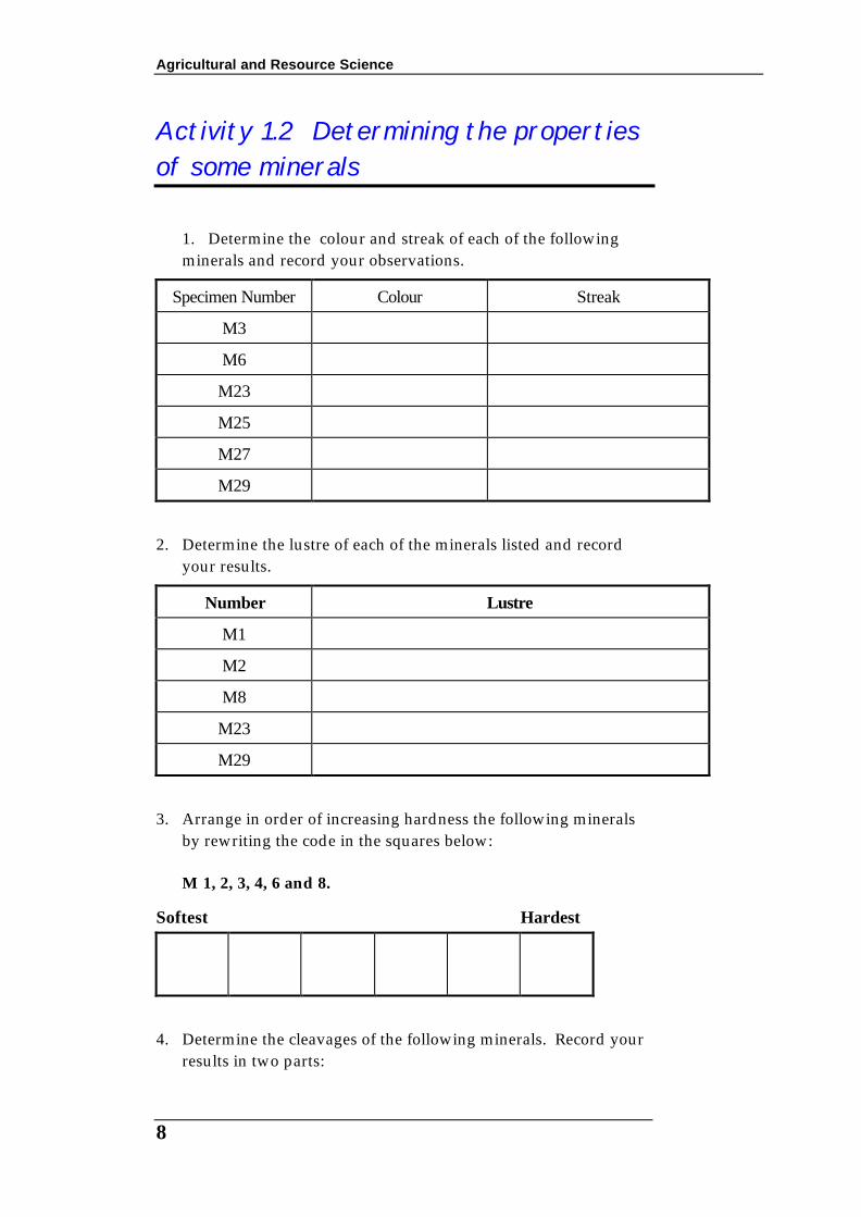
Activity 1.2 Determining the properties of some minerals
1. Determine the colour and streak of each of the following minerals and record your observations.
Specimen Number Colour Streak
M3
M6
M23
M25
M27
M29
2. Determine the lustre of each of the minerals listed and record
your results.
Number Lustre
M1
M2
M8
M23
M29
3. Arrange in order of increasing hardness the following minerals
by rewriting the code in the squares below: M 1, 2, 3, 4, 6 and 8.
Softest Hardest
4. Determine the cleavages of the following minerals. Record your results in two parts:

Module A5 -Earth Resources
9
(i) number of directions of cleavage and
whether each direction is poor, good or perfect.
Cleavage
Number (i) No. of directions (ii) poor, good or perfect
M1
M2
M3
M6
M8
M29
M55
5. Using the method of heft, determine the order of increasing S.G. for
the minerals M 3, 8, 22, 23, 27 and 29.
Most dense Least dense
Activity 1.3 What mineral is that? 1. Draw a table like the one shown below. Determine and record
the properties of the minerals listed by code number and, when completed, use Mineralogy Tables to try to complete the last column, that is, the mineral name.
M l, 2, 3, 4, 6, 8, 11, 17, 22, 23, 25, 26, 27, 29, 55, 56, 69, 78.
Table. Mineral Identification Worksheet
No. Colour/
Streak
Lustre Cleavage/
Fracture
S.G. Special properties
e.g., magnetic
Name

Agricultural and Resource Science
10
• Review Questions
1 Although all minerals have an orderly internal arrangement of atoms and ions, most minerals do not have an obvious crystal form. Explain.
2 Why is it difficult to identify a mineral by colour alone?
3 If you found a glassy mineral while walking, what simple test would determine if it is a diamond?
4 Explain the economic use the mineral corundum (hardness 9.0).
5 What is the difference between silicon and silicate?

Module A5 -Earth Resources
11
& Research Design a mineral key Try to prepare a simple flow sheet for the identification of the minerals you looked at in Activity 1.3. A truly dichotomous key is one where there are only two choices such as metallic or non-metallic. However it is more useful in this case to use the categories discussed earlier. As an example hardness may be readily identified as one of four categories. An example of a possible key has been started below.
KEY TO MINERAL IDENTIFICATION
Hardness > 5.5
Metallic Non-metallic
Unknown mineral
Coloured Colourless or light colour
Streak white or very light
Streak coloured
Hardness < 2.5
Hardness 2.5 to 5.5
Lustre
Colour
Streak
Hardness
Cleavage No cleavage

Agricultural and Resource Science
12
2. Igneous Rocks Igneous rocks are those which have solidified from a molten state. Volcanoes provide impressive evidence of this process. These represent only a small fraction of the molten rock that is, or has been present in the earth's crust. Most of this molten rock never reaches the surface but solidifies at different levels beneath the crust and is only seen when rock and sediment up to l5 km thick is removed from above by erosion. By studying the evidence from volcanoes and from the once deep igneous masses geologists are able to postulate past and present igneous processes.
Identifying igneous rocks Although over 2000 minerals are known, only eight are the main components of most igneous rocks. These eight are combinations of atoms of the most abundant elements of the earth's crust, i.e., O, Si, Al, Fe, Ca, Na, K, Mg and a ninth sometimes, H as in H2O. The minerals are silicates and therefore have many similar properties but because of different lattice arrangements the cleavage and crystal habit of each is unique. The eight minerals do not crystallise at the same time in a magma and quite frequently not all of the eight minerals occur together. These facts give rise to different overall appearance of the solidified product (texture) and the final mineral content of the rock. These properties, texture and mineral content, enable us to devise a system of classifying igneous rocks.
Activity 2.1 Identifying igneous rocks Introduction
In this exercise you are required to arrange the rocks in different ways according to their properties of
(a) overall colour
(b) texture (relation of grain sizes)
(c) mineral composition

Module A5 -Earth Resources
13
1. Obtain a box of specimens and a hand lens. Take the specimens from the tray and arrange them in order of colour, from light to dark, and place their numbers in the squares provided.
Light Dark
2. Now arrange the specimens in order of decreasing grain size.
Place their numbers in the squares provided.
Coarse grained Fine grained
3. Now combine the previous two exercises and arrange the coarser
rocks (average grains greater than 2 mm) in order from light to dark. Do the same for the finer grained rocks.
Light Dark
Coarse grained igneous rocks
Light Dark
Fine grained igneous rocks
4. Now arrange the specimens in decreasing order of grain size into
the following categories by estimating, with the aid of a hand lens, the % of quarts in the rock.
more than 10% quartz
less than 10% quartz
no quartz
Coarse grained
Fine grained
Agricultural and Resource Science
14
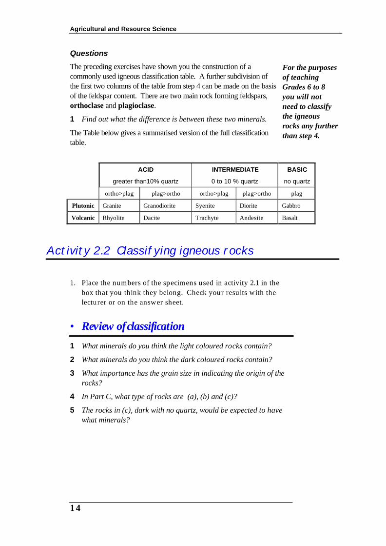
Questions
The preceding exercises have shown you the construction of a commonly used igneous classification table. A further subdivision of the first two columns of the table from step 4 can be made on the basis of the feldspar content. There are two main rock forming feldspars, orthoclase and plagioclase.
1 Find out what the difference is between these two minerals.
The Table below gives a summarised version of the full classification table.
ACID
greater than10% quartz
INTERMEDIATE
0 to 10 % quartz
BASIC
no quartz
ortho>plag plag>ortho ortho>plag plag>ortho plag
Plutonic Granite Granodiorite Syenite Diorite Gabbro
Volcanic Rhyolite Dacite Trachyte Andesite Basalt
Activity 2.2 Classifying igneous rocks 1. Place the numbers of the specimens used in activity 2.1 in the
box that you think they belong. Check your results with the lecturer or on the answer sheet.
• Review of classification 1 What minerals do you think the light coloured rocks contain?
2 What minerals do you think the dark coloured rocks contain?
3 What importance has the grain size in indicating the origin of the rocks?
4 In Part C, what type of rocks are (a), (b) and (c)?
5 The rocks in (c), dark with no quartz, would be expected to have what minerals?
For the purposes of teaching Grades 6 to 8 you will not need to classify the igneous rocks any further than step 4.

Module A5 -Earth Resources
15
By now you should realise that cooling rate is the factor responsible for the formation of coarse-grained (slow cooling at depth) and the fine grained rocks (rapid cooling aptly named volcanic).
• Review Igneous Rocks 1 Explain with reference to the rock cycle why one rock might be the
raw material for another.
2 If a lava flow, at the earth’s surface was dark in colour, what rock type might be formed wen the lava cools?
3 What does a porphyritic texture in an igneous rock indicate?
4 How are granite and rhyolite related?
3. Sedimentary rocks Weathering produces three kinds of materials that are transported and deposited as sediments, which are converted, over time, into sedimentary rocks: (a) Fragments (clasts) of pre-existing minerals and rocks
(b) New minerals as a result of the weathering processes (chemical reactions)
(c) Soluble minerals or ions removed by or precipitated from aqueous solution
Environments of sediment accumulation Bedding is a distinctive feature of sedimentary rocks and distinguishes these rocks from igneous and metamorphic rocks. Each layer in a bedding sequence represents a continuous accumulation of sediment in one depositional event. The nature and extent of these layers can indicate the past environments of deposition and thus indicate paleoclimates for particular terrains. Environments of sedimentation include:
(a) continental (land) including lucastrine (lakes)
(b) transitional (shoreline)
(c) marine (ocean floor)
Lithification Processes of lithification, that is, changing unconsolidated sediment into a coherent hard rock. These processes are also collectively known as diagenesis.

Agricultural and Resource Science
16
(a) compaction
(b) recrystallisation of unstable minerals into more stable ones.
(c) solution and replacement
(d) cementation by chemical precipitation of minerals between grains.
Textures of sedimentary rocks Characteristics such as grain composition, size, shape and sorting give important clues to the origins and environments of weathering, erosion, transportation and deposition of sediments. Table 3.1 shows a key used to classify sedimentary rocks. You will notice that the texture is very important for classifying sedimentary rocks. The texture is described in the following four terms:
1. Composition depends on the parent rock materials, fossils and solutions affecting the sediment.
2. Size of grains can be measured and are classified according to a size scale.
3. Shape of grains or particles depends on the original shape due to rock or mineral properties and the effects of abrasion during transportation. The shape is generally described in terms of roundness and sphericity that are defined below.
(a) Roundness refers to the shape of the corners of the grains. Particles that travel a long way down a fast running stream become well rounded meaning that there are no sharp or angular corners.
(b) Sphericity refers to the extent to which a grain approaches equidimensions such as the shape of a sphere or cube. The resulting shape is controlled by the composition as well as the physical abrasion during transport.
4. Sorting indicates the energy of the transporting and depositional environments. Fast moving sediment laden streams, that come to an abrupt halt, will dump the load without very much sorting resulting in poorly sorted sediments. These are characterised by a wide range of particle sizes often with little evidence of layering or bedding. Examples are turbidites, which are found in high energy marine environments. The best example is the poorly sorted sedimentary rock called greywacke.
On the other hand, quietly flowing streams carrying suspended clay particles and flowing into large lakes may deposit fine suspended clay particles forming shales. In areas where regular seasonal variations occur these shales may exhibit alternating thin layers or
Figure 3.1 This shape indicates a high degree of rounding but low sphericity

Module A5 -Earth Resources
17
laminae of shale and silt or different coloured clays. The resulting shales are called varve shales and are very important indicators of past climates.
Sedimentary structures Successive beds or layers are separated from one another by planar or nearly planar bedding planes. Often these planes reflect events from past environmental conditions, e.g., mud cracks, ripple marks and flutes. Often the textural changes within a sedimentary layer produce recognisable structures that also give clues to environments of deposition. Sedimentary structures represent changes in the nature and source of the sediments being deposited and changes in the environment of transportation and deposition.
Structures within layers of sediment
Graded bedding is seen as a gradual change from courser to finer grained particles from the bottom to the top of a single layer. Graded bedding is more recognisable in sequences of coarser grained sediments such as conglomerates and sandstones. Generally fast flowing water that gradually slows will produce this type of bedding structure.
Cross-bedding is the preservation of depositional surfaces within generally coarser grained sediments such as sandstones. The direction and facing of these sloped surfaces are used to define paleocurrents.
Structures between layers of sediment
Ripple marks are the result of wind or water currents over a sandy or silty surface such as seen in current environments with sand dunes and tidal areas. Size (amplitude and wavelength) and direction can indicate the strength of winds or water movement in past environments. Casts of these are called sole marks.
Figure 3.2 Ripple marks can be preserved as sole marks after being filled

Agricultural and Resource Science
18
Flutes, spoon shaped depressions, are commonly seen in cut and fill environments where strong water currents and eddies remove material from the river, lake or ocean floor. These are later filled with particles of a different size or composition that form casts (sole marks) of the depression or flute. These structures are very useful in determining current directions in ancient stream beds or tidal areas.
Figure 3.3 Flutes are formed by strong currents removing sediment
Mud cracks, raindrops, salt crystal casts, animal trails are also found in ancient sedimentary rocks.
Biogenic Structures
These are formed by plants and animals and are important in restructuring ancient environments. Coral reefs are the largest example of these structures. Stromatolites from the North Pole area of Western Australia form large cabbage-like structures in chert. These are believed to be about 3000 million years old. Burrowing action disturbs original lamination and structures of soft sediments resulting in a mottled appearance.
& Research Look up other books on geology to find examples of the sedimentary structures.
(a) Make a list of each and sketch each one.
(b) Describe how each of these structures are indicators to past climates
Classification of sedimentary rocks Sedimentary rocks are classified on the basis of composition and texture. The three major groups are:
(a) Chemical
Chert is a hard sedimentary rock formed on the deep ocean floor from the remains of plankton. It is mainly composed of silica and is fine grained.

Module A5 -Earth Resources
19
(b) Organic
(c) Clastic
Chemical
Sedimentary rocks which formed chemically contain mineral crystals. Sometimes the whole rock is just one mass of interlocking mineral grains. A good example is gypsum which is broadly classified as an evaporite. Other evaporite deposits including common salt, rock salt, as formed in arid regions such as in Lake Eyre, Australia.
Papua New Guinea does have some chemically deposited sedimentary rocks. One is called chert. Chert originates as an ooze of silica skeletons of diatoms (plankton) on the deep ocean floor. These sediments have been buried, lithified and then uplifted to above sea level. Chert is a very hard (7) compact rock which breaks like glass. It is made up of the mineral quartz. Another example of a chemically deposited rock is nickel-rich laterite that is found at Ramu in Madang Province. It is really a weathering product formed in place above the parent rock.
Organic
There are many examples of organic sedimentary rocks in PNG. They are all around you! Raised limestone reefs form the obvious step-like terraces along the northern coast of the main island of PNG. These raised reefs contain examples of coquina, a sediment composed almost entirely of shells, and various fossiliferous limestones.
Clastic
Due to the tectonic and volcanic history of PNG there are many deposits of pyroclastic sediments. These are classified as volcanic rocks if purely volcanic in origin. However some volcanic eruptions are so extensive that the surrounding reef has been inundated with “showers” of volcanic debris such as bombs and ash.
Breccias are commonly seen among the limestone deposits. These contain large amounts of angular volcanic fragments. Some breccias in PNG are not volcanic in origin. Theses contain poorly sorted and angular fragments of uplifted rocks.
In this very active plate margin the land is continually being uplifted. Uplifted sea floor sediments and volcanic deposits have been eroded and deposited to form siltstones, sandstones, conglomerates and greywackes. Some deep sea sediments, now above sea level, do contain shales.
Fossiliferous limestone contains the original remains of marine organisms such as shells and coral.

Agricultural and Resource Science
20
Activity 3.1 Sedimentary rocks Materials
• Labelled specimens of sedimentary rocks. • Hand lens
Procedure 1. Examine the specimens provide by your instructor.
2. For each specimen determine the texture and then use the identification key on pages 22 and 23 to list the other properties and composition.
3. Try to arrive at the name for the rock. Check your answer with the instructor.
4. Record your observation in a table as shown below.
No. Texture Composition Grain sizes Other properties
• Review Sedimentary Rocks 1 What minerals are the most common in sedimentary rocks?
2 What is the primary basis for classifying detrital sedimentary rocks?
3 Describe two chemical sedimentary rocks that may be found in PNG.
4 Compaction is an important rock forming process. Describe how this process makes a sedimentary rock “hard”.
5 What is the most characteristic feature of sedimentary rocks?
Identification key for common sedimentary rocks Adapted from M.S. Woyski, The Scientific Method in Physical Geology, Wadsworth 1970.
TEXTURE
Chemical sediment
composed of interlocking mineral grains
Crystalline
Biochemical sediment
organic fragments in cement or matrix
Organic
Detrital sediment detrital fragments with or without cement or matrix
Clastic

Module A5 -Earth Resources
21
CRYSTALLINE (Chemical sediment)
A. Harder than a knife (H=7), conchoidal fracture chert
B. Softer than a knife, harder than fingernail
1. Rapid effervescence in acid limestone
2. Slow effervescence in acid, soluble dolomite
3. No effervescence in acid, soluble in water. rock salt
C. Softer than a fingernail gypsum
ORGANIC
A. Composed of carbonate, effervesces in acid
1. Shells visible
a. Shells predominant coquina
b. Matrix predominant. fossiliferous limestone
2. Rounded fragments like fish eggs, coated shell fragments oolite
3. Shells microscopic, porous rock, friable, chalky chalk
B. Brown to black in colour, composed of carbonaceous or plant material, low S.G.
1. Plant remains visible or matted fibres peat
2. Plant texture scarcely visible, crumbles, dull lustre (brown coal)lignite
3. No plant material visible, black, dull to vitreous bituminous coal
C. Composed of silica (harder than knife), porous, low S.G. diatomite
CLASTIC
A. Fragments larger than sand size (>2 mm) RUDITE
1. Fragments angular breccia
2. Fragments rounded conglomerate
B. Fragments sand size (0.06 to 2.0 mm) sandstone ARENITE
1. Quartz is >25% of rock and mineral fragments quartz arenite
2. Rock fragments >75% of total fragments lithic arenite
3. Feldspar >50% of rock and mineral fragments. arkose
4. Poorly sorted, greyish matrix >75% of rock greywacke

Agricultural and Resource Science
22
C. Fragments smaller than sand size, <0.06 mm (microscopic) LUTITE
1. Fragments silt size (0.004 to 0.06 mm)
a) Fissile (splits along bedding planes) shale
b) Non fissile (massive) siltstone
2. Fragments clay size (<0.004 mm), surface feels smooth
a) Fissile (splits along bedding planes) shale
b) Non fissile (massive) mudstone
4. Metamorphic Rocks Metamorphic comes from the Greek meta = change and morphe = form and means changed form. Any of the three types of rocks can be changed by heat and/or pressure. The grade of metamorphism depends on the severity of change by heat or pressure. High grade metamorphic rocks are subjected to extreme temperature and pressure changes at depth. Temperatures also increase as depth increases. However metamorphic rocks have not been molten.
What types of rocks do they become if they melt?
Pressure changes occur with burial and the effect becomes greater at greater depths. Pressure changes can also occur during intense folding of rocks. These are compression forces also found at plate collision margins. Subduction zones commonly produce high grade metamorphic rocks because of deep burial and high temperatures. Metamorphic rocks formed by mainly pressure effects are called regional metamorphic rocks.
Molten bodies of rock (magma) comes into contact with other older rocks as they rise upwards through the crust. The dominant affect on the older rocks is heat. These rocks undergo changes due to the heat. These types of metamorphic rocks are called contact metamorphic rocks.
Therefore there are two major classifications for metamorphic rocks: (a) contact metamorphic
(b) regional metamorphic
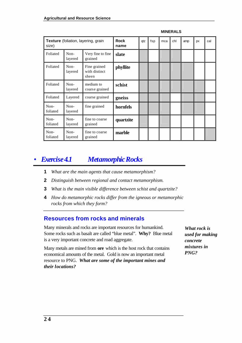
Metamorphism causes changes in the texture and the mineral composition of rocks.
At higher pressures the minerals and rock particles align to a direction at right angles to the direction of pressure. The resulting texture is called foliated. Therefore rocks which show alignment of particles and/or minerals are classed as foliated metamorphic rocks. At sustained high pressures new “space-saving” minerals form. These minerals are denser than the original minerals. A good example is the mineral garnet which forms from clay minerals. Garnet is an example of a dense silicate mineral while clays are lower in density.
Module A5 -Earth Resources
23
At high temperatures minerals that withstand high temperatures are formed. A common example is wollastonite that forms from rocks that contain limestone and sand (silica). The new mineral is very resistant to change at high temperatures.
The reaction is:
CaCO3 + SiO2 → CaSiO3 + CO2
limestone silica wollastonite
The texture of contact metamorphic rocks is generally equigranular meaning that the grains are about the same size. These are classified as non-foliated metamorphic rocks. Marble is another example of a contact or non-foliated metamorphic rock however some marble can form from pressure.
Activity 4.1 Metamorphic rocks
Materials • numbered specimens of metamorphic rocks • hand lens
Procedure 1. Obtain numbered specimens of metamorphic rocks from your
instructor.
2. Determine the texture (foliated or non-foliated).
3. Next determine if any of the foliated rocks have obvious layers of different minerals (gneiss) indicating a high grade of regional metamorphism.
4. Lastly look at the grain size and mineral composition.
5. Use the table on page 21 to determine the identity of each of the numbered specimens.
Agricultural and Resource Science
24
MINERALS
Texture (foliation, layering, grain size)
Rock name
qtz fsp mca chl amp px cal
Foliated Non-layered
Very fine to fine grained
slate
Foliated Non-layered
Fine grained with distinct sheen
phyllite
Foliated Non-layered
medium to coarse grained
schist
Foliated Layered coarse grained gneiss
Non-foliated
Non-layered
fine grained hornfels
Non-foliated
Non-layered
fine to coarse grained
quartzite
Non-foliated
Non-layered
fine to coarse grained
marble
• Exercise 4.1 Metamorphic Rocks 1 What are the main agents that cause metamorphism?
2 Distinguish between regional and contact metamorphism.
3 What is the main visible difference between schist and quartzite?
4 How do metamorphic rocks differ from the igneous or metamorphic rocks from which they form?
Resources from rocks and minerals Many minerals and rocks are important resources for humankind. Some rocks such as basalt are called “blue metal”. Why? Blue metal is a very important concrete and road aggregate.
Many metals are mined from ore which is the host rock that contains economical amounts of the metal. Gold is now an important metal resource to PNG. What are some of the important mines and their locations?
What rock is used for making concrete mixtures in PNG?
Module A5 -Earth Resources
25
5. Weathering and Erosion Weathering processes may be mechanical or chemical and the effects on different rocks will vary in different environments. The composition, texture and origin of a rock has a marked effect on the extent of weathering. Weathering is the first process that leads to a chain of events. Soils development depends on chemical weathering in place. Weathered products can be transported by erosion to another place. There are several agents of erosion: gravity, water, wind and ice. Wind and ice are not important agents of erosion in PNG today.
Mechanical weathering
Unloading
In PNG plate tectonics has contributed to large movements of the earth’s surface. The islands of PNG are composed of rocks deposited on the seafloor and then uplifted. As the rocks are eroded the pressures of deep burial are removed. This process is called unloading. Some rocks develop large joints more or less parallel to the surface as the pressure is reduced. This effect is particularly noticeable in large bodies of exposed igneous rocks.
Thermal expansion
In areas of temperature extremes rocks expand and contract eventually developing cracks. These cracks then become channels for solutions to speed up chemical weathering.
Plants
Plants play an important role in that the roots of trees can grow into joints and cracks and push rock fragments apart. The plant roots also produce chemicals which assist with chemical weathering processes.
Chemical weathering and soils The best example of chemical weathering in PNG is the slow but sure solution of limestone (coral reefs) composed of calcium carbonate. This mineral is chemically reactive with water which contains dissolved carbon dioxide. The limestone is slowly 'dissolved' by the weak carbonic acid and is carried away in solution to be redeposited later as the familiar cave growths, stalactites and stalagmites. This is a chemical weathering process.
PNG used to have glaciers! Where can you see the evidence of glaciation? What is the evidence?
Agricultural and Resource Science
26
There are several good examples of limestone caves in PNG on New Britain. As limestone is chemically dissolved and transported by water some insoluble materials remain behind. These are the non-calcareous materials such as clay, silt, sand and gravel. These remain behind to form a soil on top of the limestone. These soils are characteristically red due to the accumulation of iron oxides in the soil. These soils are called “terra rossa” which means “earth red”.
In some places the limestones and overlying volcanic sediments have weathered to leave behind deep deposits of bauxite and laterites. The best example in PNG is in the Ramu Valley where current development is underway to mine nickel. Some sources have suggested that, if these deposits are mined, there will very little fertile soils left. This is not true as laterites are very poor agricultural soils and are heavily leached in tropical climates and contain little humus. In fact there is very few nutrients available in true lateritic soils. Only areas where humus has accumulated are suitable for agriculture.
• Exercise 5.1 Weathering 1 If two identical rocks are weathered, one mechanically and one
chemically, how would the resultant products differ?
2 How does mechanical weather accelerate chemical weathering?
3 What is exfoliation? Give an example of a feature formed by this process.
4 Granite and basalt are exposed to a hot humid climate.
(a) Which type of weathering will predominate?
(b) Which rock will weather the most rapidly? Explain.
1 If heat speeds up a chemical reaction why is weathering so slow in a desert?
2 How is carbonic acid produced in nature? How does it affect limestones?
Activity 5.1 Weathering of rocks
A. Comparing marble and limestone 1. Collect specimens of marble and limestone.
2. Examine the specimens of marble and limestone.
Do you know where there are other limestone caves in PNG?
What stories are associated with the formation of these caves?

Module A5 -Earth Resources
27
Questions
1 How do these two rocks differ? How might these differences affect the rate of weathering of limestone and marble?
2 What other factors could assist or accelerate the chemical weathering of limestone or marble?
B. Weathering of granite
In this activity you will have the opportunity to examine a number of samples of granite in various stages of weathering. The specimens are labelled W1, W2, W3 and W4.
Procedure 1. Carefully examine each sample and use a hand lens to observe
the nature of the composition of each. Describe each specimen briefly in terms of overall appearance, hardness, cohesiveness and composition. Which sample is the most weathered?
2. Compare the mineral grains seen in specimens W1 and W4. Which grains or minerals appear to be unchanged and which ones have changed. Write a summary of your observations in the table below.
3. Look at samples W2 and W3. Sketch and describe the structures or features seen in these samples.
Description of minerals seen in each specimen of granite
Sample W1 Sample W2
Questions
1 Suggest the types of minerals that have changed. What has happened to these minerals? Which minerals appear to be the most resistant to weathering?
2 Some minerals have produced colour changes in the rock or produced new products. Suggest which minerals of granite are most likely to produce these observed colour changes.
3 Describe the possible weathering processes that may have caused the features observed in samples W3 and W4.
Agricultural and Resource Science
28
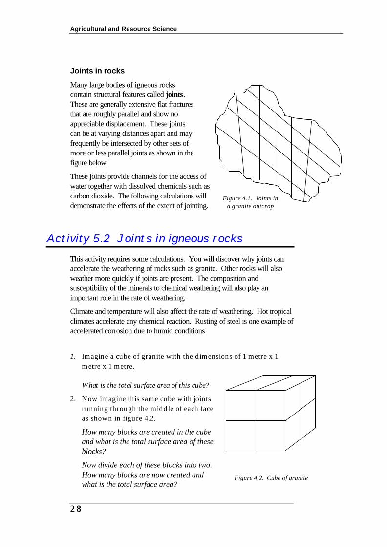
Joints in rocks
Many large bodies of igneous rocks contain structural features called joints. These are generally extensive flat fractures that are roughly parallel and show no appreciable displacement. These joints can be at varying distances apart and may frequently be intersected by other sets of more or less parallel joints as shown in the figure below.
These joints provide channels for the access of water together with dissolved chemicals such as carbon dioxide. The following calculations will demonstrate the effects of the extent of jointing.
Activity 5.2 Joints in igneous rocks This activity requires some calculations. You will discover why joints can accelerate the weathering of rocks such as granite. Other rocks will also weather more quickly if joints are present. The composition and susceptibility of the minerals to chemical weathering will also play an important role in the rate of weathering.
Climate and temperature will also affect the rate of weathering. Hot tropical climates accelerate any chemical reaction. Rusting of steel is one example of accelerated corrosion due to humid conditions
1. Imagine a cube of granite with the dimensions of 1 metre x 1
metre x 1 metre. What is the total surface area of this cube?
2. Now imagine this same cube with joints running through the middle of each face as shown in figure 4.2.
How many blocks are created in the cube and what is the total surface area of these blocks?
Now divide each of these blocks into two. How many blocks are now created and what is the total surface area?
Figure 4.1. Joints in a granite outcrop
Figure 4.2. Cube of granite
Module A5 -Earth Resources
29
Questions
1 What effect does jointing have on rocks and how does this increase the rate of weathering?
2 Referring to the specimens you have examined and a knowledge of joints, how does jointing contribute to the breakdown of granite?
Erosion Erosion is the transport of earth materials from one place to another by whatever means. As said earlier this process requires an agent of transport. This process can be so slow it is hardly noticeable or very fast as in landslides.
Agents of erosion include gravity, water, wind and ice. Wind erosion is more important in desert areas while ice erosion occurs in glacial areas. In PNG the main forces or agents of erosion are gravity (things fall down) and water, both sea and fresh.
Other agents of erosion are humans. In our daily endeavours of food growing and resource exploitation we contribute to the loss of soils and even disasters that cost human lives.
• Exercise 5.2 Dam disaster! Read “The Vaiont Dam Disaster” in your readings.
Write a summary listing the human errors that led to the loss of human life.
Mass Wasting Mass wasting is the movement of rock, soil or mud under the force of gravity. Sudden movements along well defined surfaces are called slides. Flows occur along any type of surface and generally involve the movement of soil or mud with water. These flows can be slow or fast. Slow almost undetectable movement of soil is called soil creep. Vertical objects such as posts begin to lean over where soil creeps.
The practice of clearing very steep land for subsistence farming in PNG has left many scars on the hillsides. After the trees and other binding vegetation is cut and burned the soil begins to creep down the hill. In some cases, particularly after heavy rain, the soil moves down the hill suddenly as a mud slide.
Earthquakes can also trigger slides. This happened in New Ireland and New Britain during the severe earthquakes of November 2000. Many roads were cut and farmland lost on steep slopes.

Agricultural and Resource Science
30
• Exercise 5.3 Mass wasting 1 List the major Mass Wasting agents. Discuss each agent with your
group and try to identify if any of these mass wasting events can be seen in PNG. Identify the possible cause of each.
2 What role does mass wasting play in shaping the earth?
3 What is the controlling force of mass wasting?
4 Distinguish among fall, slide and flow.
5 Compare and contrast mudflow and earthflow.
6 Soil creep is a slow process. What evidence indicates that this process may be affecting the soil on a slope?
Activity 5.3 A local area survey The nature of the rocks in different areas of PNG will vary immensely. In some areas there may be an opportunity to visit an operating mine and this may become a focus of the local field study. Alternatively some areas, such as East New Britain, provide an excellent opportunity to study volcanoes, associated land forms and erosion first hand.
Aims
1. To collect and identify rock types of the local area.
2. To relate your findings to the geological map of the local area or PNG.
3. To examine and identify first hand the physical properties of the local rocks.
4. To describe the effects of rock types on the topography of the local area.
5. Relate the importance of local rocks to traditional culture and the local or PNG economy.
Procedure 1. Prior to the excursion you should familiarise yourself with the
geological and topographical maps of the local area.
2. During the excursion your group shoul collect (with permission and due care) samples of rocks for identification in the laboratory.
3. Note the geographical limits of the terrain (slopes, rivers, vegetation, etc).
Your lecturer will outline the nature of the report to be submitted.

Module A5 -Earth Resources
31
Suggested labelling for Minerals and Rocks MINERALS ROCKS
M1 gypsum R1 granite
M2 muscovite R2 granodiorite
M3 calcite R3 aplite
M4 flourite R4 pegmatite
M6 orthoclase R5 porphyry
M8 quartz R6 rhyolite
M10 chalcedony R7 andesite
M11 talc R8 trachtyte
M13 tourmaline R9 basalt
M15 epidote R10 diorite
M17 bauxite R11 gabbro
M19 zircon R12 obsidian
M22 garnet R13 scoria
M23 hematite R14 pumice
M25 pyrite R21 breccia
M26 malachite and/or azurite
R22 sandstone
M27 chalcopyrite R23 arkose
M29 galena R24 greywacke
M30 sphalerite R25 shale
M33 cassiterite R26 tuff
M37 molybdenite R27 laterite
M39 apatite R28 bauxite
M41 corundum R29 limestone
M42 cerussite R30 oolitic limestone
M43 limonite R31 chert
M45 opal R32 conglomerate
M47 flint R33 coal
M52 chlorite R34 rock phosphate
M55 hornblende R41 quartzite
M56 augite R42 marble
M66 a zeolite (chabazite) R43 slate
M67 biotite R44 phyllite
M68 plagioclase feldspar R45 schist
M69 olivine R47 serpentinite
M76 topaz
M78 barite
M95 kaolinite
Agricultural and Resource Science
32
6. Mineral and Energy Resources Environmental, social, cultural and political issues are major players in company and government decisions to develop and extract minerals for a resource-hungry society. Economic minerals include anything extracted for use by society and a profit. These include non-metals, metals, oil and gas. This section provides opportunity for discussion to increase your awareness of not only the importance of the mining industry but also the environmental, social, cultural and technological impact of these industries in PNG.
What is a resource? A resource is defined as natural materials which are useful or economically valuable to present society. These include reserves, which can be exploited economically with existing technology, uneconomical deposits and deposits believed to exist. Reserves are affected by world demand, prices and technological developments. For example, oil shales in Australia will become economical and competitive with oil when oil prices reach about $36 per barrel. Carbon leaching processes have made gold extraction far more efficient in recent years thus allowing the mining of many low grade deposits worldwide.
A resource is economic if it can be extracted, processed and sold for a profit by the mining company and the government. Some extractive industries, such as quarrying, may not be profitable as they provide a service for such things as road fill. However most mines would not operate if costs for extraction exceeded returns. In many instances the margins are small and the capital investment is enormous. For this reason decisions to commence mining a resource may take many years. Many companies are reluctant to invest in extraction of commodities which do not have stable prices and/or are located in unstable political regions. PNG is considered a high risk investment area due to the complex interaction between Government, cultural groups and land tenure.
Finite resource A finite resource is one which is generally non-renewable in the
short term. In geological time this is of the order of millions of years so, in terms of resource management, this is never in our lifetime. Demand for some metals such as copper, lead and zinc is tipped to increase due to technological developments in the automobile industry. Why?

Module A5 -Earth Resources
33
• Exercise 6.1 Why do we need resources? Answer the following discussion questions by reading and discussing the following:
1 List important domestic and industrial uses of the following metals: aluminium, copper, gold, lead, manganese, titanium, tin, zinc
2 Are there any substitutes for these metals and where do they come from?
3 What raw materials are needed to produce the substitutes? (For example, the steel skin of a motor vehicle can be substituted with fibreglass but silica sand is needed to produce the glass for fibreglass.
4 Which resources can we live without?
5 What safeguards exist to ensure that mine development is environmentally sound?
6 Some resource development depends on the development of other resources for the supply of raw materials. For example, copper mines require coke and limestone to process the metal ores. A laterite deposit in the Ramu valley contains economic grades of nickel and cobalt. Why are these metals so important? How did the laterite ore form? What other resources would be needed to process the laterite ore?
7 The minerals industry is of critical importance to other major sectors of the PNG economy. Discuss this statement in terms of employment, service industries, remote development and transport systems.
Social, cultural and political pressures Resource developers are only willing to explore for or develop resources in regions of the world where there is security of title in the long term. Unexpected changes in Government policy, laws and cultural expectations will frighten off potential investors. Quite often these changes are sudden and due to political and/or cultural pressure groups. Political unrest, land disputes and disenchantment with government policies, relating to the distribution of royalties from the mine, led to the closure of one of the World’s largest and richest copper-gold mines at Panguna in Bougainville. These types of problems are currently affecting the development of other mining and oil and gas projects in PNG.

Agricultural and Resource Science
34
& Research: Case studies of resource development 1 Name some current resource development projects in the energy
and mining industry in PNG.
2 Describe the resource both geologically and in terms of economic benefits to the PNG nation.
3 Identify issues (social, cultural and political) currently affecting the development of these resources.
4 Why do these social, cultural and political issues deter investment in exploration and development of resources in the Pacific Region?
5 If you were in charge what would you do to resolve these issues and make the investment in the mining industry more attractive in PNG?
Mineral resources An ore deposit is rock in which a useful or valuable metal occurs in a concentration high enough to make it economically viable. Coal, oil and gas resources are generally classed as energy resources. o Magmatic
o Hydrothermal
o Plate margins
o Metamorphic
o Sedimentary
Magmatic deposits
Crystallised magmas are a ready source of a range of silicate minerals used for building and refractory industries, e.g., feldspars for high temperature bricks; kaolin clay from weathered granites for ceramics; silica sand for glass making.
Pegmatites, deposited from residual magmatic fluids within granitic intrusions, often yield large crystals and concentrations of rare elements such as Li, Be, B, U and other rare earth elements. Among the pegmatite minerals are many gemstones: tourmaline, beryl and spodumene.
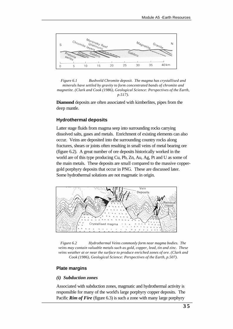
Gravity settling can produce layered concentrations of heavy minerals such as chromite and magnetite such as has occurred in the Transvaal deposits of Africa (figure 6.1).
Module A5 -Earth Resources
35
Figure 6.1 Bushveld Chromite deposit. The magma has crystallised and minerals have settled by gravity to form concentrated bands of chromite and
magnetite. (Clark and Cook (1986), Geological Science: Perspectives of the Earth, p.517).
Diamond deposits are often associated with kimberlites, pipes from the deep mantle.
Hydrothermal deposits
Latter stage fluids from magma seep into surrounding rocks carrying dissolved salts, gases and metals. Enrichment of existing elements can also occur. Veins are deposited into the surrounding country rocks along fractures, shears or joints often resulting in small veins of metal bearing ore (figure 6.2). A great number of ore deposits historically worked in the world are of this type producing Cu, Pb, Zn, Au, Ag, Pt and U as some of the main metals. These deposits are small compared to the massive copper-gold porphyry deposits that occur in PNG. These are discussed later. Some hydrothermal solutions are not magmatic in origin.
Figure 6.2 Hydrothermal Veins commonly form near magma bodies. The
veins may contain valuable metals such as gold, copper, lead, tin and zinc. These veins weather at or near the surface to produce enriched zones of ore. (Clark and
Cook (1986), Geological Science: Perspectives of the Earth, p.507).
Plate margins
(i) Subduction zones
Associated with subduction zones, magmatic and hydrothermal activity is responsible for many of the world's large porphyry copper deposits. The Pacific Rim of Fire (figure 6.3) is such a zone with many large porphyry

Agricultural and Resource Science
36
deposits of gold and copper being mined and continually discovered. These deposits are associated with magmas predominantly granitic to dioritic in composition. Large stratovolcanoes are often associated with these areas. The magmas and surrounding rocks have been hydrothermally or chemically altered and enriched with sulfides.
Extensive weathering and secondary enrichment has produced many high grade deposits of gold and/or copper on top of these eroded porphyries, such as in the highlands of PNG and the Panguna copper-gold mine in Bougainville. Most of these deposits are highly disseminated and of low grade but the enrichment makes them viable in the early expensive development years. Current metalliferous exploration is concentrating on locating old subduction zones because of this association.
Epithermal deposits
In some areas of PNG volcanic activity in the form of hot springs has leached and deposited metal sulfides and gold. These are called epithermal deposits. Two good examples are at Lihir and Feni Islands. Lihir has an operating gold mine.
(ii) Mid-ocean ridges
Recent discoveries of vents, "smokers", along the sea bed at plate spreading sites (fissures) have provided evidence for the formation of many of the sulfide ore deposits. Many famous deposits such as those in Australia at Broken Hill (Pb-Zn), Mt Isa (Cu-Pb-Zn) and McArthur River (Pb-Zn) are of this type.
Figure 6.3 Pacific Rim region of the Southwest Pacific showing major gold deposits. (Clark and
Cook (1989), Introduction to Australia's Minerals: No. 4 Copper).

Module A5 -Earth Resources
37
In the Red Sea the sulfide rich fluids react with the seawater and deposit metal sulfides on the seafloor. It is believed that the deposits of base metals at Broken Hill, Mt Isa (figure 6.4) and McArthur River formed on an ancient seafloor in this manner. Burial, folding and metamorphism enriched these ore deposits through migration and segregation of the sulfide minerals into veins and pods (pea shaped bodies) of massive proportions.
Figure 6.4. Mt Isa Orebody showing copper and lead-zinc orebodies. This deposit was formed as a fissure deposit on a deep ocean floor many millions of years ago. Uplift and metamorphism has produced the orebodies as we know today. (Clark and Cook (1989), Introduction to Australia's Minerals: No. 4 Copper).
Agricultural and Resource Science
38
Metamorphic deposits
Metamorphism can often concentrate previously uneconomic deposits into lenses or pods due to ion migration processes. Minerals are changed through reaction with the ions or the formation of new pressure resistant minerals. This mechanism was important in concentrating the base metal deposits at Broken Hill, Australia. Mineral resources of metamorphic origin include graphite, asbestos, talc, garnets and many gemstones.
Sedimentary deposits
Iron ore
The oldest sedimentary mineral deposits are the pre-Cambrian iron ores in Australia. These were formed when the earth's atmosphere contained less oxygen. Photosynthetic organisms, in the oceans, produced oxygen which reacted with iron salts from weathered rocks and precipitated iron oxides on the seafloor. The Pilbara region of Western Australian contains iron ores derived from these ancient environments.
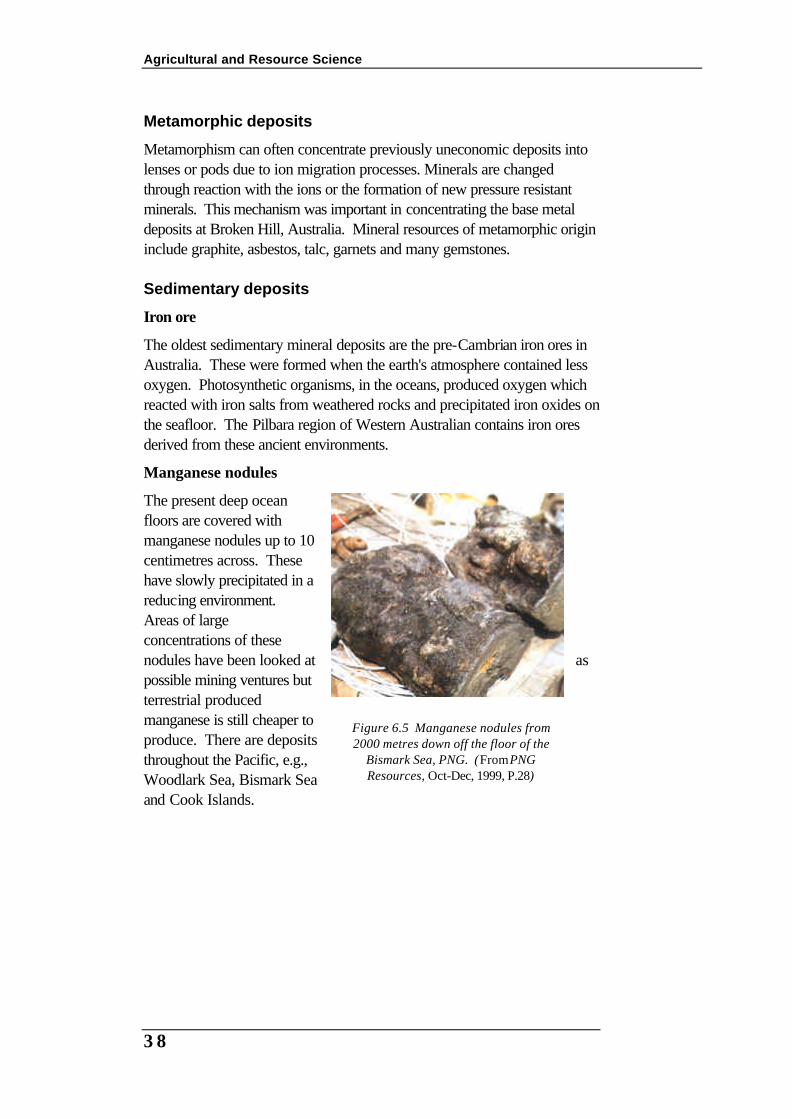
Manganese nodules
The present deep ocean floors are covered with manganese nodules up to 10 centimetres across. These have slowly precipitated in a reducing environment. Areas of large concentrations of these nodules have been looked at as possible mining ventures but terrestrial produced manganese is still cheaper to produce. There are deposits throughout the Pacific, e.g., Woodlark Sea, Bismark Sea and Cook Islands.
Figure 6.5 Manganese nodules from 2000 metres down off the floor of the
Bismark Sea, PNG. (From PNG Resources, Oct-Dec, 1999, P.28)

Module A5 -Earth Resources
39
Evaporites
Evaporites include salt, gypsum, potassium and magnesium salts. They form in areas of rapid evaporation in either enclosed inland lakes or in restricted ocean areas.
Laterites
Residuals such as laterites result from extreme leaching in wet tropical climates where the iron and aluminium oxides have been left behind or redeposited as pisolites. Bauxite, an ore of aluminium, formed at Weipa in this way. A laterite deposit in the Ramu valley, PNG, is being developed as a nickel-cobalt mine.
Placer minerals
When an ore body weathers into the soil, the heavy minerals such as gold are sorted by the action of water in creeks and streams. The action of flowing water concentrates the heavy minerals like gold on the bottom of the river course. Older deposits may be buried deeply as the river shifts and changes course (figure 6.6).
Figure 6.6. Gold weathers from the quartz vein and moves in the soil (elluvial) and is deposited in streams (fluvial).
Placers are alluvial deposits of heavy minerals that have been concentrated by the action of flowing water (figure 6.7). These occur in streams, deltas and along beaches and continental shelves. Alluvial gold has been recovered from placers in streams or rivers since prehistoric times. Cassiterite (tin oxide), mineral sands and diamonds are also recovered in large quantities from placers.

Agricultural and Resource Science
40
Figure 6.7 Heavy minerals and metals such as gold are deposited at obstructions in streams or when the current slows. These illustrations show good places to look for
alluvial gold. (Geological Science: Perspectives of the Earth, p.521).
Activity 6.1 Case study of a PNG mine
Select a mineral resource development project in PNG. For that project prepare a report using the following guide questions:
1 What is the name of the Project or mine?
2 Where is it located on a map of PNG?
3 What are the main resources being extracted?
4 What mining methods are used? Describe these using suitable illustrations.
5 How is the resource or metal extracted? Describe the process, including the by-products or waste products.
6 What effects does the human activity of resource extraction have on the environment?
7 How does the company ensure that the environmental impact is minimised?
8 What effects does the activity have on the local inhabitants economically, socially and culturally?
9 How are disputes resolved?

Module A5 -Earth Resources
41
Energy resources
History
Oil was known to local PNG people as seepages of oil in the Vailala River, Central Province. Oil exploration began about 1911 and it was not until 1986 that the first commercial flow was drilled at Iagifu near Lake Kutubu, Southern Highlands. In 1992 the first oil was exported from the Kutubu Petroleum Development Project.
Local landowners, Foe and Fasu, receive royalties and dividends through the Kutubu Joint Venture (KJV). The traditional owners used the oil seepage, "tege" in local language, in times past as body paint for ceremonies and as a trade commodity. The development of the oil and gas resources has caused sudden changes in a short time to the wealth and lifestyle of the Foe and Fasu people.
Where is oil and gas found?
Oil and gas accumulate from the remains of plankton on the deep ocean floor. The soft tissue of these tiny marine plants and animals decay in the mud (ooze) on the seafloor to produce oily substances.
The mud layers are then buried by other sediments such as silt, sand and more mud. After millions of years, deep burial (pressure) and earth movements (uplift and folding) the oily substances gradually change and migrate into the porous sandy layers.
Figure 7.1 The site of the first commercial oil flow in 1986. Oil drilling rig at Iagifu near
Lake Kutubu in the Southern Highlands. (From PNG Resources, April-June, 1999,
p.32).

Agricultural and Resource Science
42
For oil and gas to remain in a sedimentary rock it has to be trapped by an impervious layer above and be concentrated by a sedimentary structure. Such structures include faults and folds.
Figure 7.3 Oil well extracts oil using the gas pressure above the reservoir (gas expansion drive) or by pumping water into the strata to force the oil up (water drive).
In figure 7.3, the shale cap rock is impervious while the sandstone is pervious . The structure, that bends upwards, is an anticline . Gas accumulates above the level of the oil and the oil is above the water.
Water and gas drive refers to the natural pressure exerted by these on the oil reservoir.
& Research. Catering for rapid change! How have the oil companies, Chevron and Oil Search, managed the relations with and the rapid changes in the life styles of the Kutubu people? (Reference: Paradise Magazine, No 145 May-June, 2001).
Impervious layers do not allow oil, gas or water to flow through. Pervious layers do allow the flow of gas, oil and water.
Drive refers to a driving force that is pressure in this case.

Module A5 -Earth Resources
43
The Vaiont Dam Disaster & Reading for Exercise 5.2 The Vaiont Dam disaster from Tarburk &
Lutgens, Earth Science (1994). MacMillian.
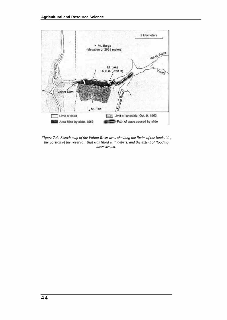
A massive rock avalanche in Peru is described at the beginning of the section on mass wasting. As with most occurrences of mass wasting, this tragic episode was triggered by a natural event – in this case an earthquake. However, disasters also result from the mass movement of surface material triggered by the actions of humans. For example, in 1960 a large dam almost 256 metres tall was built across the Vaiont Canyon in the Italian Alps. Three years later on the night of 9 October 1963, a violent disaster occurred and the dam was largely responsible.
The bedrock in Valiont Canyon slanted steeply downward toward the lake impound behind the dam and was composed of weak highly fractured limestone strata that contained beds of clay and numerous solution cavities. As the reservoir filled, the lower portions of these rocks became saturated and the clays became swollen and more plastic. The rising water reduced the internal friction that had kept the rock in place. Measurements made shortly after the reservoir was filled hinted at the problem, because they indicated that a portion of the mountain was slowly creeping downhill at the rate of 1 centimetre per week. In September 1963, the rate increased to 1 centimetre per day, then 10-20 centimetres per day and eventually to as much as 80 centimetres on the day of the disaster. Finally the mountainside let loose. In just an instant, 240 million cubic metres of rock and rubble slid down the face of Mount Toc and filled nearly 2 kilometres of the gorge to heights of 150 metres above the reservoir level (Figure 1). The filling of the reservoir pushed the water completely over the dam in a wave more than 90 metres high. More than 1.5 kilometres downstream, the wall of water was still 70 metres high and everything in its path was completely destroyed. The entire event lasted less than seven minutes yet it claimed an estimated 2600 lives. This is known as the worst dam disaster in history, but when it was over, the Vaiont Dam was still standing intact. Although the catastrophe was triggered by human interference with the Vaiont River the slide would have eventually occurred on its own; however, the effects would not have been nearly as tragic.
Agricultural and Resource Science
44
Figure 7.4. Sketch map of the Vaiont River area showing the limits of the landslide, the portion of the reservoir that was filled with debris, and the extent of flooding
downstream.