Embed Size (px)
Citation preview

California Marine Life Protection Act Initiative Key to Color Coding in the August 2007 Version of the California MLPA Draft Master Plan for Marine Protected Areas with Additional Proposed
Changes from the MLPA Blue Ribbon Task Force, et al. in Preparation for the September 12, 2007 MLPA BRTF meeting
September 9, 2007
Blue strikethrough and underline
April 2007 edits proposed by the California Department of Fish and Game
Blue strikethrough and underline, in italics
August 2007 edits proposed by the California Department of Fish and Game
Blue strikethrough and underline with yellow highlights
September 2007 edits proposed by MLPA Blue Ribbon Task Force members
Blue strikethrough and underline with light gray highlights
June 14, 2007 edits proposed by The Ocean Conservancy in a letter to the MLPA Blue Ribbon Task Force
Blue strikethrough and underline with turquoise highlights
July 2007 and August 2007 edits proposed by United Anglers of Southern California, et al. in letters to the MLPA Blue Ribbon task Force

CALIFORNIA MARINE LIFE PROTECTION ACT
MASTER PLANfor
Marine Protected Areas
California Department of Fish & Game
Revised Draft July 21, 2006August 2007 with additional proposed changes from
the MLPA Blue Ribbon Task Force, et al. in preparation for the September 12, 2007 MLPA BRTF meeting.
California Department of Fish and Game Master Plan for Marine Protected Areas July 21, 2006
CONTENTS
Executive Summary...................................................................................................................................................i Section 1. Introduction.............................................................................................................................................1
Early Years...........................................................................................................................................................2 Post World War II .................................................................................................................................................3 California’s Marine Heritage.................................................................................................................................4 Marine Life of California .......................................................................................................................................6 Factors Affecting Marine Wildlife Populations......................................................................................................7 The Marine Life Management Act........................................................................................................................8 Recent Developments..........................................................................................................................................9 Marine Protected Areas Generally.................................................................................................................1110MLPA Initiative Process .....................................................................................................................................12 Roles in the Marine Life Protection Act Initiative................................................................................................13
Organizational Partners, Committees, and Teams.........................................................................................13 Master Plan Framework ......................................................................................................... 15 and Master Plan 16
Section 2. Process for Designing Alternative Marine Protected Area Network Proposals ............................18 The Blue Ribbon Task Force MPA Design Process ..........................................................................................19 Task 1: Regional MPA Planning ....................................................................................................................2624
Activity 1.1: Convene regional process...........................................................................................................26 Activity 1.2: Develop additional advice .......................................................................................................2627Activity 1.3: Prepare regional profile ...............................................................................................................27 Activity 1.4: Develop regional ecological and socioeconomic goals, objectives and design considerations.................................................................................................................................................27Activity 1.5: Determine key locations for MPAs to meet the MLPA goals within the region .......................2728
Task 2: Assemble Draft Regional Alternative MPA PackagesProposals ..........................................................28 Activity 2.1: Recommend potential changes to existing MPAs.......................................................................28 Activity 2.2: Assemble alternative MPA packages for the region. ..............................................................2829
Task 3: Evaluate Alternative MPA Package Proposals .................................................................................2829Activity 3.1: Evaluate alternative MPA proposals .......................................................................................2829Activity 3.2: Identify monitoring and evaluation indicators. .............................................................................29 Activity 3.3: Forward alternative package proposals to the Department ........................................................29Activity 3.4: Submit proposals to Commission................................................................................................29 30
Task 4: Commission Consideration and Action .................................................................................................30 Activity 4.1: Commission review of proposals. ...............................................................................................30 Activity 4.2: Formal regulatory process...........................................................................................................30 Activity 4.3: Public testimony. .........................................................................................................................30 Activity 4.4: Commission acts on alternative regional MPA proposals...........................................................30
Section 3. Considerations in the Design of MPAs ..............................................................................................31 Goals of the Marine Life Protection Program.....................................................................................................31 MPA Networks ...................................................................................................................................................33 Science Advisory Team Guidance on MPA Network Design ............................................................................34 Consideration of Habitats in the Design of MPAs..............................................................................................40 Species Likely to Benefit from MPAs .................................................................................................................45 Biogeographical Regions ...................................................................................................................................46 Types of MPAs...................................................................................................................................................48 State Marine Reserve ........................................................................................................................................49 State Marine Park ..............................................................................................................................................50 State Marine Conservation Area........................................................................................................................50 State Marine Recreational Management Area...................................................................................................51 Combined use of marine reserves, marine parks and marine conservation areas ...........................................51 Levels of protection for MPA classification ........................................................................................................51 Setting Goals and Objectives for MPAs.............................................................................................................56 Enforcement and Public Awareness Considerations in Setting Boundaries .....................................................59 Information Supporting the Design of MPAs......................................................................................................60 Other Programs and Activities Other Than Fishing ...........................................................................................61

California Department of Fish and Game Master Plan for Marine Protected Areas July 21, 2006
Section 4. Management..........................................................................................................................................64 Structure of regional MPA management plans ..................................................................................................65 Description of major elements............................................................................................................................66
Section 5. Enforcement..........................................................................................................................................70 Existing Enforcement Assets .............................................................................................................................70 MPA Enforcement Considerations.....................................................................................................................72 Enforcement Plan Objectives.............................................................................................................................73
Section 6. Monitoring and Adaptive Management of MPAs...............................................................................75 Developing a Monitoring and Evaluation Program for MPAs and Network Components..................................76
Section 7. Funding..............................................................................................................................................8382MLPA funding history .....................................................................................................................................8382Blue Ribbon Task Force input on funding..........................................................................................................83Appropriate Sources of Funds ...........................................................................................................................84Expected activities required to implement the MLPA ....................................................................................8584Possible partners in funding or performing activities required to implement the MLPA ....................................86 Expected duration and levels of expenditures ...............................................................................................8786Structures for receipt and allocation of funds.................................................................................................8887
Section 8. Regional MPA Management Plans......................................................................................................898.1: North Coast Region (California/Oregon border - NOTE: This section has been moved to Point Arena)89
Appendix O without ChangePlanned Completion 2011
8.2: North-Central Coast Region (Point Arena to Pigeon Point)........................................................................89Planned Completion 2009
8.3: San Francisco Bay Region (Waters within San Francisco Bay).................................................................89Planned Completion 2010
8.4: Central Coast Region (Pigeon Point to Point Conception) .........................................................................898.4.1 Introduction ............................................................................................................................................89
Description of region ...................................................................................................................................89Regional design and implementation considerations ..................................................................................91Regional goals, and objectives ...................................................................................................................93Description of individual MPA boundaries (including maps), regulations, and objectives ..........................94
8.4.2. General Activities and Locations ........................................................................................................134Scientific Monitoring and Research plan ...................................................................................................134Outreach, Interpretation and Education plan.............................................................................................161Enforcement plan.......................................................................................................................................161Contingencies and Emergency Planning ..................................................................................................163
8.4.3. Operations ..........................................................................................................................................163Equipment and Facilities ...........................................................................................................................163Staffing.......................................................................................................................................................163Collaborations and Potential Partnerships ................................................................................................163
8.4.4. Costs and Funding..............................................................................................................................163Estimated costs .........................................................................................................................................163Potential funding sources ..........................................................................................................................163
8.4.5. Timelines and Milestones ...................................................................................................................164Timeline and Criteria for Implementation .................................................................................................164Timeline for Evaluation and Review of Effectiveness................................................................................164
8.5: South Coast Region (Point Conception to U.S./Mexico Border) ..............................................................164Planned Completion 2008
Literature Cited .................................................................................................................................................16590
List of Figures
Figure 1. Players in the Marine Life Protection Act Initiative ....................................................................................13 Figure 2. Process for MPA planning in study regions ..........................................................................................2021Figure 3. Flowchart of the review process to determine if individual, regional, and MLPA goals
are being met by the various types of MPAs and other management measures ..............................................32 Figure 4. An example of sea surface temperature in the California coastal waters, May 30, 2000.........................43

California Department of Fish and Game Master Plan for Marine Protected Areas July 21, 2006
Figure 5. Flowchart of process to establish and conduct a monitoring program......................................................78 Figure 6. Año Nuevo State Marine Reserve and Greyhound Rock State Marine Conservation Area.....................97Figure 7. Elkhorn Slough State Marine Reserve, Elkhorn Slough State Marine Park, and Morro Cojo
Lagoon State Marine Reserve .........................................................................................................................100Figure 8. Soquel Canyon State Marine Conservation Area and Portuguese Ledge State Marine
Conservation Area ...........................................................................................................................................103Figure 9. Ed Ricketts State Marine Conservation Area, Hopkins State Marine Reserve, and Pacific
Grove State Marine Conservation Area ...........................................................................................................106Figure 10. Carmel Pinnacles State Marine Conservation Area, Carmel Bay State Marine Conservation
Area, Point Lobos State Marine Reserve, and Point Lobos State Marine Conservation Area........................110Figure 11. Pt. Sur State Marine Reserve and Pt. Sur State Marine Conservation Area........................................116Figure 12. Big Creek State Marine Reserve and Big Creek State Marine Conservation Area ..............................119Figure 13. Piedras Blancas State Marine Reserve and Piedras Blancas State Marine Conservation Area..........123Figure 14. Cambria State Marine Reserve.............................................................................................................126Figure 15. Morro Bay East State Marine Reserve and Morro Bay State Marine Recreational
Management Area with no-take portion of the SMRMA indicated...................................................................128Figure 16. Pt. Buchon State Marine Reserve and Pt. Buchon State Marine Conservation Area including
the Diablo Canyon Nuclear Power Plant Safety Zone .....................................................................................131Figure 17. Vandenberg State Marine Reserve.......................................................................................................134Figure 18. Description of Structural Tiers ...............................................................................................................135
List of Tables
Table 1: Process for MPA planning in study regions............................................................................................2122Table 2: Comparison of potential marine protected area goals ...............................................................................59 Table 3. Central coast enforcement personnel with marine emphasis (2005).........................................................71 Table 4. Natural Resource Enforcement Assets in California ..................................................................................72 Table 5. Central coast MPA objectives that will be met by adoption and implementation of the MPA ..................148Table 6. Central coast MPA monitoring activities based upon MLPA Goals and individual MPA objectives ........150Table 7. MPAs with deep water (> 30 m) hard bottom habitat (area in mi2) ..........................................................159Table 8. Focal fish and invertebrate species for deep water (> 30m) hard bottom habitats .................................159Table 9. MPAs with shallow water (< 30m) hard bottom habitat (area in mi2) .......................................................161Table 10. Focal fish and invertebrate species for shallow water (< 30m) hard bottom habitats ............................162Table 11. MPAs with mid and deep water (>30 m) soft bottom habitat (area in mi2).............................................163Table 12. Focal fish and invertebrate species for mid and deep water (> 30 m) soft bottom habitats...................164Table 13. MPAs with rocky intertidal habitat (area in mi2)......................................................................................165Table 14. Focal fish and invertebrate species for intertidal hard bottom habitats .................................................165Table 15. Focal marine birds and mammals ..........................................................................................................166Table 16. MPAs with coastal marsh and estuary habitat (area in mi2)...................................................................168Table 17. Focal species for estuaries.....................................................................................................................168Table 18. Enforcement considerations for central coast region MPAs ..................................................................173Table 19 Central coast enforcement personnel with marine emphasis (August 2006)..........................................175Table 20. Existing data collection efforts which may provide information or potential collaboration in the Central Coast study region ...............................................................................................................................178
Appendices (a separate document) A. The Marine Life Protection Act B. The Marine Managed Areas Improvement Act C. Implementation of the Marine Life Protection Act: 1999-2004 D. Strategy for Stakeholder and Interested Public Participation E. Social Science Tools and Methods F. Outline of Information Required for Proposals for Alternative Networks of Marine Protected Areas G. Master List of Species Likely to Benefit from Marine Protected Areas H. Summary of Recent and Ongoing Processes Related to the Marine Life Protection Act Initiative I. List of Existing State Marine Protected Areas prior to MLPA Implementation (January 2005) J. Glossary and Defined Terms

California Department of Fish and Game Master Plan for Marine Protected Areas July 21, 2006
K. Marine Life Protection Act Initiative Lessons Learned Report from the Central Coast Regional Process L. Marine Life Protection Act Initiative Estimated Long-Term Costs to Implement the California Marine Life
Protection Act M. Marine Life Protection Act Initiative Consultant’s Adaptive Management and Monitoring and Evaluation
Framework N. Marine Life Protection Act Initiative Task Force Memo and Consultants’ Report on Options for Funding
the Marine Life Protection Act
O. Regional Marine Protected Area Management Plans
California Department of Fish and Game Master Plan for Marine Protected Areas July 21, 2006Page August 2007 Page i
Executive Summary
Section 1. Introduction
In 1999, the legislature approved and the governor signed the Marine Life Protection Act (MLPA; Stats.1999, Chapter 1015). The MLPA requires that the Department of Fish and Game (Department) prepare and present to the Fish and Game Commission (Commission) a master plan that will guide the adoption and implementation of a Marine Life Protection Program, which includes a statewide network of marine protected areas (MPAs). Other recent related legislation includes the Marine Life Management Act of 1998 (MLMA; Stats. 1998, Chapter 1052), Marine Managed Areas Improvement Act of 2000 (MMAIA; Stats. 2000, Chapter 385), and California Ocean Protection Act of 2004 (COPA; Stats. 2004, Chapter 719).
This legislation continues a long tradition of legislation addressing the conservation of California’s diverse coastal and marine wildlife and habitats. Since World War II especially, pressures on these resources have grown as fishing effort and ability have increased and as coastal development has transformed coastal habitats and generated pollutants. In the last 35 years, both federal and state government programs have made an effort to address, if not solve, all of these problems. Marine and coastal wildlife populations also are affected by environmental factors, such as short and long-term shifts in oceanographic conditions, the total effect of which are not clearly understood.
Since passage of the MLMA in 1998, restrictions on commercial and recreational fishing have grown as fishery managers have sought to maintain sustainable fisheries in the face of uncertainty and of declining fish populations. The MLMA reflects shifts in the goals of fishery management away from a single-species focus on maximum yields toward sustainable yields and an ecosystem perspective.
The MLPA reflects prevailing scientific views regarding the role of MPAs in conserving biological diversity, protecting habitats, aiding in the recovery of depleted fisheries, and promoting recreation, study, and education. There remains disagreement whether MPAs, particularly no-take marine reserves, provide direct benefits to fisheries. These scientific viewpoints are discussed in more detail in this document.
In August 2004, the California Resources Agency, California Department of Fish and Game, and Resources Legacy Fund Foundation launched an effort to implement the MLPA, after two unsuccessful earlier attempts. This MLPA Initiative established an MLPA Blue Ribbon Task Force, together with a Master Plan Science Advisory Team (science team) and stakeholder advisory groups, to oversee the completion of several objectives. The first of these objectives was a master plan framework, which included guidance, based on the MLPA, for the development of alternative proposals of MPAs statewide, beginning in an initial central coast study region. The framework is the backbone of this document, the master plan, which also includes specific recommendations for MPAs in each region. The master plan is expected to be an evolving document, which will be modified based on lessons learned in various regional processes and through monitoring and evaluation of MPAs throughout the State. Initial modifications have been incorporated subsequent to the completion of the first regional design process in the central coast.
California Department of Fish and Game Master Plan for Marine Protected Areas July 21, 2006Page August 2007 Page ii
Section 2. Process for Designing Alternative Marine Protected Area Network Proposals
Rather than attempting to design a single network for the entire state at one time, the MLPA Initiative envisions the assembly of a statewide network by 2011 from a series of regional processes, beginning with an area along the central coast. The master plan framework was the primary guide for that process. The master plan (developed from the framework) describes a series of activities, most of which to be undertaken by regional stakeholder groups and sub-teams of the statewide science team.
The overall aim of this four-step process is developing alternative MPA proposals for consideration by the Department, selection of a preferred alternative by the Department, and adoption of a proposal by the Commission. These steps are:
1. Regional planning, starting with the identification of study regions, moving through the preparation of regional profiles and additional advice, designing regional goals and objectives, analyzing existing MPAs and other management, and ending with the identification of alternative approaches to networks and potential MPA sites;
2. MPA planning, in which proposals for packages of MPAs are developed, after evaluation of existing and new MPAs and other management activities;
3. Evaluating the proposals, in which either the MLPA Blue Ribbon Task Force evaluates the proposals and forwards a package to the Department or the Commission reviews the proposals and provides direction to the Department, which conducts a feasibility analysis, prepares a preferred alternative, develops initial regulatory documents, and forwards this information to the Commission;
4. Commission action on MPA proposals, which includes preparing regulatory analyses (including California Environmental Quality Act review), public testimony, and action by the Commission.
It is expected that the Master Plan and the process described above will be reviewed upon completion and that changes will be made based on lessons learned. This adaptive use of the master plan will help facilitate future regional processes and statewide implementation.
Section 3. Considerations in the Design of MPAs
Achieving the MLPA’s goals and objectives to improve a statewide network of MPAs will require consideration of a number of issues, each of which is discussed in this section.
Goals of the Marine Life Protection Program
The MLPA identifies a set of goals for the Marine Life Protection Program including: conservation of biological diversity and the health of marine ecosystems; recovery of wildlife populations; improving recreational and educational opportunities consistent with biodiversity conservation; protection of representative and unique habitats for their intrinsic value; ensuring that MPAs have defined objectives, effective management and enforcement, and are designed on sound science; and ensuring MPAs are managed, to the extent possible as a network.

California Department of Fish and Game Master Plan for Marine Protected Areas July 21, 2006Page August 2007 Page iii
The MLPA notes that a variety of levels of protection may be included in MPAs and that the above program shall include several elements. These are: an “improved marine life reserve component”; specified objectives and management and enforcement measures; provisions for monitoring and adaptive management; provisions for educating the public and encouraging public participation; a process for the establishment, modification, or abolishment of existing or future new MPAs.
Each regional preferred alternative submitted by the Department to the Commission must include recommended no-take areas that encompass a representative variety of marine habitat types and communities across a range of depths and conditions and avoid activities that upset the natural functions within reserves. Collectively the regional alternatives must include replicates of similar types of habitats in each biogeographical region to the extent possible.
MPA Networks
The MLPA calls for improving and managing the state’s MPAs as a network, to the extent possible. The MLPA itself does not define a network. However, there are two common approaches to MPA networks: MPAs linked biologically and/or oceanographically, and MPAs linked through administrative function. Biological and oceanographic linkages are described in more detail in this section. At a minimum, the statewide network should function at an administrative level which reflects a consistent approach to design, funding and management.
Science Advisory Team Guidance on MPA Network Design
Explained in more detail below, the science team for the MLPA Initiative developed guidance regarding the design of MPA networks. This guidance, which is expressed in ranges for some aspects such as size and spacing of MPAs, should be the starting point for regional discussions of alternative MPAs. Although this guidance is not prescriptive, any significant deviation from it should be consistent with both regional goals and objectives and the requirements of the MLPA. The following guidelines are linked to specific objectives and not all guidelines will necessarily be achieved by each MPA:
� The diversity of species and habitats to be protected, and the diversity of human uses of marine environments, prevents a single optimum network design in all environments.
� To protect the diversity of species that live in different habitats and those that move among different habitats over their lifetime, every ‘key’ marine habitat should be represented in the MPA network.
� To protect the diversity of species that live at different depths and to accommodate the movement of individuals to and from shallow nursery or spawning grounds to adult habitats offshore, MPAs should extend from the intertidal zone to deep waters offshore.
� To best protect adult populations, based on adult neighborhood sizes and movement patterns, MPAs should have an alongshore extent of at least 5-10 km (3-6 m or 2.5-5.4 nm) of coastline, and preferably 10-20 km (6-12.5 m or 5.4-11 nm). Larger MPAs would be required to fully protect marine birds, mammals, and migratory fish.
� To facilitate dispersal among MPAs for important bottom-dwelling fish and invertebrate groups, based on currently known scales of larval dispersal, MPAs should be placed within 50-100 km (31-62 m or 27-54 nm) of each other.

California Department of Fish and Game Master Plan for Marine Protected Areas July 21, 2006Page August 2007 Page iv
� To provide analytical power for management comparisons and to buffer against catastrophic loss of an MPA, at least 3-5 replicate MPAs should be designed for each habitat type within each biogeographical region.
� To lessen negative impact while maintaining value, placement of MPAs should take into account local resource use and stakeholder activities.
� Placement of MPAs should take into account the adjacent terrestrial environment and associated human activities.
� To facilitate adaptive management of the MPA network into the future, and the use of MPAs as natural scientific laboratories, the network design should account for the need to evaluate and monitor biological changes within MPAs.
Consideration of Habitats in the Design of MPAs
The MLPA calls for protecting representative types of habitat in different depth zones and environmental conditions. The science team generally confirmed that all but one of the habitats identified in the MLPA occur within state waters: rocky reefs, intertidal zones, sandy or soft ocean bottoms, underwater pinnacles, kelp forests, submarine canyons, and seagrass beds. They noted that seamounts do not occur within state waters. The science team also noted that rocky reefs, intertidal zones, and kelp forests are actually broad categories that include several types of habitat.
The science team identified five depth zones which reflect changes in species composition: intertidal, intertidal to 30 meters, 30 meters to 100 meters, 100 meters to 200 meters, and deeper than 200 meters. The science team also called for special delineation of estuaries as a critical California coastal habitat. Finally, the science team recommended expanding the habitat definitions to include ocean circulation features, principally upwelling centers, freshwater plumes from rivers, and larval retention areas.
Species Likely to Benefit from MPAs
The MLPA requires the identification of species likely to benefit from MPAs. Identifying these species may also assist in identifying habitat areas that can contribute to achieving the goals of the MLPA. The Department prepared a list of such species, which appears in Appendix G. The Department will work with the science team in refining this list for each region. This will include identifying species on the list that are in direct need of consideration when designing MPAs, as opposed to those that may benefit but are not in immediate need of additional protection.
Geographical Regions
The MLPA requires that representative habitats be included, to the extent possible, in more than one marine reserve in each biogeographical region. The MLPA identifies the following three biogeographical regions:
� The area extending south from Point Conception, � The area between Point Conception and Point Arena, and� The area extending north from Point Arena.

California Department of Fish and Game Master Plan for Marine Protected Areas July 21, 2006Page August 2007 Page v
The MLPA also authorizes a master plan science team to modify these regions. A variety of options for the possible definition of biogeographical regions were presented to the Blue Ribbon Task Force:
1) The three biogeographical regions defined in the MLPA; 2) The two biogeographic provinces recognized by many scientists with a boundary at
Point Conception; 3) The four marine regions identified by the Master Plan Team convened by the
Department in 2000, with boundaries at Pt. Conception, Pt. Año Nuevo, and Pt. Arena; and
4) The biogeographical regions recognized by scientists who have identified borders based on species distributional patterns or on abundance and diversity data with boundaries at Pt. Conception, Monterey Bay and/or San Francisco Bay, and Cape Mendocino.
Accepting the strong scientific consensus of a major biogeographical break at Pt. Conception, the Blue Ribbon Task Force confirmed that two biogeographical regions exist along the California coast for purposes of implementing the Marine Life Protection Act. The more refined information on other breaks will be useful in designating study regions and in designing a statewide network of MPAs.
Types of MPAs and MMAs
The MLPA recognizes the role of different types of MPAs in achieving the objectives of the Marine Life Protection Program. Three types of MPAs are defined by the Marine Managed Areas Improvement Act: state marine reserve, state marine park, and state marine conservation area. Each designation provides authority for different levels of restriction on human uses and includes various objectives. The MLPA sets other requirements for the use of state marine reserves. These differences are briefly described below and their potential use in zoning of areas is discussed. In addition, one type of marine managed area (MMA) is recommended for use in locations where waterfowl hunting may occur (primarily estuarine areas). This MMA is a state marine recreational management area and may specifically allow hunting while protecting subtidal marine resources.
Setting Goals, Objectives, and Design Considerations for MPAs
The MLPA requires that all MPAs have clearly identified goals and objectives and suggests several possible objectives. The MPA design process will begin with setting regional goals and objectives that are consistent with the MLPA, then identifying goals and objectives for individual MPAs. It is recommended that these regional goals be substantially similar, if not the same, to the goals of the MLPA. Once set, goals and objectives will influence crucial decisions regarding size, location and boundaries, as well as management measures and the focus of monitoring and evaluation programs. The goals and objectives of other complementary programs will be consulted, such as the Nearshore Fishery Management Plan adopted under the Marine Life Management Act and the Abalone Recovery and Management Plan. In addition, considerations for the design of MPA networks may differ within each region. Design considerations will be developed which complement the goals and objectives and specify items to be taken into account while preparing alternatives.

California Department of Fish and Game Master Plan for Marine Protected Areas July 21, 2006Page August 2007 Page vi
Enforcement and Public Awareness Considerations in Setting Boundaries
Public acceptance and understanding of and compliance with MPA regulations can be increased if certain criteria are considered in the design of MPAs. First, boundaries should be clear, well-marked where possible, recognizable, measurable and enforceable. Ease of access to MPAs may influence the level of enforcement activity required to ensure compliance and protection. Siting MPAs where there are other special management programs such as national marine sanctuaries may enhance enforceability. In its feasibility analysis, the Department will place an emphasis on boundaries and regulations that are easily understood and enforced.
Information Supporting the Design of MPAs
The MLPA calls for the use of the “best readily available science” in designing and managing MPAs. Baseline data needs will be identified in regional profiles and MPA management plans, and the master plan offers several examples of these types of information. The MLPA also calls for soliciting information from local communities and interested parties regarding the marine environment, the history of fishing, water pollution, and the socioeconomic and environmental impacts of MPA alternatives. Considerations in evaluating the economic value of marine ecosystems and the economic effects of specific MPAs are described.
Other Programs and Activities Other than Fishing
Current and anticipated human activities that may affect representative habitats and focal species in each region and at each MPA site should be described. Where non-fishing activities may have a significant impact, a proposal for an MPA may include recommendations to appropriate agencies for reducing the impacts of those activities. Such recommendations generally should be referred also to the California Ocean Protection Council established under the California Ocean Protection Act of 2004.
Section 4. Management
The MLPA requires that California’s MPAs have effective management measures. The initial focus for meeting this requirement is the preparation of a regional management plan, a suggested outline of which is found in this section. Besides generally guiding day-to-day management of MPAs, a management plan also distills the reason for key elements of MPAs that should be monitored, evaluated, and revised in response to new information and experience. A management plan should describe the allocation of responsibility to various government agencies, non-governmental organizations and industry groups. Where possible, management of MPAs should rely on collaboration among groups, including volunteer efforts. Finally, advisory committees formed for the purpose of designing MPAs in a region may serve important purposes in the implementation of MPAs. Likewise, a statewide MPA advisory committee that can assist with implementation should be considered. Much of the material required for a management plan will be developed during the regional design of MPAs.

California Department of Fish and Game Master Plan for Marine Protected Areas July 21, 2006Page August 2007 Page vii
Section 5. Enforcement
The MLPA identifies enforcement as one of the chief deficiencies in California’s existing MPAs. Therefore, the MLPA requires that the Marine Life Protection Program provides for adequate enforcement and includes enforcement measures for all MPAs, and that the master plan include recommendations for improving enforcement.
A general discussion of the capacities of the Department’s enforcement program as well as the programs of other state and federal agencies, with which the Department may collaborate is included. A set of enforcement program objectives, including cooperative efforts, community involvement, education and operations is identified.
Section 6. Monitoring and Adaptive Management of MPAs
Like the Marine Life Management Act, the MLPA calls for adaptive management. The MLPA requires that the master plan include recommendations for monitoring and evaluation in selected areas for adaptive management. The MLPA also requires that all MPAs have measurable goals and objectives.
A process for developing monitoring and evaluation programs in different regions is described. A communications plan that will help ensure that results of monitoring are provided to decision makers and the public in terms that they can understand and act upon should be developed. A comprehensive review of monitoring results and performance should be conducted every threeto five years. If monitoring results are not consistent with the goals and objectives of an individual MPA, the region, and overall network, recommendations should be developed for altering the MPAs and their management. In addition to these planned comprehensive reviews, preliminary monitoring results and updates on monitoring progress will be provided to the Commission annually. At least every three years, the Commission is required to receive and act upon proposals to add, delete, or modify MPAs. A long-term schedule incorporating these annual updates and triennial reviews will be established.
General considerations in identifying indicators as part of a monitoring and evaluation program, and specific examples of indicators for biophysical, socioeconomic and governance objectives are discussed. Collaborative monitoring efforts with fishermen and other groups are encouraged.
Section 7. Funding
The MLPA requires that the master plan include recommendations for funding MPA management activities and for implementing the Marine Life Protection Program. The inclusion of financing considerations in management plans for regional MPAs is discussed and examples of various sources of funding are provided. Contractors to the MLPA Initiative also produced a report on long-term costs and funding options for implementing the MLPA (Appendix L and N).

California Department of Fish and Game Master Plan for Marine Protected Areas July 21, 2006Page August 2007 Page viii
Section 8. Regional MPA Management Plans For each of four coastal regions and the San Francisco Bay region detailed plans for the management of MPAs are provided. Where a region has not yet been considered within the scope of the MLPA, a proposed completion date and simple timeline are provided. For each completed region, details on specific MPA locations, boundaries, and regulations are provided. Information on the overall monitoring, enforcement, outreach and management plans are included. These plans also include cost estimates and potential funding sources and, if appropriate, timelines for implementation of new or modified MPAs in each region.
Appendices
A separate volume includes appendices with more extensive information on a number of issues raised.

California Department of Fish and Game Master Plan for Marine Protected Areas July 21, 2006Page August 2007 Page 1
Suggestion: This version of the master plan could benefit from editing to reduce its length and delete unnecessary repetition.
Section 1. Introduction
California’s rich natural heritage has supported commercial and recreational fisheries, which provide consumers with a healthy source of high-quality protein, recreational anglers with enjoyable experiences, and many coastal communities with sources of employment and revenues. The nearshore waters off California’s coast are among the top destinations for recreational scuba divers from around the world. Whether watching the flight of birds or the graceful forms of dolphins and whales, people also have increasingly sought enjoyment from observing marine wildlife. The dramatic growth of marine aquaria along the coast also serves as evidence of growing public interest in ocean wildlife, while California’s century-long renown as a leader in marine science has only grown. California enjoys beautiful and productive marine resources.
In 1999, the State of California adopted the Marine Life Protection Act (MLPA; Stats.1999, Chapter 1015), one in a long history of statutes and regulations designed to protect California’s ocean and estuarine waters and the species and habitats found within them. The Department of Fish and Game (Department) is required to prepare and present to the Fish and Game Commission (Commission) a master plan that will guide the adoption and implementation of the Marine Life Protection Program [Fish and Game Code (FGC) Section 2855].
Another relevant law, the Marine Managed Areas Improvement Act (Stats. 2000, Chapter 385), was adopted in 2000. This law sought to clarify and simplify the variety of existing designations for marine managed areas (MMAs) which include marine protected areas (MPAs). The two measures, taken together, represent a declaration that California intends to protect its oceans and the marine species that live there and provide direction on how to proceed.
In 2004 the legislature approved and the Governor signed the California Ocean Protection Act (Stats. 2004, Chapter 719). One purpose of this law is to coordinate activities of state agencies that are charged with the protection and conservation of coastal waters and ocean ecosystems, in order to improve the effectiveness of state efforts to protect ocean resources within existing fiscal limitations. The legislation identifies the following objectives:
(a) Provide a set of guiding principles for all state agencies to follow, consistent with existing law, in protecting the state’s coastal and ocean resources. (b) Encourage cooperative management with federal agencies, to protect and conserve representative coastal and ocean habitats and the ecological processes that support those habitats. (c) Improve coordination and management of state efforts to protect and conserve the ocean by establishing a cabinet level oversight body responsible for identifying more efficient methods of protecting the ocean at less cost to taxpayers. (d) Use California’s private and charitable resources more effectively in developing ocean protection and conservation strategies.

California Department of Fish and Game Master Plan for Marine Protected Areas July 21, 2006Page August 2007 Page 2
(e) Provide for public access to the ocean and ocean resources, including to marine protected areas, for recreational use, and aesthetic, educational, and scientific purposes, consistent with the sustainable long-term conservation of those resources.
Related to this legislation, on October 18, 2004, Governor Arnold Schwarzenegger released an ocean action plan, Protecting Our Ocean: California's Action Strategy, with four primary goals:
� Increase the abundance and diversity of species in California's oceans, bays, estuaries and coastal wetlands.
� Make water in these bodies cleaner.� Provide a marine and estuarine environment that Californians can productively and safely
enjoy.� Support ocean dependent economic activities.
Part of this ocean action plan is full implementation of the MLPA. Among other policies, the ocean action plan also addresses the relationship between California’s management activities and the Department of Defense as follows:
� Coordinate California ocean and coastal management activities that impact military facilities/operations with the Department of Defense, as well as requesting the Department of Defense to coordinate their activities and operational needs with the State of California to the extent possible without compromising national security objectives.
Early Years
From its very first days as a state in 1850, California has adopted statutes and regulationsdealing with the ocean, fisheries, and protection of resources, commerce and industry. In an historic sense, California's history of involvement (as with most other states) has been through early steps to regulate fishing and define health and safety requirements for those who earn a living on the waters, and to protect outstanding areas and features along the California coast and in state waters.
In the early decades of statehood, California’s policy toward natural resources reflected the desire of government at all levels to promote economic expansion by bringing natural resources into production (McEvoy 1986). Even so, lawmakers in California, as elsewhere, became concerned that the expansion of fishing might well threaten the long-term economic health of the fishing industry. In 1852, the California State Legislature passed its first fishing statute to regulate the Sacramento River salmon fishery, and continued to pass more regulations over the next several decades. In 1870, the legislature responded to the concerns of sport fishermen by establishing a State Board of Fish Commissioners, which later became the Commission. In this and other ways, California led the nation. By the end of the 19th
century, the California State Legislature had adopted a body of fisheries management law that was a model for its time.
At the same time, the courts repeatedly upheld the importance of the state’s role in protecting its resources. In 1894, for instance, the California State Supreme Court found that “The wild game within a state belongs to the people in their collective, sovereign capacity; it is not the

California Department of Fish and Game Master Plan for Marine Protected Areas July 21, 2006Page August 2007 Page 3
subject of private ownership, except in so far as the people may elect to make it so; and they may, if they see fit, absolutely prohibit the taking of it, or any traffic or commerce in it, if deemed necessary for its protection or preservation, or the public good.”
Californians often feel strongly about both available fisheries and regulations on access. Some assert that article 1, section 25, of the California Constitution gives the public a “right to fish.” It states “The people shall have the right to fish upon and from the public lands of the State and in the waters thereof…provided, that the legislature may by statute, provide for the season when and the conditions under which the different species of fish may be taken.”
However, this “right to fish” is not absolute. In 1918, the California Supreme Court considered whether a law providing for the licensing of fishermen was unconstitutional because it violated article 1, section 25. The court rejected the argument, finding that the provision authorizing the legislature to fix the seasons and conditions under which fish are taken was intended to leave the matter under the legislature’s discretion [Paladini v. Superior Court (1918) 178 Cal. 369]. As recently as 1995, a court reaffirmed the qualified, not fundamental, right to fish and that the language of the State Constitution was not intended to curtail the ability of the legislature (or the Commission through legislated authority) to regulate fishing [California Gillnetters Association v. Department of Fish and Game (1995) 39 Cal.App.4th 1145].
Also, section 25 must be read in connection with article 4, section 20 (formerly section 25½), which states that the California State Legislature may enact appropriate laws for protection of fish and game, and may delegate to the Commission such powers relating to protection and propagation of fish and game [Ex parte Parra (1914) 24 Cal.App. 339, 340]. In that respect, the California Supreme Court found it “most apparent” that the purpose of (now) article 4, section 20 “was to clothe the Legislature with ample power to adequately protect the fish and game of the state.” Further, the California Supreme Court has long declared that the power to regulate fishing has always existed as an aspect of the inherent power of the legislature to regulate the terms under which a public resource may be taken by private citizens [In re Phoedovius (1918) 177 Cal. 238, 245-246; People v. Monterey Fish Products Company (1925) 195 Cal. 548, 563]. This regulatory power clearly includes the regulation of fishing within MPAs [Section 2860, FGC].
Like other economic activities, from agriculture to manufacturing, fishing began expanding rapidly in the first few decades of the 1900s. In 1912, the legislature responded by authorizing staff for the Commission, which found itself with greater and greater responsibilities for managing industrial fisheries, in particular. In 1927, the legislature created a Department of Natural Resources, within which it housed a Division of Fish and Game.
Post World War II
After World War II, the marine policies of California and other state and federal governments were based largely on several assumptions that reflected the progressive thinking of the time. First, the abundance of marine wildlife was thought to be nearly without practical limits. Second, scientists and fishery managers believed that we possessed enough knowledge to exploit marine populations at very high levels over long periods of time without jeopardizing them. Third, the value of marine wildlife was principally as a commodity to be processed and

California Department of Fish and Game Master Plan for Marine Protected Areas July 21, 2006Page August 2007 Page 4
traded. Finally, the chief challenge in commercial fisheries management was to expand domestic fishing fleets in order to exploit the assumed riches of the sea.
In 1945, the legislature granted the Commission discretionary authority over recreational fisheries. In 1947, the legislature instituted a tax on sardine landings that was used to fund research into causes for the decline in sardine abundance. These activities led to the inauguration of one of the world’s longest series of fisheries research cruises, the California Cooperative Oceanic Fisheries Investigations, CalCOFI, a cooperative venture of the California Department of Fish and Game, Scripps Institution of Oceanography and the National Marine Fisheries Service.
Several factors combined to challenge these assumptions. Changing fishing technologies and expanding fleets increased harvests. Poor forestry practices resulted in sediment loading to coastal watersheds that impeded spawning. Development decreased wetlands, reducing their important capacities in marine life cycles and in filtering run off.
In the face of disturbing declines in a number of fisheries, state and federal fisheries agencies around the country began an intensive review of prevailing policies in the mid-1960s. In 1967, the California State Legislature passed the California Marine Resources Conservation and Development Act to develop a long-range plan for conservation and development of marine and coastal resources (1967 California Statutes Ch. 1,642). In the same year, Governor Ronald Reagan imposed an emergency two-year moratorium on commercial sardine fishing (1967 California Statues Ch. 278).
During the 1960s, recreational fishermen convinced the legislature to remove certain species of fish from commercial exploitation, such as calico bass and striped marlin. Beginning in the 1970s, traditional views of marine fish populations as commodities began shifting more rapidly. Marine wildlife and ecosystems were increasingly valued for themselves and for uses such as tourism, education, and scientific research. Recognition of the need to balance the capacity of fishing fleets with the often limited and uncertain productive capacity of marine species grew. Rather than seeking to extract the maximum yield from marine species, fisheries managers began seeking levels that would be sustainable into the distant future.
Changes also occurred in marine recreational activities. Catch and release programs became important in some fisheries. The value of the experience of fishing was recognized as being greater than just the monetary value of fishing to local businesses. Non-consumptive recreation, including surfing, diving, sightseeing, and other activities, increased dramatically. Additionally, the public became more interested in the value of healthy marine environments for both recreational use and the intrinsic value of the ocean itself.
California’s Marine Heritage
For 1,100 miles, the spectacular mass of California’s lands meets the Pacific Ocean. In many areas, mountains plunge into the oceans. Elsewhere, ancient shorelines stand as terraces above the surf. Streams and rivers break through the coastal mountains and lowlands and, in some places, flow into bays and lagoons rimmed with wetlands. Offshore, islands and rocks break the surface.

California Department of Fish and Game Master Plan for Marine Protected Areas July 21, 2006Page August 2007 Page 5
This is what we can easily see. But beneath the surface of the water offshore, California’s dramatic geological formations continue. Unlike the Atlantic or Gulf coasts, California’s shallow continental shelf is quite narrow, generally no wider than 5 miles. At its broadest point off San Francisco, the shelf extends 30 miles offshore before plunging from 600 feet to the abyssal region at 6,000 feet. Beyond state waters, peaks called seamounts rise from the depths and are generally recognized as areas where prey species aggregate, attracting a variety of marine life.
Whether near or far from shore, the ocean bottom may be rocky, sandy, or silty. It may be flat or formed of rocky reefs. In areas along the coast, great canyons cut into the continental shelf quite close to shore. For example, the Monterey submarine canyon, which is larger than the Grand Canyon of the Colorado, begins within miles of the shoreline. There, as in other submarine canyons, marine life normally found far offshore occurs close to land in the deep waters. Off southern California, the ocean bottom appears like a piece of crumpled paper, with basins, troughs, canyons, peaks, and cliffs alternating in a checkerboard pattern.
Ocean currents introduce other dimensions to California’s coastal waters. For much of the year, the California Current brings colder northern waters southward along the shore as far as southern California. There, where the coastline juts eastward, the California Current moves offshore. In the gap between the California Current and the mainland, the Southern California Countercurrent flows into the Santa Barbara Channel. Around Point Conception, these two currents meet, creating a rich transition zone. Closer to shore and deeper, the California Undercurrent also carries warmer water northward.
Seasonal changes in wind direction commonly create seasonal patterns for these currents. Beginning in March, for instance, northwesterly winds combine with the rotation of the Earth to drive surface waters offshore, triggering the upwelling of cold, nutrient-rich water from the depths. Fueled by sunlight and these nutrients, single-celled algae bloom and create a rich soup that fuels a blossoming of marine life, attracting larger animals from seabirds and swordfish to humpback and blue whales.
By September, as the northwesterly winds die down, the cold water sinks again and warmer waters return to the coast. This oceanic period lasts into October, when the predominant winds move to the southwesterly direction. These winds drive a surface current, called the Davidson Current, which flows north of Point Conception and inside the California Current, generally lasting through February.
Laid over this general pattern are both short-term and long-term changes. Local winds, topography, tidal motions, and discharge from rivers create their own currents in nearshore waters. Less frequently, a massive change in atmospheric pressure off Australia floods the eastern Pacific with warm water, which suppresses the normal pattern of upwelling. These short-term climatic changes, called El Niño, reduce the productivity of coastal waters, causing some fisheries and seabird and marine mammal populations to decline and others to increase. For instance, warm waters that flow north in an El Niño carry the larva of California sheephead and lobster from the heart of their geographical range in Mexico into the waters off California.
Other oceanographic changes last for a decade or more and these natural fluctuations can have significant impacts on the health and composition of marine life. In these regime shifts,

California Department of Fish and Game Master Plan for Marine Protected Areas July 21, 2006Page August 2007 Page 6
water temperatures rise or fall significantly, causing dramatic changes in the distribution and abundance of marine life. The collapse of the California sardine fishery occurred when heavy commercial fishing continued on sardine populations that were greatly reduced by a cooling of offshore waters in the late 1940s and early 1950s. In response to the decline in sardines, California law severely curtailed the catch. In 1977, waters off California began warming and remained relatively warm. The warmer water temperatures were favorable for sardines, whose abundance greatly increased. But the warmer waters also reduced the productivity of other fish, including many rockfishes, lingcod, sablefish, and those flatfishes that favor cold water for successful reproduction.
Currents and other bodies of water may differ dramatically in temperature and chemistry, as well as speed and direction. These factors all influence the kinds of marine life found in different bodies of water. In general terms, geography, oceanography, and biology combine to divide California marine fisheries and other marine life into two major regions north and south of Point Conception. Within each region, other differences emerge. Conservation and use of California’s marine life depends partly upon recognizing these differences.
Marine Life of California
The waters off California are host to hundreds of species of fish and marine plants and algae. Thousands of species of marine invertebrates inhabit the sea floor from tidepools along the shoreline to muddy plains thousands of feet deep. Dozens of species of coastal and offshore birds spend some part of the year in California’s waters, as do 35 species of marine mammals.
This great variety of marine life reflects the different responses of groups of animals and plants to changing environmental conditions over long periods of time. In successfully meeting their needs for growth, survival, and reproduction, individual species have developed a set of characteristics that biologists call life history traits. These traits include age at maturity, maximum age, maximum size, growth rate, natural mortality rate, and feeding and reproductive strategies.
Differences among species can be dramatic. For instance, California market squid mature within 12 months and die soon after spawning, whereas widow rockfish do not mature until age five at the earliest and may live as long as 59 years. This has profound consequences for managing fisheries so that they are sustainable.
Reproductive strategies also vary. Queenfish, for instance, may spawn 24 times in a season, ultimately releasing their body weight in eggs into the open water, where most will be eaten whether or not they are fertilized. In contrast, species such as olive rockfish spawn just once a year, releasing up to 500,000 larvae, which have been fertilized and developed internally. Other species, including sharks and surfperches, bear a small number of fully functional and live young each year.
Amid the variety, the life histories of fish tend to fall into several larger categories. For instance, fish species that have low rates of mortality as adults, such as many species of sharks, bluefin tuna, and billfish, also mature late and reproduce in smaller numbers. Organisms that have high rates of mortality as adults, such as anchovies and squid, mature early, and reproduce in large numbers. Some species spend the first several months of their lives floating as

California Department of Fish and Game Master Plan for Marine Protected Areas July 21, 2006Page August 2007 Page 7
planktonic larvae in ocean currents. Climate and oceanographic changes influence the abundance of these species more than does the number of spawning adults. Many mollusks and some sharks produce eggs which are physically attached to the substrate until hatching. For these species, local conditions and predation play a major role in abundance.
Species differ also in their movements. For instance, during winter Dover sole move into deeper water where they reproduce, then move back into shallower water in the summer to feed. Pacific whiting migrate from their summer feeding grounds off Oregon and Washington to their winter spawning grounds off southern California and Baja California. By contrast, gopher rockfish, which can live to 30 years, venture less than a mile from their home range.
Individual plants and animals are part of larger communities that are linked in many ways. One of the clearest of relationships concerns what eats what, also known as the food web. Generally, this begins with herbivores, which consume plants that have manufactured food through photosynthesis. These herbivores may be as small as the larva of an anchovy or as large as a basking shark. The smaller herbivores pass along much of the food value of the plants when they are eaten by primary carnivores, which in turn may be consumed by higher level carnivores. Humans enter the food web at a variety of levels, removing not only higher level carnivores, but herbivores, and even the lowest level algae.
These relationships among wildlife populations differ considerably among different habitats and communities. A decrease in the abundance of some species, habitat alteration, or climate changes, for instance, can affect species that feed upon them. Conversely, an increase in predator species may reduce the abundance or prey species. Healthy habitat can also play an important role in the abundance of marine wildlife. A large percentage of the state’s coastal wetlands have been destroyed or degraded, causing incalculable losses in coastal wildlife. Pollution of coastal waters can expose marine animals to toxic chemicals and can foster changes in plant communities that wildlife depends upon. A decrease in the abundance of some species, due to habitat alteration, pollution, fishing, or climate changes, can produce a ripple effect throughout the marine environment. Considering these interrelationships when managing fisheries requires an ecosystem perspective. In addition, it is important to consider existing risk-averse fishery management regulations that have, for example, restored species such as sardine to “fully recovered” status, and integrate these considerations into the ecosystem management context.
Factors Affecting Marine Wildlife Populations
The abundance and diversity of populations of marine wildlife are influenced by a wide range of natural and human-caused factors, including short-term and long-term shifts in oceanographic conditions and numerous human activities, which may have direct or indirect effects (Parrish and Tegner 2001; Sheehan and Tasto 2001; NRC 1995). The impact of each factor varies with distance from shore and with individual species.
Some types of natural phenomena, such as El Niño and La Niña fluctuations, in which especially warm or especially cool waters respectively dominate, may have transitory impacts on marine wildlife and their habitats, while other natural phenomena, such as longer-term shifts in oceanographic conditions, may affect the abundance of some types of marine wildlife over

California Department of Fish and Game Master Plan for Marine Protected Areas July 21, 2006Page August 2007 Page 8
much longer periods (Parrish and Tegner 2001). Increasingly, fisheries managers are attempting to adjust to these natural phenomena.
As in other coastal states, the development and growth of California’s population and economy, especially since World War II, introduced additional stresses to coastal ecosystems. Coastal development transformed coastal watersheds, wetlands, and estuaries, and placed greater demands on coastal ecosystems. These stresses include chemical pollution and eutrophication (input of excessive nutrients into the environment), alteration of physical habitat, and the invasion of exotic species (NRC 1995). Intake structures for “once-through” cooling systems at electrical power plants kill marine life, and the thermal discharges from these facilities contribute the largest volume of effluent into California’s coastal ocean. Chemical pollution and eutrophication can alter the abundance and biodiversity of wildlife in coastal environments, especially bays and estuaries (NRC 1995). Pollution ranges from toxic chemicals to partially treated sewage, and the sources of potential pollution range from point sources, such as sewage treatment plants, to non-point sources, such as runoff from agricultural and urban lands (Sheehan and Tasto 2001). Similarly, estuarine and shoreline habitats have been especially affected by residential, commercial and industrial development (Sheehan and Tasto 2001).
The degree of impact from these stresses on water quality and habitats varies markedly along the state’s coastline. Storm-water runoff is a particular problem in major urban areas, while some waters of the central coast are most affected by agricultural runoff (Sheehan and Tasto 2001). San Francisco Bay’s waters are affected both by industrial discharges and by dairy farm runoff. In some areas, particularly bays and estuaries, waters are so impaired that certain uses are prohibited or restricted. Many north coastal streams are impaired due to sedimentation, habitat modification, altered temperature and eutrophication. Timber harvest activities in north coast watersheds are a particular concern.
In the last 35 years, both federal and state governments have carried out regulatory and other programs to reduce these threats to coastal ecosystems. At the federal level, the Clean Water Act launched an enormous effort to reduce the flow of sewage and industrial pollutants into coastal waters (Sheehan and Tasto 2001). Since 1990, the federal government, in cooperation with state governments, has encouraged efforts to reduce the flow of non-point source pollution. In July 2000, California was the first state in the nation to receive full federal approval of its Coastal Non-point Source Pollution Control Program by the U.S. Environmental Protection Agency and the National Oceanic and Atmospheric Administration (the lead federal agencies that administer the Clean Water Act and Coastal Zone Management Act, respectively). Storm water runoff from large and medium sized urban areas is now regulated as a point source under the National Pollutant Discharge Elimination System Program. The Governor’s ocean action plan outlines many other such programs.
Passage and implementation of the state coastal legislation in the 1970s slowed the rate of loss of sensitive coastal habitats, and in some areas, efforts are underway to restore converted wetlands. In the last several years, the state has devoted more resources to addressing coastal water quality and habitat, including major state bonds. Nonetheless, future population and economic growth will continue to stress on coastal ecosystems.

California Department of Fish and Game Master Plan for Marine Protected Areas July 21, 2006Page August 2007 Page 9
The Marine Life Management Act
Like these other factors, fishing can have impacts on marine fish populations and other wildlife and has likely been having these effects since humans began to harvest marine species (NRC 1995, Jackson, et al. 2001). California has long sought to manage fisheries in its waters for long-term sustainability. In 1998 the California State Legislature responded to the shifts in understanding and public values as well as declines in some fisheries and nearshore ecosystems by adopting the Marine Life Management Act (MLMA; Stats. 1998, Chapter 1052).
Before the MLMA, the responsibility for managing most of California's marine resources harvested by commercial fisheries within state waters lay with the State Legislature, while the Department and the Commission managed the recreational fisheries and those commercial fisheries with catch quotas that changed periodically. Management of commercial fisheries under this division of responsibility was complicated, piecemeal, and often untimely, with necessary regulatory changes only occurring after much political deliberation and approval by both the California State Assembly and California State Senate.
The MLMA transferred permanent management authority to the Commission for the nearshore finfish fishery, the white seabass fishery, emerging fisheries, and other fisheries for which the Commission had some management authority prior to January 1, 1999. As importantly, the MLMA broadened the focus of fisheries management to include consideration of the ecosystem - the entire community of organisms (both fished and unfished) and the environment and habitats that those species depend on.
Recent Developments
The Marine Life Protection Act was enacted in 1999. (See Appendix A for text of the MLPA, as amended.) In doing so, the California State Legislature recognized the benefits of setting aside some areas under special protection and of ensuring that these marine protected areas (MPAs) were developed in a systematic manner, with clear goals and objectives, and management plans and programs for monitoring and evaluating their effectiveness. Rather than focusing on one use or value for marine protected areas, the MLPA recognized a wide range of values, including the conservation of biological diversity1.
Between the MLPA’s passage in 1999 and the creation of the MLPA Initiative in 2004, there were two efforts at implementation. Both attempts suffered from a lack of adequate resources. The first attempt did not ensure a robust multi-stakeholder involvement. Both attempts failed to provide sufficient information needed by stakeholders, particularly regarding the potential socioeconomic impacts of potential MPAs (See Appendix C for a more detailed description of MLPA implementation).
The first attempt became problematic when the Department and the MLPA Master Plan Team developed a set of initial proposals for a statewide network of MPAs without significant stakeholder input, even though the intent was to revise these initial proposals based on public
1 Biological diversity or “biodiversity” is defined by Public Resources Code Section 12220(b) as: a component and measure of ecosystem health and function. It is the number and genetic richness of different individuals found within the population of a species, of populations found within a species range, of different species found within a natural community or ecosystem, and of different communities and ecosystems found within a region.

California Department of Fish and Game Master Plan for Marine Protected Areas July 21, 2006Page August 2007 Page 10
comment as required by the MLPA. The second attempt was more inclusive of stakeholders, but suffered from a lack of staff and funding. After these unsuccessful attempts, state legislators and the Department realized that this complex and controversial process required significant resources and time to implement and evaluate successfully.
Since passage of the MLPA in 1999, the Pacific Fishery Management Council established several major recreational and commercial fishery closures to protect lingcod and certain populations of rockfish that were declared overfished2 by the National Marine Fisheries Service (lingcod has subsequently been declared recovered, though the southern part of the stock is still estimated to be at low levels). The closures, which remain in effect today, are generally based on depth and affect certain types of bottom-fishing gear. The closures have changed in both their total area and season several times.
The primary closures are the Cowcod Conservation Areas in southern California, which are almost entirely in federal waters, and the Rockfish Conservation Area, which is statewide and encompasses portions of state and federal waters. The total area included in State waters within the Cowcod Conservation Area is approximately 135 square nautical miles or 3.5% of all State waters. Within this area certain types of trapping and surface fishing are allowed, as well as some trawling.
While portions of the Rockfish Conservation Area are open seasonally to bottom fishing gears which impact groundfish, and the whole area is open to surface fishing, certain depth zones in certain parts of the state are closed to groundfish take year-round. The area within State waters which is closed to groundfish take year-round is about 190 square nautical miles or 4% of all State waters. These figures are based on the 2005 fishing regulations, which may change.
Such fishery conservation measures are similar to certain types of limited-take MPAs and can function as de facto MPAs. One important distinction between these closures and MPAs is that the former, while potentially of long-term duration, change based on assessments of specific stocks. Once the goal of rebuilding overfished populations is achieved, such closures may be abolished or greatly reduced. In contrast, MPAs are likely to be abolished if they fail to achieve such objectives as biodiversity conservation and habitat protection.
A significant increase in the total amount of state waters included in MPAs occurred in 2003 when the Commission established a system of 12 new MPAs (10 state marine reserves and 2 state marine conservation areas) around the Santa Barbara Channel Islands. The establishment of the 10 Channel Islands state marine reserves increased the area of state waters in marine reserves from 0.2% to 2.5%. This occurred after an initial year of discussion in the Commission, an approximately two and a half year stakeholder-based process, and another 1.5 years of public regulatory process. Monitoring of the new MPAs, and of the effect they are having on local fishing patterns, is now occurring. The details of the Channel Islands monitoring program are available at www.dfg.ca.gov/mrd/channel_islands.
2 The Federal definition of “overfished” generally describes any stock or stock complex determined to be below its overfish/rebuilding threshold (the default proxy of which is 25% of its estimated unfished biomass). Note that stocks may become overfished for a variety of reasons, including non-fishing impacts.

California Department of Fish and Game Master Plan for Marine Protected Areas July 21, 2006Page August 2007 Page 11
Marine Protected Areas Generally
Comment on proposed changes to this section: Text summarizing the National Research Council report Marine Protected Areas: Tools for Sustaining Ocean Ecosystems has been revised (in the April 13, 2007 version) to, in some cases, generalize scientific conclusions regarding no-take marine reserves to apply to marine protected areas. For example, the master plan concludes: “While most of this experience is with no-take reserves, it can be applied generally to other MPAs.” (NRC at Page 10) “Many of their conclusions, while directed to marine reserves, may have applicability to other MPAs.”(NRC at Page 11). These statements are not supported by the scientific literature, inaccurately represent the conclusions of the NRC report and should be rewritten to ensure that literature cited that relates to marine reserves should be accompanied by narratives that relate to marine reserves, not MPAs generally. At present, there is very sparse scientific literature on the performance of non-reserve MPAs and, as John U. pointed out, no literature comparing the performance of non-reserve MPAs with marine reserves. The master plan should not infer (as it currently does) that scientific literature demonstrates that non-reserve MPAs produce the same results as marine reserves.
California is able to take advantage of several decades of experience and study regarding MPAs elsewhere in the United States and abroad, as well as within its own waters. While most of this experience is with no-take reserves, it can be applied generally to other MPAs. In 2001, for instance, a committee of the National Academy of Sciences released its report Marine Protected Areas: Tools for Sustaining Ocean Ecosystems. Like other reports of the National Academy of Sciences, this report can be considered an authoritative general review of the science of marine protected areas (OMB 2004). [begin delete]Many of their conclusions, while directedIt is important to note that this group defined “marine reserves, may” more broadly than the State of California definition, using a definition more closely aligned with California’s definition of “marine protected areas”. References from the report below have applicabilitybeenchanged to other MPAsreflect the broad definition. Among other things, this expert panel concluded:
� A growing body of literature documents the effectiveness of marine reserves MPAs for conserving habitats, fostering the recovery of overexploited species, and maintaining marine communities.
� Networks of marine reserves MPAs, where the goal is to protect all components of the ecosystem through spatially defined closures, should be included as an essential element of ecosystem-based management.
� Choosing a location for a marine reserve or protected an MPA area requires an understanding of probable socioeconomic impacts as well as the environmental criteria for siting.
� It is essential to involve all potential stakeholders at the outset to develop plans for MPAs that enlist the support of the community and serve local conservation needs.

California Department of Fish and Game Master Plan for Marine Protected Areas July 21, 2006Page August 2007 Page 12
� Marine reserves and protected areas MPAs must be monitored and evaluated to determine if goals are being met and to provide information for refining the design of current and future MPAs and reserves..
� Sufficient scientific information exists on the habitat requirements and life-history traits of many species to support implementation of marine reserves and protected areas of MPAs to improve management. [end delete]
[Comment: Insert the following text as a substitute for “delete” text above.]
Among other things, this expert panel had comments in the following areas:
The National Academy of Sciences study described a rationale and precedence for the use of MPAs :
Given the growing perception that current management of marine resources and habitats is insufficient, interest is growing in approaches to ensure the continuing viability of marine ecosystems. Over the past century, concern about the rapid loss of wilderness lands led to establishment of protected areas, reserves, and parks in terrestrial ecosystems where human activities are much restricted or at least curtailed. Generally, the objective in these areas is to protect or restore ecosystems, to preserve the natural beauty of the landscape, and to support the survival of native species. The public accepts these concepts and cherishes protected areas such as national parks and wildlife refuges. Yet this approach has not transferred to the marine environment. The effectiveness of marine reserves and marine protected areas (MPAs) is debated passionately by advocates and detractors, even though more than a thousand MPAs have been established around the globe. Similar to terrestrial protected areas, advocates promote their benefits as insurance against overexploitation, conservation of biodiversity, and protection of habitat. Their potential as tools for fisheries management is recognized by many scientists (Bohnsack, 1998). However, few MPAs have been evaluated critically to determine to what extent they benefit exploited species.3
The same National Academy of Science study provided simplified definitions of MPAs in order to provide a quick reference to the general goals of MPAs in their report:
There have been numerous attempts to develop terms and definitions to encompass the array of applications of MPAs in marine conservation. In principle, the committee accepts the classification scheme developed by the International Union for the Conservation of Nature and Natural Resources (IUCN, see Appendix F) which applies to both terrestrial and marine protected areas (IUCN, 1994). The six categories in this scheme provide a mechanism for assessing the status of protected areas internationally. However, the specificity provided by the IUCN classification makes it impractical for quick reference to
3 Committee on the Evaluation, Design, and Monitoring of Marine Reserves and Protected Areas in the United States Ocean Studies Board Commission on Geosciences, Environment, and Resources National Research Council, Marine Protected Areas: Tools for Sustaining Ocean Ecosystems, Washington DC: National Academy Press, 2001, p. 11

California Department of Fish and Game Master Plan for Marine Protected Areas July 21, 2006Page August 2007 Page 13
the more general goals of MPAs described in this report. Therefore, the committee defined a simplified list of terms for the various types of protected areas, listed here in order of increasing levels of protection:
• Marine Protected Area—a discrete geographic area that has been designated to enhance the conservation of marine and coastal resources and is managed by an integrated plan that includes MPA-wide restrictions on some activities such as oil and gas extraction and higher levels of protection on delimited zones, designated as fishery andecological reserves within the MPA (see below). Examples include the Florida Keys National Marine Sanctuary and marine areas in the National Park system, such as Glacier Bay.
• Marine Reserve—a zone in which some or all of the biological resources are protected from removal or disturbance. This includes reserves established to protect threatened or endangered species and the more specific categories of fishery and ecological reserves described below.
• Fishery Reserve—a zone that precludes fishing activity on some or all species to protect critical habitat, rebuild stocks (long-term, but not necessarily permanent, closure), provide insurance against overfishing, or enhance fishery yield. Examples include Closed Areas I and II on Georges Bank, implemented to protect groundfish.
• Ecological Reserve—a zone that protects all living marine resources through prohibitions on fishing and the removal or disturbance of any living or non-living marine resource, except as necessary for monitoring or research to evaluate reserve effectiveness. Access and recreational activities may be restricted to prevent damage to the resources. Other terms that have been used to describe this type of reserve include “no-take” zones and fully-protected areas. The Western Sambos Reserve in the Florida Keys National Marine Sanctuary provides an example of this type of zoning.4
It is important to note that not even these NAS definitions are universally accepted throughout the scientific community. Consequently the literature that forms the basis of the MPA science cannot be directly applied to the MLPAI process without first translating the terminology used in each individual reference to the definitions as set forth in the MLPA. Failure to recognize this variability in the literature can lead to incorrectly attributing a specific type of MPA (as defined in the MLPA) with characteristics that are intended for another. All participants in the MLPAI process need to be aware of these differences in terminology, and are cautioned to correctly relate the literature to the specific MPA types defined by California law.
The recommendations from this study echo the goals of the MLPA particularly with regards to location, size and zoning. Those were as follows:
MPA DesignEffective implementation of marine reserves and protected areas depends on participation by the community of stakeholders in developing the management plan. Federal and state agencies will need to provide resources, expertise, and coordination to integrate individual
4 Ibid, p. 11-12

California Department of Fish and Game Master Plan for Marine Protected Areas July 21, 2006Page August 2007 Page 14
MPAs into the frameworks for coastal and marine resource management in order to meet goals established at the state, regional, national, or international level. The lead agency will need to first identify all stakeholders, both on- and off-site, and then utilize methods of communication appropriate for various user groups.
Identifying LocationsChoice of sites for MPAs should be integrated into an overall plan for marine area management that optimizes the level of protection afforded to the marine ecosystem as a whole because the success of MPAs depends on the quality of management in the surrounding waters.
Determining SizeThe optimal size of marine reserves and protected areas should be determined for each location by evaluating the conservation needs and goals, quality and amount of critical habitat, levels of resource use, efficacy of other management tools, and characteristics of the species or biological communities requiring protection.
Designating Zones and Designing NetworksZoning should be used as a mechanism for designating sites within an MPA to provide the level of protection appropriate for each management goal. 5
The National Academy of Sciences study also concluded on how MPAs of various designations might work together to achieve various goals expected of MPAs:
In many instances, multiple management goals will be included in an MPA plan and zoning can be used to accomplish some of these goals. These zones may include “ecological reserves” to protect biodiversity and provide undisturbed areas for research, “fishery reserves” to restore and protect fish stocks, and “habitat restoration areas” to facilitate recovery of damaged seabeds. 6
Since the National Academy of Sciences report, a vigorous discussion among scientists and decision makers has explored the benefits and costs of MPAs, particularly marine reserves(Nowlis and Friedlander 2004; Hilborn et al. 2004; SSC 2004; NFCC 2004; FAO 2004). Many of these discussions have focused upon the use of marine reserves MPAs as a fisheries management tool and on the effect of marine reserve MPA designation on fishing operations, fisheries management, and fish populations outside reserves. There has been virtually no discussion of the value and design of other types of MPAs, such as marine parks and marine conservation areas. There has been little direct comparison of the relative benefits no-take reserves compared to marine parks and marine conservation areas. Much of the existing research has focused on either no-take reserves alone or broader classes of MPAs and fisheries management measures but has not directly compared the two.
Recent literature supports the potential value of marine reserves MPAs for protecting habitat and biodiversity within reserve boundaries (Nowlis and Friedlander 2004; Hilborn et al. 2004; FAO 2004). This same literature cites several potential benefits of marine reserves MPAs to
5 Ibid, p. 4-7 6 Ibid, p. 7

California Department of Fish and Game Master Plan for Marine Protected Areas July 21, 2006Page August 2007 Page 15
fisheries management, including buffering against uncertainty, reducing collateral ecological impacts (e.g., bycatch and habitat damage), managing multi-species fisheries, and improving knowledge. Empirical evidence for increased fish catches outside marine reserves MPAs is sparse, although there are strong reasons to believe that if designed properly, marine reservesMPAs can contribute to fisheries management in some circumstances (Nowlis and Friedlander 2004; Hilborn et al. 2004). Without experience gained from the establishment of additionalmarine reserves MPAs, assessing the appropriateness of marine reserves MPAs for fisheries enhancement purposes will remain difficult.
At the same time, potential problems with marine reserves MPAs have been cited, including possible shifts in fishing effort, disruption of stock assessment research, and socioeconomic impacts (Hilborn et al.2004; FAO 2004; SSC 2004). Empirical evidence for these potential impacts is sparse, as well. These authors urge care in the design of marine reservesMPAs so as to minimize losses to fisheries and to increase the opportunity to obtain empirical information on marine reserves by careful experimental design (Hilborn et al. 2004; SSC 2004). These studies also note that for certain species, especially species with highly mobile adults, marine reservesMPAs are unlikely to benefit fisheries (Nowlis and Friedlander 2004; Hilborn et al.; SSC 2004; NFCC 2004). When designing marine reserves or other MPAs with a goal of enhancing fisheries, the target species and potential impacts must be considered.
It is important to remember that a primary purpose of the MLPA is to develop a plan and implement a program that will protect and restore marine biodiversity and ecosystems. The MLPA recognizes that MPAs may be a tool to accomplish those purposes, but they are not the only tool. Implementation of the MLPA must consider and respect other efforts, including traditional fishery management, water quality controls and coastal development management, in order to avoid duplication and conflicts in the state’s efforts to protect California’s ocean environment.
MLPA Initiative Process
In August 2004, a new effort was launched to implement the MLPA. Combining public and private sources of support, the MLPA Initiative had four key objectives to achieve by December 2006:
� the development of a draft master plan framework;� the development of alternative proposals for an MPA network component in a central
coast study region;� recommendations on funding sources for MPA implementation and management; and � recommendations to increase the coordination between state and federal agencies with
authority to manage ocean resources.
The first two of these products were provided to the Department for its consideration and submission to the Commission, which will take action through its normal process. These products are intended to provide a strong foundation for completing the statewide network of MPAs by 2011.
The MLPA Initiative process included the following groups and organizations:
� MLPA Blue Ribbon Task Force (an oversight body)
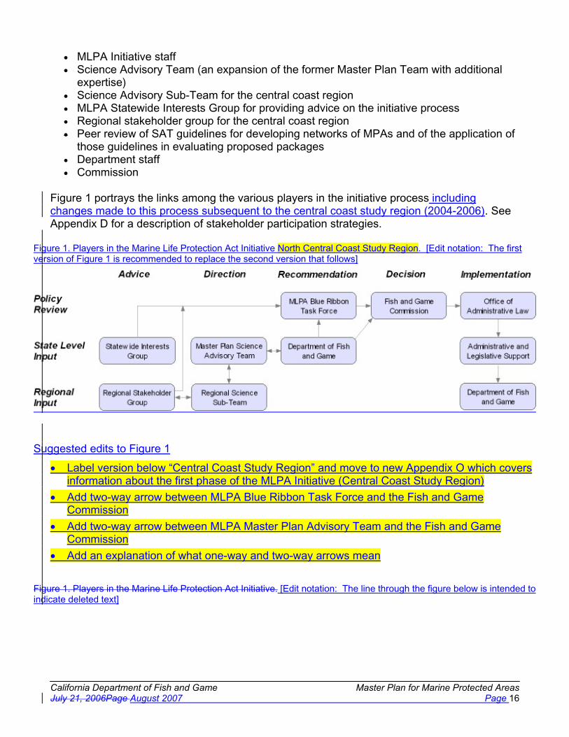
California Department of Fish and Game Master Plan for Marine Protected Areas July 21, 2006Page August 2007 Page 16
� MLPA Initiative staff� Science Advisory Team (an expansion of the former Master Plan Team with additional
expertise)� Science Advisory Sub-Team for the central coast region � MLPA Statewide Interests Group for providing advice on the initiative process� Regional stakeholder group for the central coast region � Peer review of SAT guidelines for developing networks of MPAs and of the application of
those guidelines in evaluating proposed packages � Department staff � Commission
Figure 1 portrays the links among the various players in the initiative process including changes made to this process subsequent to the central coast study region (2004-2006). See Appendix D for a description of stakeholder participation strategies.
Figure 1. Players in the Marine Life Protection Act Initiative North Central Coast Study Region. [Edit notation: The firstversion of Figure 1 is recommended to replace the second version that follows]
Suggested edits to Figure 1
� Label version below “Central Coast Study Region” and move to new Appendix O which covers information about the first phase of the MLPA Initiative (Central Coast Study Region)
� Add two-way arrow between MLPA Blue Ribbon Task Force and the Fish and Game Commission
� Add two-way arrow between MLPA Master Plan Advisory Team and the Fish and Game Commission
� Add an explanation of what one-way and two-way arrows mean
Figure 1. Players in the Marine Life Protection Act Initiative. [Edit notation: The line through the figure below is intended to indicate deleted text]

California Department of Fish and Game Master Plan for Marine Protected Areas July 21, 2006Page August 2007 Page 17
Note: input is solicited from the interested public and stakeholders at each step, until adoption of regulations by the Commission.
Roles in the Marine Life Protection Act Initiative
Organizational Partners, Committees, and Teams
The Commission is the ultimate decision-making authority for implementation of the MLPA. Specifically, the Commission makes all final decisions on the master plan, the proposed regional marine protected area proposals, and supporting CEQA documentation, all after completing its own process of public reviews. The principal mission of the other partners is to support the Commission in making sound policy decisions required by the MLPA. Although the Commission was not involved in the day-to-day work of the MLPA Initiative, the initiative provided regular opportunities for informational meetings and strategic consultation with the Commission. Commission staff also became active participants in the steering committee planning process subsequent to the first regional process (see below).
The California Resources Agency provides general oversight and public leadership for the initiative and implementation of the MLPA. Besides providing policy direction for coordinating funding and staffing, the agency made critical decisions in shaping the initiative. The secretary of the California Resources Agency selected the chair and other members of the MLPA Blue Ribbon Task Force. The secretary convened and charged the members of the task force with meeting the objectives identified in the task force description below. The California Resources Agency is also seeking adequate current and future funding for agency and Department personnel committed to the initiative and for completing future phases of the MLPA. Agencystaff also became active participants in the steering committee planning process subsequent to the first regional process (see below).
The Department serves as the lead agency for the design and implementation of the MLPA master plan and a statewide network of marine protected areas. The Department continues its traditional support of the Resources Agency and the Commission. In consultation with the Agency secretary, the Commission president, and the task force chair, the Director of the Department selected the members of the science team. Through the initiative's Steering Committee (described below), the Department assisted the development of the draft master plan framework and proposals for marine protected areas along the central coast, and isultimately responsible for presenting the final draft master plan and comments on the Blue Ribbon Task Force’s alternatives for marine protected areas in each region, including preferred

California Department of Fish and Game Master Plan for Marine Protected Areas July 21, 2006Page August 2007 Page 18
alternatives for each region, to the Commission. The Department also provides biological, enforcement and other relevant information, participates in meetings as appropriate, reviews working documents, and acts as lead agency under the California Environmental Quality Act, among other activities.
The MLPA Blue Ribbon Task Force is composed of distinguished, knowledgeable and highly credible public leaders selected by the secretary of the California Resources Agency. The charge to the task force in the first study region (the central California coast between Pigeon Point and Point Conception) was to oversee the preparation of the draft master plan framework and the development of alternative proposals for marine protected areas in an area along the central coast for the Department to present to the Commission; to prepare a comprehensive strategy for long-term funding of planning, management and enforcement of marine protected areas; and to develop recommendations for improved coordination of managing marine protected areas with federal agencies involved in ocean management. The task force also worked to resolve policy disputes and provide direction in the face of uncertainty, while meeting the objectives of the MLPA. The chair of the task force selected the executive Director of the MLPA Initiative, who in turn selected the senior MLPA project manager, operations & communications manager, and central coast MLPA project manager; worked with the Director of the Department to convene and direct the science team; and served as the principal link between the task force and initiative staff. Several task force members served as liaisons to the central coast project. In subsequent study regions task force members will provide ongoing policy guidance and advice as well as oversee the preparation of MPA alternatives and selecting a preferred alternative in each study region.
The Resources Legacy Fund Foundation useduses its best efforts to obtain, coordinate and administer philanthropic investments to supplement public funding for the MLPA Initiative, provides strategic advice to the California Resources Agency on public-private funding, and supported the initiative staff in managing private contracts for the initiative.
Other state and federal agencies played a variety of roles in the initiative. For instance, federal agencies, such as NOAA Fisheries, the National Ocean Service, and the National Marine Sanctuary Program, are valuable sources of information and may have programs that should be taken into account in designing regional MPAs. State agencies may play a similar role.
The directorDirector of the Department, in consultation with the chair of the task force, the secretary of the agency, and the president of the Commission, convened the convenes aMaster Pan Science Advisory Team (science team)) for each study region process. The science team wasis composed of the members required by the MLPA, including staff from the Department, the Department of Parks and Recreation, the State Water Resources Control Board, one member appointed from a list provided by Sea Grant, and an expanded group of scientists knowledgeable in marine ecology, fisheries science, marine protected areas, economics and the social sciences. The role of the science team wasis to assist the task force in developing the draft master plan framework by reviewing supporting and draft documents, addressing scientific issues, and framing and referring policy challenges to the task force. The science team reported to the task forcereports to the Department Director and provides input to the directortask force.

California Department of Fish and Game Master Plan for Marine Protected Areas July 21, 2006Page August 2007 Page 19
The charge to the SAT is to provide the scientific knowledge and judgment necessary to assist the Department with: (1) meeting the objectives of the MLPA Initiative, (2) providing input to the BRTF, and (3) completing the north central coast portion of the California Master Plan for MPAs. Principally, the SAT is charged with reviewing and commenting on scientific papers relevant to the implementation of the MLPA, reviewing alternative MPA proposals, reviewing draft master plan documents, addressing scientific issues presented by those documents, and addressing scientific questions raised by the BRTF or stakeholders. In the course of assisting the Department, members shall refrain from making policy judgments; rather, where available science presents options or uncertainty, the SAT shall frame and refer those policy questions to the Department or, if appropriate, the BRTF.
A sub-team of the science team serves the central coast project each study region project. The Science Advisory Sub-Team for the central coast region was composed of members of the science team, and worked with the central coast project manager and central coast stakeholder group to develop alterative marine protected area proposals by reviewing supporting and draft documents, addressing scientific issues and information provided by the central coast stakeholder group, and framing and referring policy challenges to the task force.At least one member of the science sub-team attended each central coast stakeholder group meeting. This group continues to assist the Department in reviewing and analyzing MPA packages for the central coast. This group continued to assist the Department in reviewing and analyzing MPA packages for the central coast throughout the alternative development process.In subsequent study regions, the science team similarly designates a sub-team to work directly with the stakeholders and Department to help develop scientifically sound alternatives.
The MLPA Regional Stakeholder Group includesd key, affected members of the central coast study region current study region who were are able and willing to provide information that assisted in the development of proposed alternative network components of marine protected areas. The Director of the Department and the central coast liaison of the task force solicitednominations, and selected from the nominees a representative group that met regularly over the course of the regional process to provide input to the regional project manager, provide information and other input for framing key scientific questions to be addressed by the science advisory sub-team, and worked as a group to develop alternative proposals for MPAs. The Department providesd enforcement, biological, and policy staff support to the group for information and input on enforcement key issues.
The MLPA Statewide Interests Group was is composed of members from key interest groups to advise the task force and staff on the overall MLPA Initiative process. The group did doesnot vote or otherwise take formal positions on any procedural or substantive issues, but instead alertsed the task force and staff to issues and opportunities that could improve public involvement in the initiative process.
The MLPA Steering Committee was is chaired by the MLPA Initiative’s executive director, andin the first regional process included the Department’s MLPA policy advisor, statewide technical advisor, MPA mandate coordinator, and central coast regional coordinator, and the intiative’s senior project manager, operations & communications manager, and central coast project manager. The committee was responsible for coordinating all work necessary to achieve each of the objectives of the initiative.

California Department of Fish and Game Master Plan for Marine Protected Areas July 21, 2006Page August 2007 Page 20
In subsequent study regions, the steering committee was expanded based on the experience in the central coast process. Members now include the initiative’s executive director, senior project manager, and operations and communications manager; the Department’s MPA policy advisor and MPA project supervisor; and representatives from the Resources Agency and Fish and Game Commission. This more comprehensive steering committee is designed to ensure that all policy issues in the regional process are quickly and adequately portrayed to the primary oversight and decision makers in the process.
Other Staff
Both the MLPA Initiative and Department hired and contracted a variety of other staff to help support the initiative process. Examples of these staff included biological technicians, scientific advisors, research writers, and administrative support staff. In other regions, similar levels of staffing, preferably within theThe Department, will be necessary to properly support the planning after the first study region process was complete, received significant increases in staff through the state budget process to support the implementation of the MLPA. These positions were filled in late 2006 to create a new organizational component within the Department’s Marine Region. This group of new staff will support planning and implementation in all study regions.
Master Plan Framework and Master Plan
The MLPA calls for the development of a master plan by the Department, and its adoption by the Commission7. The MLPA Initiative divided the master plan into two principal parts: a section providing guidance in the application of the MLPA to the development of a statewide MPA network (the master plan framework), and a section describing the preferred alternatives for MPA proposals. The MLPA Initiative envisioned a focus on portions of the state in a series of regional processes, beginning with the central coast. The requirement for a full master plan and implementing regulations will be met when the Commission adopts the final portion of the plan and all regions of the coast have been completed. The present master plan includes descriptions of MPAs only for those regions which have been completed.
It is important to emphasize that the physical, biological, social and economic conditions in each region of the state will affect the specific application of the MLPA and the processes recommended in this document. For example, California coastal waters, especially those in southern California, are critical for our nation's military both for training and testing as well as operations. The United States Department of Defense controls two of the Channel Islands and has installations along significant portions of the mainland coastline. Many of the operational ocean areas are significantly restricted to public access. Based on inputs from the Department of Defense, the designation of MPAs in specified operational areas of the military may not be consistent with military readiness. Therefore, in assessing the overall MLPA network, the beneficial effects of military operational areas (as well as other de facto MPAs such as long-term closures implemented through fishing regulations), with respect to habitat conservation goals will be considered in the needs assessment.
7 The Fish and Game Code requires the Department to provide a draft master plan to the Commission by January 2005 and the Commission to adopt a final master plan with regulations by December 2005 [Section 2859, FGC].

California Department of Fish and Game Master Plan for Marine Protected Areas July 21, 2006Page August 2007 Page 21
The central coast effort provided concrete experience in applying the master plan framework and this more specific guidance to a specific area. This experience was used to recommend changes incorporated in the present master plan document. In this way, the master plan framework served as the foundation for an evolution of practice that will continue to be adapted to new information as well as serving as a blueprint for developing a statewide MPA network.
The following points summarize changes made to the master plan framework in order to respond to the lessons learned in the central coast and to convert what was a framework document into a more complete master plan for the central coast:
� Section 1. Introduction: references to the MLPA Initiative have been adjusted to indicate the Initiative’s role in the central coast process versus the ongoing role of the Department in other regions.
� Section 2. Process for Designing Alternative Marine Protected Area Network Proposals: The specific proposed regional boundaries and timeline for completion was added to provide guidance for the entire state process.
� The process steps for developing alternative MPA proposals within a region have been simplified and restructured. These changes reflect the actual process used in the central coast as compared to the suggested process in the framework.
� Section 3. Considerations in the Design of MPAs: The scientific guidance on MPA design was modified in response to peer review comments from the Oregon Seagrant review panel. These changes were primarily in the form of minor text edits for clarity.
� The scientific guidance was also modified to describe how the SAT considered the varying levels of protection in different types of MPAS.
� Section 4. Management: This section was completely revised based on information provided during the central coast process on the development of regional management plans. The outline provided in this section was then used in developing the central coast management plan (Section 8).
� Section 5. Enforcement: No changes were made to this section. Details on enforcement plans for each region are found in Section 8.
� Section 6. Monitoring and Adaptive Management of MPAs: No changes were made to this section. Details on monitoring and adaptive management plans for each region are found in Section 8.
� Section 7. Funding: This section was completely revised based on information and recommendations provided by the Blue Ribbon Task Force during the central coast process. In addition, details on costs and potential funding sources for each region are found in Section 8.
� Section 8. Regional MPA Management Plans: This new section fulfills the MLPA requirement that the master plan include: recommended networks of MPAs; a preferred alternative; and recommendations for monitoring, enforcement, and funding.
� Appendices: Informational documents developed during the central coast process have been added to the list of appendices.

California Department of Fish and Game Master Plan for Marine Protected Areas July 21, 2006Page August 2007 Page 22
Section 2. Process for Designing Alternative Marine Protected Area Network Proposals
For practical reasons, the MLPA mandated required review and improvement of the existing array of MPAs and ensuring that California’s MPAs function as a network cannot be established in a single step. The resources and effort required to design and evaluate MPAs along the state’s entire 1,100-mile coast at the same time are beyond the capacity of both governmental and non-governmental resources. In addition, ecological, social and economic conditions differ widely among many regions.
A sound master plan based on the requirements of the MLPA should enable application of the MLPA to differing conditions while maintaining a statewide perspective. For these and other reasons, this master plan envisions that the statewide network will be assembled byestablishing MPAs in each of several study regions along the coast by 2011. Once established, the management, research, education, and monitoring in each region can be coordinated statewide.
The master plan framework was first applied to developing alternative proposals in the centralcoast study region. Critical to understanding this process were several concepts and definitions. The “central coast study region” was the first general area under consideration for the design of MPAs. By no means was the entire region expected to be designated an MPA. Rather, after review of the circumstances within the region, including existing MPAs and the setting of regional design considerations, goals and objectives, alternatives for the region weredeveloped.
Equally important, this study region was smaller than the “biogeographical regions” defined in the MLPA. It is the biogeographical regions that are the basis for determining the number of marine reserves as required by the MLPA for replicates of similar habitats within marine reserves.
Within the first study region, existing regulations (including existing MPAs), the status of the resources and habitats, and the requirements of the MLPA were considered. Regional goals,objectives and design considerations were then developed, followed by potential goals and objectives for individual MPAs. Possible boundaries and regulations were then identified for individual MPAs in the region, including alternative designs and potential changes to or removal of existing MPAs.
This variety of approaches to configuring MPAs within the central coast region was assembledinto alternative proposals. These alternatives were considered by the task force, and a subset was recommended to the Department. The Department ensured these alternatives werefeasible, selected a preferred alternative, and formally presented the alternatives to the Commission.
In subsequent study regions, the task force will select a preferred alternative and, rather than creating or selecting a separate preferred alternative, the Department will provide specific comments on the task force preferred. This will ensure the recommendations developed in the detailed stakeholder involvement process will be fully considered at every stage. The Department’s comments on the preferred, coupled with a more central role in the alternative

California Department of Fish and Game Master Plan for Marine Protected Areas July 21, 2006Page August 2007 Page 23
development process, will ensure that all alternatives forwarded to the Commission are feasible.
For the purpose of implementing the MLPA in a phased manner, the state has been divided into five study regions: the south coast region, the central coast region, the north central coast region, the north coast region and the San Francisco Bay region. The central coast region was selected as the first study region for MLPA implementation.8
Within the first study region, the process for designing MPA network proposals began with a review of existing ocean management regulations (including existing MPAs), the status of resources and habitats, and the requirements of the MLPA. Regional goals and design considerations were then developed followed by potential goals and objectives for individual MPAs in the region. The MPA specific planning included consideration of alternatives for potential new MPA sites, designs, boundaries and regulations as well as consideration of potential changes to or removal of existing central coast MPAs.
Individual MPAs concepts were then combined into alternative MPA network proposals. The task force considered these alternative proposals, and recommended a subset of them, including a preferred alternative, to the Department. The Department reviewed the alternative proposals for feasibility and formally presented the alternatives, including a modified version of the task force preferred alternative, to the Commission.
Subsequent study regions are expected to follow the same basic approach to MPA network design with one exception. In the future, the task force will selected a preferred alternative but the Department will not. Instead of developing its own preferred alternative, the Department will provide specific comments on the task force alternative.This will ensure the recommendations developed in the detailed stakeholder involvement process will be fully considered at every stage. The Department’s comments on the preferred alternative, coupled with a more central role in the alternative development process, will ensure that all of the alternatives forwarded to the Commission are feasible.
The Blue Ribbon Task Force MPA Design Process
Suggestion: Revise the text below and Table 1 to make clear that the SAT will evaluate any and all alternative MPA proposals considered by the task force and Commission, and any proposed changes thereto up until final adoption of a proposal by the Commission. Any option under consideration by the Commission should be subject to the same review of habitat, size and spacing analysis and socio-economic analysis by the Science Sub-Team.
The MPA design process is composed of four general activities:
8 Note, these study regions should not be confused with the “biogeographical regions” defined in the MLPA. The five designated study regions were established based on logistical criteria to facilitate phased planning and implementation of the law. The Science Advisory Team based on scientific criteria identified the two biographical regions.

California Department of Fish and Game Master Plan for Marine Protected Areas July 21, 2006Page August 2007 Page 24
1. Regional MPA planning, which starts with the identification of a study region along the coast that constitutes a logical locale based on a variety of scientific and socioeconomic criteria for studying where MPAs might appropriately be placed. Much of this background information is assembled into a regional profile. A regional stakeholder group is then established for the selected region. This step ends with the identification of regional goals and objectives, an evaluation of existing MPAs and other management measures, initial discussion of areas of ecological importance and human use interest, and refinement of the regional profile.
2. Assembling alternative MPA proposals, which involves developing and refining packages of MPAs alternative MPA proposals for the study region. This stage also includes an initial evaluation of the proposals, including socioeconomic effects, and afeasibility study to determine whether proposals can be implemented.
2. Evaluating alternative MPA proposals, which begins with initial evaluation by the task force or Development of alternative MPA proposals is informed by: a) information provided in the regional profile; b) guidance on developing MPAs which satisfy the MLPA provided by the Science Advisory Team and adopted by the Commission. The task force then forwards the package of alternative proposals to; c) the Department, or the Commission provides direction to the Department, which reviews the proposals, selects a preferred alternative ’s written guidance on feasibility criteria; d) contributions of members of the regional stakeholder group; and e) contributions provided from other sources, including interested parties, potentially affected stakeholders and prepares a general management planpublic comments. This stage also includes an initial evaluation of the proposals, including socioeconomic effects, and a feasibility study to determine whether proposals can be implemented.
During this stage regional goals and objectives developed in earlier study regions are assessed and revised as needed for subsequent study regions. As proposed MPA alternatives are finalized, information on how each MPA contributes to the goals and objectives will be developed and incorporated into the proposals for MPAs in the region... The Department actively supports this development and refinement of MPA proposals, bringing its information and perspectives into the process both verbally and in written comments.
3. Evaluating alternative MPA proposals, which begins with initial evaluation by the task force based on the information described in step 2 above. The task force then forwards the package of alternative proposals and its recommendation of a preferred alternative to the Commission. As the recommendations regarding proposed MPAs and a recommended preferred alternative are provided to the Commission, the Departmentprovides information, analyses and comments to the Commission on feasibility of aspects of the MPA proposals and on the prospects of the MPA proposals to achieve the goals of the MLPA.
4. Fish and Game Commission consideration and action on MPA proposals, which includes public hearings, consideration of testimony and action on the proposals.

California Department of Fish and Game Master Plan for Marine Protected Areas July 21, 2006Page August 2007 Page 25
Figure 2 illustrates these activities and the major elements of each. Table 1 provides a summary of the activities and elements of the activities, together with a list of the lead actors and the groups to be consulted. A more detailed description of each activity follows in the text.
The ultimate goal of these activities is compliance with the MLPA, and specific elements listed here provide general guidance only. In each regional process, the specific elements undertaken must be selected and adjusted based both on the specifics of that region and adaptations suggested from prior experiences implementing the MLPA.
The process used in the central coast study region and the master plan framework guiding that process were used as the basis for this statewide master plan. Changes were made to the framework and process based on lessons learned in the central coast process.
Suggestion: Additional efforts are necessary to ensure consistency between text descriptions of the MPA design process and Figure 2 and Table 1. For example, text says regional profile will be developed prior to RSG being formed, but Figure 2 and Table 1 reverse this order; practically it makes sense to compile the draft regional profile before convening the regional stakeholder group, and then modify based on stakeholder input.

Cal
iforn
ia D
epar
tmen
t of F
ish
and
Gam
e M
aste
r P
lan
for
Mar
ine
Pro
tect
ed A
reas
J
uly
21, 2
006A
ugus
t 200
7P
age
26
Fig
ure
2. P
roce
ss fo
r M
PA
pla
nnin
g in
stu
dy r
egio
ns.
Not
e th
at d
urin
g st
eps
2 an
d 3,
the
Dep
artm
ent,
BR
TF
, Sci
ence
Tea
m, C
omm
issi
on a
nd o
ther
gro
ups
will
par
ticip
ate
in r
evie
w a
nd e
valu
atio
n of
pot
entia
l al
tern
ativ
es.

California Marine Life Protection Act Initiative Final Draft Master Plan Framework April 4, 2005Page California Department of Fish and Game Master Plan for Marine Protected AreasAugust 2007 Page 27
Table 1: Process for MPA planning in study regions. Key to acronyms: BRTF = Blue Ribbon Task Force; CEQA = California Environmental Quality Act; DFG = Department of Fish and Game; FGC = Fish and Game Commission; RSG = Regional Stakeholder Group; SAT = Science Advisory Team; SST = Science Advisory Sub-team.
TASK LEAD ACTORS SUGGEST/COMMENT
REGIONAL MPA PLANNING1.1 Convene regional process
1.1.1 Convene regional stakeholder group (RSG)and science advisory team (SAT) DFG Director/BRTF Chair Stakeholders
1.1.2 SelectAppoint science advisory sub-team(SST)SAT) SAT/DFG Director Stakeholders
1.1.3 Select science advisory sub-team (SST) SAT/DFG
1.2 Develop additional advice
1.2.1 Identify issues requiring additional advice for designing MPAs in the study region RSG/SST/DFG Stakeholders/SAT
1.2.2 Collect and prepare additional advice for designing MPAs in the study region DFG/SST RSG/Stakeholders
1.2.3 Review additional advice for designing MPAs in the study region BRTF/FGC/SAT RSG/Stakeholders
1.2.4 Adopt additional advice for designing MPAs in the study region BRTF
1.2.5 Prepare statement of feasibility criteria DFG
1.3 Prepare regional profile
1.3.1Assemble regional information on biological, oceanographic, socioeconomic, and governance aspects of the region
DFG RSG/Stakeholders
1.3.2 Evaluate existing MPAs against goals and objectives DFG/SAT RSG/Stakeholders
1.3.3
Evaluate existing fishing and non-fishingmanagement activities, including fiehries regulations, as they relate to against the MLPA, regional goals and objectives, and other relevant state law
DFG/SAT RSG/Stakeholders
1.3.4 Identify inadequacies, if any, in existing MPAs and management DFG/SAT RSG/Stakeholders
1.3.5 Review regional information and consider comments from stakeholders RSG/SST Stakeholders
1.3.6 Identify a list of key or critical species and document their regional distribution SST Stakeholders
1.4
Develop regional ecological and socioeconomic goals, objectives and design considerationsDetermine key locations for MPAs to meet the MLPA goals within the region
RSG/SST DFG/SAT/Stakeholders

California Department of Fish and Game Master Plan for Marine Protected Areas July 21, 2006Page August 2007 Page 28
TASK LEAD ACTORS SUGGEST/COMMENT
1.4.1
Design regional goals, objectives and design considerations consistent with the MLPA and other relevant state lawEvaluate distribution of representative and unique habitats
RSG/SST Stakeholders
1.4.2Review regional goals, objectives and design considerations Evaluate wildlife populations, habitats, and uses of concern
BRTF/FGC/SATRSG/SST Stakeholders
1.4.3
Approve regional goals, objectives and design considerations Evaluate activities affecting populations and habitats within the region
BRTFRSG/SST Stakeholders
1.4.4 Identify species likely to benefit that are of particular concern to the region RSG/SST Stakeholders
1.4.5
DetermineIdentify key locations forin the region where MPAs to meetmay help achievethe MLPA goals within the region andcontribute to an overall network
RSG/SST DFG/SAT/Stakeholders
1.5.1 Evaluate distribution of representative and unique habitats RSG/SST Stakeholders
1.5.2 Evaluate wildlife populations, habitats, and uses of concern RSG/SST Stakeholders
1.5.3 Evaluate activities affecting populations and habitats within the region RSG/SST Stakeholders
1.5.4 Identify species likely to benefit that are of particular concern to the region RSG/SST Stakeholders
1.5.5Identify key locations in the region where MPAs may help achieve the MLPA goals and contribute to an overall network
RSG/SST Stakeholders
ASSEMBLE DRAFT REGIONAL ALTERNATIVE MPA PACKAGESPROPOSALS
2.1 Consider potential changes to existing MPAs RSG/SST DFG/SAT/Stakeholders
2.1.1
Consider potential modifications to existing MPAs and potential new and alternative MPAs for meeting goals and objectives of the region, the MLPA, and of other relevant state law
RSG/SST Stakeholders
2.2 Assemble draft alternative MPA packagesproposals for the region RSG/SST Stakeholders
2.2.1
Identify objectives for each existing and potential new MPAPrepare a range of alternative proposals including a variety of MPAs within the region in order to achieve the goals and objectives based on the design considerations for the region.
RSG/SST SST/SAT/Stakeholders
2.2.2
Prepare a range of alternative proposals including a variety of MPAs within the region in order to achieve the goals and objectives based on the design considerations for the region.Identify objectives for each existing and potential new MPA
RSG/SST SST/SAT/Stakeholders

California Department of Fish and Game Master Plan for Marine Protected Areas July 21, 2006Page August 2007 Page 29
TASK LEAD ACTORS SUGGEST/COMMENT
2.2.3Present this range of alternatives along with justification for each to the BRTF orCommission and SAT for review
RSG
EVALUATE ALTERNATIVE MPA PROPOSALS
3.1Evaluate alternative MPA proposals against the MLPA and other relevant state law
BRTF/FGC Stakeholders
3.1.1 Prepare preliminary habitat, size, and spacing analysis of each alternative proposal SAT/SST Stakeholders
3.1.2Prepare preliminary socio-economic analysis of potential impacts of each alternative proposal
SAT/SST/DFG Stakeholders
3.1.3Review SST analyses and revise proposals as needed to more fully meet the goals, objectives and design considerations
RSG
3.2 Identify monitoring and evaluation indicators SST/SAT DFG
3.3
Forward recommended alternative proposals and recommended preferred alternative to the DepartmentCommissionfor consideration and submission to FGCaction
BRTF
3.3.1 Conduct feasibility analysis to ensure proposals may be implemented DFG RSG/BRTF
3.3.2
Design general management plan for MPAs in the region, including monitoring, enforcement, and financing, with a periodic review of effectivenessProvide comments on BRTF recommendations to Commission
DFG/SAT RSG/BRTF/Stakeholders
3.3.3
Prepare preferred alternative based upon information submitted by BRTF, RSG, and other stakeholdersDesign general management plan for MPAs in the region, including monitoring, enforcement, outreach and financing, with a periodic review of effectiveness
DFG/SAT RSG/SAT/Stakeholders
3.4Department submission of alternative proposals, preferred alternative and other documents to FGC
DFG
COMMISSION CONSIDERATION AND ACTION
4.1 FGC review of alternative proposals and public testimony FGC Stakeholders/DFG/BRTF
4.2If FGC requests, the Department prepares regulatory documents, and a CEQA analysis is performed
DFG

California Department of Fish and Game Master Plan for Marine Protected Areas July 21, 2006Page August 2007 Page 30
TASK LEAD ACTORS SUGGEST/COMMENT
4.3FGC accepts public testimony on alternative MPA proposals and supporting documents
FGC Stakeholders
4.4 FGC acts on MPA proposals FGC
The text below describes in greater detail the process for MPA planning in a study region. It is important to note that some of the sub-activities described below may occur simultaneously or may be repeated, such as the design of individual MPAs within a region. Other important activities, such as applying socioeconomic analyses or taking monitoring into account in the design of MPAs, are elements of broader activities throughout the process.
Task 1: Regional MPA Planning
The objective of this task is to develop background information, goals and objectives, and determine key locations in the region where MPAs may be useful to achieve the MLPA goals and contribute to the overall network. This profile serves as a foundation for setting goals and objectives, developing alternative proposals, and identifying needs for additional information.
During the MLPA Initiative process, designing MPAs began with identification of an initial study region. The study region focused initial efforts to implement the MLPA in a discrete area. For the MLPA Initiative process, the MLPA Blue Ribbon Task Force (BRTF) oversaw all aspects of regional planning in the initial study region. In evaluating possible initial study region alternatives along the central coast from Point Conception to Point Arena, the MLPA Initiative used the following criteria, which may be useful in future evaluations:
� Biophysical boundaries. Species of plants and animals are not distributed continuously along the California coast. Many species form natural communities with borders that may assist in determining the central coast study region. Although the borders themselves may be fuzzy, the central coast clearly has two major zones, divided by the outflow from San Francisco Bay. A weaker, but important break occurs at Point Sur, where current gyres cause abrupt changes in the composition of the community of species.
� Is the area large enough for replicates? Options were reviewed to determine if they were large enough to replicate various habitat types in more than one MPA within the entire region.
� Relative amount of habitat mapped. High-resolution mapping allows determination of bottom type on a finer scale than hard versus soft, and can distinguish relief, complexity, and rugosity, for example, of hard bottom structures. This criterion, rated as either high, moderately-high, moderate, or low, was based on the amount of available, high-resolution, fine-scale, habitat mapping data relative to the potential study region.
� Human activity boundaries. The diversity and intensity of human activities in coastal waters are discontinuous as well. As an example, recreational fishing is more prevalent south of Point Conception than north. The waters around Monterey are among the most popular sites for scuba diving in the United States. Government jurisdictions add another layer of complexity that should also be considered. Several sub-categories were considered within this criterion:
o Recreational fishing

California Department of Fish and Game Master Plan for Marine Protected Areas July 21, 2006Page August 2007 Page 31
o Commercial fishing o Scuba diving o County jurisdictions o Military/security uses o State/federal jurisdiction
� Progress of past MLPA and other public discussion groups. Input from outside groups’ prior or ongoing discussions was considered. These groups may provide important information that will assist the regional process.
� Potential state, federal and private partners with financial or in-kind services. Potential partners were considered. The assistance provided by these partners can enhance and facilitate regional processes.
� Scientific knowledge of, and research being conducted in, the region. Public and private entities, such as universities, state and federal agencies, public waste dischargers (e.g.,Southern California Coastal Water Research Project), and power generating companies (e.g., Pacific Gas and Electric’s Diablo Canyon Power Plant) have conducted or are conducting research and monitoring studies in a variety of areas along the coast. Availability of region-specific information, including information on the distribution of habitats identified in the MLPA, should help determine the final study region.
� Availability of first-hand knowledge of the area. Numerous scientists, fishermen, and other informed individuals collectively provide a wealth of knowledge within specific areas. The level and availability of this type of information should be considered.
� Number of existing MPAs. Availability of scientific data about existing MPAs and how they meet or do not meet both resource protection needs and the requirements of the MLPA are important in determining a study region.
� Existing fishery regulations in the region and how they meet or do not meet both resource protection needs and the requirements of the MLPA. Existing regulations create differences in the need for additional protection in certain areas.
� Number of complete Department fishing districts and management areas (related to existing fishery regulations). The selected study region should reflect a consideration of these areas.
� Range or area over which a resource user may be expected to have a working knowledge of the resources. Similar to the range over which resources are utilized by user groups, the geographic range of a user’s working knowledge will vary with the resource or resources in question. This also applies to researchers, fishery managers, and other scientists within the region. The selected study region should not be so large as to preclude the ability of individual representatives to provide input on its entire geographic extent.
� Distance members of a regional stakeholder group would need to travel in order to participate in group meetings. Choosing too large a study region could impose logistical problems for those required to, or interested in, participating in the process. This criterion was rated from high to low based on the length of coastline (nautical miles) within the potential study region as follows:
o High = greater than 200 miles o Moderate to high = 151-200 miles o Moderate = 100-150 miles o Low = less than 100 miles
� Availability of Department personnel. The same considerations relative to travel that apply to the regional stakeholder group would also apply to Department staff.

California Department of Fish and Game Master Plan for Marine Protected Areas July 21, 2006Page August 2007 Page 32
A list of potential initial study regions was prepared and input was taken from the public both at BRTF meetings and at three public workshops in 2005. Specific areas of agreement among the majority of comments were noted. In addition, specific areas of concern became apparent. From this, a set of three potential initial study regions was developed. The positive and negative aspects of each potential region were presented to the BRTF, which then selected the final initial study region of Pigeon Point to Point Conception based on the information provided.
The same criteria used to determine the initial study region have been applied to the rest of the California coast. Using these criteria and the lessons learned from the initial central coast region provides a good format for completing implementation throughout the California coast. Accordingly, the following timeline is recommended for statewide planning:
Region 1: Central Coast Region (Pigeon Point to Point Conception) - Planning within this initial region was completed in 2006 Region 2: South Coast Region (Point Conception to U.S./Mexico border) - Planned completionin 2008Region 3: North-Central Coast Region (Point Arena to Pigeon Point) - Planned completion in 2009Other Regions: South Coast Region 4:(Point Conception to U.S./Mexico border), SanFrancisco Bay Region (Waters within the San Francisco Bay District as defined in CCR, Title 14, Section 27.00) - Planned completion in 2010Region 5:), North Coast Region (California/Oregon border to Point Arena) - Planned completion in 2011
The above provides a planning timeline, which may differ from the timeline of actual implementation. Implementation dates for MPAs within each region will be dependent upon acquiring appropriate levels of staff and funding to adequately manage, monitor, and enforce each area. Within each region, detailed management plans (described below) will provide specific plans and budgets for these critical activities.
Activity 1.1: Convene regional planning process
Activity 1.1.1: The directorDirector of the Department and chair of the BRTF convenes a regional stakeholder group and science advisory team to participate in the evaluation of the region and existing management, regional goals and objectives and potential changes to existing MPAs and the design of any additional MPAs.
Activity 1.1.2: The Director of the Department convenes a science advisory team withdesired membership of not more than 15 members. The science team will participate in evaluation of draft MPA proposals and provide scientific input and guidance to the Department for use in the BRTF regional planning process.
Activity 1.1.2: The science team and Department identify members who will serve on a science sub-team, which will work closely with the regional stakeholder group, and will serve as a link to the science team.

California Department of Fish and Game Master Plan for Marine Protected Areas July 21, 2006Page August 2007 Page 33
Activity 1.2: Develop additional advice
Activity 1.2.1: The regional stakeholder group, the science advisory sub-team, and staff identify issues requiring additional advice for designing MPAs in the study region.
Activity 1.2.2: In consultation with the science advisory sub-team, staff prepares draft advice on these issues.
Activity 1.2.3: theThe task force, Commission and science team review additional advice for designing MPAs in the study region.
Activity 1.2.4: the The task force or Commission acts on the additional advice. and incorporates it into planning and guidance documents.
Activity 1.2.5: The Department prepares a statement of feasibility criteria and provides it to the BRTF, RSG, and science team. This statement will provide overarching guidance on critical features of MPA proposals that make with the intent of making them realistically able to be implemented if adopted.
Activity 1.3: Prepare regional profile
Activity 1.3.1: Staff assemble regional information on biological, oceanographic,socioeconomic and governance aspects and draw upon suggestions and information provided by local communities and other stakeholders. The profile will include governance aspects related to tribal uses in the region if applicable. See Appendix E for a description of social science tools and methods. The types of the information that might be included in a regional profile may be found in Appendix F.
Activity 1.3.2: Within the profile, staff evaluate existing MPAs in the study region. This preliminary analysis will include a review of existing studies within each MPA and a determination of whether the areas are meeting their original goals as well as whether they may achieve regional goals and MLPA requirements.
Activity 1.3.3: Within the profile, staff evaluate existing management of fishing and non-fishing activities (e.g., Rockfish Conservation Areas or trawl fishery closures, etc.). Wherethis other management meets the goals and objectives of the MLPA in all or part of the region, it should be incorporated into the final design. This evaluation should in clude an assessment of whether this other management could be leveraged to help meet the goals and objectives of the MLPA in all or in part of the region during MPA design.
Activity 1.3.4: Within the profile, staff identify inadequacies in existing MPAs and management activities in meeting the goals and objectives of the MLPA. (See Appendix H for a description of planning processes related to the MLPA.)
Activity 1.3.5: The regional stakeholder group and the science sub-team review regional information and consider comments from stakeholders.

California Department of Fish and Game Master Plan for Marine Protected Areas July 21, 2006Page August 2007 Page 34
Activity 1.3.6: Drawing upon the list of species likely to benefit from protection within MPAs described in Appendix G, the science advisory sub-team develops a list of key or critical species and document their regional distribution.
Activity 1.4: Develop regional ecological and socioeconomic goals, objectives and design considerations
Activity 1.4.1: Drawing upon the regional profile and the goals and objectives of the MLPA, the regional stakeholder group and the science advisory sub-team design recommended regional goals, objectives and design considerations, consistent with the MLPA and other relevant state law. (See discussion of setting goals and objectives below.)
Activity 1.4.2: The regional goals, objectives, and design considerations developed in the regional effort are reviewed by the science team, whose comments are forwarded to the task force. The task force reviews the proposed regional goals, objectives, and alternativenetwork concepts and provides comments and suggestions to the regional stakeholdergroup for consideration in revision. The task force subsequently forwards its comments and suggestions, together with the proposed regional goals, objectives, and network concepts, to the Department
Activity 1.4.3: The task force approves the regional goals, objectives, and designconsiderations, when satisfied that they meet the standards of the MLPA.
Activity 1.5: Determine key locations for MPAs to meet the MLPA goals within the region.
Activity 1.54.1: The regional stakeholder group and the science advisory sub-team evaluate the distribution of representative and unique habitats in the region, based on the information assembled in Activity 1.3, and information provided by stakeholders, including local communities and fishermenresource users.
Activity 1.54.2: The regional stakeholder group and the science advisory sub-team identify and evaluate wildlife populations, habitats, and various human uses that may negatively impact the populations and habitats in the region.
Activity 1.54.3: The regional stakeholder group and the science advisory sub-team identify and evaluate activities that may affect populations and habitats.
Activity 1.54.4: The regional stakeholder group and the science advisory sub-team determine which key or critical species from step 1.3.6 are likely to benefit from MPAs in the region. Species Regulations allowing take for species not likely to benefit should also be considered as prohibition of their take maycould lead to unnecessary socioeconomicimpact. All species, however, should be considered for their ecological roles and interactions, whether the individual species benefit or not. The regional stakeholder group should consider what regulations are appropriate for each proposed MPA to meet the regional goals and objective. [Note: similar recommendation made by The Ocean Conservancy.]

California Department of Fish and Game Master Plan for Marine Protected Areas July 21, 2006Page August 2007 Page 35
Activity 1.54.5: The regional stakeholder group and the science advisory sub-team identify key locations in the region where MPAs may help achieve the MLPA goals and contribute to an overall network. The groups will consider both ecologically important areas and areas of key human interest in their discussions.
Task 2: Assemble Draft Regional Alternative MPA PackagesProposals
The objective of this task is to make specific recommendations on changes to existing MPAs along with suggestions for alternative new MPAs and other potential management measures. The intent is for the sum of individual MPAs to meet the regional goals and objectives and the sum of the regions to meet the MLPA goals and objectives and network requirements, while noting that any individual MPA may not meet all of the goals of the region or network.
Activity 2.1: Recommend potential changes to existing MPAs.
Activity 2.1.1: The regional stakeholder group and the science sub-team review all the above information and make initial recommendations for the modification, reduction in size, expansion, or removal of existing MPAs in order to meet regional goals and objectives consistent with the goals of the MLPA and of other relevant State law.
Activity 2.2: Assemble draft alternative MPA packagesproposals for the region
Activity 2.2.1: The regional stakeholder group reviews each revised or potential new MPA and identifies initial objectives for each MPA to help meet the goals and objectives of the MLPA.Activity 2.2.1: The regional stakeholder group and the science advisory sub-team prepare a range of alternative proposals including a variety of MPAs within the region. Each proposal is intended to achieve the goals and objectives of the MLPA and is based on the design considerations developed for the region
Activity 2.2.2: The regional stakeholder group reviews each revised or potential new MPA and the science advisory sub-team prepare a range of alternative proposals including a variety of MPAs within the region. Each proposal is intendedidentifies initial objectives for each MPA to achievehelp meet the goals and objectives of the MLPA and is based on the design considerations developed for the region.
Activity 2.2.3: The alternative proposals are presented to the task force or Commissionand SAT for review and evaluation.
Task 3: Evaluate Alternative MPA proposals
The objectives of this task are to conduct initial reviews of the alternative MPA proposals, to conduct environmental and socioeconomic analyses as required by law, and to identify potential monitoring and evaluation indicators for long-term management.

California Department of Fish and Game Master Plan for Marine Protected Areas July 21, 2006Page August 2007 Page 36
Activity 3.1: Evaluate alternative MPA proposals.
The science advisory sub-team and science team conduct a variety of analyses in order to provide relative comparisons of each package to each other in respect to the MLPA goals and objectives and other relevant State law. Where feasible, Tthis review is provided to the BRTF and Commission for discussion all proposals and may lead to revisions to the proposals and a repetition of portions of Task 3. [Note: similar recommendation made by The Ocean Conservancy.]
Activity 3.1.1: The science advisory sub-team and science team prepare preliminary analyses of the habitats within MPAs, MPA sizes, and MPA spacing for each alternative proposal. These analyses provide a relative comparison of how well each proposal meets specific goals of the MLPA.
Activity 3.1.2: The science advisory sub-team and science team, in conjunction with the Department and potential contracted support, prepare a preliminary analysis of the maximum potential impact of each proposal to existing fishing in terms of area set aside versus frequency of use.
Activity 3.1.3: The regional stakeholder group reviews the science team analyses and revises proposals, as necessary, to more fully meet the goals, objectives and design considerations.
Activity 3.2: Identify monitoring and evaluation indicators.
The regional stakeholder group and the science advisory sub-team identify potential monitoring and evaluation indicators used to evaluate progress toward achieving goals and objectives.
Activity 3.3: Forward proposals to Commission.
The task force forwards alternative proposals for MPAs, initial evaluations, and the general management plan, together with its own evaluation and a preferred alternative, to the Commission for its consideration and actions.
Activity 3.3: Forward proposals to .1: The Department.The task force forwards alternative proposals for MPAs, initial evaluations, and conducts a feasibility analysis of the general management plan, together with its own evaluation, to the Department for its consideration and submission to the Commission.proposals. This includes analysis of Department ability to enforce, monitor, manage and fund the full implementation of the proposed MPAs. The analysis will notbe contingent upon existing funds, but proposals must be reasonably expected to be implemented within the MLPA implementation timeframe. Proposals that are found infeasible will be noted with specific comments for the Commission.
Activity 3.3.12: The Department conducts a provides its comments based upon the feasibility analysis ofto the Commission including any recommendations on how to make proposals. This analysis includes analysis of the Department’s feasible while

California Department of Fish and Game Master Plan for Marine Protected Areas July 21, 2006Page August 2007 Page 37
maintaining their scientific integrity and ability to enforce, monitor, manage and fundfulfillthe full implementationgoals and objectives of the proposed MPAs. The analysis will not be contingent upon existing funds, but proposals must be reasonably expected to be implemented within the MLPA implementation timeframe. Proposals that are found infeasible may be altered by the Department in preparation of its preferred alternative, returned to the regional stakeholder group for further discussion and revision, or noted with specific comments for the Commission. .
Activity 3.3.23: The Department with assistance from the science team designs a general management plan for MPAs in the region, including specific plans for monitoring, enforcement, costs and financing, and periodic review of effectiveness. This plan may be forwarded to the Commission along with the specific area proposals or separately during the decision making process (Task 5).
Activity 3.3.3: The Department prepares a preferred alternative based upon the information submitted by the task force, regional stakeholder group, and other stakeholders or interested parties.
Activity 3.4: Submit proposals to Commission.The Department submits those alternative proposals that are consistent with the MLPA, a preferred alternative, and other pertinent information from the regional groups and the task force, to the Commission.
Task 4: Commission consideration and action
The objectives of this task are to consider public testimony and other information regarding the MPA proposals submitted by the Department and to take action on these proposals.
Activity 4.1: Commission review of proposals. The Commission reviews the alternative regional MPA proposals, takes public testimony, and determines whether to request that the Department begin the formal regulatory process.
Activity 4.2: Formal regulatory process. If the Commission does make such a request, the Department prepares regulatory language and other documents and analyses required by the California Environmental Quality Act (CEQA) and other relevant law.
Activity 4.3: Public testimony. The Commission then accepts public testimony on the alternative regional MPA proposals and on the analyses conducted under CEQA and other law.
Activity 4.4: The Commission acts on alternative regional MPA proposals.

California Department of Fish and Game Master Plan for Marine Protected Areas July 21, 2006Page August 2007 Page 38
Section 3. Considerations in the Design of MPAs
Accomplishing MLPA goals and objectives to improve a statewide network of MPAs requires considering a number of issues, some of which are addressed in the MLPA itself. These are as follows:
� Goals of the Marine Life Protection Program � MPA networks � Types of MPAs � Settling goals and objectives for MPAs � Geographical regions � Representative and unique habitats � Species likely to benefit from MPAs � Enforcement considerations in setting boundaries � Information used in the design of MPAs � Monitoring and evaluation strategies and resources � Other activities affecting resources of concern
Each of these issues is discussed below.
Goals of the Marine Life Protection Program
The foundation for achieving the goals and objectives of the MLPA is a Marine Life Protection Program (Program), which must be adopted by the Commission. The MLPA sets the following goals for the Program [FGC subsection 2853(b)]:
(1) To protect the natural diversity and abundance of marine life, and the structure, function, and integrity of marine ecosystems.
(2) To help sustain, conserve, and protect marine life populations, including those of economic value, and rebuild those that are depleted.
(3) To improve recreational, educational, and study opportunities provided by marine ecosystems that are subject to minimal human disturbance, and to manage these uses in a manner consistent with protecting biodiversity.
(4) To protect marine natural heritage, including protection of representative and unique marine life habitats in California waters for their intrinsic value.
(5) To ensure that California's MPAs have clearly defined objectives, effective management measures, and adequate enforcement, and are based on sound scientific guidelines.
(6) To ensure that the state's MPAs are designed and managed, to the extent possible, as a network.
The goals, objectives, management, monitoring, and evaluation of an MPA network must be consistent with the MLPA goals and objectives.
The goals of the MLPA go beyond the scope of traditional management of activities affecting living marine resources, which has focused upon maximizing yield from individual species or groups of species. For example, the first goal emphasizes biological diversity and the health of

California Department of Fish and Game Master Plan for Marine Protected Areas July 21, 2006Page August 2007 Page 39
marine ecosystems, rather than the abundance of individual species. The second goal recognizes a role of an MPA system as a tool in fisheries management. The third recognizes the importance of recreation and education in MPAs, and balances these with the protection of biodiversity. The fourth recognizes the value of protecting representative and unique marine habitats for their own value. The fifth and sixth goals address the deficiencies in California’s existing MPAs that the MLPA identifies elsewhere in the law. (See the glossary in Appendix J for definitions of some key terms in this goal statement.)
The MLPA also states that the preferred siting alternative for MPA networks, which the Department must present to the Commission, must include an “improved marine life reserve9
component” and must be designed according to all of the following guidelines:
(1) Each MPA shall have identified goals and objectives. Individual MPAs may serve varied primary purposes while collectively achieving the overall goals and guidelines of this chapter.
(2) Marine Life Reserves in each bioregion shall encompass a representative variety of marine habitat types and communities, across a range of depths and environmental conditions.
(3) Similar types of marine habitats shall be replicated, to the extent possible, in more than one marine life reserve in each biogeographical region.
(4) Marine life reserves shall be designed, to the extent practicable, to ensure that activities that upset the natural functions of the area are avoided.
(5) The MPA network and individual MPAs shall be of adequate size, number, type of protection, and location to ensure that each MPA meets its objectives and that the network as a whole meets the goals and guidelines of the MLPA.
Overall, proposed MPAs in each region must meet their individual goals and objectives, and the collection of MPAs and other management measures in each region and throughout the State must meet the goals and objectives of the MLPA. A simple decision tree for examining this is shown in Figure 3. This diagram indicates how the various types of MPAs along with other management measures work together to meet individual goals, regional goals, and the goals of the MLPA.
Figure 3. Flowchart of the review process to determine if individual, regional, and MLPA goals are being met by the various types of MPAs and other management measures.
9 As noted previously, marine life reserve in the context of the MLPA is synonymous with a state marine reserve.
California Department of Fish and Game Master Plan for Marine Protected Areas July 21, 2006Page August 2007 Page 40
MPA Networks
One of the goals of the Marine Life Protection Program calls for improving and managing the state’s MPAs as a network, to the extent possible. Although neither statute nor legislative history defines "network," the ordinary dictionary usage contemplates interconnectedness as a characteristic of the term. The first finding of the MLPA highlights the fact that California’s MPAs “were established on a piecemeal basis rather than according to a coherent plan” [Fish and Game Code Section 2851(a)]. The term “reserve network” has been defined as a group of reserves which is designed to meet objectives that single reserves cannot achieve on their own (Roberts and Hawkins, 2000). In general this definition may infer some direct or indirect connection of MPAs through the dispersal of adult, juvenile, and/or larval organisms or other biological interactions. In most cases, larval and juvenile dispersal rates are not known and oceanography or ocean current patterns may be combined with larval biology to help determine connectivity.
Portions of the overall network will likely differ in each region of the state. The MLPA also requires that the network as a whole meet the various goals and guidelines set forth by the law and contemplates the adaptive management of that network [Fish and Game Code Section 2857(c)(5)]. In order to meet those goals a strict interpretation of an ecological network across the entire state, based on biological connectivity, may not be possible.
As stated above, the MLPA also requires that MPAs be managed as a network, to the extent possible. This implies a coordinated system of MPAs. MPAs might be linked through biological function as in the case of adult and juvenile movement or larval transport. MPAs managed as a network might also be linked by administrative function. The important aspects of this interpretation are that MPAs are linked by common goals and a comprehensive management and monitoring plan, and that they protect areas with a wide variety of representative habitat as required by the MLPA. MPAs should be based on the same guiding principles, design criteria, and processes for implementation. In this case, a statewide network could be one that has connections through design, funding, process, and management. At a minimum, the master plan should insure that the statewide network of MPAs reflects a consistent approach to design, funding and management. The desired outcome would include components of both biological connectivity and administrative function to the extent each are practicable and supported by available science.
Because of the long-term approach of the MLPA Initiative, the statewide network of MPAs called for by the MLPA will be developed in phases, region by region. Within each region, components of the statewide network will be designed consistent with the MLPA and with regional goals and objectives. Each component ultimately will be presented as a series of options, developed in a regional process involving a regional stakeholder group and a sub-group of the science team. Each will include a preferred alternative identified by the Department and delivered to the Commission. Another application of phasing may be an incremental implementation of a portion of the statewide MPA network within a single region. This type of phasing could allow for the completion of baseline surveys or the time necessary to secure additional funding for enforcement and management. Final proposals should include an explanation of the timing of implementation.

California Department of Fish and Game Master Plan for Marine Protected Areas July 21, 2006Page August 2007 Page 41
Science Advisory Team Guidance on MPA Network Design
[Comment: Request that this section indicate how the best readily available science was used to develop the science guidelines, how these guidelines are applied when evaluating MPA proposals, and to footnote specific scientific studies used to support the individual guidelines.Hyperlinks to the supporting documents on the MLPA website would also be helpful.]
The MLPA calls for the use of the best readily available science, and establishes a science team as one vehicle for fostering consistency with this standard. The MLPA also requires that the MPA network and individual MPAs be of adequate size, number, type of protection, and location as to ensure that each MPA and the network as a whole meet the objectives of the MLPA. In addition, the MLPA requires that representative habitats in each bioregion be replicated to the extent possible in more than one marine reserve.
The availability of scientific information is expected to change and increase over time. As with the rest of this framework, the following guidelines should be modified if new science becomes available that indicates changes are warranted. Additionally, changes should be made based on adaptive management and lessons learned as MPAs are monitored throughout various regions of the state.
The science team provided the following guidance in meeting the MLPA standards. This guidance, which is expressed in ranges for some aspects such as size and spacing of MPAs, should be the starting point for regional discussions of alternative MPAs. Although this guidance is not prescriptive, any significant deviation from it should be consistent with both regional goals and objectives and the requirements of the MLPA. The guidelines are linked to specific objectives and not all guidelines will necessarily be achieved by each MPA. For each recommendation below, detailed references are provided in the bibliography with notation linking them to the appropriate section.
Overall MPA and network guidelines:
� The diversity of species and habitats to be protected, and the diversity of human uses of marine environments, prevents a single optimum network design in all environments.
� For an objective of protecting the diversity of species that live in different habitats and those that move among different habitats over their lifetime, every ‘key’ marine habitat should be represented in the MPA network.
� For an objective of protecting the diversity of species that live at different depths and to accommodate the ontogenetic movement of individuals to and from nursery or spawning grounds to adult habitats, MPAs should extend from the intertidal zone to deep waters offshore.
� For an objective of protecting adult populations, based on adult neighborhood sizes and movement patterns, MPAs should have an alongshore span of 5-10 km (3-6 m or 2.5-5.4 nm) of coastline, and preferably 10-20 km (6-12.5 m or 5.4-11 nm). Larger MPAs would be required to fully protect marine birds, mammals, and migratory fish.
� For an objective of facilitating dispersal and connectedness of important bottom-dwelling fish and invertebrate groups among MPAs, based on currently known scales of larval dispersal, MPAs should be placed within 50-100 km (31-62 m or 27-54 nm) of each other.

California Department of Fish and Game Master Plan for Marine Protected Areas July 21, 2006Page August 2007 Page 42
� "Key" marine habitats (defined below) should be replicated in multiple MPAs across large environmental and geographic gradients to protect the greater diversity of species and communities that occur across such gradients, and to protect species from local year-to-year fluctuations in larval production and recruitment.
� For an objective of providing analytical power for management comparisons and to buffer against catastrophic loss of an MPA, at least three to five replicate MPAs should be designed for each habitat type (see pages 43-45) within a biogeographical region.
� For an objective of lessening negative impact while maintaining value, placement of MPAs should take into account local resource use and stakeholder activities.
� Placement of MPAs should take into account the adjacent terrestrial environment and associated human activities.
� For an objective of facilitating adaptive management of the MPA network into the future, and the use of MPAs as natural scientific laboratories, the network design should account for the need to evaluate and monitor biological changes within MPAs.
1. Different marine habitats support particular species and biological communities, which in themselves vary across large-scale environmental gradients. (See references noted “A” in literature cited)
MPA networks should include "key" marine habitats (defined below), and each of these habitats should be represented in multiple MPAs across biogeographical regions, upwelling cells, and environmental and geographical gradients.
The strong association of most demersal marine species with particular habitat types (e.g., sea grass beds, submarine canyons, shallow and deep rock reefs), and variation in species composition across latitudinal, depth clines and biogeographical regions, implies that habitat types must be represented across each of these larger environmental gradients to capture the breadth of biodiversity in California’s waters.
Different species use marine habitats in different ways. As a result, protection of all the key habitats along the California coast is a critical component of network design. “Key” habitat types provide particular benefits by harboring a different set of species or life stages, having special physical characteristics, or being used in ways that differ from the use of other habitats. For the purpose of evaluation, key habitat types were considered to be; sand beach, rocky intertidal, estuary, shallow sand, deep sand, shallow rock, deep rock, kelp, shallow canyon, and deep canyon. In addition, many species require different habitats at different stages of their life cycle - for example, nearshore species may occur in offshore open ocean habitats during their larval phase. Thus, protection of these habitats, as well as designs that ensure connections between habitats, is critical to MPA success. Individual MPAs that encompass a diversity of habitats will both ensure the protection of species that move among habitats and protect adjoining habitats that benefit one another (e.g., exchange nutrients, productivity). Habitats with unique features (educationally, ecologically, archeologically, anthropologically, culturally, spiritually), or those that are rare should be targeted for inclusion. Habitats that are uniquely productive (e.g. upwelling centers or kelp forests) or aggregative (e.g., fronts) or those that sustain distinct use patterns (e.g. dive training centers, fishing or whale watching hot spots) should also get special consideration in design planning.
2. Target species are ecologically diverse (See references noted “B” in literature cited)

California Department of Fish and Game Master Plan for Marine Protected Areas July 21, 2006Page August 2007 Page 43
MPAs potentially protect a large number of species within their borders, and these species can have dramatically different requirements. As a result, MPA networks cannot be designed for the specific needs of each individual species. Rather, design criteria need to focus on maximizing collective benefits across species by minimizing compromises where possible. Commonly, it is more practical to consider protecting groups of species based on shared functional characteristics that influence MPA function and design (e.g., patterns of adult movement; patterns of larval dispersal; dependence on critical locations such as spawning grounds, mammal haul out areas, bird rookeries). It is also reasonable to emphasize protection of individual species and groups of species that have special significance because of their dominant role in ecosystems or their economic importance. Ecologically dominant species play the largest roles in the function of coastal ecosystems, and economically important species often experience the greatest impacts from human activities. In addition, knowledge of the distribution of rare, endemic, and endangered species should supplement the use of species groups. Generally, MPAs should not be used solely to enhance single-species management goals.
3. Uses of marine and adjacent terrestrial environments are diverse (See references noted “C” in literature cited)
The way people use coastal marine environments is highly diversified in method, goals, timing, economic objectives, and spatial patterns. The wide spectrum of environmental uses should be a part of decisions comparing alternative networks of MPAs. The heterogeneity of uses, both between and within consumptive and non-consumptive categories make it unlikely that any one design will satisfy all user groups. The design will need to make some explicit provisions for trading off among the various negative and positive impacts on user groups. Placement of MPAs should also take into account the adjacent terrestrial environment and associated human activities. Freshwater runoff can be an important source of nutrients but also a potential source of contaminants to the adjacent marine environment. Terrestrial protected areas (e.g., preserves, parks) can regulate human access, restrict discharge of contaminants and provide enforcement support to adjoining MPAs.
4. MPA permanence is especially critical for long lived animals
Two clear objectives for establishing self-sustaining MPAs are to protect areas that are important sources of reproduction (nurseries, spawning areas, egg sources) and to protect areas that will receive recruits and thus be future sources of spawning potential. To meet the first objective of protecting areas that serve as sources of young, protection should occur both for areas that historically contained high abundances and for areas that currently contain high abundances. Historically productive fishing areas, which are now depleted, are likely to show a larger, ultimate response to protective measures if critical habitat has not been damaged. Protecting areas where targeted populations were historically abundant alone is insufficient, however, because the pace of recovery may be slow, especially for species with relatively long life spans and sporadic recruitment (for example, top marine predators). Including areas with currently high abundances in an MPA network helps buffer the network from the inevitable time lag for realizing the responses of some species. The biological characteristics of longevity and sporadic recruitment also suggest that the concept of a rotation of open and closed areas will probably not work well for the diversity of coastal species in California.

California Department of Fish and Game Master Plan for Marine Protected Areas July 21, 2006Page August 2007 Page 44
5. Size and shape guidelines (See references noted “D” in literature cited)
To provide any significant protection to a target species, the size of an individual MPA must be large enough to encompass the typical movements of many individuals. Movement patterns vary greatly among species. Some are completely immobile or move only a few meters. Others forage widely. The more mobile the individuals, the larger the individual MPA must be to afford protection. Therefore, minimum MPA size constraints are set by the more mobile target species. Because some of California’s coastal species are known to move hundreds of miles, MPAs of any modest size are unlikely to provide a high degree of protection for these species. Fortunately, tagging studies indicate that net movements of many of California’s nearshore bottom-dwelling fish species, particularly reef-associated species, are on the order of 5-20 km (3-12.5 m or 2.5-11 nm) or less over the course of a year (Lea et al. 1999). Knowledge of these individual adult neighborhood or home range sizes must be combined with knowledge of how individuals are distributed relative to one another (e.g., in exclusive versus overlapping neighborhoods) to determine how many individuals a specific MPA design will protect. Current data suggest that MPAs spanning less than about 5-10 km (3-6 m or 2.5-5.4 nm) in extent along coastlines may leave many individuals of important species poorly protected. Larger MPAs, spanning 10-20 km (6-12.5 m or 5.4-11 nm) of coastline, are probably a better choice given current data on adult fish movement patterns.
In an MPA network it is relatively easy to protect non-mobile species, and relatively difficult to protect species whose ranges generally extend beyond MPA boundaries. This is due to the fact that highly mobile species will spend the majority of their lives outside the protected area and thus receive little added protection by its establishment. Non-mobile species, conversely, may spend their entire life within the protected area and be completely protected from human take. In light of this, special consideration in MPA network design is paid to species with intermediate mobility, which will not only receive significant protection but also be available for take when outside MPA boundaries. With MPAs spanning 10-20 km of coastline, pelagic species with very large neighborhood sizes will likely receive little protection unless the MPA network as a whole affords significant reductions in mortality during the cumulative periods that individuals spend in different MPAs, or unless other ecological benefits are conferred (e.g., protection of feeding grounds, reduction in bycatch). Protection for highly mobile species will come from other means, such as state and federal fisheries management programs, but MPAs may play a role.
Less is known about the net movements of most of the deeper water sedentary and pelagic fishes, especially those associated with soft-bottom habitat, but it is reasonable to suspect that the range of movements will be similar or greater than those of nearshore species. One cause of migration in demersal fishes is the changing resource/habitat requirements of individuals as they grow. Thus, individual ranges can reflect the gradual movement of an individual among habitats, and MPAs that encompass more diverse habitat types will more likely encompass the movement of an individual over its lifetime. Although fisheries may not target younger fish, offshore MPAs that include inshore nursery habitats increase the likelihood of replenishment of adult populations offshore. Such MPAs would also protect younger fish from incidental take (i.e. bycatch). Fish with moderate movements, especially those in deeper water, will require larger MPA sizes. Because several species also move between shallow and deeper habitat,

California Department of Fish and Game Master Plan for Marine Protected Areas July 21, 2006Page August 2007 Page 45
MPAs that extend offshore (from the coastline to the three-mile offshore boundary of State waters) will accommodate such movement and protect individuals over their lifetime.
Typically, the relative amount of higher relief rocky reef habitat decreases with distance from shore. In such situations, a MPA shape that covers an increasing area with distance offshore (i.e., a wedge shape) may be an effective design. This shape also better accommodates the greater movement ranges of deeper water and soft-bottom associated fishes and the larval/juvenile stages of nearshore species which may occur offshore during their planktonic phase of life. However, this may conflict with the optimum design for enforcement purposes of using lines of latitude and longitude for boundaries.
Coupling of pelagic and benthic habitats is an important consideration in both offshore and nearshore MPA design. The size of a protected area should also be large enough to facilitate enforcement and to limit deleterious edge effects caused by fishing adjacent to the MPA. MPA shape should ultimately be determined on a case-by-case basis using a combination of information about bathymetry, habitat complexity, species distribution, and relative abundance.
6. Spacing between MPAs (See references noted “E” in literature cited)
The exchange of larvae among MPAs is the fundamental biological rationale for MPA “networks”. Larval exchange has at least three primary objectives: to assure that populations within MPAs are not jeopardized by their reliance on replenishment from less protected populations outside MPAs; to ensure exchange and persistence of genetic traits of protected populations (e.g., fast growth, longevity); and to enhance the independence of populations and communities within MPAs from those outside MPAs for the use of MPAs as reference sites. One role of MPAs is to act as reference sites for comparison with less protected populations or communities. For this to occur, MPAs must act independently from areas with less protected populations. Independence is enhanced for MPAs whose replenishment is contributed to by other MPAs.
Movement out of, into and between MPAs by juveniles, larvae, eggs, or spores of marine species depends on their dispersal distance. Important determinants of dispersal distance are the length of the planktonic period, oceanography and current regimes, larval behavior, and environmental conditions (e.g., temperature and sources of entrainment). As with adult movement patterns, the dispersal of juveniles, larvae and eggs varies enormously among species. Some barely move from their natal site. Others disperse vast distances. MPAs will only be connected through the dispersal of young if they are close enough together to allow movement from one MPA to another. Any given spacing of MPAs will undoubtedly provide connectivity for some species and not for others. The challenge is minimizing the number of key or threatened species that are left isolated by widely spaced MPAs.
Based on emerging genetic data from species around the world, larval movement of 50-100 km appears common in marine invertebrates (Kinlan et al. 2005; Kinlan and Gaines 2003; Shanks et al. 2003; Siegel et al. 2003). For fishes, larval neighborhoods based on genetic data appear generally larger, ranging up to 100-200 km. For marine birds and mammals, dispersal of juveniles of hundreds of km is not unusual, but for some of these species, return of juveniles to natal areas can maintain fine-scale population structure. For MPAs to be within dispersal range for most commercial or recreational groundfish or invertebrate species, they will need to

California Department of Fish and Game Master Plan for Marine Protected Areas July 21, 2006Page August 2007 Page 46
be on the order of 50-100 km apart. Otherwise, a large fraction of coastal species will gain no benefits from connections between MPAs.
Current patterns, retention features such as fronts, eddies, bays, and the lees of headlands may create “recruitment sinks and sources”. Such spatial variation in recruitment habitat may be predictable - dispersal distances will be shorter where retention is substantial (e.g., lees of headlands). As a result, MPAs may need to be more closely spaced in these settings. Although dispersal data appear to be valid for a wide range of species, there are few coastal marine species in California that allow these estimates of larval neighborhoods to be made with confidence. Nonetheless, the specific pattern of larval dispersal in any particular species is not as important for network design as the sum of all the patterns of larval dispersal for all the species of concern.
7. Minimal replication of MPAs
MPAs in a particular habitat type need to be replicated along the coast. Four major reasons for this are: to provide stepping-stones for dispersal of marine species; to insure against local environmental disaster (e.g. oil spills or other catastrophes) that can significantly impact an individual, small MPA; to provide independent experimental replicates for scientific study of MPA effects; and for the use of MPAs as reference sites to evaluate the effects of human influences on populations and communities outside MPAs. Ideally at least five replicates (but a minimum of three) containing sufficient representation or each habitat type, should be placed in the MPA network within each biogeographical region and for each habitat to serve these goals. For large biogeographical regions, fulfilling the critical stepping stone role may require even more MPA replicates. The spacing criteria discussed above will drive the number of replicates in this situation. To ensure that the effects of MPAs can be quantified, the network should be designed in a way that facilitates comparison of protected and unprotected habitats, and between different degrees of consumptive and non-consumptive uses.
8. Human activities ranges and MPA placement
The geographic extent of human activities is suggestive of size and placement of MPAs. Fishing fleets and other user groups typically have a finite home range from ports and access points along the coast. Many activities, especially in central California, are day-based and conducted from motor-, sail- or hand-powered crafts with ranges between 1 and 29 miles (1 and 25 nautical miles). Historical patterns of fishing activity may have been concentrated much closer to ports than is true today because of declines in target species abundance from activities in the past. If MPAs are designed to limit consumptive uses, MPAs located farthest away from access points will tend to be associated with lower negative impacts. However, MPAs often become magnets for fishing along their edges. These situations create positive impacts for consumptive users by locating MPAs close to ports and coastal access points. Similarly, MPAs designed to facilitate certain non-consumptive types of activities such as diving may be more effective closer to ports and coastal access points. As a general rule, locating MPAs at the outer reaches of the maximum range of any given user group will tend to minimize the impacts on that group, both negative (loss of opportunity) and positive (creation of opportunity). The balance between these influences must be evaluated for specific locations. In addition, if MPAs restrict transit they will carry higher social, economic and,

California Department of Fish and Game Master Plan for Marine Protected Areas July 21, 2006Page August 2007 Page 47
potentially, safety costs for users seeking access to sites beyond the MPA. For these reasons, it is recommended that, in general, MPAs do not restrict transit.
9. Human activity patterns
Human activities have distinct hotspots where effort is concentrated. In certain cases there may be an ecological benefit from eliminating certain activities while their may be socioeconomic benefit from allowing others. Areas of intense use will not only be those most impacted by human perturbation of the ecosystem but also those where eliminating certain consumptive uses may cause high levels of short-term economic impact. It is recommended that proposals consider, in their design, areas of intensive human use and the cost and benefit of establishing MPAs in these areas.
Consideration of Habitats in the Design of MPAs (See additional references noted “F” in literature cited)
The first step in assembling alternative proposals for MPAs in a region and in the context of a statewide MPA network is to use existing information to the extent possible to identify and to map the habitats that should be represented. The MLPA also calls for recommendations regarding the extent and types of habitats that should be represented.
The MLPA identifies the following habitat types: rocky reefs, intertidal zones, sandy or soft ocean bottoms, underwater pinnacles, seamounts, kelp forests, submarine canyons, and seagrass beds. The Master Plan Team convened in 2000 reduced this basic list by eliminating seamounts, since there are no seamounts in state waters. The team also identified four depth zones as follows: intertidal, intertidal to 30 meters, 30 meters to 200 meters, and beyond 200 meters. Several of the seven habitat types occur in only one zone, while others may occur in three or four zones. While pelagic habitats are also important from an ecosystem perspective, they are more difficult to include in a network of MPAs due to the transitory nature of the water and its inhabitants, both of which are not constrained by lines on a map.
The science team recommends expanding these habitat definitions in several ways:
1. Based on information about fish depth distributions provided in a new book on the ecology of California marine fishes (Allen et al. in press), the science team recommends dividing the 30-200 m depth zone into a 30-100 m and a 100-200 m zone. This establishes five depth zones for consideration:
� Intertidal� Intertidal to 30 m (0 to 16 fm) � 30 to 100 m (16 to 55 fm) � 100 to 200 m (55 to 109 fm) � 200 m and deeper
2. The habitats defined in the MLPA implicitly focus on open coast ecosystems and ignore the critical influence of estuaries. California's estuaries contain most of the State's remaining soft bottom and herbaceous wetlands such as salt marshes, sand and mud flats, and eelgrass beds. Ecological communities in estuaries experience unique physical gradients that differ greatly from those in more exposed coastal habitats. They
California Department of Fish and Game Master Plan for Marine Protected Areas July 21, 2006Page August 2007 Page 48
harbor unique suites of species, are highly productive, provide sheltered areas for bird and fish feeding, and are nursery grounds for the young of a wide range of coastal species. Emergent plants filter sediments and nutrients from the watershed, stabilize shorelines, and serve as buffers for flood waters and ocean waves. Given these critical ecological roles and ecosystem functions, estuaries warrant special delineation as a critical California coastal habitat.
3. Three of the habitats defined in the MLPA – rocky reefs, intertidal zones, and kelp forests – are generic habitat descriptions that include distinct habitats that warrant specific consideration and protection. In the case of rocky reefs and intertidal zones, the type of rock that forms the reef greatly influences the species using the habitat. For example, granitic versus sedimentary rock reefs harbor substantially different ecological assemblages and should not be treated as a single habitat. Similarly, the term kelp forest is a generic term that subsumes two distinct ecological assemblages dominated by different species of kelp. Kelp forests in the southern half of the state are dominated by the giant kelp, Macrocystis pyrifera. By contrast, kelp forests in the northern half of the state are dominated by the bull kelp, Nereocystis luetkeana. In central California, both types of kelp forests occur. These two types of kelp forests harbor distinct assemblages and should be treated as separate habitats.
4. Habitat definitions in the MLPA should be expanded to include ocean circulation features, because habitat is not simply defined by the substrate. Seawater characteristics are analogous to the climate of habitats on land, and play a critical role in determining the types of species that can thrive in any given setting. Just as features of both the soil and atmosphere characterize habitats on land, features of both the substrate (e.g., rock, sand, mud) and the water that bathes it (e.g., temperature, salinity, nutrients, current speed and direction) characterize habitats in the sea. No one would argue that a sand dune at the beach and a sand dune in the desert are the same habitat. Similarly, rocky reefs in distinct oceanographic settings are different habitats that can differ fundamentally in the species that use the reefs.
5. There are often multiple habitat types within a relatively small area, and these are often incorporated into proposed MPAs. The science team distinguished these habitat types using the highest resolution bathymetry data available, when calculating percent of each habitat within proposed MPAs. For the purposes of linking habitats within a network or network component, each MPA was characterized by the habitats that it includes in an ecologically meaningful amount. For the purpose of evaluating whether habitats are adequately represented within individual MPAs, the following factors must be considered: the relative amount of that habitat in the entire region, the overall size of the MPA, and the home range of species likely to benefit from protection in an MPA that rely upon that habitat.
6. In the central coast region, high-resolution bathymetric imagery data are not available for most of the southern half of the region. Coarse-scale bathymetry data indicated that a large portion of the region was soft bottom, yet commercial and recreational fishing effort data for rockfishes associated with hard bottom, as well as anecdotal information from fishermen and other constituents, indicated that considerable hard bottom exists within state waters. Maps derived from recreational CPFV fishing data for rockfish trips and maximum extent of kelp should be used to develop proxies for the location of hard-bottom habitat for any region in which high resolution maps do not exist; these in turn should be used for habitat calculations for proposed MPAs.

California Department of Fish and Game Master Plan for Marine Protected Areas July 21, 2006Page August 2007 Page 49
The oceanography of the California coastline is dominated by the influence of the California Current System. On the continental shelf and slope this system consists of two primary currents - the California Current, which flows toward the equator, and the California Undercurrent, which flows toward the North Pole (Hickey, 1979; 1998). When present, the undercurrent occurs beneath the southward flowing California Current. North of Pt. Conception, the undercurrent may reach the surface as a nearshore, poleward flowing current that is best developed in fall and winter (Collins et al., 2000; Pierce et al., 2000). These currents vary in intensity and location, both seasonally and from year to year.
Organisms will also be affected by the circulation induced by tidal currents. For those living in shallow water habitats very close to shore, inshore of the surf zone, the dominant influence on transport of planktonic eggs and larvae will be the circulation generated by breaking waves.
As can be seen in a satellite image of ocean temperature along the California coastline (Figure 4), the circulation and physical characteristics of the California Current System are exceedingly complex and variable. This is not the image one would expect if ocean currents were analogous to northward or southward flowing rivers in the sea. Rather, ocean flows are greatly modified by variation in the strength and direction of winds, ocean temperatures and salinity, tides, the topography of the coastline, and the shape of the ocean bottom, among several other factors. The end result is a constantly changing sea of conditions.
The patterns are not completely random, however. Many aspects of ocean climates vary somewhat predictably in space, especially ones that are tied to key features of the coastline – points and headlands, river mouths, etc. Locations that share similar ocean climates are typically more similar in the types of species they harbor. Therefore, defining habitats for the MLPA and MPA networks must include habitats defined by coastal oceanography as well as the composition of the seafloor.

California Department of Fish and Game Master Plan for Marine Protected Areas July 21, 2006Page August 2007 Page 50
Figure 4. An example of sea surface temperature in the California coastal waters, May 30, 2000.
Although a wide range of oceanographic habitats could be defined for the California coastline, the science team suggests that three prominent habitats stand out because of their demonstrated importance to different suites of coastal species:
� Upwelling centers � Freshwater plumes � Retention areas
It is not recommended that such features (some of which are of very large scale) be isolated as habitats to be designated as MPAs or specifically encompassed within MPAs. However, MPAs could be designated that included or benefited from the presence or proximity of such features and processes.

California Department of Fish and Game Master Plan for Marine Protected Areas July 21, 2006Page August 2007 Page 51
Upwelling Centers
Upwelling is one of the most biologically important circulation features in the ocean. Upwelling occurs when deep water is brought to the surface. On average deep water is colder and more nutrient rich than surface waters. When upwelling delivers nutrients to the sunlit waters near the surface, it provides the fuel for rapid growth of marine plants, both plankton and seaweeds. Ultimately the added nutrients can energize the productivity of entire marine food webs. Upwelling regions are the most productive ocean ecosystems. The west coast of North America is one of the few major coastal upwelling regions on the entire planet (Chavez and Collins, 2000; Hickey, 1998). The major driver of upwelling along the California coastline is wind. Winds that blow from the north and northwest parallel to California’s generally north-south coastline drive currents at the surface. Because of the complicated effects of friction and the rotation of the earth, surface water is pushed to the right of the direction of the wind (the Coriolis Effect). With winds blowing from the north and northwest, this effect pushes surface waters away from shore. As water is pushed offshore, it is replaced by water that is upwelled from below.
The rate of upwelling depends on many features that vary spatially along the coastline – the strength and direction of the wind, the topography of the shoreline, and the shape of the continental shelf are three of the most important. Capes and headlands play a key feature in all of these drivers of upwelling. They accelerate alongshore winds, and they channel coastal currents in such a way that upwelling intensity can increase dramatically in their vicinity. As a result, major headlands and capes from Pt. Conception north are commonly centers of upwelling associated with strong rates of offshore transport of surface waters, greatly elevated nutrient concentrations, and enhanced productivity offshore (Pickett and Paduan, 2003). Since major capes and headlands tend to be fairly regularly spaced along the California coastline, with an average spacing between 150 and 200 km (93 and 124 m or 81 and 108 nm), these upwelling centers drive cells of ocean circulation with relatively predictable patterns of flow. Enhanced offshore flow and upwelling emanates from headlands, versus eddies and locations of more frequent alongshore flow in the regions between headlands. These filaments of upwelled water are readily identified emanating from key headlands in most satellite images of ocean temperature or biomass of phytoplankton. Because the upwelling centers are locations of more frequent and intense offshore flow near the surface, which moves larvae and other plankton away from shore, and elevated nutrients, which fuels much more rapid algal productivity, these locations represent a distinct oceanographically driven coastal habitat with substantially different species composition and dynamics compared to other coastal locations.
Freshwater Plumes
A second coastal habitat driven by features of the water column is generated by the influence of rivers. Freshwater emerging from watersheds alters the physical characteristics of coastal seawater (especially salinity), changes the pattern of circulation (by altering seawater density), and delivers a variety of particles and dissolved elements, such as sediments, nutrients, and microbes. These effects all arise from the land and can have a profound influence on the success of different marine species. The mouths of watersheds set the locations of low salinity plumes, and the size and shape of the plume vary over time as functions of the volume of flow from the watershed, the concentration of particles, and the nature of coastal circulation into which the water is released. The location of California’s freshwater plume habitats can be

California Department of Fish and Game Master Plan for Marine Protected Areas July 21, 2006Page August 2007 Page 52
defined by both satellite and ocean-based measurements. In other parts of the country (e.g. Mississippi River delta) and the state (e.g. San Francisco Bay estuarine complex) the influence of this habitat type is much greater than it is in regions such as the central California coast south of San Francisco.
Larval Retention Areas
Since connectivity and movement of larvae, plankton, and nutrients play such an important role in the impact of MPAs on different species, changes in the speed and direction of coastal currents can create very different ecological settings. A number of circulation features can greatly limit the coastal particles. In particular, features characterized by rotational flows, such as eddies, can greatly enhance the length of time that a particle or larval fish stays in a general region of the coastline. Such retentive features have been shown to significantly affect the species composition of coastal ecosystems (Largier, 2004). Since many retention areas are tied to fixed features of coastal topography (e.g., eddies in the lee of coastal headlands or driven by bottom topography), they define unique regions of coastal habitat that can be predictably defined.
Experience in California and elsewhere demonstrates that individual MPAs generally include several types of habitat in different depth zones, so that the overall number of MPAs required to cover the various habitat types can be smaller than the number of total habitats. The Master Plan Team convened in 2000 also called for considering adjacent lands and habitat types, including seabird and pinniped rookeries. Since marine birds and mammals are protected by federal regulations, they are not a primary focus of the MLPA. Nonetheless, these species can play important ecological roles and their success may be impacted by changes in other components of California’s coastal ecosystems that are a primary focus of MLPA. Therefore, MPA planning needs to coordinate with other efforts focused on marine birds and mammals.
As noted regarding the design of MPAs, this guidance should be the starting point for regional discussions regarding representative habitats in a region. Although this guidance is not prescriptive, any significant deviation from it should be explained.
Species Likely to Benefit from MPAs
Recommending the extent of habitat that should be included in an MPA network will require careful analysis and consideration of alternatives. These recommendations may vary with habitat and region, but should be based on the best readily available science. One aspect of determining appropriate levels of habitat coverage is the habitat requirements of species likely to benefit from MPAs in a region. California Fish and Game Code subsection 2856(a)(2)(B) requires that the master plan identify “select species or groups of species likely to benefit from MPAs, and the extent of their marine habitat, with special attention to marine breeding and spawning grounds, and available information on oceanographic features, such as current patterns, upwelling zones, and other factors that significantly affect the distribution of those fish or shellfish and their larvae.”
The Department prepared a master list of such species, which appears in Appendix G. This list may serve as a useful starting point for identifying such species in each region during the development of alternative MPA proposals. With the assistance of the science team, the

California Department of Fish and Game Master Plan for Marine Protected Areas July 21, 2006Page August 2007 Page 53
Department should develop a list of species specific to each study region of the state, as they are determined, for use by the appropriate regional stakeholder group. The list will indicate which species are of critical concern and why. This regional list then can assist in evaluating desirable levels of habitat coverage in alternative MPA proposals. Although the statewide list will be all inclusive, it is not likely that all species on the list will benefit from the establishment of new, or the expansion of existing, MPAs. For example, a species may be in naturally low abundance within this portion of its geographical range.
The Department, with the assistance of the science team, will develop scientifically based expectations of increases in abundance of focal species for each MPA. These expectations, while not hard targets or performance goals, will help managers determine the efficacy of MPAs. If expected increases are not realized, the process of adaptive management will allow for changes in the MPA design.
Biogeographical Regions
In calling for a statewide network of MPAs, to the extent possible, the MLPA recognizes that the state spans several biogeographical regions, and identified these, initially, as follows [FGC subsection 2852(b)]:
� The area extending south from Point Conception, � The area between Point Conception and Point Arena, and� The area extending north from Point Arena.
In the same provision, the MLPA provides authority for the master plan team required by FGC subsection 2855(b)(1) to establish an alternate set of boundaries. The Master Plan Team convened by the Department in 2000 determined that the three regions identified in the MLPA were not zoogeographic regions; scientists recognize only two zoogeographic regions between Baja California and British Columbia with a boundary at Pt. Conception. Instead of the term “biogeographical region,” the team adopted the term “marine region” and identified four marineregions:
� North marine region: California-Oregon border to Point Arena (about 210 linear miles or 183 linear nautical miles of coastline);
� North-central marine region: Point Arena to Point Año Nuevo (about 180 linear miles or 156 linear nautical miles of coastline);
� South-central marine region: Point Año Nuevo to Point Conception (about 233 linear miles or 203 linear nautical miles of coastline); and
� South marine region: Point Conception to the U.S./Mexico border, including the islands of the southern California Bight (about 280 linear miles or 243 linear nautical miles of coastline).
Three of the above four regions (those north of Point Conception) fall within the larger zoogeographic region accepted by scientists. These sub-regions were used more or less as subdivisions of the greater zoogeographic region by the former Master Plan Team. Technically, the requirement of replicate state marine reserves encompassing a representative variety of habitat types and depths would only apply to the two recognized zoogeographic regions within the state. However, based on the concept of a network of MPAs, in whatever

California Department of Fish and Game Master Plan for Marine Protected Areas July 21, 2006Page August 2007 Page 54
way it is defined, and the fact that it would likely require unusually and unacceptably large state marine reserves to incorporate a wide variety of habitat types if only two (the minimum definition of “replicate”) state marine reserves were established in each zoogeographic region, it is likely that a statewide network will contain more than two state marine reserves in each biogeographical region.
MPAs in different biogeographical regions will affect different suites of species. Thus replication and network design may be considered separately for relatively distinct stretches of coastline. Biogeographical regions can be distinguished based upon data of two types: 1) the location of species’ borders along the coastline; and 2) surveys of species’ distribution and abundance. Historically, the locations of species’ borders, i.e., places where multiple species terminate their ranges, have been used to define biogeographical regions or provinces. However, regional boundaries typically are set by only small subset of the species distributed up and down coast from these “breakpoints”.
The abundances and diversity of species at locations along the coast are much more reflective of differences in biological communities and provide the best evidence of biologically distinct regions from both structural and functional standpoints. Historically, such data on abundance and biological diversity have not been available at enough locations along most coastlines for broad scale, geographic analyses. As a result, definitions of biogeographical regions have been forced to rely on a less meaningful measure of biological differences – the location of species’ borders.
Biogeographers have divided all major oceans into large biogeographic provinces. California’s coastline spans two of these large-scale provinces – the Oregonian and the Californian Provinces – with a boundary in the vicinity of Point Conception. This prominent biogeographical boundary has been recognized for more than half a century. More detailed analyses of species’ borders also have led to the identification of regional scale boundaries between biogeographical sub-provinces.
Biogeographers commonly have used distributional data for subgroups of taxonomically related species (e.g., snails, seaweeds, or fish) to set biogeographical boundaries; interestingly, the boundaries for sub-provinces often differ among taxonomic groups because different types of species respond to different physical and biological characteristics in different ways (Airamé et al. 2003). Two locations, however, emerge as prominent boundaries for key coastal species. Seaweeds, intertidal invertebrates, and nearshore fishes have comparable numbers of species’ borders in the vicinity of Monterey Bay as they do at Point Conception. In addition, coastal fishes have an important sub-province boundary at Cape Mendocino.
Scientific data do not support a significant biological break between biogeographical regions at Point Arena, as identified in earlier MLPA documents. Therefore, on the basis of the distribution of species’ borders for key coastal species groups, there are three biogeographical regional boundaries and four regions along the California coast:
1. The U.S./Mexico border to Point Conception, 2. Point Conception to Monterey Bay, 3. Monterey Bay to Cape Mendocino, and 4. Cape Mendocino to the California/Oregon border.

California Department of Fish and Game Master Plan for Marine Protected Areas July 21, 2006Page August 2007 Page 55
In the past decade, detailed data have become available on species abundances and diversity from a large number of locations along California’s coast. This wealth of information on actual species assemblages now provides the opportunity to define biogeographical regions on the basis of actual ecosystem compositions, rather than the presumed composition of ecosystems inferred from species’ borders. These ecosystem-based data are a better scientific fit with the goals of the MLPA. Summaries of species abundance and diversity data, especially for shallow water species (<30 m depth), suggest that there are four points of transition along the California coastline that demarcate distinct marine assemblages: Point Conception, Monterey Bay, San Francisco Bay, and Cape Mendocino.
Three of these locations are identical to those defined above solely on the basis of species’ borders for prominent groups. The new boundary that emerges from abundance and biodiversity data is San Francisco Bay. The region between Monterey Bay and Cape Mendocino has two distinct biological assemblages on coastal reefs even though this is not a region characterized by large numbers of species’ borders. The difference in assemblages on either side of San Francisco Bay appears to be caused by changes in the types of rock that form nearshore reefs. Since the type of rock is used to defined bottom habitats for MPA designation, this transition in species composition could be addressed in MPA designs using habitat considerations or, alternatively by designating the Monterey Bay to San Francisco Bay segment as a distinct biogeographical region.
Based on this review, there are four possible definitions of the biogeographical regions that will serve as the basic structure of the statewide network of MPAs. These options are as follows:
1. The three biogeographical regions defined in the MLPA; 2. The two biogeographic provinces recognized by many scientists with a boundary at
Point Conception; 3. The four marine regions identified by the former Master Plan Team, with boundaries
at Point Conception, Point Año Nuevo, and Point Arena; and 4. The biogeographical regions recognized by scientists who have identified borders
based on species distributional patterns or on abundance and diversity data with boundaries at Point Conception, Monterey Bay and/or San Francisco Bay, and Cape Mendocino.
Accepting the strong scientific consensus of a major biogeographical break at Point Conception, the MLPA Blue Ribbon Task Force recommended that the Commission adopt the two biogeographic provinces as the biogeographical regions for purposes of implementing the Marine Life Protection Act. The task force recommended that the more refined information on other breaks be used in designating study regions and in designing networks of MPAs. These recommendations were adopted by the Commission in August 2005 within the Master Plan Framework and are not changed in this Master Plan.
Types of MPAs
The MLPA recognizes the role of different types of MPAs in achieving the objectives of the Marine Life Protection Program [FGC subsection 2853(c)]. While the MLPA does not define the different types, the Marine Managed Areas Improvement Act (MMAIA) defines all types of

California Department of Fish and Game Master Plan for Marine Protected Areas July 21, 2006Page August 2007 Page 56
MMAs including the three MPAs (state marine reserve, state marine park, and state marine conservation area) and one MMA (state marine recreational management area) used in the Master Plan for MLPA implementation (See Appendix B for the text of the MMAIA as amended).
Besides somewhat different purposes, which are described below, each type of MPA represents a different level of restriction on activities within MPA boundaries. These restrictions and purposes suggest how each designation can be used effectively in a network of MPAs.
State Marine Reserve
As defined in the MMAIA, a state marine reserve prohibits injuring, damaging, taking or possessing any living, geological, or cultural resources and must maintain the area “to the extent practicable in an undisturbed and unpolluted state” while allowing “managed enjoyment and study” by the public [PRC subsection 36710(a)]. The responsible agency may permit research, restoration, or monitoring. Such activities as boating, diving, research, and education may be allowed, to the extent feasible, so long as the area is maintained “to the extent practicable in an undisturbed and unpolluted state.” Such activities may be restricted to protect marine resources. It specifically allows the agency to permit scientific activities. The definition of “marine life reserve” in the MLPA is consistent with this definition.
The MLPA and MMAIA thus require striking a balance between protection and access in marine reserves. The form that this balance takes in an individual marine reserve will depend upon the goals and objectives of that reserve. While the MLPA specifically precludes commercial and recreational fishing from marine reserves, it also authorizes restrictions on other activities, including non-extractive activities (e.g., diving, kayaking, snorkeling, etc.). Any such restrictions, however, must be based on specific objectives for an individual site and the best readily available science. It is important to note that this statement does not imply that navigation will necessarily be restricted though MPAs or that other non-extractive activities will be regulated, although in some instances the latter may be necessary. For example, it may be necessary to protect populations of sensitive marine birds or mammals in their nesting or breeding areas by prohibiting access to some areas.
The MLPA sets other requirements for the use of marine reserves. At FGC subsection 2857(c)(3), the MLPA requires “[s]imilar types of marine habitats and communities shall be replicated, to the extent possible, in more than one marine life reserve in each biogeographical region.” Consistent with this approach, this Master Plan Framework foresees that in each biogeographical region described above, representative habitat across a range of depths should be represented in at least two marine reserves in order to assure the replication of habitats required by the MLPA. It should be noted that several of habitat types occur in only one depth zone, while others may occur in three or four depth zones. Experience demonstrates that individual MPAs generally include several types of habitat in different depth zones, so the overall number of marine reserves required to replicate the various habitat types may be less than the total combination of depth zones and habitats replicated across each region.

California Department of Fish and Game Master Plan for Marine Protected Areas July 21, 2006Page August 2007 Page 57
State Marine Park
As defined in the MMAIA, a state marine park prohibits injuring, damaging, taking or possessing for commercial use any living or nonliving marine resources. Other uses that would compromise the protection of living resources, habitat, geological, cultural, or recreational features may be restricted. All other uses are allowed, consistent with protecting resources.
State marine parks, hereafter called “marine parks”, differ from marine reserves to different degrees in their purposes as well as the type of restrictions. Unlike marine reserves, marine parks allow some or all types of recreational fishing. The types of restrictions on fishing may vary with the focal species, habitats, and goals and objectives of an individual marine park within a region. Where the primary goal is biodiversity conservation, restrictions on fishing may be different from those in a marine park where the primary goal is enhancing recreational opportunities.
State Marine Conservation Area
In a state marine conservation area, activities that would compromise the protection of species of interest, the natural community10, habitat, or geological features may be restricted. Research, education, and recreational activities, as well as commercial and recreational fishing may be permitted.
State marine conservation areas, hereafter called “marine conservation areas”, also differ from marine reserves in their purpose as well as the type of restrictions. This type of MPA allows some level of recreational and/or commercial fishing. The restrictions on fishing may vary with the focal species, habitats, and goals and objectives of an individual MPA within a region, and may, for instance, be in the form of restrictions on the catch of particular species or on the use of certain types of fishing gear. Marine conservation areas may be useful in protecting more sedentary, benthic species, while allowing the harvest of pelagic finfish11 species. Another use of a marine conservation area would be to allow the continued use of traps (which typically have relatively low bycatch rates and are more efficient for harvesting invertebrates) while prohibiting the harvest of finfish species of concern by hook-and-line or by trawls (which typically have relatively high bycatch rates). At present the large fishery closures known as the Cowcod Conservation Areas and the Rockfish Conservation Area may function as de factomarine conservation areas in that bottom fishing for finfishes is prohibited but other types of fishing are allowed, though the specific regulations in these areas are subject to change dependent on stock assessments.
5 Natural community is defined in Fish and Game Code section 2702(d) as a distinct, identifiable, and recurring association of plants and animals that are ecologically interrelated. 11 Pelagic Finfish are defined in California regulation as: northern anchovy (Engraulis mordax), barracudas (Sphyraena spp.), billfishes* (family Istiophoridae), dolphinfish (Coryphaena hippurus), Pacific herring (Clupea pallasi), jack mackerel (Trachurus symmetricus), Pacific mackerel (Scomber japonicus), salmon (Oncorhynchus spp.), Pacific sardine (Sardinops sagax), blue shark (Prionace glauca), salmon shark (Lamna ditropis), shortfin mako shark (Isurus oxyrinchus), thresher sharks (Alopias spp.), swordfish (Xiphias gladius), tunas (family Scombridae), and yellowtail (Seriola lalandi).

California Department of Fish and Game Master Plan for Marine Protected Areas July 21, 2006Page August 2007 Page 58
State Marine Recreational Management Area
In a state marine recreational management area, activities which would compromise the recreational value of the area are restricted. Recreational opportunities may be protected, enhanced, or restricted, while preserving basic resource values of the area. While not specifically a marine protected area, these marine managed areas are useful for consideration in areas where certain recreational use is allowed while extraction of subtidal living marine resources is prohibited. Specifically, these areas can be used where allowing waterfowl hunting is consistent with the desired level of subtidal resource protection. The use of this designation can specifically allow hunting, while preserving the subtidal resources in a manner similar to a state marine reserve.
Combined use of marine reserves, marine parks and marine conservation areas
The combination of the use of marine reserves, marine parks and marine conservation areas has an especially valuable role to play in designing a network that accommodates a spectrum of uses (NRC 2001; Salm et al. 2000). In the design of MPAs, plans that use all three types of MPAs may allow separation of incompatible uses (NRC 2001). For instance, a marine reserve could be buffered with a marine park in which some types of recreational fishing are regulated but allowed or with a marine conservation area where limited recreation and commercial fishing are allowed. The buffer zone may allow the full benefit of spillover to be realized in the limited-take area.
This approach may, however, prove to be problematic relative to the enforcement and public understanding of different regulations within contiguous areas. Confusing differences in regulations in a small spatial area can lead to unintentional infractions and a degradation of the function of the MPA. Care must be taken to ensure that regulations are understandable and observed by the public and enforced as necessary.
Levels of Protection for MPA Classifications
Suggestion: Retain the general elements of this section that highlight the SAT’s categorization of MPAs by relative level of protection (such as first three paragraphs), but move to Appendix O that portion of the narrative specific to the categorization completed for the central coast study region.
Suggestion: The high, moderate, low method of characterizing levels of protection issubjective and the results of such an evaluation may differ with different study regions or MPA proposals. The levels of protection text should be moved to the central coast appendix since this method of analysis was specific to that study region, and this methodology should not be used by the MLPA Master Plan Science Advisory Team in future evaluations; such evaluation should put into the context of the regional goals and objective by the stakeholders and policy makers rather than the scientists whose charge is to inform the policy.
The MLPA Master Plan Science Advisory Team recognized that there is great variation in the type and magnitude of activities that may be permitted within the three types of MPAs, in particular SMPs and SMCAs. This variety intentionally provides designers of MPA network components with flexibility in proposing MPAs that either individually or collectively fulfill the

California Department of Fish and Game Master Plan for Marine Protected Areas July 21, 2006Page August 2007 Page 59
various goals and objectives specified in the MLPA. However, this flexibility can result in complex and possibly confusing levels of protection afforded by any individual MPA or collection of MPAs. In particular, SMCAs allow for many possible combinations of recreational and commercial extractive activities. Therefore, MPA network component proposals with similar numbers and sizes of SMCAs may in fact differ markedly in the type, degree, and distribution of protection throughout the study region. Thus, the purpose of categorizing MPAs by their relative level of protection is to simplify comparisons of the overall conservation value of MPAs within and among proposed network components.
Rationale for categories of protection
MPA proposals should be evaluated particularly with respect to five of the six MLPA goals: 1, 2, 3, 4, and 6. Goal 1 addresses protection of the natural diversity and abundance of marine life, and the structure, function, and integrity of marine ecosystems. Goal 2 aims to help sustain, conserve, and protect marine life populations, including those of economic value, and rebuild those that are depleted. One aspect of Goal 3 that should be evaluated is theopportunity to study marine ecosystems that are subject to minimal human disturbances. As related to this goal, proposals should be evaluated with respect to the replication of appropriate MPA designations, habitats, and control areas. Goal 4 pertains to the protection of marine natural heritage, including protection of representative and unique marine life habitats in central California waters. Goal 6 aims to ensure that MPAs are designed and managed, to the extent possible, as a network. Goal 5 seeks to ensure that MPAs have clearly defined objectives, effective management, adequate enforcement, and are based on sound scientific guidelines. The first three parts of goal 5 are not evaluated scientifically and the last is why the master plan includes significant discussion of scientific guidelines.
The likelihood that any particular MPA or collection of MPAs will meet any of these five goals is based in large part on the type and magnitude of removal or mortality (collectively referred to as “take”) of living marine resources that occur within the MPAs. Three forms of take include (1) direct removal of a species from an MPA, (2) unintended incidental removal of a species in the process of targeting another species (referred to as “bycatch”), and (3) perturbation of the ecosystem in such a way that it leads to increased mortality of a species (e.g., alteration of habitat that leads to reduced refuge from predators). Take is not limited to fishing activities. For example, coastal power generating stations impinge fishes and invertebrates and entrain their larvae in the process of drawing ocean water for cooling systems. Likewise, many minor seawater intakes and sewage outfalls occur along the coast. The impacts of seawater intakes and sewage outfalls can be diffuse in nature, and can affect ecosystems both locally and regionally.
For the analysis of proposed MPA packages within the central coast region, pollutant sources and entrainment/impingement from coastal power plants, both of which may influence proposed MPAs, were not considered. This was largely a result of limited time and resources rather than a known lack of potential impact. It is recommended that the potential impact of water quality on MPAs is an important element which deserves further consideration. It is recommended that the science team work with the scientific staff of the State Water Resources Control Board and the Central Coast Regional Water Quality Control Board to more fully evaluate potential water quality impacts if requested to do so by the Blue Ribbon Task Force.

California Department of Fish and Game Master Plan for Marine Protected Areas July 21, 2006Page August 2007 Page 60
Additionally, commercial kelp harvest can reduce habitat availability and may directly and indirectly increase mortality of juvenile fishes. Thus, the level of protection and conservation value afforded by any particular MPA depends very much on the type and magnitude of fishing and other human activities that will be allowed within the marine protected areas.
State marine reserves (SMRs) provide the greatest level of protection to species and to ecosystems by allowing no take of any kind (with the exception of scientific take for research, restoration, or monitoring). The high level of protection created by an SMR is based on the assumption that no other appreciable level of take or alteration of the ecosystem is allowed (e.g., sewage discharge, seawater pumping, kelp harvest). In particular, SMRs provide the greatest likelihood of achieving MLPA goals 1, 2, and 4.
All other MPA designations (SMCA and SMP) allow some level of extraction of one or more species. The indirect effects of this extraction are poorly understood, both with regard to how other species in the ecosystem are affected (e.g., predators, prey, competitors), as well as incidental take of other species (i.e., bycatch). Because of this uncertainty, SMRs can provide managers with a greater certainty in meeting the objectives of ecosystem-wide protection (Goal 1) and provide them with comparisons to other types of MPAs to better understand the consequences of the direct and indirect effects of extraction allowed in those MPAs.
State marine parks (SMPs) are designed to provide recreational opportunities and therefore can allow some or all types of recreational take of a wide variety of fish and invertebrate species by various means (e.g., hook and line, spear fishing). Because of the variety of species that potentially can be taken and the potential magnitude of recreational fishing pressure, SMPs that allow recreational fishing provide low protection and conservation value relative to other, more restrictive MPAs (e.g., SMRs and some SMCAs). Although SMPs have lower value for achieving MLPA goals 1 and 2, they may assist in achieving other MLPA goals.
State marine conservation areas (SMCAs) potentially have the most variable levels of protection and conservation of the three MPA designations because they allow any combination of commercial and recreational fishing, as well as other extractive activities (e.g., kelp harvest). Coastal MPAs (i.e. MPAs within state waters) are most effective at protecting species with limited range of movement and close associations to seafloor habitats. Less protection is afforded to more wide-ranging, transient species like salmon and other pelagic finfish. This may lead to proposals of SMCAs that prohibit take of bottom-dwelling species, while allowing the take of pelagic finfish. However, fishing for some pelagic finfish, like salmon near the bottom or in relatively shallow water, increases the likelihood of taking bottom species that are targeted for protection (e.g., California halibut, lingcod, and rockfishes). Rates of bycatch are particularly high in shallow water where bottom fish may move close to the surface and become susceptible to the fishing gear. In addition, for recreational salmon fishing, the practice of “mooching” has a potentially higher bycatch rate than that of trolling.
Participants at a recent national conference12 on benthic-pelagic coupling considered the nature and magnitude of interactions among benthic (bottom-dwelling) and pelagic finfish, and the implications of these interactions for the design of marine protected areas. At this meeting,
12 Benthic-pelagic linkages in MPA design: a workshop to explore the application of science to vertical zoning approaches. November 2005. Sponsored by NOAA National Marine Protected Area Center, Science Institute, Monterey, CA.

California Department of Fish and Game Master Plan for Marine Protected Areas July 21, 2006Page August 2007 Page 61
scientists and recreational fishing representatives agreed that bycatch is higher in water depths <50m (164 ft) and lower in deeper water. This information, along with incidental catch statistics provided by CDFG, formed the basis of categorization of SMCAs into three relative levels of protection of bottom-dwelling species and their habitats.
SMCA High Protection – These SMCAs protect benthic communities, both directly and indirectly, and allow only the take of pelagic finfish. Proposed SMCAs that prohibit take of all species except salmon and other pelagic finfish in water depth greater than 50m (164 ft) were placed in this category. SMCAs with high protection are equivalent to SMRs for protecting many, but not all, species and habitats. However, our understanding of the interactions among pelagic finfish and the benthic community is incomplete. Moreover, salmon fishing in deep water (>50m) can be conducted near the bottom, resulting in bycatch of benthic species. Therefore these SMCAs do not have as high protection and conservation value as no-take SMRs, and are less likely to achieve MLPA goals 1,2, and 4. Moreover, SMRs are needed to evaluate the effects of SMCAs that allow the take of pelagic finfish.
SMCA Moderate Protection – These SMCAs protect the majority of benthic species and their habitats while allowing for the take of pelagic finfish, selected benthic fishes and invertebrates, and giant kelp (hand harvested only; see kelp harvesting section below). It is recommended that proposed SMCAs in central California that prohibit take of all species except pelagic finfish, squid, jacksmelt, butterfish, crab, spot prawn, and giant kelp should be placed in this category (a modified list of species may be appropriate in other parts of the state). These MPAs are considered to provide relatively lower protection than SMRs and SMCAs (high) primarily because they allow the take of species (crab, spot prawn and, to a lesser extent, squid) that have direct interaction, as predator, prey or habitat of those species targeted for protection. Thus, removal of these species can potentially affect the overall ecosystem (Goal 1) as well as particular species targeted for protection that feed on or otherwise interact with these species (Goal 2). In addition, take of crabs and spot prawns that live on the seafloor increases the likelihood of bycatch of those bottom-dwelling species that may be targeted for protection (i.e. rockfishes).
Although bycatch of bottom-dwelling species in market squid landings is considered minimal, the presence of bycatch has been documented through the Department’s port sampling program. The port sampling program records bycatch (i.e., presence or absence evaluations), but actual amounts of bycatch have not been quantified to date. During 2004, bycatch was present in about forty-nine percent of the observed squid landings in central California, but species that constituted bycatch were primarily pelagic finfish. Benthic species targeted for protection by MPAs comprised a very small component of the squid fishery (CDFG13).Spawning squid occur near the bottom when attaching their egg masses directly onto sand sediment. Occurrence of squid as bycatch in bottom trawls also indicates their presence on or near the bottom and their co-occurrence with benthic species. Landing receipts from the commercial butterfish and jacksmelt fisheries in central California indicate some bycatch of benthic soft-bottom species such as white croaker.
13 California Dept. Fish and Game, P. Reilly, personal communication)

California Department of Fish and Game Master Plan for Marine Protected Areas July 21, 2006Page August 2007 Page 62
The magnitude of bycatch in the commercial spot prawn trap fishery14 was quantified from a CDFG observer program in 2000-2001. In central California (Point Conception to Monterey Bay), an average of about 150 pounds of bottom-dwelling fish was taken with every 1000 pounds of spot prawns. Thirty species of finfish were observed as bycatch in the spot prawn trap fishery. The top five species, in decreasing frequency of occurrence, were sablefish, rosethorn rockfish, greenblotched rockfish group (includes greenblotched, greenspotted, and pink rockfish), spotted cusk eel, and filetail catshark, comprising 78% of all fishes in the catch (by weight). Observed bycatch included seventeen species of rockfishes. Sea stars constituted the vast majority of invertebrates taken as bycatch. Other invertebrates included red rock crab, a large sea slug, galatheid crab, urchin, octopus, box crab, hermit crab, decorator crab, brittle star, feather star, and sea cucumber. Most invertebrates and many fish species, other than rockfishes, could be returned to the water alive.
Bycatch associated with the Dungeness crab trap fishery has not been documented. Although some fishes associated with sand sediments are likely caught in this fishery, other crabs (mostly rock crab) are the only species reported in Dungeness crab landings15.
SMCA Low Protection – These SMCAs protect some benthic species and their habitats. These proposed SMCAs allow various forms of commercial and recreational fishing and kelp harvesting. Both the directed take and potential bycatch from those fisheries will greatly limit the conservation value of these MPAs relative to SMRs and SMCAs of high and moderate protection. Also, mechanical harvest of giant kelp and the harvest of bull kelp by any method result in both direct and indirect take of many invertebrate and fish species (see kelp harvesting section below). As such, these SMCAs are least likely to assist in achieving MLPA goals 1, 2, and 4.
Kelp harvesting – Potential impacts of kelp harvesting depend on the species of kelp, the method of harvest (mechanical or hand collection), and the volume of plant material removed. For both methods, take is constrained by regulations to the upper 1.2 m (4 feet) of the forest canopy formed at the surface of the ocean. Harvest of kelp forests is targeted primarily at the giant kelp, Macrocystis pyrifera, and secondarily the bull kelp, Nereocystis luetkeana.Importantly, giant kelp is a perennial (individual plants can live multiple years), and reproduction and new growth occur at the bottom of the plant. In contrast, bull kelp is an annual (individuals live only one year), and reproduction and new growth occur at the top of the plant. In addition the gas-filled bladder responsible for keeping the bull kelp erect is located at the surface. Therefore, kelp harvesting, regardless of method, has a greater negative impact on bull kelp than on giant kelp.
Assessments of the impact of harvest (both mechanical and hand) on giant kelp suggest minimal impact to the kelp plants themselves because the plants are not removed entirely and can re-grow rapidly to replace the removed canopy. Moreover, the reproductive portion of the plant is left intact at the bottom of the plant. However, harvest near the end of the summer may result in loss of the canopy for the remainder of the growing season. Whereas the amount of harvested bull kelp is much less than that of giant kelp, no impact assessment of harvesting
14 Reilly, P.N. and J. Geibel. 2002. Results of California Department of Fish and Game Spot Prawn Trawl and Trap Fisheries Bycatch Observer Program 2000-2001. Report prepared for the California Fish and Game Commission (July 2002).15 California Dept. Fish and Game, P. Reilly, personal communication).

California Department of Fish and Game Master Plan for Marine Protected Areas July 21, 2006Page August 2007 Page 63
has been conducted for bull kelp in California. However, negative impact to individuals and populations of bull kelp is likely to be much greater than giant kelp because the reproductive and growth capacity of the plants is terminated with harvest.
Of additional, and perhaps greater, concern with the harvesting of kelp is the (1) loss of habitat provided by the forest canopy for other species, (2) loss of production of plant material that is fed on by numerous grazers and detritivores in kelp forests and other habitats where drift kelp contributes to local productivity (e.g., heads of submarine canyons and sandy beaches), and (3) take (i.e. bycatch) of other species closely associated with the canopy habitat. The two harvesting methods differ markedly with respect to these three impacts. Mechanical kelp harvest is conducted by large, specially designed vessels that remove large volumes of the forest canopy and kill many associated species of fishes and invertebrates (including many species of juvenile rockfishes). Loss of habitat and food provided by kelp canopies translates to changes in growth, survival, and reproduction of those species associated with the canopy. The coastwide impact of this mortality on juvenile rockfishes has not been assessed. However, the impact to an individual kelp forest within a proposed MPA is likely to be substantial, with the loss of large numbers (1,000’s) of juveniles. Because of the impacts of mechanical kelp harvest on the well-understood role of kelp to the structure, function, and services provided by kelps to shallow reef ecosystems (Goal 1), and on many species targeted for protection (Goal 2), SMCAs that allow mechanical harvest of kelp, even if no other extractive activities are permitted, should be considered as having low protection and conservation value.
Impacts of hand harvest of kelp in support of the abalone mariculture industry have received less attention, in large part because of the presumed lesser impact of this method compared to mechanical harvest. The reduced impact is based in part on the lower volume of plant material removed and the likelihood that juvenile fishes are less likely to be removed with the canopy. However, experiments by CDFG in 1977 indicated that kelp canopy removal might increase the likelihood that young-of-the-year rockfishes are consumed by opportunistic, predatory fishes such as juvenile bocaccio16. Repeated collection of the kelp canopy from the same area likely increases local-scale impacts on habitat and food production. Because the impacts of hand harvest on the well-understood role of kelp to the structure, function and services provided by kelps to shallow reef ecosystems (Goal 1), and on many species targeted for protection by MPAs (Goal 2) are less than the impacts from mechanical harvest, SMCAs that allow hand harvest of kelp should be considered as having moderate protection and conservation value.
Setting Goals and Objectives for MPAs
Whether MPAs within a region are reserves, parks, or conservation areas, or some combination of the above, the MLPA specifies that all MPAs have certain features. First, the MLPA requires that the Program and each MPA in the preferred alternative have specific identified objectives [FGC subsections 2853(c)(2) and 2857(c)(1)]. FGC subsection 2857(c)(1) states: “[I]ndividual MPAs may serve varied primary purposes while collectively achieving the overall goals and guidelines of this chapter.” The MLPA provides some options for what these
16 Houk, J.L. and K. McCleneghan. 1993. Effects of kelp canopy removal on young-of-the-year rockfish abundance, using two census methods. California Dept. Fish and Game, Administrative Report No. 93-5. 29 p

California Department of Fish and Game Master Plan for Marine Protected Areas July 21, 2006Page August 2007 Page 64
objectives are. At FGC subsection 2857(b), the MLPA states that the preferred alternative may include MPAs that will achieve either or both of the following objectives:
(1) Protection of habitat by prohibiting potentially damaging fishing practices or other activities that upset the natural ecological functions of the area.
(2) Enhancement of a particular species or group of species, by prohibiting or restricting fishing for that species or group within the MPA boundary.
It is important to note that it is potentially damaging fishing practices, not fishing per se, that is addressed in the first objective, and that both the first and second objectives may be achieved outside of the MPLA itself, as a result of other regulatory processes. The California Ocean Protection Act provides a framework for identifying opportunities to meet the objectives of the MLPA through the actions of other state agencies.
Setting goals and objectives for a region and for individual MPAs within a region will be a critical step in developing meaningful alternatives for a statewide MPA network and assembling a recommended network of MPAs, and in the design of monitoring and evaluation. Assembling and evaluating available information on the biological, oceanographic, socioeconomic and governance features of a region, including existing MPAs, and other closures implemented through fishery management regulations, and also including non-fishing impacts, should precede setting regional goals and objectives. Similarly, setting regional goals and objectives should precede setting goals and objectives for individual MPAs as well as designing boundaries and management measures for individual MPAs. Importantly, the process of establishing regional goals and objectives must include stakeholder involvement in the analysis and decision-making process.
Once set, goals and objectives will influence crucial design decisions regarding size, location, and boundaries. For instance, a marine reserve whose primary goal is protection of biological diversity may well have a different configuration than a marine reserve whose goal is enhancement of depleted fisheries (Nowlis and Friedlander 2004).
There are a variety of techniques for setting goals and objectives. No one technique is likely to suit the diverse situations in all regions. Deciding upon a process for setting goals and objectives should be an early focus for regional discussions. In fashioning goals, the following characteristics should be kept in mind (Pomeroy et al. 2004).
A goal is a broad statement of intent that is:
� Brief and clearly defines the desired long-term vision and/or condition that will result from effective management of the MPA;
� Typically phrased as a broad mission statement; and � Simple to understand and communicate.
An objective is a more specific measurable statement of what must be accomplished to attain a goal. Usually, attaining a goal requires accomplishing two or more objectives. Useful objectives have the following features:
� Specific and easily understood;

California Department of Fish and Game Master Plan for Marine Protected Areas July 21, 2006Page August 2007 Page 65
� Written in terms of what will be accomplished, not how to go about it; � Realistically achievable; � Defined within a limited time period; and � Can be measured and validated.
In developing regional goals and objectives, attention should be paid to other complementary programs. For instance, like the MLPA, the Marine Life Management Act (MLMA) takes an ecosystem-based approach to management. The Nearshore Fishery Management Plan (NFMP) required by the MLMA identified MPAs as an important tool in achieving its goals and objectives. Similarly, the Abalone Recovery and Management Plan (ARMP) recommends the use of MPAs as additional protection to assist with the recovery of abalone populations and help support populations in fished areas. While the NFMP and ARMP defer to the MLPA process in designing and establishing networks of MPAs, the plans also identify key features of MPA networks that would contribute to the goals and objectives of the NFMP, MLMA, and ARMP. Other fishery management plans should be reviewed for similar linkages. The features that MPAs should include in order to fulfill the goals of the NFMP are (from NFMP, Section 1, and Chapter 3):
� Restrict take in any MPA [intended to meet the NFMP goals] so that the directed fishing or significant bycatch of the 19 NFMP species is prohibited
� Include some areas that have been productive fishing grounds for the 19 NFMP species in the past but are no longer heavily used by the fishery
� Include some areas known to enhance distribution or retain larvae of NFMP species � Consist of an area large enough to address biological characteristics such as movement
patterns and home range. There is an expectation that some portion of NFMP stocks will spend the majority of their life cycle within the boundaries of the MPA
� Consist of areas that replicate various habitat types within each region including areas that exhibit representative productivity
The features that MPAs should include in order to fulfill the goals of the ARMP include the following (from ARMP, Section 7.1.1.3). The ARMP recommends that at least four of the following criteria should be met:
� Suitable rocky habitat containing abundant kelp and/or foliose algae � Presence of sufficient populations to facilitate reproduction. The reproductive biology of
abalone suggests that fertilization success is reliant on close proximity, thus high densities of breeding animals could promote reproduction.
� Suitable nursery areas. Nursery grounds have been identified for juvenile abalone: crustose coralline rock habitats in shallow waters which include microhabitats of moveable rock, rock crevices, urchin spine canopy, and kelp holdfasts. Protection of areas with this cryptic habitat may promote juvenile growth and survival until emergence at 50-100 mm in shell diameter. Areas where invasive surveys find high densities of small abalone (less than 50 mm) can be classified as potential nursery areas.
� Oceanographic regimes. The protected lee of major headlands may act as collection points for water and larvae. These areas (for example, the northwest portion of Drakes Bay) may promote the settlement of planktonic larvae, and act as natural nurseries (Ebert et. al. 1988).

California Department of Fish and Game Master Plan for Marine Protected Areas July 21, 2006Page August 2007 Page 66
� Size. Existing MPAs do not provide enough area for large numbers of abalone, nor are they ideal for research regarding population dynamics.
� Accessibility. MPAs need to be accessible to researchers, enforcement personnel, and others with a legitimate interest in resource protection.
Once developed, regional goals and objectives can be matched with the goals of the different types of MPAs, as defined by the Marine Managed Areas Improvement Act (MMAIA) at PRC Section 36700 and in the MLPA. The MMAIA defines the goals for the three types of MPAs as shown in Table 2.

California Department of Fish and Game Master Plan for Marine Protected Areas July 21, 2006Page August 2007 Page 67
Table 2: Comparison of potential marine protected area goals.
Purpose
StateMarine
Reserve
StateMarine Park
State Marine Conservation
AreaProtect or restore rare, threatened, or endangered native plants, animals, or habitats in marine areas. X X
Protect or restore outstanding, representative, or imperiled marine species, communities, habitats, and ecosystems. X X X
Protect or restore diverse marine gene pools. X X Contribute to the understanding and management of marine resources and ecosystems by providing the opportunity for scientific research in outstanding, representative, or imperiled marine habitats or ecosystems.
X X X
Provide opportunities for spiritual, scientific, educational, and recreational opportunities X
Preserve cultural objects of historical, archaeological, and scientific interest in marine areas. X
Preserve outstanding or unique geological features. X X Provide for sustainable living marine resource harvest. X
Although the MLPA does not identify specific goals and objectives for marine parks and marine conservation areas, it does identify possible functions, which may be considered as goals, for marine reserves. At FGC subsection 2851(f), the MLPA says that marine reserves:
� protect habitat and ecosystems, � conserve biological diversity, � provide a sanctuary for fish and other sea life, � enhance recreational and educational opportunities, � provide a reference point against which scientists can measure changes elsewhere in
the marine environment, and� may help rebuild depleted fisheries.
Some or all of these functions may apply to any particular marine park or marine conservation area. For example, a conservation area which allows fishing for salmon and pelagic species could address bullets 1-3 and 5-6 by protecting all benthic species. A marine park could address bullet 4 as well as bullet 5.
As mentioned above, the MLPA recognizes that individual MPAs may have several goals and objectives, such as protection of biological diversity and enhancement of recreational opportunities. In these instances, special care should be taken in designing management measures, such as restrictions as well as data collection and monitoring, which will maximize the different objectives and quantify whether different objectives are being met.
Enforcement and Public Awareness Considerations in Setting Boundaries
Regardless of the amount of enforcement funding, personnel, or equipment available, the enforceability and public acceptance and understanding of marine protected areas will be enhanced if a number of criteria are considered during design and siting. While the complexities of the California coastline and locations and distributions of protected habitats

California Department of Fish and Game Master Plan for Marine Protected Areas July 21, 2006Page August 2007 Page 68
and resources make using the same criteria at each location difficult, an effort should be made to include as many of these considerations as possible.
Marine protected area boundaries should be well-marked where possible, recognizable, measurable, and enforceable. Selecting known, easily recognizable landmarks or shoreline features, where possible, as starting points for marine protected area boundaries will provide a common, easily referenced understanding of those boundaries. In general, marine protected area boundaries should be straight lines that follow whole number north-south longitude and east-west latitude coordinates wherever possible. Likewise, any offshore corners or boundary lines should be located at easily determined coordinates. This is especially true if installation and maintenance of boundary marker buoys is not cost effective or feasible. Using depth contours or distances from shore as boundary designations should be avoided, if possible, due to ambiguities in determining exact depths and distances. However, in some cases, depth boundaries may be not only unavoidable but desirable. Many of California’s existing MPAs in ocean waters use depth as the offshore boundary. This is a practical concession based on the use by divers who possess depth gauges but no other navigational aids. In the case of a proposed intertidal MPA, for example, depth would be the only practical alternative for an offshore boundary.
There are benefits and disadvantages to siting marine protected areas in locations that are accessible and/or observable, either from the shore or the water. On one hand they can increase the likelihood that potential illegal activities will be observed and reported, thereby discouraging such activities because they might be observed and increase public awareness of the MPA.
Conversely, MPAs sited in areas that are very easily accessed will naturally have higher potential for illegal activities to occur. Additionally, these areas will have the highest level of conflict with existing uses. Siting MPAs in areas close to harbors may raise issues of safety and convenience by requiring extractive users to travel farther to areas open to fishing could be problematic. Siting must be balanced between the ease of enforcement and monitoring and the potential for infractions to occur. If enforceable alternative areas are available farther from easy access points, they should be considered.
Siting marine protected areas within, or near, locations under special management (national marine sanctuaries and parks, state and local parks and beaches, research facilities, museums and aquaria, etc) may provide an added layer of enforcement, observation and public awareness. This is especially true if there are shore-side facilities and personnel based at the site.
Information Supporting the Design of MPAs
Throughout the development of alternative proposals for MPAs, an emphasis must be placed upon using the best readily available science, as required at FGC subsection 2855(a). The MLPA does not require complete or comprehensive science, but rather the level of science that is practicable.
Baseline data needs for MPAs should be drafted for inclusion in the regional profile and MPA management plan described elsewhere in this document. Examples of such needs are:

California Department of Fish and Game Master Plan for Marine Protected Areas July 21, 2006Page August 2007 Page 69
� Status of recreational, commercial, and other marine resources in the region; � Status of species in need of restoration; � Analysis of consumptive and non-consumptive activities affecting living marine
resources in the region, including commercial and recreational fishing, diving, point and non-point discharges, among others;
� Analysis of existing management and regulations; � Geographical patterns of extractive and non-extractive uses; � Economic contribution of ocean-dependent activities to local and regional economies.
This process should also draw upon the knowledge, values, and expertise of local communities and other interested parties. At FGC subsection 2855(c)(1)-(2), the MLPA specifically requires that local communities and interested parties be consulted regarding:
(1) Practical information on the marine environment and the relevant history of fishing and other resources use, areas where fishing is currently prohibited, and water pollution in the state's coastal waters.
(2) Socioeconomic and environmental impacts of various alternatives.
Understanding the distribution, magnitude, and spatial extent of economic activities and values is important in the design of marine protected areas. Marine protection can both positively and negatively impact the level and sustainability of economic values, taxes and employment. Within each region a varying level of data exist for determining these values. Additionally, stakeholder groups in each region will help provide informal data on the value of resources in their area. More information on social science tools and methods can be found in Appendix E. The regional MPA process should make every effort to assemble socioeconomic information early and to apply it in the design and evaluation of MPAs.
Other Programs and Activities Other Than Fishing
Regional profiles and profiles of potential MPAs should describe current and anticipated human activities that may affect representative habitats and focal species. Water quality and marine habitats, especially in estuarine areas, may be degraded by any of a wide range of activities (Sheehan and Tasto 2001). For instance, water quality may be undermined by point source discharges from pulp mills, sewage treatment plants, manufacturing facilities, as well as by nonpoint source discharges from agriculture, urban areas, forestry, marinas and boating, mine drainage, on-site sewage systems, and by modification of river flows. Water quality and habitats may be directly affected by dredging and the disposal of dredge spoil, and by catastrophic spills of oil or other substances.
A profile should discuss whether any such non-fishing activities are significantly affecting wildlife or habitats of concern in a potential MPA site. Where the effects of any such activities present a clear threat to resources of concern, a profile should identify current efforts to mitigate those threats. Federal, state, county, and local government agencies carry out a diverse array of programs to manage such activities (Sheehan and Tasto 2001). The Governor’s ocean action plan includes a useful survey of such programs (CRA and CEPA 2004). If warranted, a proposal for an MPA may include recommendations to appropriate agencies for reducing impacts of activities that are likely to prevent an MPA from achieving its

California Department of Fish and Game Master Plan for Marine Protected Areas July 21, 2006Page August 2007 Page 70
goals and objectives. Generally, such recommendations should also be referred to California Ocean Protection Council since the California Ocean Protection Act of 2004 created that body to promote coordination of ocean protection efforts across agencies. The council is ideally positioned to insure that MPAs established under the MLPA benefit from the programs and capabilities of agencies with responsibilities beyond those of the Department.
One significant aspect of the MLPA is its intent to comprehensively identify:
� areas in the ocean uniquely worthy of being reserved for their specific or intrinsic value, � areas that need the additional protections and attention that may come with being
designated as an MPA, � habitats and species that should be protected within MPAs in each region of the state,
and� areas of the ocean that should be reserved for specific uses.
The MLPA depicts the legislature’s intent to make California’s existing array of MPAs function as a network. It focuses on sustaining healthy marine ecosystems for their long-term values.
One purpose of the council established by the California Ocean Protection Act of 2004 (COPA) is to coordinate the activities of state agencies related to the protection and conservation of the coastal waters and ocean ecosystems to improve effectiveness of all these efforts within limited resources. COPA and the Council may serve as the vehicle for addressing non-fishing impacts that are not under the regulatory authority of the Commission.
Efforts are being undertaken by many state and federal agencies that contribute to and support the overall goals of the MLPA. These efforts include the following:
� the Department’s work to implement the Marine Life Management Act with its broader ecosystem considerations in fishery management;
� the State Water Resources Control Board recent updates to its California Ocean Plan to ensure that it establishes appropriate water quality standards and lays out a workable implementation plan;
� the work of the California Coastal Commission in monitoring local coastal programs, establishing a Critical Coastal Areas Program, permitting coastal development, and ensuring coastal zone access;
� the Resource Agency and California Environmental Protection Agency in their agreement to strengthen an MOU regarding watershed planning to give renewed support to collaborative efforts to ensure land-based activities avoid harming the marine environment in general, and bays and estuaries in particular;
� the National Marine Sanctuary Program’s sponsorship of research and community discussions regarding special marine protected areas in the Monterey Bay National Marine Sanctuary.
Likewise, there are numerous similar efforts being undertaken by federal agencies including the Water Quality Protection Program of the Monterey Bay National Marine Sanctuary; the Army Corps of Engineers’ Coastal Sediment Management Master Plan; and the continuing efforts of NOAA Fisheries to confront ocean impacts derived from upstream pollution, sand and gravel mining, over-drafting water rights, and invasive species.

California Department of Fish and Game Master Plan for Marine Protected Areas July 21, 2006Page August 2007 Page 71
While not all of these programs will have a significant effect on regional implementation of the MLPA and the designation of MPAs, coordination of the regional planning efforts will help identify ways that various efforts can be integrated and made supplementary to each other to avoid overlap and conflict. Identifying goals for individual MPAs and a network of MPAs in the context of the goals and objectives of these other agencies and programs will help ensure consistency. Management, research, and monitoring plans for MPAs should also be coordinated with these other agencies and programs to increase the likelihood that MPAs will successfully meet the MLPA goals with the least cost and disruption to the public benefits derived from the ocean.

California Department of Fish and Game Master Plan for Marine Protected Areas July 21, 2006Page August 2007 Page 72
Section 4. Management
Without effective management, MPAs and MPA networks become “paper parks,” and their goals, objectives, and benefits are not achieved (Kelleher et al. 1995). In passing the MLPA, the California State Legislature cited a lack of clearly defined purposes and effective management for MPAs previously established in state waters. As a result, the Legislature found, “…the array of MPAs creates the illusion of protection while falling far short of its potential to protect and conserve living marine life and habitat” [FGC sub-section 2851(a)]. To remedy this, the Legislature called for an overall program that will “ensure that California’s MPAs have clearly defined objectives, effective management measures, and adequate enforcement, and are based upon sound scientific guidelines…” and that MPAs have “specific identified objectives, and management and enforcement measures” [FGC sub-sections 2853(b)(5) and 2853(c)(2)].
The initial focus for meeting the management requirements of the MLPA should be the preparation of regional management plans. Besides generally guiding day-to-day management, research, education, enforcement, monitoring, and budgeting, a management plan also distills the reasoning for key elements of the network that should be monitored, evaluated, and revised in response to new information and experience. Much of the material required to complete a management plan will be developed in the course of designing, evaluating, and establishing a regional proposal.
Regional management plans will not contain specific details for methodology, protocol or activities, but will provide a foundation for developing more specific action plans, as necessary, and for adapting management measures to new information. Management plans will include a schedule for review and possible revision at least every five years, and a mechanism for revisions in the interim in response to significant events, such as unexpected monitoring results, budget shifts, or changes in the status of the populations of focal species, habitats, or the character or effectiveness of management outside individual MPAs.
While the Department, and in some circumstances the California Department of Parks and Recreation, exercise primary authority for the management of California’s MPAs, these agencies can draw upon the capacity of other agencies and organizations in carrying out critical management activities. MPAs located adjacent to facilities such as onshore protected areas, marine labs, or similar such institutions may be effectively co-managed by the local management entities. A management plan should describe the potential management partners including various government agencies and non-government organizations and industry groups. Collaboration with non-governmental organizations, including among others non-profit conservation and education organizations, yacht clubs, and fishermen’s or recreational divers’ groups, can enhance implementation of important management activities, such as education, research, and monitoring.
Stakeholder advisory committees should continue to play a role in the management of MPAs in a region after completion of the design process, although other methods for engaging the public may be used. Some form of state-wide MPA advisory committee may also serve a valuable function to help ensure a continuing linkage between public and governmental participants as the MLPA is implemented throughout the state.

California Department of Fish and Game Master Plan for Marine Protected Areas July 21, 2006Page August 2007 Page 73
Primary review of MPA regulations and effectiveness towards achieving stated goals will occur within the Fish and Game Commission’s established regulatory process. The MLPA requires that the Commission “…at least every three years, receive, consider, and promptly act upon petitions from any interested party to add, delete, or modify MPAs, favoring those petitions that are compatible with the goals and guidelines of (the MLPA)” [FGC subsection2861(a)]. As such, at a minimum a triennial review of MPAs adopted by the Commission must occur. It is, however, likely that biological changes in response to the establishment of MPAs will take longer than three years to initially occur and to subsequently change (see discussion in Section 6 below). Additionally, it is important to consider monitoring on an ongoing basis, to ensure Commission concerns, scientific needs, and stakeholder input are being incorporated into ongoing planning. Thus, the following schedule of review and decision-making in regards to monitoring and adaptive management are recommended:
� Annual Monitoring Reports and Updates - Provided to the Commission at its December meeting
� Triennial MPA Proposal Hearings - Scheduled by the Commission not later than three years subsequent to the completion of the statewide MLPA implementation process and every third year thereafter.
� Comprehensive Reviews of Monitoring Results - Provided to the Commission five years after first implementation of MPAs within each study region. Upon completion of statewide implementation, a schedule will be developed to provide a comprehensive review of monitoring results for each study region on a rotating basis. This may be scheduled at the same hearing as the annual reports, with an emphasis on results from the study region reaching its five-year timeframe.
Structure of the Regional MPA Management Plans
Management plans typically have multiple objectives. Management plans: 1. summarize programs and regulations; 2. guide preparation of annual operating plans; 3. articulate visions, goals, objectives and priorities; 4. guide management decision-making; 5. guide future project planning (including funding needs); 6. ensure public involvement in management processes; and 7. contribute to the attainment of system goals and objectives ( adapted from NOAA,
2002, p. 5).
Regional MPA management plans are envisioned to be working documents; plans should be readily accessible for reference and alteration. Retaining the plans’ usefulness requires regular updates to incorporate new information from actual implementation, consistent with goals of adaptive management. To accomplish this, processes for review and revision when necessary are included.

California Department of Fish and Game Master Plan for Marine Protected Areas July 21, 2006Page August 2007 Page 74
In developing a regional MPA management plan, many basic questions arise. Why develop a plan? Who is it for? What does it hope to accomplish, and how does it propose to do so? Relevant issues may be grouped under the follow general headings:
1. Introduction (“Why?” and “Where?”)a. Description of region b. Regional design and implementation considerations c. Regional goals, and objectives d. Description of individual MPA boundaries (including maps), regulations, and
objectives2. General Activities and Locations (“What?” and “Where?”)
a. Scientific Monitoring and Research plan b. Outreach, Interpretation and Education plan c. Enforcement plan d. Contingencies and Emergency Planning
3. Operations (“How?”)a. Equipment and Facilities b. Staffing c. Collaborations and Potential Partnerships
4. Costs and Funding (“How Much?”)a. Estimated costs b. Potential funding sources
5. Timelines and Milestones (“When?”)a. Timeline and Criteria for Implementationb. Timeline for Evaluation and Review of Effectiveness

California Department of Fish and Game Master Plan for Marine Protected Areas July 21, 2006Page August 2007 Page 75
Description of Major Elements
1. Introduction: A regional MPA management plan begins with a clear definition of the region and specific considerations for design and implementation within the region. The description includes the regional goals and objectives adopted by that regions’ stakeholder group. Boundaries of each individual MPA within the region are described along with the individual MPA objectives, and accompanying regulations. A concise list at the beginning of the plan of all characteristics relevant to the regional MPA network component and the individual MPAs will help managers determine what characteristic issues apply to the development and application of the regional MPA management plan. The MLPA Central Coast Regional Profile, completed in September 2005, provides much of this information for the central coast study region. It will be incorporated by reference within the regional MPA management plan. Future regional profiles should provide similar reference for the rest of the State.
2. General Activities and Locations: Management plans will describe general activities including; plans for scientific monitoring and research; outreach, interpretation and education activities; MPA specific enforcement plans; and contingency plans for management if current environmental or financial status changes dramatically. It is important to note that the assessment of activities specifies what is to be done in general, not who is to do it or specific protocols or methods.
a. Monitoring and Research: specifics on developing adaptive management and monitoring plans are found in Section 6.
b. Interpretation and Education: Strategies for outreach, interpretation, and education, although related, should be considered separately. Interpretation is an informal educational and communication process designed to help people enrich their understanding and appreciation of MPAs and their involvement with them. In contrast, education is broader and more holistic, imparting the knowledge and science of ocean and coastal resources and the role of marine protected areas in general to targeted audiences. Outreach includes both of the above along with materials designed to provide basic information on a broad scale to the general public.
Examples of interpretive activities include signs, dioramas, and docents for individual MPAs located either at shore stations adjacent to the MPA or at nearby embarkation points such as harbors or marinas. Educational activities might include organized field trips by K-12 classes or presentations to organizations, and are not as site-specific. General public outreach may include brochures, regulatory pamphlets and web-based information.
c. Enforcement: Enforcement activities will vary depending on the final design, location, and regulations of individual MPAs. General enforcement concerns are discussed in Section 5. Regional management plans will contain specifics on necessary enforcement activities, equipment and staff for full implementation.

California Department of Fish and Game Master Plan for Marine Protected Areas July 21, 2006Page August 2007 Page 76
d. Contingency Planning: The regional MPA management plan should identify risks specific to individual MPAs, measures that can minimize such risks, and plans for responding to them. Risks may include catastrophic pollution events, vessel groundings, or severe weather. Depending on the nature of the MPA, some of these risks will be more likely than others, and should be anticipated appropriately. Many such risks already may be the subject of contingency plans drawn up by other organizations; these plans should be referenced so they are easily referred to in the event of a catastrophe. Contingency plans will also address how implementation may change, or the specific processes to discuss change, in the event of significant ecological or financial changes.
3. Operations: A fundamental task of management plans is to explain how the managing entity proposes to implement its strategies to achieve its goals. This section of the plan should include realistic projections of the equipment and facilities needed for regional MPA management, and the number of staff and their respective qualifications.
It is not necessary that the Department provide all of the resources identified, as other sources may be found. However, the needs should be explicitly identified in order to guide the allocation of resources appropriately. Naturally, MPAs with different objectives will have different operations, and will have different stakeholder groups interested in the activities of an MPA. These groups can provide additional support.
a. Equipment and Facilities: The management plan will identify the physical resources needed to accomplish its activities. This section of a plan should include specific details that will enable the quantification of needs. Many facilities and equipment needs may be addressed by existing resources and fulfill multiple goals.
b. Staffing: Estimating how many people are expected to be involved in the implementation (short term) and management (long term) of the regional MPA network component is essential to projecting how much equipment to procure and how large facilities need to be. It also informs other considerations, such as how much training to anticipate.
Some tasks are non-delegable, and should only be undertaken by the Department. Other tasks can be filled by anyone capable of and interested in doing the job. For instance, scientific research may be most appropriately conducted by researchers from other institutions. For clarity’s sake, the regional MPA management plan should specify which personnel needs are deemed Department staff only, and which can appropriately be conducted by others agencies, groups, or organizations.
c. Collaborations and Potential Partnerships: The Department should maintain oversight of these activities to assure they are carried out appropriately by the entity to which the task is delegated. The regional MPA management plan should specify the potential reporting arrangements for collaborative efforts.
The plan should also identify which operational steps are deemed appropriate for collaborative partnerships. As constituents become more involved with MPA management activities, they may be interested in opportunities to assist in achieving

California Department of Fish and Game Master Plan for Marine Protected Areas July 21, 2006Page August 2007 Page 77
the strategies. By identifying in the management plan what tasks are appropriate for future collaborations, the plan helps focus collaborators attention to those needs.
4. Costs and Funding: This section converts the enumerated tactics into a quantified estimate of implementation costs.
a. Cost estimates: Management plans will identify local sources of funding for co-management arrangements, if any, and identify the costs not borne by outside collaborators that remain the Department’s responsibility. This task may benefit from estimated implementation costs prepared by the MLPA Initiative staff and released in draft form to the public on April 20, 2006 (Appendix L).
b. Potential Funding Sources: Though full implementation will be contingent upon acquiring adequate funding, management plans will describe both identified funding and potential new sources of funding. The description of existing financial resources will allow the Department to recommend the implementation strategy and timeline. A report on options for funding the Marine Life Protection Act was provided by consultants to the MLPA Initiative (Appendix N). This report provides an overview of potential major funding sources. Additional funding may come from local sources, outside partners and federal and private grants. Information on funding is also provided in Section 7.
5. Timelines and Milestones: A regional MPA management plan is valuable as a roadmap to guide the steps to be taken in MPA implementation. As such, laying out the expected course of implementation at the outset frames the expectations to follow. Initially this will provide the detailed expectations and requirements needed prior to implementation. Once implementation has begun, milestones and a timeline also provide a framework for evaluating and reviewing the effectiveness of MPA management.
Deadlines estimated for achieving milestones should be general and not specific to calendar dates. This recognizes that the purpose of a timeline is not to set “drop-dead” target deadlines, but rather to document which actions necessarily come before other actions, and to realistically assess how long the actions will take to complete.
For the purposes of a regional MPA management plan, only major events in the implementation of the MPA’s activities and when they are to occur should be detailed. More detailed schedules would be desirable for actual scheduling purposes, but are not appropriate in a management plan.
a. Timeline and Criteria for Implementation: Based on the information above, the Department will provide a comprehensive analysis of the needs and timeline for implementation. Certain MPAs are necessarily more difficult to implement, either due to their remoteness from facilities and staff or from the complexity of their design and regulations. Additionally, certain MPAs will benefit from existing partnerships and facilities, while others may require completely new infrastructure and programs. The Department will recommend an implementation timeline for each MPA in a region. In most cases this timeline will not include specific implementation dates.

California Department of Fish and Game Master Plan for Marine Protected Areas July 21, 2006Page August 2007 Page 78
Implementation will be based on specific criteria in the form of funding, staff, and other resources.
b. Timeline for Evaluation and Review of Effectiveness: Milestones are useless without a mechanism to revisit projections in light of actual experience. Regional MPA management plans will include annual review and long-term review. The annual review will allow fine-tuning expectations and addressing changed circumstances. Recognizing how actual conditions differ from expected conditions gives an opportunity to update the timeline so that partners can adjust their contributions. Also, assessing a plan’s strengths and weakness in anticipating results of operations provides vital information about the planning process itself.
Prior to conducting a more comprehensive, long-term review, sufficient time must be provided for biological and other changes to occur and for the monitoring program to collect enough data to detect changes with statistical significance. Though some changes may be very rapid, most will take many years to accrue, especially given the biology of fish and invertebrate species. In order to allow the process of adaptive management to continue, however, review cannot be put off indefinitely. Thus, it is recommended that a major review of the program’s results occur approximately 5 years after implementation.

California Department of Fish and Game Master Plan for Marine Protected Areas July 21, 2006Page August 2007 Page 79
Section 5. Enforcement
Existing Enforcement Assets
As indicated in the MLPA [FGC Section 2851(a)], a lack of enforcement resources is one of the reasons California’s existing MPAs create the illusion of protection while falling short of their potential to protect resources. This lack of resources is not unique to MPA enforcement and is true across all fisheries enforcement in California. To remedy this, the MLPA requires that the Marine Life Protection Program provide for adequate enforcement [FGC Section 2853(b)(5)] and include appropriate enforcement measures for all MPAs in the system [FGC Section 2853(c)(2)]. The MLPA includes in this the use, to the extent practicable, of advanced technology and surveillance systems. Because of the added emphasis on MPAs established by the MLPA and the clear need for increased enforcement resources, additional assets will be required.
The Department of Fish and Game’s enforcement staff is charged with enforcing marine resource management laws and regulations over an area encompassing approximately 1,100 miles of coastline and out to sea. Department staff also provide enforcement of federal laws and regulations within State waters and in federal waters. Enforcement duties include all commercial and sport fishing statutes and regulations, all Fish and Game Code and Title 14, California Code of Regulations restrictions, marine water pollution incidents, homeland security, and general public safety. General fishing regulations and other restrictions apply within MPAs as well as specific MPA restrictions.
The Department shares jurisdiction for federal regulations including the Magnuson Stevens Fishery Conservation and Management Act, the Endangered Species Act, and the Lacey Act. Department enforcement patrols regularly extend into federal waters between three and 12 nautical miles from shore as well as intoor the Exclusive Economic Zone beyond12(EEZ), generally defined as 3 to 200 nautical miles. from shore. A significant portion of both commercial and recreational fishing effort, and subsequently enforcement effort, occurs in federal waters and the EEZ. The existing patrol effort beyond state waters and outside MPAs must also be considered in the plan. How effectively state and federal regulations are enforced within and around the MPAs will affect the success of MPAs in conserving and protecting marine resources.
The Department of Fish and Game maintains a fleet of seven large patrol boats in the 54- to 65-foot class stationed at major ports throughout the state. These patrol boats are staffed by a cadre of 22 officers, and five support personnel. The Department also has eight patrol boats in the 24- to 30-foot range, and another 15 patrol skiffs stationed at ports and harbors throughout the state. Overall the Department has approximately 230 wardens in the field, responsible for a combination of both inland and marine patrol. A portion of these wardens have a “marine emphasis” focusing primarily on ocean enforcement but also enforcing inland regulations. The Department has a fleet of single- and twin-engine fixed wing aircraft that work in conjunction with both marine and land based wardens to help identify and investigate violations. Though seemingly impressive, when compared to the more than 5,000 square miles of California State waters and the federal waters beyond, as well as California’s vast inland area, these numbers are quite small.
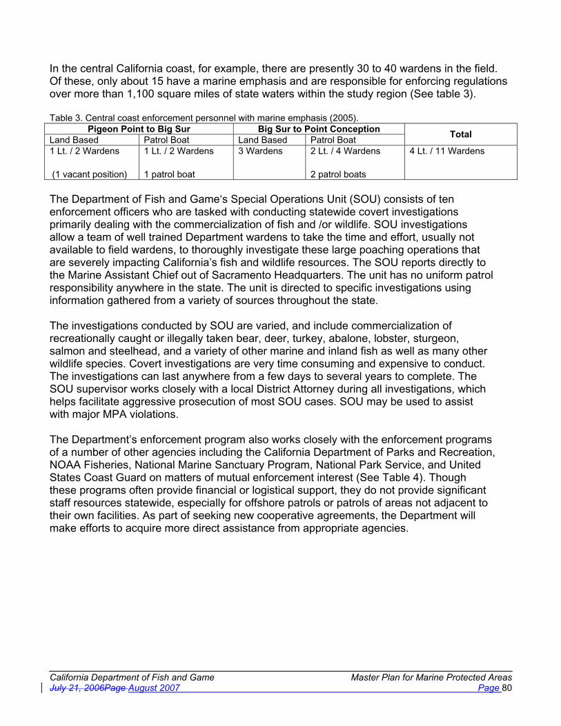
California Department of Fish and Game Master Plan for Marine Protected Areas July 21, 2006Page August 2007 Page 80
In the central California coast, for example, there are presently 30 to 40 wardens in the field. Of these, only about 15 have a marine emphasis and are responsible for enforcing regulations over more than 1,100 square miles of state waters within the study region (See table 3).
Table 3. Central coast enforcement personnel with marine emphasis (2005). Pigeon Point to Big Sur Big Sur to Point Conception
Land Based Patrol Boat Land Based Patrol Boat Total
1 Lt. / 2 Wardens
(1 vacant position)
1 Lt. / 2 Wardens
1 patrol boat
3 Wardens 2 Lt. / 4 Wardens
2 patrol boats
4 Lt. / 11 Wardens
The Department of Fish and Game‘s Special Operations Unit (SOU) consists of ten enforcement officers who are tasked with conducting statewide covert investigations primarily dealing with the commercialization of fish and /or wildlife. SOU investigations allow a team of well trained Department wardens to take the time and effort, usually not available to field wardens, to thoroughly investigate these large poaching operations that are severely impacting California’s fish and wildlife resources. The SOU reports directly to the Marine Assistant Chief out of Sacramento Headquarters. The unit has no uniform patrol responsibility anywhere in the state. The unit is directed to specific investigations using information gathered from a variety of sources throughout the state.
The investigations conducted by SOU are varied, and include commercialization of recreationally caught or illegally taken bear, deer, turkey, abalone, lobster, sturgeon, salmon and steelhead, and a variety of other marine and inland fish as well as many other wildlife species. Covert investigations are very time consuming and expensive to conduct. The investigations can last anywhere from a few days to several years to complete. The SOU supervisor works closely with a local District Attorney during all investigations, which helps facilitate aggressive prosecution of most SOU cases. SOU may be used to assist with major MPA violations.
The Department’s enforcement program also works closely with the enforcement programs of a number of other agencies including the California Department of Parks and Recreation, NOAA Fisheries, National Marine Sanctuary Program, National Park Service, and United States Coast Guard on matters of mutual enforcement interest (See Table 4). Though these programs often provide financial or logistical support, they do not provide significant staff resources statewide, especially for offshore patrols or patrols of areas not adjacent to their own facilities. As part of seeking new cooperative agreements, the Department will make efforts to acquire more direct assistance from appropriate agencies.

California Department of Fish and Game Master Plan for Marine Protected Areas July 21, 2006Page August 2007 Page 81
Table 4. Natural Resource Enforcement Assets in California Agency Assets and Activities
U.S. Coast Guard
The U.S. Coast Guard has a primary role in protecting natural resources under the Oil Pollution Act of 1990, the Rivers and Harbors Act of 1899, and the Marine Plastic Pollution and Control Act. The U.S. Coast Guard works directly with the Department’s Office of Spill Prevention and Response (OSPR) on oil pollution incidents. They also provide limited support for State and Federal fisheries regulation enforcement.
U.S. Fish and Wildlife Service U.S. Fish and Wildlife Service agents and officers have the statutory authority to enforce the Marine Mammal Protection Act, Endangered Species Act and Lacey Act.
NOAA Fisheries
The Department has a Joint Enforcement Agreement with NOAA Fisheries. NOAA Fisheries provides funding to the state to enforce federal regulations in state waters, federal offshore waters and in bays, estuaries, rivers and streams.
National Marine Sanctuaries
Currently, there are several sanctuary officers within the central coast area, patrolling the Monterey Bay National Marine Sanctuary. Boats and aircraft available for law enforcement patrols in all California Sanctuaries. Law enforcement agreements coordinate enforcement efforts, share physical resources, cross deputize state officers and provide federal funds for state operations.
National Park Service The National Park Service has enforcement personnel stationed at various federal parks along the California coast and at some of the off-shore islands.
California Department of Fish and Game
Seven large patrol boats and over twenty smaller craft are dedicated to marine patrol efforts. One large patrol boat is primarily responsible for the Channel Islands marine protected areas law enforcement patrols. Two large patrol boats are within the central coast area.
California Department of Parks and Recreation
The Department of Parks and Recreation manages approximately one third of the California coastline and has law enforcement personnel stationed in park units throughout California, many with on water patrol capability. These officers have the authority to enforce Fish and Game statutes.
Harbor Police, City Police, and Sheriffs
Local harbor districts, sheriff and police Departments often employ peace officers to conduct on-water patrols within their jurisdictions.
The MLPA places an increased importance and focus on MPAs as a tool to enhance marine resources and requires that the existing array of MPAs be improved and managed to the extent possible as a network. In order to adequately enforce MPA regulations, the Department will prioritize areas of particular concern or at particular risk and emphasize patrol of these areas. Given the Department’s other broad mandates to enforce both state and federal marine resource regulations current assets are not adequate to redirect to MPA specific patrols. The increased focus on MPAs suggested by the MLPA and the comprehensive network the act mandates will require not only a detailed enforcement plan, but additional enforcement assets.
MPA Enforcement Considerations
The level and type of enforcement activity in an individual MPA depends upon several factors. In particular, the goals and objectives of the individual MPA and its accompanying regulations dictate the enforcement needs. Specific MPA regulations and the need for or desired level of enforcement within an MPA also impact enforcement needs. In some cases, MPAs may be enforced without direct contact of individual vessels, such as in a no-take MPA where a vessel is obviously not engaged in fishing. In limited-take areas, the specific regulations may require

California Department of Fish and Game Master Plan for Marine Protected Areas July 21, 2006Page August 2007 Page 82
close examination of individual vessels to determine whether fishing activities comply with the regulations. However, while enforcement in no-take areas may consist of visual observation from a distance if the desired level of enforcement is high, they may also require careful examination of individual vessels.
Beyond the MPA classification, other elements of MPA design have implications for an effective enforcement plan. The following factors facilitate enforcement of MPAs:
� Straight line offshore boundaries which follow lines of latitude and longitude - more easily recognized by users and enforcement is simplified
� Larger shoreline lengths - provide a buffer against unintentional boundary infractions
� Proximity to cities - enhances the ability to enforce as more assets are readily available and deployment of staff and equipment is easier, however may pose problems for level of use (see below)
� Distant from heavily used areas - areas near urban development are often more heavily visited and require more enforcement effort to ensure compliance
� Fewer points of public access - Increased numbers of access points to an MPA (e.g., multiple shoreside access points versus only offshore access) require increased monitoring efforts and increased staffing
� Adjacent to the shoreline - enforceable using smaller vessels and shoreside patrol when compared to offshore MPAs with no shoreline connection
� Adjacent to onshore facilities - existing staff (e.g., state park rangers) can assist in enforcement and monitoring
The number of and distance between MPAs impacts the ability to enforce the MPA regulations. If MPAs are too far from one another, individual patrols are not able to enforce multiple areas. If MPAs are too numerous, individual patrols are not able to reach all areas. Each case would require additional enforcement personnel to cover the entire network of MPAs.
Finally, the enforcement plan must consider natural barriers to enforcement. MPAs established in areas with normally rough conditions may be difficult to patrol or access. As noted above, offshore MPAs require larger vessels and dedicated at-sea patrol. MPAs located farther offshore or more distant from ports have higher patrol costs in both time and expenses. MPAs adjacent to shore, however, may also have natural barriers to their enforceability. This would include distance from patrol bases as noted above, along with physical inaccessibility. Though MPAs in very remote and difficult-to-access areas will naturally have fewer visitors and a decreased chance of unintentional infractions, they are also uniquely suited for unobserved intentional infractions.
Enforcement Plan Objectives
The primary objective of an MPA enforcement plan is to ensure compliance with regulations designed to achieve the individual MPAs objectives. Compliance is enhanced through visible and consistent patrol and through adequate outreach to ensure public knowledge of regulations and areas. As noted above, additional enforcement personnel and assets will be required to achieve this primary objective. Increased use of cooperative agreements with other agencies may be a partial solution, but additional funding for enforcement is required for any of the solutions.
California Department of Fish and Game Master Plan for Marine Protected Areas July 21, 2006Page August 2007 Page 83
The objectives of the enforcement plan can be split into four primary categories:
1. Provide an effective and comprehensive operational ability 2. Maintain and enhance cooperative efforts with other agencies 3. Ensure public awareness of regulations and rationale 4. Provide outreach and education
The activities and funding required to implement these objectives are detailed in appendix L. In summary, the activities include:
Effective and comprehensive operational ability � Identify areas of high priority, biological sensitivity, or enforcement need � Determine MPA Network enforcement needs � Hire additional enforcement officers � Explore and acquire remote observation technology and techniques
Priorities are developed based on the potential for resource impact, level of use, and potential for infractions. High priority areas include habitats that are particularly vulnerable to damage, areas with high aggregations of critical species or species at low abundance, and areas where infractions are likely to occur or have occurred at high rates in the past.
Seek additional cooperative agreements � Develop standard operating procedures � Develop a standardized training program � Seek and support ongoing and enhanced memoranda of understanding
Ensure public awareness of regulations and rationale and provide enhanced outreach and education
� Establish a Department MPA outreach program � Develop outreach materials for enforcement staff to distribute � Establish an education advisory board � Hold public forums to educate specific groups � Develop standardized signage protocols
The Department already conducts significant outreach and educational activities. In order to ensure public awareness of MPA regulations and rationale, the Department would create specific curricula and materials dedicated to MPAs. The Department would create standards for statewide signage and information to make outreach materials consistent. Additional funding would be required for any outreach and educational activities.

California Department of Fish and Game Master Plan for Marine Protected Areas July 21, 2006Page August 2007 Page 84
Section 6: Monitoring and Adaptive Management of MPAs
In the last several decades, monitoring and evaluation have become important features of management approaches to living marine resources and the environment (NRC 1990, NRC 2001). More recently, they have become central elements in management programs intended to adapt as understanding of the managed ecosystems – both the biophysical and social systems – improves and circumstances change. In California, the legislature incorporated this adaptive approach into the Marine Life Management Act (MLMA) in 1998. Besides defining adaptive management, the MLMA requires the development of research and monitoring activities within fishery management plans [FGC Sections 90.1, 7073(b)(3), and 7081].
A year later, the legislature incorporated the principle of adaptive management as well as monitoring and evaluation of MPAs and a statewide MPA network into the MLPA in several passages. At FGC Section 2856(a)2(H), for instance, the MLPA requires that the master planinclude “[R]ecommendations for monitoring, research, and evaluation in selected areas of the preferred alternative, including existing and long-established MPAs, to assist in adaptive management of the MPA network, taking into account existing and planned research and evaluation efforts.”
In these and other ways, the MLPA emphasizes the role of monitoring and evaluation in adapting individual MPAs and the MPA network in response to new knowledge and circumstances. The adaptive management approach of the MLPA provides for futureproposals to add, modify, or eliminate MPAs based on information gained from monitoring and evaluation activities, the development of new scientific information, and input from interested parties.The MLPA requires adaptive management to ensure that a system of MPAs meets its stated goals [Section 2853 (c) (3)]. The MLPA defines adaptive management as “a management policy that seeks to improve management of biological resources, particularly in areas of scientific uncertainty, by viewing program actions as tools for learning. Actions shall be designed so that, even if they fail, they will provide useful information for future actions, and monitoring and evaluation shall be emphasized so that the interaction of different elements within marine systems may be better understood” (Section 2852 (a)). Adaptive management requires learning from current experience to improve the process of achieving the goals of the MLPA over time. The law embeds ecosystem-based adaptive management, monitoring, and evaluation into the state policies related to the management of MPAs.
This approach will require the State to develop and implement a monitoring, evaluation, and adaptive management program. The State must also develop the institutions and processes for adaptive management which do not yet exist. Two such examples are the institutions and processes by which monitoring data are collected, maintained and made useful to policy makers over long periods of time and those required to assess this information, including involvement of scientists and stakeholders and formulate recommendations to policy makers. Adaptive management, monitoring, and evaluation will be implemented at multiple spatial scales, including individual MPA, MPA networks in a region, and statewide when appropriate.
It is worth noting that the MLPA calls for monitoring and evaluation of selected areas within the preferred alternative to assist with adaptive management of the MPA network. This does not

California Department of Fish and Game Master Plan for Marine Protected Areas July 21, 2006Page August 2007 Page 85
mean that other MPAs should not also be monitored and evaluated in accordance with their own objectives and regional goals, but that the performance of selected MPAs might be used to guide future decisions over a wider area.
Monitoring and evaluation should not be done for their own sake, but to gauge the performance of an MPA in relation to its objectives. A cost effective approach in many areas may be to link these activities to other ongoing monitoring activities. Similarly there may be many opportunities to involve affected stakeholders and members of the general public in monitoring and evaluation activities as well, thus leveraging further the resources available.
Since MPAs will be implemented in a phased approach in individual regions through 2011 rather than adopted all at once statewide, the initial focus must be on developing effective monitoring programs in individual regions, including monitoring in areas both inside and outside MPAs. The final phase in developing monitoring and evaluation programs will be toevaluate and adjust these programs in individual regions to reflect a coherent program statewide.
Suggestion: Re-word the next two paragraphs of new narrative as they are confusing.
An important part of marine ecosystem management is the establishment of programs to monitor, evaluate performance, and adaptively manage the biological, social, and economic status and trends of areas within and nearby the MPAs. [What does this mean? How does one adaptively manage trends?] This chapter develops a general approach to these issues and Chapter 8 includes specifics for individual MPA network components. Long-term monitoring data are critical for understanding the status and trends of resources and identifying emerging threats to MPAs. The data will help managers, policymakers, scientists, and stakeholders determine the impacts and effectiveness of the MPA array. Data will be used to evaluate the progress towards achieving the statewide goals, regional goals and objectives, and objectives for individual MPAs established by the MLPA and by the regional stakeholder groups. They will aid in understanding the structure and function of ecosystems within the MPA system, and thereby provide an improved scientific basis for future decision-making. These data will be used for adaptive management of the MPAs.
Since MPAs will be implemented in a phased approach in individual regions through 2011, rather than adopted all at once statewide, the monitoring programs will be developed sequentially as planning is completed for each region. Nevertheless, integrating these regional monitoring programs into a coherent statewide program will be essential to ensure the resulting data can be analyzed, reported, and used to inform statewide policies. Significant economies of scale also will result if standardized methods are applied across multiple locations and regions. Early consideration should be given to how the regional monitoring programs will be integrated into the statewide system, because such integration is likely to require development of general practices – such as protocols, data standards, and information management systems – that can be applied across multiple MPAs and regions.
Clear and measurable objectives should, in turn, form the basis for the design of systems to monitor and evaluate the impacts of management actions. Monitoring and evaluation systems should explicitly address five principles (Pomeroy et al. 2004). Such programs should be:

California Department of Fish and Game Master Plan for Marine Protected Areas July 21, 2006Page August 2007 Page 86
� Useful to managers and stakeholders for improving MPA management; � Practical in use and cost; � Balanced to seek and include scientific input and public participation; � Flexible for use at different sites and in varying conditions; and � Holistic through a focus on both natural and human perspectives.
Developing a Monitoring and Evaluation Program for MPAs and Network Components
To promote consistency among monitoring and evaluation programs in different regions, a consistent process should be followed. Many of the recommendations below comeare modifiedfrom a 2004 guidebook to natural and social indicators for evaluating MPA management effectiveness (Pomeroy et al. 2004). This discussion relies heavily on the guidebook because it is comprehensive, reflects the experience from MPAs around the world, has been field tested, and relies principally upon techniques that are simple rather than complex, and therefore more likely to be implemented and sustained over the long-term. The overall intent is to ensure that progress is made to achieve the overall Goals of the MLPA. Individual MPA objectives are important in this, but should be linked to the program goals for use in evaluation.
The process below presents only the more general features of the approach presented by Pomeroy et al.; much more detail is available in the guidebook itself. In addition, monitoring and evaluation programs should reflect local conditions, constraints and opportunities. The basic steps for establishing a monitoring program are listed below and displayed in a flowchart in Figure 5.
� Identify regional goals and objectives and individual MPA objectives o Identify any overlapping goals and objectives
� Select indicators to evaluate biophysical, and socioeconomic and governance patternsand processes
o Review and prioritize indicators, o Develop quantifiable benchmarks of progress on indicators that will measure
progress toward regional goals and objectives and individual MPA objectives, and
o Identify how selected indicators and benchmarks relate to one another � Plan the evaluation
o Assess existing data; o Assess resource needs for measuring selected indicators; o Determine the audiences to receive the evaluation results; o Review relevant monitoring and evaluation programs at existing MPAs, such as
at the Channel Islands; o Identify participants in the evaluation; and o Develop a timeline and work plan for the evaluation.
� Review and revise planned monitoring and evaluation program o Conduct structured peer and public review processes, and o Make modifications in response to review
� Implement the evaluation work plan o Select methods and approach and collect data;

California Department of Fish and Game Master Plan for Marine Protected Areas July 21, 2006Page August 2007 Page 87
o Manage collected data (including identifying the data manager, providing for the long-term archiving and access to the data, and making the data available for analysis and sharing);
o Analyze collected data; and o Conduct peer review and independent evaluation to ensure robustness and
credibility of results � Communicate results and adapt management
o Share results with target audiences, and o Use results to adapt management strategies
Indicators of success include those pertaining to biophysical goals and objectives,socioeconomic goals and objectives, and governance (management) goals and objectives..Examples include, among many others, focal species abundance to determine whether resources are being sustained, household income to determine whether livelihoods affected by MPAs are being enhanced or maintained, and level of enforcement coverage and human use levels to determine if effective management strategies are in place.desired enhancement of recreational, research, and other non-consumptive opportunities is occurring. Pomeroy et al. list a total of 42 indicators (10 biophysical, 16 socioeconomic, and 16 governance) that cover combinations of 21 commonly used MPA goals and 68 commonly used objectives. The guidebook essentially provides a “toolbox” of indicators and a starting point for developing a plan. It also provides some detail on survey methods used to measure the indicators, though is not a comprehensive listing of all survey methodologies. Once regional goals and objectives are selected and individual MPA objectives determined, the guidebook and following flowchart (Figure 5) will help provide a method to establish monitoring programs.

Cal
iforn
ia D
epar
tmen
t of F
ish
and
Gam
e M
aste
r P
lan
for
Mar
ine
Pro
tect
ed A
reas
Ju
ly21
, 200
6Pag
e A
ugus
t 200
7 P
age
88
Fig
ure
5. F
low
char
t of p
roce
ss to
est
ablis
h an
d co
nduc
t a m
onito
ring
prog
ram
17.
Sta
rt P
roce
ss
C
ycle
Com
plet
e
17F
rom
Ada
pted
from
Pom
eroy
, et a
l., 2
004.
Step
1-1
: Ide
ntif
y M
PAO
vera
ll G
oals
an
d ob
ject
ives
Step
1-2
: Mat
ch
rele
vant
indi
cato
rs
toyo
ur M
PA g
oals
an
d ob
ject
ives
Step
1-3
: Rev
iew
&
prio
ritiz
e th
e in
dica
tors
iden
tifie
d
Feas
ible
to
unde
rtak
e?
Prio
ritiz
e a
sub-
set o
f in
dica
tors
Step
1-4
: Ide
ntif
y ho
w th
e se
lect
ed
indi
cato
rs r
elat
e to
on
e an
othe
r
Step
2-1
: Ass
ess
reso
urce
nee
ds f
or
mea
suri
ng y
our
indi
cato
rs
Suff
icie
nt
reso
urce
s?
Plan
to
Secu
re?
Dev
elop
a
plan
to
secu
re
reso
urce
s
Step
2-2
: Det
erm
ine
the
audi
ence
(s)
to
rece
ive
resu
lts
Impl
emen
t the
pl
an a
nd s
ecur
e th
e re
sour
ces
need
ed
Step
2-3
: Ide
ntif
y w
ho p
artic
ipat
es in
ev
alua
tion
Step
2-4
: Dev
elop
a
timel
ine
and
wor
kpla
n fo
r th
e ev
alua
tion
Step
3-1
: Im
plem
ent
eval
uatio
n w
orkp
lan
Step
3-2
: C
olle
ct D
ata
Step
3-3
: M
anag
e D
ata
Step
3-4
: A
naly
ze C
olle
cted
D
ata
Are
dat
a re
liabl
e?
Det
erm
ine
sour
ce
of e
rror
(e.
g.,
hum
an o
r sa
mpl
e)
and
adju
st p
lan
Step
3-5
: Pe
er r
evie
w a
nd
inde
pend
ent
valid
atio
n of
res
ults
Step
4-1
: Sha
re
resu
lts w
ith ta
rget
au
dien
ces
Step
4-2
: Use
re
sults
to a
dapt
m
anag
emen
t st
rate
gies
Goa
ls &
ob
ject
ives
ac
hiev
ed?
Rev
iew
and
ad
just
MPA
m
anag
emen
t pr
actic
es
Mai
ntai
n M
PAm
anag
emen
t pe
rfor
man
ce
Iter
ate
Proc
ess

California Department of Fish and Game Master Plan for Marine Protected Areas August 2007 Page 89
To achieve the purpose of informing adaptive management, the results of monitoring and evaluation must be communicated to decision makers and the public in terms that they can understand and act upon (NRC 1990). Moreover, in addition to aiding in MPA management, measuring, analyzing and communicating indicators can promote learning, sharing of knowledge and better understanding of MPA natural and social systems among scientists, resource managers, stakeholders, members of the public, and other interested parties (Pomeroy et al. 2004). To these ends, monitoring and evaluation programs for MPAs should include a communications plan that identifies the target audiences and specifies the timing, methods, and resources to regularly synthesize and present monitoring and evaluation results.
Though the results from ongoing monitoring and evaluation should be reviewed periodically, a comprehensive analysis of monitoring results should be conducted approximately every threeto five years. The longer time-frame for review takes into account the fact that biological changes are slow to occur and. Some trends are more likely to become apparent on this time scale., although others may take longer to emerge. These reviews should be transparent, include peer review, and make results available to the public. Besides evaluating monitoring methods and results, the review should evaluate whether or not the monitoring results are consistent with the objectives of the individual MPA, the goals and objectives of the region, and those of the MLPA. If the results are not consistent, the review should develop recommendations for adjustments in the management of the MPA network.
Within the above set of required components, specific monitoring methods are not prescribed.,although, as mentioned previously, some alignment of regional and statewide approaches will be desired. For example, monitoring and evaluation programs may be effective within a range of levels in intensity and sampling frequencies. They also may rely on different indicators, depending on the individual and regional MPA goals and objectives.
General Considerations in Identifying Indicators
An indicator measures the success of a management action, such as the specific design of an MPA. It is a unit of information measured over time that will make it possible to document changes in specific attributes of the MPA (Pomeroy et al. 2004). General considerations in selecting or designing an indicator include:
� Measurable - able to be recorded and analyzed in quantitative or qualitative terms. � Precise - clear meaning, with any differences in meaning well understood OR measured
the same way by different people. � Consistent - not changing over time, but always measuring the same thing.� Sensitive - changing proportionately in response to actual changes in the variables
measured.� Simple - rather than complex. � Independence defined - correlation with other indicators examined.
In selecting indicators, a monitoring and evaluation plan for an MPA or portion of the MPA network should (Pomeroy et al. 2004):
� Define and provide a brief description of the indicator;

California Department of Fish and Game Master Plan for Marine Protected Areas August 2007 Page 90
� Explain the purpose and rationale for measuring the indicator; � Consider difficulty and utility—that is, how difficult it is to measure and the relative
usefulness of information provided by the indicator; � Evaluate the required resources including people, equipment, and funding; � Specify the method and approach to collecting, analyzing, and presenting information
onhow the indicator, including sample size, andsampling design addresses issues ofspatial and temporal variation;
� Identify reference points or benchmarks against which results will be measured and timelines within which changes are expected;
� Explain how results from measuring the indicator can be used to better understand and adaptively manage the MPAprogram;
� Provide references on methods and previous uses of the indicator.
Prior knowledge of the variability in the indicators selected should be incorporated into the monitoring and evaluation design where possible. If no prior knowledge exists variation in indicators must be identified within the monitoring and evaluation program. Multiple independent indicators are required for complex systems such as in the marine environment. Consideration also should be given to the timescale within which changes in an indicator might reasonably be expected. For instance, recovery of populations of long-lived species, such as some rockfishes, may require many years; performance measures or other types of benchmarks for such indicators should reflect this longer timescale.
MPA monitoringMonitoring and evaluation programs should measure at a minimum biophysical, and socioeconomic, and governance indicators, since these dimensions of marine ecosystems are inextricably linked (Pomeroy et al. 2004). Possible indicators are described below.
Biophysical. One common focus of MPAsMPA programs is the conservation of living marine resources and habitats of California’s coastal waters. Likely biophysical goals of individual MPAs and MPA networks established under the MLPA include sustaining the abundance and diversity of marine wildlife, protecting vulnerable species and habitats, and restoring depleted populations and degraded habitats. Thus, potential biophysical indicators might include (Pomeroy et al. 2004):
� Abundance and population structure of species of high ecological or human use value; � Composition and structure of a community of organisms; � Survival of young; � Measures of ecosystem condition; � Type and level of return on fishing effort; � Water quality; and � Areas whose habitat or wildlife populations are showing signs of recovery.
Socioeconomic. Socioeconomic indicators make it possible to understand and incorporate the concerns and interests of stakeholders, to determine the impacts of management measures on stakeholders, and to document the valueuses and values of an MPA tothe program for the public and to decision makers (Pomeroy et al. 2004).

California Department of Fish and Game Master Plan for Marine Protected Areas August 2007 Page 91
PossibleExamples of possible socioeconomic indicators consistent with MLPA goals include(Pomeroy et al. 2004):
� Use data (and values of those uses) for consumptive and non-consumptive purposes, including:
o Numbers of participants o Economic effects on local communitiesMeasures of economic and to supporting
industryo Measures of perceived value and level of satisfaction derived from allowed
consumptive and non-consumptive activities o Changes in geographic and other patterns of use in and around MPAs within the
region;� LevelEffects of understanding ofallowed human impactsuses on MPA resources;� Perceptions of non-market and non-use value;� Community infrastructure and business;� Number and nature of markets; and� Volunteer and community engagement in MPA-related monitoring and education;� ShareholderStakeholder knowledge of natural history and current use patterns and
intensity.
All of these indicators would be tailored and specifically defined to reflect the conditions, resources present, use patterns and goals and objectives of each MPA or region.
Governance. By definition, MPAs are a governance tool since they limit, forbid, or otherwise control human use of marine areas and wildlife through rights and rules (Pomeroy and others 2004). Governance may include enforcement, use rights, and regulations. Goals for governance of MPAs include the following (Pomeroy et al. 2004):
� Legal certainty as indicated by legal challenges or reported failure to act because of legal uncertainty;
� Effective management structures and strategies maintained;� Effective legal structures and strategies for management maintained;� Effective public participation and representation ensured;� Management plan compliance by resource users enhanced; and� Resource use conflicts managed and reduced.
Possible governance indicators include the following:
� Local understanding of MPA regulations;� Availability of MPA administrative resources;� Existence and activity level of community organizations; � Level of public involvement; and� Clearly defined enforcement procedures.
In addition, it is important to recognize the role that volunteer monitoring activities can play in evaluation. As mentioned earlier, there may be many opportunities to leverage with existing monitoring activities in the region and to make very productive use of stakeholder, other

California Department of Fish and Game Master Plan for Marine Protected Areas August 2007 Page 92
members of the public and educational and research entities to form partnerships in conducting monitoring and management programs. For example, the Citizen Watershed Monitoring Network in the Monterey Bay National Marine Sanctuary has used a monitoring protocol developed by the U.S. Environmental Protection Agency in collecting information on water quality in the sanctuary. Information from this program has helped in determining where education and outreach efforts should be targeted, in determining how successful specific pollution reduction activities have been, and in identifying problem areas for further investigation.
Finally, monitoring and evaluation programs can benefit from engaging commercial and recreational fishermen. At the Channel Islands, in Morro Bay, Fort Bragg, and elsewhere along the California coast, fishermen, research scientists, and federal and state biologists are carrying out field projects of mutual interest, including tag-and-recapture studies that provide critical information on the movement of fish and their growth rates. Similarly, recreational fishermen have recently participated in collecting information on their catches as part of the Coastside Fishing Club’s Recreational Catch Estimation Project. The Channel Islands National Marine Sanctuary Foundation supports a Cooperative Marine Research Program which helps coordinate and fund fisheries/science cooperative monitoring projects. These initiatives are in the early stages of development, and offer important opportunities for collaboration.

California Department of Fish and Game Master Plan for Marine Protected Areas August 2007 Page 93
Section 7. Funding
Adequate funding for implementing the Marine Life Protection Act (MLPA) should be a high priority. The MLPA states that “...the commission Commission shall...implement the program [of marine protected areas] to the extent funds are available” Section 2859 (b). Consistent with this legislative intent, many participants in the MLPA Initiative advocated sufficient funding for effective management, education, enforcement, monitoring and evaluation as critical to successful implementation. Members of the California Fish and Game Commission also voiced this position, as did the leadership of the Department.
MLPA Funding History
Assembly Bill 993 (1999) enacted the MLPA to mandate the adoption by the Fish and Game Commission of a Master Plan guiding implementation of the Marine Life Protection Program.18
The MLPA specifies the Master Plan components, including recommendations for funding sources to ensure all MPA management activities are carried out and the Marine Life Protection Program is implemented.19
In signing AB 993, Governor Davis stated he was encouraging the proponents and the Department “to seek assistance from private resources to help implement the provisions of the bill.” The following year, AB 2800 (Stats.2000, Chapter 385) enacted the Marine Managed Areas Improvement Act (MMAIA), to require a standardized classification system for marine managed areas, which includes MPAs. The MMAIA expressly recognizes the need to coordinate efforts to identify opportunities for public/private partnerships,20 and is intended to work in coordination with the MLPA.21 The MLPA, in turn, requires that the Master Plan be prepared with the advice, assistance, and involvement of [fisheries] participants, marine conservationists, marine scientists, and other interested persons, and allows the Department to engage other experts to contribute to the Master Plan.22
The funding history of the current MLPA effort began with a 2004 public/private partnership between the Resources Agency, the Department, and the Resources Legacy Fund Foundation. The anticipated use of private matching funds for MLPA implementation was acknowledged in the agendas of both the Assembly Budget Subcommittee No. 3 (April 21, 2004) and the Senate Budget and Fiscal Review Subcommittee No. 2 (May 19, 2004). In appropriating $500,000 (Item 3600-001-0647), the Budget Bill (SB 1113; Stats.2004, Chapter 208) provided that the funds shall be available to match private funds for expenditure for MLPA-related activities. The Budget Bill was signed by the Governor on July 31, 2004. On August 27, 2004, the three entities executed a Memorandum of Understanding that laid the groundwork for the MLPA Initiative.
18Fish and Game Code §§ 2853(b) 2855(a). 19Fish and Game Code § 2856(a)(2)(K). 20Public Resources Code § 36601(a). 21 Fish and Game Code §§1591, 2854; Public Resources Code §§ 36750(a), 36900(b), 36900(e); See also Assembly Committee on Water, Parks, and Wildlife, Analysis of AB 2800 (1999-2000 Regular Session) April. 25, 2000; Senate Rules Committee, 3d reading analysis of AB 2800. 22Fish and Game Code § 2855(b)(4), (b)(5).

California Department of Fish and Game Master Plan for Marine Protected Areas August 2007 Page 94
In 2005, the Governor’s budget proposed $500,000 from the Environmental License Plate Fund to continue MLPA implementation. The agendas for both the Assembly Budget Subcommittee No. 3 (April 13, 2005) and the Senate Budget and Fiscal Review Subcommittee No. 2 (May 18, 2005) note the funding “is leveraging over $2 million in private foundation expenditures.” In February, the Legislative Analyst’s Office recommended that the Legislature hold the issue open pending receipt and review of the draft Master Plan Framework from the Blue Ribbon Task Force.23 After the draft Framework was transmitted to the Fish and Game Commission on May 13, 2005, the Senate Subcommittee staff recommended approving the proposal as budgeted. Consistent with the subcommittee actions, the Budget Bill (SB 77, Stats.2005, Chapter 38) appropriated $15,802,000 (Item 3600-001-0005), of which $500,000 was allocated through a Budget Change Proposal to the Marine Region for MLPA Design Management (PCA A1020) totaling $416,667.
The Governor’s January 10, 2006 budget again proposed $500,000 from the Environmental License Plate Fund to continue MLPA implementation.24 A March 30, 2006 Finance Letter included an additional $380,000 from the General Fund to fund existing Department positions that were supported by a reimbursement contract with the Resources Legacy Fund Foundation, which expires December 31, 2006.25 On April 24, 2006, Senate Subcommittee No. 2 staff recommended that it hold the issue open and request the Department to provide additional information. The Governor’s May 2006 Revision proposed $2.6 million from the General Fund to the Ocean Protection Council for MLPA implementation, together with an equivalent amount of reimbursement authority to the Department. On May 17, 2006, staff for the Senate Budget and Fiscal Review Subcommittee No. 2 recommended that it approve all MLPA proposals as budgeted. Consistent with the subcommittee actions, the Budget Bill (AB 1801, Stats.2006, Chapter 47) appropriated “at least” $ 3.47 million for MLPA implementation (Item 3600-001-0001, paragraph 8). The final approved budget for the 2006/2007 fiscal year included 11 new fulltime permanent positions for the Department to assist with planning and implementation of the MLPA along with additional one-time funds provided to both the Department and Ocean Protection Council to assist with MLPA planning and implementation. These positions and additional funding allowed the Department to establish a new organizational unit dealing specifically with MPA processes.
Blue Ribbon Task Force Input on Future Funding
Decisions about funding the MLPA involve considerations of: 1. Appropriate sources of funds; 2. Expected activities required to implement the MLPA; 3. Possible partners in funding or performing activities required to implement the MLPA; 4. Expected duration and levels of expenditures; and 5. Structures for receipt and allocation of funds.
Each of these decisions was considered by the MLPA Blue Ribbon Task Force (BRTF) and recommendations made for each.
23Analysis of the 2005-06 Budget Bill (LAO: February 2005), pp. B-63 to B-65. 24 “Environmental License Plate Fund (ELPF),” Presentation to Assembly Budget Subcommittee No. 3 (LAO: May 23, 2006), p. 2. 25Senate Budget and Fiscal Review Subcommittee No. 2 Agenda (April 24, 2006), p. 15.

California Department of Fish and Game Master Plan for Marine Protected Areas August 2007 Page 95
Appropriate Sources of Funds
Implementing the MLPA will help protect marine life and habitat and benefit Californians. Therefore, the use of general purpose, taxpayer supported resources (the General Fund for operating expenses and general obligation bonds for capital expenditures) is clearly warranted. Some particular benefits of enhanced marine life will accrue to specific users, such as recreational divers whose experiences are improved. However, these benefits may not develop for some time, or be of small magnitude to any individual, and may be administratively difficult to collect in a cost-efficient manner. At a broader geographical scale, there are likely to be economic benefits of enhanced marine life to coastal tourist businesses and to coastal property owners. Additionally, industries with operations in marine environments should reasonably expect MPAs not only to protect but also to enhance marine life over time.
Task force recommendations related to appropriate sources of funds: 1. The primary public source of funding for implementing the MLPA should be general-
purpose taxpayer funds. Efforts should be made to seek General Fund operating and general obligation bond support for the MLPA.
2. A state statute should be pursued establishing an occupancy tax on lodging in coastal areas, which is a reasonable way to capture benefits from enhanced marine life to fund implementation of the MLPA.
3. A state statute should be pursued directing fines and/or legal settlements for harmful acts in marine environments to the “Marine Life Protection Fund” (described below).
4. A state statute should be pursued establishing a presumption that costs to enhance marine life should be part of any new or renewed license or other regulatory permission for industrial activities in marine environments, to be funded by payments directed to the Marine Life Protection Fund.
5. A state statute should be pursued to allocate a share of any operating permit, or similar state, federal or local regulation, which deals with facilities, individuals or businesses that impact the ocean through discharges to the Marine Life Protection Fund.
6. A small group of interested parties should be convened to negotiate a “rigs-to-marine life” agreement to place agreed upon funds for decommissioning oil rigs into the Marine Life Protection Fund.
7. In conjunction with the above, the state should seek federal and private sector support on a matching basis.
Expected Activities Required to Implement the MLPA
California has managed individual MPAs for some time, and has recent experience with managing a network of MPAs created around the Channel Islands. This experience provides some useful information about management activities required under the MLPA. However, existing MPAs, excepting those at Channel Islands, were created before the MLPA was enacted and all were created prior to full implementation of the MLPA. The MLPA established new goals for ecosystem protection and management of both individual MPAs and networks. The management requirements and associated costs of the MLPA, therefore, go beyond the activities currently undertaken by most existing MPAs.

California Department of Fish and Game Master Plan for Marine Protected Areas August 2007 Page 96
Without specifying them in detail, it is useful to identify the different activities required for successful implementation of the MLPA, which include at least the following:
1. design, such as the process undertaken for the MLPA Central Coast Project 2. designation, including the regulatory and environmental review processes necessary to
create MPAs 3. start up, including public education regarding designation, signage, capital equipment,
and recruitment of personnel 4. baseline science, both biological and socioeconomic regarding human uses and
impacts5. operations, including management, education, personnel and enforcement 6. monitoring, including data collection, maintenance and analysis, both within and outside
individual MPAs to: 1) inform management about individual MPAs and 2) provide a basis for adaptive management
7. adaptive management processes, being the collection of information and judgments regarding the performance of individual MPAs and of networks at an ecosystem level, to change the configuration and regulations of the MPA to reflect new information and experience
8. refreshing equipment, materials and personnel as required
The first four of these activities are “one time” but will occur over several years, almost certainly past the 2011 completion date for designating marine protected areas as anticipated in the Master Plan. The remaining activities will continue as long as established MPAs remain in force.
For each activity, choices may be made about how to complete the activity (that is, steps followed to complete the activity and level of effort expended). For example, monitoring is an activity which can be undertaken in a variety of ways, with four major sets of choices needed regarding (a) what to monitor, (b) how to collect data, (c) where to collect those data, and (d) with what frequency. Choices about how to undertake activities should be made in terms of sufficiency to support management and policy decisions regarding the workings of the network of marine protected areas. There will also be choices about who “does” the needed activities. For some activities, it is possible for non-agency actors to play very large roles, with baseline science, monitoring and education being good examples. The design, adaptive management and enforcement activities will remain largely the responsibility of governments.
With respect to long-term funding, some of these activities will be fundable from bonds. Capital expenses clearly fall into this category and planning for such expenditures has been funded from bond proceeds.
Task force recommendations related to expected activities required to implement the MLPA:1. Plans to fund implementation of the MLPA should address all of the activities required
for its successful implementation, recognizing that the sources of the funds may vary and who undertakes activities may also vary over time.
2. Allocation of funds for the MLPA should be pursued in resource-focused bond proposals now pending or those developed in the future.

California Department of Fish and Game Master Plan for Marine Protected Areas August 2007 Page 97
Possible Partners in Funding or Performing Activities Required to Implement the MLPA
While the MLPA is a state statute, successful implementation can rely on partnerships. Identifying possible partners, creating the devices for joint action, and managing partnerships over time requires resources, but offers considerable promise. The list of possible partners includes other state agencies, local governments, fishermen and other users of marine resources, non-profit organizations, philanthropic organizations and volunteer groups. Partnerships can also provide access to streams of funding that are not directly available for implementing the MLPA, with examples including sharing of facilities or monitoring activities in ways that achieve the goal of MLPA implementation at lower cost. In other cases, a partner may have competencies that need not be directly provided by the state.
In developing and managing partnerships, the goal of effectively implementing the MLPA should be the criterion for entering into a partnership and the test of its success. Most partners will have goals only partially congruent with those of the MLPA and their activities will only partly match those needed by the MLPA, factors which require attention to managing the relationships. Explicit attention to partnerships contributed to the success of the Great Barrier Reef National Marine Park Authority, which has 40 individual managing partnerships.
Task force recommendations related to potential partners in funding or performing activities required to implement the MLPA:
1. Explicitly provide for the development and management of partnerships in state funding and personnel authorizations of the Department of Fish and Game.
2. Create funding mechanisms that support partnerships, which could include a joint pool of funds for marine related research to which state agencies, local governments, and philanthropic organizations could contribute, which would then fund and manage research pursuant to an agreed upon plan. Ensure legally that funds placed in joint pool or similar arrangement must be spent on MPA activities, and may not be diverted for other purposes.
Expected Duration and Levels of Expenditures
The MLPA anticipates protection of marine resources over a long period of time. The goals of protecting ecosystem integrity and habitats will continue indefinitely even as adaptive management may result in changes to specific MPAs.
Given that the statewide network of MPAs has not yet been designated, the choices about how activities are performed have not been made, and the desirability of partnerships in specific areas are not known, efforts to predict exact levels of needed funding will inevitably be inaccurate. Analyses of costs of similar or analogous programs, however, can be used to develop a reasonable range of expected expenditures. For example, an examination of the monitoring and evaluation activities associated with the Channel Islands marine protected areas and Monterey Bay National Marine Sanctuary can provide two examples of costs incurred in the activities of those two efforts to protect marine areas.

California Department of Fish and Game Master Plan for Marine Protected Areas August 2007 Page 98
As plans for implementing the MLPA are developed, closer examination of those similar or analogous programs can inform decisions regarding funding. Closer examination may lead to the conclusion that some activities can be dropped while others need to be added.
A staff analysis of the costs of similar and analogous programs suggests a range of $20-60 million annually to implement the MLPA in all California state waters. Design expenditures will be high in early years, operation and monitoring expense will build up as MPAs are designated, and adaptive management and refreshing costs will be included regularly in later years. These cost estimates will be refined as more is learned about the programs for which cost data are available but they are unlikely to change dramatically. While not large in the context of the total California State budget, expenditures in this range would be large for the Department of Fish and Game, for which the Governor’s 2006-07 budget projects $310 million in expenditures, of which only $53.6 million is from the General Fund.
Task force recommendations related to expected duration and levels of expenditures:1. Reliable long-term funding sources are needed for implementation of the MLPA and
such sources should be a significant part of a long-term funding plan. 2. Sufficient funds should be anticipated from all sources, state and other, to adequately
fund implementation of the MLPA. The best available estimates suggest total costs of several tens of millions of dollars annually. Those cost estimates should be refined, but realistic estimates of both costs and available funds should be the basis of judgments that adequate funds are available.
3. While MLPA implementation expenditures should be funded from both state and non-state sources, the state should play the lead role in ensuring adequate funding for this state program.
Structures for Receipt and Allocation of Funds
State funds for MLPA implementation will come through the established state funding mechanisms of annual budget of operating funds and bond accounts. Implementation of the MLPA would be facilitated by creating two additional structures for receipt and disbursement of funds. The first would be the “Marine Life Protection Fund” established to receive funds other than state appropriations devoted to the protection of marine life in California. The legal structure and governance of the organization should be designed to minimize risk of diversion of funds received to purposes other than marine life protection. The Marine Life Protection Fund should be structured to receive and allocate both endowment funds and capital or operating funds to be disbursed for general or specified purposes. Some sources of funds for this organization were identified above and its existence could attract other funds. The Marine Life Protection Fund would be a ready device to which organizations or individuals could direct funds to support marine life protection.
A second new structure to collect and allocate funds should focus on monitoring and evaluation activities in California ocean and estuarine waters. California has several state programs and local governments have created entities to implement monitoring and evaluation activities (e.g., Southern California Coastal Water Research Project). A similar structure could provide a device to effectuate partnerships in designing and implementing monitoring programs and in managing and analyzing data for needed policy making. This structure could

California Department of Fish and Game Master Plan for Marine Protected Areas August 2007 Page 99
be called the “California Marine Monitoring and Evaluation Institute.” A similar approach was successful in the Great Barrier Reef National Marine Park.
Task force recommendations related to structures for receipt and allocation of funds:1. A design for the “Marine Life Protection Fund” as described above be developed and
support pursued for this concept. 2. A design for the “California Marine Monitoring and Evaluation Institute” as described
above should be developed and support pursued for this concept.
California Department of Fish and Game Master Plan for Marine Protected Areas July 21, 2006Page August 2007 Page 90
Section 8. Regional MPA Management Plans NOTE: This section has been removed from the body of the draft Master Plan and inserted as a new Appendix O without change.
Suggestion: Move this section to an appendix, but move any generally applicable text to the appropriate areas of sections 1-7 of the draft master plan.

California Department of Fish and Game Master Plan for Marine Protected Areas July 21, 2006Page August 2007 Page 91
Literature Cited
Agardy, M.T. 1995. The science of conservation in the coastal zone: new insights on how to design, implement and monitor marine protected areas. IUCN Marine Conservation and Development Report, Gland, Switzerland.
Airamé, S., S. Gaines, and C. Caldow. 2003. Ecological Linkages: Marine and Estuarine Ecosystems of Central and Northern California. NOAA, National Ocean Service. Silver Spring, MD. 164 pp.
AAllen, L.G., D.J. Pondella II, and M.H. Horn (eds.) In press (2006). The Ecology of California Marine Fishes. University of California Press, Berkeley, CA.
FArmstrong, E.M. 2000. Satellite Derived Sea Surface Temperature Variability Off California During the Upwelling Season. Remote Sensing of Environment 73: 1-17.
EBailey, K.M., R.C. Rancis, and P.R. Stevens. 1982. The life history and fishery of Pacific whiting, Merluccius productus. California Cooperative Oceanic and Fishery Investigations, Report 23:81–98.
EBarnes, J.T. and D.H. Hanan. 1995. Status of the Pacific mackerel resource and fishery, 1994 and 1995. California Department of Fish & Game, Marine Resources Division, Admin. Report 95-4. 20 pp.
EBarnes, J.T., A.D. MacCall, L.D. Jacobson, and P. Wolf. 1992. Recent population trends and estimates for the Pacific sardine (Sardinops sagax). California Cooperative Oceanic Fisheries Investigations, Report 33:60-75.
CBatisse, M. 1990. Development and implementation of the Biosphere Reserve concept and its applicability to coastal regions. Environmental Conservation 17(2): 111-116.
EBaumgartner, T.R., A. Soutar, and V. Ferreira-Bartrina. 1992. Reconstruction of the history of Pacific sardine and northern anchovy populations over the past two millennia from sediments of the Santa Barbara Basin, California. California Cooperative Oceanic and Fisheries Investigations, Report 33:24–40.
Botsford, L.W., F. Micheli, and A. Hastings. 2003. Principles for the design of marine reserves. Ecological Applications 13:S25-S31.
FBreaker, L.C., and R.P. Gilliland. 1981. A satellite sequence of upwelling along the California coast. In Richards, F.A. [Ed.]. Coastal Upwelling. American Geophysical Union. Washington, D. C. Pp. 97-94.
Bureau of Land Management, Department of the Interior (2005). California Coastal National Monument Resource Management Plan, Washington, D.C.

California Department of Fish and Game Master Plan for Marine Protected Areas July 21, 2006Page August 2007 Page 92
EBurton, E. J., J. M. Cope, L. A. Kerr, and G. M. Cailliet. 2000. Biological characteristics of nearshore fishes of California: A review of existing knowledge and proposed additional studies for the Pacific Ocean interjurisdictional fisheries management plan coordination and development. Report submitted to the Pacific State Marine Fisheries Commission. http://www.dfg.ca.gov/mrd/lifehistories/report_final.html
ECailliet, G.M. and D.W. Bedford. 1983. The biology of three pelagic sharks from California waters, and their emerging fisheries: A review. California Cooperative Oceanic and Fisheries Investigations, Report 24:57-69.
ECailliet, G.M., E.K. Osada, and M. Moser. 1988. Ecological studies of sablefish in Monterey Bay. California Department of Fish & Game 74(3):132–153.
California Marine Life Protection Act Initiative. 2005. Central Coast Regional Profile, Sacramento, CA.
California Marine Life Protection Act Initiative. 2006. Draft Adaptive Management and Monitoring, Evaluation Framework, recommendation to the Blue Ribbon Task Force, February 16, 2006.
California Resources Agency and California Environmental Protection Agency (CRA and CEPA). 2004. Protecting Our Ocean" California's Action Strategy. Prepared for Governor Arnold Schwarzenegger, September 2004.
ECarlson, H. R. and R. E. Haight. 1972. Evidence for a home site and homing of adult yellowtail rockfish, Sebastes flavidus. J. Fish. Res. Bd. Canada 29:1011-1014.
FCarr, M.H. 2000. Marine protected areas: challenges and opportunities for understanding and conserving coastal marine ecosystems. Environmental Conservation. 27:106-109.
BCarr, M.H. and D.C. Reed. 1993. Conceptual issues relevant to marine harvest refuges:examples from temperate reef fishes. Canadian Journal of Aquatic Sciences and Fisheries 50:2019-2028.
ACarr, M.H. and C. Syms. In press (2006). Chapter 15: Recruitment. In: Allen, L.G., D.J. Pondella II, and M.H. Horn (eds.) The Ecology of California Marine Fishes. University of California Press, Berkeley, CA.
ECass, A.J., G.A. McFarlane, M.S. Smith, I. Barber, and K. Rutherford. 1986. Lingcod tagging in the Strait of Georgia, 1983-84. Can. MS Rep. Fish. Aquat. Sci. 1875. 49 pp.
Chavez, F.P., and C.A. Collins, 2000: Editorial: Studies of the California Current System: present past and future. Deep-Sea Res. II, Vol 47, 761-763.
Collins, C.A., N. Garfield, T.A. Rago, F.W. Rischmiller, and E. Carter, 2000: Mean structure of the inshore countercurrent and California undercurrent off Point Sur, California. Deep-Sea Res. II, Vol. 47, 765-782.
California Department of Fish and Game Master Plan for Marine Protected Areas July 21, 2006Page August 2007 Page 93
ECoombs, C. I. 1979. Reef fishes near Depoe Bay, Oregon: movement and the recreational fishery. MS thesis, Oregon State University, Corvallis.
ECulver, B. N. 1987. Results from tagging black rockfish (Sebastes melanops) off the Washington and northern Oregon coast. Pages 231-240 in Proceedings of the international rockfish symposium. University of Alaska Sea Grant Report 87-2, Fairbanks.
EDark, T.A. (ed.). 1985. Pacific whiting: the resource, industry, and management history. Marine Fisheries Review 47(2):1-98.
BEckert, G. L., Effects of the planktonic period on marine population fluctuations. Ecology: Vol. 84, 2:372–383.
Gell, F.R., and C.M. Roberts. 2003. Benefits beyond boundaries: the fishery effects of marine reserves. Trends in Ecology & Evolution 18:448-455.
FGraham, W.M., and J.L. Largier. 1997. Upwelling shadows as nearshore retention sites: the example of northern Monterey Bay. Continental Shelf Research 17(5): 509-532.
EGrantham, B.A., G.L. Eckert and A.L. Shanks. 2003. Dispersal potential of marine invertebrates in diverse habitats. Ecological Applications 13:S108-S116.
Green, R.H. 1979. Sampling Design and Statistical Methods for Environmental Biologists. John Wiley and Sons, New York. 257 pp.
EHallacher, L. E. 1984. Relocation of original territories by displaced black-and-yellow rockfish, Sebastes chrysomelas, from Carmel Bay, California. Calif. Fish and Game Bull. 70(3):158-162.
DHalpern, B. 2003. The impact of marine reserves: Do reserves work and does reserve size matter? Ecological Applications 13(1) Supplement: S117-137.
Halpern, B.S. and R.R. Warner. 2003 Matching marine reserve design to reserve objectives. Proceedings of the Royal Society of London - Series B; Biological Sciences. 270(1527). 22 September 2003. 1871-1878.
EHartman, A. R. 1987. Movement of scorpionfishes (Scorpaenidae: Sebastes and Scorpaena)in the southern California Bight. Calif. Fish and Game Bull. 73(2):68-79.
EHaugen, C.W. (ed.). 1990. The California halibut, Paralichthys californicus, resource and fisheries. California Department of Fish & Game Fish Bulletin 174.
EHeilprin, D. J. 1992. The role of olfaction in the homing ability of the blue rockfish, Sebastesmystinus, in Carmel Bay, California. MS Thesis, Moss Landing Marine Laboratories, San Jose State University. 63 pp.
Hickey, B.M., 1979: The California Current System-Hypotheses and facts. Progress in Oceanography, Vol. 8, 191-279.

California Department of Fish and Game Master Plan for Marine Protected Areas July 21, 2006Page August 2007 Page 94
Hickey, B.M., 1998: Western North America, Tip of Baja California to Vancouver Island. In: Robinson, Allan R. and Brink, Kenneth H., The Sea, Wiley, New York, pp. 345-393.
Hilborn, R., K. Stokes, J.J. Maguire, T. Smith, L.W. Botsford, J. Mangel, J. Orensanz, A. Parma, J. Rice, J. Bell, K.L. Cochrane, S. Garcia, S.J. Hall, G.P. Kirkwood, K. Sainsbury, G. Stefansson, and C. Walters. 2004. When can marine reserves improve fisheries management? Ocean & Coastal Management 47:197-205.
Hixon, M.A. and B.N. Tissot. 2007. Comparison of trawled vs untrawled mud seafloor assemblages of fish and macroinvertebrates at Coquille Bank, Oregon. J. of Exp. Mar. Biol. Ecol. In Press.
EHorton, H.F. 1989. Species profiles: Life histories and environmental requirements of coastal fishes and invertebrates (Pacific Northwest) - Dover and rock sole. Biological Report, U.S. Fish and Wildlife Service. 17 pp.
A Hyrenbach, D.K., K.A. Forney, P.K. Dayton. Marine protected areas and ocean basin management. Aquatic Conservation: Marine and Freshwater Ecosystems 10(6): 437-458.
EIanelli, J.N., R. Lauth, and L.D. Jacobson. 1994. Status of the thornyhead (Sebastolobus sp.) resource in 1994. National Marine Fisheries Service, Alaska Fisheries Science Center. 58 pp.
Jackson, J.B.C., M.X. Kirby, W.H. Berger, K.A. Bjorndal, L.W. Botsford, B.J. Bourque, R.H. Bradbury, R. Cooke, J. Erlandson, J.A. Estes, T.P. Hughes, S. Kidwell, C.B. Lange, and R.R. Warner. 2001. Historical Overfishing and the Recent Collapse of Coastal Ecosystems. Science. 293:629-637.
EJagielo, T.H. 1990. Movement of tagged lingcod Ophiodon elongatus at Neah Bay, Washington. Fish. Bull. 88(4):815-820.
Jones, P.J.S. 1994. A review and analysis of the objectives of marine nature reserves. Ocean and Coastal Management 22(3): 149-178.
AJones, P. J. S. 2002. Marine protected area strategies: issues, divergences and the search for middle ground. Reviews in Fish Biology and Fisheries. 11: 197-216.
EKarpov, K. A., D. P. Albin, and W. H. VanBuskirk. 1995. The marine recreational finfishery in northern and central California: Historical comparison (1958-1986), status of stocks (1980-1986), and effects of changes in the California Current.Bulletin Number 176 of the California Department of Fish and Game.
Kelleher, G., C. Bleakey, and S. Wells. 1995. A Global Representative System of Marine Protected Areas. Washington, D.C.: World Bank.
Kelleher, G, editor. 1999. Guidelines for Marine Protected Areas. Wales, UK: IUCN.http://www.iucn.org/themes/wcpa/pubs/pdfs/mpa_guidelines.pdf.

California Department of Fish and Game Master Plan for Marine Protected Areas July 21, 2006Page August 2007 Page 95
Kelleher G. and R. Kenchington. 1992. Guidelines for Establishing Marine Protected Areas. A Marine Conservation and Development Report. IUCN, Gland, Switzerland. vii+ 79 pp.
CKildow, J. and C. S. Colgan. 2005. California’s Ocean Economy. Report to the Resources Agency, State of California. The National Ocean Economics Program. July 2005. 156 pages. http://resources.ca.gov/press_documents/CA_Ocean_Econ_Report.pdf
EKinlan, B.P. & Gaines, S.D. 2003. Propagule dispersal in marine and terrestrial environments: A community perspective. Ecology, 84, 2007-2020.
FKlinger, T. and C. Ebbesmeyer. 2001. Using Oceanographic Linkages to Guide Marine Protected Area Network Design. Puget Sound Research. http://www.psat.wa.gov/Publications/01_proceedings/sessions/oral/4a_kling.pdf
EKramer, S.H. 1990. Habitat specificity and ontogenetic movements of juvenile California halibut, Paralichthys californicus, and other flatfishes in shallow waters of southern California. Ph.D. thesis, University of California San Diego. 266 pp.
EKrygier, E.E. and W.G. Pearcy. 1986. The role of estuarine and offshore nursery areas for young English sole, Parophrys vetulus Girard, off Oregon. U.S. Fisheries Bulletin 84:119–132.
Largier, J., 2004: The importance of retention zones in the dispersal of larvae. American Fisheries Society Symposium, 42, 105-122.
ELaurs, R.M. and R.J. Lynn. 1977. Seasonal migration of North Pacific albacore, Thunnusalalunga, into North American coastal waters: Distribution, relative abundance, and association with transition zone waters. U.S. Fishery Bulletin 75(4):795–822.
ELea, R. N., R. D. McAllister, and D. A. VenTresca. 1999. Biological aspects of nearshore rockfishes of the genus Sebastes from Central California, with notes on ecologically related sport fishes. Calif. Fish and Game Fish Bull No. 177. 109 pp.
ELeet, W.S., C.M. Dewees, and C. W. Haugen. 1992. California's living marine resources. University of California Sea Grant, Davis. 257 pp.
ELeet. W.S., C.M. Dewees, R. Klingbeil, and E. Larson. 2001. California's Living Marine Resources: A Status Report. California Department of Fish and Game. 593 pp.
ELenarz, W.H., D.A. VenTresca, W.M. Graham, F. B. Schwing, and F. Chavez. 1995. Explorations of El Nino events and associated biological population dynamics off central California. California Cooperative Oceanic Fisheries Investigations Reports. 36:106-119.
ALove, M.S., M.H. Carr and L.J. Haldorson. 1991. The ecology of substrate-associated juveniles of the genus Sebastes. Environmental Biology of Fishes 30:225-243.

California Department of Fish and Game Master Plan for Marine Protected Areas July 21, 2006Page August 2007 Page 96
ELove, M. 1996. Probably more than you want to know about the fishes of the Pacific Coast. Really Big Press, Santa Barbara, CA. 381 pp.
ELove, M.S., M. Yoklavich, and L. Thorsteinson. 2002. The rockfishes of the Northeast Pacific. University of California Press, Berkeley and Los Angeles, California. 404 pp.
EMacCall, A. D., S. Ralston, D. Pearson, and E. Williams. 1999. Status of bocaccio off California in 1999 and outlook for the next millenium. In Appendix: Status of the Pacific coast groundfish fishery through 1999 and recommended acceptable biological catches for 2000: Stock assessment and fishery evaluation. Pacific Fishery Management Council, 2130 SW Fifth Avenue, Suite 224, Portland, Oregon.
CMascia, M. 2004. Social dimensions of marine reserves. pages 164-186 In: Sobel, J and C. Dahlgren (eds) Marine Reserves: A Guide to Science, Design, and Use. Island Press, Washington DC, USA. 381 pages.
EMatthews, K. R. 1990. An experimental study of the habitat preferences and movement patterns of copper, quillback, and brown rockfishes (Sebastes spp.). Environ. Biol. Fish. 29:161-178.
EMatthews, K.R. 1992. A telemetric study of the home ranges and homing routes of lingcod Ophiodon elongatus on shallow rocky reefs off Vancouver Island, British Columbia. Fish. Bull. 90:784-790.
EMathews, S.B. and M. LaRiviere. 1987. Movement of tagged lingcod, Ophiodonelongatus, in the Pacific Northwest. Fish. Bull. 85(1):153-159.
EMathews, S. B., and M. W. Barker. 1983. Movements of rockfish (Sebastes) tagged in northern Puget Sound, Washington. Fishery Bulletin 82:916-922.
McEvoy, A.F. 1986. The Fisherman's Problem: Ecology and Law in the California Fisheries, 1850-1980. New York, Cambridge University Press. 368 pp.
EMiller, D.J. and J. Geibel. 1973. Summary of blue rockfish and lingcod life histories: A reef ecology study; and giant kelp, Macrocystis pyrifera, experiments in Monterey Bay, California. California Department of Fish & Game Fish Bulletin No. 158. 137 pp.
AMoser, H. G. and G. W. Boehlert. 1991. Ecology of pelagic larvae and juveniles of the genus Sebastes. Environmental Biology of Fishes 30: 203-224.
National Fisheries Conservation Center (NFCC). 2004. Consensus Statement: Integrating Marine Reserves and Fisheries Management. http://www.nfcc-fisheries.org/consensus.
National Marine Sanctuary Program (NMSP). 2004. Sanctuary Advisory Councils National Report. National Ocean Service. 36 pp. http://www.sanctuaries.nos.noaa.gov/special/SAC_workshop_reportfinal.pdf

California Department of Fish and Game Master Plan for Marine Protected Areas July 21, 2006Page August 2007 Page 97
National Fisheries Conservation Center (NFCC). 2004. Integrating Marine Reserve Science and Fishery Management. in NFCC Consensus Conference. http://nfcc-fisheries.org/consensus/.
National Oceanic and Atmospheric Administration (NOAA), National Marine Sanctuary Program. 2002. National Marine Sanctuary Management Plan Handbook, 3rd Edition, Silver Springs, Maryland.
National Research Council (NRC). 1990. Managing Troubled Waters: The Role of Marine Environmental Monitoring. Washington, DC: National Academy Press. 125 pp.
National Research Council (NRC). 1995. Understanding Marine Biodiversity: A Research Agenda for the Nation. National Academy Press, Washington, D.C.
A,CNational Research Council (NRC). 2001. Marine protected areas: Tools for sustaining ocean ecosystems. National Academy Press, Washington, D.C.
ANational Research Council (NRC). 2005. Understanding Marine Biodiversity. National Academy of Sciences. Washington, D.C.
Nasby-Lucas, N.M., B.W. Embly. M.A. Hixon, S.G. Merle, B.n. Tissot, and D.J. Wright. 2002. Integration of submersible transect data and high-resolution multibeam sonar imagery for a habitat-based groundfish assessment of Hecata Bank, Oregon. Fish. Bull. 100:739-751.
Nowlis, J.S. and A. Friedlander. 2004. Design and Designation of Marine Reserves, in Marine Reserves: A Guide to Science, Design, and Use, Sobel S and Dahlgren C, Eds. Island Press, Washington, DC.
Office of Management and Budget (OMB). 2004. Final Information Quality Bulletin for Peer Review. December 4, 2004. (Accessed 24 March 2004)http://www.thecre.com/pdf/peer_bulletin.pdf.
EPalumbi, S. R. 2003. Population genetics, demographic connectivity and the design of marine reserves. Ecological Applications. 13:S146-S158.
Parrish, R.R. and M.J. Tegner. 2001. California’s Variable Ocean Environment, in California’s Living Marine Resources: A Status Report, Leet, W.S., Dewees, C.M., Klingbeil, R., and Larson, E.J., Eds. California Department of Fish and Game. Pages 21-28.
EPearcy, W.G. 1992. Movements of acoustically-tagged yellowtail rockfish Sebastes flaviduson Heceta Bank, Oregon. Fish. Bull. 90:726-735.
EPereyra, W.T., W.G. Pearcy, and F.E. Carvey, Jr. 1969. Sebastes flavidus, a shelf rockfish feeding on mesopelagic fauna, with consideration of the ecological implications. J. Fish. Res. Bd. Can. 26:2211-2215.

California Department of Fish and Game Master Plan for Marine Protected Areas July 21, 2006Page August 2007 Page 98
Pickett, M., and J.D. Paduan, 2003: Wind stress curl and related upwelling in the California Current System from high resolution COAMPS reanalysis fields. J. Geophys Res., 108, 25-1 to 25-10.
Pierce, S.D., R.L. Smith, P.M. Kosro, J.A. Barth, and C.D. Wilson, 2000: Continuity of the poleward undercurrent along the eastern boundary of the mid-latitude north Pacific. Deep-Sea Res. II, Vol. 47, 811-829.
Pomeroy R.S., J.E. Parks, and L.M. Watson. 2004. How is your MPA doing? A Guidebook of Natural and Social Indicators for Evaluating Marine Protected Area Management Effectiveness. IUCN, Gland, Switzerland and Cambridge, UK. xvi + 216 p. (Accessed 17 January 2004). http://effectivempa.noaa.gov/guidebook/guidebook.html.
Pomeroy, R.S. and T. Goetze. 2003. Belize case study: Marine protected areas co-managed by Friends of Nature. Caribbean Coastal Co-management Guidelines Project. Barbados: Caribbean Conservation Association (CCA). 69 pp. http://www.ccanet.net/Downloads/BelizeMPAs.pdf.
A,DRoberts, C.M., S. Andelman, G. Branch, R.H. Bustamante, J.C. Castilla, J. Dugan, B.S. Halpern, K.D. Lafferty, H. Leslie, J. Lubchenco, D. McArdle, H.P. Possingham, M. Ruckelshaus, and R.R. Warner. 2003. Ecological criteria for evaluating candidate sites for marine reserves. Ecological Applications Supplement 13(1): 199-214.
DRoberts, C.M., S. Andelman, G. Branch, R.H. Bustamante, J.C. Castilla, J. Dugan, B.S. Halpern, K.D. Lafferty, H. Leslie, J. Lubchenco, D. McArdle, H.P. Possingham, M. Ruckelshaus, and R.R. Warner. 2003. Application of ecological criteria in selecting marine reserves and developing reserve networks. Ecological Applications 13(1) Supplement 13(1): 215-228.
DRoberts, C.M., B. Halpern, S.R. Palumbi, and R. Warner. 2001. Designing Reserve Networks: Why Small, Isolated Protected Areas Are Not Enough. Conservation Biology 2: 10-17.
Roberts, C.M. and J.P Hawkins. 2000. Fully-protected marine reserves: a guide. WWF Endangered Seas Campaign. Washington, DC and Environment Department, University of York, York YO10 5DD, UK.
Salm R.V., J. Clark, and E. Siirila. 2000. Marine and Coastal Protected Areas: A guide for planners and managers. Washington, DC: IUCN. xxi + 371 pp.
ASalomon, A.K., N.P. Waller, C. McIlhagga, R.L. Yung, C. Walters 2002. Modeling the trophic effects of marine protected area zoning policies: A case study, Aquatic Ecology, Volume 36, Issue 1, Jan 2002, Pages 85 – 95.
Scientific and Statistical Committee, Pacific Fishery Management Council (SSC). 2004. Marine reserves: objectives, rationales, fishery management implications and regulatory requirements. Pacific Fishery Management Council, Portland, Oregon.

California Department of Fish and Game Master Plan for Marine Protected Areas July 21, 2006Page August 2007 Page 99
EShanks, A.L., B. Grantham, and M.H. Carr. 2003. Propagule dispersal distance and the size and spacing of marine reserves. Ecological Applications 13:S159-169.
FService, S.K., J.A. Rice, and F. P. Chavez. 1998. Relationship between physical and biological variables during the upwelling period in Monterey Bay, California. Deep-Sea Research Part II 45: 1669-1685.
Sheehan, L. and R. Tasto. 2001. The Status of Habitats and Water Quality in California’s Coastal and Marine Environment, in California’s Living Marine Resources: A Status Report, Leet, W.S., Dewees, C.M., Klingbeil, R., and Larson, E.J., Eds. California Department of Fish and Game. Pages 29-45.
ESmith, S.E. and N. Abramson. 1990. Leopard shark Triakis semifasciata distribution, mortality rate, yield, and stock replenishment estimates based on a tagging study in San Francisco Bay. U.S. Fishery Bulletin 88(2):371–381.
EStanley, R. D., B. M. Leaman, L. Haldorson, and V. M. O'Connell. 1994. Movements of tagged adult yellowtail rockfish, Sebastes flavidus, off the west coast of North America. Fish. Bull. 92:655-663.
DStarr, R.M., V. O'Connell, and S. Ralston. 2004. Movements of lingcod (Ophiodon elongatus)in southeast Alaska: potential for increased conservation and yield from marine reserves. Canadian Journal of Fisheries and Aquatic Sciences. 61:1083-1094.
EStarr, R.M., J.N. Heine, J.M. Felton, and G.M. Cailliet. 2002. Movements of bocaccio (Sebastes paucispinis) and greenspotted (Sebastes chlorostictus) rockfishes in a Monterey submarine canyon: Implications for the design of marine reserves. Fishery Bulletin Vol. 100, No. 2. pp. 324-337.
EStarr, R.M., J.N. Heine, and K.A. Johnson. 2000. In situ techniques for tagging and tracking rockfishes. North American Journal of Fisheries Management, Vol. 20:597-609.
EStarr, R.M. and R.E. Thorne. 1998. Acoustic assessment of squid stocks. pp. 181-198 in: P.G. Rodhouse, E.G. Dawe, and R.K. O'Dor (eds.): Squid recruitment dynamics: the genus Illex as a model, the commercial Illex species and influences on variability. FAO Fish. Tech. Pap. No. 376. Rome, Italy.
AStevens, T. 2002. Rigor and representativeness in marine protected area design. Coastal Management. 30:237-248.
Stewart-Oaten, A. 1986. Problems in the analysis of environmental monitoring data. Pp. 109-132 In Schmitt, R.J., C.W. Osenberg (eds) Detection of ecological impacts: conceptual issues and application in coastal marine habitats. Academic Press, San Diego, CA.
CStoms, D.M., F.W. Davis, S.J. Andelman, M.H Carr, S.D. Gaines, B.S. Halpern, R. Hoenicke, S.G. Leibowitz, A. Leydecker, E.M.P. Madin, H. Tallis, and R.R. Warner. in press. Integrated coastal reserve planning: making the land-sea connection. Frontiers in Ecology.

California Department of Fish and Game Master Plan for Marine Protected Areas July 21, 2006Page August 2007 Page 100
FStrub, P.T., P.M. Kosro, and A. Huyer. 1991. The nature of cold filaments in the California Current system. Journal of Geophysical Research 96:14743-14768.
Tenera Environmental, Inc. 1998. Diablo Canyon Power Plant Thermal Effects Monitoring Program analysis report. Chapter 1 � Changes in the marine environment resulting from the Diablo Canyon Power Plant discharge. Pacific Gas and Electric Company, San Francisco, CA.
United Nations Food and Agriculture Organization, Committee on Fisheries (FAO). 2004. Marine protected areas (MPAs) and fisheries. COFI/2005/8.
EWilkins, M.E. 1996. Long term trends in abundance: Results of triennial bottom trawl surveys of west coast groundfish resources between 1977 and 1995. Alaska Fisheries Science Center, NMFS/NOAA, 7600 Sand Point Way NE, Seattle, Washington 98115.
EYamanaka, K.L. and L.J. Richards. 1993. Movements of transplanted lingcod, Ophiodon elongatus, determined by ultrasonic telemetry. Fish. Bull. 91:582-587.
Yoklavich, M., G. Cailliet, R.N. Lea, H.G. Greene, R. Starr, J. De Marignac, and J. Field. 2002. Deepwater habitat and fish resources associated with the Big Creek Marine Ecological Reserve. CalCOFI Rep. 43:120-140.
Yoklavich, M., H.G. Greene, G.M. Cailliet, D.E. Sullivan, R.N. Lea, and M.S. Love. 2000. Habitat associations of deep-water rockfishes in a submarine canyon: an example of a natural refuge. Fish. Bull. 98:625-641.

CALIFORNIA MARINE LIFE PROTECTION ACT
APPENDICES TO THE MASTER PLAN
California Department of Fish & Game
Revised Draft July 21, 2006
August 2007 with additional proposed changes from the MLPA Blue Ribbon Task Force, et al. in preparation for the September
12, 2007 MLPA BRTF meeting.

California Department of Fish and Game Master Plan Appendices August 2007 Page i
TABLE OF CONTENTS
Appendix A. The Marine Life Protection Act (MLPA)........................................................................................A-1
Appendix B. The Marine Managed Areas Improvement Act (MMAIA)...........................................................9B-1
Appendix C. Implementation of the Marine Life Protection Act: 1999-2004...............................................17C-1Past Funding of MLPA Activities..................................................................................................................19C-3
Appendix D. Strategy for Stakeholder and Interested Public Participation .................................................2D-1Background ....................................................................................................................................................2D-1Stakeholders Defined.....................................................................................................................................2D-2Interested Public Participation........................................................................................................................2D-3Stakeholder Participation ...............................................................................................................................2D-3Literature Cited.............................................................................................................................................26D-6
Appendix E: Social Science Tools and Methods .......................................................................................... 27E-1
Appendix F. Outline of Information Required for Marine Protected Area Proposals................................ 30F-1Summary...................................................................................................................................................... 30F-1The Setting................................................................................................................................................... 30F-1The Proposal................................................................................................................................................ 31F-2Individual MPAs within the Proposal............................................................................................................ 34F-5Attachment A to Appendix F ........................................................................................................................ 35F-6
Appendix G. Master List of Species Likely to Benefit from Marine Protected Areas................................42G-1Some Key Species Most Likely to Benefit from Marine Protected Areas in the Central Coast Study Region...........................................................................................................................G-18
Appendix H. Summary of Recent and Ongoing Processes Related to the Marine Life Protection Act Initiative ...................................................................................................................................59H-1
List of Ongoing and Recent MPA Processes...............................................................................................59H-1State, Federal and Local Agencies with MPA Interests and Their Authority to Establish MPAs.................60H-2Recent and Ongoing MPA Processes .........................................................................................................63H-5
Appendix I. List of Existing State Marine Protected Areas prior to MLPA Implementation (January 2005).................................................................................................................................................... 68I-1
Appendix J. Glossary and Defined Terms ..................................................................................................... 72J-1
Appendix K. Marine Life Protection Act Initiative Lessons Learned ReportReports from the Central Coast Regional Process ..................................................................................................................................77K-1
Appendix L. Marine Life Protection Act Initiative Estimated Long-Term Costs to Implement the California Marine Life Protection Act....................................................................................................... 78L-1
Appendix M. Marine Life Protection Act Initiative Consultant’s Adaptive Management and Monitoring and Evaluation Framework ......................................................................................................... 95M-1
Appendix N. Marine Life Protection Act Initiative Task Force Memos and Consultants’ Report on Options for Funding the Marine Life Protection Act...................................................................................145N-1

California Department of Fish and Game Master Plan Appendices August 2007 Page ii
Appendix O. Regional MPA Management Plans ...............................................................................................O-1 1: North Coast Region (California/Oregon border to Alder Creek near Point Arena) ......................................O-1 Timeline to be Determined 2: North-Central Coast Region (Alder Creek near Point Arena to Pigeon Point) ............................................O-1 Planned Completion 2009 3: San Francisco Bay Region (Waters within San Francisco Bay)..................................................................O-1 Timeline to be Determined 4: Central Coast Region (Pigeon Point to Point Conception) ..........................................................................O-1 4.1 Introduction .............................................................................................................................................O-1
Description of region .................................................................................................................................O-1Regional design and implementation considerations................................................................................O-3Regional goals, and objectives .................................................................................................................O-5Description of individual MPA boundaries (including maps), regulations, and objectives ........................O-6
4.2. General Activities and Locations .........................................................................................................O-49Baseline Scientific Monitoring and Research plan ..................................................................................O-49Long-term and Ongoing Monitoring Plan ................................................................................................O-54Outreach, Interpretation and Education plan...........................................................................................O-84Enforcement plan.....................................................................................................................................O-84
4.3. Operations ...........................................................................................................................................O-89Equipment and Facilities .........................................................................................................................O-89Staffing.....................................................................................................................................................O-89Collaborations and Potential Partnerships ..............................................................................................O-90
4.4. Costs and Funding...............................................................................................................................O-91Estimated costs .......................................................................................................................................O-91Potential funding sources ........................................................................................................................O-91
4.5. Timelines and Milestones ....................................................................................................................O-91Timeline and Criteria for Implementation ...............................................................................................O-91Timeline for Evaluation and Review of Effectiveness..............................................................................O-91
5: South Coast Region (Point Conception to U.S./Mexico Border) ...............................................................O-92 Timeline to be Determined

Appendix A. The Marine Life Protection Act (MLPA)
No changes suggested for this appendix.

Appendix B. The Marine Managed Areas Improvement Act (MMAIA)
No changes suggested for this appendix.

Appendix C. Implementation of the Marine Life Protection Act: 1999-2004
No substantive changes suggested for this appendix.

Appendix D. Strategy for Stakeholder and Interested Public Participation
No substantive changes suggested for this appendix.

Appendix E. Social Science Tools and Methods
No substantive changes suggested for this appendix.

California Department of Fish and Game Master Plan Appendices August 2007 Page F-1
Appendix F. Outline of Information Required for Marine Protected Area Proposals
The Marine Life Protection Act (MLPA) requires the development and evaluation of alternative proposals for marine protected areas (MPAs) in each biogeographical region. There are several sources of guidance regarding the contents and evaluation of MPA proposals:
� The MLPA � Discussions of the Master Plan Team established under the MLPA � Criteria developed by the State Interagency Coordinating Committee for Marine
Managed Areas pursuant to the Marine Managed Areas Improvement Act � Experience with establishing MPAs in California and elsewhere.
Distillation of this guidance will assist in developing and evaluating MPA proposals by identifying early in the process the required or desirable information, synthesis, analysis, and evaluation. The current limited capacity of state agencies to carry out all of these functions argues for encouraging the private sector to take on more of these activities. The more the information and analytical requirements of the MLPA are met by MPA proposals from the private sector, the more likely it will be that responsible agencies can carry out due diligence review of these proposals.
The proposed outline of information required for MPA proposals is based on the guidance identified above. Definition of key terms will require further discussion as part of the broader MLPA Initiative. Whether prepared by a public agency or by a private organization, a proposal should aim at addressing most, if not all, of the requirements listed below.
The outline is organized in four sections: � A summary � The setting � The proposal � Individual MPAs within the proposal
Summary � Objectives of proposal � How the proposal addresses the requirements of the MLPA and other relevant law
The Setting � Description of region
o Legal description of the boundaries of study area � Rationale for boundaries
o Species or groups of species likely to benefit from MPAs [FGC §2856(a)(2)(B)] (See list of species at www.dfg.ca.gov/mrd/mlpa/guidelines.html and www.dfg.ca.gov/mrd/mlpa/table_inv.html.)
� Distribution of these species in the region and beyond � Status of these species in the region and beyond
o Representative or unique marine ecosystems in the region [FGC §2853(b)(1)] � Distribution of these ecosystems � Status of these ecosystems (principally “function” and “integrity”)

California Department of Fish and Game Master Plan Appendices August 2007 Page F-2
o Distribution of representative and unique habitats in the region generally, and specifically for species likely to benefit:
� Rocky reefs � Intertidal zones � Sandy or soft ocean bottoms � Submerged pinnacles � Kelp forests � Submarine canyons � Seagrass beds
o Distribution of oceanic features that may influence target species, including currents and upwelling zones (FGC §2856[a]2[B])
o Current and anticipated distribution of human uses � Aquatic
� Commercial fishing � Recreational fishing � Diving � Etc.
� Terrestrial � Discharges � Recreation � Aesthetics � Other
o Current management of human activities affecting target species, ecosystems, and habitats
o Evaluation of current management of human activities affecting target species, ecosystems, and habitats in relations to the goals and objectives of the MLPA
The Proposal � Process used to develop the proposal
o Participants and their roles o Sources of information
� Gap analysis o Description of existing MPAs o Adequacy of existing management plans and funding o Target habitats and ecosystems entirely unrepresented or insufficiently protected
by existing MPAs and other management activities o Target habitats and ecosystems insufficiently protected by existing MPAs and
other management activities, without replicates in the region or with replicates too widely spaced
� Framework for regional MPA proposal
� Regional goals and objectives for a MPA proposal o Relation of goals and objectives to the MLPA generally and to resource problems
and opportunities in the region specifically
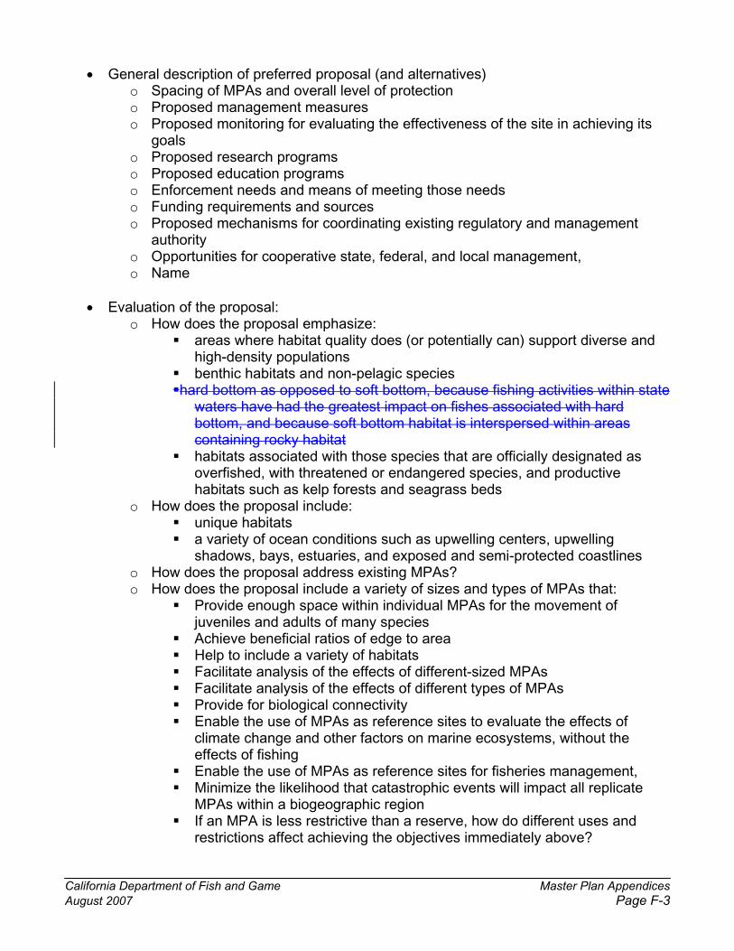
California Department of Fish and Game Master Plan Appendices August 2007 Page F-3
� General description of preferred proposal (and alternatives) o Spacing of MPAs and overall level of protection o Proposed management measures o Proposed monitoring for evaluating the effectiveness of the site in achieving its
goalso Proposed research programs o Proposed education programs o Enforcement needs and means of meeting those needs o Funding requirements and sources o Proposed mechanisms for coordinating existing regulatory and management
authorityo Opportunities for cooperative state, federal, and local management, o Name
� Evaluation of the proposal: o How does the proposal emphasize:
� areas where habitat quality does (or potentially can) support diverse and high-density populations
� benthic habitats and non-pelagic species �hard bottom as opposed to soft bottom, because fishing activities within state
waters have had the greatest impact on fishes associated with hard bottom, and because soft bottom habitat is interspersed within areas containing rocky habitat
� habitats associated with those species that are officially designated as overfished, with threatened or endangered species, and productive habitats such as kelp forests and seagrass beds
o How does the proposal include: � unique habitats � a variety of ocean conditions such as upwelling centers, upwelling
shadows, bays, estuaries, and exposed and semi-protected coastlines o How does the proposal address existing MPAs? o How does the proposal include a variety of sizes and types of MPAs that:
� Provide enough space within individual MPAs for the movement of juveniles and adults of many species
� Achieve beneficial ratios of edge to area � Help to include a variety of habitats � Facilitate analysis of the effects of different-sized MPAs � Facilitate analysis of the effects of different types of MPAs � Provide for biological connectivity � Enable the use of MPAs as reference sites to evaluate the effects of
climate change and other factors on marine ecosystems, without the effects of fishing
� Enable the use of MPAs as reference sites for fisheries management, � Minimize the likelihood that catastrophic events will impact all replicate
MPAs within a biogeographic region � If an MPA is less restrictive than a reserve, how do different uses and
restrictions affect achieving the objectives immediately above?

California Department of Fish and Game Master Plan Appendices August 2007 Page F-4
o How does the proposal use simple and easily recognizable boundaries to facilitate identification and enforcement of MPA regulations?
o Where feasible, how does the proposal locate MPAs in areas where there is onsite presence to facilitate enforcement?
o How does the proposal consider non-extractive uses, cultural resources, and existing fisheries and fishing regulations?
o How does the proposal consider proximity to ports, safe anchorage sites, and points of access, to minimize negative impacts on people and increase benefits?
o How does the proposal facilitate monitoring of MPA effectiveness by including well-studied sites, both in MPAs and unprotected areas?
o How does the proposal consider positive and negative socioeconomic consequences?
� What are the socio-economic impacts of the proposal? o Current uses:
� What are the current uses of sites within the proposal that are likely to be affected?
� What are the likely impacts of MPAs upon these uses? o Future uses:
� How are current uses expected to change in response to the sites within the proposal?
� What are the socio-economic impacts of these changes? o Costs and benefits:
� What uses are likely to benefit from sites within the proposal, and how? � What uses are likely to suffer from MPAs, and how?
� What is the improved marine reserve component of the proposal? (FGC §2857[c]) o Which habitat types are represented in at least one marine reserve in this
biogeographical region? � Do reserves include habitat types and communities across different depth
ranges?� Do reserves include habitat types and communities across different
environmental conditions?� Is each habitat type and community represented in at least one reserve in
this region?
� Which species will benefit from the proposal and how?(See list of species at www.dfg.ca.gov/mrd/mlpa/guidelines.html and www.dfg.ca.gov/mrd/mlpa/table_inv.html.)
� How does this proposal meet the goals and guidelines of the MLPA (FGC § 2853[b]): o Protect the natural diversity and abundance of marine life, and the structure,
function, and integrity of marine ecosystems; o Help sustain, conserve, and protect marine life populations, including those of
economic value, and rebuild those that are depleted; o Improve recreational, educational, and study opportunities provided by marine
ecosystems that are subject to minimal human disturbance, and to manage these uses in a manner consistent with protecting biodiversity;

California Department of Fish and Game Master Plan Appendices August 2007 Page F-5
o Protect marine natural heritage, including protection of representative and unique marine life habitats in California waters for their intrinsic value;
o Ensure that California’s MPAs have clearly defined objectives, effective management measures, and adequate enforcement, and are based on sound scientific guidelines;
o Ensure that the state’s MPAs are designed and managed, to the extent possible, as a network.
� Information necessary for fulfilling required CEQA alternative analysis.
Individual MPAs within the Proposal
� What are the boundaries of this MPA? � What is the total area of the MPA? � What is the total shoreline length of the MPA? � Does this MPA expand upon an existing MPA? � What is the overall goal of this MPA? � What are the objectives that serve this goal? � What species, populations, habitats, or ecosystem functions are of most concern in this
area?o What are the chief threats to these features?
� Which of these threats are amenable to management? o What restrictions are proposed that address these threats? o What additional restrictions or designations (e.g. water quality protection areas)
would help address these threats?� Many of the general design issues identified for the network apply here as well. � What features does the site display among those identified for different types of MPAs
by the State Interagency Coordinating Committee for Marine Managed Areas? (See Attachment A.)

California Department of Fish and Game Master Plan Appendices August 2007 Page F-6
ATTACHMENT A TO APPENDIX F
Excerpted from California State Interagency Coordinating Committee for MMAs CRITERIA FOR DESIGNATING MARINE MANAGED AREAS
Pursuant to statute, these designation criteria have been developed by the State Interagency Coordinating Committee for Marine Managed Areas to assist individuals or groups in developing site proposals. While the criteria are based on language in California law, it is not required that a site meet all of the criteria listed for a specific classification. Because different MMAs will have different goals and purposes, some of the criteria listed overlap or are mutually exclusive. All the criteria are presented here to help applicants prepare appropriate documentation. Site proposals need only address those criteria that apply to the specific site and classification being proposed (see item #6 on the application form).
[Note that the word “potential” has been added before each set of criteria in this attachment. This word has been added during development of the draft master plan framework for the MLPA Initiative and was not part of the original attachment as developed by the California State Interagency Coordinating Committee for MMAs.]
I. STATE MARINE RESERVE
A. Potential Biological Criteria 1. The proposed site will protect or restore rare, threatened, or endangered native species
or habitats.
2. The proposed site will protect outstanding, representative, or imperiled marine species, communities, habitats, or ecosystems.
3. The proposed site will protect populations of one or more fish species that have been declared “overfished” by the National Marine Fisheries Service. [seewww.nmfs.noaa.gov for list]
4. The proposed site will protect populations of harvested species that are of concern to state or federal fishery managers.
5. One or more habitats within the proposed site is/are designated as essential fish habitat (EFH) by the National Marine Fisheries Service. [see www.nmfs.noaa.gov for list]
6. The proposed site will protect habitat, or biological communities, populations, species or gene pools that are under-represented or not replicated in the existing network of state marine managed areas.
7. The proposed site will protect connections between geographic areas and/or habitat types, including estuarine and marine, wetland and intertidal, intertidal and subtidal, and deep and shallow water.
8. The proposed site is biologically highly productive.

California Department of Fish and Game Master Plan Appendices August 2007 Page F-7
9. The proposed site contains multiple habitat types.
10. The proposed site has historically received relatively heavy fishing effort, it is likely that some populations of fished species are locally depleted, and populations of fished species are expected to rebound if protected.
B. Potential Socio-Economic Criteria 1. The proposed site currently or potentially provides public access, consistent with
resource protection goals.
2. The proposed site currently or potentially provides educational and interpretive activities for the public.
3. The proposed site has historically received relatively little fishing effort.
4. Designation of the proposed site is not likely to have a significant negative socio-economic impact on those who have traditionally used the area.
5. Designation of the proposed site is likely to have a positive socio-economic impact.
6. The proposed site is bordered by similar habitat in which spillover effects from protecting one or more species could benefit those fishing adjacent to the site.
C. Potential Management and Enforcement Criteria 1. The proposed site overlaps or is adjacent to an existing protected or managed area,
thus facilitating enforcement.
2. The proposed site is adjacent to a populated area in which public stewardship would facilitate enforcement.
3. The proposed site has boundaries that are practical and enforceable.
4. Designating this site would lessen the impact of human uses on sensitive populations of marine or estuarine organisms.
5. The proposed site has little or no direct access from land, or the access is controlled.
6. The proposed site has or will have funding sources and/or in-kind resources for enforcement.
7. The proposed site has or will have funding sources and/or in-kind resources for management activities.

California Department of Fish and Game Master Plan Appendices August 2007 Page F-8
D. Potential Evaluation and Research Criteria 1. The proposed site will provide an opportunity for scientific research or monitoring in
outstanding, representative, or imperiled marine habitats or ecosystems.
2. The proposed site has or will have funding for scientific research or monitoring.
3. The proposed site has been the site of previous scientific research or monitoring studies.
4. Seafloor habitat within the proposed site has been partially or totally mapped using side-scan sonar or equivalent technology.
II. STATE MARINE PARK
A. Potential Biological Criteria 1. The proposed site will protect a spacious natural system.
2. The proposed site will protect outstanding, representative, or imperiled marine species, communities, habitats, or ecosystems.
3. The proposed site will afford some protection to populations of harvested species that are of concern to state or federal fishery managers.
4. One or more habitats within the proposed site are designated as essential fish habitat (EFH) by the National Marine Fisheries Service. [see www.nmfs.noaa.gov for list]
5. The proposed site will protect habitat, or biological communities, populations or species that are under-represented or not replicated in the existing network of state marine managed areas.
6. The proposed site will protect connections between geographic areas and/or habitat types, including estuarine and marine, wetland and intertidal, intertidal and subtidal, and deep and shallow water.
7. The proposed site is biologically highly productive.
8. The proposed site contains multiple habitat types.
9. The proposed site has historically received relatively heavy fishing effort, it is likely that some populations of fished species are locally depleted, and populations of fished species are expected to increase if protected.
10. The proposed site will protect populations of one or more fish species that have been declared “overfished” by the National Marine Fisheries Service. [seewww.nmfs.noaa.gov for list]

California Department of Fish and Game Master Plan Appendices August 2007 Page F-9
B. Potential Cultural Criteria 1. The proposed site has cultural objects or sites of historical, archaeological or scientific
interest.
C. Potential Socio-Economic Criteria 2. The proposed site currently or potentially provides public access, consistent with
resource protection goals.
3. The proposed site currently or potentially provides educational and interpretive activities for the public.
4. The proposed site will provide sustainable recreational opportunities in the absence of conflicting uses.
5. The proposed site will provide recreational opportunities to meet other than purely local needs.
6. The proposed site has historically received relatively little fishing effort.
7. Designation of the proposed site is not likely to have a significant negative socio-economic impact on those who have traditionally used the area.
8. Designation of the proposed site is likely to have a positive socio-economic impact.
9. The proposed site is bordered by similar habitat in which spillover effects from protecting one or more species could benefit those fishing adjacent to the area.
D. Potential Geological Criteria 1. The proposed site has outstanding or unique geological features that contribute to the
biological productivity of the area.
2. The proposed site has geological features that are critical to the lifecycle of native marine or estuarine species.
E. Potential Management and Enforcement Criteria 1. The proposed site overlaps or is adjacent to an existing protected or managed area,
thus facilitating enforcement.
2. The proposed site is adjacent to a populated area in which public stewardship would facilitate enforcement.
3. The proposed site has boundaries that are practical and enforceable.
4. Designating this site would lessen the impact of human activities on sensitive populations of marine or estuarine organisms.
5. The proposed site has or will have funding sources and/or in-kind resources for enforcement.

California Department of Fish and Game Master Plan Appendices August 2007 Page F-10
6. The proposed site has or will have funding sources and/or in-kind resources for management activities.
F. Potential Evaluation and Research Criteria 1. The proposed site will provide an opportunity for scientific research or monitoring in
outstanding, representative, or imperiled marine habitats or ecosystems.
2. The proposed site has or will have funding for scientific research or monitoring.
3. The proposed site has been the site of previous scientific research or monitoring studies.
4. Seafloor habitat within the proposed site has been partially or totally mapped using side-scan sonar or equivalent technology.
III. STATE MARINE CONSERVATION AREA
A. Potential Biological Criteria 1. The proposed site will protect or restore rare, threatened, or endangered native species
or habitats.
2. The proposed site will protect outstanding, representative, or imperiled marine species, communities, habitats, or ecosystems.
3. The proposed site will protect populations of one or more fish species that have been declared “overfished” by the National Marine Fisheries Service. [seewww.nmfs.noaa.gov for list]
4. The proposed site will protect populations of harvested species that are of concern to state or federal fishery managers.
5. One or more habitats within the proposed site are designated as essential fish habitat (EFH) by the National Marine Fisheries Service. [see www.nmfs.noaa.gov for list]
6. The proposed site will protect habitat, or biological communities, populations, species or gene pools that are under-represented or not replicated in the existing network of state marine managed areas.
7. The proposed site will protect connections between geographic areas and/or habitat types, including estuarine and marine, wetland and intertidal, intertidal and subtidal, and deep and shallow water.
8. The proposed site is biologically highly productive.
9. The proposed site contains multiple habitat types.

California Department of Fish and Game Master Plan Appendices August 2007 Page F-11
10. The proposed site has historically received relatively heavy fishing effort, it is likely that some populations of fished species are locally depleted, and populations of fished species are expected to rebound significantly if protected.
B. Potential Socio-Economic Criteria 1. The proposed site currently or potentially provides public access, consistent with
resource protection goals.
2. The proposed site currently or potentially provides educational and interpretive activities for the public.
3. The proposed site has historically received relatively little fishing effort.
4. Designation of the proposed site is not likely to have a significant negative socio-economic impact on those who have traditionally used the area.
5. Designation of the proposed site is likely to have a positive socio-economic impact.
6. The proposed site is bordered by similar habitat in which spillover effects from protecting one or more species could benefit those fishing adjacent to the area.
C. Potential Geological Criteria 1. The proposed site has outstanding or unique geological features that contribute to the
biological productivity of the area.
2. The proposed site has geological features that are critical to the lifecycle of native marine or estuarine species.
D. Potential Management and Enforcement Criteria 1. The proposed site overlaps or is adjacent to an existing protected or managed area,
thus facilitating enforcement.
2. The proposed site is adjacent to a populated area in which public stewardship would facilitate enforcement.
3. The proposed site has boundaries that are practical and enforceable.
4. Designating this site would lessen the impact of human activities on sensitive populations of marine or estuarine organisms.
5. The proposed site has living marine resources that if managed properly will allow for sustainable harvest.
6. The proposed site has or will have funding sources and/or in-kind resources for enforcement.
7. The proposed site has or will have funding sources and/or in-kind resources for management activities.

California Department of Fish and Game Master Plan Appendices August 2007 Page F-12
E. Potential Evaluation and Research Criteria 1. The proposed site will provide an opportunity for scientific research or monitoring in
outstanding, representative, or imperiled marine habitats or ecosystems.
2. The proposed site has or will have funding for scientific research or monitoring.
3. The proposed site has been the site of previous scientific research or monitoring studies.
4. Seafloor habitat within the proposed site has been partially or totally mapped using side-scan sonar or equivalent technology.

California Department of Fish and Game Master Plan Appendices July 21, 2006Page August 2007 Page G-1
Appendix G. Master List of Species Likely to Benefit from Marine Protected Areas
The Marine Life Protection Act requires that the Master Plan identify select species or groups of species likely to benefit from MPAs. Species likely to benefit from establishing an MPA are those whose home range, behavior, reproduction, exploitation rate or population status indicates that they may benefit from spatial management. This includes species that are directly targeted by fisheries, those which are caught incidental to fishing for the target species (bycatch) and which cannot be returned to the water with a high rate of survival, and those which may be indirectly impacted through ecological changes within MPAs. A reduction in removal of a species within MPAs has been shown worldwide to increase abundance, mean size, and reproductive potential of certain fished species1. These increases are seen primarily in fished species, though other species are also seen to increase.
An equally important consideration of whether a species may benefit is the tendency of individuals of a species, which are at or above harvestable size, to move, either ontogenetically (related to growth) or seasonally (related to spawning or migration cycles). Species with a strong tendency to move will not benefit significantly from the establishment of MPAs unless individual sites are large enough to encompass their entire range of movement. These include pelagic species such as northern anchovy, Pacific sardine, Pacific mackerel, jack mackerel, Pacific herring, and California market squid, highly migratory species such as albacore, tuna (bigeye, bluefin, yellowfin tuna, and skipjack), Pacific bonito, wahoo, opah, dolphin fish, swordfish, and striped marlin, most shark species (with the possible exception of smouthhounds, leopard, and angel sharks), and other migratory species, including chinook and cojo salmon, striped bass, yellowtail, barracuda, Pacific hake, and sablefish. However, establishing MPAs in areas which are known spawning grounds for such species would benefit stocks by allowing successful spawning by those sexually mature individuals which have not been harvested in open fishing areas.
Tables G-1 and G-2 include Californian marine species which are likely to benefit from the establishment of MPAs. The list includes both harvested species and other species that may benefit from MPAs due to reduced bycatch or habitat disturbance or enhanced ecological function due to increased abundance of harvested species. This list will be refined in each regional process to indicate which species are of particular concern and are most necessary to consider in the modification or design of MPAs. The resulting lists of “key species” most likely to benefit in each study region follow the more general list here.
1 Halpern, B.S. 2003. The impact of marine reserves: do reserves work and does reserve size matter? Ecological Applications 13(1) Supplement: S117-S137.
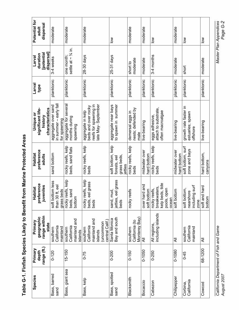
Cal
iforn
ia D
epar
tmen
t of F
ish
and
Gam
e M
aste
r P
lan
App
endi
ces
Aug
ust 2
007
P
age
G-2
Tab
le G
-1. F
infi
sh S
pec
ies
Lik
ely
to B
enef
it f
rom
Mar
ine
Pro
tect
ed A
reas
Sp
ecie
s P
rim
ary
dep
thra
ng
e (f
t.)
Pri
mar
y g
eog
rap
hic
ra
ng
e w
ith
in
stat
e
Hab
itat
p
refe
ren
ce
juve
nile
s
Hab
itat
p
refe
ren
ce
adu
lts
Un
iqu
e o
r si
gn
ific
ant
life-
his
tory
ch
arac
teri
stic
s
Lar
val
typ
e L
arva
l d
ura
tio
n[p
ote
nti
ald
isp
ersa
l]
Po
ten
tial
fo
r ad
ult
dis
per
sal
Bas
s, b
arre
d sa
nd
0-12
0 so
uthe
rn
Cal
iforn
iam
ainl
and
soft
botto
m le
ss
than
30
ft, e
el
gras
s be
ds
sand
bot
tom
ag
greg
ate
over
san
d in
sum
mer
– e
arly
fall
for
spaw
ning
plan
kton
ic
3-4
wee
ks
mod
erat
e
Bas
s, g
iant
sea
15
-150
so
uthe
rn
Cal
iforn
iam
ainl
and
and
isla
nds
rock
y re
efs,
kel
p be
ds, s
and
botto
m
rock
y re
efs,
kel
p be
ds, s
and
flats
ag
greg
ate
for
seve
ral
mon
ths
durin
g sp
awni
ng
plan
kton
ic
one
mon
th;
settl
e at
~ ¾
in.
mod
erat
e
Bas
s, k
elp
0-75
so
uthe
rn
Cal
iforn
iam
ainl
and
and
isla
nds
(unc
omm
on
cent
ral C
alif.
)
rock
y re
efs,
kel
p be
ds, e
el g
rass
be
ds
rock
y re
efs,
kel
p be
ds
aggr
egat
e in
kel
p be
ds a
nd o
ver
rock
y re
efs
for
spaw
ning
in
late
May
- S
epte
mbe
r
plan
kton
ic
28-3
0 da
ys
mod
erat
e
Bas
s, s
potte
d sa
nd
0-20
0 S
anta
Mon
ica
Bay
and
sou
th
sand
, mud
, je
tties
, eel
gra
ss
beds
soft
botto
m, k
elp
fore
sts,
eel
gr
ass
beds
, je
tties
aggr
egat
e ne
ar b
ays
to s
paw
n in
sum
mer
pl
ankt
onic
25
-31
days
lo
w
Bla
cksm
ith
0-15
0 so
uthe
rn
Cal
iforn
ia (
to
Mon
tere
y B
ay)
rock
y re
efs
rock
y re
efs,
kel
p be
ds
dem
ersa
l egg
s in
ne
sts;
def
ende
d by
m
ale
plan
kton
ic
shor
t to
mod
erat
e m
oder
ate
Boc
acci
o 0-
1050
A
ll ov
er h
ard
and
soft
botto
m
mid
wat
er o
ver
hard
bot
tom
liv
e-be
arin
g pl
ankt
onic
m
oder
ate
mod
erat
e
Cab
ezon
0-
250
All
regi
ons,
in
clud
ing
isla
nds
rock
y re
efs,
br
eakw
ater
s,
kelp
bed
s, ti
de
pool
s, o
pen
ocea
n
rock
y re
efs,
kel
p be
ds
eggs
adh
esiv
e,
atta
ch to
sub
stra
te,
ofte
n m
acro
alga
e
plan
kton
ic
3-4
mon
ths
low
Chi
lipep
per
0-10
80
All
soft
botto
m
mid
wat
er o
ver
hard
bot
tom
liv
e-be
arin
g pl
ankt
onic
m
oder
ate
mod
erat
e
Cor
bina
,C
alifo
rnia
0-45
so
uthe
rn
Cal
iforn
iam
ainl
and
soft
botto
m,
near
shor
e in
clud
ing
surf
zo
ne
soft
botto
m, s
urf
zone
and
bay
s gr
owth
rat
e fa
ster
in
estu
arie
s; s
paw
n of
fsho
re
plan
kton
ic
shor
t lo
w
Cow
cod
68-1
200
All
soft
and
hard
bo
ttom
hard
bot
tom
, ca
nyon
s liv
e-be
arin
g pl
ankt
onic
m
oder
ate
low

Cal
iforn
ia D
epar
tmen
t of F
ish
and
Gam
e M
aste
r P
lan
App
endi
ces
Aug
ust 2
007
P
age
G-3
Sp
ecie
s P
rim
ary
dep
thra
ng
e (f
t.)
Pri
mar
y g
eog
rap
hic
ra
ng
e w
ith
in
stat
e
Hab
itat
p
refe
ren
ce
juve
nile
s
Hab
itat
p
refe
ren
ce
adu
lts
Un
iqu
e o
r si
gn
ific
ant
life-
his
tory
ch
arac
teri
stic
s
Lar
val
typ
e L
arva
l d
ura
tio
n[p
ote
nti
ald
isp
ersa
l]
Po
ten
tial
fo
r ad
ult
dis
per
sal
Cro
aker
, bla
ck
0-15
0 so
uthe
rn
Cal
iforn
iam
ainl
and
soft
botto
m,
near
shor
e in
clud
ing
surf
zo
ne
soft
botto
m, s
urf
zone
; oc
casi
onal
ly
rock
y re
efs
one
of fe
w c
roak
ers
to p
refe
r ro
cky
reef
s an
d ke
lp b
eds
plan
kton
ic
shor
t lo
w
Cro
aker
, whi
te
0-42
0 A
ll; m
ost
com
mon
Poi
nt
Rey
es to
Mex
ico
bord
er
near
bot
tom
in
shal
low
sof
t ha
bita
t
soft
botto
m,
prim
arily
near
shor
e an
d es
tuar
ies
scho
olin
g; m
ultip
le
spaw
ning
eac
h ye
ar;
adul
ts in
dee
per
wat
er th
an ju
veni
les
plan
kton
ic;
larv
aebe
com
eep
iben
thic
shor
t lo
w
Cro
aker
, ye
llow
fin0-
150
mai
nlan
d, P
t. C
once
ptio
n so
uth
soft
botto
m,
near
shor
e an
d es
tuar
ies
soft
botto
m,
beac
hes
and
pier
s, e
stua
ries,
ke
lp b
eds
spaw
ning
prim
arily
in
sum
mer
pl
ankt
onic
sh
ort
low
Eel
, wol
f In
tert
idal
to
600
no
rthe
rn a
nd
cent
ral C
alifo
rnia
pe
lagi
c ro
cky
reef
s, k
elp
beds
no
t a tr
ue e
el; s
paw
n O
ct.-
Feb
ruar
y pl
ankt
onic
?1-
2 m
onth
s m
oder
ate
Flo
unde
r,
star
ry
Sha
llow
-90
0no
rthe
rn a
nd
cent
ral C
alifo
rnia
es
tuar
ies
and
bays
, nea
rsho
re
soft
botto
m
soft
botto
m;
estu
arie
s an
d ba
ys to
upp
er
slop
e
spaw
n ne
ar r
iver
m
outh
s an
d in
es
tuar
ies
and
bays
plan
kton
ic
25-7
5 da
ys
mod
erat
e
Gar
ibal
di
0-95
so
uthe
rn
Cal
iforn
iaro
cky
reef
s, k
elp
beds
ro
cky
reef
s, k
elp
beds
m
ales
gua
rd e
ggs,
at
tach
ed to
red
alg
ae
plan
kton
ic
unkn
own
low
Gob
y,bl
ueba
nded
0-
210
incl
. in
tert
idal
sout
hern
C
alifo
rnia
(unc
omm
on to
M
onte
rey)
rock
y re
efs
rock
y re
efs,
kel
p be
ds
mal
es g
uard
egg
s,
atta
ched
on
broo
d ch
ambe
rs
plan
kton
ic
unkn
own
low
Gob
y, z
ebra
In
tert
idal
to
200
so
uthe
rn
Cal
iforn
iaro
cky
reef
s ro
cky
reef
s,
usua
lly in
cr
evic
es a
nd
cave
s
dem
ersa
l egg
s,
atta
ched
to r
oof o
f sh
elte
r
plan
kton
ic
unkn
own
low
Gre
enlin
g, k
elp
0-15
0 no
rthe
rn a
nd
cent
ral C
alifo
rnia
ro
cky
reef
s, k
elp
beds
ro
cky
reef
s, k
elp
beds
eg
gs a
dher
e to
roc
ky
subs
trat
e pl
ankt
onic
un
know
n m
oder
ate
Gre
enlin
g, r
ock
shal
low
no
rthe
rn a
nd
cent
ral C
alifo
rnia
ro
cky
reef
s, k
elp
beds
ro
cky
reef
s, k
elp
beds
eg
gs a
dher
e to
roc
ky
subs
trat
e pl
ankt
onic
un
know
n m
oder
ate

Cal
iforn
ia D
epar
tmen
t of F
ish
and
Gam
e M
aste
r P
lan
App
endi
ces
Aug
ust 2
007
P
age
G-4
Sp
ecie
s P
rim
ary
dep
thra
ng
e (f
t.)
Pri
mar
y g
eog
rap
hic
ra
ng
e w
ith
in
stat
e
Hab
itat
p
refe
ren
ce
juve
nile
s
Hab
itat
p
refe
ren
ce
adu
lts
Un
iqu
e o
r si
gn
ific
ant
life-
his
tory
ch
arac
teri
stic
s
Lar
val
typ
e L
arva
l d
ura
tio
n[p
ote
nti
ald
isp
ersa
l]
Po
ten
tial
fo
r ad
ult
dis
per
sal
Gru
nion
, C
alifo
rnia
0-60
so
uthe
rn a
nd
cent
ral C
alifo
rnia
sa
ndy
near
shor
e ar
eas
sand
y ne
arsh
ore
area
s eg
gs d
epos
ited
on
sand
y be
ache
s; la
ck
filam
ents
plan
kton
ic
low
to
mod
erat
e m
oder
ate
Gui
tarf
ish,
sh
ovel
nose
0-
50
sout
hern
and
ce
ntra
l Cal
iforn
ia
as a
dults
sh
allo
w s
and
or
mud
, ope
n co
ast,
bays
, and
es
tuar
ies
live-
bear
ing
bent
hic
none
m
oder
ate
Hag
fish,
P
acifi
c 30
-309
6 A
ll ?
soft
botto
m
depo
sit e
gg c
ases
?
unkn
own
mod
erat
e
Hal
fmoo
n 0-
130
sout
hern
C
alifo
rnia
rock
y re
efs,
kel
p be
ds
rock
y re
efs,
kel
p be
ds
regu
late
s ke
lp g
row
th
by g
razi
ng
plan
kton
ic
unkn
own
mod
erat
e
Hal
ibut
,C
alifo
rnia
0-30
0 A
ll es
tuar
ies,
sh
allo
w o
pen
coas
t sof
t bo
ttom
estu
arie
s an
d so
ft bo
ttom
ope
n co
ast
dist
ribut
ion
influ
ence
d by
El N
iño
even
ts
plan
kton
ic
< 30
day
s m
oder
ate
Jack
smel
t sh
allo
w
All
kelp
and
eel
gr
ass
beds
; sa
ndy
beac
hes;
ha
rbor
s
kelp
and
eel
gr
ass
beds
; sa
ndy
beac
hes;
ha
rbor
s
eggs
with
fila
men
ts
for
atta
chm
ent t
o ee
l gr
ass
and
shal
low
al
gal b
eds
plan
kton
ic
low
m
oder
ate
Ling
cod
0-14
00
All
rock
y re
efs,
kel
p be
ds,
hard
bo
ttom
, sof
t bo
ttom
rock
y re
efs,
kel
p be
ds,
hard
bo
ttom
, sof
t bo
ttom
Spa
wns
nea
rsho
re
on r
ocky
ree
fs; m
ales
gu
ard
eggs
plan
kton
ic
3 m
onth
s hi
gh
Liza
rdfis
h,
Cal
iforn
ia5-
750
sout
hern
and
ce
ntra
l Cal
iforn
ia
prim
arily
sof
t bo
ttom
prim
arily
sof
t bo
ttom
rest
on
botto
m u
sing
pe
lvic
fins
pl
ankt
onic
un
know
n m
oder
ate
Mid
ship
man
, pl
ainf
in0-
1000
A
ll so
ft bo
ttom
so
ft bo
ttom
; sp
awn
on h
ard
subs
trat
e
Egg
s de
posi
ted
on
rock
s an
d ha
rd
subs
trat
e
plan
kton
ic
unkn
own
mod
erat
e
Opa
leye
0-
95
sout
hern
and
ce
ntra
l Cal
iforn
ia
rock
y in
tert
idal
ro
cky
reef
s, k
elp
beds
re
gula
tes
kelp
gro
wth
by
gra
zing
pl
ankt
onic
un
know
n m
oder
ate
Pac
ific
ocea
n pe
rch
180-
2100
A
ll m
idw
ater
ove
r ha
rd b
otto
m
mid
wat
er o
ver
hard
bot
tom
liv
e-be
arin
g pl
ankt
onic
m
oder
ate
mod
erat
e
Pac
ific
pom
pano
(B
utte
rfis
h)
30-3
00
All
coas
tal p
elag
ic
coas
tal p
elag
ic
a sc
hool
ing
spec
ies;
pl
ankt
onic
un
know
n m
oder
ate

Cal
iforn
ia D
epar
tmen
t of F
ish
and
Gam
e M
aste
r P
lan
App
endi
ces
Aug
ust 2
007
P
age
G-5
Sp
ecie
s P
rim
ary
dep
thra
ng
e (f
t.)
Pri
mar
y g
eog
rap
hic
ra
ng
e w
ith
in
stat
e
Hab
itat
p
refe
ren
ce
juve
nile
s
Hab
itat
p
refe
ren
ce
adu
lts
Un
iqu
e o
r si
gn
ific
ant
life-
his
tory
ch
arac
teri
stic
s
Lar
val
typ
e L
arva
l d
ura
tio
n[p
ote
nti
ald
isp
ersa
l]
Po
ten
tial
fo
r ad
ult
dis
per
sal
Pric
kleb
ack,
m
onke
yfac
e0-
80
nort
hern
and
ce
ntra
l Cal
iforn
ia
rock
y in
tert
idal
ro
cky
reef
s, k
elp
beds
de
posi
t egg
s on
ro
cky
subs
trat
e pl
ankt
onic
lo
w
low
Pric
kleb
ack,
ro
ck
0-60
no
rthe
rn a
nd
cent
ral C
alifo
rnia
ro
cky
inte
rtid
al
rock
y re
efs,
sh
allo
w
depo
sit e
ggs
on
rock
y su
bstr
ate
plan
kton
ic
low
lo
w
Que
enfis
h 0-
180
sout
hern
and
ce
ntra
l Cal
iforn
ia
soft
botto
m
shal
low
wat
er
and
sand
y bo
ttom
; in
bays
an
d sl
ough
s
spaw
n at
nig
ht fr
om
Mar
ch to
Sep
tem
ber
plan
kton
ic
shor
t m
oder
ate
Ray
, bat
0-
150
All
shal
low
sof
t bo
ttom
; bay
s an
d es
tuar
ies
shal
low
san
dy
and
rock
y ar
eas,
in
clud
ing
bays
an
d es
tuar
ies;
ke
lp b
eds
live-
bear
ing
m
inia
ture
adul
tsno
ne
mod
erat
e
Roc
kfis
h,
auro
ra
600-
1800
A
ll so
ft bo
ttom
ha
rd a
nd s
oft
botto
mliv
e-be
arin
g pl
ankt
onic
m
oder
ate
mod
erat
e
Roc
kfis
h, b
ank
102-
810
All
mid
wat
er
mid
wat
er o
ver
hard
bot
tom
, dr
op o
ffs
live-
bear
ing
plan
kton
ic
mod
erat
e m
oder
ate
Roc
kfis
h, b
lack
0-
1200
no
rthe
rn a
nd
cent
ral C
alifo
rnia
so
ft bo
ttom
ro
cky
reef
s, k
elp
fore
sts
live-
bear
ing
plan
kton
ic
mod
erat
e m
oder
ate
Roc
kfis
h,
blac
k-an
d-ye
llow
0-12
0 so
uthe
rn a
nd
cent
ral C
alifo
rnia
sh
allo
w r
ocky
re
efs
shal
low
roc
ky
reef
s, k
elp
fore
sts
live-
bear
ing
plan
kton
ic
Low
to
mod
erat
e lo
w
Roc
kfis
h,
blac
kgill
720-
1800
(ju
v.<6
60)
All
soft
botto
m
hard
bot
tom
, sof
t bo
ttom
,ca
nyon
s, s
teep
dr
op o
ffs
live-
bear
ing
plan
kton
ic
mod
erat
e m
oder
ate
Roc
kfis
h, b
lue
0-30
0 A
ll ro
cky
reef
s, k
elp
fore
sts,
sof
t bo
ttom
rock
y re
efs,
kel
p fo
rest
s liv
e-be
arin
g pl
ankt
onic
m
oder
ate
mod
erat
e
Roc
kfis
h,
brow
n 0-
420
All
low
-rel
ief h
ard
and
soft
botto
m
low
-rel
ief h
ard
and
soft
botto
m
live-
bear
ing
plan
kton
ic
low
tom
oder
ate
low

Cal
iforn
ia D
epar
tmen
t of F
ish
and
Gam
e M
aste
r P
lan
App
endi
ces
Aug
ust 2
007
P
age
G-6
Sp
ecie
s P
rim
ary
dep
thra
ng
e (f
t.)
Pri
mar
y g
eog
rap
hic
ra
ng
e w
ith
in
stat
e
Hab
itat
p
refe
ren
ce
juve
nile
s
Hab
itat
p
refe
ren
ce
adu
lts
Un
iqu
e o
r si
gn
ific
ant
life-
his
tory
ch
arac
teri
stic
s
Lar
val
typ
e L
arva
l d
ura
tio
n[p
ote
nti
ald
isp
ersa
l]
Po
ten
tial
fo
r ad
ult
dis
per
sal
Roc
kfis
h,
calic
o 60
-840
so
uthe
rn a
nd
cent
ral C
alifo
rnia
so
ft bo
ttom
ha
rd b
otto
m,
sand
-roc
k an
d m
ud-r
ock
inte
rfac
e
live-
bear
ing
plan
kton
ic
mod
erat
e lo
w
Roc
kfis
h,
cana
ry
0-90
0 no
rthe
rn a
nd
cent
ral C
alifo
rnia
so
ft bo
ttom
; sa
nd-r
ock
inte
rfac
e
mid
wat
er a
nd
near
bot
tom
ove
r ha
rd b
otto
m
live-
bear
ing
plan
kton
ic
mod
erat
e m
oder
ate
to
high
Roc
kfis
h,
Chi
na
36-4
20
nort
hern
and
ce
ntra
l Cal
iforn
ia
rock
y re
efs
rock
y re
efs,
kel
p fo
rest
s liv
e-be
arin
g pl
ankt
onic
lo
w to
m
oder
ate
low
Roc
kfis
h,
copp
er
0-60
0 A
ll ro
cky
reef
s an
d so
ft bo
ttom
ro
cky
reef
s, k
elp
fore
sts
live-
bear
ing
plan
kton
ic
mod
erat
e lo
w
Roc
kfis
h,
dark
blot
ched
24
0-18
00
All
soft
botto
m
soft
and
hard
bo
ttom
live-
bear
ing
plan
kton
ic
mod
erat
e m
oder
ate
Roc
kfis
h, fl
ag
100-
600
sout
hern
and
ce
ntra
l Cal
iforn
ia
rock
y re
efs
rock
y re
efs,
ca
nyon
s liv
e-be
arin
g pl
ankt
onic
M
oder
ate
low
Roc
kfis
h,
frec
kled
130-
550
sout
hern
C
alifo
rnia
soft
botto
m
hard
bot
tom
liv
e-be
arin
g pl
ankt
onic
M
oder
ate
low
?
Roc
kfis
h,
goph
er
0-18
0 so
uthe
rn a
nd
cent
ral C
alifo
rnia
ro
cky
reef
s ro
cky
reef
s, k
elp
fore
sts
live-
bear
ing
plan
kton
ic
low
to
mod
erat
e lo
w
Roc
kfis
h, g
rass
0-
150
All
shal
low
roc
ky
reef
ssh
allo
w r
ocky
re
efs,
kel
p fo
rest
s
live-
bear
ing
plan
kton
ic
mod
erat
e lo
w
Roc
kfis
h,
gree
nblo
tche
d 20
0-13
00
sout
hern
and
ce
ntra
l Cal
iforn
ia
soft
botto
m
hard
and
sof
t bo
ttom
, can
yons
liv
e-be
arin
g pl
ankt
onic
m
oder
ate
low
Roc
kfis
h,
gree
nspo
tted
160-
660
sout
hern
and
ce
ntra
l Cal
iforn
ia
soft
botto
m
hard
bot
tom
, ca
nyon
s liv
e-be
arin
g pl
ankt
onic
m
oder
ate
low
Roc
kfis
h,
gree
nstr
iped
20
0-13
20
All
soft
botto
m
low
rel
ief h
ard
botto
m, s
oft
botto
m
live-
bear
ing
plan
kton
ic
mod
erat
e m
oder
ate
Roc
kfis
h,
halfb
ande
d 19
2-13
20
sout
hern
and
ce
ntra
l Cal
iforn
ia
soft
botto
m
low
rel
ief h
ard
and
soft
botto
m,
cobb
le
live-
bear
ing
plan
kton
ic
mod
erat
e m
oder
ate
Roc
kfis
h,
hone
ycom
b 90
-250
so
uthe
rn
Cal
iforn
iaso
ft bo
ttom
ha
rd b
otto
m
live-
bear
ing
plan
kton
ic
mod
erat
e
Roc
kfis
h, k
elp
0-15
0 so
uthe
rn a
nd
cent
ral C
alifo
rnia
ke
lp fo
rest
s an
d ro
cky
reef
s ke
lp fo
rest
s liv
e-be
arin
g pl
ankt
onic
m
oder
ate
low

Cal
iforn
ia D
epar
tmen
t of F
ish
and
Gam
e M
aste
r P
lan
App
endi
ces
Aug
ust 2
007
P
age
G-7
Sp
ecie
s P
rim
ary
dep
thra
ng
e (f
t.)
Pri
mar
y g
eog
rap
hic
ra
ng
e w
ith
in
stat
e
Hab
itat
p
refe
ren
ce
juve
nile
s
Hab
itat
p
refe
ren
ce
adu
lts
Un
iqu
e o
r si
gn
ific
ant
life-
his
tory
ch
arac
teri
stic
s
Lar
val
typ
e L
arva
l d
ura
tio
n[p
ote
nti
ald
isp
ersa
l]
Po
ten
tial
fo
r ad
ult
dis
per
sal
Roc
kfis
h, O
live
0-48
0 so
uthe
rn a
nd
cent
ral C
alifo
rnia
ke
lp fo
rest
s, s
oft
botto
mro
cky
reef
s, k
elp
fore
sts
live-
bear
ing
plan
kton
ic
mod
erat
e lo
w
Roc
kfis
h, p
ink
250-
1200
so
uthe
rn a
nd
cent
ral C
alifo
rnia
so
ft bo
ttom
ha
rd b
otto
m,
cany
ons
live-
bear
ing
plan
kton
ic
mod
erat
e lo
w
Roc
kfis
h,
pink
rose
32
5-96
0 so
uthe
rn a
nd
cent
ral C
alifo
rnia
so
ft bo
ttom
ha
rd b
otto
m,
cany
ons
live-
bear
ing
plan
kton
ic
mod
erat
e lo
w
Roc
kfis
h,
quill
back
75-9
00
nort
hern
and
ce
ntra
l Cal
iforn
ia
rock
y re
efs
rock
y re
efs
live-
bear
ing
plan
kton
ic
mod
erat
e lo
w
Roc
kfis
h,
redb
ande
d 30
0-15
60
All
soft
botto
m
soft
and
hard
bo
ttom
live-
bear
ing
plan
kton
ic
mod
erat
e lo
w
Roc
kfis
h,
reds
trip
e 30
0-12
00
nort
hern
and
ce
ntra
l Cal
iforn
ia
hard
bot
tom
ha
rd b
otto
m
live-
bear
ing
plan
kton
ic
mod
erat
e m
oder
ate
Roc
kfis
h,
rose
thor
n 39
0-18
00
nort
hern
and
ce
ntra
l Cal
iforn
ia
soft
and
hard
bo
ttom
hard
bot
tom
, ca
nyon
s liv
e-be
arin
g pl
ankt
onic
m
oder
ate
low
Roc
kfis
h, r
osy
50
-420
A
ll so
ft an
d ha
rd
botto
mha
rd b
otto
m
live-
bear
ing
plan
kton
ic
mod
erat
e lo
w
Roc
kfis
h,
shar
pchi
n 30
0-10
50
All
hard
bot
tom
ha
rd b
otto
m
live-
bear
ing
plan
kton
ic
mod
erat
e m
oder
ate
Roc
kfis
h,
shor
tbel
ly0-
930
All
mid
wat
er o
ver
hard
bot
tom
m
idw
ater
ove
r ha
rd b
otto
m
live-
bear
ing
plan
kton
ic
mod
erat
e m
oder
ate
Roc
kfis
h,
spec
kled
10
0-12
00
All
hard
bot
tom
ha
rd b
otto
m
live-
bear
ing
plan
kton
ic
mod
erat
e m
oder
ate
Roc
kfis
h,
split
nose
70
0-15
60
All
soft
botto
m
hard
bot
tom
, ca
nyon
s liv
e-be
arin
g pl
ankt
onic
m
oder
ate
mod
erat
e
Roc
kfis
h,
squa
resp
ot
60-6
00
All
hard
bot
tom
ha
rd b
otto
m
live-
bear
ing
plan
kton
ic
mod
erat
e m
oder
ate
Roc
kfis
h,
star
ry
80-9
00
sout
hern
and
ce
ntra
l Cal
iforn
ia
hard
bot
tom
ha
rd b
otto
m
live-
bear
ing
plan
kton
ic
mod
erat
e lo
w
Roc
kfis
h,
strip
etai
l19
2-13
20
All
soft
botto
m
soft
and
hard
bo
ttom
live-
bear
ing
plan
kton
ic
mod
erat
e m
oder
ate
Roc
kfis
h,
swor
dspi
ne
250-
1420
so
uthe
rn a
nd
cent
ral C
alifo
rnia
so
ft bo
ttom
ha
rd b
otto
m,
cany
ons
live-
bear
ing
plan
kton
ic
mod
erat
e lo
w
Roc
kfis
h, ti
ger
200-
900
nort
hern
and
ce
ntra
l Cal
iforn
ia
hard
bot
tom
ha
rd b
otto
m
live-
bear
ing
plan
kton
ic
mod
erat
e lo
w

Cal
iforn
ia D
epar
tmen
t of F
ish
and
Gam
e M
aste
r P
lan
App
endi
ces
Aug
ust 2
007
P
age
G-8
Sp
ecie
s P
rim
ary
dep
thra
ng
e (f
t.)
Pri
mar
y g
eog
rap
hic
ra
ng
e w
ith
in
stat
e
Hab
itat
p
refe
ren
ce
juve
nile
s
Hab
itat
p
refe
ren
ce
adu
lts
Un
iqu
e o
r si
gn
ific
ant
life-
his
tory
ch
arac
teri
stic
s
Lar
val
typ
e L
arva
l d
ura
tio
n[p
ote
nti
ald
isp
ersa
l]
Po
ten
tial
fo
r ad
ult
dis
per
sal
Roc
kfis
h,
tree
fish
0-15
0 so
uthe
rn a
nd
cent
ral C
alifo
rnia
ro
cky
reef
s ro
cky
reef
s, k
elp
fore
sts
live-
bear
ing
plan
kton
ic
mod
erat
e lo
w
Roc
kfis
h,
verm
ilion
0-90
0 A
ll so
ft an
d ha
rd
botto
mw
ide
dept
h ra
nge,
roc
ky
reef
s, k
elp
fore
sts,
can
yons
live-
bear
ing
plan
kton
ic
mod
erat
e lo
w
Roc
kfis
h,
wid
ow
0-12
00
All
mid
wat
er o
ver
hard
bot
tom
m
idw
ater
ove
r ha
rd b
otto
m
live-
bear
ing
plan
kton
ic
mod
erat
e m
oder
ate
Roc
kfis
h,
yello
wey
e 15
0-12
00
nort
hern
and
ce
ntra
l Cal
iforn
ia
rock
y re
efs
hard
bot
tom
, ca
nyon
s liv
e-be
arin
g pl
ankt
onic
m
oder
ate
low
Roc
kfis
h,
yello
wta
il0-
1800
A
ll m
idw
ater
m
idw
ater
ove
r ha
rd b
otto
m
live-
bear
ing
plan
kton
ic
mod
erat
e m
oder
ate
San
ddab
, P
acifi
c 30
-180
0 A
ll so
ft bo
ttom
so
ft bo
ttom
m
ay s
paw
n tw
ice
a ye
arpl
ankt
onic
un
know
n m
oder
ate
Sar
go
0-13
0 so
uthe
rn
Cal
iforn
iaro
cky
reef
s, k
elp
beds
, san
d ro
cky
reef
s, k
elp
beds
, san
d bo
ttom
broa
dcas
t spa
wne
rs
plan
kton
ic
unkn
own
mod
erat
e
Sco
rpio
nfis
h,
Cal
iforn
ia0-
600
sout
hern
C
alifo
rnia
reef
sys
tem
s ha
rd a
nd s
oft
botto
mad
ults
agg
rega
te in
12
to 3
60 fe
et to
sp
awn;
egg
s re
leas
ed in
ge
latin
ous
mas
ses
that
floa
t to
surf
ace
plan
kton
ic
unkn
own
low
Scu
lpin
,st
agho
rn
0-30
0 A
ll so
ft bo
ttom
, es
tuar
ies
soft
botto
m,
estu
arie
s ab
unda
nt in
San
F
ranc
isco
est
uary
pl
ankt
onic
un
know
n m
oder
ate
Sea
bass
, whi
te
0-40
0 so
uthe
rn a
nd
cent
ral C
alifo
rnia
oc
curs
fart
her
nort
h du
ring
El
Niñ
o ev
ents
sand
y ar
ea,
estu
arie
s, p
iers
, je
tties
, kel
p be
ds
kelp
bed
s. r
ocky
re
efs,
offs
hore
ba
nks,
ope
n oc
ean
adul
ts a
ggre
gate
in
sprin
g-su
mm
er
durin
g sp
awni
ng
plan
kton
ic
hi
gh
Sha
rk, b
row
n sm
ooth
houn
d 0-
360
All
bays
and
es
tuar
ies
soft
botto
m,
bays
and
es
tuar
ies,
ne
arsh
ore
live-
bear
ing
min
iatu
re
adul
tsze
ro
mod
erat
e

Cal
iforn
ia D
epar
tmen
t of F
ish
and
Gam
e M
aste
r P
lan
App
endi
ces
Aug
ust 2
007
P
age
G-9
Sp
ecie
s P
rim
ary
dep
thra
ng
e (f
t.)
Pri
mar
y g
eog
rap
hic
ra
ng
e w
ith
in
stat
e
Hab
itat
p
refe
ren
ce
juve
nile
s
Hab
itat
p
refe
ren
ce
adu
lts
Un
iqu
e o
r si
gn
ific
ant
life-
his
tory
ch
arac
teri
stic
s
Lar
val
typ
e L
arva
l d
ura
tio
n[p
ote
nti
ald
isp
ersa
l]
Po
ten
tial
fo
r ad
ult
dis
per
sal
Sha
rk, g
ray
smoo
thho
und
0-15
0 A
ll ba
ys a
nd
estu
arie
s so
ft bo
ttom
, ba
ys a
nd
estu
arie
s,
near
shor
e
live-
bear
ing
min
iatu
re
adul
tsze
ro
mod
erat
e
Sha
rk, h
orn
0-49
2 so
uthe
rn
Cal
iforn
iaro
cky
reef
s, k
elp
beds
ro
cky
reef
s, k
elp
beds
la
y eg
g ca
ses
m
inia
ture
ad
ults
zero
m
oder
ate
Sha
rk, l
eopa
rd
0-30
0 A
ll en
clos
ed b
ays
and
slou
ghs;
ke
lp b
eds;
sh
allo
w s
andy
ar
eas
encl
osed
bay
s an
d sl
ough
s;
kelp
bed
s;
shal
low
san
dy
area
s ne
ar r
eefs
aggr
egat
e in
ver
y sh
allo
w w
ater
to
rele
ase
youn
g; l
ive-
bear
ing
min
iatu
read
ults
zero
m
oder
ate
Sha
rk, P
acifi
c an
gel
3-60
0 so
uthe
rn a
nd
cent
ral C
alifo
rnia
fla
t, sa
ndy
botto
ms;
fla
t, sa
ndy
botto
ms;
san
d ch
anne
ls
betw
een
reef
s
live-
bear
ing
min
iatu
re
adul
tsze
ro
mod
erat
e
She
ephe
ad,
Cal
iforn
ia0-
180
sout
hern
and
ce
ntra
l Cal
iforn
ia
rock
y re
efs,
kel
p be
ds
rock
y re
efs,
kel
p be
ds
chan
ges
sex
from
fe
mal
e to
mal
e w
ith
size
plan
kton
ic
unkn
own
low
Ska
te, b
ig
10-3
60
nort
hern
and
ce
ntra
l Cal
iforn
ia
soft
botto
m
soft
botto
m,
occa
sion
ally
ro
cky
reef
s
youn
g ha
tch
from
eg
gs in
cas
es
min
iatu
read
ults
zero
m
oder
ate
Ska
te,
Cal
iforn
ia60
-220
0 A
ll so
ft bo
ttom
so
ft bo
ttom
yo
ung
hatc
h fr
om
eggs
in c
ases
m
inia
ture
adul
tsze
ro
mod
erat
e
Ska
te,
long
nose
18
0-20
40
All
soft
botto
m
soft
botto
m
youn
g ha
tch
from
eg
gs in
cas
es
min
iatu
read
ults
zero
m
oder
ate
Sm
elt,
nigh
t 0-
420
nort
hern
and
ce
ntra
l Cal
iforn
ia
soft
botto
m
shal
low
san
dy
coas
tal a
reas
sp
awn
in s
urf z
one
at
nigh
tpl
ankt
onic
lo
w to
m
oder
ate
mod
erat
e
Sm
elt,
surf
sh
allo
w
nort
hern
and
ce
ntra
l Cal
iforn
ia
soft
botto
m
shal
low
san
dy
coas
tal a
reas
sp
awn
in s
urf z
one
in
dayt
ime
plan
kton
ic
low
to
mod
erat
e m
oder
ate
Sm
elt,
whi
teba
it 0-
180
nort
hern
and
ce
ntra
l Cal
iforn
ia
soft
botto
m
shal
low
san
dy
coas
tal a
reas
, ba
ys, a
nd
estu
arie
s
spaw
n in
san
dy
subt
idal
are
as
plan
kton
ic
low
to
mod
erat
e m
oder
ate
Sol
e, D
over
60
-300
0 A
ll so
ft bo
ttom
, de
ep w
ater
so
ft bo
ttom
, de
ep w
ater
a
port
ion
of th
e st
ock
mig
rate
s pl
ankt
onic
at
leas
t 1 y
ear
mod
erat
e
Sol
e, E
nglis
h 60
-100
0 A
ll so
ft bo
ttom
, sh
elf
soft
botto
m
mig
rate
s, s
paw
ns a
t 20
0-36
0 ft
plan
kton
ic
6-10
wee
ks
mod
erat
e

Cal
iforn
ia D
epar
tmen
t of F
ish
and
Gam
e M
aste
r P
lan
App
endi
ces
Aug
ust 2
007
P
age
G-1
0
Sp
ecie
s P
rim
ary
dep
thra
ng
e (f
t.)
Pri
mar
y g
eog
rap
hic
ra
ng
e w
ith
in
stat
e
Hab
itat
p
refe
ren
ce
juve
nile
s
Hab
itat
p
refe
ren
ce
adu
lts
Un
iqu
e o
r si
gn
ific
ant
life-
his
tory
ch
arac
teri
stic
s
Lar
val
typ
e L
arva
l d
ura
tio
n[p
ote
nti
ald
isp
ersa
l]
Po
ten
tial
fo
r ad
ult
dis
per
sal
Sol
e, p
etra
le
60-1
500
All
soft
and
hard
bo
ttom
, she
lf so
ft an
d ha
rd
botto
m, s
helf
mig
rate
s, s
paw
ns a
t 90
0-12
00 ft
pl
ankt
onic
un
know
n m
oder
ate
Sol
e, r
ex
60-2
100
All
Sof
t bot
tom
, sh
elf a
nd s
lope
so
ft bo
ttom
, sh
elf a
nd s
lope
sp
awns
at 3
00-9
00 ft
pl
ankt
onic
at
leas
t 1 y
ear
mod
erat
e
Sol
e, r
ock
50-1
200
nort
hern
and
ce
ntra
l Cal
iforn
ia
soft
and
hard
bo
ttom
, she
lf so
ft an
d ha
rd
botto
m, s
helf
one
of fe
w fl
atfis
hes
foun
d on
roc
ky
botto
m
plan
kton
ic
unkn
own
mod
erat
e
Sol
e, s
and
5-31
2 no
rthe
rn a
nd
cent
ral C
alifo
rnia
S
oft b
otto
m,
near
shor
e,
estu
arie
s
soft
botto
m,
near
shor
e on
e of
few
med
ium
-la
rge
flatfi
sh fo
und
insh
ore
plan
kton
ic
unkn
own
mod
erat
e
Sol
e, s
lend
er
250-
1700
A
ll so
ft bo
ttom
, sh
elf a
nd s
lope
so
ft bo
ttom
, sh
elf a
nd s
lope
re
lativ
ely
abun
dant
of
fsho
re s
peci
es
plan
kton
ic
mod
erat
e m
oder
ate
Sur
fper
ch,
barr
ed0-
240
sout
hern
and
ce
ntra
l Cal
iforn
ia
beac
hes
beac
hes
bear
live
, fre
e-sw
imm
ing
youn
g no
tap
plic
able
no
t app
licab
le
mod
erat
e
Sur
fper
ch,
blac
k0-
130
All
rock
y re
ef, k
elp
beds
ro
cky
reef
, kel
p be
ds
bear
live
, fre
e-sw
imm
ing
youn
g no
tap
plic
able
no
t app
licab
le
mod
erat
e
Sur
fper
ch,
calic
o 0-
30
All
beac
hes
beac
hes
bear
live
, fre
e-sw
imm
ing
youn
g no
tap
plic
able
no
t app
licab
le
mod
erat
e
Sur
fper
ch, p
ile
0-15
0 A
ll ro
cky
reef
s, k
elp
beds
, sof
t bo
ttom
rock
y re
efs,
kel
p be
ds, s
oft
botto
m
bear
live
, fre
e-sw
imm
ing
youn
g no
tap
plic
able
no
t app
licab
le
mod
erat
e
Sur
fper
ch,
rain
bow
0-
130
All
rock
y re
ef, k
elp
beds
ro
cky
reef
, kel
p be
ds
bear
live
, fre
e-sw
imm
ing
youn
g no
tap
plic
able
no
t app
licab
le
mod
erat
e
Sur
fper
ch,
redt
ail
0-60
no
rthe
rn a
nd
cent
ral C
alifo
rnia
be
ache
s be
ache
s be
ar li
ve, f
ree-
swim
min
g yo
ung
not
appl
icab
le
not a
pplic
able
m
oder
ate
Sur
fper
ch,
rubb
erlip
0-
150
All
rock
y re
efs,
kel
p be
ds, s
oft
botto
m
rock
y re
efs,
kel
p be
ds, s
oft
botto
m
bear
live
, fre
e-sw
imm
ing
youn
g no
tap
plic
able
no
t app
licab
le
mod
erat
e
Sur
fper
ch,
shin
er
0-48
0 A
ll es
tuar
ies,
sof
t bo
ttom
, kel
p be
ds, r
ocky
ree
f
estu
arie
s, s
oft
botto
m, k
elp
beds
, roc
ky r
eef
bear
live
, fre
e-sw
imm
ing
youn
g no
tap
plic
able
no
t app
licab
le
mod
erat
e to
hi
gh(?
)
Sur
fper
ch,
strip
ed
0-55
A
ll ro
cky
reef
, kel
p be
ds
rock
y re
ef, k
elp
beds
be
ar li
ve, f
ree-
swim
min
g yo
ung
not
appl
icab
le
not a
pplic
able
m
oder
ate
Sur
fper
ch,
wal
leye
0-60
A
ll be
ache
s be
ache
s be
ar li
ve, f
ree-
swim
min
g yo
ung
not
appl
icab
le
not a
pplic
able
m
oder
ate

Cal
iforn
ia D
epar
tmen
t of F
ish
and
Gam
e M
aste
r P
lan
App
endi
ces
Aug
ust 2
007
P
age
G-1
1
Sp
ecie
s P
rim
ary
dep
thra
ng
e (f
t.)
Pri
mar
y g
eog
rap
hic
ra
ng
e w
ith
in
stat
e
Hab
itat
p
refe
ren
ce
juve
nile
s
Hab
itat
p
refe
ren
ce
adu
lts
Un
iqu
e o
r si
gn
ific
ant
life-
his
tory
ch
arac
teri
stic
s
Lar
val
typ
e L
arva
l d
ura
tio
n[p
ote
nti
ald
isp
ersa
l]
Po
ten
tial
fo
r ad
ult
dis
per
sal
Sur
fper
ch,
whi
te0-
140
All
rock
y re
efs,
kel
p be
ds, s
oft
botto
m
rock
y re
efs,
kel
p be
ds, s
oft
botto
m
bear
live
, fre
e-sw
imm
ing
youn
g no
tap
plic
able
no
t app
licab
le
mod
erat
e
Tho
rnyh
ead,
lo
ngsp
ine
1090
-50
00A
ll de
ep h
ard
and
soft
botto
m
deep
har
d an
d so
ft bo
ttom
; sl
ope
lack
sw
im b
ladd
er;
may
sur
vive
afte
r be
ing
brou
ght t
o su
rfac
e an
d re
leas
ed;
spaw
n ge
latin
ous
float
ing
egg
mas
ses
plan
kton
ic
unkn
own
mod
erat
e to
hi
gh
Tho
rnyh
ead,
sh
orts
pine
84
-500
0+
All
deep
har
d an
d so
ft bo
ttom
de
ep h
ard
and
soft
botto
m;
slop
e
lack
sw
im b
ladd
er;
may
sur
vive
afte
r be
ing
brou
ght t
o su
rfac
e an
d re
leas
ed;
spaw
n ge
latin
ous
float
ing
egg
mas
ses
plan
kton
ic
unkn
own
mod
erat
e to
hi
gh
Tom
cod,
Pac
ific
0-72
0 no
rthe
rn a
nd
cent
ral C
alifo
rnia
un
know
n so
ft bo
ttom
br
oadc
ast s
paw
ners
; hi
gh fe
cund
ity
plan
kton
ic
unkn
own
mod
erat
e
Top
smel
t sh
allo
w
All
kelp
and
eel
gr
ass
beds
; sa
ndy
beac
hes,
ha
rbor
s
kelp
and
eel
gr
ass
beds
; sa
ndy
beac
hes,
ha
rbor
s
spaw
ns in
eel
gra
ss
and
alga
l bed
s,
poss
ibly
kel
p be
ds;
eggs
atta
ch to
sp
awni
ng s
ubst
rate
by
adh
esiv
e fil
amen
ts
plan
kton
ic
low
m
oder
ate
Tur
bot,
C-O
sh
allo
w-
966
All
rock
y re
ef, s
and;
sh
elf
rock
y re
ef, s
and;
sh
elf
one
of fe
w fl
atfis
hes
to o
ccur
in k
elp
beds
pl
ankt
onic
un
know
n m
oder
ate
Tur
bot,
curlf
in
25-1
146
All
soft
botto
m
soft
botto
m;
shel
fsm
all m
outh
; diff
icul
t to
cat
ch w
ith h
ook-
and-
line
plan
kton
ic
unkn
own
mod
erat
e
Whi
tefis
h,oc
ean
0-30
0 so
uthe
rn a
nd
cent
ral C
alifo
rnia
un
know
n m
idw
ater
ove
r ha
rd a
nd s
oft
botto
m
resp
onds
favo
rabl
y to
E
l Niñ
o co
nditi
ons
plan
kton
ic
unkn
own
mod
erat
e

Cal
iforn
ia D
epar
tmen
t of F
ish
and
Gam
e M
aste
r P
lan
App
endi
ces
Aug
ust 2
007
P
age
G-1
2
Tab
le G
-2. I
nve
rteb
rate
, Alg
a, a
nd
Pla
nt
Sp
ecie
s L
ikel
y to
Ben
efit
fro
m M
arin
e P
rote
cted
Are
as
Sp
ecie
s P
rim
ary
dep
thra
ng
e (f
t.)
Pri
mar
y g
eog
rap
hic
ra
ng
e w
ith
in
stat
e
Hab
itat
p
refe
ren
ce
juve
nile
s
Hab
itat
p
refe
ren
ce
adu
lts
Un
iqu
e o
r si
gn
ific
ant
life-
his
tory
ch
arac
teri
stic
s
Lar
val
typ
e L
arva
l d
ura
tio
n[p
ote
nti
ald
isp
ersa
l]
Po
ten
tial
fo
r ad
ult
dis
per
sal
Inve
rteb
rate
s
Aba
lone
, bla
ck
Inte
rtid
al
sout
hern
and
ce
ntra
l Cal
iforn
ia
crev
ices
in r
ocky
re
efs,
kel
p be
ds
rock
y re
efs,
kel
p be
ds
susc
eptib
le to
w
ither
ing
synd
rom
e di
seas
e
plan
kton
ic
4-7
days
lo
w
Aba
lone
, fla
t 20
-70
All
regi
ons,
in
clud
ing
isla
nds
crev
ices
in r
ocky
re
efs,
kel
p be
ds
rock
y re
efs,
kel
p be
ds
gene
rally
a c
rypt
ic
spec
ies
plan
kton
ic
4-7
days
lo
w
Aba
lone
, gre
en
subt
idal
T
o 20
S
outh
, mai
nlan
d an
d is
land
s cr
evic
es in
roc
ky
reef
s, k
elp
beds
ro
cky
reef
s, k
elp
beds
fe
ed o
n dr
ift a
lgae
pl
ankt
onic
4-
7 da
ys
low
Aba
lone
, pin
k 20
-120
S
outh
, mai
nlan
d an
d is
land
s cr
evic
es in
roc
ky
reef
s, k
elp
beds
. ro
ck o
utcr
ops
rock
y re
efs,
kel
p be
ds. r
ock
outc
rops
gene
rally
occ
urs
whe
re w
ater
tem
p is
ab
ove
14 C
plan
kton
ic
4-7
days
lo
w
Aba
lone
, pin
to
subt
idal
to
70no
rthe
rn a
nd
cent
ral C
alifo
rnia
cr
evic
es in
roc
ky
reef
s, k
elp
beds
ro
cky
reef
s, k
elp
beds
co
mm
only
foun
d at
ap
prox
. 4-in
ch le
ngth
pl
ankt
onic
4-
7 da
ys
low
Aba
lone
, red
In
tert
idal
to
80
All
regi
ons,
in
clud
ing
isla
nds
crev
ices
in r
ocky
re
efs,
kel
p be
ds,
boul
der
outc
rops
, und
er
cano
py o
f red
ur
chin
s
rock
y re
efs,
kel
p be
ds, b
ould
er
outc
rops
larg
est a
balo
ne
spec
ies
in th
e w
orld
pl
ankt
onic
4-
7 da
ys
low
Aba
lone
,th
read
ed
20-8
0 S
outh
, mai
nlan
d an
d is
land
s cr
evic
es in
roc
ky
reef
s, k
elp
beds
ro
cky
reef
s, k
elp
beds
so
me
cons
ider
it a
su
bspe
cies
of P
into
ab
alon
e
plan
kton
ic
4-7
days
lo
w
Aba
lone
, whi
te
80-2
00
Sou
th, m
ainl
and
and
isla
nds
expo
sed
rock
y ar
eas
expo
sed
rock
y ar
eas
max
imum
age
es
timat
ed a
t 40
year
s pl
ankt
onic
4-
7 da
ys
low
Cla
m,
Cal
iforn
iaja
ckkn
ife
Inte
rtid
alto
Sou
th, m
ainl
and
and
isla
nds
sand
y m
ud,
estu
arie
s sa
ndy
mud
, es
tuar
ies
occu
pies
a
perm
anen
t bur
row
pl
ankt
onic
un
know
n lo
w
Cla
m, c
hion
e (s
ever
al
spec
ies)
Inte
rtid
alto
165
S
outh
, mai
nlan
d an
d is
land
s m
ud, s
and,
es
tuar
ies
mud
, san
d,
estu
arie
s sm
ooth
chi
one
subj
ect t
o ha
bita
t los
s du
e to
har
bor
deve
lopm
ent
plan
kton
ic
unkn
own
low

Cal
iforn
ia D
epar
tmen
t of F
ish
and
Gam
e M
aste
r P
lan
App
endi
ces
Aug
ust 2
007
P
age
G-1
3
Sp
ecie
s P
rim
ary
dep
thra
ng
e (f
t.)
Pri
mar
y g
eog
rap
hic
ra
ng
e w
ith
in
stat
e
Hab
itat
p
refe
ren
ce
juve
nile
s
Hab
itat
p
refe
ren
ce
adu
lts
Un
iqu
e o
r si
gn
ific
ant
life-
his
tory
ch
arac
teri
stic
s
Lar
val
typ
e L
arva
l d
ura
tio
n[p
ote
nti
ald
isp
ersa
l]
Po
ten
tial
fo
r ad
ult
dis
per
sal
Cla
m, g
aper
(s
ever
al
spec
ies)
Inte
rtid
alto
150
A
ll re
gion
s
sand
, san
d/m
ud,
estu
arie
s sa
nd, s
and/
mud
, es
tuar
ies
may
live
to 1
7 ye
ars
plan
kton
ic
unkn
own
low
Cla
m, g
eodu
ck
0-36
0 A
ll re
gion
s sa
nd/m
ud,
estu
arie
s sa
nd/m
ud,
estu
arie
s in
divi
dual
s m
ay
exce
ed 1
0 po
unds
pl
ankt
onic
2
wee
ks
low
Cla
m, l
ittle
neck
(s
ever
al
spec
ies)
Inte
rtid
al
All
regi
ons,
in
clud
ing
isla
nds
cobb
le b
eds
cobb
le b
eds
priz
ed fo
od it
em
plan
kton
ic
unkn
own
low
Cla
m, M
anila
In
tert
idal
A
ll re
gion
s sa
nd/m
ud,
estu
arie
s sa
nd/m
ud,
estu
arie
s in
trod
uced
from
Ja
pan;
impo
rtan
t re
crea
tiona
l spe
cies
plan
kton
ic
3 w
eeks
lo
w
Cla
m, P
ism
o In
tert
idal
to
80
sout
hern
and
ce
ntra
l Cal
iforn
ia
expo
sed
sand
ex
pose
d sa
nd
prim
ary
prey
item
of
Cal
iforn
ia s
ea o
tters
pl
ankt
onic
pe
lagi
c ph
ase
2-3
days
lo
w
Cla
m, r
azor
In
tert
idal
an
dsh
allo
w
subt
idal
nort
hern
and
ce
ntra
l Cal
iforn
ia
expo
sed
sand
ex
pose
d sa
nd
indi
vidu
als
can
bury
th
emse
lves
in 7
se
cond
s
plan
kton
ic
8 w
eeks
lo
w
Cla
m, s
ofts
hell
Inte
rtid
al
nort
hern
and
ce
ntra
l Cal
iforn
ia
mud
m
ud
may
hav
e be
en
intr
oduc
ed w
ith
east
ern
oyst
er
plan
kton
ic
unkn
own
low
Cla
m,
Was
hing
ton
(sev
eral
sp
ecie
s)
Inte
rtid
alto
100
A
ll re
gion
s sa
nd/m
ud,
estu
arie
s sa
nd/m
ud,
estu
arie
s kn
own
to c
once
ntra
te
para
lytic
she
llfis
h po
ison
ing
toxi
n
plan
kton
ic
4 w
eeks
Lo
w
Coc
kles
In
tert
idal
to
660
A
ll re
gion
s,
incl
udin
g is
land
s sa
nd, s
and/
mud
, m
ud, e
stua
ries
sand
, san
d/m
ud,
mud
, est
uarie
s on
e sp
ecie
s m
ay li
ve
to 1
6 ye
ars
plan
kton
ic
unkn
own
Low
Cra
b, b
ox
0-18
00
All
regi
ons,
in
clud
ing
isla
nds
rock
y re
ef,
subm
arin
e ca
nyon
s
rock
y re
ef,
subm
arin
e ca
nyon
s
unkn
own
plan
kton
ic
unkn
own
unkn
own
Cra
b, b
row
n ro
ck
0-30
0 A
ll re
gion
s,
incl
udin
g is
land
s ro
cky
reef
s, k
elp
beds
, ro
cky
reef
s, k
elp
beds
, ro
ck c
rabs
may
live
5-
6 ye
ars
plan
kton
ic
3-4
mon
ths
mod
erat
e
Cra
b,
Dun
gene
ss
0-30
0 no
rthe
rn a
nd
cent
ral C
alifo
rnia
sa
nd, s
and-
mud
, es
tuar
ies
sand
, san
d-m
ud
larv
ae m
ay b
e tr
ans-
po
rted
mor
e th
an 5
0 m
iles
offs
hore
plan
kton
ic
105-
125
days
m
oder
ate

Cal
iforn
ia D
epar
tmen
t of F
ish
and
Gam
e M
aste
r P
lan
App
endi
ces
Aug
ust 2
007
P
age
G-1
4
Sp
ecie
s P
rim
ary
dep
thra
ng
e (f
t.)
Pri
mar
y g
eog
rap
hic
ra
ng
e w
ith
in
stat
e
Hab
itat
p
refe
ren
ce
juve
nile
s
Hab
itat
p
refe
ren
ce
adu
lts
Un
iqu
e o
r si
gn
ific
ant
life-
his
tory
ch
arac
teri
stic
s
Lar
val
typ
e L
arva
l d
ura
tio
n[p
ote
nti
ald
isp
ersa
l]
Po
ten
tial
fo
r ad
ult
dis
per
sal
Cra
b, r
ed r
ock
0-75
0 A
ll re
gion
s,
incl
udin
g is
land
s ro
cky
reef
s,
subm
arin
e ca
nyon
s
rock
y re
efs,
su
bmar
ine
cany
ons
may
co-
occu
r w
ith
spot
pra
wns
pl
ankt
onic
3-
4 m
onth
s m
oder
ate
Cra
b, s
and
Inte
rtid
al
All
regi
ons,
in
clud
ing
isla
nds
inte
rtid
al,
shal
low
sub
tidal
sa
nd
inte
rtid
al,
shal
low
sub
tidal
sa
nd
larv
ae m
ay o
ccur
with
D
unge
ness
cra
b la
rvae
plan
kton
ic
unkn
own
low
Cra
b, s
pide
r (s
heep
cra
b)
20-4
10
sout
hern
C
alifo
rnia
rock
y re
efs,
kel
p be
ds
rock
y re
efs,
kel
p be
ds
ceas
e m
oltin
g af
ter
reac
hing
mat
urity
pl
ankt
onic
un
know
n m
oder
ate-
high
Cra
b, y
ello
w
rock
0-
300
sout
hern
C
alifo
rnia
sand
, sof
t bo
ttom
sand
, sof
t bo
ttom
egg-
bear
ing
fem
ales
m
ay c
ongr
egat
e in
ro
ck-s
and
inte
rfac
e ha
bita
t
plan
kton
ic
3-4
mon
ths
mod
erat
e
Cuc
umbe
r, s
ea
(sev
eral
sp
ecie
s)
0-30
0 A
ll re
gion
s,
incl
udin
g is
land
s ro
cky
reef
s,
sand
/mud
ro
cky
reef
s,
sand
/mud
do
not
form
spa
wni
ng
aggr
egat
ions
pl
ankt
onic
51
-91
days
lo
w
Lim
pets
In
tert
idal
to
100
All
regi
ons,
in
clud
ing
isla
nds
rock
y re
efs
rock
y re
efs
som
e sp
ecie
s m
ay
live
15 y
ears
pl
ankt
onic
le
ss th
an 1
w
eek
Low
Lobs
ter,
C
alifo
rnia
0- 2
40
Sou
th, m
ainl
and
and
isla
nds
surf
gra
ss b
eds
rock
y re
ef, k
elp
beds
, eel
gra
ss
beds
egg-
bear
ing
fem
ales
ge
nera
lly fo
und
in
shal
low
wat
er
plan
kton
ic
5-9
mon
ths
mod
erat
e-hi
gh
Mus
sels
(s
ever
al
spec
ies)
Inte
rtid
alto
130
A
ll re
gion
s,
incl
udin
g is
land
s ro
cky
reef
s,
pilin
gsro
cky
reef
s,
pilin
gsbi
oacc
umul
ator
of
toxi
ns.
plan
kton
ic
1 m
onth
Lo
w
Oct
opus
(s
ever
al
spec
ies)
Inte
rtid
alto
660
A
ll re
gion
s,
incl
udin
g is
land
s ro
cky
reef
s, k
elp
beds
, sof
t bo
ttom
rock
y re
efs,
kel
p be
ds, s
oft
botto
m
eggs
are
atta
ched
to
subs
trat
e an
d br
oode
d by
fem
ales
plan
kton
ic
1 m
onth
or
less
Low
Pra
wn,
ridge
back
14
5-52
5 S
outh
; mai
nlan
d an
d is
land
s sa
nd, s
hell,
gr
een
mud
sa
nd, s
hell,
gr
een
mud
po
sitiv
e re
spon
se to
E
l Niñ
o co
nditi
ons
plan
kton
ic
unkn
own
low
Pra
wn,
spo
t 15
0-1,
600
All
regi
ons,
in
clud
ing
isla
nds
shal
low
er m
ud,
mud
-san
d,
sand
/roc
k. r
ocky
re
ef, s
ubm
arin
e ca
nyon
s
mud
, mud
-san
d,
sand
/roc
k. r
ocky
re
ef, s
ubm
arin
e ca
nyon
s
chan
ge s
ex fr
om
mal
e to
fem
ale
durin
g ye
ar 4
plan
kton
ic
unkn
own
mod
erat
e

Cal
iforn
ia D
epar
tmen
t of F
ish
and
Gam
e M
aste
r P
lan
App
endi
ces
Aug
ust 2
007
P
age
G-1
5
Sp
ecie
s P
rim
ary
dep
thra
ng
e (f
t.)
Pri
mar
y g
eog
rap
hic
ra
ng
e w
ith
in
stat
e
Hab
itat
p
refe
ren
ce
juve
nile
s
Hab
itat
p
refe
ren
ce
adu
lts
Un
iqu
e o
r si
gn
ific
ant
life-
his
tory
ch
arac
teri
stic
s
Lar
val
typ
e L
arva
l d
ura
tio
n[p
ote
nti
ald
isp
ersa
l]
Po
ten
tial
fo
r ad
ult
dis
per
sal
Sca
llop,
roc
k In
tert
idal
to
100
A
ll re
gion
s,
incl
udin
g is
land
s ro
cky
reef
s, p
ier
pilin
gs, r
ock
jetti
es
rock
y re
efs,
pie
r pi
lings
, roc
k je
tties
into
lera
nt o
f sal
inity
le
ss th
an 2
5 pp
t pl
ankt
onic
5
wee
ks
Low
Sea
har
e (t
wo
spec
ies)
0-
60
sout
hern
and
ce
ntra
l Cal
iforn
ia
hard
and
sof
t bo
ttom
, kel
p be
ds
hard
and
sof
t bo
ttom
, kel
p be
ds
larg
e ne
rve
gang
lia
mak
e th
em u
sefu
l for
re
sear
ch
plan
kton
ic
4-5
wee
ks
Low
Sea
sta
rs
(man
y sp
ecie
s)
Inte
rtid
alto
dee
pest
ca
nyon
s
All
regi
ons,
in
clud
ing
isla
nds
rock
y re
efs,
har
d bo
ttom
, san
d ro
cky
reef
s, h
ard
botto
m, s
and
som
e sp
ecie
s ad
apte
d to
exp
osur
e at
low
tide
s
plan
kton
ic
unkn
own
Low
Shr
imp,
bay
(s
ever
al
spec
ies)
0-57
5 A
ll re
gion
s so
ft bo
ttom
, es
tuar
ies
soft
botto
m,
estu
arie
s m
ajor
pre
y ite
m fo
r fis
hes
plan
kton
ic
30-4
0 da
ys
low
-mod
erat
e
Shr
imp,
coon
strip
e 60
-600
no
rthe
rn a
nd
cent
ral C
alifo
rnia
sa
nd, g
rave
l, ro
cky
reef
, su
bmar
ine
cany
on
sand
, gra
vel,
rock
y re
ef,
subm
arin
e ca
nyon
chan
ge s
ex fr
om
mal
e to
fem
ale
durin
g ye
ar 1
or
2
plan
kton
ic
unkn
own
mod
erat
e
Shr
imp,
gho
st
and
mud
sh
rimp
(sev
eral
sp
ecie
s)
Inte
rtid
al
All
regi
ons
sand
, san
d/m
ud,
sand
/ gr
avel
sand
, san
d/m
ud,
sand
/gra
vel
form
per
man
ent
burr
ows
or
impe
rman
ent t
unne
ls
plan
kton
ic
unkn
own
low
Shr
imp,
oce
an
150-
1200
no
rthe
rn a
nd
cent
ral
Cal
iforn
ia:
Ore
gon
bord
er
to P
t. A
rgue
llo
gree
n m
ud,
mud
-san
d gr
een
mud
, m
ud-s
and
chan
ge s
ex fr
om
mal
e to
fem
ale
durin
g ye
ar 2
plan
kton
ic
2.5
to 3
m
onth
sm
oder
ate
Sna
il, m
oon
Inte
rtid
al
to 5
00
All
regi
ons,
in
clud
ing
isla
nds
soft
botto
m
soft
botto
m
has
aqui
fero
us
syst
em o
f spo
ngy
sinu
ses
in fo
ot
plan
kton
ic
2 w
eeks
lo
w
Sna
il, to
p (s
ever
al
spec
ies)
0-10
0 so
uthe
rn
Cal
iforn
iaro
cky
reef
s, k
elp
beds
, inc
ludi
ng
cano
py
rock
y re
efs,
kel
p be
ds, i
nclu
ding
ca
nopy
com
mon
in u
pper
ke
lp c
anop
y pl
ankt
onic
un
know
n lo
w
Sna
il, tu
rban
(s
ever
al
spec
ies)
Inte
rtid
alto
250
A
ll re
gion
s,
incl
udin
g is
land
s sh
allo
wer
roc
ky
reef
s, k
elp
beds
, in
clud
ing
cano
py
rock
y re
efs,
kel
p be
ds, i
nclu
ding
ca
nopy
feed
s pr
imar
ily o
n ke
lp a
nd c
oral
line
alga
e
plan
kton
ic
unkn
own
low

Cal
iforn
ia D
epar
tmen
t of F
ish
and
Gam
e M
aste
r P
lan
App
endi
ces
Aug
ust 2
007
P
age
G-1
6
Sp
ecie
s P
rim
ary
dep
thra
ng
e (f
t.)
Pri
mar
y g
eog
rap
hic
ra
ng
e w
ith
in
stat
e
Hab
itat
p
refe
ren
ce
juve
nile
s
Hab
itat
p
refe
ren
ce
adu
lts
Un
iqu
e o
r si
gn
ific
ant
life-
his
tory
ch
arac
teri
stic
s
Lar
val
typ
e L
arva
l d
ura
tio
n[p
ote
nti
ald
isp
ersa
l]
Po
ten
tial
fo
r ad
ult
dis
per
sal
Squ
id, m
arke
t 0
to a
t le
ast 6
00
sout
hern
and
ce
ntra
l Cal
iforn
ia
over
sof
t bot
tom
ov
er s
oft b
otto
m
shor
t-liv
ed; a
vera
ge
squi
d in
com
mer
cial
fis
hery
is ½
yea
r ol
d.
plan
kton
ic
unkn
own
high
Urc
hin,
pur
ple
0-30
0 A
ll re
gion
s,
incl
udin
g is
land
s ro
cky
reef
s, k
elp
beds
, und
er
cano
py o
f adu
lts
rock
y re
efs,
kel
p be
ds
requ
ire h
igh
dens
ities
fo
r su
cces
sful
sp
awni
ng
plan
kton
ic
6-8
wee
ks
low
Urc
hin,
red
In
tert
idal
to
400
A
ll re
gion
s,
incl
udin
g is
land
s ro
cky
reef
s, k
elp
beds
, und
er
cano
py o
f adu
lts
rock
y re
efs,
kel
p be
ds
requ
ire h
igh
dens
ities
fo
r su
cces
sful
sp
awni
ng
plan
kton
ic
6-8
wee
ks
low
Urc
hin,
whi
te
0-99
0 S
outh
, inc
ludi
ng
isla
nds
sand
, eel
gra
ss
beds
sa
nd, e
el g
rass
be
ds
extr
emel
y ef
ficie
nt
graz
ers
on s
mal
ler
alga
es
plan
kton
ic
30-6
0 da
ys
low
Whe
lk, K
elle
t’s
0-23
0 S
outh
, inc
ludi
ng
isla
nds
rock
y re
efs,
kel
p be
ds, g
rave
l, sa
nd
rock
y re
efs,
kel
p be
ds, g
rave
l, sa
nd
spaw
ning
ag
greg
atio
ns o
f up
to
20 in
divi
dual
s oc
cur
in s
prin
g
plan
kton
ic
unkn
own
low
Wor
ms
(pol
ycha
etes
) In
tert
idal
to d
eepe
st
cany
ons
All
rock
y re
efs
in
mus
sel b
eds,
co
bble
bed
s,
soft
botto
m
rock
y re
efs
in
mus
sel b
eds,
co
bble
bed
s,
soft
botto
m
seve
ral s
peci
es h
ave
toot
hed
prob
osci
s pl
ankt
onic
va
riabl
e lo
w
Alg
ae a
nd
P
lan
ts
Gel
idiu
m s
p.
(man
y sp
ecie
s)
Inte
rtid
al,
to 1
00
All
regi
ons,
in
clud
ing
isla
nds
rock
y re
efs
rock
y re
efs
may
form
s m
ats
of
alga
l tur
f no
tap
plic
able
no
t app
licab
le
none
Gra
cila
ria s
p.
(man
y sp
ecie
s)
Inte
rtid
alto
50
All
regi
ons,
in
clud
ing
isla
nds
soft
botto
ms
soft
botto
ms
used
as
spaw
ning
su
bstr
ate
by h
errin
g in
SF
Bay
not
appl
icab
le
not a
pplic
able
no
ne
Kel
p, b
ull
10-7
0 no
rthe
rn a
nd
cent
ral C
alifo
rnia
on
roc
k or
co
bble
sub
stra
te
on r
ock
or
cobb
le s
ubst
rate
fo
und
whe
re w
ater
te
mp
is <
than
60
F
not
appl
icab
le
not a
pplic
able
no
ne
Kel
p, g
iant
20
-120
so
uthe
rn a
nd
cent
ral C
alifo
rnia
on
san
d an
d ro
ck s
ubst
rate
on
san
d an
d ro
ck s
ubst
rate
fr
onds
may
gro
w u
p to
24
inch
es p
er d
ay
not
appl
icab
le
not a
pplic
able
no
ne
Por
phyr
a sp
. (m
any
spec
ies)
In
tert
idal
to 1
00
All
regi
ons,
in
clud
ing
isla
nds
rock
y re
efs
rock
y re
efs
may
be
com
mon
in
high
-ene
rgy
surf
zo
nes
not
appl
icab
le
not a
pplic
able
no
ne

Cal
iforn
ia D
epar
tmen
t of F
ish
and
Gam
e M
aste
r P
lan
App
endi
ces
Aug
ust 2
007
P
age
G-1
7
Sp
ecie
s P
rim
ary
dep
thra
ng
e (f
t.)
Pri
mar
y g
eog
rap
hic
ra
ng
e w
ith
in
stat
e
Hab
itat
p
refe
ren
ce
juve
nile
s
Hab
itat
p
refe
ren
ce
adu
lts
Un
iqu
e o
r si
gn
ific
ant
life-
his
tory
ch
arac
teri
stic
s
Lar
val
typ
e L
arva
l d
ura
tio
n[p
ote
nti
ald
isp
ersa
l]
Po
ten
tial
fo
r ad
ult
dis
per
sal
Sea
pal
m
Inte
rtid
al
nort
hern
and
ce
ntra
l Cal
iforn
ia
expo
sed
rock
y re
efs
expo
sed
rock
y re
efs
indi
vidu
als
can
rege
nera
te b
lade
s bu
t not
stip
e.
not
appl
icab
le
not a
pplic
able
no
ne
Zos
tera
mar
ina
(eel
gra
ss)
5-20
A
ll re
gion
s in
clud
ing
isla
nds
shal
low
sh
elte
red
mud
an
d sa
nd
shal
low
sh
elte
red
mud
an
d sa
nd
flow
erin
g pl
ant
not
appl
icab
le
not a
pplic
able
no
ne

California Department of Fish and Game Master Plan Appendices August 2007 Page G-18
Some Key Species Likely to Benefit from Marine Protected Areasin the Central Coast Study Region
Introduction:
The Marine Life Protection Act [Section 2856(a)(2)(B)] calls for "An identification of select species or groups of species likely to benefit from MPAs". Well-designed MPAs could result in population-level effects, deemed to be beneficial to certain species or groups of species. These might include: 1) increases in abundance, 2) changes in population size structure resulting from increases in the number of individuals living to achieve larger body sizes and older ages, 3) increases in reproductive output due to the increased abundance of larger, older individuals. At the multi-species community level, well-designed MPAs could result in changes in community-level parameters over time, such as diversity and structure (defined as the result of species present in the community and their abundances), which can be distinguished from those occurring in non-MPAs. These changes might result in differences in community functions among MPAs and other areas.
It is important to note that not all MPAs in all areas will necessarily have all of these results. The overall benefit to any individual species will necessarily depend upon the final MPA design. Additionally, not all individual MPAs or groups of MPAs will necessarily lead to benefits for all species. A variety of design considerations must be taken into account when developing MPAs in order to maximize the potential benefits to the broadest range of species.
In this section, the criteria, discussion, and resultant list focus on some individual species that may benefit from MPAs. While this discussion and criteria consider the current status of species, they are not intended to explain how MPAs might be used as a fisheries management tool. Although MPAs may assist with rebuilding of depleted populations, current fisheries management strategies and rebuilding plans may achieve the same results with regards to single stock management. The goals and objectives of the Marine Life Protection Act primarily address protection of habitats, natural heritage, diversity, and abundance, and do not specifically consider fisheries management.
Discussion:
This list of some key species likely to benefit may be useful for designing MPAs and in the evaluation of MPAs. It is expected that the development of such a list be a dynamic process and subject to change as new information on the effects of MPAs and on species status becomes available. By definition, the primary change due to the establishment of an MPA (whether a reserve, park, or conservation area) is a reduction in take. Those species likely to benefit directly by a decrease in the level of harvest are those that are targeted by fisheries, as well as those that are caught incidentally to fishing for the target species (i.e., bycatch) and cannot be successfully returned to the water following capture. It is expected that species likely to benefit will be afforded some degree of reduced mortality within the MPAs and that the local population within an MPA will experience increased survivorship, increased growth, and/or larval production within the MPAs. These benefits may or may not transfer to this species in other areas, depending on the amount of spill over (transport of new recruits or adults beyond

California Department of Fish and Game Master Plan Appendices August 2007 Page G-19
the range of the MPA) and on existence of nearby sinks (that is, loss of individuals due to increased mortality in certain areas).
Direct benefits of MPAs may also accrue for seabirds, turtles, and marine mammals (pinnipeds and whales). For instance, aside from fish species, bycatch in some fisheries also includes species of turtles, marine mammals, and seabirds. Other human impacts include vessel activities (e.g., noise, motion, lights) in areas surrounding seabird breeding colonies and marine mammal rookeries, and inadvertent entanglement in associated gear. Decreasing or eliminating such disturbance, harassment, and other negative interactions within an MPA will reduce mortality of these species.
Besides impacting particular species, fishing indirectly can cause changes to the function of communities and ecosystems. For example, because large predators (e.g., yelloweye rockfish, bocaccio) often are the targets of fisheries, restricting harvest within an MPA likely will change the trophic dynamics (both predator and competitive interactions) of the system. Similarly, the abundance of macroalgae and sea grasses can be strongly affected by indirect species interactions that differ between MPAs and non-MPAs. In addition, species that already are fully protected (e.g., Marine Mammal Protection Act, Endangered Species Act, etc.) could be afforded additional indirect benefit from MPAs. For example, sea otters, pinnipeds, and some seabirds prey on some of those species (e.g., abalone, urchins, rock crabs, squid, and young rockfish) that could be expected to increase in size and abundance with increased protection of an MPA. It should be noted, however, that some of these top predators (i.e., sea otters) may locally reduce or prevent any realized gain in their prey species within an MPA.
Foraging seabirds and marine mammals can congregate at prey aggregations that are associated with hydrographic (e.g., fronts and eddies) and topographic features (e.g., seamounts, submarine canyons, promontories). These areas have been suggested to serve as “refugia” for top predators during periods of reduced food due to climate variability (e.g., El Niño). Parts of the Monterey Canyon, for example, are persistent foraging sites for many seabird and marine mammal assemblages. Some seabirds and mammals persistently forage near and downstream from upwelling centers, many located near coastal promontories along the California coastline. Affording MPA status to such areas could benefit all such predators.
Reduction in fishing effort by some specific gears within an MPA can also reduce or eliminate disturbance or destruction of the biological and physical structural components of benthic habitats, thereby indirectly benefiting those organisms associated with such habitats. Because change to ecosystem function can be complex, usually is not well documented, and therefore is not entirely understood, it is difficult to surmise all species that may indirectlybenefit (or alternately suffer loss) from increased protection within MPAs. In addition, the species likely to benefit (and the magnitude of those benefits) will vary from place to place and will be dependent on local conditions.

California Department of Fish and Game Master Plan Appendices August 2007 Page G-20
Proposed List:
Table G1 includes a draft list of some key central coast species most likely to benefit from MPAs. Species that occur in the central coast study region were included on this list primarily based on the extent of their adult mobility or dispersal, on their persistent use of specific sites to forage, grow, or breed, on certain life history characteristics that contribute to a species vulnerability to depletion, and on the status and trend of their population size.
The extent of movement of individual species generally changes among larval, juvenile, and adult life stages, and can influence how much protection that species receives from an MPA network. Many species in the central coast area have pelagic larval stages that disperse during several weeks to months, potentially over broad geographic areas, before settling to benthic habitats. Some of these species move from shallow water as juveniles to deeper depths as adults. Some species, such as squid, leopard sharks, and lingcod, exhibit seasonal patterns in movement that often are related to reproduction and/or feeding. MPAs are likely to have their greatest direct benefits on residential species. In general, MPAs offer direct protection to less mobile or sedentary species that locally aggregate in specific habitats (e.g., many of the rockfish species); these species can be especially vulnerable to local depletion by fisheries that target their specific habitats.
Mobile seabird and marine mammal species that breed and/or forage persistently in specific areas along the central coast also are included on this list. Mobile pelagic species (e.g., northern anchovy, Pacific sardine, salmon, herring etc.) represent a critical forage component in the central California coastal ecosystem, and protection afforded such species in an MPA could affect local ecosystem function. However, these pelagic species are less likely to benefit directly from the establishment of MPAs unless the size of the MPA encompasses their range of movement or the MPA is located to protect critical life stages (i.e., spawning or feeding aggregations, nursery grounds). For example, some salmon stocks can benefit from protection as they aggregate to spawn in areas near river mouths, and the herring fishery is highly regulated in their spawning areas in California bays.
Direct benefits of MPAs are expected to be much reduced for highly migratory species (e.g., swordfish, tunas, some sharks) that likely spend relatively little time inside local coastal MPAs. Protection of these mobile species and their contributions to local marine ecosystems may best be addressed by larger-scale regulatory measures.
Summary:
One or more of the following criteria were used in identifying some key species most likely to benefit in the central coast region. Note that this list is not exhaustive and other criteria may be appropriate. The individual criteria in the attached table are not additive within each species; that is, all criteria are not equally weighted in importance when considering potential MPA benefits for these species:
� Species occurs on the central coast� Species is either directly or indirectly affected by take

California Department of Fish and Game Master Plan Appendices August 2007 Page G-21
� Species has small-to-moderate adult neighborhood size (e.g., small = 0-5 km; moderate = 10-20 km) and moderate-to-large take (either current or historic take).
� Species population trend, stock size, or status is known to have declined or been reduced.
� Species has unknown population size or status, but shares life history traits and/or co-occurs with species of low or declining status.
� Species has particular life stage (e.g., uses persistent breeding, foraging, or nursery areas) amenable to spatial management
� Species size structure has shifted towards smaller individuals. � Species habitat is vulnerable to disturbance� Species of particular ecological significance (e.g. kelp, sea otter, etc.)
For each of the above, a “1” in the following table means that species meets the criterion, a “0” means it does not meet the criterion, and “ND” means there is no data available. Comments about particular criteria or data sources are included where appropriate.

Cal
iforn
ia D
epar
tmen
t of F
ish
and
Gam
e M
aste
r P
lan
App
endi
ces
July
21,
200
6 Pag
eA
ugus
t 200
7P
age
G-2
2
Sp
ecie
sP
rim
ary
Bo
tto
m t
ype
(Ro
ck/S
and
)
Sh
allo
w
Dep
th
(ft.
)
Dee
pes
t D
epth
(f
t.)
sm-m
od
ad
ult
ho
me
ran
ge
(sm
0-
5 km
mo
d
10-2
0 km
)
Cu
rren
tly
mo
d-l
arg
e ta
ke
His
tori
cally
m
od
-lar
ge
take
Lo
w P
op
. E
stim
ate
(<40
%
un
fish
ed)
Siz
est
ruct
ure
sh
ifte
d
tow
ard
sm
ind
iv
life
his
tory
tr
ait
vuln
erab
le
life
stag
e to
b
enef
it (
e.g
., sp
awn
ing
ac
tivi
ty,
nu
rser
y ar
ea)
hab
itat
im
pac
ted
(b
y h
um
an
acti
vity
)
Eco
log
ical
ly
Imp
ort
ant
(key
sto
ne
or
hab
itat
fo
rmin
g)
Co
mm
ents
"ND
" =
No
data
"ND
" =
No
data
"ND
" =
No
data
"ND
" =
No
data
"ND
" =
No
data
"ND
" =
No
data
"ND
" =
No
data
"ND
" =
No
data
"ND
" =
No
data
Inve
rteb
rate
s
blac
k ab
alon
e R
ock
Inte
rtid
al20
10
11
11
01
0O
nly
bene
fit in
are
as a
bsen
t of s
ea o
tters
brow
n ro
ck c
rab
Bot
h0
>330
11
1N
DN
D0
00
0O
nly
bene
fit in
are
as a
bsen
t of s
ea o
tters
cora
lsR
ock
40>5
001
00
ND
ND
10
11
Pos
sibl
e im
pact
s fr
om tr
awlin
g or
oth
er b
otto
m
cont
act
Dun
gene
ss c
rab
San
d0
755
01
1N
D0
00
00
Due
to m
anag
emen
t reg
ime,
no
size
shi
ft
ghos
t shr
imp
San
dIn
tert
idal
11
10
ND
ND
00
10
fish
bait
gorg
onia
nsR
ock
40>5
001
00
ND
ND
10
11
Pos
sibl
e im
pact
s fr
om tr
awlin
g or
oth
er b
otto
m
cont
act
limpe
tsR
ock
Inte
rtid
al98
10
0N
D1
00
11
rem
oval
impa
cts
othe
r sp
ecie
s
little
neck
cla
ms
Coa
rse
San
dIn
tert
idal
Inte
rtid
al1
00
ND
ND
00
10
mar
ket s
quid
Pel
agic
/San
d0
11
0N
D0
00
1B
oth
fora
ge s
peci
es a
nd p
reda
tors
on
smal
l fis
hes
moo
n sn
ail
San
dIn
tert
idal
499
10
0N
DN
D0
01
0
mud
shr
imp
San
dIn
tert
idal
11
00
ND
ND
00
10
mus
sels
Roc
kIn
tert
idal
131
10
0N
DN
D0
01
1re
mov
al im
pact
s ot
her
spec
ies
Pis
mo
clam
San
d0
821
01
01
10
00
very
slo
w g
row
ing
adul
ts, l
ong
lived
, 50
year
s, O
nly
bene
fit in
are
as a
bsen
t of s
ea o
tters
purp
le u
rchi
nB
oth
030
21
00
ND
ND
00
01
Onl
y be
nefit
in a
reas
abs
ent o
f sea
otte
rs, r
emov
al
impa
cts
othe
r sp
ecie
s
red
abal
one
Roc
kIn
tert
idal
200
10
11
11
00
0sh
ort-
lived
, non
-fee
ding
larv
al s
tage
, Onl
y be
nefit
in
area
s ab
sent
of s
ea o
tters
red
rock
cra
bB
oth
075
01
11
ND
ND
00
00
Onl
y be
nefit
in a
reas
abs
ent o
f sea
otte
rs
red
urch
inB
oth
Inte
rtid
al29
51
11
0N
D0
00
1O
nly
bene
fit in
are
as a
bsen
t of s
ea o
tters
, rem
oval
im
pact
s ot
her
spec
ies
rock
sca
llop
Roc
k0
981
ND
ND
ND
ND
10
00
Evi
denc
e of
pos
itive
impa
ct in
So.
Cal
res
erve
s
sand
cra
bS
and
Inte
rtid
al1
10
0N
DN
D0
00
0
sea
hare
sB
oth
059
10
0N
DN
D0
00
0
sea
pens
San
d25
>300
10
0N
DN
D1
01
1P
ossi
ble
impa
cts
from
traw
ling
or o
ther
bot
tom
co
ntac
tse
a st
ars
Bot
hIn
tert
idal
>600
10
0N
DN
D0
01
1K
eyst
one
spec
ies
in in
tert
idal
spon
ges
Roc
kIn
tert
idal
>200
01
00
ND
ND
10
11
Pos
sibl
e im
pact
s fr
om tr
awlin
g or
oth
er b
otto
m
cont
act
spot
pra
wn
San
d/In
terf
ace
150
1600
11
1N
DN
D0
00
0
turb
an s
nail
Roc
kIn
tert
idal
249
10
0N
DN
D0
01
0
wor
ms
Bot
hIn
tert
idal
>600
10
0N
DN
D0
01
0

Cal
iforn
ia D
epar
tmen
t of F
ish
and
Gam
e M
aste
r P
lan
App
endi
ces
July
21,
200
6 Pag
eA
ugus
t 200
7P
age
G-2
3
Sp
ecie
sP
rim
ary
Bo
tto
m t
ype
(Ro
ck/S
and
)
Sh
allo
w
Dep
th
(ft.
)
Dee
pes
t D
epth
(f
t.)
sm-m
od
ad
ult
ho
me
ran
ge
(sm
0-
5 km
mo
d
10-2
0 km
)
Cu
rren
tly
mo
d-l
arg
e ta
ke
His
tori
cally
m
od
-lar
ge
take
Lo
w P
op
. E
stim
ate
(<40
%
un
fish
ed)
Siz
est
ruct
ure
sh
ifte
d
tow
ard
sm
ind
iv
life
his
tory
tr
ait
vuln
erab
le
life
stag
e to
b
enef
it (
e.g
., sp
awn
ing
ac
tivi
ty,
nu
rser
y ar
ea)
hab
itat
im
pac
ted
(b
y h
um
an
acti
vity
)
Eco
log
ical
ly
Imp
ort
ant
(key
sto
ne
or
hab
itat
fo
rmin
g)
Co
mm
ents
Pla
nt
and
A
lgae
bull
kelp
Roc
k1
591
00
00
00
01
eel g
rass
San
d1
101
00
10
10
11
gian
t kel
pR
ock
2012
11
00
00
00
01
othe
r in
tert
idal
al
gal s
peci
esR
ock
Inte
rtid
alIn
tert
idal
10
00
01
01
1
rock
wee
dsR
ock
Inte
rtid
alIn
tert
idal
10
00
01
01
1
sea
palm
Roc
kIn
tert
idal
Inte
rtid
al1
00
00
10
10
Fis
hes
auro
ra r
ockf
ish
San
d/R
ock
266
2930
ND
11
ND
ND
10
00
bank
roc
kfis
hR
ock
102
1489
ND
11
ND
11
00
0de
clin
es in
pop
siz
e an
d ag
e/le
ngth
in fi
sher
y
barr
ed s
urfp
erch
San
d0
240
11
1N
DN
D1
00
0pi
ers;
jetti
es;s
andy
bea
ches
bat r
ayS
and/
Roc
k0
354
01
0N
DN
D1
11
1
aggr
egat
e to
spa
wn
and
bree
d in
shor
e. V
ery
ofte
n in
th
e sa
ndy
area
s in
kel
p be
ds, b
etw
een
the
rock
s.
Top
pre
dato
r. D
iggi
ng in
san
d ha
s pr
ofou
nd im
pact
on
inve
rteb
rate
com
mun
ity.
big
skat
eS
and
726
240
00
ND
ND
10
00
low
fecu
ndity
blac
k ro
ckfis
h R
ock
012
001
11
11
10
00
Per
Ste
ve R
alst
on, C
A p
opul
atio
n lik
ely
belo
w 4
0%
blac
k su
rfpe
rch
Roc
k0
150
11
1N
DN
D1
01
0pi
ers;
jetti
es; e
stua
ries;
kel
p; lo
w fe
cund
ity
blac
k-an
d-ye
llow
ro
ckfis
hR
ock
012
01
11
ND
ND
10
00
blac
kgill
roc
kfis
hR
ock
289
2520
ND
11
0N
D1
00
0
blue
roc
kfis
h R
ock
018
000
11
01
10
01
filte
r ba
rnac
le la
rvae
(G
aine
s an
d R
ough
gard
en)
boca
ccio
Roc
k0
1578
01
11
11
00
1T
op p
reda
tor;
adu
lts w
ith lo
w m
ovem
ent.
decl
inin
g le
ngth
s in
cen
tral
CA
CP
FV
(M
ason
199
8)
bron
zesp
otte
d ro
ckfis
hro
ck24
613
541
11
ND
ND
10
00
brow
n ro
ckfis
hR
ock
048
01
11
ND
01
00
0lo
cally
impo
rtan
t spe
cies
in p
lace
s lik
e S
F B
ay s
ince
18
50br
own
smoo
thho
und
San
d0
922
01
0N
DN
D1
11
0in
shor
e nu
rser
y
cabe
zon
Roc
k0
360
11
10
ND
00
00
calic
o ro
ckfis
hR
ock
010
001
00
ND
ND
10
00

Cal
iforn
ia D
epar
tmen
t of F
ish
and
Gam
e M
aste
r P
lan
App
endi
ces
July
21,
200
6 Pag
eA
ugus
t 200
7P
age
G-2
4
Sp
ecie
sP
rim
ary
Bo
tto
m t
ype
(Ro
ck/S
and
)
Sh
allo
w
Dep
th
(ft.
)
Dee
pes
t D
epth
(f
t.)
sm-m
od
ad
ult
ho
me
ran
ge
(sm
0-
5 km
mo
d
10-2
0 km
)
Cu
rren
tly
mo
d-l
arg
e ta
ke
His
tori
cally
m
od
-lar
ge
take
Lo
w P
op
. E
stim
ate
(<40
%
un
fish
ed)
Siz
est
ruct
ure
sh
ifte
d
tow
ard
sm
ind
iv
life
his
tory
tr
ait
vuln
erab
le
life
stag
e to
b
enef
it (
e.g
., sp
awn
ing
ac
tivi
ty,
nu
rser
y ar
ea)
hab
itat
im
pac
ted
(b
y h
um
an
acti
vity
)
Eco
log
ical
ly
Imp
ort
ant
(key
sto
ne
or
hab
itat
fo
rmin
g)
Co
mm
ents
Cal
iforn
ia h
alib
utS
and
192
20
11
0N
D0
10
0nu
rser
y an
d sp
awni
ng a
ggre
gatio
ns
Cal
iforn
ia s
kate
San
d43
5248
00
0N
DN
D1
00
0
cana
ry r
ockf
ish
Roc
k0
1440
00
11
11
00
0de
clin
ing
leng
ths
in c
entr
al C
A C
PF
V (
Mas
on 1
998)
chili
pepp
er
rock
fish
rock
016
110
11
01
10
00
decl
inin
g le
ngth
s in
cen
tral
CA
CP
FV
(M
ason
199
8)
chin
a ro
ckfis
hro
ck10
420
11
1N
DN
D1
00
0
copp
er r
ockf
ish
Roc
k0
607
11
1N
D1
10
00
cow
cod
Roc
k13
216
101
01
1N
D1
00
1da
rkbl
otch
ed
rock
fish
Bot
h95
2985
11
11
ND
10
00
Dov
er s
ole
San
d7
4500
01
10
ND
00
00
Eng
lish
sole
San
d0
1800
01
10
ND
00
00
flag
rock
fish
Roc
k10
013
711
11
ND
ND
10
00
goph
er r
ockf
ish
Roc
k0
282
11
10
ND
10
00
gras
s ro
ckfis
hR
ock
015
01
11
ND
ND
10
00
gree
nblo
tche
d ro
ckfis
hR
ock
180
1610
11
1N
DN
D1
00
0
gree
nspo
tted
rock
fish
Bot
h98
1243
11
1N
DN
D1
00
0
gree
nstr
iped
ro
ckfis
hS
and/
Inte
rfac
e39
3756
11
1N
DN
D1
00
0
kelp
gre
enlin
gR
ock
042
61
11
ND
ND
00
00
kelp
roc
kfis
hR
ock
019
01
11
ND
ND
10
00
leop
ard
shar
kS
and
051
50
10
ND
ND
11
10
estu
arin
e pu
ppin
g an
d nu
rser
y gr
ound
s. V
ery
com
mon
in k
elp
beds
, ofte
n up
in th
e w
ater
col
umn
in k
elp
beds
at n
ight
.lin
gcod
R
ock
015
581
11
1N
D0
10
0re
prod
uctiv
e ag
greg
atio
ns
long
nose
ska
teS
and
3035
060
00
ND
ND
10
00
low
fecu
ndity
long
spin
e th
orny
head
San
d66
057
600
11
0N
D0
00
0
mon
keyf
ace
pric
kleb
ack
Roc
k0
801
11
ND
ND
10
10
hom
ing;
tide
pool
s; la
rge
TL;
pot
entia
l loc
al d
eple
tion
oliv
e ro
ckfis
h R
ock
056
41
11
ND
11
00
0
Pac
ific
hagf
ish
San
d/R
ock
5331
680
01
ND
ND
00
00
petr
ale
sole
San
d0
1800
01
11
ND
00
00

Cal
iforn
ia D
epar
tmen
t of F
ish
and
Gam
e M
aste
r P
lan
App
endi
ces
July
21,
200
6 Pag
eA
ugus
t 200
7P
age
G-2
5
Sp
ecie
sP
rim
ary
Bo
tto
m t
ype
(Ro
ck/S
and
)
Sh
allo
w
Dep
th
(ft.
)
Dee
pes
t D
epth
(f
t.)
sm-m
od
ad
ult
ho
me
ran
ge
(sm
0-
5 km
mo
d
10-2
0 km
)
Cu
rren
tly
mo
d-l
arg
e ta
ke
His
tori
cally
m
od
-lar
ge
take
Lo
w P
op
. E
stim
ate
(<40
%
un
fish
ed)
Siz
est
ruct
ure
sh
ifte
d
tow
ard
sm
ind
iv
life
his
tory
tr
ait
vuln
erab
le
life
stag
e to
b
enef
it (
e.g
., sp
awn
ing
ac
tivi
ty,
nu
rser
y ar
ea)
hab
itat
im
pac
ted
(b
y h
um
an
acti
vity
)
Eco
log
ical
ly
Imp
ort
ant
(key
sto
ne
or
hab
itat
fo
rmin
g)
Co
mm
ents
pile
sur
fper
chR
ock
029
51
11
ND
ND
10
00
pier
s; je
tties
; est
uarie
s; k
elp.
Low
fecu
ndity
pink
roc
kfis
hR
ock
150
1200
10
0N
DN
D1
00
0qu
illba
ck
rock
fish
rock
1689
91
11
ND
ND
10
00
rain
bow
su
rfpe
rch
Roc
k0
165
ND
00
ND
ND
10
10
harb
ors;
eel
gras
s. s
ome
evid
ence
they
mov
e in
shor
e an
d of
fsho
re, m
ovem
ents
are
not
kno
wn;
lo
w fe
cund
ity.
redb
ande
d ro
ckfis
hR
ock
161
3756
ND
11
ND
ND
10
00
rex
sole
San
d0
3756
01
10
ND
00
00
rose
thor
n ro
ckfis
hB
oth
194
3756
11
1N
DN
D1
00
0
rosy
roc
kfis
hR
ock
2486
41
11
ND
ND
10
00
rubb
erlip
su
rfpe
rch
Roc
k0
165
ND
11
ND
ND
10
10
pier
s; je
tties
; kel
p. L
ow fe
cund
ity
sand
sol
eS
and
010
66N
D1
1N
DN
D0
00
0
sand
dab,
Pac
ific
San
d0
1800
01
10
ND
00
00
shin
er s
urfp
erch
Bot
h0
480
ND
11
ND
ND
00
10
estu
arie
s; k
elpb
eds
shor
tspi
ne
thor
nyhe
adS
and/
Roc
k56
5000
01
10
ND
00
00
Juve
nile
s, in
par
ticul
ar, a
re o
ften
foun
d on
roc
ks.
slen
der
sole
San
d30
3756
00
0N
DN
D0
00
0sp
eckl
ed
rock
fish
Roc
k10
012
001
11
ND
ND
10
00
split
nose
rock
fish
sand
262
2932
01
1N
DN
D1
00
0
squa
resp
ot
rock
fish
Roc
k60
1000
11
00
ND
10
00
star
ry fl
ound
erS
and
019
68N
D1
10
ND
00
10
estu
arin
e nu
rser
ies
star
ry r
ockf
ish
Roc
k50
900
11
1N
DN
D1
00
0
strip
ed s
urfp
erch
Roc
k0
165
01
1N
DN
D0
01
0pi
ers;
jetti
es; e
stua
ries;
kel
p
surf
sm
elt
San
d0
300
11
ND
ND
01
10
spaw
n in
sur
fzon
e
tops
mel
tS
and
085
ND
11
ND
ND
01
10
eggs
laid
on
plan
ts in
bac
kwat
er
tree
fish
Roc
k0
320
11
1N
DN
D1
00
0ve
rmili
on
rock
fish
Roc
k0
1440
11
10
11
00
0so
uthe
rn C
A d
eclin
es in
leng
th (
Love
et a
l.)
wal
leye
su
rfpe
rch
Bot
h0
597
11
1N
DN
D0
00
0sa
ndy
beac
hes;
pie
rs

Cal
iforn
ia D
epar
tmen
t of F
ish
and
Gam
e M
aste
r P
lan
App
endi
ces
July
21,
200
6 Pag
eA
ugus
t 200
7P
age
G-2
6
Sp
ecie
sP
rim
ary
Bo
tto
m t
ype
(Ro
ck/S
and
)
Sh
allo
w
Dep
th
(ft.
)
Dee
pes
t D
epth
(f
t.)
sm-m
od
ad
ult
ho
me
ran
ge
(sm
0-
5 km
mo
d
10-2
0 km
)
Cu
rren
tly
mo
d-l
arg
e ta
ke
His
tori
cally
m
od
-lar
ge
take
Lo
w P
op
. E
stim
ate
(<40
%
un
fish
ed)
Siz
est
ruct
ure
sh
ifte
d
tow
ard
sm
ind
iv
life
his
tory
tr
ait
vuln
erab
le
life
stag
e to
b
enef
it (
e.g
., sp
awn
ing
ac
tivi
ty,
nu
rser
y ar
ea)
hab
itat
im
pac
ted
(b
y h
um
an
acti
vity
)
Eco
log
ical
ly
Imp
ort
ant
(key
sto
ne
or
hab
itat
fo
rmin
g)
Co
mm
ents
whi
te c
roak
erS
and
078
10
00
ND
ND
00
00
whi
te s
urfp
erch
Bot
h0
230
11
1N
DN
D0
01
0es
tuar
ies
wid
ow r
ockf
ish
Roc
k0
2625
00
11
ND
11
00
know
n to
agg
rega
te a
roun
d pi
nnac
les/
seam
ount
s
wol
f eel
Roc
k0
740
10
0N
DN
D0
10
0se
dent
ary;
mat
e-fo
r-lif
e? L
arge
siz
e
yello
wey
e ro
ckfis
hR
ock
4918
001
01
1N
D1
00
1T
op p
reda
tor.
yello
wta
il ro
ckfis
hro
ck0
1801
01
10
11
00
0de
clin
ing
leng
ths
in c
entr
al C
A C
PF
V (
Mas
on 1
998)
Sea
bir
ds
(bre
edin
g)
Bra
ndt’s
Cor
mor
ant
surf
ace
500
00
00
11
10
pote
ntia
l for
fora
ge b
ase
incr
ease
, pot
entia
l hum
an
dist
urba
nce
redu
ctio
n
Bro
wn
Pel
ican
surf
ace
100
00
10
11
10
pote
ntia
l for
fora
ge b
ase
incr
ease
, pot
entia
l hum
an
dist
urba
nce
redu
ctio
n, d
ownl
istin
g un
der
cons
ider
atio
n
Com
mon
Mur
resu
rfac
e60
00
00
00
11
10
pote
ntia
l for
fora
ge b
ase
incr
ease
, pot
entia
l hum
an
dist
urba
nce
redu
ctio
n
Dou
ble-
cres
ted
Cor
mor
ant
surf
ace
500
00
00
11
10
pote
ntia
l for
fora
ge b
ase
incr
ease
, pot
entia
l hum
an
dist
urba
nce
redu
ctio
n
Leas
t Ter
nsu
rfac
esu
rfac
e0
00
10
11
10
pote
ntia
l for
fora
ge b
ase
incr
ease
, pot
entia
l hum
an
dist
urba
nce
redu
ctio
n
Mar
bled
Mur
rele
tsu
rfac
e10
00
00
10
11
10
Sig
nific
ant d
eclin
e in
Cal
iforn
ia p
opul
atio
n (O
nly
foun
d in
nor
ther
n pa
rt o
f cen
tral
coa
st),
pote
ntia
l for
fo
rage
bas
e in
crea
se, p
oten
tial h
uman
dis
turb
ance
re
duct
ion
Pel
agic
Cor
mor
ant
surf
ace
500
00
00
11
10
pote
ntia
l for
fora
ge b
ase
incr
ease
, pot
entia
l hum
an
dist
urba
nce
redu
ctio
nP
igeo
n G
uille
mot
surf
ace
100
00
00
01
11
0po
tent
ial f
or fo
rage
bas
e in
crea
se, p
oten
tial h
uman
di
stur
banc
e re
duct
ion
Rhi
noce
ros
Auk
let
surf
ace
300
00
01
01
11
0po
tent
ial f
or fo
rage
bas
e in
crea
se, p
oten
tial h
uman
di
stur
banc
e re
duct
ion
Sea
bir
d
(Mig
ran
t)G
rebe
spp
. (W
este
rn,
Cla
rk’s
)su
rfac
e30
00
00
01
00
0po
tent
ial f
or fo
rage
bas
e in
crea
se

Cal
iforn
ia D
epar
tmen
t of F
ish
and
Gam
e M
aste
r P
lan
App
endi
ces
July
21,
200
6 Pag
eA
ugus
t 200
7P
age
G-2
7
Sp
ecie
sP
rim
ary
Bo
tto
m t
ype
(Ro
ck/S
and
)
Sh
allo
w
Dep
th
(ft.
)
Dee
pes
t D
epth
(f
t.)
sm-m
od
ad
ult
ho
me
ran
ge
(sm
0-
5 km
mo
d
10-2
0 km
)
Cu
rren
tly
mo
d-l
arg
e ta
ke
His
tori
cally
m
od
-lar
ge
take
Lo
w P
op
. E
stim
ate
(<40
%
un
fish
ed)
Siz
est
ruct
ure
sh
ifte
d
tow
ard
sm
ind
iv
life
his
tory
tr
ait
vuln
erab
le
life
stag
e to
b
enef
it (
e.g
., sp
awn
ing
ac
tivi
ty,
nu
rser
y ar
ea)
hab
itat
im
pac
ted
(b
y h
um
an
acti
vity
)
Eco
log
ical
ly
Imp
ort
ant
(key
sto
ne
or
hab
itat
fo
rmin
g)
Co
mm
ents
Loon
spp
. (P
acifi
c an
d R
ed-n
ecke
d)su
rfac
e50
00
00
01
00
0po
tent
ial f
or fo
rage
bas
e in
crea
se
Nor
ther
n F
ulm
arsu
rfac
e5
00
00
01
00
0po
tent
ial f
or fo
rage
bas
e in
crea
se
Red
-nec
ked
Pha
laro
pesu
rfac
esu
rfac
e0
00
00
10
00
pote
ntia
l for
fora
ge b
ase
incr
ease
Sco
ter
spp.
(S
urf,
Whi
te-
win
ged)
surf
ace
100
00
00
10
00
pote
ntia
l for
fora
ge b
ase
incr
ease
She
arw
ater
spp
. (S
ooty
, Bla
ck-
vent
ed)
surf
ace
300
00
00
10
00
pote
ntia
l for
fora
ge b
ase
incr
ease
Mar
ine
mam
mal
sG
ray
wha
lesu
rfac
e0
01
00
00
00
pote
ntia
l for
fora
ge b
ase
incr
ease
Har
bor
porp
oise
surf
ace
10
10
00
00
0po
tent
ial f
or fo
rage
bas
e in
crea
se
Har
bor
seal
surf
ace
00
10
00
11
1po
tent
ial f
or fo
rage
bas
e in
crea
se, p
oten
tial h
uman
di
stur
banc
e re
duct
ion
Sho
rt-b
eake
d co
mm
on d
olph
insu
rfac
e0
00
00
00
00
pote
ntia
l for
fora
ge b
ase
incr
ease
Sou
ther
n S
ea
Otte
rsu
rfac
e0
01
10
00
01
pote
ntia
l for
fora
ge b
ase
incr
ease
Ste
ller’s
sea
lion
surf
ace
00
11
00
01
1A
no N
uevo
pop
ulat
ion
has
decl
ined
, pot
entia
l for
fo
rage
bas
e in
crea
se, p
oten
tial h
uman
dis
turb
ance
re
duct
ion

Appendix H. Summary of Recent and Ongoing Processes Related to the Marine Life Protection Act Initiative
No substantive changes suggested for this appendix.

California Department of Fish and Game Master Plan Appendices August 2007 Page I-1
Appendix I. DescriptionList of Existing State Marine Protected Areas
For descriptions of existing MPAs, please consult http://www.dfg.ca.gov/mrd/mlpa/descriptions.html.
The Marine Life Protection Act (MLPA) requires an analysis of the state’s current MPAs, based on the preferred siting alternative for a proposed statewide network of MPAs. The analysis shall include “recommendations as to whether any specific MPAs should be consolidated, expanded, abolished, reclassified, or managed differently so that, taken as a group, the MPAs best achieve the goals” of the MLPA and conform to MLPA guidelines.
The Department of Fish and Game has assembled basic descriptions and analyses of existing MPAs at http://www.dfg.ca.gov/mrd/mlpa/descriptions.html. Since a preferred siting alternative has not yet been developed, these analyses of existing MPAs are preliminary and are intended as a starting point for the more detailed analyses called for in the MLPA. Each characterization contains a general description of the habitats and depth range, a summary of existing regulations, the primary objectives for establishing the MPA, a summary of relevant research and monitoring within the MPA, and relevant scientific literature citations.
Also included is a preliminary assessment of the overall effectiveness of each MPA. This preliminary assessment is based on a variety of criteria, including baseline monitoring studies, comparisons of factors such as species diversity and density, individual animal sizes, the ability to provide research, educational, and non-extractive recreational opportunities, and the ability of the regulations to be enforced. One problem in evaluating MPA effectiveness for many existing MPAs is the lack of clearly defined goals when they were established. Many of the estuarine MPAs do not have a preliminary assessment of overall effectiveness due to a current lack of available information.
A subsequent, more detailed, evaluation of each MPA will take place as the MLPA Initiative process focuses on individual regions and begins to develop and evaluate options for networks of MPAs for each region. Because one of the requirements of the MLPA is to “encompass a representative variety of marine habitat types and communities, across a range of depths andenvironmental communities”, in the form of marine life refuges (defined as no-take areas in the act and now known as state marine reserves), the subsequent evaluations must consider the need for changing existing MPAs or adding new ones in order to meet this and other requirements of the MLPA.
The literature cited in these preliminary evaluations includes those studies found as of December 2004, and is intended to be an initial review. The literature citations are organized into four categories and listed by reference number from the literature cited section of this report:
1.Published references which relate to the effectiveness of the particular MPA,2.Published references which relate to the use of the particular MPA as a site for research, 3.Unpublished references which relate to the effectiveness of the particular MPA, and 4.Unpublished references which relate to the use of the particular MPA as a site for
research.

California Department of Fish and Game Master Plan Appendices August 2007 Page I-2
If no citations are listed in the description of an MPA, none could be found for that MPA. New references may be added to this report as they become available. At the end of this report is a general list of published and unpublished references that relate to MPAs, including theoretical studies of MPA design where the work was not specifically conducted within or adjacent to MPAs off California. More references are available on the Department of Fish and Game’s website at http://www.dfg.ca.gov/mrd/mlpa.
The MPAs evaluated at the MLPA web site are organized geographically from north to south by county, as follows:
Within each study region, a detailed evaluation of each MPA will take place. Because one of the requirements of the MLPA is to “encompass a representative variety of marine habitat types and communities, across a range of depths and environmental communities”, in the form of marine life refuges (defined as no-take areas in the act and now known as state marine reserves), the subsequent evaluations must consider the need for changing existing MPAs or adding new ones in order to meet this and other requirements of the MLPA.
The existing MPAs evaluated within each study region include those in existence at the start of the study region process. The following list includes all MPAs in existence at the start of the first MLPA Initiative study region in 2005. For updated lists of existing areas, including those adopted pursuant to the MLPA process, please see the Department of Fish and Game web site at www.dfg.ca.gov/mrd/mlpa. MPAs in existences as of January 1, 2005 were:
Humboldt County� Punta Gorda State Marine Reserve
Mendocino County� MacKerricher State Marine Conservation Area � Point Cabrillo State Marine Conservation Area � Russian Gulch State Marine Conservation Area� Van Damme State Marine Conservation Area� Manchester and Arena Rock State Marine Conservation Area
Sonoma County� Del Mar Landing State Marine Park� Salt Point State Marine Conservation Area� Gerstle Cove State Marine Conservation Area � Fort Ross State Marine Conservation Area� Sonoma Coast State Marine Conservation Area� Bodega State Marine Reserve
Napa County� Fagan Marsh State Marine Park
Marin County� Tomales Bay State Marine Park� Point Reyes Headlands State Marine Conservation Area � Estero de Limantour State Marine Conservation Area

California Department of Fish and Game Master Plan Appendices August 2007 Page I-3
� Duxbury Reef State Marine Conservation Area � Corte Madera Marsh State Marine Park� Marin Islands State Marine Park
San Francisco County� Farallon Islands State Marine Conservation Area
Solano County� Peytonia Slough State Marine Park
Alameda County� Albany Mudflats State Marine Park� Robert W. Crown State Marine Conservation Area
San Mateo County� Redwood Shores State Marine Park� Bair Island State Marine Park� James V. Fitzgerald State Marine Park
Monterey County� Elkhorn Slough State Marine Reserve � Hopkins State Marine Reserve� Pacific Grove State Marine Conservation Area � Carmel Bay State Marine Conservation Area � Point Lobos State Marine Reserve � Julia Pfeiffer Burns State Marine Conservation Area� Big Creek State Marine Reserve
San Luis Obispo County� Atascadero Beach State Marine Conservation Area� Morro Beach State Marine Conservation Area � Pismo State Marine Conservation Area� Pismo-Oceano Beach State Marine Conservation Area
Santa Barbara County� Vandenberg State Marine Reserve � Richardson Rock State Marine Reserve (San Miguel Island)� Judith Rock State Marine Reserve (San Miguel Island) � Harris Point State Marine Reserve (San Miguel Island)� South Point State Marine Reserve (Santa Rosa Island)� Carrington Point State Marine Reserve (Santa Rosa Island)� Skunk Point State Marine Reserve (Santa Rosa Island)� Painted Cave State Marine Conservation Area (Santa Cruz Island)� Gull Island State Marine Reserve (Santa Cruz Island)� Scorpion State Marine Reserve (Santa Cruz Island)� Refugio State Marine Conservation Area � Goleta Slough State Marine Park� Santa Barbara Island State Marine Reserve

California Department of Fish and Game Master Plan Appendices August 2007 Page I-4
Ventura County� Anacapa State Marine Reserve� Anacapa State Marine Conservation Area� Big Sycamore Canyon State Marine Reserve
Los Angeles County� Abalone Cove State Marine Park� Point Fermin State Marine Park� Catalina Marine Science Center State Marine Reserve� Farnsworth Bank State Marine Conservation Area� Lover’s Cove State Marine Conservation Area
Orange County� Bolsa Chica State Marine Park � Upper Newport Bay State Marine Park� Robert E. Badham State Marine Park� Crystal Cove State Marine Conservation Area � Irvine Coast State Marine Park� Laguna Beach State Marine Park� Heisler Park State Marine Reserve � South Laguna Beach State Marine Park� Niguel State Marine Park� Dana Point State Marine Park � Doheny State Marine Park � Doheny State Marine Conservation Area
San Diego County� Buena Vista Lagoon State Marine Park� Agua Hedionda Lagoon State Marine Reserve � Batiquitos Lagoon State Marine Park� Encinitas State Marine Conservation Area� Cardiff and San Elijo State Marine Conservation Area� San Elijo Lagoon State Marine Park� San Dieguito Lagoon State Marine Park� San Diego-Scripps State Marine Conservation Area� La Jolla State Marine Conservation Area � Mia J. Tegner State Marine Conservation Area

Appendix J. Glossary and Defined Terms
No substantive changes suggested for this appendix.

California Department of Fish and Game Master Plan Appendices July 21, 2006Page August 2007 Page K-1
Appendix K. Marine Life Protection Act Initiative Lessons Learned ReportReports from the Central Coast Regional Process
To be added when completeFollowing are four reports on lessons learned during the first study region process along California’

Appendix L. Marine Life Protection Act Initiative Estimated Long-Term Costs to Implement the California Marine Life Protection Act
No substantive changes suggested for this appendix.

Appendix M. Marine Life Protection Act Initiative Consultant’s Adaptive Management and Monitoring and Evaluation Framework
No substantive changes suggested for this appendix.

Appendix N. Marine Life Protection Act Initiative Task Force Memos and Consultants’ Report on Options for Funding the Marine Life Protection Act
No substantive changes suggested for this appendix.

California Department of Fish and Game Master Plan for Marine Protected Areas August 2007 Page O-1
Appendix O. Regional MPA Management Plans
This Appendix was added from Section 8 of the April 2007 version of the Revised Draft Master Plan. No changes have been made to the text of the section from the April 2007 version; however, note that all text in this new appendix is in blue underline, even though there weretwo sets of changes made between July 2006 and April 2007 (there is no distinction made between the two).
Suggest adding somewhere to this appendix:
The Science Advisory Sub-Team for the central coast study region was composed of members of the science team, and worked with the central coast project manager and central coast stakeholder group to develop alterative marine protected area proposals. The sub-team reviewed supporting and draft documents, addressed scientific issues and information provided by the central coast stakeholder group, evaluated marine protected area proposals using the science guidelines, and framed and referred policy challenges to the task force. At least one member of the science sub-team attended each central coast stakeholder group meeting. This group continued to assist the Department in reviewing and analyzing MPA packages for the central coast throughout the alternative development process.
Levels of Protection for MPA Classifications
Suggestion: Retain the general elements of this section in the main text that highlights the SAT’s categorization of MPAs by relative level of protection (such as first three paragraphs), but move to this new appendix that portion of the narrative specific to the categorization completed for the central coast study region.
Section 2856 (a) (2) (D) of the MLPA requires that “[r]ecommended alternative networks of MPAs…” be included in the Master Plan. A brief description of the other MPA network alternatives considered by the Commission during the central coast process should be included as an appendix to the draft master plan to ensure compliance with this section of the act.
The section on Greyhound Rock SMCA lists squid as one of the species likely to benefit from creation of the MPA. Since take of squid is permitted in this MPA, squid should be removed from the list of species likely to benefit from the MPA.
The section on Natural Bridges SMR refers to the area as providing an opportunity to compare an intertidal state marine reserve with an adjacent state marine park with similar habitat. No such state marine park exists adjacent to the Natural Bridges SMR; therefore this text should be revised.
It is not clear whether Table 5 is meant to include a comprehensive list of all of the MPAs that will help meet the listed objectives or merely a subset of the potential MPAs that may contribute to meeting this objective that has been selected for the purpose of monitoring. We

California Department of Fish and Game Master Plan for Marine Protected Areas August 2007 Page O-2
strongly support the approach of selected an appropriate subset of MPAs for the purposes of monitoring network effectiveness over time. However, we note that Table 5 could include additional or alternative MPAs in several of its categories. For example, under the objective of siting marine protected area adjacent to a terrestrial state park or state reserve, Natural Bridges SMR, Elkhorn Slough SMR, Piedras Blancas SMR, and Cambria/White Rock SMCA could all be added. Under the objective of minimizing socioeconomic impacts by siting MPAs in areas that are already closed to fishing, areas that are currently significantly but not completely closed to some forms of fishing (via EFH and or RCA) should also be included.Such areas include Soquel Canyon, Portuguese Ledge, Point Sur and Carmel Bay.
8.1: North Coast Region (California/Oregon border to Alder Creek near Point Arena)
Timeline to be Determined
8.2: North-Central Coast Region (Alder Creek near Point Arena to Pigeon Point)
Proposed TimelineConvene Stakeholder Working Group - April 2007Complete Working Group Process - March 2008Blue Ribbon Task Force Provides Recommendations to Commission - April 2008Commission Consideration of Recommended Alternatives - May - December 2008Completion of Regulatory and Environmental Review Processes - January 2009
8.3: San Francisco Bay Region (Waters within the San Francisco Bay District as defined in CCR, Title 14, Section 27.00)
Timeline to be Determined
8.4: Central Coast Region (Pigeon Point to Point Conception)
8.4.1 Introduction
Description of region
The Central Coast study region is one of the most biologically productive regions in the world. Furthermore, California’s marine and coastal environments form part of the State’s identity and support important economies that depend on healthy ocean resources, such as fisheries and coastal tourism. A detailed description of the Central Coast region is found in the California Marine Life Protection Act Initiative Regional Profile of the Central Coast Study Region (Pigeon Point to Point Conception, CA) (MLPA Initiative, 2005). The following management plan for Central Coast MPAs is intended to summarize this description and key features and considerations for design and implementation of MPAs.
The Central Coast study region encompasses approximately 860 square nautical miles and extends from the shoreline (mean high tide) to a maximum depth of approximately 1,475 meters (806 fm) in Monterey Submarine Canyon. Within Monterey Bay the state waters boundary extends more than the usual 3 nautical miles from shore to a distance of more than

California Department of Fish and Game Master Plan for Marine Protected Areas August 2007 Page O-3
15 miles from shore. The study region includes a broad array of habitats from intertidal to continental shelf and slope and submarine canyons that bisect the continental margin.
The Central Coast study region has many unique features that all played a role in both its selection as the first region for MLPA implementation and in responding to MLPA goals. These features include:
� Globally rare and significant upwelling-driven system that supports high marine biodiversity in open waters (plankton, invertebrates, fish, marine mammals, seabirds).
� Globally unique giant kelp forests and associated fish assemblages (such as many species of rockfish).
� Unusual abundance of large submarine canyons within state waters and high bathymetric complexity in the northern part of the region, which bring deep sea and near-shore assemblages in close proximity.
� Rare and regionally important estuaries (Elkhorn Slough and Morro Bay).� Rich and productive fisheries that have supported coastal communities and provided
fresh seafood to the region and the world.� Renown as a diving, kayaking, fishing, and whale-watching destination; marine
recreational activities help to support coastal tourism and coastal communities.� An unusual abundance of marine research and educational institutions whose staff have
explored and studied the region and helped to raise public awareness about marine biology.
The region is characterized as having high biodiversity, with 26 species of marine mammals, 94 species of seabirds, more than 300 species of fish, 4 species of sea turtles, 31 phyla (thousands of species) of invertebrates and more than 450 species of marine algae. The biodiversity of this marine region was one of the driving factors in the designation of theMonterey Bay National Marine Sanctuary in 1992, and for the founding of the Monterey Bay Aquarium in 1978.
Depleted or over-fished species found in the region include red and black abalone, seven species of groundfish. Special status species such as coho salmon, steelhead trout, sea otters, pinnipeds, cetaceans, and seabirds are also found in the region.
All of the habitats listed in the MLPA (except seamounts) or recommended by the SAT for inclusion in MPA siting are found in the study region. Notably, there are two larger estuaries in the region: Morro Bay, which is a National Estuary Program site, and Elkhorn Slough, which includes a National Estuarine Research Reserve. There are numerous small estuaries where coastal streams meet the sea; some of these are still populated by threatened coho salmon and steelhead trout. The region is unique in California with an abundance of submarine canyons with their heads reaching near the coast in both Monterey and Carmel Bays and off the Big Sur Coast. Hard substrata (e.g., rocky reefs) are much less common than soft bottom habitats in the region in all depth zones. Underwater pinnacles (rocky cones or outcrops) that can be important as areas where fish and other species aggregate are found throughout the region and are abundant in certain locations.
Biogenic habitats such as kelp forests, seagrass beds, and cold water corals and sponges provide important structure and habitat for many other species. Eelgrass beds are found in

California Department of Fish and Game Master Plan for Marine Protected Areas August 2007 Page O-4
Morro Bay and Elkhorn Slough and cover a relatively small area; however, eelgrass beds are very important as nursery grounds for fish and invertebrates and foraging areas for migratory shorebirds and waterfowl in the region. Surfgrass, which fringes the open coast, is found along more than a third of the study region in the shallow subtidal zone. Two types of kelp forests, dominated by giant kelp or bull kelp, are found in the Central Coast region in areas where rocky substrata allow them to attach; each type of kelp forest has different assemblages of species associated with it. Giant kelp forests dominate south of Davenport (Santa Cruz County), while bull kelp is more dominant in the far northern portion of the study region.
Five coastal counties comprise the study region (San Mateo, Santa Cruz, Monterey, San Luis Obispo, and Santa Barbara).
There are over 40 institutions with marine research or educational objectives in the region. Several existing research and monitoring programs such as the Partnership for Interdisciplinary Studies of Coastal Oceans (PISCO), Long-term Monitoring Program & Experiential Training for Students (LiMPETS), Multi-Agency Rocky Intertidal Network (MARINe), and the Cooperative Research and Assessment of Nearshore Ecosystems (CRANE) represent potential opportunities for future research and education associated with MPAs.
In 2007 there were 12 existing state MPAs in the region, and a special invertebrate closure at Año Nuevo (San Mateo County). These MPAs existing prior to the implementation of the MLPA varied in size and comprised 3.8% of the study region in their total area. More than halfof these allowed the take of most recreationally or commercially important species. Certain existing areas such as the Point Lobos State Marine Reserve were considered key areas which provided full protection of marine resources.
Regional design and implementation considerations
Design and implementation considerations are additional factors that may help fulfill provisions of the MLPA related to facilitating enforcement, encouraging public involvement, and incorporating socio-economic considerations, while meeting the act's goals and guidelines. Design considerations were applied as the location, category (reserve, park or conservation area), size and other characteristics of potential MPAs were developed. Design and implementation considerations are cross cutting (they apply to all MPAs) and are not necessarily measurable. In developing regional goals and objectives for the central coast, the CCRSG identified several issues that should be considered in the design of marine protected areas:
1. In evaluating the siting of MPAs, considerations shall include the needs and interests of all users.
2. Recognize relevant portions of existing state and federal fishery management areas and regulations, to the extent possible, when designing new MPAs or modifying existingones.
3. To the extent possible, site MPAs to prevent fishing effort shifts that would result in serial depletion.

California Department of Fish and Game Master Plan for Marine Protected Areas August 2007 Page O-5
4. When crafting MPA proposals, include considerations for design found in the Nearshore Fishery Management Plan13 and the Abalone Recovery and Management Plan14.
5. In developing MPA proposals, consider how existing state and federal programs address the goals and objectives of the MLPA and the central coast region as well as how these proposals may coordinate with other programs.
6. To the extent possible, site MPAs adjacent to terrestrial federal, state, county, or city parks, marine laboratories, or other "eyes on the water" to facilitate management, enforcement, and monitoring.
7. To the extent possible, site MPAs to facilitate use of volunteers to assist in monitoring and management.
8. To the extent possible, site MPAs to take advantage of existing long-term monitoring studies.
9. To the extent possible, design MPA boundaries that facilitate ease of public recognitionand ease of enforcement.
Implementation considerations arise after the design of MPAs as the Department and any other responsible agencies implement decisions of the Commission. The CCRSG developed the following implementation considerations:
1. Improve public outreach related to MPAs through the use of docents, improved signage, and production of an educational brochure for central coast MPAs.
2. When appropriate, phase the implementation of central coast MPAs to ensure their effective management, monitoring, and enforcement.
3. Ensure adequate funding for monitoring, management, and enforcement is available for implementing new MPAs. [In addition to approving this language, the BRTF also adopted three statements related to funding
4. Develop regional management and enforcement measures, including cooperative enforcement agreements, adaptive management, and jurisdictional maps, which can be effectively used, adopted statewide, and periodically reviewed.
13 Design considerations from Nearshore Fishery Management Plan: 1. Restrict take in any MPA [intended to meet the NFMP goals] so that the directed fishing or significant
bycatch of the 19 NFMP species is prohibited. 2. Include some areas that have been productive fishing grounds for the 19 NFMP species in the past but
are no longer heavily used by the fishery. 3. Include some areas known to enhance distribution or retain larvae of NFMP species 4. Consist of an area large enough to address biological characteristics such as movement patterns and
home range. There is an expectation that some portion of NFMP stocks will spend the majority of their life cycle within the boundaries of the MPA.
5. Consist of areas that replicate various habitat types within each region including areas that exhibit representative productivity.
14 Design considerations from draft Abalone and Recovery and Management Plan: Proposed MPA sites should satisfy at least four of the following criteria.
1. Include within MPAs suitable rocky habitat containing abundant kelp and/or foliose algae 2. Insure presence of sufficient populations to facilitate reproduction. 3. Include within MPAs suitable nursery areas, in particular crustose coralline rock habitats in shallow waters
that include microhabitats of moveable rock, rock crevices, urchin spine canopy, and kelp holdfasts. 4. Include within MPAs the protected lee of major headlands that may act as collection points for water and
larvae.5. Include MPAs large enough to include large numbers of abalone and for research regarding population
dynamics.6. Include MPAs that are accessible to researchers, enforcement personnel, and others with a legitimate
interest in resource protection.

California Department of Fish and Game Master Plan for Marine Protected Areas August 2007 Page O-6
Regional goals, and objectives
The members of the CCRSG agreed that regional goals, objectives, and design and implementation considerations are all very important in the development of an effective system of marine protected areas (MPAs) that have stakeholder support. Regional goals are statements of what the regional MPAs are ultimately trying to achieve (Pomeroy et al., 2004). The Regional goals are largely taken directly from the MLPA itself. Regional objectives are more specific measurable statements of what must be accomplished to attain a related goal (Pomeroy et al., 2004).
Goal 1. To protect the natural diversity and abundance of marine life, and the structure, function, and integrity of marine ecosystems.
1. Protect areas of high species diversity and maintain species diversity and abundance, consistent with natural fluctuations, of populations in representative habitats.
2. Protect marine life communities associated with areas of diverse habitat types in close proximity to each other.
3. Protect natural size and age structure and genetic diversity of populations in representative habitats.
4. Protect natural trophic structure and food webs in representative habitats.5. Protect ecosystem structure, function, integrity and ecological processes to facilitate
recovery of natural communities from disturbances both natural and human induced.
Goal 2. To help sustain, conserve, and protect marine life populations, including those of economic value, and rebuild those that are depleted.
1. Help protect or rebuild populations of rare, threatened, endangered, depleted, or overfished species, where identified, and the habitats and ecosystem functions upon which they rely.
2. Protect larval sources and enhance reproductive capacity of species most likely to benefit from MPAs through retention of large, mature individuals.
3. Protect selected species and the habitats on which they depend while allowing the harvest of migratory, highly mobile, or other species where appropriate through the use of state marine conservation areas and state marine parks.
Goal 3. To improve recreational, educational, and study opportunities provided by marine ecosystems that are subject to minimal human disturbances, and to manage these uses in a manner consistent with protecting biodiversity.
1. Ensure some MPAs are close to population centers and research and education institutions and include areas of traditional non-consumptive recreational use and are accessible for recreational, educational, and study opportunities.
2. To enhance the likelihood of scientifically valid studies, replicate appropriate MPA designations, habitats or control areas (including areas open to fishing) to the extent possible.
3. Develop collaborative scientific monitoring and research projects evaluating MPAs that link with classroom science curricula, volunteer dive programs, and fishermen of all ages, and identify participants.
4. Protect or enhance recreational experience by ensuring natural size and age structure of marine populations.

California Department of Fish and Game Master Plan for Marine Protected Areas August 2007 Page O-7
Goal 4. To protect marine natural heritage, including protection of representative and unique marine life habitats in central California waters, for their intrinsic value.
2. Include within MPAs the following habitat types: estuaries, heads of submarine canyons, and pinnacles.
3. Protect species associated with, and replicate to the extent possible, representatives of all marine habitats identified in the MLPA or the Master Plan Framework across a range of depths.
Goal 5. To ensure that central California’s MPAs have clearly defined objectives, effective management measures, and adequate enforcement, and are based on sound scientific guidelines.
1. Minimize negative socio-economic impacts and optimize positive socio-economic impacts for all users, to the extent possible, and if consistent with the Marine Life Protection Act and its goals and guidelines.
2. For all MPAs in the region, develop objectives, a long-term monitoring plan that includes standardized biological and socioeconomic monitoring protocols, and a strategy for MPA evaluation, and ensure that each MPA objective is linked to one or more regional objectives.
3. To the extent possible, effectively use scientific guidelines in the Master Plan Framework.
Goal 6. To ensure that the central coast’s MPAs are designed and managed, to the extent possible, as a component of a statewide network.
1. Develop a process for regional review and evaluation of implementation effectiveness that includes stakeholder involvement to determine if regional MPAs are an effective component of a statewide network.
2. Develop a mechanism to coordinate with future MLPA regional stakeholder groups in other regions to ensure that the statewide MPA network meets the goals of the MLPA.
Description of individual MPA and MMA boundaries, regulations, and objectives
Explanation of Descriptive Parameters:MPA or MMA: The name and classification of the marine protected area or marine managed area, using the classification system established by the Marine Managed Areas Improvement Act.Area (square miles): The approximate surface area of the MPA or MMA measured using a geographical information system program.Along-shore span (miles): The approximate straight line distance parallel to shore of the MPA or MMA or, if not adjacent to shore, the straight line distance of the greatest dimension parallel or perpendicular to shore. This distance is not the length of the shoreline within the MPA, but rather an “as-the-fish-swims” measure.Depth range (feet): The approximate range of depth within the MPA or MMA, with 0 feet being equivalent to the shoreward boundary of mean high tide if applicable measured using a geographical information system program.Primary habitat types: The types of benthic substrate and/or attached marine plant or macroalgal species which comprise the majority of the proposed MPA or MMA.Regulations: The specific fishing or other use regulations within the MPA or MMA which are in addition to those of the general area.
California Department of Fish and Game Master Plan for Marine Protected Areas August 2007 Page O-8
Boundaries: Waypoints expressed in latitude and longitude defining the corners of the MPA or MMA (including the intersection with the shoreline at mean high tide if applicable), with straight lines, unless otherwise specified, connecting the waypoints in the order listed to form the seaward boundaries.Examples of species likely to benefit: A subset of the marine fish, invertebrate, plant, bird, and mammal species likely to directly or indirectly benefit from the MPA or MMA. This includes marine fish, invertebrate, and plant species which are generally either sessile, sedentary, or have relatively small home ranges and for which take is prohibited, but also includes marine bird and mammal species which, although already fully protected through other regulations or statutes, may benefit further from protection of their primary prey or forage species. Summary of Objectives: A brief summary of the objectives for the MPA or MMA and how these objectives are related to the overall goals of the MLPA. Detailed Objectives (with reference to regional goal and objective): a list of all the individual objectives for the MPA or MMA, with reference to the applicable Regional Goal number and Regional Objective number.
MPA: Año Nuevo State Marine Conservation AreaArea (sq. mi.): 11.07Along-shore span (mi): 8.4Depth range (ft): 0-175
Primary habitat types: sandy beach, rocky intertidal, surfgrass, shallow hard and soft bottom.
Regulations: Commercial take of giant kelp by hand only.
Boundaries: This area is bounded in the north by the mean high tide line and a distance of 200 feet seaward of mean low tide between the following two points (Figure 6): 37º 10.00’ N. lat. 122º 21.90’ W. long.; and37º 08.70’ N. lat. 122º 21.00’ W. long.The area then continues southward bounded by the mean high tide line and straight lines connecting the following points in the order listed (Figure 6):37º 08.70’ N. lat. 122º 21.00’ W. long.; 37º 04.70’ N. lat. 122º 21.00’ W. long.; and37º 04.70’ N. lat. 122º 16.20’ W. long.
Examples of species likely to benefit: nearshore and shelf rockfishes, lingcod, cabezon, kelp greenling, surfperches, sardine, mackerel, anchovy, California halibut, sanddabs, Dungeness crab, littleneck clams, squid, murres, shearwaters.
Summary of Objectives: Provide protection to shallow soft and hard substrates and associated species in an area characterized by low-relief shale and a mixture of giant kelp and bull kelp. This area is important to the formation of an ecologically sound MPA network component, by linking these habitats to similar habitats in other parts of the region.
Detailed Objectives (with reference to regional goal and objective):� Protect area of high species diversity characteristic of the central coast region north of
Monterey Bay and maintain species diversity and abundance as demonstrated by

California Department of Fish and Game Master Plan for Marine Protected Areas August 2007 Page O-9
monitoring appropriate indicator species, with focus on Nearshore Fishery Management Plan species. (Goal 1, Objective 1)
� Protect communities associated with diverse intertidal habitats including wave-cut rocky platforms, sand and gravel beaches, offshore island, shallow rocky reef, shallow soft bottom, and mixed giant/bull kelp beds, in close proximity to each other. (Goal 1, Objective 2)
� Protect natural size and age structure and genetic diversity of populations of nearshore rockfish species and invertebrates including appropriate indicator species. (Goal 1, Objective 3)
� Protect natural trophic structure and food web including forage base (including crabs, squid and coastal pelagic finfish) for listed marine birds and marine mammals as well as higher trophic level fish. (Goal 1, Objective 4)
� Protect range of ecosystem functions associated with lee of headland in productive upwelling zone. (Goal 1, Objective 5)
� Protect important forage area for nearby breeding colonies of listed marine birds and marine mammals, including sea otters. Reduce disturbance to breeding colonies of listed marine birds, in particular marbled murrelets, and marine mammal rookeries from activities associated with vessels fishing (lights, noise, etc). (Goal 2, Objective 1)
� Protect larval source and enhance reproductive capacity of invertebrate species such as Dungeness crab, limpets, mussels, turban snails, red abalone, black abalone, and finfish species including nearshore rockfishes and California halibut. (Goal 2, Objective 2)
� Site a marine protected area adjacent to a terrestrial state park with high number of annual visitors that has traditionally served as an important marine education site through visitor center and docent program. (Goal 3, Objective 1)
� Include sandy and gravel beaches, and shallow hard and soft bottom habitat in a state marine reserve. (Goal 4, Objective 2)

California Department of Fish and Game Master Plan for Marine Protected Areas August 2007 Page O-10
Figure 6. Año Nuevo State Marine Conservation Area and Greyhound Rock State Marine Conservation Area
Año Nuevo SMCA
Greyhound Rock SMCA
MPA: Greyhound Rock State Marine Conservation AreaArea (sq. mi.): 11.81Along-shore span (mi): 3.1Depth range (ft): 0-216
Primary habitat types: sandy beach, rocky intertidal, surfgrass, shallow hard and soft bottom, kelp bed.
Regulations: Take of all living marine resources is prohibited except commercial and recreational hand harvest of giant kelp (Macrocystis sp.); commercial and recreational take of squid (Loligo opalescens) and salmon (Oncorhynchus spp.); and the recreational harvest of finfish by hook-and-line from shore.
Boundaries: This area is bounded by the mean high tide line, the state water boundary and straight lines connecting the following points in the order listed except where stated as following the state water boundary (Figure 6):37º 04.70’ N. lat. 122º 16.20’ W. long.;37º 04.70’ N. lat. 122º 21.00’ W. long.;37º 03.55’ N. lat. 122º 21.00’ W. long.; thence southward along the state water line to37º 02.57’ N. lat. 122º 19.10’ W. long.; and

California Department of Fish and Game Master Plan for Marine Protected Areas August 2007 Page O-11
37º 02.57’ N. lat. 122º 14.00’ W. long.
Examples of species likely to benefit: nearshore and shelf rockfishes, lingcod, cabezon, kelp greenling, surfperches, sardine, mackerel, anchovy, California halibut, sanddabs, Dungeness crab, littleneck clams, squid, murres, shearwaters.
Summary of Objectives: Provide increased protection to shallow soft and hard substrates and associated species in the northern portion of the study region characterized by low-relief shale and a mixture of giant kelp and bull kelp. This area is intended to protect the subtidal fish and invertebrate and intertidal invertebrate communities while allowing for uses that have little on those communities to continue. This area is important to the formation of an ecologically sound MPA network component, by linking these habitats to similar habitats in other parts of the region.
Detailed Objectives (with reference to regional goal and objective):� Protect area of high benthic species diversity characteristic of the central coast region
north of Monterey Bay and maintain benthic species diversity and abundance as demonstrated by monitoring appropriate indicator species, with focus on Nearshore Fishery Management Plan species. (Goal 1, Objective 1)
� Protect natural size and age structure and genetic diversity of populations of nearshore rockfish species and invertebrates including appropriate indicator species. (Goal 1, Objective 3)
� Protect important forage area for nearby breeding colonies of listed marine birds by prohibiting the harvest of pelagic finfish other than salmon. (Goal 2, Objective 1)
� Protect larval source and enhance reproductive capacity of invertebrate species such as Dungeness crab, limpets, mussels, turban snails, red abalone, black abalone, and finfish species including nearshore rockfishes and California halibut. (Goal 2, Objective 2)
MPA: Natural Bridges State Marine ReserveArea (sq. mi.): 0.58Along-shore span (mi): 4.1Depth range (ft): 0-21
Primary habitat types: sandy beach, rocky intertidal, surfgrass.
Regulations: No take.
Boundaries: This area is bounded by the mean high tide line and a distance of 200 feet seaward of the mean low tide line between the following two points (Figure 7):36° 57.90’ N. lat. 122° 07.65’ W. long.; and36° 57.00’ N. lat. 122° 03.50’ W. long.
Examples of species likely to benefit: limpets, mussels, clams, snails, algae.
Rationale: Provide complete protection to a rocky and soft bottom intertidal area in close proximity to a research institution and provide an opportunity for comparative studies here and

California Department of Fish and Game Master Plan for Marine Protected Areas August 2007 Page O-12
in an adjacent intertidal state marine park. This area would provide protection for intertidal species while allowing take of species outside the intertidal zone.
Detailed Objectives (with reference to regional goal and objective):� Protect species associated with high-diversity intertidal habitat and intertidal regions
north of Monterey Bay. (Goal 1, Objective 1)� Include areas with sand and gravel beaches, rocky intertidal, wave-cut platforms,
exposed rocky cliffs, and salt marsh, in close proximity to each other. (Goal 1, Objective 2)
� Protect natural size and age structure and genetic diversity of populations of intertidal invertebrates, including owl limpets. (Goal 1, Objective 3)
� Protect natural trophic structure and food web of rocky intertidal communities, including mussel and surfgrass beds. (Goal 1, Objective 4)
� Protect larval source and enhance reproductive capacity of intertidal invertebrate species such as limpets, mussels, and turban snails. (Goal 2, Objective 2)
� Enhance educational/research use of accessible intertidal area by establishing a state marine reserve in a prime educational area, adjacent to two terrestrial state parks and the University of California, Santa Cruz. (Goal 3, Objective 1)
� Replicate intertidal habitat found at Año Nuevo State Marine Reserve and at a monitoring site, not within a marine protected area, at nearby Sand Hill Bluff. (Goal 3, Objective 2)
� Encourage continuation of research at a site historically monitored by high school students as part of the Long-term Monitoring Program and Experiential Training for Students (LiMPETS). (Goal 3, Objective 3)
� Provide the opportunity to study differences in relative abundance and size frequency of intertidal algal and invertebrate species within a state marine reserve compared with an adjacent state marine park with similar habitat. (Goal 3, Objective 3)
� Include, and replicate within marine protected areas, surfgrass and mussel beds found within Año Nuevo State Marine Reserve. (Goal 4, Objective 2)

California Department of Fish and Game Master Plan for Marine Protected Areas August 2007 Page O-13
Figure 7. Natural Bridges State Marine Reserve
Natural Bridges SMR
MPA: Elkhorn Slough State Marine ReserveArea (sq. mi.): 1.48Along-shore span (mi): 4.4Depth range (ft): 0-10
Primary habitat types: estuary, coastal marsh, tidal flats, shallow soft bottom.
Regulations: No take.
Boundaries: This area includes the area below mean high tide within Elkhorn Slough and between longitude 121º 46.40’ W. and latitude 36º 50.50’ N (Figure 8).
Examples of species likely to benefit: leopard shark, surf perches, bat ray, starry flounder, crabs, gaper clams, ghost shrimp, mud shrimp, worms, eelgrass.
Summary of Objectives: Continue to provide complete protection for one of the few estuarine areas of the central coast and expand this protection to include the entire slough channel as opposed to one half of the channel as is presently included.

California Department of Fish and Game Master Plan for Marine Protected Areas August 2007 Page O-14
Detailed Objectives (with reference to regional goal and objective):� Protect estuarine area with high bird diversity. (Goal 1, Objective 1)� Protect communities associated with area with diversity of estuarine habitats, including
open channels, mud flats, and eelgrass beds, in close proximity to each other. (Goal 1, Objective 2)
� Protect natural age, size structure, and genetic diversity of fish and invertebrate species characteristic of one of largest estuarine systems within the central coast, in particular elasmobranches, flatfishes, gaper clams, and fat innkeeper worms. (Goal 1, Objective 3)
� Protect natural structure and food web of estuarine system, including invertebrate forage base for sea otters and marine birds. (Goal 1, Objective 4)
� Help protect listed marine birds and southern sea otter by protecting feeding, roosting, and nesting habitat. (Goal 2, Objective 1)
� Enhance reproductive capacity of both invertebrate and fish species by prohibiting take in important nursery area. (Goal 2, Objective 2)
� Provide increased research and education opportunities by expanding an existing state marine reserve in an area adjacent to educational and interpretive facilities of the National Estuarine Research Reserve and Moss Landing Marine Laboratories. (Goal 3, Objective 1)
� Include and replicate representative estuarine habitat in central coast region within a state marine reserve. (Goal 3, Objective 2)
� Include estuarine habitat within a state marine reserve. (Goal 4, Objective 1)
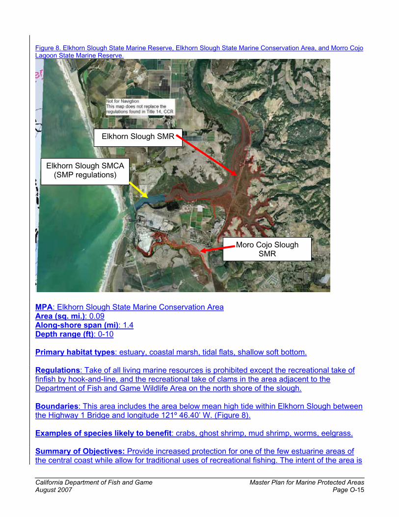
California Department of Fish and Game Master Plan for Marine Protected Areas August 2007 Page O-15
Figure 8. Elkhorn Slough State Marine Reserve, Elkhorn Slough State Marine Conservation Area, and Morro Cojo Lagoon State Marine Reserve.
MPA: Elkhorn Slough State Marine Conservation AreaArea (sq. mi.): 0.09Along-shore span (mi): 1.4Depth range (ft): 0-10
Primary habitat types: estuary, coastal marsh, tidal flats, shallow soft bottom.
Regulations: Take of all living marine resources is prohibited except the recreational take of finfish by hook-and-line, and the recreational take of clams in the area adjacent to the Department of Fish and Game Wildlife Area on the north shore of the slough.
Boundaries: This area includes the area below mean high tide within Elkhorn Slough between the Highway 1 Bridge and longitude 121º 46.40’ W. (Figure 8).
Examples of species likely to benefit: crabs, ghost shrimp, mud shrimp, worms, eelgrass.
Summary of Objectives: Provide increased protection for one of the few estuarine areas of the central coast while allow for traditional uses of recreational fishing. The intent of the area is
Elkhorn Slough SMR
Elkhorn Slough SMCA (SMP regulations)
Moro Cojo Slough SMR

California Department of Fish and Game Master Plan for Marine Protected Areas August 2007 Page O-16
to allow small scale recreational fishing activities to continue, while limiting any future increases in use that do not presently occur. The area will also prohibit take of clams in an area used by sea otters for foraging, potentially providing more available prey for the otters.
Detailed Objectives (with reference to regional goal and objective):� Protect estuarine area with high bird diversity. (Goal 1, Objective 1)� Protect communities associated with area with diversity of estuarine habitats, including
open channels, mud flats, and eelgrass beds, in close proximity to each other. (Goal 1, Objective 2)
� Protect natural age, size structure, and genetic diversity of some invertebrate species, such as fat innkeeper worms, characteristic of one of largest estuarine systems within the central coast. (Goal 1, Objective 3)
� Provide for traditional recreational consumptive and nonconsumptive uses while offering some protection due to the prohibition of commercial fishing. (Goal 2, Objective 3)
MPA: Moro Cojo Slough State Marine ReserveArea (sq. mi.): 0.46Along-shore span (mi): 5.0Depth range (ft): 0-10
Primary habitat types: estuary, tidal flats, shallow soft bottom.
Regulations: No take.
Boundaries: This area includes the area within Moro Cojo Slough below mean high tide and between the Highway 1 Bridge and the crossing of the Southern Pacific Railroad tracks (Figure 8).
Examples of species likely to benefit: surfperches, snails, eelgrass.
Summary of Objectives: Provide complete protection for one of the few estuarine areas of the central coast. A recent grant to the North Monterey County Recreation and Park District will create more than three miles of nature trails and interpretive stations within the slough; the additional protection provided by the reserve will help ensure this increased access does not lead to new take of living resources.
Detailed Objectives (with reference to regional goal and objective):� Help protect listed marine birds by protecting feeding, roosting, and nesting habitat.
(Goal 2, Objective 1)� Include and replicate representative estuarine habitat in central coast region within a
state marine reserve. (Goal 3, Objective 2)� Include estuarine habitat within a state marine reserve. (Goal 4, Objective 1)

California Department of Fish and Game Master Plan for Marine Protected Areas August 2007 Page O-17
MPA: Soquel Canyon State Marine Conservation AreaArea (sq. mi.): 23.41Along-shore span (mi): 7.2Depth range (ft): 247-2113
Primary habitat types: shallow hard and soft bottom, deep hard and soft bottom, deep canyon.
Regulations: Take of all living marine resources is prohibited except the commercial and recreational take of pelagic finfish.
Boundaries: This area is bounded by straight lines connecting the following points in the order listed (Figure 9):36º 51.00’ N. lat. 121º 56.00’ W. long.;36º 51.00’ N. lat. 122º 03.80’ W. long.;36º 48.00’ N. lat. 122º 02.88’ W. long.;36º 48.00’ N. lat. 121º 56.00’ W. long.; and36º 51.00’ N. lat. 121º 56.00’ W. long.
Examples of species likely to benefit: shelf and slope rockfishes, lingcod, Dover sole, spot prawn, squid.
Summary of Objectives: Provide increased protection to shallow and deep complex submarine canyon habitat and the majority of associated benthic species. The Soquel Canyon area is important to the formation of an ecologically sound MPA network component, by linking these habitats to similar habitats in other parts of the region.
Detailed Objectives (with reference to regional goal and objective):� Protect area with high species diversity associated with submarine canyon, including
depth-stratified species assemblages with shelf and slope rockfishes. (Goal 1, Objective 1)
� Help protect communities associated with area of diverse habitat including shallow hard and soft bottom, deep hard and soft bottom, and submarine canyon, over a large depth range, and in close proximity to each other. (Goal 1, Objective 2)
� Help restore overfished groundfish species by maintaining large individuals of species such as bocaccio, canary, and yelloweye rockfishes in an area that serves as a natural refuge for these species due to inaccessible vertical rock outcrops in a submarine canyon. (Goal 1, Objective 3)
� Protect overfished rockfishes, including bocaccio, canary, and yelloweye. (Goal 2, Objective 1)
� Enhance reproductive capacity of benthic and deepwater fish species by prohibiting fishing for these species and allowing only fisheries with limited bycatch of these species. (Goal 2, Objective 2)
� Protect rockfishes and other components of a deep benthic community, while allowing the harvest of pelagic finfish. (Goal 2, Objective 3)

California Department of Fish and Game Master Plan for Marine Protected Areas August 2007 Page O-18
� Enhance education and study opportunities by establishing a marine protected area near the Monterey Bay Aquarium Research Institute and Moss Landing Marine Laboratories where remotely operated vehicles, a future Monterey Accelerated Research System (MARS) cable, and other research methods have already generated baseline data. (Goal 3, Objective 1)
� Provide replicate deepwater hard bottom, soft bottom and submarine canyon habitats, in which fishing for benthic finfish species is prohibited, for Portuguese Ledge and Point Lobos State Marine Conservation Areas and Big Creek State Marine Reserve. (Goal 3, Objective 2)
� Include submarine canyon head habitat within a marine protected area. (Goal 4, Objective 1)
� Include and replicate deepwater hard and soft bottom and submarine canyon habitats across a wide range of depth. (Goal 4, Objective 2)
� Minimize negative socio-economic impacts to the pelagic finfish fisheries while protecting benthic finfishes within a marine protected area. (Goal 5, Objective 1)
� Minimize negative socio-economic impacts to rockfish fisheries by establishing a state marine conservation area in an area which encompasses part of the Rockfish Conservation Area, which is already closed to rockfish fishing. (Goal 5, Objective 1)
� Establish marine protected areas that meet Master Plan Framework scientific guidelines regarding preferred size (greater than 18 square miles). (Goal 5, Objective 3)
Figure 9. Soquel Canyon State Marine Conservation Area and Portuguese Ledge State Marine Conservation Area.
Soquel Canyon SMCA
Portuguese Ledge SMCA

California Department of Fish and Game Master Plan for Marine Protected Areas August 2007 Page O-19
MPA: Portuguese Ledge State Marine Conservation AreaArea (sq. mi.): 10.90Along-shore span (mi): 5.4Depth range (ft): 302-4838
Primary habitat types: shallow hard and soft bottom, deep hard and soft bottom, deep submarine canyon.
Regulations: Take of all living marine resources is prohibited except the commercial and recreational take of pelagic finfish.
Boundaries: This area is bounded by straight lines connecting the following points in the order listed (Figure 9):36º 43.00’ N. lat. 121º 56.00’ W. long.;36º 43.00’ N. lat. 122º 01.30’ W. long.;36º 41.00’ N. lat. 122º 00.80’ W. long.;36º 41.00’ N. lat. 121º 56.00’ W. long.; and36º 43.00’ N. lat. 121º 56.00’ W. long.
Examples of species likely to benefit: shelf and slope rockfishes, lingcod, Dover sole, Dungeness crab, spot prawn, squid.
Summary of Objectives: Provide increased protection to deep submarine canyon, other deep hard and soft habitat, and all associated benthic species. This area is important to the formation of an ecologically sound MPA network component, by linking these habitats to similar habitats in other parts of the region.
Detailed Objectives (with reference to regional goal and objective):� Protect area with high species diversity associated with submarine canyon, including
depth-stratified species assemblages with shelf and slope rockfishes. (Goal 1, Objective 1)
� Help protect communities associated with area of diverse habitat including shallow hard and soft bottom, deep hard and soft bottom, and submarine canyon, over a large depth range, and in close proximity to each other. (Goal 1, Objective 2)
� Help restore overfished groundfish species by maintaining large individuals of species such as bocaccio, canary, and yelloweye rockfishes in an area that has been fished heavily for decades and has become less productive. (Goal 1, Objective 3)
� Protect overfished rockfishes, including bocaccio, canary, and yelloweye. (Goal 2, Objective 1)
� Enhance reproductive capacity of benthic and deepwater fish and invertebrate species by prohibiting fishing for these species and allowing fisheries with limited bycatch of these species. (Goal 2, Objective 2)
� Protect rockfishes and other components of a deep benthic community, while allowing the harvest of pelagic finfish. (Goal 2, Objective 3)
� Enhance education and study opportunities by establishing a marine protected area near the Monterey Bay Aquarium Research Institute and Moss Landing Marine

California Department of Fish and Game Master Plan for Marine Protected Areas August 2007 Page O-20
Laboratories where remotely operated vehicles and other research methods have already generated baseline data. (Goal 3, Objective 1)
� Provide replicate deepwater hard bottom, soft bottom and submarine canyon habitats, in which fishing for benthic species is prohibited, for Soquel Canyon and Point Lobos State Marine Conservation Areas and Big Creek State Marine Reserve. (Goal 3, Objective 2)
� Include and replicate deepwater hard and soft bottom and submarine canyon habitats across a wide range of depth. (Goal 4, Objective 2)
� Minimize negative socio-economic impacts to the pelagic finfish fisheries while protecting benthic habitat within a marine protected area. (Goal 5, Objective 1)
� Minimize negative socio-economic impacts to rockfish fisheries by establishing a state marine conservation area in an area which encompasses the Rockfish Conservation Area, which is already closed to rockfish fishing. (Goal 5, Objective 1)
� Establish marine protected areas that meet Master Plan Framework scientific guidelines regarding preferred size (greater than 18 square miles). (Goal 5, Objective 3)
MPA: Edward F. Ricketts State Marine Conservation AreaArea (sq. mi.): 0.22Along-shore span (mi): 1Depth range (ft): 0-74
Primary habitat types: sandy beach, rocky intertidal, surfgrass, shallow hard and soft bottom, kelp bed.
Regulations: Take of all living marine resources is prohibited except the recreational take of finfish by hook-and-line and, north of 36° 36.83’ N. Latitude, the commercial take of kelp by hand. Any individual licensed commercial kelp harvester may take no more than 12 tons of kelp from the portion of Administrative Kelp Bed 220 within the Edward F. Ricketts State Marine Conservation Area in any calendar month.
Boundaries: This area is bounded by the mean high tide line and straight lines connecting the following points in the order listed (Figure 10):36º 36.50’ N. lat. 121º 53.37’ W. long.;36º 37.25’ N. lat. 121º 53.78’ W. long.; and36º 37.10’ N. lat. 121º 54.09’ W. long.
Examples of species likely to benefit: mussels, limpets, turban snails, sea stars.
Summary of Objectives: Provide increased protection to a heavily-used area with shallow hard and soft bottom habitats, including kelp beds, while allowing for some traditional consumptive uses. The primary purpose of this area is to provide for recreational opportunities (both consumptive and nonconsumptive) in an area that is minimally impacted by other consumptive activities.
Detailed Objectives (with reference to regional goal and objective):� Protect invertebrates and the habitats on which they depend while allowing the harvest
of finfish and kelp. (Goal 2, Objective 3)
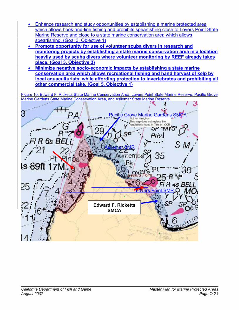
California Department of Fish and Game Master Plan for Marine Protected Areas August 2007 Page O-21
� Enhance research and study opportunities by establishing a marine protected area which allows hook-and-line fishing and prohibits spearfishing close to Lovers Point State Marine Reserve and close to a state marine conservation area which allows spearfishing. (Goal 3, Objective 1)
� Promote opportunity for use of volunteer scuba divers in research and monitoring projects by establishing a state marine conservation area in a location heavily used by scuba divers where volunteer monitoring by REEF already takes place. (Goal 3, Objective 3)
� Minimize negative socio-economic impacts by establishing a state marine conservation area which allows recreational fishing and hand harvest of kelp by local aquaculturists, while affording protection to invertebrates and prohibiting all other commercial take. (Goal 5, Objective 1)
Figure 10. Edward F. Ricketts State Marine Conservation Area, Lovers Point State Marine Reserve, Pacific Grove Marine Gardens State Marine Conservation Area, and Asilomar State Marine Reserve.
Pacific Grove Marine Gardens SMCA
Asilomar SMR
Lovers Point SMR
Edward F. Ricketts SMCA

California Department of Fish and Game Master Plan for Marine Protected Areas August 2007 Page O-22
MPA: Lovers Point State Marine ReserveArea (sq. mi.): 0.30Along-shore span (mi): 1.0Depth range (ft): 0-88
Primary habitat types: sandy beach, rocky intertidal, surfgrass, shallow hard and soft bottom, kelp bed.
Regulations: No take.
Boundaries: This area is bounded by the mean high tide line and straight lines connecting the following points in the order listed (Figure 10):36º 37.10’ N. lat. 121º 54.09’ W. long.;36º 37.25’ N. lat. 121º 53.78’ W. long.;36º 37.38’ N. lat. 121º 53.85’ W. long.;36º 37.60’ N. lat. 121º 54.75’ W. long.; and36º 37.60’ N. lat. 121º 54.91’ W. long.
Examples of species likely to benefit: nearshore rockfishes, lingcod, cabezon, kelp greenling, surfperches, California halibut, giant kelp, mussels, limpets, sea stars, southern sea otter, cormorants.
Summary of Objectives: Provide for increased protection through the expansion of an existing state marine reserve in shallow hard and soft bottom habitats in an area close to population centers and used by nonconsumptive divers. The primary goal of this MPA will be to provide for recreational nonconsumptive uses in an area minimally impacted by human take. Additionally this increases the area adjacent to an existing research institution which can facilitate research and monitoring within the MPA.
Detailed Objectives (with reference to regional goal and objective):� Continue to provide protection to a rich diversity of invertebrates and fish species
characteristic of shallow rocky and soft bottom habitat of southern Monterey Bay, while expanding protection to a small reef in slightly deeper water. (Goal 1, Objective1)
� Help protect southern sea otter and marine bird habitat. (Goal 2, Objective 1)� Protect large individuals of resident nearshore fish species in known nursery area. (Goal
2, Objective 2)� Enhance scientific research opportunities at site of traditional high research value by
expanding protection in adjacent areas and extending the existing state marine reserve alongshore and into deeper water. (Goal 3, Objective 1)
� Enhance recreational non-consumptive diving experience at site of traditional high diving use by expanding protection in adjacent areas and extending the existing state marine reserve alongshore and into deeper water. (Goal 3, Objective 1)
� Benefit from site’s location adjacent to Stanford University’s Hopkins Marine Station and its use by students for educational and monitoring purposes. (Goal 3, Objective 3)
� Minimize socio-economic impacts by limiting the state marine reserve to a maximum depth of approximately 60 feet (except for Hopkins Deep Reef) which will allow

California Department of Fish and Game Master Plan for Marine Protected Areas August 2007 Page O-23
continued commercial and recreational fishing in deeper waters adjacent to the state marine reserve. (Goal 5, Objective 1)
MPA: Pacific Grove Marine Gardens State Marine Conservation AreaArea (sq. mi.): 0.93Along-shore span (mi): 3.8Depth range (ft): 0-172
Primary habitat types: sandy beach, rocky intertidal, surfgrass, shallow hard and soft bottom, kelp bed.
Regulations: Take of all living marine resources is prohibited except recreational take of finfish and the commercial take of kelp by hand. Any individual licensed commercial kelp harvester may take no more than 44 tons of kelp from the portion of Administrative Kelp Bed 220 within the Pacific Grove Marine Gardens State Marine Conservation Area in any calendar month.
Boundaries: This area is bounded by the mean high tide line and straight lines connecting the following points in the order listed (Figure 10):36º 37.60’ N. lat. 121º 54.91’ W. long.;36º 37.60’ N. lat. 121º 54.75’ W. long.;36º 38.70’ N. lat. 121º 55.40’ W. long.;36º 38.90’ N. lat. 121º 56.60’ W. long.; and36º 38.22’ N. lat. 121º 56.15’ W. long.
Examples of species likely to benefit: invertebrates, including mussels, limpets, turban snails, sea stars, squid.
Summary of Objectives: Provide increased protection to a heavily-used area with shallow hard and soft bottom habitats, including kelp beds, while allowing for some traditionalconsumptive uses. The primary purpose of this area is to provide for recreational opportunities (both consumptive and nonconsumptive) in an area that is minimally impacted by other consumptive activities.
Detailed Objectives (with reference to regional goal and objective):� Enhance non-consumptive recreational experience by prohibiting commercial finfishing
and all invertebrate take in an area that includes traditional scuba diving sites accessed from the beach or boats. (Goal 3, Objective 1)
� Continue to protect, within a state marine conservation area, an area close to Monterey and adjacent to Pacific Grove that has long-standing and strong community support and high research, educational and recreational value, particularly with respect to tide pools. (Goal 3, Objective 1)
� Provide potential opportunity to study impacts of the hand harvest of kelp and spearfishing by establishing an expanded state marine reserve and a state marine conservation area (which also allows hand harvest of kelp and prohibits spearfishing) adjacent or near to this site. (Goal 3, Objective 2)
� Promote opportunity for use of volunteer scuba divers in research and monitoring projects by establishing a state marine conservation area in a location

California Department of Fish and Game Master Plan for Marine Protected Areas August 2007 Page O-24
heavily used by scuba divers where volunteer monitoring by REEF already takes place. (Goal 3, Objective 3)
� Enhance recreational fishing within the state marine conservation area through a prohibition on commercial take and by providing for a natural size and age structure of resident finfish species in an adjacent state marine reserve. (Goal 3, Objective 4)
� Allow continued recreational fishing in traditional use area and hand harvest of kelp close to abalone aquaculture facilities. (Goal 5, Objective 1)
MPA: Asilomar State Marine ReserveArea (sq. mi.): 1.51Along-shore span (mi): 2.3Depth range (ft): 0-172
Primary habitat types: sandy beach, rocky intertidal, surfgrass, shallow hard and soft bottom, kelp bed.
Regulations: No take
Boundaries: This area is bounded by the mean high tide line and straight lines connecting the following points in the order listed (Figure 10):36º 38.22’ N. lat. 121º 56.15’ W. long.;36º 38.90’ N. lat. 121º 56.60’ W. long.; and36° 36.60’ N. lat. 121° 57.50’ W. long.;
Examples of species likely to benefit: nearshore rockfishes, lingcod, cabezon, kelp greenling, surfperches, California halibut, giant kelp, mussels, limpets, sea stars, southern sea otter, cormorants.
Rationale: Provide for complete protection in shallow hard and soft bottom habitats in an area close to population centers and used by nonconsumptive divers. The primary goals of this MPA will be to provide for recreational nonconsumptive uses in an area minimally impacted by human take, and to provide benefits to an adjacent fished area through spillover of adult fishes and increased potential for larval production.
Detailed Objectives (with reference to regional goal and objective):� Provide protection to a rich diversity of invertebrates and fish species characteristic of
shallow rocky and soft bottom habitat near southern Monterey Bay. (Goal 1, Objective1)� Help protect southern sea otter and marine bird habitat. (Goal 2, Objective 1)� Protect large individuals of resident nearshore fish species adjacent to an area which
experiences significant recreational fishing effort. (Goal 2, Objective 2)� Enhance recreational non-consumptive diving experience at site of traditional diving
use. (Goal 3, Objective 1)� Benefit from site’s location close to Stanford University’s Hopkins Marine Station and its
use by students for educational and monitoring purposes. (Goal 3, Objective 3)� Minimize socio-economic impacts by limiting the state marine reserve to an area which
is primarily less than 90 feet deep, which will allow continued commercial and

California Department of Fish and Game Master Plan for Marine Protected Areas August 2007 Page O-25
recreational fishing in deeper waters adjacent to the state marine reserve. (Goal 5, Objective 1)
MPA: Carmel Pinnacles State Marine ReserveArea (sq. mi.): 0.53Along-shore span (mi): 1.0Depth range (ft): 69-223
Primary habitat types: rocky pinnacles, kelp bed.
Regulations: No take.
Boundaries: This area is bounded by the straight lines connecting the following points in the order listed (Figure 11):36º 33.65’ N. lat. 121º 57.60’ W. long.;36º 33.65’ N. lat. 121º 58.50’ W. long.;36º 33.10’ N. lat. 121º 58.50’ W. long.;36º 33.10’ N. lat. 121º 57.60’ W. long.; and36º 33.65’ N. lat. 121º 57.60’ W. long.;
Examples of species likely to benefit: nearshore rockfishes, lingcod, cabezon, kelp greenling, surfperches, giant kelp, bull kelp, sponges, hydrocorals.
Summary of Objectives: Provide for complete protection in an area of complex hard bottom habitat, including kelp beds and pinnacles, is close to port and frequently used by nonconsumptive divers. The primary purpose of this area would be to protect a unique pinnacle area that is accessible to divers for nonconsumptive uses while maintaining similar habitats nearby as open fishing areas.
Detailed Objectives (with reference to regional goal and objective):� Protect communities associated with high-relief rocky reef habitat (including pinnacles),
bull kelp and giant kelp forests, and hydrocorals, in close proximity to each other. (Goal 1, Objective 2)
� Enhance non-consumptive recreational scuba diving experience at a traditional dive site formerly open to fishing. (Goal 3, Objective 1)
� Replicate pinnacle habitat found within Point Lobos State Marine Reserve. (Goal 3, Objective 2)
� Include pinnacle habitat, with dense rockfish populations, sponges, and hydrocorals, within a state marine reserve. (Goal 4, Objective 1)

California Department of Fish and Game Master Plan for Marine Protected Areas August 2007 Page O-26
Figure 11. Carmel Pinnacles State Marine Conservation Area, Carmel Bay State Marine Conservation Area, Point Lobos State Marine Reserve, and Point Lobos State Marine Conservation Area.
MPA: Carmel Bay State Marine Conservation AreaArea (sq. mi.): 2.12Along-shore span (mi): 3.5Depth range (ft): 0-471
Primary habitat types: sandy beach, rocky intertidal, surfgrass, shallow hard and soft bottom, submarine canyon head, kelp bed.
Regulations: Take of all living marine resources is prohibited except the recreational take of finfish and the commercial take of giant kelp (Macrocystis pyrifera) by hand. Any individual licensed commercial kelp harvester may take no more than 44 tons of kelp from the portion of Administrative Kelp Bed 219 within the Carmel Bay State Marine Conservation Area in any calendar month.
Boundaries: This area is bounded by the mean high tide line and straight lines connecting the following points in the order listed (Figure 11):36º 33.65’ N. lat. 121º 57.10’ W. long.;36º 31.70’ N. lat. 121º 56.30’ W. long.; and
Carmel Pinnacles SMR
Carmel Bay SMCA
Pt. Lobos SMCA
Pt. Lobos SMR

California Department of Fish and Game Master Plan for Marine Protected Areas August 2007 Page O-27
36º 31.70’ N. lat. 121º 55.55’ W. long.
Examples of species likely to benefit: invertebrates, including squid.
Summary of Objectives: Continue to provide existing level of protection in an area of diverse shallow habitat characterized by traditional recreational uses.
Detailed Objectives (with reference to regional goal and objective):� Allow continued recreational harvest of finfish and commercial harvest of kelp by hand
in an area of historic recreational use value near Monterey harbor while protecting invertebrates. (Goal 2, Objective 3)
� Maintain an existing state marine conservation area located near the population center of Monterey Peninsula that is accessible for recreational opportunities, both consumptive and non-consumptive. (Goal 3, Objective 1)
� Maintain an existing state marine conservation area that includes a Moss Landing Marine Laboratories long-term monitoring site. (Goal 3, Objective 3)
� Allow for the comparison of a recreational fishing area adjacent to a no-take area (Goal 3, Objective 3)
MPA: Point Lobos State Marine ReserveArea (sq. mi.): 5.36Along-shore span (mi): 4.7Depth range (ft): 0-408
Primary habitat types: sandy beach, rocky intertidal, surfgrass, shallow hard and soft bottom, pinnacles, kelp bed.
Regulations: No take. Access restricted in some areas due to existing Point Lobos State Reserve (State Park Unit) regulations but these restrictions will not apply to areas outside the existing Pt. Lobos State Reserve (State Park Unit) boundaries.
Boundaries: This area is bounded by the mean high tide line and straight lines connecting the following points in the order listed (Figure 11):36º 31.70’ N. lat. 121º 55.55’ W. long.;36º 31.70’ N. lat. 121º 58.25’ W. long.;36º 28.88’ N. lat. 121º 58.25’ W. long.; and36º 28.88’ N. lat. 121º 56.30’ W. long.
Examples of species likely to benefit: nearshore rockfishes, lingcod, cabezon, kelp greenling, surfperches, giant kelp, bull kelp, squid, sponges, hydrocorals, cormorants, pelicans, southern sea otter, harbor seal.
Summary of Objectives: Provide for increased complete protection through the expansion of an existing state marine reserve in shallow hard and soft bottom habitats in an area close to population centers and used by nonconsumptive divers. This area is important to the formation of an ecologically sound MPA network component, by linking these habitats to similar habitats in other parts of the region.

California Department of Fish and Game Master Plan for Marine Protected Areas August 2007 Page O-28
Detailed Objectives (with reference to regional goal and objective):� Protect area of high species diversity characteristic of the granitic shallow hard bottom
habitat within the central coast, and maintain species diversity and abundance as demonstrated by monitoring indicator species. (Goal 1, Objective 1)
� Protect communities associated with a mosaic of sandy and rocky intertidal, kelp bed, shallow rocky reef, shallow sandy bottom, and submarine canyon head habitats in close proximity to each other. (Goal 1, Objective 2)
� Protect natural age and size structure of invertebrate and fish species associated with sandy and rocky intertidal, kelp bed, shallow rocky reef, shallow sandy bottom, and submarine canyon head habitat. (Goal 1, Objective 3)
� Protect natural trophic structure and food webs, including forage species such as squid and coastal pelagic finfish that serve as prey for other fish, marine birds, and marine mammals. (Goal 1, Objective 4)
� Protect ecosystem structure and functions associated with submarine canyon head, rocky reef, and kelp forest communities. (Goal 1, Objective 5)
� Help protect listed marine bird and marine mammal species by protecting forage base. (Goal 2, Objective 1)
� Protect larval sources and enhance reproductive capacity of invertebrates and nearshore finfish with limited movement patterns. (Goal 2, Objective 2)
� Enhance extensive educational and interpretive facilities, including visitor center and docent program, through expansion of an existing state marine reserve. (Goal 3, Objective 1)
� Enhance Partnership for Interdisciplinary Studies of Coastal Oceans (PISCO) monitoring program (which has existing replicate monitoring sites inside and outside the state marine reserve) through expansion of the existing state marine reserve. (Goal 3, Objective 2)
� Replicate pinnacles habitat found in Carmel Pinnacles State Marine Reserve. (Goal 3, Objective 2)
� Enhance existing local high school monitoring program through expansion of the state marine reserve. (Goal 3, Objective 3)
� Protect and enhance recreational diving experience by expanding protection of existing state marine reserve to better ensure protection of large fish. (Goal 3, Objective 4)
� Protect head of Carmel Submarine Canyon and pinnacle habitats within a state marine reserve. (Goal 4, Objective 1)
� Include rocky intertidal, kelp bed, shallow rocky reef, and shallow soft bottom habitats within a state marine reserve, and increase protection of pinnacle habitat. (Goal 4, Objective 2)
� Optimize positive socio-economic benefits by improving protection in area that has particularly high non-consumptive use patterns, including scuba diving and wildlife watching. (Goal 5, Objective 1)
� Establish a marine protected area complex (along with Point Lobos State Marine Conservation Area) that meets Master Plan Framework scientific guidelines for minimum shoreline extent and offshore extent. (Goal 5, Objective 3)

California Department of Fish and Game Master Plan for Marine Protected Areas August 2007 Page O-29
MPA: Point Lobos State Marine Conservation AreaArea (sq. mi.): 8.85Along-shore span (mi): 3.2Depth range (ft): 268-1858
Primary habitat types: shallow and deep hard bottom, shallow and deep soft bottom, shallow and deep submarine canyon.
Regulations: Take of all living marine resources is prohibited except commercial and recreational take of salmon (Oncorhynchus spp.), albacore (Thunnus alalunga), and spot prawn (Pandalus platyceros).
Boundaries: This area is bounded by the state water line offshore and straight lines connecting the following points in the order listed unless otherwise stated (Figure 11):36º 31.70’ N. lat. 121º 58.25’ W. long.;36º 31.70’ N. lat. 122º 01.30’ W. long.; thence southward along the state water line to36º 28.88’ N. lat. 122º 00.55’ W. long.;36º 28.88’ N. lat. 121º 58.25’ W. long.; and36º 31.70’ N. lat. 121º 58.25’ W. long.
Examples of species likely to benefit: shelf and slope rockfishes, lingcod, sponges, hydrocorals, cormorants, pelicans, southern sea otter, harbor seal.
Summary of Objectives: Provide for increased protection of benthic finfishes in a diverse area containing shallow and deep, and hard and soft habitats, while minimizing impact to rockfish fisheries, through the incorporation of part of the Rockfish Conservation Area into the MPA, and salmon and spot prawn fisheries. This area is important to the formation of an ecologically sound MPA network component, by linking these habitats to similar habitats in other parts of the region.
Detailed Objectives (with reference to regional goal and objective):� Protect communities associated with area with shallow hard and soft bottom, deep hard
and soft bottom, and shallow and deep submarine canyon habitats across a wide depth range and in close proximity to each other. (Goal 1, Objective 2)
� Help protect populations of overfished rockfish (including bocaccio, canary and yelloweye) and help protect forage species (including coastal pelagic finfish) for listed marine birds. (Goal 2, Objective 1)
� Enhance reproductive capacity of benthic fish species by prohibiting fishing for them in deep water. (Goal 2, Objective 2)
� Enhance reproductive capacity of benthic fish species by only allowing fishing for selected pelagic finfishes and spot prawn (by trap), where bycatch of benthic fishes is minimal. (Goal 2, Objective 2)
� Provide an opportunity for comparative studies in Soquel Canyon and Portuguese Ledge State Marine Conservation Areas which have similar habitats. (Goal 3, Objective 1)
� Minimize negative socio-economic impacts by allowing fishing for salmon, albacore and spot prawn, and by incorporating a portion of the Rockfish Conservation Area (closed to groundfish take) and Essential Fish Habitat trawl closure. (Goal 5, Objective 1)

California Department of Fish and Game Master Plan for Marine Protected Areas August 2007 Page O-30
� Establish a marine protected area complex (along with Point Lobos State Marine Reserve) that meets Master Plan Framework scientific guidelines for minimum shoreline extent and offshore extent. (Goal 5, Objective 3)
MPA: Point Sur State Marine ReserveArea (sq. mi.): 9.72Along-shore span (mi): 5.2Depth range (ft): 0-178
Primary habitat types: sandy beach, rocky intertidal, surfgrass, shallow hard and soft bottom, kelp bed, canyon head.
Regulations: No take.
Boundaries: This area is bounded by the mean high tide line and straight lines connecting the following points in the order listed (Figure 12):36º 18.40’ N. lat. 121º 54.10’ W. long.;36º 18.40’ N. lat. 121º 56.00’ W. long.;36º 15.00’ N. lat. 121º 52.50’ W. long.; and36º 15.00’ N. lat. 121º 50.25’ W. long.;NOTE: An alternative boundary description is provided in the Regulations. Final Commission action will determine the boundaries of this MPA.
Examples of species likely to benefit: nearshore and shelf rockfishes, lingcod, cabezon, kelp greenling, surfperches, giant kelp, bull kelp, squid, Dungeness crab, murres, guillemots, cormorants, petrels, auklets.
Summary of Objectives: Provide for complete protection of a diverse area containing shallow hard and soft habitats, kelp beds, and associated fish and invertebrate species while minimizing impact to shelf rockfish fisheries through the incorporation of part of the Rockfish Conservation Area into the MPA. This area is important to the formation of an ecologically sound MPA network component, by linking these habitats to similar habitats in other parts of the region.
Detailed Objectives (with reference to regional goal and objective):� Protect area of particularly high species diversity associated with upwelling cell in lee of
headland, as well as area immediately north of a headland, and maintain species diversity and abundance as demonstrated by monitoring indicator species. (Goal 1, Objective 1, and 2)
� Protect natural age and size structure of invertebrate and fish species associated with sandy beach, rocky intertidal, kelp bed, shallow rocky reef, and shallow sandy bottom habitat. (Goal 1, Objective 3)
� Protect natural trophic structure and food webs, including forage species such as juvenile rockfish, squid, and coastal pelagic finfish that serve as prey for other fish, marine birds, and marine mammals. (Goal 1, Objective 4)
� Provide protection to an area that contains a persistent upwelling plume and generally southerly flow, well-suited to provide larval dispersal to other areas. (Goal 1, Objective 5)

California Department of Fish and Game Master Plan for Marine Protected Areas August 2007 Page O-31
� Help protect populations of overfished rockfish species including bocaccio, yelloweye, and canary. (Goal 2, Objective 1)
� Protect forage base for listed marine birds and marine mammals as well as overfished rockfish species. (Goal 2, Objective 1)
� Protect larval sources and enhance reproductive capacity of shelf species including rockfishes. (Goal 2, Objective 2)
� Establish a marine protected area near a terrestrial state park where an adjacent PISCO subtidal monitoring site exists. (Goal 3, Objective 1)
� Include submarine canyon head habitat found in the Soquel Canyon and Point Lobos State Marine Conservation Areas and Point Lobos State Marine Reserve. (Goal 3, Objective 2)
� Include submarine canyon head within a state marine reserve. (Goal 4, Objective 1)� Include shallow hard and soft bottom, and shallow canyon habitat within a state marine
reserve, including an area of broad continental shelf within a larger area of primarily narrow continental shelf. (Goal 4, Objective 2)
� Minimize negative socio-economic impacts by incorporating a portion of the Rockfish Conservation Area (closed to groundfish take), and considering existing squid fishing grounds. (Goal 5, Objective 1)
� Establish a marine protected area complex (along with Point Sur State Marine Conservation Area) that meets preferred Master Plan Framework scientific guidelines for size. (Goal 5, Objective 3)
Figure 12. Pt. Sur State Marine Reserve and Pt. Sur State Marine Conservation Area.
Pt. Sur SMCA Pt. Sur SMR

California Department of Fish and Game Master Plan for Marine Protected Areas August 2007 Page O-32
MPA: Point Sur State Marine Conservation AreaArea (sq. mi.): 9.96Along-shore span (mi): 5.2Depth range (ft): 134-424
Primary habitat types: shallow hard and soft bottom.
Regulations: Take of all living marine resources is prohibited except commercial and recreational take of salmon (Oncorhynchus spp.) and albacore (Thunnus alalunga).
Boundaries: This area is bounded by the state water line offshore and straight lines connecting the following points in the order listed unless otherwise stated (Figure 12):36º 18.40’ N. lat. 121º 56.00’ W. long.;36º 18.40’ N. lat. 121º 58.33’ W. long.; thence southward along the state water line to36º 15.00’ N. lat. 121º 55.10’ W. long.;36º 15.00’ N. lat. 121º 52.50’ W. long.; and36º 18.40’ N. lat. 121º 56.00’ W. long.
Examples of species likely to benefit: nearshore and shelf rockfishes, lingcod, cabezon, kelp greenling, surfperches, giant kelp, squid, Dungeness crab, spot prawn, murres, cormorants, southern sea otter.
Summary of Objectives: Provide for increased protection of a diverse area containing shallow hard and soft habitats, kelp beds, and associated fish and invertebrate species while minimizing impact to shelf rockfish fisheries, through the incorporation of part of the Rockfish Conservation Area into the MPA, and to the salmon fishery. This area is important to the formation of an ecologically sound MPA network component, by linking these habitats to similar habitats in other parts of the region. In addition, unique habitats in federal waters are adjacent to this area and may be connected if appropriate in future processes.
Detailed Objectives (with reference to regional goal and objective):� Protect area of high species diversity associated with shallow hard and soft bottom
habitats where the continental shelf is relatively broad. (Goal 1, Objective 1 and 2)� Protect natural age and size structure of invertebrate and fish species associated with
shallow rocky reef and soft bottom habitat. (Goal 1, Objective 3)� Protect natural trophic structure and food webs, including forage species such as
juvenile rockfish, squid, and coastal pelagic finfish that serve as prey for other fish, marine birds, and marine mammals. (Goal 1, Objective 4)
� Provide protection to communities associated with an area that contains a persistent upwelling plume and generally southerly flow, well-suited to provide larval dispersal to other areas. (Goal 1, Objective 5)
� Help maintain populations of overfished rockfish species including bocaccio, yelloweye, and canary. (Goal 2, Objective 1)
� Protect forage base for listed marine birds and marine mammals as well as overfished rockfish species. (Goal 2, Objective 1)
� Protect larval sources and enhance reproductive capacity of benthic shelf species including rockfishes. (Goal 2, Objective 2)

California Department of Fish and Game Master Plan for Marine Protected Areas August 2007 Page O-33
� Minimize negative socio-economic impacts by incorporating a portion of the Rockfish Conservation Area (closed to groundfish take), and by allowing the harvest of salmon and albacore. (Goal 5, Objective 1)
� Establish a marine protected area complex (along with Point Sur State Marine Reserve) that meets preferred Master Plan Framework scientific guidelines for size. (Goal 5, Objective 3)
MPA: Big Creek State Marine Conservation AreaArea (sq. mi.): 8Along-shore span (mi): 2.5Depth range (ft): 0-1964
Primary habitat types: sandy beach, rocky intertidal, surfgrass, shallow hard and soft bottom, deep hard and soft bottom, shallow and deep submarine canyon, pinnacles, kelp bed.
Regulations: Take of all living marine resources is prohibited except the commercial and recreational take of salmon (Oncorhynchus spp.), albacore (Thunnus alalunga), and the commercial take of spot prawn (Pandalus platyceros).
Boundaries: This area is bounded by the state water line offshore and straight lines connecting the following points in the order listed unless otherwise stated (Figure 13):36° 07.20’ N. lat. 121° 39.00’ W. long.;36° 07.20’ N. lat. 121° 42.90’ W. long.; thence southward along the three nautical mile offshore boundary to36° 05.20’ N. lat. 121° 41.24’ W. long.;36° 05.20’ N. lat. 121° 38.00’ W. long.; and36° 07.20’ N. lat. 121° 39.00’ W. long.
Examples of species likely to benefit: nearshore, shelf, and slope rockfishes, lingcod, cabezon, kelp greenling, surfperches, squid, giant kelp, murres, cormorants, southern sea otter.
Summary of Objectives: Provide for increased protection of a diverse area containing shallow and deep, and hard and soft habitats, kelp beds, submarine canyons, and associated fish and invertebrate species while minimizing impact to shelf rockfish fisheries, through the incorporation of part of the Rockfish Conservation Area into the MPA, and to the spot prawn and salmon fisheries. This area is important to the formation of an ecologically sound MPA network component, by linking these habitats to similar habitats in other parts of the region.
Detailed Objectives (with reference to regional goal and objective):� Protect area of high species diversity associated with shallow and deep water habitats,
including submarine canyon. (Goal 1, Objective 1)� Protect communities associated with sandy beach, rocky intertidal, shallow hard and
soft bottom, surfgrass and kelp beds, deep hard and soft bottom, and shallow and deep submarine canyon habitat in close proximity to each other. (Goal 1, Objective 2)
� Protect natural age and size structure of fish and most invertebrate species associated with sandy and rocky intertidal, surfgrass and kelp beds, shallow and deep rocky reef,

California Department of Fish and Game Master Plan for Marine Protected Areas August 2007 Page O-34
shallow and deep sandy bottom, and shallow and deep submarine canyon habitat. (Goal 1, Objective 3)
� Help maintain populations of overfished rockfish species including bocaccio, yelloweye, and canary. (Goal 2, Objective 1)
� Protect forage base for listed marine birds and marine mammals as well as overfished rockfish species. (Goal 2, Objective 1)
� Protect larval sources and enhance reproductive capacity of deepwater species including rockfishes. (Goal 2, Objective 2)
� Provide opportunities afforded by a nearby terrestrial reserve, managed by the University of California, to link classroom curricula. (Goal 3, Objective 3)
� Provide opportunities for collaborative research projects involving commercial fishermen, including a possible study on the impact of salmon fishing. (Goal 3, Objective 3)
� Minimize negative socio-economic impacts by incorporating a portion of the Rockfish Conservation Area (closed to groundfish take), and by allowing the harvest of spot prawn, salmon, and albacore. (Goal 5, Objective 1)
Figure 13. Big Creek State Marine Reserve and Big Creek State Marine Conservation Area
Big Creek SMCA
Big Creek SMR

California Department of Fish and Game Master Plan for Marine Protected Areas August 2007 Page O-35
MPA: Big Creek State Marine ReserveArea (sq. mi.): 14.47Along-shore span (mi): 6.1Depth range (ft): 0-2393
Primary habitat types: sandy beach, rocky intertidal, surfgrass, shallow hard and soft bottom, deep hard and soft bottom, shallow and deep submarine canyon, pinnacles, kelp bed.
Regulations: No take.
Boundaries: This area is bounded by the state water line offshore and straight lines connecting the following points in the order listed unless otherwise stated (Figure 13):36° 07.20’ N. lat. 121° 38.00’ W. long.;36° 07.20’ N. lat. 121° 39.00’ W. long.;36° 05.20’ N. lat. 121° 38.00’ W. long.36° 05.20’ N. lat. 121° 41.25’ W. long.; thence southward along the three nautical mile offshore boundary to36° 02.65’ N. lat. 121° 39.70’ W. long.; and36° 02.65’ N. lat. 121° 35.13’ W. long.
Examples of species likely to benefit: nearshore, shelf, and slope rockfishes, lingcod, cabezon, kelp greenling, surfperches, spot prawn, squid, giant kelp, murres, cormorants, southern sea otter.
Summary of Objectives: Provide for increased complete protection, through expansion of an existing state marine reserve, of a diverse area containing shallow and deep, and hard and soft habitats, kelp beds, submarine canyons, and associated fish and invertebrate species while minimizing impact to shelf rockfish fisheries through the incorporation of part of the Rockfish Conservation Area into the MPA. This area is important to the formation of an ecologically sound MPA network component, by linking these habitats to similar habitats in other parts of the region.
Detailed Objectives (with reference to regional goal and objective):� Protect area of high species diversity associated with shallow and deep water habitats,
including submarine canyon. (Goal 1, Objective 1)� Protect communities associated with sandy beach, rocky intertidal, shallow hard and
soft bottom, surfgrass and kelp beds, deep hard and soft bottom, and shallow and deep submarine canyon habitat in close proximity to each other. (Goal 1, Objective 2)
� Protect natural age and size structure of invertebrate and fish species associated with sandy and rocky intertidal, surfgrass and kelp beds, shallow and deep rocky reef, shallow and deep sandy bottom, and shallow and deep submarine canyon habitat. (Goal 1, Objective 3)
� Protect natural trophic structure and food webs, including forage species such as juvenile rockfish, squid, and coastal pelagic finfish that serve as prey for other fish, marine birds, and marine mammals. (Goal 1, Objective 4)
� Protect full range of ecosystem functions in an area between upwelling zones. (Goal 1, Objective 5)

California Department of Fish and Game Master Plan for Marine Protected Areas August 2007 Page O-36
� Help maintain populations of overfished rockfish species including bocaccio, yelloweye, and canary. (Goal 2, Objective 1)
� Protect forage base for listed marine birds and marine mammals as well as overfished rockfish species. (Goal 2, Objective 1)
� Protect larval sources and enhance reproductive capacity of deepwater species including rockfishes. (Goal 2, Objective 2)
� Expand existing state marine reserve adjacent to a terrestrial reserve run by the University of California, which provides research and educational opportunities and existing baseline data inside and outside of the state marine reserve. (Goal 3, Objective 1)
� Provide opportunities afforded by an adjacent terrestrial reserve, managed by the University of California, to link classroom curricula. (Goal 3, Objective 3)
� Provide opportunities for collaborative research projects involving commercial fishermen, including a possible study on the impact of salmon fishing. (Goal 3, Objective 3)
� Replicate within a state marine reserve the shallow habitat found in Point Lobos and Point Sur State Marine Reserves. (Goal 4, Objective 2)
� Minimize negative socio-economic impacts by incorporating a portion of the Rockfish Conservation Area (closed to groundfish take). (Goal 5, Objective 1)
� Establish a state marine reserve that meets Master Plan Framework scientific guidelines for size. (Goal 5, Objective 3)
MPA: Piedras Blancas State Marine ReserveArea (sq. mi.): 10.4Along-shore span (mi): 6.4Depth range (ft): 0-157
Primary habitat types: sandy beach, rocky intertidal, surfgrass, shallow hard and soft bottom, kelp bed.
Regulations: No take.
Boundaries: This area is bounded by the mean high tide line and straight lines connecting the following points in the order listed (Figure 14):35º 42.85’ N. lat. 121º 18.95’ W. long.;35º 42.85’ N. lat. 121º 21.00’ W. long.;35º 39.15’ N. lat. 121º 18.50’ W. long.; and35º 39.15’ N. lat. 121º 14.45’ W. long.
Examples of species likely to benefit: nearshore and shelf rockfishes, lingcod, cabezon, kelp greenling, surfperches, spot prawn, squid, giant kelp, murres, cormorants, pelicans, guillemots, southern sea otter.
Summary of Objectives: Provide for complete protection of a diverse area containing shallow hard and soft habitats, kelp beds, pinnacles, and associated fish and invertebrate species in an area receiving increased public visitation due to marine mammal viewing opportunities. This

California Department of Fish and Game Master Plan for Marine Protected Areas August 2007 Page O-37
area is important to the formation of an ecologically sound MPA network component, by linking these habitats to similar habitats in other parts of the region.
Detailed Objectives (with reference to regional goal and objective):� Protect area of particularly high species diversity including fish, invertebrates, kelp,
marine birds, and marine mammals, including major rookeries containing California sea lion, northern elephant seal, harbor seal, Stellar sea lion, and northern fur seal. (Goal 1, Objective 1)
� Protect communities associated with extensive and high value intertidal zone which will be subject to additional visitation due to conversion from private to public ownership of land. (Goal 1, Objective 1)
� Protect communities associated with a mosaic of habitat types, including sandy beach with diverse cobble size, rocky intertidal, surfgrass bed, kelp forest, pinnacles, and shallow hard and soft bottom, in close proximity to each other. (Goal 1, Objective 2)
� Protect natural age and size structure of species associated with sandy beach, rocky intertidal, surfgrass bed, kelp forest, pinnacles, and shallow hard and soft bottom habitat. (Goal 1, Objective 3)
� Protect natural trophic structure and food webs, including forage species such as juvenile rockfish, squid, and coastal pelagic finfish that serve as prey for other fish, marine birds, and marine mammals. (Goal 1, Objective 4)
� Protect forage base for marine birds and marine mammals and eliminate disturbances associated with fishing activities. (Goal 1, Objective 5)
� Protect communities associated with an upwelling zone where larval dispersion to other areas is likely. (Goal 1, Objective 5)
� Help protect populations of overfished rockfish species including bocaccio, yelloweye, and canary. (Goal 2, Objective 1)
� Protect larval sources and enhance reproductive capacity of nearshore fish and invertebrate species. (Goal 2, Objective 2)
� Replicate within a state marine reserve the range of habitats found at Point Sur and Point Buchon State Marine Reserves in an area that includes a PISCO monitoring site. (Goal 3, Objective 2)
� Enhance classroom component of research and monitoring as related to the Friends of the Elephant Seal organization. (Goal 3, Objective 3)
� Include pinnacle habitat within a state marine reserve. (Goal 4, Objective 1)� Include and replicate sandy beach, rocky intertidal, surfgrass bed, kelp forest,
pinnacles, and shallow hard and soft bottom habitat. (Goal 4, Objective 2)� Increase positive socio-economic benefits by protecting an area with exceptionally high
natural heritage values, including education, wildlife viewing, and tourism. (Goal 5, Objective 1)
� Establish a marine protected area complex (along with Piedras Blancas State Marine Conservation Area) that meets Master Plan Framework scientific guidelines forpreferred size. (Goal 5, Objective 3)

California Department of Fish and Game Master Plan for Marine Protected Areas August 2007 Page O-38
Figure 14. Piedras Blancas State Marine Reserve and Piedras Blancas State Marine Conservation Area
Piedras Blancas SMCA Piedras Blancas SMR
MPA: Piedras Blancas State Marine Conservation AreaArea (sq. mi.): 8.76Along-shore span (mi): 4.9Depth range (ft): 94-337
Primary habitat types: shallow hard and soft bottom.
Regulations: Take of all living marine resources is prohibited except commercial and recreational take of salmon (Oncorhynchus spp.) and albacore (Thunnus alalunga).
Boundaries: This area is bounded by the state water line offshore and straight lines connecting the following points in the order listed unless otherwise stated (Figure 14):35º 42.85’ N. lat. 121º 21.00’ W. long.;35º 42.85’ N. lat. 121º 22.85’ W. long.; thence southward along the state water line to35º 39.15’ N. lat. 121º 20.90’ W. long.; 35º 39.15’ N. lat. 121º 18.50’ W. long.; and35º 42.85’ N. lat. 121º 21.00’ W. long.
Examples of species likely to benefit: nearshore and shelf rockfishes, lingcod, cabezon, kelp greenling, surfperches, giant kelp, squid, Dungeness crab, murres, cormorants, southern sea otter.

California Department of Fish and Game Master Plan for Marine Protected Areas August 2007 Page O-39
Summary of Objectives: Provide for increased protection of a diverse area containing shallow hard and soft habitats, kelp beds, pinnacles, and associated fish and invertebrate species in an area receiving increased public visitation due to marine mammal viewing opportunities, while minimizing impact to the salmon fishery. This area is important to the formation of an ecologically sound MPA network component, by linking these habitats to similar habitats in other parts of the region.
Detailed Objectives (with reference to regional goal and objective):� Protect benthic areas with high species diversity and maintain benthic species diversity
and abundance, consistent with natural fluctuations, of populations in shallow hard and soft bottom. (Goal 1, Objective 1)
� Protect communities associated with area with shallow hard and soft bottom in close proximity to each other. (Goal 1, Objective 2)
� Protect natural age and size structure of invertebrate and fish species associated with shallow rocky reef and soft bottom habitat. (Goal 1, Objective 3)
� Protect offshore forage base for seabird and marine mammal populations. (Goal 1, Objective 5)
� Help maintain populations of overfished rockfish species including bocaccio, yelloweye, and canary. (Goal 2, Objective 1)
� Protect larval sources and enhance reproductive capacity of benthic shelf species including rockfishes. (Goal 2, Objective 2)
� Establish a marine protected area complex (along with Piedras Blancas State Marine Reserve) that meets Master Plan Framework scientific guidelines for preferred size. (Goal 5, Objective 3)
MPA: Cambria State Marine Conservation Area (State Marine Park Regulations)Area (sq. mi.): 6.26Along-shore span (mi): 5.8Depth range (ft): 0-105
Primary habitat types: sandy beach, rocky intertidal, surfgrass, shallow hard and soft bottom, kelp bed.
Regulations: No commercial take. Recreational take is allowed.
Boundaries: This area is bounded by the mean high tide line and straight lines connecting the following points in the order listed (Figure 15). 35° 37.10’ N. lat. 121° 09.20’ W. long.;35° 37.10’ N. lat. 121° 10.70’ W. long.;35° 32.85’ N. lat. 121° 06.70’ W. long.; and35° 32.85’ N. lat. 121° 05.85’ W. long.

California Department of Fish and Game Master Plan for Marine Protected Areas August 2007 Page O-40
Examples of species likely to benefit: squid, giant kelp.
Objectives (with reference to regional goal and objective):� Provide some protection to nearshore shelf rockfish species, cabezon, and kelp
greenling through the prohibition of commercial fishing. (Goal 2, Objective 3)� Enhance recreational fishing near a population center (Cambria) by prohibiting
commercial take in an area traditionally accessed primarily by recreational users. (Goal 3, Objective 1)
� Replicate habitats found in adjacent Cambria State Marine Reserve to allow comparison of an area which allows recreational fishing only with an area in which all take is prohibited. (Goal 3, Objective 2)
� Provide research benefits from existing subtidal and intertidal monitoring sites in this area and in the adjacent Cambria State Marine Reserve. (Goal 3, Objective 2)
� Enhance recreational fishing experience prohibiting commercial fishing. (Goal 3, Objective 4)
� Increase positive socioeconomic impacts for recreational fishing by establishing a state marine park in an area of traditional recreational use. (Goal 5, Objective 1)
Figure 15. Cambria State Marine Conservation Area and White Rock (Cambria) State Marine Conservation Area
Cambria SMCA
White Rock (Cambria) SMCA

California Department of Fish and Game Master Plan for Marine Protected Areas August 2007 Page O-41
MPA: White Rock (Cambria) State Marine Conservation AreaArea (sq. mi.): 2.32Along-shore span (mi): 3.5Depth range (ft): 0-99
Primary habitat types: sandy beach, rocky intertidal, surfgrass, shallow hard and soft bottom, kelp bed.
Regulations: Take of all living marine resources is prohibited except the commercial take of kelp with limitations on total monthly harvest.
Boundaries: This area is bounded by the mean high tide line and straight lines connecting the following points in the order listed (Figure 15):35° 32.85’ N. lat. 121° 05.85’ W. long.;35° 32.85’ N. lat. 121° 06.70’ W. long.;35º 30.50’ N. lat. 121º 05.00’ W. long.; and35º 30.50’ N. lat. 121º 03.40’ W. long.
Examples of species likely to benefit: nearshore rockfish, squid, mussels, turban snails, limpets
Summary of Objectives: Provide for protection of a diverse area containing shallow hard and soft habitats, kelp beds, pinnacles, and associated fish and invertebrate species adjacent to an existing land based preserve and research facility.
Detailed Objectives (with reference to regional goal and objective):� Protect area of particularly high species diversity including fish, invertebrates, kelp,
marine birds, and marine mammals, including major rookeries containing California sea lion, northern elephant seal, harbor seal, Stellar sea lion, and northern fur seal. (Goal 1, Objective 1)
� Protect communities associated with a mosaic of habitat types, including sandy beach with diverse cobble size, rocky intertidal, surfgrass bed, kelp forest, pinnacles, and shallow hard and soft bottom, in close proximity to each other. (Goal 1, Objective 2)
� Protect natural age and size structure of species associated with sandy beach, rocky intertidal, surfgrass bed, kelp forest, pinnacles, and shallow hard and soft bottom habitat. (Goal 1, Objective 3)
� Protect natural trophic structure and food webs, including forage species such as juvenile rockfish, squid, and coastal pelagic finfish that serve as prey for other fish, marine birds, and marine mammals. (Goal 1, Objective 4)
� Protect larval sources and enhance reproductive capacity of nearshore fish and invertebrate species. (Goal 2, Objective 2)
� Provide protection to nearshore shelf rockfish species, cabezon, and kelp greenling through the prohibition of commercial and recreational fishing. (Goal 2, Objective 3)
� Replicate within a state marine reserve the range of shallow habitats found at Point Sur and Point Buchon State Marine Reserves. (Goal 3, Objective 2)
� Provide research benefits from existing subtidal and intertidal monitoring sites in this area and by comparison with adjacent state marine park. (Goal 3, Objective 2)

California Department of Fish and Game Master Plan for Marine Protected Areas August 2007 Page O-42
� Include and replicate sandy beach, rocky intertidal, surfgrass bed, kelp forest, pinnacles, and shallow hard and soft bottom habitat. (Goal 4, Objective 2)
MPA: Morro Bay State Marine ReserveArea (sq. mi.): 0.3Along-shore span (mi): 1.4Depth range (ft): 0-10
Primary habitat types: coastal marsh, tidal flats, estuary.
Regulations: No take
Boundaries: This area includes the area below mean high tide line within Morro Bay east of longitude 120º 50.340' W. (Figure 16):
Examples of species likely to benefit: surfperches, leopard shark, starry flounder, worms, pelicans, scoters.
Summary of Objectives: Provide for complete protection in a portion of one of the few estuarine areas of the central coast. This area is within an existing State Park lease where current Park rules prohibit take of living resources.
Detailed Objectives (with reference to regional goal and objective):� Protect estuarine area with high marine bird diversity. (Goal 1, Objective 1)� Protect communities associated with area with diversity of estuarine habitats, including
open channels and mud flats, in close proximity to each other. (Goal 1, Objective 2)� Protect natural age, size structure, and genetic diversity of fish and invertebrate
species, especially elasmobranches and flatfishes, characteristic of largest estuarine system within the central coast. (Goal 1, Objective 3)
� Protect natural structure and food web of estuarine system, including invertebrate forage base for marine birds. (Goal 1, Objective 4)
� Help protect listed marine birds and southern sea otter by protecting feeding area. (Goal 2, Objective 1)
� Enhance reproductive capacity of invertebrate and fish estuarine species by prohibiting take in important nursery area. (Goal 2, Objective 2)
� Provide educational and interpretive resources by establishing a state marine reserve adjacent to a museum, a terrestrial state park, and within the Morro Bay Estuarine Reserve. (Goal 3, Objective 1)
� Include and replicate representative central coast estuarine habitat within a state marine reserve. (Goal 3, Objective 2)
� Include estuarine habitat within a state marine reserve. (Goal 4, Objective 1)

California Department of Fish and Game Master Plan for Marine Protected Areas August 2007 Page O-43
� Minimize negative socio-economic impacts by establishing a state marine reserve in an area that is already closed to fishing, and where non-consumptive values such as wildlife viewing are likely to be enhanced. (Goal 5, Objective 1)
Figure 16. Morro Bay East State Marine Reserve and Morro Bay State Marine Recreational Management Area with no-take portion of the SMRMA indicated.
Morro Bay SMR
Morro Bay SMRMA
No-take portion of SMRMA

California Department of Fish and Game Master Plan for Marine Protected Areas August 2007 Page O-44
MPA: Morro Bay State Marine Recreational Management AreaArea (sq. mi.): 3.01Along-shore span (mi): 9.4Depth range (ft): 0-22
Primary habitat types: sandy beach, coastal marsh, tidal flats, eelgrass beds, estuary.
Regulations: Take of all living marine resources is prohibited except recreational take of finfish, permitted aquaculture of oysters, and receiving of finfish for bait purposes north of latitude 35° 19.700' N. Recreational hunting of waterfowl is permitted unless otherwise restricted by hunting regulations.
Boundaries: This area includes the area below mean high tide within Morro Bay east of the Morro Bay entrance breakwater and west of longitude 120º 50.340' W. (Figure 16):
Examples of species likely to benefit: worms, pelicans, scoters, ghost shrimp, mud shrimp.
Summary of Objectives: Provide increased protection for one of the few estuarine areas of the central coast while allowing for the traditional use of waterfowl hunting.
Detailed Objectives (with reference to regional goal and objective):� Protect estuarine area with high marine bird diversity. (Goal 1, Objective 1)� Protect invertebrate communities associated with area with diversity of estuarine
habitats, including open channels and mud flats, in close proximity to each other. (Goal 1, Objective 2)
� Protect natural age, size structure, and genetic diversity of invertebrate species characteristic of largest estuarine system within the central coast. (Goal 1, Objective 3)
� Protect natural structure and food web of estuarine system in a portion of the MMA, including invertebrate forage base for marine birds. (Goal 1, Objective 4)
� Help protect listed marine birds and southern sea otter by protecting feeding area. (Goal 2, Objective 1)
� Enhance reproductive capacity of invertebrate estuarine species by prohibiting take in important estuarine area. (Goal 2, Objective 2)
� Provide educational and interpretive resources by establishing a state marine recreational management area with full protection of marine invertebrate and algae species adjacent to a museum, a terrestrial state park, and within the Morro Bay Estuarine Reserve. (Goal 3, Objective 1)
� Include with estuarine habitat within a state marine recreational management area. (Goal 4, Objective 1)
� Minimize negative socio-economic impacts by establishing a state marine recreational management area with a no-take component in a location that has experienced relatively little fishing effort but has been a traditional waterfowl hunting area. (Goal 5, Objective 1)

California Department of Fish and Game Master Plan for Marine Protected Areas August 2007 Page O-45
MPA: Point Buchon State Marine ReserveArea (sq. mi.): 6.66Along-shore span (mi): 2.9Depth range (ft): 0-208
Primary habitat types: sandy beach, rocky intertidal, shallow hard and soft bottom, pinnacles, kelp bed.
Regulations: No take.
Boundaries: This area is bounded by the mean high tide line and straight lines connecting the following points in the order listed (Figure 17):35º 15.25’ N. lat. 120º 54.00’ W. long.;35º 15.25’ N. lat. 120º 56.00’ W. long.;35º 11.00’ N. lat. 120º 52.40’ W. long.; and35º 13.30’ N. lat. 120º 52.40’ W. long.NOTE: An alternative boundary description is provided in the Regulations. Final Commission action will determine the boundaries of this MPA.
Examples of species likely to benefit: nearshore and shelf rockfishes, lingcod, cabezon, kelp greenling, surfperches, California halibut, squid, shearwaters, pelicans, southern sea otter.
Summary of Objectives: Provide for complete protection of a diverse area containing shallow hard and soft habitats, kelp beds, pinnacles, and associated fish and invertebrate species, while benefiting from additional protection due to an adjacent national security closure. This area is important to the formation of an ecologically sound MPA network component, by linking these habitats to similar habitats in other parts of the region.
Detailed Objectives (with reference to regional goal and objective):� Protect area of particularly high species diversity including fish, invertebrates, kelp,
marine birds, and marine mammals. (Goal 1, Objective 1)� Protect communities associated with diverse habitats, including sandy beach, rocky
intertidal, kelp forest, and shallow hard and soft bottom habitat, in close proximity to each other. (Goal 1, Objective 2)
� Protect natural age and size structure of species associated with sandy beach, rocky intertidal, kelp forest, and shallow hard and soft bottom habitat. (Goal 1, Objective 3)
� Protect natural trophic structure and food webs in area representative of shallow hard and soft bottom habitats south of Morro Bay. (Goal 1, Objective 4)
� Protect full range of ecosystem functions in an area between two upwelling zones. (Goal 1, Objective 5)
� Help protect populations of nearshore rockfish in an area that has traditionally received relatively high fishing effort. (Goal 2, Objective 1).
� Protect larval sources and enhance reproductive capacity of nearshore fish and invertebrate species. (Goal 2, Objective 2)

California Department of Fish and Game Master Plan for Marine Protected Areas August 2007 Page O-46
� Establish a state marine reserve which encompasses an existing Cooperative Research and Assessment of Nearshore Ecosystems (CRANE) monitoring site, and which includes baseline data collected for power plant impact monitoring. (Goal 3, Objective 1)
� Establish a state marine reserve adjacent to a newly expanded terrestrial state park which has high visitor rates, interpretive facilities, docent presence, and parking. (Goal 3, Objective 1)
� Replicate within a state marine reserve the range of habitats found at fished sites south of Diablo Canyon Nuclear Power Plant. (Goal 3, Objective 2)
� Include pinnacle habitat within a state marine reserve. (Goal 4, Objective 1)� Include and replicate sandy beach, rocky intertidal, kelp forest, pinnacles, and shallow
hard and soft bottom habitat. (Goal 4, Objective 2)� Establish a marine protected area complex (along with Point Buchon State Marine
Conservation Area) that meets Master Plan Framework scientific guidelines for size. (Goal 5, Objective 3)

California Department of Fish and Game Master Plan for Marine Protected Areas August 2007 Page O-47
Figure 17. Pt. Buchon State Marine Reserve and Pt. Buchon State Marine Conservation Area including the Diablo Canyon Nuclear Power Plant Safety Zone.
Pt. Buchon SMR
Pt. Buchon SMCA
Diablo Canyon NPP Safety Zone
MPA: Point Buchon State Marine Conservation AreaArea (sq. mi.): 11.55Along-shore span (mi): 5.9Depth range (ft): 191-377
Primary habitat types: shallow hard and soft bottom, deep hard and soft bottom.
Regulations: Take of all living marine resources is prohibited except commercial and recreational take of salmon (Oncorhynchus spp.) and albacore (Thunnus alalunga).
Boundaries: This area is bounded by the state water line offshore and straight lines connecting the following points in the order listed unless otherwise stated (Figure 12):35º 15.25’ N. lat. 120º 56.00’ W. long.;35º 15.25’ N. lat. 120º 57.80’ W. long.; thence southward along the state water line to35º 11.00’ N. lat. 120º 55.20’ W. long.; 35º 11.00’ N. lat. 120º 52.40’ W. long.; and35º 15.25’ N. lat. 120º 56.00’ W. long.;

California Department of Fish and Game Master Plan for Marine Protected Areas August 2007 Page O-48
Examples of species likely to benefit: nearshore and shelf rockfishes, lingcod, cabezon, California halibut, squid, shearwaters, pelicans.
Summary of Objectives: Provide for increased protection of a diverse area containing shallow hard and soft habitats, kelp beds, pinnacles, and associated fish and invertebrate species, while minimizing impact to the salmon fishery. This area is important to the formation of an ecologically sound MPA network component, by linking these habitats to similar habitats in other parts of the region.
Detailed Objectives (with reference to regional goal and objective):� Protect larval sources and enhance reproductive capacity of benthic fishes,
invertebrates. (Goal 2, Objective 2)� Provide additional protection for benthic species and typical forage species (squid and
pelagic finfish) while allowing fishing for salmon and albacore. (Goal 2, Objective 3)� Replicate with a state marine conservation area the range of habitats found at fished
sites south of Diablo Canyon Nuclear Power Plant. (Goal 3, Objective 2)� Minimize negative socio-economic impacts by incorporating a portion of the Rockfish
Conservation Area (closed to groundfish take), and by allowing the harvest of salmon and albacore. (Goal 5, Objective 1)
� Establish a marine protected area complex (along with Point Buchon State Marine Reserve) that meets Master Plan Framework scientific guidelines for size. (Goal 5, Objective 3)
MPA: Vandenberg State Marine ReserveArea (sq. mi.): 32.84Along-shore span (mi): 14.3Depth range (ft): 0-127
Primary habitat types: sandy beach, rocky intertidal, shallow hard and soft bottom, kelp bed.
Regulations: No take.
Boundaries: This area is bounded by the mean high tide line and straight lines connecting the following points in the order listed (Figure 18):34º 44.65’ N. lat. 120º 37.75’ W. long.;34º 44.65’ N. lat. 120º 40.00’ W. long.;34º 33.25’ N. lat. 120º 40.00’ W. long.; and34º 33.25’ N. lat. 120º 37.25’ W. long.
(A) Within the Vandenberg State Marine Reserve, no take of living marine resources is permitted except take incidental to the mission critical operations of the Vandenberg Air Force Base and approved commercial space launch operations approved by the Base Commander. (B) Public Entry. Public entry into the Vandenberg State Marine Reserve may be restricted at the discretion of the Department to protect wildlife, aquatic life, or habitat or by the Commander of Vandenberg Air Force Base to protect base operations. (C) The Department shall enter into a Memorandum of Understanding (MOU) with the Commander of Vandenberg Air Force Base for the management and administration of the

California Department of Fish and Game Master Plan for Marine Protected Areas August 2007 Page O-49
Vandenberg State Marine Reserve. The MOU shall include all uses necessary and compatible with the Vandenberg Air Force Base's national defense mission and details on cooperative enforcement and monitoring.
Examples of species likely to benefit: nearshore and shelf rockfishes, lingcod, cabezon, kelp greenling, surfperches, California halibut, Dungeness crab, rock crab, squid, shearwaters, pelicans, southern sea otter.
Summary of Objectives: Provide for complete protection of a diverse area containing shallow hard and soft habitats, kelp beds, and associated fish and invertebrate, while benefiting from protection provided by an existing state marine reserve and restrictions on vessel traffic, including fishing vessels, due to the presence of Vandenberg Air Force Base. This area is important to the formation of an ecologically sound MPA network component, by linking these habitats to similar habitats in other parts of the region.
Detailed Objectives (with reference to regional goal and objective):� Protect area with high marine bird, marine mammal, fish, and invertebrate species
diversity and abundance. (Goal 1, Objective 1)� Protect communities associated with area with unique oceanographic conditions in
transition zone near a biogeographical regional boundary, including sandy beach, rocky intertidal, kelp forest, and hard and soft bottom habitat, and in close proximity to each other. (Goal 1, Objective 2)
� Protect natural age and size structure of Nearshore Fishery Management Plan species which occur within the central coast. (Goal 1: Objective 3)
� Protect trophic structure and food web in area representative of shallow habitats south of Morro Bay. (Goal 1, Objectives 4)
� Protect ecosystem structure and functions in representative shallow habitat in southern end of central coast. (Goal 1, Objective 5)
� Increase ecological benefits to an area containing a mosaic of shallow hard and soft bottom habitats through the expansion of an existing state marine reserve. (Goal 1, Objective 5)
� Help protect marine bird and marine mammal species of concern by protecting forage base adjacent to colonies and rookeries. (Goal 2, Objective 1)
� Protect larval sources and enhance reproductive capacity of benthic fishes, invertebrates, and coastal pelagic finfish. (Goal 2, Objective 2)
� Establish a state marine reserve which encompasses an existing PISCO monitoring site, a Multi-Agency Intertidal Network (MARINe) monitoring site, and a Point Reyes Bird Observatory (PRBO) study site. (Goal 3, Objective 1)
� Replicate with a state marine reserve the same range of habitats found at fished sites at Point Sal. (Goal 3, Objective 2)
� Include and replicate within a state marine reserve sandy beach, rocky intertidal, and shallow hard and soft bottom habitats. (Goal 4, Objective 2)
� Establish a state marine reserve that meets preferred Master Plan Framework scientific guidelines for size. (Goal 5, Objective 3)

California Department of Fish and Game Master Plan for Marine Protected Areas August 2007 Page O-50
Figure 18. Vandenberg State Marine Reserve.
Vandenberg SMR
8.4.2. General Activities and Locations
Baseline Scientific Monitoring and Research plan
Monitoring to support adaptive management of MPA networks or network components (a) begins with understanding of baseline conditions and (b) proceeds over time to monitor changes expected to result from the establishment of Marine Protected areas. Prior to full implementation, or concurrent with implementation of new or expanded MPAs, baseline data are needed to help guide future decisions on the effectiveness of the network component in meeting the goals of the MLPA and specific objectives of individual MPAs. These baseline indicators comprise a core set of biological and socioeconomic variables that will be an integral component of the MPAs’ long term monitoring and where some urgency exists to commence data collection activities. Thus, these baseline indicators represent some, but not all, of the data categories needed for monitoring the MPA network.

California Department of Fish and Game Master Plan for Marine Protected Areas August 2007 Page O-51
Specifically, the baseline indicators fulfill the following three criteria:
1. Each will be useful for evaluating performance relative to the statewide, Central Coast regional, and MLPA goals and the individual MPA-specific objectives;
2. Each is likely to be highly sensitive to the changed management status of the MPAs following designation: Therefore, priority should be given to collecting data on these indicators as soon as possible relative to implementation of the MPAs; and
3. Practical scientifically-valid methods already exist for gathering data on each indicator.
Selection of these indicators was informed by consideration of the Central Coast regional and MPA specific goals and objectives and the broader set of long-term monitoring needs identified in Table 6. Following are lists of potential bio-physical and human use data collection programs ranked in priority for baseline data needs. Each includes estimates for the first year costs for the Central Coast project area. These costs would form the basis of estimates for long-term costs for future study regions, but should not be considered equivalent to annual costs for a long term monitoring plan and associated costs to support adaptive management. The final data collection programs will depend upon both the final set of MPAs selected and implementation dates.
Potential Bio-Physical Baseline Data Collection Programs
Indicator: Distribution, diversity, relative abundance, and sizes of species and habitat attributes for deep canyons, coral, and rocky reef habitats.Priority: HighDescription: This program would use submersible submarine surveys to study deepwater species and habitats inside and outside of designated MPAs in the Central Coast. Surveys would focus on approximately 60-80 species of fish and 20-30 species of invertebrates at depths ranging from 50-300 meters at approximately 34 sites (17 MPAs) and would require approximately one sea day per site. Relation to Existing Programs: These data are not being collected by existing programs.Estimated Cost: $1,600,000
Indicator: Distribution, diversity, relative abundance, and sizes of species and habitat attributes for kelp forest habitats.Priority: HighDescription: This program would use SCUBA surveys to study kelp forest species and habitats inside and outside of designated MPAs in the Central Coast. Surveys would focus on approximately 25 species of fish, 30 species of invertebrates, and 10 species of algae at approximately 30 sites (15 MPAs).Relation to Existing Programs: This program would compliment existing monitoring programs.Estimated Cost: $400,000
Indicator Data: Distribution, diversity, relative abundance, and sizes of species and habitat attributes for kelp forest habitats.Priority: HighDescription: This program use fishing gear surveys to study kelp forest species inside and outside of designated MPAs with kelp forest habitats in the Central Coast. Surveys would

California Department of Fish and Game Master Plan for Marine Protected Areas August 2007 Page O-52
focus on 25 species of fish at approximately 30 sites (15 MPAs) and would require multiple days of surveys at each location. Relation to Existing Programs: These data are not being collected by existing programs.Estimated Cost: $250,000
Indicator Data: Distribution, diversity, relative abundance, and sizes of species and habitat attributes for midwater and deep soft bottom habitats.Priority: MediumDescription: This program would use sled or ROV surveys to study soft bottom species and habitats inside and outside of designated MPAs in the Central Coast. Surveys would focus on fish at approximately 10 sites (5 MPAs based).Relation to Existing Programs: These data are not being collected by existing programs.Estimated Cost: $400,000
Indicator Data: Distribution, diversity, relative abundance, and sizes of species and habitat attributes for rocky intertidal habitats.Priority: MediumDescription: This program would use visual surveys to study rocky intertidal species and habitats inside and outside of designated MPAs in the Central Coast. Surveys would focus on algae and invertebrates at approximately 28 sites (14 MPAs).Relation to Existing Programs: This program would compliment existing monitoring programs.Estimated Cost: $200,000
Indicator Data: Distribution, species composition, abundance (density), group size, and behaviors or marine mammal and bird populationsPriority: MediumDescription: This program would use shipboard surveys and follow randomly placed transect lines inside and adjacent to designated MPAs in the Central Coast. Surveys would gather information of a wide variety of species, with special attention to Marbled Murrelets, Common Murre, Sooty Shearwaters, Cassin's Auklet, Harbor seals, and Harbor porpoise. Surveys would focus on 10 MPAs in the network where marine birds and mammals were listed as a priority in MPA-specific objectives.Relation to Existing Programs: This program would compliment existing monitoring programs.Estimated Cost: $200,000
Indicator Data: Distribution, diversity, relative abundance, and sizes of species and habitat attributes for estuarine habitatsPriority: LowDescription: This program would study estuarine species and habitats at designated MPAs in the Central Coast (2 MPAs).Relation to Existing Programs: Programs to gather these data may already exist at MPAs in the Central Coast. Such programs need to be researched. Estimated Cost: Up to $500,000 depending on existing programs.
Indicator Data: Distribution, diversity, relative abundance, and sizes of species and habitat attributes for sandy beach habitats
California Department of Fish and Game Master Plan for Marine Protected Areas August 2007 Page O-53
Priority: LowDescription: This program would use tag and recapture programs and visual and SCUBA surveys to study sandy beach species and habitats in less than 15 meter depths inside and outside of designated MPAs in the Central Coast. Surveys would focus on fish, invertebrates, and birds at all MPAs with sandy beach habitats. Relation to Existing Programs: These data are not being collected by existing programs.Estimated Cost: $200,000
Potential Human-Use Baseline Data Collection Programs
Indicator Data: Fine-scale spatial data on effort and harvest of commercial consumptive users.Priority: HighDescription: This program would use transponders on a sample of the commercial fishing fleet in order to gather information on the effort and harvest of these users. This program would also develop a protocol to be used with the transponder information. Relation to Existing Programs: These data would complement the logbook information that is collected for the commercial squid and spot prawn fisheries. Estimated Cost: $280,000
Indicator Data: CRFS data, intercept surveys, logbook data for recreational consumptive users (Phase 1)Priority: HighDescription: Catch and fishing effort data for recreational consumptive users (including commercial passenger fishing vessels) are currently being collected from a variety of sources. This program will assimilate, compile, and analyze this existing information to make it more usable in assessing MPAs in the Central Coast Study Region, including the development of GIS tools. Relation to Existing Programs: These data are already being collected, but the resulting information has not been synthesized. Estimated Cost: $100,000
Indicator Data: CRFS data, intercept surveys, logbook data for recreational consumptive users (Phase 2)Priority: HighDescription: Catch and fishing effort data for recreational consumptive users (including commercial passenger fishing vessels) are currently being collected from a variety of sources. This program will expand the collection of these data in order to better understand assess MPAs in the Central Coast Study RegionRelation to Existing Programs: These data are already being collected, but collection programs need to be expanded.Estimated Cost: $300,000
Indicator Data: Non-consumptive effort and welfare data (primary group).Priority: HighDescription: This program would measure effort and welfare (number of trips, number of dives, etc.) of non-consumptive SCUBA divers across time and space. Zip code information (travel cost) and expenditure patterns data would also be collected. Sampling methods might

California Department of Fish and Game Master Plan for Marine Protected Areas August 2007 Page O-54
include postcard mail-back surveys to identify the user populations, internet surveys for more in-depth info and intercept surveys for fine scale spatial data including looking at charts/maps and creating shapefiles to determine where use occurs.Relation to Existing Programs: These data are not being collected by existing programs. Estimated Cost: $400,000
Indicator Data: Cost and earnings data for commercial consumptive users.Priority: MediumDescription: This program would collect data on cost and earnings of commercial fishermen before and after MPA implementation.Relation to Existing Programs: These data are not being collected by existing programs.Estimated Cost: $300,000
Indicator Data: Stated importance data for commercial consumptive users. Priority: MediumDescription: This program would expand upon the data collected by Ecotrust by conducting stated importance surveys on a regular short-term basis (e.g. annually) with commercial fishermen. This kind of information might be used to address gaps in other data on commercial consumptive users. Relation to Existing Programs: This program would expand upon the past Ecotrust study. Estimated Cost: $250,000-$300,000
Indicator Data: Stated preference data for recreational consumptive usersPriority: MediumDescription: Additional data would be collected to measure the knowledge, attitudes, and perceptions (beyond what is collected in CRFS surveys) of recreational consumptive users in relation to MPAs by means of representative sampling using surveys, group sessions, data mining, and other methods. Phone surveys might be used for license-holders. Intercept surveys would be necessary to collect data on users fishing from man-made structures. Relation to Existing Programs: These data are not being collected by existing programs. Estimated Cost: $250,000-$300,000
Indicator Data: Cost and earnings data for recreational consumptive use businessesPriority: MediumDescription: These data are necessary to estimate impact of MPAs on employment, business profitability, and flow of pertinent tax revenues. Relation to Existing Programs: These data have not been collected in a broad, uniform effortEstimated Cost: $100,000-$200,000
Indicator Data: Non-consumptive effort and welfare data (secondary group).Priority: MediumDescription: This program would measure effort and welfare of non-consumptive users for a "secondary" group, including kayakers, wildlife viewers (tidepool, bird, and whale) and unplanned ancillary activities. These users are less directly affected by MPAs than the "primary" group described above, though they may be greater in number.Relation to Existing Programs: These data are not being collected by existing programs. Estimated Cost: $200,000

California Department of Fish and Game Master Plan for Marine Protected Areas August 2007 Page O-55
Indicator Data: Non-consumptive user knowledge, attitudes, and perceptions.Priority: MediumDescription: This program would gather data on the knowledge, attitudes, and perceptions of non-consumptive users across time, space, and user-group. Information would be gathered for core non-consumptive user groups including divers, kayakers, and wildlife viewers (whale, bird, tidepool). Data would b gathered by means of surveys, group sessions, data mining, and other methods. Relation to Existing Programs: These data are not being collected by existing programs.Estimated Cost: $100,000 (Estimated cost dependent on combination with effort and welfare data collection programs)
Long-term and ongoing Monitoring
As stated above in Section 6, the purpose of monitoring is to measure performance relative to stated goals and objectives and provide information for adaptive management. The Marine Life Protection Act (MLPA) calls for monitoring of selected areas to assist with adaptive management of the MPA network. Similar to the baseline program, ongoing monitoring is directed by the specific objectives of the individual MPAs (see individual MPA and MMA descriptions in section 8.4.1 above) within the regional network component as well as the overarching objectives of the regional component as a whole (see regional goals and objectives in section 8.4.1 above) and those of the MLPA. Given the anticipated size of the statewide network as well as network components, monitoring all MPAs for all goals and objectives is not feasible. Rather, where MPAs share goals and/or objectives, a representative subset of MPAs will be monitored to determine performance. It is expected that most objectives for each MPA will be evaluated.
The regional goals are: Goal 1) to protect the natural diversity and abundance of marine life, and the structure, function, and integrity of marine ecosystems; Goal 2) to help sustain, conserve, and protect marine life populations, including those of economic value, and rebuild those that are depleted; Goal 3) improve recreational, educational, and study opportunities provided by marine ecosystems that are subject to minimal human disturbances and manage these uses in a manner consistent with protecting biodiversity; Goal 4) to protect marine natural heritage, including protection of representative and unique marine life habitats in central California waters, for their intrinsic value; Goal 5) ensure that central California’s MPAs have clearly defined objectives, effective management measures, and adequate enforcement, and are based on sound scientific guidelines; and Goal 6) to ensure that the central coast’s MPAs are designed and managed, to the extent possible, as a component of a statewide network (Section 8.4.1). Monitoring will be necessary and evaluated by performance indicators for specific objectives for each goal. Monitoring will encompass biophysical, socioeconomic, management, and enforcement parameters.
The long term monitoring program will consist of existing monitoring programs and collaborations. Ongoing monitoring programs that meet the necessary parameters will be utilized and expanded upon where necessary. Collaborations will also be sought to support additional monitoring efforts and where no ongoing monitoring is occurring. Ongoing monitoring efforts are discussed in greater detail below in the section Long Term Monitoring. Potential collaborations are identified under the monitoring plan and in the section

California Department of Fish and Game Master Plan for Marine Protected Areas August 2007 Page O-56
Collaborations and Potential Partnerships. A request for proposals process will be used to support monitoring programs and develop specific protocol.
Biophysical Monitoring
Monitoring ecosystem attributesA functioning ecosystem is one that maintains species diversity and abundance, trophic structure, and can contain multiple habitats. Further, ecosystem functions are those natural processes that provide a set of conditions to allow for the above factors to occur and be maintained. These processes are driven by both biological and physical factors which combine in specific areas, e.g. areas of upwelling or biogeographic transition zones.
Regional goal 1 is essentially the protection of ecosystems and ecosystem attributes. The primary objectives within goal 1 are to protect and maintain ecosystem structure and function; protect and maintain areas of high species diversity and abundance; protect and maintain trophic structure; protect marine communities associated with a diversity of habitats; and the natural size and age structure and genetic diversity of populations. While the objectives areintended to provide protection to ecosystems, ecosystems are not bounded in small areas. An MPA provides protection by means of regulations to a specific area containing part of the ecosystem. The regulations primarily limit fishing, but may restrict other activities that have the potential to damage resources. It is assumed that human activities, particularly fishing, havereduced or eliminated populations of some species in some areas, changed feeding and other ecological relationships, and/or resulted in alterations in ecosystem attributes. With the restriction of deleterious activities, ecosystem attributes should recover within the protected area.
The objectives in Goal 1 will be achieved through the protection of various ecozones and habitats represented across all MPAs. As an example, Año Nuevo SMR and Point Sur SMR contain headlands that create a lee, while upwelling zones have been identified in the Big Creek SMR and Point Buchon SMR, and areas of high species diversity will be protected with the Año Nuevo SMR, Piedras Blancas SMR, Cambria SMR, Point Buchon SMR, and Vandenberg SMR. Some MPAs have been identified as containing specific habitats or species. For example, estuarine habitats will be protected in the Elkhorn Slough SMR and SMP or the Morro Bay SMRMA and SMR while many nearshore fishery management plan species are found in the Greyhound Rock SMCA. Similarly, certain MPAs have been identified to protect the trophic structure of seabirds, marine mammals, or higher trophic level fish.
Performance indicators will provide a unit to compare against reference areas outside the MPAs. Indicators for ecosystem structure and function include species composition, species diversity and number of species with increased recruitment. The expectation is that a full complement of species is present and that abundances are within the range of normal variability. If that is the case, then competition between species, predator/prey relationships and other functional attributes should be normal as well. If the MPA serves as a nursery, initial juvenile recruitment should be enhanced relative to reference areas outside MPAs. The number of species with enhanced recruitment measures the magnitude of the nursery function across species. Species composition and diversity can be calculated from measurements of the number of species, their relative abundance, and evenness within a sample.

California Department of Fish and Game Master Plan for Marine Protected Areas August 2007 Page O-57
Population Monitoring
Regional goal 2 provides protection for populations and the rebuilding of depleted populations. Objectives that are necessary in protecting populations and population dynamics (goal 2) are to enhance reproductive capacity and protect larval sources through the retention of large, mature individuals, and to protect particular species of interest while allowing some harvest of others. An additional objective within goal 2 is the rebuilding of depleted species and protection of the habitats upon which they rely. As noted for goal 1 these objectives will be met through various MPAs.
Performance indicators for population monitoring include identifying the proportion of the regional population within MPAs, population size, recruitment and mortality, number of juveniles, number of reproductive females, and the number of larvae or offspring per adult.
Protection of larval sources and enhanced reproductive capacity goes hand-in-hand with protection of the population. With reduced mortality, it is expected that the number and size of individuals within MPAs will increase. With increasing numbers of large females, reproductive capacity should increase (be enhanced). If a MPA acts as a nursery site, there should be more juveniles inside the MPA than in outside reference areas. The increase in recruitment could result from self-recruitment (larvae settling back to the populations from which they were spawned) or from recruitment from outside areas. Similarly, if a MPA acts as a spawning site, there should be increased reproductive output from that MPA.
The amount of protection afforded a population by MPAs depends on the proportion of the population within MPAs and the residence time of that proportion. Population size can be calculated from measurements of density and the amount of available habitat. Estimating the proportion of the regional population within MPAs requires an estimate of the total abundance of the population within the region and residence time within MPAs. When most of the population lives within MPAs and the species is relatively sedentary, protection will be high. When the species is broadly distributed and/or mobile, protection will be lower. MPAs may provide protection for a critical life stage. In this case, protection may be high even when a majority of the population is not protected.
The contribution of the MPAs to the restoration of overfished species can, in part, be measured by the increase in abundance within MPAs compared to areas outside of MPAs. Presumably, enhanced reproduction will also increase abundance of depleted species outside of MPAs.However, at present, it is difficult to follow the movement of larvae (or other propagules) produced in MPAs, although new genetic and other approaches can provide measures of larval dispersal, demographic connectivity between populations, and self-recruitment. It is also difficult to determine if settling larvae survive and grow to reproductive size. The potential contribution of MPAs to restoration of depleted populations can be calculated, but measuring the realized potential will require further research and development.
For seabirds and mammals, the primary indicator is the number of offspring per adult, whichcan be measured by monitoring breeding activity.

California Department of Fish and Game Master Plan for Marine Protected Areas August 2007 Page O-58
Habitat Monitoring
Regional goal 4 is the protection of habitats. Objectives pertaining to the protection of habitats are the inclusion and replication of a diversity of habitats within the MPA network and network components, inclusion of a diversity of habitats within individual MPAs, and the protection of specific habitats. Additionally, goal 4 specifically calls for the inclusion of estuaries, heads of submarine canyons, and pinnacles. These objectives were used in designing network components and will be realized with implementation of the MPAs.
The indicators for habitat monitoring are the presence or absence of a particular habitat and the amount of habitat in each habitat category. While this indicator only measures quantity, indicators of quality are not currently available. Measuring habitat will require calculating habitat areas from existing fine-scale habitat maps, kelp bed aerial survey photos, and mapping previously unmapped hard and soft bottom substrates, eelgrass and surfgrass beds.It will also require using satellite imagery to map the location of upwelling plumes near Point Sur and the location of the transition zone near Point Conception.
Determining if the objectives are met will require measuring the amount of each habitat in the MPAs. Measurements are needed over time because anthropogenic activities can change habitats. The location of oceanographic features may also change over time.
Socioeconomic Monitoring
Socioeconomic information is needed to evaluate regional Goal 3 which is to improve recreational, educational, and study opportunities provided by marine ecosystems that are subject to minimal human disturbances, and to manage these uses in a manner consistent with protecting biodiversity. Evaluating this goal will require monitoring human activities, the effect of the activities on the ecosystem, and the effectiveness of management.
Primary indicators for socioeconomic monitoring include changes in non-consumptive recreational, commercial, and educational and research activities. Indicators for recreation include the number of recreational trips by activity (scuba diving, boating and kayaking, wildlife viewing, tidepooling), and recreational participant satisfaction. Indicators for education are the number of educational trips and the number of classroom study units related to central coast MPAs. Indicators for research are the number of research projects in the MPAs and the number of citations of publications resulting from projects in MPAs.
To determine the social and economic ramifications for users and associated communities there is a particular need to measure changes in recreational and commercial fishing and non-consumptive uses, not only as part of the evaluation of social and economic impacts, but also to determine if displacement of fishing activity is increasing biological impacts outside of MPAs.
Management and Enforcement Monitoring
Information related to management and enforcement is needed for the evaluation of regional Goal 5 which is to ensure that central California’s MPAs have clearly defined objectives, effective management measures, and adequate enforcement, and are based on sound

California Department of Fish and Game Master Plan for Marine Protected Areas August 2007 Page O-59
scientific guidelines; and Goal 6 which is to ensure that the central coast’s MPAs are designed and managed, to the extent possible, as a component of a statewide network. Specific regional objectives under goal 5 are basically to minimize negative socioeconomic impacts, develop objectives, a long term monitoring plan, and evaluation process, and use scientific guidelines in the Master Plan Framework. Regional objectives under goal 6 include developing a process for regional review and evaluation including stakeholder involvement, and developing a mechanism to coordinate future stakeholder groups to ensure the statewide network meets the goals of the MLPA.
Indicators for management and enforcement monitoring are discussed below in the long-term monitoring plan summary.
Network Monitoring
Regional goals providing guidance on network design are: Goal 5) to ensure that central California’s MPAs have clearly defined objectives, effective management measures, and adequate enforcement, and are based on sound scientific guidelines; and Goal 6) to ensure that the central coast’s MPAs are designed and managed, to the extent possible, as a component of a statewide network.
The MLPA Science Advisory Team (SAT) developed guidelines as a framework for the design process with the intention of producing a network of MPAs that met the goals and objectives of the MLPA. MPA-specific objectives for network design provide directions for: 1) siting MPAs (e.g., site a MPA adjacent to a terrestrial park/reserve); 2) meeting network criteria for size, shoreline extent, etc.; 3) increasing socioeconomic benefits; 4) minimization of negative socioeconomic impacts; 5) provision for some types of fishing and/or harvest; and 6) provision for research and education. It should be noted that some of the MPA objectives will not require monitoring but will be met upon adoption. These objectives are listed in Table 5 below. Other MPA objectives related to the protection of the physical habitat types will not require monitoring but only an initial verification of the presence of those habitats, as significant long-term changes to basic substrate types are not expected to occur within MPAs or the central coast region in general. For the remainder of the MPA objectives, specific monitoring activities linked to them are provided below with the specific indicators to be monitored. The sampling design and frequency of monitoring will incorporate considerations of spatial and temporal variation in ecological and human-related patterns and processes. In any case, sampling frequency will vary from annually to every five years depending on the information being gathered and spatial location (Table 6).
Evaluating performance of the network or network components requires knowledge of connectivity. Biological connectivity of the network and network components depends on the movement of adults and larvae or other propagules (e.g., spores) between individual MPAs. As discussed above, adults and juveniles gain protection by residence within an MPA. The residence may be within a single MPA or within multiple MPAs. With larvae, the expectation is that some larvae produced in an MPA will settle and grow within another MPA. Of course, larvae settling in any one area are likely to come from multiple sources. Larvae settling in an MPA may come from areas outside of MPAs and larvae produced in an MPA may settle in or outside MPAs. To measure connectivity, the source of the settling larvae must be known.
California Department of Fish and Game Master Plan for Marine Protected Areas August 2007 Page O-60
With the current state of knowledge, it is possible to measure adult and juvenile movement with acoustic tags and/or mark and recapture studies. Although measuring larval production and settlement in the field is possible, tracking larval dispersal and determining larval sources is difficult. However, new genetic and other approaches can provide measures of larval dispersal, demographic connectivity between populations, and self-recruitment (larvae settling back to the populations from which they were spawned). Larval dispersal can also be modeled.With additional research, it may be possible to improve methods for tracking larvae or develop other approaches for measuring network properties. The biophysical monitoring program will provide useful information on, among other things, adult movement and the change in the density, size structure and larval production of populations over time. Research is needed to provide guidance on how to use the data to measure connectivity.
Final determinations on effectiveness of the region’s network component will be made based upon the network component as a whole, though adaptive management may occur at the scale of individual MPAs, groups of MPAs, or the entire regional network component. Table 6 lists the goals of the MLPA the various MPAs expected to help achieve those goals, the general objectives, the overarching questions necessary to determine if the objectives have been met, and the general monitoring activities. Following the table is a summary of the monitoring plan necessary to conduct the activities listed.

Cal
iforn
ia D
epar
tmen
t of F
ish
and
Gam
e M
aste
r P
lan
for
Mar
ine
Pro
tect
ed A
reas
A
ugus
t 200
7 P
age
O-6
1
Tab
le 5
. Cen
tral
coa
st M
PA
obj
ectiv
es th
at w
ill b
e m
et (
or m
ostly
met
) by
ado
ptio
n an
d im
plem
enta
tion
of th
e M
PA
. For
full
obje
ctiv
es s
ee s
ectio
n 8.
4.1
abov
e.M
LP
A
Go
al B
y N
um
ber
MP
As
Gen
eral
Ob
ject
ive
Ove
rarc
hin
g Q
ues
tio
nM
on
ito
rin
g A
ctiv
ity
2
Soq
uel C
anyo
n S
MC
AP
ortu
gues
e Le
dge
SM
CA
Poi
nt L
obos
SM
CA
Poi
nt B
ucho
n S
MC
A
Pro
tect
roc
kfis
hes
and
othe
r co
mpo
nent
s of
a d
eep
bent
hic
com
mun
ity, w
hile
al
low
ing
som
e ha
rves
t
Is ta
ke o
f roc
kfis
h pr
ohib
ited
whi
le o
ther
ha
rves
t is
allo
wed
?C
ompl
eted
by
adop
tion
of M
PA
; will
req
uire
m
onito
ring
of u
se to
con
firm
2E
lkho
rn S
loug
h S
MP
Pro
vide
for
trad
ition
al r
ecre
atio
nal
cons
umpt
ive
and
nonc
onsu
mpt
ive
uses
w
hile
offe
ring
som
e pr
otec
tion
due
to th
e pr
ohib
ition
of c
omm
erci
al fi
shin
g.
Doe
s th
e M
PA
allo
w fo
r re
crea
tiona
l and
no
ncon
sum
ptiv
e us
es a
nd p
rohi
bit c
omm
erci
al
ones
?
Com
plet
ed b
y ad
optio
n of
MP
A; w
ill r
equi
re
mon
itorin
g of
use
to c
onfir
m
2C
arm
el B
ay S
MC
A
Allo
w c
ontin
ued
recr
eatio
nal h
arve
st o
f fin
fish
and
com
mer
cial
har
vest
of k
elp
by
hand
in a
n ar
ea o
f his
toric
rec
reat
iona
l use
va
lue
near
Mon
tere
y ha
rbor
whi
le
prot
ectin
g in
vert
ebra
tes.
Doe
s th
e M
PA
allo
w c
ontin
ued
uses
and
pr
ohib
it ta
ke o
f inv
erte
brat
es?
Com
plet
ed b
y ad
optio
n of
MP
A; w
ill r
equi
re
mon
itorin
g of
use
to c
onfir
m
3
Elk
horn
Slo
ugh
SM
RS
oque
l Can
yon
SM
CA
Por
tugu
ese
Ledg
e S
MC
AE
d R
icke
tts S
MC
ALo
vers
Poi
nt S
MR
Pac
ific
Gro
ve M
arin
e G
arde
ns S
MC
AC
arm
el B
ay S
MC
AP
oint
Lob
os S
MR
Poi
nt L
obos
SM
CA
Big
Cre
ek S
MC
AB
ig C
reek
SM
RC
ambr
ia S
MR
Mor
ro B
ay S
MR
MA
Mor
ro B
ay S
MR
Poi
nt B
ucho
n S
MR
Van
denb
erg
SM
R
Pro
vide
incr
ease
d re
sear
ch, e
duca
tion
and
stud
y op
port
uniti
es
Is M
PA
adj
acen
t or
near
to r
esea
rch
faci
litie
sor
site
s an
d do
res
earc
h an
d ed
ucat
ion
activ
ities
incr
ease
ove
r tim
e?
Par
tially
com
plet
ed b
y ad
optio
n of
MP
A, t
rack
re
sear
ch a
nd e
duca
tion
activ
ities
.
3B
ig C
reek
SM
CA
Big
Cre
ek S
MR
Pro
vide
opp
ortu
nitie
s af
ford
ed b
y a
near
by
terr
estr
ial r
eser
ve…
to li
nk c
lass
room
cu
rric
ula.
Doe
s M
PA
pro
vide
opp
ortu
nity
to li
nk to
cl
assr
oom
cur
ricul
a?C
ompl
eted
by
adop
tion
of M
PA
; will
req
uire
m
onito
ring
of u
se to
con
firm
3B
ig C
reek
SM
CA
Big
Cre
ek S
MR
Pro
vide
opp
ortu
nitie
s fo
r co
llabo
rativ
e re
sear
ch p
roje
cts
invo
lvin
g co
mm
erci
al
fishe
rmen
, inc
ludi
ng a
pos
sibl
e st
udy
on
the
impa
ct o
f sal
mon
fish
ing.
Doe
s M
PA
pro
vide
opp
ortu
nitie
s fo
r co
llabo
rativ
e re
sear
ch?
Com
plet
ed b
y ad
optio
n of
MP
A; w
ill r
equi
re
mon
itorin
g of
use
to c
onfir
m
3E
d R
icke
tts S
MC
AP
acifi
c G
rove
Mar
ine
Gar
dens
SM
CA
Pro
mot
e op
port
unity
for
use
of v
olun
teer
sc
uba
dive
rs in
res
earc
h an
d m
onito
ring
proj
ects
by
esta
blis
hing
a s
tate
mar
ine
cons
erva
tion
area
in a
loca
tion
heav
ily
used
by
scub
a di
vers
whe
re v
olun
teer
m
onito
ring
…al
read
y ta
kes
plac
e.
Is th
e M
PA
in a
n ar
ea w
here
vol
unte
er
mon
itorin
g ta
kes
plac
e?C
ompl
eted
by
adop
tion
of M
PA
; will
req
uire
m
onito
ring
of u
se to
con
firm

Cal
iforn
ia D
epar
tmen
t of F
ish
and
Gam
e M
aste
r P
lan
for
Mar
ine
Pro
tect
ed A
reas
A
ugus
t 200
7 P
age
O-6
2
ML
PA
G
oal
By
Nu
mb
erM
PA
sG
ener
al O
bje
ctiv
eO
vera
rch
ing
Qu
esti
on
Mo
nit
ori
ng
Act
ivit
y
3P
acifi
c G
rove
Mar
ine
Gar
dens
SM
CA
C
arm
el B
ay S
MC
A
Mai
ntai
n an
exi
stin
g st
ate
mar
ine
cons
erva
tion
area
loca
ted
near
a
popu
latio
n ce
nter
that
is a
cces
sibl
e fo
r re
crea
tiona
l opp
ortu
nitie
s, b
oth
cons
umpt
ive
and
non-
cons
umpt
ive.
Is th
e M
PA
nea
r th
e po
pula
tion
cent
er a
nd
acce
ssib
le to
rec
reat
iona
l opp
ortu
nitie
s?C
ompl
eted
by
adop
tion
of M
PA
3C
arm
el B
ay S
MC
AA
llow
for
the
com
paris
on o
f a r
ecre
atio
nal
fishi
ng a
rea
adja
cent
to a
no-
take
are
a.D
oes
the
MP
A a
llow
for
take
/no-
take
co
mpa
rison
?C
ompl
eted
by
adop
tion
of M
PA
3
Año
Nue
vo S
MR
Poi
nt L
obos
SM
RP
oint
Sur
SM
RP
t. B
ucho
n S
MR
Site
a m
arin
e pr
otec
ted
area
adj
acen
t to
a te
rres
tria
l sta
te p
ark
or s
tate
res
erve
…Is
MP
A a
djac
ent t
o a
Sta
te P
ark
or R
eser
ve?
Año
Nue
vo S
tate
Res
erve
, Poi
nt L
obos
Sta
te
Res
erve
, Poi
nt S
ur S
tate
His
toric
Par
k, a
nd
Mon
tana
de
Oro
Com
plet
ed b
y ad
optio
n of
MP
A
5
Poi
nt L
obos
SM
RP
oint
Lob
os S
MC
AB
ig C
reek
SM
CA
Big
Cre
ek S
MR
Poi
nt B
ucho
n S
MR
Poi
nt B
ucho
n S
MC
A
Est
ablis
h m
arin
e pr
otec
ted
area
co
mpl
exes
that
mee
t Mas
ter
Pla
n F
ram
ewor
k sc
ient
ific
guid
elin
es fo
r m
inim
um s
ize
Doe
s co
mpl
ex m
eet m
inim
um g
uide
lines
?C
ompl
eted
by
adop
tion
of M
PA
5
Soq
uel C
anyo
n S
MC
AP
ortu
gues
e Le
dge
SM
CA
Poi
nt S
ur S
MR
Poi
nt S
ur S
MC
AP
iedr
as B
lanc
as S
MR
Pie
dras
Bla
ncas
SM
CA
Van
denb
erg
SM
R
Est
ablis
h m
arin
e pr
otec
ted
area
s or
co
mpl
exes
that
mee
t Mas
ter
Pla
n F
ram
ewor
k sc
ient
ific
guid
elin
es r
egar
ding
pr
efer
red
size
.
Doe
s th
e M
PA
mee
t the
pre
ferr
ed s
ize
guid
elin
es?
Com
plet
ed b
y ad
optio
n of
MP
A
5E
d R
icke
tts S
MC
A
Min
imiz
e ne
gativ
e so
cio-
econ
omic
impa
cts
by e
stab
lishi
ng a
sta
te m
arin
e co
nser
vatio
n ar
ea w
hich
allo
ws
recr
eatio
nal f
ishi
ng a
nd h
and
harv
est o
f ke
lp b
y lo
cal a
quac
ultu
rists
, whi
le a
fford
ing
prot
ectio
n to
inve
rteb
rate
s an
d pr
ohib
iting
al
l oth
er c
omm
erci
al ta
ke.
Doe
s M
PA
allo
w r
ecre
atio
nal f
ishi
ng a
nd h
and
harv
est o
f kel
p an
d pr
ohib
it ot
her
take
?C
ompl
eted
by
adop
tion
of M
PA
5P
acifi
c G
rove
Mar
ine
Gar
dens
SM
CA
Allo
w c
ontin
ued
recr
eatio
nal f
ishi
ng in
tr
aditi
onal
use
are
a an
d ha
nd h
arve
st o
f ke
lp c
lose
to a
balo
ne a
quac
ultu
re fa
cilit
ies.
Are
rec
reat
iona
l fis
hing
and
kel
p ha
rves
t al
low
ed in
the
area
?C
ompl
eted
by
adop
tion
of M
PA
5M
orro
Bay
SM
RM
A
Min
imiz
e ne
gativ
e so
cio-
econ
omic
impa
cts
by e
stab
lishi
ng a
sta
te m
arin
e re
crea
tiona
l m
anag
emen
t are
a in
a lo
catio
n th
at h
as
expe
rienc
ed r
elat
ivel
y lit
tle fi
shin
g ef
fort
bu
t has
bee
n a
trad
ition
al w
ater
fow
l hu
ntin
g ar
ea.
Doe
s th
e ar
ea a
llow
wat
erfo
wl h
untin
g w
hile
pr
ohib
iting
oth
er ta
ke?
Com
plet
ed b
y ad
optio
n of
MP
A

Cal
iforn
ia D
epar
tmen
t of F
ish
and
Gam
e M
aste
r P
lan
for
Mar
ine
Pro
tect
ed A
reas
A
ugus
t 200
7 P
age
O-6
3
ML
PA
G
oal
By
Nu
mb
erM
PA
sG
ener
al O
bje
ctiv
eO
vera
rch
ing
Qu
esti
on
Mo
nit
ori
ng
Act
ivit
y
5M
orro
Bay
SM
RM
inim
ize
nega
tive
soci
o-ec
onom
ic im
pact
s by
est
ablis
hing
a s
tate
mar
ine
rese
rve
in a
lo
catio
n th
at is
alre
ady
clos
ed to
fish
ing…
Is th
e ar
ea a
lread
y cl
osed
to fi
shin
g?C
ompl
eted
by
adop
tion
of M
PA
Tab
le 6
. Cen
tral
coa
st M
PA
mon
itorin
g ac
tiviti
es b
ased
upo
n M
LPA
Goa
ls a
nd g
ener
al in
divi
dual
MP
A o
bjec
tives
. For
full
obje
ctiv
es s
ee s
ectio
n 8.
4.1
abov
e.M
LP
A
Go
al B
y N
um
ber
MP
As
Gen
eral
Ob
ject
ive
Ove
rarc
hin
g Q
ues
tio
nP
ote
nti
al M
on
ito
rin
g A
ctiv
ity
and
F
req
uen
cy
1
Año
Nue
vo S
MR
Gre
yhou
nd R
ock
SM
CA
Soq
uel C
anyo
n S
MC
AP
ortu
gues
e Le
dge
SM
CA
Poi
nt L
obos
SM
RP
oint
Sur
SM
RP
oint
Sur
SM
CA
Big
Cre
ek S
MC
AB
ig C
reek
SM
RP
iedr
as B
lanc
as S
MR
Pie
dras
Bla
ncas
SM
CA
Cam
bria
SM
RM
orro
Bay
SM
RM
AM
orro
Bay
SM
RP
oint
Buc
hon
SM
RV
ande
nber
g S
MR
Pro
tect
are
a of
hig
h sp
ecie
s di
vers
ity…
and
mai
ntai
n sp
ecie
s di
vers
ity a
nd
abun
danc
e…
Do
spec
ies
richn
ess
and/
or d
iver
sity
sta
y th
e sa
me
or in
crea
se in
MP
As
rela
tive
to a
reas
of
sim
ilar
habi
tat a
djac
ent t
o an
d di
stan
t fro
m
MP
As?
Mea
sure
com
mun
ity s
truc
ture
and
spe
cies
co
mpo
sitio
n in
clud
ing
habi
tat f
orm
ing
spec
ies
with
in a
nd o
utsi
de M
PA
s ov
er ti
me
Mon
itorin
g fr
eque
ncy
shou
ld o
ccur
ann
ually
to
ever
y ot
her
year
, exc
ept M
orro
Bay
SM
RM
A
and
Mor
ro B
ay S
MR
bird
div
ersi
ty s
houl
d be
m
onito
red
upon
impl
emen
tatio
n an
d ev
ery
3rd
year
ther
eafte
r
1
Año
Nue
vo S
MR
Soq
uel C
anyo
n S
MC
AP
ortu
gues
e Le
dge
SM
CA
Car
mel
Pin
nacl
es S
MR
Poi
nt L
obos
SM
RP
oint
Lob
os S
MC
AP
oint
Sur
SM
RP
oint
Sur
SM
CA
Big
Cre
ek S
MC
AB
ig C
reek
SM
RP
iedr
as B
lanc
as S
MR
Pie
dras
Bla
ncas
SM
CA
Cam
bria
SM
RM
orro
Bay
SM
RM
AM
orro
Bay
SM
RP
oint
Buc
hon
SM
RV
ande
nber
g S
MR
Pro
tect
mar
ine
com
mun
ities
ass
ocia
ted
with
var
ious
div
erse
hab
itats
Is th
e ha
bita
t pre
sent
and
doe
s it
pers
ist i
n a
viab
le s
tate
with
in th
e M
PA
?
Mon
itor
habi
tat p
rese
nce,
com
posi
tion,
and
st
atus
ove
r tim
e
Mon
itorin
g fr
eque
ncy
shou
ld o
ccur
upo
n im
plem
enta
tion
and
ever
y 3rd
yea
r th
erea
fter,

Cal
iforn
ia D
epar
tmen
t of F
ish
and
Gam
e M
aste
r P
lan
for
Mar
ine
Pro
tect
ed A
reas
A
ugus
t 200
7 P
age
O-6
4
ML
PA
G
oal
By
Nu
mb
erM
PA
sG
ener
al O
bje
ctiv
eO
vera
rch
ing
Qu
esti
on
Po
ten
tial
Mo
nit
ori
ng
Act
ivit
y an
d
Fre
qu
ency
1
Año
Nue
vo S
MR
Gre
yhou
nd R
ock
SM
CA
Elk
horn
Slo
ugh
SM
RE
lkho
rn S
loug
h S
MP
Poi
nt L
obos
SM
RP
oint
Sur
SM
RP
oint
Sur
SM
CA
Big
Cre
ek S
MC
AB
ig C
reek
SM
RP
iedr
as B
lanc
as S
MR
Pie
dras
Bla
ncas
SM
CA
Cam
bria
SM
RM
orro
Bay
SM
RM
AM
orro
Bay
SM
RP
oint
Buc
hon
SM
RV
ande
nber
g S
MR
Pro
tect
nat
ural
siz
e an
d ag
e st
ruct
ure
and
gene
tic d
iver
sity
of v
ario
us m
arin
e sp
ecie
s po
pula
tions
Do
foca
l spe
cies
insi
de m
arin
e re
serv
es
incr
ease
in s
ize,
num
bers
, and
bio
mas
s re
lativ
e to
are
as o
f sim
ilar
habi
tat a
djac
ent t
o an
d di
stan
t fro
m M
PA
s?
Mea
sure
siz
e ra
nge,
den
sity
, and
mak
eup
of
foca
l spe
cies
ass
embl
ages
with
in, a
djac
ent t
o an
d fa
r fr
om M
PA
s
Mon
itorin
g fr
eque
ncy
shou
ld o
ccur
ann
ually
to
ever
y ot
her
year
1
Año
Nue
vo S
MR
Poi
nt L
obos
SM
RP
oint
Sur
SM
RP
oint
Sur
SM
CA
Pie
dras
Bla
ncas
SM
RP
iedr
as B
lanc
as S
MC
AC
ambr
ia S
MR
Mor
ro B
ay S
MR
MA
Mor
ro B
ay S
MR
Poi
nt B
ucho
n S
MR
Van
denb
erg
SM
R
Pro
tect
nat
ural
trop
hic
stru
ctur
e an
d fo
od
web
incl
udin
g fo
rage
bas
e …
for
liste
d m
arin
e bi
rds
and
mar
ine
mam
mal
s as
wel
l as
hig
her
trop
hic
leve
l fis
h…
Is th
e fo
od w
eb in
tegr
ity g
reat
er w
ithin
the
MP
A th
an o
utsi
de: D
o th
e ab
unda
nce
and
size
/age
str
uctu
re o
f key
pre
dato
r an
d pr
ey
spec
ies
diffe
r in
side
and
out
side
MP
As
in
area
s of
com
para
ble
habi
tat?
Map
trop
hic
rela
tions
hips
then
est
imat
e bi
omas
s fo
r di
ffere
nt tr
ophi
c le
vels
and
m
easu
re a
vera
ge w
eigh
t of h
ighe
r tr
ophi
c le
vel
spec
ies
whe
re p
ossi
ble
Mon
itorin
g fr
eque
ncy
shou
ld o
ccur
eve
ry 3
rd-5
th
year
1
Año
Nue
vo S
MR
P
oint
Lob
os S
MR
Big
Cre
ek S
MR
Poi
nt B
ucho
n S
MR
Van
denb
erg
SM
R
Pro
tect
eco
syst
em s
truc
ture
and
func
tions
as
soci
ated
with
var
ious
hab
itats
Is th
e pr
opor
tion
of a
rea
with
in w
hich
foca
l sp
ecie
s ar
e re
stor
ed to
or
mai
ntai
ned
at s
elf
repl
enis
hing
leve
ls g
reat
er w
ithin
the
MP
A th
an
in s
imila
r ha
bita
ts o
utsi
de?
Use
com
mun
ity s
truc
ture
and
foca
l spe
cies
si
ze r
ange
and
den
sity
dat
a to
mod
el a
bilit
y to
re
plen
ish
Mon
itorin
g fr
eque
ncy
shou
ld o
ccur
eve
ry 3
rd-5
th
year
1E
lkho
rn S
loug
h S
MR
Elk
horn
Slo
ugh
SM
PP
rote
ct e
stua
rine
area
with
hig
h bi
rd
dive
rsity
.D
oes
MP
A c
onta
in h
igh
bird
div
ersi
ty a
nd is
th
is d
iver
sity
mai
ntai
ned?
Mon
itor
bird
div
ersi
ty w
ithin
and
out
side
the
area
ove
r tim
e.
Mon
itorin
g fr
eque
ncy
shou
ld o
ccur
upo
n im
plem
enta
tion
and
ever
y 3rd
yea
r th
erea
fter

Cal
iforn
ia D
epar
tmen
t of F
ish
and
Gam
e M
aste
r P
lan
for
Mar
ine
Pro
tect
ed A
reas
A
ugus
t 200
7 P
age
O-6
5
ML
PA
G
oal
By
Nu
mb
erM
PA
sG
ener
al O
bje
ctiv
eO
vera
rch
ing
Qu
esti
on
Po
ten
tial
Mo
nit
ori
ng
Act
ivit
y an
d
Fre
qu
ency
1E
lkho
rn S
loug
h S
MR
Elk
horn
Slo
ugh
SM
PP
rote
ct a
rea
with
div
ersi
ty o
f est
uarin
e ha
bita
ts…
Is th
e ha
bita
t pre
sent
and
doe
s it
pers
ist i
n a
viab
le s
tate
with
in th
e M
PA
?
Mon
itor
habi
tat p
rese
nce,
com
posi
tion,
and
st
atus
ove
r tim
e
Mon
itorin
g fr
eque
ncy
shou
ld o
ccur
upo
n im
plem
enta
tion
and
ever
y 3rd
yea
r th
erea
fter
1E
lkho
rn S
loug
h S
MR
Mor
ro B
ay S
MR
MA
Mor
ro B
ay S
MR
Pro
tect
nat
ural
str
uctu
re a
nd fo
od w
eb o
f es
tuar
ine
syst
em…
Is th
e fo
od w
eb in
tegr
ity g
reat
er w
ithin
the
MP
A th
an o
utsi
de: D
o th
e ab
unda
nce
and
size
/age
str
uctu
re o
f key
pre
dato
r an
d pr
ey
spec
ies
diffe
r in
side
and
out
side
MP
As
in
area
s of
com
para
ble
habi
tat?
Map
trop
hic
rela
tions
hips
then
est
imat
e bi
omas
s fo
r di
ffere
nt tr
ophi
c le
vels
and
m
easu
re a
vera
ge w
eigh
t of h
ighe
r tr
ophi
c le
vel
spec
ies
whe
re p
ossi
ble
Mon
itorin
g fr
eque
ncy
shou
ld o
ccur
upo
n im
plem
enta
tion
and
ever
y 3rd
yea
r th
erea
fter
1S
oque
l Can
yon
SM
CA
Por
tugu
ese
Ledg
e S
MC
AH
elp
rest
ore
over
fishe
d sp
ecie
s by
m
aint
aini
ng la
rge
indi
vidu
als
Do
foca
l spe
cies
insi
de M
PA
s in
crea
se in
siz
e,
num
bers
, and
bio
mas
s re
lativ
e to
are
as o
f si
mila
r ha
bita
t adj
acen
t to
and
dist
ant f
rom
M
PA
s?
Mea
sure
siz
e ra
nge,
den
sity
, and
mak
eup
of
foca
l spe
cies
ass
embl
age
with
in, n
ear
and
dist
ant f
rom
MP
A o
ver
time
Mon
itorin
g fr
eque
ncy
shou
ld o
ccur
ann
ually
to
ever
y ot
her
year
1P
oint
Sur
SM
RP
oint
Sur
SM
CA
Pro
vide
pro
tect
ion
to s
peci
es a
ssoc
iate
d w
ith a
n ar
ea th
at c
onta
ins
a pe
rsis
tent
up
wel
ling
plum
e an
d ge
nera
lly s
outh
erly
flo
w, w
ell-s
uite
d to
pro
vide
larv
al d
ispe
rsal
to
oth
er a
reas
.
Pro
port
ion
of a
rea
with
in w
hich
foca
l spe
cies
ar
e re
stor
ed to
or
mai
ntai
ned
at s
elf
repl
enis
hing
leve
ls
Use
com
mun
ity s
truc
ture
and
foca
l spe
cies
si
ze r
ange
and
den
sity
dat
a to
mod
el a
bilit
y to
re
plen
ish
Mon
itorin
g fr
eque
ncy
shou
ld o
ccur
eve
ry 3
rd-5
th
year
in th
e P
oint
Sur
SM
R a
nd o
nce
upon
im
plem
enta
tion
in th
e P
oint
Sur
SM
CA

Cal
iforn
ia D
epar
tmen
t of F
ish
and
Gam
e M
aste
r P
lan
for
Mar
ine
Pro
tect
ed A
reas
A
ugus
t 200
7 P
age
O-6
6
ML
PA
G
oal
By
Nu
mb
erM
PA
sG
ener
al O
bje
ctiv
eO
vera
rch
ing
Qu
esti
on
Po
ten
tial
Mo
nit
ori
ng
Act
ivit
y an
d
Fre
qu
ency
2E
d R
icke
tts S
MC
AP
rote
ct in
vert
ebra
tes
and
the
habi
tats
on
whi
ch th
ey d
epen
d w
hile
allo
win
g th
e ha
rves
t of f
infis
h an
d ke
lp.
Do
spec
ies
richn
ess
and/
or d
iver
sity
sta
y th
e sa
me
or in
crea
se in
MP
As
rela
tive
to a
reas
of
sim
ilar
habi
tat a
djac
ent t
o an
d di
stan
t fro
m
MP
As?
Mea
sure
com
mun
ity s
truc
ture
and
spe
cies
co
mpo
sitio
n in
clud
ing
habi
tat f
orm
ing
spec
ies
with
in a
nd o
utsi
de M
PA
s ov
er ti
me
Mon
itorin
g fr
eque
ncy
shou
ld o
ccur
ann
ually
to
ever
y ot
her
year
2
Año
Nue
vo S
MR
Gre
yhou
nd R
ock
SM
CA
Elk
horn
Slo
ugh
SM
RS
oque
l Can
yon
SM
CA
Por
tugu
ese
Ledg
e S
MC
A
Poi
nt L
obos
SM
RP
oint
Lob
os S
MC
AP
oint
Sur
SM
RP
oint
Sur
SM
CA
Big
Cre
ek S
MC
AB
ig C
reek
SM
RP
iedr
as B
lanc
as S
MR
Pie
dras
Bla
ncas
SM
CA
Cam
bria
SM
RP
oint
Buc
hon
SM
RP
oint
Buc
hon
SM
CA
Van
denb
erg
SM
R
Pro
tect
larv
al s
ourc
e an
d en
hanc
e re
prod
uctiv
e ca
paci
ty o
f var
ious
spe
cies
in
clud
ing
over
fishe
d sp
ecie
s
Do
rese
rves
ret
ain
larg
e, m
atur
e, fe
cund
in
divi
dual
s of
sel
ecte
d sp
ecie
s an
d do
re
crui
tmen
t rat
es o
f sel
ecte
d sp
ecie
s ch
ange
ov
er ti
me
insi
de m
arin
e re
serv
es v
ersu
s ar
eas
outs
ide?
Mea
sure
siz
e ra
nge,
den
sity
, and
mak
eup
of
foca
l spe
cies
ass
embl
age
and
rela
tive
recr
uitm
ent15
rat
es o
f sel
ecte
d sp
ecie
s in
side
an
d ou
tsid
e M
PA
s
Mon
itorin
g fr
eque
ncy
shou
ld o
ccur
ann
ually
to
ever
y ot
her
year
2
Love
rs P
oint
SM
RC
ambr
ia S
MR
Mor
ro B
ay S
MR
MA
Mor
ro B
ay S
MR
Pro
tect
larg
e in
divi
dual
s of
res
iden
t mar
ine
spec
ies
in k
now
n nu
rser
y ar
ea.
Do
foca
l spe
cies
insi
de M
PA
s in
crea
se in
siz
e,
num
bers
, and
bio
mas
s re
lativ
e to
are
as o
f si
mila
r ha
bita
t adj
acen
t to
and
dist
ant f
rom
M
PA
s?
Mea
sure
siz
e ra
nge,
den
sity
, and
mak
eup
of
foca
l spe
cies
ass
embl
age
with
in, n
ear
and
dist
ant f
rom
MP
A o
ver
time
Mon
itorin
g fr
eque
ncy
shou
ld o
ccur
ann
ually
to
ever
y ot
her
year
15R
ecru
itm
ent:
The
am
ount
of f
ish
adde
d to
the
expl
oita
ble
stoc
k ea
ch y
ear
due
to g
row
th a
nd/o
r m
igra
tion
into
the
fishi
ng a
rea.
For
exa
mpl
e, th
e nu
mbe
r of
fish
that
gro
w to
be
com
e vu
lner
able
to th
e fis
hing
gea
r in
one
yea
r w
ould
be
the
recr
uitm
ent t
o th
e fis
habl
e po
pula
tion
that
yea
r. T
his
term
is a
lso
used
in r
efer
ring
to th
e nu
mbe
r of
fish
from
a
year
cla
ss r
each
ing
a ce
rtai
n ag
e. F
or e
xam
ple,
all
fish
reac
hing
thei
r se
cond
yea
r w
ould
be
age
2 re
crui
ts. (
Sou
rce:
"T
echn
ical
Ter
ms"
NO
AA
's N
atio
nal
Mar
ine
Fis
her
ies
Ser
vice
No
rth
east
Fis
her
ies
Sci
ence
Cen
ter
http
://w
ww
.nef
sc.n
oaa.
gov/
tech
niqu
es/te
ch_t
erm
s.ht
ml )

Cal
iforn
ia D
epar
tmen
t of F
ish
and
Gam
e M
aste
r P
lan
for
Mar
ine
Pro
tect
ed A
reas
A
ugus
t 200
7 P
age
O-6
7
ML
PA
G
oal
By
Nu
mb
erM
PA
sG
ener
al O
bje
ctiv
eO
vera
rch
ing
Qu
esti
on
Po
ten
tial
Mo
nit
ori
ng
Act
ivit
y an
d
Fre
qu
ency
2
Año
Nue
vo S
MR
Gre
yhou
nd R
ock
SM
CA
Elk
horn
Slo
ugh
SM
RM
oro
Coj
o La
goon
SM
RP
oint
Lob
os S
MR
Poi
nt S
ur S
MR
Poi
nt S
ur S
MC
AB
ig C
reek
SM
CA
Big
Cre
ek S
MR
Mor
ro B
ay S
MR
MA
Mor
ro B
ay S
MR
Van
denb
erg
SM
R
Hel
p pr
otec
t var
ious
mar
ine
bird
s an
d m
amm
als
by p
rote
ctin
g fe
edin
g, r
oost
ing,
an
d ne
stin
g ha
bita
t…
Are
fora
ging
, roo
stin
g, a
nd n
estin
g be
havi
ors
diffe
rent
insi
de M
PA
ver
sus
outs
ide
and
is
dist
urba
nce
grea
ter
in fi
shed
are
as?
Use
vis
ual s
urve
ys o
f are
a be
fore
and
afte
r im
plem
enta
tion
to m
easu
re fr
eque
ncy
of
dist
urba
nce
from
sea
and
sho
re-b
ased
ac
tiviti
es
Mon
itorin
g sh
ould
occ
ur p
rior
to
impl
emen
tatio
n an
d th
ree-
times
per
yea
r fo
r th
e fir
st 5
yea
rs
3
Pie
dras
Bla
ncas
SM
RE
nhan
ce c
lass
room
com
pone
nt o
f re
sear
ch a
nd m
onito
ring
as r
elat
ed to
the
Frie
nds
of th
e E
leph
ant S
eal o
rgan
izat
ion.
Rel
ativ
e m
easu
re o
f abi
lity
to c
onve
y co
nser
vatio
n m
essa
ge u
sing
loca
l exa
mpl
esS
urve
y of
stu
dent
s in
the
prog
ram
Mon
itorin
g sh
ould
occ
ur p
rior
to
impl
emen
tatio
n th
en o
nce
per
year
for
5 ye
ars
3
Elk
horn
Slo
ugh
SM
RM
oro
Coj
o La
goon
SM
RC
arm
el P
inna
cles
SM
RP
oint
Lob
os S
MR
Poi
nt S
ur S
MR
Big
Cre
ek S
MR
Pie
dras
Bla
ncas
SM
RC
ambr
ia S
MR
Mor
ro B
ay S
MR
MA
16
Mor
ro B
ay S
MR
Poi
nt B
ucho
n S
MR
Van
denb
erg
SM
R
Rep
licat
e re
pres
enta
tive
habi
tats
with
in
stat
e m
arin
e re
serv
esIs
the
habi
tat p
rese
nt a
nd d
oes
it pe
rsis
t in
a vi
able
sta
te w
ithin
the
MP
A?
Mon
itor
habi
tat p
rese
nce,
com
posi
tion,
and
st
atus
ove
r tim
e
Mon
itorin
g fr
eque
ncy
shou
ld o
ccur
upo
n im
plem
enta
tion
and
ever
y 3rd
yea
r th
erea
fter
3
Love
rs P
oint
SM
RP
acifi
c G
rove
Mar
ine
Gar
dens
SM
CA
Car
mel
Pin
nacl
es S
MR
Poi
nt L
obos
SM
R
Enh
ance
rec
reat
iona
l non
-con
sum
ptiv
e di
ving
exp
erie
nce
at s
ite o
f tra
ditio
nal h
igh
divi
ng u
se…
Are
non
-con
sum
ptiv
e re
crea
tiona
l exp
erie
nces
in
are
as s
ubje
ct to
min
imal
dis
turb
ance
im
prov
ing?
Wha
t are
the
attit
udes
and
pe
rcep
tions
of u
sers
and
thei
r re
crea
tiona
l ex
perie
nce
and
how
has
that
cha
nged
ove
r tim
e?
Sur
veys
of d
iver
s to
det
erm
ine
rela
tive
satis
fact
ion
Fre
quen
cy o
f sur
veys
sho
uld
occu
r pr
ior
to
impl
emen
tatio
n th
en 2
-3 ti
mes
per
yea
r fo
r th
e fir
st 5
yea
rs
16 T
houg
h no
t a tr
ue S
MR
, the
Mor
ro B
ay S
MR
MA
incl
udes
a c
ompo
nent
of
no-t
ake
area
equ
ival
ent i
n pr
otec
tion
to a
n SM
R

Cal
iforn
ia D
epar
tmen
t of F
ish
and
Gam
e M
aste
r P
lan
for
Mar
ine
Pro
tect
ed A
reas
A
ugus
t 200
7 P
age
O-6
8
ML
PA
G
oal
By
Nu
mb
erM
PA
sG
ener
al O
bje
ctiv
eO
vera
rch
ing
Qu
esti
on
Po
ten
tial
Mo
nit
ori
ng
Act
ivit
y an
d
Fre
qu
ency
3P
acifi
c G
rove
Mar
ine
Gar
dens
SM
CA
Enh
ance
rec
reat
iona
l fis
hing
with
in th
e st
ate
mar
ine
cons
erva
tion
area
thro
ugh
a pr
ohib
ition
on
com
mer
cial
take
and
by
prov
idin
g fo
r a
natu
ral s
ize
and
age
stru
ctur
e of
res
iden
t fin
fish
spec
ies
in a
n ad
jace
nt s
tate
mar
ine
rese
rve.
Is r
ecre
atio
nal f
ishi
ng s
ucce
ss (
catc
h pe
r un
it of
effo
rt)
impr
ovin
g al
ong
with
cha
nges
in fo
cal
spec
ies
size
ran
ge, a
bund
ance
and
pop
ulat
ion
stru
ctur
e
Sur
veys
of f
ishe
rmen
and
fish
ery
depe
nden
t da
ta fr
om C
RF
S p
rogr
am c
ombi
ned
with
m
easu
ring
size
ran
ge, d
ensi
ty, a
nd m
akeu
p of
fo
cal s
peci
es a
ssem
blag
e
Mon
itorin
g fr
eque
ncy
shou
ld o
ccur
ann
ually
to
ever
y ot
her
year
4
Año
Nue
vo S
MR
Elk
horn
Slo
ugh
SM
RM
oro
Coj
o E
stua
ry S
MR
Car
mel
Pin
nacl
es S
MR
Poi
nt L
obos
SM
RP
oint
Sur
SM
RB
ig C
reek
SM
RP
iedr
as B
lanc
as S
MR
Cam
bria
SM
RM
orro
Bay
SM
RP
oint
Buc
hon
SM
RV
ande
nber
g S
MR
Incl
ude
and
repl
icat
e va
rious
hab
itats
in
stat
e m
arin
e re
serv
esIs
the
habi
tat p
rese
nt a
nd d
oes
it pe
rsis
t in
a vi
able
sta
te w
ithin
the
MP
A?
Mon
itor
habi
tat p
rese
nce,
com
posi
tion,
and
st
atus
ove
r tim
e
Mon
itorin
g fr
eque
ncy
shou
ld o
ccur
upo
n im
plem
enta
tion
and
ever
y 3rd
yea
r th
erea
fter
5S
oque
l Can
yon
SM
CA
Por
tugu
ese
Ledg
e S
MC
AP
oint
Lob
os S
MC
A
Min
imiz
e ne
gativ
e so
cio-
econ
omic
impa
cts
to th
e va
rious
fish
erie
s w
hile
pro
tect
ing
bent
hic
finfis
hes
Is ta
ke o
f ben
thic
fish
es p
rohi
bite
d w
hile
take
of
oth
er s
peci
es a
llow
ed a
nd is
cat
ch p
er u
nit
of e
ffort
in th
ese
fishe
ries
mai
ntai
ned?
Par
tially
com
plet
ed b
y ad
optio
n of
MP
A. T
rack
ca
tch
and
effo
rt in
sub
ject
fish
erie
s.
Mon
itorin
g sh
ould
occ
ur a
nnua
lly
5P
oint
Lob
os S
MR
Pie
dras
Bla
ncas
SM
R
Opt
imiz
e po
sitiv
e so
cio-
econ
omic
ben
efits
by
impr
ovin
g pr
otec
tion
in a
rea
that
has
pa
rtic
ular
ly h
igh
non-
cons
umpt
ive
use
patte
rns…
Are
non
-con
sum
ptiv
e re
crea
tiona
l exp
erie
nces
in
are
as s
ubje
ct to
min
imal
dis
turb
ance
im
prov
ing?
Wha
t are
the
attit
udes
and
pe
rcep
tions
of u
sers
and
thei
r re
crea
tiona
l ex
perie
nce
and
how
has
that
cha
nged
ove
r tim
e?
Sur
veys
of n
on-c
onsu
mpt
ive
user
s
Fre
quen
cy o
f sur
veys
sho
uld
occu
r pr
ior
to
impl
emen
tatio
n th
en 2
-3 ti
mes
per
yea
r fo
r th
e fir
st 5
yea
rs
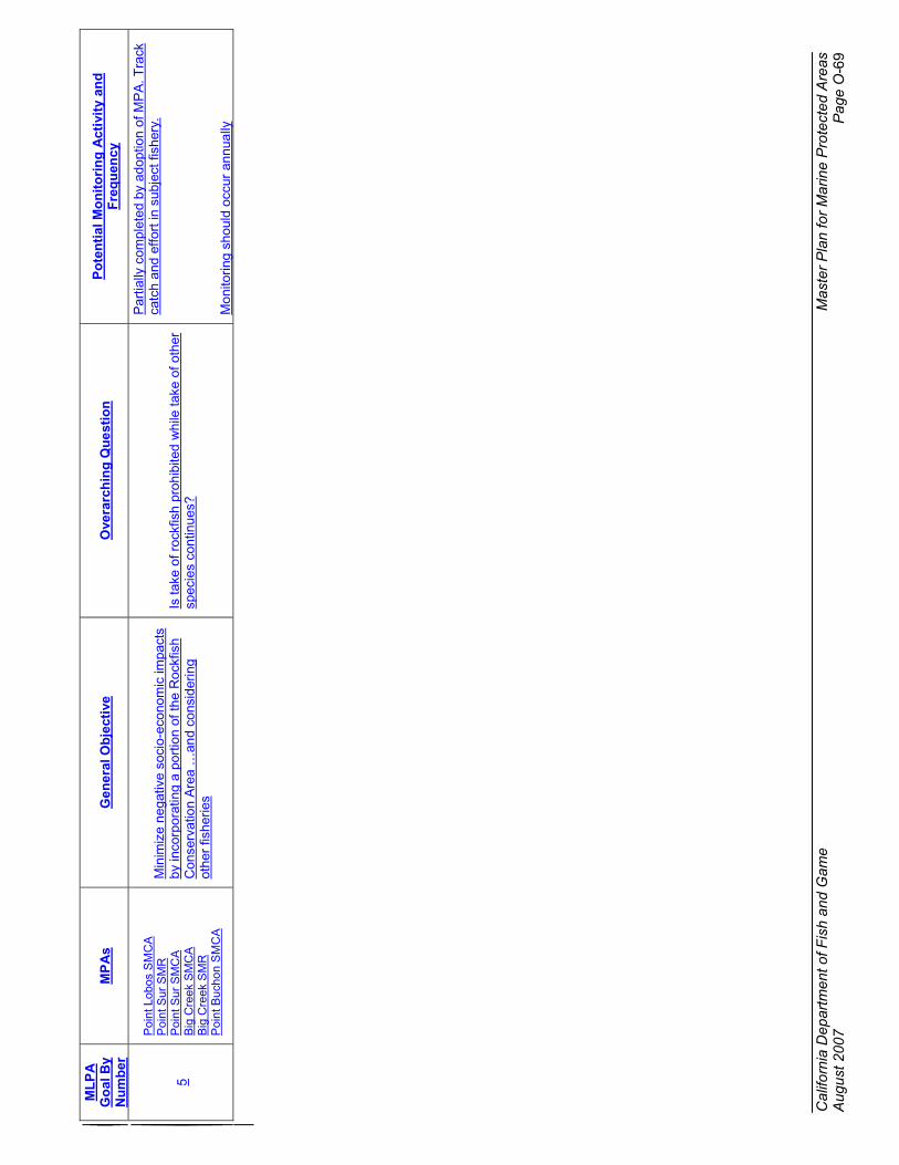
Cal
iforn
ia D
epar
tmen
t of F
ish
and
Gam
e M
aste
r P
lan
for
Mar
ine
Pro
tect
ed A
reas
A
ugus
t 200
7 P
age
O-6
9
ML
PA
G
oal
By
Nu
mb
erM
PA
sG
ener
al O
bje
ctiv
eO
vera
rch
ing
Qu
esti
on
Po
ten
tial
Mo
nit
ori
ng
Act
ivit
y an
d
Fre
qu
ency
5
Poi
nt L
obos
SM
CA
Poi
nt S
ur S
MR
Poi
nt S
ur S
MC
AB
ig C
reek
SM
CA
Big
Cre
ek S
MR
Poi
nt B
ucho
n S
MC
A
Min
imiz
e ne
gativ
e so
cio-
econ
omic
impa
cts
by in
corp
orat
ing
a po
rtio
n of
the
Roc
kfis
h C
onse
rvat
ion
Are
a …
and
cons
ider
ing
othe
r fis
herie
s
Is ta
ke o
f roc
kfis
h pr
ohib
ited
whi
le ta
ke o
f oth
er
spec
ies
cont
inue
s?
Par
tially
com
plet
ed b
y ad
optio
n of
MP
A. T
rack
ca
tch
and
effo
rt in
sub
ject
fish
ery.
Mon
itorin
g sh
ould
occ
ur a
nnua
lly

California Department of Fish and Game Master Plan Appendicesfor Marine Protected AreasJuly 21, 2006Page August 2007 Page O-70
Performance Determination
Performance will be measured for the network as a whole, for network components, and for groups of MPAs with common objectives. In some instances, performance will be measured for a single MPA to determine if MPA specific goals are met.
In some instances, such as the need to include a diversity of habitats, performance will simply be a measure of the presence or absence and/or quantity of a particular habitat or feature. This can be measured at the individual MPA level or across the network of MPAs.
In other instances to measure performance some metrics will need to be measured and compared against reference sites. With studies conducted in nature, it is not possible to control all factors driving the system. It is possible to compare areas with and without an impact (e.g., establishing MPAs), but measuring the impact requires differentiating the response to the impact to those caused by other factors. In other words, is a response the outcome of a MPA designation? Likewise, is a response due to reduced fishing pressure or reduced pollution, or other factors?
One approach to this problem is Before-After-Control-Impact (BACI) monitoring (Green 1979,Stewart-Oaten 1986). In a BACI design, samples are taken in impacted and reference areas before and after the impact starts (such as before MPA designation). The premise of the BACI design is that treatments can be referenced against some control, in this case the “before” condition. Where applicable the BACI approach will be used.
Similar to the BACI approach reference sites within and outside of MPAs will be used to make comparisons. To accommodate for variance numerous measurements across the range of variability will be made, ensuring that data are collected for the most important factors that drive the system. This approach over time will allow for trends to develop within and outsideMPA boundaries.
To support the BACI design some baseline data exists and will be identified. Other baseline data will be gathered across various MPAs and reference sites. The baseline data that will be necessary to achieve the monitoring goals many are identified above. Baseline data and much of the monitoring activities will be solicited through a RFP (request for proposals) process.
The Department will be the lead agency for data management, assessment and communication. Data will be collected from the monitoring programs and outside sources and integrated into a database. Data will be analyzed to evaluate performance of the network and network components relative to the goals and objectives, and provide the information needed for adaptive management. Results and conclusions will be communicated to resource managers and the public. Long-term storage and management of data will be provided by the Department’s Biogeographic Data Branch.
Monitoring of fishing effort
For this monitoring program, the most important variable to measure is fishing effort before and after implementation of the MPAs. Populations in MPAs are expected to respond in relation to

California Department of Fish and Game Master Plan Appendicesfor Marine Protected AreasJuly 21, 2006Page August 2007 Page O-71
the prior level of fishing, with more response in heavily fished than in lightly fished MPAs. Fishing effort in areas outside MPAs will change not only in response to the MPAs, but also in response to changes in the regulatory, economic and social environment. Because fishing effort in outside areas is variable both temporally and spatially, all MPA/reference comparisons will need to consider fishing effort. The evaluation of MPAs will also need to consider if displaced fishing effort is affecting areas outside of MPAs.
Recreational fishing will be monitored through the Department’s California Recreational Fishing Survey (CRFS) which collects data on catch and fishing effort for private and rental boats, commercial passenger fishing vessels (CPFVs), man-made structures such as piers and jetties, and beaches and banks. The data can be referenced to 1 minute of latitude by 1minute of longitude (approximately 1 square nautical mile), a scale that will allow analysis at the level of an individual MPA. The survey began in 2004 as a modification of a previous recreational fishing survey, and will continue through time, CRFS is a source of baseline and post-implementation data. Logbooks submitted to the Department from CPFVs will also provide valuable long-term data.
Collecting data for commercial fishing is more problematic. Data from logbooks submitted to the Department are available for spot prawn, and squid, although spot prawn data do not have fine spatial resolution. Data for other types of commercial fishing will need to be collected from a new program. Methods could include shipboard transponders and/or observers, remote sensing or aerial surveys, and/or incentive-based voluntary reporting. Information on preferred areas for fishing collected by Ecotrust can serve as a proxy for pre-implementation fishing effort.
Monitoring by habitat
Monitoring activities are presented in order of priority. Recommendations of the Baseline Science-Management Panel (BSMP) were considered when setting priorities, but modified for the purpose of long-term monitoring. Deep water rocky habitat was ranked first because it supports many of the species mentioned in the objectives (e.g., rockfish and other groundfishspecies) and, based on the Ecotrust analysis; this habitat has had the most consumptive use. Shallow rocky habitat, including kelp beds, was ranked second because it supports many of the species mentioned in the objectives. Since habitat mapping is required for the evaluation of Goal 4 and many MPA-specific objectives, it is considered high priority and ranked third. Within medium priority activities, deep water soft bottom and rocky intertidal were ranked one and two, respectively. Low priority activities are not included here. Measuring residence time of species is needed to evaluate the level of protection afforded by MPAs and is considered for each habitat type.
Deep Water (> 30m) Hard Bottom Monitoring
Eighteen MPAs have deep water (> 30 m) hard bottom habitat (Table 7) with seven having habitat in >100 m. For logistical reasons MPAs with little hard bottom habitat or those that are not well mapped will not be monitored. MPAs that have been identified by the science panel as either having substantial hard bottom habitat > 0.25 mi2 or are of interest for other reasons will have long term monitoring. Based on the known amount of available hard bottom habitat and professional judgment the science panel identified 12 MPAs that should be sampled: Soquel

California Department of Fish and Game Master Plan Appendicesfor Marine Protected AreasJuly 21, 2006Page August 2007 Page O-72
Canyon SMCA, Portuguese Ledge SMCA, Carmel Pinnacles SMR, Pt Lobos SMR, Point Lobos SMCA, Point Sur SMR, Point Sur SMCA, Big Creek SMR, Big Creek SMCA, Piedras Blancas SMCA, Point Buchon SMR, and Point Buchon SMCA. It must be noted that as the pool of knowledge increases on these areas MPAs the monitoring list may be modified.
Table 7. MPAs with deep water (> 30 m) hard bottom habitat (area in mi2).
MPA Name 30-100 m 100-200 m >200 m
Soquel Canyon SMCA 2.38 2.05 0.87Portuguese Ledge SMCA 0.38 1.62 1.51Pacific Grove Marine Gardens SMCA 0.14 0 0Asilomar SMR 0.08 0 0Carmel Pinnacles SMR 0.37 0 0Carmel Bay SMCA 0.04 0 0Pt. Lobos SMR 1.13 0 0Pt. Lobos SMCA 0.26 1.64 0.95Point Sur SMR 1.8 0 0Point Sur SMCA 1.84 0.01 0Big Creek SMCA 0.06 0.05 0.02Big Creek SMR 0.11 0.01 0.03Piedras Blancas SMR 0.15 0 0Piedras Blancas SMCA 0.56 0 0Cambria SMR 0.02 0 0Point Buchon SMR 0.75 0 0Point Buchon SMCA 0.69 0.02 0Vandenberg SMR 0.25 0 0
The Science Advisory Team recommended a list of species likely to benefit from MPAs. From this list focal species (Table 8) were identified to provide direct comparisons to reference sites outside the MPAs. The focal species will provide one measure with which to monitor change in populations over time.
Table 8. Focal fish and invertebrate species for deep water (> 30m) hard bottom habitats.
Common Name Scientific Name Reason for Selectionbocaccio Sebastes paucispinis shift number, size1
cowcod Sebastes levis shift number, size1
lingcod Ophiodon elongatus shift number1
blue rockfish Sebastes mystinus shift number, size 1
greenspotted rockfish Sebastes chlorosticus shift size1
copper rockfish Sebastes caurinus shift size1
olive rockfish Sebastes serranoides shift size1
squarespot rockfish Sebastes hopkinsi fishedyelloweye rockfish Sebastes ruberrimus shift number1
yellowtail rockfish Sebastes flavidus shift size1
widow rockfish Sebastes entomelas shift number1
vermilion rockfish Sebastes miniatus shift size1
galatheid crabs Galatheidae incidental catch in spot prawn fishery
red rock crab Cancer productus fished, incidental catch in spot

California Department of Fish and Game Master Plan Appendicesfor Marine Protected AreasJuly 21, 2006Page August 2007 Page O-73
Common Name Scientific Name Reason for Selectionprawn fishery
box crab Lopholithodes foraminatus fished, incidental catch in spot prawn fishery
crinoids Florometra serratissima habitat formingsponges Porifera habitat forminganemones Metridium spp., Urticina picivora habitat forming
black corals Antipathes spp. ecosystem componentbasket stars Gorgonocephalis eucemis habitat formingsea stars Ceramaster spp., Mediaster
aequilis, Pteraster spp.predatory
spot prawn Pandalus platyceros fished1 Shift number, size means that studies have shown that populations have been reduced in abundance (or density) and/or the size distribution has been altered
Existing data on deep water habitats is limited for the central coast region but will be critical in establishing baseline information. In 2003, the National Marine Fisheries Service (NMFS)extended the sampling area for their annual trawl surveys for groundfish to include all of Washington, Oregon and California from approximately 55 to 1280 m. To avoid losing the nets, higher relief areas are avoided, but the trawls do sample lower relief hard bottom habitat. In 1992-1993 Yoklavich, et al. (2000) surveyed benthic fish populations in Soquel Canyon. In 1997-1998 Yoklavich, et al. (2002) surveyed benthic fish populations inside and outside of the Big Creek Marine Ecological Reserve (now Big Creek State Marine Reserve). Both surveys were conducted with a submersible. Strip transects were videotaped to provide documentation of fish abundance and habitat type.
For the Channel Islands MPA monitoring program in southern California, a Remotely Operated Vehicle (ROV) is used to survey fish in hard bottom habitats beyond the reach of divers (20-80 m) (http://www.dfg.ca.gov/mrd/fir/dss.html). Survey techniques used in ROV and submersible surveys are similar, but not identical. To compare methods, Dr. Milton Love and Donna Schroeder surveyed two of the ROV survey sites with a submersible in 2005. Results of the comparison should be available soon. Nasby et al. (2002) integrated detailed seafloor mapping and submersible transects to estimate fish densities across broad areas of a deepwater bank off Oregon.
To provide standardized baseline information the science panel developed a stratified random block sample design intended to be robust enough to allow for different methodologies, such as ROV, AUV, or towed camera surveys. Deep water hard bottom habitats will be stratified by depth; 30-100m, 100-200m, and >200m. Based on the current knowledge of habitat distribution, a grid with blocks 500m x 500m (exact grid size may change as specific protocols and sites are further refined) will be placed on maps depicting hard bottom habitats. Blocks will be randomly selected within each stratum. Certain criteria, e.g. blocks may not be adjacent to each other, may be applied to ensure the distribution of blocks is representative of the habitat within each strata. Each of these blocks will provide the core of the sampling and will be re-surveyed each year. Similarly, blocks will be selected at reference sites that contain similar habitat in each of the identified strata.

California Department of Fish and Game Master Plan Appendicesfor Marine Protected AreasJuly 21, 2006Page August 2007 Page O-74
At each sample block replicate transects will be surveyed. Transect direction will be random/haphazard for each survey block and each year. Transect length will be determined as protocol are refined but based on suggestions by the science panel are initially set to be 100-150m in length.
Existing survey techniques can be used to measure size and density of conspicuous benthic fish and invertebrates, including all focal fish species (Table 8), although some work will be needed to create detailed sampling protocols, including quality assurance/quality control (QA/QC). Survey methods need to be developed for invertebrates.
Transect survey techniques should provide data for all focal invertebrates, except crabs and spot prawn, which will need to be sampled with traps. In areas with limited visibility, sampling with traps and/or fishing gear will be needed.
Targeted research/monitoring projects can provide data on residence times of selected focal species. Starr et al. (2000, 2002) have developed techniques for tagging and tracking deep water species such as bocaccio and greenspotted rockfishes. Monitoring activities that addresses these questions and details on other non-visual monitoring programs will be provided as those projects develop.
Shallow Water (< 30m) Hard Bottom Monitoring
Eighteen MPAs have shallow water (< 30m) hard bottom habitat (Table 9).
Table 9. MPAs with shallow water (< 30m) hard bottom habitat (area in mi2).
MPA Name Hard 0-30 Average
KelpPISCO
SamplingSite
Año Nuevo SMR 3.56 0.01 X
Greyhound Rock SMCA 1.96 0.01 X
Natural Bridges SMR 0.58 0.02 XEdward F. Ricketts SMCA 0.06 0.05 XLovers Point SMR 0.09 0.08 XPacific Grove Marine Gardens SMCA 0.48 0.14Asilomar SMR 0.59 0.11Carmel Pinnacles SMR 0.07 0.01Carmel Bay SMCA 0.71 0.30 XPt. Lobos SMR 1.03 0.27 XPoint Sur SMR 3.41 0.84 XBig Creek SMCA 0.40 0.17Big Creek SMR 0.57 0.21 XPiedras Blancas SMR 1.60 0.50 XCambria SMP 1.34 0.57 XCambria SMR 1.02 0.38 XPoint Buchon SMR 0.60 0.21Vandenberg SMR 3.27 0.02 X

California Department of Fish and Game Master Plan Appendicesfor Marine Protected AreasJuly 21, 2006Page August 2007 Page O-75
Visual surveys will provide data for all focal species (Table 10), except grass rockfish, cabezon, and brown rock crab. Traps and/or hook and line fishing will be needed for these species and to sample areas with limited visibility. At some sites, particularly Año Nuevo SMR, and Greyhound Rock SMCA, where diver safety precludes scuba surveys, ROVs may be used.
Table 10. Focal fish and invertebrate species for shallow water (< 30m) hard bottom habitats.
Common Name Scientific name Reason for selectionlingcod Ophiodon elongatus shift number1
kelp greenling Hexagrammos decagrammus
fished
grass rockfish Sebastes rastrelliger fishedbrown rockfish Sebastes auriculatus fishedvermilion rockfish Sebastes miniatus shift size1
copper rockfish Sebastes caurinus shift size1
black rockfish Sebastes melanops shift number1
blue rockfish Sebastes mystinus shift size1
olive rockfish Sebastes serranoides shift size1
gopher rockfish Sebastes carnatus fishedkelp rockfish Sebastes atrovirens fishedcabezon Scorpaenichthys
marmoratusfished
black surfperch Embiotoca jacksoni major component of ecosystem
striped surfperch Embiotoca lateralis major component of ecosystem
abalones Haliotis spp shift number, size1
red urchin Strongylocentrotus franciscanus
fished, removal affects other species
purple urchin Strongylocentrotus purpuratus
population level affects other species
sea stars Pisaster spp. keystone speciesbrown rock crab Cancer antennarius fishedbull kelp Nereocystis luetkeana habitat forminggiant kelp Macrocystis pyrifera habitat forming
1 Shift number, size means that studies have shown that populations have been reduced in abundance (or density) and/or the size distribution has been altered
The Partnership for Interdisciplinary Studies of Coastal Oceans (PISCO) has ongoing monitoring at 14 sites within the central coast region, with 10 inside MPAs (Table 9). Sites have been sampled annually, starting between 1999 and 2004, depending on the site. Divers conduct visual surveys of conspicuous fish species and count selected invertebrate and algal species along replicate 30 x 2 m transects. Uniform contact sampling is used to measure substrate type and relief as well as the percent cover of benthic organisms. Additionally, the monitoring program for the Diablo Canyon Nuclear Power Plant has been sampling for fish and invertebrates since 1978 (Tenera 1998).
Reef Check, a volunteer organization, has 12 stations in the central coast region, 11 in MPAs. Additional sites inside and outside MPAs will be added as the program expands. Sampling began in the fall of 2006 and will continue twice a year in the spring and fall. Reef Check

California Department of Fish and Game Master Plan Appendicesfor Marine Protected AreasJuly 21, 2006Page August 2007 Page O-76
protocols are adapted from the PISCO/CRANE protocols and will provide density and size information for all the focal species. Surveys are limited to depths less than 18 m. Reef Check has recently entered into an MOU to provide monitoring data to CDFG.
The Cooperative Research and Assessment of Nearshore Ecosystems (CRANE) Program is a collaborative monitoring program between CDFG and various universities, private organizations, and government programs designed to provide data for fishery management and performance of marine protected areas. The CRANE program began sampling in 2004 and included several sites within existing MPAs. The CRANE program will provide the basic framework for monitoring and performance evaluation. The CRANE program was specifically developed as collaboration and will therefore utilize and expand on partnerships. Details about the CRANE program can be found at http://www.dfg.ca.gov/MRD/fir/sss.html#crane.
Deep Water (> 30m) Soft Bottom MonitoringTwenty-one MPAs have mid and deep water (> 30m) soft bottom habitat (Table 11). All 21 have habitat between 30 and 100 m; 7 have habitat in deeper water. Additionally, a list of focal species has been developed for this habitat (Table 12).
Table 11. MPAs with mid and deep water (>30 m) soft bottom habitat (area in mi2).
MPA Name Soft 30-100 m Soft 100-200 m Soft >200 m
Año Nuevo SMR 2.70 0.00 0.00Greyhound Rock SMCA 9.03 0.00 0.00Soquel Canyon SMCA 13.20 1.77 3.14Portuguese Ledge SMCA 1.46 4.45 1.48Pacific Grove Marine Gardens SMCA 0.02 0.00 0.00Asilomar SMR 0.01 0.00 0.00Carmel Pinnacles SMR 0.07 0.00 0.00Carmel Bay SMCA 0.05 0.00 0.00Pt. Lobos SMR 2.32 0.06 0.00Pt. Lobos SMCA 0.18 2.94 2.88Point Sur SMR 2.34 0.00 0.00Point Sur SMCA 8.10 0.00 0.00Big Creek SMCA 2.19 0.36 6.12Big Creek SMR 2.61 0.84 7.05Piedras Blancas SMR 2.56 0.00 0.00Piedras Blancas SMCA 8.20 0.00 0.00Cambria SMP 0.44 0.00 0.00Cambria SMR 0.33 0.00 0.00Point Buchon SMR 4.66 0.00 0.00Point Buchon SMCA 7.93 2.91 0.00Vandenberg SMR 9.69 0.00 0.00

California Department of Fish and Game Master Plan Appendicesfor Marine Protected AreasJuly 21, 2006Page August 2007 Page O-77
Table 12. Focal fish and invertebrate species for mid and deep water (> 30 m) soft bottom habitats.
Common Name Scientific Name Reason for Selectionpetrale sole Eopsetta jordani shift number, sizeDover sole Microstomus pacificus fishedEnglish sole Parophrys vetulus fishedslender sole Lyopsetta exilis fishedrex sole Glyptocephalus zachirus fishedPacific sandab Citharichthys sordidus fishedsablefish Anoplopoma fimbria fishedsplitnose rockfish Sebastes diploproa fishedchilipepper Sebastes goodei fishedspotted ratfish Hydrolagus colliei ecosystem componentshortspine thorneyhead Sebastolobus alascanus fishedlongspine thorneyhead Sebastolobus altivelis fishedCalifornia skate Raja inornata fishedlongnose skate Raja rhina fished
sea pensStylatula spp, Ptilosarchus spp, Anthoptilum spp. habitat forming
flat mud star Luidia foliolata. predatorsunflower star Pycnopodia helianthoides predatorcarpet star Thrissacanthias penicillatus predatorfragile red sea urchin Allocentrotus fragilis ecosystem componentDungeness crab Cancer magister fished
Monitoring protocols used to survey hard bottom habitat can be adapted to monitor soft bottom habitats. However, besides the annual trawl survey by NMFS described in “Deep Water (>30m) Hard Bottom Monitoring”, there is no ongoing monitoring of mid and deep water soft bottom habitats. Submersible surveys by Yoklavich, et al. (2000) in Soquel Canyon, and Yoklavich, et al. (2002) in and adjacent to Big Creek Marine Ecological Reserve (now Big Creek SMR) included deep water soft bottom habitat. Hixon and Tissot (2007) ran submersible transects for fishes and invertebrates over deep mud seafloors off Oregon. Visual survey techniques will capture all focal species except Dungeness crab, which can be sampled with traps. Trawls can also be used. Trawls can capture all species, although sea pens may be under-represented because they anchor into the substrate.
Specific monitoring activities for mid and deep water (>30 m) soft bottom habitats will be presented as programs develop.
Rocky Intertidal MonitoringTwelve MPAs have rocky intertidal habitat (Table 13). The Multi-Agency Rocky Intertidal Network (MARINe), a partnership of more than 40 federal, state, academic and other institutions, monitors 20 sites in the central coast region; five sites are inside MPAs (Table 13). The focal species for rocky intertidal monitoring are presented in table 14.
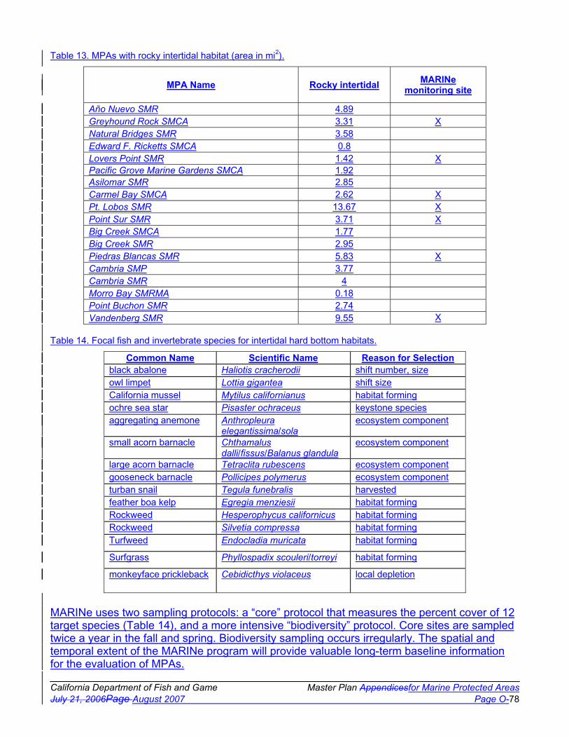
California Department of Fish and Game Master Plan Appendicesfor Marine Protected AreasJuly 21, 2006Page August 2007 Page O-78
Table 13. MPAs with rocky intertidal habitat (area in mi2).
MPA Name Rocky intertidal MARINe monitoring site
Año Nuevo SMR 4.89Greyhound Rock SMCA 3.31 XNatural Bridges SMR 3.58Edward F. Ricketts SMCA 0.8Lovers Point SMR 1.42 XPacific Grove Marine Gardens SMCA 1.92Asilomar SMR 2.85Carmel Bay SMCA 2.62 XPt. Lobos SMR 13.67 XPoint Sur SMR 3.71 XBig Creek SMCA 1.77Big Creek SMR 2.95Piedras Blancas SMR 5.83 XCambria SMP 3.77Cambria SMR 4Morro Bay SMRMA 0.18Point Buchon SMR 2.74Vandenberg SMR 9.55 X
Table 14. Focal fish and invertebrate species for intertidal hard bottom habitats.
Common Name Scientific Name Reason for Selectionblack abalone Haliotis cracherodii shift number, sizeowl limpet Lottia gigantea shift sizeCalifornia mussel Mytilus californianus habitat formingochre sea star Pisaster ochraceus keystone speciesaggregating anemone Anthropleura
elegantissima/solaecosystem component
small acorn barnacle Chthamalus dalli/fissus/Balanus glandula
ecosystem component
large acorn barnacle Tetraclita rubescens ecosystem componentgooseneck barnacle Pollicipes polymerus ecosystem componentturban snail Tegula funebralis harvestedfeather boa kelp Egregia menziesii habitat formingRockweed Hesperophycus californicus habitat formingRockweed Silvetia compressa habitat formingTurfweed Endocladia muricata habitat forming
Surfgrass Phyllospadix scouleri/torreyi habitat forming
monkeyface prickleback Cebidicthys violaceus local depletion
MARINe uses two sampling protocols: a “core” protocol that measures the percent cover of 12 target species (Table 14), and a more intensive “biodiversity” protocol. Core sites are sampled twice a year in the fall and spring. Biodiversity sampling occurs irregularly. The spatial and temporal extent of the MARINe program will provide valuable long-term baseline information for the evaluation of MPAs.

California Department of Fish and Game Master Plan Appendicesfor Marine Protected AreasJuly 21, 2006Page August 2007 Page O-79
The percent cover of target species as well as other associated species is measured by photographing approximately five permanent 50 X 75 cm plots established in areas of high target species density. The photographs are then scored in the laboratory using point-contact methods. In areas with sufficient populations, the number and size distribution of owl limpets (Lottia gigantea) is measured in five permanent circular plots. Band transects or irregularly-shaped plots, depending on the site, are used to estimate the number and size of black abalone (Haliotis cracherodii) and seastars (primarily Pisaster ochraceus). Timed searches are used where densities are too low for band transects. The cover of surfgrass and associated species is measured on approximately three permanent transects, 10 m long, with point contact methods.
The list of focal species for intertidal hardbottom monitoring and MARINe target species (Table 14) are identical except for the inclusion of turban snails and monkeyface prickleback. These two species were included because they are harvested. While turban snails are not a MARINe target species, they are sampled annually. MARINe protocols will not provide data for fish such as the monkeyface prickleback. Special studies, including trapping and/or hook and line fishingusing the traditional recreational gear known as a “poke pole”, will be needed for this species.
It is expected that additional monitoring will closely follow MARINe protocols. However, it may be necessary in some instances to augment the sampling with additional replication and/or random sampling.
Marine Mammal and Seabird MonitoringIf some fish and invertebrate species increase in size and number as expected, MPAs may affect seabirds and marine mammals by increasing or shifting their forage base.
Focal seabirds and marine mammals (Table 15) occur throughout the central coast region.
Table 15. Focal marine birds and mammals.
Common Name Scientific Name Reason for Selection
Marine BirdsBrandt's cormorant Phalacrocorax
penicillatusdisturbance, increase in forage base
brown pelican Pelecanus occidentalis disturbance, increase in forage base
common murre Uria aalge disturbance, increase in forage base
double-crested cormorant
Phalacrocorax auritus disturbance, increase in forage base
pelagic cormorant Phalacrocorax pelagicus disturbance, increase in forage base
rhinocerous auklet Cerorhinca monocerata disturbance, increase in forage base
pigeon guillemot Cepphus columba disturbance, increase in forage base
grebes Podicipedidae increase in forage baseloons Gaviidae increase in forage basemarbled murrelet Brachramphus
marmoratusdisturbance, increase in forage base
sooty shearwater Puffinus griseus hot spots for prey, indicator of prey

California Department of Fish and Game Master Plan Appendicesfor Marine Protected AreasJuly 21, 2006Page August 2007 Page O-80
Common Name Scientific Name Reason for Selection
Marine Birdsavailability
Cassin’s auklet Ptychoramphus aleuticus Indicator of krill and larval fish abundance
black oyster catcher Haematopus bachmani intertidal ecosystem component
Marine Mammalssea otter Enhydra lutris keystone speciesCalifornia sea lion Zalophus californianus predatorharbor seal Phoca vitulina predatorelephant seal Mirounga angustirostris predatorharbor porpoise Phocoena phocoena aggregate in specific areas
Aerial, shoreline, and strip surveys can be used to measure the distribution and abundance and foraging patterns of focal species of seabirds and mammals. Surveys of breeding sites can measure breeding success (number of offspring per adult). Studies of diet can provide information for evaluation of foraging behavior and reproductive success, as well as information on the availability of prey species. Although no specific monitoring protocol has been established to monitor marine mammals or seabirds existing programs may meet many of the monitoring needs.
NMFS and the Monterey Bay National Marine Sanctuary (MBNMS) have a program called Collaborative Survey of Cetacean Abundance and the Pelagic Ecosystem (CSCAPE) which conducts annual surveys of marine mammals. Track lines are surveyed on a large scale grid(~160 km) from the US/Canadian border to the US/Mexico border and on a smaller grid (18.5 km) within the boundaries of the MBNMS. Although the survey targets marine mammals, seabirds are also recorded. The sampling provides good information on abundances, but the grid is too large for monitoring individual MPAs.
The United States Geological Service (USGS) conducts surveys of sea otters in the spring and fall in the area between Monterey Bay and Santa Barbara. Sightings are made from shore or with aerial surveys in inaccessible areas. Burney LeBoeuf, at U.C. Santa Cruz, has conducted annual surveys of elephant seals in the MBNMS since 1968.
Dr. Jim Harvey and students at the Moss Landing Marine Laboratory conduct biannual surveys of shorebirds and annual surveys of harbor seals and sea otters in Elkhorn Slough. Elkhorn Slough National Estuarine Research Reserve program volunteers have surveyed shorebirds at 24 sites bimonthly since 1998. Surveys are also conducted at rookeries to determine breeding success for herons, egrets, cormorants and Caspian terns.
Shorebird populations in Morro Bay have been monitored biannually by Morro Bay National Estuary Program volunteers in conjunction with the PRBO Conservation Science (PRBO). Since 1992, from April through August, PRBO has conducted weekly surveys of seabird abundance, breeding performance, and diet at Año Nuevo Island and monthly diet surveys since 2001. At Vandenberg SMR, PRBO has conducted weekly surveys (April through August) of breeding seabird population size and performance since 1999 and seabird diets and seabird

California Department of Fish and Game Master Plan Appendicesfor Marine Protected AreasJuly 21, 2006Page August 2007 Page O-81
and marine mammal foraging distributions since 2000. Roosting seabird distributions have been surveyed biweekly from January through December since 2001.
Coastal Marsh and Estuary MonitoringNine MPAs have coastal marsh and estuarine habitat (Table 16); most of the habitat is in Elkhorn Slough and Morro Bay. The list of focal species created for estuarine habitats is presented in table 17.
Table 16. MPAs with coastal marsh and estuary habitat (area in mi2).
MPA Name Coastal marsh Tidal flats Eelgrass Estuary
Natural Bridges SMR 0.68 0.00 0.00 0.00
Elkhorn Slough SMR 9.16 9.16 0.03 1.48
Elkhorn Slough SMP 0.95 0.99 0.01 0.09
Moro Cojo SMR 0.00 0.00 0.00 0.46Piedras Blancas SMR 0.00 0.00 0.00 0.01
Cambria SMP 0.47 0.15 0.00 0.01Morro Bay SMR 1.52 0.72 0.00 0.3
Morro Bay SMRMA 6.69 5.23 1.04 3.01Vandenberg SMR 0.01 0.01 0.00 0.00
Table 17. Focal species for estuaries.
Common Name Scientific Name Reason for Selectiontopsmelt Atherinops affinis lay eggs on plantsleopard shark Triakis semifasciata use estuary as nursery, fishedblack surfperch Embiotoca jacksoni fishedshiner surfperch Cymatogaster aggregata fishedghost shrimp Calianassa spp. collected for baitinnkeeper worm Urechis caupo ecosystem componentgaper clams Tresus spp. ecosystem componenteelgrass Zostera spp. habitat forming
Both Elkhorn Slough and Morro Bay have ongoing monitoring. As part of the Elkhorn Slough National Estuarine Research Reserve program, volunteers have collected water quality samples monthly at 24 stations since 1998. Baited traps are used to capture crabs and visual surveys are done of surface burrow structures to measure populations of gaper clams, fat innkeeper worms, and ghost shrimp. Since 1994, Morro Bay National Estuary Program volunteers have conducted annual aerial and sonar surveys to map the distribution and abundance of eelgrass in the Bay.
Ongoing monitoring will provide sufficient information for some focal species (Table 15). Monitoring in Elkhorn Slough will provide information for ghost shrimp, innkeeper worms, andgaper clams. Surveys would need to be conducted in Morro Bay for these species. Eelgrass is mapped in Morro Bay, but not in Elkhorn Slough. Given the limited amount of habitat, mapping eelgrass in Elkhorn Slough may not be cost effective.

California Department of Fish and Game Master Plan Appendicesfor Marine Protected AreasJuly 21, 2006Page August 2007 Page O-82
At present, there is no ongoing monitoring for focal fish species in Morro Bay or Elkhorn Slough. In Elkhorn Slough there is some historical data from Moss Landing Marine Lab research projects and class trawls, but nothing after 2003. Trawl, gill net, and/or trap sampling will be needed for the evaluation of focal fish species. Details on these programs will be added as they are developed.
Socioeconomic monitoring
To evaluate changes in opportunities for recreation, education and research (goal 3), it will be necessary to measure activities within and outside MPAs before and after implementation. In contrast to the biophysical system, impacts on activities will begin to occur simultaneously with implementation. In this case, a baseline can be established with existing data and/or user surveys. If the MPAs function as expected, the level of activity should increase inside MPAs.
The MPA-specific objective to increase positive socioeconomic benefits applies primarily to non-consumptive uses in Piedras Blancas SMR, recreational fishing in Cambria SMP, and non-consumptive diving in Hopkins SMR, Pacific Grove SMCA, Asilomar SMR, Carmel Pinnacles SMR, and Point Lobos SMR. Priorities for monitoring developed by the BSMP are provided in the following text; however, priorities for baseline and long-term monitoring will differ. As noted in the report of the MLPA Initiative Staff (2006), prioritization is primarily a policy decision, not a scientific judgment.
Non-Consumptive Recreation, Education, and ResearchEstablishing a baseline for the indicators described above in Long-term and Ongoing Monitoring will require surveys, literature reviews or other data collection, as there is little existing information. Most of the existing information on recreational activities is aggregated at the level of the county and state, a scale too large to be useful for evaluating the central coast network or individual MPAs. LaFranchi and Tamanaka (2005) conducted a preliminary survey of recreational use in Monterey and Santa Cruz Counties. These data are useful, but limited in scope.
Surveys of non-consumptive users as well as educational and research institutions can be done via mail or the internet or, in the case of present use, by intercepting people on site. Survey instruments can be designed to collect information about the time and location of use, attitudes, perceptions, and cost. The Baseline Science and Monitoring Panel (BSMP) considered a survey of divers’ high priority because divers are most directly affected by MPA designation. The survey would include effort by location and time, travel cost and expenditures. Including other user groups (kayakers, wildlife viewing and unplanned activities) and information on knowledge, attitudes, and perceptions for all users was considered medium priority.
A literature search can be conducted to establish a baseline number of research publications as well as the number of post-implementation citations.
Consumptive Uses As noted above, determining the location and intensity of fishing before and after implementation of the MPAs is critical to the assessment of biophysical impacts (e.g. from

California Department of Fish and Game Master Plan Appendicesfor Marine Protected AreasJuly 21, 2006Page August 2007 Page O-83
displaced fishing effort, see discussion above on monitoring fishing effort) as well as socioeconomic impacts.
For the economic and social dimension, the BSMP considered collecting data on costs and earnings from businesses depending on recreational consumptive use and measuring the knowledge, attitudes and perceptions of recreational users’ medium priority.
Data on costs and earnings, employment and other characteristics can be collected to ascertain economic and social effects of MPAs on fishery participants and fishing operations (medium priority). The BSMP determined that socioeconomic data on coastal communities should not be a priority; however, impacts can be measured by analyzing linkages between resource users and coastal communities.
Management and Enforcement Monitoring
The framework for the evaluation of Management and Enforcement is provided by the Regional MPA Management Plan. The Plan is the guide for implementation and a measure of performance is implementation relative to the Plan.
The Management Plan includes the following elements:
1. Introduction (“Why?” and “Where?”)a. Description of region b. Regional design and implementation considerationsc. Regional goals, and objectives d. Description of individual MPA boundaries (including maps), regulations, and
objectives2. General Activities and Locations (“What?” and “Where?”)
a. Scientific Monitoring and Research planb. Outreach, Interpretation and Education planc. Enforcement pland. Contingencies and Emergency Planning
3. Operations (“How?”)a. Equipment and Facilitiesb. Staffingc. Collaborations and Potential Partnerships
4. Costs and Funding (“How Much?”)a. Estimated costsb. Potential funding sources
5. Timelines and Milestones (“When?”)a. Timeline and Criteria for Implementation b. Timeline for Evaluation and Review of Effectiveness
Evaluation of management performance should consider the nature and extent of work performed to implement each program activity, specifically: 1) scientific monitoring; 2) outreach, interpretation and education; 3) enforcement; and 4) contingency and emergency planning. The descriptions of program elements should include information on equipment and

California Department of Fish and Game Master Plan Appendicesfor Marine Protected AreasJuly 21, 2006Page August 2007 Page O-84
facilities; staff and budget; collaborators, partners, and stakeholder involvement; as well as the timelines and milestones that have or have not been met.
The evaluation of program elements should consider implementation relative to regional goals and objectives, as well goals and objectives in individual activity plans (e.g., the scientific monitoring plan). The effect of staffing and budget on implementation should also be evaluated. To determine if central coast MPAs are operating as a network component, and if the regional network is operating as part of a statewide network, implementation should be evaluated for consistency within the regional and statewide system. Inconsistencies should be explained.
Although management and enforcement will begin with implementation, time is needed to create an operational history. To have sufficient information, management and enforcement should be evaluated 5 years after implementation.
Indicators for all program elements include extent of implementation and extent of stakeholder and public involvement. Indicators specific to program elements follow.
One indicator for the first program element “scientific monitoring” is the availability of information for adaptive management. The description of scientific monitoring should include program objectives, use of the data for evaluation of regional and MPA-specific goals and objectives, and use of the data for adaptive management. Data gaps should be identified, and availability and use of the data by stakeholders, researchers, and other outside entities described.
Indicators for the second program element “outreach, interpretation, and education” include distribution of materials explaining the regulations, understanding and acceptance of the regulations, distribution of educational materials, the presence of interpretive signs, and extent of stakeholder involvement. The description of outreach, interpretation, and education should include use of the materials by stakeholders and other groups, as well as a measure of stakeholder understanding of the materials.
Indicators for the third program element “enforcement” include clearly defined enforcement procedures, enforcement coverage, and information dissemination to encourage compliance. The description of enforcement should include the number and extent of patrols, citations, and contacts with users.
Indicators for the fourth program element “contingency and emergency planning” include speed of response and presence of residual problems. The description of emergency responses should include an evaluation of the availability of resources and lessons learned.
Evaluation of the Network Design
Monitoring to evaluate the execution of the guidelines is discussed in this section. Monitoring to evaluate the management of the network or network component is discussed in the section “Management and Enforcement Monitoring” and monitoring to evaluate biological properties of the network or network component is discussed in “Biophysical Monitoring”.
California Department of Fish and Game Master Plan Appendicesfor Marine Protected AreasJuly 21, 2006Page August 2007 Page O-85
Data Management, Assessment and Communication
To assure data quality and integrity, quality assurance/quality control (QA/QC) procedures will be needed from field sampling to data analysis. Where appropriate, sampling equipment needs to be calibrated and tested prior to use. When sampling at sea, limits need to be set on operating conditions (e.g., wave height, water clarity) to provide for safety of the crew and to assure data quality and consistency. Data entered into electronic format should be double checked. Data in electronic format should be verified with range checks and other tests ofreasonableness. QA/QC procedures and operations should be documented.
QA/QC is also needed to assure data consistency, particularly when data are collected by separate programs. Sampling methods need to be standardized. Sampling protocols should be written in detail and distributed to all survey participants. Field notes, ship logs, and other records need to be kept to demonstrate that protocols were followed; deviations in protocols need to be documented. In some instances, it may be necessary to conduct inter-calibrations to measure data consistency among participants.
Scientific and public review will also be needed. It is expected that stakeholder and scientific advisory groups will be involved in monitoring, data analysis and evaluation.
Outreach, Interpretation and Education plan
The Department will hire a full-time outreach and education specialist to address a variety of Marine outreach needs, including MLPA. Additionally entry level staff will be hired in each region who will help implement outreach plans and provided direct contact with various user groups in the field. Programs may be developed to provide volunteer and cooperative outreach support and will be described as they are identified.
As specific outreach materials and programs are developed, details will be added to this document. Funding for outreach may come from the California Ocean Protection Council through bond funds received in the 2007/2008 budget cycle.
Enforcement plan
In order to facilitate enforcement, the Department proposes using a multi-tiered effort that targets high risk areas (areas prone to infractions) with higher levels of enforcement while maintaining sufficient enforcement in all MPAs. In certain areas, formal and informal partnerships will be relied upon to increase the number of “eyes-on-the-water”, person-hours of enforcement, and visibility of enforcement personnel. In some cases, formal memoranda of understanding (MOUs) will be developed to allow fund transfer between partner agencies.
Table 18 lists each MPA in the central coast region along with enforcement considerations. Staff needs to implement this plan are discussed in subsection 8.4.3.

California Department of Fish and Game Master Plan Appendicesfor Marine Protected AreasJuly 21, 2006Page August 2007 Page O-86
Table 18. Enforcement considerations for central coast region MPAs.MPA Name Primary
EnforcementMethod
Potential Partnerships/ Assistance
SpecialConsiderations
SpecialEquipment
NeedsAño Nuevo SMCA Ocean/Vessel
patrol with some shoreline patrol
California State Parks 14 to 16 miles to get patrol skiff to the area. Large Patrol vessel is about 25 miles away.
Boat launch at Año Nuevo-need to be able to trailer small boat closer to the area. Some aircraft patrol.
Greyhound Rock SMCA
Ocean/Vessel patrol with some shoreline patrol
Same issues as Año Nuevo
Same issues as Año Nuevo
Elkhorn Slough SMR Shoreline patrol with some small skiff patrol
Elkhorn Slough Foundation, NOAA/Elkhorn Slough National Estuarine Research Reserve
Boats
Elkhorn Slough SMCA (SMP
Shoreline patrol with some small skiff patrol
Elkhorn Slough Foundation, NOAA/Elkhorn Slough National EstuarineResearch Reserve
Boats
Moro Cojo SloughSMR
Shoreline patrol with some small skiff patrol
Elkhorn Slough Foundation, NOAA/Elkhorn Slough National Estuarine Research Reserve
Soquel Canyon SMCA
Ocean/Vessel patrol
Monterey Bay Marine Sanctuary
Heavily fished area - will require extensive on water patrol.
Small skiff and large boat patrol. Some aircraft patrol.
Portuguese Ledge SMCA
Ocean/Vessel patrol
Monterey Bay Marine Sanctuary
Not connected to shore - requires boat patrol
Small skiff and large boat patrol. Some aircraft patrol.
Edward F. Ricketts SMCA
Shoreline patrol and some boat patrol
Coast Guard, Monterey and Pacific Grove Police Departments. Monterey Bay Aquarium and Hopkins Marine Station. Monterey Bay Marine Sanctuary
Heavily used area. Many non-consumptive users.
Small boat patrol.
Lovers Point SMR Shoreline patrol and small skiff patrol
StanfordUniversity/Hopkins Marine Station. Monterey Bay Aquarium. Coast Guard. Monterey Police Department. Monterey Bay Marine Sanctuary
Heavily used area. Many non-consumptive users.
Boats
Pacific Grove Marine Gardens SMCA
Shoreline patrol and small skiff patrol
State Parks. Monterey Bay Sanctuary. Pacific Grove PD. Coast Guard
Heavily used area. Many non-consumptive users.
Boats
Carmel Pinnacles SMR
Ocean/Vessel patrol
Monterey Bay Sanctuary

California Department of Fish and Game Master Plan Appendicesfor Marine Protected AreasJuly 21, 2006Page August 2007 Page O-87
MPA Name PrimaryEnforcement
Method
Potential Partnerships/ Assistance
SpecialConsiderations
SpecialEquipment
NeedsCarmel Bay SMCA Shoreline patrol
and Ocean/Vessel patrol
Monterey Bay Sanctuary. Carmel PD
Boats
Point Lobos SMR Shoreline patrol and Ocean/Vessel patrol
California State Parks. Monterey Bay Sanctuary.
High use area for divers.
Boats
Point Lobos SMCA Ocean/Vessel patrol
California State Parks. Monterey Bay Sanctuary.
Boats
Point Sur SMR Ocean/Vessel patrol with some shoreline patrol
Coast Guard Distance from harbor. Weather hampers ability to patrol area by boat.
Large and small boats for patrol. Aircraft patrol
Point Sur SMCA Ocean/Vessel patrol
Coast Guard Distance from harbor. Weather hampers ability to patrol area by boat.
Large and small boats for patrol. Aircraft patrol
Big Creek SMCA Ocean/Vessel patrol
Remote area. Only large boat patrol can patrol area.
Large patrol boat and aircraft.
Big Creek SMR Shoreline patrol and Ocean/Vessel patrol
University of California/Big Creek Reserve
Remote area. Only large boat patrol can patrol area.
Large patrol boat and aircraft.
Piedras Blancas SMR
Shoreline patrol and Ocean/Vessel patrol
Fairly remote Small and large patrol boats and aircraft.
Piedras Blancas SMCA
Ocean/Vessel patrol
Fairly remote Small and large patrol boats and aircraft.
Cambria SMCA (SMP)
Shoreline patrol with some boat patrol
Boats
White Rock (Cambria) SMR
Shoreline patrol with some boat patrol
University of California/Ken Norris Rancho Marino Reserve
Boats
Morro Bay SMRMA Shoreline patrol with some small boat patrol.
State Parks. Multi use area with hunting, fishing, and non consumptive users.
Boats
Morro Bay SMR Shoreline patrol with small and large boat patrol
California State Parks
Point Buchon SMR Ocean/Vessel patrol with shoreline patrol
California State Parks Diablo Canyon Power Plant proximity.
Large and small patrol boats
Point Buchon SMCA Ocean/Vessel patrol
Diablo Canyon Power Plant proximity.
Large and small patrol boats

California Department of Fish and Game Master Plan Appendicesfor Marine Protected AreasJuly 21, 2006Page August 2007 Page O-88
MPA Name PrimaryEnforcement
Method
Potential Partnerships/ Assistance
SpecialConsiderations
SpecialEquipment
NeedsVandenberg SMR Shoreline patrol
and Ocean/Vessel patrol
Vandenberg Air Force Base
Access to Vandenberg for shoreline patrol. Limited patrol by aircraft
Large and small patrol boats
Enforcement Personnel
Table 19 Central coast enforcement personnel with marine emphasis (August 2006).Pigeon Point to Big Sur Big Sur to Point ConceptionLand Based Patrol Boat Land Based Patrol Boat
Total
1 Lt. / 2 Wardens
1 Lt. / 2 Wardens
1 patrol boat
2 Wardens 2 Lt. / 4 Wardens
2 patrol boats
4 Lieutenants
10 Wardens
The Department has 14 marine emphasis enforcement staff located within the central coast project covering the area between Pigeon Point and Point Conception. The four lieutenants and ten wardens have a primary emphasis of at sea and shore based marine patrol within this large area. There are also inland wardens that work the non-marine issues along the same area of the central coast. These wardens deal with all inland hunting, fishing, pollution, habitat loss, and other related enforcement issues. This small group of marine emphasis and land based wardens will not be able to adequately handle the added responsibilities of enforcement of these MPAs without assistance. Currently the Law Enforcement Division has 65 vacant positions and is unable to redirect enforcement personnel or current new hires to a new mandate.
The 2006/2007 Governors Budget allowed the Department to create nine new enforcement positions (including engineer positions) to assist with MLPA, MLMA, and Halibut Trawl Bill implementation. These positions cannot be filled, trained, and deployed until at least September of 2008. Until that time, the Department will not implement identified patrol efforts in most of the new MPAs along the central coast.
The Department will be unable to fill enforcement positions designated to MLPA enforcement until it acquires a new hiring list in 2007. The hiring process includes testing, background investigation, hiring, and training. This process takes 18 to 24 months to bring a new warden into the field. The Department is having a difficult time with recruitment and retention of wardens due to salary disparities with other law enforcement agencies. Our warden recruitment is not currently able to keep up with attrition due to retirements and separations. Unless the problem with recruitment and retention is fixed, we may have difficulties placingwardens into these new MLPA positions in the foreseeable future.
Current MPA enforcement will be accomplished using existing personnel resources. Positions cannot be redirected to concentrate on MLPA enforcement due to duties and responsibilities currently facing enforcement. The Department will use MLPA funding to pay overtime to existing wardens to patrol these new areas. Current enforcement staff on the central coast will be supplemented by wardens to assist with patrol effort within the MPAs through directed enforcement details paid through MPA funding.

California Department of Fish and Game Master Plan Appendicesfor Marine Protected AreasJuly 21, 2006Page August 2007 Page O-89
MPA’s will be patrolled by many techniques including large patrol boats, small patrol skiffs, aircraft, and by wardens on the coast. Each MPA has special needs requiring specialized patrol efforts. Areas closer to ports will require less effort to get to, but because of their proximity to population centers, will have a higher use than remote areas. Remote areas may get fewer users, but require a more significant travel. This last patrol would include large boat or aircraft patrol.
Training
Coastal Wardens working within the central coast area of California will receive training on the new suite of marine protected areas in their patrol districts. This training will include but is not limited to area boundaries and area specific regulations.
Timeline for Implementation of New Enforcement Staff
Enforcement of MPAs in the central coast project will be implemented in phases as DFG enforcement staff levels are augmented to handle the extra work load created by these new MPAs.
Year One (2006-2007)
The Department filled the first of nine new enforcement positions as a Captain in January of 2007. The new MLPA Captain will work closely with department staff in implementing the option approved by the Commission in April of 2007. This Captain will also be closely involved in second round of MLPA initiative in the North Central Coast. As the next eight MLPA positions are filled, this captain will supervise the MLPA enforcement effort in the central coast area.
Start the hiring process for the nine new enforcement positions authorized by the 2006/2007 budget. If no problems are encountered in the hiring process, the Department expects these wardens to be in the field by the end 2008. One to two years are required to complete the hiring process and training to bring a new warden into the field. The ability to hire and train new staff is dependent on State budget, hiring constraints, and academy availability.
During the first year, enforcement will be done with existing DFG enforcement staff. Wardens will receive training on the new MPA boundaries and regulations. Generally speaking, MPAs close in proximity to existing staff will get more patrol effort than those areas that are more remote. The Department will direct our effort mainly to MPAs with high use or sensitivity during the first year.
Because of limited staff near the MPA’s, DFG will initiate directed patrols to increase visibility and decrease unauthorized user impacts. Directed patrols will be conducted intermittently and can be initiated for a number of reasons.
Year one’s enforcement effort should be projected to be moderate due to staffing levels and other mandates. DFG will direct patrol efforts toward these MPAs, with the understanding that redirection of existing enforcement staff from their current duties is not an option. Overtime and

California Department of Fish and Game Master Plan Appendicesfor Marine Protected AreasJuly 21, 2006Page August 2007 Page O-90
directed patrols will augment available MPA enforcement. MPAs close to ports will routinely see more effort than the MPAs that are more remote. DFG will implement increased MPA patrol efforts as new positions are established and filled.
Year Two (2007-2008)
Continue with the hiring process for the nine positions authorized in the 2006/2007 budget.
Continue to patrol MPAs with existing enforcement staff as described in year one.
Late in year two, assuming the recruitment and retention problems are solved, the Department should have the first group of wardens filling the MPA funded positions. These wardens will be assigned coastal positions between Pigeon Point and Point Conception. Four wardens would be assigned between Pigeon Point and Big Sur, and four wardens between Big Sur and Point Conception. The eight wardens would be supervised by one lieutenant located in the Monterey Bay area. These wardens will be MPA emphasis wardens, but will also be involved with other DFG enforcement patrols and priorities.
These wardens will offer an increased level of service and patrol in the MPAs. The patrol efforts in all of the MPAs will see significant increase, especially areas that are more remote where minimal patrol effort was seen in year one. MPAs near ports will receive a significant boost in patrol effort as a result of these new positions. These wardens will work closely with other DFG wardens and utilize other DFG staff as needed and available to assist with MPA enforcement. Directed enforcement patrols and details will continue to be utilized to infiltrate problem areas and work identified issues.
Additional DFG Enforcement Resources
DFG has three large patrol boats in the 54 to 65 foot class stationed at major ports along the central coast. Each large patrol boat is staffed by one lieutenant and two wardens. DFG also has a fleet of single and twin engine fixed wing aircraft that work in conjunction with both marine and land based wardens to help identify and investigate violations.
Contingencies and Emergency PlanningDetails on contingencies for natural disasters and/or unforeseen changes in local conditions will be added if necessary.
8.4.3. OperationsEquipment and FacilitiesAt this point, no additional equipment or facilities have been identified that are necessary to the successful implementation of MPAs in the central coast region.
Staffing
Based on staff positions received in the 2006/2007 State budget, the Department hired a management/policy level staff person to oversee implementation of the central coast MPAs and planning in subsequent study regions. Ten of the other new positions have been hired to assist with planning in the next study region. These staff included a range of expertise and

California Department of Fish and Game Master Plan Appendicesfor Marine Protected AreasJuly 21, 2006Page August 2007 Page O-91
classifications from entry level data collection and analysis to specialist and supervisory level planning staff. The staff form the core of a new Department Marine Region project focused solely on MPA planning issues.
In addition to the above, staff have been added to existing Department Marine Region projects with duties that will include implementation of the central coast MPAs in addition to implementation and ongoing management under the scope of the Marine Life Management Act. Examples of projects that have new staff include: groundfish management; bay and estuary management; invertebrate management; state finfish management and state fishery review; research vessel operations; and fishery independent data collection. All of these staff perform duties which support a range of Department priorities, including MPA monitoring, management and implementation.
Enforcement staffing and implementation concerns are discussed in section 8.4.2 above.
Collaborations and Potential PartnershipsCollaboration will be particularly important in monitoring and evaluation. Collaboration can build financial, institutional and intellectual synergies, producing more with better results. Academic institutions and governmental agencies have ongoing monitoring programs that will provide valuable data. Volunteer programs are being developed and have the potential to greatly augment the scope of sampling. Commercial and recreational fishermen have in-depth, personal knowledge that can inform all aspects of monitoring. It will be desirable to work with commercial fishermen who have boats and fishing gear as well as specialized knowledge of fishing that will be needed to conduct some of the monitoring proposed in this plan. Cooperative sampling will be an integral part of this monitoring program and sampling will build upon existing programs as much as possible. Existing data and potential for collaboration are presented below in Table 20.
Table 20. Existing data collection efforts which may provide information or potential collaboration in the Central Coast study region.
Organization
Samplingoccurs with
in study region
Samplesites within
MPAs
Long term monitoring zone comments
PISCO X X X Shallowsubtidal
Standardized, surveys fish, macro-invertebrates, algae, substrate type,
relief, benthic cover
Reef Check X X X Shallowsubtidal
Modified PISCO/CRANE protocol, will be comparable to PISCO/CRANE at some
resolutions
REEF X Shallowsubtidal
Uses timed swims instead of transects –would provide community composition
information
MARINe X X X Rocky intertidal
Rocky intertidal surveys, uses indicator species, uses combination of photo
quadrats, transects, and timed searches
LIMPETS X Rocky intertidal Samples 4 sites, transects, quadrats
NMFS and MBNMS
Marine mammal surveys, seabirds, spans very large geographic areas
USGS Sea otters, aerial and shore-based surveys

California Department of Fish and Game Master Plan Appendicesfor Marine Protected AreasJuly 21, 2006Page August 2007 Page O-92
UCSC X Elephant seals in MBNMSMoss
Landing X X estuary Shorebirds, harbor seals, sea otters in Elkhorn Slough
Elkhorn SloughNational
Estuarine Research Reserve program
X X estuaryShorebirds and rookeries, water samples,
crab, gaper clams, some other invertebrates
Morro Bay National Estuary
program and PRBO
X estuarySeabird abundance, breeding
performance and diet at Año Nuevo, eel grass
8.4.4. Costs and Funding
Estimated costsPreliminary cost estimates of baseline monitoring are provided in section 4.2 above.
Potential funding sources
Funding to initiate MPA related monitoring was provided to the Department and California Ocean Protection Council in the 2006/2007 State budget. These funds will primarily be used to support baseline monitoring programs. Long-term funding sources will be described as they become available and are identified.
8.4.5. Timelines and Milestones
Timeline and Criteria for Implementation
The Commission will make a final determination on regulations for new MPAs in the central coast region in April 2007. Upon adoption of regulations, final Administrative Procedure Act documents will be prepared and submitted to the Office of Administrative Law (OAL). OAL may take up to 30 working days to review these documents and the regulatory adoption process. If approved by OAL, the regulations are submitted to the Secretary of State and becomeeffective 30 days later.
Timeline for Evaluation and Review of Effectiveness
Once data on the effects of MPAs have been obtained, they can then be evaluated with respect to data collected in other California and worldwide MPAs to determine if the intended goals have been achieved. The evaluation of these data along with a statement of statistical confidence determines the MPAs effectiveness.
Since most biological responses will lag behind the change in protection, minimum time limits must be established. These minimum limits should allow sufficient time for change to occur and for planned monitoring to detect this change with statistical significance. To meet the ongoing needs of an adaptive management process, however, it is also necessary to establish

California Department of Fish and Game Master Plan Appendicesfor Marine Protected AreasJuly 21, 2006Page August 2007 Page O-93
upper time limits. Upper time limits ensure the MPAs will be reviewed in a reasonable amount of time.
Though some changes may be very rapid, most will take many years to accrue, especially given the biology of fish and invertebrate species in the region. In order to allow the process of adaptive management to continue, however, review cannot be put off indefinitely. Thus, it is recommended that a major review of this monitoring program’s results occur approximately five years after reserve implementation. Interim annual reviews should highlight success or failure of the monitoring itself as well as data which show more instantaneous changes, such as landings and income from fisheries.
8.5: South Coast Region (Point Conception to U.S./Mexico Border)
Timeline to be Determined


![[XLS] · Web view12/20/2007 12/20/2007 12/20/2007 12/20/2007 12/20/2007 12/20/2007 12/20/2007 12/20/2007 12/20/2007 12/20/2007 12/20/2007 12/20/2007 12/20/2007 12/20/2007 12/20/2007](https://img.dokumen.tips/doc/110x75/5aaaf20d7f8b9aa06a8b5311/xls-view12202007-12202007-12202007-12202007-12202007-12202007-12202007.jpg)


