Embed Size (px)
Citation preview

1
Master Plan for Thirurangadi Development Block
Submitted to Kerala Research Programme
Centre for Development Studies Thiruvananthapuram
Prepared by Centre for Earth Science Studies Thiruvananthapuram – 695 031

2
FOREWORD
Watershed based development was an important development concept popularized by people's planning movement. During the formulation of the Tenth Five Year Plan, it was emphasized that development activities in the agricultural and related sectors must be watershed based. But our Development Blocks are not properly equipped with the expertise to make watershed based development master plans for sustainable development, particularly in Natural Resource Management (NRM) context. Therefore, we at Centre for Earth Science Studies decided, to create a model for participatory NRM concept wherein the stakeholders freely interact with the technocrats such as earth scientists and engineers at local level. We have designed the development of this master plan to suit the guidelines for preparation of Tenth Five Year Plan so that the outcome of this project can directly be used. We have provided technical support, but the success of this programme is due to the involvement of the people of the Thirurangadi Block Panchayath.
Meanwhile, we are happy that, we could instill confidence among the farmers, that production and productivity can be increased and sustainable development is possible, through conservation of soil, water and bio-mass.
The work was completed through the joint efforts of scientists from Centre for Earth Science Studies and State Institute for Rural Development, Peoples’ Representatives of Block and Grama-Panchayaths, Government officials and voluntary activists.
I place on record our sincere gratitude to all those who actively participated in this activity, which was the first of its kind in Malappuram District. Further, we are happy to see that there are already efforts to replicate such programmes in other Block Panchayats in the district, which we take as a recognition to the model.
M. BABA Director
Centre for Earth Science Studies Thiruvananthapuram
3
PROJECT TEAM Principal Investigator: Dr. Terry Machado :
Scientist Centre for Earth Science Studies, Thiruvananthapuram
Co-Principal Investigator: Shri. K. Kutty Ahmed Kutty
Minister for Local Administration, Government of Kerala
Investigators: Shri. C K Sasidharan, Scientist,
Centre for Earth Science Studies Dr. Motilal, Faculty, State Institute for Rural Development Dr. Oommen John, Faculty, State Institute for Rural Development

4
PARTICIPATING INSTITUTIONS CENTRE FOR EARTH SCIENCE STUDIES THIRUVANANTHAPURAM THIRURANGADI BLOCK PANCHAYAT THIRURANGADI STATE INSTITUTE FOR RURAL DEVLEOPMENT KOTTARAKKARA
5
CONTENTS
Execut ive Summary i
Acknowledgement 2 The Pro jec t Team 4 List of Tables PART – I 1. Master Plan For Development Based On Micro Watersheds 5
I.1. Introduction I.2. Objectives
I.3. Anticipated Achievements I.4. Beneficiaries I.5. Thirurangadi Block Panchayat – A Thumb-Nail Sketch
1.5.1. Geographical Features 1.5.2. Population Features 1.5.3. Climate
1.5.4. Development Sectors 2. The Preparation Of Watershed Based Development Master Plan: The
Methodology Adopted 18 2.1 Training Of Master Trainers
2.2 Delineation Of Watersheds
2.3 Unit Level Training
2. 4 Formation Of Survey Teams
2.5 Formation Of Watershed Committee
2.6 Campaign Activities
2.7 Stream And Gully Survey
6
2.8 Transect Walk
2.9. Neighbourhood Group (Nhg) Meetings
2.10 Formulation Of Intervention Strategies
3. Action Plan For Watershed Based Development 25
3.1 Entry Point Activities
3.2 Activities In Different Sectors
3.3 Campaigning Activities
3.5 Activities
3.5.1 Agricultural Sector
3.5.2 Animals Husbandry Sector 3.5.3 Fisheries Sector
3.5.4 Structures for Soil and Water Conservation 3.6 Review Of Projects
3.7 Organization (Karshaka Koottayma)
3.8 Block Level Projects
3.9 Financial Analysis

7
PART – II 31 Mooniyur Grama Panchayat
Cheranur Watershed Kizhakkanthodu Wtershed Mannattam Para Watershed Parakkadavu Watershed Vaikkathu Padam Watershed
Nannambra Gram Panchyat
Chiramukku Watershed Kondur Watershed Thyyala Watershed Thiruthy Watershed
Parappangadi Gram Panchyat
Chiramangalam Watershed Parappangadi Watershed Ullannam Watershed
Thirurangadi Gram Panchyat
Kakkatupadom Watershed Pannampuzha Watershed Vaddakemumbaram Watershed Venchali Watershed
Peruvallur Gram Panchyat
Enavoor Watershed Kollamchina Watershed Parambilpeedika Watershed
Thenipalam Gram Panchyat
Koyyappa Watershed Thenipalam A & B Watersheds
Vallikunnu Gram Panchyat
Ariyaloor Watershed Kanjhirapotta Watershed

8
Keezhayil Watershed Kodakkadu Watershed

9
Acknowledgements
The 9th Five-Year Plan, carried out as the People's Plan Campaign, remains as a
milestone in the developmental history of Kerala. The people's planning
campaign process could set the ball rolling for the people on participatory mode
of democracy, decentralised power structure, local level planning, localized
developments, all of which together happened to be far more impressive than the
laudable physical or material attainments of the plan period. The participation
of people in the planning process, implementation and monitoring, and the fact
that people became conscious of a plan perspective, are going to have far-
reaching and deeper influence and implications.
Beyond the delimitations of "wards", the natural boundaries of watershed areas
gained prominence as sound basis for developmental plans, by the second half of
9th plan period. The direction that the 10th plan proposals related to agricultural
sector shall be based on watershed zones is the natural outcome of such a shift in
approach.
We have great pleasure in presenting this Watershed Based Master Plan of
Thirurangadi Block Panchayath and the Grama Panchayaths to Kerala Research
Programme of the Centre for Development Studies. We place on record our
sincere gratitude to the Dr. Narayanan Nair, Programme co-coordinator of
Kerala Research Programme for giving us this opportunity to prepare a Master
Plan for Thirurangadi Block through financial support; his contribution through
lively discussions and guidance have led to this unique endeavour. This
reporting pertains to land and water conservation initiatives and will go long
away in evolving multi-sect oral integrated action plans.
This mission would have seen light with out unstinted support of Smt. Ullatil
Razia and Shri. M.A. Khader the President and Vic-President of Thirurangadi
Development Block. The support rendered by the Secretary of Thirurangadi

10
Block deserve special mention the investigators are thankful number of logistic
support including space for the project office. Master trainers numbering 91
selected from the block and grama panchayaths consisting of elected
representatives, working group members and volunteers mainly students were
given training to begin with. The days that followed were full of hectic activities.
Rich field experience of resource personnel of the Integrated Rural Technology
Centre, Palakkad have been used during various stages of preparation of this
master plan document, particularly the expertise rendered by
Shri.R..Sathish and C. Rajesh greatly appreciated. The sincere selfless and
bountiful help given by the public, the volunteers, the officials of the block office
and the grama panchayaths and elected representatives was the synergy of this
mission.
We thank, Dr. M. Baba, Director, Centre for Earth Science Studies, for his
constant encouragement. Dr. N. P. Kurian, Head, Marine Sciences Division,
Centre for Earth Science Studies for his support and various logistic facilities.
Assistance of Shri. Girishkumar, K., Project Assistant, Centre for Earth Science
Studies, was instrumental in preparation of this final report.
The Project Team

13
PART – I
1. MASTER PLAN FOR DEVELOPMENT BASED ON MICRO WATERSHEDS
1.1 INTRODUCTION
A shift of paradigm from growth-centered development to human-centered
development with increasing involvement of civil society groups is currently taking
place. The UNDP for example, include natural resource security as one of the 7 areas of human security which would in turn address problems related to food
security and poverty amelioration. Hence, civil society and community-based
activities have developed and are seen as a new social movement active both at the local and trans-national levels. For ensuring productivity the natural requirements are
soil and water. For these reasons soil and water are considered as basic natural
resources. Of these soil is comparatively and ordinarily immobile, while water can flow from higher elevation to lower. When joined with water soil also become mobile.
Their movement in nature is within certain limits. For example, let us imagine that
we are standing by the side of a stream - during raining time. The water flows down the stream. Where all from the water has reached the stream? Along the hills, the
valleys, the slopes and the fields the water has flow down to the stream. All of them
together constitute the watershed (area) of the stream. Every drop of rain that falls

14
on this watershed and the enjoining soil, can flow only through the stream, by the
side of which we stand.
It is this evident that ordinarily water and soil movement in nature is within such a
natural boundary. The man made compartmentalisations such as "ward" and
"panchayath" for the convenience of administration are not respected by boundaries of watershed.
Watershed based planning is of paramount importance because this brings
enhancement of overall productivity in primary sector founded on basic natural resources into focus. The direction given by the state government that the 10th Five
Year Plan proposals shall be framed by the PRIs on the basis of the respective
watersheds in the locality was the main motivating factor for the Thirurangadi Block Panchayath to prepare such a watershed based comprehensive and exhaustive
master plan for themselves with the help of Centre for Earth Science Studies.
This participation right from the grass-root level remains as the most creditable achievement, a milestone in decentralised planning. About 500 volunteers from the
locality worked with the elected representatives and the officials along with the expert
group from Centre for Earth Science Studies, for the completion of the project.
Why Thirurangadi Block ?
Recent studies of decentralisation of natural-resource management through
watershed based development have indicated two related aspects: (i) participation of
local bodies have fluctuated with change in regime at local bodies, (ii) Strength of
Neighbour-hood plays major role in determining. Both these aspects are congenial
in this Block, the panchayats is consistently being ruled by UDF and the
neighbourhood groups are strongly poised.
1.2 OBJECTIVES
15
To delineate and mark the micro level watersheds in the field and the cadastral maps
into 1:4000 scale in the following grama panchayaths of Thirurangadi Block; Thenhipalam Panchayat, Nannambra Panchayat, Parappanangadi Panchayat,
Tirurangadi Panchayat, Moonniyur Panchayat, Peruvathur Panchayat and A.R.
Nagar Panchayat in adjacent Vengara Block.
a. To determine the nature of interventions and activities to be carried out for protecting
soil and water in each of the survey plots of these panchayaths.
b. To draw up annual and five-year plan projects based on watersheds for increasing agricultural productivity in these panchayaths.
c. To provide belt protection with different appropriate fodder grasses and tree species
along the ridgelines of highest level watersheds.
d. To conserve and improve (by desilting, weeding out, deepening and repairing the
bunds and banks) the surface sources of water such as ponds, streams, water
channels, rivulets and rivers; and use them for fish cultivation. To convert after minor repair the quarries that have been neglected after use into water bodies fit for fish
cultivation.
e. To conduct repeated awareness building campaign to bring about change in the mind set and attitude of the people about "development"; to inculcate in them the
concept and culture of "earth-soil-water literacy"; to enable them to create an
alternate model of sustainable development by which they become conflict of building up programmes for meeting them own livelihood.
1.3 ANTICIPATED ACHIEVEMENTS
a. More employment opportunities can emerge directly by enhancement in agricultural
productivity and indirectly through increase in availability of raw materials. The
additional income generating activities are likely to be centered around the Kudumbasree - Self Help Groups and therefore they may be antipoverty measures
too.
b. The problem of drinking water scarcity may be solved to a substantial level, as the measures adopted for water conservation are helpful in increasing the ground water
table.
16
c. The activities for conserving soil and water are carried out in such a way that locally
available materials and expertise are put to maximum use.
d. The topographical feature of the block is with medium and steep slopes. By diverse
biological interventions and certain types of constructions, the running water can be
obstructed to some extent and made to "walk" instead. This act allows more water to percolate down the soil and increases the quantum of ground water.
e. The seedlings required for each watershed can be raised by the nurseries of
Kudumbasrees of that locality.
f. As the paddy cultivation prospects become better, paddy fields which is the most
effective water storage systems get conserved.
g. As the major chunk of developmental programmes is implemented by Kudumbasree - SHG participation, the income generation opportunity and the empowerment of
women can be achieved.
1.4 BENEFICIARIES
The entire populations of the Thirurangadi Block Panchayath are the
beneficiaries of this multi-faceted project. The major beneficiaries are likely to be
Kudumbasree/SGSY /SHG women members. The poor or weaker farmers and the volunteering farmers can be given special attention and consideration.
1.5 THIRURANGADI BLOCK PANCHAYATH - A THUMP NAIL SKETCH
Thirurangadi Block Panchayath, a predominantly agricultural land, is part of Thirurangadi Taluk of Malappuram District. It has an area of 142 km2 and
comprises of seven grama panchayaths; Thenhipalam Panchayat+ Peruvathur
Panchayat 36.23 km2, Nannambra Panchayat 18.35 km2, Parappanangadi Panchayat 22.25 km2, Tirurangadi Panchayat 17.73 km2, Moonniyur Panchayat
22.40 km2 and Vallikunnu Panchayat 25.14 km2 .
1.5.1 Geographical Features

17
Malappuram district, in which the Thirurangadi Block is located with in latitudes: 10o 49’ -- 11 o 40’ and longitudes: 75 o 50’ –76 o 35’ . The Nilgiri district of Tamilnadu and the Arabian Sea are the East – West boundaries, whereas the Palghat and Kozhikode districts are the South and North boundaries (Fig:1). Thirurangadi block is sprawling in 142 Km2 of mainly lateritic terrain. This consists of seven panchayats the western panchayat Parappangadi is with dominant coastal landform and the eastern Peruvallur and Thenipalam panchayats are dominant with undulating mid-land landform. The geographical features of the area chosen are in unison with their suitability and natural resource conservation.
In the project area the landscape elevations vary from 10 to 98 m from MSL. The
low levels are situated in Parappanangadi Grama Panchayath and the higher
ones in Peruvallur and Vallikunnu Grama Panchayaths. There are many medium and steep sloping lands in the block. Generally, geomorphological feature of the
block is of rolling topography with medium and steep ridges and runnels which
facilitates run-off. Therefore, by diverse geo-biological interventions and certain types of appropriate technology based constructions the running water can be
hurdled to some extent and made to "walk"; thereby induce ground water
recharge.
Soil types: Alluvium along the river beds and loamy soil along the valleys is the general soil distribution pattern. Of the total, 20% area possesses this type of soil. About 70% has broken powdery lateritic type and 10% displays brawny and powdery rock pattern of soil condition usually along the duri-crest.
In total the Thirurangadi has 5472 cadastral parcels spread over in 7 panchayats
with and average area of 2.6 Ha. for each parcel (Fig: 3 ).
1.5.2 Population Features
The total population of Thirurangadi block as per 2001 census is 2,96,034; men 1,43,437 and women 1,52,597. The panchayath wise population is shown in
Table

18
Population Details
Grama Panchayath
Area (km2 Population Scheduled Caste Scheduled
Tribe
M F Total
Populat-
ion Density
/ km2
Ratio* M F Tota
l M F Total
Vallikkunnu 25.14 20221 21619 41840 1664.28 1069 1495 1592 3087 0 0 0
Thenhippalam
17.32 13293 13980 27273 1574.65 1052 1326 1352 2678 7 4 11
Peruvallur 18.91 15005 15619 30624 1619.46 1041 1175 1133 2308 0 0 0 Moonniyur 22.40 23189 24183 47372 2114.82 1043 1341 1364 2705 2 4 6 Parappanangadi
22.25 30326 32455 62781 2821.62 1070 1603 1617 3220 8 8 16
Nannambra 18.35 16846 18686 35532 1936.35 1109 480 455 935 3 2 5
Tirurangadi 17.73 24557 26055 50612 2854.60 1061 634 679 1313 8 6 14
Total 143437 152597 296034
* No. of women/1000 men is expressed in ratio.
As revealed by Table the Parappanangadi Panchayath has got maximum and Thenhippalam panchayath minimum population density. In the case of sex ratio
all the seven panchayats have preponderance of females over males.
This is opposed to the state ratio and this state of affairs deserve deeper enquiry. The literacy percentage of the block panchayath is 75.45 percent. The
Parappanangadi panchayath has maximum number of scheduled tribes.
The labour front: A good percentage in the block belongs to peasants and
agricultural labourers. The number of labourers, panchayath wise and gender
wise is given in Table 4.
Labourers Details
Regular (Main) Nominal (Marginal) Panchatats
M F Total M F Total Vallikkunnu 1477
8 1710 16488 4566 928 5494
Thenhippalam 9966 1814 11780 1942 366 2308 Peruvallur 9300 626 9926 2820 656 3476 Moonniyur 1615
4 1500 17654 2984 1042 4026
Parappanangadi 25544
2368 27912 1522 574 2096
Nannambra 10124
678 10802 2126 508 2634
19
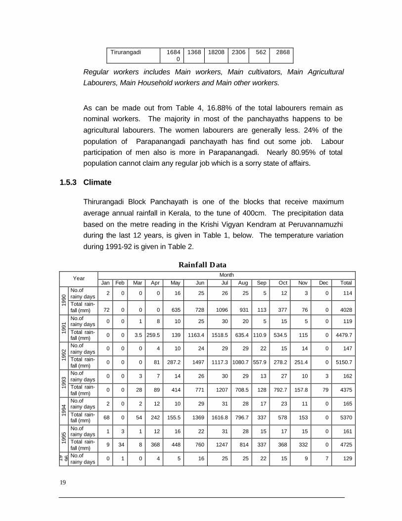
Tirurangadi 16840
1368 18208 2306 562 2868
Regular workers includes Main workers, Main cultivators, Main Agricultural Labourers, Main Household workers and Main other workers.
As can be made out from Table 4, 16.88% of the total labourers remain as nominal workers. The majority in most of the panchayaths happens to be
agricultural labourers. The women labourers are generally less. 24% of the
population of Parapanangadi panchayath has find out some job. Labour participation of men also is more in Parapanangadi. Nearly 80.95% of total population cannot claim any regular job which is a sorry state of affairs.
1.5.3 Climate
Thirurangadi Block Panchayath is one of the blocks that receive maximum
average annual rainfall in Kerala, to the tune of 400cm. The precipitation data
based on the metre reading in the Krishi Vigyan Kendram at Peruvannamuzhi during the last 12 years, is given in Table 1, below. The temperature variation
during 1991-92 is given in Table 2.
Rainfall Data Month
Year Jan Feb Mar Apr May Jun Jul Aug Sep Oct Nov Dec Total
No.of rainy days
2 0 0 0 16 25 26 25 5 12 3 0 114
1990
Total rain- fall (mm) 72 0 0 0 635 728 1096 931 113 377 76 0 4028
No.of rainy days 0 0 1 8 10 25 30 20 5 15 5 0 119
1991
Total rain- fall (mm) 0 0 3.5 259.5 139 1163.4 1518.5 635.4 110.9 534.5 115 0 4479.7
No.of rainy days
0 0 0 4 10 24 29 29 22 15 14 0 147
1992
Total rain- fall (mm)
0 0 0 81 287.2 1497 1117.3 1080.7 557.9 278.2 251.4 0 5150.7
No.of rainy days
0 0 3 7 14 26 30 29 13 27 10 3 162
1993
Total rain- fall (mm)
0 0 28 89 414 771 1207 708.5 128 792.7 157.8 79 4375
No.of rainy days 2 0 2 12 10 29 31 28 17 23 11 0 165
1994
Total rain- fall (mm) 68 0 54 242 155.5 1369 1616.8 796.7 337 578 153 0 5370
No.of rainy days 1 3 1 12 16 22 31 28 15 17 15 0 161
1995
Total rain- fall (mm)
9 34 8 368 448 760 1247 814 337 368 332 0 4725
19 96 No.of
rainy days 0 1 0 4 5 16 25 25 22 15 9 7 129

20
Total rain- fall (mm)
0 30 0 31 72 836 1177 817.4 452 426 134 106.6 4082
No.of rainy days 2 0 3 2 12 19 31 30 13 18 17 11 158
1997
Total rain- fall (mm) 2.5 0 15 3.5 208 812 1970 1287 356.5 452 412 263 5781.5
No.of rainy days 0 0 1 8 13 25 30 25 23 20 10 4 159
1998
Total rain- fall (mm)
0 0 5.5 54.9 160 1070.6 1306.2 561.2 655 432 155 43 4443.4
No.of rainy days
0 1 7 21 24 28 23 9 27 8 1 1 150
1999
Total rain- fall (mm)
0 34.6 2.5 54.6 635.3 869 1362 768 122 685.5 42.5 12 4588
No.of rainy days
5 2 0 9 9 28 21 26 26 16 5 4 151
2000
Total rain- fall (mm)
76 7 0 86 152 1120 281.3 1002.5 499 493 40 185 3941.8
No.of rainy days 0 2 0 12 14 26 27 28 12 18 13 1 153
2001
Total rain- fall (mm) 0 43 0 247 349 1048 927 632 204 333 285 10 4078
No.of rainy days 2 5 1 14 18 25 30 26 8 - - - 129
2002
Total rain- fall (mm)
16 90 3 204 570 807 580 728 120 - - - 3118
Temperature -1991 ( in oC)
Month Max. Min. January 29 23.1 February 31.8 24.7 March 32.7 28 April 32.1 26.8 May 32.9 31.9 June 28.4 26.4 July 27.6 25.2 August 28.6 25.8 September 32.6 27.6 October 28.9 24.4 November 29 25 December 25.9 20.9
1.5.4 Developmental Sectors
The different developmental sectors do not project consistent progress or growth.
The agricultural production and productivity register declining trend. Due to heavy migration to gulf countries, trend of leaving agricultural field fallow is on the
increase. The performance of public institutions, quality wise, is not at all in tune
with the expectations and requirements of the public. The health, the drinking

21
water availability and the educational scenarios are just few examples. The
participation of women in employment and labour fronts is nominal. Social and financial status is poor and gender discrimination is rampant. The problem of
pollution in Thirurangadi threatens public health and hygiene.
There are about 26 drainage channels of second order onwards and most of them are rain fed. There are about 79 canals and 7 lift irrigation systems. Only
one perennial river Kadalundipuzha is recharging the open wells. Well density is
high varying from a few to over 100 wells per Km2.
In general the different development related line departments do not properly co-
ordinate and integrate resources to give consistent progress or growth. The
agricultural production and productivity register declining trend. The trend of leaving agricultural field fallow is on the increase, particularly with increasing
migratory trend. The participation of women in employment and labour fronts is
nominal. The problem of pollution mainly due to solid waste disposal in Thirurangadi block threatens public health and hygiene. The vested forest lands
need to be protected. These initiations are very much significant for maintaining
the ecological balance of the block.
The continuous impoverishment of agriculturists and agricultural laborers, the
latter losing more and more agricultural jobs day by day; the stagnation in various
production fronts, public works and constructions and loss of labour in such areas; the unemployment among educated youth - all these are burning issues
facing the developmental sectors of the block. It is in this background that an
attempt for watershed based planning is undertaken.
Economic base (main economic features of the project region agriculture/livestock resources) (on village/micro watershed basis)
The major crops are coconut, pepper fruit crops (cashew, mango etc) followed by cereals. During the past five years, a decline in area under paddy and an increase in area in pepper, rubber and coconut can be observed. The reason for the shift from annual crops to cash crops is the degradation of land in the lower topographic regions. Rearing of milk animals, goat, hen are additional source of income for the farmers.

22
Land use, farming systems and cropping patterns (Theme wise)
Out of the total geographical area of 13617 hectares, the net area sown constitutes about 7600 hectares or about 55.81 percent of the total geographical area. The intensity of cropping is hardly around 126.97 per cent. Forest area in the block is negligible at 2 per cent though land under miscellaneous tree crops accounts for 29.48 per cent of the geographical area. Current and other fallow lands, as also cultivable wastes are also not significant. Land put to non-agricultural uses constitutes 9.56 per cent of the geographical area. Thus, it appears that there is little scope for bringing more area under cultivation. Therefore intensive cropping pattern need to be encouraged and attempts to rehabilitate the cultivable waste (188.86 Ha.) should be the top priority. The land use pattern of Tirurangadi Block is set-forth in the following table
Sl.No. Land Use Area (Hectors)
% to Total Area
1. Total Geographical area 13,617 100.00
2. Forest 2.00 0.015
3. Cultivable waste 188.86 1.38
4. Barren & uncultivable land 374.86 2.75
5. Land put to Non-agricultural 1301.57 9.56
6. Land under miscellaneous tree crops not included in area sown
4014.00 29.48
. Pasture – grazing land 34.68 0.26
8. Current fallow 74.5 0.55
9. Other fallow 28.00 0.21
10. Net area sown 7600.00 55.81
11. Area sown more that once Intensity of cropping
1650.00 126.97
12. Gross Cropped area (GCA) 9250.00 -
Since the population pressure is very high, most of the land is put to use for various purposes. Due to unscientific use, the degradation of land is very fast, resulting in reduced productivity, year after year. This process has innumerable indirect effects on the total system and socio economic life of the locality. In the watersheds proposed for integrated treatment most of the land is held by private farmers who are also concerned about annual degradation of their lands.
23
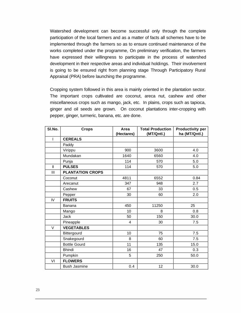
Watershed development can become successful only through the complete participation of the local farmers and as a matter of facts all schemes have to be implemented through the farmers so as to ensure continued maintenance of the works completed under the programme, On preliminary verification, the farmers have expressed their willingness to participate in the process of watershed development in their respective areas and individual holdings. Their involvement is going to be ensured right from planning stage Through Participatory Rural Appraisal (PRA) before launching the programme.
Cropping system followed in this area is mainly oriented in the plantation sector. The important crops cultivated are coconut, areca nut, cashew and other miscellaneous crops such as mango, jack, etc. In plains, crops such as tapioca, ginger and oil seeds are grown. On coconut plantations inter-cropping with pepper, ginger, turmeric, banana, etc. are done.
Sl.No. Crops Area (Hectares)
Total Production (MT/Qntl.)
Productivity per ha (MT/Qntl.)
I CEREALS Paddy Virippu 900 3600 4.0 Mundakan 1640 6560 4.0 Punja 114 570 5.0 II PULSES 114 570 5.0 III PLANTATION CROPS Coconut 4811 6552 0.84 Arecanut 347 948 2.7 Cashew 67 33 0.5 Pepper 30 60 2.0
IV FRUITS Banana 450 11250 25 Mango 10 8 0.8 Jack 50 150 30.0 Pineapple 4 30 7.5
V VEGETABLES Bittergourd 10 75 7.5 Snakegourd 8 60 7.5 Bottle Gourd 11 135 15.0 Bhindi 16 47 0.3 Pumpkin 5 250 50.0
VI FLOWERS Bush Jasmine 0.4 12 30.0

24
Best-accepted fruit plants in the area are as follows: Mango, Jack, Guava, Annona, Sapota, Pappaya, Tamarind and Nutmeg
General problems in agricultural sector can be catogorised and rated as follows:
Sl. No.
Important Problems
Munniyoor
Nannambr
a
Parappananga
di
Tenhipalam
Tirurangadi
Vallikunnu
Peruvallur
1 Low availability of Irrigation
A A A B B A A
2 Fragmentation of Land
B C A B A B C
3 Non-availability of Labour
A A A A A A B
4 Low fertility B B B B C C B
5 Water shed A A A C B B C
6 Exploitation of Middle man
B C B B B B B
7 Diseases C B C C C C C
8 Low price of Agri. Commodity
A A A A A A A
A = More Critical, B = Critical & C = Some Problems but not Critical
Livestock rearing/Fodder availability. (on village/micro watershed basis)
Panchayat wise cattle distribution pattern is given below:
Livestock and Animal Husbandry Sl. No. Name of Panchayat Cattle Buffalo Goat
1 Moonniyoor 1316 92 1370 2 Nannambra 2202 250 1457 3 Parappanangadi 3906 216 3392 4 Thenhippalam 4251 266 1622 5 Tirurangadi 2217 149 2052 6 Vallikunnu 2384 28 1420

25
The problems related livestock stake holders are listed and weighed in the following table: Sl. No.
Problems Munniyoor
Nannambr
a
Parappananga
di
Tenhipalam
Tirurangadi
Vallikunnu
Peruvallur
1 Low price of Milk B A B B A B B
2 Higher price of cattle feed
A A A A A A A
3 Lack of slaughter house
A A A A A A A
4 H igher cattle diseases
A A B B B B B
5 Lack of fodder grass A A A A A A A
6 Deficiency of Veterinary Hospitals
A A B B B B A
7 Lack of production of milk, egg, meat
B B B B B B B
8 Lack of awareness of proteins in cattle
A A A A A A A
9 Lack of Milk Co-operative Societies
B A C C A C B
10 Lack of high breeds of domestic animals/birds
B A B B A B B
A = More Critical, B = Critical & C = Some Problems but not CriticalEconomic activities
(other than agriculture i.e. forestry rural handicrafts etc. (on village/micro watershed
basis)
Pottery, Small industries, Petty shop, Ready made garments etc are the main secondary occupations of the rural peoples.
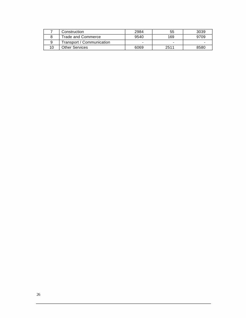
Details of working Populations: Sl.No. Nature Male Female Total
1 Main/Full time workers 45987 5935 51920 2 Agriculture/Cultivation 4818 222 5040 3 Agril. Labour 10170 1589 11759 4 Animal Husbandry - - - 5 Household/SSI/Handicrafts - - - 6 Manufacturing/Service - - -
26
7 Construction 2984 55 3039 8 Trade and Commerce 9540 169 9709 9 Transport / Communication - - - 10 Other Services 6069 2511 8580

27
2. THE PREPARATION OF WATERSHED BASED DEVELOPMENT MASTER PLAN: THE METHODOLOGY ADOPTED
A major goal in participatory natural resource management (NRM) has long been balancing the multiple uses of land and water resources. Water harvesting
remains an important component of natural resource utilization, but must be
approached in such a way that ecosystem dynamics and other considerations are not sacrificed. One way in which water harvesting practices are made
sustainable in NRM programmes is to ensure stakeholders’ participation in local
level development plans. Through the use of scheduling optimization models, constraints can be structured and connect water harvesting to local area
development in phased manner according to availability of funds. Therefore the
estimates are made panchayats wise and given year wise break-up of fund requirement (Tables:10.1 to 10.8) Block level requirement is consolidated in
Table 11.
Time-line of progress after the administrative decision in this regard by the block panchayath to co-ordinate the field work various activities, is given below.
In Jan 2003 the Block Panchayath discussed the State Government guidelines to
prepare 10th five year plan proposals and came to understand that is should be based on watersheds of the different localities. Subsequently discussions took
place at different levels on the same, and finally Centre for Earth Science
Studies, with the financial support from the Kerala Research Programme of Centre for Development Studies, undertook the task of providing technical help to
this project. The Thirurangadi Block Panchayath council and the grama
panchayaths councils of Thenhipalam Panchayat, Peruvathur Panchayat, Nannambra Panchayat, Parappanangadi Panchayat, Tirurangadi Panchayat,
Moonniyur Panchayat and Vallikunnu Panchayat in the block, together made a
Memorandum of Understanding (MoU) to co-operate with Centre for Earth Science Studies to undertake the intervention and resource mapping. Detailed
discussions were held on the necessity of formulating watershed based 10th five
year plan proposal, and subsequently the activity calendar was also drawn up for the timely completion of the work. The cadastral maps in 1:4000 scale of all
grama panchayths were collected from village offices. It was decided that the
grama panchayaths and the block panchayath will select "master trainers" for watershed based master plan preparation. The understanding was that the

28
number of Master Trainers will be proportional to the area of the concerned
grama panchayath. The number of such master trainers is given Table below.
No. of Master Trainers
Panchayath No. of Master trainers
Thenipalam & Peruvallur 27 Muniyur & Thiruranadi 15 Kayanna, Nochad 16 Parappangadi & Nannambra 11 Vallikunnu 22 Total 91
The master trainers hailed from varied backgrounds. Students constitute the
single largest category among the master trainers as given in the following Table.
The Employment of Master Trainers
Employment No. of Master trainers
Farmers 10 Volunteers/Politicians/ people's representatives
15
Agriculture Officers 5 Students 30 Govt. Employees 5 Surveyor 1 Agriculture Assistants 3 Engineers 2 Teachers 10 Others 10
Total 91
2.1 TRAINING OF MASTER TRAINERS
During May 27th to 31st the Master Trainers were given intensive training at S M S M
Polytechnic at Tirur on the significance of watershed based master plan preparation and the method of preparing such master plans.
On the third day the trainers were given field training. The module of training is
provided as Annexure 1. On the final day of training for the effective management of the watershed master plan preparation work the block area was divided into five
units. As per the watershed review document of the block, there are 26 micro
watersheds in Thirurangadi Block. The segregation into five units was made in such
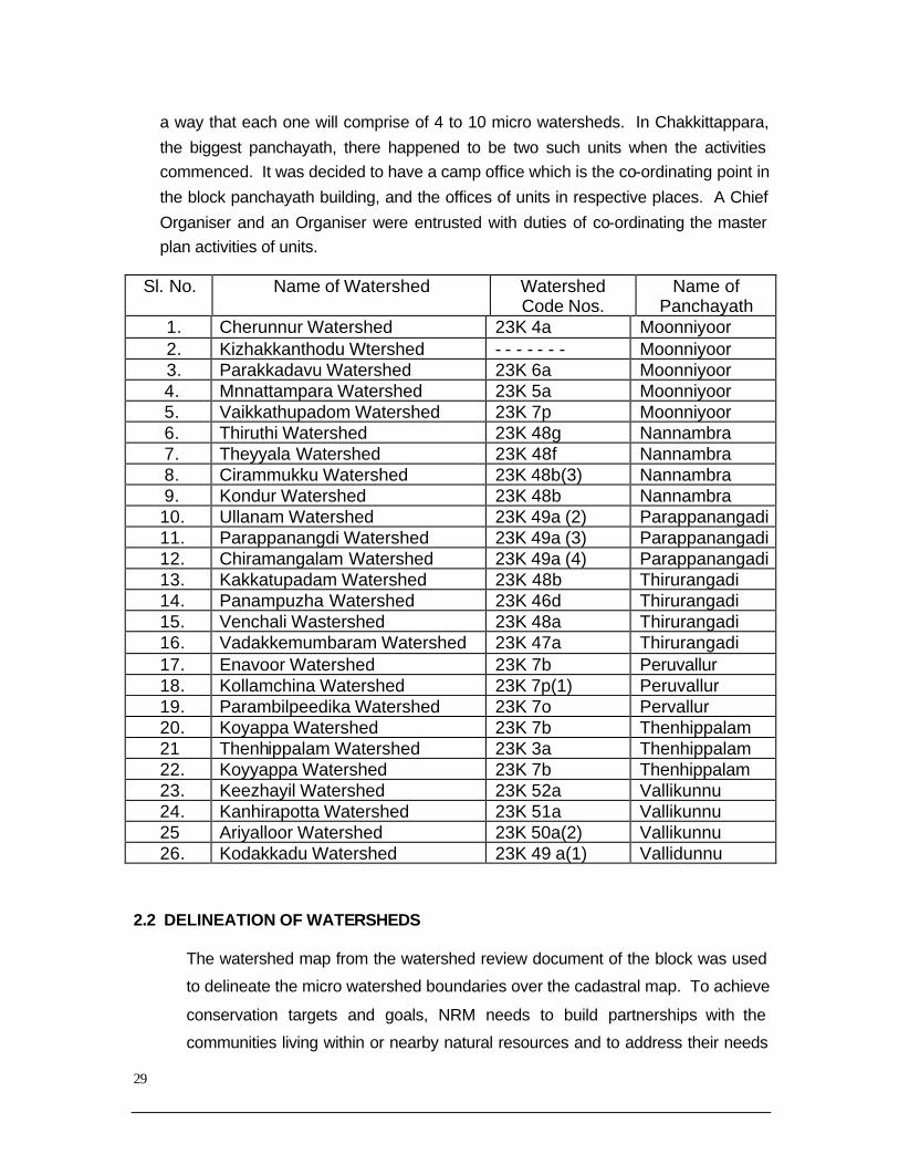
29
a way that each one will comprise of 4 to 10 micro watersheds. In Chakkittappara,
the biggest panchayath, there happened to be two such units when the activities commenced. It was decided to have a camp office which is the co-ordinating point in
the block panchayath building, and the offices of units in respective places. A Chief
Organiser and an Organiser were entrusted with duties of co-ordinating the master plan activities of units.
Sl. No. Name of Watershed Watershed Code Nos.
Name of Panchayath
1. Cherunnur Watershed 23K 4a Moonniyoor 2. Kizhakkanthodu Wtershed - - - - - - - Moonniyoor 3. Parakkadavu Watershed 23K 6a Moonniyoor
4. Mnnattampara Watershed 23K 5a Moonniyoor 5. Vaikkathupadom Watershed 23K 7p Moonniyoor 6. Thiruthi Watershed 23K 48g Nannambra 7. Theyyala Watershed 23K 48f Nannambra 8. Cirammukku Watershed 23K 48b(3) Nannambra 9. Kondur Watershed 23K 48b Nannambra 10. Ullanam Watershed 23K 49a (2) Parappanangadi 11. Parappanangdi Watershed 23K 49a (3) Parappanangadi 12. Chiramangalam Watershed 23K 49a (4) Parappanangadi 13. Kakkatupadam Watershed 23K 48b Thirurangadi 14. Panampuzha Watershed 23K 46d Thirurangadi 15. Venchali Wastershed 23K 48a Thirurangadi 16. Vadakkemumbaram Watershed 23K 47a Thirurangadi 17. Enavoor Watershed 23K 7b Peruvallur 18. Kollamchina Watershed 23K 7p(1) Peruvallur 19. Parambilpeedika Watershed 23K 7o Pervallur 20. Koyappa Watershed 23K 7b Thenhippalam 21 Thenhippalam Watershed 23K 3a Thenhippalam 22. Koyyappa Watershed 23K 7b Thenhippalam 23. Keezhayil Watershed 23K 52a Vallikunnu 24. Kanhirapotta Watershed 23K 51a Vallikunnu 25 Ariyalloor Watershed 23K 50a(2) Vallikunnu 26. Kodakkadu Watershed 23K 49 a(1) Vallidunnu
2.2 DELINEATION OF WATERSHEDS
The watershed map from the watershed review document of the block was used
to delineate the micro watershed boundaries over the cadastral map. To achieve
conservation targets and goals, NRM needs to build partnerships with the
communities living within or nearby natural resources and to address their needs

30
for their livelihoods. Therefore, co-management approaches have been
developed right from the data inventory phase to integrate natural resource
utilization for the subsistence and development of local communities. The local
volunteers undertook ‘transect walks’ in the company of technocrats to exchange
ideas on traditional and modern technologies in NRM.
The watershed map and the cadastral map were together used during the
transect walks taken to delineate the actual survey plots that make up the
watersheds. Ridge lines could be earmarked and by extending the ridge lines in opposite directions Watersheds were delineated. On August 16, each master
trainer was imparted with practical field training in watershed delineation in any
one micro watershed coming in their unit.
2.3 UNIT LEVEL TRAINING
In each watershed two groups of seven members each together to collect data
for the preparation of watershed master plan and to organise meetings of the neighbourhood groups were formed. Training was given to local voluntary
activists in each unit. A meeting of master trainers was held on august 23rd in
block panchayath hall to make preparations for regional training. Master trainers divided into different subject groups held discussions on presenting the various
topics. Experts from Centre for Earth Science Studies , Integrated Rural
Technology Centre, CCADA, Agriculture Department, Animal Husbandry and Kerala Forest Research Institute handled different subjects in the training
programme. The details of the unit level training programme is given in the table
below.
Details of Regional Training
Participants Name of Unit Date of
Training Place Male Femal
e Total
Thenipalam July 25 & 26
Panchayath Community Hall, Thenipalam
10 30 40
Peruvallur August 21& 22
Panchayath Community Hall, Pervallur
12 22 36
Vallikunnu & Parappanangadi
August 25 & 26
Paramppangadi H.S.S
15 22 37
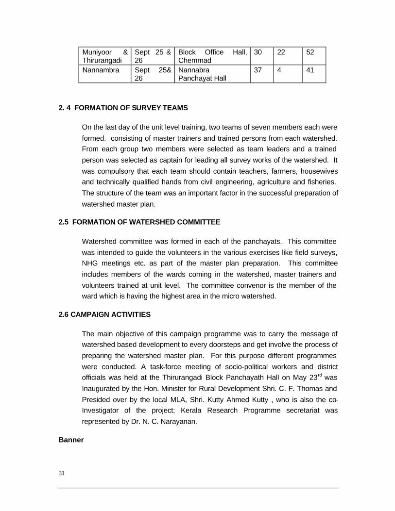
31
Muniyoor & Thirurangadi
Sept 25 & 26
Block Office Hall, Chemmad
30 22 52
Nannambra Sept 25& 26
Nannabra Panchayat Hall
37 4 41
2. 4 FORMATION OF SURVEY TEAMS
On the last day of the unit level training, two teams of seven members each were
formed. consisting of master trainers and trained persons from each watershed. From each group two members were selected as team leaders and a trained
person was selected as captain for leading all survey works of the watershed. It
was compulsory that each team should contain teachers, farmers, housewives and technically qualified hands from civil engineering, agriculture and fisheries.
The structure of the team was an important factor in the successful preparation of
watershed master plan.
2.5 FORMATION OF WATERSHED COMMITTEE
Watershed committee was formed in each of the panchayats. This committee
was intended to guide the volunteers in the various exercises like field surveys, NHG meetings etc. as part of the master plan preparation. This committee
includes members of the wards coming in the watershed, master trainers and
volunteers trained at unit level. The committee convenor is the member of the ward which is having the highest area in the micro watershed.
2.6 CAMPAIGN ACTIVITIES
The main objective of this campaign programme was to carry the message of watershed based development to every doorsteps and get involve the process of
preparing the watershed master plan. For this purpose different programmes
were conducted. A task-force meeting of socio-political workers and district officials was held at the Thirurangadi Block Panchayath Hall on May 23rd was
Inaugurated by the Hon. Minister for Rural Development Shri. C. F. Thomas and
Presided over by the local MLA, Shri. Kutty Ahmed Kutty , who is also the co- Investigator of the project; Kerala Research Programme secretariat was
represented by Dr. N. C. Narayanan.
Banner
32
Banners with the message "sustainable development through watershed
planning, co-operate in the preparation of block level master plan" were displayed at every prominent junctions of the block. It was also decided that all
LSGIs and offices transferred to them should print the above message in their
printing materials.
Explanation made in school assemblies
A programme was planned to take the message of watershed based
development to every student and teacher of the block. It is hoped to achieve the participation of every family in the master plan preparation in this way.
Master trainers attended school assemblies and explained to the students and
teachers about the importance of the watershed based development.
2.7 STREAM AND GULLY SURVEY
A detailed field survey was conducted in every micro watershed to identify
suitable locations for soil and water conservation like gully plugging, side bank protection, checkdam, etc. The survey on the left side of the main stream was
done by one team, and the survey on the main stream and right side was done
by another team. Topographical features, land use pattern and intervention points were recorded in the cadastral map. Micro details of each intervention
point was recorded in the formats. In the afternoon of every alternate days team
members came to the unit office and transferred the field data collected to a fair map kept there. Moreover, the data which could not be recorded in the map and
formats were entered in a field diary.
2.8 TRANSECT WALK
Transect walk is found to be most suitable PRA technique for quick data
collection in this area. Route for walk was decided in consultation with the local
agricultural officer in the Krish Bhavan, so that walk can lead through areas with different topographical features, land use and development prospects / problems
. The transect team consisted of farmers, teachers, women, people with

33
technical qualification in agriculture, animal husbandry, fisheries, civil engineering
or geology. Each team had a kit comprising two copies of the cadastral map, data collection formats, field diary, measuring tape, colour pencils, scale and
hard board. One person recorded the features of the terrain and water
resources, second person the land use pattern and intervention possibilities in cadastral maps. Measurements of the intervention proposals were recorded in
the formats. Intervention proposals for important areas are formulated after
conducting field interviews with stakeholders and discussion with experts. One team member continuously recorded the position of the team in the map after
taking measurements.
2.9. NEIGHBOURHOOD GROUP (NHG) MEETINGS
Neighbourhood Group (NHG) is the collective of about 50 households.
Eventhough the NHGs were not very active in the block, the Women Self Help
Groups (WSHGs, Kudumbashree) were functioning well. However one can assume farmers participation only by calling general NHG. It was decided to call
the general NHGs for discussing the intervention possibilities suggested as part
of the master plan preparation. As a prelude to this meeting all draft intervention proposals for an NHG area was consolidated. However, owing to various
reasons these meetings are yet to happen.
Organisation
Extensive campaign work was undertaken to bring people to watershed based
masterplan preparation. Public system announcements were done at
Panchayats. Posters and banners depicting the message of water/ soil conservation were displayed at important places of the block.
.2.11 FORMULATION OF INTERVENTION STRATEGIES
Experts in the fields like agriculture, fisheries, soil and water conservation, geology and civil engineering visited the block many times and gave guidance for
preparing master plan. Meetings of agriculture experts, veterinary experts, soil
conservation officers and engineers were conducted for this purpose. In the meeting of engineers serving in the block panchayath a consensus was arrived
on the use of appropriate technology in construction works.
Agriculture Sector

34
Under the convenorship of the concerned agriculture officer, agriculture experts
committee were formed for visits in each unit. These committees visited problem areas with agriculture assistants, people's representatives and survey volunteers
and suggested solutions.
Fisheries Sector
During the field survey, ponds , abandoned quarries with water conservation
potential were identified. Expert visits were to be arranged from November 15th
to 25th to identify suitable ponds from the preliminary list for fish farming.
Soil and Water Conservation
Civil engineering structures like check dams, VCBs, side bank protection of
streams and ponds, conversion of abandoned quarries to water conservation structures etc, suggested in the field survey required in-depth technical
verification by experts.
3. ACTION PLAN FOR WATERSHED BASED DEVELOPMENT
Prioritisation of different soil and water conservation activities were done based on ridge
to valley approach. The surface run off and sediment load are reduced by making
intervention measures like gully plugging, agroforestry, contour bunding, percolation pits, fodder grass cultivation, cover crops etc at the ridges in first and second years.
Subsequently during the fourth and fifth year check dams, VCBs, side bank protection
etc are done at lower areas. This will help to avoid sedimentation of costlier structures likely to be constructed in lower areas.
3.3 ENTRY POINT ACTIVITIES

35
Cheaper interventions which can be done with high level of people's participation are
included in initial years. One example is the construction of percolation pits, this activity is planned for June 2005 The other entry point activities planned are (i) awareness
campaign among the people on watershed based development, (ii) video show of
successful watershed development models and (iii) training to people's representatives, implementing officers and socio-cultural leaders. Through all these activities, it would be
possible to make a structural change in the agriculture sector and create an attitude
among the people for watershed based development.
3.4 ACTIVITIES IN DIFFERENT SECTORS
The activities in the master plan are envisaged in four development sectors. The
campaign activities which would have a catalystic role is included in initial years. A detailed account of the campaign activities and other development activities are given
below.
3.3 CAMPAIGNING ACTIVITIES
Extensive campaigning is planned for creating awareness on importance of watershed
based development to the general public. This campaign has two approaches. One
approach comprise training programme on various dimensions of watershed based development to those who are engaged in the orientation of the society. The other
approach include exhibiting posters, video shows and arranging processions and
voluntary activities conveying the message directly to the people through quiz competition, essay writing and poster creations, interest on this line can be generated
among students who are the citizen of tomorrow.
3.5 ACTIVITIES
3.5.1 Agricultural Sector
Increase in production capacity and total production through increase in density of intercrop is the policy of intervention in this sector. It also aims at developing a beet of
trees along the ridgeline at all the watersheds. Growing trees, fodder grass, cover crops
etc in areas having steep slope reduce soil erosion. Income of the farmers are to be improved through growing self sufficiency aimed through cultivation of vegetables in
areas with moderate slope. The uniqueness of these activities include;
36
1. The seeding requirement is completely met by the nursery run be
kudumbasree/SHG's.
2. The master plan targets cutting and replacement of 10% of diseased and
unproductive coconut trees with high yielding varieties of coconut tree within a period
of 5 years, Kadalavankku and Seemakonna (were ever necessary) are planted as biological fence so as to increase the production of biomanure and reduce soil
erosion.
3. It is highly imperative to conserve the water holding system, the paddy fields. This is possible only when paddy farming become profitable. Keeping this as target, a
project is included in the masterplan for mechanisation in paddy fields in the initial
period of 3 years.
Technical Known-How
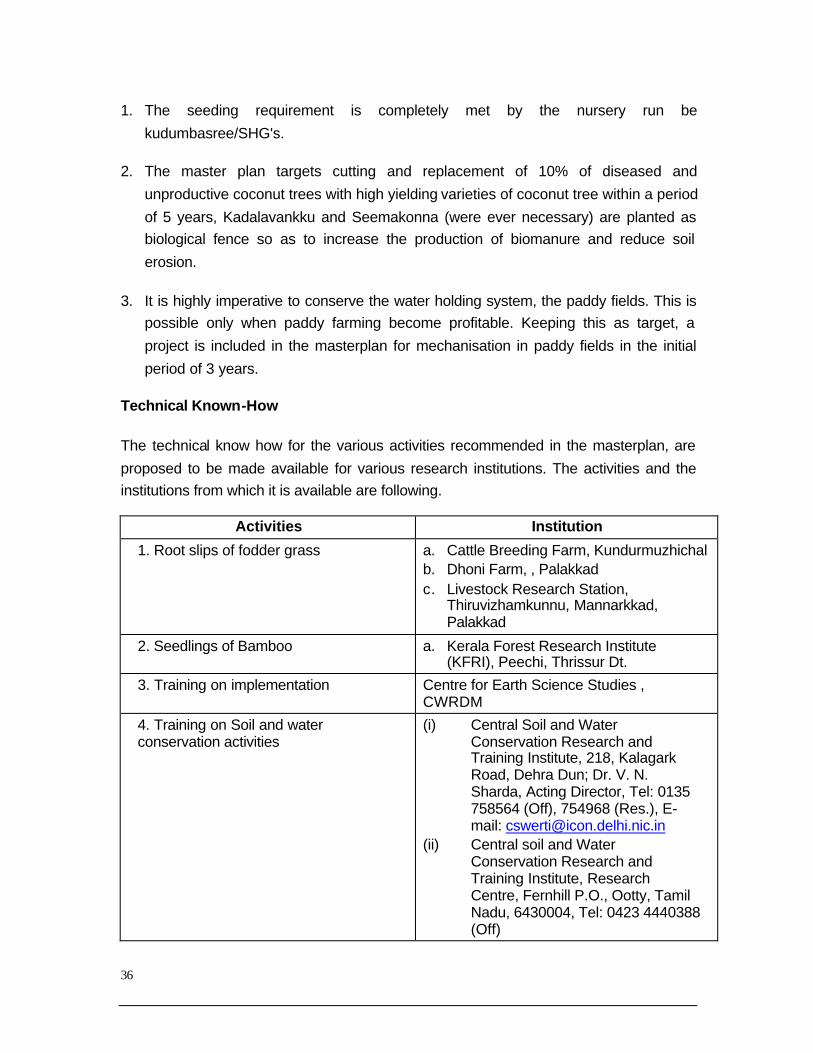
The technical know how for the various activities recommended in the masterplan, are
proposed to be made available for various research institutions. The activities and the institutions from which it is available are following.
Activities Institution
1. Root slips of fodder grass a. Cattle Breeding Farm, Kundurmuzhichal b. Dhoni Farm, , Palakkad c. Livestock Research Station,
Thiruvizhamkunnu, Mannarkkad, Palakkad
2. Seedlings of Bamboo a. Kerala Forest Research Institute (KFRI), Peechi, Thrissur Dt.
3. Training on implementation Centre for Earth Science Studies , CWRDM
4. Training on Soil and water conservation activities
(i) Central Soil and Water Conservation Research and Training Institute, 218, Kalagark Road, Dehra Dun; Dr. V. N. Sharda, Acting Director, Tel: 0135 758564 (Off), 754968 (Res.), E-mail: [email protected]
(ii) Central soil and Water Conservation Research and Training Institute, Research Centre, Fernhill P.O., Ootty, Tamil Nadu, 6430004, Tel: 0423 4440388 (Off)
37
5. Training on nursery making (iii) Krishi Vigyan Kendra, Peruvannamoozhi
6.Consultation on appropriate technology
(iv) National Institute of Technology, Kozhikode
3.5.2 Animals Husbandry Sector
The availability of fodder grass is to be increased for development of animal husbandry
sector. The activities in this line are need to be included in the masterplan. In order to
increase the cattle population in each watershed; a project for calf rearing is suggested. These projects are to be implemented through Kudumbasree SHG groups. The groups
engaged in farming of the fodders grass in the initial years are selected for this project.
The cow-dung available through the rearing of the cattle can be utilised for improving fodder grass production.
It is intended to develop goat-breeding unit in each watershed for improvement in
availability of Malabary variety of goat. This project also will be implemented through Kudumbasree SHGS.
3.5.3 Fisheries Sector
It is intended to develop fish culture in all suitable water bodies, live ponds and paddy fields, etc available in the block. All farmers interested in fish culture will be given training
and technical support by the block panchayath. A fisheries extension center will be setup
at block level to support fish farmers with regard to testing of water quality parameters, prevention of fish diseases, guidance in culture management, growth monitoring and
marketing. Fish seeds will be made available to the farmers by the block panchayath.
The project for the fish culture in the Peruvannamoozhi reservoir is included in the masterplan. Integrated fish farming is designed for maximum utilization of resources
available locally. In order to support the depleting natural fish resources, facilities to
enhance breeding of the natural fishes need to be setup in the Kadalundi river. This will be done with the co-operation of district panchayath and fisheries resource management
society. Fish seeds can be stocked in the Kadalundi river, for augmenting the fish
population with the co-operation of the district Panchayath and the state department of fisheries.
3.5.4 Structures for Soil and Water Conservation

38
The structures for soil and water conservation includes, contour bunds, percolation pits,
gully plugging, check dams, side protection of the streams, conservation of ponds etc. As mentioned earlier, the approach here is to proceed downward form the sideline.
Contour bunds in areas with steep slope and rainpits in area with moderate and gentle
slope are recommended. In the first years, the contour bunds and gully plugging will be done in the areas with higher elevations. As past of the campaigning activities, 1 lakh
rain pits will be constructed in the second year.
Appropriate Technology
For the construction of gully plugging, check dams and side protection the technology to
be utilised is not the traditional one. Instead, the methods utilizing locally available
building materials and skills are recommended. Like for instance, gully plugging is to be done using locally available bamboo stakes fixed in the soil and by using plastic bags
and stones arranged as per requirement. As a result of this type of construction the
major part of the money expended is received back by the local people via construction material and labour. This will strengthen the local economy. The protection and
maintenance of these constructions can also be done locally. Training for such activities
will be given by IRTC, Mundur.
Cross Bars and Side Protection of Streams
These activities will be undertaken during the last year. For side protection of streams,
instead of the traditional stone work, constructions using sandbags reinforced with bamboo will be used. This will reduce the expenditure by way of utilization of local
resources. Traditional methods of construction will be utilised only in the case of cross
bars. The various construction activities using appropriate technology are given in Annexure-8.
3.6 REVIEW OF PROJECTS
If any agriculture intervention in the group of projects is found as not acceptable to the farmers in the interim review, the outlay of such project will be transferred and utilized for
acceptable projects based on the unit cost. .
3.7 ORGANIZATION (Karshaka koottayma)

39
In order to organize the above-mentioned activities efficiently an organisational setup
extending from the lower levels to the block panchayath level is essential. The farmers network proposed would be the lowermost organization implementing the watershed
based development. The members of farmers network (Karshaka kootayma) comprise of
farmers owning agriculture land over 5 cents, residing in a particular place having an area of 20-40 acres. One person among the members is to be selected as the convener
of the farmer's network.
Watershed Committee (WC)
Watershed committee will be responsible for the implementation of watershed based
development training and voluntary activities in a watershed. The chairman of this
committee will be the block division member of the area and the convenor will be the member of the biggest ward coming in the watershed. The other members are members
of the wards coming partly or completely in the watershed, convenors of the farmers
network, convenors of Kudumbasree neighbourhood groups, presidents and secretaries of the paddy farmers group, two representatives of agricultural labors (of which one
person has to be from Scheduled caste). Besides this master trainers and captain of the
watershed will be the members of the watershed committee.
One master trainee will be the joint convenor and another ward member (if three wards
are there, the second biggest wards) will be the vice-chairman of the watershed
committee. If there is only one ward, a senior member can be appointed as the vice-chairman. The watershed committee will have to meet once in a month and review the
activities.
Panchayath Level Watershed Development Committee (PWDC)
Panchayath level watershed development committee is to be constituted with
panchayath president as chairman and agricultural officer as the convenor. This
committee would do the organization, implementation, and financial expenditure of various projects of the partial and complete watersheds coming in the panchayath area.
The block division members, panchayath members, implementing officers of agriculture
and allied sectors, Engineers, chairman of TSG, convenor of watershed committee, representative of master trainers, two representatives from farmers network, two
representatives from Kudumbasree etc will be the members of this committee.
Technical Support Group (TSG)
40
A Technical support group is to be constituted for the technical support of the watershed
based development in the panchayath. The TSG is to be organized by including professional graduates and diploma holders in the field of agriculture, soil and water
conservation, diary development, fish culture, civil engineering, geology etc. Besides
them retired overseers/supervisors/Inspectors in the above fields and implementing officers should be included. The chairman and convenor of the TSG will have to be
nominated by the panchayath. Retired professional and concerned agricultural officers
are to be selected as chairman and convenor respectively. Meeting of the TSG is to be convened once in a month at panchayath level.
Block Level Watershed Development Committee (BWDC)
It is required to constitute a block level watershed development committee for organization, implementation, financial expenditure and monitoring of the watershed
based development programmes. The chairman of this committee will be block
panchayath president and convenor will be the assistant director of agriculture. The members of this committee include grama panchayath presidents, district panchayath
members, block panchayath members, panchayath level watershed development
committee convenors, fisheries extension officer, soil conservation officer, representatives of research institutions, 3 retired officers from the concerned fields and
five master trainees.
3.8 BLOCK LEVEL PROJECTS
The details of the projects implemented directly by the block panchayath are given in
Table: .
3.9 FINANCIAL ANALYSIS
The total amount required for the implementation of the master plan is 10.397 crore, to
be spread over for five years, out of which Rs.1.04 crore will be the beneficiary
contribution.
41
PART – II
42
CHERANUR WATERSHED (Mooniyur Grama Panchayat)
Cheranur watershed is identified with watershed No: 23K4a in Landuse Board (LUB) document. It is located with in 124&5 wards of Mooniyur Panchayath.
Boundaries
It is bounded by Chelari – Chenakalandi road in the north, the national highway on the east, Paddikkal – Chranur road on the south east and the Kaldlundipuzha
river on the west.
Demographic Profile
Population: Female 5736, Male 5564, the number of women slightly exceeds that
of men. Majority of the people are small farmers and farm labourers.
Topographical Features
This watershed is dotted with steep hills and the plains. General topography
resembles moderately sloping undulating topography.
Type of Soil
Loamy Soil is found in paddy fields and in the plains red soil mixed with sand is
seen.
Land Use
Plains are mostly utilised for cultivation. The important crops are coconut,
arecanut, banana, pepper, tapioca, yam and paddy. About 5 acres of land in
different places is utilized for rubber cultivation.

43
Conservational Problems and Solutions
Side banks of all the streams and canals are damaged due to land slips. The following side banks of the streams should be protected by building rubble
mounted or masonry walls. Details on interventions required for optimum water
conservation are given in Table:1.1.1 to1.1.4 and year wise fund allocation is suggested in Table:10.1. The side wall protection is given only in critical zones.
Estimate is provided both for conventional masonry structures and vegetative
protections such as vettiver / bamboo.
KIZHAKKANTHODU WTERSHED
(Mooniyur Gram Panchyat)
Cheranur watershed is identified with watershed No: 23K4a in Landuse Board (LUB) document. It is located with in 4,5,6,7,10 & 11 wards of Mooniyur
Panchayath. This watershed has an approximate aerial extent of 4.65 Km2
Boundaries
It is bounded by Mill road on the north, the national highway on the west,
Thalappara – Chemad road on the south east and the Kaldlundipuzha river on
the south.
Topographical Features
This watershed is dotted with moderate hills and the plains. General topography
resembles moderately sloping undulating topography. This watershed is located at about 60 m. above MSL.
Type of Soil
Loamy Soil is found in paddy fields and in the plains red soil mixed with sand is seen.
Land Use
Plains are mostly utilised for cultivation. The important crops are coconut, arecanut, banana, pepper, tapioca, yam and paddy. About 5 acres of land in
different places is utilized for rubber cultivation.
Conservational Problems and measures
44
Side banks of all the streams and canals are damaged due to bank erosion. The
following side banks of the streams should be protected by building rubble mounted or masonry walls: about 600m of Annithodu, Kannanchira and
Avukandanchira Details on interventions required for optimum water
conservation is given in Table1.2.1to 1.2.4 and year wise fund allocation is suggested in Table:10.1. The side wall protection is given only in critical zones.
Estimate is provided both for conventional masonry structures and vegetative
protections such as vettiver / bamboo.
Possibilities
Gully plugging should be done in small streams.
1. Build check dams.
2. Build side penetration mud walls and contour bunds.
3. Penetration holes should also be built in large numbers.
4. Discourage leveling of paddy fields for non-agricultural purposes.
5. Renovate and conserve canals and ponds.
6. Grow grass and other plants.
7. Teach farmers scientific methods of cultivation.
8. Avoid excessive exploitation of natural resources.
9. Conserve forests.
10. Take necessary action to make people ‘water literate’
MANNATTAM PARA WATERSHED (Mooniyur Gram Panchyat)
Mannattmpara watershed is identified with watershed No: 23K 5a in Landuse
Board (LUB) document. It is located with in 5,6, & 7 wards of Mooniyur
Panchayath.
Boundaries
45
It is bounded by Paddikal - Cheranur road in the north, the national highway on
the east, Kuppa – Vellimukku road on the south and the Kaldlundipuzha river on the west.
Demographic Profile
Population: Female 5736, Male 5564, the number of women slightly exceeds that of men. Majority of the people are small farmers and farm labourers.
Topographical Features
This watershed is devoid of hills and dominated by moderately sloping mid-slope region which leads to gently sloping plains which covers about 4.87 Km2.
Type of Soil
Loamy Soil is found in paddy fields and in the plains red soil mixed with sand is
seen.
Land Use
Plains are mostly utilised for cultivation. The important crops are coconut,
arecanut, banana, pepper, tapioca, yam and paddy.
Conservational Problems and Solutions
Side banks of all the streams and canals are damaged due to land slips. The following
side banks of the streams should be protected by building rubble mounted or masonry
walls. Details on interventions required for optimum water conservation is given in Table:1.3.1 to 1.3.3 and year wise fund allocation is suggested in Table:10.1. The side
wall protection is given only in critical zones. Estimate is provided both for conventional
masonry structures and appropriate technology based vegetative protections such as vettiver / bamboo.
PARAKKADAVU WATERSHED (Mooniyur Grama Panchayat)
Introduction

46
Parakkadavu watershed is identified with watershed No: 23K6a in Kerala
Watershed Atlas of the Landuse Board (LUB) document. It is located with in 7,8,9,10,11,12,13 & 14 wards of Mooniyur Panchayath.
Boundaries
It is bounded by Vellimukku – Koopa road in the north, the National Highway on east, Mudicheri – Karatu road on the south east and the Kaldlundipuzha river on
the west.
Topographical Features
This watershed is dotted with moderately steep to steep hills and the plains.
General topography resembles gently sloping undulating topography.
Type of Soil
Loamy Soil is found in paddy fields and in the plains red soil mixed with sand is
seen.
Land Use
Valley floors are mostly utilised for paddy cultivation. The important crops are
coconut, arecanut, banana, pepper, tapioca, yam and paddy.
Conservational Problems and Measures
Side banks of all the streams and canals are damaged due to land slips. Details
on interventions required for optimum water conservation is given in Table:1.4.1to 1.4.4 and year wise fund allocation is suggested in Table:10.1. The
side wall protection is given only in critical zones. Estimate is provided both for
conventional masonry structures and vegetative protections such as vettiver / bamboo.
VAIKKATHU PADAM WATERSHED (Mooniyur Gram Panchyat)

47
Vaikkathu Padom watershed is identified with watershed No: 23K 7p in Landuse
Board (LUB) document. It is located with in ward 3 of Mooniyur Panchayath and 6 & 7 wards of Thennipalam GP.
Boundaries
It is bounded by Paddikal - Cheranur road in the north, the national highway on the east, Kuppa – Vellimukku road on the south and the Kaldlundipuzha river on
the west.
Demographic Profile
Population: Female 5736, Male 5564, the number of women slightly exceeds that
of men. Majority of the people are small farmers and farm labourers.
Topographical Features
This watershed is devoid of hills and dominated by moderately sloping mid-slope region which leads to gently sloping plains which covers about 4.87 Km2.
Type of Soil
Loamy Soil is found in paddy fields and in the plains red soil mixed with sand is also seen.
Land Use
Plains are mostly utilised for cultivation. The important crops are coconut, arecanut, banana, pepper, tapioca, yam and paddy.
Conservational Problems and Solutions
Side banks of all the streams and canals are damaged due to land slips. The following side banks of the streams should be protected by building rubble
mounted or masonry walls. Details on interventions required for optimum water
conservation is given in Table:1.5.1.to 1.5.3.and year wise fund allocation is suggested in Table: 10.1. The side wall protection is given only in critical zones.
48
Estimate is provided both for conventional masonry structures and vegetative
protections such as vettiver / bamboo.
CHIRAMUKKU WATERSHED ( Nannambra Gram Panchyat)
Chiramukku watershed is identified with watershed No: 23K 48b in Landuse
Board (LUB) document. It is located with in ward 1 & 2 of Nannambra
Panchayath. Though known as Chiramukku watershed , the main stream is Kappu thodu.
Boundaries
It is bounded by Thirurangadi Panchayat in the north, Kakkadu padom on the south and Palaambu – Kaddadu road on the west.
Demographic Profile
Population: Female 1466, Male 1205, the number of women population is higher than that of men. Majority of the people are small farmers and farm labourers and
immigrants to Gulf countries.
Topographical Features
The terrain in this watershed is devoid of hills and dominated by steeply sloping
highly undulating mid-slope region which leads to gently sloping flood plains
which covers about 1.67 Km2. Laterite is the major constituent of the terrain.
Type of Soil
Loamy Soil is found in paddy fields and in the plains red soil mixed with gravelly
sand is seen in the higher planes.
Land Use
Plains are mostly utilised for cultivation. The important crops are coconut,
arecanut, banana, pepper, tapioca, yam and paddy.
Conservational Problems and Solutions

49
Side banks of all the streams and canals are damaged due to land slips. The
following side banks of the streams should be protected by building rubble mounted or masonry walls. Details on interventions required for optimum water
conservation is given in Table:2.1.1 to 2.1.4 and year wise fund allocation is
suggested in Table:10.2. The side wall protection is given only in critical zones. Estimate is provided both for conventional masonry structures and vegetative
protections such as vettiver / bamboo.
KONDUR WATERSHED ( Nannambra Gram Panchyat)
Kondur watershed is identified with watershed No: 23K 48c in Landuse Board (LUB) document. It is located with in ward 3 & 4 of Nannambra Panchayath.
Boundaries
It is bounded by Kappil padom of Thirurangadi Panchayat in the north, K T Haji N S S road on the south and Thurppin – Moodikkal padon road on the west.
Demographic Profile
Population: Female 2066, Male 1785, the number of women population is higher
than that of men. Majority of the people are small farmers and farm labourers and immigrants to Gulf countries.
Topographical Features
The terrain in this watershed is devoid of hills and dominated by steeply sloping highly undulating mid-slope region which leads to gently sloping flood plains
which covers about 4.17 Km2. Laterite is the major constituent of the terrain.
Type of Soil
Loamy Soil is found in paddy fields and in the plains red soil mixed with gravelly
sand is seen in the higher planes.

50
Land Use
Plains are mostly utilised for cultivation. The important crops are coconut, arecanut, banana, pepper, tapioca, yam and paddy.
Conservational Problems and Solutions
Side banks of all the streams and canals are damaged due to land slips. The following side banks of the streams should be protected by building rubble
mounted or masonry walls. Details on interventions required for optimum water
conservation is given in Table:2.2.1. to 2.2.5 and year wise fund allocation is suggested in Table:10.2. The side wall protection is given only in critical zones.
Estimate is provided both for conventional masonry structures and vegetative
protections such as vettiver / bamboo.
THYYALA WATERSHED ( Nannambra Gram Panchyat)
Thhyyala watershed is identified with watershed No: 23K 48f in Landuse Board (LUB) document. It is located with in ward 5,6,7 & 9 of Nannambra Panchayath.
Boundaries
It is bounded by Ollur Panchayat in the north, Ommapuzha padom on the south and the Kodunji U P School on the west.
Demographic Profile
51
Population: Female 1466, Male 1744, the number of women population is higher
than that of men. Majority of the people are small farmers and farm labourers and immigrants to Gulf countries.
Topographical Features
The terrain in this watershed is devoid of hills and dominated by steeply sloping highly undulating mid-slope region which leads to gently sloping flood plains
which covers about 6.67 Km2.
Type of Soil
Loamy Soil is found in paddy fields and in the plains red soil mixed with sand is
seen in the upper reaches.
Land Use
Plains are mostly utilised for cultivation. The important crops are coconut,
arecanut, banana, pepper, tapioca, yam and paddy.
Conservational Problems and Solutions
Side banks of all the streams and canals are damaged due to land slips. The following
side banks of the streams should be protected by building rubble mounted or masonry
walls. Details on interventions required for optimum water conservation is given in Table:2.3.1 to 2.3.5 and year wise fund allocation is suggested in Table:10.2. The side
wall protection is given only in critical zones. Estimate is provided both for conventional
masonry structures and vegetative protections such as vettiver / bamboo.
THIRUTHY WATERSHED ( Nannambra Gram Panchyat)
Thiruthy watershed is identified with watershed No: 23K 48g in Landuse Board
(LUB) document. It is located with in ward 8, 9,& 11 of Nannambra Panchayath.
Boundaries
It is bounded by Thirurangadi – Thirkulam road in the north, , Kalamthuruthi –
Kodinji road on the south and the Poorapuzha river on the west.

52
Demographic Profile
Population: Female 2736, Male 2564, the number of women population is lesser than that of men. Majority of the people are small farmers and farm labourers and
migrants.
Topographical Features
The terrain in this watershed is devoid of hills and dominated by steeply sloping
highly undulating mid-slope region which leads to gently sloping flood plains
which covers about 5.84 Km2.
Type of Soil
Loamy Soil is found in paddy fields and in the plains red soil mixed with sand is
seen in the upper reaches.
Land Use
Plains are mostly utilised for cultivation. The important crops are coconut,
arecanut, banana, pepper, tapioca, yam and paddy.
Conservational Problems and Solutions
Side banks of all the streams and canals are damaged due to land slips. The following
side banks of the streams should be protected by building rubble mounted or masonry walls. Details on interventions required for optimum water conservation is given in
Table:2.4.1 to2.4.5. and year wise fund allocation is suggested in Table:10.2. The side
wall protection is given only in critical zones. Estimate is provided both for conventional masonry structures and vegetative protections such as vettiver / bamboo.
CHIRAMANGALAM WATERSHED ( Parappangadi Gram Panchyat)
Chiramangalam watershed is identified with watershed No: 23K 49a (4) in
Landuse Board (LUB) document. It is located with in ward 6, 7, 8 & 9 of Parappanangdi Panchayath.
Boundaries

53
It is bounded by Chettipadi watershed in the north, Poorapuzha river on the
south and Poorapuzha watershed is the eastern boundary. Altitude does not exceed 15m.
Demographic Profile
Population: Female 6689, Male 6085, the number of women population is higher than that of men. Majority of the people are small farmers and farm labourers and
immigrants to Gulf countries.
Topographical Features
The terrain in this watershed is devoid of hills and dominated by gently sloping
foot-slope region which leads to gently sloping flood plains which covers about
2.68 Km2. Wheatered Laterite is the major constituent of the terrain.
Type of Soil
Sandy Loam is the soil in paddy fields and in the plains red soil mixed with
gravelly sand is seen in the higher planes.
Land Use
Plains are mostly utilised for paddy cultivation. The important crops are coconut,
arecanut, banana and paddy.
Conservational Problems and Solutions
Side banks of all the streams and canals are damaged due to land slips. The following
side banks of the streams should be protected by building rubble mounted or masonry walls. Details on interventions required for optimum water conservation is given in
Table:3.2.1 to 3.2.4 and year wise fund allocation is suggested in Table:10.3. The side
wall protection is given only in critical zones. Estimate is provided both for conventional masonry structures and vegetative protections such as vettiver / bamboo.
PARAPPANGADI WATERSHED ( Parappangadi Gram Panchyat)
Parappangadi watershed is identified with watershed No: 23K 49a (3) in Landuse
Board (LUB) document. It is located with in ward 5, 10, 11 & 12 of
Parappanangdi Panchayath.

54
Boundaries
It is bounded by Ullanam watershed in the north, Chiramangalam watershed on the south and Chettipadi watershed on the east. Altitude does not exceed 15m.
Demographic Profile
Population: Female 5579, Male 5285, the number of women population is higher than that of men. Majority of the people are small farmers and farm labourers and
immigrants to Gulf countries.
Topographical Features
The terrain in this watershed is devoid of hills and dominated by gently sloping
foot-slope region which leads to gently sloping flood plains which covers about 4.17 Km2. Wheatered Laterite is the major constituent of the terrain.
Type of Soil
Sandy Loam is the soil in paddy fields and in the plains red soil mixed with gravelly sand is seen in the higher planes.
Land Use
Plains are mostly utilised for paddy cultivation. The important crops are coconut, arecanut, banana and paddy.
Side banks of all the streams and canals are damaged due to land slips. The following
side banks of the streams should be protected by building rubble mounted or masonry walls. Details on interventions required for optimum water conservation is given in
Table:3.3.1 to 3.3.5 and year wise fund allocation is suggested in Table:10.3. The side
wall protection is given only in critical zones. Estimate is provided both for conventional masonry structures and vegetative protections such as vettiver / bamboo.
ULLANNAM WATERSHED ( Parappangadi Gram Panchyat)

55
Ullanam watershed is identified with watershed No: 23K 49a (2) in Landuse
Board (LUB) document. It is located with in ward 12, 13 & 14 of Parappanangdi Panchayath.
Boundaries
It is bounded by Vallikunnu Panchayat in the north, Keezhchra on the south and Kadalundipuzha on the east.
Demographic Profile
Population: Female 4579, Male 4285, the number of women population is higher than that of men. Majority of the people are small farmers and farm labourers and
immigrants to Gulf countries.
Topographical Features
The terrain in this watershed is devoid of hills and dominated by gently sloping
foot-slope region which leads to gently sloping flood plains which covers about
4.17 Km2. Wheatered Laterite is the major constituent of the terrain.
Type of Soil
Sandy Loam is the soil in paddy fields and in the plains red soil mixed with
gravelly sand is seen in the higher planes.
Land Use
Plains are mostly utilised for cultivation. The important crops are coconut,
arecanut, banana and paddy.
Conservational Problems and Solutions
Side banks of all the streams and canals are damaged due to land slips. The following
side banks of the streams should be protected by building rubble mounted or masonry walls. Details on interventions required for optimum water conservation is given in
Table:2.4.1 to2.4.5. and year wise fund allocation is suggested in Table:10.2. The side
wall protection is given only in critical zones. Estimate is provided both for conventional masonry structures and vegetative protections such as vettiver / bamboo.

56
KAKKATUPADOM WATERSHED ( Thirurangadi Gram Panchyat)
Kakkatupadom watershed is identified with watershed No: 23K 48b in Landuse
Board (LUB) document.
Boundaries
It is bounded by NH-17 on the east, Malappuram – Parappangadi road on the
north, Nannambra Panchayat on the south and Venjali watershed is the western
boundary. Altitude does not exceed 15m.
Demographic Profile
Population: Female 6689, Male 6085, the number of women population is higher
than that of men. Majority of the people are small farmers, farm labourers, immigrants to Gulf countries and construction workers.
Topographical Features
The terrain in this watershed is devoid of hills and dominated by gently sloping foot-slope region which leads to gently sloping flood plains which covers about
1.58 Km2. Wheatered Laterite is the major constituent of the terrain.
Type of Soil
Sandy Loam is the soil in paddy fields and in the plains red soil mixed with
gravelly sand is seen in the higher planes.
Land Use
Plains are mostly utilised for paddy cultivation. The important crops are coconut,
arecanut, banana and paddy.
Conservational Problems and Solutions
Side banks of all the streams and canals are damaged due to land slips. The
following side banks of the streams should be protected by building rubble
mounted or masonry walls. Details on interventions required for optimum water conservation is given in Table:4.1.1 to 4.1.4 and year wise fund allocation is
suggested in Table:10.4. The side wall protection is given only in critical zones.

57
Estimate is provided both for conventional masonry structures and vegetative
protections such as vettiver / bamboo.
PANNAMPUZHA WATERSHED ( Thirurangadi Gram Panchyat)
Pannampuzha watershed is identified with watershed No: 23K 46d in Landuse Board (LUB) document.
Boundaries
It is bounded by Vengara Panchayat on the east, Malappuram – Parappangadi road on the north, A R Nagar Panchayat on the south and A R Nagar Panchayat
is the western boundary.
Demographic Profile
Population: Female 5189, Male 5085, the number of women population is higher
than that of men. Majority of the people are small farmers, farm labourers,
immigrants to Gulf countries and construction workers.
Topographical Features
The terrain in this watershed is devoid of hills and dominated by gently sloping
foot-slope region which leads to gently sloping flood plains which covers about 1.25 Km2. Wheatered Laterite is the major constituent of the terrain.
Type of Soil
Sandy Loam is the soil in paddy fields and in the plains red soil mixed with gravelly sand is seen in the higher planes.
Land Use
Plains are mostly utilised for paddy cultivation. The important crops are coconut, arecanut, banana and paddy which make up 90% of cultivated land.
Conservational Problems and Solutions
Side banks of all the streams and canals are damaged due to land slips. The following side banks of the streams should be protected by building rubble

58
mounted or masonry walls. Details on interventions required for optimum water
conservation is given in Table: 4.2.1 to 4.2.4, and year wise fund allocation is suggested in Table:10.4. The side wall protection is given only in critical zones.
Estimate is provided both for conventional masonry structures and vegetative
protections such as vettiver / bamboo.
VADDAKEMUMBARAM WATERSHED ( Thirurangadi Gram Panchyat)
Vakkakemumbaram watershed is identified with watershed No: 23K 47a in Landuse Board (LUB) document.
Boundaries
It is bounded by Kakkunnathupara raoad on the east, Kadalundipuzha river on north and west, Malappuram – Parappangadi road on the south.
Demographic Profile
Population: Female 4189, Male 3995, the number of women population is higher than that of men. Majority of the people are small farmers, farm labourers,
immigrants to Gulf countries and construction workers.
Topographical Features
The terrain in this watershed is devoid of hills and dominated by gently sloping
foot-slope region which leads to gently sloping flood plains which covers about
2.50 Km2. Weathered Laterite is the major constituent of the terrain.
Type of Soil
Sandy Loam is the soil in paddy fields and in the plains red soil mixed with
gravelly sand is seen in the higher planes.
Land Use
Plains are mostly utilised for paddy cultivation. The important crops are coconut,
arecanut, banana and paddy which make up 90% of cultivated land.
Conservational Problems and Solutions
59
Side banks of all the streams and canals are damaged due to land slips. The
following side banks of the streams should be protected by building rubble mounted or masonry walls. Details on interventions required for optimum water
conservation is given in Table:4.3.1. to 4.3.4, and year wise fund allocation is
suggested in Table:10.4. The side wall protection is given only in critical zones. Estimate is provided both for conventional masonry structures and vegetative
protections such as vettiver / bamboo.
VENCHALI WATERSHED ( Thirurangadi Gram Panchyat)
Venchali watershed is identified with watershed No: 23K 48a in Landuse Board
(LUB) document.
Boundaries
It is bounded by Kakkatupadom on the east, Malappuram – Parappangadi road
on the north, Nannambra Panchayat on the south and Keeranallurpuzha is the western boundary.
Demographic Profile
Population: Female 5289, Male 5195, the number of women population is higher than that of men. Majority of the people are small farmers, farm labourers,
immigrants to Gulf countries and construction workers.
Topographical Features
The terrain in this watershed is devoid of hills and dominated by gently sloping
foot-slope region which leads to gently sloping flood plains which covers about
3.50 Km2. Weathered Laterite is the major constituent of the terrain.
Type of Soil
Sandy Loam is the soil in paddy fields and in the plains red soil mixed with
gravelly sand is seen in the higher planes.
Land Use
Plains are mostly utilised for paddy cultivation. The important crops are coconut,
arecanut, banana and paddy which make up 90% of cultivated land.

60
Conservational Problems and Solutions
Side banks of all the streams and canals are damaged due to land slips. The following side banks of the streams should be protected by building rubble mounted or masonry
walls. Details on interventions required for optimum water conservation is given in
Table:4.4.1. to 4.4.4, and year wise fund allocation is suggested in Table:10.4. The side wall protection is given only in critical zones. Estimate is provided both for conventional
masonry structures and vegetative protections such as vettiver / bamboo.
ENAVOOR WATERSHED ( Peruvallur Gram Panchyat)
Enavoor watershed is identified with watershed No: 23K 7b in Landuse Board
(LUB) document. Comprises 6, 7, 8, 9, 10 & 11
Boundaries
It is bounded by Koyppathodu on the east, Kadapadi – Chuuliyalapuraya road on
west, A R Nagar panchayats on the south, Panikodampadi – Kadappadi road on the north.
Demographic Profile
Population: Female 6689, Male 6295, the number of women population is higher than that of men. Majority of the people are small farmers, farm labourers,
immigrants to Gulf countries and construction workers.
Topographical Features
The terrain in this watershed is devoid of hills and dominated by gently sloping
foot-slope region which leads to gently sloping flood plains which covers about
6.85 Km2. Weathered Laterite is the major constituent of the terrain.
Type of Soil
Sandy Loam is the soil in paddy fields and in the plains red soil mixed with
gravelly sand is seen in the higher planes.
Land Use
61
Plains are mostly utilised for paddy cultivation. The important crops are coconut,
arecanut, banana and paddy which make up 90% of cultivated land.
Conservational Problems and Solutions
Side banks of all the streams and canals are damaged due to land slips. The following
side banks of the streams should be protected by building rubble mounted or masonry walls. Details on interventions required for optimum water conservation is given in
Table:5.1.1. to 5.1.5, and year wise fund allocation is suggested in Table:10.5. The side
wall protection is given only in critical zones. Estimate is provided both for conventional masonry structures and vegetative protections such as vettiver / bamboo.
KOLLAMCHINA WATERSHED ( Peruvallur Gram Panchyat)
Kollamchena watershed is identified with watershed No: 23K 7p(1) in Landuse
Board (LUB) document. Comprises 3, 4, 5 & 6
Boundaries
It is bounded by Kunnammangalm Panchayat on the east, A R Nagar panchayat
on the south, Pallikkal panchayat on the north.
Demographic Profile
Population: Female 4589, Male 4495, the number of women and men population
are almost equal. Majority of the people are small farmers, farm labourers, immigrants to Gulf countries and construction workers.
Topographical Features
The terrain in this watershed is devoid of hills and dominated by gently sloping foot-slope region which leads to gently sloping flood plains which covers about
5.30 Km2. Weathered Laterite is the major constituent of the terrain.
Type of Soil
Sandy Loam is the soil in paddy fields and in the plains red soil mixed with
gravelly sand is seen in the higher planes.
62
Land Use
Plains are mostly utilised for paddy cultivation. The important crops are coconut, arecanut, banana and paddy which make up 90% of cultivated land.
Conservational Problems and Solutions
Side banks of all the streams and canals are damaged due to land slips. The following side banks of the streams should be protected by building rubble mounted or masonry
walls. Details on interventions required for optimum water conservation is given in
Table:5.2.1. to 5.2.4, and year wise fund allocation is suggested in Table:10.5. The side wall protection is given only in critical zones. Estimate is provided both for conventional
masonry structures and vegetative protections such as vettiver / bamboo.
PARAMBILPEEDIKA WATERSHED ( Peruvallur Gram Panchyat)
Parambilpeedika watershed is identified with watershed No: 23K 7o in Landuse Board (LUB) document. Comprises 1, 2, 12, 13 & 14
Boundaries
It is bounded by Kadapadi –Valakandi area on the east, Kadapadi – Panikodampadi road on the south, Pallikkal panchayat on the north.
Demographic Profile
Population: Female 4589, Male 4495, the number of women and men population are almost equal. Majority of the people are small farmers, farm labourers,
immigrants to Gulf countries and construction workers.
Topographical Features
The terrain in this watershed is devoid of hills and dominated by gently sloping
foot-slope region which leads to gently sloping flood plains which covers about
5.30 Km2. Weathered Laterite is the major constituent of the terrain.
Type of Soil
63
Sandy Loam is the soil in paddy fields and in the plains red soil mixed with
gravelly sand is seen in the higher planes.
Land Use
Plains are mostly utilised for paddy cultivation. The important crops are coconut,
arecanut, banana and paddy which make up 90% of cultivated land.
KOYYAPPA WATERSHED ( Thenipalam Gram Panchyat)
Koyyappa watershed is identified with watershed No: 23K 7b in Landuse Board
(LUB) document. Comprises 5, 6, 7& 8
Boundaries
It is bounded by Koyyppathodu on the east, Muniyoor Panchayat on the south,
Vallikunnu panchayat on the north.
Demographic Profile
Population: Female 4489, Male 4395, the number of women and men population
are almost equal. Majority of the people are small farmers, farm labourers,
immigrants to Gulf countries and construction workers.
Topographical Features
The terrain in this watershed is devoid of hills and dominated by gently sloping
foot-slope region which leads to gently sloping flood plains which covers about 5.34 Km2. Weathered Laterite is the major constituent of the terrain.
Type of Soil

64
Sandy Loam is the soil in paddy fields and in the plains red soil mixed with
gravelly sand is seen in the higher planes.
Land Use
Plains are mostly utilised for paddy cultivation. The important crops are coconut,
arecanut, banana and paddy which make up 90% of cultivated land.
Conservational Problems and Solutions
Side banks of all the streams and canals are damaged due to land slips. The
following side banks of the streams should be protected by building rubble mounted or masonry walls. Details on interventions required for optimum water
conservation is given in Table:6.1.1 to 6.1.4 and year wise fund allocation is
suggested in Table:10.6. The side wall protection is given only in critical zones. Estimate is provided both for conventional masonry structures and vegetative
protections such as vettiver / bamboo.
THENIPALAM A & B WATERSHEDS ( Thenipalam Gram Panchyat)
Thenipalam watershed is identified with watershed No: 23K 3a in Landuse Board
(LUB) document. Comprises wards 1 to 4 & 9 to 13
Boundaries
It is bounded by Kozhikode – Thrissur NH on the east, Kadalundipuzha river on
the south, Vallikunnu and Chelamppra panchayats on the north.
Demographic Profile
Population: Female 4489, Male 4395, the number of women and men population
are almost equal. Majority of the people are small farmers, farm labourers, immigrants to Gulf countries and construction workers.
Topographical Features
The terrain in this watershed is devoid of hills and dominated by gently sloping foot-slope region which leads to gently sloping flood plains which covers about
5.34 Km2. Weathered Laterite is the major constituent of the terrain.
65
Type of Soil
Sandy Loam is the soil in paddy fields and in the plains red soil mixed with gravelly sand is seen in the higher planes.
Land Use
Plains are mostly utilised for paddy cultivation. The important crops are coconut, arecanut, banana and paddy which make up 90% of cultivated land.
Conservational Problems and Solutions
Side banks of all the streams and canals are damaged due to land slips. The following side banks of the streams should be protected by building rubble
mounted or masonry walls. Details on interventions required for optimum water
conservation is given in Table: 6.2.1 to 6.2.5 and 6.3.1 to 6.3.5; year wise fund allocation is suggested in Table:10.6. The side wall protection is given only in
critical zones. Estimate is provided both for conventional masonry structures and
vegetative protections such as vettiver / bamboo.
ARIYALOOR WATERSHED ( Vallikunnu Gram Panchyat)
Ariyaloor watershed is identified with watershed No: 23K 50a (2) in Landuse Board (LUB) document. Comprises wards 7, 8, 9, 10 & 11.
Boundaries
It is bounded by Kadalundi river on the east, on the south, Annagadi watershed on the north and Arabian Sea on the west.
Demographic Profile
Population: Female 3489, Male 4595, the number of women population is lower than men. Majority of the people are small farmers, farm labourers, immigrants to
Gulf countries and construction workers.
Topographical Features
The terrain in this watershed is devoid of hills and dominated by gently sloping
foot-slope region which leads to gently sloping flood plains which constitute 4.89
66
Km2. Weathered Laterite is the major constituent of the terrain. Nearly 50% of the
land area is situated at >55m elevation.
Type of Soil
Sandy Loam is the soil in paddy fields and in the plains red soil mixed with
gravelly sand is seen in the higher planes.
Land Use
Plains are mostly utilised for paddy cultivation. The important crops are coconut,
arecanut, banana and paddy which make up 90% of cultivated land.
Conservational Problems and Solutions
Side banks of all the streams and canals are damaged due to land slips. The
following side banks of the streams should be protected by building rubble mounted or masonry walls. Details on interventions required for optimum water
conservation is given in Table: 7.2.1 to 7.2.6 and year wise fund allocation is
suggested in Table:10.7. The side wall protection is given only in critical zones. Estimate is provided both for conventional masonry structures and vegetative
protections such as vettiver / bamboo.
KANJHIRAPOTTA WATERSHED ( Vallikunnu Gram Panchyat)
Kanjhirapotta watershed is identified with watershed No: 23K 51a in Landuse
Board (LUB) document. Comprises wards 5,6 &12
Boundaries
It is bounded by Kanjhirapotta watershed on the east, Annagadi watershed on
the south, Kalalundipuzha river on the north and Arabian Sea on the west.
Demographic Profile
Population: Female 3489, Male 4595, the number of women population is lower
than men. Majority of the people are small farmers, farm labourers, immigrants to Gulf countries and construction workers.
Topographical Features
67
The terrain in this watershed is devoid of hills and dominated by gently sloping
foot-slope region which leads to gently sloping flood plains. Weathered Laterite is the major constituent of the terrain. Nearly 50% of the land area is situated at
>55m elevation.
Type of Soil
Sandy Loam is the soil in paddy fields and in the plains red soil mixed with
gravelly sand is seen in the higher planes.
Land Use
Plains are mostly utilised for paddy cultivation. The important crops are coconut,
arecanut, banana and paddy which make up 90% of cultivated land.
Conservational Problems and Solutions
Side banks of all the streams and canals are damaged due to land slips. The
following side banks of the streams should be protected by building rubble
mounted or masonry walls. Details on interventions required for optimum water conservation is given in Table:7.3.1 to 7.3.4 and year wise fund allocation is
suggested in Table:10.7. The side wall protection is given only in critical zones.
Estimate is provided both for conventional masonry structures and vegetative protections such as vettiver / bamboo.
KEEZHAYIL WATERSHED ( Vallikunnu Gram Panchyat)
Watershed is identified with watershed No: 23K 52a in Landuse Board (LUB)
document. Comprises wards 1 to 4.
Boundaries
It is bounded by Kanjhirapotta watershed on the east, Annagadi watershed on
the south, Kalalundipuzha river on the north and Arabian Sea on the west.
Demographic Profile
Population: Female 5289, Male 4995, the number of women population is
marginally higher than men. Majority of the people are small farmers, farm
labourers, immigrants to Gulf countries and construction workers.

68
Topographical Features
The terrain in this watershed is devoid of hills and dominated by gently sloping foot-slope region which leads to gently sloping flood plains which covers about
5.75 Km2. Weathered Laterite is the major constituent of the terrain. Nearly 50%
of the land area is situated at >50m elevation.
Type of Soil
Sandy Loam is the soil in paddy fields and in the plains red soil mixed with
gravelly sand is seen in the higher planes.
Land Use
Plains are mostly utilised for paddy cultivation. The important crops are coconut,
arecanut, banana and paddy which make up 90% of cultivated land.
Conservational Problems and Solutions
Side banks of all the streams and canals are damaged due to land slips. The
following side banks of the streams should be protected by building rubble mounted or masonry walls. Details on interventions required for optimum water
conservation is given in Table: 7.4.1 to 7.4.5 and year wise fund allocation is
suggested in Table:10.7. The side wall protection is given only in critical zones. Estimate is provided both for conventional masonry structures and vegetative
protections such as vettiver / bamboo.
KODAKKADU WATERSHED ( Vallikunnu Gram Panchyat)
Kodakkadu watershed (Also known as Ananganadi) is identified with watershed
No: 23K 51 in Landuse Board (LUB) document. Comprises wards 1,2,3,4,5,7 & 8
Boundaries
It is bounded by Kadalundi river on the east, on the south, Ariyaloor watershed on the north and Arabian Sea on the west.
Demographic Profile

69
Population: Female 8589, Male 8095, the number of women population is higher
than men. Majority of the people are small farmers, farm labourers, immigrants to Gulf countries and construction workers.
Topographical Features
The terrain in this watershed is devoid of hills and dominated by gently sloping foot-slope region which leads to gently sloping flood plains which constitute 5.0
Km2. Weathered Laterite is the major constituent of the terrain. Nearly 50% of the
land area is situated at >55m elevation.
Type of Soil
Sandy Loam is the soil in paddy fields and in the plains red soil mixed with
gravelly sand is seen in the higher planes.
Land Use
Plains are mostly utilised for paddy cultivation. The important crops are coconut,
arecanut, banana and paddy which make up 90% of cultivated land.
Conservational Problems and Solutions
Side banks of all the streams and canals are damaged due to land slips. The
following side banks of the streams should be protected by building rubble mounted or masonry walls. Details on interventions required for optimum water
conservation is given in Table:7.5.1 to 7.5.5 and year wise fund allocation is
suggested in Table:10.7. The side wall protection is given only in critical zones. Estimate is provided both for conventional masonry structures and vegetative
protections such as vettiver / bamboo.
2.9.6 Civil Constructions for Water and Soil Conservation
Details of civil constructions for soil and water conservation is given in tables.
Annual expenditure statements of various construction activities are given in table and details of each activity separately are given in consecutive tables.
Technical details that have to be followed while executing the work and the
method used for the preparation of estimate rate are also given in the annexure.

70
2.10 FINANCIAL ANALYSIS
In each of the watershed based action plan, suggested projects are grouped under various sectors. Plan fund and beneficiary contribution for each project are
also given in tables. In projects under civil construction complete expenditure is
given as plan fund. The expenditure for building contour bunds, side penetration mud walls and digging percolation pits is divided as 25% plan fund and 75% as
labour contribution. Table 5 gives the consolidated expenditure statement for the
Block.