Embed Size (px)
Citation preview

1
APPENDICES
Appendix No. Content Page
Appendix 1 List of Housing or Mixed Use Allocations Incorporating Housing 2
Appendix 2 Reserve Locations for Future Development – SummaryComparative Assessment
7
Appendix 3 Infrastructure Schedule 12
Appendix 4 Cycle Network Maps 36
Appendix 5 Biodiversity Designations 44
Appendix 6 Proposals Maps 45
2
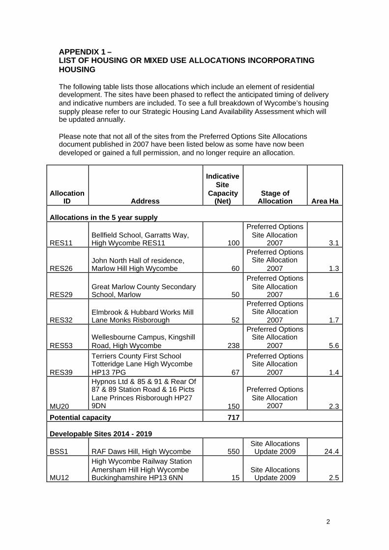
APPENDIX 1 –LIST OF HOUSING OR MIXED USE ALLOCATIONS INCORPORATINGHOUSING
The following table lists those allocations which include an element of residentialdevelopment. The sites have been phased to reflect the anticipated timing of deliveryand indicative numbers are included. To see a full breakdown of Wycombe’s housingsupply please refer to our Strategic Housing Land Availability Assessment which willbe updated annually.
Please note that not all of the sites from the Preferred Options Site Allocationsdocument published in 2007 have been listed below as some have now beendeveloped or gained a full permission, and no longer require an allocation.
AllocationID Address
IndicativeSite
Capacity(Net)
Stage ofAllocation Area Ha
Allocations in the 5 year supply
RES11Bellfield School, Garratts Way,High Wycombe RES11 100
Preferred OptionsSite Allocation
2007 3.1
RES26John North Hall of residence,Marlow Hill High Wycombe 60
Preferred OptionsSite Allocation
2007 1.3
RES29Great Marlow County SecondarySchool, Marlow 50
Preferred OptionsSite Allocation
2007 1.6
RES32Elmbrook & Hubbard Works MillLane Monks Risborough 52
Preferred OptionsSite Allocation
2007 1.7
RES53Wellesbourne Campus, KingshillRoad, High Wycombe 238
Preferred OptionsSite Allocation
2007 5.6
RES39
Terriers County First SchoolTotteridge Lane High WycombeHP13 7PG 67
Preferred OptionsSite Allocation
2007 1.4
MU20
Hypnos Ltd & 85 & 91 & Rear Of87 & 89 Station Road & 16 PictsLane Princes Risborough HP279DN 150
Preferred OptionsSite Allocation
2007 2.3
Potential capacity 717
Developable Sites 2014 - 2019
BSS1 RAF Daws Hill, High Wycombe 550Site AllocationsUpdate 2009 24.4
MU12
High Wycombe Railway StationAmersham Hill High WycombeBuckinghamshire HP13 6NN 15
Site AllocationsUpdate 2009 2.5

3
AllocationID Address
IndicativeSite
Capacity(Net)
Stage ofAllocation Area Ha
MU16
Compair Broomwade, BellfieldRoad Employment Area,Hughenden Avenue 20
Site AllocationsUpdate 2009 7.9
MU17
Former De La Rue Site CoatesLane High WycombeBuckinghamshire HP13 5EZ 86
Site AllocationsUpdate 2009 3.0
MU19Wycombe Sports Centre, MarlowHill, High Wycombe 20
Site AllocationsUpdate 2009 8.6
MU22 Desborough Road Car Park 29Site AllocationsUpdate 2009 0.2
MU23Duke Street Car Park, HighWycombe 50
Site AllocationsUpdate 2009 0.7
MU3
Green Street County FirstSchool, Green Street,Desborough 8
Site AllocationsUpdate 2009 0.6
MU4 Leigh Street Employment Area 100Site AllocationsUpdate 2009 2.7
MU6 Baker Street 50Site AllocationsUpdate 2009 3.1
MU7 Brook Street, High Wycombe 13
Preferred OptionsSite Allocation
2007 0.1
MU8Collins House, Corner of BridgeSt/Desborough Rd 41
Site AllocationsUpdate 2009 0.2
PC10 Gordons Builders Merchants 5
Preferred OptionsSite Allocation
2007 0.1
PC7
BCC Highways Depot,Corporation Yard, LongwickRoad, Princes Risborough. 18
Preferred OptionsSite Allocation
2007 0.2
PC9The Wharf Business Centre,Wharf Lane, Bourne End 10
Preferred OptionsSite Allocation
2007 0.2
RES28Clean Linen Services, 166 LittleMarlow Road, Marlow 14
Preferred OptionsSite Allocation
2007 0.4
RES34
Stokenchurch County FirstSchool, Slade Road,Stokenchurch 15
Preferred OptionsSite Allocation
2007 1.8
RES54Kingswood County First School,Totteridge Lane 30
Preferred OptionsSite Allocation
2007 1.7
SMA0068 Portlands Gardens, Marlow 50Site AllocationsUpdate 2009 1.4
Potential capacity 1124
Developable Sites 2019-2026

4
AllocationID Address
IndicativeSite
Capacity(Net)
Stage ofAllocation Area Ha
MU10 Easton Street 30Site AllocationsUpdate 2009 3.4
MU14 West End Road 55
Preferred OptionsSite Allocation
2007 0.9
MU24 Octagon Parade 20Site AllocationsUpdate 2009 0.6
MU5Downley Court and Cross Court,Plomer Green Avenue 10
Preferred OptionsSite Allocation
2007 0.6
MU7Bus Depot, Bridge Street, HighWycombe 50
Preferred OptionsSite Allocation
2007 1.2
MU7 Vernon Building, High Wycombe 23
Preferred OptionsSite Allocation
2007 0.2
MU7Corner of Bridge St/Oxford Road,High Wycombe 59
Preferred OptionsSite Allocation
2007 0.5
RES7Folly Works, Dashwood Avenue,High Wycombe 7
Preferred OptionsSite Allocation
2007 0.1
Potential capacity 254
New Allocations*
MU33
Land Off Wooburn Mead,Wycombe Lane and Landadjacent to SRS joinery Ltd, 10Wycombe Lane, Wooburn Green 17
Site AllocationsUpdate 2009 0.8
SHLAA 1Rear of 29 - 39 and 37 FurlongRoad, Bourne End 5
Site AllocationsUpdate 2009 0.1
SHLAA 1Frank Hudson Furniture Factory,Rosebery Avenue 5
Site AllocationsUpdate 2009 0.1
KR1Kingsmead Recreation Ground,London Road 15
Site AllocationsUpdate 2009 2.3
MU26Chilterns Shopping Centre,Frogmoor, High Wycombe 50
Site AllocationsUpdate 2009 0.8
MU32 Liston Road Car Park, Marlow 15Site AllocationsUpdate 2009 0.4
SR4
Ker Maria Nursing Home, TheRetreat, Aylesbury Road, princesRisborough 21
Site AllocationsUpdate 2009 1.1
Greenfield Sites
RL1 Slate Meadow 150Site AllocationsUpdate 2009 10.4
RL2Land At Terriers Farm KingshillRoad High Wycombe 400
Site AllocationsUpdate 2009 22.6
5
AllocationID Address
IndicativeSite
Capacity(Net)
Stage ofAllocation Area Ha
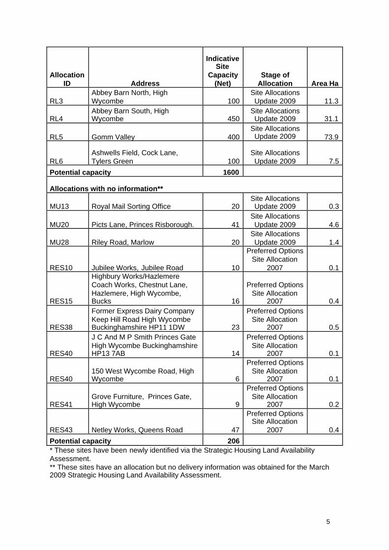
RL3Abbey Barn North, HighWycombe 100
Site AllocationsUpdate 2009 11.3
RL4Abbey Barn South, HighWycombe 450
Site AllocationsUpdate 2009 31.1
RL5 Gomm Valley 400Site AllocationsUpdate 2009 73.9
RL6Ashwells Field, Cock Lane,Tylers Green 100
Site AllocationsUpdate 2009 7.5
Potential capacity 1600
Allocations with no information**
MU13 Royal Mail Sorting Office 20Site AllocationsUpdate 2009 0.3
MU20 Picts Lane, Princes Risborough. 41Site AllocationsUpdate 2009 4.6
MU28 Riley Road, Marlow 20Site AllocationsUpdate 2009 1.4
RES10 Jubilee Works, Jubilee Road 10
Preferred OptionsSite Allocation
2007 0.1
RES15
Highbury Works/HazlemereCoach Works, Chestnut Lane,Hazlemere, High Wycombe,Bucks 16
Preferred OptionsSite Allocation
2007 0.4
RES38
Former Express Dairy CompanyKeep Hill Road High WycombeBuckinghamshire HP11 1DW 23
Preferred OptionsSite Allocation
2007 0.5
RES40
J C And M P Smith Princes GateHigh Wycombe BuckinghamshireHP13 7AB 14
Preferred OptionsSite Allocation
2007 0.1
RES40150 West Wycombe Road, HighWycombe 6
Preferred OptionsSite Allocation
2007 0.1
RES41Grove Furniture, Princes Gate,High Wycombe 9
Preferred OptionsSite Allocation
2007 0.2
RES43 Netley Works, Queens Road 47
Preferred OptionsSite Allocation
2007 0.4
Potential capacity 206* These sites have been newly identified via the Strategic Housing Land AvailabilityAssessment.** These sites have an allocation but no delivery information was obtained for the March2009 Strategic Housing Land Availability Assessment.

6
AllocationID Address
IndicativeSite
Capacity(Net)
Stage ofAllocation Area Ha
Sites with Permission at the base date 31 March 2008
MU21 Wycombe Marsh 465
Preferred OptionsSite Allocation
2007 6.4

7
APPENDIX 2RESERVE LOCATIONS FOR FUTURE DEVELOPMENT – SUMMARY COMPARATIVE ASSESSMENT
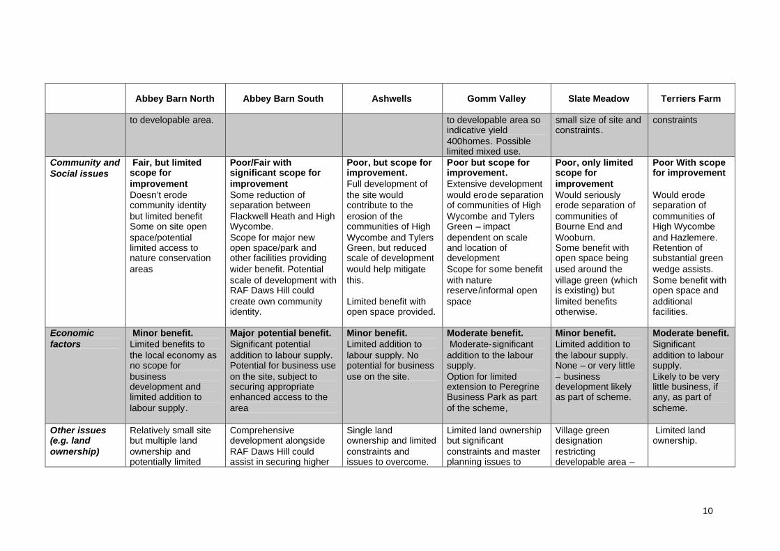
Abbey Barn North Abbey Barn South Ashwells Gomm Valley Slate Meadow Terriers Farm
Landscape Moderateconstraint, butsome scope tomitigate impactsImportant views fromacross the valley tothe northeast,although lower partsof site less visible.Adjacent to locallandscape area.Site part of existingGreen InfrastructureNetwork link runningnorth-south betweenformer railwaycorridor andDeangarden Wood.
Minor to moderateconstraint, but scope tomitigate impacts to afair degreeAdjacent to a locallandscape area.Historical woodland riderepresents importantlandscape feature.Attractive natural valleylandform betweenDeangarden Wood andwoodland ride. Site nothighly visible from longerdistance views.Site part of existingGreen InfrastructureNetwork link runningnorth-south betweenDeangarden Wood andthe countryside to thesouth.
Moderateconstraint, butscope to mitigateimpacts to a fairdegree.Sloping landform onwest of the siteenables attractiveviews to and fromMicklefield and KingsWood.Eastern fields arevisually contained bytopography andexisting vegetation.Site part of existingGreen InfrastructureNetwork link runningnorth-west towardsKings Wood andpotential GreenInfrastructureNetwork link northeast towards TylersGreen.
Very major constraint,and difficult tomitigate impacts fully.Rolling valley landformis an attractive and rarefeature within the urbansettlement.Important views to andfrom the Wye valley tothe south, and acrossthe valley from thepublic footpath to theeast.Development likely toharm integrity oflandscape – someareas less sensitive todevelopment thanothers.Site part of existingGreen InfrastructureNetwork link runningnorth-west towardsKings Wood, and to theopen countryside to theeast.
Minor to moderateconstraint, andsome scope tomitigate impactsRelatively limitedintrinsic landscapevalue. Adjacent tolocal landscapearea.Views into and out ofthe sites from valleysides.Site part of existingGreen InfrastructureNetwork link runningbetween formerrailway corridor andriver. Part ofpotential GreenInfrastructureNetwork link alongdisused railway lineand river corridor.Importantrecreational value forlocal residents.
Moderate tomajor constraint,and some scopeto mitigateimpacts.Adjacent toAONB.Enclosed site withhigh qualityhedgerowfeatures.Importantrecreational valuefor local residents.Site part ofexisting GreenInfrastructureNetwork linkrunning betweenformer railwaycorridor and river.Part of potentialGreenInfrastructureNetwork link alongdisused railwayline and rivercorridor.

8
Abbey Barn North Abbey Barn South Ashwells Gomm Valley Slate Meadow Terriers Farm
Ecology Major constraint,but scope forimprovements.Priority BAP habitat(chalk grassland) andlocal natureconservationdesignation affectingmuch of the site.Vicinity to ancientwoodland and LWSfurther constrain site.Developable areasignificantlyconstrained.Managementagreement for naturalareas likely to berequired.
Minor/Moderateconstraint, but keyareas can be retained.Mature trees andhedgerows are presentacting as constraint todevelopment (especiallywoodland ride).Strategically important aspart of a green wildlifelink between areas northand south of the site.
Minor constraint.No significantecological impactexpected.
Major constraint, butscope forimprovements.Presence of SSSI,BNS, LWS and AncientWoodland severelyrestricting thedevelopable area.
Extensive undesignatedareas need to beretained for biodiversitypurposes/habitatcreation. Managementagreement for naturalareas likely to berequired.
Minor constraint.No significantecologicalconstraints.
Moderateconstraint, butkey areas can beretained.Mature hedgerowsof high ecologicalvalue (alsodesignated asBNSs) but couldbe integrated intodevelopment.
Otherenvironmentalissues
Moderateconstraint.Small amount ofGrade 2 AgriculturalLand on site (12.4%of site area)
Major constraint.Mainly Grade 2 (28%)and 3A (42.7%)Agricultural land.
Minor constraint.Mainly Grade 3AAgricultural Land.
Moderate constraint.Some Grade 3AAgricultural land, smallamount of Grade 2.
Major constraint.Parts of site in FloodZones 2. The RiverWye along the site isFlood Zone 3b.Much of site Grade 2and 3A AgriculturalLand.
Minor tomoderate impact.Some Grade 3AAgricultural Land.Site adjoinsTerriersConservationArea.
Transport Fair/PoorAZ 3 and 4 but busroutes a significantwalk away (there isan hourly bus service
Poor, but scope forimprovement.AZ5. Very poorly locatedfor public transport links.Major public transport
Poor.AZ5. Very poorlylinked for publictransport. Access andbetter public transport
Poor, but scope forlimited improvement.AZ4/5. Site only fairlynear to bus services.Would require bus
Fair.AZ4. Frequent busroutes pass by thesite.Moderate impact on
Fair/Good andscope for someimprovement.AZ3. Site nearfrequent bus

9
Abbey Barn North Abbey Barn South Ashwells Gomm Valley Slate Meadow Terriers Farm
on Kingsmead Road).Some facilities e.g.Wycombe Marshwithin walkingdistance but difficulttopographically.
Potential accessdifficulties into thesite. Scale ofdevelopment limitswider network impact
improvements would berequired as part ofdevelopment.Impact on network high,particularly whenconsidered alongsidedevelopment of RAFDaws Hill. Extensivemitigation measuresrequired.
links serving the sitewould need to beprovided.Potential impacts oftraffic on Cock Lane.
route through the site.Significant impact onhighway network.
network routes serving thetown centre.Potentiallysuitable locationfor park and ridefacilities.Significant impacton highwaynetwork
Proximity toservices/facilities
Fair/poor.Some services inWycombe Marshwithin reasonablewalking distance butlimited (retail park).
Poor, but scope forimprovement.Despite relative proximityto town centre, siteremote from services dueto topography andseparation of WycombeAbbey School and RAFDaws Hill. Potential scaleof development (alongwith RAF Daws Hill)would enable provision ofsome on-site facilities.
Poor.Site has very pooraccess to a range ofservices.
Fair/poor, only limitedscope forimprovement.Site has relatively pooraccess to a range ofservices – remote fromHW town centre. Scaleof development mightfacilitate some limitedlocal improvement
Fair.Site is reasonablyclose to some localservices but a longerdistance from villagecentre of BourneEnd. Remote fromHW town centre.
Fair/Good, onlylimited scope forimprovement.Site hasreasonableaccess to a rangeof services locallyand relativeproximity to thetown centre. Scaleof developmentmight facilitatesome limited localimprovement
Contribution tohousing
Limitedcontribution.Up to 100 homesmax but restrictions
Significant contribution.Approx 450 homes. Alsoa mix of uses likely.
Limitedcontribution.Approx 100 homesdue to constraints.
Moderate –Significantcontribution.Significant restrictions
Limitedcontribution.Limited to150 homesdue to relatively
Significantcontribution.Approx 400 givensize of site and
10
Abbey Barn North Abbey Barn South Ashwells Gomm Valley Slate Meadow Terriers Farm
to developable area. to developable area soindicative yield400homes. Possiblelimited mixed use.
small size of site andconstraints.
constraints
Community andSocial issues
Fair, but limitedscope forimprovementDoesn’t erodecommunity identitybut limited benefitSome on site openspace/potentiallimited access tonature conservationareas
Poor/Fair withsignificant scope forimprovementSome reduction ofseparation betweenFlackwell Heath and HighWycombe.Scope for major newopen space/park andother facilities providingwider benefit. Potentialscale of development withRAF Daws Hill couldcreate own communityidentity.
Poor, but scope forimprovement.Full development ofthe site wouldcontribute to theerosion of thecommunities of HighWycombe and TylersGreen, but reducedscale of developmentwould help mitigatethis.
Limited benefit withopen space provided.
Poor but scope forimprovement.Extensive developmentwould erode separationof communities of HighWycombe and TylersGreen – impactdependent on scaleand location ofdevelopmentScope for some benefitwith naturereserve/informal openspace
Poor, only limitedscope forimprovementWould seriouslyerode separation ofcommunities ofBourne End andWooburn.Some benefit withopen space beingused around thevillage green (whichis existing) butlimited benefitsotherwise.
Poor With scopefor improvement
Would erodeseparation ofcommunities ofHigh Wycombeand Hazlemere.Retention ofsubstantial greenwedge assists.Some benefit withopen space andadditionalfacilities.
Economicfactors
Minor benefit.Limited benefits tothe local economy asno scope forbusinessdevelopment andlimited addition tolabour supply.
Major potential benefit.Significant potentialaddition to labour supply.Potential for business useon the site, subject tosecuring appropriateenhanced access to thearea
Minor benefit.Limited addition tolabour supply. Nopotential for businessuse on the site.
Moderate benefit.Moderate-significant
addition to the laboursupply.Option for limitedextension to PeregrineBusiness Park as partof the scheme,
Minor benefit.Limited addition tothe labour supply.None – or very little– businessdevelopment likelyas part of scheme.
Moderate benefit.Significantaddition to laboursupply.Likely to be verylittle business, ifany, as part ofscheme.
Other issues(e.g. landownership)
Relatively small sitebut multiple landownership andpotentially limited
Comprehensivedevelopment alongsideRAF Daws Hill couldassist in securing higher
Single landownership and limitedconstraints andissues to overcome.
Limited land ownershipbut significantconstraints and masterplanning issues to
Village greendesignationrestrictingdevelopable area –
Limited landownership.

11
Abbey Barn North Abbey Barn South Ashwells Gomm Valley Slate Meadow Terriers Farm
developable area. quality development inthe area and in securingsatisfactory transport/other infrastructuresolutions to the potentiallysingle largest area ofdevelopment in theDistrict. Singlelandownership and flat.Potential for CHPdelivery.
overcome, andpotentially limiteddevelopable area.
would need landswap orarrangement of openspace.Flood risks wouldneed to bemanaged.
PotentialSustainabilityBenefits
Good; all sites would be expected to comply with Policy A16 on Sustainable Construction.

12
APPENDIX 3INFRASTRUCTURE SCHEDULE
Context
This Infrastructure Schedule sets out the key infrastructure requirements to supportthe sustainable delivery of the sites identified in this Delivery and Site Allocations, asset out in Policy B17.
The Infrastructure Schedule has been developed through consultation with serviceproviders and reflects their current infrastructure requirements to supportdevelopment across the district (as at Spring 2009)1.
As the development plan is implemented and infrastructure requirements of serviceproviders become more refined, the Schedule will be required to be updated to reflectthese changing priorities. It is expected that the Schedule will be updated and themost recent Schedule should be used when assessing infrastructure need.
Structure of the Schedule
The Infrastructure Schedule exists in two halves.
Section A – the Infrastructure Schedule.This lists the specific schemes that have been identified by service providers. It alsoidentifies costs and potential funding sources, phasing of delivery and responsibledelivery agencies.
Infrastructure requirements are divided between different geographical areas toreflect the different levels at which service provision operates. These are
o Sub-regionalo District wideo The four Local Community Areas within the district:
High Wycombe Chepping Wye Valley South West Chilterns & Marlow Princes Risborough
Individual site specific requirements (including for strategic sites and Greenfieldreserve sites) will be added to the infrastructure schedule following the conclusion ofthe update consultation on the Delivery and Site Allocations DPD in summer 2009.This will allow for an appropriate assessment of infrastructure requirements when thetiming of the delivery of these sites is more certain.
Section B – Accompanying Text to the Infrastructure Schedule.Due to the differing nature of the operations of individual service providers at times ithas not been possible to reflect the responses of service providers within theschedule itself. Therefore where required additional information / explanation hasbeen provided in Section B.
1 Further information on the process undertaken can be found in the background paperSupporting Growth: Infrastructure Requirements in Wycombe district to 2026 (WDC, 2009)

13
SECTION A: Infrastructure Schedule
SUB-REGIONAL INFRASTRUCTURE REQUIREMENTS (defined by infrastructure which physically crosses outside the Wycombe District Counciladministrative border and/or whose services serve a wider population than Wycombe district)
PhasingSchemeRef. Scheme Delivery
Agency(s)Cost(£m)
FundingSources Pre-
20112011-16
2016-21
2021-26
Status
TRANSPORTSR/T1 High Wycombe – Bourne End (&
Maidenhead) Ultra Light Rail(N.B. this proposal is currently beingconsulted upon as an option for thefuture protection of the former HighWycombe –Bourne End railwayalignment, as part of the WDFDelivery & Site Allocations DPDupdate consultation, summer 2009)
WDC & BCC 110 To beidentified
SR/T2 Regional Coachway – J4, M40 BCC (+WDC) 25(C&R)
SEERARFA
Schemebeingdeveloped
PublicTransport
SR/T3 Inter regional coach network Berkshireauthorities(+BCC &SEERA)
25(C&R)
SEERARFA orKick StartBid
Schemebeingdeveloped.
Rail Network
SR/T4 Aylesbury – High Wycombe rail routeupgrade
Chiltern Rail(+BCC)
80 ChilternRailways /NetworkRail
SR/T5 North – South Links – Improvementsto the A4010
BCC (+WDC) 10 To beidentifiedHighway
Network SR/T6 M40 / A404 / M$ / M25 MotorwayBox
BCC (+HA &Berkshireauthorities)
12 SEERARFA bid
PUBLIC SERVICES
14
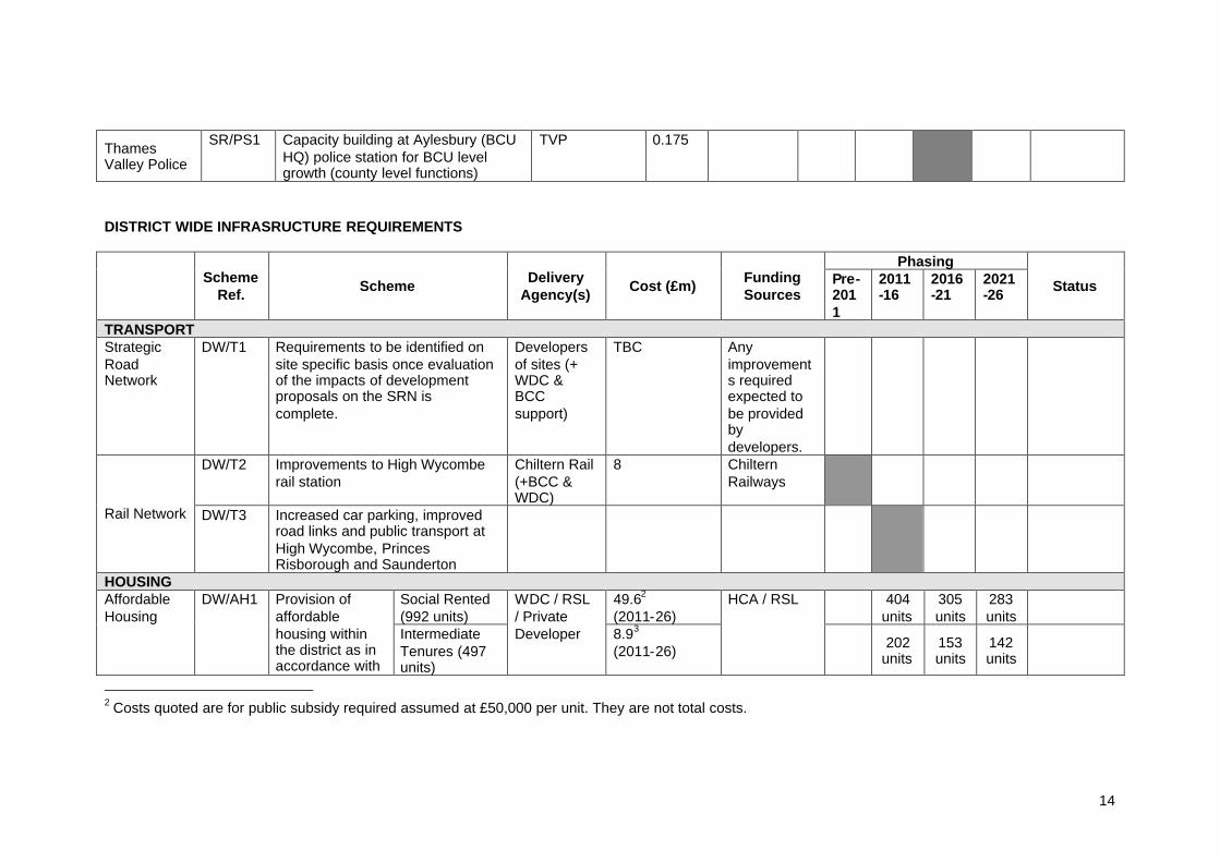
ThamesValley Police
SR/PS1 Capacity building at Aylesbury (BCUHQ) police station for BCU levelgrowth (county level functions)
TVP 0.175
DISTRICT WIDE INFRASRUCTURE REQUIREMENTS
PhasingScheme
Ref. Scheme DeliveryAgency(s) Cost (£m) Funding
SourcesPre-2011
2011-16
2016-21
2021-26 Status
TRANSPORTStrategicRoadNetwork
DW/T1 Requirements to be identified onsite specific basis once evaluationof the impacts of developmentproposals on the SRN iscomplete.
Developersof sites (+WDC &BCCsupport)
TBC Anyimprovements requiredexpected tobe providedbydevelopers.
DW/T2 Improvements to High Wycomberail station
Chiltern Rail(+BCC &WDC)
8 ChilternRailways
Rail Network DW/T3 Increased car parking, improvedroad links and public transport atHigh Wycombe, PrincesRisborough and Saunderton
HOUSINGSocial Rented(992 units)
49.62
(2011-26)404
units305units
283units
AffordableHousing
DW/AH1 Provision ofaffordablehousing withinthe district as inaccordance with
IntermediateTenures (497units)
WDC / RSL/ PrivateDeveloper 8.93
(2011-26)
HCA / RSL
202units
153units
142units
2 Costs quoted are for public subsidy required assumed at £50,000 per unit. They are not total costs.

15
Core StrategyPolicy CS 13AffordableHousing andHousing Mix
EDUCATIONFurthereducation
DW/E1 Redevelopment of Amersham &Wycombe College campus in HighWycombe town centre
Amersham& WycombeCollege
50 Learning &Skills Council
Awaitingfunding
Highereducation
DW/E2 Expansion of BNU campus in HighWycombe town centre
Underconstruction
HEALTHAcute Care& GeneralHospitals
DW/H1 No future specific requirementsidentified.
PrimaryCare Trust
DW/H2 No response received to date.
MentalHealth Trust
DW/H3 No response received to date.
SOCIAL INFRASTRUCTUREDW/SI1 Community stadium for London
Wasps and Wycombe WanderersSportsFacilities
DW/SI2 Play and teen facilities WDC 0.06 per LEAPsite0.1 per NEAPsite
Potential fordevelopercontributions
Should be delivered pre-construction for off-site andbefore 100 homes occupiedfor on-site
Adult SocialCare
DW/SI3 Numbers of required units up to2020 (more detailed breakdownavailable)
SpecialistHousing
General Needs
Learning 86 115
Development lead(+WDC &BCCsupport)
Specialistaccommodation = £54,945per unit
General needsaccommodatio
Potential fordevelopercontributions.SHG andprivatedevelopers
Adult social carerequirement is not aparticularly ‘stepped’requirement and can bedelivered at the same timeas the wider developments,there is no ‘critical mass’
3 Costs quoted are for public subsidy required assumed at £18,000 per unit. They are not total costs.

16
disabilityPSD 8 0MentalHealth
6 39
OlderPeople
137 394
Othervulnerable groups
34 134
n = £121,725per unit
that’s needs to be achieved,
GREEN INFRASTRUCTUREOpen Space DW/GI1 Provision of amenity open space
and development of strategicgreen corridors and woodlands,parks & gardens and outdoorsports areas
WDC 0.025 – 0.03 Potential fordevelopercontributions
Should ideally be deliveredpre construction because ofminimum 3 years requiredfor land to ‘settle’ andbecome useable by thepublic.
Costs basedon typicalrevenuecosts for 10yearsmaintenance of generalopen space
GreenInfrastructure Network
DW/GI2 Green Infrastructure Networkemerging to identify, protect andenhance important landscapefeatures, wildlife corridors andBAP Areas of Opportunity, areasof important historic landscapecharacter and existing andpotential cycle and pedestrianroutes forming part of a widernetwork.
WDC TBC Potential fordevelopercontributions
PUBLIC SERVICESThamesValleyPolice
DW/PS1 Reprovision of Wycombe PoliceStation
TVP 0.09 Sale of TVPassets /developercontributions
Optionappraisalbeingundertaken.

17
Bucks Fire &RescueService
DW/PS2 Provision of fire hydrants andother works necessary to ensureadequate supplies of water (asdetailed within the currentWycombe DeveloperContributions SPD)
BFRS As set out inWDCDeveloperContributionsGuide
DW/PS3 Increase provision of AmenityPoints (small offices able to housestaff on breaks and space to parkan ambulance)
SCAS TBC TBC
AmbulanceService DW/PS4 Provision of a replacement
Resource Centre (with goodaccess to major roads in the area)
SCAS (+StrategicHealthAuthority)
TBC TBC
ArchivesService
DW/PS5 Requirement for an additional1,026sqm of archive space
BCC 3.7 To beidentified
Existing deficiencies willwork to proceed as soon aspossible after 2011.
UTILITIES AND WASTEDW/UW1
Upgrade of Princes RisboroughSewerage Treatment Works
ThamesWater
Beingundertakenin 2009
DW/UW2
Sludge stream improvementsrequired to Little MarlowSewerage Treatment Works (tocomply with changing sludgeregulations)
ThamesWater
DW/UW3
Localised upgrades of waternetwork will be required
ThamesWater
TBC
ThamesWater
DW/UW4
Strategic solution required totackle capacity problems ofwastewater network (to beidentified)
ThamesWater
TBC Funding tobe securedthroughbusinessplans
WasteManagemen
DW/UW5
Need for additional householdwaste recycling centres (HWRCs),
BCC &WDC
18
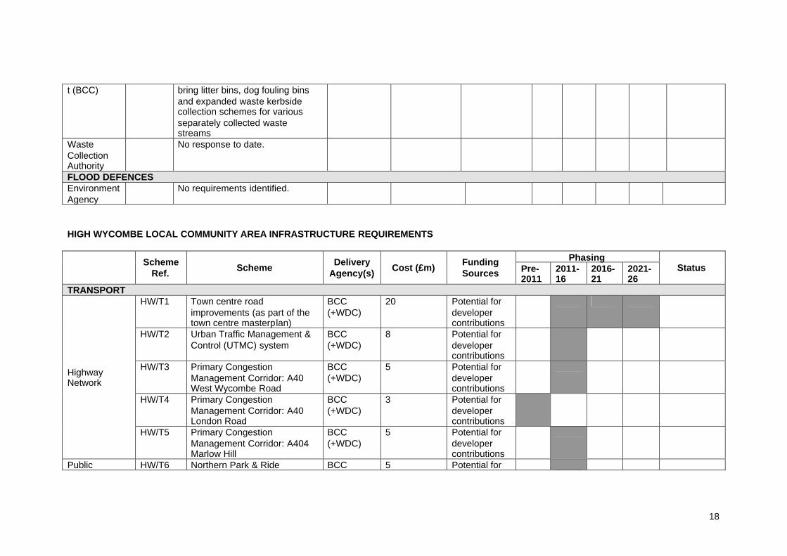
t (BCC) bring litter bins, dog fouling binsand expanded waste kerbsidecollection schemes for variousseparately collected wastestreams
WasteCollectionAuthority
No response to date.
FLOOD DEFENCESEnvironmentAgency
No requirements identified.
HIGH WYCOMBE LOCAL COMMUNITY AREA INFRASTRUCTURE REQUIREMENTS
PhasingSchemeRef. Scheme Delivery
Agency(s) Cost (£m) FundingSources Pre-
20112011-16
2016-21
2021-26
Status
TRANSPORTHW/T1 Town centre road
improvements (as part of thetown centre masterplan)
BCC(+WDC)
20 Potential fordevelopercontributions
HW/T2 Urban Traffic Management &Control (UTMC) system
BCC(+WDC)
8 Potential fordevelopercontributions
HW/T3 Primary CongestionManagement Corridor: A40West Wycombe Road
BCC(+WDC)
5 Potential fordevelopercontributions
HW/T4 Primary CongestionManagement Corridor: A40London Road
BCC(+WDC)
3 Potential fordevelopercontributions
HighwayNetwork
HW/T5 Primary CongestionManagement Corridor: A404Marlow Hill
BCC(+WDC)
5 Potential fordevelopercontributions
Public HW/T6 Northern Park & Ride BCC 5 Potential for

19
(+WDC) developercontributions
HW/T7 Relocation of Southern Park &Ride with Regional Coachway
BCC(+WDC)
Potential fordevelopercontributions
HW/T8 Primary Public TransportCorridor (PPTC): A404Amersham Hill / A4128Hughenden Road
BCC(+WDC)
3 Potential fordevelopercontributions
HW/T9 Primary Public TransportCorridor (PPTC): DesboroughAvenue / A404 Marlow Hill
BCC(+WDC)
3 Potential fordevelopercontributions
Transport
HW/T10 Bus Gate – A404 Marlow Hill BCC(+WDC)
1 To beidentified.
HW/T11 Cycle network (includingpromotion, information andcycle parking provision intown centre)
BCC(+WDC)
2 Potential fordevelopercontributions
Walking andCyclingNetwork
HW/T12 Improvements to town centrewalking provision (improvedsignage, pedestrian crossings,provision of dropped kerbsand tactile paving)
BCC(+WDC)
1 Potential fordevelopercontributions
EDUCATIONNursery &Primary
HW/E1 Anticipated increase innumber of pupils (2008-26) =1423
BCC
Secondary(11-15)
HW/E2 Anticipated increase innumber of pupils (2008-26) =872
BCC
Secondary(Post 16)
HW/E3 Anticipated increase innumber of pupils (2008-26) =229
BCC
Costscalculatedusing densitymultipliers
To beidentified.Potential fordevelopercontributions.
Adult Learning HW/E4 Increased infrastructure tosupport the expansion
Culture &Learning
£2850/sqm.=
No fundingsource
Existing usecreating
20
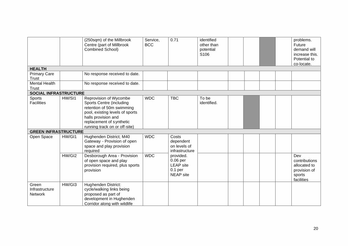
(250sqm) of the MillbrookCentre (part of MillbrookCombined School)
Service,BCC
0.71 identifiedother thanpotentialS106
problems.Futuredemand willincrease this.Potential toco-locate.
HEALTHPrimary CareTrust
No response received to date.
Mental HealthTrust
No response received to date.
SOCIAL INFRASTRUCTURESportsFacilities
HW/SI1 Reprovision of WycombeSports Centre (includingretention of 50m swimmingpool, existing levels of sportshalls provision andreplacement of syntheticrunning track on or off-site)
WDC TBC To beidentified.
GREEN INFRASTRUCTUREHW/GI1 Hughenden District; M40
Gateway - Provision of openspace and play provisionrequired
WDCOpen Space
HW/GI2 Desborough Area - Provisionof open space and playprovision required, plus sportsprovision
WDC
Costsdependenton levels ofinfrastructureprovided.0.06 perLEAP site0.1 perNEAP site
Devcontributionsallocated toprovision ofsportsfacilities
GreenInfrastructureNetwork
HW/GI3 Hughenden District:cycle/walking links beingproposed as part ofdevelopment in HughendenCorridor along with wildlife
21
corridor enhancement alongstream and landscape corridoralong proposed new routes.Desborough Area: enhancedcycle/walking links beingproposed with enhancedwildlife corridor links alongriver.M40 Gateway: any newdevelopment will be requiredto identify, protect andenhance wildlifehabitats/corridors,walking/cycling links,important landscape andhistoric features in line withour emerging GreenInfrastructure Network.
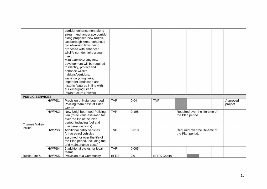
PUBLIC SERVICESHW/PS1 Provision of Neighbourhood
Policing team base at EdenCentre
TVP 0.04 TVP Approvedproject
HW/PS2 New Neighbourhood Policingvan (three vans assumed forover the life of the Planperiod, including fuel andmaintenance costs)
TVP 0.195 Required over the life-time ofthe Plan period.
HW/PS3 Additional patrol vehicles(three patrol vehiclesassumed for over the life ofthe Plan period, including fueland maintenance costs)
TVP 0.018 Required over the life-time ofthe Plan period.
Thames ValleyPolice
HW/PS4 6 additional cycles for localteams
TVP 0.0054
Bucks Fire & HW/PS5 Provision of a Community BFRS 2.9 BFRS Capital
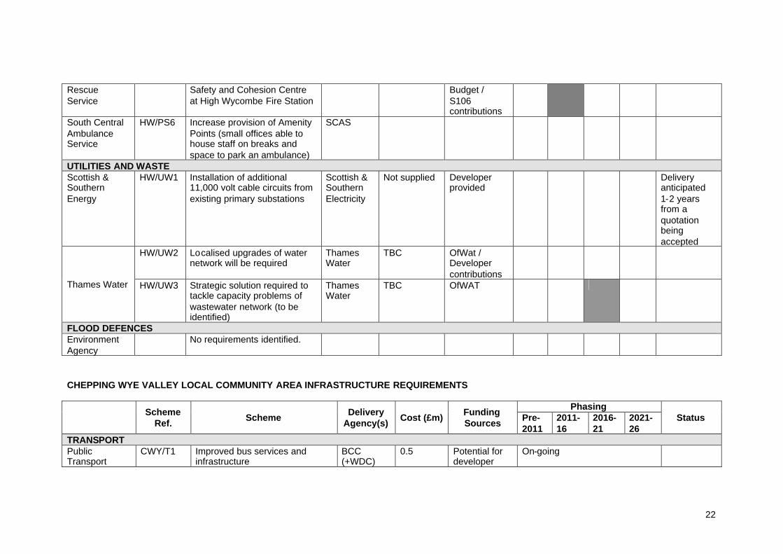
22
RescueService
Safety and Cohesion Centreat High Wycombe Fire Station
Budget /S106contributions
South CentralAmbulanceService
HW/PS6 Increase provision of AmenityPoints (small offices able tohouse staff on breaks andspace to park an ambulance)
SCAS
UTILITIES AND WASTEScottish &SouthernEnergy
HW/UW1 Installation of additional11,000 volt cable circuits fromexisting primary substations
Scottish &SouthernElectricity
Not supplied Developerprovided
Deliveryanticipated1-2 yearsfrom aquotationbeingaccepted
HW/UW2 Localised upgrades of waternetwork will be required
ThamesWater
TBC OfWat /Developercontributions
Thames Water HW/UW3 Strategic solution required totackle capacity problems ofwastewater network (to beidentified)
ThamesWater
TBC OfWAT
FLOOD DEFENCESEnvironmentAgency
No requirements identified.
CHEPPING WYE VALLEY LOCAL COMMUNITY AREA INFRASTRUCTURE REQUIREMENTS
PhasingSchemeRef. Scheme Delivery
Agency(s) Cost (£m) FundingSources Pre-
20112011-16
2016-21
2021-26
Status
TRANSPORTPublicTransport
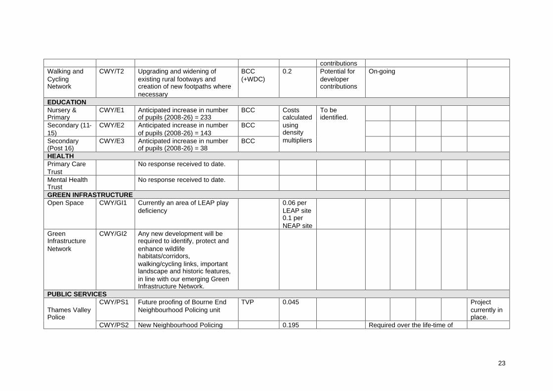
CWY/T1 Improved bus services andinfrastructure
BCC(+WDC)
0.5 Potential fordeveloper
On-going
23
contributionsWalking andCyclingNetwork
CWY/T2 Upgrading and widening ofexisting rural footways andcreation of new footpaths wherenecessary
BCC(+WDC)
0.2 Potential fordevelopercontributions
On-going
EDUCATIONNursery &Primary
CWY/E1 Anticipated increase in numberof pupils (2008-26) = 233
BCC
Secondary (11-15)
CWY/E2 Anticipated increase in numberof pupils (2008-26) = 143
BCC
Secondary(Post 16)
CWY/E3 Anticipated increase in numberof pupils (2008-26) = 38
BCC
Costscalculatedusingdensitymultipliers
To beidentified.
HEALTHPrimary CareTrust
No response received to date.
Mental HealthTrust
No response received to date.
GREEN INFRASTRUCTUREOpen Space CWY/GI1 Currently an area of LEAP play
deficiency0.06 perLEAP site0.1 perNEAP site
GreenInfrastructureNetwork
CWY/GI2 Any new development will berequired to identify, protect andenhance wildlifehabitats/corridors,walking/cycling links, importantlandscape and historic features,in line with our emerging GreenInfrastructure Network.
PUBLIC SERVICESCWY/PS1 Future proofing of Bourne End
Neighbourhood Policing unitTVP 0.045 Project
currently inplace.
Thames ValleyPolice
CWY/PS2 New Neighbourhood Policing 0.195 Required over the life-time of
24
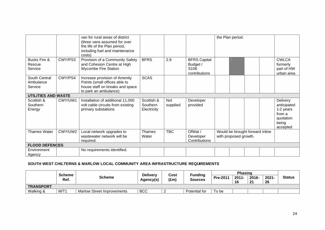
van for rural areas of district(three vans assumed for overthe life of the Plan period,including fuel and maintenancecosts)
the Plan period.
Bucks Fire &RescueService
CWY/PS3 Provision of a Community Safetyand Cohesion Centre at HighWycombe Fire Station
BFRS 2.9 BFRS CapitalBudget /S106contributions
CWLCAformerlypart of HWurban area
South CentralAmbulanceService
CWY/PS4 Increase provision of AmenityPoints (small offices able tohouse staff on breaks and spaceto park an ambulance)
SCAS
UTILITIES AND WASTEScottish &SouthernEnergy
CWY/UW1 Installation of additional 11,000volt cable circuits from existingprimary substations
Scottish &SouthernElectricity
Notsupplied
Developerprovided
Deliveryanticipated1-2 yearsfrom aquotationbeingaccepted
Thames Water CWY/UW2 Local network upgrades towastewater network will berequired.
ThamesWater
TBC OfWat /DeveloperContributions
Would be brought forward inlinewith proposed growth.
FLOOD DEFENCESEnvironmentAgency
No requirements identified.
SOUTH WEST CHILTERNS & MARLOW LOCAL COMMUNITY AREA INFRASTRUCTURE REQUIREMENTS
PhasingSchemeRef. Scheme Delivery
Agency(s)Cost(£m)
FundingSources Pre-2011 2011-
162016-21
2021-26
Status
TRANSPORTWalking & M/T1 Marlow Street Improvements BCC 2 Potential for To be

25
(+WDC) developercontributions
identified.
CyclingNetwork M/T2 Implementation of cycling and
walking routes in Marlow, in linewith agreed town cycle network
BCC(+WDC)
0.5 Potential fordevelopercontributions
To beidentified.
EDUCATIONNursery &Primary
M/E1 Anticipated increase in number ofpupils (2008-26) = 220
BCC
Secondary (11-15)
M/E2 Anticipated increase in number ofpupils (2008-26) = 135
BCC
Secondary(Post 16)
M/E3 Anticipated increase in number ofpupils (2008-26) = 36
BCC
Costscalculatedusingdensitymultipliers
To beidentified.
HEALTHPrimary CareTrust.
No response received to date.
Mental HealthTrust.
No response received to date.
SOCIAL INFRASTRUCTURESportsFacilities
M/SI1 Additional need for swimmingfacility provision
WDC TBC
GREEN INFRASTRUCTUREM/GI1 Play deficiencies exist in the west
and north of MarlowWDC
M/GI2 Open space deficiencies existsouth-east of Marlow
WDCOpen Space
M/GI3 Play deficiency exists in the eastof Stokenchurch and Frieth
WDC
0.06 perLEAP site0.1 perNEAP site
GreenInfrastructureNetwork
M/GI4 Any new development will berequired to identify, protect andenhance wildlifehabitats/corridors, walking/cyclinglinks, important landscape andhistoric features, in line with ouremerging Green InfrastructureNetwork.

26
PUBLIC SERVICESM/PS1 Future proofing of Stokenchurch
Neighbourhood Policing unitTVP 0.03 Project
currentlyin place.Thames Valley
Police M/PS2 Adaptation of Marlow policestation
TVP 0.225
South CentralAmbulanceService
M/PS3 Increase provision of AmenityPoints (small offices able tohouse staff on breaks and spaceto park an ambulance). Marlowseen as a priority for thisprovision.
SCAS
UTILITIES AND WASTEM/UW1 Localised infrastructure upgrades
likely to be required for watersupply network
ThamesWater
TBC OfWAT /Developercontributions
Would be brought forward inlinewith proposed growth.
Thames Water
M/UW2 Network upgrades to wastewaternetwork required to tie in withHigh Wycombe strategic networkupgrade (e.g. Stokenchurch &Lane End)Localised network infrastructureupgrades also required.
ThamesWater
TBC OfWAT /Developercontributions
FLOOD DEFENCESEnvironmentAgency
No requirements identified.
27
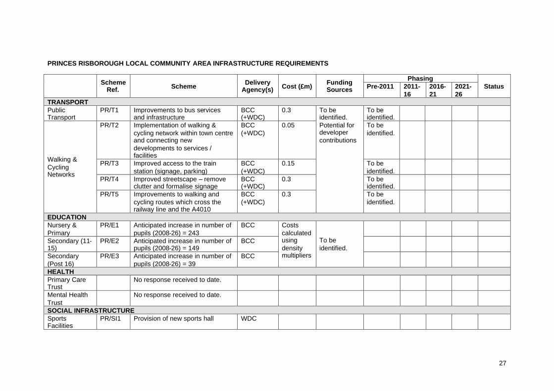
PRINCES RISBOROUGH LOCAL COMMUNITY AREA INFRASTRUCTURE REQUIREMENTS
PhasingSchemeRef. Scheme Delivery
Agency(s) Cost (£m) FundingSources Pre-2011 2011-
162016-21
2021-26
Status
TRANSPORTPublicTransport
PR/T1 Improvements to bus servicesand infrastructure
BCC(+WDC)
0.3 To beidentified.
PR/T2 Implementation of walking &cycling network within town centreand connecting newdevelopments to services /facilities
BCC(+WDC)
0.05 To beidentified.
PR/T3 Improved access to the trainstation (signage, parking)
BCC(+WDC)
0.15 To beidentified.
PR/T4 Improved streetscape – removeclutter and formalise signage
BCC(+WDC)
0.3 To beidentified.
Walking &CyclingNetworks
PR/T5 Improvements to walking andcycling routes which cross therailway line and the A4010
BCC(+WDC)
0.3
To beidentified.Potential fordevelopercontributions
To beidentified.
EDUCATIONNursery &Primary
PR/E1 Anticipated increase in number ofpupils (2008-26) = 243
BCC
Secondary (11-15)
PR/E2 Anticipated increase in number ofpupils (2008-26) = 149
BCC
Secondary(Post 16)
PR/E3 Anticipated increase in number ofpupils (2008-26) = 39
BCC
Costscalculatedusingdensitymultipliers
To beidentified.
HEALTHPrimary CareTrust
No response received to date.
Mental HealthTrust
No response received to date.
SOCIAL INFRASTRUCTURESportsFacilities
PR/SI1 Provision of new sports hall WDC
28
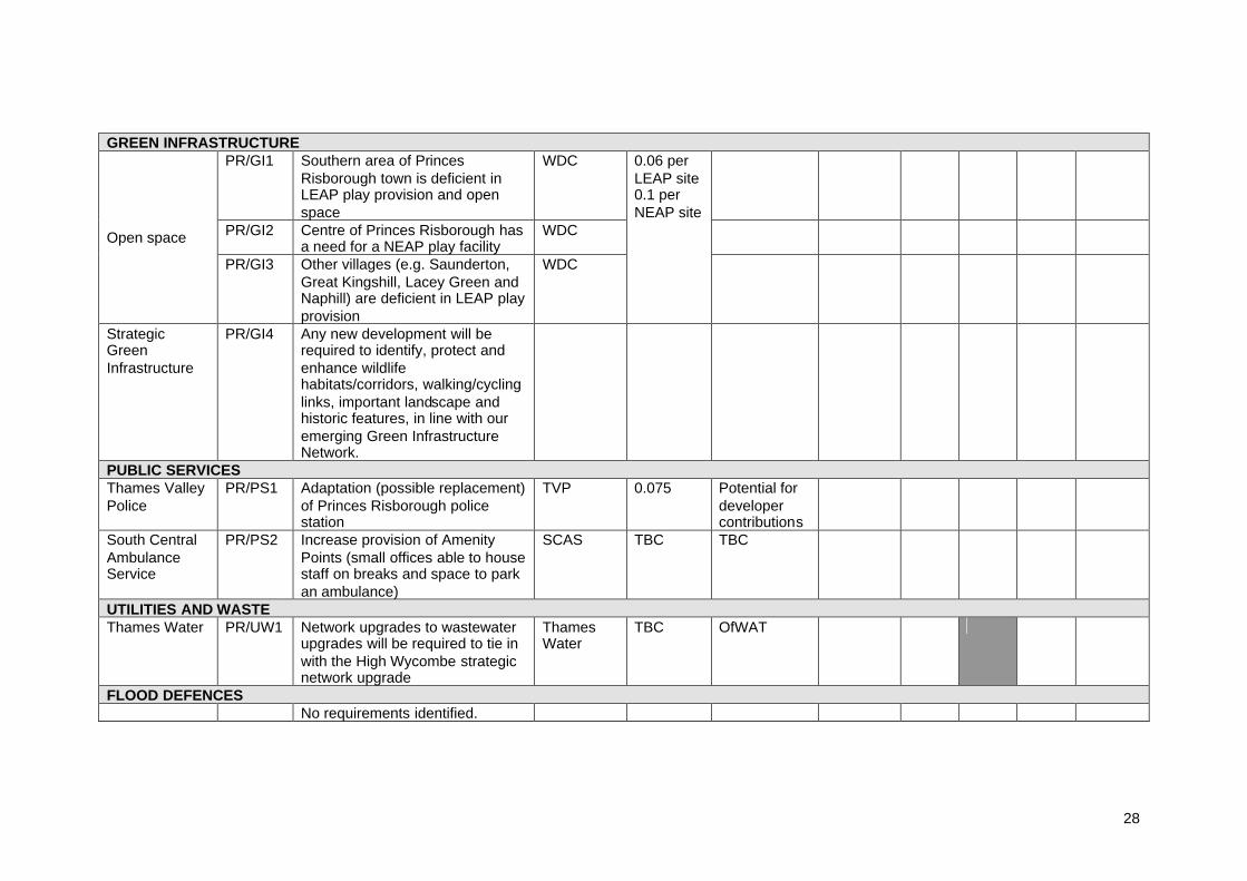
GREEN INFRASTRUCTUREPR/GI1 Southern area of Princes
Risborough town is deficient inLEAP play provision and openspace
WDC
PR/GI2 Centre of Princes Risborough hasa need for a NEAP play facility
WDCOpen space
PR/GI3 Other villages (e.g. Saunderton,Great Kingshill, Lacey Green andNaphill) are deficient in LEAP playprovision
WDC
0.06 perLEAP site0.1 perNEAP site
StrategicGreenInfrastructure
PR/GI4 Any new development will berequired to identify, protect andenhance wildlifehabitats/corridors, walking/cyclinglinks, important landscape andhistoric features, in line with ouremerging Green InfrastructureNetwork.
PUBLIC SERVICESThames ValleyPolice
PR/PS1 Adaptation (possible replacement)of Princes Risborough policestation
TVP 0.075 Potential fordevelopercontributions
South CentralAmbulanceService
PR/PS2 Increase provision of AmenityPoints (small offices able to housestaff on breaks and space to parkan ambulance)
SCAS TBC TBC
UTILITIES AND WASTEThames Water PR/UW1 Network upgrades to wastewater
upgrades will be required to tie inwith the High Wycombe strategicnetwork upgrade
ThamesWater
TBC OfWAT
FLOOD DEFENCESNo requirements identified.

29
SECTION B: Accompanying Text to the Infrastructure Schedule
TRANSPORT
Rail Network
Service Provider: First Great Western (TOC) No plans for any further expansion / improvements or alterations to either Marlow
or Bourne End stations or services. Funding for any improvements to Marlow or Bourne End were in the first few
years of the franchise and these have been completed.
Service Provider: Chiltern Railways (TOC) Rail infrastructure has a long lead in time and would need to be planned in
advance of housing. The delivery of infrastructure would require more planning todetermine the impact the housing construction would have specifically on rail
Consideration of impacts on stations at Beaconsfield & Gerrards Cross also needto be taken into consideration (although not within Wycombe district)
Strategic Road Network
Service Provider: Highways Agency Interest relates to M40 (Junctions 3-5) and the A404(T) south of M40 Junction 4 Presently working closely with Wycombe District Council and Buckinghamshire
County Council to evaluate the impacts of development proposals on the SRN Until the above evaluation is complete the HA is unable to provide detailed
comment on infrastructure required to support the LDF If specific measures are required to mitigate the impacts of particular
development, individually or in combination, on the SRN, it is considered thatsuch dependencies should be identified within the LDF and infrastructureschedule. The HA is particularly concerned about the potential impacts on theSRN of development in the M40 Gateway area, and it is considered essential thatmeasures to mitigate SRN impacts associated within these sites are identified inthe LDF.
The HA is presently investigating the feasibility of a scheme to reduce congestionat Bisham roundabout, however any such scheme is not currently within the HA’sprogramme of works. It should be noted that while the Bisham roundabout sitsoutside the administrative boundary of Wycombe district (within the RoyalBorough of Windsor & Maidenhead) the junction is part of an important strategicroute from High Wycombe down into the Thames Valley and as such anyimprovements will have an impact on the residents of Wycombe district.
It is an aspiration of Buckinghamshire County Council and Wycombe DistrictCouncil to see improvements to the Westhorpe Interchange junction (A404 /A3155). However there are currently no proposals for improvements and suchproposals will need close liaison with the Highways Agency who maintainresponsibility for the A404.

30
HOUSING
Affordable HousingService Provider: WDC Housing Policy CS 13 Affordable Housing and Housing Mix includes the target that
between 2011-16 27% of the dwellings provided within the district is affordablehousing
The SHMA sets out a total identified annual need requirement of 425 affordabledwellings. However the number of units used for this exercise has been based onthe projected number of dwellings completions (2011-2026) as set out within theHousing Trajectory in the AMR 2008. The numbers are therefore based onproportionate delivery.
Projected Number of Dwellings Completions 2011-2026 (taken from AMR Housing Trajectory 2008)
5516
Projected Number of Affordable Units to be delivered(based on 27% target in Core Strategy Policy 13)
1489
Tenure Split No. of UnitsSocial Rented (66%) 992Intermediate Tenures (33%) 497
Costs quoted within the Infrastructure Schedule are for public subsidy only. Theydo not reflect the total cost of providing housing (for example they do not includeconstruction costs).
The value of the subsidy per unit has been based on average costs figuressupplied by the Homes & Communities Agency for the delivery of social rentedand intermediate tenures. The following figures have been used:
Average cost perunit
Social rented £50,000Intermediate Tenures £18,000

31
EDUCATION
Early YearsService Provider: BCC Children & Young People Service BCC currently undertaking programme to ensure that by 2010 every community
(equivalent to approximately 800 under 5s) is served by a Sure Start Children’sCentre.
Where housing growth exceeds 3000 dwellings, estimated that this will generatethe need to secure accommodation and land from developers for a Children’sCentre
BCC will be considering the possible impact of housing growth on safeguardingprovision in the district – particularly in High Wycombe – for example familycentre and respite care provision
Secondary and primary educationService Provider: BCC Children & Young People Service BCC policy is to develop area based plans on education provision that reflect the
needs and aspirations of the local community. The plans for all primary andsecondary schools in Wycombe. These plans are likely to go out for publicconsultation in autumn 2009 and be finalised by spring 2010.
Future infrastructure requirements as a result of housing growth will beaddressed and identified through the Local Area School Place Plans.
Secondary schools in Wycombe and all primary schools (apart from schools inWest Wycombe and to a lesser degree Princes Risborough) are projected tohave a deficit of permanent school places over the next five years.
Infrastructure requirements and needs will need to take into account legislativechanges which will require all 16-18 years olds to remain in full timeeducation/training.
Special Needs EducationService Provider: BCC Children & Young People Service BCC is currently reviewing special needs provision across the county. This
review will take into account the potential increase in demand for special schoolplaces resulting from housing growth.
Adult LearningService Provider: BCC Culture & Learning Service Current Adult Learning provision covers most of the proposed development
areas. Dedicated centres cover the areas of
o Green Streeto Highcresto Marlowo Millbrooko Princes Risborougho Stokenchurch
Other provision is being developed within libraries at Bourne End, High Wycombeand Micklefield
Principal capital funding is usually sourced from the Leaning & Skills Council.However to LSC ceases to be as of the 31 March 2010 and as yet no othercapital funding stream has been identified. The Service would be looking forSection 106 contributions to support further capital development.

32
HEALTH
Acute Care and General HospitalService Provider: Wycombe General Hospital Future strategy of reconfiguration of operations on site, to retain a critical mass of
services on site. Retention of some degree of flexibility for other uses on parts of the site.
SOCIAL INFRASTRUCTURE
Adult Social CareService Provider: BCC Adult Social Care Ageing population and changing demography will have impact on way services
are delivered and need for infrastructure Very little direct funding from BCC to finance infrastructure requirements. Service
is reliant on developers accessing HCA funding and on private developmentsassisting in meeting the needs of people.
Currently a shortage of nursing home accommodation (with predicted increase infuture demand), extra care housing is very limited and quality of shelteredhousing is inconsistent across the district.
Service developing strategy ’12 Year Housing Plan for People with SupportNeeds’ which will further inform the future housing needs for ASC and covers allservice areas (learning disability, mental health, PSD, older people and othergroups that require support).
Figures referenced in the infrastructure schedule are taken from this draftdocument. Split defined between specialist accommodation and more generalneeds housing to meet demands of specific client groups
o Specialist accommodation – requiring 24 hour staffing and more likelihoodof co-location of units within a shared facility
o General needs housing – covers a wide range of accommodation thatcould mainly be met within planned developments, but consider thepossible needs for adaptations and meeting lifetime homes standards.
o For the purpose of this exercise, extra care housing is defined as ‘generalneeds’ – however it is a special case as 24 hour support will be neededfor a number of people living in extra care, and extra care is built with flatsco-located in schemes of over 30 flats together, with communal facilities.
Arts DevelopmentService Provider: WDC Community Services WDC currently developing Public Art Strategy, which is due for adoption in
summer 2009. The strategy will set out WDC approaches to the provision of publicart and the strategy will detail opportunities for both on and off site opportunitiesthroughout the district
Current deficiencies across Wycombe district include local provision for cinemascreenings and gallery space for local art exhibitions
Need (present and in future) to provide improvements in the public realm, strategicpublic art expertise and increased art facilities
Community HallsService Provider: WDC Community Services Future community facilities are likely to be community owned community centres
33
rather than halls. This would be a more sustainable approach, and more relevantto developments away from the town centre.
Community Facility Strategy currently being produced. Anticipated publicationJune 2009
Sports FacilitiesService Provider: WDC Community Services Wycombe District Sports Facility Strategy – currently in draft form, expected
publication date June 2009. Requirement for additional infrastructure will beincluded within the strategy. Once finalised the strategy will be used to assessfuture needs and will provide a basis for estimating costs of future provision.
Provisional findings of draft strategy are reflected in infrastructure schedule.
GREEN INFRASTRUCTURE
Green Infrastructure / Open SpaceService Provider: BCC and WDC An Open Space Strategy is currently being developed by WDC and may highlight
further infrastructure requirements to be included within the schedule.
PUBLIC SERVICES
Fire and RescueService Provider: Bucks Fire & Rescue Service Plans are currently being progressed for the refurbishment of High Wycombe Fire
Station. This refurbishment will include improvements for the purpose ofcommunity safety and cohesion as identified within the current WDC developercontributions SPD.
Provision of Community Safety and Cohesion Centre at High Wycombe firestation (covers both High Wycombe Local Community Area and Chepping WyeValley LCA as formerly CWV part of High Wycombe urban area)
Would welcome opportunities to consider other schemes where by working inpartnership and by sharing infrastructure it use may be maximised to generatevalue to meet the needs identified in the Wycombe Community Plan and BFRS’sIntegrated Risk Management Plan.
Ambulance ServiceService Provider: South Central Ambulance Service Siting of Amenity Points is important in that it is easy to get out of and onto main
roads as soon as possible Marlow seen as a priority in the provision of an Amenity Point Possibility of co-locating main facilities (but with separate space) with TVP
Crematoria & Burial GroundsService Provider: WDC Community Services Existing cemetery burial space anticipated to be used in the next 25-30 years at
present burial rates. Consideration will be given to address this issue in thefuture.
Existing capacity at Chilterns Crematorium at Amersham is considered to beadequate at this time
Libraries
34
Service Provider: BCC Culture and Learning The library provision across the District is adequate for the proposed
development. The new High Wycombe library operates within the heart of the District and
existing branch libraries cover the remaining areas ato Flackwell Heatho Hazlemereo Princes Risborougho Marlowo Stokenchurcho Micklefield (library being rebuilt)o Bourne End (library currently being extended)
Potential for co-location with other services. Current examples across the countrywhere libraries exist in village halls.
UTILITIES and WASTE
Service Provider: Environment Agency All sites shown on the maps would drain into the Little Marlow STW, and be
discharged to the river Thames. We expect there will be an increase indischarges due to the proposed developments, but we think it is unlikely that theproposed developments would cause a problem for consent standards orincrease the impact on the Thames.
Service Provider: National Grid High voltage electricity overhead transmission lines / underground cables within
Wycombe Districto ZL line – 4000,000-volt route from East Claydon substation in Aylesbury
Vale to Amersham substation in Chiltern district passes through a smallsection of land at the northern boundary of the district
Gas transmission assets located within Wycombe districto Pipeline 1363. Feeder Detail: 7 Feeder Nuffield / A4130
Distribution of new housing growth in Wycombe district will not have a significanteffect upon National Grid’s infrastructure, both gas and electricity transmission. Itis unlikely that any extra growth will create capacity issues for National Grid giventhe scale of these gas and electricity transmission networks. The existing networkshould be able to cope with additional demands.
The electricity and gas distribution companies in the area are Southern GasNetworks and Scottish & Southern Energy Networks. It will be these supplierswho should be contacted for further information regarding constraints andopportunities that the distribution networks may have on growth in the area, andnot the transmission network which operations at a much more strategic level.
Service Provider: Scottish & Southern Energy At the present time (Feb 09) existing primary infrastructure can support the
additional 8000+ houses. However if additional loads materialise then somereinforcement may be required.
High Wycombe, Chepping Wye Valley and South West Chilterns & Marlow LocalCommunity Areas – for all of the areas mentioned it will be necessary to installadditional 11,000 volt cable circuits from existing substations
Service Provider: Thames WaterExisting Deficiencies

35
Water infrastructure: local network has low pressure issues Sewerage infrastructure: Little Marlow STW will require future sludge stream
improvements to meet new sludge regulations. Upgrade of Princes RisboroughSTW to commence in 2009 to ensure STW meets discharges consents.Wycombe sewer network close to capacity and strategic network solutionrequired.
Requirements (district wide) Localised upgrades will be required to water supplies An extensive study is required to determine the most appropriate wastewater
network strategic solution is required to serve future growth. Funding will besought in our next Business Plan period (2010-2015) but this will have to beprioritised against other similar studies in the region.
Network upgrades and the wastewater network strategic solution study would besubject to funding being provided for their implementation.
Waste ManagementService Provider: BCC Waste Management Services Existing deficiencies in Wycombe area in HWRC facilities. Ideally there should be
two HWRC centres to serve the area of Wycombe. Additional collections schemes operated by the district councils could place
increase pressure on the existing WDA in-vessel composting (IVC) plant locatedin Booker, High Wycombe
Need for additional bring sites, litter bins, dog fouling bins and expanded wastekerbside collection schemes for various separately collected waste streams
The waste collection authorities are best placed to address infrastructurerequirements.
FLOOD DEFENCES
Service Provider: Environment AgencyCurrently no flood defence projects planned for Wycombe District
36
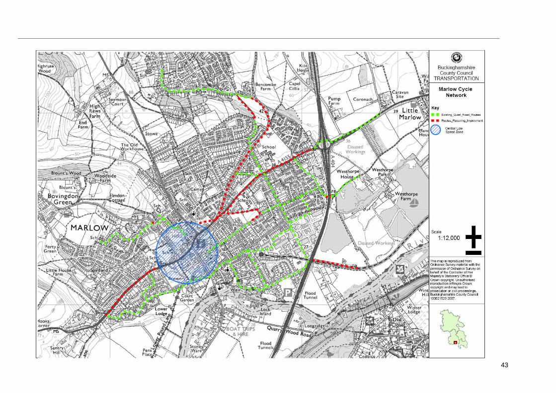
APPENDIX 4CYCLE NETWORK MAPS
The following cycle maps show the proposed cycle network and routes as set out inthe Transport Infrastructure section of this document.
Map Title Map Number
Round Wycombe Cycle Network Cycle Map AHolmers Lane, High Wycombe to HolyhillWood
Cycle Map 1
Queens Road, High Wycombe Cycle Map 2Along the River Thames at Bourne End(from Coldmoorholme Lane to StationRoad)
Cycle Map 3
Cycle routes in Marlow (various) Cycle Map 4Former railway line between HighWycombe and Bourne End (continuedprotection will be dependant on outcomeof consultation on options for the futureuse of this route as set out in thisdocument)
See Fig 4.2 in main document.
Marlow cycle network Cycle Map B

37
Cycle maps are not to scale.

38

39
40

41

42
43
44
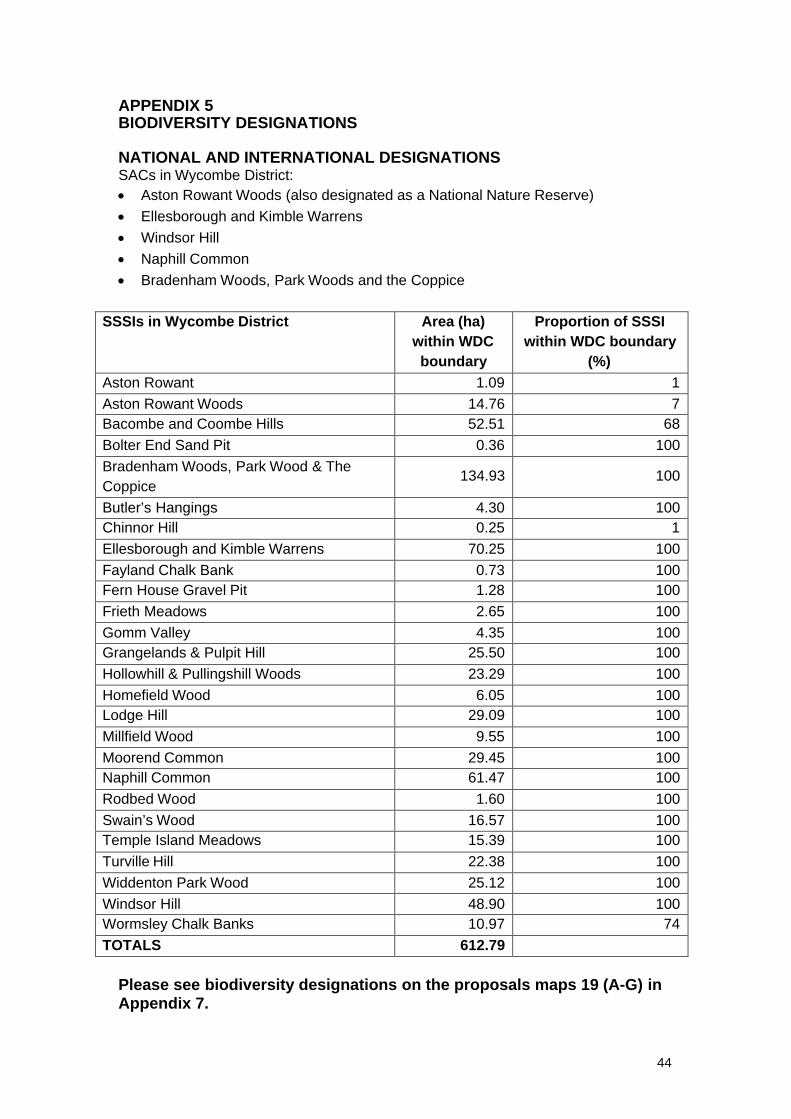
APPENDIX 5BIODIVERSITY DESIGNATIONS
NATIONAL AND INTERNATIONAL DESIGNATIONSSACs in Wycombe District: Aston Rowant Woods (also designated as a National Nature Reserve) Ellesborough and Kimble Warrens Windsor Hill Naphill Common Bradenham Woods, Park Woods and the Coppice
SSSIs in Wycombe District Area (ha)within WDCboundary
Proportion of SSSIwithin WDC boundary
(%)Aston Rowant 1.09 1Aston Rowant Woods 14.76 7Bacombe and Coombe Hills 52.51 68Bolter End Sand Pit 0.36 100Bradenham Woods, Park Wood & TheCoppice
134.93 100
Butler’s Hangings 4.30 100Chinnor Hill 0.25 1Ellesborough and Kimble Warrens 70.25 100Fayland Chalk Bank 0.73 100Fern House Gravel Pit 1.28 100Frieth Meadows 2.65 100Gomm Valley 4.35 100Grangelands & Pulpit Hill 25.50 100Hollowhill & Pullingshill Woods 23.29 100Homefield Wood 6.05 100Lodge Hill 29.09 100Millfield Wood 9.55 100Moorend Common 29.45 100Naphill Common 61.47 100Rodbed Wood 1.60 100Swain’s Wood 16.57 100Temple Island Meadows 15.39 100Turville Hill 22.38 100Widdenton Park Wood 25.12 100Windsor Hill 48.90 100Wormsley Chalk Banks 10.97 74TOTALS 612.79
Please see biodiversity designations on the proposals maps 19 (A-G) inAppendix 7.
45
APPENDIX 6PROPOSALS MAPS – AVAILABLE TO DOWNLOAD SEPARATELY
Proposals Map Index
Policy / Site Reference Map No.
High Wycombe 14Marlow 15
B5 Town Centre Boundaryand Allocations
Princes Risborough 16B7 District Centres 17B8 Settlement Boundaries 18B11 Sites and Species ofNational and InternationalImportance
19 (A-G)
B12 Sites of Local andRegional Importance
19 (A-G)
HWTC3 Delivering the Town CentreVision in Detail
1
HWTC5 Primary Shopping Frontages 14HWTC6 Secondary ShoppingFrontages
14
HWTC7 Special Retail Policy Zones 14MU6 Baker Street 1MU8 Collins House / Corner of BridgeStreet/Desborough RoadMU9 Dovecot Remainder / Archway 1MU11 Lily’s Walk 1MU12 High Wycombe Railway Station 1MU14 Buckingham House and CastleHouse
1
MU15 Swan Frontage 1MU22 Desborough Road Car Parkand The Kings Centre
1
MU23 Duke Street Car Park 1MU24 Octagon Parade 1MU26 Bridge Street 1MU27 Chilterns Shopping Centre 1MU31 Wycombe General Hospital 1PBA10 Easton Street 1PBA12 Council Offices and Royal MailSorting Office
1
High Wycombe TownCentre
RES56 Suffield Road 1D1 Desborough Delivery Framework 2D2 Delivering New Open Space andRiver Corridor Improvements
2
MU2 Bartletts, Grafton Street 2MU3 Green Street 2
Desborough Area
MU4 Leigh Street 2MU16 Former Compair 3Hughenden DistrictMU17 Former De La Rue 3BSS1 RAF Daws Hill 4M40 GatewayRL3 Abbey Barn North 4
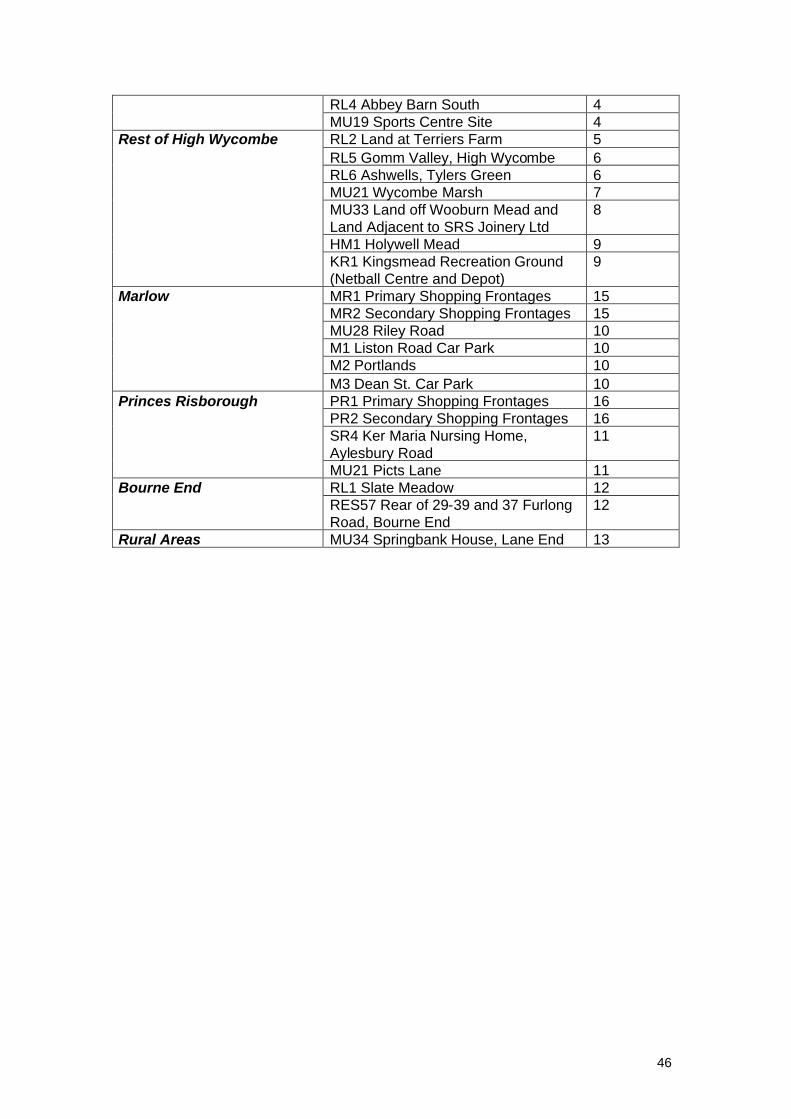
46
RL4 Abbey Barn South 4MU19 Sports Centre Site 4RL2 Land at Terriers Farm 5RL5 Gomm Valley, High Wycombe 6RL6 Ashwells, Tylers Green 6MU21 Wycombe Marsh 7MU33 Land off Wooburn Mead andLand Adjacent to SRS Joinery Ltd
8
HM1 Holywell Mead 9
Rest of High Wycombe
KR1 Kingsmead Recreation Ground(Netball Centre and Depot)
9
MR1 Primary Shopping Frontages 15MR2 Secondary Shopping Frontages 15MU28 Riley Road 10M1 Liston Road Car Park 10M2 Portlands 10
Marlow
M3 Dean St. Car Park 10PR1 Primary Shopping Frontages 16PR2 Secondary Shopping Frontages 16SR4 Ker Maria Nursing Home,Aylesbury Road
11
Princes Risborough
MU21 Picts Lane 11RL1 Slate Meadow 12Bourne EndRES57 Rear of 29-39 and 37 FurlongRoad, Bourne End
12
Rural Areas MU34 Springbank House, Lane End 13

47