Embed Size (px)
Citation preview

Maryland Association of Floodplain and Stormwater Managers
Second Annual MeetingSecond Annual MeetingOctober 18 - 19, 2006
Laurel MarylandLaurel, Maryland
Pam Pogue, ChairAssociation of State Floodplain Managers
S Fl d l i P MState Floodplain Program ManagerRhode Island Emergency Management Agency

Association of State Floodplain Managers
• Organization of professionals involved in all aspects of floodplain managementin all aspects of floodplain management
• Executive Office• Executive Office – 8 staff employees in Madison, Wisconsin
• Policy is developed primarily from members

ASFPM MissionASFPM Mission
Mitigate the losses costsMitigate the losses, costs, and human suffering caused by floodingcaused by flooding.
and
Protect the natural and beneficial functions ofbeneficial functions of floodplains.

ASFPM StructureASFPM Structure
• Executive Office• Board of Directors• Regional Directors• Chapter Directors
P li C itt• Policy Committees• Chapters
Certified Floodplain Managers (CFMs)• Certified Floodplain Managers (CFMs)• Membership• ASFPM Foundation• ASFPM Foundation

ASFPM Policy CommitteesASFPM Policy Committees• Arid Regions• Coastal Issues• Flood Insurance• Flood MitigationFlood Mitigation• Mapping & Engineering Standards• Floodplain Regulations
No Adverse Impact• No Adverse Impact• Floodproofing/Retrofitting• Multi-Objective Management• Public Education• Professional Development• Stormwater ManagementStormwater Management• Training
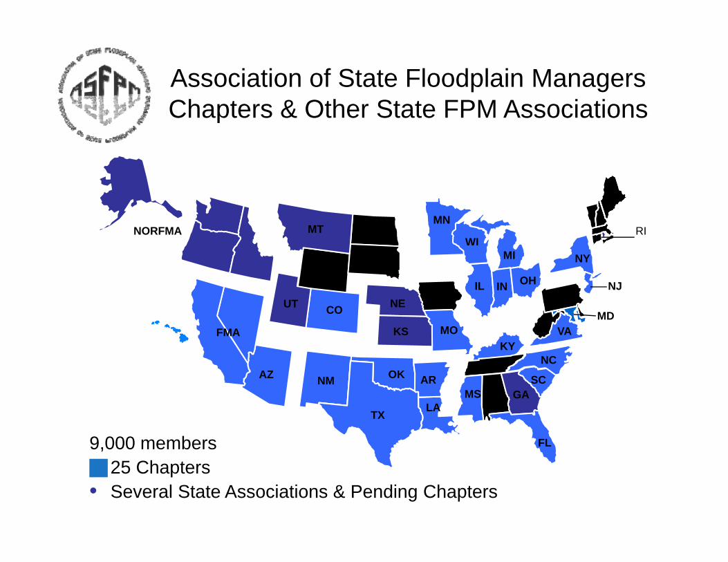
Association of State Floodplain ManagersCh t & Oth St t FPM A i tiChapters & Other State FPM Associations
WI
MNNORFMA MT RI
IL
MI NY
IN OH
COUT NENJ
MDVA
NC
SCAROKNMAZ
MOFMA KSKY
MD
9,000 members FL
MSLATX
GA
25 Chapters• Several State Associations & Pending Chapters
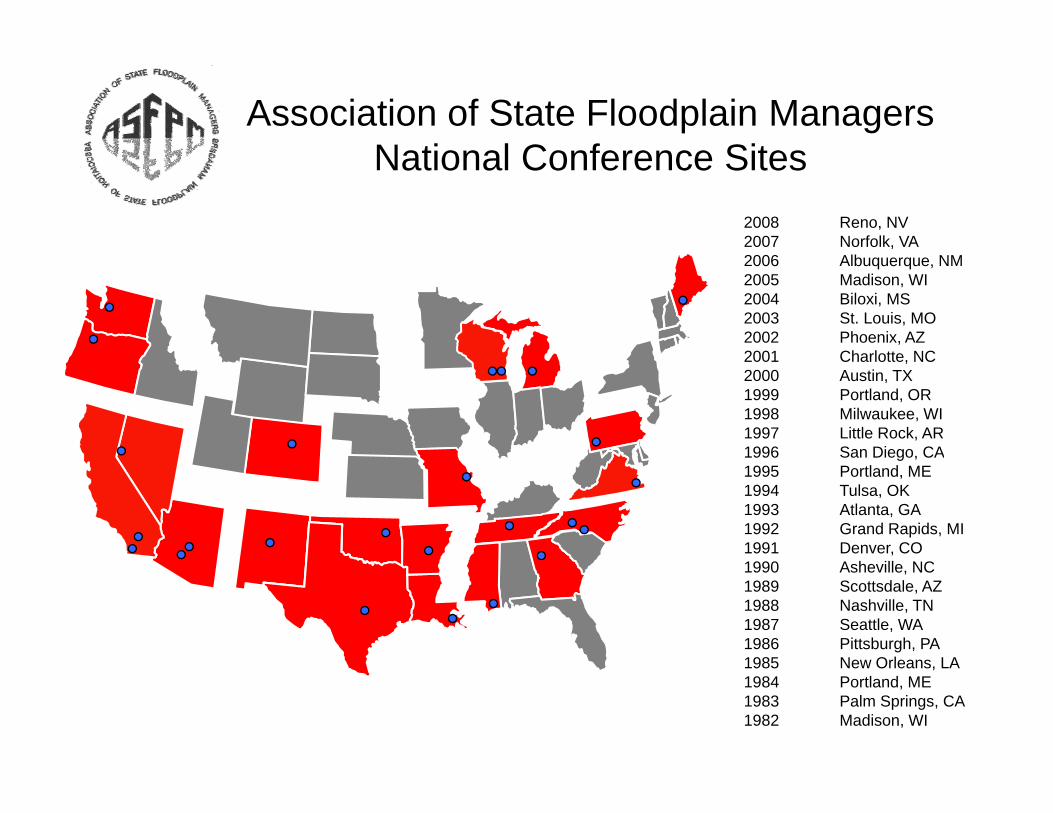
Association of State Floodplain ManagersN ti l C f SitNational Conference Sites
2008 Reno, NV2007 Norfolk, VA2006 Albuquerque, NM2005 Madison, WI2004 Biloxi, MS2003 St. Louis, MO2002 Phoenix, AZ2001 Charlotte NC2001 Charlotte, NC2000 Austin, TX1999 Portland, OR1998 Milwaukee, WI1997 Little Rock, AR1996 San Diego, CAg ,1995 Portland, ME1994 Tulsa, OK1993 Atlanta, GA 1992 Grand Rapids, MI1991 Denver, CO1990 Asheville, NC1989 Scottsdale, AZ1988 Nashville, TN1987 Seattle, WA1986 Pittsburgh, PA1985 New Orleans LA1985 New Orleans, LA1984 Portland, ME1983 Palm Springs, CA1982 Madison, WI

Who Represents Maryland?Who Represents Maryland?
• ASFPM Region III RepresentativeJ h MillJohn Miller Hillsborough County, Florida
• ASFPM Chapter Director, District 3ASFPM Chapter Director, District 3

So what are we doing?
MAP MOD SUPPORT

MAP MOD supportMAP MOD support
CTP Incentives for States
MAPMOD technical support
Analysis of approximate zone mapping techniquesmapping techniques
TECHNICAL SUPPORT DISASTER RECOVERY IN THE GULF STATESTHE GULF STATES

ASFPM Current Katrina P j tProjects
• Technical Support – Disaster Recovery Volunteer Coordinationy– ASFPM Web page – EMAC link to State CoordinatorsEMAC link to State Coordinators– EMAC directory of state contacts– Assisted LA with EMAC requestsAssisted LA with EMAC requests– Put 16 volunteers in Mississippi
Training materials added to volunteer– Training materials added to volunteer page

COASTAL NAI HANDBOOK AND TRAINING

NAI Coastal HandbookNAI Coastal Handbook
Focuses exclusively on coastal regulations and developmentregulations and development
Partnering with NOAA CoastalPartnering with NOAA Coastal Services Center to deliver Spanish version
Training provided to StateTraining provided to State chapters/associations
ASFPM CFM PROGRAM

Certified Floodplain M t P (CFM)Management Program (CFM)
Online training opportunities to be posted
CBOR activities (test updates, state certifications etc)state certifications, etc)
Enhance CEC online directoryy
Funding provided by NOAA, FEMA, USACE

NATIONAL POLICYPOLICY
DISCUSSION WITH US
CONGRESSIONALCONGRESSIONAL STAFFS
ASFPM/NAFSMA/FEMA/CORPS LEVEE POLICY SYMPOSIUMLEVEE POLICY SYMPOSIUM

Partner with agencies to effectively implement natural hazard reduction programs
– National Levee Symposium
– Gulf Workshop
– Insurance Industry Meetings

MEETINGS WITH NATIONALNATIONAL
REPRESENTATIVES FROM THE
INSURANCEINSURANCE INDUSTRY
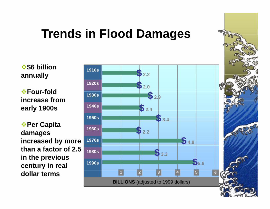
Trends in Flood Damages
$6 billi
g
1920s
1910s$6 billion annually
Four fold$$ 2.0
$$ 2.2
$$
1950s
1940s
1930sFour-fold increase from early 1900s $$ 2.4
$$
$$ 2.9
1970s
1960s
1950s
Per Capita damages increased by more
$$ 3.4
$$ 2.2
$$ 4.9
1990s
1980s
ythan a factor of 2.5 in the previous century in real
$$$$ 3.3
$$5.6
1 2 3 4 5 6
BILLIONS (adjusted to 1999 dollars)dollar terms

What is Influencing the Trend?gIncreased Property at Risk
Current policy:
Promotes intensification in risk areasIgnores changing conditionsIgnores adverse impacts to existing
tipropertiesUndervalues natural floodplain f tifunctions

Hurricanes Katrina-Rita and WilmaHurricanes Katrina-Rita and Wilma Created New Critical Issues on:
National Flood Insurance Program Solvency
National Levee Policy
Flood Recovery Advisory Maps
Mitigation funding for recoveryMitigation funding for recoveryMitigation funding for recoveryMitigation funding for recovery
No Adverse Impact Floodplain ManagementNo Adverse Impact Floodplain Management

Floodplain After Filling

Even if NFIP minimum criteria standards werecriteria standards were
implemented in a i t t d f tconsistent and perfect
manner throughout the gcountry, flood damages
would continue towould continue to increase…


Why No Adverse Impact?Why No Adverse Impact?• Flood damages are rapidly increasing
Existing approaches only address• Existing approaches only address
how to build in a floodplainrather thanrather than
how to minimize future damages in a floodplainin a floodplain
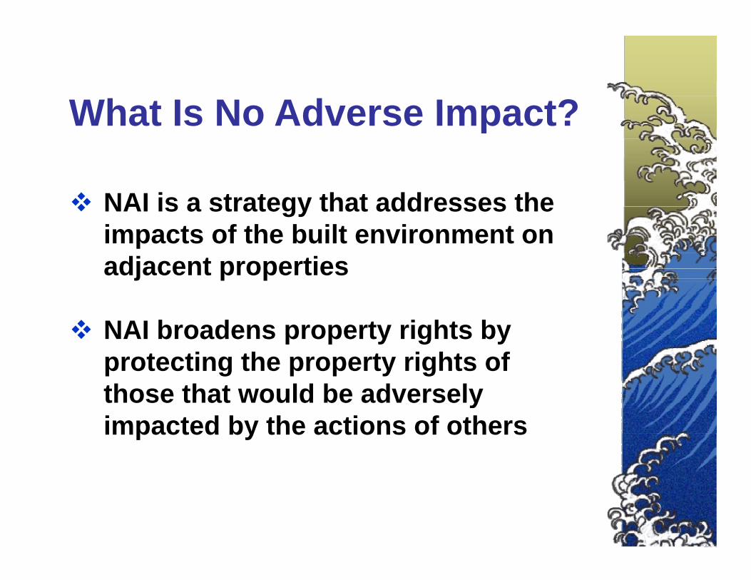
What Is No Adverse Impact?What Is No Adverse Impact?
NAI is a strategy that addresses the impacts of the built environment on adjacent properties
NAI broadens property rights byNAI broadens property rights by protecting the property rights of those that would be adverselythose that would be adversely impacted by the actions of others

No Adverse Impact Floodplain ManagementManagement
Current approaches deal primarily with how to build in a floodplain vs. how to minimize future damages
Insurance driven approach – Regulations address the structure being built/insured not on effects to adjacent propertiesproperties
Floodplain filling continues despite decades of evidence that it leads to increasing flood heightsg g
Flood Insurance Program essentially rates structures once – when they are built – then grandfathered. Subsequent y g qflood increases not factored – no means to re-rate.

No Adverse Impact RolesNo Adverse Impact Roles
Local government is the keyDevelop and adopt NAI community-p p ybased plansAdopt NAI strategiesEducate citizens on the “Good Neighbor Policy”

No Adverse Impact RolesNo Adverse Impact RolesState government
• Update State Executive Orders• Update State Executive Orders• Provide locals technical & planning
assistance • Adopt policies with incentives to
encourage NAI
Federal government • Update Federal Executive Orders• Update Federal Executive Orders• Provide technical assistance • Adopt policies with incentives toAdopt policies with incentives to
encourage NAI • Evaluate how we measure success

Incorporate NAI into Nation’s O ll Fl d P liOverall Flood Policy
• Continued development of NAI pmaterials for use at the community level– NAI case studies– Coastal NAI publicationsCoastal NAI publications– Spanish version of NAI Toolkit
• Introducing NAI concept to other F d l i OMB i lFederal agencies, OMB, congressional staff
• NAI focus at conferences and other venues
• Legal research on NAI Takings, community liability with legal workshopscommunity liability with legal workshops for attorneys

THE NAI TOOLKITImplement NAI Concepts through 7 Building Blocks
•Hazard Identification
•Planning•Planning
•Regulations & Standards
•Mitigation Actions
•Infrastructure•Infrastructure
•Emergency Services
•Education & Outreach

Community Activities that C I NAICan Incorporate NAI:
Hazard IdentificationEd ti d O t hEducation and Outreach PlanningRegulations and Standards Mitigation ActionsMitigation Actions InfrastructureEmergenc Ser icesEmergency Services
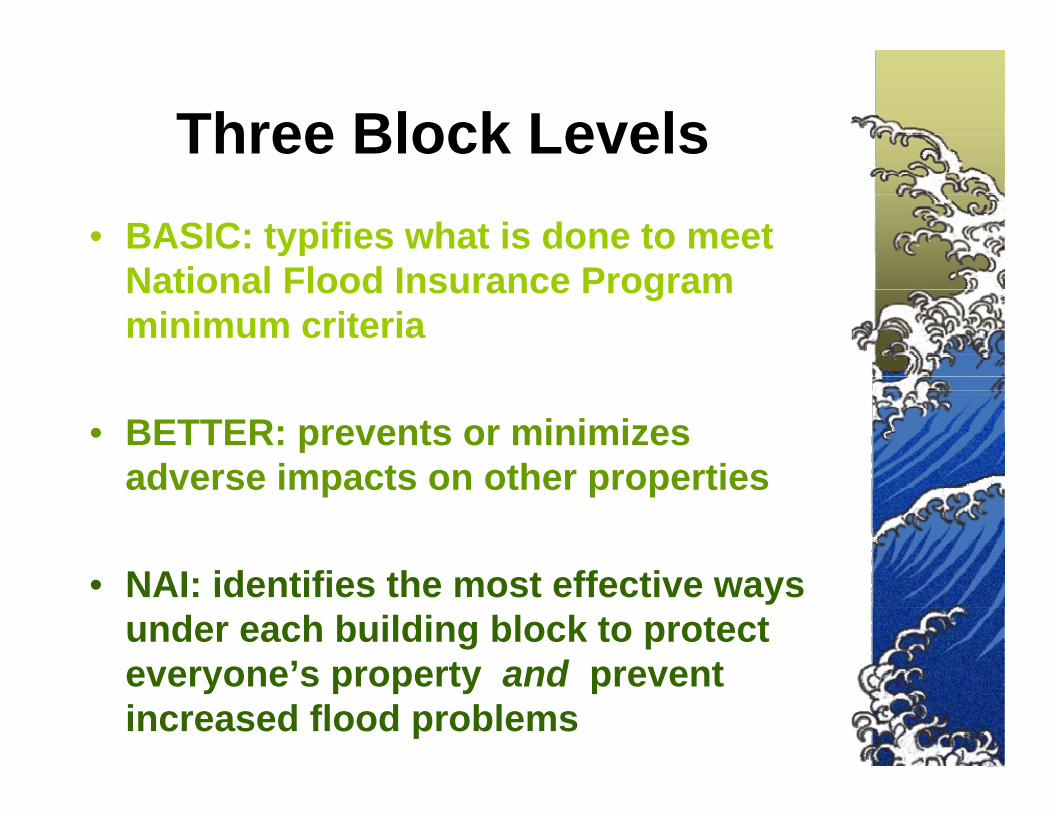
Three Block LevelsThree Block Levels• BASIC: typifies what is done to meet yp
National Flood Insurance Program minimum criteria
• BETTER: prevents or minimizes adverse impacts on other properties
• NAI: identifies the most effective ways under each building block to protect
’ t d teveryone’s property and prevent increased flood problems

PlanningPlanning
• Activities that communities pursue to direct future development and publicly funded projects.
• If done right, planning canIf done right, planning can prevent future flooding problems and meet the goalsproblems and meet the goals of many.

BASIC: Land Use Planning d Z iand Zoning
• Balance of public and private interestsinterests
• Comprehensive land use plans– Transportation plansTransportation plans– Economic development plans– Housing plans– Habitat protection; watershed
management; coastal zone plans; beach managementg
• Zoning ordinances

BETTER: Plans that Address Flooding Issues
and Problemsand Problems
• Restrict damage-prone developmentRestrict damage prone development• Low density zoning• Vulnerability/Risk analysis• Vulnerability/Risk analysis• Geographic Information System Mapping• Special Area Management Plans• Special Area Management Plans• Stormwater Management Plans
Hazard Mitigation Plans• Hazard Mitigation Plans

NAI: Multi-Objective MManagement
• All planning that involves flooding should identify all of the impacts of the hazard and all of the alternative measures thatand all of the alternative measures that address the impacts
• “M-O-M”/SAMP approach – gain a larger pp g gconstituency to support the plans with longer term goalsS t i bilit ti th d f th• Sustainability – meeting the needs of the present, without compromising the ability of future generations to meet their ownof future generations to meet their own needs

COASTAL NAI PLANNING TOOLSCOASTAL NAI PLANNING TOOLS• Coastal vegetative buffers
W tl d iti ti b ki• Wetland mitigation banking• Local land use plans• Watershed Management Plansg• Land acquisition• Habitat & coastal feature restoration and
enhancemente a ce e t• Special Area Management Plan activity can include
» regulatory» non-regulatory» planning» acquisition and designation» wetlands and dune restoration» research and assessment» research and assessment» outreach and education

COASTAL NAI MITIGAITON TOOLSCOASTAL NAI MITIGAITON TOOLS
• Elevate buildings above flood level g
• Keep floodwater below high damage-prone part of the building
The Dune Protection Ordinance for• The Dune Protection Ordinance for Southern Shores, NC, protects dunes from encroachment by development and crossing by pedestrians at other than approved crossing pointscrossing points
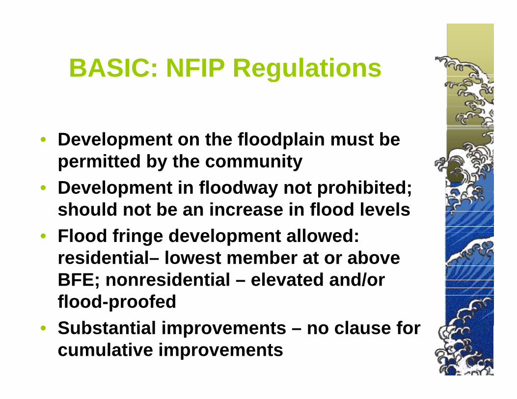
BASIC: NFIP RegulationsBASIC: NFIP Regulations
• Development on the floodplain must be permitted by the community
• Development in floodway not prohibited; should not be an increase in flood levels
• Flood fringe development allowed: residential– lowest member at or above BFE id ti l l t d d/BFE; nonresidential – elevated and/or flood-proofed
• Substantial improvements no clause for• Substantial improvements – no clause for cumulative improvements
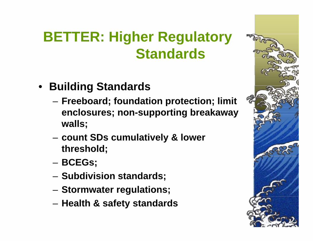
BETTER: Higher Regulatory Standards
• Building Standards– Freeboard; foundation protection; limit ; p ;
enclosures; non-supporting breakaway walls; count SDs cumulatively & lower– count SDs cumulatively & lower threshold;
– BCEGs; ;– Subdivision standards; – Stormwater regulations; – Health & safety standards

COASTALNAI REGULATION TOOLSCOASTALNAI REGULATION TOOLS
• coastal barrier development prohibited
Success Stories
coastal barrier development prohibited• implement dune and beach protection regulations
– stairs and boardwalks over dunes required– removal of vegetation prohibited– altering sand dune fences prohibitedSuccess Storiesaltering sand dune fences prohibited– coastal set-back regulations required– vegetative buffer required
• coastal storm hazard mitigation measures – preservation/conservation zonesp– waterfront setbacks– vegetative coastal buffers– impervious cover limits– stream corridor buffers
wetland buffer areas– wetland buffer areas– transfer of development rights – Coastal Barriers Resources Act protects undeveloped coastal barriers

COASTAL NAI HAZARD ID & MAPPING TOOLSMAPPING TOOLS
• Coastal Zone Management gProgram establishes setbacks, dune ,protection standards
• Coastal A zoneCoastal A zone identified and regulated
Planning for Pelican Watch, Southern Shores, NC, utilizes lot lines
superimposed on aerial photographs
regulated

COASTAL NAI EDUCATION AND OUTREACH TOOLS
• Coastal Construction Manual training • NAI and legal training workshopsg g p
Neighborhood Meeting in Southern Sh NC
.
Shores, NC.

Actions Your Community Can Take
• Define “adverse impact”, based on your community’s unique conditiony y q
• Evaluate your hazards and programsp g
• Identify existing adverse impacts in the floodplain and throughout the p gwatershed
• Require adverse impacts to be q pmitigated when development occurs

Wh C Y D ?What Can You Do?
• Define “adverse impact”, based on your community’s unique conditionyour community s unique condition
• Evaluate your hazards and programs• Identify existing adverse impacts inIdentify existing adverse impacts in
the floodplain and throughout the watershed
• Require adverse impacts to be mitigated when development occurs
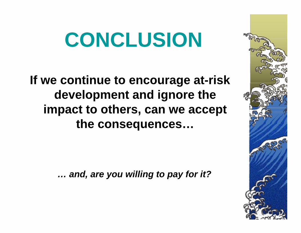
CONCLUSIONCONCLUSION
If we continue to encourage at-risk development and ignore the
impact to others, can we accept the consequences…
… and, are you willing to pay for it?

QUESTIONS & COMMENTSQUESTIONS & COMMENTS
for more information onfor more information on No Adverse Impact contact:
The Association of State Floodplain Managers
608 274 0123608-274-0123
Email: asfpm@floods orgEmail: [email protected] Site: www.floods.org