Embed Size (px)
Citation preview

Marko Maric, Vladimir Stojanovic
June 28, 2016
San Diego Convention Center
2016 ESRI International User Conference
Presentation UC1708

2
NIS (Petroleum Industry of Serbia)
Introduction
One of the largest, vertically integrated energycompanies in the South-East Europe
Until 2009 - state owned company - since 2009majority shareholder Russian oil companyGazprom neft

3
GIS in NIS
Enterprise web app for asset management purposes
Encompasses spatial,legal, accounting and
technical data
Since 2011
Over 450 registered users within the Company
On average, over 60 different users log in on
a daily basis
Connected to otherCompany databases (SAP,
Geobank, Lease database, Orphey,…)
Contains information about each real estate
that the Company owns or uses
Search
View
Measure
Build the reports
Analyze
Edit
4
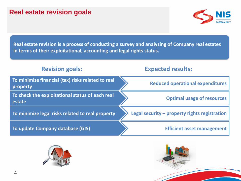
Real estate revision goals
To minimize financial (tax) risks related to real property
To check the exploitational status of each real estate
To minimize legal risks related to real property
To update Company database (GIS)
Reduced operational expenditures
Optimal usage of resources
Legal security – property rights registration
Efficient asset management
Revision goals: Expected results:
Real estate revision is a process of conducting a survey and analyzing of Company real estates in terms of their exploitational, accounting and legal rights status.
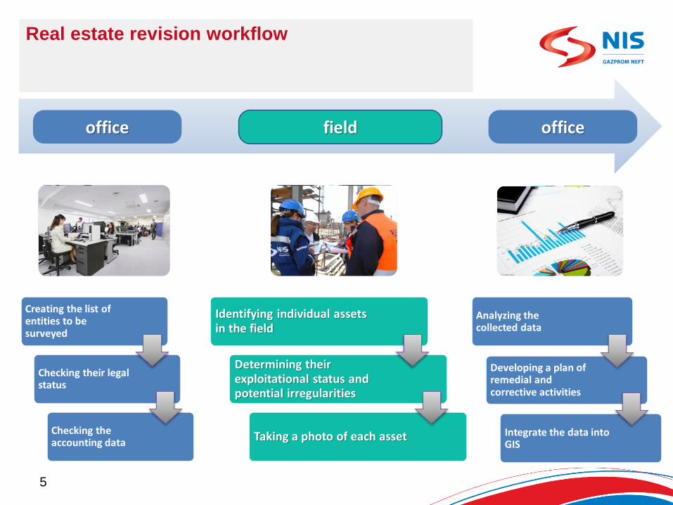
Real estate revision workflow
officeoffice
Creating the list of entities to be surveyed
Checking their legalstatus
Checking the accounting data
Analyzing the collected data
Developing a plan of remedial andcorrective activities
Integrate the data into GIS
field
5
Identifying individual assetsin the field
Determining their exploitational status and potential irregularities
Taking a photo of each asset

Real estate revision fieldwork – until 2015
2014 – Classic „Paper and pencil“ method
2 persons required in a team
Data collection on paper
Taking photos of entities using camera
Entering the collected data each daymanually into Excel
Manual import of photos from camera into GIS database (one by one)
Challenges:
Time needed for entering already collecteddata into Excel
Time needed for entering photos into database
Risk of human error while entering data
Difficult identification of assets in the field
Difficult search for particular data6
mapsspread sheets photographs
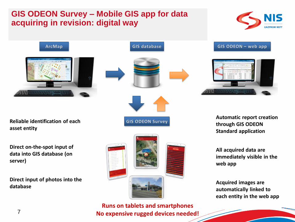
GIS ODEON Survey – Mobile GIS app for data acquiring in revision: digital way
Reliable identification of each asset entity
Direct on-the-spot input of data into GIS database (on server)
Direct input of photos into the database
Automatic report creation through GIS ODEON Standard application
All acquired data areimmediately visible in the web app
Acquired images are automatically linked to each entity in the web app
7Runs on tablets and smartphones
No expensive rugged devices needed!

-Search for group of entities or single
entity
-Displays the position of an assetand current positionof mobile device on
the map
-Access to the form for data input
-List of entities within a group
-Overview of entitieswhich have been
surveyed
-Display position of entity on the map
-Access to the form for data input
-Module for the creation of a new object in the field
-Form for data input with drop-down
values
-Direct access to photo taking and
storage
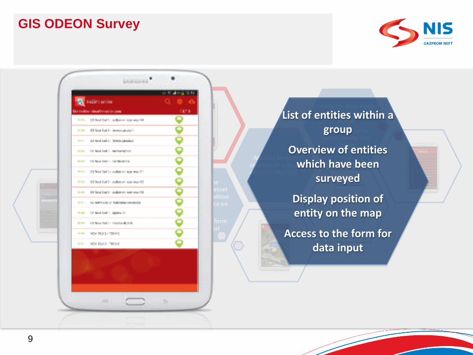
GIS ODEON Survey
8
Search for groupof entities orsingle entity
-Search for group of entities or single
entity
-Displays the position of an assetand current positionof mobile device on
the map
-Access to the form for data input
-List of entities within a group
-Overview of entitieswhich have been
surveyed
-Display position of entity on the map
-Access to the form for data input
-Module for the creation of a new object in the field
-Form for data input with drop-down
values
-Direct access to photo taking and
storage
GIS ODEON Survey
9
List of entities within a group
Overview of entitieswhich have been
surveyed
Display position of entity on the map
Access to the form for data input
-Search for group of entities or single
entity
-Displays the position of an assetand current positionof mobile device on
the map
-Access to the form for data input
-List of entities within a group
-Overview of entitieswhich have been
surveyed
-Display position of entity on the map
-Access to the form for data input
-Module for the creation of a new object in the field
-Form for data input with drop-down
values
-Direct access to photo taking and
storage
GIS ODEON Survey
10
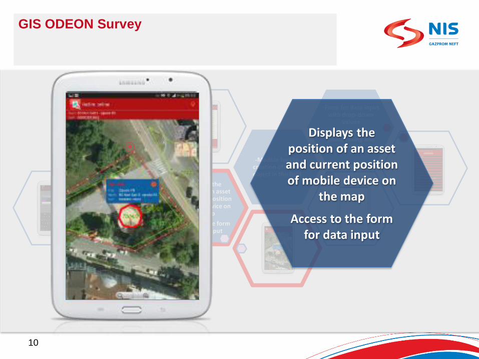
Displays the position of an assetand current positionof mobile device on
the map
Access to the form for data input

-Search for group of entities or single
entity
-Displays the position of an assetand current positionof mobile device on
the map
-Access to the form for data input
-List of entities within a group
-Overview of entitieswhich have been
surveyed
-Display position of entity on the map
-Access to the form for data input
-Module for the creation of a new object in the field
-Form for data input with drop-down
values
-Direct access to photo taking and
storage
GIS ODEON Survey
11
Form for data input with drop-down
values
Direct access to photo taking and
storage

-Search for group of entities or single
entity
-Displays the position of an assetand current positionof mobile device on
the map
-Access to the form for data input
-List of entities within a group
-Overview of entitieswhich have been
surveyed
-Display position of entity on the map
-Access to the form for data input
-Module for the creation of a new object in the field
-Form for data input with drop-down
values
-Direct access to photo taking and
storage
GIS ODEON Survey
12
Module for the creation of a new object in
the field
7
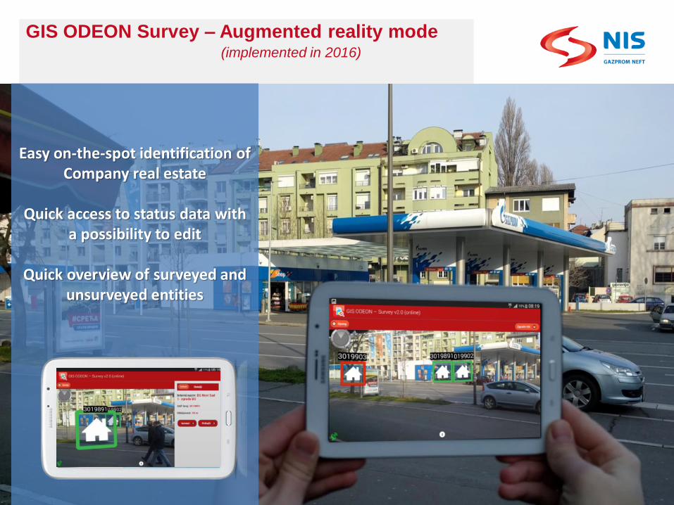
GIS ODEON Survey – Augmented reality mode(implemented in 2016)
Easy on-the-spot identification of Company real estate
Quick access to status data witha possibility to edit
Quick overview of surveyed andunsurveyed entities
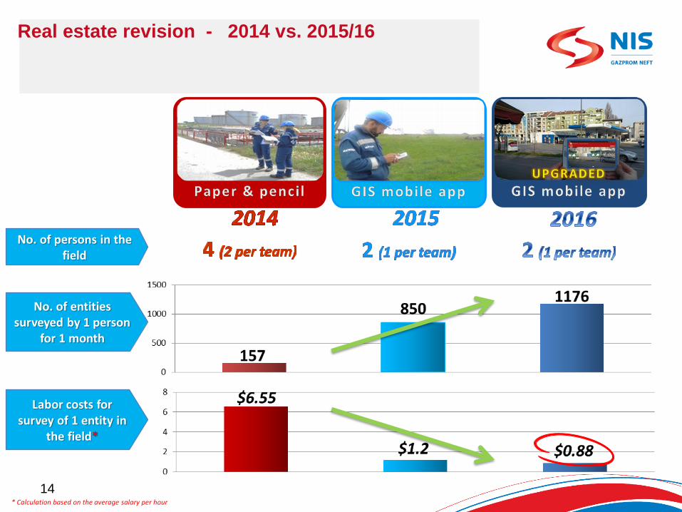
Real estate revision - 2014 vs. 2015/16
* Calculation based on the average salary per hour
14
No. of persons in thefield
No. of entities surveyed by 1 person
for 1 month
Labor costs for survey of 1 entity in
the field*
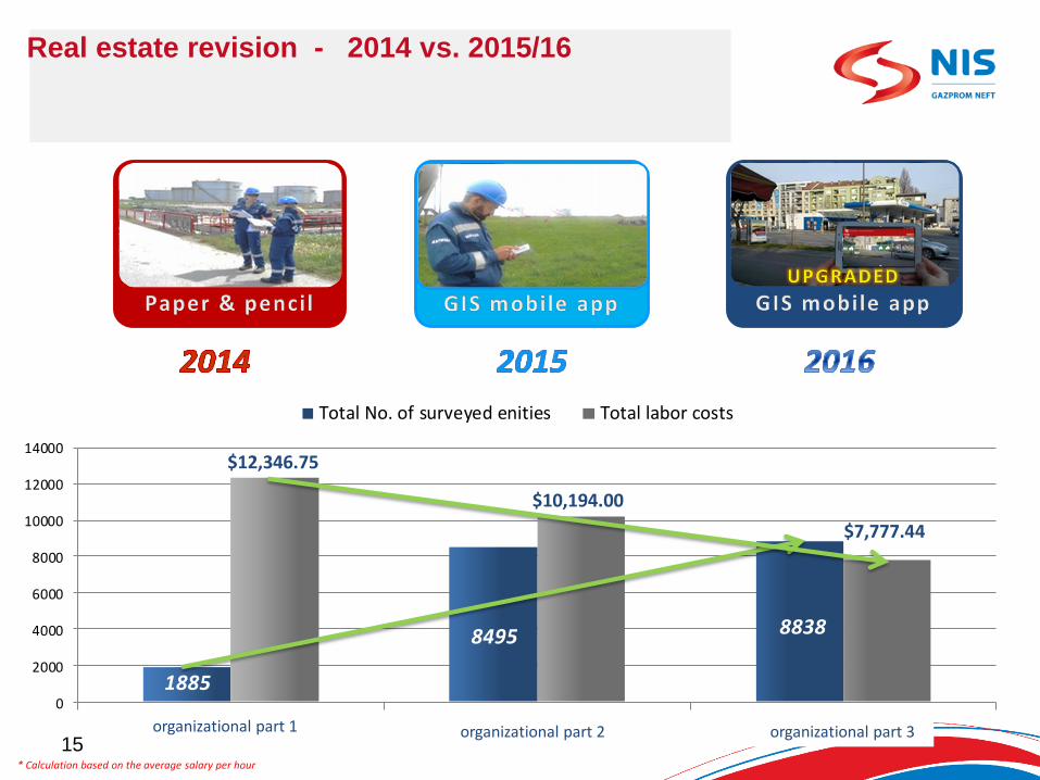
Real estate revision - 2014 vs. 2015/16
* Calculation based on the average salary per hour
15
1885
8495 8838
0
2000
4000
6000
8000
10000
12000
14000
Total No. of surveyed enities Total labor costs
$12,346.75
$10,194.00
$7,777.44
organizational part 1 organizational part 2 organizational part 3

GIS ODEON Survey’s tangible benefits – Savings in 2015 and 2016
IF REVISION 2015 HAD BEEN DONE WITHOUT GIS MOBILE APP, THE FOLLOWING WOULD HAVE BEEN
ADDITIONALY REQUIRED:
8 MORE OPERATORS
FUEL COSTS FOR 3 MORE CARS
HIRING LAND SURVEYORS TO DETERMINE THE POSITION OF
UNDEVELOPED PARCELS
$45,448.25
$7,272.00
$5,300.00
SAVINGS IN 2015 AND EXPECTED SAVINGS IN 2016
Total savings in 2015:Expected net savings for the first two years
$ 92,520.25
Total costs for tablets, app development and maintenance in 2015 and 2016
$28,200.00
Expected savings in 2016
$62,700.00
Savings in 2015
$58,020.25
16
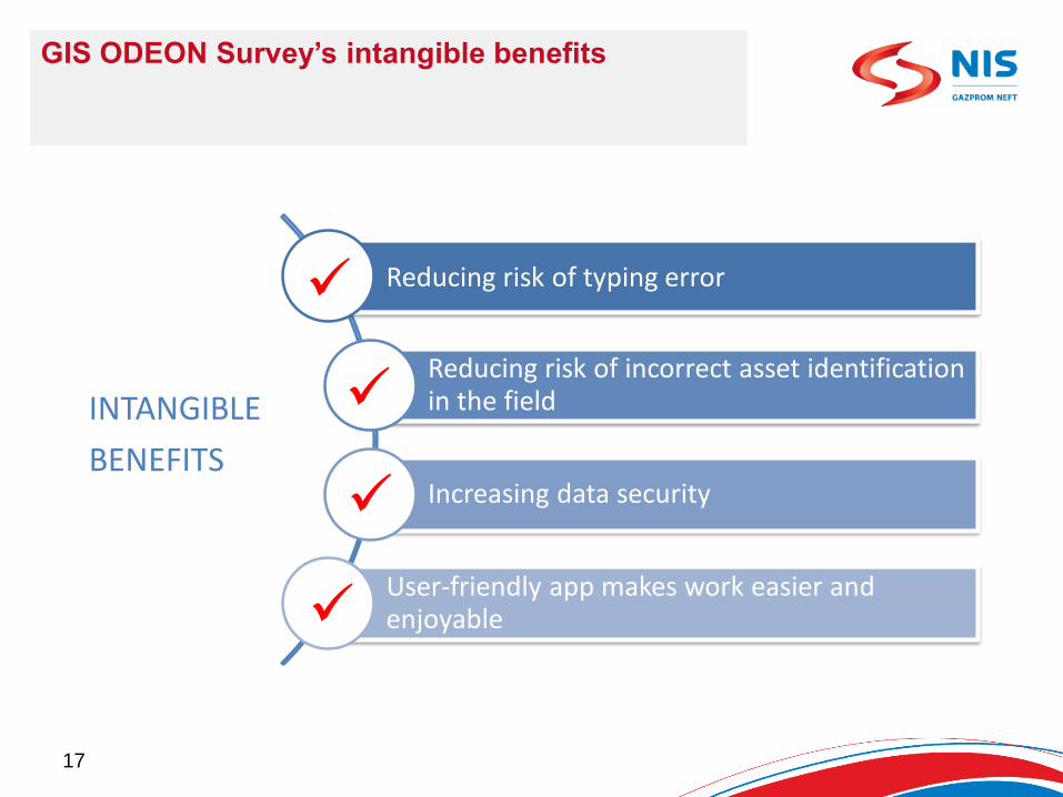
GIS ODEON Survey’s intangible benefits
Reducing risk of typing error
Reducing risk of incorrect asset identificationin the field
Increasing data security
User-friendly app makes work easier and enjoyable
INTANGIBLE
BENEFITS
17
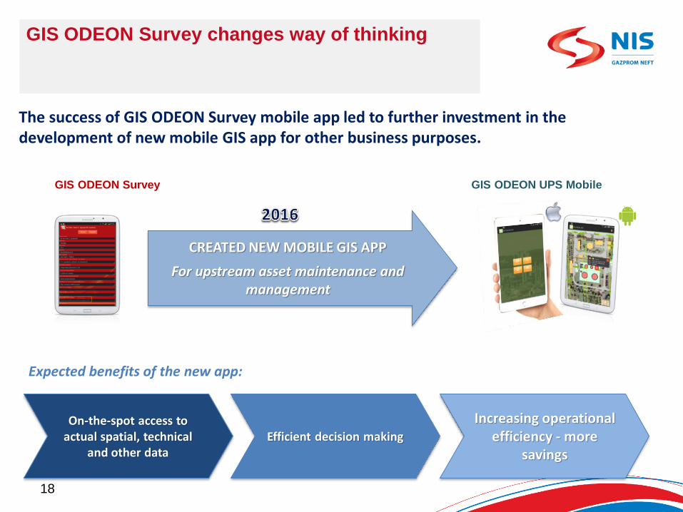
GIS ODEON Survey changes way of thinking
The success of GIS ODEON Survey mobile app led to further investment in thedevelopment of new mobile GIS app for other business purposes.
CREATED NEW MOBILE GIS APP
For upstream asset maintenance and management
Expected benefits of the new app:
On-the-spot access to actual spatial, technical
and other dataEfficient decision making
Increasing operational efficiency - more
savings
GIS ODEON UPS MobileGIS ODEON Survey
18
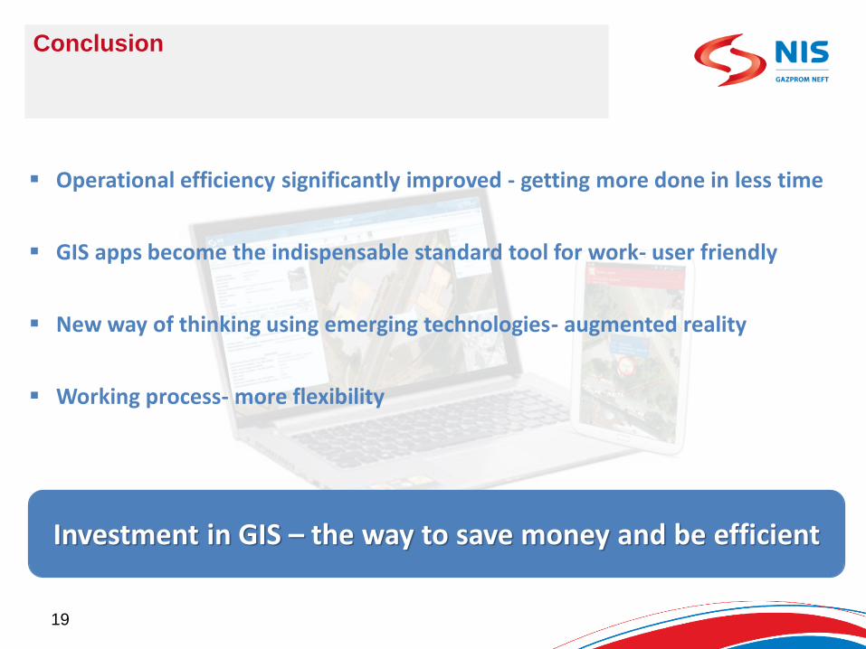
Conclusion
Operational efficiency significantly improved - getting more done in less time
GIS apps become the indispensable standard tool for work- user friendly
New way of thinking using emerging technologies- augmented reality
Working process- more flexibility
Investment in GIS – the way to save money and be efficient
19