Embed Size (px)
Citation preview

DOCUMENTS DEPT.
Final Report
3
JEF388.411•I341f
I

OOCUMENTS
SAN FRANCISCO
PUBLIC LIBRARY
REFERENCEBOOK
Not to be taken from the Library
Cover photo courtesy of The California Historical Society

SAN FRANCISCO PUBLIC LIBRARY
223 04288 3075
This report is dedicated to the memory of Mr.
Glenn Erikson, San Francisco Department of City Planning,
for his tireless efforts to resolve city policy in
support of a Market Street Transit Thoroughfare.
REF 388.411 M341f
Market Street planning
project : final report
1985]
3 1223 04288 3075

Introduction
In 1968, the City embarked on a Market Street Beautifi-
cation Project including plans to virtually remove public
transit from the surface of the street. During the inter-
vening period, office space in downtown San Francisco
increased by 35 million square feet, more than doubling
the original supply. Patronage on the new Muni Metrosubway as well as on the 17 Muni surface lines serving
Market Street has continued to grow apace. At present,
185,000 trips are carried by Muni's surface lines, with
another 150,000 on Metro - more than one out of every
three Muni trips systemwide.
In 1983, the Board of Supervisors formally acknowl-
edged the need to maintain and improve transit oper-
ations on Market Street by amending the 1968 plan to
make way for four lanes of transit, including the reten-
tion of passenger boarding islands and operation of his-
toric streetcars. The Downtown Plan has more recently
reiterated that Market Street transit be expanded in
order to better serve downtown growth.
This new concept-a Transit Thoroughfare - is now a
reality. On August 7, 1985, Muni in cooperation with the
Department of Public Works began a nine-month trial
operation of four-lane service on Market Street between
the Financial District and Civic Center. Accordingly,
Muni buses and trolley coaches now operate in two lanes
in both directions, along with streetcar service as part of
the Historic Trolley Festival. The recently completed
trolley overhead wire project on Market Street has madeexpanded transit service possible along this segment of
the street.
Boarding islands and curb stops have been relocated byDPW to serve the four lanes ofMuni vehicles. DPW has
also implemented various street area and signalization
changes, and the Police Department has initiated special
traffic control and enforcement procedures. All of these
measures have been geared to improve transit speed andreliability.
Following the nine-month period, it is intended that the
Transit Thoroughfare shall become permanent, and that
the Market Street Beautification Project be completedwith amendments to the original design plan required byMuni's four lane operation. Market Street will be
regraded and resurfaced, new streetcar tracks will be laid,
boarding islands and adjacent traffic lanes will be
widened, crosswalk and sidewalk bricking will be fin-
ished, granite curbs and gutters will be installed, and newtransit shelters will be constructed as part of a city-wide
program. The Historic Trolley Festival will continue to
run on Market Street as a regular summer Muni service,
evolving into the year-round 'F' Line operation as track
and equipment improvements are completed and related
transit projects are finished on the Embarcadero.
Implementation of the Market Street Transit TTiorough-
fare beyond the initial test period awaits the City's
approval of recommendations contained in this report,
and the programming of adequate funding sources.
Given these policy actions, the Market Street beautifi-
cation process can be completed, incorporatmjj a Transit
Thoroughfare able to accommodate existing Muni pa-
trons with enhanced efficiency, and capable of absorbing
anticipated growth in transit use as forecast m the
Downtown Plan.
1.

Background
Market Street Today
For over twenty years, the City of San Franicsco has
been actively pursuing the revitalization of Market
Street, with decidedly mixed results.
Beginning in 1963 a design plan was developed to trans-
form Market Street into the "Champs Elysees of the
West." That proposal, inspired by the decision to
build BART, and a separate tunnel for Muni's street-
cars, led to what has become one of the longest
running public works projects in the City's history.
Work on the surface of Market Street was originally
forestalled due to successive delays in completing
Muni's Metro subway and acquiring new streetcars
(aka Light Rail Vehicles.) The extraordinary price
inflation of the 1970's served to raise costs above
available funds as a result, further postponing project
completion. In the meantime, transportation issues
generally and the City's transit policies in particular
changed dramatically.
The Schematic Street Design Plan approved by the
Board of Supervisors for Market Street in 1968 (Res.
116-68) and subsequently constructed in the sidewalk
and plaza areas, assumed that most public transit
would disappear from the street east of Van Ness
Avenue. Streetcars were to be replaced by the MuniMetro subway; most surface Muni lines were to be
rerouted onto Mission Street or realigned to intersect
with Market Street but not travel along it. Only a shut-
tle bus operation was to remain, serving local trips and
Muni transfers.
Following initial construction of the 1968 Plan, City
staff together with various citizens and interest groups
began questioning the inherent assumptions about
reducing Muni service on Market Street. In 1978, the
Board responded by amending the Plan (Res. 213-78)
to require the retention of trolley overhead wires. This
sent a strong message to the community that Muni ser-
vice would in fact continue to operate on the surface
of Market Street.
In 1979, the Board empowered itself (Res. 846-79) to
actively control any track or boarding island removals
from the street, and in 1981 authorized a "Market
Street Design Planning Study" (Res. 240-81) to review
transit operations and street design, including the ret-
ention of streetcars. Following hearings on the Design
Planning Study in 1982 and 1983, the Board unanim-
ously resolved to amend its policy intent with respect
to Market Street Beautification (Res. 160-83), calling
for operation of four lanes of Muni service east of VanNess Avenue, using "... safe and aesthetically
designed passenger loading islands and overhead
wires. .." The Board further resolved to support the
retention of surface streetcar operations, including the
upgrading of streetcar tracks on Market Street east of
Van Ness, with a connection to the proposed 'E'
Embarcadero streetcar line.
The Board requested the Public Utilities Commission
to conduct public workshops and hearings, with the
objective of developing the specifics of a streetcar plan
and necessary amendments to the 1968 Beautification
Plan for their consideration and adoption.
The Market Street Planning Project was created in Jan-
uary 1984 to develop a response to the Board. Admin-
istered by PUC Planning &. Development through a
Project Manager, the first task was to circulate copies
of the 1982 Design Planning Study and assemble a
Technical Advisory Committee (TAC) to review and
update report findings.
2.

Key
Finished Sidewalks and Plazas Finished Street at Final Grade
Finished Crosswalks '.',''l'[',',','.[','.','.Z Existing Streetcar Tracks
Finished Curbs, Gutters and Trim Boarding Islands
An Interim Report was thereafter prepared summariz-
ing the TAC's assessment of Market Street planning
activities to date. The report was circulated to nearly
1,000 citizens and organizations, and highlighted plan-
ning issues yet to be resolved in responding to revised
Board policy. The report was directed to the Market
Street Community Advisory Committee (CAC) for
developing final recommendations.
The San Francisco Public Utilities Commission organ-
ized the CAC in 1982 to work with the City and its
consultants in designing a new trolley overhead wire
system for Market Street. The success of that endeavor
and the interrelatedness of the two projects argued
convincingly that this liaison should be maintained for
the Market Street Planning Project.
The Committee consists of individuals representing a
cross-section of interests and professional expertise
both in and out of City government. The CAC's titular
spokesperson, Bernard Averbuch, is Executive Direc-
tor of the Greater Market Street Development Associ-
ation and has participated in all aspects of Market
Street activities over the years.
In addition to developing the planning recommenda-tions transmitted herein, CAC support has already
enabled Muni in cooperation with the Department of
Public Works, to commence expanded four-lane oper-
ations on Market Street for a nine-month trial period.
The results of this trial will provide the necessary pre-
requisite experience for a permanent Transit Tho-
roughfare for Market Street, consistent with amen-
ded Board policy.
The Market Street Community Advisory Committee,
Technical Advisory Committee, and Ripley Associates
Urban Design Consultants - the Project Team -in con-
cert with the City's Transportation Policy Group, there-
fore recommend that the initiatives outlined in this
report be approved pursuant to Board Resolution 160-
83, and that appropriate steps be taken to move for-
ward in adopting a specific project plan, including:
• Amendments to the 1968 Market Street Schematic Street
Design plan.
' A plan for the operation of surface streetcars on Market
Street. (TKe F-Line Streetcar)
It must be emphasized that recommendations set forth
by this report do more than simply respond to the
operating needs of Muni. They have been developed as
an integral part of the urban design concept underlying
completed elements of the Market Street Beautification
Project -elements which have successfully withstood
the test of time.
While serving a critical transportation function, the
recommendations seek to balance transp>ortation needs
with concerns for open space, pedestrian amenities and
visual enhancement of San Francisco's urban core. In
short, they are not proposed as ends in themselves, but
as the important means to preserving what Market
Street is and has been for generations ot San Francis-
cans: a true artery in the transportation sense; a preat
urban boulevard; and an intense and lively concourse
for human activity.
Design Recommendations
Amendments to the 1968
Market Street Schematic Street Design Plan
The Ciampi-Halprin-Warnecke Schematic Street
Design Plan which was adopted in 1968 has been sub-
stantially completed along Market Street between
Steuart and McCoppin Streets. Its streetscape elements
are extremely handsome and durable - on a par with
similar boulevards in the great cities of the world.
Urban design is concerned with all users but is primar-
ily oriented to pedestrians. Detailed design decisions
regarding street furniture, paving materials, propor-
tions of curb width to sidewalk width - all of which
contribute to the visual appearance of the street-
scape -are primarily perceived by pedestrians. Autoand transit users enjoy the view down the corridor and
need to be able to understand directions easily, but
whether a curb is granite or concrete is not perceivable
from a moving vehicle. Market Street is primarily a
pedestrian-oriented boulevard, which is heavily served
by transit. It is pedestrians who shop, who stop in the
restaurants and work in the offices above; who buy
flowers and provide street entertainment; who above
all make the city and its major streets "where the
action is."
The materials chosen for Market Street are not the
least expensive from either an initial or maintenance
point of view. They are the kind of materials which
acquire "patina" and beauty as they age rather than
deteriorating over time. The significance of adequate
maintenance, repair and replacement cannot be over
emphasized in this context.
In the final analysis, the quality of a city's investment
in the public infrastructure determines the quality of
private investment. If it is San Francisco's objective to
attract the best development partners in the nation and
world to Market Street - which has been the case in the
financial district, and is beginning to happen in the
retail district and Civic Center - then the City itself
must set the design and maintenance standards.
It is the Project Team's majority recommendation,
given this objective, to retain the elements, materials
and dimensions of the 1968 plan, commensurate with
the requirements of Muni's Transit Thoroughfare
operation. Variation in design should occur mainly in
the vicinity of boarding islands as required due to their
widening and the widening of adjacent traffic lanes
-
and then only in dimension, not in materials. Addi-
tional changes in selected elements are also recom-
mended based on a decade of street operations and
maintenance experience.
4.
4.
i
i
I

Design Recommendations
Market Street Transit Thoroughfare
In February 1983, the Board of Supervisors
unanimously resolved to amend policy intent of the
1968 Market Street Design Plan based on a changed
perception of the street's transportation function.
Formal action followed prolonged reevaluation of
Market Street's evolving traffic, pedestrian and transit
circulation characteristics.
Traffic
According to Department of Public Works cordon
counts, lower Market Street presently serves a rela-
tively minor traffic circulation function, with average
daily volumes ranging between 10,000 and 18,000
vehicles per day. (This compares to 50-55,000 vehicles
per day on Van Ness Avenue, for example.) Trucks
and other service vehicles represent less than six per-
cent of this vehicular traffic.
Pedestrians
Lower Market is a densely utilized pedestrian corridor,
supporting local and regional rapid transit services
along an axis which interconnects San Francisco's
financial, retail and governmental activity centers.
Completed elements of the 1968 Plan, notably wide,
tree-lined sidewalks, are ideally suited for this role.
During the noon hour, pedestrian volumes routinely
exceed 4,000 persons per hour past a given point in
the vicinities of Montgomery and Powell Streets.
Transit
Market Street's preeminent role is as the highest
transit-use street in the City. In addition to the two-
level BART/Muni Metro subway network, the street
presently carries portions of 17 Muni surface routes. Atotal of up to 100 transit vehicles per direction per
hour operate during peak periods. All routes have
eastern terminus at either the Transbay Terminal or near
the Ferry Buiding adjacent to Embarcadero Center,
and serve neighborhoods throughout central and west-
ern San Francisco as well as downtown itself. Planning
statistics indicate that over one-third of Muni's
900,000 daily patron trips travel on or under Market
Street at some point. Muni's current Five-Year Plan
calls for further increases in these totals, with 1990transit ridership to downtown expected to increase byas many as 21,000 daily trips.
Market Street has been designated as a transit preferen-
tial street in the City's Master Plan since 1971. Thejust-approved Downtown Plan for San Francisco and
its associated EIR identifies Market Street (Van Ness
to Steuart) as the top citywide candidate for conver-
sion to a Transit/Commercial Mall.
The current Muni operating plan for Market Street
places special emphasis on improved transit service
reliability and freedom from delay. Relatively small
time savings, when spread over many runs and vast
numbers of riders can pay large returns to Muni in
terms of productivity and efficiency improvements and
cost savings.
The Transit Thoroughfare Project has already relocated
curb and island stops in both directions, to the degree
possible, along near (approach) side block faces of
numbered street intersections from First Street to VanNess Avenue. All stops are thereby arranged symmet-
rically, with generally one minute travel time spacing
from stop to stop. This in turn allows for directionally
symmetrical signal timing, with the objective being a
minimum delay to transit vehicles. Passenger loading is
intended to take place during the signal's red phase,
with the green phase permitting transit vehicles suffi-
cient time to travel to the next stop including routine
delays and mid-block intersections.
In the plan approved by the PUC and DPW for trial
operation, islands have been placed at the near side of
crosswalks. However, curb stops generally trail behind
on the same block face. This permits a staggered patt-
ern of transit stops, and allows other traffic to bypass
loading Muni vehicles.
The resulting four lane Transit Thoroughfare, includ-
ing streetcars, reestablishes Market Street's traditional
role as San Francisco's primary public transportation
corridor.
6.

Drawing by Genslcr and Aaaoclates
1
7.

Design Recommendations
Street Area Configuration
Key
Plan at Fourth Street and Market
Existing Curb
Drawing by Ripley Associates
The key variable in street design considered by the
Project Team revolved around the way in which
widened islands and adjacent traffic lanes can best
be incorporated into a finished street area defined by
millions of dollars of completed sidewalks, relocated
utilities, rapid transit entrances, ventilation shafts and
so on.
The Market Street Design Planning Study (June 1982)
had recommended a so-called "weave" solution. Theproposal was to widen islands inward toward the cen-
ter of the street, thus establishing a weaving pattern to
the center traffic lanes (and tracks) in the vicinity of
islands. This recommendation was developed primarily
in deference to an urban design objective of maintain-
ing a uniformly straight and parallel curb line.
In reconsidering this finding, the Project Team con-
cluded that while desirable, a uniform curb is not
mandatory from a design perspective. In fact, the line-
arity of street and track in the "non-weave" configura-
tion was thought to outweigh linearity of the curb in
an overall visual context.
Notwithstanding these design arguments, the Project
Team was unanimous in its support of a "non-weave"
solution based on four overriding criteria:
1. Cost - A "non-weave" solution results in a $3.5
million cost savings relative to a "weave" solution:
• Finished streetcar track and street surfaces over the
BART/Metro stations need not be rebuilt.
• Fewer utility relocations will be required due to
sidewalk narrowing than would be required by weav-
ing tracks and relocating islands, and rebuilding
BART/Metro ventilation shafts can also be com-
pletely avoided.
2. Safety - "Non-weave" is regarded as safer for traffic
and transit operations, given the real potential for
head-on collisions in Market Street's constrained
street area with seven-foot center lane offsets
required under the "weave" configuration.
3. Disruption - "Non-weave" is less disruptive to
construct. In addition to preserving finished street
and tracks over the BART/Metro Stations, "non-
weave" construction activity will be concentrated
along curb and sidewalk areas adjacent to the sixteen
islands between Eighth and Fremont Streets. Assum-
ing a maximum of 200 linear feet of curb and side-
walk to be realigned for each island, 3000 + linear
feet of curb must be reconstructed. The remainder
of the street in this segment, totalling over 16,000
linear feet of curb, may be completed to the original
1968 design specifications.
4. Flexibility - "Non-weave" retains future flexibility
for traffic and transit operations. Weaving tracks
and associated work is far more expensive to modify
at some future date, than is reestablishing the
sidewalk.
8.

9.
Design Recommendations
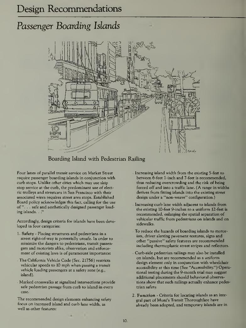
Passenger Boarding Islands
Boarding Island with Pedestrian Railing
Four lanes of parallel transit service on Market Street
require passenger boarding islands in conjunction with
curb stops. Unlike other cities which may use skip
stop service at the curb, the predominant use of elect-
ric trolleys and streetcars in San Francisco with their
associated wires requires street area stops. Established
Board policy acknowledges this fact, calling for the use
of". . . safe and aesthetically designed passenger load-
ing islands. .."
Accordingly, design criteria for islands have been deve-
loped in four categories:
1 . Safety - Placing structures and pedestrians in a
street right-of-way is potentially unsafe. In order to
minimize the dangers to pedestrians, transit passen-
gers and motorists alike, observation and enforce-
ment of existing laws is of paramount importance:
• The California Vehicle Code (Sec. 21756) restricts
vehicular speeds to 10 mph when passing a transit
vehicle loading passengers at a safety zone (e.g.,
island).
• Marked crosswalks at signalized intersections provide
safe pedestrian passage from curb to island in every
case.
The recommended design elements enhancing safety
focus on increased island and curb lane width, as
well as other features:
Increasing island width from the existing 5 -feet to
between 6-feet 1-inch and 7-feet is recommended,
thus reducing overcrowding and the risk of being
forced off and into a traffic lane. (A range in widths
derives from fitting islands into the existing street
design under a "non-weave" configuration.)
Increasing curb lane width adjacent to islands from
the existing 10-feet 9-inches to a uniform 12-feet is
recommended, enlarging the spatial separation of
vehicular traffic from pedestrians on islands and on
sidewalks.
• To reduce the hazards of boarding islands to motor-
ists, driver alerting pavement textures, signs and
other "passive" safety features are recommendedincluding thermoplastic street stripes and reflectors.
Curb-side pedestrian railings may also be installed
on islands, but are recommended as a uniform
design element only in conjunction with wheelchair
accessibility at this time (See "Accessibility.") Opera-
tional testing during the 9-month trial may suggest
additional placements should behavioral observa-
tions show that such railings actually enhance pedes-
trian safety.
2. Function - Criteria for locating islands as an inte-
gral part of Muni's Transit Thoroughfare have
already been adopted, and temporary islands are in
10.

Boarding Island without Pedestrian Railing Drawings by Ripiey Associates
place as part of the ongoing 9-month trial. Uniformisland lengths of 110-feet are also in place for
the trial. These standards were adopted for all
shared-use islands - islands used by both coaches and
streetcars -in that two articulated coaches or three
standard vehicles can be accommodated simultane-
ously. Streetcar-only islands have been sized to 60-
feet in length.
3. Appearance - Since passenger boarding islands
were not part of the original 1968 Design Plan,
they should be designed to blend into the existing
streetscape. It is therefore recommended by a
majority of the Project Team that islands should be
constructed to standard 6-inch curb height, with a
brick paved surface patterned after sidewalk areas,
and bordered by 6-inch granite curbs. A handicap
ramp should be incorporated at the crosswalk end of
those islands designed to be wheelchair-accessible.
DPW dissents on the recommendation for brick and
granite materials due to high installation and main-
tenance costs as well as concerns about pedestrian
safety. DPW has no alternative materials recom-
mendation, however.
Island 'gores' (traffic lane dividers at the traffic
approach-end) should be flush with the street, and
consist of a rough textured surface area. Also, at the
island's gore-end and inside the island curbs, two granite
bollards are to be placed for pedestrian protection from
oncoming traffic. A break-away bollard anchorage is
to be engineered for potential vehicular impacts as
well. Reflectors are to line the gore borders and be
placed on the vertical bollards. Speed limit ( 10
MPH) signs are to be incorporated at the approach
end of islands, designed to standard
.
4. Accessibility - Boarding islands must be designed
to serve the needs of elderly and handicapped per-
sons. Location of all islands at signalli:ed crosswalks
permits safe access for ambulatory persons. Demon-stration testing has shown, however, that 7-foot
width islands in conjunction with curbside railings
on the island are required for safe wheelchair access.
Muni's E&H Advisory Committee has reviewed al-
ternative island configurations and agreed on instal-
lation criteria: given constraints on island width
imposed by Market Street's finished elements, 7-
foot islands are to he located no more than three
blocks apart.
The recommended "non-weave" plan successfully
accommodates this criterion. Of the sixteen shared-
use islands, nine (four inbound, five iHitK>und) are
7-feet in width, three are 6-foet 3-incho ui width,
and four are 6-feet 1 inch. Strcetcar-onlv islands
need not be accessible, and width varies between 5-
feet and 7-feet.
11.

Design Recommendations
Sidewalk, Curb Area and Crosswalks
/
>
k30'-0'
^1^ VARIES ^/V
CENIHirC OF MARKET STREETSTREETCAR TRACKS
"I
h ——
^
-— 5
VEHICLE CAUTION SIQNTHERMOPLASTIC GUIDEUNETB.BWNES
J.j.,i,a..,.
Detail Plan at Fifth and Market
The great majority of sidewalk area construction wascompleted during the early and mid 1970's consistent
with the 1968 Design Plan. During the intervening
decade of use by the community and upkeep by the
City, a number of lessons have been learned and per-
ceptions changed regarding several of the elements in
place.
As designed and partially installed in the original pro-
ject, the granite-trimmed brick crosswalks and granite
curbs and gutters are integral design elements within
the total street plan. Ten years of experience, however,
indicate that structural failures have occurred with cer-
tain components of each. Redesign of these elements
must therefore alleviate the break-up problems while
retaining the street's design integrity.
The Project Team recommends six revisions to the
1968 Design Plan in keeping with this objective:
1 . Curbs - Granite continues to be the recommendedmaterial for all curb pieces. The Ciampi plan dimen-sions (15-18 inches) should be adhered to in all but
island locations. To accommodate street widening
adjacent to islands, curb width may be reduced to
12-inches. While a uniform front-of-curb line is
preferable, overall sidewalk width reductions ranging
between 2-feet 4-inches and 3-feet 3-inches in the
vicinity of islands is acceptable from a design stand-
point. Attention must, however, be focused on com-plimenting curb transitions with existing brick workand other sidewalk elements, (e.g., tree grates.)
2. Gutters - Existing granite pavers installed along
Market Street should be retained and repaired in
accordance with improved installation techniques
developed by DPW to enhance durability. This is
recommended for all finished sections between
McCoppin and Steuart. A majority of the Project
Team recommends that new treatments in gutter
areas between Seventh and Fremont should be
placed in the form of two 6-inch granite strip pavers
using improved installation techniques. Considera-
tion of special sub-grade reinforcement of gutters at
Muni curb stop locations is also encouraged due to
recurrent break-up.
DPW dissents on the recommendation for new gran-
ite pavers between Seventh and Fremont. Their con-
12.

Drawing by Ripley Associates
cern focuses on high cost and safety. No alternative
materials recommendation for the gutters has been
set forth by DPW.
3. Loading Bays - The curb and gutter treatments in
loading bays should be the same as along the rest
of the roadway, with a false gutter at the curb and
a functional gutter along the street line. New curb
should be designed with curve radii to accommodatemechanical street cleaning equipment. Finished
curbs should not be altered, however.
Where Ciampi plan specifications called for granite
paver stones within loading bay areas, it is recom-
mended to substitute asphalt due to unsightly oil
and grease stains.
4. Crosswalks - A majority of the Project Teamrecommends that all remaining crosswalks should be
installed consistent with the Ciampi plan design
pattern, using brick pavers and granite edge bands as
originally specified. All new crosswalks should be
constructed on concrete slabs using special, high ten-
sile strength brick and mortar pursuant to improvedDPW installation techniques developed to enhance
durability. Crosswalks are to be directly related to all
boarding islands, both functionally and in terms of
design, thus establishing a continuous pedestrian
safety zone within the street area, also consistent
with the 1968 design plan.
DPW supports the retention of brick and granite
'patterns' but dissents on the use of brick and gran-
ite materials to complete crosswalks. Again, high
installation and maintenance costs together with
concern for pedestrian safety underly their opptv
sition. DPW makes no alternative materials
recommendation.
5. Catch Basins - Only those basins adjacent to
boarding islands must be relocated or reconstructed
to remain flush with the final curb face.
6. Handicap Ramps - All handicap ramps must be
totally recessed within the sidewalk area Ix-twoen
Eighth and Steuart Streets. This will require recon-
struction of brick in sidewalk areas near the curb,
and is necessitated in order to improve dramagc and
durability in gutter areas.
13.

Design Recommendations
Streetscape Elements
Street Furniture
In addition to major maintenance where needed, there
is Project Team consensus on five recommendations:
1. Kiosks - The round kiosks should be retained,but
with modifications to form, function or both. Aremovable plexiglass covering should be developed
and installed to protect posted materials and deter
vandalism. Private sector and non-profit organiza-
tions should then be solicited to actively use and
maintain individual kiosks. If this fails, the kiosks
should be removed.
2. Newsracks - There is unanimous agreement that
newspapers should be located in well designed 'gang'
dispensers at specified locations. Unit newspaper
dispensers chained to poles or trees is unattractive
and destructive.
DPW is presently conducting a demonstration effort
with participating newspapers. The Project Teamconcurs in a recently approved Board of Supervisors
ordinance (359-85) amending the Public WorksCode to regulate placement, anchorage and mainte-
nance of newsracks on public streets and sidewalks,
and supports its enforcement.
3. Bicycle Racks - All remaining granite bicycle racks
should be removed. Future provision to accommo-date safe bicycle parking is necessary. The Market
Street Advisory Committee shall coordinate with
DPW staff and bicycle interest groups.
4. Benches - Reevaluation of granite bench design and
location should be undertaken by DPW in order to
accommodate pedestrian comfort and convenience
while deterring vagrancy. In particular, a number of
Muni stops no longer offer seating to waiting
patrons and should be addressed.
5. Transit Shelters - The so-called "T' shelters installed
as part of the original project have not functioned
well for a variety of reasons, including the relocation
of a number of Muni stops to alternative sites. The
'T' shelters require massive foundation supports and
are not easily moved.
The Project Team therefore recommends replacing
all existing 'T' shelters. New Market Street Shelters
will be provided beginning in 1986-87 as part of a
PUC transit shelter program being established for
Muni routes citywide. The program will require a
private firm to erect and maintain the shelters
according to contractually stipulated design and per-
formance criteria. Final shelter design must be
approved by the Arts Commission.
Art ProgramThe Project Team has adopted guidelines and recom-
mends active support for implementing an art programas an integral part of Market Street construction:
1. Pursuant to San Francisco's "Art Enrichment/
Art in Public Places Program" (Ord. No. 30-69) andconsistent with federal grant funding guidelines, the
equivalent of 2% of the project's capital costs should
be allocated toward the inclusion of art. This is
desirable and fundamental to the successful urban
design of Market Street.
2. Installed art pieces should be concentrated at plazas,
waiting areas and junctions with other major pedes-
trian spaces along Market Street - such as United
Nations and Mechanics Plazas.
3. Provision should be made for "seasonal," changing
installations along the length of Market Street. These
changing exhibits may take three forms: banners
hung from "Path of Gold" poles; poster art in pro-
posed transit shelters; and a rotating sculptural
program.
Arts Commission staff shall administer the imple-
mentation and operation of this program with policy
guidance from the Market Street Community Advi-
sory Committee.
Other Elements
Other Project Team recommendations for street design
changes include:
1 . Signage - Due to damage caused by street traffic,
uniform relocation of street signage along Market
Street between Steuart and McCoppin is recom-
mended so that no part of the sign is closer than 25-
inches from the curb. This in addition to general
deterioration and the inability to replace custom
fixtures presents the opportunity to re-sign the
entire street.
The pole support and signage system along Market
Street, while very well designed, was poorly engineered
from a maintenance perspective. The design itself has
served well for ten years. The system, which includes
traffic and pedestrian signals, street signs and special
area designations, is a comprehensive graphic design
concept. If uniform changes are made in concert with
relocation, the new concept should be provided by a
graphic designer to preserve the coherence ofthe entire
14.

Drawing by Gensler and Associates
system. An alternative system should be specified
using catalogue components in deference to effective
and inexpensive maintenance.
In the near term, DPW will be installing "Tow-Away No Stopping" and "Truck Zone" signs to the
new standard between Fremont and Seventh, and
relocating BART/Metro subway entrance signs to
the 'head' of all street entrances to better serve
pedestrians.
2. Fire Hydrants - The Committee approved the re-
tention of fire hydrants in their present locations
given existing front-of-curb alignments; sidewalk
narrowing adjacent to islands shall require relocation
of affected hydrants 27-inches in from the new curb
face, per SFFD standard.
3. Landscape Materials - All broken, diseased andunder-sized trees should be replaced with mature
stock matching existing species, and a maintenance
program be initiated by DPW in conjunction with
the Recreation &l Park Department to ensure further
growth. Any tree/treewell removals are unaccepta-
ble. (Note: The "non-weave" plan adds one tree to
Market Street's inventory near Sixth Street.)
All private property owners fronting Market Street
are encouraged to develop plantings at entryways
and in window boxes where feasible and
appropriate.
4. Path-of-Gold/TroUey Wire Poles - No realign-
ment of P-O-G or trolley wire support poles is
recommended.
5. Center and Stop Line Granite - The center line
and stop line granite strips in the Ciampi plan have
been eliminated due to maintenance and safety
considerations.
15.
Design Recommendations
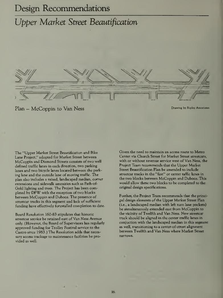
Upper Market Street Beautification
The "Upper Market Street Beautification and Bike
Lane Project," adopted for Market Street between
McCoppin and Diamond Streets consists of two well
defined traffic lanes in each direction, two parking
lanes and two bicycle lanes located between the park-
ing lane and the outside lane of moving traffic. The
plan also includes a raised, landscaped median, corner
extensions and sidewalk amenities such as Path-of-
Gold lighting and trees. The Project has been com-
pleted by DPW with the exception of two blocks
between McCoppin and Duboce. The presence of
streetcar tracks in this segment and lack of sufficient
funding have effectively forestalled completion to date.
Board Resolution 160-83 stipulates that historic
streetcar service be retained east of Van Ness Avenue
only. (However, the Board of Supervisors has regularly
approved funding for Trolley Festival service to the
Castro since 1983.) The Resolution adds that neces-
sary access trackage to maintenance facilities be pro-
vided as well.
Given the need to maintain an access route to MetroCenter via Church Street for Market Street streetcars,
with or without revenue service west of Van Ness, the
Project Team recommends that the Upper Market
Street Beautification Plan be amended to include
streetcar tracks in the "fast" or center taffic lanes in
the two blocks between McCoppin and Duboce. This
would allow these two blocks to be completed to the
original design specifications.
Further, the Project Team recommends that the princi-
pal design elements of the Upper Market Street Plan
(i.e., a landscaped median with left turn lane pockets)
be simultaneously extended east from McCoppin to
the vicinity of Twelfth and Van Ness. New streetcar
track should be aligned in the center traffic lanes in
conjuction with the landscaped median in this segment
as well, transitioning to a center-of-street alignment
between Twelfth and Van Ness where Market Street
narrows.
16.

Historic Streetcar Recommendations
A Streetcar Plan for Market Street
Drawing by Gensler and Associates
Market Street has traditionally had streetcar opera-
tions. Rail cars ran on Market for 122 years prior to
their removal in 1982, making it the longest continu-
ously operated rail service on a main street anywhere
in America. With the phased introduction of MuniMetro subway service during 1980 and 1981 , street-
car service was discontinued on the surface of Market
Street.
The decision to eliminate streetcar service was influ-
enced by the 1968 Design Plan which envisioned the
underground Muni Metro as an upgraded replacement
service. Therefore, the removal of streetcar tracks and
boarding islands, along with shifting most surface tran-
sit to Mission Street was assumed by architects and
engineers who laid out the original street plans. Yet,
between 1965 and 1985 approximately 35 million
square feet of office space was added in the downtownarea. The downtown's retail core flourished as well,
and tourism continued to grow.
Increasing ridership demand generated by these devel-
opments together with other circulation constraints
rendered impractical any proposal to route surface
transit onto Mission Street. Five years afer opening.
Muni Metro is carrying more than twice the daily rid-
ership (150,000 vs 70,000) carried by earlier street-
cars, and cannot accommodate additional trips during
peak periods. Projected growth in downtown employ-
ment cannot rely solely upon the increased Metro
capacity to be realized from a turn-around loop and
other subway improvements.
The Board recognized these trends, first by acting in
1978 to retain overhead wires for surface routes on
Market, and resolving in 1983 to expand transit to a 4-
lane operation including historic streetcars.
Limited operation of streetcars was continued by Muniduring 1981 and 1982. In 1983, through the auspices
of the San Francisco Chamber of Commerce in coop-
eration with Muni, a "Historic Trolley Festival" was
launched using streetcars of various ages and origins.
Billed as a one-time replacement for the cable cars
which were then undergoing rehabilitation, the festival
quickly gained the support ot many elements ot the
community as exhibiting the potential tor full time
operations. In subsequent years, the Festival has oper-
ated to even greater community acclaim, in conjunc-
tion with the cable cars.
San Francisco has apparently rediscovered its love
affair for streetcars on Market Street, with daily rider-
ship during the 1985 season averaging 5,500 trips.
17.
Historic Streetcar Recommendations
Line Streetcar Function and Operation
Market Street's streetcar, designated the 'F' Line, is
primarily intended to supplement local transit service
along the length of Market Street, from the Embar-
cadero west to at least Van Ness Avenue in the Civic
Center. The benefits to be derived from historic street-
car service along Market Street are augmented by the
Board's concurrent 1983 policy resolution to integrate
it with the proposed 'E' Embarcadero streetcar line,
thus providing 'F' Line service north along the water-
front to the Pier 39/Fishermans Wharf area.
An 'F' line streetcar will fulfill the following public
transportation functions:
• Improved surface transit along Market Street to serve
the new office space and other activity centers (e.g.
Yerba Buena Gardens, Ferry Plaza) currently being
constructed or planned.
• Direct transit service between Market Street and the
developing northeastern waterfront, Fishermans
Wharf and Fort Mason, with built-in capacity for
growth.
• Some relief to the overcrowded cable car lines by
diverting people who would enjoy the historic flavor
of the streetcars for trips between downtown and
Fishermans Wharf.
• Maintenance of surface rail access to downtown in
the event of scheduled or unscheduled shutdown of
the Market Street subway.
Muni Planning projects that over 23,000* daily riders
will use the 'F' streetcars initially, with a capacity to
absorb nearly twice as many. This is comparable with
patronage on the cable car lines.
In terms of indirect benefits, the use of older, refur-
bished streetcars will add a highly visible, mobile ele-
ment to the Market Street environment, reinforcing
the historic context of the original Beautification Plan.
The 'F' Line will further demonstrate the public sec-
tor's commitment to upgrading the local economy, and
compliments the City's established image as a unique
destination for visitors and tourists.
Muni estimates that a schedule which calls for 7Vi
minute headways (8 cars per hour per direction)
would be sufficient during the 12 hours of greatest
demand, dropping back to 15 minute headways for the
remaining 8 hours of the operating day. A round-trip
running time of 90 minutes (Castro/Market - Fisher-
mans WharO is based on the current 8-Market and 32-
Embarcadero schedules.
Initially, 15 vehicles would be required to operate
along the 'F' route, not including spares. Muni figures
indicate 225 vehicle hours of daily operation under
this plan, or just over 82,000 vehicle hours per year.
It is further assumed for operations and financial plan-
ning purposes that an 'F' streetcar operating along
Market Street and the northeastern waterfront wouldsubstitute for part or all of existing bus and trolley
services which duplicate the proposed streetcar route
(i.e., 8-Market and 32-Embarcadero lines).
Annual Operating Costs and Revenues(1985-86 $'s)
Direct Direct Average
Cost (1) Revenue(2) Daily Trips
Alt. Western
Termini:
VanNess/Market $2.3-3.7M $2.4M 15,900Castro/Market 2.6-4.3M 3.4M 23,400
Notes
1. Cost range for 1-2 person crews: $32-52 per veh-hr.
based on actual Historic Trolley Festival costs. Anyadditional cost savings due to service substitution
would be deducted from net 'F' Line costs.
2. Revenue from 40<f average fare collected per trip,
based on actual No. 8 trolley receipts.
*This assumes a western terminus at Castro/Market, and
an eastern terminus at Fishermans Wharf/Fort Mason.
18.

'F' Line Streetcar Service Corridors
Market Street Pursuant to Res. 160-83
Northeastern Waterfront to Fort Mason via 'E' Line Tracks, Pursuant to Res. 160-83
Upper Market to Castro via Church and Seventeenth
19.

Historic Streetcar Recommendations
Line Streetcar Rolling Stock
Drawing by Gensler and Associates
Muni's inventory of streetcars is as follows:
• 50 President's Conference Commission (PCC) Cars• 9 Melbourne Cars
• 1 1 Historic Trolley Festival Cars
Substantial rebuilding of mechanical components and
general refurbishment is needed for the PCC cars
stored at Pier 70. Reconfiguration of the MelbourneCars for one-man operation is also recommended. His-
toric Festival equipment can be reserved for weekends,
holidays and other special occasions.
Muni's reserve streetcar fleet availability and mixnevertheless offers excellent opportunities to satisfy
an operating need for 15 on-line cars plus 5 spares
for regular 'F' Line service.
Rehabilitation costs for each of the 20 PCC cars
needed for 'F' Line service have been calculated based
on the following work to be done:
Direct Labor
Overhead
Parts &. Materials
Transportation
Total Per Car
$91,000 per car
70,000 per car
77,000 per car
12,000 per car
$250,000
Only '1 100' series cars should be used from the Pier 70
inventory since they are cheaper to restore and easier to
maintain. At least one year's lead time would be needed
to obtain parts, with another year for the actual work.
20.

Historic Streetcar Recommendations
Streetcar Storage/TsAainteruxnce Facility
Key—— 'F'-Line Route
• ••••• Connecting Tracks
Three sites for streetcar storage and maintenance have
been identified:
• Metro Center
• Duhoce Portal
' Southeastern Waterfront
Historic cars currently are stored and receive heavy
maintenance at Metro Center. However, as a long-term
'F' Line facility, Metro Center would have to be
expanded, possibly including the upper lot presently
used for material storage and auto parking.
Duboce is also presently used by the historic cars for
overnight storage and light maintenance. Long-term 'F'
Line day time storage and puUout capability is seen as
available here, but no maintenance facility is contem-
plated given surrounding land-use. Funds for landscap-
ing and securing the Duboce Portal area are presently
programmed by Muni and DPW has plans for a bike
path along the same right-of-way.
The 1-280 Transfer Concept Program has developed
broad outlines for a streetcar storage and maintenance
facility for both 'E' and 'F' Line cars in the general vic-
inity of Mission Bay. Given project staging wherein 'E'
Line tracks would be installed toward the end ot the
I- 280 process however, an interim 'F' Line capability
may be necessary.
A final decision on siting and constructing a combined
'E' and 'F' streetcar storage and maintenance facility
will be deferred pending further technical analysis and
recommendations from the 1-280 and Mission Bay
projects.
21.

Historic Streetcar Recommendations
The Project Team recommends the following 'F' Line
streetcar route and termini:
1 . Core Segment - Redesign of Market Street
between Van Ness Avenue and Fremont Street has
been assigned top priority by the Project Team in
order to expedite the development of an operating
configuration for Muni's 4-lane Transit Thorough-
fare. Muni service totalling 185,000 trips each day is
affected; the completion of the Trolley Overhead
Project lends further urgency to this objective.
The so-called "core" segment of 'F' Line streetcar
tracks is incorporated in planning decisions for street
redesign along this alignment as one element of the
Transit Thoroughfare.
2. Eastern Route and E'Line Interconnection -
Extension of new streetcar tracks east along Market
Street from the Transbay Terminal Loop to the
intersection of Steuart and Market is recommended.
Underground construction of the Muni Metro tur-
naround will prevent laying tracks between Spear
and Steuart until after 1990, however. Boarding
islands for streetcars at Drumm/Main and Market
are recommended to be added under a "non-weave"
design configuration consistent with the remainder
of the street. Given installation of a temporary track
cross-over, they may serve as an interim eastern
terminus for the 'F' Line pending completion of the
subway turnaround.
The recommended alignment for 'F' Line tracks
between Steuart/Market and the 'E' Line along the
Embarcadero will be developed as part of the ongo-
ing 1-280 Project's technical analysis of traffic, tran-
sit and land-use issues. The Project Team does
recommend that the preferred interconnection
alignment be in the area between Market Street/
Justin Herman Plaza and Mission Street.
3. Western Route and Terminus - Existing Board
policy supports the retention of historic streetcar
service on Market Street only as far west as VanNess Avenue.
The corresponding Project Team and TPG recom-
mendation is therefore to designate the islands at
Van Ness and Market as an interim western termi-
nus for 'F' Line streetcars. A temporary, leading
point cross-over west of Van Ness at Twelfth will
accommodate double-ended cars in this operation,
and is also recommended. Single-ended cars will use
the existing 'wye' track at Eleventh Street, which
should be rehabilitated at the same time as the core
segment of track on Market Street.
The proposed Twelfth Street cross-over will make
the existing Ninth Street crossover redundant, and
the Project Team recomends its removal as part of
core segment track reconstruction. The existing
crossover near Sixth Street should be relocated at
the same time to just west of the inbound boarding
island at Fifth Street to allow efficient short-run ser-
vice between the Powell Street cable car turntable
and Fishermans Wharf. The First Street "leading
point" crossover should be reconstructed as a "trail-
ing point," and (presuming Transbay Terminal loop
tracks are to be retained) switches should be
22.
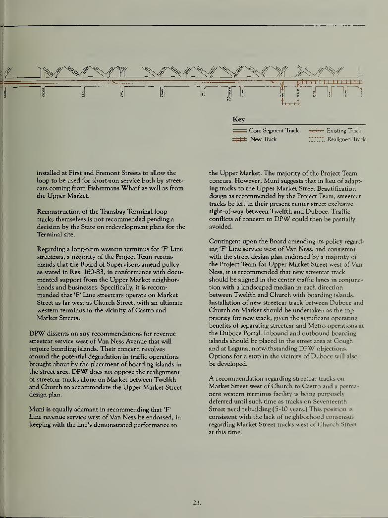
inninnriiHi
Key
Core Segment Track
I I I New Track
Existing Track
Realigned Track
installed at First and Fremont Streets to allow the
loop to be used for short-run service both by street-
cars coming from Fishermans Wharf as well as fromthe Upper Market.
Reconstruction of the Transbay Terminal loop
tracks themselves is not recommended pending a
decision by the State on redevelopment plans for the
Terminal site.
Regarding a long-term western terminus for T' Line
streetcars, a majority of the Project Team recom-
mends that the Board of Supervisors amend policy
as stated in Res. 160-83, in conformance with docu-
mented support from the Upper Market neighbor-
hoods and businesses. Specifically, it is recom-
mended that 'F' Line streetcars operate on Market
Street as far west as Church Street, with an ultimate
western terminus in the vicinity of Castro and
Market Streets.
DPW dissents on any recommendations for revenue
streetcar service west of Van Ness Avenue that will
require boarding islands. Their concern revolves
around the potential degradation in traffic operations
brought about by the placement of boarding islands in
the street area. DPW does not oppose the realignment
of streetcar tracks alone on Market between Twelfth
and Church to accommodate the Upper Market Street
design plan.
Muni is equally adamant in recommending that 'F'
Line revenue service west of Van Ness be endorsed, in
keeping with the line's demonstrated performance to
the Upper Market. The majority of the Project Teamconcurs. However, Muni suggests that in lieu of adapt-
ing tracks to the Upper Market Street Beautification
design as recommended by the Project Team, streetcar
tracks be left in their present center street exclusive
right-of-way between Twelfth and Duboce. Traffic
conflicts of concern to DPW could then be partially
avoided.
Contingent upon the Board amending its policy regard-
ing *F' Line service west of Van Ness, and consistent
with the street design plan endorsed by a majority of
the Project Team for Upper Market Street west of VanNess, it is recommended that new streetcar track
should be aligned in the center traffic lanes in conjunc-
tion with a landscaped median in each direction
between Twelfth and Church with boarding islands.
Installation of new streetcar track between DubcKe and
Church on Market should be undertaken as the top
priority for new track, given the significant operating
benefits of separating streetcar and Metro operations at
the Duboce Portal. Inbound and outbound boarding
islands should be placed in the street area at Goughand at Laguna, notwithstanding DPW objections.
Options for a stop in the vicinity of Duboce will also
be developed.
A recommendation regarding streetcar tracks on
Market Street west of Church to Castro and a perma-
nent western terminus facility is being purposelv
deferred until such time as tracks on Scventct-nth
Street need rebuilding (5-10 years.) This pf)sition is
consistent with the lack of neighborhood consensus
regarding Market Street tracks west of Church Street
at this time.
23.
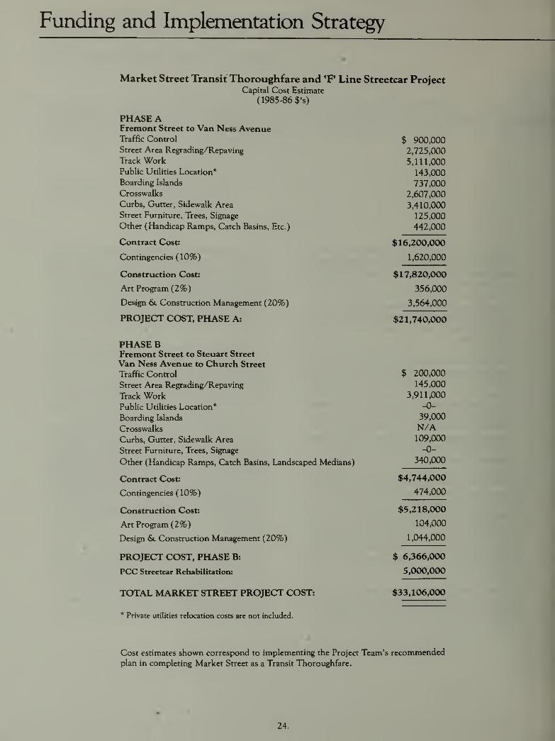
Funding and Implementation Strategy
Market Street Transit Thoroughfare and 'F* Line Streetcar ProjectCapital Cost Estimate
(1985-86 $'s)
PHASE AFremont Street to Van Ness AvenueTraffic Control $ 900,000Street Area Regrading/Repaving
Track Work 5,111,000Public Utilities Location* 143,000Boarding Islands 737,000Crosswalks 2,607,000
Curbs, Gutter, Sidewalk Area 3,410,000
Street Furniture, Trees, Signage 125,000
Other (Handicap Ramps, Catch Basirw, Etc.) 442,000
Contract Cost: $16.200.0CX)
Contingencies (10%) 1,620,000
Construction Cost: $17,820,000
Art Program (2%) 356,000
Design & Construction Management (20%) 3,564,000
PROTFPT POST PHASF A.
PHASE BFremont Street to Steuart Street
Van Ness Avenue to Church Street
Traffic Control $ 200,000
Street Area Regradine/Repavine 145,000
Track Work 3,911,000
Public Utilities Location* -0-
Boarding Islands 39 000
Crosswalks N/ACurbs, Gutter, Sidewalk Area 109,000
Street Furniture, Trees, Signage -0-
Other (Handicap Ramps, Catch Basins, Landscaped Medians) 340,000
Contract Cost: $4,744,000
V^UilLlIlgCllV.LCdV. /
474,000
Construction Cost: $5,218,000
Art Program (2%) 104,000
Design &l Construction Management (20%) 1,044,000
PROJECT COST, PFLASE B: $ 6,366,000
FCC Streetcar Rehabilitation: 5,000,000
TOTAL MARKET STREET PROJECT COST: $33,106,000
* Private utilities relocation costs are not included.
Cost estimates shown correspond to implementing the Project Team's recommendedplan in completing Market Street as a Transit Thoroughfare.
24.
In preparing these estimates, the costs for completing
the Transit Thoroughfare segment -Fremont Street to
Van Ness Avenue -have been shown separately. This
emphasizes the highest priority for completing the
portion of Market Street affecting the greatest number
of Muni riders, with corresponding potential to
achieve the greatest systemwide productivity and
efficiency improvements for Muni operations.
As a Transit Thoroughfare Project, all Market Street
funding should be pursued in the context of a Municapital improvement project. Substantial gasoline
excise tax revenues reserved in earlier years to com-
plete the street improvements must therefore be
made available as local match to leverage state and
federal transit grant resources.
Accordingly, a grant application has been prepared by
PUC's Finance Bureau to accompany this report. It
seeks to authorize $946,500 in Federal Aid Urbangrant funds, plus local match of $151,500, for fiscal
1986-87. The PUC's Utilities Engineering Bureau shall
complete final design for Phase A of the project using
these funds. The Board and Mayor are requested to
approve the grant application simultaneously with the
planning recommendations included herein in order to
expedite this process.
The bulk of capital funding for the Market Street
Transit Thoroughfare will be sought from federal,
state, regional and local transit grant resources com-mencing with fiscal year 1987-88. The project will be
incorporated into Muni's Capital Improvement Pro-
gram, and be prioritized to compete for available fund-
ing. Earliest completion under these circumstances
would be calendar year 1990.
Policy Oversight
Ongoing policy oversight is needed in order to moni-tor project implementation and street performance,
with the capability of addressing unanticipated issues
as they arise.
The Project Team recommends that the Market Street
Community Advisory Committee be maintained in a
policy oversight capacity, working through the Project
Manager designated by PUC's Utilities Engineering
Bureau during project design and construction stages.
Intermittent meetings shall be called by the Project
Manager to address policy matters requiring resolution
by the CAC.
Following project completion and thereafter, the
Market Street Community Advisory Committee shall
meet at least once each year upon request of the Exec-
utive Director for the Greater Market Street Develop>-
ment Association to monitor street maintenance and
operations. Committee findings shall be communicatedto the Mayor, the General Manager of the PUC, and
the Director of Public Works for response and action.
Subcommittees may be designated by the CAC to
coordinate specific endeavors with responsible city
departments, such as the execution of a street art
program, landscaping initiatives, bicycle access plan-
ning and the like.
25.

Market Street Advisory Committee
Bernard Averbuch Rick Laubscher Chi-Hsin Shao
Greater Market Street S.F. Historic Trolley Festival S.F. Department of City Planning
Development Associatioix
Jaimie Levin *Scott Shoaf
*Carl Barton S.F PUC ' Public Affairs S.F. Department of Public Works
S.F. Municipal RailwayAlan Lubliner *Robert Stein
Michael Bell Majior's Office S.F. PL/C - L/titities Pntrinpprina R«rp/iM
S.F. Art Commission*Jill Manton *Peter Straus
Lucia Bogatay S.F. Art Commission S.F. ^Aunicipal Railu^ay
Mayor's Advisory Committee
nn 1 JhtiPT ^A/lTK-Pt Strppt Bruce Marshall Paul Toliver
S.F. Muni Coalition SF. Municipal Railway
Lee Dolson
Downtoum. Association Michael McGill Jon Twichell
S.F. Planning & Urban Emharcadero Citizen's CommitteeRichard Evans Research Association
S.F. Defjartm^nt of Public Works Dmitri VedenskyRichard Morten S.F. Art Commission
Arthur Gensler S.F. Chamber of Commerce
Gensler arui Associates Architects Gary Weinstein
*Carl Natvig Urban Trar\sportation DevelopmentGerald Gibney S.F. Municifjal Railway Corporation Ltd(USA) Inc.
Tudor Engineering Company*John Newlin George Williams
Gergory Gleichman S.F. Police Department S F Dphartmpnt of dt\ Pl/innincf
S.F. Bay Area Rapid Trarxsit District
*Ron Niewiarowski Peggy WoodringWilbur Hamilton S.F PUC - Planning & Development AIA/S.F. Urban Design Committee
S.F. Redevelopment AgencyRai Okamoto *Gordon Wong
Leo Jed Okamoto arui Murata S.F. Department of Public WorksS.F. PVC XJxilities Engineering Bureau
*Edward Phipps Paul ZigmanElmer Johnson S.F. Fire Department Environmental Science Associates, Inc.
Building Otwiers and Managers Association
Norman Rolfe
S.F. Tomorrow *Technical Advisory Committee Member
Project Planning Mafiager
Lee KnightSFPUC - Planning& Development425 Mason Street
San Francisco, CA 94102
Rudolf Nothenberg, General Manager
S.F. Public Utilities Commission
Douglas Wright, Director
SFPUC - Planning & Development
Urban Design Consultants
Cynthia Ripley
Ripley Associates
Architects & Planners
459 Bryant Street
San Francisco, CA 94107
3QQQQQQQ)QQQ06
Printing by Brochure design by
The McDougall Press, Inc. Gensler and Associates/Architects
1031 Irving Street 550 Kearny Street
San Francisco, CA 94122 San Francisco, CA 94108
26.


Published November, 1985