Embed Size (px)
Citation preview
Anatec Aberdeen Office Cambs Office
Address: Cain House, 10 Exchange Street, Aberdeen AB11 6PH,
Scotland, UK
Braemoor, No. 4 The Warren, Witchford, Ely, Cambs, CB6 2HN,
UK
Tel: 01224 253700 01353 661200
Fax: 0709 2367306 0709 2367306
Email: [email protected] [email protected]
Maritime Traffic Survey - Winter 2013
Brims Tidal Array
(Technical Note)
Prepared by: Anatec Limited
Presented to: Brims Tidal Array Limited
Date: 28 January 2014
Revision No.: 01
Ref.: A2455-SSE-BTA-1
Project: A2455
Client: Brims Tidal Array Limited
Title: Brims Tidal Array - Maritime Traffic Survey - Winter 2013 www.anatec.com
Date: 28 January 2014 Page: ii
Doc: A2455 Brims Maritime Traffic Survey Winter 2013 rev 01.docx
TABLE OF CONTENTS
1. INTRODUCTION............................................................................................................ 1
1.1 BACKGROUND.................................................................................................................... 1 1.2 ABBREVIATIONS ................................................................................................................ 1
2. SURVEY SET-UP ............................................................................................................ 2
2.1 INTRODUCTION .................................................................................................................. 2 2.2 SURVEY LOCATION ............................................................................................................ 2
2.3 EQUIPMENT AND MANNING ............................................................................................... 4 2.4 AIS DESCRIPTION .............................................................................................................. 5 2.5 WEATHER AND TIDAL DATA ............................................................................................. 6
3. SURVEY RESULTS ...................................................................................................... 13
3.1 INTRODUCTION ................................................................................................................ 13 3.2 TRACKS BY DAY AND TYPE ............................................................................................. 13
3.4 SHIP SIZE ......................................................................................................................... 15 3.5 AVERAGE COURSE ........................................................................................................... 20
3.6 AVERAGE SPEED .............................................................................................................. 21 3.7 DESTINATION ................................................................................................................... 23 3.8 VESSELS CROSSING AFL AREA ........................................................................................ 24
3.9 VISUALLY OBSERVED TARGETS ...................................................................................... 25
4. DETAILED REVIEW BY VESSEL TYPE ................................................................ 27
4.1 INTRODUCTION ................................................................................................................ 27 4.2 PASSENGER VESSELS ....................................................................................................... 27
4.3 FISHING VESSELS ............................................................................................................. 28 4.4 CARGO VESSELS .............................................................................................................. 30
4.5 TANKERS ......................................................................................................................... 30 4.6 ALL OTHER VESSELS ....................................................................................................... 31
5. CONCLUSIONS ............................................................................................................ 34
Project: A2455
Client: Brims Tidal Array Limited
Title: Brims Tidal Array - Maritime Traffic Survey - Winter 2013 www.anatec.com
Date: 28 January 2014 Page: i
Doc: A2455 Brims Maritime Traffic Survey Winter 2013 rev 01.docx
1. Introduction
1.1 Background
As part of the Navigation Risk Assessment of the proposed Brims Tide Array Project, 28
days of shipping data surrounding the Agreement for Lease (AfL) area is being gathered.
The data are being gathered over 2 x 14 day periods to give account to seasonal and tidal
variations. This report presents analysis of the first 14 day survey which has been carried out
on the island of Hoy, Orkney, between 22nd
November and 6th
December 2013. The data have
been collected using radar, AIS and visual observations.
1.2 Abbreviations
The following abbreviations are used in the report:
AfL - Agreement for Lease
AIS - Automatic Identification System
ARPA - Automatic Radar Plotting Aid
ETA - Estimated Time of Arrival
EU - European Union
IMO - International Maritime Organisation
MMSI - Mobile Maritime Service Identity
nm - Nautical Miles (1nm = 1,852 metres)
SOLAS - Safety of Life at Sea
VHF - Very High Frequency
Project: A2455
Client: Brims Tidal Array Limited
Title: Brims Tidal Array - Maritime Traffic Survey - Winter 2013 www.anatec.com
Date: 28 January 2014 Page: ii
Doc: A2455 Brims Maritime Traffic Survey Winter 2013 rev 01.docx
2. Survey Set-up
2.1 Introduction
A maritime traffic survey of the proposed Brims tidal energy site was carried out near Judas
Hill, Brims on the island of Hoy. The objective of the survey was to collect 14 days of
shipping data in proximity to the Brims Agreement for Lease (AfL) area during Winter 2013.
The survey site was approximately 25m above sea level and 200m from the cliff edge. The
location offered line-of-sight fully covering the Brims AfL area. The survey began on the
morning of Friday 22nd
November 2013 and concluded on Friday 6thth
December 2013.
The primary objective of the survey was to identify and validate the routeing of vessels and
the level of vessel activity in and around the Brims AfL area. This was achieved by recording
in real-time the positions of vessels within range of the Automatic Identification System
(AIS) receiver and ARPA radar, supplemented by observation of vessels within visual range
to obtain information on type and size where the information was not available from AIS.
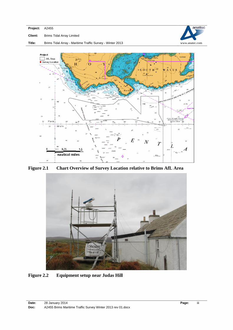
2.2 Survey Location
The radar and AIS were set up at co-ordinates 57o 46’ 33.5” North, 03
o 13’ 30.06” West. The
radar was mounted on scaffolding to give a more elevated view. The survey location relative
to the Brims AfL area is shown in Figure 2.1.
The survey location is approximately 0.7nm from the closest part of the Brims AfL area and
2.9 nm from the furthest point.
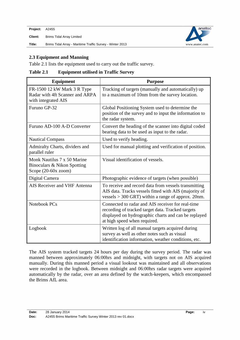
Figure 2.2 presents the equipment setup at the site.
Project: A2455
Client: Brims Tidal Array Limited
Title: Brims Tidal Array - Maritime Traffic Survey - Winter 2013 www.anatec.com
Date: 28 January 2014 Page: iii
Doc: A2455 Brims Maritime Traffic Survey Winter 2013 rev 01.docx
Figure 2.1 Chart Overview of Survey Location relative to Brims AfL Area
Figure 2.2 Equipment setup near Judas Hill
Project: A2455
Client: Brims Tidal Array Limited
Title: Brims Tidal Array - Maritime Traffic Survey - Winter 2013 www.anatec.com
Date: 28 January 2014 Page: iv
Doc: A2455 Brims Maritime Traffic Survey Winter 2013 rev 01.docx
2.3 Equipment and Manning
Table 2.1 lists the equipment used to carry out the traffic survey.
Table 2.1 Equipment utilised in Traffic Survey
Equipment Purpose
FR-1500 12 kW Mark 3 R Type
Radar with 4ft Scanner and ARPA
with integrated AIS
Tracking of targets (manually and automatically) up
to a maximum of 10nm from the survey location.
Furuno GP-32 Global Positioning System used to determine the
position of the survey and to input the information to
the radar system.
Furuno AD-100 A-D Converter Convert the heading of the scanner into digital coded
bearing data to be used as input to the radar.
Nautical Compass Used to verify heading.
Admiralty Charts, dividers and
parallel ruler
Used for manual plotting and verification of position.
Monk Nautilus 7 x 50 Marine
Binoculars & Nikon Spotting
Scope (20-60x zoom)
Visual identification of vessels.
Digital Camera Photographic evidence of targets (when possible)
AIS Receiver and VHF Antenna To receive and record data from vessels transmitting
AIS data. Tracks vessels fitted with AIS (majority of
vessels > 300 GRT) within a range of approx. 20nm.
Notebook PCs Connected to radar and AIS receiver for real-time
recording of tracked target data. Tracked targets
displayed on hydrographic charts and can be replayed
at high speed when required.
Logbook Written log of all manual targets acquired during
survey as well as other notes such as visual
identification information, weather conditions, etc.
The AIS system tracked targets 24 hours per day during the survey period. The radar was
manned between approximately 06:00hrs and midnight, with targets not on AIS acquired
manually. During this manned period a visual lookout was maintained and all observations
were recorded in the logbook. Between midnight and 06:00hrs radar targets were acquired
automatically by the radar, over an area defined by the watch-keepers, which encompassed
the Brims AfL area.

Project: A2455
Client: Brims Tidal Array Limited
Title: Brims Tidal Array - Maritime Traffic Survey - Winter 2013 www.anatec.com
Date: 28 January 2014 Page: v
Doc: A2455 Brims Maritime Traffic Survey Winter 2013 rev 01.docx
2.4 AIS Description
Regulation 19 of SOLAS Chapter V - Carriage requirements for ship borne navigational
systems and equipment - sets out navigational equipment to be carried on board ships,
according to ship type. In 2000, IMO adopted a new requirement (as part of a revised chapter
V) for ships to carry automatic identification systems (AIS). AIS is a system by which ships
transmit data concerning their position, MMSI etc. on two individual VHF channels to the
shore and other vessels, at very frequent intervals. The data is transmitted automatically via
VHF to other vessels and coastal stations/authorities.
The regulation requires AIS to be fitted aboard all ships of 300 gross tonnage and upwards
engaged on international voyages, cargo ships of 500 gross tonnage and upwards not engaged
on international voyages and passenger ships irrespective of size built on or after 1 July 2002.
It also applies to ships engaged on international voyages constructed before 1 July 2002,
according to the following timetable:
passenger ships, not later than 1 July 2003;
tankers, not later than the first survey for safety equipment on or after 1 July 2003;
ships, other than passenger ships and tankers, of 50,000 gross tonnage and upwards, not
later than 1 July 2004.
An amendment adopted by the Diplomatic Conference on Maritime Security in December
2002 states that ships, other than passenger ships and tankers, of 300 gross tonnage and
upwards but less than 50,000 gross tonnage, will be required to fit AIS not later than the first
safety equipment survey after 1 July 2004 or by 31 December 2004, whichever occurs earlier.
Ships fitted with AIS shall maintain AIS in operation at all times except where international
agreements, rules or standards provide for the protection of navigational information.
EU fishing vessels of 18m length and over have been required to carry AIS since 31st May
2013. New built fishing vessels of overall length exceeding 15 metres have been subject to
the carrying requirement from 30 November 2010.
Both dynamic and static information are transmitted by the vessel. Table 2.2 presents the
dynamic and static data provided via AIS.
Table 2.2 AIS Information
Static Dynamic Voyage related
MMSI Position (Lat/Long) Draught
IMO Number Time Hazardous Cargo (type)
Call Sign Course over ground Destination
Name Speed over ground ETA
Length and Beam Heading Route Plan
Type of Ship Navigational Status
Type of Nav Sensor Rate of Turn
Project: A2455
Client: Brims Tidal Array Limited
Title: Brims Tidal Array - Maritime Traffic Survey - Winter 2013 www.anatec.com
Date: 28 January 2014 Page: vi
Doc: A2455 Brims Maritime Traffic Survey Winter 2013 rev 01.docx
2.5 Weather and Tidal Data
The weather was recorded in a logbook every 6 hours during the manned periods of the
survey and is presented in Table 2.3. During the survey, daylight hours were typically
between 8:00 and 16:00 hours. The wind direction was variable but predominantly from the
south west. The wind speed was also highly variable throughout the survey period but was
typically between Beaufort Force 2 and Beaufort Force 5. A maximum wind speed of Force
7-8 was recorded on 5th
December 2013.
Visibility was generally in excess of 7nm however occasional fog was experienced. Sea state
ranged from slight to rough.

Project: A2455
Client: Brims Tidal Array Limited
Title: Brims Tidal Array - Maritime Traffic Survey Winter 2013 www.anatec.com
Date: 28 January 2014 Page: 7
Doc: A2455 Brims Maritime Traffic Survey Winter 2013 rev 01.docx
Table 2.3 Weather throughout 14 Day Survey Period
Date Time Wind Direction Beaufort Force Sea State Visibility (nm) Comments
22/11/2013
12:00:00 WNW 4-5 Moderate 4 Rain showers
18:00:00 WNW 2 Slight 7+ Clear night
00:00:00 W 2-3 Slight 7+ Light showers
23/11/2013
06:00:00 W 2 Slight 7+ Light showers
12:00:00 WNW 3-4 Slight 7+ Squall showers
18:00:00 WNW 2-3 Slight 7+ Squall showers
00:00:00 W 2 Slight 7+ Dry and clear
24/11/2013
06:00:00 W 1-2 Slight 7+ Dry and calm
12:00:00 W 2 Slight 7+ Dry and clear
18:00:00 W 2 Slight 7+ Dry and clear
00:00:00 W 2 Slight 7+ Dry and clear
25/11/2013
06:00:00 WNW 2 Slight 7+ Clear
12:00:00 WSW 3 Slight 7+ Wet and cloudy
18:00:00 WSW 4 Moderate 5 Rain showers
00:00:00 SW 2-3 Slight 7+ Dry
26/11/2013
06:00:00 W 5 Moderate 5 Heavy rain + gusts
12:00:00 SW 4-5 Moderate 6 Cloudy + light showers
18:00:00 SW 6-7 Moderate 5 Windy + rain showers
00:00:00 SW 5-6 Moderate 7+ Clear
27/11/2013
06:00:00 SW 4-5 Moderate 7+ Clear
12:00:00 SW 5-6 Rough 6 Cloudy and showers
18:00:00 W 6-7 Moderate 6 Clear
00:00:00 W 5-6 Moderate 7+ Clear
Project: A2455
Client: Brims Tidal Array Limited
Title: Brims Tidal Array - Maritime Traffic Survey Winter 2013 www.anatec.com
Date: 28 January 2014 Page: 8
Doc: A2455 Brims Maritime Traffic Survey Winter 2013 rev 01.docx
Date Time Wind Direction Beaufort Force Sea State Visibility (nm) Comments
28/11/2013
06:00:00 W 3 Slight 7+ Clear
12:00:00 W 3 Slight 7+ Light cloud
18:00:00 W 2 Slight 7+ Cloudy
00:00:00 W 4 Moderate 7+ Light showers
29/11/2013
06:00:00 NW 6 Moderate 7+ Thunder and lightning
12:00:00 NW 8 Rough 4 Squall showers
18:00:00 WNW 6-7 Rough 4-5 Squall showers
00:00:00 W 4 Moderate 7+ Dry
30/11/2013
06:00:00 NW 3 Slight 7+ Dry
12:00:00 WSW 5 Moderate 7+ Rain showers
18:00:00 WSW 6 Rough 4-5 Rain showers
00:00:00 WSW 4-5 Moderate 7+ Dry
01/12/2013
06:00:00 WSW 4 Moderate 7+ Dry
12:00:00 WSW 2 Slight 7+ Dry + light cloud
18:00:00 SW 2 Slight 7+ Dry + light cloud
00:00:00 SW 2 Slight 7+ Dry + light cloud
02/12/2013
06:00:00 WSW 2 Slight 7+ Dry
12:00:00 SW 3 Slight 7+ Dry + light cloud
18:00:00 SW 4 Moderate 7+ Dry + cloudy
00:00:00 SW 4 Moderate 7+ Dry + Cloudy
03/12/2013
06:00:00 SW 3 Slight 4-5 Rain showers
12:00:00 W 1-2 Slight 7+ Cloudy
18:00:00 W 2-3 Slight 7+ Rain showers
00:00:00 W 4-5 Moderate 7+ Rain showers

Project: A2455
Client: Brims Tidal Array Limited
Title: Brims Tidal Array - Maritime Traffic Survey Winter 2013 www.anatec.com
Date: 28 January 2014 Page: 9
Doc: A2455 Brims Maritime Traffic Survey Winter 2013 rev 01.docx
Date Time Wind Direction Beaufort Force Sea State Visibility (nm) Comments
04/12/2013
06:00:00 SWS 4 Moderate 7+ Rain Showers
12:00:00 W 5-6 Rough 7+ Heavy squalls
18:00:00 W 6-7 Rough 4-5 Heavy squalls
00:00:00 W 6-7 Rough 7+ Heavy squalls
05/12/2013
06:00:00 W 7-8 Rough 7+ Heavy squalls
12:00:00 NW 7-8 Rough 7+ Hail showers
18:00:00 NW 7-8 Rough 7+ Hail showers
00:00:00 NW 6-7 Rough 7+ Hail showers
06/12/2013 06:00:00 NW 6-7 Rough 7+ Dry
Project: A2455
Client: Brims Tidal Array Limited
Title: Brims Tidal Array - Maritime Traffic Survey Winter 2013 www.anatec.com
Date: 28 January 2014 Page: 10
Doc: A2455 Brims Maritime Traffic Survey Winter 2013 rev 01.docx
Table 2.4 , Figure 2.3 and Figure 2.4 provide tidal predictions for Widewall Bay, situated on
the island of South Ronaldsay, which is the closest source of tidal data to the Brims AfL area.
There was a spring tide on the 22nd
November 2013
Table 2.4 Tidal Predictions for Widewall Bay during Survey Period
Date Time Water Height above
Chart Datum (m)
22 November 2013
5:20 1.1
11:51 3.3
17:58 0.9
0:21 3
23 November 2013
5:56 1.3
12:30 3.2
18:41 1.1
1:05 2.8
24 November 2013
6:37 1.4
13:14 3
19:35 1.2
1:56 2.7
25 November 2013
7:30 1.6
14:07 2.9
20:44 1.3
2:58 2.6
26 November 2013
8:50 1.7
15:11 2.8
21:54 1.3
4:05 2.7
27 November 2013
10:10 1.7
16:18 2.8
22:58 1.2
28 November 2013
5:08 2.8
11:17 1.5
17:21 2.9
23:54 1
29 November 2013
6:04 3
12:14 1.3
18:18 3.1
0:42 0.8
30 November 2013
6:56 3.2
13:02 1.1
19:12 3.3
1:26 0.6
01 December 2013 7:43 3.5
Project: A2455
Client: Brims Tidal Array Limited
Title: Brims Tidal Array - Maritime Traffic Survey Winter 2013 www.anatec.com
Date: 28 January 2014 Page: 11
Doc: A2455 Brims Maritime Traffic Survey Winter 2013 rev 01.docx
Date Time Water Height above
Chart Datum (m)
13:47 0.8
20:03 3.6
2:09 0.5
02 December 2013
8:28 3.7
14:30 0.5
20:52 3.7
2:52 0.4
03 December 2013
9:13 3.9
15:15 0.3
21:41 3.8
3:36 0.4
04 December 2013
9:57 4
16:02 0.2
22:29 3.9
4:21 0.5
05 December 2013
10:42 4
16:51 0.2
23:18 3.8
Figure 2.3 Tidal Predictions for Widewall Bay (22nd
-28th
November 2013)
Project: A2455
Client: Brims Tidal Array Limited
Title: Brims Tidal Array - Maritime Traffic Survey Winter 2013 www.anatec.com
Date: 28 January 2014 Page: 12
Doc: A2455 Brims Maritime Traffic Survey Winter 2013 rev 01.docx
Figure 2.4 Tidal Predictions for Widewall Bay (29th
November– 5th
December 2013)
Project: A2455
Client: Brims Tidal Array Limited
Title: Brims Tidal Array - Maritime Traffic Survey Winter 2013 www.anatec.com
Date: 28 January 2014 Page: 13
Doc: A2455 Brims Maritime Traffic Survey Winter 2013 rev 01.docx
3. Survey Results
3.1 Introduction
This section presents the vessel tracks recorded by the radar and AIS during the 14 day
survey period.
As the AIS receiver tended to track vessels over a greater range than radar, and also provided
more accurate information on position and ship characteristics, the AIS track has been used
where the vessel was tracked by both systems. The radar-tracks (non-AIS) were then
combined with the AIS data to create a single data set of all vessels.
Tracks have been colour-coded by vessel type. This information was available from the vast
majority of vessels fitted with AIS. The non-AIS radar tracks are included in the data set have
also been colour-coded based on visual observations where available.
The charts show all tracks within five nautical miles of the Brims AfL area. The analysis and
discussion focuses on vessels passing within the Brims AfL area.
3.2 Tracks by Day and Type
An overview of all the combined tracks recorded throughout the survey period, colour-coded
by vessel type, is presented in Figure 3.1.
Following this, a more detailed plot of vessel tracks in the vicinity of the Brims AfL area is
presented in Figure 3.2.

Project: A2455
Client: Brims Tidal Array Limited
Title: Brims Tidal Array - Maritime Traffic Survey Winter 2013 www.anatec.com
Date: 28 January 2014 Page: 14
Doc: A2455 Brims Maritime Traffic Survey Winter 2013 rev 01.docx
Figure 3.1 General Overview of Tracks in Proximity to the Brims AfL Area
Figure 3.2 Detailed Overview of Tracks in Proximity to the Brims AfL Area

Project: A2455
Client: Brims Tidal Array Limited
Title: Brims Tidal Array - Maritime Traffic Survey Winter 2013 www.anatec.com
Date: 28 January 2014 Page: 15
Doc: A2455 Brims Maritime Traffic Survey Winter 2013 rev 01.docx
Within 5nm of the AfL area there was an average of 25 vessels per day. The majority of these
were cargo ships and tankers using the Outer Sound of the Pentland Firth and passing south
of the AfL area.
The daily number of vessels recorded passing within the Brims AfL area during the survey
period is presented in Figure 3.3. (Note: the 22nd
November and 6th
December are half days
due to survey equipment set-up and removal).
Figure 3.3 Unique Vessels per Day Passing within the Brims AfL Area
There were twenty vessels tracked through the site in total over the 14 days. The busiest day
had four vessels with several days having no recorded activity within the site.
Of the twenty vessels that passed through the Brims AfL, six were fishing vessels, five cargo
vessels, four passenger vessels, one military, three classed as “other” and one unidentified.
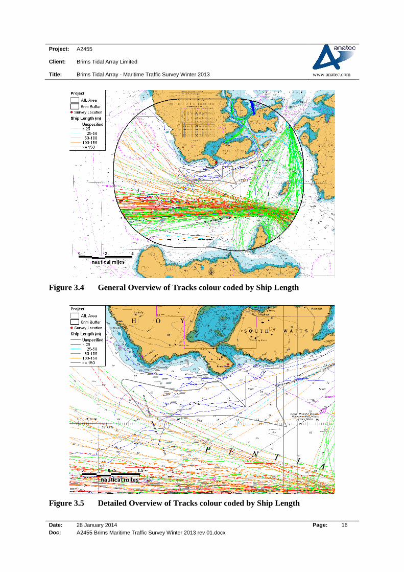
3.4 Ship Size
Based on the information available from AIS and visual observation of the radar targets
(where possible), the tracks colour-coded by length are presented in Figure 3.4 and Figure
3.5.
0
1
2
3
4
5
Nu
mb
er o
f V
esse
ls
Date
Project: A2455
Client: Brims Tidal Array Limited
Title: Brims Tidal Array - Maritime Traffic Survey Winter 2013 www.anatec.com
Date: 28 January 2014 Page: 16
Doc: A2455 Brims Maritime Traffic Survey Winter 2013 rev 01.docx
Figure 3.4 General Overview of Tracks colour coded by Ship Length
Figure 3.5 Detailed Overview of Tracks colour coded by Ship Length

Project: A2455
Client: Brims Tidal Array Limited
Title: Brims Tidal Array - Maritime Traffic Survey Winter 2013 www.anatec.com
Date: 28 January 2014 Page: 17
Doc: A2455 Brims Maritime Traffic Survey Winter 2013 rev 01.docx
The longest vessel tracked passing within the Brims AfL area was the 165m cargo vessel
Godafoss which passed through the AfL area on 12th
December 2013 travelling to Rotterdam.
A photo of the Godafoss vessel is shown in Figure 3.6 Eight of the vessels that passed
through the Brims AfL were <25m, one was between 25m and 50m, two were between 50m
and 100m, four were between 100m and 125m, three were between 125m and 150m, and 2
were > 150m.
Figure 3.6 Library Photo of the Container Vessel Godafoss
Based on the information available from AIS, the tracks colour-coded by draught are
presented in Figure 3.7and Figure 3.8.

Project: A2455
Client: Brims Tidal Array Limited
Title: Brims Tidal Array - Maritime Traffic Survey Winter 2013 www.anatec.com
Date: 28 January 2014 Page: 18
Doc: A2455 Brims Maritime Traffic Survey Winter 2013 rev 01.docx
Figure 3.7 General Overview of Tracks colour coded by Ship Draught
Figure 3.8 Detailed Overview of Tracks colour coded by Ship Draught
Project: A2455
Client: Brims Tidal Array Limited
Title: Brims Tidal Array - Maritime Traffic Survey Winter 2013 www.anatec.com
Date: 28 January 2014 Page: 19
Doc: A2455 Brims Maritime Traffic Survey Winter 2013 rev 01.docx
In the AfL during the survey, six vessels were recorded with a draught of 5m or greater and
six between 2-5m. The deepest draught was the cargo vessel Godafoss (9.1m) heading to
Rotterdam.
The draught of the non-AIS vessel tracks were unspecified, however, these were visually
identified as small vessels of less than 5m draught.
Within 5nm, thirteen vessels were recorded with a draught of 10m or greater, but these did
not enter the Brims AfL.
Project: A2455
Client: Brims Tidal Array Limited
Title: Brims Tidal Array - Maritime Traffic Survey Winter 2013 www.anatec.com
Date: 28 January 2014 Page: 20
Doc: A2455 Brims Maritime Traffic Survey Winter 2013 rev 01.docx
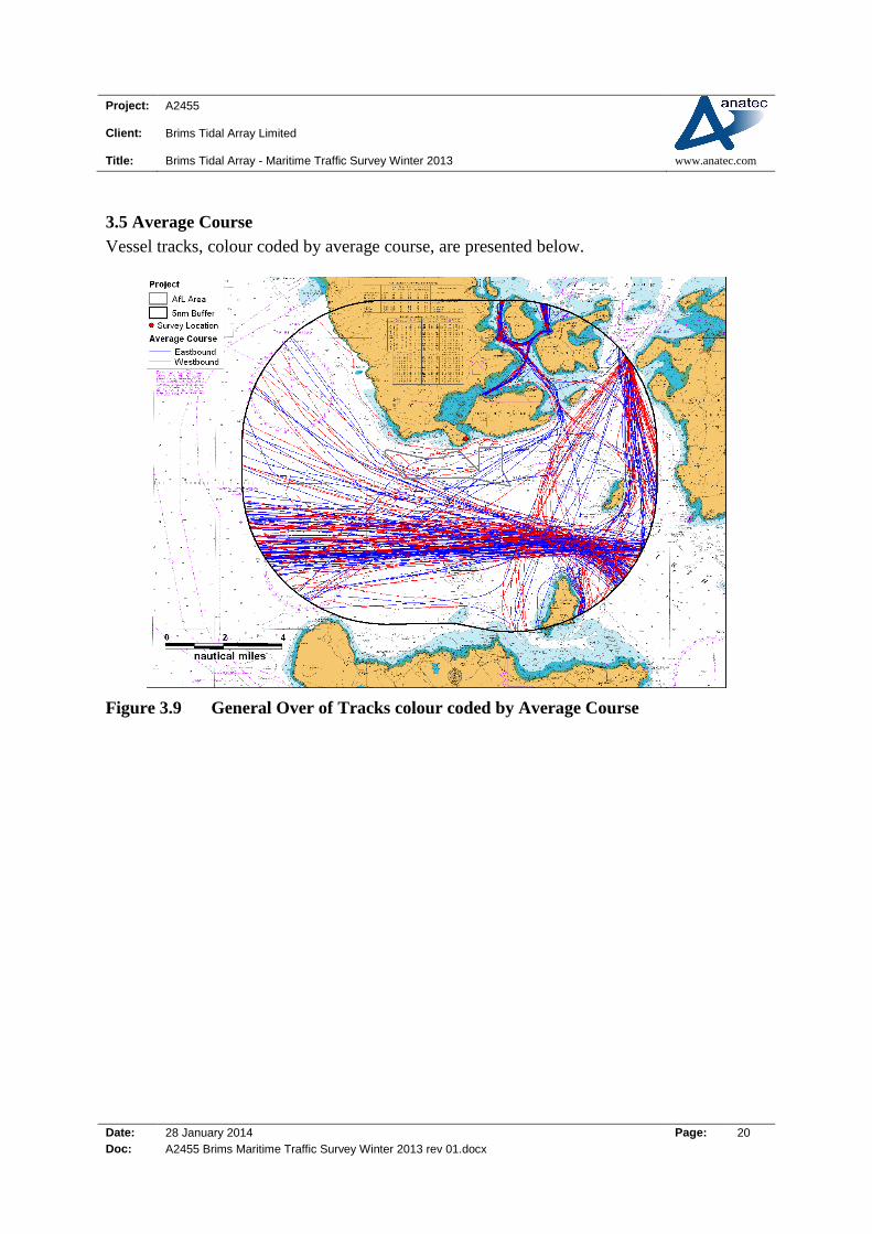
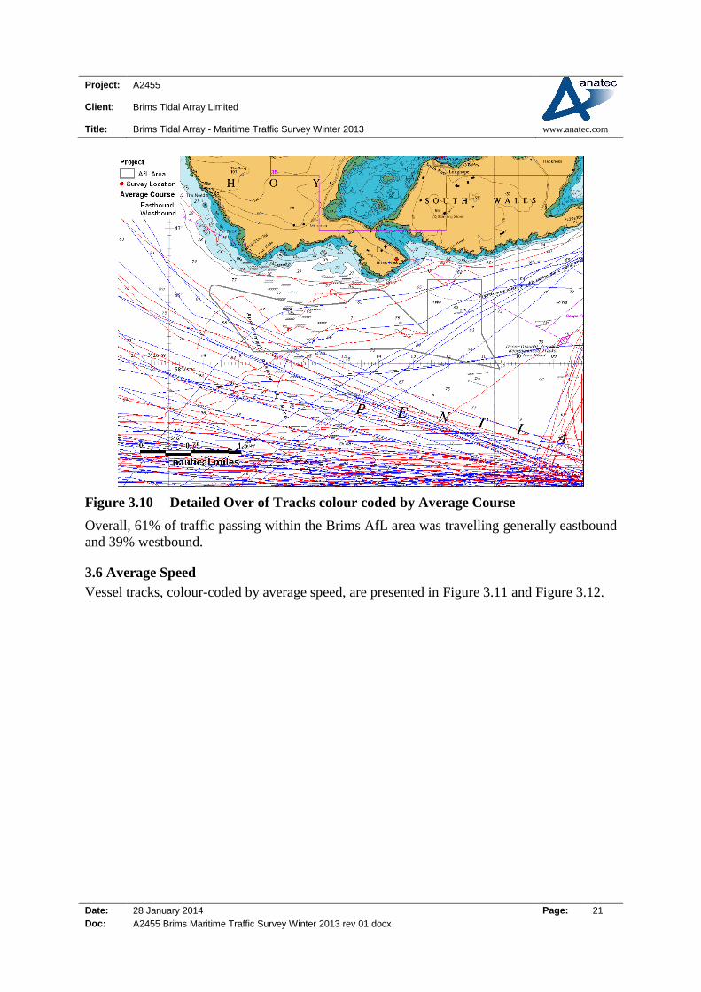
3.5 Average Course
Vessel tracks, colour coded by average course, are presented below.
Figure 3.9 General Over of Tracks colour coded by Average Course
Project: A2455
Client: Brims Tidal Array Limited
Title: Brims Tidal Array - Maritime Traffic Survey Winter 2013 www.anatec.com
Date: 28 January 2014 Page: 21
Doc: A2455 Brims Maritime Traffic Survey Winter 2013 rev 01.docx
Figure 3.10 Detailed Over of Tracks colour coded by Average Course
Overall, 61% of traffic passing within the Brims AfL area was travelling generally eastbound
and 39% westbound.
3.6 Average Speed
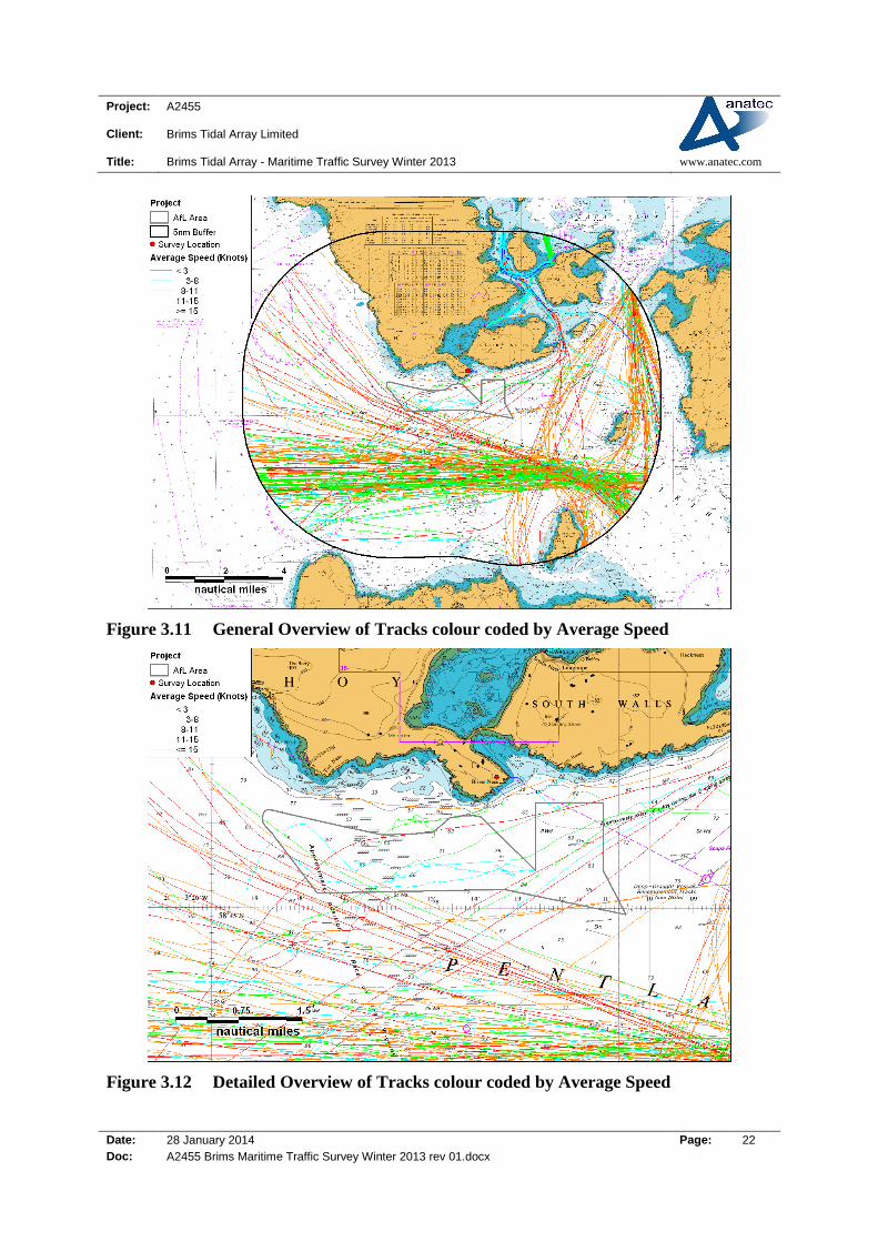
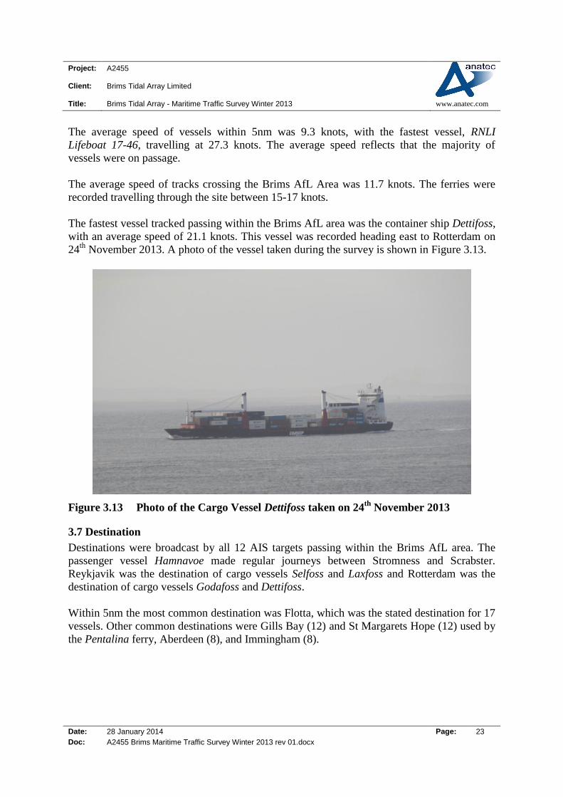
Vessel tracks, colour-coded by average speed, are presented in Figure 3.11 and Figure 3.12.
Project: A2455
Client: Brims Tidal Array Limited
Title: Brims Tidal Array - Maritime Traffic Survey Winter 2013 www.anatec.com
Date: 28 January 2014 Page: 22
Doc: A2455 Brims Maritime Traffic Survey Winter 2013 rev 01.docx
Figure 3.11 General Overview of Tracks colour coded by Average Speed
Figure 3.12 Detailed Overview of Tracks colour coded by Average Speed
Project: A2455
Client: Brims Tidal Array Limited
Title: Brims Tidal Array - Maritime Traffic Survey Winter 2013 www.anatec.com
Date: 28 January 2014 Page: 23
Doc: A2455 Brims Maritime Traffic Survey Winter 2013 rev 01.docx
The average speed of vessels within 5nm was 9.3 knots, with the fastest vessel, RNLI
Lifeboat 17-46, travelling at 27.3 knots. The average speed reflects that the majority of
vessels were on passage.
The average speed of tracks crossing the Brims AfL Area was 11.7 knots. The ferries were
recorded travelling through the site between 15-17 knots.
The fastest vessel tracked passing within the Brims AfL area was the container ship Dettifoss,
with an average speed of 21.1 knots. This vessel was recorded heading east to Rotterdam on
24th
November 2013. A photo of the vessel taken during the survey is shown in Figure 3.13.
Figure 3.13 Photo of the Cargo Vessel Dettifoss taken on 24th
November 2013
3.7 Destination
Destinations were broadcast by all 12 AIS targets passing within the Brims AfL area. The
passenger vessel Hamnavoe made regular journeys between Stromness and Scrabster.
Reykjavik was the destination of cargo vessels Selfoss and Laxfoss and Rotterdam was the
destination of cargo vessels Godafoss and Dettifoss.
Within 5nm the most common destination was Flotta, which was the stated destination for 17
vessels. Other common destinations were Gills Bay (12) and St Margarets Hope (12) used by
the Pentalina ferry, Aberdeen (8), and Immingham (8).

Project: A2455
Client: Brims Tidal Array Limited
Title: Brims Tidal Array - Maritime Traffic Survey Winter 2013 www.anatec.com
Date: 28 January 2014 Page: 24
Doc: A2455 Brims Maritime Traffic Survey Winter 2013 rev 01.docx
3.8 Vessels crossing AfL Area
Twenty vessel tracks passed through the Brims AfL area during the 14 day survey period.
Twelve were broadcasting on AIS and the other eight were tracked on radar. Details on the
vessels are presented in Table 3.1.
Table 3.1 Vessels Passing within the Brims AfL Area
Name (or
Description) Type
Number of
Transits
Length (m) Draught (m) AIS
Hamnavoe Ferry 4 112 4.4 Yes
Caspian Hope Fishing 2 8 N/A No
Selfoss Cargo 2 127 7.3 Yes
Guiding Light Fishing 2 12.9 N/A No
Blue Hulled
Potter Fishing 1 <25 N/A No
Dettifoss Cargo 1 164 8.6 Yes
Godafoss Cargo 1 165 9.1 Yes
Helen Burnie
Multi-purpose
Support
Vessel
1 25 2.5 Yes
Hirta Fisheries
Patrol 1 84 5.4 Yes
HMS
Northumberland Military 1 133 4.9 Yes
Laxfoss Cargo 1 80 5 Yes
Samantha Jane Fishing 1 12.6 N/A No
Welcome Home Sea angling
charter 1 <25 N/A No
Unidentified
Vessel Unspecified 1 <25 N/A No
The Northlink ferry Hamnavoe made four transits when travelling between Stromness and
Scrabster. Other vessels with multiple transits included the fishing vessels Caspian Hope (2)
and Guiding Light (2) and the cargo vessel Selfoss (2). A photo of the vessel Caspian Hope is
shown in Figure 3.14.
The unidentified vessel was recorded on radar in darkness and therefore could not be visually
observed. It is noted this vessel was returning towards Scapa Flow, which the Samantha Jane
had been observed departing a few hours earlier that day.
Project: A2455
Client: Brims Tidal Array Limited
Title: Brims Tidal Array - Maritime Traffic Survey Winter 2013 www.anatec.com
Date: 28 January 2014 Page: 25
Doc: A2455 Brims Maritime Traffic Survey Winter 2013 rev 01.docx
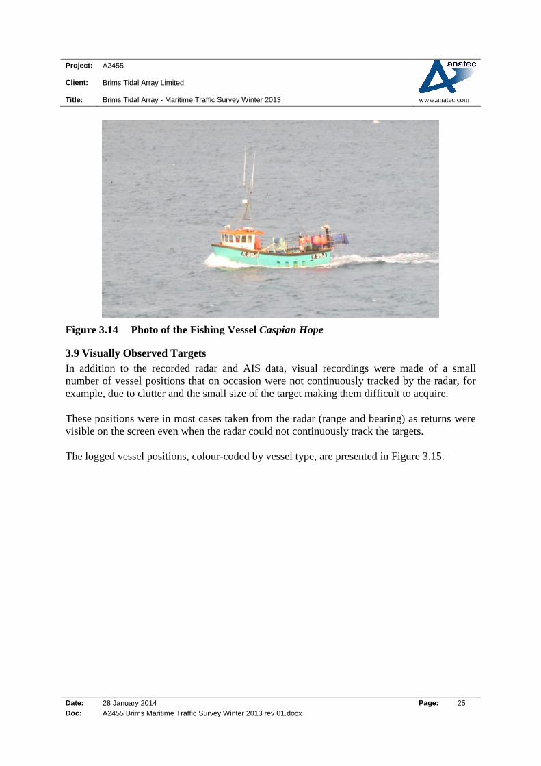
Figure 3.14 Photo of the Fishing Vessel Caspian Hope
3.9 Visually Observed Targets
In addition to the recorded radar and AIS data, visual recordings were made of a small
number of vessel positions that on occasion were not continuously tracked by the radar, for
example, due to clutter and the small size of the target making them difficult to acquire.
These positions were in most cases taken from the radar (range and bearing) as returns were
visible on the screen even when the radar could not continuously track the targets.
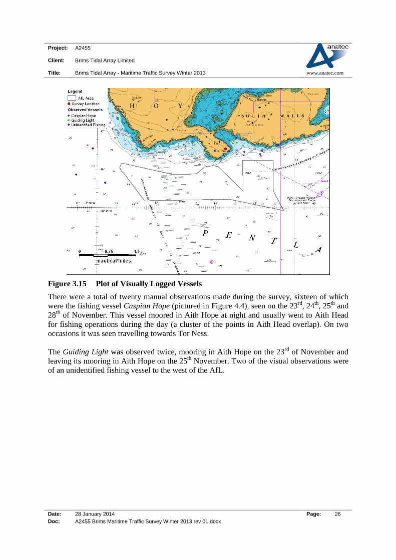
The logged vessel positions, colour-coded by vessel type, are presented in Figure 3.15.
Project: A2455
Client: Brims Tidal Array Limited
Title: Brims Tidal Array - Maritime Traffic Survey Winter 2013 www.anatec.com
Date: 28 January 2014 Page: 26
Doc: A2455 Brims Maritime Traffic Survey Winter 2013 rev 01.docx
Figure 3.15 Plot of Visually Logged Vessels
There were a total of twenty manual observations made during the survey, sixteen of which
were the fishing vessel Caspian Hope (pictured in Figure 4.4), seen on the 23rd
, 24th
, 25th
and
28th
of November. This vessel moored in Aith Hope at night and usually went to Aith Head
for fishing operations during the day (a cluster of the points in Aith Head overlap). On two
occasions it was seen travelling towards Tor Ness.
The Guiding Light was observed twice, mooring in Aith Hope on the 23rd
of November and
leaving its mooring in Aith Hope on the 25th
November. Two of the visual observations were
of an unidentified fishing vessel to the west of the AfL.

Project: A2455
Client: Brims Tidal Array Limited
Title: Brims Tidal Array - Maritime Traffic Survey Winter 2013 www.anatec.com
Date: 28 January 2014 Page: 27
Doc: A2455 Brims Maritime Traffic Survey Winter 2013 rev 01.docx
4. Detailed Review by Vessel Type
4.1 Introduction
This section presents more detailed analysis of the two weeks of survey data by vessel type.
4.2 Passenger Vessels
The passenger vessels tracked passing within the vicinity of the Brims AfL area are shown in
Figure 4.1.
Figure 4.1 Passenger Vessels Tracks recorded during Brims Survey
The Hamnavoe was the only passenger vessel passing through the AfL and passed through
during periods of bad weather. The Pentalina between Gills Bay and St Margaret’s Hope
came within 1.4nm of the AfL. Hoy Head kept well to the north when running between
Houton and Lyness.
A photo of the Hamnavoe taken during the survey is shown in Figure 4.2.
Project: A2455
Client: Brims Tidal Array Limited
Title: Brims Tidal Array - Maritime Traffic Survey Winter 2013 www.anatec.com
Date: 28 January 2014 Page: 28
Doc: A2455 Brims Maritime Traffic Survey Winter 2013 rev 01.docx
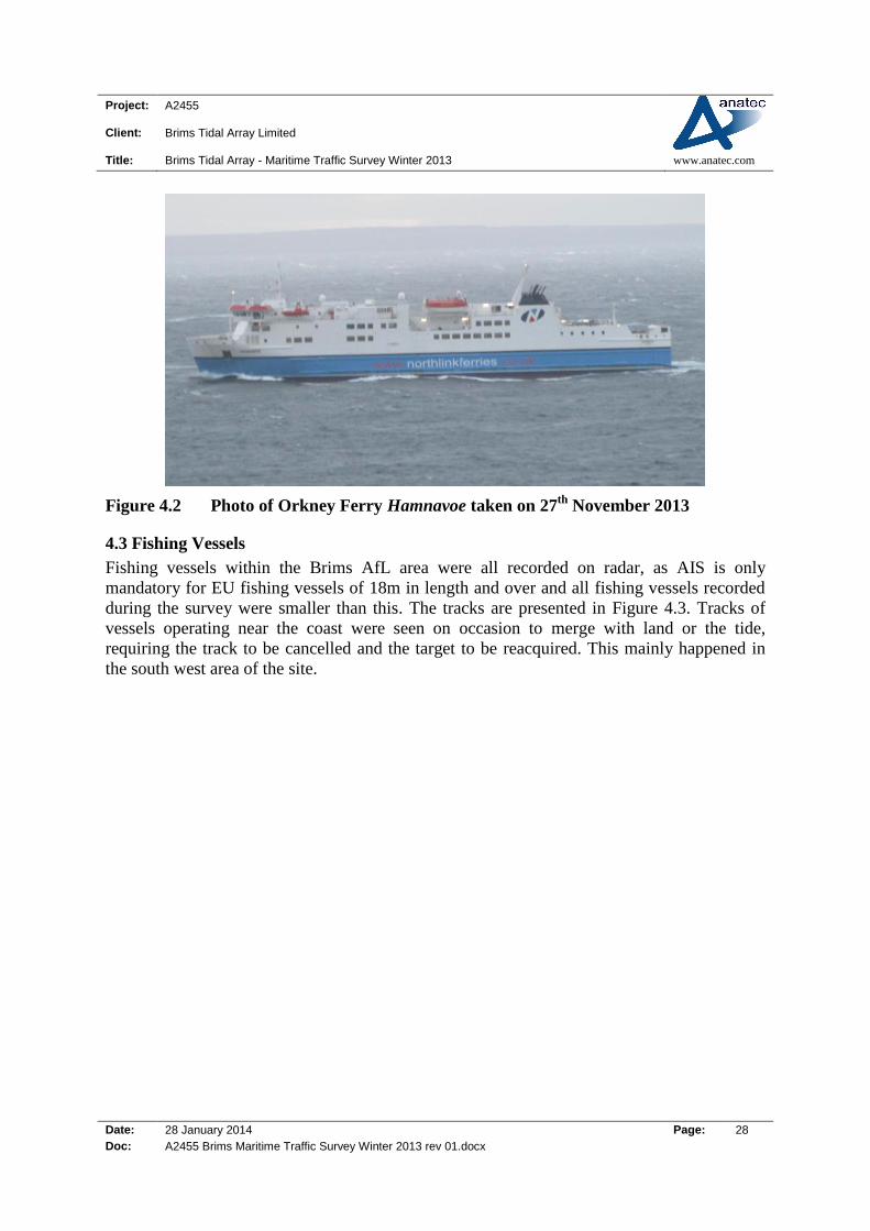
Figure 4.2 Photo of Orkney Ferry Hamnavoe taken on 27th
November 2013
4.3 Fishing Vessels
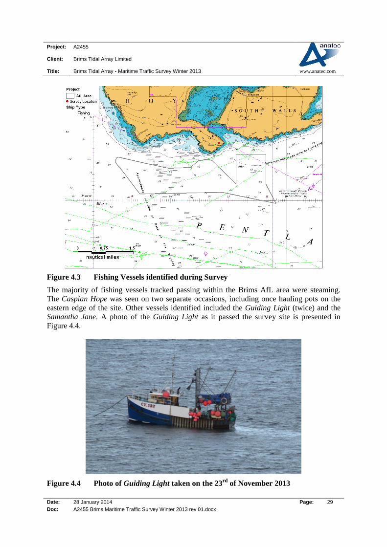
Fishing vessels within the Brims AfL area were all recorded on radar, as AIS is only
mandatory for EU fishing vessels of 18m in length and over and all fishing vessels recorded
during the survey were smaller than this. The tracks are presented in Figure 4.3. Tracks of
vessels operating near the coast were seen on occasion to merge with land or the tide,
requiring the track to be cancelled and the target to be reacquired. This mainly happened in
the south west area of the site.
Project: A2455
Client: Brims Tidal Array Limited
Title: Brims Tidal Array - Maritime Traffic Survey Winter 2013 www.anatec.com
Date: 28 January 2014 Page: 29
Doc: A2455 Brims Maritime Traffic Survey Winter 2013 rev 01.docx
Figure 4.3 Fishing Vessels identified during Survey
The majority of fishing vessels tracked passing within the Brims AfL area were steaming.
The Caspian Hope was seen on two separate occasions, including once hauling pots on the
eastern edge of the site. Other vessels identified included the Guiding Light (twice) and the
Samantha Jane. A photo of the Guiding Light as it passed the survey site is presented in
Figure 4.4.
Figure 4.4 Photo of Guiding Light taken on the 23rd
of November 2013
Project: A2455
Client: Brims Tidal Array Limited
Title: Brims Tidal Array - Maritime Traffic Survey Winter 2013 www.anatec.com
Date: 28 January 2014 Page: 30
Doc: A2455 Brims Maritime Traffic Survey Winter 2013 rev 01.docx
4.4 Cargo Vessels
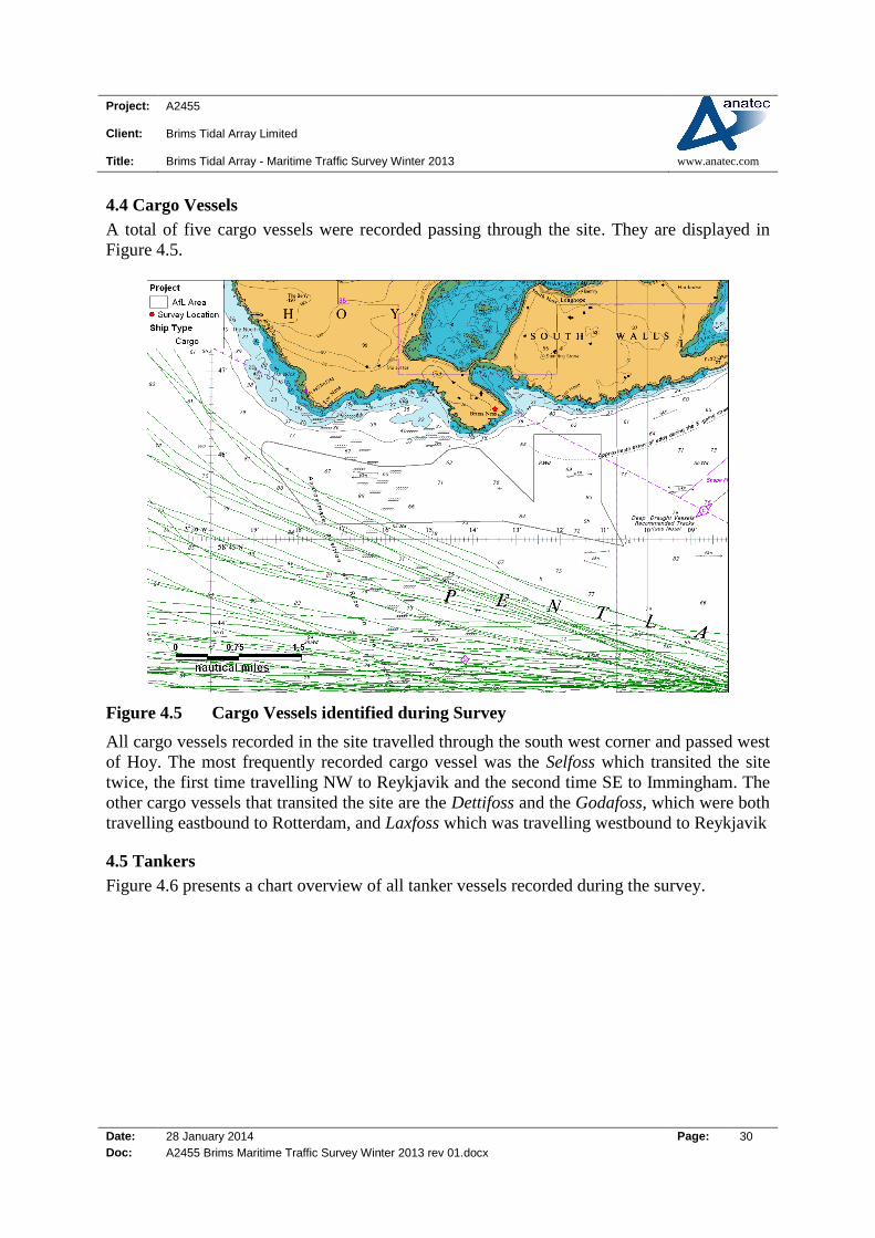
A total of five cargo vessels were recorded passing through the site. They are displayed in
Figure 4.5.
Figure 4.5 Cargo Vessels identified during Survey
All cargo vessels recorded in the site travelled through the south west corner and passed west
of Hoy. The most frequently recorded cargo vessel was the Selfoss which transited the site
twice, the first time travelling NW to Reykjavik and the second time SE to Immingham. The
other cargo vessels that transited the site are the Dettifoss and the Godafoss, which were both
travelling eastbound to Rotterdam, and Laxfoss which was travelling westbound to Reykjavik
4.5 Tankers
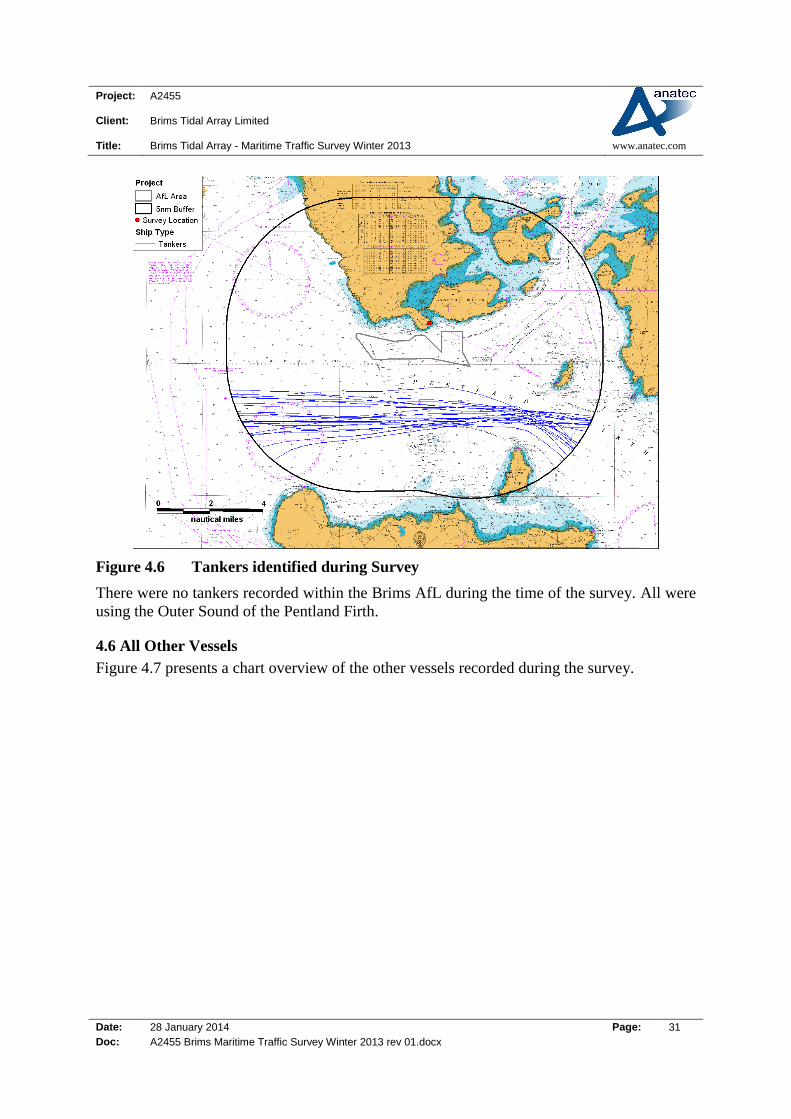
Figure 4.6 presents a chart overview of all tanker vessels recorded during the survey.
Project: A2455
Client: Brims Tidal Array Limited
Title: Brims Tidal Array - Maritime Traffic Survey Winter 2013 www.anatec.com
Date: 28 January 2014 Page: 31
Doc: A2455 Brims Maritime Traffic Survey Winter 2013 rev 01.docx
Figure 4.6 Tankers identified during Survey
There were no tankers recorded within the Brims AfL during the time of the survey. All were
using the Outer Sound of the Pentland Firth.
4.6 All Other Vessels
Figure 4.7 presents a chart overview of the other vessels recorded during the survey.
Project: A2455
Client: Brims Tidal Array Limited
Title: Brims Tidal Array - Maritime Traffic Survey Winter 2013 www.anatec.com
Date: 28 January 2014 Page: 32
Doc: A2455 Brims Maritime Traffic Survey Winter 2013 rev 01.docx
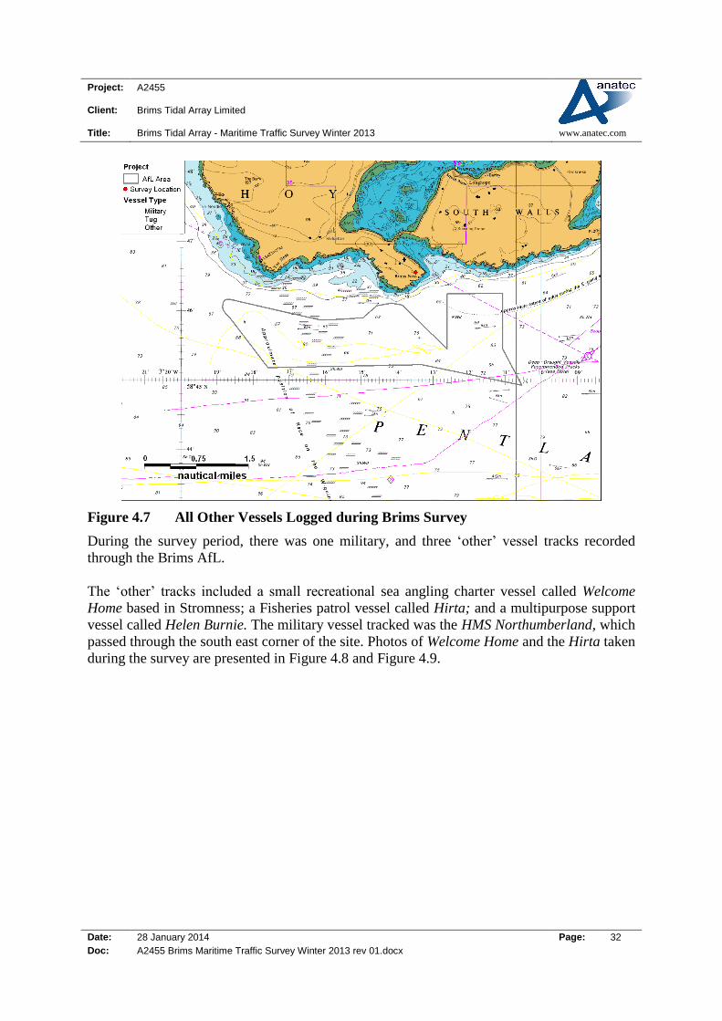
Figure 4.7 All Other Vessels Logged during Brims Survey
During the survey period, there was one military, and three ‘other’ vessel tracks recorded
through the Brims AfL.
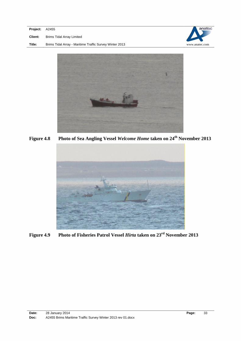
The ‘other’ tracks included a small recreational sea angling charter vessel called Welcome
Home based in Stromness; a Fisheries patrol vessel called Hirta; and a multipurpose support
vessel called Helen Burnie. The military vessel tracked was the HMS Northumberland, which
passed through the south east corner of the site. Photos of Welcome Home and the Hirta taken
during the survey are presented in Figure 4.8 and Figure 4.9.
Project: A2455
Client: Brims Tidal Array Limited
Title: Brims Tidal Array - Maritime Traffic Survey Winter 2013 www.anatec.com
Date: 28 January 2014 Page: 33
Doc: A2455 Brims Maritime Traffic Survey Winter 2013 rev 01.docx
Figure 4.8 Photo of Sea Angling Vessel Welcome Home taken on 24th
November 2013
Figure 4.9 Photo of Fisheries Patrol Vessel Hirta taken on 23rd
November 2013
Project: A2455
Client: Brims Tidal Array Limited
Title: Brims Tidal Array - Maritime Traffic Survey Winter 2013 www.anatec.com
Date: 28 January 2014 Page: 34
Doc: A2455 Brims Maritime Traffic Survey Winter 2013 rev 01.docx
5. Conclusions
This report has presented analysis of 14-days radar and AIS surveying of the proposed Brims
tidal energy site. The survey was carried out near Judas Hill, Brims, Island of Hoy between
the 22nd November and 6th December 2013.
Throughout the survey period, 20 unique tracks were recorded crossing the Brims AfL area.
The most common vessels were fishing (6), cargo (5) and passenger (4).
A further 14-day survey is planned in summer 2014 to provide the data required for the
Navigation Risk Assessment, meeting the MCA requirements.