Embed Size (px)
Citation preview
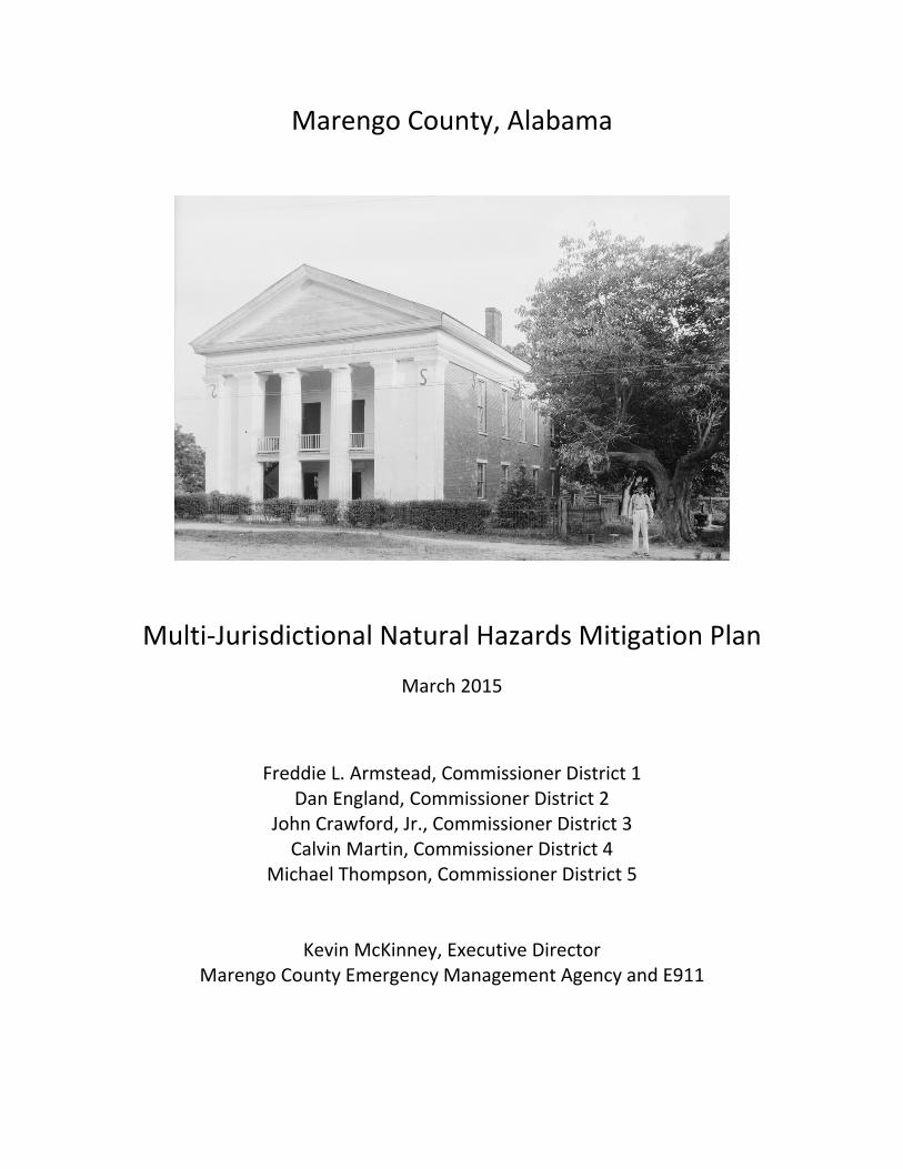
Marengo County, Alabama
Multi‐Jurisdictional Natural Hazards Mitigation Plan
March 2015
Freddie L. Armstead, Commissioner District 1 Dan England, Commissioner District 2
John Crawford, Jr., Commissioner District 3 Calvin Martin, Commissioner District 4
Michael Thompson, Commissioner District 5
Kevin McKinney, Executive Director Marengo County Emergency Management Agency and E911

Marengo County, Alabama
Unicorporated Marengo County
Town of Dayton
City of Demopolis
Town of Faunsdale
City of Linden
Town of Myrtlewood
Town of Providence
Town of Sweetwater
Town of Thomaston
Multi‐Jurisdictional Natural Hazards Mitigation Plan
March 2015
Freddie L. Armstead, Commissioner District 1 Dan England, Commissioner District 2
John Crawford, Jr., Commissioner District 3 Calvin Martin, Commissioner District 4
Michael Thompson, Commissioner District 5
Kevin McKinney, Executive Director Marengo County Emergency Management Agency and E911

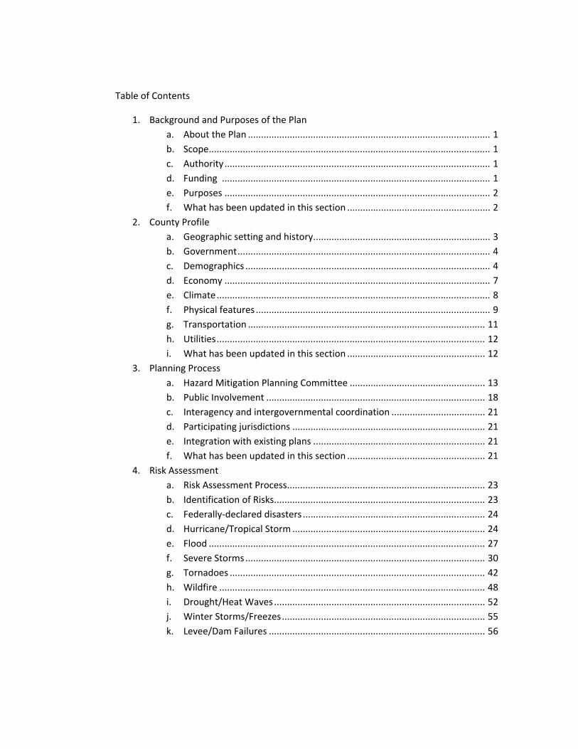
Table of Contents
1. Background and Purposes of the Plan
a. About the Plan ............................................................................................. 1
b. Scope ............................................................................................................ 1
c. Authority ...................................................................................................... 1
d. Funding ....................................................................................................... 1
e. Purposes ...................................................................................................... 2
f. What has been updated in this section ....................................................... 2
2. County Profile
a. Geographic setting and history .................................................................... 3
b. Government ................................................................................................. 4
c. Demographics .............................................................................................. 4
d. Economy ...................................................................................................... 7
e. Climate ......................................................................................................... 8
f. Physical features .......................................................................................... 9
g. Transportation ........................................................................................... 11
h. Utilities ....................................................................................................... 12
i. What has been updated in this section ..................................................... 12
3. Planning Process
a. Hazard Mitigation Planning Committee .................................................... 13
b. Public Involvement .................................................................................... 18
c. Interagency and intergovernmental coordination .................................... 21
d. Participating jurisdictions .......................................................................... 21
e. Integration with existing plans .................................................................. 21
f. What has been updated in this section ..................................................... 21
4. Risk Assessment
a. Risk Assessment Process............................................................................ 23
b. Identification of Risks................................................................................. 23
c. Federally‐declared disasters ...................................................................... 24
d. Hurricane/Tropical Storm .......................................................................... 24
e. Flood .......................................................................................................... 27
f. Severe Storms ............................................................................................ 30
g. Tornadoes .................................................................................................. 42
h. Wildfire ...................................................................................................... 48
i. Drought/Heat Waves ................................................................................. 52
j. Winter Storms/Freezes .............................................................................. 55
k. Levee/Dam Failures ................................................................................... 56

l. Landslides .................................................................................................. 58
m. Earthquakes ............................................................................................... 66
n. Vulnerability Assessment and Identification of Assets .............................. 62
i. Building Assets ....................................................................... 63
ii. Critical Facilities ...................................................................... 63
iii. Estimated Losses by Hazard .................................................. 77
iv. Analysis of Development Trends ........................................... 80
v. Risk Assessment by Jurisdiction ............................................ 80
o. What has been updated in this section .................................................... 81
5. Mitigation Strategies
a. Purpose of Mitigation Strategies......................................................... 82
b. Identification and Analysis of Mitigation Measures ........................... 82
c. Types of Mitigation Activities .............................................................. 82
d. Existing Hazard Mitigation Activities ................................................... 83
e. Mitigation Issues and Opportunities ................................................... 85
f. Mitigation Policies Plan ...................................................................... 86
i. Unincorporated Marengo County Mitigation Measures ....... 88
ii. Town of Dayton Mitigation Measures ................................... 97
iii. City of Demopolis Mitigation Measures ............................... 106
iv. Town of Faunsdale Mitigation Measures ............................. 115
v. City of Linden Mitigation Measures ..................................... 124
vi. Town of Myrtlewood Mitigation Measures ......................... 133
vii. Town of Providence Mitigation Measures ........................... 142
viii. Town of Sweet Water Mitigation Measures ....................... 151
ix. Town of Thomaston Mitigation Measures ........................... 161
6. Plan Maintenance .......................................................................................... 170
7. Approval and Adoption .................................................................................. 172
8. Appendices
a. Appendix A – 44 CFR 201 Hazard Mitigation Planning ............................ i
b. Appendix B – Sign in sheets for each meeting .................................... xiii
c. Appendix C – Resolutions by each entity adopting the Plan Update. . xx
d. Appendix D – Completed Local Mitigation Plan Review Crosswalk .. xxix

List of Acronyms
AEMA ................................................... Alabama Emergency Management Agency
FEMA ......................................................... Federal Emergency Management Agency
HMGP ................................................................... Hazard Mitigation Grant Program
NCDC ........................................................................... National Climate Data Center
NFIP ...................................................................... National Flood Insurance Program
NWS .................................................................................. National Weather Service
PDM ....................................................................................... Pre‐Disaster Mitigation
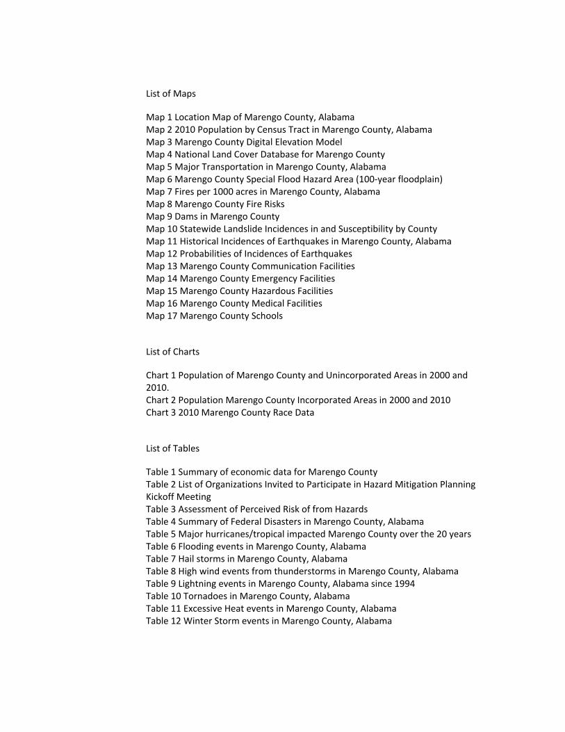
List of Maps
Map 1 Location Map of Marengo County, Alabama Map 2 2010 Population by Census Tract in Marengo County, Alabama Map 3 Marengo County Digital Elevation Model Map 4 National Land Cover Database for Marengo County Map 5 Major Transportation in Marengo County, Alabama Map 6 Marengo County Special Flood Hazard Area (100‐year floodplain) Map 7 Fires per 1000 acres in Marengo County, Alabama Map 8 Marengo County Fire Risks Map 9 Dams in Marengo County Map 10 Statewide Landslide Incidences in and Susceptibility by County Map 11 Historical Incidences of Earthquakes in Marengo County, Alabama Map 12 Probabilities of Incidences of Earthquakes Map 13 Marengo County Communication Facilities Map 14 Marengo County Emergency Facilities Map 15 Marengo County Hazardous Facilities Map 16 Marengo County Medical Facilities Map 17 Marengo County Schools
List of Charts
Chart 1 Population of Marengo County and Unincorporated Areas in 2000 and 2010. Chart 2 Population Marengo County Incorporated Areas in 2000 and 2010 Chart 3 2010 Marengo County Race Data
List of Tables
Table 1 Summary of economic data for Marengo County Table 2 List of Organizations Invited to Participate in Hazard Mitigation Planning Kickoff Meeting Table 3 Assessment of Perceived Risk of from Hazards Table 4 Summary of Federal Disasters in Marengo County, Alabama Table 5 Major hurricanes/tropical impacted Marengo County over the 20 years Table 6 Flooding events in Marengo County, Alabama Table 7 Hail storms in Marengo County, Alabama Table 8 High wind events from thunderstorms in Marengo County, Alabama Table 9 Lightning events in Marengo County, Alabama since 1994 Table 10 Tornadoes in Marengo County, Alabama Table 11 Excessive Heat events in Marengo County, Alabama Table 12 Winter Storm events in Marengo County, Alabama
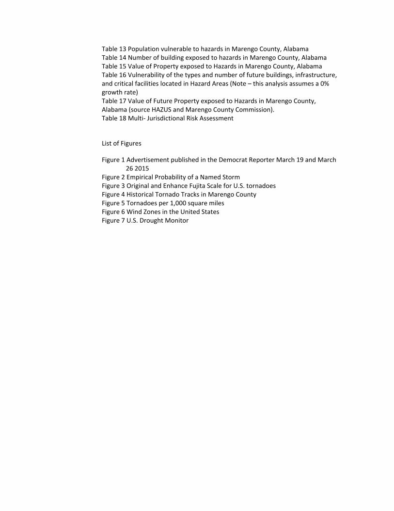
Table 13 Population vulnerable to hazards in Marengo County, Alabama Table 14 Number of building exposed to hazards in Marengo County, Alabama Table 15 Value of Property exposed to Hazards in Marengo County, Alabama Table 16 Vulnerability of the types and number of future buildings, infrastructure, and critical facilities located in Hazard Areas (Note – this analysis assumes a 0% growth rate) Table 17 Value of Future Property exposed to Hazards in Marengo County, Alabama (source HAZUS and Marengo County Commission). Table 18 Multi‐ Jurisdictional Risk Assessment
List of Figures
Figure 1 Advertisement published in the Democrat Reporter March 19 and March 26 2015 Figure 2 Empirical Probability of a Named Storm Figure 3 Original and Enhance Fujita Scale for U.S. tornadoes Figure 4 Historical Tornado Tracks in Marengo County Figure 5 Tornadoes per 1,000 square miles Figure 6 Wind Zones in the United States Figure 7 U.S. Drought Monitor
~ 1 ~
1. Background and Purposes of the Plan
a. About the Plan ‐ On October 30, 2000, the United States Congress passed the Disaster Mitigation
Action Act of 2000. This act requires a local jurisdiction to develop and adopt hazard mitigation
plans in order to receive federal funding from the Hazard Mitigation Program (HMGP) or the Pre‐
Disaster Mitigation Program (PDM). Hazard Mitigation is any sustained action taken to reduce or
eliminate the long‐term risk to human life and property from hazards. Mitigation activities may be
implemented prior to, during, or after an incident. However, it has been demonstrated that
hazard mitigation is most effective when based on an inclusive, comprehensive, long‐term plan
that is developed before a disaster occurs.
The Marengo County Multi‐Jurisdictional Natural Hazards Mitigation Plan is an update to the
previously approved plan which was approved by FEMA in 2010. In 2012 , the Marengo County
Commission was awarded a HMGP grant (1971‐713) to update the previously‐approved plan so
that Marengo County will meet the eligibility requirements for PDM and HMGP funding.
b. Scope – The Marengo County Multi‐Jurisdictional Natural Hazards Mitigation Plan includes
numerous entities located within Marengo County Alabama. These entities include both
incorporated and unincorporated areas along with rural water authorities and the Marengo
County Board of Education, City Board of Education, City of Demopolis Board of Education. The
plan update followed the guidance provided by the Federal Emergency Management Agency
(FEMA) entitled Local Mitigation Plan Review Guide (October 1, 2011). This document will contain
all of the required elements in order to be eligible for federal funding.
c. Authority – Section 409 of the Robert T. Stafford Disaster and Relief Act (Public Law 93‐288, as
amended) and Title 44 CFR, as amended by Section 102 of the Disaster Mitigation Act of 2000
provide the framework for state and local governments to evaluate and mitigate all hazards as a
condition for receiving Federal disaster assistance. A major requirement of the law is the
development and adoption of a local hazard mitigation plan.
d. Funding – On December 14, 2013, FEMA awarded an HMGP (1971‐713) grant to the Alabama
Emergency Management Agency (AEMA) for $30,000.00 with a federal share (75%) of $7,500.
Donation of staff time from the local community was used as the required match for the grant.
e. Purposes ‐ Hazard mitigation is any action taken to permanently reduce or eliminate long‐ term
risks to people and their property from the effects of hazards. Natural hazards come in many
forms: tornadoes, floods, hurricanes, severe storms, winter freezes, droughts, landslides, or dam
failures resulting from natural disaster crises. Communities can take steps to prepare and
implement mitigation techniques for almost any type of hazard that may threaten its citizens,
businesses and institutions. Hazard mitigation planning helps to identify a range of structural
~ 2 ~
approaches to lower the costs of future disasters by meeting the unique needs of the
community. For example, structural mitigation projects for flooding could involve modifying a
stream channel to increase the conveyance of floodwaters or retarding the flow rate by the
construction of detention facilities. Mitigation strategies can also involve non‐structural
initiatives, such as educational programs to inform homeowners of their vulnerability to natural
disasters in order to encourage them to purchase insurance or retrofit their homes. Non‐
structural programs can also include developing and enforcing regulations to prevent
construction in hazard areas, or to ensure that development that does occur will be resistant to
the hazards threatening the area.
Mitigation programs and projects serve to lessen a community's vulnerability to the hardships
and costs of disasters. The implementation of mitigation programs is a key component to
achieving a sustainable community, one in which the economic and social needs of people,
businesses, and institutions coexist with natural environmental constraints and are protected
from the disruptions and impacts of emergencies and disasters. Hazard mitigation planning
must be closely coordinated with a community's overall planning and development efforts. The
most effective way for a community to initiate this objective is through a comprehensive local
mitigation planning program, as presented here. Comprehensive planning can provide Marengo
County citizens a safe, healthy and prosperous place in which to live and work.
The purpose of the Marengo County Multi‐Jurisdictional Hazard Mitigation Plan is to develop
a unified approach among its local governments for dealing with identified hazards and hazard
management problems. This plan serves as a guide for local governments in their ongoing efforts
to reduce vulnerability to the impacts produced by natural hazards.
Further, the plan seeks to accomplish the following additional purposes: 1. Establish an ongoing hazard mitigation planning program 2. Identify and assess the hazards that pose a threat to life and property 3. Evaluate additional mitigation measures that should be undertaken 4. Outline procedures for monitoring the implementation of mitigation strategies
f. What has been updated in this section ‐ This plan provides guidance for local mitigation activities over the next five‐year planning cycle. It encourages activities that are most effective and appropriate for mitigating the effects of all natural hazards. The first section of the plan gives a basic overview of the need and purpose of a Hazard Mitigation Plan.
2. County Profile
a. Geographic setting and history – Marengo County is located in rural western Alabama.
According to the 2010 U.S. Census, the County’s population was 21,027. The County contains
approximately 983 square miles and is bordered on the north by Sumter County, Greene and
Hale Counties, on the east by Perry, Dallas, and Wilcox Counties, on the south by Clarke
County, and on the west by Choctaw County. Marengo County was created by the Alabama
~ 3 ~
Territorial legislature on February 6, 1818, from land acquired from the Choctaw Indians by
the Treaty of Fort St. Stephens on October 24, 1816. The county also contains, in decreasing
order of population, the City of Demopolis (2010 U.S. Census population 7,483), Towns of
Linden (2010 U.S. Census population 2,125, Thomaston (2010 U.S. Census population 417,
Town of Sweet Water (2010 U.S. Census population 258), Town of Providence (U.S. Census
population 223), Town of Myrtlewood (U.S. Census population 130), Town of Faunsdale (U.S.
Census population 98), and Town of Dayton (2010 U.S. Census population 52).
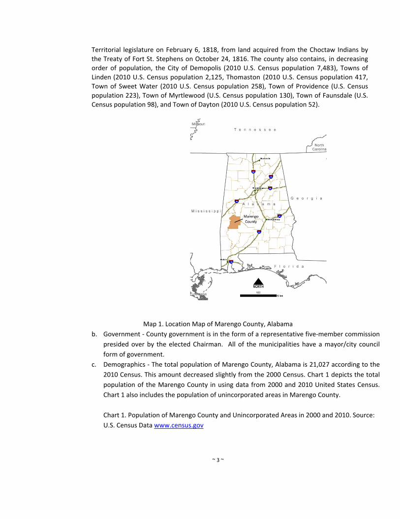
Map 1. Location Map of Marengo County, Alabama
b. Government ‐ County government is in the form of a representative five‐member commission
presided over by the elected Chairman. All of the municipalities have a mayor/city council
form of government.
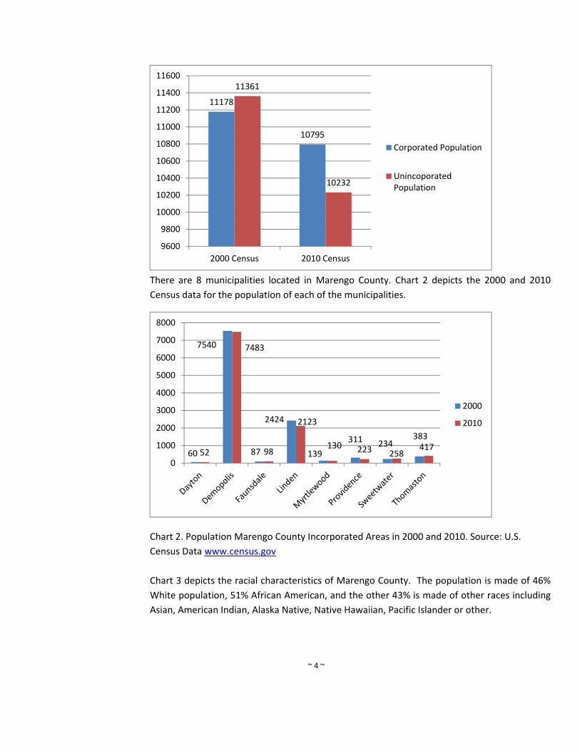
c. Demographics ‐ The total population of Marengo County, Alabama is 21,027 according to the
2010 Census. This amount decreased slightly from the 2000 Census. Chart 1 depicts the total
population of the Marengo County in using data from 2000 and 2010 United States Census.
Chart 1 also includes the population of unincorporated areas in Marengo County.
Chart 1. Population of Marengo County and Unincorporated Areas in 2000 and 2010. Source:
U.S. Census Data www.census.gov
~ 4 ~
There are 8 municipalities located in Marengo County. Chart 2 depicts the 2000 and 2010
Census data for the population of each of the municipalities.
Chart 2. Population Marengo County Incorporated Areas in 2000 and 2010. Source: U.S.
Census Data www.census.gov
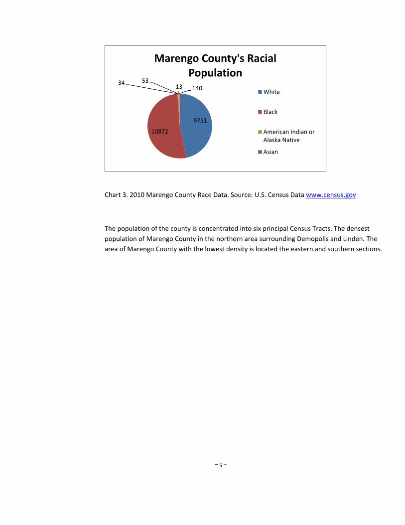
Chart 3 depicts the racial characteristics of Marengo County. The population is made of 46%
White population, 51% African American, and the other 43% is made of other races including
Asian, American Indian, Alaska Native, Native Hawaiian, Pacific Islander or other.
11178
10795
11361
10232
9600
9800
10000
10200
10400
10600
10800
11000
11200
11400
11600
2000 Census 2010 Census
Corporated Population
UnincoporatedPopulation
60
7540
87
2424
139
311 234383
52
7483
98
2123
130 223 258417
0
1000
2000
3000
4000
5000
6000
7000
8000
2000
2010
~ 5 ~
Chart 3. 2010 Marengo County Race Data. Source: U.S. Census Data www.census.gov
The population of the county is concentrated into six principal Census Tracts. The densest
population of Marengo County in the northern area surrounding Demopolis and Linden. The
area of Marengo County with the lowest density is located the eastern and southern sections.
9751
10872
34 5313 140
Marengo County's Racial Population
White
Black
American Indian orAlaska Native
Asian

~ 6 ~
Map 2. 2010 Population by Census Tract in Marengo County, Alabama
d. Economy – According to the 2010 U.S. Census, 49% of Marengo County’s population lives in
unincorporated areas. This has remained relatively unchanged since the 2000 Census. The
percentage of the population that has finished high school (83.7%) or better is higher than
both the state average (82.1%). Marengo County also has below average median and per
capita incomes. The median annual income in Marengo County is $35,079, lower than the
state median income ($40,474). A significantly higher percentage of individuals and families
live below the poverty line (24.0%) when compared to the state average (14.7%). Table 1
summarizes economic data of Marengo County using data from the U.S. Census.
Population 21,027
Male 9,913
Female 11,114
Median Age 41.8
Total Households 8,464
Total Housing Units 10,215
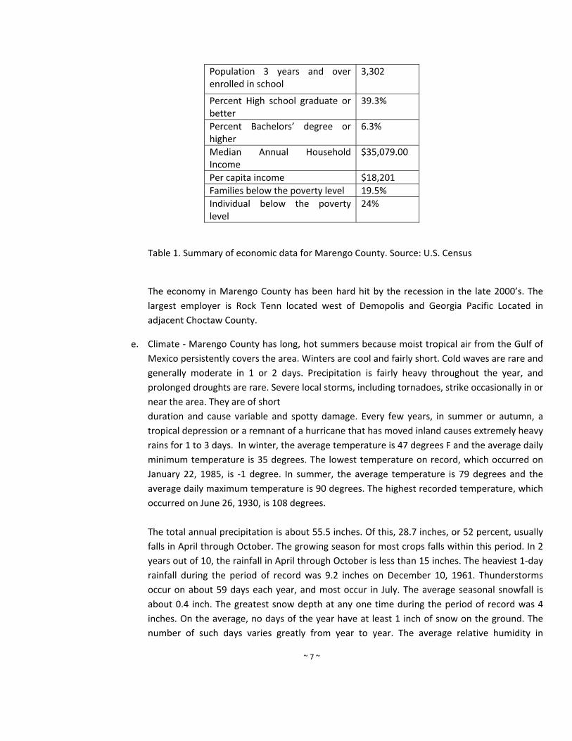
~ 7 ~
Population 3 years and over enrolled in school
3,302
Percent High school graduate or better
39.3%
Percent Bachelors’ degree or higher
6.3%
Median Annual Household Income
$35,079.00
Per capita income $18,201
Families below the poverty level 19.5%
Individual below the poverty level
24%
Table 1. Summary of economic data for Marengo County. Source: U.S. Census
The economy in Marengo County has been hard hit by the recession in the late 2000’s. The
largest employer is Rock Tenn located west of Demopolis and Georgia Pacific Located in
adjacent Choctaw County.
e. Climate ‐ Marengo County has long, hot summers because moist tropical air from the Gulf of
Mexico persistently covers the area. Winters are cool and fairly short. Cold waves are rare and
generally moderate in 1 or 2 days. Precipitation is fairly heavy throughout the year, and
prolonged droughts are rare. Severe local storms, including tornadoes, strike occasionally in or
near the area. They are of short
duration and cause variable and spotty damage. Every few years, in summer or autumn, a
tropical depression or a remnant of a hurricane that has moved inland causes extremely heavy
rains for 1 to 3 days. In winter, the average temperature is 47 degrees F and the average daily
minimum temperature is 35 degrees. The lowest temperature on record, which occurred on
January 22, 1985, is ‐1 degree. In summer, the average temperature is 79 degrees and the
average daily maximum temperature is 90 degrees. The highest recorded temperature, which
occurred on June 26, 1930, is 108 degrees.
The total annual precipitation is about 55.5 inches. Of this, 28.7 inches, or 52 percent, usually
falls in April through October. The growing season for most crops falls within this period. In 2
years out of 10, the rainfall in April through October is less than 15 inches. The heaviest 1‐day
rainfall during the period of record was 9.2 inches on December 10, 1961. Thunderstorms
occur on about 59 days each year, and most occur in July. The average seasonal snowfall is
about 0.4 inch. The greatest snow depth at any one time during the period of record was 4
inches. On the average, no days of the year have at least 1 inch of snow on the ground. The
number of such days varies greatly from year to year. The average relative humidity in
~ 8 ~
midafternoon is about 55 percent. Humidity is higher at night, and the average at dawn is
about 89 percent. The sun shines 67 percent of the time possible in summer and 50 percent in
winter. The prevailing wind is from the south. Average windspeed is highest, 7.8 miles per
hour, in March.
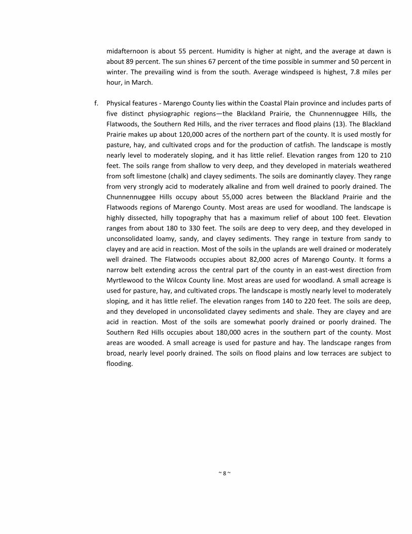
f. Physical features ‐ Marengo County lies within the Coastal Plain province and includes parts of
five distinct physiographic regions—the Blackland Prairie, the Chunnennuggee Hills, the
Flatwoods, the Southern Red Hills, and the river terraces and flood plains (13). The Blackland
Prairie makes up about 120,000 acres of the northern part of the county. It is used mostly for
pasture, hay, and cultivated crops and for the production of catfish. The landscape is mostly
nearly level to moderately sloping, and it has little relief. Elevation ranges from 120 to 210
feet. The soils range from shallow to very deep, and they developed in materials weathered
from soft limestone (chalk) and clayey sediments. The soils are dominantly clayey. They range
from very strongly acid to moderately alkaline and from well drained to poorly drained. The
Chunnennuggee Hills occupy about 55,000 acres between the Blackland Prairie and the
Flatwoods regions of Marengo County. Most areas are used for woodland. The landscape is
highly dissected, hilly topography that has a maximum relief of about 100 feet. Elevation
ranges from about 180 to 330 feet. The soils are deep to very deep, and they developed in
unconsolidated loamy, sandy, and clayey sediments. They range in texture from sandy to
clayey and are acid in reaction. Most of the soils in the uplands are well drained or moderately
well drained. The Flatwoods occupies about 82,000 acres of Marengo County. It forms a
narrow belt extending across the central part of the county in an east‐west direction from
Myrtlewood to the Wilcox County line. Most areas are used for woodland. A small acreage is
used for pasture, hay, and cultivated crops. The landscape is mostly nearly level to moderately
sloping, and it has little relief. The elevation ranges from 140 to 220 feet. The soils are deep,
and they developed in unconsolidated clayey sediments and shale. They are clayey and are
acid in reaction. Most of the soils are somewhat poorly drained or poorly drained. The
Southern Red Hills occupies about 180,000 acres in the southern part of the county. Most
areas are wooded. A small acreage is used for pasture and hay. The landscape ranges from
broad, nearly level poorly drained. The soils on flood plains and low terraces are subject to
flooding.
~ 9 ~
Map 3. Marengo County Digital Elevation Model
Agriculture and forest products have sustained the economy of the county over recorded
history. Textile manufacturing and a few other small industries have also been in the county.
Where cotton was once king, the main agricultural enterprises are now beef cattle and hog
production. Significant growth has also occurred in the pond‐raised catfish and bait‐fish
industry. Timber is produced on about 87 percent of the land area in the county. It provides
raw material for local sawmills and for pulp and paper producers. Woodland also provides
habitat for wild game, such as wild turkey, white‐tailed deer, and feral hogs. This game
attracts hunters from across the Nation. Loblolly pine has largely replaced longleaf pine and
shortleaf pine, which were harvested by the early settlers.
~ 10 ~
Map 4. National Land Cover Database for Marengo County. 2005.
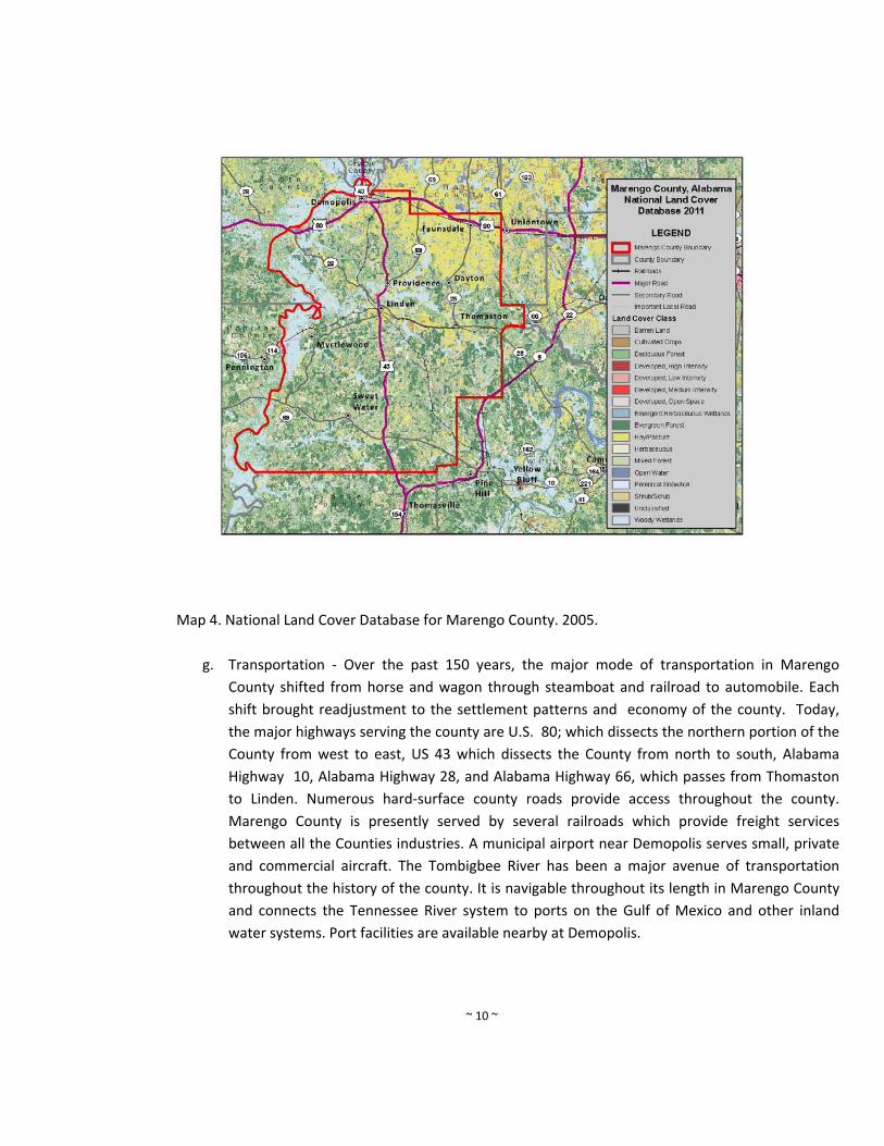
g. Transportation ‐ Over the past 150 years, the major mode of transportation in Marengo
County shifted from horse and wagon through steamboat and railroad to automobile. Each
shift brought readjustment to the settlement patterns and economy of the county. Today,
the major highways serving the county are U.S. 80; which dissects the northern portion of the
County from west to east, US 43 which dissects the County from north to south, Alabama
Highway 10, Alabama Highway 28, and Alabama Highway 66, which passes from Thomaston
to Linden. Numerous hard‐surface county roads provide access throughout the county.
Marengo County is presently served by several railroads which provide freight services
between all the Counties industries. A municipal airport near Demopolis serves small, private
and commercial aircraft. The Tombigbee River has been a major avenue of transportation
throughout the history of the county. It is navigable throughout its length in Marengo County
and connects the Tennessee River system to ports on the Gulf of Mexico and other inland
water systems. Port facilities are available nearby at Demopolis.

~ 11 ~
Map 5. Major Transportation in Marengo County, Alabama. Source: U.S. Tiger Data 2010.
h. Utilities ‐ Electric power is provided by the Alabama Power Company and Black Warrior Power
Company. Water service is provided by the City of Demopolis, the South Marengo County
Water Authority, Town of Thomaston, City of Linden, Tow of Myrtlewood Water System, and
the Town of Faunsdale. There are centralized sanitary sewer service offered in the City of
Demopolis and the City of Linden.
i. What has been updated in this section – Updated data was used to update the County profile.
These data sets include 2010 Census, current land use maps, and recent economic data
provide by Marengo County Chamber of Commerce.
~ 12 ~
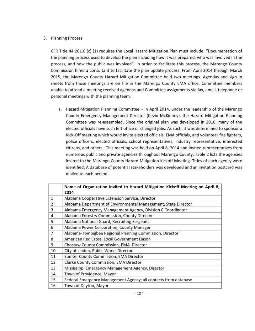
3. Planning Process
CFR Title 44 201.6 (c) (1) requires the Local Hazard Mitigation Plan must include: “Documentation of
the planning process used to develop the plan including how it was prepared, who was involved in the
process, and how the public was involved”. In order to facilitate this process, the Marengo County
Commission hired a consultant to facilitate the plan update process. From April 2014 through March
2015, the Marengo County Hazard Mitigation Committee held two meetings. Agendas and sign in
sheets from those meetings are on file in the Marengo County EMA office. Committee members
unable to attend a meeting received agendas and Committee assignments via fax, email, telephone or
personal meetings with the planning team.
a. Hazard Mitigation Planning Committee – In April 2014, under the leadership of the Marengo
County Emergency Management Director (Kevin McKinney), the Hazard Mitigation Planning
Committee was re‐assembled. Since the original plan was developed in 2010, many of the
elected officials have such left office or changed jobs. As such, it was determined to sponsor a
Kick‐Off meeting which would invite elected officials, EMA officials, and volunteer fire fighters,
police officers, elected officials, school representatives, industry representative, interested
citizens, and others. This meeting was held on April 8, 2014 and invited representatives from
numerous public and private agencies throughout Marengo County. Table 2 lists the agencies
invited to the Marengo County Hazard Mitigation Kickoff Meeting. Titles of each agency were
identified. A database of potential stakeholders was developed and an invitation postcard was
mailed to each person.
Name of Organization Invited to Hazard Mitigation Kickoff Meeting on April 8, 2014
1 Alabama Cooperative Extension Service, Director
2 Alabama Department of Environmental Management, State Director
3 Alabama Emergency Management Agency, Division C Coordinator
4 Alabama Forestry Commission, County Director
5 Alabama National Guard, Recruiting Sergeant
6 Alabama Power Corporation, County Manager
7 Alabama‐Tombigbee Regional Planning Commission, Director
8 American Red Cross, Local Government Liason
9 Choctaw County Commission, EMA Director
10 City of Linden, Public Works Director
11 Sumter County Commission, EMA Director
12 Clarke County Commission, EMA Director
13 Mississippi Emergency Management Agency, Director
14 Town of Providence, Mayor
15 Federal Emergency Management Agency, all contacts from database
16 Town of Dayton, Mayor
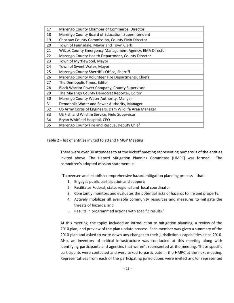
~ 13 ~
17 Marengo County Chamber of Commerce, Director
18 Marengo County Board of Education, Superintendent
19 Choctaw County Commission, County EMA Director
20 Town of Faunsdale, Mayor and Town Clerk
21 Wilcox County Emergency Management Agency, EMA Director
22 Marengo County Health Department, County Director
23 Town of Myrtlewood, Mayor
24 Town of Sweet Water, Mayor
25 Marengo County Sherriff’s Office, Sherriff
26 Marengo County Volunteer Fire Departments, Chiefs
27 The Demopolis Times, Editor
28 Black Warrior Power Company, County Supervisor
29 The Marengo County Democrat Reporter, Editor
30 Marengo County Water Authority, Manger
31 Demopolis Water and Sewer Authority, Manager
32 US Army Corps of Engineers, Dam Wildlife Area Manager
33 US Fish and Wildlife Service, Field Supervisor
34 Bryan Whitfield Hospital, CEO
35 Marengo County Fire and Rescue, Deputy Chief
Table 2 – list of entities invited to attend HMGP Meeting
There were over 30 attendees to at the Kickoff meeting representing numerous of the entities
invited above. The Hazard Mitigation Planning Committee (HMPC) was formed. The
committee's adopted mission statement is:
‘To oversee and establish comprehensive hazard mitigation planning process that:
1. Engages public participation and support;
2. Facilitates Federal, state, regional and local coordinator
3. Constantly monitors and evaluates the potential risks of hazards to life and property;
4. Actively mobilizes all available community resources and measures to mitigate the
threats of hazards; and
5. Results in programmed actions with specific results.’
At this meeting, the topics included an introduction to mitigation planning, a review of the
2010 plan, and preview of the plan update process. Each member was given a summary of the
2010 plan and asked to write down any changes to their jurisdiction’s capabilities since 2010.
Also, an inventory of critical infrastructure was conducted at this meeting along with
identifying participants and agencies that weren’t represented at the meeting. These specific
participants were contacted and were asked to participate in the HMPC at the next meeting.
Representatives from each of the participating jurisdictions were invited and/or represented
~ 14 ~
at each of the meetings. The jurisdiction that were represented at the meeting include the
Sweetwater Volunteer Fire Department (representing both the Town of Sweetwater and
Volunteer Fire Department), Brian Whitfield hospital in Demopolis, the Old Spring Hill
Volunteer Fire Department, the Marengo County Sherriff’s Department, the Marengo County
Department of Public Health, City of Demopolis, City of Demopolis Police Department, City of
Demopolis Fire Department, City of Linden, Alabama Forestry Commission, Town of
Myrtlewood, Town of Thomaston, Marengo County Commission and Town of Faunsdale.
The Town of Dayton and Town of Providence did not participate. These towns are have a very
small population and do not have active mayors or councils. The Marengo County EMA
director maintains a good relationship with the community will contact them in regarding any
emergency services.
The attendees were handed out a stakeholder survey that contained the following three
questions:
1. Who should be involved in this process and is not at the kickoff meeting? The Update to
the Marengo County Hazard Mitigation Plan should include all aspects‐ i.e. public
agencies, private businesses, and non‐profit organizations. Please include contact
information if available.
2. What in your opinion are the vulnerable areas of Marengo County to a hazard? In other
words, what should be protected?
a. Building Stock
b. Critical Facilities
c. Transportation Systems
d. Lifeline Utility Systems
e. Communication Systems
f. High Potential Loss Facility
g. Hazardous Material Facility
h. Economic Elements
i. Historical, Environmental, and Cultural Resource Areas
3. In light of the tornadoes in April, what types of actions are necessary to improve
Marengo County’s response to hazard events?
a. Prevention
b. Property Protection
c. Public Education and Awareness
d. Natural Resource Protection
~ 15 ~
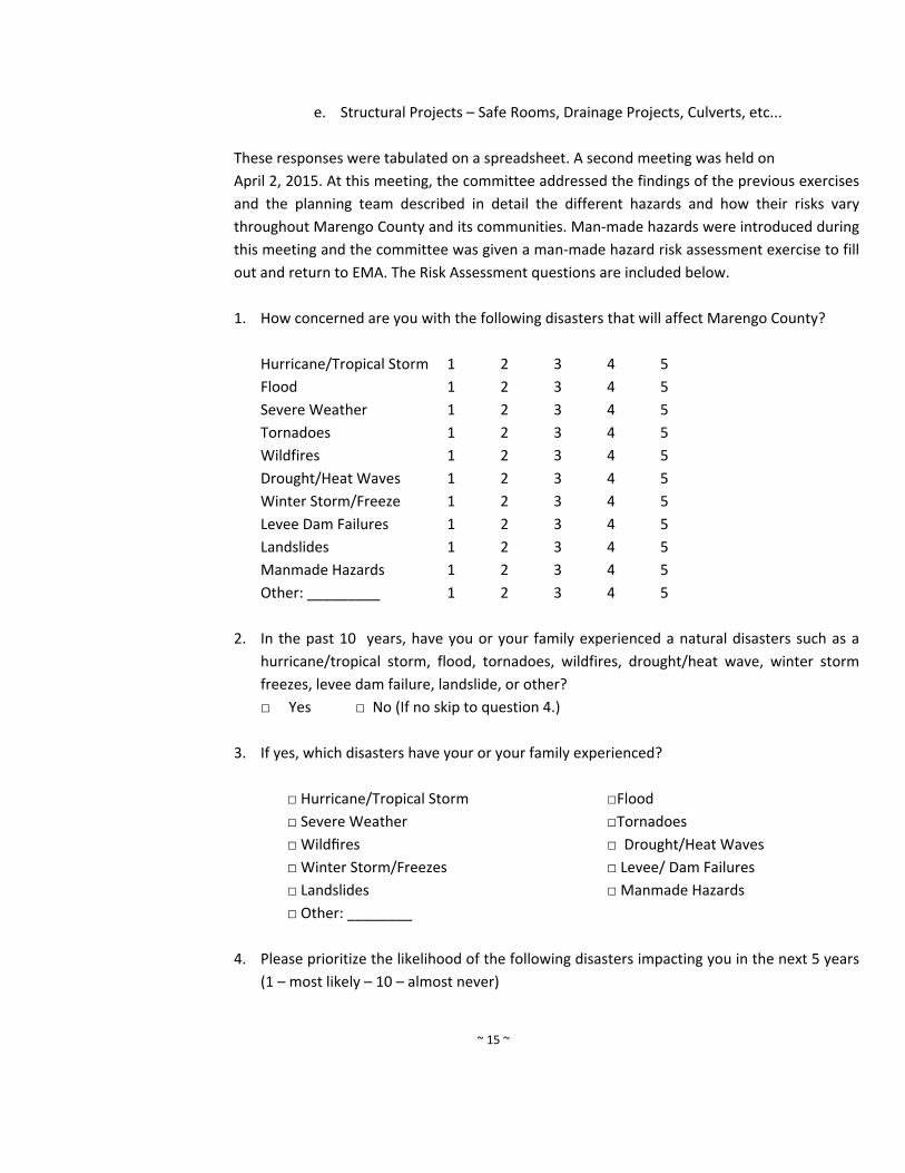
e. Structural Projects – Safe Rooms, Drainage Projects, Culverts, etc...
These responses were tabulated on a spreadsheet. A second meeting was held on
April 2, 2015. At this meeting, the committee addressed the findings of the previous exercises
and the planning team described in detail the different hazards and how their risks vary
throughout Marengo County and its communities. Man‐made hazards were introduced during
this meeting and the committee was given a man‐made hazard risk assessment exercise to fill
out and return to EMA. The Risk Assessment questions are included below.
1. How concerned are you with the following disasters that will affect Marengo County?
Hurricane/Tropical Storm 1 2 3 4 5
Flood 1 2 3 4 5
Severe Weather 1 2 3 4 5
Tornadoes 1 2 3 4 5
Wildfires 1 2 3 4 5
Drought/Heat Waves 1 2 3 4 5
Winter Storm/Freeze 1 2 3 4 5
Levee Dam Failures 1 2 3 4 5
Landslides 1 2 3 4 5
Manmade Hazards 1 2 3 4 5
Other: _________ 1 2 3 4 5
2. In the past 10 years, have you or your family experienced a natural disasters such as a
hurricane/tropical storm, flood, tornadoes, wildfires, drought/heat wave, winter storm
freezes, levee dam failure, landslide, or other?
□ Yes □ No (If no skip to question 4.)
3. If yes, which disasters have your or your family experienced?
□ Hurricane/Tropical Storm □Flood
□ Severe Weather □Tornadoes
□ Wildfires □ Drought/Heat Waves
□ Winter Storm/Freezes □ Levee/ Dam Failures
□ Landslides □ Manmade Hazards
□ Other: ________
4. Please prioritize the likelihood of the following disasters impacting you in the next 5 years
(1 – most likely – 10 – almost never)
~ 16 ~
a. Hurricane/Tropical Storm ________
b. Flood ________
c. Severe Weather ________
d. Tornadoes ________
e. Wildfires ________
f. Drought/Heat Waves ________
g. Winter Storm/Freezes ________
h. Levee Dam Failures ________
i. Landslides ________
j. Manmade Hazards ________
k. Other: _________ ________
The results from this exercise were tallied and used in the risk assessment.
The final public meeting was held on April 2, 2015 and presented the results from the risk
assessment along with mitigation strategies for each participating jurisdiction. All
representatives who attended the meetings were participants on committee. The consultant
developed the meeting agendas following guidance provided by the Local Mitigation Plan
Review Guide date October 1, 2011. The consultant developed the draft plan and it was
reviewed the EMA Director (Kevin McKinney) along with other planning consultants. All
meeting attendees were involved in the plan development process. Please find a detailed
description below of the jurisdictions that are new, continuing, or no longer participating in
the Hazard Mitigation planning process. Each chapter of the plan was reviewed and updated
by the Marengo County Multi‐Hazard Mitigation committee.
New Participating Jurisdictions
None.
Continuing Jurisdictions
1. Marengo County Commission
2. City of Demopolis
3. Town of Faunsdale
4. City of Linden
5. Town of Myrtlewood
6. Town of Sweet Water
7. Town of Thomaston
Jurisdictions that are no longer participating
1. Town of Dayton
~ 17 ~
2. Town of Providence
Please note the EMA Director will maintain contact with these entities as the
process moves forward.
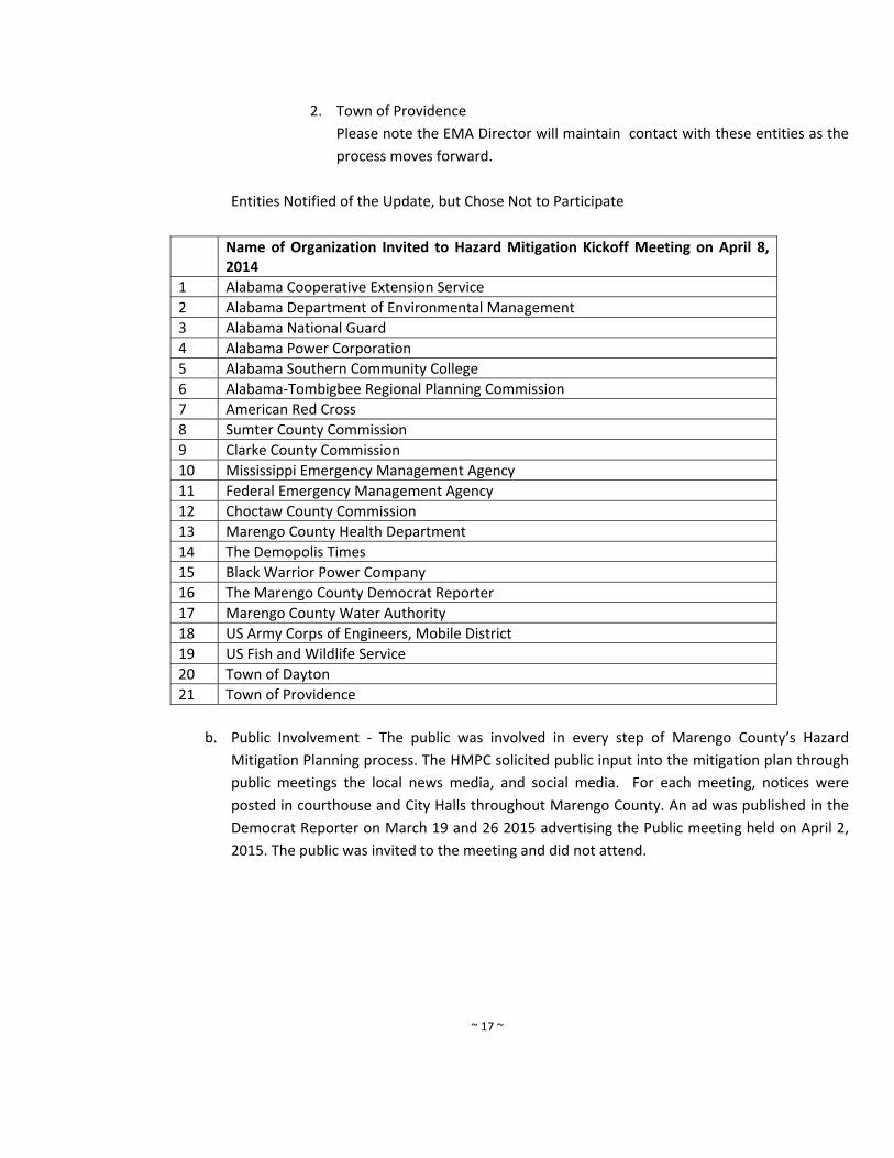
Entities Notified of the Update, but Chose Not to Participate
Name of Organization Invited to Hazard Mitigation Kickoff Meeting on April 8, 2014
1 Alabama Cooperative Extension Service
2 Alabama Department of Environmental Management
3 Alabama National Guard
4 Alabama Power Corporation
5 Alabama Southern Community College
6 Alabama‐Tombigbee Regional Planning Commission
7 American Red Cross
8 Sumter County Commission
9 Clarke County Commission
10 Mississippi Emergency Management Agency
11 Federal Emergency Management Agency
12 Choctaw County Commission
13 Marengo County Health Department
14 The Demopolis Times
15 Black Warrior Power Company
16 The Marengo County Democrat Reporter
17 Marengo County Water Authority
18 US Army Corps of Engineers, Mobile District
19 US Fish and Wildlife Service
20 Town of Dayton
21 Town of Providence
b. Public Involvement ‐ The public was involved in every step of Marengo County’s Hazard
Mitigation Planning process. The HMPC solicited public input into the mitigation plan through
public meetings the local news media, and social media. For each meeting, notices were
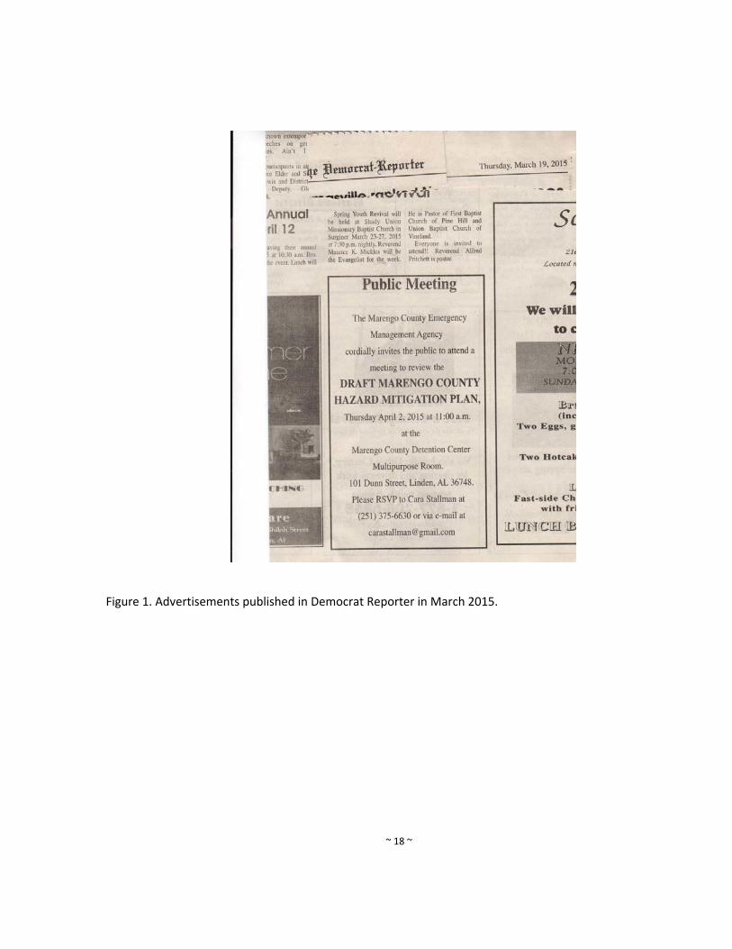
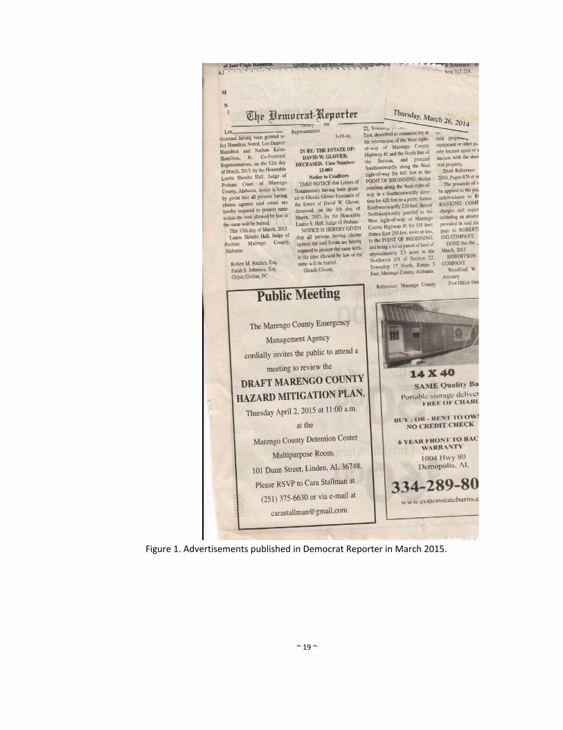
posted in courthouse and City Halls throughout Marengo County. An ad was published in the
Democrat Reporter on March 19 and 26 2015 advertising the Public meeting held on April 2,
2015. The public was invited to the meeting and did not attend.
~ 18 ~
Figure 1. Advertisements published in Democrat Reporter in March 2015.
~ 19 ~
Figure 1. Advertisements published in Democrat Reporter in March 2015.
~ 20 ~
Last, prior to adopting the plan, each jurisdiction will hold a public hearing at each of their
Commission and Council meeting. These meetings will be held after Marengo County receives
its approval letter from FEMA.
c. Interagency and intergovernmental coordination – As stated in the part a above, numerous
federal, state, regional and local agencies were invited to the kickoff meeting. Participation
was encouraged through mailings, e‐mail and follow‐up phone calls. In sum, there were over
25 agencies represented through the planning process either directly or indirectly.
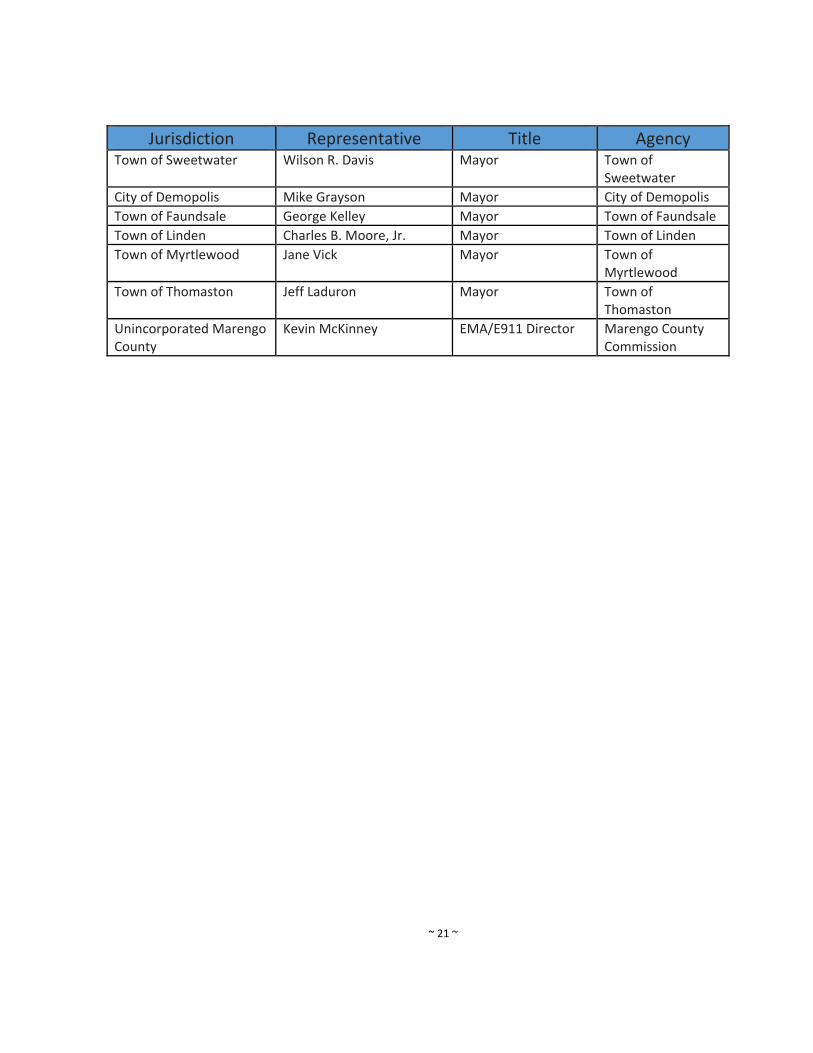
d. Participating jurisdictions ‐ All jurisdictions within Marengo County have participated in the
planning process by direct representation on the planning committee or through informal
review. Each entity has committed to adopting the final plan by formal resolution. These
jurisdictions include the municipalities of Demopolis, Linden, Myrtlewood, Sweet Water, and
Thomaston. Dayton and Providence did not participate. (see attached table).
e. Integration with existing plans ‐ This document will be incorporated into the Marengo County
Emergency Operations Plan administered through the Emergency Management Agency office.
Numerous other plans were identified throughout the planning process however, no plans
have regulatory jurisdiction over any area countywide throughout Marengo County. For
example, there are no building codes enforced in Marengo County nor any comprehensive or
zoning plans. However, there are many plans that indirectly coordinate with the Marengo
County Hazard Mitigation Plan. These plans were checked to make sure any of the proposed
policies in the Marengo County Hazard Mitigation Plan does not conflict with these existing
plans. These plans include:
Marengo County Emergency Operations Plan
U.S. 2010 Census Alabama State Data Center Population Projections 2000‐2025
NOAA and NWS records: past occurrence data
Flood Insurance Rate Maps
Forest Statistics for Alabama
State of Alabama State Hazard Mitigation Plan
Geological Hazards Information for the Geological Survey of Alabama
Marengo County Soil Survey
f. What has been updated in this section ‐ This section contains a variety of organizational and
basic information that deals with the update process. This information had to be revised in
order to document the update process. The Marengo County Commission reviewed this
section and made all revisions. The revised areas include an Outlined Natural Hazards Steering
Committee’s involvement in update process, Outlined public involvement process in plan
update, Updated Interagency and Intergovernmental Coordination Section, Updated
participated jurisdictions, and updated reports and information sources that were consulted.
~ 21 ~
Jurisdiction Representative Title Agency Town of Sweetwater Wilson R. Davis Mayor Town of
Sweetwater
City of Demopolis Mike Grayson Mayor City of Demopolis
Town of Faundsale George Kelley Mayor Town of Faundsale
Town of Linden Charles B. Moore, Jr. Mayor Town of Linden
Town of Myrtlewood Jane Vick Mayor Town of Myrtlewood
Town of Thomaston Jeff Laduron Mayor Town of Thomaston
Unincorporated Marengo County
Kevin McKinney EMA/E911 Director Marengo County Commission
~ 22 ~
4. Risk Assessment
a. Risk Assessment Process ‐ This risk assessment identifies all natural hazards affecting Marengo
County. It provides information on the history and extent of hazards, evaluates the possible
effects, identifies vulnerable populations and assets (buildings, critical facilities, and essential
infrastructure), and estimates potential losses that might occur. The risk assessment process
identifies the most critical problems and issues that require mitigation actions.
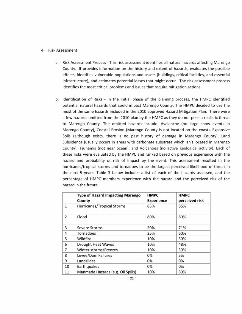
b. Identification of Risks ‐ In the initial phase of the planning process, the HMPC identified
potential natural hazards that could impact Marengo County. The HMPC decided to use the
most of the same hazards included in the 2010 approved Hazard Mitigation Plan. There were
a few hazards omitted from the 2010 plan by the HMPC as they do not pose a realistic threat
to Marengo County. The omitted hazards include: Avalanche (no large snow events in
Marengo County), Coastal Erosion (Marengo County is not located on the coast), Expansive
Soils (although exists, there is no past history of damage in Marengo County), Land
Subsidence (usually occurs in areas with carbonate substrate which isn’t located in Marengo
County), Tsunamis (not near ocean), and Volcanoes (no active geological activity). Each of
these risks were evaluated by the HMPC and ranked based on previous experience with the
hazard and probability or risk of impact by the event. This assessment resulted in the
hurricanes/tropical storms and tornadoes to be the largest perceived likelihood of threat in
the next 5 years. Table 3 below includes a list of each of the hazards assessed, and the
percentage of HMPC members experience with the hazard and the perceived risk of the
hazard in the future.
Type of Hazard Impacting Marengo County
HMPC Experience
HMPC perceived risk
1 Hurricanes/Tropical Storms
85% 85%
2 Flood
80% 80%
3 Severe Storms 50% 71%
4 Tornadoes 25% 60%
5 Wildfire 10% 50%
6 Drought Heat Waves 10% 48%
7 Winter storms/Freezes 10% 39%
8 Levee/Dam Failures 0% 5%
9 Landslides 0% 0%
10 Earthquakes 0% 0%
11 Manmade Hazards (e.g. Oil Spills) 10% 80%

~ 23 ~
Table 3. Assessment of Perceived Risk of from Hazards
c. Federally‐declared disasters ‐ Marengo County has been included in a total of 11 federal
disaster declarations from 1973 to date. Table 4 summarized the federal disaster declarations
that have taken place in Marengo County since the 1970’s.
Disaster Number
Type Date of Declaration
1 369 Tornado 4/5/1973
2 458 Flood 3/14/1975
3 3045 Drought 8/16/1977
4 3074 Flood 3/17/1979
5 578 Flood 4/18/1979
6 598 Hurricane Frederik 9/13/1979
7 861 Severe Storms 4/7/1990
8 1466 Severe Storms, Tornadoes and Flooding
5/12/2003
9 3096 Snow Storm 3/15/1993
10 1185 Severe Storm 7/25/1997
11 1250 Hurricane Georges 10/13/1998
12 1549 Hurricane Ivan 9/15/2004
13 193 Hurricane Dennis 7/10/2005
13 1605 Hurricane Katrina 8/25/2005
14 1971 Tornadoes 4/15/2011 and 4/29/2011
Table 4. Summary of Federal Disasters in Marengo County, Alabama
d. Hurricane/Tropical Storm
Hazard Description ‐ A "tropical cyclone" is a generic term for a cyclonic, low‐pressure system
over tropical or sub‐tropical waters. Tropical cyclones with maximum sustained winds of less
than 39 mph are called tropical depressions. A tropical storm is a cyclone with maximum
sustained winds greater than 39 mph but less than 74 mph, and a tropical storm with winds
that have reached a constant speed of 74 miles per hour or more is a hurricane. Coastal
Alabama borders a part of the northern Gulf of Mexico that has a high incidence of hurricanes
causing wind and water damage in Marengo County.
Though the center of Marengo County is located approximately 150 miles from the Gulf of
Mexico, hurricanes and tropical storms sometimes bring high winds and heavy rains to the
area as they move north. Table 5 lists the major hurricanes/tropical storms that have
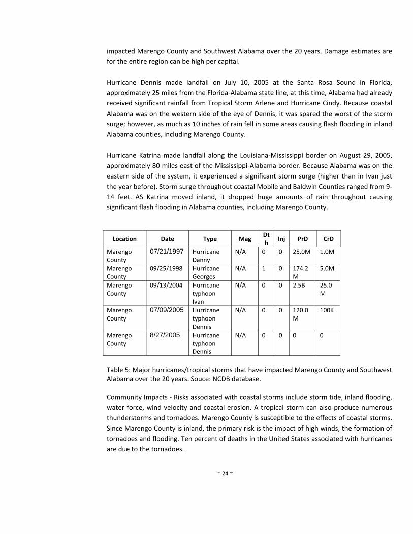
~ 24 ~
impacted Marengo County and Southwest Alabama over the 20 years. Damage estimates are
for the entire region can be high per capital.
Hurricane Dennis made landfall on July 10, 2005 at the Santa Rosa Sound in Florida,
approximately 25 miles from the Florida‐Alabama state line, at this time, Alabama had already
received significant rainfall from Tropical Storm Arlene and Hurricane Cindy. Because coastal
Alabama was on the western side of the eye of Dennis, it was spared the worst of the storm
surge; however, as much as 10 inches of rain fell in some areas causing flash flooding in inland
Alabama counties, including Marengo County.
Hurricane Katrina made landfall along the Louisiana‐Mississippi border on August 29, 2005,
approximately 80 miles east of the Mississippi‐Alabama border. Because Alabama was on the
eastern side of the system, it experienced a significant storm surge (higher than in Ivan just
the year before). Storm surge throughout coastal Mobile and Baldwin Counties ranged from 9‐
14 feet. AS Katrina moved inland, it dropped huge amounts of rain throughout causing
significant flash flooding in Alabama counties, including Marengo County.
Location Date Type Mag Dth
Inj PrD CrD
Marengo County
07/21/1997 Hurricane Danny
N/A 0 0 25.0M 1.0M
Marengo County
09/25/1998 Hurricane Georges
N/A 1 0 174.2M
5.0M
Marengo County
09/13/2004 Hurricanetyphoon Ivan
N/A 0 0 2.5B 25.0M
Marengo County
07/09/2005 Hurricanetyphoon Dennis
N/A 0 0 120.0M
100K
Marengo County
8/27/2005 Hurricanetyphoon Dennis
N/A 0 0 0 0
Table 5: Major hurricanes/tropical storms that have impacted Marengo County and Southwest Alabama over the 20 years. Souce: NCDB database. Community Impacts ‐ Risks associated with coastal storms include storm tide, inland flooding,
water force, wind velocity and coastal erosion. A tropical storm can also produce numerous
thunderstorms and tornadoes. Marengo County is susceptible to the effects of coastal storms.
Since Marengo County is inland, the primary risk is the impact of high winds, the formation of
tornadoes and flooding. Ten percent of deaths in the United States associated with hurricanes
are due to the tornadoes.
~ 25 ~
Impact means the consequence or effects of the hazard on people, structures, facilities,
systems, capabilities, or activities. The impact of a tropical storm/hurricane can be damage to
structures, facilities, utility lines from falling debris, lack of power for extended period of time,
no access to remote areas due to downed trees and blocked roads, and emergencies services
can be suspended, damage to infrastructure from wind (i.e. roof damage), and road damage
due to localized flooding from heavy rain events. This damage can happen in each jurisdiction
located within Marengo County.
Location and Extent ‐ All areas in Marengco County vulnerable to impacts from Hurricanes
and Tropical Storms. Extent is the strength or magnitude of the hazard. Extent of a hurricane
can be described using the Saffir‐Simpson Scale.
Category One (Sustained winds 74‐95 mph, 64‐82 kt, or 119‐153 km/hr). Very
dangerous winds will produce some damage
Category Two (Sustained winds 96‐110 mph, 83‐95 kt, or 154‐177 km/hr). Extremely
dangerous winds will cause extensive damage
Category Three (Sustained winds 111‐130 mph, 96‐113 kt, or 178‐209
km/hr).Devastating damage will occur
Category Four (Sustained winds 131‐155 mph, 114‐135 kt, or 210‐249 km/hr).
Catastrophic damage will occur
Category Five (Sustained winds greater than 155 mph, greater than 135 kt, or greater
than 249 km/hr).Catastrophic damage will occur.
The extent for this hazard is a Category 5 hurricane leading to catastrophic damage, sustained
winds, greater than 155mph, heavy flood and wind damage, loss of life, injuries, temporary
loss of utilities, and timber loss.
Probability of Future Occurrences ‐ Marengo County is highly susceptible to hurricanes and
tropical storms. Based on historical data, Marengo County can expect a hurricane once every
two years, or 50% of the time. Another analysis was conducted by the Atlantic Oceanographic
and Meteorological Laboratory. The organization analyzed hurricane activity from 1944‐1999.
This study resulted in a map showing probabilities of a strike that will affect the during the
hurricane season. Figure 2 depicts the results of this analysis.
~ 26 ~
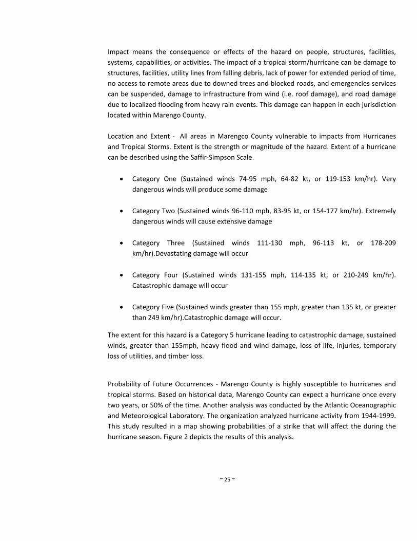
Figure 2. Empirical Probability of a Named Storm – note Marengo County is noted as having a
36% chance of being hit by a Named Storm. http://www.aoml.noaa.gov/hrd/tcfaq/G12.html
e. Flood
Hazard description ‐ Flooding is the accumulation of water within a water body (e.g., stream,
river, lake, or reservoir) and the overflow of excess water onto adjacent floodplains.
Floodplains are usually lowlands adjacent to water bodies that are subject to recurring floods.
Marengo County is a slight risk to moderate risk of flooding. Flooding in large rivers usually
results from large‐scale weather systems that generate prolonged rainfall over wide areas.
Small rivers and streams are susceptible to flooding from more localized weather systems that
cause intense rainfall over small areas.
"Flash flood" is a term widely used by flood experts and the general population. However,
there is no single definition and method to distinguish flash flooding from riverine and other
floods. For the purpose of this plan, we will define flash flooding as flooding that occurs due
to localized drainage and is outside the boundaries of the FIRM floodplain.
~ 27 ~
Local drainage floods may occur outside of recognized drainage channels or delineated
floodplains for a variety of reasons, including concentrated local precipitation, a lack of
infiltration, inadequate facilities for drainage and storm water conveyance, and/or increased
surface runoff. Such events often occur in flat areas, particularly during winter and spring in
areas with frozen ground, and also in urbanized areas with large impermeable surfaces. High
groundwater flooding is a seasonal occurrence in some areas, but may occur in other areas
after prolonged periods of above‐average precipitation.
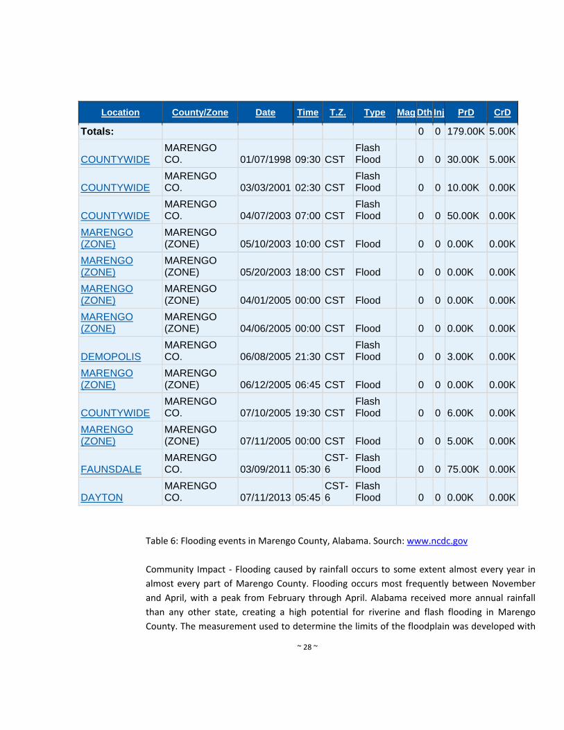
Hazard History ‐ Since 1996, there have been several major flooding events in Marengo
County according to the National Climate Data Center. Table 6 lists each of these events. The
NCDC Storm Events Database provides the following details on a flood event in 1996: ‘Rainfall
of up to eight inches caused many roads in the northwest part of the county to be closed. The
storm that caused the heavy rains remained almost stationary over Marengo County for
most of the morning then slowly moved southeast during the afternoon. Most of the roads
that had to be closed were dirt roads. The roads remained closed into the early evening hours,
associated with a hurricanes or tropical storms. Table 6 includes a list of the 13 recent
flooding events in Marengo County (Source: NCDC database).
~ 28 ~
Location County/Zone Date Time T.Z. Type Mag Dth Inj PrD CrD
Totals: 0 0 179.00K 5.00K
COUNTYWIDE
MARENGO CO. 01/07/1998 09:30 CST
Flash Flood 0 0 30.00K 5.00K
COUNTYWIDE
MARENGO CO. 03/03/2001 02:30 CST
Flash Flood 0 0 10.00K 0.00K
COUNTYWIDE
MARENGO CO. 04/07/2003 07:00 CST
Flash Flood 0 0 50.00K 0.00K
MARENGO (ZONE)
MARENGO (ZONE) 05/10/2003 10:00 CST Flood 0 0 0.00K 0.00K
MARENGO (ZONE)
MARENGO (ZONE) 05/20/2003 18:00 CST Flood 0 0 0.00K 0.00K
MARENGO (ZONE)
MARENGO (ZONE) 04/01/2005 00:00 CST Flood 0 0 0.00K 0.00K
MARENGO (ZONE)
MARENGO (ZONE) 04/06/2005 00:00 CST Flood 0 0 0.00K 0.00K
DEMOPOLIS
MARENGO CO. 06/08/2005 21:30 CST
Flash Flood 0 0 3.00K 0.00K
MARENGO (ZONE)
MARENGO (ZONE) 06/12/2005 06:45 CST Flood 0 0 0.00K 0.00K
COUNTYWIDE
MARENGO CO. 07/10/2005 19:30 CST
Flash Flood 0 0 6.00K 0.00K
MARENGO (ZONE)
MARENGO (ZONE) 07/11/2005 00:00 CST Flood 0 0 5.00K 0.00K
FAUNSDALE
MARENGO CO. 03/09/2011 05:30
CST-6
Flash Flood 0 0 75.00K 0.00K
DAYTON
MARENGO CO. 07/11/2013 05:45
CST-6
Flash Flood 0 0 0.00K 0.00K
Table 6: Flooding events in Marengo County, Alabama. Sourch: www.ncdc.gov
Community Impact ‐ Flooding caused by rainfall occurs to some extent almost every year in
almost every part of Marengo County. Flooding occurs most frequently between November
and April, with a peak from February through April. Alabama received more annual rainfall
than any other state, creating a high potential for riverine and flash flooding in Marengo
County. The measurement used to determine the limits of the floodplain was developed with

~ 29 ~
the enactment of the National Flood Insurance Act of 1968 (NFIP). Under the NFIP it was
determined that the base standard was the 100‐year or "base flood". This means that the
limits of the flood plain arc set by the limits of a rain event that has a 1% annual chance of
occurrence. There are established techniques for determining the base flood limits. These
techniques have been used to develop Flood Insurance Rate Maps or FIRMs. FIRMs illustrate
elevation of the base flood and the 500‐year event (0.2% annual chance of occurrence) in
areas where a model has been developed.
The risks associated with flash flooding are the same as riverine flooding. One clear
distinction is the element of surprise. Flash flooding, as the name implies, occurs quickly and
without much warning. In riverine flooding, the time and height of the crest can be accurately
predicted, and warnings can be issued several hours in advance. The National Flood Insurance
Program’s Flood Insurance Rate Maps (FIRMs) for the county were consulted to determine if
there was a flood risk. The risks associated with flash flooding are the same as riverine
flooding. There are no repetitive loss properties in Marengo County.
Impact means the consequence or effects of the hazard on people, structures, facilities,
systems, capabilities, or activities. The impact of flooding can be damage to houses and
buildings from rising water, lack of access to remote areas due to downed trees and blocked
roads, and emergencies services can be suspended. This damage can happen in each
jurisdiction located within Marengo County.
Location and Extent ‐ Most flooding occurs within the Tombigbee River floodplain, which runs
along the western boundary of the County. Further, the Town of Providence is largely within a
FEMA‐designated flood zone. Faunsdale, Myrtlewood, Dayton, Sweetwater, Linden and
Thomaston have little or no flood areas. Approximately 15% of the City of Demopolis is
located in flood‐prone areas and the Town of Providence is almost entirely located within a
flood zone. There are very little populated areas located within a flood zone in unincorporated
Marengo County.
Marengo County has experienced some flood damages, however due to the rural nature of
County, flooding is not a major problem. Most flooding is of flash type, along streams and
tributaries. Flooding and heavy rain both have also been known to cause major road damage.
Floodwaters that cover the surface of the road often result in the base of the road washing
away and surface asphalt cracking or failing. Failure of the roads can lead to utility damages.
As shown by the flood in 1998, Marengo County is susceptible to major damage from flooding.
Floods are capable of undermining buildings and bridges, eroding shorelines and riverbanks,
tearing out trees, washing out access routes, and causing loss of life and injuries. Floods occur
in all 50 states and FEMA estimates that 9 million households and $390 billion in property are
at risk from flooding. The location of flood‐prone areas are located within the 100‐year
~ 30 ~
floodplain as determined by the FEMA flood maps. The date of the most recent published
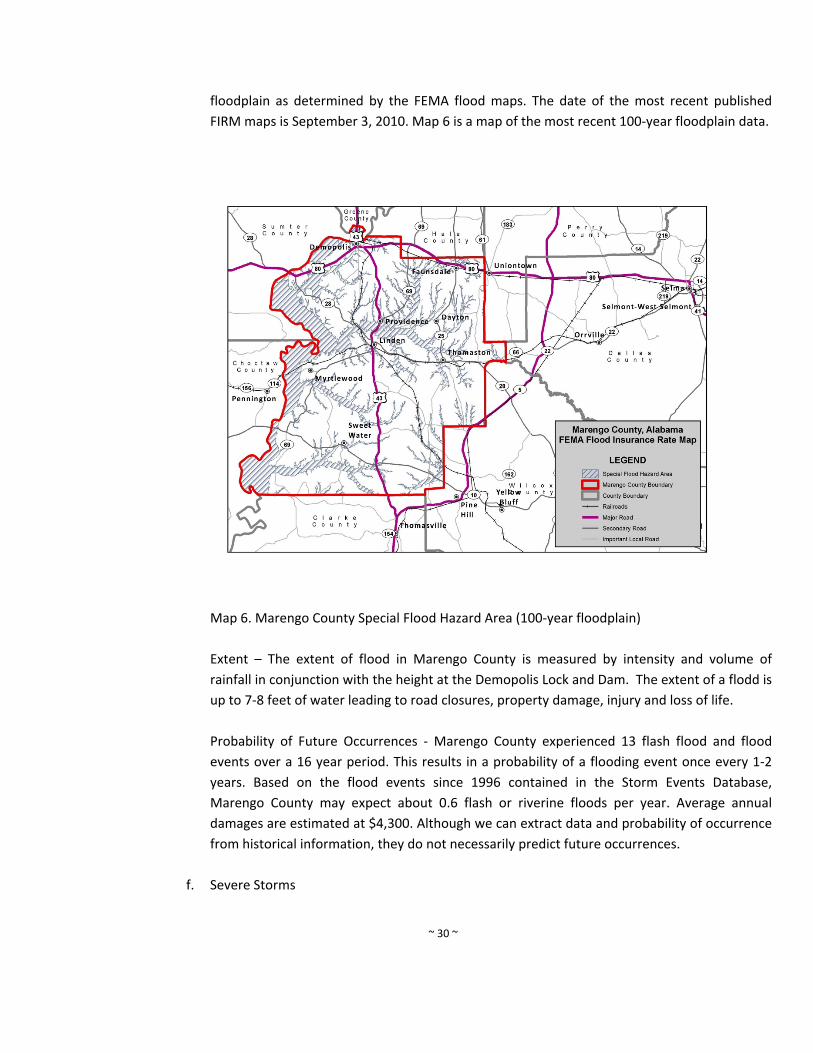
FIRM maps is September 3, 2010. Map 6 is a map of the most recent 100‐year floodplain data.
Map 6. Marengo County Special Flood Hazard Area (100‐year floodplain)
Extent – The extent of flood in Marengo County is measured by intensity and volume of
rainfall in conjunction with the height at the Demopolis Lock and Dam. The extent of a flodd is
up to 7‐8 feet of water leading to road closures, property damage, injury and loss of life.
Probability of Future Occurrences ‐ Marengo County experienced 13 flash flood and flood
events over a 16 year period. This results in a probability of a flooding event once every 1‐2
years. Based on the flood events since 1996 contained in the Storm Events Database,
Marengo County may expect about 0.6 flash or riverine floods per year. Average annual
damages are estimated at $4,300. Although we can extract data and probability of occurrence
from historical information, they do not necessarily predict future occurrences.
f. Severe Storms
~ 31 ~
Hazard Description ‐ A severe thunderstorm is a storm containing damaging winds of at least
58 miles per hour or hail that measures a minimum of three‐fourths of an inch in diameter.
All severe thunderstorms contain intense lightning and straight‐line or downburst winds that
can be extremely strong and concentrated. Falling rain and sinking air create these winds that
can reach speeds as high as 125 mph.
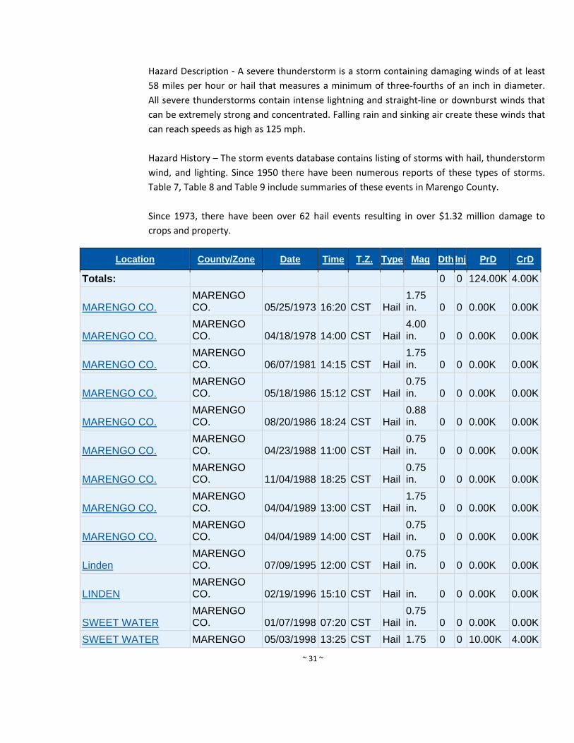
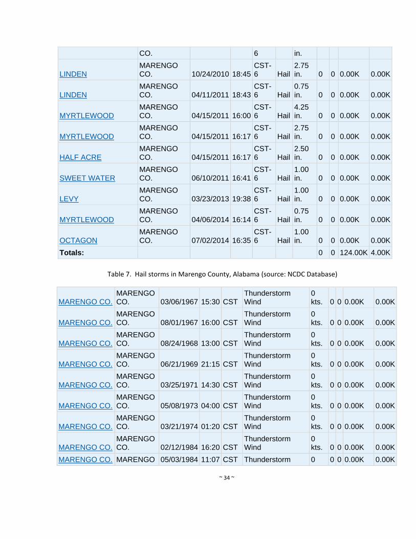
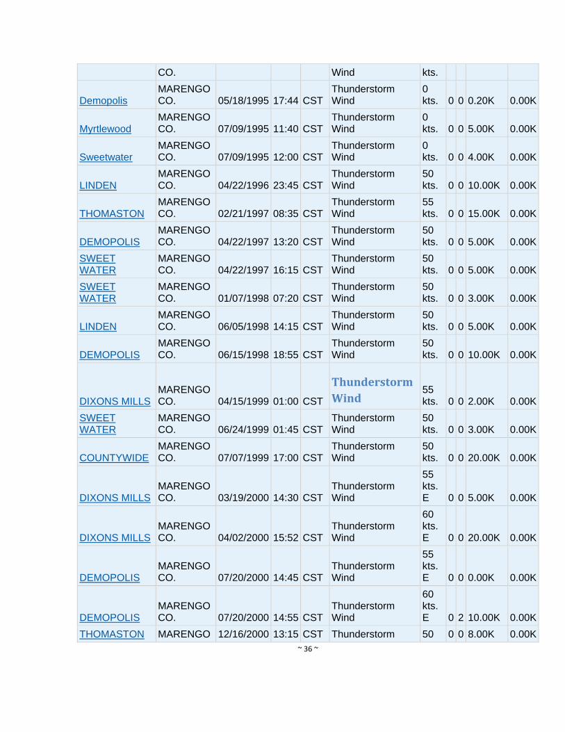
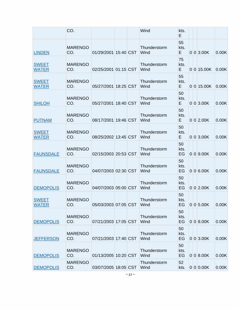
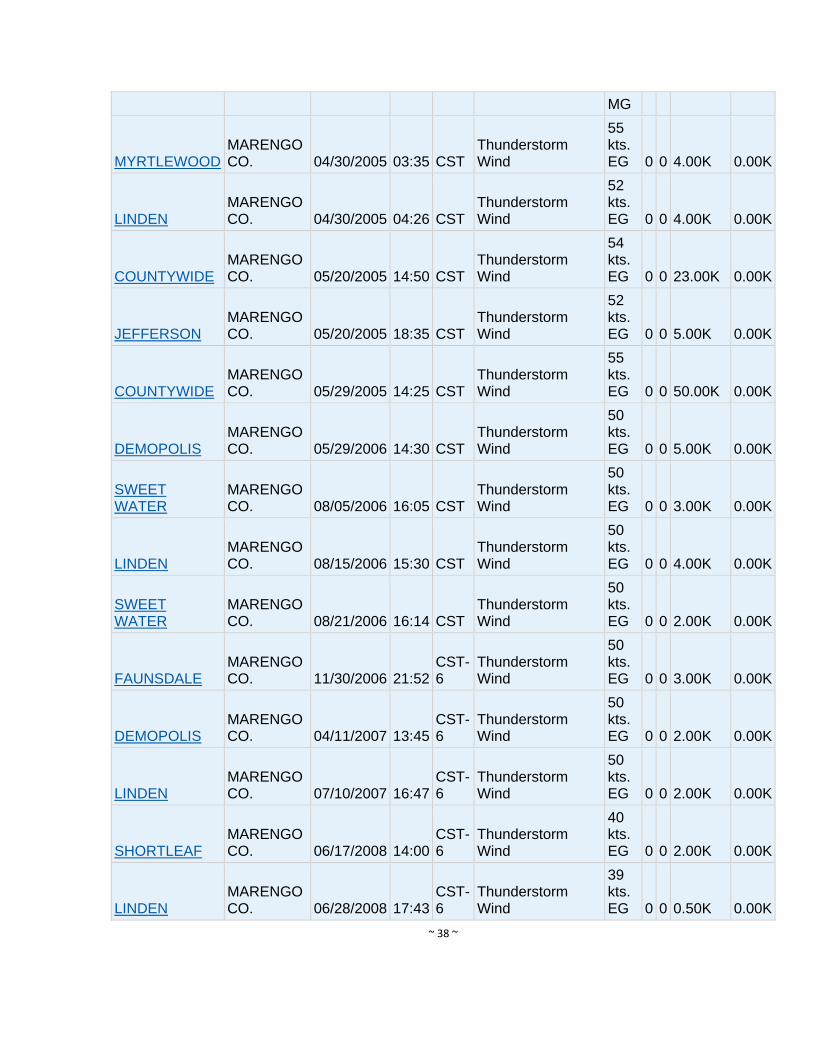
Hazard History – The storm events database contains listing of storms with hail, thunderstorm
wind, and lighting. Since 1950 there have been numerous reports of these types of storms.
Table 7, Table 8 and Table 9 include summaries of these events in Marengo County.
Since 1973, there have been over 62 hail events resulting in over $1.32 million damage to
crops and property.
Location County/Zone Date Time T.Z. Type Mag Dth Inj PrD CrD
Totals: 0 0 124.00K 4.00K
MARENGO CO.
MARENGO CO. 05/25/1973 16:20 CST Hail
1.75 in. 0 0 0.00K 0.00K
MARENGO CO.
MARENGO CO. 04/18/1978 14:00 CST Hail
4.00 in. 0 0 0.00K 0.00K
MARENGO CO.
MARENGO CO. 06/07/1981 14:15 CST Hail
1.75 in. 0 0 0.00K 0.00K
MARENGO CO.
MARENGO CO. 05/18/1986 15:12 CST Hail
0.75 in. 0 0 0.00K 0.00K
MARENGO CO.
MARENGO CO. 08/20/1986 18:24 CST Hail
0.88 in. 0 0 0.00K 0.00K
MARENGO CO.
MARENGO CO. 04/23/1988 11:00 CST Hail
0.75 in. 0 0 0.00K 0.00K
MARENGO CO.
MARENGO CO. 11/04/1988 18:25 CST Hail
0.75 in. 0 0 0.00K 0.00K
MARENGO CO.
MARENGO CO. 04/04/1989 13:00 CST Hail
1.75 in. 0 0 0.00K 0.00K
MARENGO CO.
MARENGO CO. 04/04/1989 14:00 CST Hail
0.75 in. 0 0 0.00K 0.00K
Linden
MARENGO CO. 07/09/1995 12:00 CST Hail
0.75 in. 0 0 0.00K 0.00K
LINDEN
MARENGO CO. 02/19/1996 15:10 CST Hail in. 0 0 0.00K 0.00K
SWEET WATER
MARENGO CO. 01/07/1998 07:20 CST Hail
0.75 in. 0 0 0.00K 0.00K
SWEET WATER MARENGO 05/03/1998 13:25 CST Hail 1.75 0 0 10.00K 4.00K
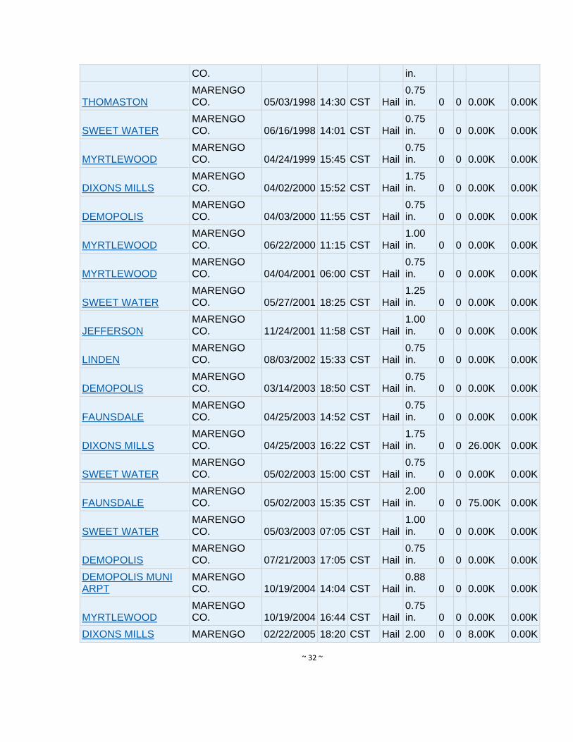
~ 32 ~
CO. in.
THOMASTON
MARENGO CO. 05/03/1998 14:30 CST Hail
0.75 in. 0 0 0.00K 0.00K
SWEET WATER
MARENGO CO. 06/16/1998 14:01 CST Hail
0.75 in. 0 0 0.00K 0.00K
MYRTLEWOOD
MARENGO CO. 04/24/1999 15:45 CST Hail
0.75 in. 0 0 0.00K 0.00K
DIXONS MILLS
MARENGO CO. 04/02/2000 15:52 CST Hail
1.75 in. 0 0 0.00K 0.00K
DEMOPOLIS
MARENGO CO. 04/03/2000 11:55 CST Hail
0.75 in. 0 0 0.00K 0.00K
MYRTLEWOOD
MARENGO CO. 06/22/2000 11:15 CST Hail
1.00 in. 0 0 0.00K 0.00K
MYRTLEWOOD
MARENGO CO. 04/04/2001 06:00 CST Hail
0.75 in. 0 0 0.00K 0.00K
SWEET WATER
MARENGO CO. 05/27/2001 18:25 CST Hail
1.25 in. 0 0 0.00K 0.00K
JEFFERSON
MARENGO CO. 11/24/2001 11:58 CST Hail
1.00 in. 0 0 0.00K 0.00K
LINDEN
MARENGO CO. 08/03/2002 15:33 CST Hail
0.75 in. 0 0 0.00K 0.00K
DEMOPOLIS
MARENGO CO. 03/14/2003 18:50 CST Hail
0.75 in. 0 0 0.00K 0.00K
FAUNSDALE
MARENGO CO. 04/25/2003 14:52 CST Hail
0.75 in. 0 0 0.00K 0.00K
DIXONS MILLS
MARENGO CO. 04/25/2003 16:22 CST Hail
1.75 in. 0 0 26.00K 0.00K
SWEET WATER
MARENGO CO. 05/02/2003 15:00 CST Hail
0.75 in. 0 0 0.00K 0.00K
FAUNSDALE
MARENGO CO. 05/02/2003 15:35 CST Hail
2.00 in. 0 0 75.00K 0.00K
SWEET WATER
MARENGO CO. 05/03/2003 07:05 CST Hail
1.00 in. 0 0 0.00K 0.00K
DEMOPOLIS
MARENGO CO. 07/21/2003 17:05 CST Hail
0.75 in. 0 0 0.00K 0.00K
DEMOPOLIS MUNI ARPT
MARENGO CO. 10/19/2004 14:04 CST Hail
0.88 in. 0 0 0.00K 0.00K
MYRTLEWOOD
MARENGO CO. 10/19/2004 16:44 CST Hail
0.75 in. 0 0 0.00K 0.00K
DIXONS MILLS MARENGO 02/22/2005 18:20 CST Hail 2.00 0 0 8.00K 0.00K
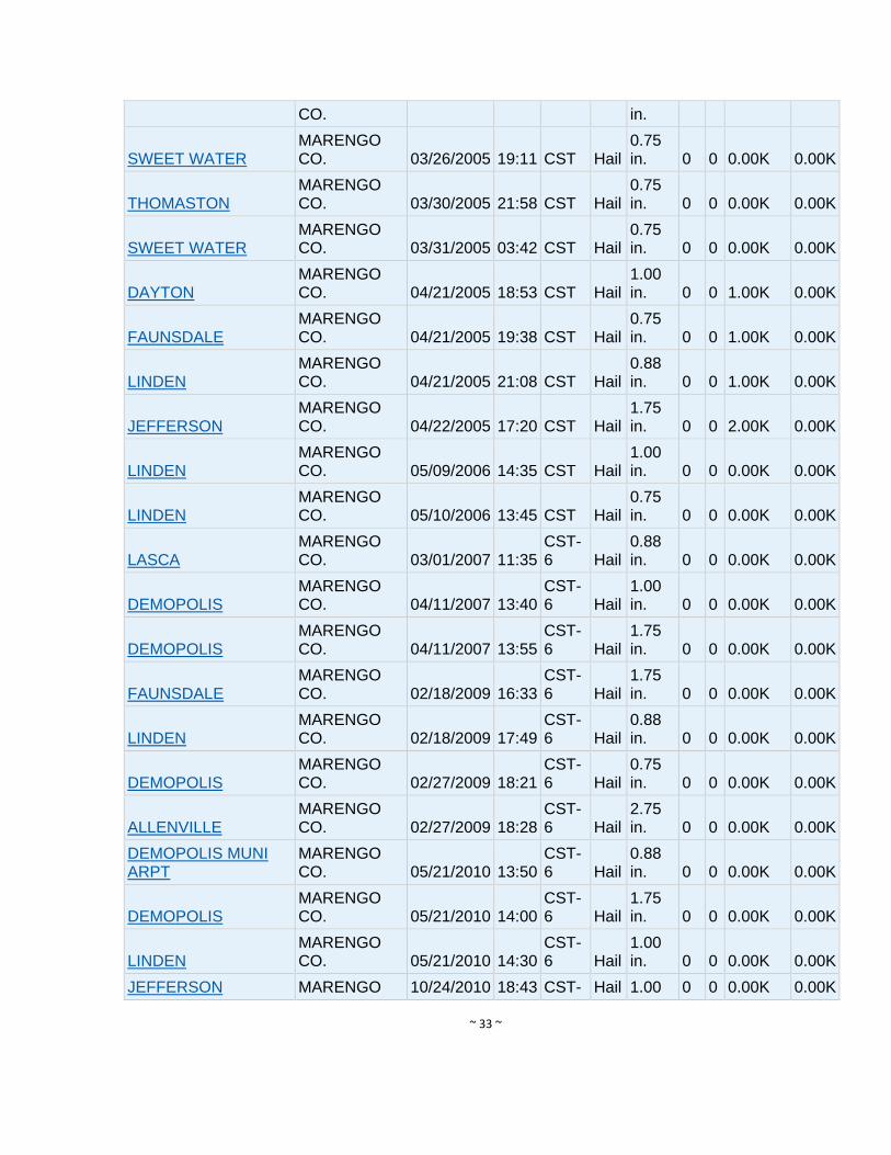
~ 33 ~
CO. in.
SWEET WATER
MARENGO CO. 03/26/2005 19:11 CST Hail
0.75 in. 0 0 0.00K 0.00K
THOMASTON
MARENGO CO. 03/30/2005 21:58 CST Hail
0.75 in. 0 0 0.00K 0.00K
SWEET WATER
MARENGO CO. 03/31/2005 03:42 CST Hail
0.75 in. 0 0 0.00K 0.00K
DAYTON
MARENGO CO. 04/21/2005 18:53 CST Hail
1.00 in. 0 0 1.00K 0.00K
FAUNSDALE
MARENGO CO. 04/21/2005 19:38 CST Hail
0.75 in. 0 0 1.00K 0.00K
LINDEN
MARENGO CO. 04/21/2005 21:08 CST Hail
0.88 in. 0 0 1.00K 0.00K
JEFFERSON
MARENGO CO. 04/22/2005 17:20 CST Hail
1.75 in. 0 0 2.00K 0.00K
LINDEN
MARENGO CO. 05/09/2006 14:35 CST Hail
1.00 in. 0 0 0.00K 0.00K
LINDEN
MARENGO CO. 05/10/2006 13:45 CST Hail
0.75 in. 0 0 0.00K 0.00K
LASCA
MARENGO CO. 03/01/2007 11:35
CST-6 Hail
0.88 in. 0 0 0.00K 0.00K
DEMOPOLIS
MARENGO CO. 04/11/2007 13:40
CST-6 Hail
1.00 in. 0 0 0.00K 0.00K
DEMOPOLIS
MARENGO CO. 04/11/2007 13:55
CST-6 Hail
1.75 in. 0 0 0.00K 0.00K
FAUNSDALE
MARENGO CO. 02/18/2009 16:33
CST-6 Hail
1.75 in. 0 0 0.00K 0.00K
LINDEN
MARENGO CO. 02/18/2009 17:49
CST-6 Hail
0.88 in. 0 0 0.00K 0.00K
DEMOPOLIS
MARENGO CO. 02/27/2009 18:21
CST-6 Hail
0.75 in. 0 0 0.00K 0.00K
ALLENVILLE
MARENGO CO. 02/27/2009 18:28
CST-6 Hail
2.75 in. 0 0 0.00K 0.00K
DEMOPOLIS MUNI ARPT
MARENGO CO. 05/21/2010 13:50
CST-6 Hail
0.88 in. 0 0 0.00K 0.00K
DEMOPOLIS
MARENGO CO. 05/21/2010 14:00
CST-6 Hail
1.75 in. 0 0 0.00K 0.00K
LINDEN
MARENGO CO. 05/21/2010 14:30
CST-6 Hail
1.00 in. 0 0 0.00K 0.00K
JEFFERSON MARENGO 10/24/2010 18:43 CST- Hail 1.00 0 0 0.00K 0.00K
~ 34 ~
CO. 6 in.
LINDEN
MARENGO CO. 10/24/2010 18:45
CST-6 Hail
2.75 in. 0 0 0.00K 0.00K
LINDEN
MARENGO CO. 04/11/2011 18:43
CST-6 Hail
0.75 in. 0 0 0.00K 0.00K
MYRTLEWOOD
MARENGO CO. 04/15/2011 16:00
CST-6 Hail
4.25 in. 0 0 0.00K 0.00K
MYRTLEWOOD
MARENGO CO. 04/15/2011 16:17
CST-6 Hail
2.75 in. 0 0 0.00K 0.00K
HALF ACRE
MARENGO CO. 04/15/2011 16:17
CST-6 Hail
2.50 in. 0 0 0.00K 0.00K
SWEET WATER
MARENGO CO. 06/10/2011 16:41
CST-6 Hail
1.00 in. 0 0 0.00K 0.00K
LEVY
MARENGO CO. 03/23/2013 19:38
CST-6 Hail
1.00 in. 0 0 0.00K 0.00K
MYRTLEWOOD
MARENGO CO. 04/06/2014 16:14
CST-6 Hail
0.75 in. 0 0 0.00K 0.00K
OCTAGON
MARENGO CO. 07/02/2014 16:35
CST-6 Hail
1.00 in. 0 0 0.00K 0.00K
Totals: 0 0 124.00K 4.00K
Table 7. Hail storms in Marengo County, Alabama (source: NCDC Database)
MARENGO CO.
MARENGO CO. 03/06/1967 15:30 CST
Thunderstorm Wind
0 kts. 0 0 0.00K 0.00K
MARENGO CO.
MARENGO CO. 08/01/1967 16:00 CST
Thunderstorm Wind
0 kts. 0 0 0.00K 0.00K
MARENGO CO.
MARENGO CO. 08/24/1968 13:00 CST
Thunderstorm Wind
0 kts. 0 0 0.00K 0.00K
MARENGO CO.
MARENGO CO. 06/21/1969 21:15 CST
Thunderstorm Wind
0 kts. 0 0 0.00K 0.00K
MARENGO CO.
MARENGO CO. 03/25/1971 14:30 CST
Thunderstorm Wind
0 kts. 0 0 0.00K 0.00K
MARENGO CO.
MARENGO CO. 05/08/1973 04:00 CST
Thunderstorm Wind
0 kts. 0 0 0.00K 0.00K
MARENGO CO.
MARENGO CO. 03/21/1974 01:20 CST
Thunderstorm Wind
0 kts. 0 0 0.00K 0.00K
MARENGO CO.
MARENGO CO. 02/12/1984 16:20 CST
Thunderstorm Wind
0 kts. 0 0 0.00K 0.00K
MARENGO CO. MARENGO 05/03/1984 11:07 CST Thunderstorm 0 0 0 0.00K 0.00K

~ 35 ~
CO. Wind kts.
MARENGO CO.
MARENGO CO. 04/05/1985 16:45 CST
Thunderstorm Wind
0 kts. 0 0 0.00K 0.00K
MARENGO CO.
MARENGO CO. 02/04/1986 17:55 CST
Thunderstorm Wind
0 kts. 0 0 0.00K 0.00K
MARENGO CO.
MARENGO CO. 11/04/1988 18:08 CST
Thunderstorm Wind
0 kts. 0 0 0.00K 0.00K
MARENGO CO.
MARENGO CO. 04/05/1989 17:30 CST
Thunderstorm Wind
0 kts. 0 0 0.00K 0.00K
MARENGO CO.
MARENGO CO. 02/10/1990 02:05 CST
Thunderstorm Wind
65 kts. 0 0 0.00K 0.00K
MARENGO CO.
MARENGO CO. 05/12/1990 18:00 CST
Thunderstorm Wind
0 kts. 0 0 0.00K 0.00K
MARENGO CO.
MARENGO CO. 06/22/1990 17:55 CST
Thunderstorm Wind
0 kts. 0 0 0.00K 0.00K
MARENGO CO.
MARENGO CO. 08/20/1990 18:20 CST
Thunderstorm Wind
0 kts. 0 0 0.00K 0.00K
MARENGO CO.
MARENGO CO. 03/29/1991 07:25 CST
Thunderstorm Wind
0 kts. 0 1 0.00K 0.00K
MARENGO CO.
MARENGO CO. 03/18/1992 17:00 PST
Thunderstorm Wind
0 kts. 0 0 0.00K 0.00K
MARENGO CO.
MARENGO CO. 08/27/1992 07:00 PST
Thunderstorm Wind
0 kts. 0 0 0.00K 0.00K
MARENGO CO.
MARENGO CO. 11/21/1992 16:40 PST
Thunderstorm Wind
0 kts. 0 0 0.00K 0.00K
Demopolis
MARENGO CO. 03/09/1994 13:00 CST
Thunderstorm Wind
0 kts. 0 0 50.00K 0.00K
Sweetwater
MARENGO CO. 01/06/1995 13:15 CST
Thunderstorm Wind
0 kts. 0 0 0.00K 0.00K
Jefferson
MARENGO CO. 01/06/1995 13:30 CST
Thunderstorm Wind
0 kts. 0 0 0.00K 0.00K
Providence
MARENGO CO. 03/07/1995 14:40 CST
Thunderstorm Wind
0 kts. 0 0 18.00K 0.00K
MARENGO CO.
MARENGO CO. 04/20/1995 23:45 CST
Thunderstorm Wind
0 kts. 0 0 0.00K 0.00K
Jefferson
MARENGO CO. 04/20/1995 23:45 CST
Thunderstorm Wind
0 kts. 0 0 0.00K 0.00K
Demopolis
MARENGO CO. 05/15/1995 18:10 CST
Thunderstorm Wind
0 kts. 0 0 5.00K 0.00K
MARENGO CO. MARENGO 05/15/1995 18:55 CST Thunderstorm 0 0 0 8.00K 0.00K
~ 36 ~
CO. Wind kts.
Demopolis
MARENGO CO. 05/18/1995 17:44 CST
Thunderstorm Wind
0 kts. 0 0 0.20K 0.00K
Myrtlewood
MARENGO CO. 07/09/1995 11:40 CST
Thunderstorm Wind
0 kts. 0 0 5.00K 0.00K
Sweetwater
MARENGO CO. 07/09/1995 12:00 CST
Thunderstorm Wind
0 kts. 0 0 4.00K 0.00K
LINDEN
MARENGO CO. 04/22/1996 23:45 CST
Thunderstorm Wind
50 kts. 0 0 10.00K 0.00K
THOMASTON
MARENGO CO. 02/21/1997 08:35 CST
Thunderstorm Wind
55 kts. 0 0 15.00K 0.00K
DEMOPOLIS
MARENGO CO. 04/22/1997 13:20 CST
Thunderstorm Wind
50 kts. 0 0 5.00K 0.00K
SWEET WATER
MARENGO CO. 04/22/1997 16:15 CST
Thunderstorm Wind
50 kts. 0 0 5.00K 0.00K
SWEET WATER
MARENGO CO. 01/07/1998 07:20 CST
Thunderstorm Wind
50 kts. 0 0 3.00K 0.00K
LINDEN
MARENGO CO. 06/05/1998 14:15 CST
Thunderstorm Wind
50 kts. 0 0 5.00K 0.00K
DEMOPOLIS
MARENGO CO. 06/15/1998 18:55 CST
Thunderstorm Wind
50 kts. 0 0 10.00K 0.00K
DIXONS MILLS
MARENGO CO. 04/15/1999 01:00 CST
ThunderstormWind
55 kts. 0 0 2.00K 0.00K
SWEET WATER
MARENGO CO. 06/24/1999 01:45 CST
Thunderstorm Wind
50 kts. 0 0 3.00K 0.00K
COUNTYWIDE
MARENGO CO. 07/07/1999 17:00 CST
Thunderstorm Wind
50 kts. 0 0 20.00K 0.00K
DIXONS MILLS
MARENGO CO. 03/19/2000 14:30 CST
Thunderstorm Wind
55 kts. E 0 0 5.00K 0.00K
DIXONS MILLS
MARENGO CO. 04/02/2000 15:52 CST
Thunderstorm Wind
60 kts. E 0 0 20.00K 0.00K
DEMOPOLIS
MARENGO CO. 07/20/2000 14:45 CST
Thunderstorm Wind
55 kts. E 0 0 0.00K 0.00K
DEMOPOLIS
MARENGO CO. 07/20/2000 14:55 CST
Thunderstorm Wind
60 kts. E 0 2 10.00K 0.00K
THOMASTON MARENGO 12/16/2000 13:15 CST Thunderstorm 50 0 0 8.00K 0.00K
~ 37 ~
CO. Wind kts. E
LINDEN
MARENGO CO. 01/29/2001 15:40 CST
Thunderstorm Wind
55 kts. E 0 0 3.00K 0.00K
SWEET WATER
MARENGO CO. 02/25/2001 01:15 CST
Thunderstorm Wind
75 kts. E 0 0 15.00K 0.00K
SWEET WATER
MARENGO CO. 05/27/2001 18:25 CST
Thunderstorm Wind
55 kts. E 0 0 15.00K 0.00K
SHILOH
MARENGO CO. 05/27/2001 18:40 CST
Thunderstorm Wind
50 kts. E 0 0 3.00K 0.00K
PUTNAM
MARENGO CO. 08/17/2001 19:46 CST
Thunderstorm Wind
50 kts. E 0 0 2.00K 0.00K
SWEET WATER
MARENGO CO. 08/25/2002 13:45 CST
Thunderstorm Wind
50 kts. E 0 0 3.00K 0.00K
FAUNSDALE
MARENGO CO. 02/15/2003 20:53 CST
Thunderstorm Wind
50 kts. EG 0 0 9.00K 0.00K
FAUNSDALE
MARENGO CO. 04/07/2003 02:30 CST
Thunderstorm Wind
50 kts. EG 0 0 6.00K 0.00K
DEMOPOLIS
MARENGO CO. 04/07/2003 05:00 CST
Thunderstorm Wind
50 kts. EG 0 0 2.00K 0.00K
SWEET WATER
MARENGO CO. 05/03/2003 07:05 CST
Thunderstorm Wind
50 kts. EG 0 0 5.00K 0.00K
DEMOPOLIS
MARENGO CO. 07/21/2003 17:05 CST
Thunderstorm Wind
50 kts. EG 0 0 8.00K 0.00K
JEFFERSON
MARENGO CO. 07/21/2003 17:40 CST
Thunderstorm Wind
50 kts. EG 0 0 3.00K 0.00K
DEMOPOLIS
MARENGO CO. 01/13/2005 10:20 CST
Thunderstorm Wind
50 kts. EG 0 0 8.00K 0.00K
DEMOPOLIS
MARENGO CO. 03/07/2005 18:05 CST
Thunderstorm Wind
52 kts. 0 0 0.00K 0.00K
~ 38 ~
MG
MYRTLEWOOD
MARENGO CO. 04/30/2005 03:35 CST
Thunderstorm Wind
55 kts. EG 0 0 4.00K 0.00K
LINDEN
MARENGO CO. 04/30/2005 04:26 CST
Thunderstorm Wind
52 kts. EG 0 0 4.00K 0.00K
COUNTYWIDE
MARENGO CO. 05/20/2005 14:50 CST
Thunderstorm Wind
54 kts. EG 0 0 23.00K 0.00K
JEFFERSON
MARENGO CO. 05/20/2005 18:35 CST
Thunderstorm Wind
52 kts. EG 0 0 5.00K 0.00K
COUNTYWIDE
MARENGO CO. 05/29/2005 14:25 CST
Thunderstorm Wind
55 kts. EG 0 0 50.00K 0.00K
DEMOPOLIS
MARENGO CO. 05/29/2006 14:30 CST
Thunderstorm Wind
50 kts. EG 0 0 5.00K 0.00K
SWEET WATER
MARENGO CO. 08/05/2006 16:05 CST
Thunderstorm Wind
50 kts. EG 0 0 3.00K 0.00K
LINDEN
MARENGO CO. 08/15/2006 15:30 CST
Thunderstorm Wind
50 kts. EG 0 0 4.00K 0.00K
SWEET WATER
MARENGO CO. 08/21/2006 16:14 CST
Thunderstorm Wind
50 kts. EG 0 0 2.00K 0.00K
FAUNSDALE
MARENGO CO. 11/30/2006 21:52
CST-6
Thunderstorm Wind
50 kts. EG 0 0 3.00K 0.00K
DEMOPOLIS
MARENGO CO. 04/11/2007 13:45
CST-6
Thunderstorm Wind
50 kts. EG 0 0 2.00K 0.00K
LINDEN
MARENGO CO. 07/10/2007 16:47
CST-6
Thunderstorm Wind
50 kts. EG 0 0 2.00K 0.00K
SHORTLEAF
MARENGO CO. 06/17/2008 14:00
CST-6
Thunderstorm Wind
40 kts. EG 0 0 2.00K 0.00K
LINDEN
MARENGO CO. 06/28/2008 17:43
CST-6
Thunderstorm Wind
39 kts. EG 0 0 0.50K 0.00K
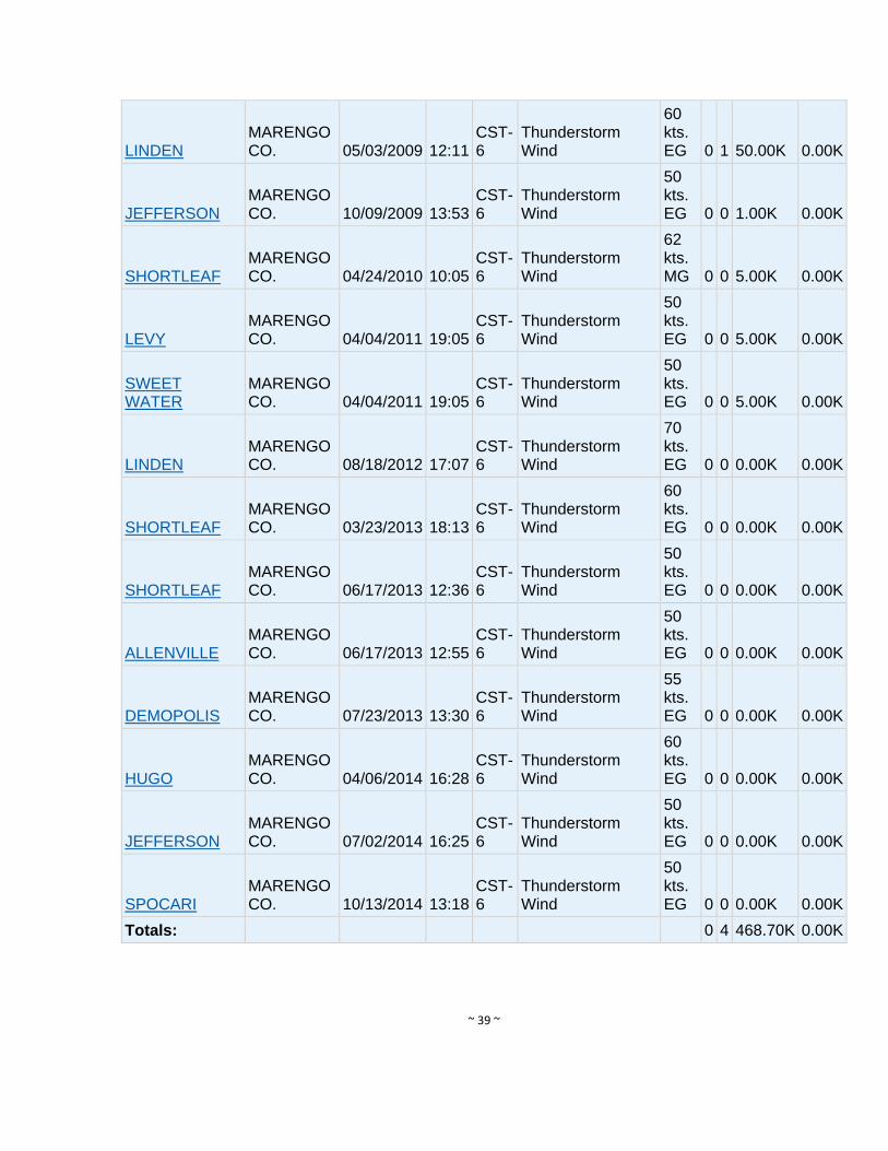
~ 39 ~
LINDEN
MARENGO CO. 05/03/2009 12:11
CST-6
Thunderstorm Wind
60 kts. EG 0 1 50.00K 0.00K
JEFFERSON
MARENGO CO. 10/09/2009 13:53
CST-6
Thunderstorm Wind
50 kts. EG 0 0 1.00K 0.00K
SHORTLEAF
MARENGO CO. 04/24/2010 10:05
CST-6
Thunderstorm Wind
62 kts. MG 0 0 5.00K 0.00K
LEVY
MARENGO CO. 04/04/2011 19:05
CST-6
Thunderstorm Wind
50 kts. EG 0 0 5.00K 0.00K
SWEET WATER
MARENGO CO. 04/04/2011 19:05
CST-6
Thunderstorm Wind
50 kts. EG 0 0 5.00K 0.00K
LINDEN
MARENGO CO. 08/18/2012 17:07
CST-6
Thunderstorm Wind
70 kts. EG 0 0 0.00K 0.00K
SHORTLEAF
MARENGO CO. 03/23/2013 18:13
CST-6
Thunderstorm Wind
60 kts. EG 0 0 0.00K 0.00K
SHORTLEAF
MARENGO CO. 06/17/2013 12:36
CST-6
Thunderstorm Wind
50 kts. EG 0 0 0.00K 0.00K
ALLENVILLE
MARENGO CO. 06/17/2013 12:55
CST-6
Thunderstorm Wind
50 kts. EG 0 0 0.00K 0.00K
DEMOPOLIS
MARENGO CO. 07/23/2013 13:30
CST-6
Thunderstorm Wind
55 kts. EG 0 0 0.00K 0.00K
HUGO
MARENGO CO. 04/06/2014 16:28
CST-6
Thunderstorm Wind
60 kts. EG 0 0 0.00K 0.00K
JEFFERSON
MARENGO CO. 07/02/2014 16:25
CST-6
Thunderstorm Wind
50 kts. EG 0 0 0.00K 0.00K
SPOCARI
MARENGO CO. 10/13/2014 13:18
CST-6
Thunderstorm Wind
50 kts. EG 0 0 0.00K 0.00K
Totals: 0 4 468.70K 0.00K
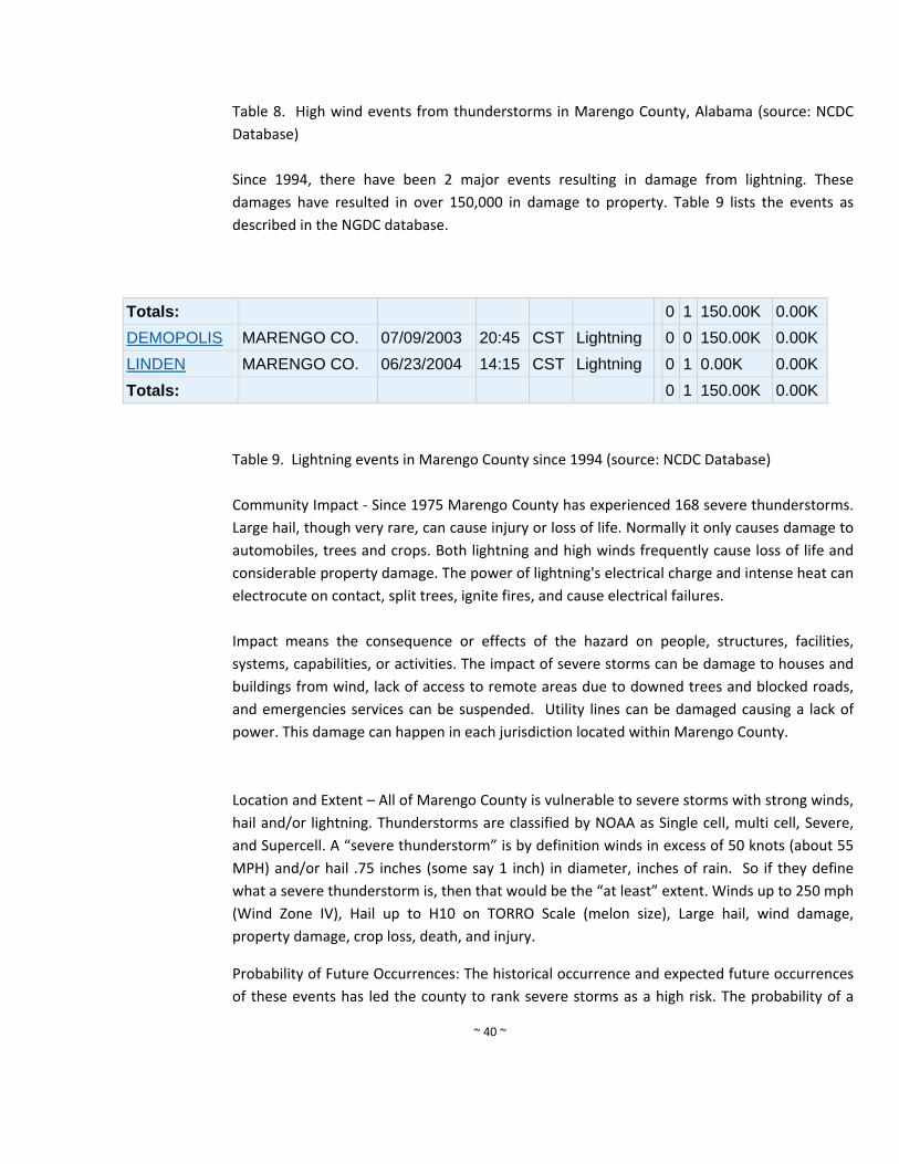
~ 40 ~
Table 8. High wind events from thunderstorms in Marengo County, Alabama (source: NCDC
Database)
Since 1994, there have been 2 major events resulting in damage from lightning. These
damages have resulted in over 150,000 in damage to property. Table 9 lists the events as
described in the NGDC database.
Totals: 0 1 150.00K 0.00K
DEMOPOLIS MARENGO CO. 07/09/2003 20:45 CST Lightning 0 0 150.00K 0.00K
LINDEN MARENGO CO. 06/23/2004 14:15 CST Lightning 0 1 0.00K 0.00K
Totals: 0 1 150.00K 0.00K
Table 9. Lightning events in Marengo County since 1994 (source: NCDC Database)
Community Impact ‐ Since 1975 Marengo County has experienced 168 severe thunderstorms.
Large hail, though very rare, can cause injury or loss of life. Normally it only causes damage to
automobiles, trees and crops. Both lightning and high winds frequently cause loss of life and
considerable property damage. The power of lightning's electrical charge and intense heat can
electrocute on contact, split trees, ignite fires, and cause electrical failures.
Impact means the consequence or effects of the hazard on people, structures, facilities,
systems, capabilities, or activities. The impact of severe storms can be damage to houses and
buildings from wind, lack of access to remote areas due to downed trees and blocked roads,
and emergencies services can be suspended. Utility lines can be damaged causing a lack of
power. This damage can happen in each jurisdiction located within Marengo County.
Location and Extent – All of Marengo County is vulnerable to severe storms with strong winds,
hail and/or lightning. Thunderstorms are classified by NOAA as Single cell, multi cell, Severe,
and Supercell. A “severe thunderstorm” is by definition winds in excess of 50 knots (about 55
MPH) and/or hail .75 inches (some say 1 inch) in diameter, inches of rain. So if they define
what a severe thunderstorm is, then that would be the “at least” extent. Winds up to 250 mph
(Wind Zone IV), Hail up to H10 on TORRO Scale (melon size), Large hail, wind damage,
property damage, crop loss, death, and injury.
Probability of Future Occurrences: The historical occurrence and expected future occurrences
of these events has led the county to rank severe storms as a high risk. The probability of a
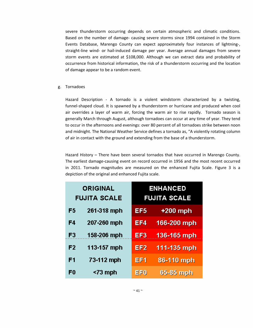
~ 41 ~
severe thunderstorm occurring depends on certain atmospheric and climatic conditions.
Based on the number of damage‐ causing severe storms since 1994 contained in the Storm
Events Database, Marengo County can expect approximately four instances of lightning‐,
straight‐line wind‐ or hail‐induced damage per year. Average annual damages from severe
storm events are estimated at $108,000. Although we can extract data and probability of
occurrence from historical information, the risk of a thunderstorm occurring and the location
of damage appear to be a random event.
g. Tornadoes
Hazard Description ‐ A tornado is a violent windstorm characterized by a twisting,
funnel‐shaped cloud. It is spawned by a thunderstorm or hurricane and produced when cool
air overrides a layer of warm air, forcing the warm air to rise rapidly. Tornado season is
generally March through August, although tornadoes can occur at any time of year. They tend
to occur in the afternoons and evenings: over 80 percent of all tornadoes strike between noon
and midnight. The National Weather Service defines a tornado as, “A violently rotating column
of air in contact with the ground and extending from the base of a thunderstorm.
Hazard History – There have been several tornados that have occurred in Marengo County.
The earliest damage‐causing event on record occurred in 1956 and the most recent occurred
in 2011. Tornado magnitudes are measured on the enhanced Fujita Scale. Figure 3 is a
depiction of the original and enhanced Fujita scale.
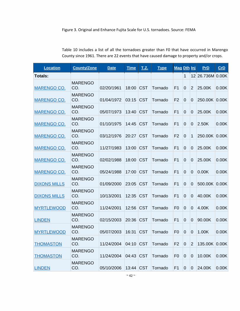
~ 42 ~
Figure 3. Original and Enhance Fujita Scale for U.S. tornadoes. Source: FEMA
Table 10 includes a list of all the tornadoes greater than F0 that have occurred in Marengo
County since 1961. There are 22 events that have caused damage to property and/or crops.
Location County/Zone Date Time T.Z. Type Mag Dth Inj PrD CrD
Totals: 1 12 26.736M 0.00K
MARENGO CO.
MARENGO CO. 02/20/1961 18:00 CST Tornado F1 0 2 25.00K 0.00K
MARENGO CO.
MARENGO CO. 01/04/1972 03:15 CST Tornado F2 0 0 250.00K 0.00K
MARENGO CO.
MARENGO CO. 05/07/1973 13:40 CST Tornado F1 0 0 25.00K 0.00K
MARENGO CO.
MARENGO CO. 01/10/1975 14:45 CST Tornado F1 0 0 2.50K 0.00K
MARENGO CO.
MARENGO CO. 03/12/1976 20:27 CST Tornado F2 0 1 250.00K 0.00K
MARENGO CO.
MARENGO CO. 11/27/1983 13:00 CST Tornado F1 0 0 25.00K 0.00K
MARENGO CO.
MARENGO CO. 02/02/1988 18:00 CST Tornado F1 0 0 25.00K 0.00K
MARENGO CO.
MARENGO CO. 05/24/1988 17:00 CST Tornado F1 0 0 0.00K 0.00K
DIXONS MILLS
MARENGO CO. 01/09/2000 23:05 CST Tornado F1 0 0 500.00K 0.00K
DIXONS MILLS
MARENGO CO. 10/13/2001 12:35 CST Tornado F1 0 0 40.00K 0.00K
MYRTLEWOOD
MARENGO CO. 11/24/2001 12:56 CST Tornado F0 0 0 4.00K 0.00K
LINDEN
MARENGO CO. 02/15/2003 20:36 CST Tornado F1 0 0 90.00K 0.00K
MYRTLEWOOD
MARENGO CO. 05/07/2003 16:31 CST Tornado F0 0 0 1.00K 0.00K
THOMASTON
MARENGO CO. 11/24/2004 04:10 CST Tornado F2 0 2 135.00K 0.00K
THOMASTON
MARENGO CO. 11/24/2004 04:43 CST Tornado F0 0 0 10.00K 0.00K
LINDEN
MARENGO CO. 05/10/2006 13:44 CST Tornado F1 0 0 24.00K 0.00K
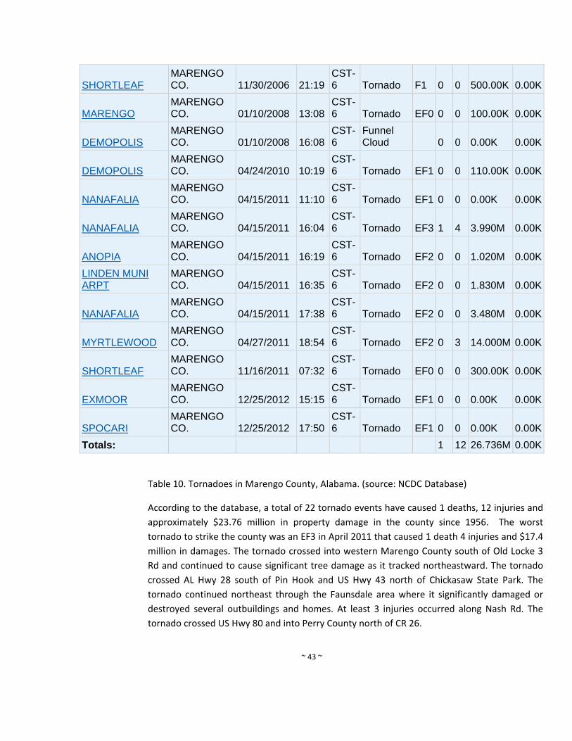
~ 43 ~
SHORTLEAF
MARENGO CO. 11/30/2006 21:19
CST-6 Tornado F1 0 0 500.00K 0.00K
MARENGO
MARENGO CO. 01/10/2008 13:08
CST-6 Tornado EF0 0 0 100.00K 0.00K
DEMOPOLIS
MARENGO CO. 01/10/2008 16:08
CST-6
Funnel Cloud 0 0 0.00K 0.00K
DEMOPOLIS
MARENGO CO. 04/24/2010 10:19
CST-6 Tornado EF1 0 0 110.00K 0.00K
NANAFALIA
MARENGO CO. 04/15/2011 11:10
CST-6 Tornado EF1 0 0 0.00K 0.00K
NANAFALIA
MARENGO CO. 04/15/2011 16:04
CST-6 Tornado EF3 1 4 3.990M 0.00K
ANOPIA
MARENGO CO. 04/15/2011 16:19
CST-6 Tornado EF2 0 0 1.020M 0.00K
LINDEN MUNI ARPT
MARENGO CO. 04/15/2011 16:35
CST-6 Tornado EF2 0 0 1.830M 0.00K
NANAFALIA
MARENGO CO. 04/15/2011 17:38
CST-6 Tornado EF2 0 0 3.480M 0.00K
MYRTLEWOOD
MARENGO CO. 04/27/2011 18:54
CST-6 Tornado EF2 0 3 14.000M 0.00K
SHORTLEAF
MARENGO CO. 11/16/2011 07:32
CST-6 Tornado EF0 0 0 300.00K 0.00K
EXMOOR
MARENGO CO. 12/25/2012 15:15
CST-6 Tornado EF1 0 0 0.00K 0.00K
SPOCARI
MARENGO CO. 12/25/2012 17:50
CST-6 Tornado EF1 0 0 0.00K 0.00K
Totals: 1 12 26.736M 0.00K
Table 10. Tornadoes in Marengo County, Alabama. (source: NCDC Database)
According to the database, a total of 22 tornado events have caused 1 deaths, 12 injuries and
approximately $23.76 million in property damage in the county since 1956. The worst
tornado to strike the county was an EF3 in April 2011 that caused 1 death 4 injuries and $17.4
million in damages. The tornado crossed into western Marengo County south of Old Locke 3
Rd and continued to cause significant tree damage as it tracked northeastward. The tornado
crossed AL Hwy 28 south of Pin Hook and US Hwy 43 north of Chickasaw State Park. The
tornado continued northeast through the Faunsdale area where it significantly damaged or
destroyed several outbuildings and homes. At least 3 injuries occurred along Nash Rd. The
tornado crossed US Hwy 80 and into Perry County north of CR 26.
~ 44 ~
There was also a EF2 to hit the same year on April 15, 2011. National Weather Service
meteorologists surveyed the damage near Nanafalia. Winds were estimated at 100 mph.
There were several eyewitness accounts of the tree and minor roof damage, where several
hardwood trees were uprooted and many softwoods were snapped off. The tornado damage
path was 4.21 miles long and was 60 yards wide at its widest point. This tornado started in
Choctaw County Alabama, south southwest of Butler. It was on the ground for almost 5 miles
before it crossed into Marengo County. The damage in Marengo County was mainly to trees.
Therefore, the total tornado damage path was 9.18 miles long. The tornado was 200 yards
wide at its widest point in Marengo County. The highest damage rating was an EF‐1 in both
counties.
A tornado touched down in Marengo County just west of County Road 90 in a rural setting.
The tornado moved northeast and snapped or uprooted dozens of trees. As the tornado
crossed State Highway 69 just south of Myrtlewood, it strengthened to an EF‐3 rating, with
maximum winds of 150 mph. Several dozen mobile homes were heavily damage or destroyed,
resulting in 1 fatality. In the community of Hilltop, several more mobile homes were
destroyed, resulting in 4 injuries. The tornado continued to move northeast where it snapped
and uprooted many more trees. It lifted after it crossed State Highway 28, northwest of
Linden. The tornado had a slight left turn to its path.
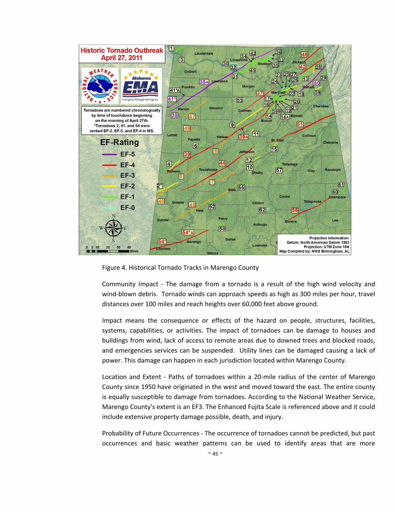
~ 45 ~
Figure 4. Historical Tornado Tracks in Marengo County
Community Impact ‐ The damage from a tornado is a result of the high wind velocity and
wind‐blown debris. Tornado winds can approach speeds as high as 300 miles per hour, travel
distances over 100 miles and reach heights over 60,000 feet above ground.
Impact means the consequence or effects of the hazard on people, structures, facilities,
systems, capabilities, or activities. The impact of tornadoes can be damage to houses and
buildings from wind, lack of access to remote areas due to downed trees and blocked roads,
and emergencies services can be suspended. Utility lines can be damaged causing a lack of
power. This damage can happen in each jurisdiction located within Marengo County.
Location and Extent ‐ Paths of tornadoes within a 20‐mile radius of the center of Marengo
County since 1950 have originated in the west and moved toward the east. The entire county
is equally susceptible to damage from tornadoes. According to the National Weather Service,
Marengo County's extent is an EF3. The Enhanced Fujita Scale is referenced above and it could
include extensive property damage possible, death, and injury.
Probability of Future Occurrences ‐ The occurrence of tornadoes cannot be predicted, but past
occurrences and basic weather patterns can be used to identify areas that are more
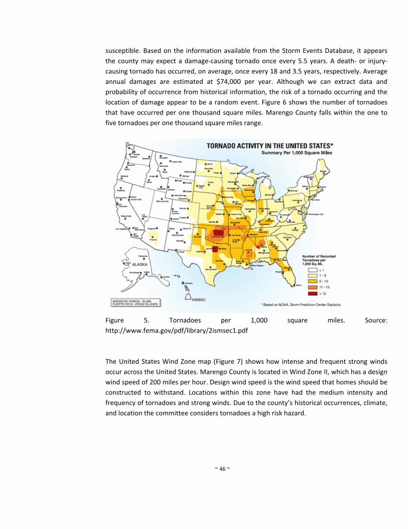
~ 46 ~
susceptible. Based on the information available from the Storm Events Database, it appears
the county may expect a damage‐causing tornado once every 5.5 years. A death‐ or injury‐
causing tornado has occurred, on average, once every 18 and 3.5 years, respectively. Average
annual damages are estimated at $74,000 per year. Although we can extract data and
probability of occurrence from historical information, the risk of a tornado occurring and the
location of damage appear to be a random event. Figure 6 shows the number of tornadoes
that have occurred per one thousand square miles. Marengo County falls within the one to
five tornadoes per one thousand square miles range.
Figure 5. Tornadoes per 1,000 square miles. Source:
http://www.fema.gov/pdf/library/2ismsec1.pdf
The United States Wind Zone map (Figure 7) shows how intense and frequent strong winds
occur across the United States. Marengo County is located in Wind Zone II, which has a design
wind speed of 200 miles per hour. Design wind speed is the wind speed that homes should be
constructed to withstand. Locations within this zone have had the medium intensity and
frequency of tornadoes and strong winds. Due to the county’s historical occurrences, climate,
and location the committee considers tornadoes a high risk hazard.
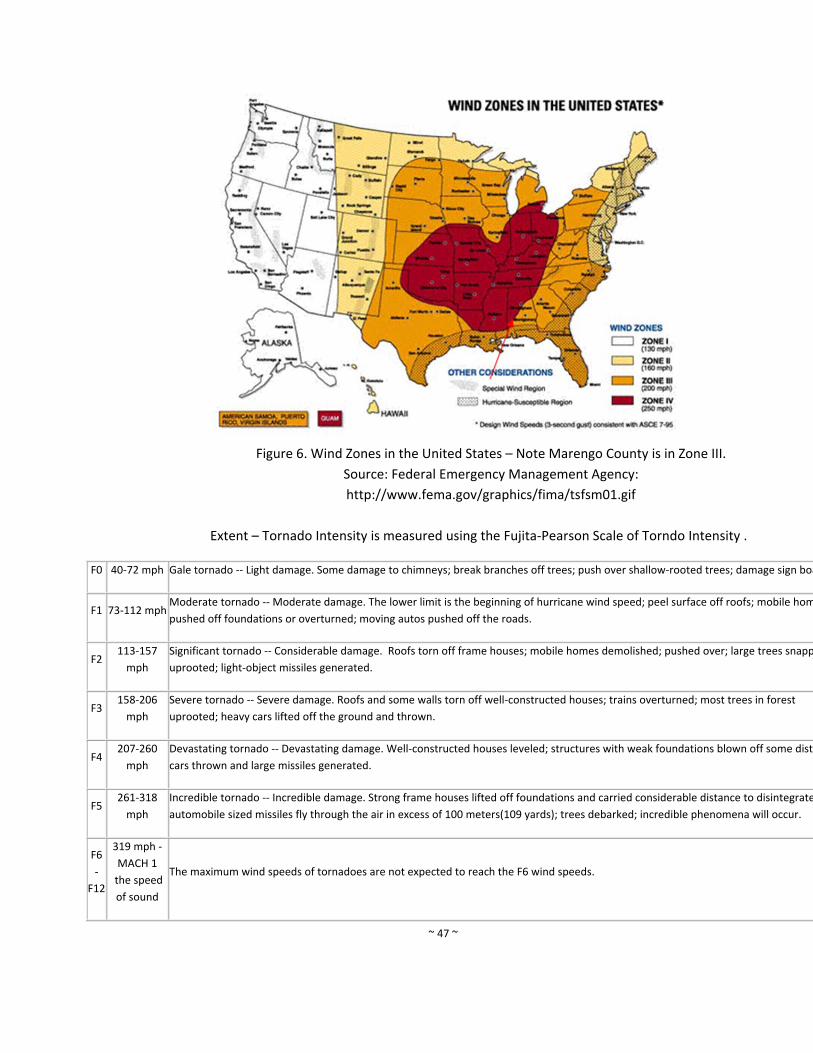
~ 47 ~
Figure 6. Wind Zones in the United States – Note Marengo County is in Zone III.
Source: Federal Emergency Management Agency:
http://www.fema.gov/graphics/fima/tsfsm01.gif
Extent – Tornado Intensity is measured using the Fujita‐Pearson Scale of Torndo Intensity .
F0 40‐72 mph Gale tornado ‐‐ Light damage. Some damage to chimneys; break branches off trees; push over shallow‐rooted trees; damage sign boa
F1 73‐112 mph Moderate tornado ‐‐ Moderate damage. The lower limit is the beginning of hurricane wind speed; peel surface off roofs; mobile hom
pushed off foundations or overturned; moving autos pushed off the roads.
F2 113‐157
mph
Significant tornado ‐‐ Considerable damage. Roofs torn off frame houses; mobile homes demolished; pushed over; large trees snapp
uprooted; light‐object missiles generated.
F3 158‐206
mph
Severe tornado ‐‐ Severe damage. Roofs and some walls torn off well‐constructed houses; trains overturned; most trees in forest
uprooted; heavy cars lifted off the ground and thrown.
F4 207‐260
mph
Devastating tornado ‐‐ Devastating damage. Well‐constructed houses leveled; structures with weak foundations blown off some dista
cars thrown and large missiles generated.
F5 261‐318
mph
Incredible tornado ‐‐ Incredible damage. Strong frame houses lifted off foundations and carried considerable distance to disintegrate
automobile sized missiles fly through the air in excess of 100 meters(109 yards); trees debarked; incredible phenomena will occur.
F6
‐
F12
319 mph ‐
MACH 1
the speed
of sound
The maximum wind speeds of tornadoes are not expected to reach the F6 wind speeds.
~ 48 ~
h. Wildfire
Hazard Description ‐ There are four categories of wildfires that are experienced throughout
the United States including: wildland fires, interface or intermix fires, firestorms,
prescribed fires and prescribed natural fires. The primary categories of fires in Marengo
County are wildland fires. Wildland fires are fueled exclusively by natural vegetation. The
frequency and severity of wildfires is dependent on weather and on human activity. Nearly all
wildfires in Marengo County are human caused (only a very small percent are caused by
lightning), with arson and careless debris burning being the major causes of wildfires. If not
promptly controlled, wildfires may grow into an emergency or disaster. Even small fires can
threaten lives, damage forest resources, and destroy structures.
Hazard History – According the NCDC database, there has been no significant fire in Marengo
County. From 10/1/2008 to 9/30/2011, there were 150 reported fires for a total of 1054 acres
burned. Map 7 depicts fire occurrence for every 1000 acres. This map depicts areas of low,
medium, high and extreme fire location. There have been extreme fires in several locations
throughout Marengo County, but overall the majority of the county’s area has been low to
medium fire occurrence.
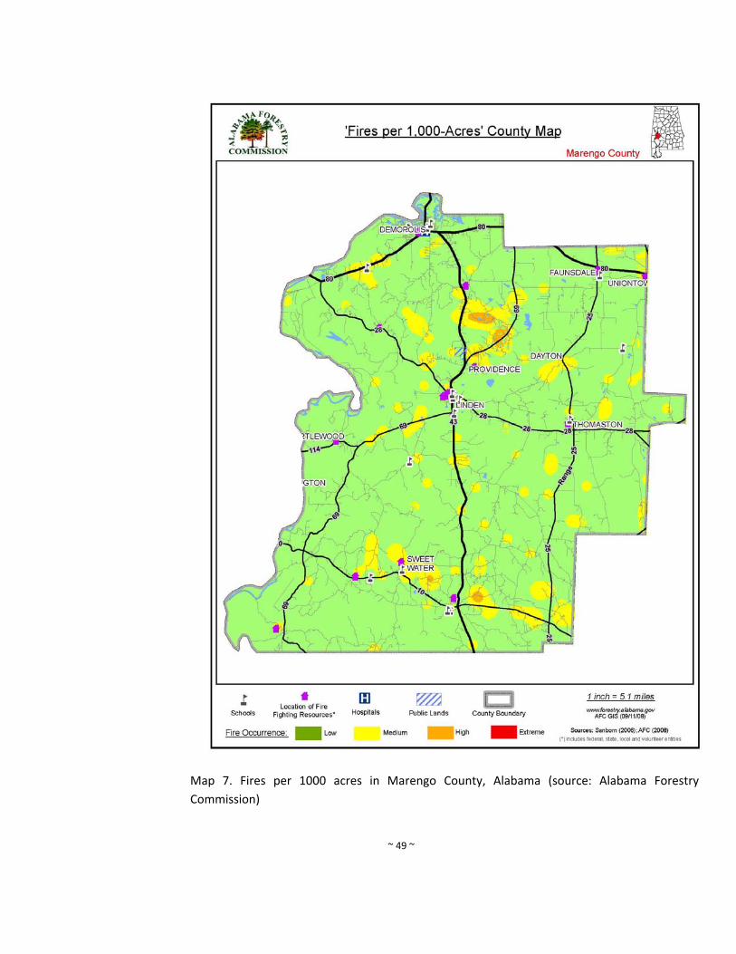
~ 49 ~
Map 7. Fires per 1000 acres in Marengo County, Alabama (source: Alabama Forestry
Commission)
~ 50 ~
Community Impact ‐ Wildfires can cause considerable damage and loss of life especially in
areas where there is an interface between wild land and urban development. Marengo
County has multiple fuel sources and is prone to drought and thunderstorms; therefore,
wildfires are a significant risk. Furthermore, rural fire departments are almost exclusively
made up of volunteers and usually have limited resources that are stretched during periods
when numerous fires occur.
Impact means the consequence or effects of the hazard on people, structures, facilities,
systems, capabilities, or activities. The impact of severe storms can be damage to houses and
buildings from wind, lack of access to remote areas due to downed trees and blocked roads,
and emergencies services can be suspended. Utility lines can be damaged causing a lack of
power. This damage can happen in each jurisdiction located within Marengo County.
Location and Extent – Wildland fires can occur anywhere in Marengo County, however the risk
is higher in rural forested areas. Extent of wildfire is measured by acres burned.
Probability of Future Occurrences: Based on historical information, Marengo County can
expect an average of 50 significant wildfires per year that damage or destroy an average of
21.08 acres per event. Although one can extract data and probability of occurrence from
historical information, the risk of a wild fire occurring and the location of damage appear to be
random.
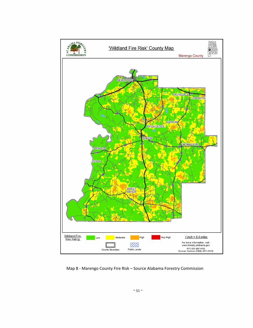
~ 51 ~
Map 8 ‐ Marengo County Fire Risk – Source Alabama Forestry Commission
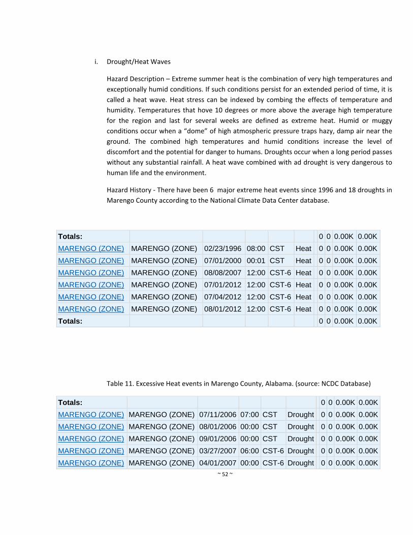
~ 52 ~
i. Drought/Heat Waves
Hazard Description – Extreme summer heat is the combination of very high temperatures and
exceptionally humid conditions. If such conditions persist for an extended period of time, it is
called a heat wave. Heat stress can be indexed by combing the effects of temperature and
humidity. Temperatures that hove 10 degrees or more above the average high temperature
for the region and last for several weeks are defined as extreme heat. Humid or muggy
conditions occur when a “dome” of high atmospheric pressure traps hazy, damp air near the
ground. The combined high temperatures and humid conditions increase the level of
discomfort and the potential for danger to humans. Droughts occur when a long period passes
without any substantial rainfall. A heat wave combined with ad drought is very dangerous to
human life and the environment.
Hazard History ‐ There have been 6 major extreme heat events since 1996 and 18 droughts in
Marengo County according to the National Climate Data Center database.
Totals: 0 0 0.00K 0.00K
MARENGO (ZONE) MARENGO (ZONE) 02/23/1996 08:00 CST Heat 0 0 0.00K 0.00K
MARENGO (ZONE) MARENGO (ZONE) 07/01/2000 00:01 CST Heat 0 0 0.00K 0.00K
MARENGO (ZONE) MARENGO (ZONE) 08/08/2007 12:00 CST-6 Heat 0 0 0.00K 0.00K
MARENGO (ZONE) MARENGO (ZONE) 07/01/2012 12:00 CST-6 Heat 0 0 0.00K 0.00K
MARENGO (ZONE) MARENGO (ZONE) 07/04/2012 12:00 CST-6 Heat 0 0 0.00K 0.00K
MARENGO (ZONE) MARENGO (ZONE) 08/01/2012 12:00 CST-6 Heat 0 0 0.00K 0.00K
Totals: 0 0 0.00K 0.00K
Table 11. Excessive Heat events in Marengo County, Alabama. (source: NCDC Database)
Totals: 0 0 0.00K 0.00K
MARENGO (ZONE) MARENGO (ZONE) 07/11/2006 07:00 CST Drought 0 0 0.00K 0.00K
MARENGO (ZONE) MARENGO (ZONE) 08/01/2006 00:00 CST Drought 0 0 0.00K 0.00K
MARENGO (ZONE) MARENGO (ZONE) 09/01/2006 00:00 CST Drought 0 0 0.00K 0.00K
MARENGO (ZONE) MARENGO (ZONE) 03/27/2007 06:00 CST-6 Drought 0 0 0.00K 0.00K
MARENGO (ZONE) MARENGO (ZONE) 04/01/2007 00:00 CST-6 Drought 0 0 0.00K 0.00K
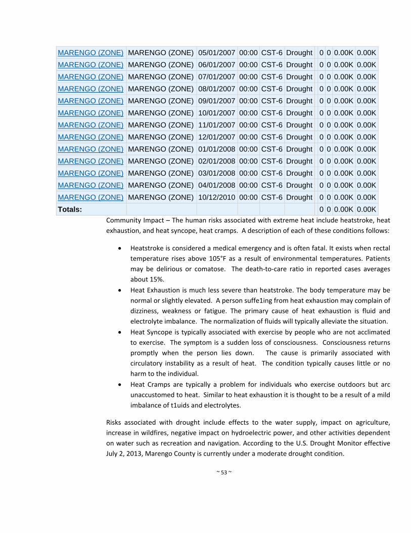
~ 53 ~
MARENGO (ZONE) MARENGO (ZONE) 05/01/2007 00:00 CST-6 Drought 0 0 0.00K 0.00K
MARENGO (ZONE) MARENGO (ZONE) 06/01/2007 00:00 CST-6 Drought 0 0 0.00K 0.00K
MARENGO (ZONE) MARENGO (ZONE) 07/01/2007 00:00 CST-6 Drought 0 0 0.00K 0.00K
MARENGO (ZONE) MARENGO (ZONE) 08/01/2007 00:00 CST-6 Drought 0 0 0.00K 0.00K
MARENGO (ZONE) MARENGO (ZONE) 09/01/2007 00:00 CST-6 Drought 0 0 0.00K 0.00K
MARENGO (ZONE) MARENGO (ZONE) 10/01/2007 00:00 CST-6 Drought 0 0 0.00K 0.00K
MARENGO (ZONE) MARENGO (ZONE) 11/01/2007 00:00 CST-6 Drought 0 0 0.00K 0.00K
MARENGO (ZONE) MARENGO (ZONE) 12/01/2007 00:00 CST-6 Drought 0 0 0.00K 0.00K
MARENGO (ZONE) MARENGO (ZONE) 01/01/2008 00:00 CST-6 Drought 0 0 0.00K 0.00K
MARENGO (ZONE) MARENGO (ZONE) 02/01/2008 00:00 CST-6 Drought 0 0 0.00K 0.00K
MARENGO (ZONE) MARENGO (ZONE) 03/01/2008 00:00 CST-6 Drought 0 0 0.00K 0.00K
MARENGO (ZONE) MARENGO (ZONE) 04/01/2008 00:00 CST-6 Drought 0 0 0.00K 0.00K
MARENGO (ZONE) MARENGO (ZONE) 10/12/2010 00:00 CST-6 Drought 0 0 0.00K 0.00K
Totals: 0 0 0.00K 0.00K
Community Impact – The human risks associated with extreme heat include heatstroke, heat
exhaustion, and heat syncope, heat cramps. A description of each of these conditions follows:
Heatstroke is considered a medical emergency and is often fatal. It exists when rectal
temperature rises above 105°F as a result of environmental temperatures. Patients
may be delirious or comatose. The death‐to‐care ratio in reported cases averages
about 15%.
Heat Exhaustion is much less severe than heatstroke. The body temperature may be
normal or slightly elevated. A person suffe1ing from heat exhaustion may complain of
dizziness, weakness or fatigue. The primary cause of heat exhaustion is fluid and
electrolyte imbalance. The normalization of fluids will typically alleviate the situation.
Heat Syncope is typically associated with exercise by people who are not acclimated
to exercise. The symptom is a sudden loss of consciousness. Consciousness returns
promptly when the person lies down. The cause is primarily associated with
circulatory instability as a result of heat. The condition typically causes little or no
harm to the individual.
Heat Cramps are typically a problem for individuals who exercise outdoors but arc
unaccustomed to heat. Similar to heat exhaustion it is thought to be a result of a mild
imbalance of t1uids and electrolytes.
Risks associated with drought include effects to the water supply, impact on agriculture,
increase in wildfires, negative impact on hydroelectric power, and other activities dependent
on water such as recreation and navigation. According to the U.S. Drought Monitor effective
July 2, 2013, Marengo County is currently under a moderate drought condition.
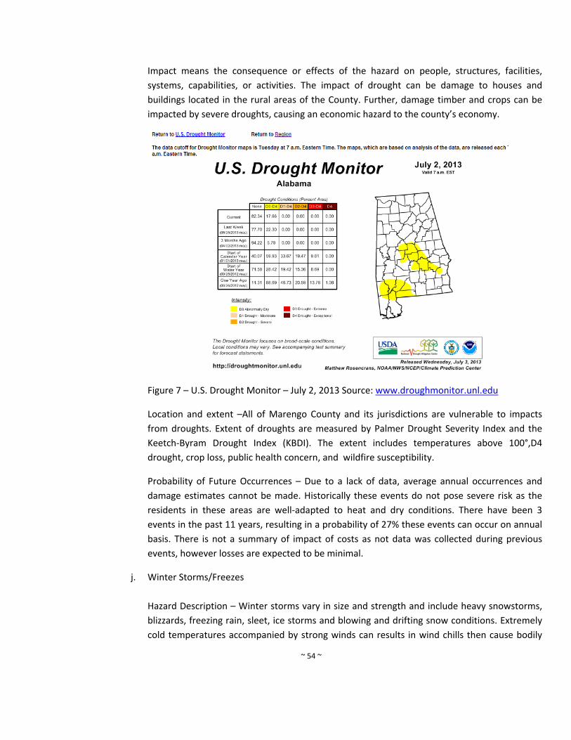
~ 54 ~
Impact means the consequence or effects of the hazard on people, structures, facilities,
systems, capabilities, or activities. The impact of drought can be damage to houses and
buildings located in the rural areas of the County. Further, damage timber and crops can be
impacted by severe droughts, causing an economic hazard to the county’s economy.
Figure 7 – U.S. Drought Monitor – July 2, 2013 Source: www.droughmonitor.unl.edu
Location and extent –All of Marengo County and its jurisdictions are vulnerable to impacts
from droughts. Extent of droughts are measured by Palmer Drought Severity Index and the
Keetch‐Byram Drought Index (KBDI). The extent includes temperatures above 100°,D4
drought, crop loss, public health concern, and wildfire susceptibility.
Probability of Future Occurrences – Due to a lack of data, average annual occurrences and
damage estimates cannot be made. Historically these events do not pose severe risk as the
residents in these areas are well‐adapted to heat and dry conditions. There have been 3
events in the past 11 years, resulting in a probability of 27% these events can occur on annual
basis. There is not a summary of impact of costs as not data was collected during previous
events, however losses are expected to be minimal.
j. Winter Storms/Freezes
Hazard Description – Winter storms vary in size and strength and include heavy snowstorms,
blizzards, freezing rain, sleet, ice storms and blowing and drifting snow conditions. Extremely
cold temperatures accompanied by strong winds can results in wind chills then cause bodily
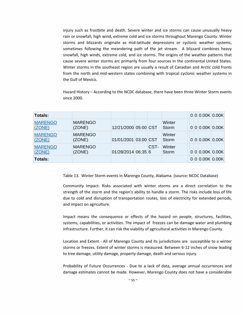
~ 55 ~
injury such as frostbite and death. Severe winter and ice storms can cause unusually heavy
rain or snowfall, high wind, extreme cold and ice storms throughout Marengo County. Winter
storms and blizzards originate as mid‐latitude depressions or cyclonic weather systems,
sometimes following the meandering path of the jet stream. A blizzard combines heavy
snowfall, high winds, extreme cold, and ice storms. The origins of the weather patterns that
cause severe winter storms arc primarily from four sources in the continental United States.
Winter storms in the southeast region are usually a result of Canadian and Arctic cold fronts
from the north and mid‐western states combining with tropical cyclonic weather systems in
the Gulf of Mexico.
Hazard History – According to the NCDC database, there have been three Winter Storm events
since 2000.
Totals: 0 0 0.00K 0.00K
MARENGO (ZONE)
MARENGO (ZONE) 12/21/2000 05:00 CST
Winter Storm 0 0 0.00K 0.00K
MARENGO (ZONE)
MARENGO (ZONE) 01/01/2001 03:00 CST
Winter Storm 0 0 0.00K 0.00K
MARENGO (ZONE)
MARENGO (ZONE) 01/28/2014 06:35
CST-6
Winter Storm 0 0 0.00K 0.00K
Totals: 0 0 0.00K 0.00K
Table 13. Winter Storm events in Marengo County, Alabama. (source: NCDC Database)
Community Impact: Risks associated with winter storms are a direct correlation to the
strength of the storm and the region's ability to handle a storm. The risks include loss of life
due to cold and disruption of transportation routes, loss of electricity for extended periods,
and impact on agriculture.
Impact means the consequence or effects of the hazard on people, structures, facilities,
systems, capabilities, or activities. The impact of freezes can be damage water and plumbing
infrastructure. Further, it can risk the viability of agricultural activities in Marengo County.
Location and Extent ‐ All of Marengo County and its jurisdictions are susceptible to a winter
storms or freezes. Extent of winter storms is measured. Between 6‐12 inches of snow leading
to tree damage, utility damage, property damage, death and serious injury.
Probability of Future Occurrences ‐ Due to a lack of data, average annual occurrences and
damage estimates cannot be made. However, Marengo County does not have a considerable
~ 56 ~
risk of a winter storm occurring and it has a high threat of a winter storm adversely affecting
the area. This is a direct result to the area's ability to handle a severe winter storm. Although
they are rare, Marengo County is susceptible to winter storms.
k. Levee/Dam Failures
Hazard Description – A dam is barriers constructed across a water course in order to store,
control, or divert water. Dams are usually constructed of earth, rock, concrete, or mine
tailings. The water impounded behind a dam is referred to as the reservoir and is measured in
acre‐feet, with one‐afoot being the volume of water that covers one acre of land to a depth of
one foot. Due to topography, even a small dam may have a reservoir containing many acre‐
feet of water. A dam failure is the collapse, breach or other failure of a dame that causes
downstream flooding. Dam failures may result from natural events, human‐caused events, or
a combination thereof. Due to the lack of advance warning, failures resulting from natural
events, such as hurricanes, earthquakes, or landslides, may be particularly severe. Prolonged
rainfall that produces flooding is the most common cause of dame failure, according to FEMA.
Dam failures usually occur when the spillway capacity if inadequate and water overtops the
dam or when internal erosion through the dam foundation occurs (also known as piping). If
internal erosion or overtopping cause a full structural breach, a high‐velocity, debris laden
wall of water is released and rushed downstream, damaging or destroying whatever is in its
path.
Hazard History – No dam/levee failure events have ever been reported in Marengo County.
Community Impact – When a dam fails, a large quantity of water is suddenly released
downstream, destroying anything in its path. The area impacted by the water emitted by
dame failure would encounter the same risks as those in a flood zone during periods of
flooding. The area directly affected by the water released during a dam failure is not county
wide.
Impact means the consequence or effects of the hazard on people, structures, facilities,
systems, capabilities, or activities. The impact of levee dam can be rapid flooding of low lying
area. This hazard would most likely impact Dempolis as is is directly downstearm from a dam
in the Tombigbee River. However, any residence or building constructed down or levee could
be impacted anywhere in Marengo County.
Dam Failure
The National Inventory of Dams lists twenty‐five dams as being located in Marengo County.
This number differs from the number in the previous plan, due to the fact that not all of the

~ 57 ~
previously identified dams meet the National Inventory of Dams criteria. The NID consists of
dams meeting at least one of the following criteria: 1) High hazard classification ‐ loss of one
human life is likely if the dam fails, 2) Significant hazard classification ‐ possible loss of human
life and likely significant property or environmental destruction, 3) Equal or exceed 25 feet in
height and exceed 15 acre‐feet in storage, 4) Equal or exceed 50 acre‐feet storage and exceed
6 feet in height.
The table below gives the number of dams classified in each potential downstream hazard
category. One dam is classified as having high hazard potential; meaning their failure or
misoperation would probably result in the loss of human life. Six dams are listed in the
significant risk category meaning their failure or misoperation would probably not result in the
loss of life, but would result in economic loss, environmental damage, and disruption of
lifeline facilities. The remaining eighteen dams in the county are listed as at low risk meaning
that their failure or misoperation would not result in the loss of life and only low economic or
environmental damage.
The Demopolis Lock and Dam located in Marengo is a high‐risk dam operated by the Corps of
Engineers. The failure of this dam could potentially affect the City of Demopolis water supply
and damage infrastructure within Maregno County. The Corps of Engineers have operating
procedures and plans to monitor and prevent this from occurring. At this time the Natural
Hazards Steering Committee feels that although dam failure is a hazard, it will be classified as
low risk. This decision
was made due to the extensive planning the Corps of Engineers has undertaken at the
Demopolis Lock &Dam and the sparse populations around the significant risk dams.
Location and Extents. Extent of Dam safety is measured by using the National Inventory of
Dams (NID) includes a Hazard Potential Rating: Low, Significant or High. Demopolis Dam
failure would cause extensive damage, loss of life, crop loss, and environmental damages.
National Inventory of Dams Risk Categories: Marengo County
Hazard Categories Number of Dams
High 1
Significant 6
Low 18
Total 25
Probability of Future Occurrences ‐ The risks associated with dam‐levee failure are the same
as those risks associated with flooding. Risks to Marengo County are minimal. The probability
of future occurrences cannot be characterized on a countywide basis because of the lack of
information available.
~ 58 ~
l. Landslides
Hazard Description ‐ A "landslide" is the downward and outward movement of slopes. The
terms refers various forming materials acting under the force of gravity. The term covers a
broad category of events, including mudflows, mudslides, debris flows, rock falls, rockslides,
debris avalanches, debris slides and earth flows. Landslides may consist of natural rock, soil,
artificial fill, or combinations of these materials. Landslides are classified by type of
movement, including; slides, flows, lateral spreads, falls and topples. A "landslide" is the
downward and outward movement of slope ‐ forming materials acting under the force of
gravity. The term covers a broad category of events, including mudflows, mudslides, debris
flows, rock falls, rockslides, debris avalanches, debris slides and earth flows. Landslides may
consist of natural rock, soil, artificial fill, or combinations of these materials. Landslides are
classified by type of movement, including; slides, flows, lateral spreads, falls and topples.
Almost any steep or rugged terrain is susceptible to landslide under the right conditions. The
most hazardous areas are steep slopes on ridges, hill and mountains; incised stream channels;
and slopes excavated for buildings and roads. Slid potentials are enhanced where slopes are
destabilized by construction or river erosion. Road cut s and other altered ore excavated areas
are particularly susceptible to landslides and debris flows. Rainfall and seismic shaking by
earthquakes or blasting can trigger landslides.
Debris flows (also referred to as mudslides) generally occur during intense rainfall on water
saturated soils. They usually start on steep hillsides as soil slumps or slides that liquefy and
accelerate to speeds as great as 35 miles per hour. Multiple debris flows may merge, gain
volume and travel long distances from their source, making areas down slope particularly
hazardous. Surface runoff channels along roadways and below culverts are common sites of
debris flows and other landslides.
Hazard History ‐ No instances of landslides were reported by the planning committee or
revealed by an Internet search.
Community Impact ‐ The effects of landslides are often misrepresented as being the result of
the landslide's trigger event, such as a flood, earthquake, volcanic eruption, hurricane, or
coastal storm. The impact from a landslide can include loss of life, damage to buildings, lost
productivity, disruption in utilities and transportation systems, and reduced property values.
Impact means the consequence or effects of the hazard on people, structures, facilities,
systems, capabilities, or activities. The impact of a landslide can crush a home or bulding.
Further, roads can be impassible.
Location and Extent – Only one recorded landslide event has occurred in Marengo County.
The northern area of the county lies in an area of moderate incidence, according to the
Geological Survey of Alabama. This area is depicted on Map 10. The lack of landslide
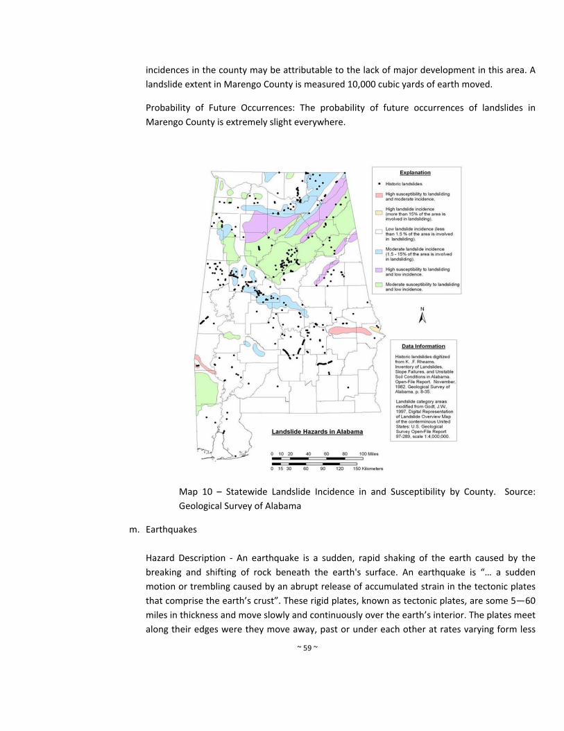
~ 59 ~
incidences in the county may be attributable to the lack of major development in this area. A
landslide extent in Marengo County is measured 10,000 cubic yards of earth moved.
Probability of Future Occurrences: The probability of future occurrences of landslides in
Marengo County is extremely slight everywhere.
Map 10 – Statewide Landslide Incidence in and Susceptibility by County. Source:
Geological Survey of Alabama
m. Earthquakes
Hazard Description ‐ An earthquake is a sudden, rapid shaking of the earth caused by the
breaking and shifting of rock beneath the earth's surface. An earthquake is “… a sudden
motion or trembling caused by an abrupt release of accumulated strain in the tectonic plates
that comprise the earth’s crust”. These rigid plates, known as tectonic plates, are some 5—60
miles in thickness and move slowly and continuously over the earth’s interior. The plates meet
along their edges were they move away, past or under each other at rates varying form less
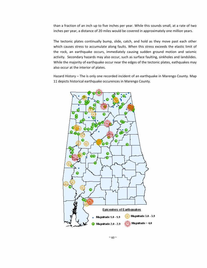
~ 60 ~
than a fraction of an inch up to five inches per year. While this sounds small, at a rate of two
inches per year, a distance of 20 miles would be covered in approximately one million years.
The tectonic plates continually bump, slide, catch, and hold as they move past each other
which causes stress to accumulate along faults. When this stress exceeds the elastic limit of
the rock, an earthquake occurs, immediately causing sudden ground motion and seismic
activity. Secondary hazards may also occur, such as surface faulting, sinkholes and landslides.
While the majority of earthquake occur near the edges of the tectonic plates, eathquakes may
also occur at the interior of plates.
Hazard History – The is only one recorded incident of an earthquake in Marengo County. Map
11 depicts historical earthquake occurences in Marengo County.
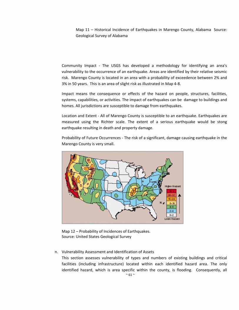
~ 61 ~
Map 11 – Historical Incidence of Earthquakes in Marengo County, Alabama Source:
Geological Survey of Alabama
Community Impact ‐ The USGS has developed a methodology for identifying an area's
vulnerability to the occurrence of an earthquake. Areas are identified by their relative seismic
risk. Marengo County is located in an area with a probability of exceedence between 2% and
3% in 50 years. This is an area of slight risk as illustrated in Map 4‐8.
Impact means the consequence or effects of the hazard on people, structures, facilities,
systems, capabilities, or activities. The impact of earthquakes can be damage to buildings and
homes. All jurisdictions are susceptible to damage from earthquakes.
Location and Extent ‐ All of Marengo County is susceptible to an earthquake. Earthquakes are
measured using the Richter scale. The extent of a serious earthquake would be stong
earthquake resulting in death and property damage.
Probability of Future Occurrences ‐ The risk of a significant, damage causing earthquake in the
Marengo County is very small.
Map 12 – Probability of Incidences of Earthquakes. Source: United States Geological Survey
n. Vulnerability Assessment and Identification of Assets
This section assesses vulnerability of types and numbers of existing buildings and critical
facilities (including infrastructure) located within each identified hazard area. The only
identified hazard, which is area specific within the county, is flooding. Consequently, all
~ 62 ~
buildings and critical facilities are exposed to all remaining hazards. The building counts and
values are taken from the HAZUS databases. These are not current counts, but data
availability is limited. Dollar values are not adjusted to current values. Designation of a
facility as critical is based on the HAZUS definitions, as follows:
Essential Facilities. These facilities are critical to the health and welfare of the entire
county population and are essential following hazard events, including emergency
response facilities (police, fire, and emergency management), medical care facilities
(hospitals and other care facilities), schools, and shelters for evacuation.
Lifeline Utility Systems. These facilities are essential lifelines that include potable water,
wastewater, natural gas, electric, and communications systems.
Transportation Systems. These facilities include highways, bridges, railways, and
waterways.
High Potential Loss Facilities. These facilities include military installations and high
potential loss dams.
Hazardous Materials Facilities. These facilities may pose a threat if disrupted by natural
hazards and include hazardous industrial chemicals, explosives, flammables, toxins, and
radioactive materials.
i. Building Assets – Marengo County has over 5400 buildings valued at over $600
million. All of the buildings are at risk for natural hazards damages.
Number of Buildings by Type
Residential Commercial Industrial Agriculture Religious Government Education Total
4450 200 40 647 29 16 18 5400
Source: Marengo County Revenue Commission
Value by Type of Building
Residential Commercial Industrial Agriculture Religious Government Education Total
$78,512,000.00 $4,550,774.00 $3,425,656.00 $984,754.00 $3,258,745.00 $185,201.00 $245,747.00 $91,162,877.00
Source: FEMA HAZUS and Marengo County Revenue Commission
ii. Critical Facilities – The Hazard Mitigation Planning Committee updated this list of
critical facilities in Marengo County included in the 2010 Hazard Mitigation Plan. The
groups of critical facilities include communication facilities, emergency response
facilities, hazardous material sites, medical care facilities, and schools. Maps of each
~ 63 ~
of these facilities are depicted in Maps 13‐17. The Marengo County Hazard Mitigation
Steering Committee identified critical facilities in the following six categories:
i. A critical facility is critical to the health and welfare of the entire jurisdiction. They
become essential in the event of a natural disaster. These facilities include police
stations, fire stations, schools, and hospitals.
ii. Critical facilities are lifelines that provide the jurisdiction with necessities such as
potable water.
iii. Critical facilities include the transportation corridors necessary to keep the
jurisdiction connected.
iv. Critical facilities include those facilities that house persons with special needs
(jails, nursing homes). They may also include locations where large groups often
meet.
v. Critical facilities include locations with hazardous materials. These materials may
pose a threat to health and safety if disrupted.
vi. Critical facilities include those in which potential losses, both human and
economic, are high.
The list of Marengo County Critical Facilities was updated from the previous plan and
information and costs were provided by each jurisdiction. If a critical facility was
removed, it is no longer considered a facility at risk in Marengo County.

~ 64 ~
Marengo County Commission – Critical Facilities
Facility Location Estimated Cost
Marengo County High School Dixons Mills $20,000,000
Surginer VFD Surginer $500,000
Jefferson VFD Jefferson $500,000
Dixons Mills VFD Dixon Mills $500,000
Old Spring Hill VFD Spring Hill $500,000
Putnam VFD Putman $500,000
Courthouse Linden $15,000,000
Jail Linden $10,000,000
Annex Linden $4,000,000
Armory Linden $1,000,000
E911 Linden $500,000
County Shop/Engineers Office Linden $500,000 2560
2010 Pierce Class A tanker/pumper
$250,000
1020 gallon tank
SCBAs
Generator and Lighting
JAWs of Life
Foam equipped
2563
1989 Ford Big Red 5800 Tanker $160,000
1400 gallon
SCBAs
2564
1982 Tas Ford Class /Tanker‐Pumper
$150,000
5800 Darley Pumper
1500 gallon tank
Backup Woods and grass
SCBAs
2565
1982 Pierce Class A Pumper $180,000
1000 gallon
SCBAs
Foam equiped
32 buckets of 6% AFFF foam in station
Aqueous Film Foaming
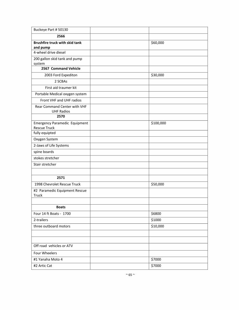
~ 65 ~
Buckeye Part # 50130
2566
Brushfire truck with skid tank and pump
$60,000
4‐wheel drive diesel
200 gallon skid tank and pump system
2567 Command Vehicle
2003 Ford Expediton $30,000
2 SCBAs
First aid traumer kit
Portable Medical oxygen system
Front VHF and UHF radios
Rear Command Center with VHF UHF Radios
2570
Emergency Paramedic Equipment Rescue Truck
$100,000
fully equipted
Oxygen System
2‐Jaws of Life Systems
spine boards
stokes stretcher
Stair stretcher
2571
1998 Chevrolet Rescue Truck $50,000
#2 Paramedic Equipment Rescue Truck
Boats
Four 14 ft Boats ‐ 1700 $6800
2‐trailers $1000
three outboard motors $10,000
Off road vehicles or ATV
Four Wheelers
#1 Yanaha Moto 4 $7000
#2 Artic Cat $7000
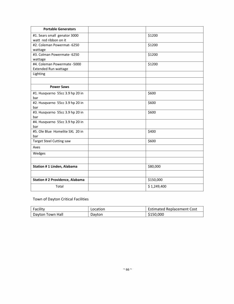
~ 66 ~
Portable Generators
#1. Sears small genator 3000 watt red ribbon on it
$1200
#2. Coleman Powermat‐ 6250 wattage
$1200
#3. Colman Powermate‐ 6250 wattage
$1200
#4. Coleman Powermate ‐5000 Extended Run wattage
$1200
Lighting
Power Saws
#1. Husqvarno 55cc 3.9 hp 20 in bar
$600
#2. Husqvarno 55cc 3.9 hp 20 in bar
$600
#3. Husqvarno 55cc 3.9 hp 20 in bar
$600
#4. Husqvarno 55cc 3.9 hp 20 in bar
#5. Ole Blue Homelite SXL 20 in bar
$400
Target Steel Cutting saw $600
Axes
Wedges
Station # 1 Linden, Alabama $80,000
Station # 2 Providence, Alabama $150,000
Total $ 1,249,400
Town of Dayton Critical Facilities
Facility Location Estimated Replacement Cost
Dayton Town Hall Dayton $150,000
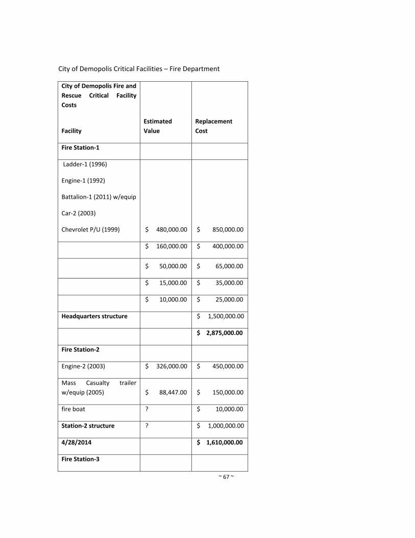
~ 67 ~
City of Demopolis Critical Facilities – Fire Department
City of Demopolis Fire and
Rescue Critical Facility
Costs
Facility
Estimated
Value
Replacement
Cost
Fire Station‐1
Ladder‐1 (1996)
Engine‐1 (1992)
Battalion‐1 (2011) w/equip
Car‐2 (2003)
Chevrolet P/U (1999) $ 480,000.00 $ 850,000.00
$ 160,000.00 $ 400,000.00
$ 50,000.00 $ 65,000.00
$ 15,000.00 $ 35,000.00
$ 10,000.00 $ 25,000.00
Headquarters structure $ 1,500,000.00
$ 2,875,000.00
Fire Station‐2
Engine‐2 (2003) $ 326,000.00 $ 450,000.00
Mass Casualty trailer
w/equip (2005) $ 88,447.00 $ 150,000.00
fire boat ? $ 10,000.00
Station‐2 structure ? $ 1,000,000.00
4/28/2014 $ 1,610,000.00
Fire Station‐3
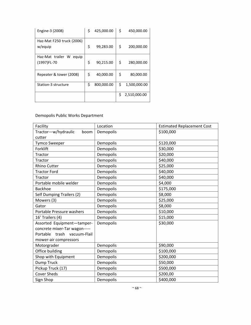
~ 68 ~
Engine‐3 (2008) $ 425,000.00 $ 450,000.00
Haz‐Mat F250 truck (2006)
w/equip $ 99,283.00 $ 200,000.00
Haz‐Mat trailer W equip
(1997)FL‐70 $ 90,215.00 $ 280,000.00
Repeater & tower (2008) $ 40,000.00 $ 80,000.00
Station‐3 structure $ 800,000.00 $ 1,500,000.00
$ 2,510,000.00
Demopolis Public Works Department
Facility Location Estimated Replacement Cost
Tractor—w/hydraulic boom cutter
Demopolis $100,000
Tymco Sweeper Demopolis $120,000
Forklift Demopolis $30,000
Tractor Demopolis $20,000
Tractor Demopolis $40,000
Rhino Cutter Demopolis $25,000
Tractor Ford Demopolis $40,000
Tractor Demopolis $40,000
Portable mobile welder Demopolis $4,000
Backhoe Demopolis $175,000
Self Dumping Trailers (2) Demopolis $8,000
Mowers (3) Demopolis $25,000
Gator Demopolis $8,000
Portable Pressure washers Demopolis $10,000
16’ Trailers (4) Demopolis $15,000
Assorted Equipment—tamper‐concrete mixer‐Tar wagon‐‐‐‐‐ Portable trash vacuum‐Flail mower‐air compressors
Demopolis $30,000
Motorgrader Demopolis $90,000
Office building Demopolis $100,000
Shop with Equipment Demopolis $200,000
Dump Truck Demopolis $50,000
Pickup Truck (17) Demopolis $500,000
Cover Sheds Demopolis $200,00
Sign Shop Demopolis $400,000
~ 69 ~
Demopolis Library Inventory
Facility Location Estimated Replacement Cost
Collections $849,685.00Data Systems/Technology
$88,748.75
Desks $7,800.00
Furnishings $35,912.50
Misc. Furnishings $35,149.75
Office Machines $20,523.75
Shelving $60,091.37
Tables $32,852.56
Art $5,000.00
Circulation Desks $20,000.00
Outside Railing $3,000.00
Awnings $5,000.00
Building $2,000,000.00
Town of Faunsdale Critical Facilities
Facility Estimated Cost
Town Hall $300,000
Water Tank and Pump $750,000
Old Town Hall $75,000
Senior Citizens Center $250,000
Fire Department $500,000
City of Linden Critical Facilities
Facility Estimated Cost
Airplane Hangar $19,800
City Hall $325,000
Control Pit and Equipment CR 44 $45,000
Dayton Deep well $480,000
Fire Department $520,000
Industrial Park $110,000
Maintenance Shop $350,000
Police Department $185,000
Pumping Station – Highway 43 North $45,000
Scott Park $250,000
Sewer Pumping Station – Sammie Drive $30,000
Sewer Pumping Station – Anderson Cr. $30,000
~ 70 ~
Sewer Pumping Station – Frisco Street $30,000
Sewer Pumping Station – Williams Street $30,000
Street Department Equipment $200,000
Utility Department Equipment $450,000
Water Tank – CR 1 $370,000
Water Tank – Dayton $425,000
Water Tank – East Coates $350,000
Water Valve – CR 44 and Highway 43 $8,400
Linden Elementary $1,188,486
Linden High $3,406,736
G.P. Austin $2,394,638
Marengo Technology Center $3,256,214
Marengo Alternative School $15,000,000
Marengo Academy $12,500,000
Marengo County Nursing Home $50,000,000
City of Linden Fire Department – Generator $8,500
City of Linden Closed in Trailer $12,000
Backhoe – City Shop $54,000
Zero Turn Mower $7,500
Tractor and Cutter $42,000
Backhoe $58,000
Sewer Camera $9,700
Utilities Zero Turn Mower $7,500
Town of Myrtlewood Critical Facilities
Facility Estimated Cost
Myrtlewood Community Center $400,000
Myrtlewood VFD $500,000
Town Hall and Water Department $150,000
Water Tank #1 $150,000
Water Tank #2 $200,000
Water Tank #4 $250,000
Water Tank #4 $150,000
Well #1 $50,000
Well #2 $50,000
Well #3 $350,000
Town of Providence Critical Facilities
Facility Estimated Cost
Town Hall $150,000
~ 71 ~
Town of Sweet Water Critical Facilities
Facility Estimated Cost
Town Hall $250,000
Water Tank $110,000
Sweet Water VFD Station #1 $150,000
Sweet Water VFD Station #2 $150,000
Sweet Water Recreation Park $250,000
Old Doctor’s office $20,000
Town Rental House $45,000
Sweet Water Country Shed $10,000
Pump House and water pump $23,000
Sweet Water High School $20,000,000
South Marengo Fire and Rescue $400,000
Town of Thomaston Critical Facilities
Facility Estimated Cost
City Shop $375,000
Town Hall $355,000
Well #3 $267,000
50K Elevated Water Tower $339,000
250K Water Tank $470,000
South Marengo Booster Pump $150,000
Police/Fire Department $523,000
Post Office $330,000
Civic Center/Cafeteria $100,000
Total $2,909,000
~ 72 ~
Map 13 – Marengo County Communication Facilities
|
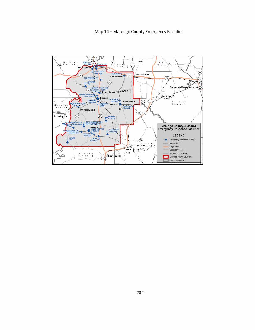
~ 73 ~
Map 14 – Marengo County Emergency Facilities

~ 74 ~
Map 15 – Marengo County Hazardous Materials
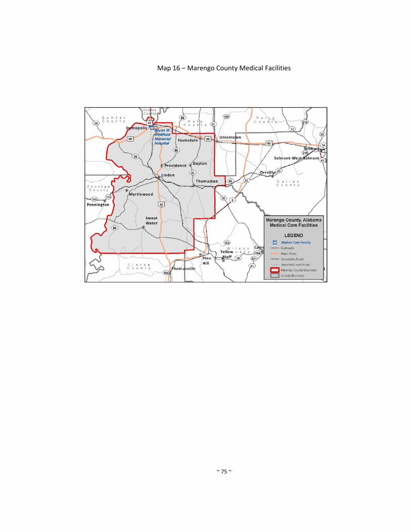
~ 75 ~
Map 16 – Marengo County Medical Facilities
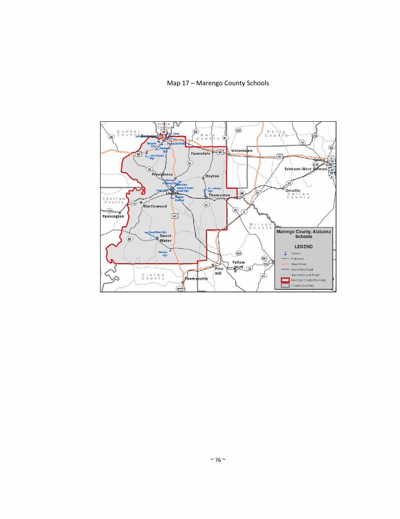
~ 76 ~
Map 17 – Marengo County Schools
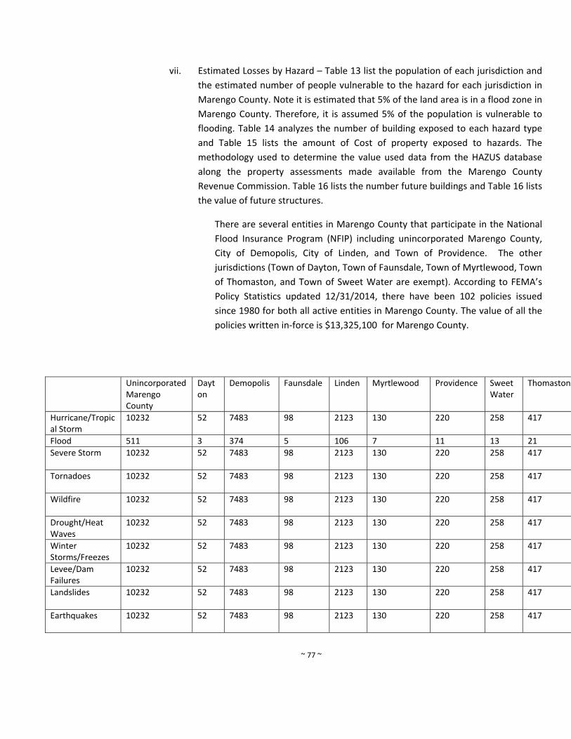
~ 77 ~
vii. Estimated Losses by Hazard – Table 13 list the population of each jurisdiction and
the estimated number of people vulnerable to the hazard for each jurisdiction in
Marengo County. Note it is estimated that 5% of the land area is in a flood zone in
Marengo County. Therefore, it is assumed 5% of the population is vulnerable to
flooding. Table 14 analyzes the number of building exposed to each hazard type
and Table 15 lists the amount of Cost of property exposed to hazards. The
methodology used to determine the value used data from the HAZUS database
along the property assessments made available from the Marengo County
Revenue Commission. Table 16 lists the number future buildings and Table 16 lists
the value of future structures.
There are several entities in Marengo County that participate in the National
Flood Insurance Program (NFIP) including unincorporated Marengo County,
City of Demopolis, City of Linden, and Town of Providence. The other
jurisdictions (Town of Dayton, Town of Faunsdale, Town of Myrtlewood, Town
of Thomaston, and Town of Sweet Water are exempt). According to FEMA’s
Policy Statistics updated 12/31/2014, there have been 102 policies issued
since 1980 for both all active entities in Marengo County. The value of all the
policies written in‐force is $13,325,100 for Marengo County.
Unincorporated Marengo County
Dayton
Demopolis Faunsdale Linden Myrtlewood Providence Sweet Water
Thomaston
Hurricane/Tropical Storm
10232 52
7483 98 2123 130 220 258 417
Flood 511 3 374 5 106 7 11 13 21
Severe Storm 10232 52
7483 98 2123 130 220 258 417
Tornadoes 10232 52
7483 98 2123 130 220 258 417
Wildfire 10232 52
7483 98 2123 130 220 258 417
Drought/Heat Waves
10232 52
7483 98 2123 130 220 258 417
Winter Storms/Freezes
10232 52
7483 98 2123 130 220 258 417
Levee/Dam Failures
10232 52
7483 98 2123 130 220 258 417
Landslides 10232 52
7483 98 2123 130 220 258 417
Earthquakes 10232 52
7483 98 2123 130 220 258 417

~ 78 ~
Table 13. Population vulnerable to hazards in Marengo County, Alabama
Number of Buildings Exposed to Hazards
Residential Commercial Industrial Agriculture Religious Government EducationHurricane/Tropical Storm 9087 127 78 14 38 14 15 Flood 454 6 4 1 2 1 1 Severe Storm 9087 127 78 14 38 14 15 Tornadoes 9087 127 78 14 38 14 15 Wildfire 9087 127 78 14 38 14 15 Drought/Heat Waves 9087 127 78 14 38 14 15 Winter Storms/Freezes 9087 127 78 14 38 14 15 Levee/Dam Failures 9087 127 78 14 38 14 15 Landslides 9087 127 78 14 38 14 15 Earthquakes 9087 127 78 14 38 14 15
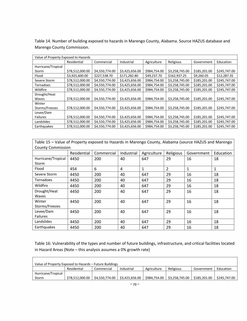
~ 79 ~
Table 14. Number of building exposed to hazards in Marengo County, Alabama. Source HAZUS database and
Marengo County Commission.
Value of Property Exposed to Hazards
Residential Commercial Industrial Agriculture Religious Government Education
Hurricane/Tropical Storm $78,512,000.00 $4,550,774.00 $3,425,656.00 $984,754.00 $3,258,745.00 $185,201.00 $245,747.00
Flood $3,925,600.00 $227,538.70 $171,282.80 $49,237.70 $162,937.25 $9,260.05 $12,287.35
Severe Storm $78,512,000.00 $4,550,774.00 $3,425,656.00 $984,754.00 $3,258,745.00 $185,201.00 $245,747.00
Tornadoes $78,512,000.00 $4,550,774.00 $3,425,656.00 $984,754.00 $3,258,745.00 $185,201.00 $245,747.00
Wildfire $78,512,000.00 $4,550,774.00 $3,425,656.00 $984,754.00 $3,258,745.00 $185,201.00 $245,747.00
Drought/Heat Waves $78,512,000.00 $4,550,774.00 $3,425,656.00 $984,754.00 $3,258,745.00 $185,201.00 $245,747.00
Winter Storms/Freezes $78,512,000.00 $4,550,774.00 $3,425,656.00 $984,754.00 $3,258,745.00 $185,201.00 $245,747.00
Levee/Dam Failures $78,512,000.00 $4,550,774.00 $3,425,656.00 $984,754.00 $3,258,745.00 $185,201.00 $245,747.00
Landslides $78,512,000.00 $4,550,774.00 $3,425,656.00 $984,754.00 $3,258,745.00 $185,201.00 $245,747.00
Earthquakes $78,512,000.00 $4,550,774.00 $3,425,656.00 $984,754.00 $3,258,745.00 $185,201.00 $245,747.00
Table 15 – Value of Property exposed to Hazards in Marengo County, Alabama (source HAZUS and Marengo County Commission
Residential Commercial Industrial Agriculture Religious Government EducationHurricane/Tropical Storm
4450 200 40 647 29 16 18
Flood 454 6 4 1 2 1 1 Severe Storm 4450 200 40 647 29 16 18 Tornadoes 4450 200 40 647 29 16 18 Wildfire 4450 200 40 647 29 16 18 Drought/Heat Waves
4450 200 40 647 29 16 18
Winter Storms/Freezes
4450 200 40 647 29 16 18
Levee/Dam Failures
4450 200 40 647 29 16 18
Landslides 4450 200 40 647 29 16 18 Earthquakes 4450 200 40 647 29 16 18
Table 16: Vulnerability of the types and number of future buildings, infrastructure, and critical facilities located
in Hazard Areas (Note – this analysis assumes a 0% growth rate)
Value of Property Exposed to Hazards – Future Buildings
Residential Commercial Industrial Agriculture Religious Government Education
Hurricane/Tropical Storm $78,512,000.00 $4,550,774.00 $3,425,656.00 $984,754.00 $3,258,745.00 $185,201.00 $245,747.00
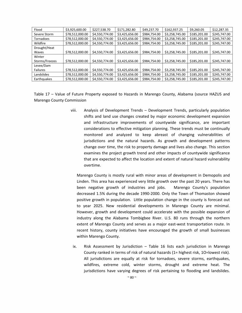
~ 80 ~
Flood $3,925,600.00 $227,538.70 $171,282.80 $49,237.70 $162,937.25 $9,260.05 $12,287.35
Severe Storm $78,512,000.00 $4,550,774.00 $3,425,656.00 $984,754.00 $3,258,745.00 $185,201.00 $245,747.00
Tornadoes $78,512,000.00 $4,550,774.00 $3,425,656.00 $984,754.00 $3,258,745.00 $185,201.00 $245,747.00
Wildfire $78,512,000.00 $4,550,774.00 $3,425,656.00 $984,754.00 $3,258,745.00 $185,201.00 $245,747.00
Drought/Heat Waves $78,512,000.00 $4,550,774.00 $3,425,656.00 $984,754.00 $3,258,745.00 $185,201.00 $245,747.00
Winter Storms/Freezes $78,512,000.00 $4,550,774.00 $3,425,656.00 $984,754.00 $3,258,745.00 $185,201.00 $245,747.00
Levee/Dam Failures $78,512,000.00 $4,550,774.00 $3,425,656.00 $984,754.00 $3,258,745.00 $185,201.00 $245,747.00
Landslides $78,512,000.00 $4,550,774.00 $3,425,656.00 $984,754.00 $3,258,745.00 $185,201.00 $245,747.00
Earthquakes $78,512,000.00 $4,550,774.00 $3,425,656.00 $984,754.00 $3,258,745.00 $185,201.00 $245,747.00
Table 17 – Value of Future Property exposed to Hazards in Marengo County, Alabama (source HAZUS and
Marengo County Commission
viii. Analysis of Development Trends – Development Trends, particularly population
shifts and land use changes created by major economic development expansion
and infrastructure improvements of countywide significance, are important
considerations to effective mitigation planning. These trends must be continually
monitored and analyzed to keep abreast of changing vulnerabilities of
jurisdictions and the natural hazards. As growth and development patterns
change over time, the risk to property damage and lives also change. This section
examines the project growth trend and other impacts of countywide significance
that are expected to affect the location and extent of natural hazard vulnerability
overtime.
Marengo County is mostly rural with minor areas of development in Demopolis and
Linden. This area has experienced very little growth over the past 20 years. There has
been negative growth of industries and jobs. Marengo County's population
decreased 1.5% during the decade 1990‐2000. Only the Town of Thomaston showed
positive growth in population. Little population change in the county is forecast out
to year 2025. New residential developments in Marengo County are minimal.
However, growth and development could accelerate with the possible expansion of
industry along the Alabama Tombigbee River. U.S. 80 runs through the northern
extent of Marengo County and serves as a major east‐west transportation route. In
recent history, county initiatives have encouraged the growth of small businesses
within Marengo County.
ix. Risk Assessment by Jurisdiction – Table 16 lists each jurisdiction in Marengo
County ranked in terms of risk of natural hazards (1= highest risk, 1O=lowest risk).
All jurisdictions are equally at risk for tornadoes, severe storms, earthquakes,
wildfires, extreme cold, winter storms, drought and extreme heat. The
jurisdictions have varying degrees of risk pertaining to flooding and landslides.
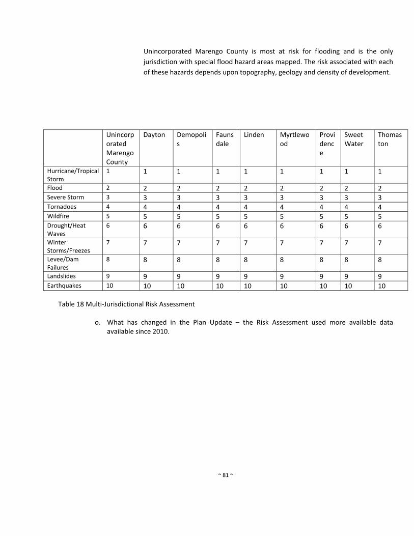
~ 81 ~
Unincorporated Marengo County is most at risk for flooding and is the only
jurisdiction with special flood hazard areas mapped. The risk associated with each
of these hazards depends upon topography, geology and density of development.
Unincorporated Marengo County
Dayton Demopolis
Faunsdale
Linden Myrtlewood
Providence
Sweet Water
Thomaston
Hurricane/Tropical Storm
1 1 1 1 1 1 1 1 1
Flood 2 2 2 2 2 2 2 2 2 Severe Storm 3 3 3 3 3 3 3 3 3 Tornadoes 4 4 4 4 4 4 4 4 4 Wildfire 5 5 5 5 5 5 5 5 5 Drought/Heat Waves
6 6 6 6 6 6 6 6 6
Winter Storms/Freezes
7 7 7 7 7 7 7 7 7
Levee/Dam Failures
8 8 8 8 8 8 8 8 8
Landslides 9 9 9 9 9 9 9 9 9 Earthquakes 10 10 10 10 10 10 10 10 10
Table 18 Multi‐Jurisdictional Risk Assessment
o. What has changed in the Plan Update – the Risk Assessment used more available data available since 2010.
~ 82 ~
5. Mitigation Strategies
a. Purpose of Mitigation Goals Strategies ‐ These mitigation strategies provide a blueprint for
each participating jurisdiction to reduce the potential losses identified in the risk assessment
through a comprehensive plan of goals, objectives, and policies. It guides the communities
that have participated in its preparation through the Hazard Mitigation Planning Committee
(HMPC). These communities have adopted this plan and committed their resources to
achieve its goals.
In unincorporated Marengo County, the Marengo County Emergency Management Agency
was established via a resolution. The AEMA was established through Section 4 of the Alabama
Emergency Management Act of 1955 (Public Law 31‐9), Act 47, June 1955. Section 10,
Alabama Law, 1955 Act No. 47, directs the establishment of local organization for emergency
management in accordance with the state emergency management plan and programs. The
local organizations have the responsibility for coordinating the disaster preparedness,
mitigation, response and recovery efforts of local government. Under this legislation, each
county is required to have an emergency management organization, either individual or
jointly. Appropriate ordinance and/or resolution are required to establish each local
organization and must provide for the organization, powers, duties, divisions, services and
staff of the agency.
One of the most significant state enabling statutes related to hazard mitigation can be found
in the Title 11, Chapter 52, Planning, Zoning, and Subdivision of the Code of Alabama. Section
11‐52 et seq is the state planning enabling legislation for municipalities only. First enacted in
1935, the statue provides municipalities broad powers for comprehensive planning, capital
improvements programming and the regulation of land use, development, and conservation
of land areas through zoning ordinance and subdivision regulations. It permits municipalities
to create planning commission to oversee planning and land use controls, and Boards of
Adjustments to hear appeals. It is the basis for floodplain management regulations within all
municipalities and provides additional powers to control the location and types of
development activities that might be affected by other natural hazards, including landslides
and land subsidence.
Unincorporated areas of the counties in Alabama are severely restricted by the lack of a state
planning enabling statute. Only three counties statewide – Baldwin, Jefferson and parts of
Shelby County – are permitted to establish zoning ordinance by special acts adopted by Title
11, Chapter 24 of the Code of Alabama. County commissions are permitted to regulate the
subdivision of land and the construction of streets and utilities with the advice of an advisory
board. Municipalities may enforce subdivision regulations with its police jurisdiction which can
~ 83 ~
extend two miles beyond the municipal boundaries within unincorporated areas of a county.
Code of Alabama, Title 11, Chapter 19 Sections 11‐19‐1 through 11‐19‐24, entitled the
Comprehensive Land Use Management Act was enacted to prevent economic and human loss
in flood‐prone areas and permit counties to manage floodplain development within
unincorporated areas. This act provides the established county commissions the authority to
create a comprehensive land‐use management program floodplain management, in
accordance the NFIP criteria. As a result, unincorporated communities are eligible for flood
insurance through the NFIP. This program helps mitigate damages cause by floods by
controlling land use and development and improve the long‐range management of flood
prone areas. The statue authorizes each county commission to adopt floodplain management
ordinance for unincorporated areas. County Planning Commissions are granted broad
authority to control development in flood prone zone by adopting ordinances and Flood
Insurance Rate Maps that delineate the various flood zones controlled by the adopted
ordinances. Each county must appoint and administrator of the program and provide for a
Board of Adjustment to hear appeals to the ordinance requirements.
Marengo County has its subdivision authority and the authority to develop a Flood Hazard
Prevention ordinance. The municipal Jurisdictions in Marengo County (City of Demopolis,
Sweet Water, Linden, Providence, Thomaston, Dayton, Faunsdale, and Myrtlewood), have
authority to pass ordinances to implement the Hazard Mitigation Plans. However, are Dayton
and Providence have a very small population and therefore, look to the leadership and
authority leadership of the Marengo County EMA to assist with the implementation of the
strategies.
b. Identification and Analysis of Mitigation Measures ‐ The Hazard Mitigation Planning
Committee guided the preparation of these strategies. The Committee first reviewed the risk
assessment to determine the most critical hazard threats to each jurisdiction (see Chapter 4.
Risk Assessment). Next, the Committee and each jurisdiction reviewed existing authorities,
policies, programs, and resources through an exercise to rate the capabilities of each
jurisdiction to implement mitigation measures. These authorities and resources include local
legislation for subdivisions (for counties), ability to pass ordinances (municipalities), the
floodplain prevention ordinance, and resources for planning made available by the Alabama
Tombigbee Regional Planning Commission. Finally, the HMPC analyzed a broad range of
available mitigation measures. On this basis, the Committee evaluated the ability of each
jurisdiction to expand on and improve these tools. The Committee recommends those
measures that might best respond to the vulnerability concerns within the existing and
potential capabilities of each jurisdiction.
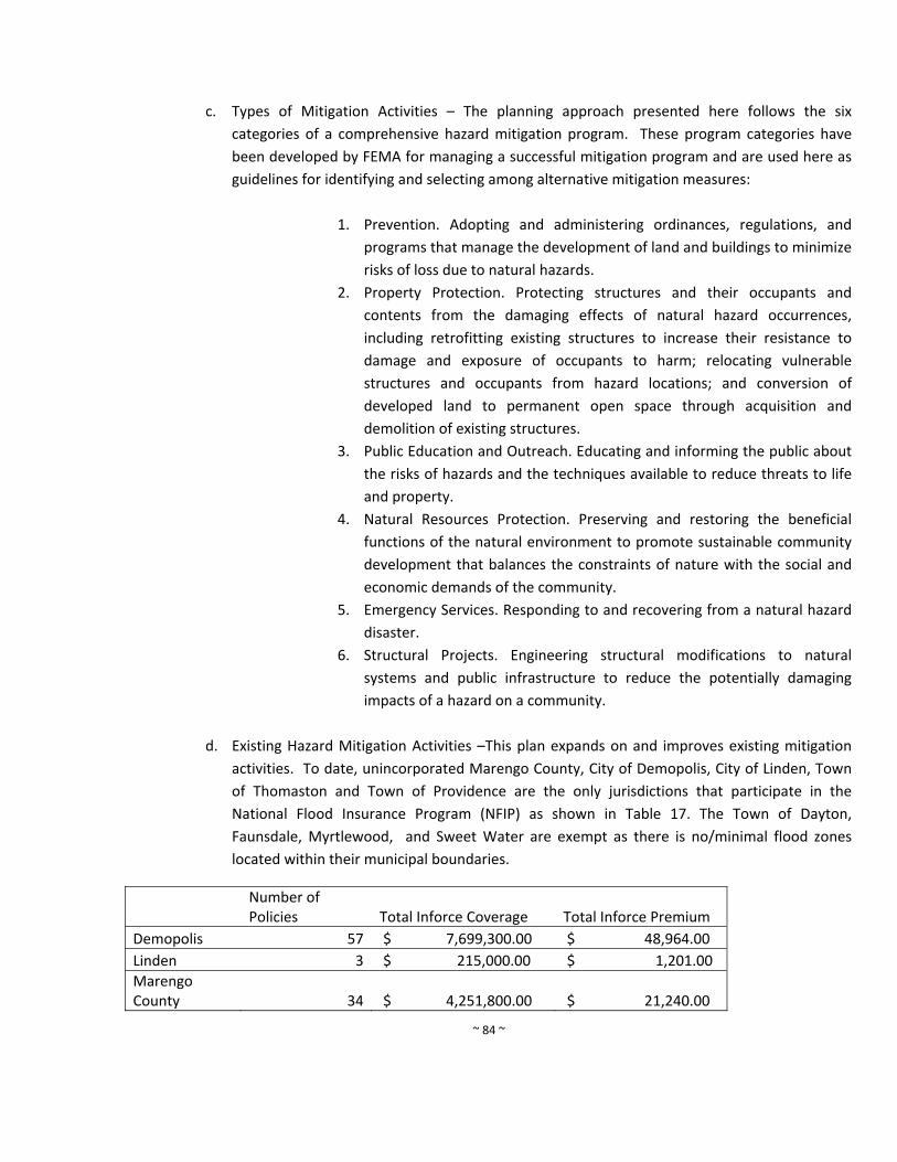
~ 84 ~
c. Types of Mitigation Activities – The planning approach presented here follows the six
categories of a comprehensive hazard mitigation program. These program categories have
been developed by FEMA for managing a successful mitigation program and are used here as
guidelines for identifying and selecting among alternative mitigation measures:
1. Prevention. Adopting and administering ordinances, regulations, and
programs that manage the development of land and buildings to minimize
risks of loss due to natural hazards.
2. Property Protection. Protecting structures and their occupants and
contents from the damaging effects of natural hazard occurrences,
including retrofitting existing structures to increase their resistance to
damage and exposure of occupants to harm; relocating vulnerable
structures and occupants from hazard locations; and conversion of
developed land to permanent open space through acquisition and
demolition of existing structures.
3. Public Education and Outreach. Educating and informing the public about
the risks of hazards and the techniques available to reduce threats to life
and property.
4. Natural Resources Protection. Preserving and restoring the beneficial
functions of the natural environment to promote sustainable community
development that balances the constraints of nature with the social and
economic demands of the community.
5. Emergency Services. Responding to and recovering from a natural hazard
disaster.
6. Structural Projects. Engineering structural modifications to natural
systems and public infrastructure to reduce the potentially damaging
impacts of a hazard on a community.
d. Existing Hazard Mitigation Activities –This plan expands on and improves existing mitigation
activities. To date, unincorporated Marengo County, City of Demopolis, City of Linden, Town
of Thomaston and Town of Providence are the only jurisdictions that participate in the
National Flood Insurance Program (NFIP) as shown in Table 17. The Town of Dayton,
Faunsdale, Myrtlewood, and Sweet Water are exempt as there is no/minimal flood zones
located within their municipal boundaries.
Number of Policies Total Inforce Coverage Total Inforce Premium
Demopolis 57 $ 7,699,300.00 $ 48,964.00
Linden 3 $ 215,000.00 $ 1,201.00
Marengo County 34 $ 4,251,800.00 $ 21,240.00
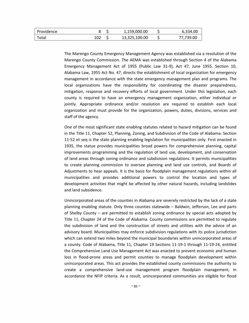
~ 85 ~
Providence 8 $ 1,159,000.00 $ 6,334.00
Total 102 $ 13,325,100.00 $ 77,739.00
The Marengo County Emergency Management Agency was established via a resolution of the
Marengo County Commission. The AEMA was established through Section 4 of the Alabama
Emergency Management Act of 1955 (Public Law 31‐9), Act 47, June 1955. Section 10,
Alabama Law, 1955 Act No. 47, directs the establishment of local organization for emergency
management in accordance with the state emergency management plan and programs. The
local organizations have the responsibility for coordinating the disaster preparedness,
mitigation, response and recovery efforts of local government. Under this legislation, each
county is required to have an emergency management organization, either individual or
jointly. Appropriate ordinance and/or resolution are required to establish each local
organization and must provide for the organization, powers, duties, divisions, services and
staff of the agency.
One of the most significant state enabling statutes related to hazard mitigation can be found
in the Title 11, Chapter 52, Planning, Zoning, and Subdivision of the Code of Alabama. Section
11‐52 et seq is the state planning enabling legislation for municipalities only. First enacted in
1935, the statue provides municipalities broad powers for comprehensive planning, capital
improvements programming and the regulation of land use, development, and conservation
of land areas through zoning ordinance and subdivision regulations. It permits municipalities
to create planning commission to oversee planning and land use controls, and Boards of
Adjustments to hear appeals. It is the basis for floodplain management regulations within all
municipalities and provides additional powers to control the location and types of
development activities that might be affected by other natural hazards, including landslides
and land subsidence.
Unincorporated areas of the counties in Alabama are severely restricted by the lack of a state
planning enabling statute. Only three counties statewide – Baldwin, Jefferson, Lee and parts
of Shelby County – are permitted to establish zoning ordinance by special acts adopted by
Title 11, Chapter 24 of the Code of Alabama. County commissions are permitted to regulate
the subdivision of land and the construction of streets and utilities with the advice of an
advisory board. Municipalities may enforce subdivision regulations with its police jurisdiction
which can extend two miles beyond the municipal boundaries within unincorporated areas of
a county. Code of Alabama, Title 11, Chapter 19 Sections 11‐19‐1 through 11‐19‐24, entitled
the Comprehensive Land Use Management Act was enacted to prevent economic and human
loss in flood‐prone areas and permit counties to manage floodplain development within
unincorporated areas. This act provides the established county commissions the authority to
create a comprehensive land‐use management program floodplain management, in
accordance the NFIP criteria. As a result, unincorporated communities are eligible for flood
~ 86 ~
insurance through the NFIP. This program helps mitigate damages cause by floods by
controlling land use and development and improve the long‐range management of flood
prone areas. The statue authorizes each county commission to adopt floodplain management
ordinance for unincorporated areas. County Planning Commissions are granted broad
authority to control development in flood prone zone by adopting ordinances and Flood
Insurance Rate Maps that delineate the various flood zones controlled by the adopted
ordinances. Each county must appoint and administrator of the program and provide for a
Board of Adjustment to hear appeals to the ordinance requirements.
e. Mitigation Issues and Opportunities – The policies of this plan respond to the mitigation issues
and opportunities presented in this section. These are derived from the findings of the risk
assessment and capability assessment and discussions with members of the HMPC.
Prevention
Tornadoes, severe storms and hurricanes are the most threatening hazards to Marengo
County communities.
No Marengo County municipalities practice comprehensive planning, except for
Myrtlewood and Demopolis.
The county expects a slight population increase of 1.1% out to year 2025.
A large number of areas depicted on the Flood Insurance Rate Maps are designated
"Approximate" zones where no detailed studies and flood elevation data exist.
Unincorporated Marengo County, City of Demopolis, City of Linden, Town of Providence,
and Town of Thomaston are the only jurisdictions that participate in the NFIP.
The municipalities of Dayton, Faunsdale, Myrtlewood, Sweet Water and are exempt
because they don’t have any significant 100‐year floodplain located with their municipal
limits.
Property Protection
Standard homeowner and business insurance policies do not cover flood damages.
Many older homes and buildings located in flood plains are not protected from flooding.
Public Education and Outreach
Real estate agents and property owners have a continuing need for flood map
information.
The public is generally unaware of risks associated with hazards and the mitigation
measures available for property protection.
Local libraries are available to serve as repositories for information on hazards and
methods of protection.
~ 87 ~
Technical assistance materials are available through FEMA to assist property owners on
alternative property protection measures.
School environmental education programs provide excellent opportunities for public
education on hazard mitigation alternatives.
A multitude of public outreach opportunities and resources are available.
Public information activities are among the least expensive mitigation measures but often
the most effective.
Natural Resources Protection
Stream and river banks and riparian zones help manage floods and filter runoff.
Accidental or intentional dumping of household and commercial, such as household
garbage, tires, shopping carts, and landscape debris, can obstruct flows.
Storm‐damaged trees ‐ resulting from hurricanes, tornadoes, severe thunderstorms, and
wind storms‐ can clog streets and access during periods of disaster response, obstruct the
natural discharge of flood waters, disrupt utility services, increase debris removal, damage
property, and increase disaster recovery costs.
Emergency Services
1. Weather radios in homes and businesses provide inexpensive means for advance warning.
2. Further, an extensive outdoor siren system should be installed in Marengo County due the
high frequency and intensity of tornadoes.
Structural Projects
1. Regular maintenance of streams and drainage ways is critical to their effective operation
for storm water discharge.
f. Mitigation Policies Plan
This section presents the long‐term, comprehensive plan for mitigation of natural hazards.
Each of these mitigation actions will be carried out by the Marengo County Emergency
Management in coordination with local, state, federal, and other agencies. Priority mitigation
projects carried over into the action program should only be implemented if the benefits are
maximized and outweigh the associated costs of the proposed projects. The goals of this
mitigation policies plan apply to all jurisdictions within the county. The communities' long‐
range vision for disaster resistance and the mission of the HMPC are restated here for
reference.
Over the last 5 years, Marengo County has had success in implementing actions form the 2010
plan. Some of the actions have been completed; however most are processes and have not
yet been completed. Also, some mitigation measures have been deleted from the plan as they
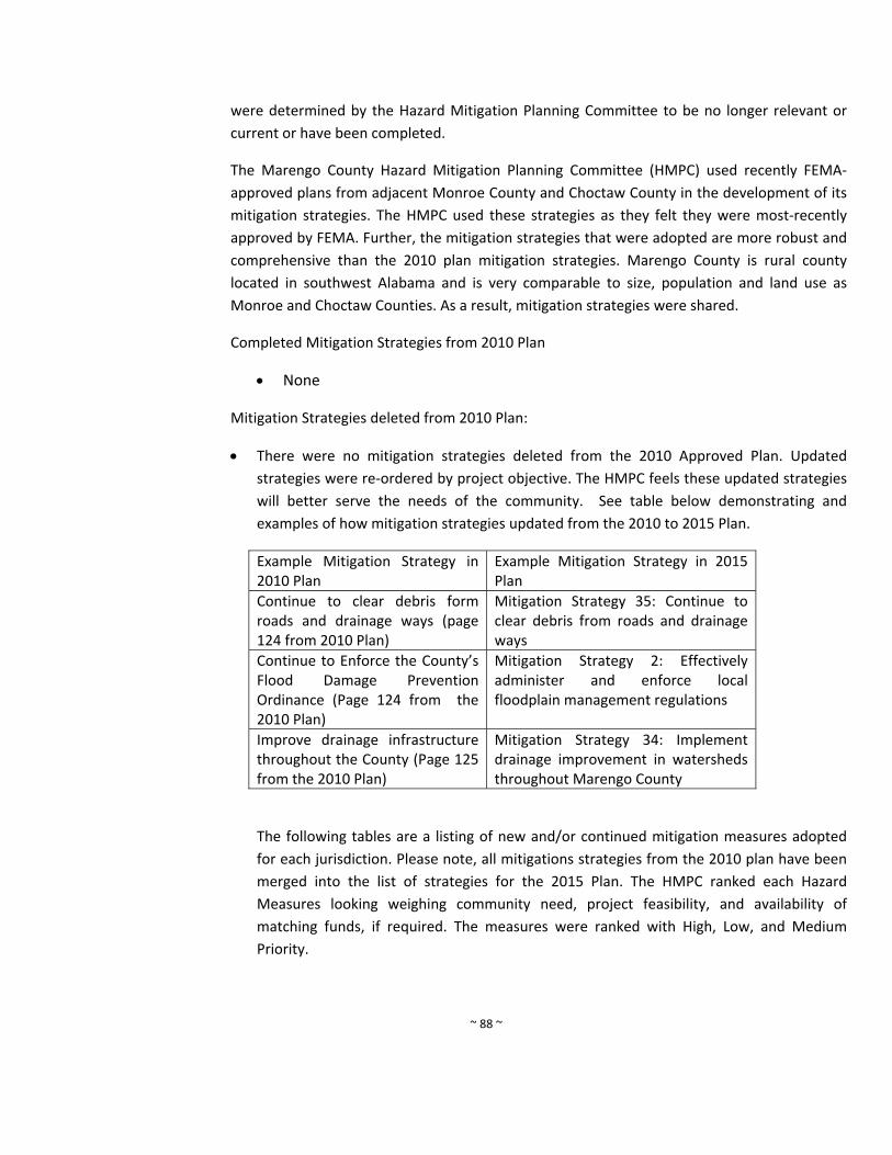
~ 88 ~
were determined by the Hazard Mitigation Planning Committee to be no longer relevant or
current or have been completed.
The Marengo County Hazard Mitigation Planning Committee (HMPC) used recently FEMA‐
approved plans from adjacent Monroe County and Choctaw County in the development of its
mitigation strategies. The HMPC used these strategies as they felt they were most‐recently
approved by FEMA. Further, the mitigation strategies that were adopted are more robust and
comprehensive than the 2010 plan mitigation strategies. Marengo County is rural county
located in southwest Alabama and is very comparable to size, population and land use as
Monroe and Choctaw Counties. As a result, mitigation strategies were shared.
Completed Mitigation Strategies from 2010 Plan
None
Mitigation Strategies deleted from 2010 Plan:
There were no mitigation strategies deleted from the 2010 Approved Plan. Updated
strategies were re‐ordered by project objective. The HMPC feels these updated strategies
will better serve the needs of the community. See table below demonstrating and
examples of how mitigation strategies updated from the 2010 to 2015 Plan.
Example Mitigation Strategy in 2010 Plan
Example Mitigation Strategy in 2015 Plan
Continue to clear debris form roads and drainage ways (page 124 from 2010 Plan)
Mitigation Strategy 35: Continue to clear debris from roads and drainage ways
Continue to Enforce the County’s Flood Damage Prevention Ordinance (Page 124 from the 2010 Plan)
Mitigation Strategy 2: Effectively administer and enforce local floodplain management regulations
Improve drainage infrastructure throughout the County (Page 125 from the 2010 Plan)
Mitigation Strategy 34: Implement drainage improvement in watersheds throughout Marengo County
The following tables are a listing of new and/or continued mitigation measures adopted
for each jurisdiction. Please note, all mitigations strategies from the 2010 plan have been
merged into the list of strategies for the 2015 Plan. The HMPC ranked each Hazard
Measures looking weighing community need, project feasibility, and availability of
matching funds, if required. The measures were ranked with High, Low, and Medium
Priority.
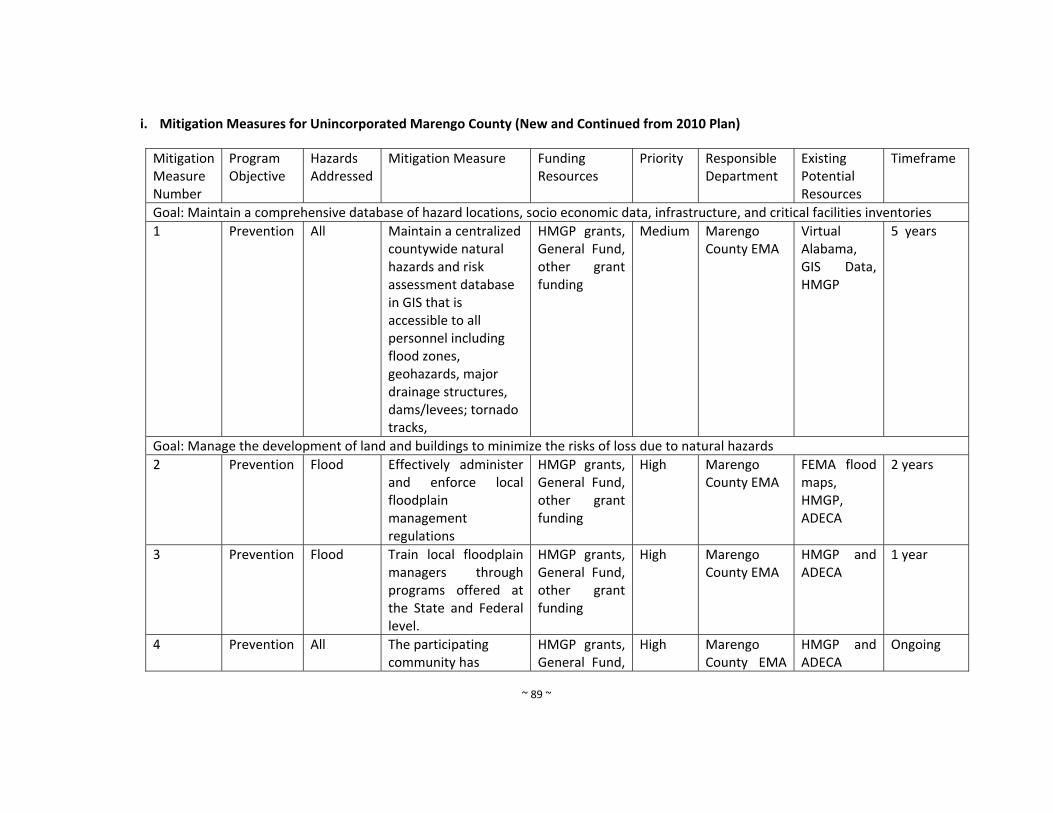
~ 89 ~
i. Mitigation Measures for Unincorporated Marengo County (New and Continued from 2010 Plan)
Mitigation Measure Number
Program Objective
Hazards Addressed
Mitigation Measure Funding Resources
Priority
Responsible Department
Existing Potential Resources
Timeframe
Goal: Maintain a comprehensive database of hazard locations, socio economic data, infrastructure, and critical facilities inventories
1 Prevention All Maintain a centralized countywide natural hazards and risk assessment database in GIS that is accessible to all personnel including flood zones, geohazards, major drainage structures, dams/levees; tornado tracks,
HMGP grants, General Fund, other grant funding
Medium Marengo County EMA
Virtual Alabama, GIS Data, HMGP
5 years
Goal: Manage the development of land and buildings to minimize the risks of loss due to natural hazards
2 Prevention Flood Effectively administer and enforce local floodplain management regulations
HMGP grants, General Fund, other grant funding
High Marengo County EMA
FEMA flood maps, HMGP, ADECA
2 years
3 Prevention Flood Train local floodplain managers through programs offered at the State and Federal level.
HMGP grants, General Fund, other grant funding
High Marengo County EMA
HMGP and ADECA
1 year
4 Prevention All The participating community has
HMGP grants, General Fund,
High Marengo County EMA
HMGP and ADECA
Ongoing

~ 90 ~
adopted and enforces floodplain management ordinances that meet or exceed the minimum requirements of the NFIP. These requirements are intended to prevent loss of life and property and reduce taxpayer costs for disaster relief, as well as minimize economic and social hardships that result from flooding.
other grant funding
and
5 Prevention All Maintain a library of technical assistance and guidance materials for local floodplain managers and use Marengo County EMA website for implementation
HMGP grants, General Fund, other grant funding
Medium Marengo County EMA
HMGP and ADECA
1 year
6 Prevention All Promote adoption of uniform flood hazard prevention ordinance among all of the NFIP
HMGP grants, General Fund, other grant funding
Medium Marengo County EMA
HMGP and ADECA
1 year

~ 91 ~
communities in Marengo County.
7 Prevention All Acquire GIS software for marinating risk assessment data
HMGP grants, General Fund, other grant funding
High Marengo County EMA
HMGP and ADECA
5 years
8 Prevention All Prepare and adopt a comprehensive plan
HMGP grants, General Fund, other grant funding
Low Marengo County EMA
HMGP and ADECA
10 years
9 Prevention All Require the construction of Safe Rooms in new public buildings, such as new schools, libraries, community centers and other public buildings when feasible
HMGP grants, General Fund, other grant funding
High All jurisdictions
HMGP 1 year
10 Prevention All Construct free‐standing public Safe Rooms in existing vulnerable locations
HMGP grants, General Fund, other grant funding
High All jurisdictions
HMGP ADECA
5 years
11 Prevention All Apply for funding to update/revise mitigation plan when needed
HMGP grants, General Fund, other grant funding
Medium All jurisdictions
HMGP 5 years
12 Prevention All Conduct special studies as needed to identify hazard risks and mitigation
HMGP grants, General Fund, other grant funding
Medium All jurisdictions
HMGP 10 years

~ 92 ~
measures
Goal: Protect structures and their occupants and contents from damaging effects of natural hazards
13 Property Protection
All Encourage retrofits of older homes constructed before the enactment of floodplain regulations
HMGP grants, General Fund, other grant funding
Medium All jurisdictions
HMGP 2 years
14 Property Protection
All Maintain insurance riders on existing properties
HMGP grants, General Fund, other grant funding
High All jurisdictions
HMGP Ongoing
15 Property Protection
All Provide back‐up power for critical facilities and fire stations
HMGP grants, General Fund, other grant funding
High All jurisdictions
HMGP 2 years
16 Property Protection
All Promote good construction practices and proper code enforcement to eliminate most structural problems during natural hazard events
HMGP grants, General Fund, other grant funding
Medium All jurisdictions
HMGP 2 years
17 Property Protection
All Encourage the construction of safe rooms within new public buildings, such as new schools, libraries, community centers, and other
HMGP grants, General Fund, other grant funding
High All jurisdictions
HMGP 2 years
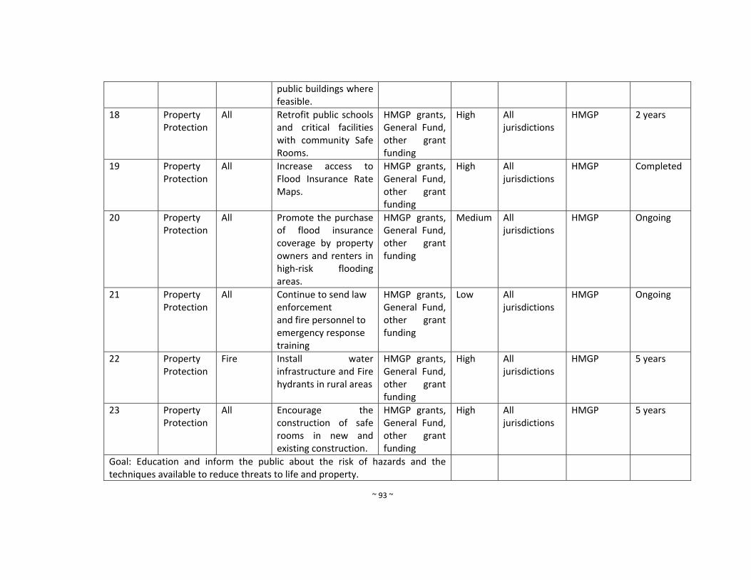
~ 93 ~
public buildings where feasible.
18 Property Protection
All Retrofit public schools and critical facilities with community Safe Rooms.
HMGP grants, General Fund, other grant funding
High All jurisdictions
HMGP 2 years
19 Property Protection
All Increase access to Flood Insurance Rate Maps.
HMGP grants, General Fund, other grant funding
High All jurisdictions
HMGP Completed
20 Property Protection
All Promote the purchase of flood insurance coverage by property owners and renters in high‐risk flooding areas.
HMGP grants, General Fund, other grant funding
Medium All jurisdictions
HMGP Ongoing
21 Property Protection
All Continue to send law enforcement and fire personnel to emergency response training
HMGP grants, General Fund, other grant funding
Low All jurisdictions
HMGP Ongoing
22 Property Protection
Fire Install water infrastructure and Fire hydrants in rural areas
HMGP grants, General Fund, other grant funding
High All jurisdictions
HMGP 5 years
23 Property Protection
All Encourage the construction of safe rooms in new and existing construction.
HMGP grants, General Fund, other grant funding
High All jurisdictions
HMGP 5 years
Goal: Education and inform the public about the risk of hazards and the techniques available to reduce threats to life and property.
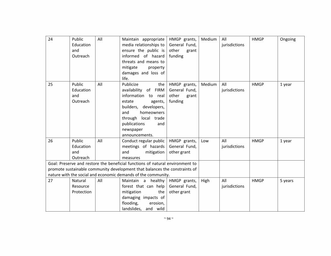
~ 94 ~
24 Public Education and Outreach
All Maintain appropriate media relationships to ensure the public is informed of hazard threats and means to mitigate property damages and loss of life.
HMGP grants, General Fund, other grant funding
Medium All jurisdictions
HMGP Ongoing
25 Public Education and Outreach
All Publicize the availability of FIRM information to real estate agents, builders, developers, and homeowners through local trade publications and newspaper announcements.
HMGP grants, General Fund, other grant funding
Medium All jurisdictions
HMGP 1 year
26 Public Education and Outreach
All Conduct regular public meetings of hazards and mitigation measures
HMGP grants, General Fund, other grant
Low All jurisdictions
HMGP 1 year
Goal: Preserve and restore the beneficial functions of natural environment to promote sustainable community development that balances the constraints of nature with the social and economic demands of the community.
27 Natural Resource Protection
All Maintain a healthy forest that can help mitigation the damaging impacts of flooding, erosion, landslides, and wild
HMGP grants, General Fund, other grant
High All jurisdictions
HMGP 5 years
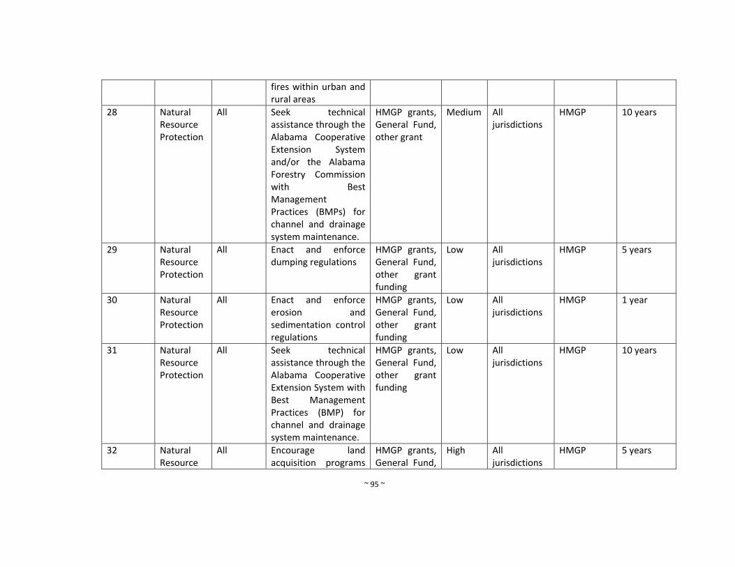
~ 95 ~
fires within urban and rural areas
28 Natural Resource Protection
All Seek technical assistance through the Alabama Cooperative Extension System and/or the Alabama Forestry Commission with Best Management Practices (BMPs) for channel and drainage system maintenance.
HMGP grants, General Fund, other grant
Medium All jurisdictions
HMGP 10 years
29 Natural Resource Protection
All Enact and enforce dumping regulations
HMGP grants, General Fund, other grant funding
Low All jurisdictions
HMGP 5 years
30 Natural Resource Protection
All Enact and enforce erosion and sedimentation control regulations
HMGP grants, General Fund, other grant funding
Low All jurisdictions
HMGP 1 year
31 Natural Resource Protection
All Seek technical assistance through the Alabama Cooperative Extension System with Best Management Practices (BMP) for channel and drainage system maintenance.
HMGP grants, General Fund, other grant funding
Low All jurisdictions
HMGP 10 years
32 Natural Resource
All Encourage land acquisition programs
HMGP grants, General Fund,
High All jurisdictions
HMGP 5 years

~ 96 ~
Protection to acquire habitat throughout Marengo County
other grant
Goal: Apply engineered structural modifications to natural systems and public infrastructure to reduce potentially damaging impacts of hazards, where feasible, cost effective, and environmentally suitable
33 Structural Projects
All Improve maintenance programs for streams and drainage ways.
HMGP grants, General Fund, other grant funding
High
All jurisdictions
HMGP 3 years
34 Structural Projects
All Implement drainage improvement in watersheds throughout Marengo County
HMGP grants, General Fund, other grant funding
High All jurisdictions
HMGP 3 years
35 Structural Projects
All Continue to clear debris from roads and drainage ways
HMGP grants, General Fund, other grant funding
High All jurisdictions
HMGP 10 years
36 Structural Projects
All Continue to improve and maintain county road system
HMGP grants, General Fund, other grant funding
High All jurisdictions
HMGP 5 years
37 Structural Projects
All Prepare and implement standard operation procedures for drainage system maintenance
HMGP grants, General Fund, other grant funding
Low All jurisdictions
HMGP 5 years
Goal: Improve the Efficiency, timing, and effectiveness of response and recovery for natural hazard disasters
38 Emergency All Improve public HMGP grants, High All HMGP 1 year
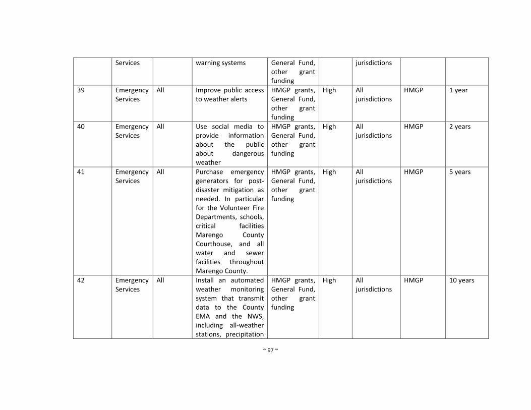
~ 97 ~
Services warning systems General Fund, other grant funding
jurisdictions
39 Emergency Services
All Improve public access to weather alerts
HMGP grants, General Fund, other grant funding
High All jurisdictions
HMGP 1 year
40 Emergency Services
All Use social media to provide information about the public about dangerous weather
HMGP grants, General Fund, other grant funding
High All jurisdictions
HMGP 2 years
41 Emergency Services
All Purchase emergency generators for post‐disaster mitigation as needed. In particular for the Volunteer Fire Departments, schools, critical facilities Marengo County Courthouse, and all water and sewer facilities throughout Marengo County.
HMGP grants, General Fund, other grant funding
High All jurisdictions
HMGP 5 years
42 Emergency Services
All
Install an automated weather monitoring system that transmit data to the County EMA and the NWS, including all‐weather stations, precipitation
HMGP grants, General Fund, other grant funding
High All jurisdictions
HMGP 10 years
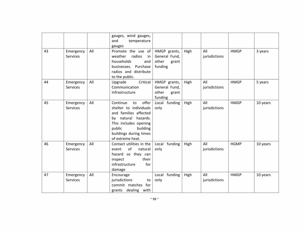
~ 98 ~
gauges, wind gauges, and temperature gauges
43 Emergency Services
All Promote the use of weather radios in households and businesses. Purchase radios and distribute to the public.
HMGP grants, General Fund, other grant funding
High All jurisdictions
HMGP 3 years
44 Emergency Services
All Upgrade Critical Communication Infrastructure
HMGP grants, General Fund, other grant funding
High All jurisdictions
HMGP 5 years
45 Emergency Services
All Continue to offer shelter to individuals and families affected by natural hazards. This includes opening public building buildings during times of extreme heat.
Local funding only
High All jurisdictions
HMGP 10 years
46 Emergency Services
All Contact utilities in the event of natural hazard so they can inspect their infrastructure for damage
Local funding only
High All jurisdictions
HGMP 10 years
47 Emergency Services
All Encourage jurisdictions to commit matches for grants dealing with
Local funding only
High All jurisdictions
HMGP 10 years
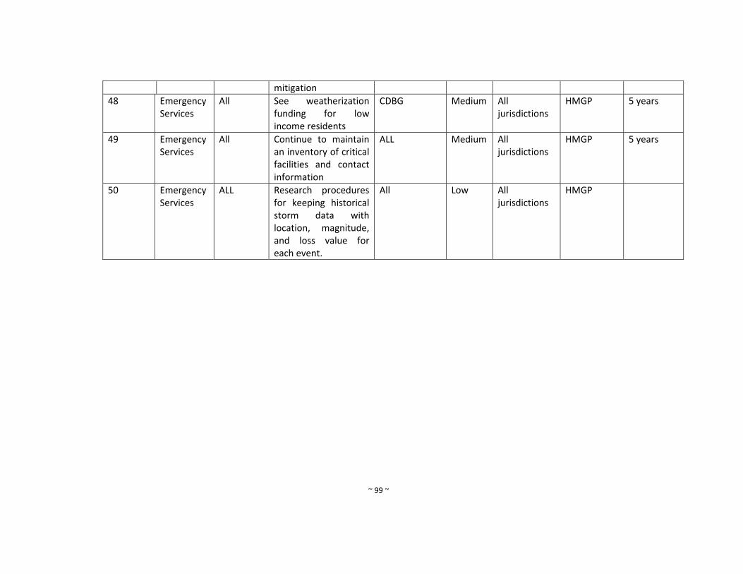
~ 99 ~
mitigation
48 Emergency Services
All See weatherization funding for low income residents
CDBG Medium All jurisdictions
HMGP 5 years
49 Emergency Services
All Continue to maintain an inventory of critical facilities and contact information
ALL Medium All jurisdictions
HMGP 5 years
50 Emergency Services
ALL Research procedures for keeping historical storm data with location, magnitude, and loss value for each event.
All Low All jurisdictions
HMGP
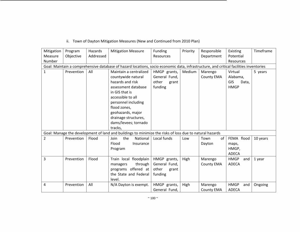
~ 100 ~
ii. Town of Dayton Mitigation Measures (New and Continued from 2010 Plan)
Mitigation Measure Number
Program Objective
Hazards Addressed
Mitigation Measure Funding Resources
Priority
Responsible Department
Existing Potential Resources
Timeframe
Goal: Maintain a comprehensive database of hazard locations, socio economic data, infrastructure, and critical facilities inventories
1 Prevention All Maintain a centralized countywide natural hazards and risk assessment database in GIS that is accessible to all personnel including flood zones, geohazards, major drainage structures, dams/levees; tornado tracks,
HMGP grants, General Fund, other grant funding
Medium Marengo County EMA
Virtual Alabama, GIS Data, HMGP
5 years
Goal: Manage the development of land and buildings to minimize the risks of loss due to natural hazards
2 Prevention Flood Join the National Flood Insurance Program
Local funds Low Town of Dayton
FEMA flood maps, HMGP, ADECA
10 years
3 Prevention Flood Train local floodplain managers through programs offered at the State and Federal level.
HMGP grants, General Fund, other grant funding
High Marengo County EMA
HMGP and ADECA
1 year
4 Prevention All N/A Dayton is exempt. HMGP grants, General Fund,
High Marengo County EMA
HMGP and ADECA
Ongoing
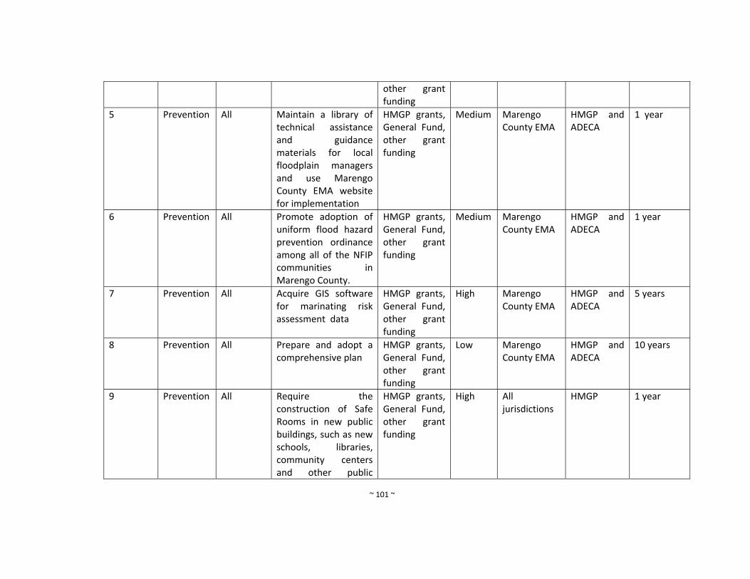
~ 101 ~
other grant funding
5 Prevention All Maintain a library of technical assistance and guidance materials for local floodplain managers and use Marengo County EMA website for implementation
HMGP grants, General Fund, other grant funding
Medium Marengo County EMA
HMGP and ADECA
1 year
6 Prevention All Promote adoption of uniform flood hazard prevention ordinance among all of the NFIP communities in Marengo County.
HMGP grants, General Fund, other grant funding
Medium Marengo County EMA
HMGP and ADECA
1 year
7 Prevention All Acquire GIS software for marinating risk assessment data
HMGP grants, General Fund, other grant funding
High Marengo County EMA
HMGP and ADECA
5 years
8 Prevention All Prepare and adopt a comprehensive plan
HMGP grants, General Fund, other grant funding
Low Marengo County EMA
HMGP and ADECA
10 years
9 Prevention All Require the construction of Safe Rooms in new public buildings, such as new schools, libraries, community centers and other public
HMGP grants, General Fund, other grant funding
High All jurisdictions
HMGP 1 year
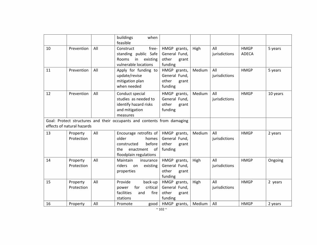
~ 102 ~
buildings when feasible
10 Prevention All Construct free‐standing public Safe Rooms in existing vulnerable locations
HMGP grants, General Fund, other grant funding
High All jurisdictions
HMGP ADECA
5 years
11 Prevention All Apply for funding to update/revise mitigation plan when needed
HMGP grants, General Fund, other grant funding
Medium All jurisdictions
HMGP 5 years
12 Prevention All Conduct special studies as needed to identify hazard risks and mitigation measures
HMGP grants, General Fund, other grant funding
Medium All jurisdictions
HMGP 10 years
Goal: Protect structures and their occupants and contents from damaging effects of natural hazards
13 Property Protection
All Encourage retrofits of older homes constructed before the enactment of floodplain regulations
HMGP grants, General Fund, other grant funding
Medium All jurisdictions
HMGP 2 years
14 Property Protection
All Maintain insurance riders on existing properties
HMGP grants, General Fund, other grant funding
High All jurisdictions
HMGP Ongoing
15 Property Protection
All Provide back‐up power for critical facilities and fire stations
HMGP grants, General Fund, other grant funding
High All jurisdictions
HMGP 2 years
16 Property All Promote good HMGP grants, Medium All HMGP 2 years
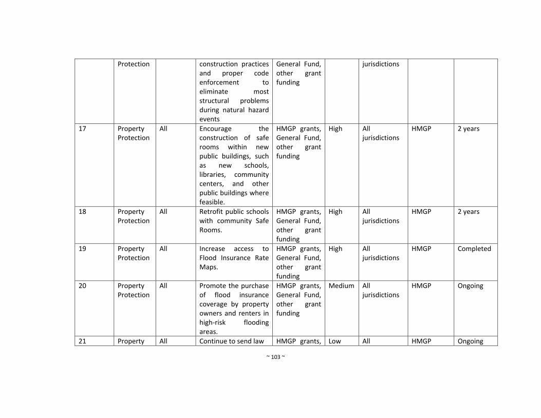
~ 103 ~
Protection construction practices and proper code enforcement to eliminate most structural problems during natural hazard events
General Fund, other grant funding
jurisdictions
17 Property Protection
All Encourage the construction of safe rooms within new public buildings, such as new schools, libraries, community centers, and other public buildings where feasible.
HMGP grants, General Fund, other grant funding
High All jurisdictions
HMGP 2 years
18 Property Protection
All Retrofit public schools with community Safe Rooms.
HMGP grants, General Fund, other grant funding
High All jurisdictions
HMGP 2 years
19 Property Protection
All Increase access to Flood Insurance Rate Maps.
HMGP grants, General Fund, other grant funding
High All jurisdictions
HMGP Completed
20 Property Protection
All Promote the purchase of flood insurance coverage by property owners and renters in high‐risk flooding areas.
HMGP grants, General Fund, other grant funding
Medium All jurisdictions
HMGP Ongoing
21 Property All Continue to send law HMGP grants, Low All HMGP Ongoing
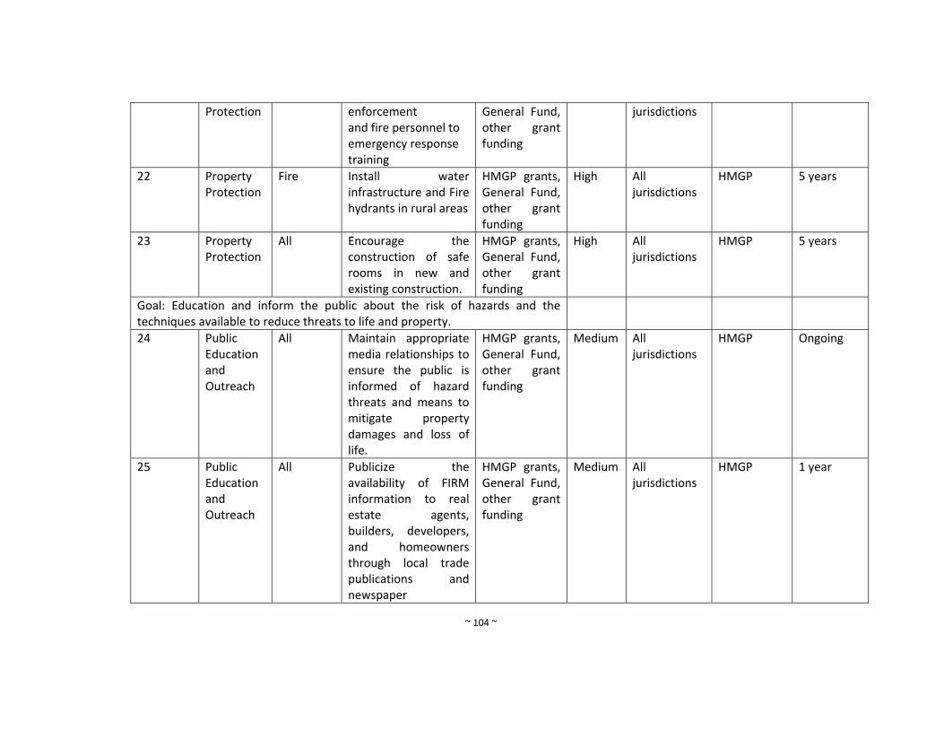
~ 104 ~
Protection enforcement and fire personnel to emergency response training
General Fund, other grant funding
jurisdictions
22 Property Protection
Fire Install water infrastructure and Fire hydrants in rural areas
HMGP grants, General Fund, other grant funding
High All jurisdictions
HMGP 5 years
23 Property Protection
All Encourage the construction of safe rooms in new and existing construction.
HMGP grants, General Fund, other grant funding
High All jurisdictions
HMGP 5 years
Goal: Education and inform the public about the risk of hazards and the techniques available to reduce threats to life and property.
24 Public Education and Outreach
All Maintain appropriate media relationships to ensure the public is informed of hazard threats and means to mitigate property damages and loss of life.
HMGP grants, General Fund, other grant funding
Medium All jurisdictions
HMGP Ongoing
25 Public Education and Outreach
All Publicize the availability of FIRM information to real estate agents, builders, developers, and homeowners through local trade publications and newspaper
HMGP grants, General Fund, other grant funding
Medium All jurisdictions
HMGP 1 year
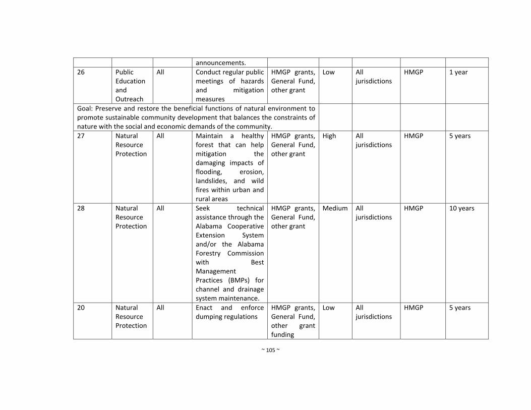
~ 105 ~
announcements.
26 Public Education and Outreach
All Conduct regular public meetings of hazards and mitigation measures
HMGP grants, General Fund, other grant
Low All jurisdictions
HMGP 1 year
Goal: Preserve and restore the beneficial functions of natural environment to promote sustainable community development that balances the constraints of nature with the social and economic demands of the community.
27 Natural Resource Protection
All Maintain a healthy forest that can help mitigation the damaging impacts of flooding, erosion, landslides, and wild fires within urban and rural areas
HMGP grants, General Fund, other grant
High All jurisdictions
HMGP 5 years
28 Natural Resource Protection
All Seek technical assistance through the Alabama Cooperative Extension System and/or the Alabama Forestry Commission with Best Management Practices (BMPs) for channel and drainage system maintenance.
HMGP grants, General Fund, other grant
Medium All jurisdictions
HMGP 10 years
20 Natural Resource Protection
All Enact and enforce dumping regulations
HMGP grants, General Fund, other grant funding
Low All jurisdictions
HMGP 5 years
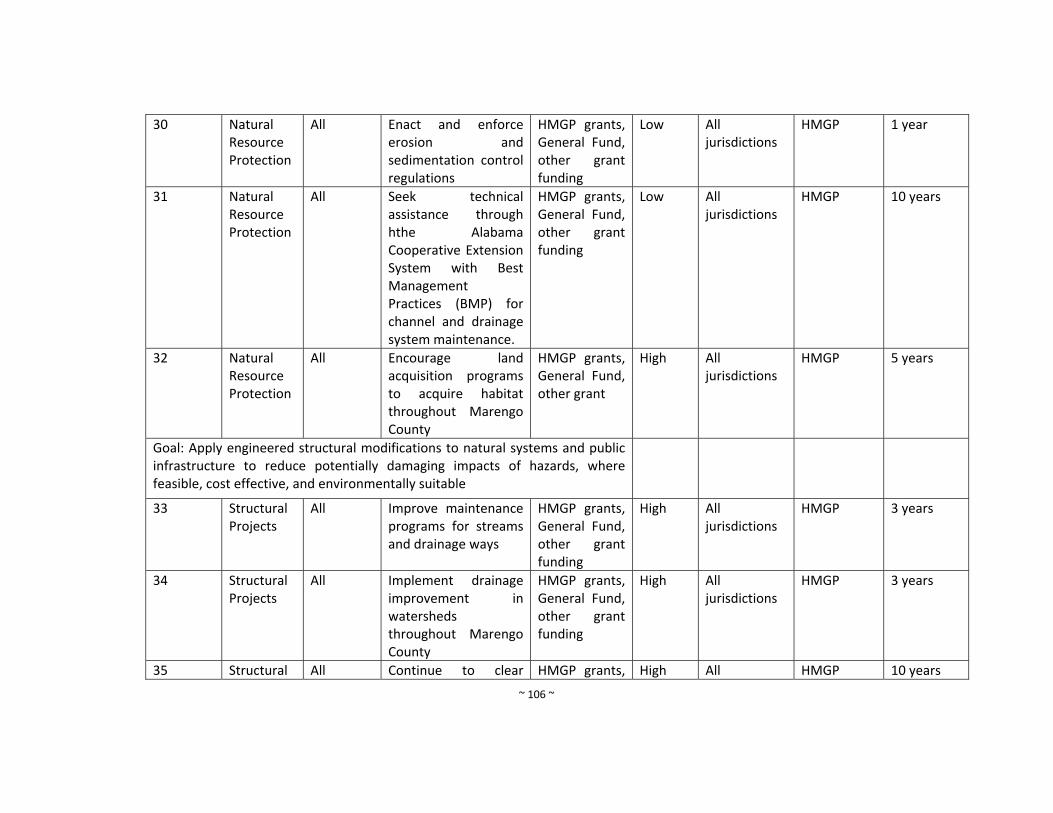
~ 106 ~
30 Natural Resource Protection
All Enact and enforce erosion and sedimentation control regulations
HMGP grants, General Fund, other grant funding
Low All jurisdictions
HMGP 1 year
31 Natural Resource Protection
All Seek technical assistance through hthe Alabama Cooperative Extension System with Best Management Practices (BMP) for channel and drainage system maintenance.
HMGP grants, General Fund, other grant funding
Low All jurisdictions
HMGP 10 years
32 Natural Resource Protection
All Encourage land acquisition programs to acquire habitat throughout Marengo County
HMGP grants, General Fund, other grant
High All jurisdictions
HMGP 5 years
Goal: Apply engineered structural modifications to natural systems and public infrastructure to reduce potentially damaging impacts of hazards, where feasible, cost effective, and environmentally suitable
33 Structural Projects
All Improve maintenance programs for streams and drainage ways
HMGP grants, General Fund, other grant funding
High
All jurisdictions
HMGP 3 years
34 Structural Projects
All Implement drainage improvement in watersheds throughout Marengo County
HMGP grants, General Fund, other grant funding
High All jurisdictions
HMGP 3 years
35 Structural All Continue to clear HMGP grants, High All HMGP 10 years
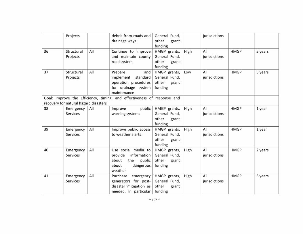
~ 107 ~
Projects debris from roads and drainage ways
General Fund, other grant funding
jurisdictions
36 Structural Projects
All Continue to improve and maintain county road system
HMGP grants, General Fund, other grant funding
High All jurisdictions
HMGP 5 years
37 Structural Projects
All Prepare and implement standard operation procedures for drainage system maintenance
HMGP grants, General Fund, other grant funding
Low All jurisdictions
HMGP 5 years
Goal: Improve the Efficiency, timing, and effectiveness of response and recovery for natural hazard disasters
38 Emergency Services
All Improve public warning systems
HMGP grants, General Fund, other grant funding
High All jurisdictions
HMGP 1 year
39 Emergency Services
All Improve public access to weather alerts
HMGP grants, General Fund, other grant funding
High All jurisdictions
HMGP 1 year
40 Emergency Services
All Use social media to provide information about the public about dangerous weather
HMGP grants, General Fund, other grant funding
High All jurisdictions
HMGP 2 years
41 Emergency Services
All Purchase emergency generators for post‐disaster mitigation as needed. In particular
HMGP grants, General Fund, other grant funding
High All jurisdictions
HMGP 5 years
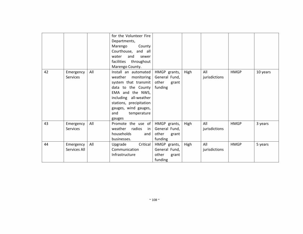
~ 108 ~
for the Volunteer Fire Departments, Marengo County Courthouse, and all water and sewer facilities throughout Marengo County.
42 Emergency Services
All Install an automated weather monitoring system that transmit data to the County EMA and the NWS, including all‐weather stations, precipitation gauges, wind gauges, and temperature gauges
HMGP grants, General Fund, other grant funding
High All jurisdictions
HMGP 10 years
43 Emergency Services
All Promote the use of weather radios in households and businesses.
HMGP grants, General Fund, other grant funding
High All jurisdictions
HMGP 3 years
44 Emergency Services All
All Upgrade Critical Communication Infrastructure
HMGP grants, General Fund, other grant funding
High All jurisdictions
HMGP 5 years
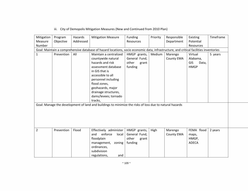
~ 109 ~
iii. City of Demopolis Mitigation Measures (New and Continued from 2010 Plan)
Mitigation Measure Number
Program Objective
Hazards Addressed
Mitigation Measure Funding Resources
Priority
Responsible Department
Existing Potential Resources
Timeframe
Goal: Maintain a comprehensive database of hazard locations, socio economic data, infrastructure, and critical facilities inventories
1 Prevention All Maintain a centralized countywide natural hazards and risk assessment database in GIS that is accessible to all personnel including flood zones, geohazards, major drainage structures, dams/levees; tornado tracks,
HMGP grants, General Fund, other grant funding
Medium Marengo County EMA
Virtual Alabama, GIS Data, HMGP
5 years
Goal: Manage the development of land and buildings to minimize the risks of loss due to natural hazards
2 Prevention Flood Effectively administer and enforce local floodplain management, zoning ordinances, subdivision regulations, and
HMGP grants, General Fund, other grant funding
High Marengo County EMA
FEMA flood maps, HMGP, ADECA
2 years
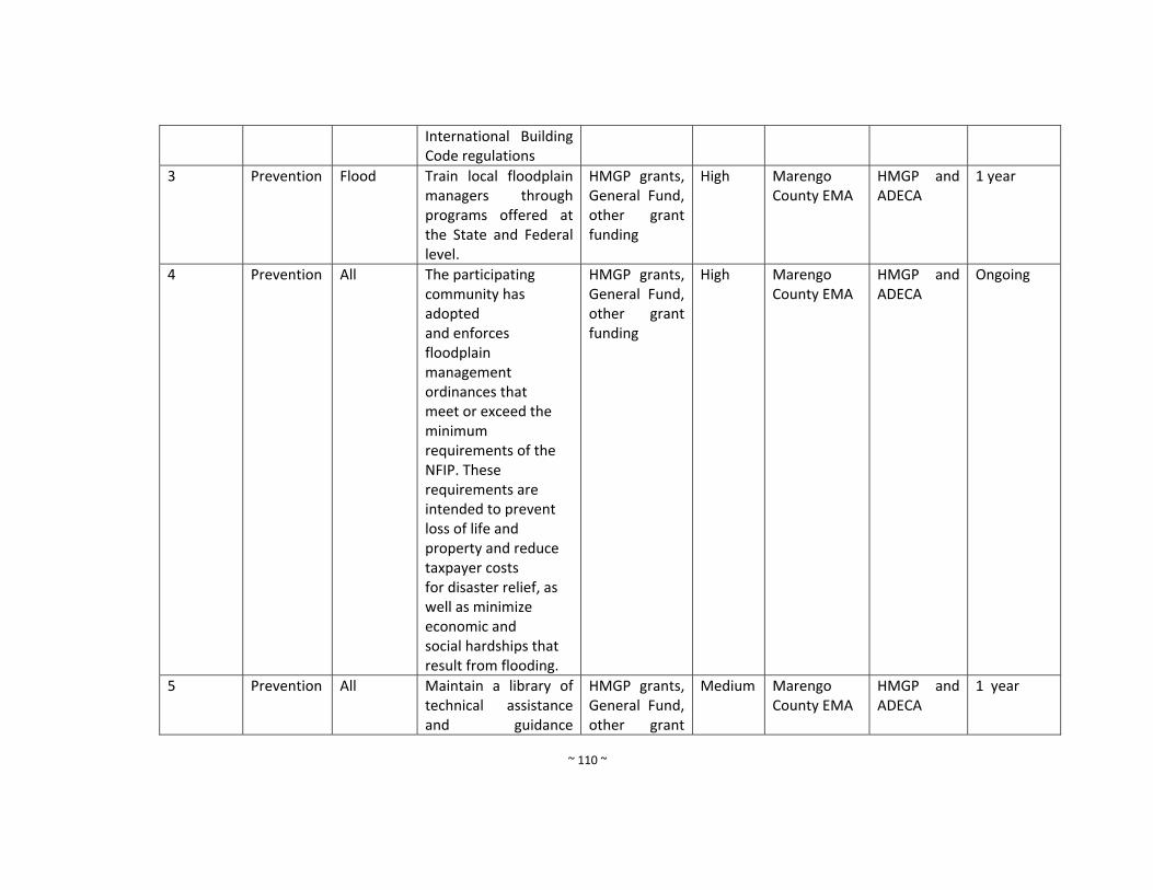
~ 110 ~
International Building Code regulations
3 Prevention Flood Train local floodplain managers through programs offered at the State and Federal level.
HMGP grants, General Fund, other grant funding
High Marengo County EMA
HMGP and ADECA
1 year
4 Prevention All The participating community has adopted and enforces floodplain management ordinances that meet or exceed the minimum requirements of the NFIP. These requirements are intended to prevent loss of life and property and reduce taxpayer costs for disaster relief, as well as minimize economic and social hardships that result from flooding.
HMGP grants, General Fund, other grant funding
High Marengo County EMA
HMGP and ADECA
Ongoing
5 Prevention All Maintain a library of technical assistance and guidance
HMGP grants, General Fund, other grant
Medium Marengo County EMA
HMGP and ADECA
1 year
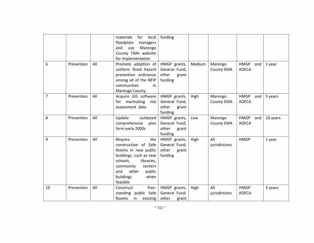
~ 111 ~
materials for local floodplain managers and use Marengo County EMA website for implementation
funding
6 Prevention All Promote adoption of uniform flood hazard prevention ordinance among all of the NFIP communities in Marengo County.
HMGP grants, General Fund, other grant funding
Medium Marengo County EMA
HMGP and ADECA
1 year
7 Prevention All Acquire GIS software for marinating risk assessment data
HMGP grants, General Fund, other grant funding
High Marengo County EMA
HMGP and ADECA
5 years
8 Prevention All Update outdated comprehensive plan form early 2000s
HMGP grants, General Fund, other grant funding
Low Marengo County EMA
HMGP and ADECA
10 years
9 Prevention All Require the construction of Safe Rooms in new public buildings, such as new schools, libraries, community centers and other public buildings when feasible
HMGP grants, General Fund, other grant funding
High All jurisdictions
HMGP 1 year
10 Prevention All Construct free‐standing public Safe Rooms in existing
HMGP grants, General Fund, other grant
High All jurisdictions
HMGP ADECA
5 years
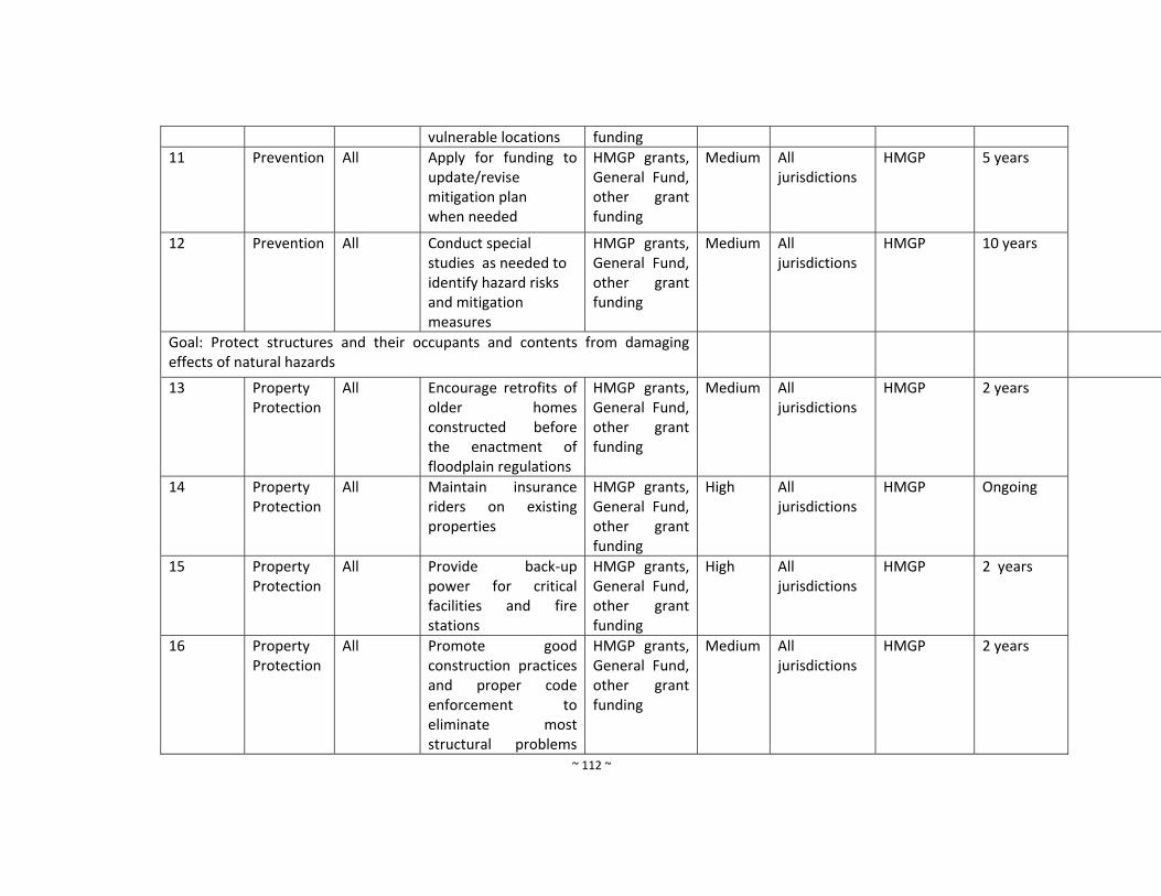
~ 112 ~
vulnerable locations funding
11 Prevention All Apply for funding to update/revise mitigation plan when needed
HMGP grants, General Fund, other grant funding
Medium All jurisdictions
HMGP 5 years
12 Prevention All Conduct special studies as needed to identify hazard risks and mitigation measures
HMGP grants, General Fund, other grant funding
Medium All jurisdictions
HMGP 10 years
Goal: Protect structures and their occupants and contents from damaging effects of natural hazards
13 Property Protection
All Encourage retrofits of older homes constructed before the enactment of floodplain regulations
HMGP grants, General Fund, other grant funding
Medium All jurisdictions
HMGP 2 years
14 Property Protection
All Maintain insurance riders on existing properties
HMGP grants, General Fund, other grant funding
High All jurisdictions
HMGP Ongoing
15 Property Protection
All Provide back‐up power for critical facilities and fire stations
HMGP grants, General Fund, other grant funding
High All jurisdictions
HMGP 2 years
16 Property Protection
All Promote good construction practices and proper code enforcement to eliminate most structural problems
HMGP grants, General Fund, other grant funding
Medium All jurisdictions
HMGP 2 years

~ 113 ~
during natural hazard events
17 Property Protection
All Encourage the construction of safe rooms within new public buildings, such as new schools, libraries, community centers, and other public buildings where feasible.
HMGP grants, General Fund, other grant funding
High All jurisdictions
HMGP 2 years
18 Property Protection
All Retrofit public schools with community Safe Rooms.
HMGP grants, General Fund, other grant funding
High All jurisdictions
HMGP 2 years
19 Property Protection
All Increase access to Flood Insurance Rate Maps.
HMGP grants, General Fund, other grant funding
High All jurisdictions
HMGP Completed
20 Property Protection
All Promote the purchase of flood insurance coverage by property owners and renters in high‐risk flooding areas.
HMGP grants, General Fund, other grant funding
Medium All jurisdictions
HMGP Ongoing
21 Property Protection
All Continue to send law enforcement and fire personnel to emergency response training
HMGP grants, General Fund, other grant funding
Low All jurisdictions
HMGP Ongoing
22 Property Fire Install water HMGP grants, High All HMGP 5 years
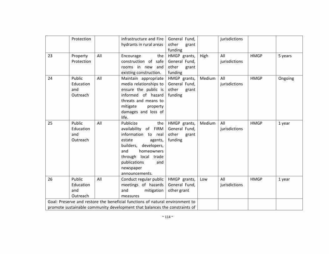
~ 114 ~
Protection infrastructure and Fire hydrants in rural areas
General Fund, other grant funding
jurisdictions
23 Property Protection
All Encourage the construction of safe rooms in new and existing construction.
HMGP grants, General Fund, other grant funding
High All jurisdictions
HMGP 5 years
24 Public Education and Outreach
All Maintain appropriate media relationships to ensure the public is informed of hazard threats and means to mitigate property damages and loss of life.
HMGP grants, General Fund, other grant funding
Medium All jurisdictions
HMGP Ongoing
25 Public Education and Outreach
All Publicize the availability of FIRM information to real estate agents, builders, developers, and homeowners through local trade publications and newspaper announcements.
HMGP grants, General Fund, other grant funding
Medium All jurisdictions
HMGP 1 year
26 Public Education and Outreach
All Conduct regular public meetings of hazards and mitigation measures
HMGP grants, General Fund, other grant
Low All jurisdictions
HMGP 1 year
Goal: Preserve and restore the beneficial functions of natural environment to promote sustainable community development that balances the constraints of
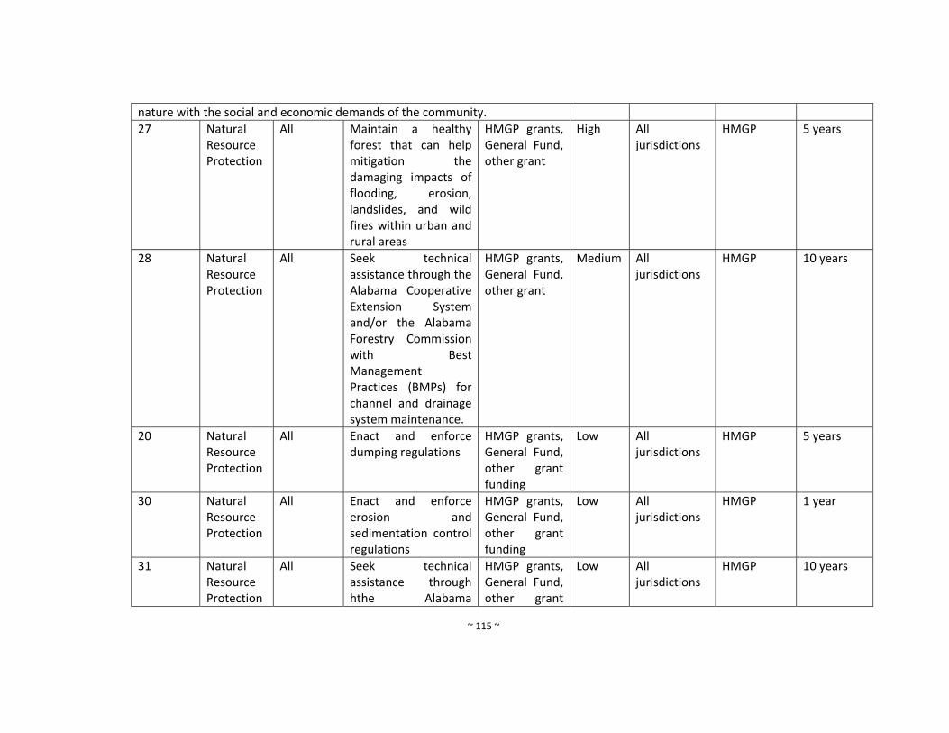
~ 115 ~
nature with the social and economic demands of the community.
27 Natural Resource Protection
All Maintain a healthy forest that can help mitigation the damaging impacts of flooding, erosion, landslides, and wild fires within urban and rural areas
HMGP grants, General Fund, other grant
High All jurisdictions
HMGP 5 years
28 Natural Resource Protection
All Seek technical assistance through the Alabama Cooperative Extension System and/or the Alabama Forestry Commission with Best Management Practices (BMPs) for channel and drainage system maintenance.
HMGP grants, General Fund, other grant
Medium All jurisdictions
HMGP 10 years
20 Natural Resource Protection
All Enact and enforce dumping regulations
HMGP grants, General Fund, other grant funding
Low All jurisdictions
HMGP 5 years
30 Natural Resource Protection
All Enact and enforce erosion and sedimentation control regulations
HMGP grants, General Fund, other grant funding
Low All jurisdictions
HMGP 1 year
31 Natural Resource Protection
All Seek technical assistance through hthe Alabama
HMGP grants, General Fund, other grant
Low All jurisdictions
HMGP 10 years
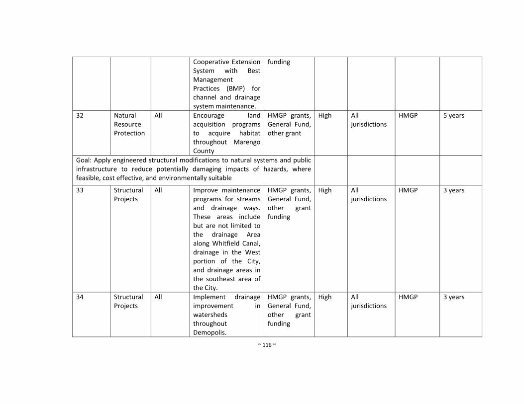
~ 116 ~
Cooperative Extension System with Best Management Practices (BMP) for channel and drainage system maintenance.
funding
32 Natural Resource Protection
All Encourage land acquisition programs to acquire habitat throughout Marengo County
HMGP grants, General Fund, other grant
High All jurisdictions
HMGP 5 years
Goal: Apply engineered structural modifications to natural systems and public infrastructure to reduce potentially damaging impacts of hazards, where feasible, cost effective, and environmentally suitable
33 Structural Projects
All Improve maintenance programs for streams and drainage ways. These areas include but are not limited to the drainage Area along Whitfield Canal, drainage in the West portion of the City, and drainage areas in the southeast area of the City.
HMGP grants, General Fund, other grant funding
High
All jurisdictions
HMGP 3 years
34 Structural Projects
All Implement drainage improvement in watersheds throughout Demopolis.
HMGP grants, General Fund, other grant funding
High All jurisdictions
HMGP 3 years
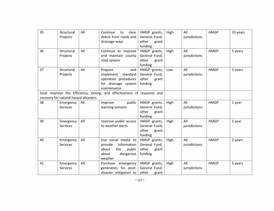
~ 117 ~
35 Structural Projects
All Continue to clear debris from roads and drainage ways
HMGP grants, General Fund, other grant funding
High All jurisdictions
HMGP 10 years
36 Structural Projects
All Continue to improve and maintain county road system
HMGP grants, General Fund, other grant funding
High All jurisdictions
HMGP 5 years
37 Structural Projects
All Prepare and implement standard operation procedures for drainage system maintenance
HMGP grants, General Fund, other grant funding
Low All jurisdictions
HMGP 5 years
Goal: Improve the Efficiency, timing, and effectiveness of response and recovery for natural hazard disasters
38 Emergency Services
All Improve public warning systems
HMGP grants, General Fund, other grant funding
High All jurisdictions
HMGP 1 year
39 Emergency Services
All Improve public access to weather alerts
HMGP grants, General Fund, other grant funding
High All jurisdictions
HMGP 1 year
40 Emergency Services
All Use social media to provide information about the public about dangerous weather
HMGP grants, General Fund, other grant funding
High All jurisdictions
HMGP 2 years
41 Emergency Services
All Purchase emergency generators for post‐disaster mitigation as
HMGP grants, General Fund, other grant
High All jurisdictions
HMGP 5 years
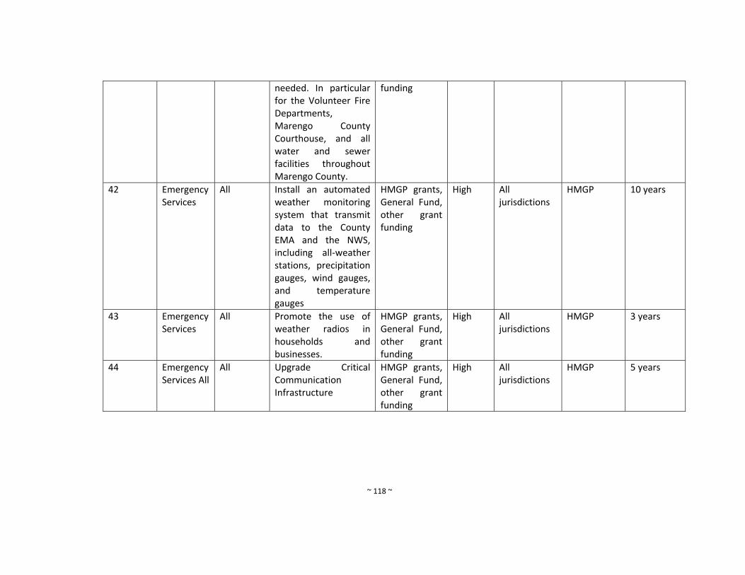
~ 118 ~
needed. In particular for the Volunteer Fire Departments, Marengo County Courthouse, and all water and sewer facilities throughout Marengo County.
funding
42 Emergency Services
All Install an automated weather monitoring system that transmit data to the County EMA and the NWS, including all‐weather stations, precipitation gauges, wind gauges, and temperature gauges
HMGP grants, General Fund, other grant funding
High All jurisdictions
HMGP 10 years
43 Emergency Services
All Promote the use of weather radios in households and businesses.
HMGP grants, General Fund, other grant funding
High All jurisdictions
HMGP 3 years
44 Emergency Services All
All Upgrade Critical Communication Infrastructure
HMGP grants, General Fund, other grant funding
High All jurisdictions
HMGP 5 years
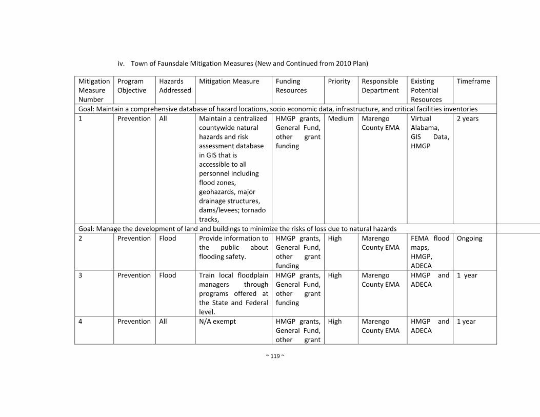
~ 119 ~
iv. Town of Faunsdale Mitigation Measures (New and Continued from 2010 Plan)
Mitigation Measure Number
Program Objective
Hazards Addressed
Mitigation Measure Funding Resources
Priority
Responsible Department
Existing Potential Resources
Timeframe
Goal: Maintain a comprehensive database of hazard locations, socio economic data, infrastructure, and critical facilities inventories
1 Prevention All Maintain a centralized countywide natural hazards and risk assessment database in GIS that is accessible to all personnel including flood zones, geohazards, major drainage structures, dams/levees; tornado tracks,
HMGP grants, General Fund, other grant funding
Medium Marengo County EMA
Virtual Alabama, GIS Data, HMGP
2 years
Goal: Manage the development of land and buildings to minimize the risks of loss due to natural hazards
2 Prevention Flood Provide information to the public about flooding safety.
HMGP grants, General Fund, other grant funding
High Marengo County EMA
FEMA flood maps, HMGP, ADECA
Ongoing
3 Prevention Flood Train local floodplain managers through programs offered at the State and Federal level.
HMGP grants, General Fund, other grant funding
High Marengo County EMA
HMGP and ADECA
1 year
4 Prevention All N/A exempt HMGP grants, General Fund, other grant
High Marengo County EMA
HMGP and ADECA
1 year
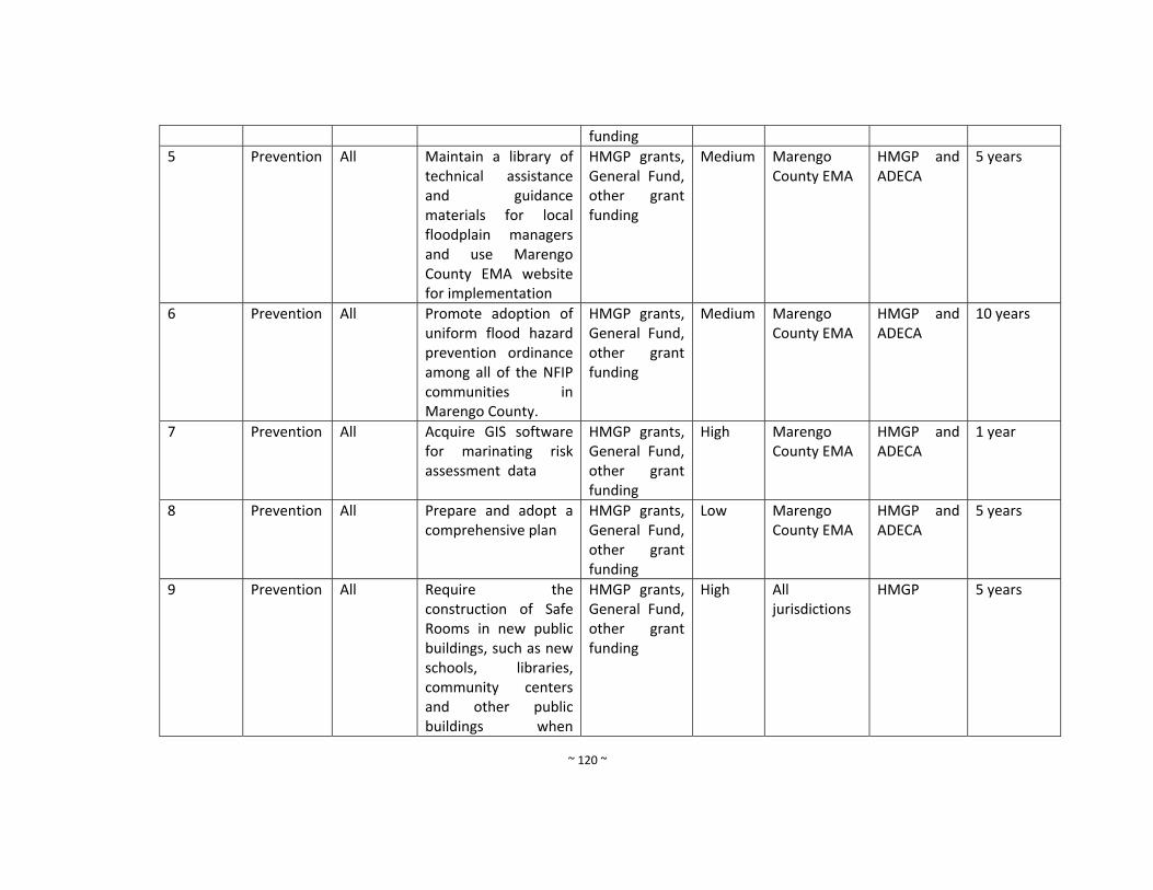
~ 120 ~
funding
5 Prevention All Maintain a library of technical assistance and guidance materials for local floodplain managers and use Marengo County EMA website for implementation
HMGP grants, General Fund, other grant funding
Medium Marengo County EMA
HMGP and ADECA
5 years
6 Prevention All Promote adoption of uniform flood hazard prevention ordinance among all of the NFIP communities in Marengo County.
HMGP grants, General Fund, other grant funding
Medium Marengo County EMA
HMGP and ADECA
10 years
7 Prevention All Acquire GIS software for marinating risk assessment data
HMGP grants, General Fund, other grant funding
High Marengo County EMA
HMGP and ADECA
1 year
8 Prevention All Prepare and adopt a comprehensive plan
HMGP grants, General Fund, other grant funding
Low Marengo County EMA
HMGP and ADECA
5 years
9 Prevention All Require the construction of Safe Rooms in new public buildings, such as new schools, libraries, community centers and other public buildings when
HMGP grants, General Fund, other grant funding
High All jurisdictions
HMGP 5 years
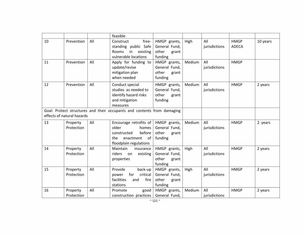
~ 121 ~
feasible
10 Prevention All Construct free‐standing public Safe Rooms in existing vulnerable locations
HMGP grants, General Fund, other grant funding
High All jurisdictions
HMGP ADECA
10 years
11 Prevention All Apply for funding to update/revise mitigation plan when needed
HMGP grants, General Fund, other grant funding
Medium All jurisdictions
HMGP
12 Prevention All Conduct special studies as needed to identify hazard risks and mitigation measures
HMGP grants, General Fund, other grant funding
Medium All jurisdictions
HMGP 2 years
Goal: Protect structures and their occupants and contents from damaging effects of natural hazards
13 Property Protection
All Encourage retrofits of older homes constructed before the enactment of floodplain regulations
HMGP grants, General Fund, other grant funding
Medium All jurisdictions
HMGP 2 years
14 Property Protection
All Maintain insurance riders on existing properties
HMGP grants, General Fund, other grant funding
High All jurisdictions
HMGP 2 years
15 Property Protection
All Provide back‐up power for critical facilities and fire stations
HMGP grants, General Fund, other grant funding
High All jurisdictions
HMGP 2 years
16 Property Protection
All Promote good construction practices
HMGP grants, General Fund,
Medium All jurisdictions
HMGP 2 years
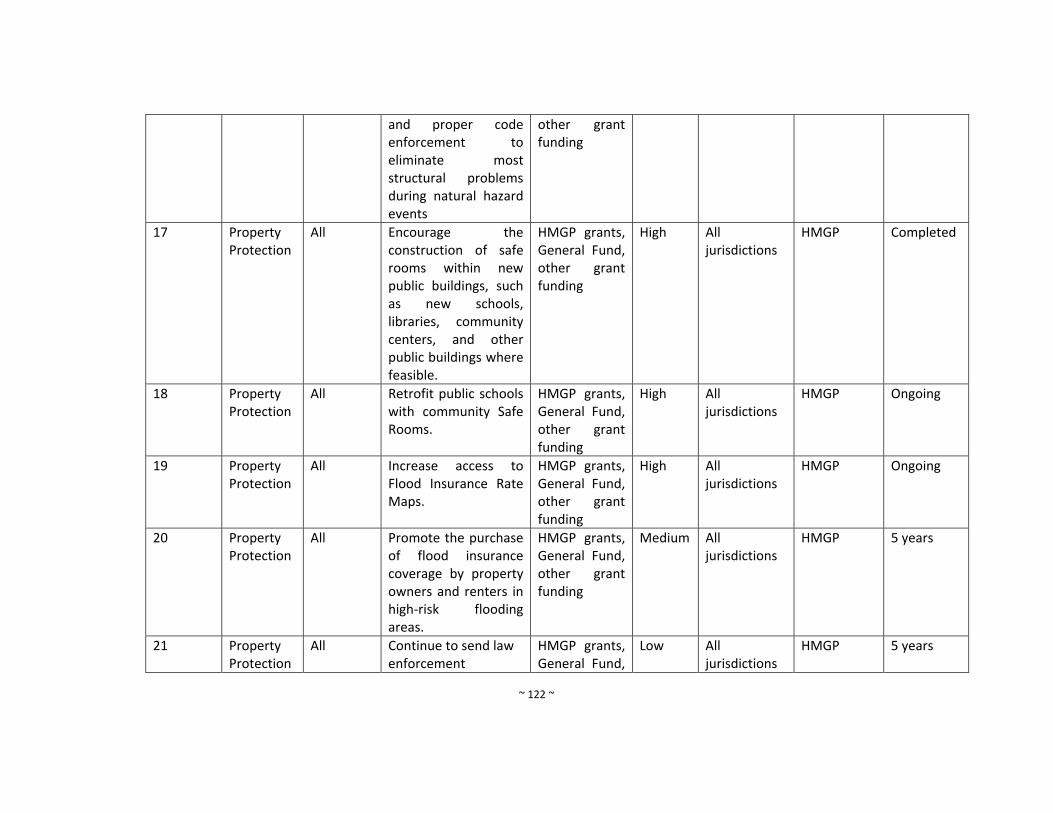
~ 122 ~
and proper code enforcement to eliminate most structural problems during natural hazard events
other grant funding
17 Property Protection
All Encourage the construction of safe rooms within new public buildings, such as new schools, libraries, community centers, and other public buildings where feasible.
HMGP grants, General Fund, other grant funding
High All jurisdictions
HMGP Completed
18 Property Protection
All Retrofit public schools with community Safe Rooms.
HMGP grants, General Fund, other grant funding
High All jurisdictions
HMGP Ongoing
19 Property Protection
All Increase access to Flood Insurance Rate Maps.
HMGP grants, General Fund, other grant funding
High All jurisdictions
HMGP Ongoing
20 Property Protection
All Promote the purchase of flood insurance coverage by property owners and renters in high‐risk flooding areas.
HMGP grants, General Fund, other grant funding
Medium All jurisdictions
HMGP 5 years
21 Property Protection
All Continue to send law enforcement
HMGP grants, General Fund,
Low All jurisdictions
HMGP 5 years
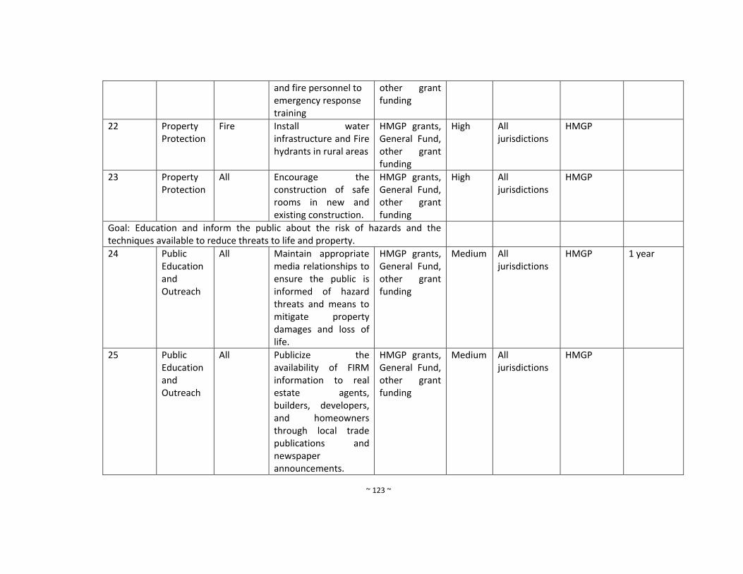
~ 123 ~
and fire personnel to emergency response training
other grant funding
22 Property Protection
Fire Install water infrastructure and Fire hydrants in rural areas
HMGP grants, General Fund, other grant funding
High All jurisdictions
HMGP
23 Property Protection
All Encourage the construction of safe rooms in new and existing construction.
HMGP grants, General Fund, other grant funding
High All jurisdictions
HMGP
Goal: Education and inform the public about the risk of hazards and the techniques available to reduce threats to life and property.
24 Public Education and Outreach
All Maintain appropriate media relationships to ensure the public is informed of hazard threats and means to mitigate property damages and loss of life.
HMGP grants, General Fund, other grant funding
Medium All jurisdictions
HMGP 1 year
25 Public Education and Outreach
All Publicize the availability of FIRM information to real estate agents, builders, developers, and homeowners through local trade publications and newspaper announcements.
HMGP grants, General Fund, other grant funding
Medium All jurisdictions
HMGP
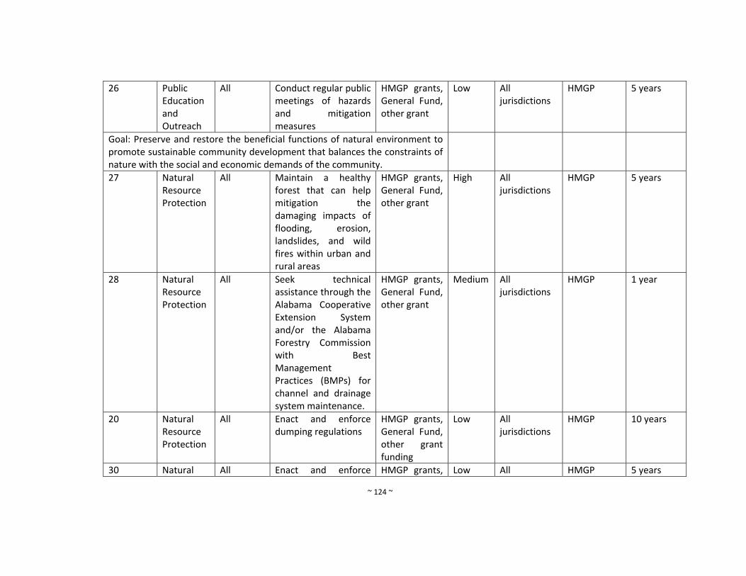
~ 124 ~
26 Public Education and Outreach
All Conduct regular public meetings of hazards and mitigation measures
HMGP grants, General Fund, other grant
Low All jurisdictions
HMGP 5 years
Goal: Preserve and restore the beneficial functions of natural environment to promote sustainable community development that balances the constraints of nature with the social and economic demands of the community.
27 Natural Resource Protection
All Maintain a healthy forest that can help mitigation the damaging impacts of flooding, erosion, landslides, and wild fires within urban and rural areas
HMGP grants, General Fund, other grant
High All jurisdictions
HMGP 5 years
28 Natural Resource Protection
All Seek technical assistance through the Alabama Cooperative Extension System and/or the Alabama Forestry Commission with Best Management Practices (BMPs) for channel and drainage system maintenance.
HMGP grants, General Fund, other grant
Medium All jurisdictions
HMGP 1 year
20 Natural Resource Protection
All Enact and enforce dumping regulations
HMGP grants, General Fund, other grant funding
Low All jurisdictions
HMGP 10 years
30 Natural All Enact and enforce HMGP grants, Low All HMGP 5 years
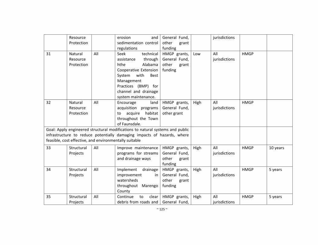
~ 125 ~
Resource Protection
erosion and sedimentation control regulations
General Fund, other grant funding
jurisdictions
31 Natural Resource Protection
All Seek technical assistance through hthe Alabama Cooperative Extension System with Best Management Practices (BMP) for channel and drainage system maintenance.
HMGP grants, General Fund, other grant funding
Low All jurisdictions
HMGP
32 Natural Resource Protection
All Encourage land acquisition programs to acquire habitat throughout the Town of Faunsdale.
HMGP grants, General Fund, other grant
High All jurisdictions
HMGP
Goal: Apply engineered structural modifications to natural systems and public infrastructure to reduce potentially damaging impacts of hazards, where feasible, cost effective, and environmentally suitable
33 Structural Projects
All Improve maintenance programs for streams and drainage ways
HMGP grants, General Fund, other grant funding
High
All jurisdictions
HMGP 10 years
34 Structural Projects
All Implement drainage improvement in watersheds throughout Marengo County
HMGP grants, General Fund, other grant funding
High All jurisdictions
HMGP 5 years
35 Structural Projects
All Continue to clear debris from roads and
HMGP grants, General Fund,
High All jurisdictions
HMGP 5 years
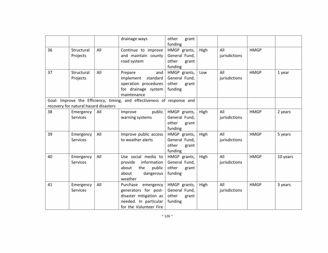
~ 126 ~
drainage ways other grant funding
36 Structural Projects
All Continue to improve and maintain county road system
HMGP grants, General Fund, other grant funding
High All jurisdictions
HMGP
37 Structural Projects
All Prepare and implement standard operation procedures for drainage system maintenance
HMGP grants, General Fund, other grant funding
Low All jurisdictions
HMGP 1 year
Goal: Improve the Efficiency, timing, and effectiveness of response and recovery for natural hazard disasters
38 Emergency Services
All Improve public warning systems
HMGP grants, General Fund, other grant funding
High All jurisdictions
HMGP 2 years
39 Emergency Services
All Improve public access to weather alerts
HMGP grants, General Fund, other grant funding
High All jurisdictions
HMGP 5 years
40 Emergency Services
All Use social media to provide information about the public about dangerous weather
HMGP grants, General Fund, other grant funding
High All jurisdictions
HMGP 10 years
41 Emergency Services
All Purchase emergency generators for post‐disaster mitigation as needed. In particular for the Volunteer Fire
HMGP grants, General Fund, other grant funding
High All jurisdictions
HMGP 3 years
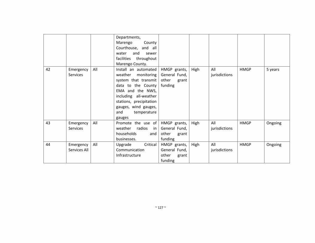
~ 127 ~
Departments, Marengo County Courthouse, and all water and sewer facilities throughout Marengo County.
42 Emergency Services
All
Install an automated weather monitoring system that transmit data to the County EMA and the NWS, including all‐weather stations, precipitation gauges, wind gauges, and temperature gauges
HMGP grants, General Fund, other grant funding
High All jurisdictions
HMGP 5 years
43 Emergency Services
All Promote the use of weather radios in households and businesses.
HMGP grants, General Fund, other grant funding
High All jurisdictions
HMGP Ongoing
44 Emergency Services All
All Upgrade Critical Communication Infrastructure
HMGP grants, General Fund, other grant funding
High All jurisdictions
HMGP Ongoing
~ 128 ~
v. City of Linden (New and Continued from 2010 Plan)
Mitigation Measure Number
Program Objective
Hazards Addressed
Mitigation Measure Funding Resources
Priority
Responsible Department
Existing Potential Resources
Timeframe
Goal: Maintain a comprehensive database of hazard locations, socio economic data, infrastructure, and critical facilities inventories
1 Prevention All Maintain a centralized countywide natural hazards and risk assessment database in GIS that is accessible to all personnel including flood zones, geohazards, major drainage structures, dams/levees; tornado tracks,
HMGP grants, General Fund, other grant funding
Medium Marengo County EMA
Virtual Alabama, GIS Data, HMGP
5 years
Goal: Manage the development of land and buildings to minimize the risks of loss due to natural hazards
2 Prevention Flood Effectively administer and enforce local floodplain management regulations along with enforcement of International Building Codes, zoning ordinance and subdivision regulations.
HMGP grants, General Fund, other grant funding
High Marengo County EMA
FEMA flood maps, HMGP, ADECA
2 years
3 Prevention Flood Train local floodplain HMGP grants, High Marengo HMGP and 1 year
~ 129 ~
managers through programs offered at the State and Federal level.
General Fund, other grant funding
County EMA ADECA
4 Prevention All The participating community has adopted and enforces floodplain management ordinances that meet or exceed the minimum requirements of the NFIP. These requirements are intended to prevent loss of life and property and reduce taxpayer costs for disaster relief, as well as minimize economic and social hardships that result from flooding.
HMGP grants, General Fund, other grant funding
High Marengo County EMA
HMGP and ADECA
Ongoing
5 Prevention All Maintain a library of technical assistance and guidance materials for local floodplain managers and use Marengo
HMGP grants, General Fund, other grant funding
Medium Marengo County EMA
HMGP and ADECA
1 year
~ 130 ~
County EMA website for implementation
6 Prevention All Promote adoption of uniform flood hazard prevention ordinance among all of the NFIP communities in the City of Linden.
HMGP grants, General Fund, other grant funding
Medium Marengo County EMA
HMGP and ADECA
1 year
7 Prevention All Acquire GIS software for marinating risk assessment data
HMGP grants, General Fund, other grant funding
High Marengo County EMA
HMGP and ADECA
5 years
8 Prevention All Prepare and adopt a comprehensive plan
HMGP grants, General Fund, other grant funding
Low Marengo County EMA
HMGP and ADECA
10 years
9 Prevention All
Require the construction of Safe Rooms in new public buildings, such as new schools, libraries, community centers and other public buildings when feasible
HMGP grants, General Fund, other grant funding
High All jurisdictions
HMGP 1 year
10 Prevention All Construct free‐standing public Safe Rooms in existing vulnerable locations
HMGP grants, General Fund, other grant funding
High All jurisdictions
HMGP ADECA
5 years
~ 131 ~
11 Prevention All Apply for funding to update/revise mitigation plan when needed
HMGP grants, General Fund, other grant funding
Medium All jurisdictions
HMGP 5 years
12 Prevention All Conduct special studies as needed to identify hazard risks and mitigation measures
HMGP grants, General Fund, other grant funding
Medium All jurisdictions
HMGP 10 years
Goal: Protect structures and their occupants and contents from damaging effects of natural hazards
13 Property Protection
All Encourage retrofits of older homes constructed before the enactment of floodplain regulations
HMGP grants, General Fund, other grant funding
Medium All jurisdictions
HMGP 2 years
14 Property Protection
All Maintain insurance riders on existing properties
HMGP grants, General Fund, other grant funding
High All jurisdictions
HMGP Ongoing
15 Property Protection
All Provide back‐up power for critical facilities and fire stations
HMGP grants, General Fund, other grant funding
High All jurisdictions
HMGP 2 years
16 Property Protection
All Promote good construction practices and proper code enforcement to eliminate most structural problems during natural hazard
HMGP grants, General Fund, other grant funding
Medium All jurisdictions
HMGP 2 years
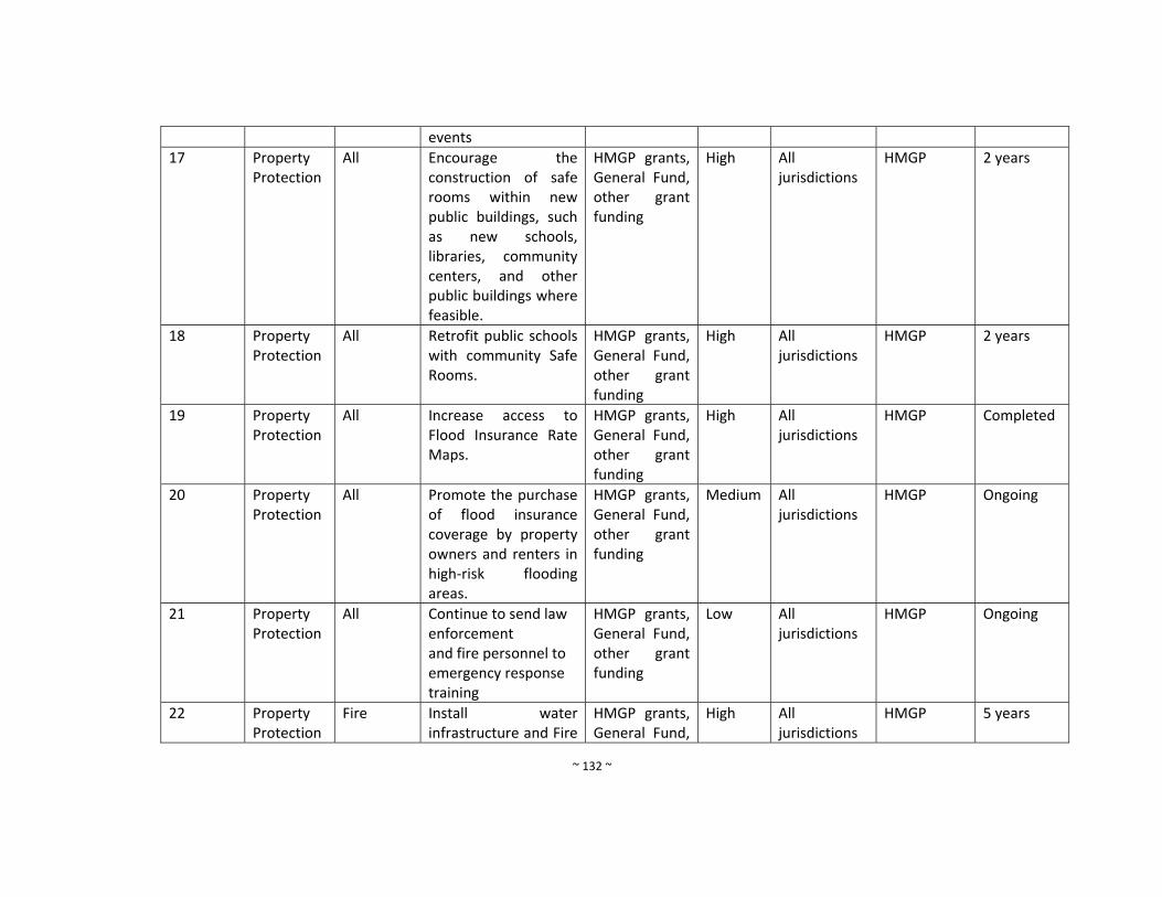
~ 132 ~
events
17 Property Protection
All Encourage the construction of safe rooms within new public buildings, such as new schools, libraries, community centers, and other public buildings where feasible.
HMGP grants, General Fund, other grant funding
High All jurisdictions
HMGP 2 years
18 Property Protection
All Retrofit public schools with community Safe Rooms.
HMGP grants, General Fund, other grant funding
High All jurisdictions
HMGP 2 years
19 Property Protection
All Increase access to Flood Insurance Rate Maps.
HMGP grants, General Fund, other grant funding
High All jurisdictions
HMGP Completed
20 Property Protection
All Promote the purchase of flood insurance coverage by property owners and renters in high‐risk flooding areas.
HMGP grants, General Fund, other grant funding
Medium All jurisdictions
HMGP Ongoing
21 Property Protection
All Continue to send law enforcement and fire personnel to emergency response training
HMGP grants, General Fund, other grant funding
Low All jurisdictions
HMGP Ongoing
22 Property Protection
Fire Install water infrastructure and Fire
HMGP grants, General Fund,
High All jurisdictions
HMGP 5 years
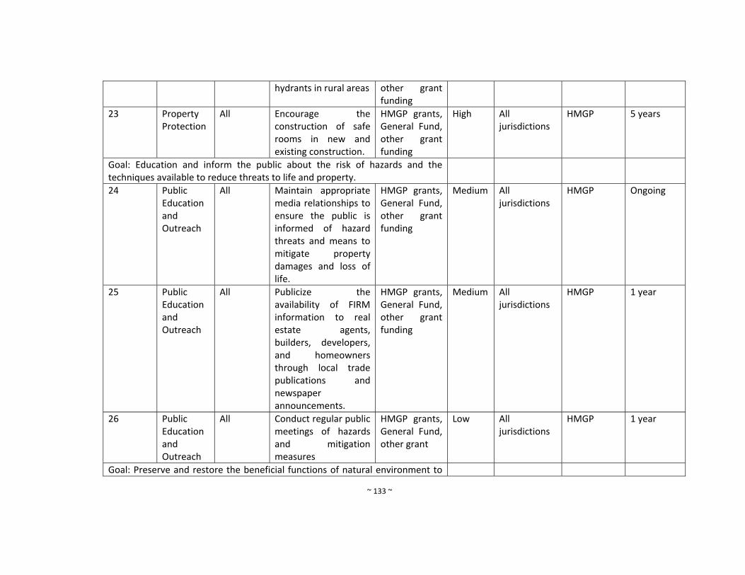
~ 133 ~
hydrants in rural areas other grant funding
23 Property Protection
All Encourage the construction of safe rooms in new and existing construction.
HMGP grants, General Fund, other grant funding
High All jurisdictions
HMGP 5 years
Goal: Education and inform the public about the risk of hazards and the techniques available to reduce threats to life and property.
24 Public Education and Outreach
All Maintain appropriate media relationships to ensure the public is informed of hazard threats and means to mitigate property damages and loss of life.
HMGP grants, General Fund, other grant funding
Medium All jurisdictions
HMGP Ongoing
25 Public Education and Outreach
All Publicize the availability of FIRM information to real estate agents, builders, developers, and homeowners through local trade publications and newspaper announcements.
HMGP grants, General Fund, other grant funding
Medium All jurisdictions
HMGP 1 year
26 Public Education and Outreach
All Conduct regular public meetings of hazards and mitigation measures
HMGP grants, General Fund, other grant
Low All jurisdictions
HMGP 1 year
Goal: Preserve and restore the beneficial functions of natural environment to
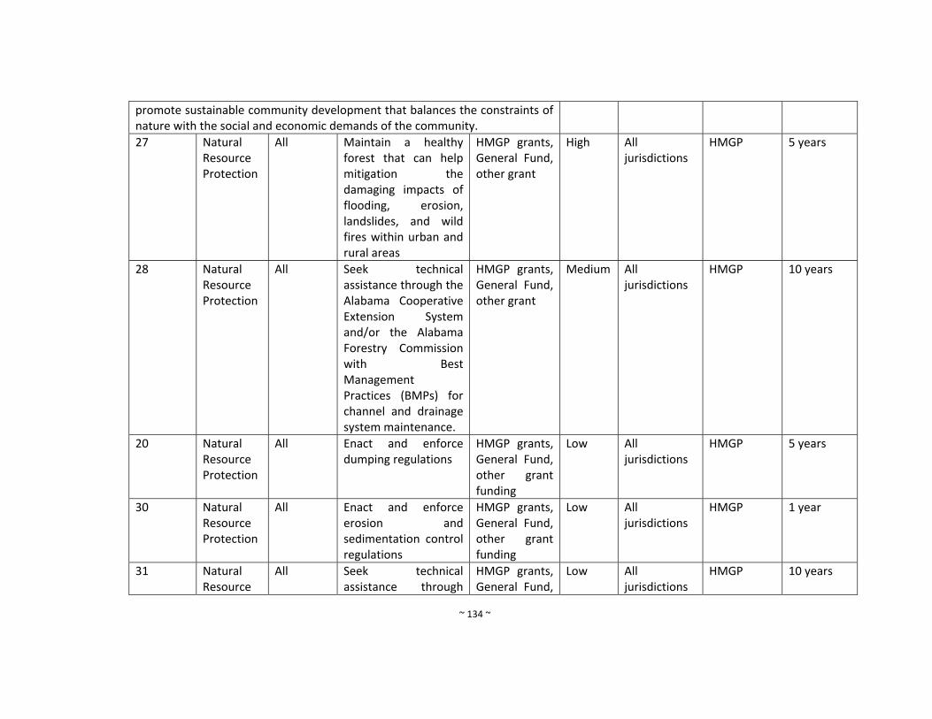
~ 134 ~
promote sustainable community development that balances the constraints of nature with the social and economic demands of the community.
27 Natural Resource Protection
All Maintain a healthy forest that can help mitigation the damaging impacts of flooding, erosion, landslides, and wild fires within urban and rural areas
HMGP grants, General Fund, other grant
High All jurisdictions
HMGP 5 years
28 Natural Resource Protection
All Seek technical assistance through the Alabama Cooperative Extension System and/or the Alabama Forestry Commission with Best Management Practices (BMPs) for channel and drainage system maintenance.
HMGP grants, General Fund, other grant
Medium All jurisdictions
HMGP 10 years
20 Natural Resource Protection
All Enact and enforce dumping regulations
HMGP grants, General Fund, other grant funding
Low All jurisdictions
HMGP 5 years
30 Natural Resource Protection
All Enact and enforce erosion and sedimentation control regulations
HMGP grants, General Fund, other grant funding
Low All jurisdictions
HMGP 1 year
31 Natural Resource
All Seek technical assistance through
HMGP grants, General Fund,
Low All jurisdictions
HMGP 10 years
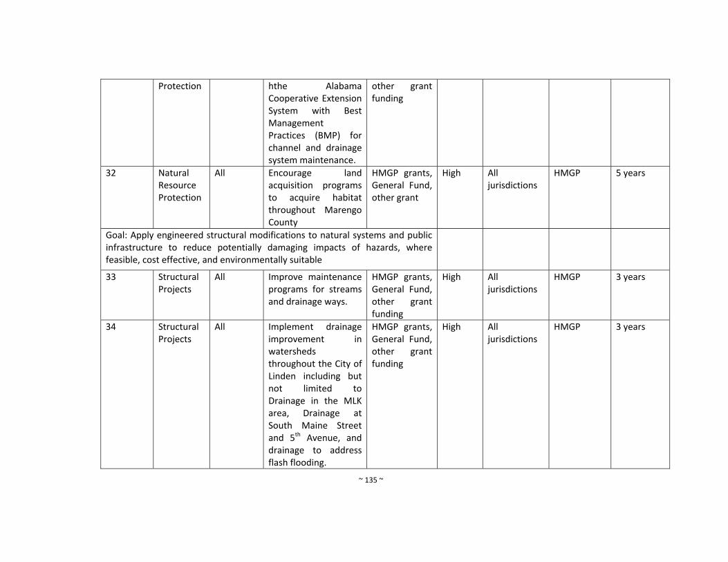
~ 135 ~
Protection hthe Alabama Cooperative Extension System with Best Management Practices (BMP) for channel and drainage system maintenance.
other grant funding
32 Natural Resource Protection
All Encourage land acquisition programs to acquire habitat throughout Marengo County
HMGP grants, General Fund, other grant
High All jurisdictions
HMGP 5 years
Goal: Apply engineered structural modifications to natural systems and public infrastructure to reduce potentially damaging impacts of hazards, where feasible, cost effective, and environmentally suitable
33 Structural Projects
All Improve maintenance programs for streams and drainage ways.
HMGP grants, General Fund, other grant funding
High
All jurisdictions
HMGP 3 years
34 Structural Projects
All Implement drainage improvement in watersheds throughout the City of Linden including but not limited to Drainage in the MLK area, Drainage at South Maine Street and 5th Avenue, and drainage to address flash flooding.
HMGP grants, General Fund, other grant funding
High All jurisdictions
HMGP 3 years

~ 136 ~
35 Structural Projects
All Continue to clear debris from roads and drainage ways
HMGP grants, General Fund, other grant funding
High All jurisdictions
HMGP 10 years
36 Structural Projects
All Continue to improve and maintain county road system
HMGP grants, General Fund, other grant funding
High All jurisdictions
HMGP 5 years
37 Structural Projects
All Prepare and implement standard operation procedures for drainage system maintenance
HMGP grants, General Fund, other grant funding
Low All jurisdictions
HMGP 5 years
Goal: Improve the Efficiency, timing, and effectiveness of response and recovery for natural hazard disasters
38 Emergency Services
All Improve public warning systems
HMGP grants, General Fund, other grant funding
High All jurisdictions
HMGP 1 year
39 Emergency Services
All Improve public access to weather alerts
HMGP grants, General Fund, other grant funding
High All jurisdictions
HMGP 1 year
40 Emergency Services
All Use social media to provide information about the public about dangerous weather
HMGP grants, General Fund, other grant funding
High All jurisdictions
HMGP 2 years
41 Emergency Services
All Purchase emergency generators for post‐disaster mitigation as
HMGP grants, General Fund, other grant
High All jurisdictions
HMGP 5 years
~ 137 ~
needed. In particular for the Volunteer Fire Departments, Marengo County Courthouse, Police Stations, and all water and sewer facilities throughout Marengo County.
funding
42 Emergency Services
All Install an automated weather monitoring system that transmit data to the County EMA and the NWS, including all‐weather stations, precipitation gauges, wind gauges, and temperature gauges
HMGP grants, General Fund, other grant funding
High All jurisdictions
HMGP 10 years
43 Emergency Services
All Promote the use of weather radios in households and businesses.
HMGP grants, General Fund, other grant funding
High All jurisdictions
HMGP 3 years
44 Emergency Services All
All Upgrade Critical Communication Infrastructure
HMGP grants, General Fund, other grant funding
High All jurisdictions
HMGP 5 years
~ 138 ~
vi. Town of Myrtlewood Mitigation Measures (New and Continued from 2010 Plan)
Mitigation Measure Number
Program Objective
Hazards Addressed
Mitigation Measure Funding Resources
Priority
Responsible Department
Existing Potential Resources
Timeframe
Goal: Maintain a comprehensive database of hazard locations, socio economic data, infrastructure, and critical facilities inventories
1 Prevention All Maintain a centralized countywide natural hazards and risk assessment database in GIS that is accessible to all personnel including flood zones, geohazards, major drainage structures, dams/levees; tornado tracks,
HMGP grants, General Fund, other grant funding
Medium Marengo County EMA
Virtual Alabama, GIS Data, HMGP
Ongoing
Goal: Manage the development of land and buildings to minimize the risks of loss due to natural hazards
2 Prevention Flood Provide information to the public about flooding safety.
HMGP grants, General Fund, other grant funding
High Marengo County EMA
FEMA flood maps, HMGP, ADECA
Ongoing
3 Prevention Flood Train local floodplain managers through programs offered at the State and Federal level.
HMGP grants, General Fund, other grant funding
High Marengo County EMA
HMGP and ADECA
Ongoing
4 Prevention All The participating community has adopted
HMGP grants, General Fund, other grant
High Marengo County EMA
HMGP and ADECA
Ongoing

~ 139 ~
and enforces floodplain management ordinances that meet or exceed the minimum requirements of the NFIP. These requirements are intended to prevent loss of life and property and reduce taxpayer costs for disaster relief, as well as minimize economic and social hardships that result from flooding.
funding
5 Prevention All Maintain a library of technical assistance and guidance materials for local floodplain managers and use Marengo County EMA website for implementation
HMGP grants, General Fund, other grant funding
Medium Marengo County EMA
HMGP and ADECA
Ongoing
6 Prevention All Promote adoption of uniform flood hazard prevention ordinance among all of the NFIP communities in
HMGP grants, General Fund, other grant funding
Medium Marengo County EMA
HMGP and ADECA
Ongoing

~ 140 ~
Marengo County.
7 Prevention All Acquire GIS software for marinating risk assessment data
HMGP grants, General Fund, other grant funding
High Marengo County EMA
HMGP and ADECA
Ongoing
8 Prevention All Prepare and adopt a comprehensive plan
HMGP grants, General Fund, other grant funding
Low Marengo County EMA
HMGP and ADECA
Ongoing
9 Prevention All Require the construction of Safe Rooms in new public buildings, such as new schools, libraries, community centers and other public buildings when feasible
HMGP grants, General Fund, other grant funding
High All jurisdictions
HMGP Ongoing
10 Prevention All Construct free‐standing public Safe Rooms in existing vulnerable locations
HMGP grants, General Fund, other grant funding
High All jurisdictions
HMGP ADECA
Ongoing
11 Prevention All Apply for funding to update/revise mitigation plan when needed
HMGP grants, General Fund, other grant funding
Medium All jurisdictions
HMGP Ongoing
12 Prevention All Conduct special studies as needed to identify hazard risks and mitigation measures
HMGP grants, General Fund, other grant funding
Medium All jurisdictions
HMGP Ongoing

~ 141 ~
Goal: Protect structures and their occupants and contents from damaging effects of natural hazards
13 Property Protection
All Encourage retrofits of older homes constructed before the enactment of floodplain regulations
HMGP grants, General Fund, other grant funding
Medium All jurisdictions
HMGP Ongoing
14 Property Protection
All Maintain insurance riders on existing properties
HMGP grants, General Fund, other grant funding
High All jurisdictions
HMGP Ongoing
15 Property Protection
All Provide back‐up power for critical facilities and fire stations
HMGP grants, General Fund, other grant funding
High All jurisdictions
HMGP Ongoing
16 Property Protection
All Promote good construction practices and proper code enforcement to eliminate most structural problems during natural hazard events
HMGP grants, General Fund, other grant funding
Medium All jurisdictions
HMGP Ongoing
17 Property Protection
All Encourage the construction of safe rooms within new public buildings, such as new schools, libraries, community centers, and other public buildings where
HMGP grants, General Fund, other grant funding
High All jurisdictions
HMGP Ongoing
~ 142 ~
feasible.
18 Property Protection
All Retrofit public schools with community Safe Rooms.
HMGP grants, General Fund, other grant funding
High All jurisdictions
HMGP Ongoing
19 Property Protection
All Increase access to Flood Insurance Rate Maps.
HMGP grants, General Fund, other grant funding
High All jurisdictions
HMGP Ongoing
20 Property Protection
All Promote the purchase of flood insurance coverage by property owners and renters in high‐risk flooding areas.
HMGP grants, General Fund, other grant funding
Medium All jurisdictions
HMGP Ongoing
21 Property Protection
All Continue to send law enforcement and fire personnel to emergency response training
HMGP grants, General Fund, other grant funding
Low All jurisdictions
HMGP Ongoing
22 Property Protection
Fire Install water infrastructure and Fire hydrants in rural areas
HMGP grants, General Fund, other grant funding
High All jurisdictions
HMGP Ongoing
23 Property Protection
All Encourage the construction of safe rooms in new and existing construction.
HMGP grants, General Fund, other grant funding
High All jurisdictions
HMGP Ongoing
Mitigation Measure Number
Program Objective
Hazards Addressed
Mitigation Measure Funding Resources
Priority All jurisdictions
HMGP Ongoing
~ 143 ~
Goal: Education and inform the public about the risk of hazards and the techniques available to reduce threats to life and property.
24 Public Education and Outreach
All Maintain appropriate media relationships to ensure the public is informed of hazard threats and means to mitigate property damages and loss of life.
HMGP grants, General Fund, other grant funding
Medium All jurisdictions
HMGP Ongoing
25 Public Education and Outreach
All Publicize the availability of FIRM information to real estate agents, builders, developers, and homeowners through local trade publications and newspaper announcements.
HMGP grants, General Fund, other grant funding
Medium All jurisdictions
HMGP Ongoing
26 Public Education and Outreach
All Conduct regular public meetings of hazards and mitigation measures
HMGP grants, General Fund, other grant
Low All jurisdictions
HMGP Ongoing
Goal: Preserve and restore the beneficial functions of natural environment to promote sustainable community development that balances the constraints of nature with the social and economic demands of the community.
27 Natural Resource Protection
All Maintain a healthy forest that can help mitigation the damaging impacts of
HMGP grants, General Fund, other grant
High All jurisdictions
HMGP Ongoing
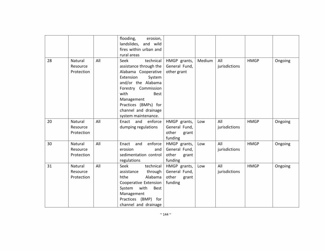
~ 144 ~
flooding, erosion, landslides, and wild fires within urban and rural areas
28 Natural Resource Protection
All Seek technical assistance through the Alabama Cooperative Extension System and/or the Alabama Forestry Commission with Best Management Practices (BMPs) for channel and drainage system maintenance.
HMGP grants, General Fund, other grant
Medium All jurisdictions
HMGP Ongoing
20 Natural Resource Protection
All Enact and enforce dumping regulations
HMGP grants, General Fund, other grant funding
Low All jurisdictions
HMGP Ongoing
30 Natural Resource Protection
All Enact and enforce erosion and sedimentation control regulations
HMGP grants, General Fund, other grant funding
Low All jurisdictions
HMGP Ongoing
31 Natural Resource Protection
All Seek technical assistance through hthe Alabama Cooperative Extension System with Best Management Practices (BMP) for channel and drainage
HMGP grants, General Fund, other grant funding
Low All jurisdictions
HMGP Ongoing
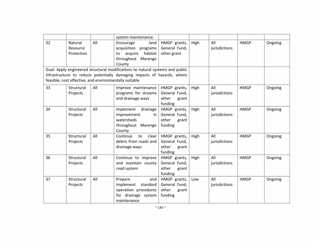
~ 145 ~
system maintenance.
32 Natural Resource Protection
All Encourage land acquisition programs to acquire habitat throughout Marengo County
HMGP grants, General Fund, other grant
High All jurisdictions
HMGP Ongoing
Goal: Apply engineered structural modifications to natural systems and public infrastructure to reduce potentially damaging impacts of hazards, where feasible, cost effective, and environmentally suitable
33 Structural Projects
All Improve maintenance programs for streams and drainage ways
HMGP grants, General Fund, other grant funding
High
All jurisdictions
HMGP Ongoing
34 Structural Projects
All Implement drainage improvement in watersheds throughout Marengo County
HMGP grants, General Fund, other grant funding
High All jurisdictions
HMGP Ongoing
35 Structural Projects
All Continue to clear debris from roads and drainage ways
HMGP grants, General Fund, other grant funding
High All jurisdictions
HMGP Ongoing
36 Structural Projects
All Continue to improve and maintain county road system
HMGP grants, General Fund, other grant funding
High All jurisdictions
HMGP Ongoing
37 Structural Projects
All Prepare and implement standard operation procedures for drainage system maintenance
HMGP grants, General Fund, other grant funding
Low All jurisdictions
HMGP Ongoing
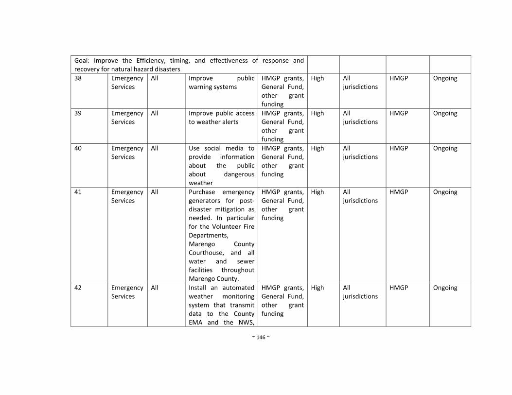
~ 146 ~
Goal: Improve the Efficiency, timing, and effectiveness of response and recovery for natural hazard disasters
38 Emergency Services
All Improve public warning systems
HMGP grants, General Fund, other grant funding
High All jurisdictions
HMGP Ongoing
39 Emergency Services
All Improve public access to weather alerts
HMGP grants, General Fund, other grant funding
High All jurisdictions
HMGP Ongoing
40 Emergency Services
All Use social media to provide information about the public about dangerous weather
HMGP grants, General Fund, other grant funding
High All jurisdictions
HMGP Ongoing
41 Emergency Services
All Purchase emergency generators for post‐disaster mitigation as needed. In particular for the Volunteer Fire Departments, Marengo County Courthouse, and all water and sewer facilities throughout Marengo County.
HMGP grants, General Fund, other grant funding
High All jurisdictions
HMGP Ongoing
42 Emergency Services
All Install an automated weather monitoring system that transmit data to the County EMA and the NWS,
HMGP grants, General Fund, other grant funding
High All jurisdictions
HMGP Ongoing
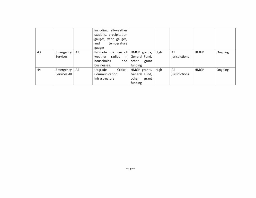
~ 147 ~
including all‐weather stations, precipitation gauges, wind gauges, and temperature gauges
43 Emergency Services
All Promote the use of weather radios in households and businesses.
HMGP grants, General Fund, other grant funding
High All jurisdictions
HMGP Ongoing
44 Emergency Services All
All Upgrade Critical Communication Infrastructure
HMGP grants, General Fund, other grant funding
High All jurisdictions
HMGP Ongoing
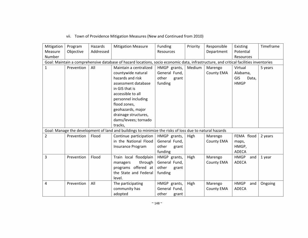
~ 148 ~
vii. Town of Providence Mitigation Measures (New and Continued from 2010)
Mitigation Measure Number
Program Objective
Hazards Addressed
Mitigation Measure Funding Resources
Priority
Responsible Department
Existing Potential Resources
Timeframe
Goal: Maintain a comprehensive database of hazard locations, socio economic data, infrastructure, and critical facilities inventories
1 Prevention All Maintain a centralized countywide natural hazards and risk assessment database in GIS that is accessible to all personnel including flood zones, geohazards, major drainage structures, dams/levees; tornado tracks,
HMGP grants, General Fund, other grant funding
Medium Marengo County EMA
Virtual Alabama, GIS Data, HMGP
5 years
Goal: Manage the development of land and buildings to minimize the risks of loss due to natural hazards
2 Prevention Flood Continue participation in the National Flood Insurance Program
HMGP grants, General Fund, other grant funding
High Marengo County EMA
FEMA flood maps, HMGP, ADECA
2 years
3 Prevention Flood Train local floodplain managers through programs offered at the State and Federal level.
HMGP grants, General Fund, other grant funding
High Marengo County EMA
HMGP and ADECA
1 year
4 Prevention All The participating community has adopted
HMGP grants, General Fund, other grant
High Marengo County EMA
HMGP and ADECA
Ongoing
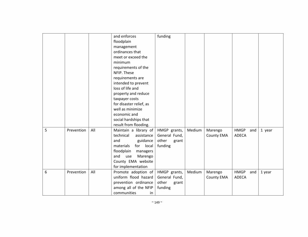
~ 149 ~
and enforces floodplain management ordinances that meet or exceed the minimum requirements of the NFIP. These requirements are intended to prevent loss of life and property and reduce taxpayer costs for disaster relief, as well as minimize economic and social hardships that result from flooding.
funding
5 Prevention All Maintain a library of technical assistance and guidance materials for local floodplain managers and use Marengo County EMA website for implementation
HMGP grants, General Fund, other grant funding
Medium Marengo County EMA
HMGP and ADECA
1 year
6 Prevention All Promote adoption of uniform flood hazard prevention ordinance among all of the NFIP communities in
HMGP grants, General Fund, other grant funding
Medium Marengo County EMA
HMGP and ADECA
1 year
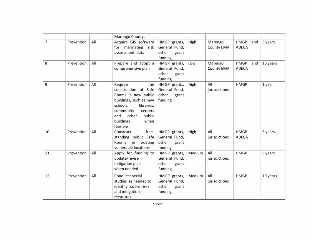
~ 150 ~
Marengo County.
7 Prevention All Acquire GIS software for marinating risk assessment data
HMGP grants, General Fund, other grant funding
High Marengo County EMA
HMGP and ADECA
5 years
8 Prevention All Prepare and adopt a comprehensive plan
HMGP grants, General Fund, other grant funding
Low Marengo County EMA
HMGP and ADECA
10 years
9 Prevention All Require the construction of Safe Rooms in new public buildings, such as new schools, libraries, community centers and other public buildings when feasible
HMGP grants, General Fund, other grant funding
High All jurisdictions
HMGP 1 year
10 Prevention All Construct free‐standing public Safe Rooms in existing vulnerable locations
HMGP grants, General Fund, other grant funding
High All jurisdictions
HMGP ADECA
5 years
11 Prevention All Apply for funding to update/revise mitigation plan when needed
HMGP grants, General Fund, other grant funding
Medium All jurisdictions
HMGP 5 years
12 Prevention All Conduct special studies as needed to identify hazard risks and mitigation measures
HMGP grants, General Fund, other grant funding
Medium All jurisdictions
HMGP 10 years

~ 151 ~
Goal: Protect structures and their occupants and contents from damaging effects of natural hazards
13 Property Protection
All Encourage retrofits of older homes constructed before the enactment of floodplain regulations
HMGP grants, General Fund, other grant funding
Medium All jurisdictions
HMGP 2 years
14 Property Protection
All Maintain insurance riders on existing properties
HMGP grants, General Fund, other grant funding
High All jurisdictions
HMGP Ongoing
15 Property Protection
All Provide back‐up power for critical facilities and fire stations
HMGP grants, General Fund, other grant funding
High All jurisdictions
HMGP 2 years
16 Property Protection
All Promote good construction practices and proper code enforcement to eliminate most structural problems during natural hazard events
HMGP grants, General Fund, other grant funding
Medium All jurisdictions
HMGP 2 years
17 Property Protection
All Encourage the construction of safe rooms within new public buildings, such as new schools, libraries, community centers, and other public buildings where
HMGP grants, General Fund, other grant funding
High All jurisdictions
HMGP 2 years
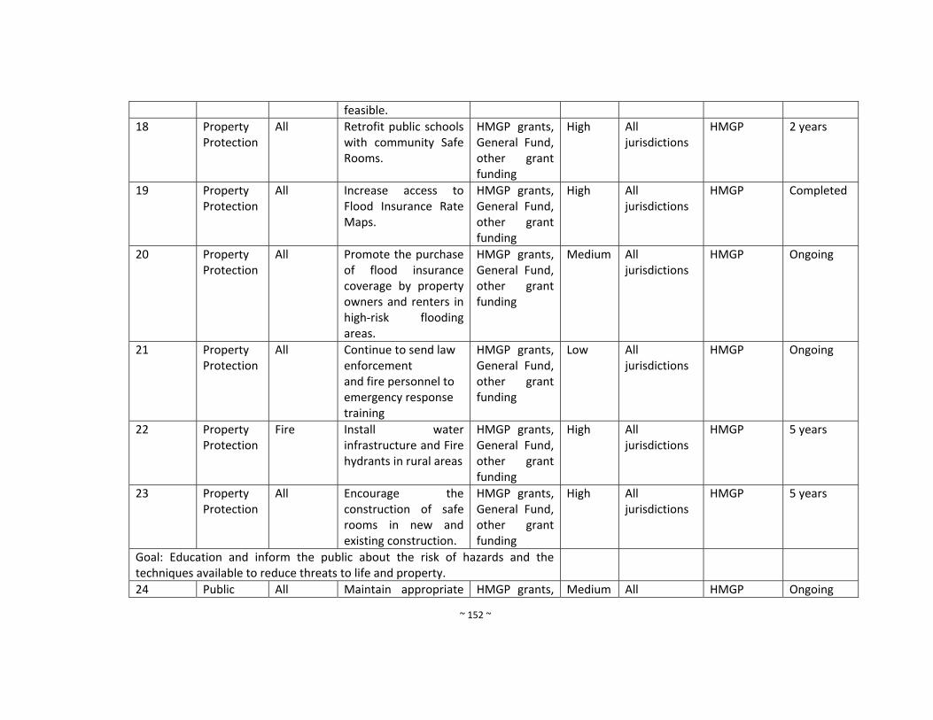
~ 152 ~
feasible.
18 Property Protection
All Retrofit public schools with community Safe Rooms.
HMGP grants, General Fund, other grant funding
High All jurisdictions
HMGP 2 years
19 Property Protection
All Increase access to Flood Insurance Rate Maps.
HMGP grants, General Fund, other grant funding
High All jurisdictions
HMGP Completed
20 Property Protection
All Promote the purchase of flood insurance coverage by property owners and renters in high‐risk flooding areas.
HMGP grants, General Fund, other grant funding
Medium All jurisdictions
HMGP Ongoing
21 Property Protection
All Continue to send law enforcement and fire personnel to emergency response training
HMGP grants, General Fund, other grant funding
Low All jurisdictions
HMGP Ongoing
22 Property Protection
Fire Install water infrastructure and Fire hydrants in rural areas
HMGP grants, General Fund, other grant funding
High All jurisdictions
HMGP 5 years
23 Property Protection
All Encourage the construction of safe rooms in new and existing construction.
HMGP grants, General Fund, other grant funding
High All jurisdictions
HMGP 5 years
Goal: Education and inform the public about the risk of hazards and the techniques available to reduce threats to life and property.
24 Public All Maintain appropriate HMGP grants, Medium All HMGP Ongoing

~ 153 ~
Education and Outreach
media relationships to ensure the public is informed of hazard threats and means to mitigate property damages and loss of life.
General Fund, other grant funding
jurisdictions
25 Public Education and Outreach
All Publicize the availability of FIRM information to real estate agents, builders, developers, and homeowners through local trade publications and newspaper announcements.
HMGP grants, General Fund, other grant funding
Medium All jurisdictions
HMGP 1 year
26 Public Education and Outreach
All Conduct regular public meetings of hazards and mitigation measures
HMGP grants, General Fund, other grant
Low All jurisdictions
HMGP 1 year
Goal: Preserve and restore the beneficial functions of natural environment to promote sustainable community development that balances the constraints of nature with the social and economic demands of the community.
27 Natural Resource Protection
All Maintain a healthy forest that can help mitigation the damaging impacts of flooding, erosion, landslides, and wild fires within urban and
HMGP grants, General Fund, other grant
High All jurisdictions
HMGP 5 years
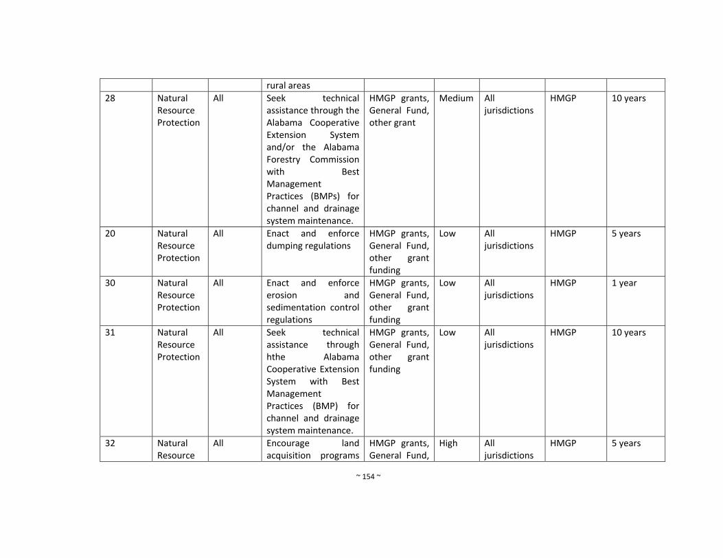
~ 154 ~
rural areas
28 Natural Resource Protection
All Seek technical assistance through the Alabama Cooperative Extension System and/or the Alabama Forestry Commission with Best Management Practices (BMPs) for channel and drainage system maintenance.
HMGP grants, General Fund, other grant
Medium All jurisdictions
HMGP 10 years
20 Natural Resource Protection
All Enact and enforce dumping regulations
HMGP grants, General Fund, other grant funding
Low All jurisdictions
HMGP 5 years
30 Natural Resource Protection
All Enact and enforce erosion and sedimentation control regulations
HMGP grants, General Fund, other grant funding
Low All jurisdictions
HMGP 1 year
31 Natural Resource Protection
All Seek technical assistance through hthe Alabama Cooperative Extension System with Best Management Practices (BMP) for channel and drainage system maintenance.
HMGP grants, General Fund, other grant funding
Low All jurisdictions
HMGP 10 years
32 Natural Resource
All Encourage land acquisition programs
HMGP grants, General Fund,
High All jurisdictions
HMGP 5 years
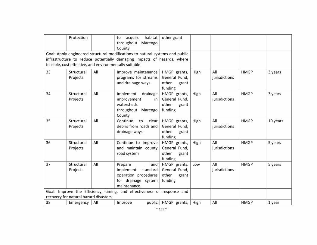
~ 155 ~
Protection to acquire habitat throughout Marengo County
other grant
Goal: Apply engineered structural modifications to natural systems and public infrastructure to reduce potentially damaging impacts of hazards, where feasible, cost effective, and environmentally suitable
33 Structural Projects
All Improve maintenance programs for streams and drainage ways
HMGP grants, General Fund, other grant funding
High
All jurisdictions
HMGP 3 years
34 Structural Projects
All Implement drainage improvement in watersheds throughout Marengo County
HMGP grants, General Fund, other grant funding
High All jurisdictions
HMGP 3 years
35 Structural Projects
All Continue to clear debris from roads and drainage ways
HMGP grants, General Fund, other grant funding
High All jurisdictions
HMGP 10 years
36 Structural Projects
All Continue to improve and maintain county road system
HMGP grants, General Fund, other grant funding
High All jurisdictions
HMGP 5 years
37 Structural Projects
All Prepare and implement standard operation procedures for drainage system maintenance
HMGP grants, General Fund, other grant funding
Low All jurisdictions
HMGP 5 years
Goal: Improve the Efficiency, timing, and effectiveness of response and recovery for natural hazard disasters
38 Emergency All Improve public HMGP grants, High All HMGP 1 year

~ 156 ~
Services warning systems General Fund, other grant funding
jurisdictions
39 Emergency Services
All Improve public access to weather alerts
HMGP grants, General Fund, other grant funding
High All jurisdictions
HMGP 1 year
40 Emergency Services
All Use social media to provide information about the public about dangerous weather
HMGP grants, General Fund, other grant funding
High All jurisdictions
HMGP 2 years
41 Emergency Services
All Purchase emergency generators for post‐disaster mitigation as needed. In particular for the Volunteer Fire Departments, Marengo County Courthouse, and all water and sewer facilities throughout Marengo County.
HMGP grants, General Fund, other grant funding
High All jurisdictions
HMGP 5 years
42 Emergency Services
All
Install an automated weather monitoring system that transmit data to the County EMA and the NWS, including all‐weather stations, precipitation gauges, wind gauges,
HMGP grants, General Fund, other grant funding
High All jurisdictions
HMGP 10 years
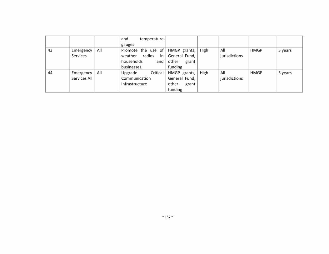
~ 157 ~
and temperature gauges
43 Emergency Services
All Promote the use of weather radios in households and businesses.
HMGP grants, General Fund, other grant funding
High All jurisdictions
HMGP 3 years
44 Emergency Services All
All Upgrade Critical Communication Infrastructure
HMGP grants, General Fund, other grant funding
High All jurisdictions
HMGP 5 years
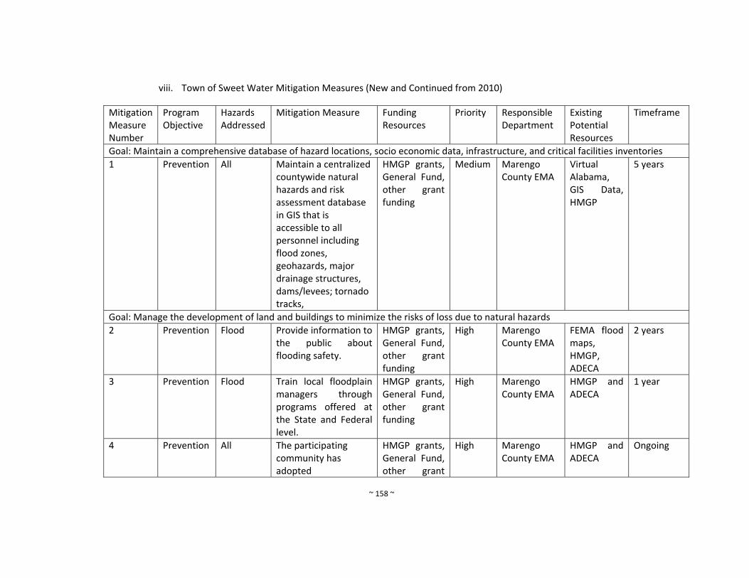
~ 158 ~
viii. Town of Sweet Water Mitigation Measures (New and Continued from 2010)
Mitigation Measure Number
Program Objective
Hazards Addressed
Mitigation Measure Funding Resources
Priority
Responsible Department
Existing Potential Resources
Timeframe
Goal: Maintain a comprehensive database of hazard locations, socio economic data, infrastructure, and critical facilities inventories
1 Prevention All Maintain a centralized countywide natural hazards and risk assessment database in GIS that is accessible to all personnel including flood zones, geohazards, major drainage structures, dams/levees; tornado tracks,
HMGP grants, General Fund, other grant funding
Medium Marengo County EMA
Virtual Alabama, GIS Data, HMGP
5 years
Goal: Manage the development of land and buildings to minimize the risks of loss due to natural hazards
2 Prevention Flood Provide information to the public about flooding safety.
HMGP grants, General Fund, other grant funding
High Marengo County EMA
FEMA flood maps, HMGP, ADECA
2 years
3 Prevention Flood Train local floodplain managers through programs offered at the State and Federal level.
HMGP grants, General Fund, other grant funding
High Marengo County EMA
HMGP and ADECA
1 year
4 Prevention All The participating community has adopted
HMGP grants, General Fund, other grant
High Marengo County EMA
HMGP and ADECA
Ongoing

~ 159 ~
and enforces floodplain management ordinances that meet or exceed the minimum requirements of the NFIP. These requirements are intended to prevent loss of life and property and reduce taxpayer costs for disaster relief, as well as minimize economic and social hardships that result from flooding.
funding
5 Prevention All Maintain a library of technical assistance and guidance materials for local floodplain managers and use Marengo County EMA website for implementation
HMGP grants, General Fund, other grant funding
Medium Marengo County EMA
HMGP and ADECA
1 year
6 Prevention All Promote adoption of uniform flood hazard prevention ordinance among all of the NFIP communities in
HMGP grants, General Fund, other grant funding
Medium Marengo County EMA
HMGP and ADECA
1 year

~ 160 ~
Marengo County.
7 Prevention All Acquire GIS software for marinating risk assessment data
HMGP grants, General Fund, other grant funding
High Marengo County EMA
HMGP and ADECA
5 years
8 Prevention All Prepare and adopt a comprehensive plan
HMGP grants, General Fund, other grant funding
Low Marengo County EMA
HMGP and ADECA
10 years
9 Prevention All
Require the construction of Safe Rooms in new public buildings, such as new schools, libraries, community centers and other public buildings when feasible
HMGP grants, General Fund, other grant funding
High All jurisdictions
HMGP 1 year
10 Prevention All Construct free‐standing public Safe Rooms in existing vulnerable locations
HMGP grants, General Fund, other grant funding
High All jurisdictions
HMGP ADECA
5 years
11 Prevention All Apply for funding to update/revise mitigation plan when needed
HMGP grants, General Fund, other grant funding
Medium All jurisdictions
HMGP 5 years
12 Prevention All Conduct special studies as needed to identify hazard risks and mitigation measures
HMGP grants, General Fund, other grant funding
Medium All jurisdictions
HMGP 10 years
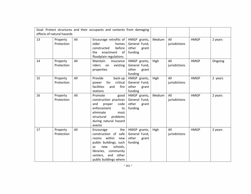
~ 161 ~
Goal: Protect structures and their occupants and contents from damaging effects of natural hazards
13 Property Protection
All Encourage retrofits of older homes constructed before the enactment of floodplain regulations
HMGP grants, General Fund, other grant funding
Medium All jurisdictions
HMGP 2 years
14 Property Protection
All Maintain insurance riders on existing properties
HMGP grants, General Fund, other grant funding
High All jurisdictions
HMGP Ongoing
15 Property Protection
All Provide back‐up power for critical facilities and fire stations
HMGP grants, General Fund, other grant funding
High All jurisdictions
HMGP 2 years
16 Property Protection
All Promote good construction practices and proper code enforcement to eliminate most structural problems during natural hazard events
HMGP grants, General Fund, other grant funding
Medium All jurisdictions
HMGP 2 years
17 Property Protection
All Encourage the construction of safe rooms within new public buildings, such as new schools, libraries, community centers, and other public buildings where
HMGP grants, General Fund, other grant funding
High All jurisdictions
HMGP 2 years

~ 162 ~
feasible.
18 Property Protection
All Retrofit public schools with community Safe Rooms.
HMGP grants, General Fund, other grant funding
High All jurisdictions
HMGP 2 years
19 Property Protection
All Increase access to Flood Insurance Rate Maps.
HMGP grants, General Fund, other grant funding
High All jurisdictions
HMGP Completed
20 Property Protection
All Promote the purchase of flood insurance coverage by property owners and renters in high‐risk flooding areas.
HMGP grants, General Fund, other grant funding
Medium All jurisdictions
HMGP Ongoing
21 Property Protection
All Continue to send law enforcement and fire personnel to emergency response training
HMGP grants, General Fund, other grant funding
Low All jurisdictions
HMGP Ongoing
22 Property Protection
Fire Install water infrastructure and Fire hydrants in rural areas
HMGP grants, General Fund, other grant funding
High All jurisdictions
HMGP 5 years
23 Property Protection
All Encourage the construction of safe rooms in new and existing construction.
HMGP grants, General Fund, other grant funding
High All jurisdictions
HMGP 5 years
Goal: Education and inform the public about the risk of hazards and the techniques available to reduce threats to life and property.
24 Public All Maintain appropriate HMGP grants, Medium All HMGP Ongoing
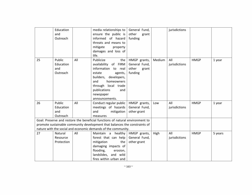
~ 163 ~
Education and Outreach
media relationships to ensure the public is informed of hazard threats and means to mitigate property damages and loss of life.
General Fund, other grant funding
jurisdictions
25 Public Education and Outreach
All Publicize the availability of FIRM information to real estate agents, builders, developers, and homeowners through local trade publications and newspaper announcements.
HMGP grants, General Fund, other grant funding
Medium All jurisdictions
HMGP 1 year
26 Public Education and Outreach
All Conduct regular public meetings of hazards and mitigation measures
HMGP grants, General Fund, other grant
Low All jurisdictions
HMGP 1 year
Goal: Preserve and restore the beneficial functions of natural environment to promote sustainable community development that balances the constraints of nature with the social and economic demands of the community.
27 Natural Resource Protection
All Maintain a healthy forest that can help mitigation the damaging impacts of flooding, erosion, landslides, and wild fires within urban and
HMGP grants, General Fund, other grant
High All jurisdictions
HMGP 5 years

~ 164 ~
rural areas
28 Natural Resource Protection
All Seek technical assistance through the Alabama Cooperative Extension System and/or the Alabama Forestry Commission with Best Management Practices (BMPs) for channel and drainage system maintenance.
HMGP grants, General Fund, other grant
Medium All jurisdictions
HMGP 10 years
20 Natural Resource Protection
All Enact and enforce dumping regulations
HMGP grants, General Fund, other grant funding
Low All jurisdictions
HMGP 5 years
30 Natural Resource Protection
All Enact and enforce erosion and sedimentation control regulations
HMGP grants, General Fund, other grant funding
Low All jurisdictions
HMGP 1 year
31 Natural Resource Protection
All Seek technical assistance through hthe Alabama Cooperative Extension System with Best Management Practices (BMP) for channel and drainage system maintenance.
HMGP grants, General Fund, other grant funding
Low All jurisdictions
HMGP 10 years
32 Natural Resource
All Encourage land acquisition programs
HMGP grants, General Fund,
High All jurisdictions
HMGP 5 years
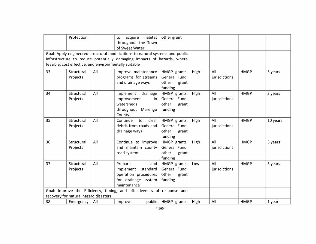
~ 165 ~
Protection to acquire habitat throughout the Town of Sweet Water
other grant
Goal: Apply engineered structural modifications to natural systems and public infrastructure to reduce potentially damaging impacts of hazards, where feasible, cost effective, and environmentally suitable
33 Structural Projects
All Improve maintenance programs for streams and drainage ways
HMGP grants, General Fund, other grant funding
High
All jurisdictions
HMGP 3 years
34 Structural Projects
All Implement drainage improvement in watersheds throughout Marengo County
HMGP grants, General Fund, other grant funding
High All jurisdictions
HMGP 3 years
35 Structural Projects
All Continue to clear debris from roads and drainage ways
HMGP grants, General Fund, other grant funding
High All jurisdictions
HMGP 10 years
36 Structural Projects
All Continue to improve and maintain county road system
HMGP grants, General Fund, other grant funding
High All jurisdictions
HMGP 5 years
37 Structural Projects
All Prepare and implement standard operation procedures for drainage system maintenance
HMGP grants, General Fund, other grant funding
Low All jurisdictions
HMGP 5 years
Goal: Improve the Efficiency, timing, and effectiveness of response and recovery for natural hazard disasters
38 Emergency All Improve public HMGP grants, High All HMGP 1 year
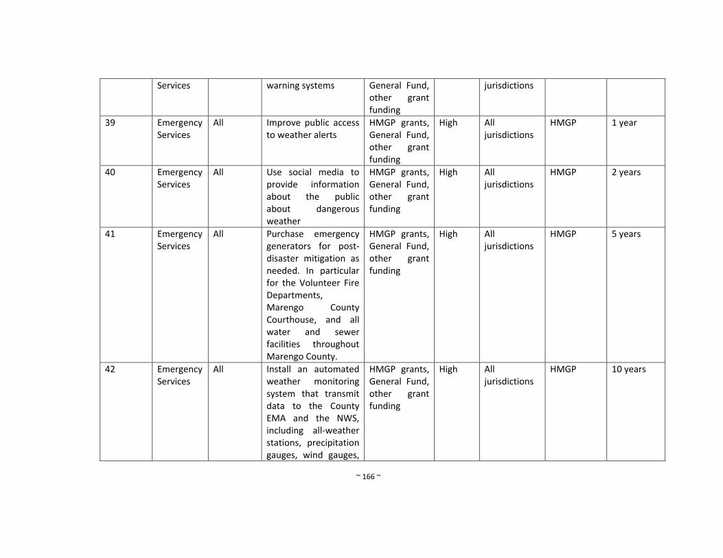
~ 166 ~
Services warning systems General Fund, other grant funding
jurisdictions
39 Emergency Services
All Improve public access to weather alerts
HMGP grants, General Fund, other grant funding
High All jurisdictions
HMGP 1 year
40 Emergency Services
All Use social media to provide information about the public about dangerous weather
HMGP grants, General Fund, other grant funding
High All jurisdictions
HMGP 2 years
41 Emergency Services
All Purchase emergency generators for post‐disaster mitigation as needed. In particular for the Volunteer Fire Departments, Marengo County Courthouse, and all water and sewer facilities throughout Marengo County.
HMGP grants, General Fund, other grant funding
High All jurisdictions
HMGP 5 years
42 Emergency Services
All
Install an automated weather monitoring system that transmit data to the County EMA and the NWS, including all‐weather stations, precipitation gauges, wind gauges,
HMGP grants, General Fund, other grant funding
High All jurisdictions
HMGP 10 years
~ 167 ~
and temperature gauges
43 Emergency Services
All Promote the use of weather radios in households and businesses.
HMGP grants, General Fund, other grant funding
High All jurisdictions
HMGP 3 years
44 Emergency Services All
All Upgrade Critical Communication Infrastructure
HMGP grants, General Fund, other grant funding
High All jurisdictions
HMGP
~ 168 ~
Town of Thomaston Mitigation Measures (New and Continued from 2010)
Mitigation Measure Number
Program Objective
Hazards Addressed
Mitigation Measure Funding Resources
Priority
Responsible Department
Existing Potential Resources
Timeframe
Goal: Maintain a comprehensive database of hazard locations, socio economic data, infrastructure, and critical facilities inventories
1 Prevention All Maintain a centralized countywide natural hazards and risk assessment database in GIS that is accessible to all personnel including flood zones, geohazards, major drainage structures, dams/levees; tornado tracks,
HMGP grants, General Fund, other grant funding
Medium Marengo County EMA
Virtual Alabama, GIS Data, HMGP
5 years
Goal: Manage the development of land and buildings to minimize the risks of loss due to natural hazards
2 Prevention Flood Effectively administer and enforce local floodplain management regulations
HMGP grants, General Fund, other grant funding
High Marengo County EMA
FEMA flood maps, HMGP, ADECA
2 years
3 Prevention Flood Train local floodplain managers through programs offered at the State and Federal level.
HMGP grants, General Fund, other grant funding
High Marengo County EMA
HMGP and ADECA
1 year
4 Prevention All The participating community has
HMGP grants, General Fund,
High Marengo County EMA
HMGP and ADECA
Ongoing
~ 169 ~
adopted and enforces floodplain management ordinances that meet or exceed the minimum requirements of the NFIP. These requirements are intended to prevent loss of life and property and reduce taxpayer costs for disaster relief, as well as minimize economic and social hardships that result from flooding.
other grant funding
5 Prevention All Maintain a library of technical assistance and guidance materials for local floodplain managers and use Marengo County EMA website for implementation
HMGP grants, General Fund, other grant funding
Medium Marengo County EMA
HMGP and ADECA
1 year
6 Prevention All Promote adoption of uniform flood hazard prevention ordinance among all of the NFIP
HMGP grants, General Fund, other grant funding
Medium Marengo County EMA
HMGP and ADECA
1 year
~ 170 ~
communities in Marengo County.
7 Prevention All Acquire GIS software for marinating risk assessment data
HMGP grants, General Fund, other grant funding
High Marengo County EMA
HMGP and ADECA
5 years
8 Prevention All Prepare and adopt a comprehensive plan
HMGP grants, General Fund, other grant funding
Low Marengo County EMA
HMGP and ADECA
10 years
9 Prevention All
Require the construction of Safe Rooms in new public buildings, such as new schools, libraries, community centers and other public buildings when feasible
HMGP grants, General Fund, other grant funding
High All jurisdictions
HMGP 1 year
10 Prevention All Construct free‐standing public Safe Rooms in existing vulnerable locations
HMGP grants, General Fund, other grant funding
High All jurisdictions
HMGP ADECA
5 years
11 Prevention All Apply for funding to update/revise mitigation plan when needed
HMGP grants, General Fund, other grant funding
Medium All jurisdictions
HMGP 5 years
12 Prevention All Conduct special studies as needed to identify hazard risks and mitigation
HMGP grants, General Fund, other grant funding
Medium All jurisdictions
HMGP 10 years
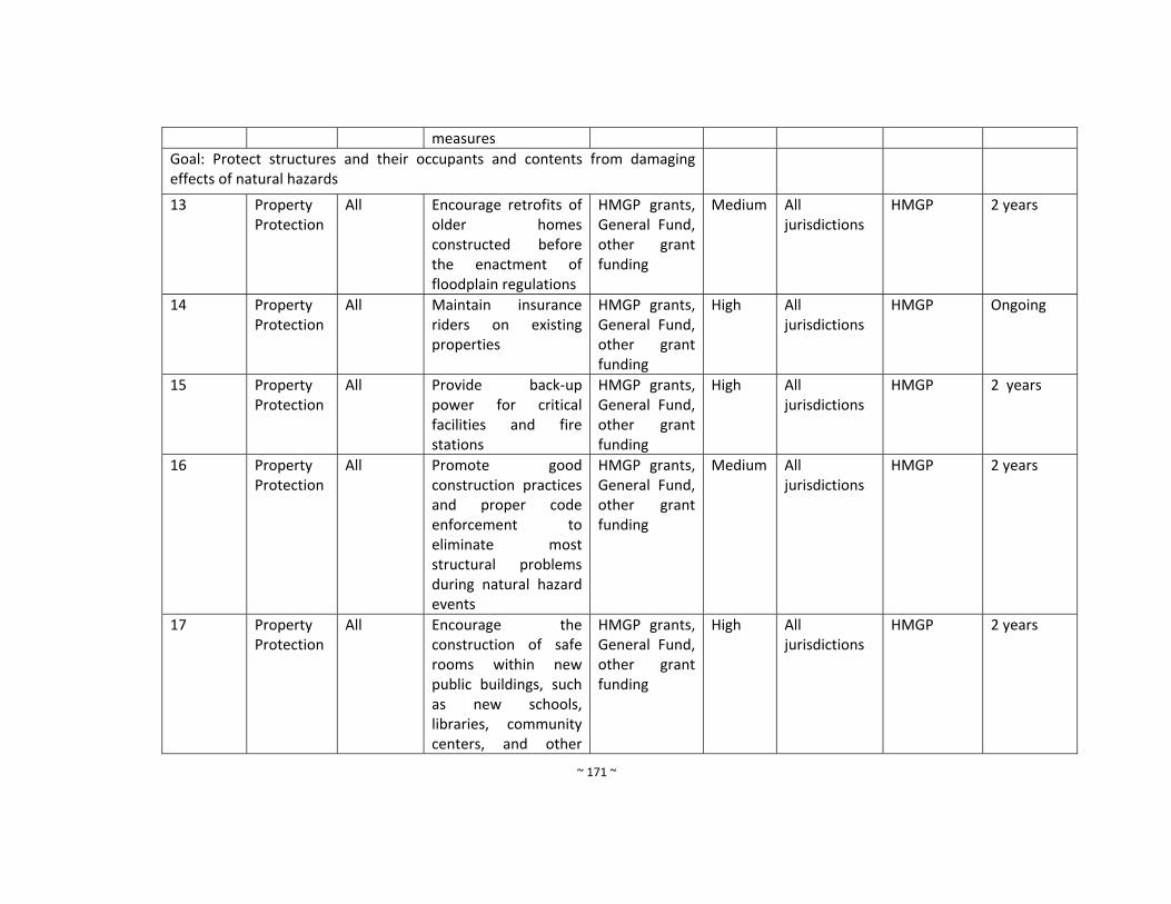
~ 171 ~
measures
Goal: Protect structures and their occupants and contents from damaging effects of natural hazards
13 Property Protection
All Encourage retrofits of older homes constructed before the enactment of floodplain regulations
HMGP grants, General Fund, other grant funding
Medium All jurisdictions
HMGP 2 years
14 Property Protection
All Maintain insurance riders on existing properties
HMGP grants, General Fund, other grant funding
High All jurisdictions
HMGP Ongoing
15 Property Protection
All Provide back‐up power for critical facilities and fire stations
HMGP grants, General Fund, other grant funding
High All jurisdictions
HMGP 2 years
16 Property Protection
All Promote good construction practices and proper code enforcement to eliminate most structural problems during natural hazard events
HMGP grants, General Fund, other grant funding
Medium All jurisdictions
HMGP 2 years
17 Property Protection
All Encourage the construction of safe rooms within new public buildings, such as new schools, libraries, community centers, and other
HMGP grants, General Fund, other grant funding
High All jurisdictions
HMGP 2 years
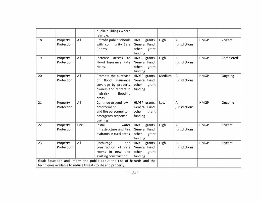
~ 172 ~
public buildings where feasible.
18 Property Protection
All Retrofit public schools with community Safe Rooms.
HMGP grants, General Fund, other grant funding
High All jurisdictions
HMGP 2 years
19 Property Protection
All Increase access to Flood Insurance Rate Maps.
HMGP grants, General Fund, other grant funding
High All jurisdictions
HMGP Completed
20 Property Protection
All Promote the purchase of flood insurance coverage by property owners and renters in high‐risk flooding areas.
HMGP grants, General Fund, other grant funding
Medium All jurisdictions
HMGP Ongoing
21 Property Protection
All Continue to send law enforcement and fire personnel to emergency response training
HMGP grants, General Fund, other grant funding
Low All jurisdictions
HMGP Ongoing
22 Property Protection
Fire Install water infrastructure and Fire hydrants in rural areas
HMGP grants, General Fund, other grant funding
High All jurisdictions
HMGP 5 years
23 Property Protection
All Encourage the construction of safe rooms in new and existing construction.
HMGP grants, General Fund, other grant funding
High All jurisdictions
HMGP 5 years
Goal: Education and inform the public about the risk of hazards and the techniques available to reduce threats to life and property.

~ 173 ~
24 Public Education and Outreach
All Maintain appropriate media relationships to ensure the public is informed of hazard threats and means to mitigate property damages and loss of life.
HMGP grants, General Fund, other grant funding
Medium All jurisdictions
HMGP Ongoing
25 Public Education and Outreach
All Publicize the availability of FIRM information to real estate agents, builders, developers, and homeowners through local trade publications and newspaper announcements.
HMGP grants, General Fund, other grant funding
Medium All jurisdictions
HMGP 1 year
26 Public Education and Outreach
All Conduct regular public meetings of hazards and mitigation measures
HMGP grants, General Fund, other grant
Low All jurisdictions
HMGP 1 year
Goal: Preserve and restore the beneficial functions of natural environment to promote sustainable community development that balances the constraints of nature with the social and economic demands of the community.
27 Natural Resource Protection
All Maintain a healthy forest that can help mitigation the damaging impacts of flooding, erosion, landslides, and wild
HMGP grants, General Fund, other grant
High All jurisdictions
HMGP 5 years
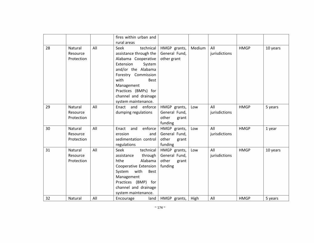
~ 174 ~
fires within urban and rural areas
28 Natural Resource Protection
All Seek technical assistance through the Alabama Cooperative Extension System and/or the Alabama Forestry Commission with Best Management Practices (BMPs) for channel and drainage system maintenance.
HMGP grants, General Fund, other grant
Medium All jurisdictions
HMGP 10 years
29 Natural Resource Protection
All Enact and enforce dumping regulations
HMGP grants, General Fund, other grant funding
Low All jurisdictions
HMGP 5 years
30 Natural Resource Protection
All Enact and enforce erosion and sedimentation control regulations
HMGP grants, General Fund, other grant funding
Low All jurisdictions
HMGP 1 year
31 Natural Resource Protection
All Seek technical assistance through hthe Alabama Cooperative Extension System with Best Management Practices (BMP) for channel and drainage system maintenance.
HMGP grants, General Fund, other grant funding
Low All jurisdictions
HMGP 10 years
32 Natural All Encourage land HMGP grants, High All HMGP 5 years
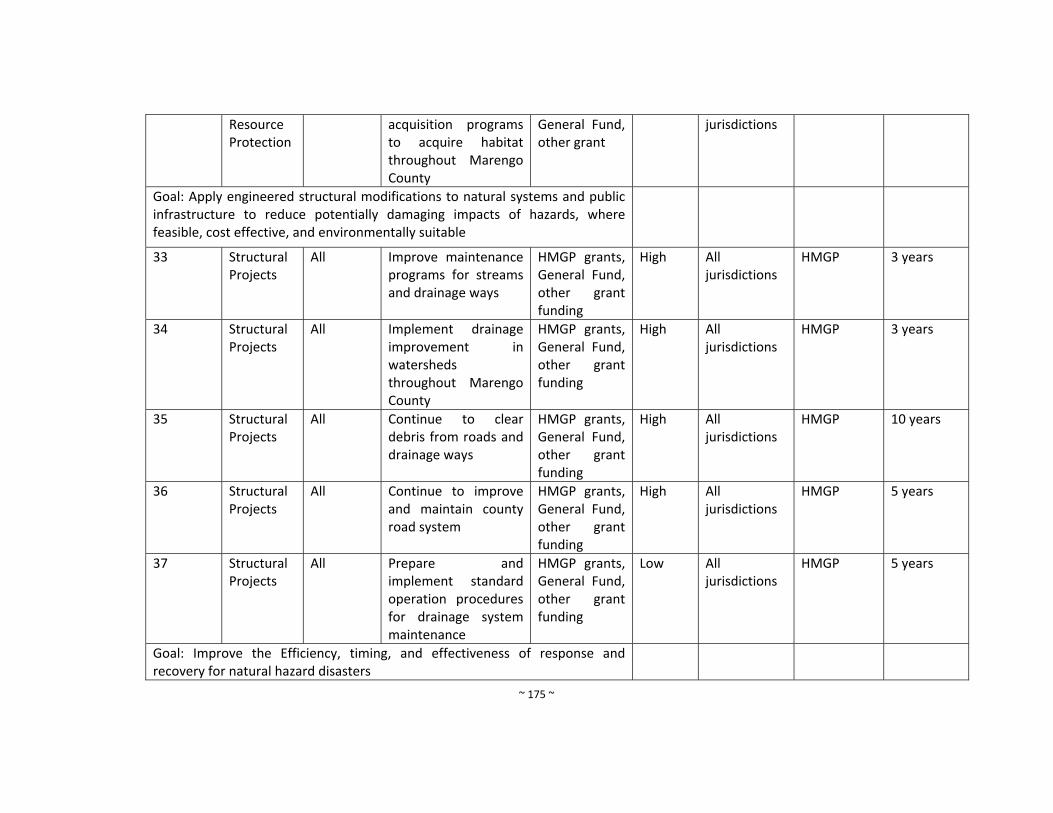
~ 175 ~
Resource Protection
acquisition programs to acquire habitat throughout Marengo County
General Fund, other grant
jurisdictions
Goal: Apply engineered structural modifications to natural systems and public infrastructure to reduce potentially damaging impacts of hazards, where feasible, cost effective, and environmentally suitable
33 Structural Projects
All Improve maintenance programs for streams and drainage ways
HMGP grants, General Fund, other grant funding
High
All jurisdictions
HMGP 3 years
34 Structural Projects
All Implement drainage improvement in watersheds throughout Marengo County
HMGP grants, General Fund, other grant funding
High All jurisdictions
HMGP 3 years
35 Structural Projects
All Continue to clear debris from roads and drainage ways
HMGP grants, General Fund, other grant funding
High All jurisdictions
HMGP 10 years
36 Structural Projects
All Continue to improve and maintain county road system
HMGP grants, General Fund, other grant funding
High All jurisdictions
HMGP 5 years
37 Structural Projects
All Prepare and implement standard operation procedures for drainage system maintenance
HMGP grants, General Fund, other grant funding
Low All jurisdictions
HMGP 5 years
Goal: Improve the Efficiency, timing, and effectiveness of response and recovery for natural hazard disasters

~ 176 ~
38 Emergency Services
All Improve public warning systems
HMGP grants, General Fund, other grant funding
High All jurisdictions
HMGP 1 year
39 Emergency Services
All Improve public access to weather alerts
HMGP grants, General Fund, other grant funding
High All jurisdictions
HMGP 1 year
40 Emergency Services
All Use social media to provide information about the public about dangerous weather
HMGP grants, General Fund, other grant funding
High All jurisdictions
HMGP 2 years
41 Emergency Services
All Purchase emergency generators for post‐disaster mitigation as needed. In particular for the Volunteer Fire Departments, Marengo County Courthouse, and all water and sewer facilities throughout Marengo County.
HMGP grants, General Fund, other grant funding
High All jurisdictions
HMGP 5 years
42 Emergency Services
All
Install an automated weather monitoring system that transmit data to the County EMA and the NWS, including all‐weather stations, precipitation
HMGP grants, General Fund, other grant funding
High All jurisdictions
HMGP 10 years
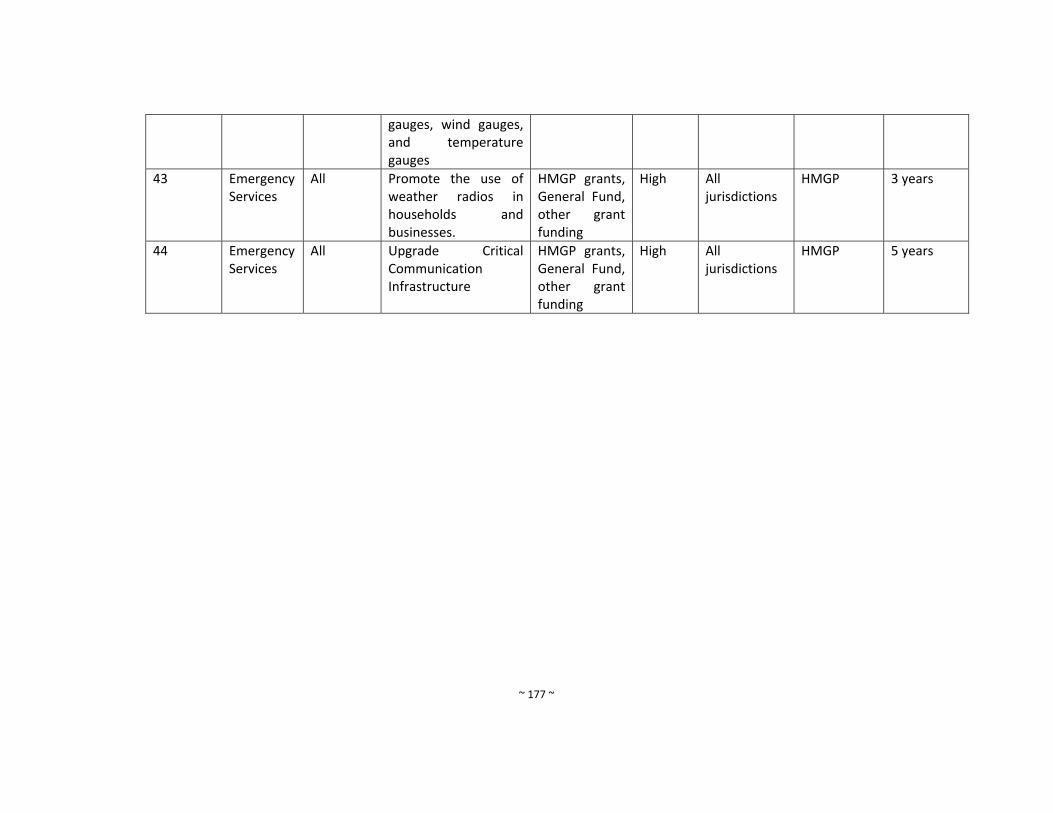
~ 177 ~
gauges, wind gauges, and temperature gauges
43 Emergency Services
All Promote the use of weather radios in households and businesses.
HMGP grants, General Fund, other grant funding
High All jurisdictions
HMGP 3 years
44 Emergency Services
All Upgrade Critical Communication Infrastructure
HMGP grants, General Fund, other grant funding
High All jurisdictions
HMGP 5 years
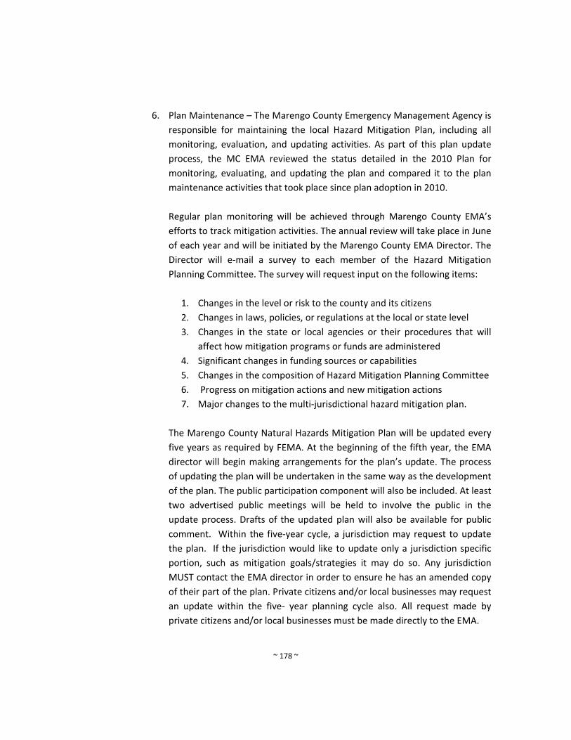
~ 178 ~
6. Plan Maintenance – The Marengo County Emergency Management Agency is
responsible for maintaining the local Hazard Mitigation Plan, including all
monitoring, evaluation, and updating activities. As part of this plan update
process, the MC EMA reviewed the status detailed in the 2010 Plan for
monitoring, evaluating, and updating the plan and compared it to the plan
maintenance activities that took place since plan adoption in 2010.
Regular plan monitoring will be achieved through Marengo County EMA’s
efforts to track mitigation activities. The annual review will take place in June
of each year and will be initiated by the Marengo County EMA Director. The
Director will e‐mail a survey to each member of the Hazard Mitigation
Planning Committee. The survey will request input on the following items:
1. Changes in the level or risk to the county and its citizens
2. Changes in laws, policies, or regulations at the local or state level
3. Changes in the state or local agencies or their procedures that will
affect how mitigation programs or funds are administered
4. Significant changes in funding sources or capabilities
5. Changes in the composition of Hazard Mitigation Planning Committee
6. Progress on mitigation actions and new mitigation actions
7. Major changes to the multi‐jurisdictional hazard mitigation plan.
The Marengo County Natural Hazards Mitigation Plan will be updated every
five years as required by FEMA. At the beginning of the fifth year, the EMA
director will begin making arrangements for the plan’s update. The process
of updating the plan will be undertaken in the same way as the development
of the plan. The public participation component will also be included. At least
two advertised public meetings will be held to involve the public in the
update process. Drafts of the updated plan will also be available for public
comment. Within the five‐year cycle, a jurisdiction may request to update
the plan. If the jurisdiction would like to update only a jurisdiction specific
portion, such as mitigation goals/strategies it may do so. Any jurisdiction
MUST contact the EMA director in order to ensure he has an amended copy
of their part of the plan. Private citizens and/or local businesses may request
an update within the five‐ year planning cycle also. All request made by
private citizens and/or local businesses must be made directly to the EMA.

~ 179 ~
In the event modifications to the plan are warranted as a result of the annual
review or other conditions, the Committee will oversee and approve all
revisions to the plan. Before any revisions are submitted to the jurisdictions
for adoption, a notice will be placed in the local newspaper, allowing an
opportunity for the public to review the proposed amendments at the EMA
offices, submit written comments, and present comments at a public
meeting. The Committee will then submit all revisions for adoption by all of
the jurisdictions. A copy of the plan revisions will be submitted to all holders
of the original plan in a timely manner.
At the end of the five‐year cycle of the Action Program, the Committee will
oversee a major update to the plan that follows the federal planning criteria
in effect at the time of the update. The updated plan will again be submitted
to the AEMA and FEMA for approval.
A critical part of maintaining an effective and relevant natural hazards
mitigation plan is ongoing public review and comment. Consequently, the
Hazard Mitigation Planning Committee is dedicated to direct involvement of
its citizens in providing feedback and comments on the plan throughout the
five‐year implementation cycle. To this end, a hard copy of the plan will be
available for viewing at all appropriate agencies throughout the County;
including, at a minimum, the Marengo County Emergency Management
Agency Office, the office of the County Commission, the offices of the
Mayors, and the main public library.
The Marengo County Hazard Mitigation Plan will be incorporated into
existing planning mechanisms in all participating jurisdictions. However,
since Marengo County is rural with negligible growth, there are few existing
planning mechanisms available. Those jurisdictions with building codes or
zoning ordinances will incorporate hazard mitigation strategies into existing
codes. These updates will occur as budgets and time allow. Those
jurisdictions without building codes or zoning ordinances, that decide to
adopt new ordinances, will be required to reflect the goals and objectives
they set forth in the plan. Those jurisdictions updating comprehensive plans
will also have to reflect their hazard mitigation goals and objectives in their
plan. The Marengo County EMA will also incorporate the plan in the
Emergency Operations Plan at the next update. The mitigation plan was
reviewed to ensure that any proposed changes (i.e. land use) would not
conflict with strategies identified in the plan. The mitigation plan will also be
consulted to ensure that no hazards (i.e. landslides, subsidence, and
~ 180 ~
expansive soil) are present when permits or variances are granted.
Strategies and goals identified in the mitigation plan will also be
incorporated into other planning mechanisms’ strategies and goals. As other
jurisdictions update their plans, the same steps will be followed.
7. Approval and Adoption – After preliminary review by FEMA, each jurisdiction in
Marengo County will adopt the plan via resolution. The Marengo County plan update
applies to all local agencies, board, commission, and departments assigned mitigation
responsibilities, and to others as deigned by the Marengo County Commission or
Director or the Marengo County Emergency Management Agency.
The Marengo County Multi‐Hazard Mitigation Plan Update was prepared in
compliance with Public Law 106‐390, Disaster Mitigation Act of 2000, as amended.
This plan update implements hazard mitigation measures intended to eliminate or
reduce the effects of further disaster throughout Marengo County, and was
developed in a joint and cooperate venture by members of the Marengo County
Hazard Mitigation Planning Committee.
Marengo County will comply with all application state and federal statutes and
regulations in effect with respect to the periods for which it received grant funding, in
compliance with 44 Code of Federal Regulations (CDF) 113.11c. Marengo County will
amend its plan whenever necessary to reflect changes in local/state and/or federal
laws and statutes required in 44 CFR, 12,11d. At a minimum, the Marengo County
Emergency Management Agency will review and if necessary, update the plan every
five years from the date of approval in accordance with 44 CRF, 201.6 (5) (d0 (3) in
order to continue program eligibility.

~ i ~
7. Appendices
a. Appendix A – 44 CFR 201 Hazard Mitigation Planning
~ ii ~
~ iii ~

~ iv ~
~ v ~
~ vi ~
~ vii ~
~ viii ~
~ ix ~
~ x ~
~ xi ~
~ xii ~

~ xiii ~
b. Appendix B – Sign in sheets and agendas for each meeting
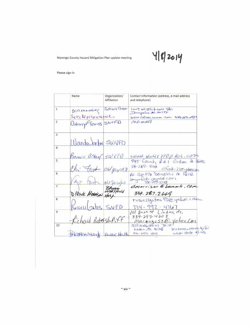
~ xiv ~
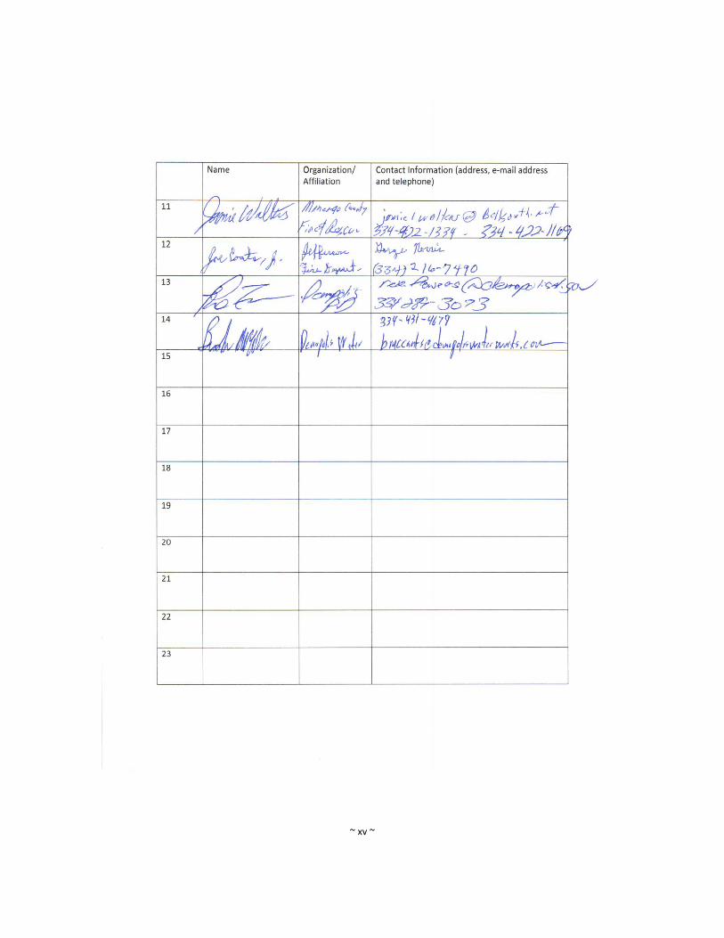
~ xv ~

~ xvi ~
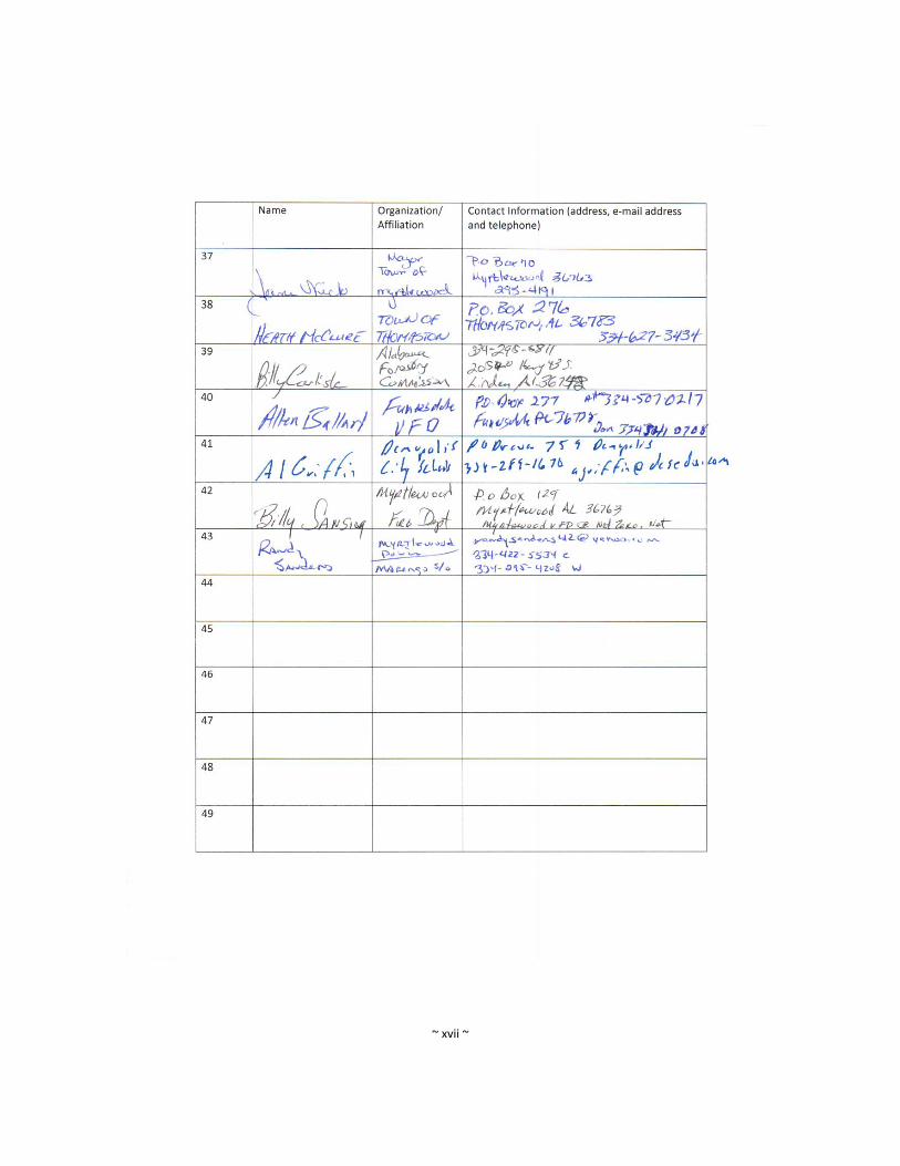
~ xvii ~
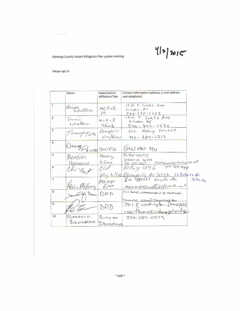
~ xviii ~
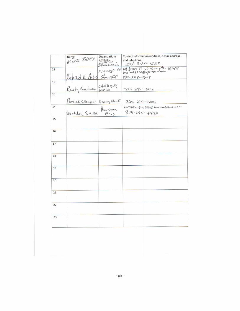
~ xix ~

~ xx ~
c. Appendix C – Resolutions by each entity adopting the Plan Update

~ xxi ~
Appendix D Local Mtigation Plan Review Tool.
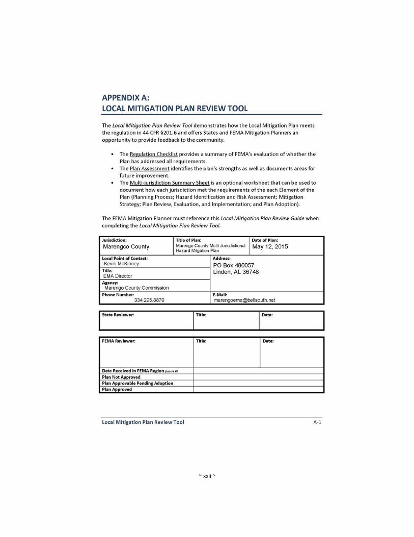
~ xxii ~

~ xxiii ~
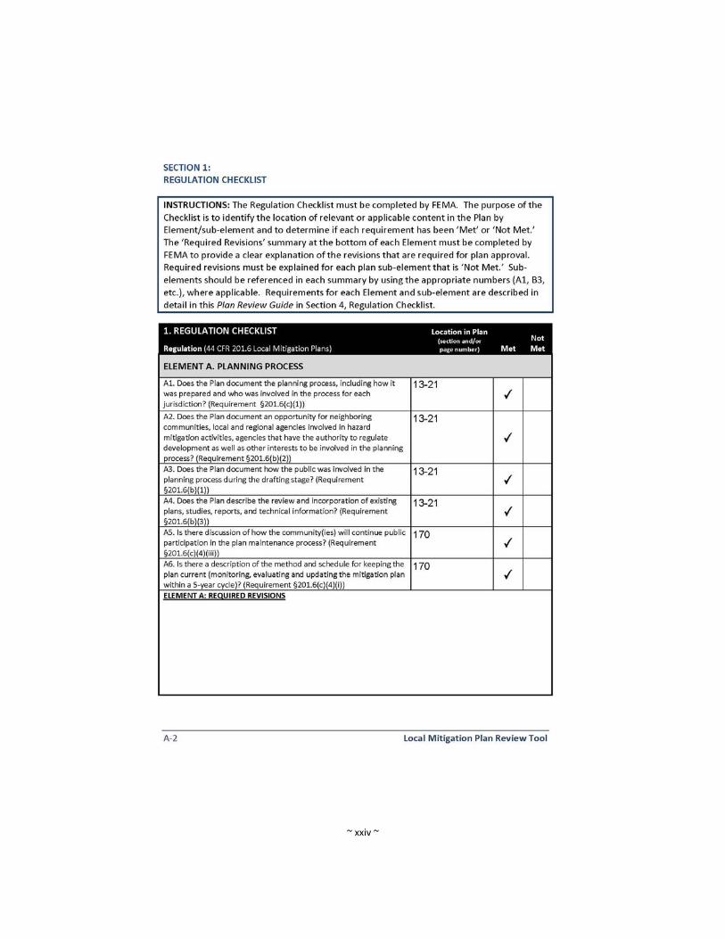
~ xxiv ~

~ xxv ~
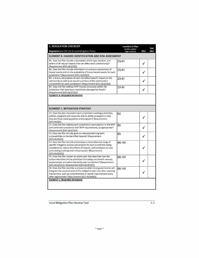
~ xxvi ~

~ xxvii ~
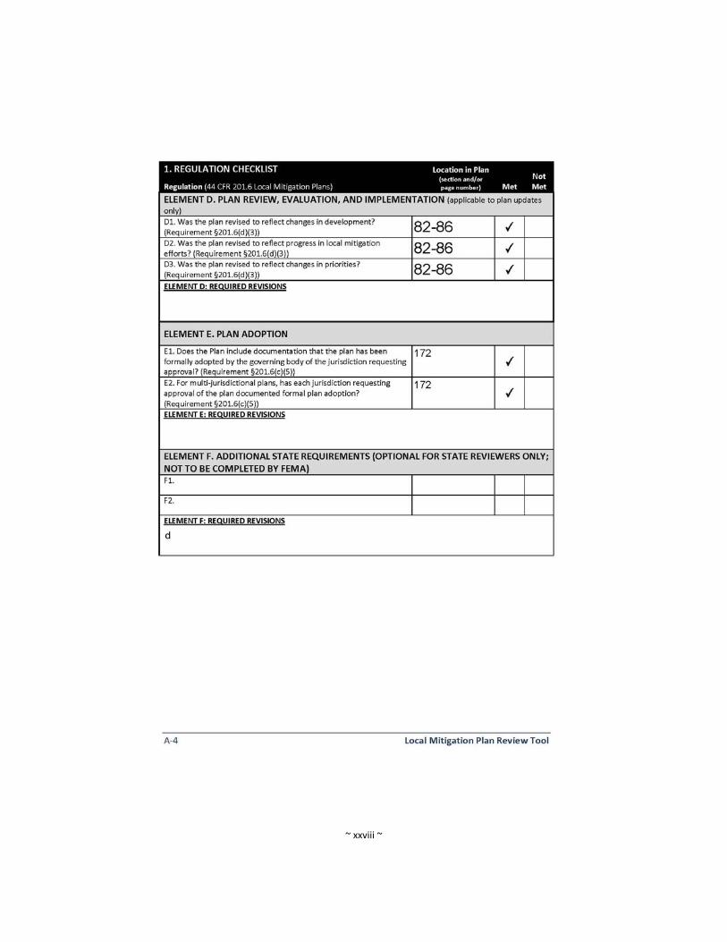
~ xxviii ~

~ xxix ~