Embed Size (px)
Citation preview

March 2017
National Weather Service
Pendleton, Oregon


Select March Averages and Departures

March 2017 Weather Pattern
The mean synoptic pattern for the month of March 2017 was characterized by an upper level low pressure system in the eastern Gulf of Alaska, which extended into western portions of Canada. A strong area of high pressure remained in place over the Aleutian Islands and far northeastern Russia. This would typically supply very cold air to our region...however this month the very cold air remain cut off just to the north of the Pacific Northwest. Instead our weather pattern was heavily influenced by a fast moving Pacific jet stream, which was directed into our area in between the aforementioned Gulf of Alaska low, and a broad upper level high over the Southwest US. This Pacific jet stream brought ample moisture to the Northwest, with systems moving through every couple of days. Precipitation totals were mainly above to well above average for the month. Some significant snow also fell in the higher mountains across the region. The low lands received little if any snow for the month. Overnight lows were elevated due to extensive cloud cover associated with the fast moving storms systems.
L H
H

March 2017 Detailed Upper Level Pattern Analysis
The first half of March featured an expansive upper level ridge over far western Alaska and northeast Asia. This directed some very cold air into east-central Alaska and western Canada under an upper level trough. The Pacific Northwest remained in a fast, maritime Pacific flow during this time.
For the last two weeks of the month, the offshore ridge broke down. This allowed more of southwesterly flow into the Pacific Northwest, as the wet pattern continued.

Top 7 Warmest Average March Monthly Min T
City Rank March 2017 Avg Min T
Current or Previous Warmest Mar Avg Min T
Monument #1 35.8 34.3 in 1986
Long Creek #1 32.1 31.1 in 1984
Hermiston #2 36.8 37.9 in 2003
Pasco #2 37.4 39.1 in 2003
Grizzly #2 30.1 30.2 in 2003
Yakima #3 34.9 36.9 in 1983
Kennewick #3 39.4 41.4 in 2003
Meacham #4 29.4 30.4 in 1968
Redmond #4 30.3 32.5 in 1983
The Dalles #6 39.1 41.8 in 1983

Top 7 Warmest Average March Monthly Min T (Cont’d)
City Rank March 2017 Avg Min T
Current or Previous Warmest Mar Avg Min T
Ellensburg #6 32.0 34.4 in 2015
La Grande #6 33.7 34.7 in 1978
Sisters #6 28.6 31.7 in 1983
Whitman Mission #6 36.3 38.3 in 2003
Walla Walla #7 40.8 41.9 in 2004
Bend #7 31.6 34.9 in 1934
Easton #7 29.5 33.7 in 2015
Milton Freewater #7(T) 40.8 43.7 in 2003

Top 10 Warmest Average March Monthly Temperature
City Rank March 2017 Avg T
Current or Previous Warmest Mar Avg T
Monument #4 46.2 48.2 in 1986
Long Creek #5 42.1 43.4 in 2015
Meacham #5 38.0 41.0 in 2015
Hermiston #7 46.8 49.7 in 2015
Pasco #8 46.9 50.8 in 2003
Redmond #8 42.9 45.6 in 1986
Easton #9 35.7 43.1 in 1934
Yakima #10 45.8 50.1 in 2015
Monthly and Daily Snow Records
City Daily Snowfall and Date
Previous Daily Snowfall Record
Cle Elum 5” on 3/8 3” on 3/08/1951
Snowden 7” on 3/7 N/A
Easton 10” on 3/8 7” on 3/08/2009
Meacham 6” on 3/7 4.7” on 3/07/1956
Emigrant Springs 7.8” on 3/5 N/A
** Easton, WA had it’s 7th snowiest March on record, with 26.0 inches of snow for the month. The Current record snowiest March is 46.5 inches which occurred in 2009**
Note, N/A at a station indicates too short of a period of record , or no data was available.

Daily Precipitation Records In March
City Daily Precip and Date
Previous Daily Precip Record
Dayton 0.64” on 3/9 0.56” on 3/9/1928
Meacham 1.38” on 3/29 1.04” on 3/29/2009
Pasco 0.45” on 3/24 0.20” on 3/24/2002
John Day 0.40” on 3/30 0.38” on 3/30/1974
Pendleton 0.53” on 3/24 0.27” on 3/24/2006
Long Creek 0.35” on 3/27 0.27” on 3/27/2014
Meacham 0.71” on 3/08 0.67” on 3/08/2006
Monument 0.50” on 3/07 0.45” on 3/07/1992
Satus Pass 0.57” on 3/04 0.38” on 3/04/2009

Top 7 March Monthly Precipitation Totals
City Rank Mar 2017 Precip
Current or Previous Mar Record Monthly Precip
Pendleton (City) #1 3.06 Inches 2.78 Inches in 1932
Hermiston #2 1.47 Inches 1.65 Inches in 2012
Pendleton Exp Sta #2 3.47 Inches 3.90 Inches in 1983
Walla Walla #3 3.74 Inches 4.33 Inches in 1983
Meacham #3 6.94 Inches 7.68 Inches in 2009
Richland #4 1.46 Inches 1.98 Inches in 1957
The Dalles #5 2.36 Inches 3.56 Inches in 1957
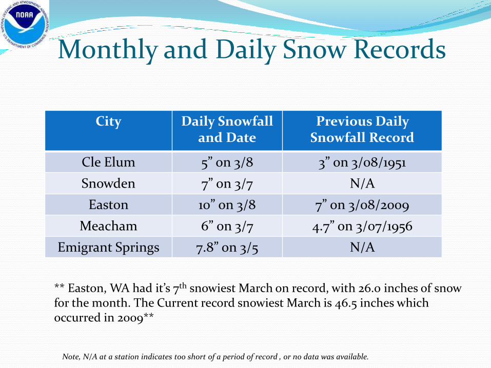
Top 7 March Monthly Precipitation Totals (Cont’d)
City Rank Mar 2017 Precip
Current or Previous Mar Record Monthly Precip
Kennewick #5 1.64 Inches 1.94 Inches in 1904
Pendleton (Arpt) #6 2.35 Inches 2.82 Inches in 1983
Whitman Mission #6 2.37 Inches 2.87 Inches in 1989
Ellensburg #7 1.27 Inches 2.42 Inches in 2011
Easton #7 7.88 Inches 10.90 Inches in 1932
Goldendale #7 3.12 Inches 4.14 Inches in 1957
La Grande #7 2.24 Inches 3.36 Inches in 1983
Satus Pass #7 3.35 Inches 6.94 Inches in 1983

March 4 – 9th Rain & Mtn Snow
Location Rainfall Peak Wind or Snow
Pendleton, OR 0.69” 38 MPH
Meacham, OR 2.41” 15.6 Inches
Redmond, OR 0.03” 37 MPH
Pasco, WA 0.31 36 MPH
Walla Walla, WA 1.06” 40 MPH
Yakima, WA 0.28” 34 MPH
Hermiston, OR 0.28 32 MPH
Ellensburg, WA 0.16” 33 MPH
Cle Elum, WA 1.16” 10.0 Inches
La Grande, OR 0.78” 1.0 Inches
Heppner, OR 0.45” Trace
Easton 2.08” 25.0 Inches
A large upper level low pressure system pushed onshore across the Pacific Northwest. This system brought periods of moderate to heavy precipitation to the area. Snow levels were very low, under 2500 feet at times. Heavy snow accumulated in the area mountains, such as at Easton and Meacham. Pendleton even recorded 0.3 inches of snow on the 4th and 5th of March.
Snow in Pendleton! March 5th 2017 0.3” fell

March 4 – 9th Snowfall Reports

March 11 – 15th Rain Event
A frontal system lifted through the area bringing periods of rain and warmer temperatures to the region. Heavy rainfall totals of 1 to 2 inches occurred along the East Slopes of the Washington Cascades and parts of the Blue Mountains. This rain and snow melt acted to further exacerbate flooding concerns across the region.
Location Precip
Trout Lake (WA) 2.11”
Snowden 1.01”
Easton 1.51”
Mt Adams RS 1.28”
Ellensburg 0.18”
Meacham 1.05”
Yakima 0.15
Hermiston 0.23”
Walla Walla 1.21”
Pendleton 0.37”
Pasco 0.45
Echo 0.21”
Heppner 0.34”

March 10 – 19th Flooding Summary Location Flooding Statistics and Remarks
Walla Walla River at Touchet
On 3/10 and again on 3/16 the river reached minor flood stage. The river crested at 14.2 feet, & minor flooding begins at 13.0 feet
Yakima County Several bouts of mainly minor flooding occurred along Wide Hollow, Cowiche, Cottonwood and Ahtanum Creeks. Lake Willow overflowed, flooding a neighborhood near Fruitvale on 3/16
West Ellensburg Mostly minor, nuisance flooding occurred along Mercer and Wilson creeks on 3/13. Some homes were threatened.
Grande Ronde River at Troy
The river periodically went above minor flood stage, reaching a crest near 11.3, from 3/15 through 3/18. Flood stage is 10.0 feet.
Klickitat River at Pitt
The river reached 9,1 feet on 3/16...flood stage is 9.0 feet.
Umatilla River From Gibbon to Pendleton
& Hermiston
Minor flooding occurred along the river from Gibbon to Pendleton, Reith, Echo, Stanfield and near Hermiston. The water flooded mainly fields and parks...and was close to a few structures in places. Moderate flood stage was not reached.
John Day River at Service Creek
The river reached 11.9 feet periodically on 3/16 and 3/17...flood stage is 11.5 feet.
Periods of rain and snowmelt sent a large volume of water down area rivers and streams. Most of the
flooding was minor. Some homes were affected, especially in Yakima County.

Flooding Around The Region
Field Flooding outside Echo, OR Field Flooding Echo, OR
Minor Park Flooding Yakima County. Image Credit Yakima OEM
Canyon Creek at Bankfull

March 21 – 27nd Rain Event Location Precip
Total Peak Wind
Pendleton 1.09” 33 MPH
Meacham 1.25” 23 MPH
Redmond 0.26 40 MPH
Pasco 0.60” 31 MPH
Walla Walla 0.70” 31 MPH
Yakima 0.47” 30 MPH
Hermiston 0.65” 35 MPH
Ellensburg 0.66” 33 MPH
Condon 0.73” N/A
Arlington 0.74” N/A
Whitman Mission
0.59” N/A
Pelton Dam 0.77” N/A
Seneca 0.45” N/A
A series of storm systems moved through the area during this time period. These systems brought periods of rain and some gusty winds to the region. Rainfall totals were mainly between about a quarter to three-quarters of an inch in the lower elevations, with 0ver 1 inch reported at the higher elevation sites. This additional rainfall allowed area streams and rivers to continue running high and fast through the end of the month.

Drought Ends in Pacific NW
The latest drought monitor shows improvement over much of the region. Drought conditions are no longer being reported in either Washington or Oregon at this time. Much of the western US has seen significant improvements since the beginning of the water year. Extreme or exceptional drought conditions no longer exists in the western US at this time.

April Drought Outlook
The monthly drought outlook for April from the CPC indicates drought development is not expected in the Northwest through the coming month. A deep mountain snow pack remains in many locations, and this should help to maintain the water supply.

ENSO Neutral Conditions Prevail
ENSO neutral conditions are present. Sea Surface Temperatures (SSTs) are near average across the central and east-central Pacific. SSTs are above average in the eastern Pacific. ENSO neutral conditions are favored through the spring months, with increasing chances for El Niño development into the fall.
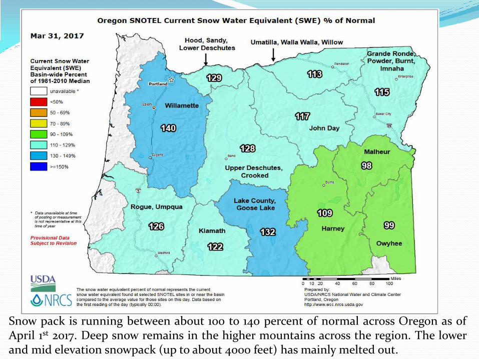
Snow pack is running between about 100 to 140 percent of normal across Oregon as of April 1st 2017. Deep snow remains in the higher mountains across the region. The lower and mid elevation snowpack (up to about 4000 feet) has mainly melted out.

The snow pack has increased in terms of averages through the month of March. Statewide snow pack is now running between about 100 to 140 percent of normal. Deep snow pack remains above about 3000 feet in most locations. Lower elevations have limited to no snow pack remaining.


April Temperature Outlook This graphic is issued by the Climate Prediction Center or CPC and is the Temperature Outlook for the month of April. The cool colors indicate a greater chance of below normal temperatures (none) and the warm colors represent a greater chance of above normal temperatures. The time period for the normals runs from 1981-2010. There are equal chances for above, below or near normal temperatures across the Pacific Northwest, northern Rockies, and the north-central Plains in April. The Southwest and entire eastern portion of the US have higher probabilities for above average temperatures through the month of April.

April Precipitation Outlook This graphic is CPC's Precipitation
Outlook for the month of April.
The green colors represent a
greater chance of above normal
precipitation, and the brown
colors represent a greater chance
of below normal precipitation.
Over western Washington and
Oregon there are higher chances
for above average precipitation
through April. Across eastern
Washington and Oregon there are
equal chances for above, below or
near normal precipitation
amounts through the month.
Other areas that favor above
average precipitation in April
include: the northern Plains, and
along the Central Gulf Coast and
lower Mississippi Valley region.