Embed Size (px)
Citation preview

MAPS OF UTAH

POLITICAL MAPSshow borders and boundaries assigned by humans.
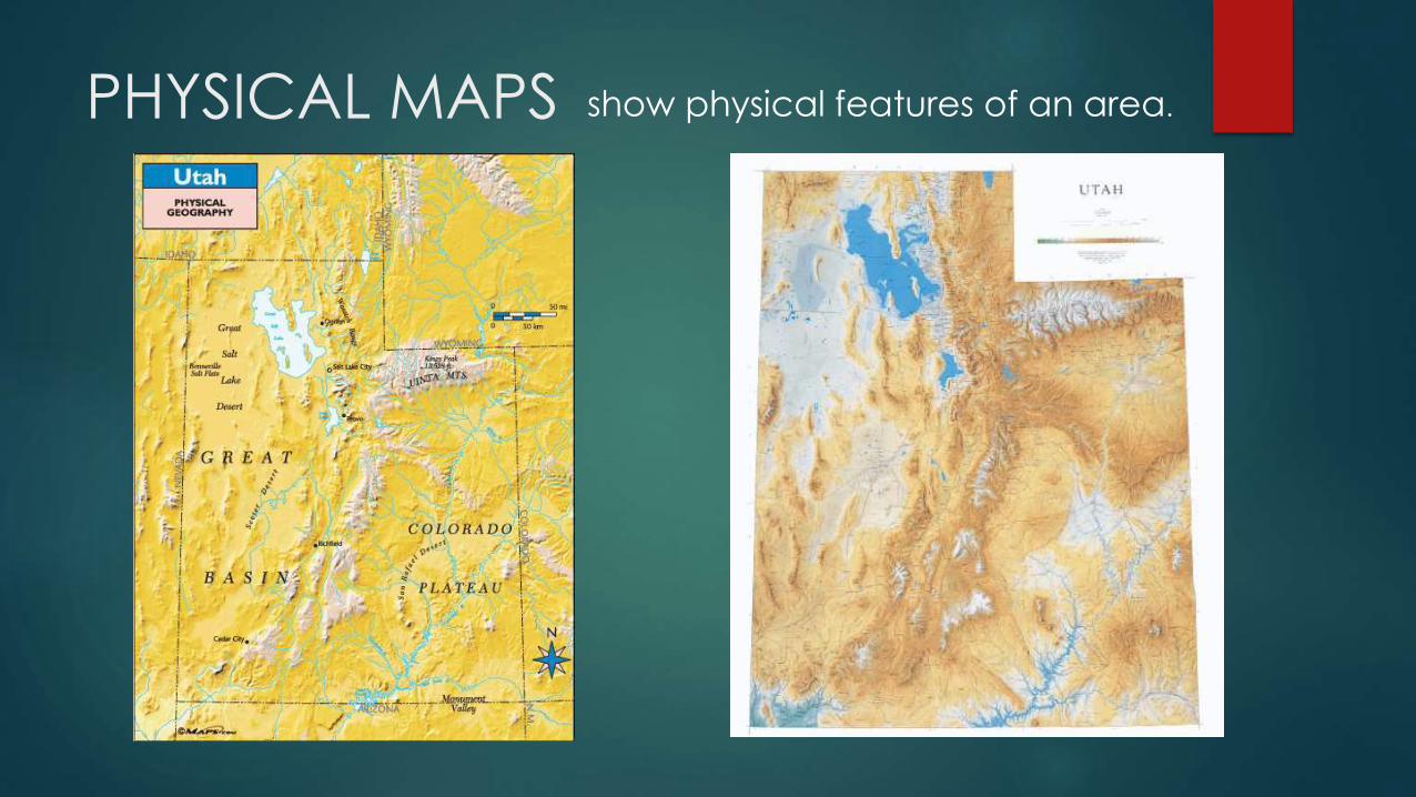
PHYSICAL MAPS show physical features of an area.

PRECIPITATION MAPS
Shows rainfall averages

POPULATION MAPS
Shows population distribution

CLIMATE MAPS
Shows the climate of the area

ELEVATION MAPSShows elevation changes

TOPOGRAPHIC OR CONTOUR
MAPS
Topographic or contour
maps show elevation
changes in more detail.

LEGEND/KEY a tool that identifies the symbols on a
map and what they represent.

SCALE helps determine real distances between points
on a map.

COMPASS ROSE shows you what the directions on a map are.

EQUATORan imaginary line that circles the globe halfway
between the North and South poles.

LATITUDE Lines of latitude are drawn in an east-west direction.
Measure north to south.

PRIME MERIDIANAn imaginary line drawn from the North Pole through Greenwich England to the South pole.

LONGITUDELines of longitude are drawn in a north-south
direction.
Measure east to west.

MAP REVIEW
What is the purpose of a political map?
To show borders of countries, states, and cities

MAP REVIEW
What I the purpose of a Physical map?
Physical maps show what the surface of the world
looks like
MAP REVIEW
Think about a hiker. What kind of map would they need?
A physical map.
Why?
They would need to know things like where mountains, forest,
and rivers are.

MAP REVIEW
I am planning a trip to New York. What kind of map
would I most likely need?
A political map
Why?
A political map would show me states and cities. This is information that
I would likely need to know if going to New York.

Utah’s Land Regions
A landform is a
feature of the
earth’s surface.
Three main kinds of
landforms are found
in Utah – Mountains,
Plateaus, and
basins.
Lakes are also
landforms.
• BASINS: Wide bowl-
shaped areas
• PLATEAUS: high, wide,
flat areas
• MOUNTAINS

The Great Basin Region
• No outlet to the Ocean
• In Utah, streams and rivers run
to the valley floor forming
Utah Lake & the Great Salt
Lake.
• Utah’s most populated areas
are found on the flat fertile
land on the edge of this
desert region.
• The Great Basin (and the rest
of our state) is DRY!

Rocky Mountain Region
• Uinta and Wasatch Mountain
Ranges.
• Rivers, streams, lakes & reservoirs
• Forests
• Home to animals, plants.
• Provide camping, hiking, skiing,
etc…
• People come from all over the
world to enjoy Mountain areas.
MOST IMPORTANT SOURCE
OF WATER FOR UTAH

The Colorado Plateau Region
• Doesn’t get much rain; very dry.
• Streams and rivers from higher
plateaus all flow to Colorado
River..
All 5 of Utah’s National Parks are in the Colorado Plateau Region.