Embed Size (px)
Citation preview
i
The Occasional Papers
Maps of The First World War: An Illustrated Essay and List of Select Maps in
The Library of Congress
Series No. 7 A Philip Lee Phillips Map Society Publication
Ryan J. Moore

The Occasional Papers
A Philip Lee Phillips Map Society Publication
Editorial Staff:
Ralph E. Ehrenberg
Managing Editor
Ryan Moore
Chief Editor, Design and Layout
Michael Klein
Editor
Anthony Mullan
Editor
Geography and Map Division
Library of Congress
Washington, D.C.
Summer 2014
Maps of The First World War: An Illustrated Essay and List of Select Maps in
The Library of Congress
Ryan J. Moore


iii
Foreword
The Philip Lee Phillips Map Society of the Library of Congress is a national support
group that has been established to stimulate interest in the Geography and Map Division’s car-
tographic and geographic holdings and to further develop its collections through financial dona-
tions, gifts, and bequests. The Phillips Map Society publishes a journal dedicated to the study
of maps and collections held in the Division known as The Occasional Papers. This install-
ment focuses on World War I maps and is issued on the war’s centenary with the hope that it
will stimulate interest and research on the cartography of the “war to end all wars.”
World War I was the first major world event to have an impact on the Geography and
Map Division, after its establishment in 1897. With the advent of the war, military and com-
mercial map publishers greatly expanded production of topographic, battle, and geographic
maps for combatants and the general public. Philip Lee Phillips, the first and longest tenured
chief of the Geography and Map Division (1897-1924), made a special effort to collect these
works. They were described under his direction in A List of Atlases and Maps Applicable to the
World War, published by the Government Printing Office in 1918.
Phillips’ successor, Lawrence Martin (1924-1946), continued this effort. Colonel Mar-
tin, as he preferred to be called, taught the fundamentals of cartography and map interpretation
as an army officer during World War I and then served as Chief of the Army’s Geographical
Section of the General Staff’s Military Intelligence Division, a position that involved collecting,
evaluating, and disseminating geographic and cartographic information. Following the Armi-
stice, he conducted fieldwork and map studies in Central Europe with the American Commis-
sion to Negotiate Peace. Martin retired from active military duty in 1920 but remained in the
Officers Reserve Corps with the rank of Lieutenant Colonel.

iv
With a strong interest in military history, Geography and Map Division Specialist Ryan
Moore continues in this tradition. Mr. Moore has graduate degrees in history and library sci-
ence. During the past four years, he has processed three World War I special collections and
has reviewed nearly all of the Division’s related holdings. His introductory essay places these
maps within the context of the war.
Ralph E. Ehrenberg
Chief, Geography and Map Division

v
Preface
I began this project in 2010 with a goal of surveying the World War I trench maps in
the Geography and Map Division. Once engrossed in the collection, however, my research
soon extended to a review of naval warfare, military intelligence, and aerial reconnaissance
maps. Pandora’s box was opened. I discovered that while there is not only a wealth of primary
sources—maps printed during the war and reprints of maps used during the war—a large col-
lection of historical studies is part of the collection, as well. After reviewing so many amazing
maps, I was unsure of how to account satisfactorily for all of them. Therefore, when planning
for this publication, I decided to limit my review to primarily military maps that were printed
during the World War I era. I urge anyone who is interested in this fascinating historical period
to use this publication as a starting point to discover the Library’s amazing primary resources. I
am confident that the examples offered will support a variety of research topics and will en-
hance the teaching of the subject.
This project would not have been possible without the assistance of Ralph Ehrenberg,
Dr. John Hébert, Mike Buscher, Anthony Mullan, and Michael Klein. Each of them provided
encouragement, useful suggestions, and excellent insights. Mr. Klein served as the first reader
of my earliest draft, and Margaret Wagner of the Library’s Publishing Office helped greatly in
the editing process. Their suggestions greatly improved my manuscript.
Ryan Moore
Geography and Map Division

Figure 1

Contents
Foreword by Ralph E. Ehrenberg iii
Preface v
Essay
Introduction 1
Trenches and Mass Bombardment 5
Blockade, Submarines, and Battleships 13
America Enters the War 19
Maps of Battle Lines 23
Conclusion 29
Information about Map Figures and Illustrations 31
Endnotes 35
Cartobibliography 37
Cartobibliography Entry
Special Collections 1
Atlases 4
Maps by Call Number
United States 14
Mexico 15
Europe 16
France 24
Belgium 58
Germany 59
Romania 64
Balkans 65
Eastern Europe 68
Russia 69
Middle East 73
Asia 77
Africa 80
Fig
ure
2
Th
e C
entr
al
Po
wer
s—G
erm
an
y, A
ust
ria-H
un
ga
ry, th
e O
ttom
an
Em
pir
e, a
nd
Bu
lgari
a

Maps of The First World War
Figure 3

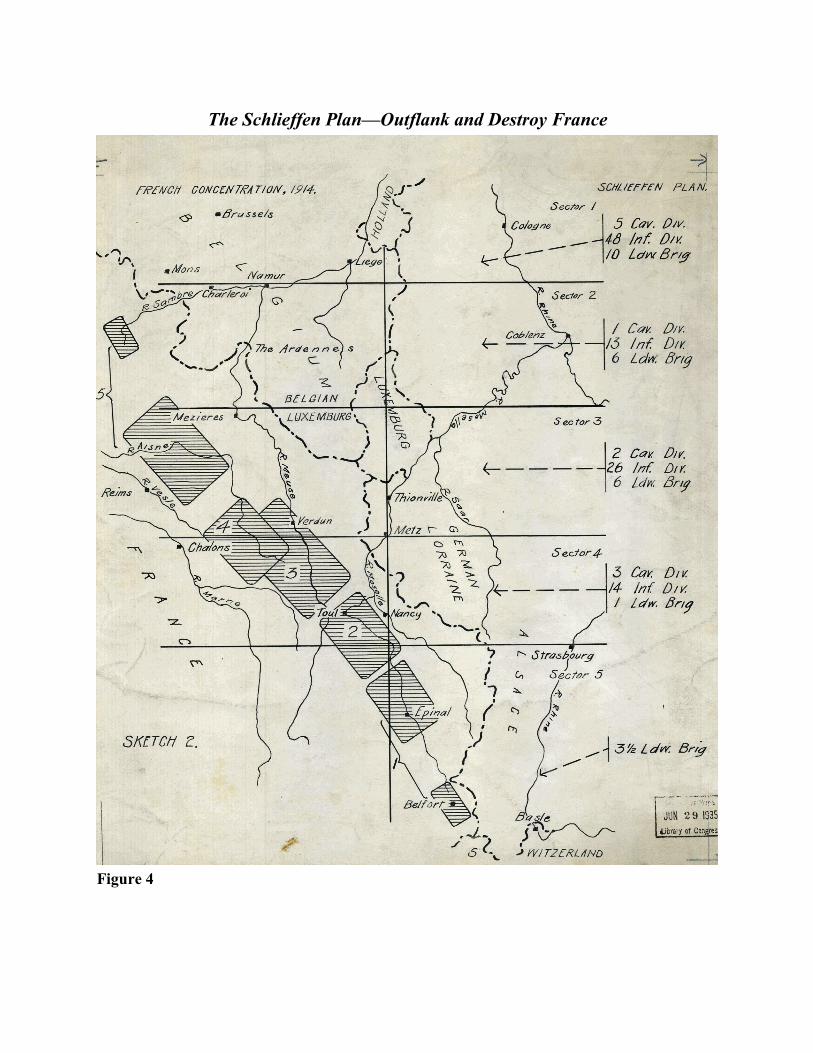
Figure 4
The Schlieffen Plan—Outflank and Destroy France

1
Introduction
The German military strategist Count Alfred von Schlieffen stressed that a command-
er without highly detailed maps that modeled the zones of fighting would be highly ineffective
in modern warfare.1 In his role as Chief of the German Imperial General Staff, Schlieffen
(1833-1913) was principally concerned with Germany’s vulnerable geographic position. Situat-
ed between the allied European powers of France and Russia, Germany was certain to face a
war on two fronts should trouble arise with either. Turning to ancient Roman history for inspi-
ration, the German strategist studied Hannibal's victory at the 216 B.C. Battle of Cannae, in
which a numerically smaller Carthaginian army quickly surrounded and slaughtered the Ro-
mans.
The idea of achieving a similar speedy outflanking maneuver captured Schlieffen’s im-
agination. He concluded that Germany should first fight France, the more militarily capable of
its foes, by sending troops through neutral Belgium to circumvent a large portion of France’s
defenses, while Russia, which would take weeks to mobilize, was to be held at bay with mini-
mal forces in the east. The so-called Schlieffen plan won the confidence of the German high
command. The plan was reworked and crafted until the Germans were certain that victory over
France would be achieved in six weeks, and troops then would be transferred by rail to defeat
Russia. Undoubtedly, the plan appeared to be bulletproof when viewed on a map; however, the
German leadership disregarded the wisdom of the revered military strategist Helmuth von Molt-
ke the Elder (1800-1891), who once warned that no plan survives contact with the enemy.
Nonetheless convinced of victory, they also shrugged off Britain’s treaty to protect Belgian
neutrality. It was the beginning of many underestimations that would haunt Germany during
the war. Figure 4

2
In 1918, Philip Lee Phillips, then Chief of the Library of Congress Hall of Maps and
Charts (now the Geography and Map Division), recognized the role of maps in relation to the
war and continued to collect and compile materials created by the United States and foreign
governments. As a result of his efforts, The Library of Congress published his cartobibliog-
raphy on the World War I titled: A list of atlases and maps applicable to the world war. All of
the maps cited were of a non-classified nature, and bibliographic information about the maps
was omitted. On this hundredth anniversary of the war’s start, a fresh look at the Library of
Congress collections of World War I-era maps is in order, since many documents have been de-
classified over the years, and the Library has acquired significant numbers of maps from the
combatants.
This essay and cartobibliography highlights the Library’s most significant special col-
lections, atlases, and maps pertaining to the Great War, as World War I was known in its day.
The largest number of maps come from American sources or foreign-made maps used by the
American military or diplomatic corps. The most informative military maps can be found in the
collection of Major-General Charles P. Summerall, who was the commander of the American
Fifth Corps. Particularly interesting are the assorted tactical maps for artillery fire. Summerall
was infamous for ordering an attack on German positions hours before the Armistice with Ger-
many was to take effect. Some 365 Americans were killed in the action, which became the sub-
ject of a congressional investigation. The collection of Willard B. Prince complements the
Summerall collection. Prince was a regimental sergeant assigned to the Fifth Division’s Topo-
graphical Unit. In addition to maps, his collection contains diaries, photos, and other docu-
ments that shed light on the war and on cartographic processes employed by the American Ex-
3
peditionary Forces (AEF). The collection is an excellent example of history from the “bottom
up.” Prince was an outstanding mapmaker and draftsman who is best remembered today for
designing the Heisman Trophy for the New York Downtown Athletic Club. Equally intriguing
is the collection of maps compiled by General Tasker H. Bliss. Both a wartime commander and
an advisor to President Woodrow Wilson during the postwar peace negotiations, Bliss acquired
maps that offer insight into postwar issues related to the need of redrawing borders, settling eth-
nic conflicts, and confronting the threat posed by the rise of Bolshevism in Russia.
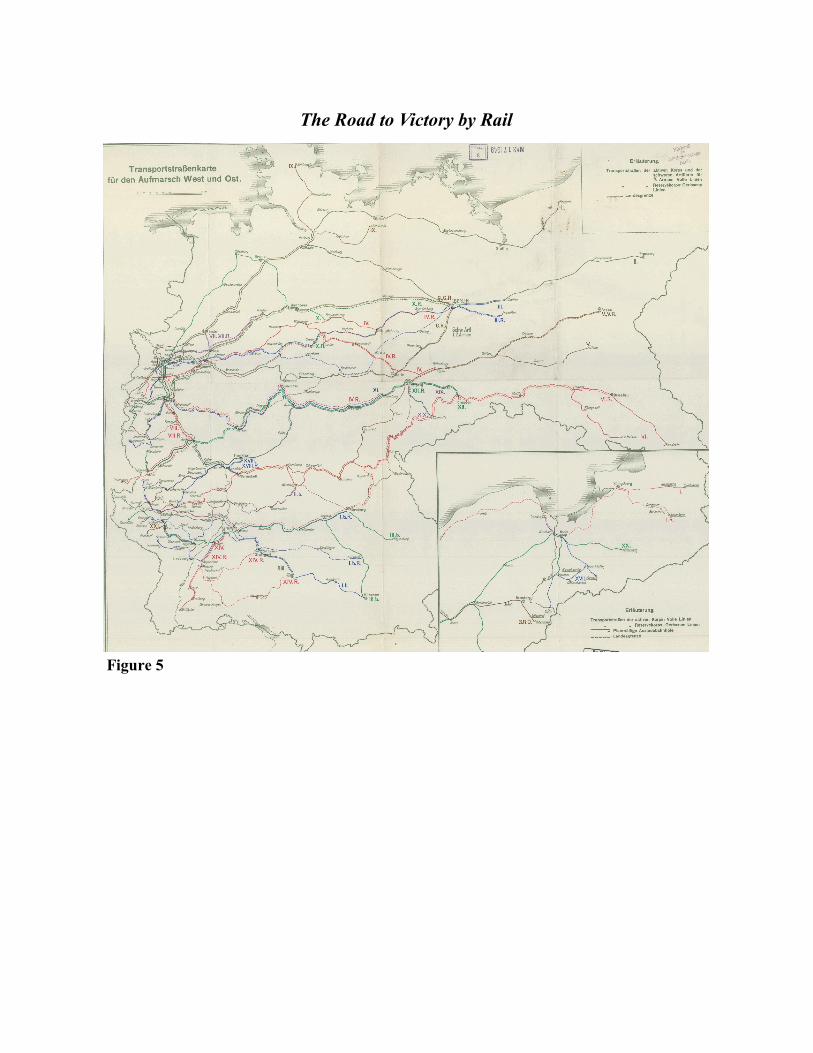
Figure 5
The Road to Victory by Rail

5
Trenches and Mass Bombardment
By the 1900s, advances in science and engineering led to the production of devastating
weapons such as giant howitzers, battleships, machine guns, tanks, bombers, and poison gas.
The deadly power of these modern arms was unleashed following the assassination on June 28,
1914 of Archduke Franz Ferdinand of Austria and his wife during a state visit to Bosnia-
Herzegovina. A Bosnian Serb, who resented Austro-Hungarian rule, carried out the killing with
the assistance of a secret Serbian military society known as the Black Hand. After a month of
ensuing political maneuvering, Austria-Hungary declared war on Serbia. Within a week, Rus-
sia, France, Great Britain, and Serbia had lined up against Austria-Hungary and Germany, and
World War I had begun. During the first weeks of the war, German troops were brought to the
western and eastern fronts by a well-developed railroad network that had been built in the previ-
ous decade for just such a purpose. Figure 5
Maps were a critical element of the war, as attested by the millions that were produced
for the world’s militaries; however, maps for tactical planning were not ready at the outbreak of
hostilities. Commanders on the Western Front, for example, had to rely on small scale maps
such as the French Carte de l’Etat Major, originally published at a 1:80,000 scale from surveys
conducted in the early to mid-1800s. Other available materials were cadastral surveys dating
from the Napoleonic era, which emerged as important sources of information for mapping areas
in northern France, including places under German control.2
When British forces departed for France in August, mapping was not an immediate pri-
ority; they had allocated only a single officer and clerk to the effort. By the end of the war,
however, the survey organization of the British Expeditionary Force (BEF) had expanded to

6
nearly 5,000 officers and enlisted men. Throughout the war, these British military cartogra-
phers created more than 35 million map sheets in the field using mobile printing presses.3
Ready or not with the proper maps, the BEF’s first priority was to assist their French ally to
stem Germany's rapid advance towards Paris. At the first Battle of the Marne (September 6-12,
1914), the Allies rallied, counterattacked, and stopped the Germans. Under these pressing con-
ditions, situation maps were at times created by hand. Figure 6
With neither side able to take the initiative, complex trench networks emerged on the
Western Front. Main trench lines often ran parallel, or nearly so, with those of the enemy. Sec-
ond and third tier trenches, situated behind the main line, were built to support the front and
served as a place of retreat. Intersecting these combat positions was a network of
Figure 6
Saving Paris from the Kaiser’s Onslaught

7
“communications trenches” by which troops and supplies could ingress and egress in relative
safety. Small scale maps proved ineffective in the densely tangled trenches.
Not until 1916, however, did a complete system of larger scale maps for the entire West-
ern Front become available for the Allies; the Central Powers were feverishly mapping, as well.
Allied tactical maps were general printed at three scales: infantry maps at 1:10,000; artillery
maps at 1:20,000; and planning maps at 1:40,000. Intelligence needed to create these maps was
gathered from observations in the field and from the air, as well as from statements given by
prisoners. New data was overlaid on prefabricated topographic sheets and updated daily. Con-
cerns arose about the impact of weather and soil on maps that were being used in the field;
however, even greater worries developed over losing a map showing one’s own positions. Cau-
tion dictated, therefore, that troops on the front only be issued with maps depicting enemy
Know Thy Enemy — A Prototypical Tactical Map
Figure 7

8
trenches.4 Figure 7
Unseating an enemy
from fortified positions re-
quired the use of artillery
and accurate maps. Targets
had to be identified and fire
plans developed. Typically,
shelling preceded an infan-
try assault. The goal was
not only to destroy barbed-
wire and other formidable
defenses but also to break
an enemy’s will to fight.
Once orders were issued, gunners and spotters referred to large-scale maps, which had
subdivided grid lines that allowed for the correction of fire to within a few yards of the target.
This was an important development in warfare, known first as “map shooting” and later as
“predicted fire,” because gunners could hit targets without first having to take ranging shots,
thereby preserving the element of surprise. The British general George McKenzie Franks of the
Royal Artillery characterized this development as “one of the wonders of the war,” though won-
drous in the darkest of ways, as artillery fire was responsible for some 60 percent of all casual-
ties.5 Despite well-planned bombardments, entrenched defenders seemed to defy logic and re-
grouped quickly to pour intense machine gun and rifle fire on attacking troops exposed in no
man’s land. Attackers were cut down in droves, yet these tactics prevailed for nearly two years.
A Matrix of Devastation—The Gunner’s Grid
Figure 8

9
Figure 8
Seeking to break the stalemate on the West-
ern Front, in 1916, British tacticians began revisit-
ing an artillery bombardment method known as a
“creeping barrage" to assist attacking troops. Used
previously in the South African Boer Wars, the
practice was complicated, required timing, and
could not be executed without reliable maps. The
line of advance was plotted on a map, and artillery
shelled designated points that were typically 100
yards ahead of the infantry's position. Following a
fixed timetable, the bombardment rolled forward to
destroy obstacles, as the infantry advanced behind it
in relative safety. The process continued until the
troops reached the final stage of the assault. The
verdict was typically decided by opponents who
fired shots at close range and engaged in hand-to-
hand fighting with bayonets, trench shovels, or oth-
er improvised weapons.6 Figure 9
The destructive power of heavy guns de-
manded that they be neutralized quickly. Combat-
ants refined techniques such as flash spotting and sound ranging to find enemy gun emplace-
ments. The former required frontline observers to note the bearing (direction) of the enemy
Figure 9
The Bombardment Clears the Way

10
gun’s muzzle flash. Intersecting the location of the observer and his reported direction of the
gun’s flash with that of other observers spotting the same gun, it was possible to determine the
approximate position of the opponent’s artillery piece. Whereas, the latter involved strategical-
ly placed microphones connected to a graphing device that measured the differences detected in
the gun’s report. By 1916, British sound ranging methods were accurate from 25 to 50 meters
under normal weather conditions; in fact, all combatants had some method of locating opposing
artillery. These counter-battery measures forced artillery commanders to relocate their guns
frequently or run the risk of having them destroyed.
The deadly game of hide and seek was complicated by the development of aerial recon-
naissance. A British officer reflected after the war: “It was impossible to have guns deployed at
the same point and in action for weeks or months without the position being given away in the
air photograph by tracks and gun pits, no matter how one tried to camouflage it.”7 So accurate
was aerial photography that it accounted for more than 30 percent of all information collected.
By 1917, British aerial reconnaissance reduced the error factor in mapping German targets to
less than 20 yards.8 Without a doubt, the combination of heavy guns, aerial photography and
mapping was devastating.
11
Figure 10

Figure 11

13
Blockade, Submarines, and Battleships
The public hungered for information about the war, and the conflict at sea was a prime
example of how maps illustrated the growing danger to civilians and combatants alike. Prob-
lems escalated when Britain and France planned to strangle Germany and its allies by means of
naval blockades. Germany retaliated using its submarine fleet, known as U-boats, to strike at
Allied commerce and also neutral ships bound for Allied ports. Maps of areas in which U-boats
were known to be operating quickly made their way into newspapers. It sparked a fiery public
debate about the meaning of “freedom of the seas” in an era of when Germany wished to disre-
gard treaties that required warships, including submarines, to warn non-combatant vessels be-
fore firing on them and to rescue survivors. The ensuing political outrage caused Germany to
vacillate between abiding by conventions and maximizing the submarine’s surprise attack po-
tential. Maps were showing their worth as a means of both propaganda and planning.
Figure 11
On the shipping lanes of the Pacific and Indian oceans, Germany attacked Allied com-
merce with both surface military vessels and commercial ships fitted with weapons, which were
known as commerce raiders. The loss of commercial ships caused insurance rates to rise dra-
matically and resulted in a temporary stoppage in some areas until the raiders were neutralized.
The Allies worked feverishly to chart the likely whereabouts of the elusive German raiders,
which benefited from the fact that most commercial ships lacked radios and therefore could not
warn others of the threat. Intelligence officers culminated information from direct sightings, the
last known location of ships believed to have been attacked, and occasionally, the lucky inter-
cept of a German radio transmission, which revealed either the raider’s location or destination.
The most famous German raider was the warship SMS Emden whose crew often dis-

Figure 12
On the Trail of Germany’s Elusive Raider S.M.S. Emden
Figure 13
Crossing the German “T” — Textbook Maneuver at Jutland

15
guised their vessel by adding a false fourth funnel to alter the ship’s configuration. The clever
use of camouflage enabled the raider to sink or capture some thirty merchant vessels and war-
ships in the opening months of the war. On November 9, 1914, its cruise of the Indian and Pa-
cific oceans ended after the ship was run aground intentionally to avoid capture by a more pow-
erful Australian warship near the Cocos Islands.9 Figure 12
While this guerilla war at sea was being waged, the mighty surface fleets of Britain and
Germany played a tense waiting game. After two years and a pair of skirmishes, they finally
clashed in the largest naval engagement of the war, the Battle of Jutland, during the summer of
1916. The German navy sortied into the North Sea to lure the British into a decisive battle.
During the early stages of the fight, Britain’s fast but lightly armored battle cruisers met the
Germans with disastrous results. The lauded battle cruiser HMS Indefatigable went to the bot-
tom in seconds after a German shell ripped through its light armor and exploded the magazine.
Only two of the crew of 1,019 survived. However, the tables turned when British battleships
arrived on the scene. The British had anticipated the German fleet’s position and performed a
textbook maneuver called “crossing the enemy’s T.” This meant the British could fire a full
broadside as the Germans approached them from an intersecting path. The fighting was fero-
cious. In total, three of England’s vaunted battle cruisers were sunk, along with eleven other
ships. Germany lost six ships and four small torpedo boats. With loses mounting, the Kaiser’s
fleet raced home, and the battered Royal Navy failed to pursue effectively; afterwards, both
sides claimed victory. Despite the stinging loss of capital British ships, the strategic balance of
heavy ships remained with England. The German Kriegsmarine was consigned to port for the
remainder of the war.10 As all this unfolded on the world’s vital sea lanes, the public sought to
understand the battle, and other engagements, through map recreations. Figure 13

Figure 14


Aer
ial
Ph
oto
gra
ph
ic A
naly
sis
by
Dou
gh
bo
y C
art
ogra
ph
er W
illa
rd B
. P
rin
ce
Fig
ure
15

19
America Enters the War
The United States entered the war in 1917 after Germany resumed U-boat surprise at-
tacks—placing American ships, cargoes, and people in increased danger—and then added insult
to injury with an unsuccessful bid to lure Mexico into an alliance.11 The first American troops
arrived in France in June 1917; AEF troops deployed on the Western Front would eventually
number some two million men.12 Unlike American combat troops who initially failed to heed
cautionary suggestions from their allies and made some reckless attacks, AEF mapmakers were
more than willing to benefit from experience. Eighty-three officers and 1,068 enlisted men
were responsible for creating and updating maps for the “doughboys.”13 The skill level of AEF
mapmakers and draftsmen varied greatly. While many of the officers had honed their craft with
the U.S. Geological Survey, others, in particular enlisted men, had received minimal training
and were expected to learn on the job.
Among the mapmakers assigned to the U.S. Army Fifth Division’s Topographical Unit
was Regimental Sergeant Willard B. Prince. The sergeant was one of the first Americans
trained in aerial mapping by the French. Prince explained that the goal was to document the
enemy’s position and to translate the data to maps; the process, however, was both dangerous
and tedious. The best photographs were shot at an altitude of 1,500 meters, which was well
within in the range of anti-aircraft guns. Despite this threat, it was necessary to take photo-
graphs over enemy airspace on a daily basis and to compare the results with previous shoots. A
given photograph was cleaned (“restitution), analyzed (“interpretation”), and the data was trans-
ferred from the photograph to a map by tracing, ensuring that it matched the correct coordinates
(“rectification”).

Figure 16
The Meuse-Argonne—America’s Largest Offensive of the War
21
Working in less than ideal field conditions, often in poor lighting and relying on
handheld magnifying glasses, analysts looked for changes in the landscape, such as the appear-
ance of new trenches and foot or tire prints that would indicate the presence of enemy forces,
since rarely were they photographed in the open. In fact, nearly every clue about enemy posi-
tions and movements was indicated on Allied maps such as damaged or destroyed bridges, the
presence of Red Cross hospitals, and even church towers that the enemy might use for observa-
tion.14 Figure 15
By 1918, a series of successful Allied offenses, such as the Meuse-Argonne, steadily
forced back the German lines, during which the fighting was often tenacious. The rapidly
changing conditions on the ground made information from enemy sources critical in order to
have a reliable picture of the situation. Intelligence gathered from German prisoners, captured
documents, and the “spy system” was so accurate that American forces had “in black and
white,” the location, name and in many cases the strength of the opposing German divisions,
according to Prince. As the AEF advanced to exploit this information, headquarters lost track
of their troops on occasion; however, this problem often was resolved by the use of aerial pho-
tography. Prince recalled the method employed was as follows: Troops positioned at regular
intervals displayed white canvasses skyward; a reconnaissance plane passed over the positions,
photographing them; mapmakers received photographs that showed a series of white squares
that illustrated the length of the American lines; and this information was transposed to situa-
tion maps. 15 These mapping practices helped to make the Meuse-Argonne offensive the AEF’s
largest and most successful campaign of the war. Figure 16
The Germans were suffering under the weight of the Allied attacks and attempted to
consolidate their positions by withdrawing to the east. Prince recalled during the American-led

22
St. Mihiel offensive: “Some roads appeared actually choked with motor trucks, ambulances,
big guns and troops all making a hasty retreat. Message after message was dropt to us from
planes telling of the enemy rout. We located these points and picked important crossroads as
good marks. These were given to the artillery who opened up with destructive, intermittent,
harassing, and every variety of artillery fire on the great bewildered retreating mass of Huns. It
resulted in complete demoralization and terrific losses.”16 Indeed, the loss of experienced men
and increasingly irreplaceable equipment proved unsustainable, and Germany—suffering from
the Allied blockade, facing the invasion of its homeland, and its allies crumbling—sued for
peace. The war concluded with the signing of the Armistice on November 11, 1918. Although
some German military leaders scoffed at their government’s capitulation and wished to fight
on, the odds were clearly stacked against them. The Allies held a numerical advantage in divi-
sions, 213 to the 183 German formations; additionally, Allied forces were qualitatively superi-
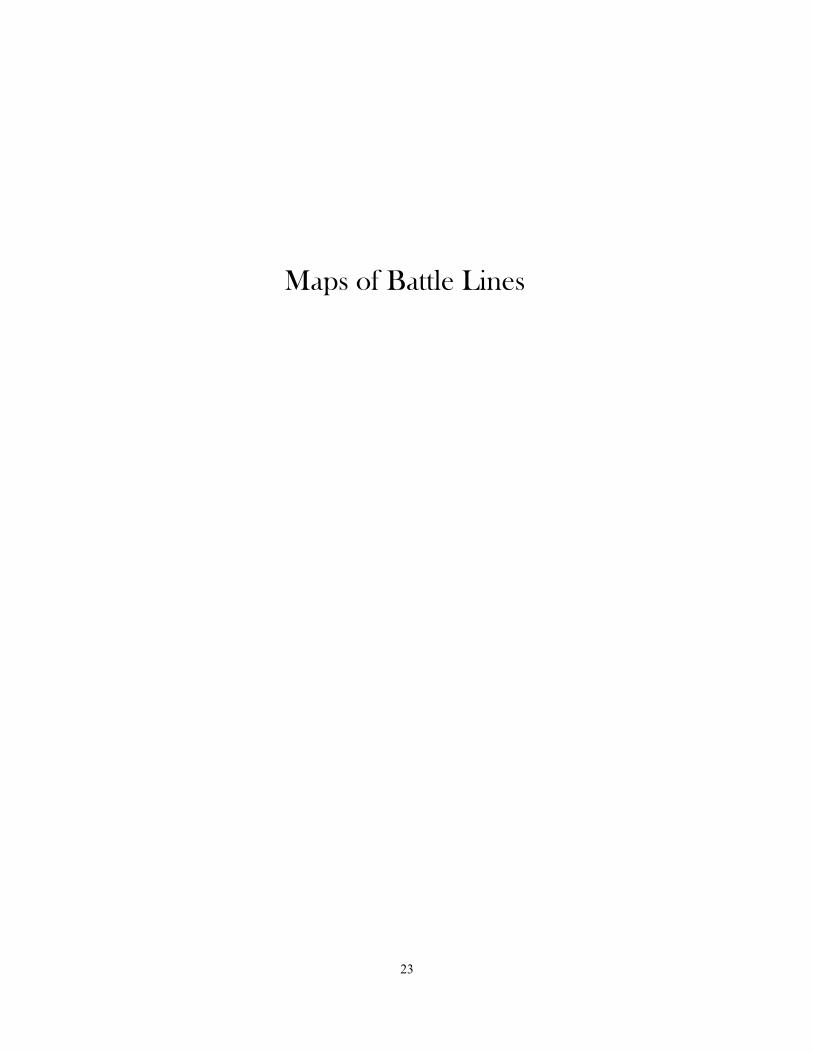
or, as they were better equipped, fed, and had higher morale. Figure 17
23
Maps of Battle Lines

All
Qu
iet
on
th
e W
este
rn F
ron
t—A
rmis
tice
Day
Nove
mber
11, 1918
Fig
ure
17

Figure 18. Information from captured German maps, prisoner's statements, and recent aero-
plane photographs : [Sommerance region].
Infantry commanders received copies of this map that identified German positions. A
notice on the map reads: “Information from captured German maps, prisoner’s statements and
recent aeroplane photographs.” The map notes artillery and machine gun emplacements. Be-
hind the German trench line sits the Kriemhilde Stellung. It was a portion of the larger Hinden-
burg Line that was a vast system of defenses in northeastern France. The Germans used Rus-
sian prisoners to construct the line during the winter of 1916–17. From map: “For the last two
months men have been working on these trenches; deepening them and building deep dugouts
capable of housing fifty to one hundred men each.”

Figure 19. “Planmaterial der 3. Armee…” From [Maps showing World War I campaigns in
northern France around Verdun at various dates].
An example of a German-produced map of the complex trench networks situated at
Verdun, France. Following its defeat in the campaign by French forces in 1916, German forces
adopted a defensive posture. They are depicted in blue; the Allied troops are in red. The sheet
is part of a set that frequently was updated to show the changing trench lines.

Figure 20. [Map showing trenches and observation posts in eastern region of Sommerance].
This Map bears the title Kriemhilde Stellung, which was the German defensive line that
stretched from Reims to near Verdun. From map: “Trenches shown in heavy lines have been
deepened or worked on recently.” The newly constructed defenses reflected the German High
Command’s strategy to contain the presence of American troops whose presence gave numeri-
cal superiority to the Allies.

Figure 21. Presumed enemy order of battle, October 7, 1918 : [Sommerance region].
American intelligence depicted the German positions in Sommerance, France as of Oc-
tober 7, 1918. German forces are classified by their quality of fighting skill; the best are ranked
as first class and poorest groups as fourth class. Units are broken down into division and then
regiment. The duration of time a unit has spent on the front line is stated, as it could supply
planners with information about its combat effectiveness or war weariness. Territory seized as
a result of an American minor attack on October 6 is shown.

Fig
ure
22
Ger
man
y S
ever
ed, D
isa
rmed
, a
nd
Occ
upie
d
29
Conclusion
During World War I, military mapping had grown by leaps and bounds. Full-scale op-
erations, involving mobile printing presses, had produced millions of maps that were needed for
infantry assaults, artillery bombardments, and all other operations. Once finely tuned, the map-
making process involved exploiting a data collection network with many tentacles that included
information derived from aerial photography, scouts, captured maps, and prisoners of war. The
intelligence was filtered from data collectors to analysts, who passed it on to mapmakers. This
complex process ensured that even the most junior officers had reliable maps. More than any
other time in history up to that point, soldiers knew the enemy’s location, its strength, the char-
acter of the ground the enemy held, and the ground that had to be taken. The modern military
map proved that with knowledge one had deadly power. No one could agree more than the 65
million men who had been called to fight, and 15 million of whom had become casualties. The
Great War involved a staggering toll of death and mayhem. It was a conflict unlike any that
had gone before; moreover, it proved maps and modern warfare were inseparable.
Following the war, Allied policymakers faced the daunting task of redrawing borders in
a way that would ensure a lasting peace. Dealing with the defeated Central Powers, in particu-
lar Germany, was a contentious issue amongst the Allies. Negotiators debated heavily and at
length over the extent to which Germany would be punished, how much it would pay in repara-
tions, the amount of territory it would concede, and how large a military it would be permitted
to have. Germany was shocked by the final settlement. The German army was reduced to a
100,000 man territorial defense force. Thirteen percent of its territory was severed, totaling
more than 33,000 square miles. Millions of ethnic Germans were forced to live under Czecho-
slovakian and Polish governments, which amounted to roughly ten percent of its population.

30
The Rhineland, the German industrial heartland, was demilitarized and occupied by Allied
troops. German colonies in Africa and the Pacific were divided among the victors. A period of
seemingly endless political, social, and economic strife followed inside Germany until Adolf
Hitler took power in 1933.17 Germany’s allies, the Austro-Hungary Empire and the Ottoman
Empire, had literally disappeared from the map; while Bulgaria lost significant portions of terri-
tory.18 Figure 22
After four years of war, the world had changed radically. The number of states in Eu-
rope increased from twenty-six to thirty-eight. More than 30 million ethnic minorities were
displaced and forced to live outside of their homelands. Worldwide, the total length of interna-
tional borders increased by 12,500 miles. Interest in the peace proceedings captured the imagi-
nation of the world, and publishers like Rand McNally printed thousands of copies of maps that
illustrated the world’s newest countries and redrawn boundaries. 19
In closing, maps served as a means of making war and peace, as well as a window into
understanding those momentous events— both then and now.

31
Map Figures and Illustrations
Cover: Historical Map American Expeditionary Force / Ezra C. Stiles, cartographer and Paul
C. Bowman, historian. Pittsburgh, Pa.: Herbick & Held Printing Co., 1932, from Library of
Congress American Memory.
1. “Enlist in the 472nd Engineers. Surveying, mapping reproducing military and aerial maps.
Surveyor- Topographers- Computers- Photographers lithographic- Topograding- Draftsmen.
Address commanding Officer, 472nd Engineers, 7th and B Street, Washington, D.C," from Na-
tional Archives and Records Administration, Still Picture Records Section, Special Media Ar-
chives Services Division (NWCS-S).
2. Subject nationalities of the German alliance: from the Allies’ peace terms as stated in their
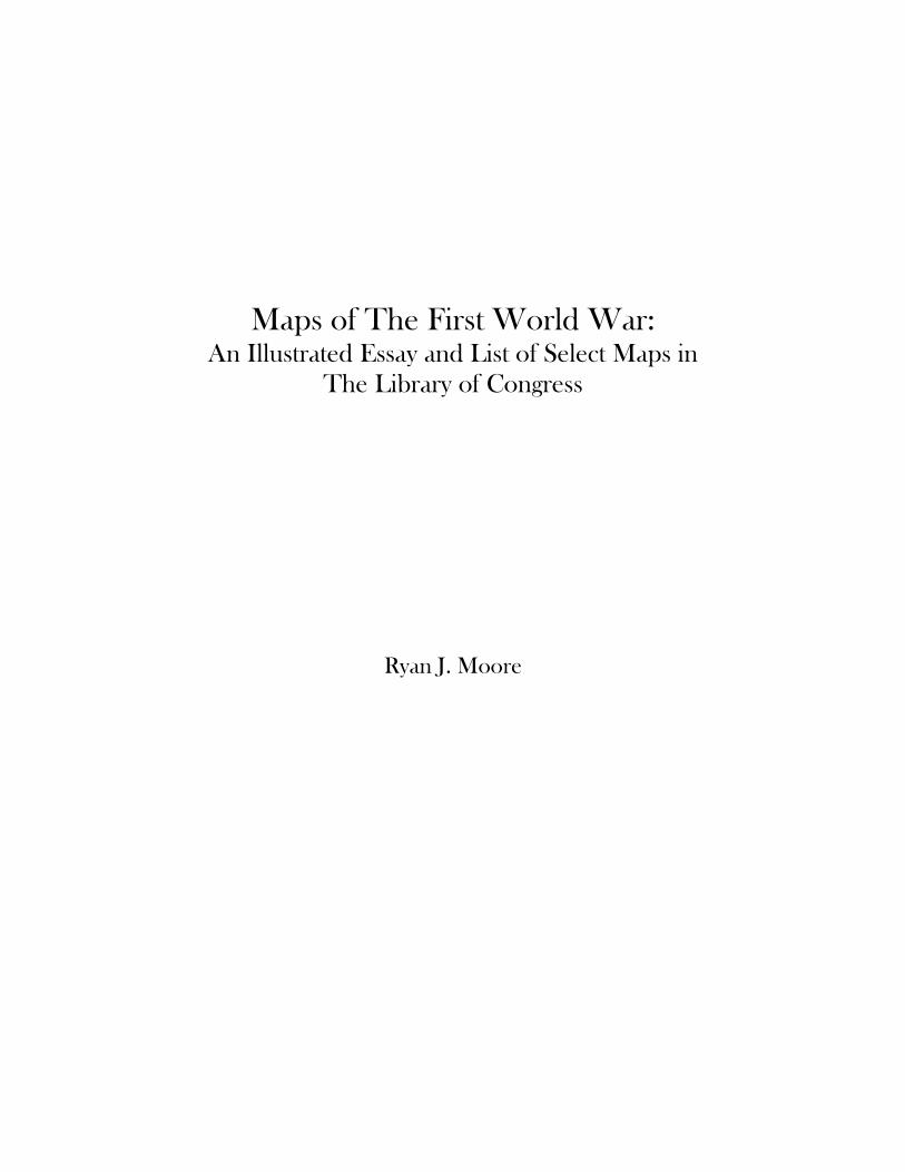
reply to President Wilson’s note of 19th Dec. 1916 : [Eurasia], from G&M collection.
The map shows the territory and peoples that were under the control of Germany and its
allies; together they were known as the Central Powers. The map includes text, statistics, and
tables showing populations by nationality.
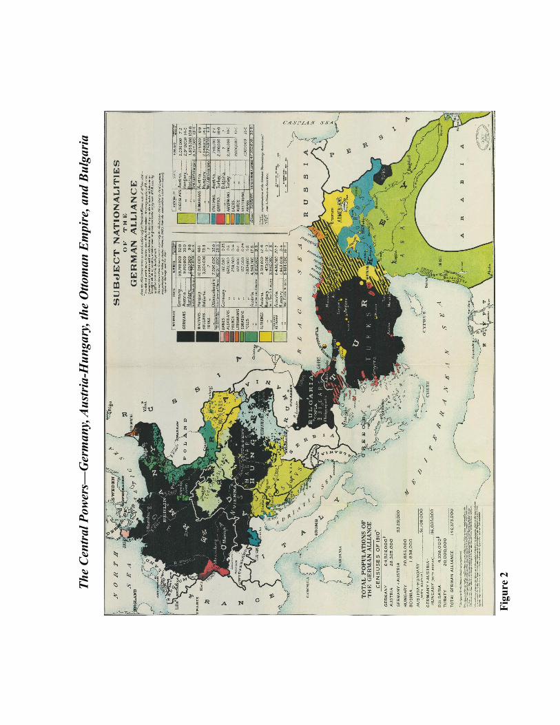
3. “War of the Races” from The War of the Nations, (New York, 1919), from Library of Con-
gress American Memory.
4. “Sketch 2. French Concentration,” folder 41, from Tasker Bliss Collection.
This map is a simplified illustration of the German Schlieffen Plan in which the Kaiser’s
forces flanked the French army by sweeping through Belgium before turning towards Paris.
The German and French order of battle is represented.
5. “Transportstrassenkarte fuer den Aufmarsch West und Ost,” from Das Deutsche Feldeisen-
bahnwesen, from G&M collection.
The map depicts Germany’s extensive railroad network that in large part was designed
for the rapid transport of troops between its western and eastern borders. The routes for moving
troops and artillery of Germany’s 2nd Armee is illustrated. This force took part in the 1914 at-
tack on Belgium. Later, in 1916, it bore the brunt of the Allied attack in the Battle of the
Somme.
6. Situation le 9 septembre 1914 au moment ou le commandement allemand ordonne la retraite
de l’aile droite et du centre: [France], from G&M vault.
A hand-drawn map showing how the French and British armies mounted a counterattack
at Marne to stop the German attack. Paris was saved and four years of stalemate on the West-
ern Front followed.

32
7. “Probable Route to Alert Positions…” Folder 3: Maps to Accompany Summary of Opera-
tions First Army, August 9 - November 11, 1918, from Summerall Collection.
The confusing matrix of trench lines and shifting enemy dugouts made up-to-date tacti-
cal maps a necessity for junior officers. Maps would be frequently amended using information
from prisoners and aerial photography.
8. Position of batteries & units of fire: [Stenay], from G&M vault.
An artillery grid that shows the effective range of light to heavy guns. This fire plan
was created for supporting an assault across the Meuse River on the morning of November
11,1918, which was the last American attack of the war, just hours before the Armistice was to
take effect.
9. “Plan of attack St. Mihiel Operation…” Container 13: U.S. Army First Division…, from
Summerall Collection.
An example of creeping or rolling barrage, a later tactical development in the war,
whereby the artillery barrage rolled forward according to a fixed timetable, and the infantry fol-
lowed behind the “fire curtain” that would be “lifted” when the final target was reached.
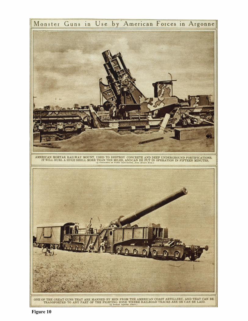
10. “Monster Guns in Use by American Forces in Argonne” from The War of the Nations,
(New York, 1919), from Library of Congress American Memory.
11. “A German Illustration of ‘Freedom of the Seas’ in War Time,” from G&M Title Collec-
tion, Europe: World War I, 1915.
A newspaper map of the era, likely the Times of London, that used maps to provide
both information and propaganda. It illustrates the German naval “exclusion zones” where U-
boats would fire without warning.
12. Commerce raiders, 1914-1915 – “Cruise of the Commerce Raider ‘Emden,’” from G&M
atlas collection.
The SMS Emden was a German cruiser based in Tsingtao, China, along with other ships
of the East Asia Squadron. At the outbreak of war, the ship’s daring captain, Karl von Mueller,
broke off from the main body, which was headed back to Germany, and raided Allied com-
merce in the Indian Ocean. Mueller employed camouflage and night raids to great success. He
captured or sank some 30 Allied ships and terrorized ports. British Naval Intelligence created
this chart to track the Emden’s whereabouts.
13. [Battle of the Jutland], Malby & Sons Ltd., London, 1916, from G&M Title Collection, Eu-
rope World War I, 1915.
One of nineteen maps that depict the Battle of the Jutland. Publisher Malby & Sons
produced these maps to explain the war’s largest naval battle to the public.

33
14. “The Submarine on Whose Ruthless Employment…” from The War of the Nations, (New
York, 1919), from Library of Congress American Memory.
15. “Map on Cardboard,” folder 10, from Prince Collection.
Willard B. Prince’s photographic analysis of a river crossed by the Fifth Division in
1918. The photograph has annotations by Prince that indicate where German forces were posi-
tioned, the point of the American crossing, and damaged homes.
16. Meuse-Argonne offensive, map showing daily position of front line: Map Room G-3,
G.H.Q., May 24, 1919, from Summerall Collection.
This map depicts the Meuse-Argonne Offensive, also known as the Battle of the Ar-
gonne Forest. The engagement lasted from September 26, 1918, until the Armistice on Novem-
ber 11. During these 47 days, more than 1.2 million American soldiers went into action. It was
the principal engagement of the AEF. The map was produced in 1919 to document the AEF’s
history.
17. “Order of Battle on Western Front 11 .A.M., Nov. 11, 1918,” from the Tasker Bliss Collec-
tion.
18. “Information from captured German maps, prisoner's statements, and recent aeroplane pho-
tographs: [Sommerance region],” from Summerall Collection.
19. “Planmaterial der 3. Armee…”[Maps showing World War I campaigns in northern France
around Verdun at various dates], from G&M collection.
20. [Map showing trenches and observation posts in eastern region of Sommerance], from
G&M collection.
21. Presumed enemy order of battle, October 7, 1918 : [Sommerance region], from G&M col-
lection.
22. “Partition of Germany,” from Concise Peace Atlas, from G&M atlas collection.
Back cover: Map of hostile airdromes: [France], from G&M collection.
Map shows German airfields colored in red and black. Airfields, like artillery, were fre-
quently relocated to safeguard against enemy attack.


35
Endnotes
1. Hew Strachan, The First World War (New York: Viking, 2003), 177.
2. Peter Chasseaud, Artillery’s Astrologers: A History of British Survey and Mapping on the
Western Front, 1914-1917, (Lewes, U.K.: Mapbooks, 1999), 1-5.
3. Jeffrey S. Murray, “In the Trenches: British surveyors made a crucial contribution during
World War I – an accurate map of the battlefield,” Fine Books & Collections, 52, (2010), 3.
4. Ibid., 3-4.
5. Ibid., 2.
6. Chasseaud, Artillery’s Astrologers,196-198.
7. Murray, “In the Trenches,” 3.
8. Ibid., 3-4.
9. John Walter, The Kaiser’s Pirates: German Surface Raiders in World War One, (Annapolis:
Naval Institute Press, 1994), 69, 85.
10. Strachan, First World War, 225.
11. Barbara W. Tuchman, The Zimmermann Telegram, (New York: Ballantine, 1994), 77.
12. George B. Clark, The American Expeditionary Force in World War I : a statistical history,
1917-1919, (Jefferson, North Carolina : McFarland & Company, 2013), 54.
13. Chasseaud, Artillery’s Astrologer, 498-499.
14. Willard B. Prince, Folder 4: “Told from the Inside by former Regimental Sergeant Major
W.B. Prince,” Folder 5: “Reminiscence of a Topographical Man,” and Folder 18: “Scrape book
small map and note: ‘Red line shows our course into the Argonne,’” [The Willard B. Prince
Collection of World War I maps and other related cartographic materials], Held by the Li-
brary of Congress Geography and Map Division.
15. Ibid., “Told from the Inside.”
16. Ibid.
17. Margaret MacMillan, Paris 1919: Six Months that Changed the World, (New York: Ran-
dom House, 2001), 465.
18. Ibid., 486.

36
19. Wesley J. Reisser, “Mapping for Peace: The American Inquiry and the Paris Peace Confer-
ence, 1918-1919,” The Portolan, 71, (Spring 2008), 17.

37
Cartobibliography
—Special Collections
1. [Tasker Howard Bliss collection of World War I maps and other related graphic mate-
rials]. 234 pieces (chiefly col. maps, some with ms. additions): some photocopies; 188 x 125
cm. or smaller. 2004627137
Consists principally of color and black-and-white maps of Europe during the period of
World War I and the succeeding Paris Peace Conference of 1919. Some of these are annotated
with ink or colored pencil. There are various maps related to Asia and Turkey, as well as mis-
cellaneous maps of Texas, Wisconsin, and the District of Columbia. The collection also in-
cludes photocopied aerial views (many negative) of ancient cities and fortresses, in addition to
diagrams, illustrations, statistical tables, a paperbound atlas (Europe and the Near East showing
newly redrawn international boundaries), a photograph, and various typewritten sheets. Some
map sheets have a typewritten text affixed to the recto.
G5701.S65 coll .B5
2. [Charles Pelot Summerall collection of maps, primarily showing First World War bat-
tles and campaigns in France]. 96 maps : some color, some manuscript ; various sizes.
2013591430
This collection contains maps from the Charles Pelot Summerall papers that have been
transferred from the Manuscript Division of the Library of Congress, which includes manu-
script maps of tactical operations in Meuse-Argonne, Saint Mihiel, and Verdun. The collection
also includes maps of Camp Zachary Taylor, Fort Bragg, and southeastern United States ports.
G5831.S65 .M3
3. [Willard B. Prince collection of World War I maps and other related graphic materi-
als]. ca. 366 pieces (chiefly maps, ms. maps, mss.) : printed items, photocopies, some col. ; on
sheets 90 x 132 cm. or smaller. 2007627349
Prince was a regimental sergeant assigned to U.S. Army’s Fifth Division’s Topograph-
ical Unit. In addition to his maps of the Fifth Division’s engagements, his collection contains
diaries, photos, and other personal documents.
G5831.S65 coll .P7 Vault : Prince

38
—Atlases
4. La Dalmazia; cenni geografici e statistici, illustrati da 32 figure fuori testo con un atlan-
te di 22 tavole a colori comprendenti 60 carte. (Instituto Geografico de Agostini, 1918).
Dainelli, Giotto, 1878-1968. 73 p., 1 l. incl tables. plates. 25 cm. and atlas of XXII maps (part
fold.) 39 cm. 19009991
This atlas was prepared by the Italian geologist and geographer, Giotto Dainelli, a later
supporter of Mussolini’s Fascist regime and its imperial enterprises. The work depicts vegeta-
tion, water, natural resources and other features. At the time of publication, Italy was deter-
mined to seize Dalmatia per the secret Treaty of London, which was signed in 1915 by Italy,
England, and France.
G2032.D3 D3 1918 fol.
5. Carte du theatre des operations a l'echelle du 500,000e. France. Armée. Service
géographique. 2 v. fold. col. maps. 32 cm. unk82007213
French military gazetteer with maps of the war, depicting both the western and eastern
fronts where French troops were engaged in action.
G1037 .F7 1916
6. Commerce raiders, 1914-1915. Great Britain. Naval Intelligence Division. [1] l., 8 col.
maps. 64 x 76 cm. map56000614
Map figure 12.
G1037 .G73 1917 (Map)
7. Commerce raiders, 1916-1917. Great Britain. Naval Intelligence Division. [1] l., 3 col.
maps. 64 x 76 cm. map56000615
G1037 .G732 1917 (Map)
8. Concise peace atlas, containing President Wilson's peace conditions, peace conference
who’s who, disposition of former German colonies, war cyclopedia, dates of notable bat-
tles, approximate value of foreign coins .... Rand McNally and Company. 16 p. incl. 10 col.
maps. 26 cm. unk81055307
Map figure 22.
G1037 .R34 1919 (G&M)

39
9. Report of the First Army A. E. F. United States. Army. A. E. F., 1917-1920. 1 v. (14
plates of col. maps) 25 cm. unk82096336
Post-action studies of the Meuse-Argonne and St. Mihiel offensives. It shows the loca-
tions of military units and includes a "Secret Operation Map."
G1037 .U48 1923
10. World war records; First division, A. E. F., regular. United States. Army. 1st Division.
1 v. and atlas 36 cm. 28027895
Set of battle maps, charts, and sketches.
G1037.U52 1928 Atlas / D570.3 1st .A4 Atlas
11. World war records. First division, A. E. F., regular German documents. United States.
Army. 1st Division. 4 v. illus., maps, tables. 36 cm. and atlas. 44 x 50 cm. 34000367
Reproductions of maps, charts and translated German documents. Plates: I. Sommer-
ville, Ansauville and Cantigny sectors -- II. Aisne-Marne (Soissons) -- III. St. Mihiel offensive -
- IV. Meuse-Argonne.
G1037.u53 1930 folio
12. Carte del teatro di guerra italo-austriaco. Istituto geografico militare (Italy). 3 pts. (in
portfolio) 17 col. maps (part fold.) 50 x 64 cm. map5500068
Maps showing the Italian front with Austro-Hungarian Empire in March 1917.
G1985 .I83 1917
13. Pacific colonies of Germany. Churchill, William. 11 col. maps ; cm. unk82080196
Maps of German colonies in Asia from their beginnings in 1880 until their disposses-
sion in 1919. One of the set shows American interests in the Pacific.
G2860 .C5 1918
40
Maps by Call Number
—United States
14. Map of Black Tom Island, Jersey City, New Jersey: showing area damaged by explo-
sion and fire, July 30th 1916. Sanborn Map Company. 2010588272
This map by the Sanborn Fire Insurance Map Company illustrates the damage inflicted
on American ammunition storage facilities, industrial plants, warehouses, railroad tracks,
wharves, and piers by German saboteurs.
G3814.J5:2B5S65 1916 .S3
—Mexico
15. Outline map of Mexican Border. United States. War Dept. General Staff. War College. 1
map ; 45 x 214 cm. 98686049
Map depicts the international boundary between the United States and Mexico; it was
created during a time of rising tensions between the two nations, which reached its apex when
Pancho Villa raided an American border town and was pursued into Mexico by American
troops.
G3701.F2 1916 .U6 TIL
—Europe
16. Subject nationalities of the German alliance: from the Allies’ peace terms as stated in
their reply to President Wilson’s note of 19th Dec. 1916 : [Eurasia]. 1 map : col. ; 71 x 92
cm. 2004628224
Map figure 3.
G5691.E2 1910 .S9
17. Eastern Front campaigns. col. map 36 x 23 cm. 77697237
Depicts battle lines from 1914 to 1916, involving Russian, Austro-Hungarian, and Ger-
man forces, along with units of minor nations.
G5701.S65 1917 .E3

41
18. The Daily telegraph map of Europe / by Alexander Gross; produced by "Geographia"
Ltd. Gross, Alexander, 1879-1958. 1 map : col. ; 74 x 96 cm. fold. in cover 22 x 13 cm. “From
the papers of Oscar Terry Crosby.” 79695138
Commercially produced map that depicts major battle lines and occupied territories.
G5701.S65 1919 .G7
19. Sektion Europa. maps : both sides of some sheets, col. ; 56 x 72 cm. “Geheim!; Stabsaus-
gabe!; Nicht in die vordere Linie nehmen; Darf in die vorderste Linie nicht mitgenommen
werden!” 92680720
Tactical situation maps created by the Austro-Hungarian Army that include artillery
plans and enemy positions.
G5701.S65 s25 .S4
20. Meine Kriegserinnerungen 1914-18: [Europa]. Ludendorff, Erich, 1865-1937. 10 maps ;
sheets 67 x 57 cm. or smaller. “Zu: Ludendorff, Meine Kriegserinnerungen 1914-18.”
92680566
Reproductions of maps possessed by Erich Friedrich Wilhelm Ludendorff, Quartermas-
ter General of the German Army and joint leader, with Paul von Hindenburg, of the German
military during the War. Plates: Karte I. Tannenberg, 1914 -- Karte II. Die Schlacht an den Ma-
surischen Seen, 1914 -- Karte III. Der Feldzug in Sudpolen, Herbst 1914 -- Karte IV. Der Feld-
zug in Nordpolen, Herbst 1914 -- Karte V. Die Winterschlacht in Masuren -- Karte VI. Der
Sommerfeldzug gegen Russland, 1915 -- Karte VII. Ubersichtskarte uber den Weltkrieg --
Karte VIII. Der Feldzug gegen Rumanien, 1916 -- Karte IX. Der deutsche Angriff im Westen
1918 -- Karte X. Deutsche Ruckzugsbewegungen 1918.
G5701.S65 svar .L8
21. Skeleton map of Western Europe. Great Britain. War Office. General Staff, Geographical
Section. col. maps 54 x 71 cm. unk83003993
Map depicts railways in black and principal roads in red. It also identifies "fortresses"
in France, Belgium, and Germany.
G5720 s500 .G7

42
22. [Map of World War I western-front military actions in Europe, 1914-1918] / prepared
by G2-A3. Great Britain. War Office. G2-A3. 1 map : col., cloth backing ; 265 x 253 cm. Re-
moved from the Francis LeJau Parker Papers in LC Manuscript Division. 89694311
Map is extensively annotated in colored ink and crayon to show British, French, and
German military lines and action.
G5721.S65 1918 .G7 MLC Vault
23. Westlicher Kriegsschauplatz 1914: Wiedergabe der franzosischen Generalstabskarte:
[Europa]. maps on sheets : photocopies, some hand col. ; sheets 51 x 66 cm. “War College Di-
vision, Map Section.” 92680719
This set of maps illustrates French and German trench lines in 1914. The base maps
were created by the French General Staff.
G5721.S65 s200 .W4
—France
24. Carte-guide Campbell : [France]. < > maps : col. ; 93 x 95 cm. or smaller. "Stanford’s
Geogl. Estabt., London." 2009583011
Commercial maps made to illustrate the war in France.
G5831.P2 s250 .B51
25. Wettlauf um die Flanke 1914: [Frankreich]. Bayerisches Kriegsarchiv in Munchen. 29
maps : col. ; 37 x 36 cm. or smaller. “Bayer. Kriegsarchiv, Wettlauf um die Flanke 1914.”
91685768
These maps depict campaigns in northern France near Belgium in the regions of Lille,
Douai, Arras, Lens, Peronne, and Avion.
G5831.S65 svar .B3
26. Deutsche Stellungen, Ende Dezember 1914: Orte grosserer Gefechte in der ten Halfte
des Dezember 1914: [France]. 1 map ; 41 x 27 cm. Text on verso. 2006459192
The map shows the locations of German units at the end of December 1914.
G5831.S65 1914 .D4

43
27. Location of headquarters of units in 26th, 29th & 82nd Divs. (5th Corps):
[northeastern France]. 1 map : ms., col. ; on sheet 90 x 47 cm. Summerall Papers. 92684148
The map depicts various American headquarters in Troyes, France. It lists engineer en-
campments, machine gun emplacements, and armored units.
G5831.S65 1918 .L6 Vault
28. Meuse-Argonne offensive, map showing daily position of front line: Map Room G-3,
G.H.Q., May 24, 1919. 1 map : col. ; 84 x 72 cm. Summerall Papers. 92684037
Map figure 16.
G5831.S65 1918 .M4
29. St. Mihiel offensive, map showing daily position of front line: Map Room G-3, G.H.Q.,
May 24, 1919. maps : col. ; 51 x 80 cm., some folded to 17 x 12 cm. 92684036
Southeast of Verdun, the AEF and one French corps command by General John J. Per-
shing attacked German positions at St. Mihiel from September 12-16. The attack caught the
Germans in the midst of a retreat and was more successful than anticipated, which is represent-
ed in this reprinted battle map.
G5831.S65 1918 .S8
30. [Maps showing entrenchments in France during the World War I, 1916-1918]. France.
Armée. Service géographique. maps: some col. ; 100 x 100 cm. or smaller. “Secret.” 92680725
Trench maps showing Allies in red and Central Powers in blue.
G5831.S65 s10 .F7
31. Trench map. [France and Belgium]. Great Britain. Ordnance Survey. maps: some col. ;
50 x 80 cm., some folded to 17 x 12 cm. 92680726
These are highly detailed maps of trench lines. Upper right corner indicates date of map
revision for military intelligence purposes. Indexes are printed on the back of some sheets.
G5831.S65 s10 .G7

44
32. Enemy order of battle 1918: [France] / G-2 First Army, A.E.F. United States. Army.
American Expeditionary Forces. maps : some col. ; 66 x 98 cm. or smaller. Summerall Papers.
92680855
These maps illustrate campaigns between October and November 1918. It includes a
legend describing how intelligence was obtained.
G5821. S65 .M3
33. [Maps showing entrenchments in France during the World War I, 1918]. France.
Armée. Service géographique. maps : some col. ; 100 x 100 cm. or smaller, in 2 portfolios 77 x
58 cm. “Secret.” 92680721
G5831.S65 s20 .F7
34. Trench map: France. Great Britain. Ordnance Survey. 92680724
Annotated maps showing German and British trench lines.
G5831.S65 s20 .G7
35. Map of hostile airdromes: [France]. maps : col. ; 73 x 80 cm. or smaller. 92686650
Map figure back cover
G5831.S65 s200 .M3
36. [Maps showing World War I campaigns in northern France around Verdun]. maps :
col. ; 40 x 40 cm. 92680718
Map figure 18.
G5831.S65 s25 .M3
37. Meuse-Argonne operations / prepared by G.2.C. United States. Army. Corps of Engi-
neers. G.2.C. maps : col. ; 84 x 85 cm. or smaller. Summerall Papers. 92684029
Set shows tactical-level operations in the Meuse-Argonne offensive. Plates: Plate IA.
German divisions engaged, Sept. 26th to 29th inc. -- Plate IIA. German divisions engaged Oct.
4th-16th -- Plate III. Kriemhilde Stellung : September 29, 1918 -- Plate IIIA. German divisions
engaged Nov. 1st-6th, 1918 -- Plate IV. Areas photographed by observation group, 5th Army
Corps, air service -- Plate IVA. Order of battle, Nov. 10, 1918 : presumed except for 31st, 88th,
236th, and 27th divisions which were engaged on Nov. 10th-11th -- Plate V. Artillery objective
& infantry assault map, G-2, October 30, 1918 -- Plate VI. Stenay special.
G5831.S65 s50 .U5
45
38. Cours d'emploi des armes: croquis: [France]. Ecole spéciale militaire de Saint-Cyr. 19
maps : col. ; on sheets 51 x 49 cm. or smaller, folded in cover 37 x 27 cm. 91685883
A set of combat studies by the French military.
G5831.S65 svar .E2
39. [Maps showing World War I campaigns in northern France around Verdun]. 33
maps : some ms. ; 101 x 170 cm. or smaller, in portfolio 67 x 88 cm. 92680718
Maps of German combat actions in France, including Verdun; annotated in German.
Maps are from various publications and manuscripts. Index map: "Kartenmaterial der Festungs
-Vermessungs-Abteilung Nr. 3" is mounted inside the portfolio.
G5831.S65 svar .M3
40. St. Mihiel operations / prepared by G.2.C. Corps. United States. Army. Corps of Engi-
neers. G.2.C. maps : some col. ; on sheets 96 x 99 cm. or smaller. 92684030
A set of reproductions that show combat operations in and around St. Mihiel, France.
Plate II. St. Mihiel Operations -- Plate III. Occupation -- Plate IV. Disposition of enemy defen-
sive weapons and dugouts --. Plate V. Translated from German: "Very secret position of Army
Detachment "C" as of March 20, 1918” -- Plate VI. German divisions engaged.
G5831.S65 svar .U5
41. Map to illustrate the Meuse-Argonne Offensive: first, second, and last phases. 1 map :
col. ; 72 x 62 cm., folded to 13 x 19 cm. 92686657
From map: “Map to accompany Report of the Commander in Chief, November 20,
1918."
G5832.A735S65 1918 .M3
42. Situation le 5 septembre 1914 la veille de la Bataille de la Marne: [France]. 1 manu-
script map: color; 23 x 65 cm. 201158864
A map drawn by hand depicting the beginning of the Battle of the Marne in September
of 1914.
G5832.M3S65 .S5 Vault
46
43. Situation le 9 septembre 1914 au moment ou le commandement allemand ordonne la
retraite de l’aile droite et du centre: [France]. 1 manuscript map : color ; 22 x 34 cm.
2011588649
Map figure 6.
G5832.M3S65 .S52 Vault
44. Front Lorraine et Alsace. 1 map : col. ; 54 x 41 cm. 92686610
Map shows the front line at Alsace-Lorraine in January of 1916.
G5833.A4S65 1916.MLC Vault
45. Front de Lorraine / VIIIe Armee, Etat Major, 2e Bureau. France. Armée. Armée, 8e.
Etat-Major. Bureau, 2e. 92684032
This French map depicts trench lines near Nancy in September 1918. Bolder lines rep-
resent stronger positions.
G5833.L65S65 1918 .F7 Vault
46. Cumieres 1/10,000 / traced and reproduced at Army General Staff College, A.E.F. Ar-
my General Staff College (U.S.) 1 map : col. ; 70 x 97 cm. Summerall Papers. 92684139
Map depicts entrenchments in western region of Cumiere.
G5834.C977S65 1918 .U5
47. [Map of World War I military actions and positions in the vicinity of Peronne, Somme
Department, France]. 1 map : cloth backing ; 80 x 191 cm. Francis LeJau Parker Papers.
89694318
Extensively colored pencil annotations on printed base maps.
G5834 .P45S65 1918 .M3 Oversize
48. Remonville / prepared & printed by G.2.C. United States. Army. Corps of Engineers.
G.2.C. 1 map : col. ; 80 x 55 cm. Summerall Papers. 92684039
Map depicts trenches, batteries, machine guns, ammunition dumps, observation posts,
dugouts, and other tactical features.
G5834.R283S65 1918 .U5

47
49. Map to illustrate the offensive of the St. Mihiel salient. 1 map: col. ; 42 x 54 cm. "To ac-
company report of the Commander in Chief, November 20, 1918." Summerall Papers.
92684034
Map shows American battlefield operations in St. Mihiel.
G5834.S3418S65 1918 .M31
50. St. Mihiel operations, First American Army, Sept. 12-15 / prepared & printed by G-2-
C, IX Corps. United States. Army. Corps of Engineers. G.2.C. Corps, IX. 1 map : col. ; 50 x 81
cm. Summerall Papers. 92684140
Map shows American battlefield operations in St. Mihiel.
G5834.S3418S65 1918 .U5
51. Information from captured German maps, prisoner's statements, and recent aero-
plane photographs : [Sommerance region]. United States. Army. Army Corps, 1st. G.S. Sec-
ond Section. 1 map : col. ; 56 x 61 cm. Summerall Papers. 92684150
See map figure 17.
G5834.S86S65 1918 .U5
52. [Map showing trenches and observation posts in eastern region of Sommerance]. Unit-
ed States. Army. Army Corps, 1st. G.S. Second Section. 1 map : col. ; 55 x 85 cm. Base map:
Kriemhilde Stellung. Summerall Papers. 92684151
Map figure 19.
G5834.S86S65 1918 .U51
53. Presumed enemy order of battle, October 7, 1918: [Sommerance region]. United States.
Army. Army Corps, 1st. G.S. Second Section. 1 map : col. ; 55 x 61 cm. Base map drawn and
printed by G-2-C, 1st A.C.U.S. Summerall Papers. 92684152
Map figure 20.
G5834.S86S65 1918 .U52

48
54. Position of batteries & units of fire: [Stenay]. 1 map: ms., col., tracing ; 80 x 80 cm. Sum-
merall Papers. 92684226
Map figure 8.
G5834.S885S65 1918 .P6 Vault
55. Thiaucourt. United States. Army. Division, 7th. 1 map : col. ; 53 x 70 cm. + legend sheet
([1] sheet : col., ms. ; 22 x 23 cm. Title on accompanying legend sheet: Situation map, 7th Divi-
sion, Oct. 11, 1918. "Printed at Base Printing Plant 29th Engineers, U.S. Army, 1918."
Extensively annotated in colored pencils and inks, the map depicts battlefield positions
and military installations.
G5834.T315S65 1918 .U5 MLC
56. Schema des fronts successifs, nord de Verdun, 20-26 aout 1917 / Groupe de canevas de
tir. France. Armée. Groupe de canevas de ti. 1 map : col. ; 50 x 70 cm. "Tirage du 13 aout
1917." 92686617.
Map shows the military situation at Verdun in August 1917.
G5834.V35S65 1917 .F4 MLC
57. [Map of operations, September 26 to October 20, 1918, showing objectives, bounda-
ries, and advances: region northwest of Verdun]. United States. Army. Army Corps, 1st.
G.S. Second Section. 1 map : col. ; 50 x 81 cm. Summerall Papers. 92684149
Map shows Allied advance during the Meuse-Argonne offensive.
G5834.V35S65 1918 .U5
—Belgium
58. [Map of World War I battle positions in the Bruges region, Belgium]. 1 map : col. ; 58
x 107 cm. Manuscript, blue pencil; on Great Britain G.S.G.S. topographic base maps.
80691199
Map illustrates the positions of docked German warships and shore batteries located in
Ostend, Belgium during April 1918. The report was made prior to the British raids on Ostend
and Zeebruggee. Listed German warships include: Kaiserin (Kaiser-class battleship), Goeben
(Moltke-class battle cruiser), Tirpitz (Bismarck-class battleship), Hindenburg (battle cruiser),
and Deutschland (raiding cruiser).
G6014.B8S65 1914 .M3 Vault
49
—Germany
59. Das Deutsche Feldeisenbahnwesen. 22 maps on 10 sheets : some col. ; 75 x 84 cm. or
smaller, sheets 78 x 89 cm. or smaller. “Zu Das deutsche Feldeisenbahnwesen. Band I.”
91685772
Map figure 5.
G6081.P3 svar .D4
60. [Maps showing harbors in Germany]. Great Britain. Admiralty War Staff. maps : some
col. ; 85 x 98 cm. or smaller. “O.S.O. 1915.” 91683762
An incomplete set of maps showing German harbors and naval installations. Plates: 4 .
Emden and harbour -- 8B. Map of district north of Hamburg -- 11. Wilhelmshaven -- 14. Ham-
burg, plan of port ; Hamburg shipyards ; Harburg [3 maps on 1 sheet] -- 15. Hamburg, plan of
town.
G6081.P55 svar .G7
61. Map of hostile airdromes, August 2, 1918: [Mannheim region]. 1 map: col. ; 72 x 80
cm. "Printed at Base Printing Plant, 29th Engineers, U.S. Army." 92685985
Map shows German airfields and support bases.
G6299.M3S65 1918 .M3
62. Situation map, IV Army Corps, Dec. 20/18: [Rhineland-Palatinate]. 1 map : ms., col. ;
on sheet 172 x 121 cm. Summerall Papers. 92684144
Map shows the military situation in the region south of Bonn, west of the Rhine River,
and northeast of the Mosel River.
G6391.S65 1918 .S5 Vault
63. [Ruhr Operations March-April, 1920]. 4 maps : col. ; 111 x 91 cm. or smaller.
2012588843
Map of Reichswehr, postwar German military, operations against Communist-led militia
uprising in the Ruhr, which was prepared by the German government and annotated heavily by
U.S. military intelligence.
G6362 R8.S1 1920 .R Vault

50
—Romania
64. Militargeographische beschreibung von Rumanien. Nitz, E. 3 p.l., 299 p. and atlas of 18
fold. gs 23000309
This map contains geographical descriptions of Romania created by the German General
Staff. Romania fought along side Russia against the Central Powers.
G6521.S1 1916 .R6
— Balkans
65. Proposed boundary between Greece and Albania and population composition of south
central Yugoslavia and northern Albania. Great Britain. War Office. General Staff. Geo-
graphical Section. 3 maps : col. ; 37 x 61 cm. or smaller, on sheets 58 x 71 cm. or smaller.
88694277
Maps include a population study of Serbians and Albanians. They highlight the loca-
tions of alleged Serbian massacres of Albanians.
G6811.F2 s250 .G7 Vault
66. Approximative zones according to the secret Treaty of London (April 26th 1915):
[Albania] / A. Radovitch. Radovitch, A. (André), 1872-. 1 map : ms., col. ; 46 x 38 cm. Black
ink, col. inks, and col. washes on photocopy base map. 88694279
Map showing territory to be ceded to Italy and Serbia in exchange for their entrance into
the war against the Central Powers. The Treaty of Versailles would nullify the agreement.
G6831.F2 1915 .R3 Vault
67. Topographic quadrangle maps of the Struma River Valley, Bulgaria and Greece] / 8th
Field Survey Co. R.E. Great Britain. Army. Royal Engineers. Field Survey Co., 8th. maps:
col., mounted on linen ; 40 x 50 cm. "Unclassified." 91684073
The Struma River, which flows through modern-day Macedonia and Bulgaria, was part
of the Macedonian Front in the Balkans. The Allies had come to aid Serbia, in the autumn of
1915, which was being crushed by the combined weight of the assault of Germany, Austria-
Hungary, and Bulgaria. The assistance, however, had arrived too late and Serbian troops were
forced to evacuate. Three years later, the Serbians with Allied support liberated their country
and knocked Bulgaria out of the war. These maps were likely used in the planning of the 1918
Allied offensive.
G6892.S8 s20 .G7

51
—Eastern Europe
68. Feldmassig hergestellte Fliegerkarte: [Osteuropa]. Prussia (Germany). Landesaufnahme.
Kartogr. Abteilung. maps : col. ; 29 x 37 cm. or smaller. "Nur fur den Dienstgebrauch."
93680340
This aeronautical chart depicts eastern Poland, Lithuania, and Latvia. It is one of the
few examples of such charts in the collection.
G6966.P6 s200 .P7
—Russia
69. Archangel district, Russia. United States. Corps of Engineers. Allied Mapping Section.
unk81002821
A topographic survey that shows “base” locations of the American troops in Archangel.
The force was part of an Allied intervention in Russia, where a civil war was being waged fol-
lowing a revolution in 1917 that led to the abdication of Czar Nicholas II in favor of a provi-
sional government. The Allies hoped their efforts would keep Russia in the war, but Com-
munists led by Lenin seized power from the provisional government and sued for peace with
the Central Powers.
G7064.V56A1 1919 .J4
70. Gebiet der Armee-Abtlg. Woyrsch: [Ostpolen]. maps: col. ; 37 x 81 cm. 93686591
This aeronautical chart shows military entrenchments and installations, which are print-
ed in red and blue on a topographic base.
G7091.R2 s25 .G4 MLC
71. Karte der Ukraine. Germany. Armee. Generalstab. Kartographisches Institute. maps 46 x
62 cm. unk83041731
These highly detailed maps of Ukraine were created by the German General Staff in
1918. They show roads, waterways, communication lines, and topography.
G7100 s125 .G4

52
72. Map of Siberia, Maritime Province / American Expeditionary Forces. United States.
Army. American Expeditionary Forces. Engineer Office. maps : ms., linen ; 44 x 48 cm. or
smaller. "Based on Russian General Staff map." 99442532
These maps were used by the American forces to gain knowledge of the Siberian terrain
during the period of American intervention in 1918-1920. Americans were garrisoned in Vladi-
vostok from 1918 to 1920. Its mission was to support resistance to the Bolsheviks during the
Russian Civil War, protect American supplies and railroad stock, and rescue the forty-thousand-
or-so Czech forces detained along the Trans-Siberian Railroad. It saw limited action, and
American casualties were minimal.
G7323.P7 s84 .U5 Vault
—Middle East
73. Turkish military features in the Levant. Great Britain. Army. Corps of Royal Engineers.
col. maps 64 x 64 cm. unk83021508
Tactical maps of Ottoman trenches, barbed wire lines, gun emplacements, and machine
gun posts. Key positions include: Gaza, Beersheba, Hairpin Redoubt, Atawine Redoubt, and
Hareira Redoubt. The maps were used for planning operations during the Battle of Palestine in
1917.
G7421.P4 s20 .G7
74. Karte der asiatischen Turkei / auf Grund des gleichnamigen Blattes der Karte in
1:200000 der K. Osman Landesaufnahme bearbeitet von der Kartogr. Abteilung der Kgl.
Preuss. Landesaufnahme. Prussia (Germany). Landesaufnahme. Kartogr. Abteilung. maps: col.,
mounted on linen ; 40 x 51 cm. "Nur fur den Dienstgebrauch!" 92682779
Set of German foreign office maps of the Ottoman Empire. The Germans dispatched
military and political advisors to help prepare its ally to fight the British and Russians. These
topographic maps were made to assist German officers working in the field. They include place
names, major cities, roads, other lines of communication, and pronunciation guides.
G7430 s200 .P7
75. Dunya Savası'nda Osmanlı Devleti. 7 maps on 1 sheet: col., laminated; 18 x 18 cm. or
smaller, sheet 98 x 68 cm. 2005626333
Seven maps that depict battles and territorial changes in Turkey. It includes text, chro-
nology, and illustrations.
G7431.S65 2004 .G8

53
76. Mesopotamia. Survey of India. 14 maps : col. ; 58 x 100 cm., folded in cover 17 x 13 cm.
“Official use only.” 91684651
Set of maps of what is now Iraq created by the Survey of India, which was essentially
composed of British military engineers. Maps were relevant to British troops stationed in India
who fought German-led Ottoman forces for control of present-day Iraq.
G7610 s126 .S8
—Asia
77. Commercial map of China / compiled from the latest surveys and other authentic
sources. Oriental Geographical Society, 1916. 1 map : col. ; 131 x 119 cm. + 1 index. "Japan
Gazette Press, Yokohoma, Japan." 2007629182
This commercial map and index of China was “compiled from latest surveys and other
authentic sources.” It appeared in the Japan Gazette Press on January 1, 1916. The legend dif-
ferentiates major and minor cities; also, it lists communications lines and railways. The index is
replete with advertisements of Japanese industries in China.
G7821.G1 1916 .O7
78. Minami Manshu oyobi Kantoshu / chosha Ando Rikinosuke. Ando, Rikinosuke. 1 map:
photocopy; 50 x 34 cm. 2007628212
Map shows territory on the Liadong Peninsula in Manchuria that was leased by the
Kwangtung Army of the Imperial Japanese Army. Place names are in Japanese.
G7822.M2 1918 .A5
79. Kasei Kita Shina jumanbun no ichi zu. Tsingtao / Sanbo Honbu, Rikuchi Sokuryobu;
Rinji Sokuryobu. Japan. Rikuchi Sokuryobu. maps; 36 x 48 cm. 92682617
This Japanese survey depicts the German colony of Tsingtao in China, which the Japa-
nese and British later jointly seized during the war. This action deprived Germany of its only
significant Asian port.
G7824.Q4A1 s100 .J3

54
—Africa
80. German East Africa. Great Britain. War Office. General Staff. Geographical Section.4
maps : col. ; 63 x 78 cm. or smaller. 2009578552
Set of large scale maps of Eastern Tanzania and the Kenya border that depict population
centers, railroads, roads, and other features needed to execute military maneuvers. The maps
were made by the Germans in 1912 and reprinted by the British War Office in 1915. Britain
planned to seize the lightly defended German colonies by deploying troops stationed in India.
Although the Germans were unable to hold onto the territory, its forces evaded capture and
fought a guerilla campaign until the end of the war.
G8440 s100 .G7

The Philip Lee Phillips Map Society of the Library of Congress is named in honor of
Philip Lee Phillips (1857-1924), the first Superintendent of Maps at the Library of Congress when
the Hall of Maps and Charts was established in 1897.
The group is a non-profit, voluntary association whose objective is to develop, enhance,
and promote the work of the Geography and Map Division by advancing its publication, educa-
tion, exhibition, preservation and acquisition programs.

56