Embed Size (px)
Citation preview
Mapping Tourists Centers in Pune city using Geospatial Technology Using Quantum GIS and Google Earth
Tutorial ID: IGET_CT_002 This tutorial has been developed by BVIEER as part of the IGET web portal intended to provide easy access to geospatial education. This tutorial is released under the Creative Commons license. Your support will help our team to improve the content and to continue to offer high quality geospatial educational resources. For suggestions and feedback please visit www.iget.in.

IGET_CT-002 Mapping tourist centers of Pune city
2
Mapping Tourist centers of Pune city using geospatial technology
Objective: To identify the tourist places in Pune city and map them using different typologies. Software: Google Earth, Quantum GIS Level: Advanced Time required: 2 Hour Prerequisites and Geospatial Skills:
1. Quantum GIS should be installed on the computer and basic knowledge of interface 2. Google Earth should be installed and Basic knowledge about the its interface 3. Should have completed all the GIS and RS tutorials from the dst-iget portal.
Tutorial Credits:, Mr. Sanjay Jagtap, Mr. Ganesh Dhawale, Mr. Praveen Kamble, Mrs. Kanchan Misal, Mr. Gorakh Waje Edited: Ms. Prachi Dev, Mr. Lakshmikanth Kumar and Prof. Dr. Shamita Kumar Reading:

IGET_CT-002 Mapping tourist centers of Pune city
3
Introduction: Pune is the seventh largest city in India and second largest city in Maharashtra after Mumbai. Pune Municipal Corporation (PMC) jurisdiction extends up to an area of 243.84 sq. km. housing 2.54 million populace within 144 wards. Referred as ‘Detroit of India’, the city has experienced a long standing urban tradition: first as an historical center of pre-colonial urbanism, then as an important military center during British rule, after independence as a rapidly growing contemporary industrial center, and today identified as a growing metropolis. Pune, also known as an ‘Oxford of India’, houses six Universities with about 600 functional higher education centers catering to an estimated 5 lakh student population. Additionally, Pune is popularly nicknamed as ‘Queen of Deccan’, ‘Pensioners Paradise’, ‘Cultural Capital of Maharashtra’, ‘Cyber City’ etc. owing to its location, pleasant climate, historical importance, vibrant culture and upcoming IT-BT centers. Location: Situated on leeward site of Deccan Plateau (Sanhyadri Hills/Western Ghats) between 18º 32' North latitude and 72 º 51’ East longitudes, Pune is well connected by road, rail and air network with almost all the important cities within Maharashtra and India. The city is located at the confluence of Mula and Mutha rivers (plains of Bhima and Nira River basin) at a height of 560 m above Mean Sea Level (MSL) and characterized by vast stretches of undulating plains inter spread by low and medium ranges of hills. In this tutorial we will see how we can demarcate these highly important places in the city of Pune using geospatial technology. We will first list down the tourist places in Pune, then divide them in proper typologies (e.g. Historical, Institutional) and then create meaningful maps out of this dataset.
I. Listing of tourist’s places in Pune city.
1. We can take help of different tourism website available online to list down the places in Pune city like Maharashtra tourism, Trip advisor etc.
2. The final list of tourist places listed for this exercise are as follows: Pashan Lake Bharati Vidyapeeth Chatushrungi Temple Dadusheth Ganapati Savitribai Phule Pune University Chhatrapati Sambhaji Park Shaniwar Wada Furgusson college Janglimaharaj Temple Saras Baug MIT college Pataleshwar Caves Lal Mahal Sinhagad Institute Wadgaon Bund Garden Peshwe Park TMV Pune Tribal Research Center Kelkar Museum Parvati Hill St. Merys Church Vishram Baug Wada Shinde Chhatri Race Course Empress Garden Rajiv Gandhi Zoo Park Ohel David Church Agakhan Palace Balgandharv Rangmandir Yerawada Prison Raj Bhawan Mahatma Phule Wada Kasba Ganpati SNDT University Deccan College Osho International Katraj Jain Temple PMC Building National War Memorial Hadapsar Airport Agriculture College Deccan Gymkhana Ground SP College St. Teresa Church Dr. Babasaheb Ambedkar
Sanskritik Bhavan Dr. Ambedkar College
Mula-Mutha Bird sanctuary

IGET_CT-002 Mapping tourist centers of Pune city
4
Now we have already listed down the tourist places, now we will move on to the next step of dividing these tourist places in different categories based on its importance. You can add few more if interested. II. Identifying different typologies and dividing the list in these typologies.
If we see the list above, we can broadly classify them in four major groups.
a. Historical --- Places of historical importance b. Institutional -– Old Educational buildings c. Religious – Religion places d. Other – include Zoo, Museums, Gardens etc.
Now we will divide the places above in the categories that we have finalized
Historical Institutional Religious Others
Shaniwar Wada Raj Bhawan Dadusheth Ganapati Pashan LakeLal Mahal SNDT University St. Teresa Church Saras BaugVishramBaug Wada Hadapsar Airport Chatushrungi Temple Kelkar MuseumAgakhan Palace SP College Janglimaharaj Temple Peshwe ParkShinde Chhatri Dr. Ambedkar College St. Merys Church Rajiv Gandhi Zoo ParkParvati Hill Agriculture College Ohel David Church Empress GardenPataleshwar Caves Deccan College Katraj Jain Temple Bund GardenTribal Research Center
Savitribai Phule Pune University
Kasba Ganpati Race Course
National War Memorial
Sinhagad Institute Wadgaon
Deccan Gymkhana Ground
Balgandharv Rangmandir
TMV Pune Mula-Mutha Bird sanctuary
Mahatma Phule Wada
Dr. Babasaheb Ambedkar Sanskritik Bhavan
Chhatrapati Sambhaji Park
PMC Building Furgusson college Bharati Vidyapeeth Yerawada Prison Osho International MIT college
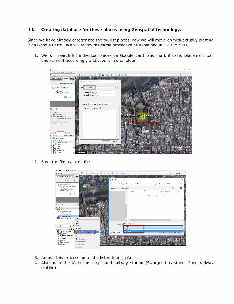
III. Creating database for these places using Geospatial technology. Since we have already categorized the tourist places, now we will move on with actually plotting it on Google Earth. We will follow the same procedure as explained in IGET_MP_001.
1. We will search for individual places on Google Earth and mark it using placemark tool and name it accordingly and save it in one folder.
2. Save the file as ‘.kml’ file
3. Repeat this process for all the listed tourist places. 4. Also mark the Main bus stops and railway station (Swarget bus stand, Pune railway
station)

IV. Adding attributes to the collected data We will find out the shortest route and the distance from each tourist place to the main bus stand and the railway station. There are two ways of calculating distances between the two points. One is Euclidean distance (As the crow flies) and second the actual distance. To calculate Euclidean distance we only need two points and the ‘Distance matrix’ will calculate the distances between the two points. For calculating actual distances on ground we will need the road layer, which will give exact route from one point to another. In this tutorial we will consider both the cases.
A. Calculating Euclidean Distances between the points.
1. Before we actually proceed with the shortest path we will convert the tourist’s places which we have saved as ‘.kml’ to ‘.shp’ so that the calculations are easier.
2. Open the ‘.kml’ file à right click and ‘Save As’ and select it as ‘Esri shapefile’ à click ‘OK’ once you have saved all your files in appropriate folders, open all the shapefiles and remove all kml layers in QGIS map window.
3. Project all the layers in projected coordinate system, in this case we will convert the shapefiles into UTM 43N. (Please refer IGET_GIS_002 for projecting the layers).
4. (If you want skip first three sections and directly want to continue from here then use the data provided with this tutorial ‘Tourist_Places’)
5. Goto Menu à Vector à Analysis tools à Distance matrix. 6. A new window will open up. Firstly we will find out distances from Pune station to evry
tourist place. So give the ‘Input point layer’ as ‘Pune_Station’ and keep ‘Input unique ID field’ as ‘Name’
7. Next select the ‘Target point layer’ as ‘Tourist places’ and ‘Target unique ID field’ as ‘Name’
8. Let the output matrix type be default as linear distance matrix.
5
6
8

IGET_CT-002 Mapping tourist centers of Pune city
7
9. Save the ‘Output distance matrix’ in appropriate folder in your local disk using ‘Browse’
10. Click ‘OK’ and the the distance matrix file will be saved as .csv file. 11. Now we will load this file in map canvas and then join it with the attribute of tourist
places. To load the file navigate to Menu à Layer à Add Layer à Add delimited text layer.
12. The new window will open up. Browse through your folders and select the previously saved .csv file.
13. Next Select ‘No geometry (attribute only table)’ from Geometry definition. And click ‘OK’
14. Table is now added to table of content list. Now we will join this table with Tourist places shapefile using ‘Name’ as an unique ID.
15. Goto properties of Tourist places à Join à Give Unique Id à click OK. (Refer the screen shot for further reference).
16. Open the attribute table of Tourist places layer and check if all the attributes are added to the table.
11
12

IGET_CT-002 Mapping tourist centers of Pune city
8
17. Repeat the same procedure for calculating distance between swarget_Bus_stand and the Tourist places.
18. Once both the distances are calculated, the attribute table of Tourist places should be as shown in the screen shot below.
19. The join which we have performed on the layer is virtual join, so we will save this layer as shapefile to keep all the joint records.
20. We can delete the attribute which are not required. So keep only the field ‘Name’ ‘Dist_rail_1’ and ‘Dist_bus_1’. Attribute table will look as follows:
21. Now we have got distance between individual tourist places and the major public
transport places. The distances calculated are in meters as the layer was in projected coordinate system.
IGET_CT-002 Mapping tourist centers of Pune city
9
B. Calculating Actual distances between the points
22. To find out shortest path between certain points we need road layer. And best possible road network available for use is ‘Open Street Map’. We can download this network using QGIS.
23. Open the Pune PMC boundary in QGIS map interface from the given data set. 24. Goto Plugins and install ‘OpenStreetMap’ plugin using search tool.
Note: To download any plugin from QGIS respesotery you will need internet connection. For more on how to connect your QGIS to internet and how to install plugins please refer ‘IGET_GIS_001’
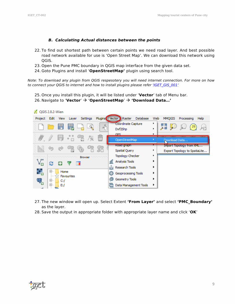
25. Once you install this plugin, it will be listed under ‘Vector’ tab of Menu bar. 26. Navigate to ‘Vector’ à ‘OpenStreetMap’ à ‘Download Data…’
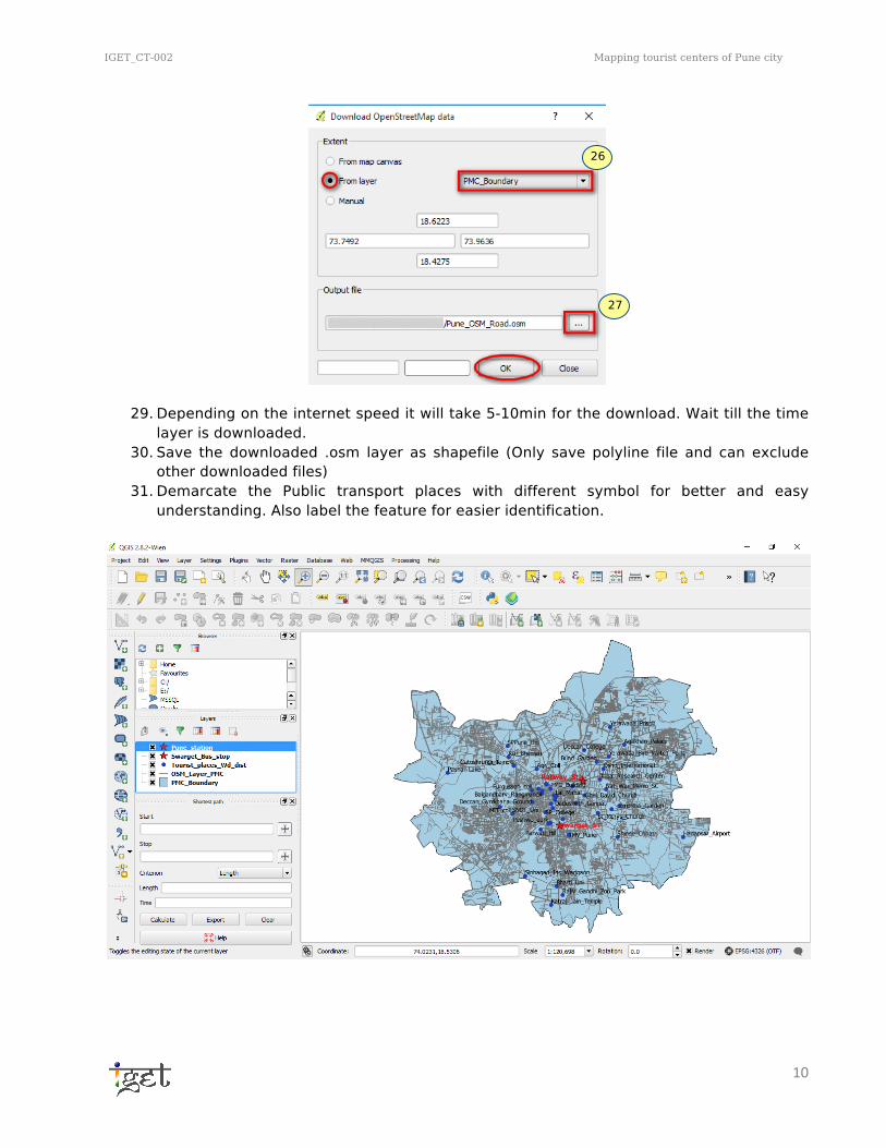
27. The new window will open up. Select Extent ‘From Layer’ and select ‘PMC_Boundary’ as the layer.
28. Save the output in appropriate folder with appropriate layer name and click ‘OK’
25
IGET_CT-002 Mapping tourist centers of Pune city
10
29. Depending on the internet speed it will take 5-10min for the download. Wait till the time layer is downloaded.
30. Save the downloaded .osm layer as shapefile (Only save polyline file and can exclude other downloaded files)
31. Demarcate the Public transport places with different symbol for better and easy understanding. Also label the feature for easier identification.
26
27
IGET_CT-002 Mapping tourist centers of Pune city
11
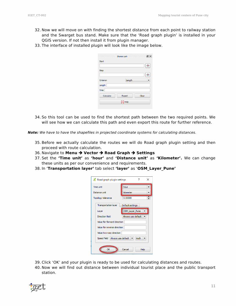
32. Now we will move on with finding the shortest distance from each point to railway station and the Swarget bus stand. Make sure that the ‘Road graph plugin’ is installed in your QGIS version. If not then install it from plugin manager.
33. The interface of installed plugin will look like the image below.
34. So this tool can be used to find the shortest path between the two required points. We
will see how we can calculate this path and even export this route for further reference. Note: We have to have the shapefiles in projected coordinate systems for calculating distances.
35. Before we actually calculate the routes we will do Road graph plugin setting and then proceed with route calculation.
36. Navigate to Menu à Vector à Road Graph à Settings 37. Set the ‘Time unit’ as ‘hour’ and ‘Distance unit’ as ‘Kilometer’. We can change
these units as per our convenience and requirements. 38. In ‘Transportation layer’ tab select ‘layer’ as ‘OSM_Layer_Pune’
39. Click ‘OK’ and your plugin is ready to be used for calculating distances and routes. 40. Now we will find out distance between individual tourist place and the public transport
station.
IGET_CT-002 Mapping tourist centers of Pune city
12
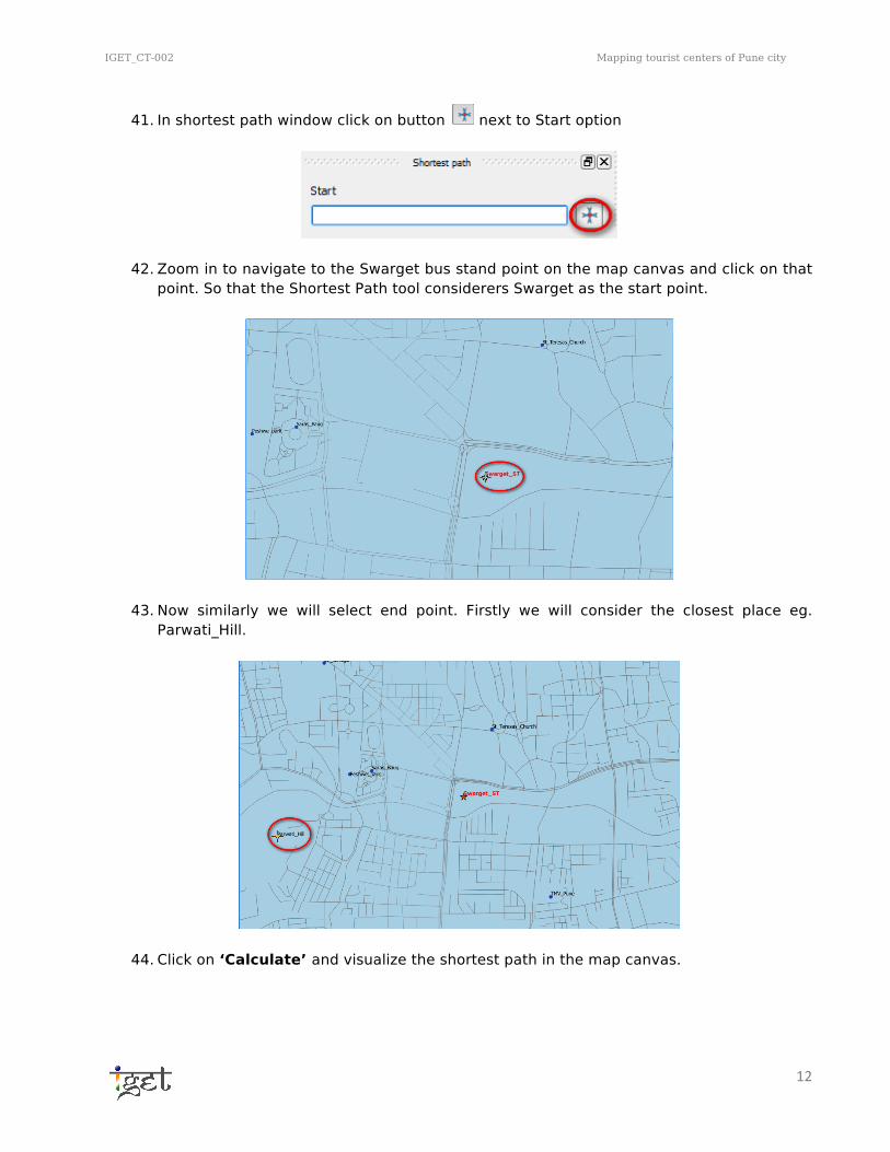
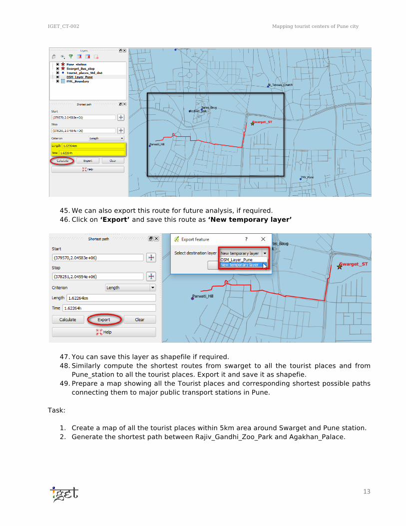
41. In shortest path window click on button next to Start option
42. Zoom in to navigate to the Swarget bus stand point on the map canvas and click on that point. So that the Shortest Path tool considerers Swarget as the start point.
43. Now similarly we will select end point. Firstly we will consider the closest place eg. Parwati_Hill.
44. Click on ‘Calculate’ and visualize the shortest path in the map canvas.
IGET_CT-002 Mapping tourist centers of Pune city
13
45. We can also export this route for future analysis, if required. 46. Click on ‘Export’ and save this route as ‘New temporary layer’
47. You can save this layer as shapefile if required. 48. Similarly compute the shortest routes from swarget to all the tourist places and from
Pune_station to all the tourist places. Export it and save it as shapefie. 49. Prepare a map showing all the Tourist places and corresponding shortest possible paths
connecting them to major public transport stations in Pune. Task:
1. Create a map of all the tourist places within 5km area around Swarget and Pune station. 2. Generate the shortest path between Rajiv_Gandhi_Zoo_Park and Agakhan_Palace.