Embed Size (px)
Citation preview
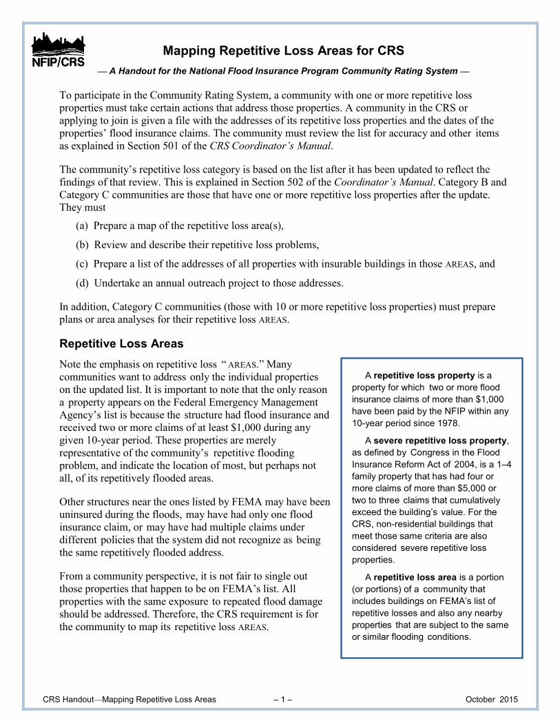
CRS Handout—Mapping Repetitive Loss Areas – 1 – October 2015
A repetitive loss property is a
property for which two or more flood
insurance claims of more than $1,000
have been paid by the NFIP within any
10-year period since 1978.
A severe repetitive loss property,
as defined by Congress in the Flood
Insurance Reform Act of 2004, is a 1–4
family property that has had four or
more claims of more than $5,000 or
two to three claims that cumulatively
exceed the building’s value. For the
CRS, non-residential buildings that
meet those same criteria are also
considered severe repetitive loss
properties.
A repetitive loss area is a portion
(or portions) of a community that
includes buildings on FEMA’s list of
repetitive losses and also any nearby
properties that are subject to the same
or similar flooding conditions.
Mapping Repetitive Loss Areas for CRS
— A Handout for the National Flood Insurance Program Community Rating System —
To participate in the Community Rating System, a community with one or more repetitive loss
properties must take certain actions that address those properties. A community in the CRS or
applying to join is given a file with the addresses of its repetitive loss properties and the dates of the
properties’ flood insurance claims. The community must review the list for accuracy and other items
as explained in Section 501 of the CRS Coordinator’s Manual.
The community’s repetitive loss category is based on the list after it has been updated to reflect the
findings of that review. This is explained in Section 502 of the Coordinator’s Manual. Category B and
Category C communities are those that have one or more repetitive loss properties after the update.
They must
(a) Prepare a map of the repetitive loss area(s),
(b) Review and describe their repetitive loss problems,
(c) Prepare a list of the addresses of all properties with insurable buildings in those AREAS, and
(d) Undertake an annual outreach project to those addresses.
In addition, Category C communities (those with 10 or more repetitive loss properties) must prepare
plans or area analyses for their repetitive loss AREAS.
Repetitive Loss Areas
Note the emphasis on repetitive loss “ AREAS.” Many
communities want to address only the individual properties
on the updated list. It is important to note that the only reason
a property appears on the Federal Emergency Management
Agency’s list is because the structure had flood insurance and
received two or more claims of at least $1,000 during any
given 10-year period. These properties are merely
representative of the community’s repetitive flooding
problem, and indicate the location of most, but perhaps not
all, of its repetitively flooded areas.
Other structures near the ones listed by FEMA may have been
uninsured during the floods, may have had only one flood
insurance claim, or may have had multiple claims under
different policies that the system did not recognize as being
the same repetitively flooded address.
From a community perspective, it is not fair to single out
those properties that happen to be on FEMA’s list. All
properties with the same exposure to repeated flood damage
should be addressed. Therefore, the CRS requirement is for
the community to map its repetitive loss AREAS.
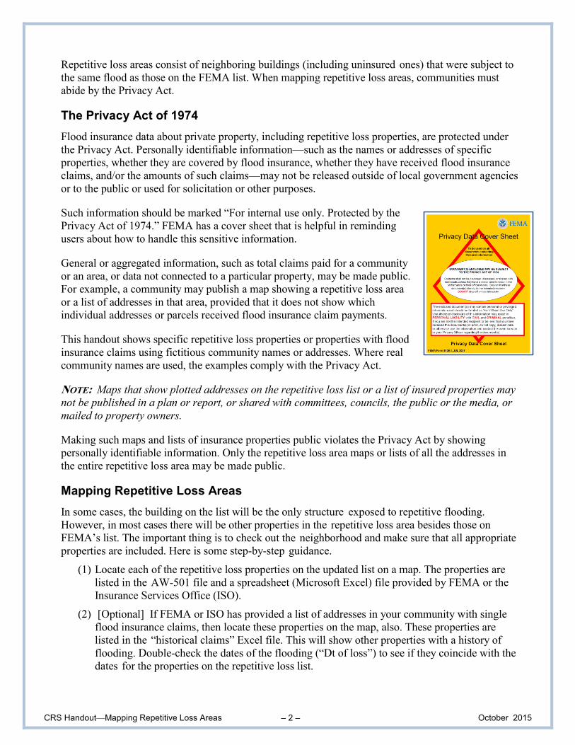
CRS Handout—Mapping Repetitive Loss Areas – 2 – October 2015
Repetitive loss areas consist of neighboring buildings (including uninsured ones) that were subject to
the same flood as those on the FEMA list. When mapping repetitive loss areas, communities must
abide by the Privacy Act.
The Privacy Act of 1974
Flood insurance data about private property, including repetitive loss properties, are protected under
the Privacy Act. Personally identifiable information—such as the names or addresses of specific
properties, whether they are covered by flood insurance, whether they have received flood insurance
claims, and/or the amounts of such claims—may not be released outside of local government agencies
or to the public or used for solicitation or other purposes.
Such information should be marked “For internal use only. Protected by the
Privacy Act of 1974.” FEMA has a cover sheet that is helpful in reminding
users about how to handle this sensitive information.
General or aggregated information, such as total claims paid for a community
or an area, or data not connected to a particular property, may be made public.
For example, a community may publish a map showing a repetitive loss area
or a list of addresses in that area, provided that it does not show which
individual addresses or parcels received flood insurance claim payments.
This handout shows specific repetitive loss properties or properties with flood
insurance claims using fictitious community names or addresses. Where real
community names are used, the examples comply with the Privacy Act.
NOTE: Maps that show plotted addresses on the repetitive loss list or a list of insured properties may
not be published in a plan or report, or shared with committees, councils, the public or the media, or
mailed to property owners.
Making such maps and lists of insurance properties public violates the Privacy Act by showing
personally identifiable information. Only the repetitive loss area maps or lists of all the addresses in
the entire repetitive loss area may be made public.
Mapping Repetitive Loss Areas
In some cases, the building on the list will be the only structure exposed to repetitive flooding.
However, in most cases there will be other properties in the repetitive loss area besides those on
FEMA’s list. The important thing is to check out the neighborhood and make sure that all appropriate
properties are included. Here is some step-by-step guidance.
(1) Locate each of the repetitive loss properties on the updated list on a map. The properties are
listed in the AW-501 file and a spreadsheet (Microsoft Excel) file provided by FEMA or the
Insurance Services Office (ISO).
(2) [Optional] If FEMA or ISO has provided a list of addresses in your community with single
flood insurance claims, then locate these properties on the map, also. These properties are
listed in the “historical claims” Excel file. This will show other properties with a history of
flooding. Double-check the dates of the flooding (“Dt of loss”) to see if they coincide with the
dates for the properties on the repetitive loss list.
CRS Handout—Mapping Repetitive Loss Areas – 3 – October 2015
(3) If you have the capability, overlay a topographic map or geographic information system (GIS)
layer to identify areas that are obviously lower in elevation than areas that do not have
repetitive claims. If the properties are in the floodplain, 100-year and 500-year floodplain
boundaries show lower areas. See Example 1 on the next page.
(4) Draw lines around those areas with similarly situated properties, i.e., subject to flooding and
lower-lying than the surrounding properties. These are your repetitive loss AREAS.
(5) Check the area(s) in the field to confirm the boundaries. If the mapping doesn’t make sense, it
may be that the repetitive loss buildings are unique. For example, they may be the only
buildings in the neighborhood on slab foundations, so they are lower than the others. See
Examples 4 and 6.
(6) In every case, a visit to the site helps confirm that the boundary makes sense. See Example 5.
(7) If these “remote” ways to determine the repetitive loss area boundary don’t explain why an
area is flooded repeatedly, you should contact the property owners. See Example 6.
(8) If you conclude that there is only one building in a repetitive loss area, be sure to document the
reasons for your conclusion. Single-property repetitive loss areas can be described in a short
narrative about the general area in which it is located. If you need to make the map public,
make sure the location of the single parcel is not shown. Also see Example 4.
(9) If you have a lot of repetitive loss properties spread throughout your community or flood
plain, you can declare your entire community or floodplain to be a repetitive loss area.
The Map the Public Sees
After you have settled on the boundaries of your repetitive loss AREAS, prepare a map that shows the
AREA boundaries THAT DOES NOT SHOW ANY INDIVIDUAL BUILDINGS (CIRCLED OR PLOTTED) FROM
FEMA’S LISTS. This map can be published or otherwise made public. “Public” includes members of a
planning committee and city council members.
To comply with the Privacy Act, make sure your list(s) of properties on FEMA’s lists and
all maps showing plots of those properties are EITHER DELETED OR STORED IN A SECURE
PLACE. You may want to keep your work maps, but keep them in a secure location, not
accessible to the public. Paper copies need the orange Privacy Act cover sheet or other
notice that the information is sensitive. Digital files can be password protected.
The Address List
After the repetitive loss areas are identified, you must prepare a list of the addresses of all improved
parcels in those areas. An improved parcel is one with an INSURABLE BUILDING on it. For CRS
purposes, an insurable building is a walled and roofed structure, principally above ground and affixed
to a permanent site, including a manufactured (mobile) home on a foundation. When in doubt, refer to
Section 301 of the Coordinator’s Manual.
For More Information
See the Coordinator’s Manual, Sections 501 through 503, or contact your ISO/CRS Specialist.
CRS Handout—Mapping Repetitive Loss Areas – 4 – October 2015
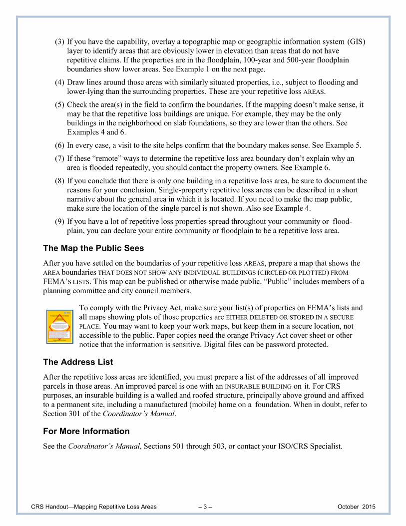
Example 1. Insurance Data and Contour Data
This community has two properties on its updated repetitive loss list, both with addresses on Water
Street. These are marked with an “RL” on the map below. They had claim payments in March 2005
and April 2011. Both dates coincide with overbank flooding on Water Creek.
Two other properties had one claim payment for the same April 2011 flood. These are marked with a
“1C” on the map.
All of the houses along Water Street are of similar construction. The community concludes that all
properties on Water Creek with buildings in or near the 500-year floodplain (shaded in grey) are
exposed to the repetitive flooding hazard, even those with no record of flood insurance claims. The
staff thought it was better to be safe and give all nearby property owners a heads-up about the potential
for repetitive flood damage. The resulting repetitive loss area line is drawn in the map below. There
are nine properties in the area.
The work map at the top of this page must be kept in a secure location (the name of the
community and the true names of the streets are not shown here). However, the community
can make the lower map public. The lower map can be used in mitigation plans, area
analyses, and other documents that can be given to planning committee members, the media,
and residents of the area. Even though the lower map shows individual houses, it does not
identify which ones received a flood insurance claim.
CRS Handout—Mapping Repetitive Loss Areas – 5 – October 2015
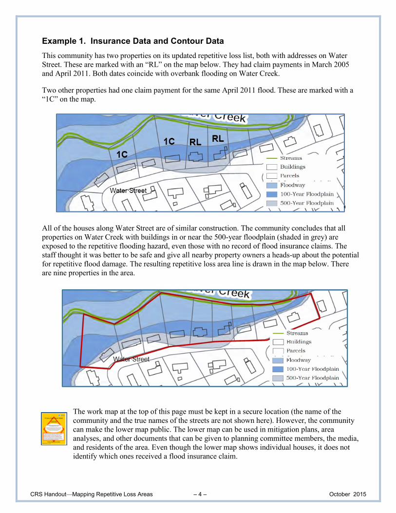
Example 2. Coordination with Complaints
This community located the properties from FEMA’s list and then added the locations of past reports
of street flooding. These reports came from public works (shown with a blue circle) and citizens’
complaints (shown with a yellow circle). When all the information was reviewed, it became obvious
that the problem was larger than the two properties on FEMA’s list.
This work map must be kept in a secure location (the name of the community and the
names of the streets are not shown here). However, the community can make the aerial
photo below public. The aerial photo can be used in mitigation plans, area analyses, and
other documents that can be given to planning committee members, the media, and
residents of the area. Even though the photo shows individual houses, it does not identify
which ones received a flood insurance claim.
CRS Handout—Mapping Repetitive Loss Areas – 6 – October 2015
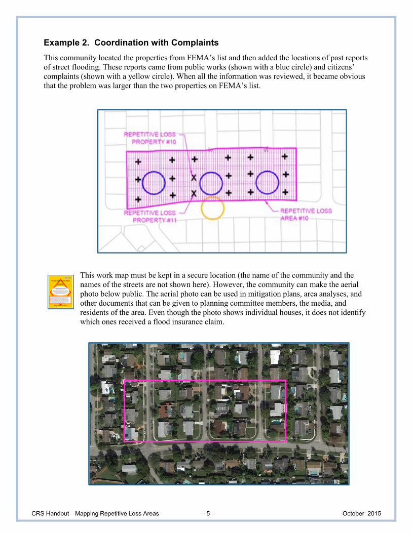
Example 3. Area Known to be Repetitively Flooded
The Richardson Subdivision is in unincorporated Kane County, Illinois, along the Fox River. It has
27 single-family homes, 24 of them constructed before floodplain management regulations took effect.
As seen in the aerial map below, it is in a position that is “asking for trouble.” The entire subdivision
is in the floodway. It has a history of yard flooding in the spring and during ice jams on the Fox.
Only one property in the subdivision is on FEMA’s repetitive loss list. Two others have received one
flood insurance claim each. Instead of trying to isolate a small area based on the claims history, the
County opted to include the entire subdivision as an official repetitive loss area (area circled in red).
The map below can be made public because it does not reveal who received a flood insurance claim.

CRS Handout—Mapping Repetitive Loss Areas – 7 – October 2015
Example 4. Contour Map Data—Single Property
The parcel at 211 North River (a made-up address) is on FEMA’s list. As seen in the aerial map,
below left, the riverfront land to the north is open space. To the south are a parking lot and several
commercial properties that are closer to North River Street and on higher ground.
The community shot the elevation of the lowest grade adjacent to the building at 211 North River. It is
613.1 feet above sea level. The GIS topographic map below shows the 100-year floodplain (in red)
and contour lines (in light green). All other buildings in the area are above the 618-foot contour line
and they have no history of flood insurance claims.
Based on this information, the community determined that 211 North River Street is a
single-property repetitive loss area. When there is only a single property in the repetitive loss
area, a community has two options for the map that will be seen by the public:
1. It does not publish a map, but uses a narrative to explain that somewhere on North River Street
there is a single-building repetitive loss area; or
2. It publishes a map at a large scale and uses a large dot, circle or some other means to show a
large area. The reader cannot tell which property in that area is the repetitive loss property. The
map below right is an example of showing two single-property repetitive loss areas with a
large enough dot that the reader cannot determine which property received the insurance
claims.
CRS Handout—Mapping Repetitive Loss Areas – 8 – October 2015
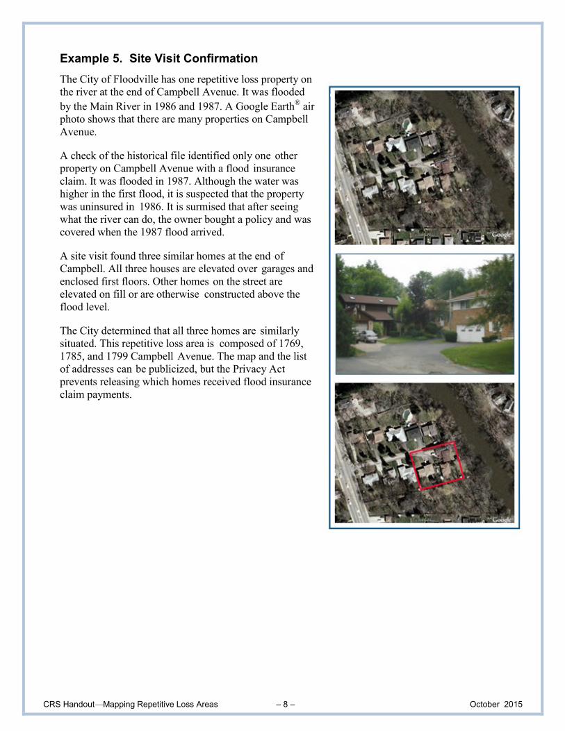
Example 5. Site Visit Confirmation
The City of Floodville has one repetitive loss property on
the river at the end of Campbell Avenue. It was flooded
by the Main River in 1986 and 1987. A Google Earth®
air
photo shows that there are many properties on Campbell
Avenue.
A check of the historical file identified only one other
property on Campbell Avenue with a flood insurance
claim. It was flooded in 1987. Although the water was
higher in the first flood, it is suspected that the property
was uninsured in 1986. It is surmised that after seeing
what the river can do, the owner bought a policy and was
covered when the 1987 flood arrived.
A site visit found three similar homes at the end of
Campbell. All three houses are elevated over garages and
enclosed first floors. Other homes on the street are
elevated on fill or are otherwise constructed above the
flood level.
The City determined that all three homes are similarly
situated. This repetitive loss area is composed of 1769,
1785, and 1799 Campbell Avenue. The map and the list
of addresses can be publicized, but the Privacy Act
prevents releasing which homes received flood insurance
claim payments.
CRS Handout—Mapping Repetitive Loss Areas – 9 – October 2015
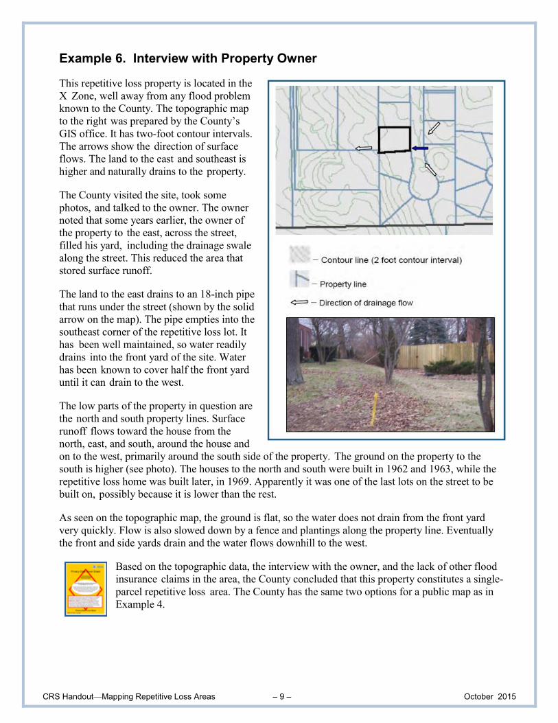
Example 6. Interview with Property Owner
This repetitive loss property is located in the
X Zone, well away from any flood problem
known to the County. The topographic map
to the right was prepared by the County’s
GIS office. It has two-foot contour intervals.
The arrows show the direction of surface
flows. The land to the east and southeast is
higher and naturally drains to the property.
The County visited the site, took some
photos, and talked to the owner. The owner
noted that some years earlier, the owner of
the property to the east, across the street,
filled his yard, including the drainage swale
along the street. This reduced the area that
stored surface runoff.
The land to the east drains to an 18-inch pipe
that runs under the street (shown by the solid
arrow on the map). The pipe empties into the
southeast corner of the repetitive loss lot. It
has been well maintained, so water readily
drains into the front yard of the site. Water
has been known to cover half the front yard
until it can drain to the west.
The low parts of the property in question are
the north and south property lines. Surface
runoff flows toward the house from the
north, east, and south, around the house and
on to the west, primarily around the south side of the property. The ground on the property to the
south is higher (see photo). The houses to the north and south were built in 1962 and 1963, while the
repetitive loss home was built later, in 1969. Apparently it was one of the last lots on the street to be
built on, possibly because it is lower than the rest.
As seen on the topographic map, the ground is flat, so the water does not drain from the front yard
very quickly. Flow is also slowed down by a fence and plantings along the property line. Eventually
the front and side yards drain and the water flows downhill to the west.
Based on the topographic data, the interview with the owner, and the lack of other flood
insurance claims in the area, the County concluded that this property constitutes a single-
parcel repetitive loss area. The County has the same two options for a public map as in
Example 4.