Embed Size (px)
Citation preview

488 SCHOOL SCIENCE AND MATHEMATICS
MAPPING BY AERIAL PHOTOGRAPHY.1BY W. H. SPURGIN,
Hyde Park High School, Chicago, III.No one, who has a most casual interest in maps, can glance
at the ground from an airplane in flight without the feeling thathe is looking at a vast colored map, which, in its wealth of de-tail of land and water, of railroads, highways and paths, offorest and cultivated ground, of buildings and towns, in itsabsolute accuracy and up-to-dateness, should be the envy anddespair of every professional map-maker. So striking is thisresemblance that it could hardly have failed to occur to balloon-is fcs years ago that a map could be very easily made with acamera.Much has been written concerning the importance of aerial
photography in the war; and the limits of this paper do notpermit of a full discussion of that topic, interesting though itmight prove. Yet, since fche science of aerial photographicmapping owes by far the greater part of its growth to the war,we must glance for a moment at some of the uses to which itwas put.The Germans seem to have started using hand-held cameras
early in the -war with, of course, no attempt at systematic map-ping, but these were quite unsatisfactory, largely because theleather bellows caved in under the strong air currents, and soona metal camera with fixed focus and focal plane shutter wasdevised and attached to the fuselage. Plates were carried inmagazines, and exposures and changes of plates made by hand.Development was rapid to a highly perfected type, using rollfilms, kept flat by suction, and capable, when adjusted foraltitude and speed and set in motion, of making automatically100 successive exposures at any desired time interval, the powerfor operation being supplied by a small fan propeller workinglike a wind-mill.
Complete photographic maps of the zone of activity formedthe basis of operations in each sector, and squadrons of recon-naissance planes were employed keeping them up to date. Intime of great activity large sections would be re-photographedevery day, while particular points might be photographed everytwo or three hours, and the series carefully studied for anychanges. Nofc only were these photographs extensively used at^Read before the Earth Science Section of the Central Association of Science and Mathe-
matics Teachers. November 29. 1919.
AERIAL PHOTOGRAPHY 489
headquarters, but copies were given to infantry officers whenan attack was planned, and to the artillery for checking up theeffect of their fire. Photographic expeditions were carried farback into the enemy territory for the purpose of mapping linesof communication, camps, ammunition and supply dumps, fly-ing fields,, and the like. The occasional value of a single photo-graph is seen when we are told that on one occasion twelveFrench planes, carrying twelve pilots and twelve observers weredispatched at 15-minute intervals in an attempt to obtain onepicture. Perhaps we should notice, before leaving this topic,that accurate base maps were continually used as a basis for,and a check upon, the photographic maps, they not being ofsufficient accuracy otherwise.The range of a flyers vision is perhaps not commonly realized.
By applying the theorem of the secant and its external segmentas related to the tangent we find that, at an elevation of onemile, the horizon, in comparatively flat country, is 89 milesdistant, and that that distance increases as the square root ofthe altitude. Thus, on a perfectly clear day a flyer 6500 feetabove Lansing, Michigan, could easily see portions of L. Mich-igan, L. Huron, and L. Erie; while if Rohlf, on his record alti-tude flight last September, of 34,610 feet, had been over LakeHuron he could actually have seen in one sweeping glance allof Lakes Huron and Erie, more than half of Lakes Michiganand Ontario, and a considerable portion of Lake Superior.
. The area included within a single photograph depends, ofcourse, upon the altitude, the focal length of the lens, and thearea of the plate. While lenses of 48-in. focal length were usedwhere a detailed view of some object such as an enemy batterywas desired, and anti-aircraft guns made considerable altitudenecessary, the most satisfactory lens for general mapping wasthe 10-inch. With this lens, and an elevation of 10,000 feetthe image is approximately on the scale of 1-12,000. An 8xl0-in.;plate, then, would cover an area about 2 miles long and 1.6miles wide. When a continuous map of a laiger area is desiredthe pilot flies in a straight line, taking pains to retain the samealtitude, and to keep the plane horizontal to avoid distortion,while the observer makes exposures at an interval calculated togive 1-4 to 1-3 overlap. The prints are then carefully matchedand pasted together, forming a mosaic. As many stiips as arenecessary may be photographed in this way and a completemap built up of any desired area.Very little aerial mapping has been done in this country.
490 SCHOOL SCIENCE AND MATHEMATICS
During the war a few such maps were prepared by photographicunits in training, the largest being of the vicinity of Ft. Sill,covering an area about 35 miles by 10 miles. Another, some-what smaller, but of more interest to geographers, covered aportion of the alluvial fan region of Southern California. Thework of mapping routes connecting the various flying fields wasstarted but not completed. During the past summer a squadronwas engaged in making a mosaic 20 miles wide of the routebetween Oklahoma City "and Fort Sill, a distance of 80 miles.30,000 plates will be exposed, and the completed map will be onthe scale of about 1 foot to the mile. Another squadron ismapping coast-to-coast aerial routes.
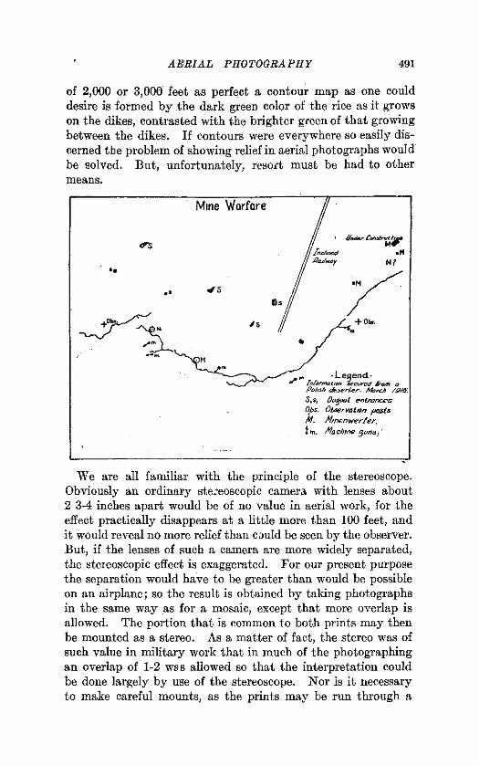
It may seem at fust thought that an aerial photograph, takenfrom vertically overhead might be held in any position forstudy. In this picture (see insert), the trench system runsalong a pronounced crescent-shaped ridge; in front, a row ofmine craters; behind, dirt thrown out from dugouts, and downthe slope. If we turn the picture upside down I think you willobserve a persistent attempt on the part of the trenches todisguise themselves as stone fences in a valley, while the minecraters and shell holes are neatly turned wrong side out. Theexplanation of the reversal of slopes seems to lie in the fact thatin all of our experience with photographs of landscapes, as wellas with landscapes themselves, the shadows fall, in general,down. If a picture is held so that the shadows fall up ourmind refuses to accept the new situation and insists upon in-terpreting the slopes in such a way as to fit our pre-conceivednotions of downward-falling shadows. The same effect maysometimes be seenon an ordinary terrestrial landscape view, par-ticularly if it has well defined shadows and no prominent artificialobjects.
Perhaps some of my hearers have been struck by the apparentflatness of the country in aerial photographs. It is true thatall relief disappears at a comparatively low elevation unless thesun is at such a low angle as to bring it out by shadows. Muchmay be inferred from .the course of roads and railroads, fromthe direction of plowing where contour plowing is followed, andfrom the streams, but nothing definite as to elevations. Thewriter spent the greater part of the summer of 1918 at EbertsField in the lice district of Arkansas. The land is extremelylevel, but still the rice-growers find it necessary to throw updikes along the contour of the suiface t) retain the standingwater on the growing rice. When viewed from an elevation


AERIAL PHOTOGRAPHY 491
of 2,000 or 3,000 feet as perfect a contour map as one coulddesire is formed by the dark green color of the rice as it growson the dikes, contrasted with the brighter green of that growingbetween the dikes. If contours were everywhere so easily dis-cerned the problem of showing relief in aerial photographs wouldbe solved. But, unfortunately, resort must be had to othermeans.
We are all familiar with the principle of the stereoscope.Obviously an ordinary stereoscopic camera with lenses about2 3-4 inches apart would be of no value in aerial work, for theeffect practically disappears at a little more than 100 feet, andit would reveal no more relief than could be seen by the observer.But, if the lenses of such a camera are more widely separated,the steieoscopic effect is exaggerated. For our present purposethe separation would have to be greater than would be possibleon an airplane; so the result is obtained by taking photographsin the same way as for a mosaic, except that more overlap isallowed. The portion that is common to both prints may thenbe mounted as a stereo. As a matter of fact, the stereo was ofsuch value in military work that in much of the photographingan overlap of 1-2 was allowed so that the interpretation couldbe done largely by use of the stereoscope. Nor is it necessaryto make careful mounts, as the prints may be run through a

492 SCHOOL SCIENCE AND MATHEMATICS
cardboard with slits and quickly adjusted for any particularobject. One or two examples will serve to illustrate the use ofsteieos in the war. Shell holes were frequently covered overwith camouflage to conceal machine gun or battery positions.While these particular shell holes looked no different from othersin an ordinary view, they immediately became conspicuous ina stereoscopic view by reason of their lack of depth.The most striking thing about aerial stereos is the great exag-
geration of the relief. Ordinary houses assume the proportionsof skyscrapers, box-cars of grain elevators, and ordinary treesof palm trees. The rule was given that views intended for thispurpose should be taken at an interval of 1-8 the altitude, but’a greater or less interval merely increases or decreases the stereo--scopic effect. Interchanging the right and left sides of a storedchanges all elevations into depressions and we have the effect,of looking into the plaster casts of the buildings. . .
;
We may now turn our attention to the future of this new art.May we accept at their face value the claims of the most ardentsupporters of aerial mapping to the effect that it is soon todisplace all other methods of mapping? There can be no ques-tion that, for completeness of detail (apart from relief) the aerialphotograph leaves little to be desired. Nor can we conceive ofa,ny other method whereby all this detail could be obtainedWith anything like the ease and speed. But, desiiable as thesefeatures are in themselves, the first thing to consider in anysystem of mapping is accuracy, and here we open the door fora host of disturbing factors.
Let us look first at the physical difficulties involved in secur-ing the picture. The camera is more or less rigidly attachedto the fuselage which necessitates that the plane, at the momentof exposure, be perfectly horizontal; otherwise, the plate willnot be parallel with the ground, and distortion will result.Furthermore, in making a mosaic, all the exposures must be made,at exactly the same altitude. Both of these conditions call forvery skillful piloting. To be sure, pictures taken at differingaltitudes may be enlarged or reduced to the same scale, andeven those taken at an angle may be rectified, but that requiresan accurate base map of the region. Some device may bedeveloped which will retain the camera in its proper positionregardless of the attitude of the plane, but we must bear inmind the instability of the support itself. The use of small,dirigibles instead of airplanes would to some extent obviate:
AERIAL PHOTOGRAPHY 493
this difficulty by reason of their ability to hover over a point,thus enabling the observer to work more leisurely.
Again, a low altitude requires either a wide angle lens to coverterritory, or a much larger number of exposures. But highaltitudes, above 10,000 feet for instance, involve temperaturechanges which are likely to ^disturb the focus and retard theaction of the moving parts.Fog and haze are a hindrance, but the use of color sensitized
plates and color screens, which weie developed by the Bureauof Standards during the war, have wonderfully reduced thisdifficulty.The focal plane shutter introduces another error which may
not be disregarded. This arises from the fact that the plateis not all exposed at once, which causes an elongation in thedirection of flight.
Let us suppose, however, that by one device or another thesetechnical difficulties have been surmounted. Certain inherentweaknesses still remain. In a hilly region the hillfcops, beingnearer the camera, will photograph larger. Thus, if the camerais 10,000 feet above a valley, and a neighboring hilltop is 2,000feet above the same valley, the lengths of the images of equaldistances on the two will be in the ratio of 8-10. Furthermore,hills not in the center of the picture will appear to lean awayfrom the center, particularly so with wider angle lenses, andmore noticeably so the farther away from the center.
In view of these shortcomings it seems quite certain thatwhere accuracy, say of one part in 10,000, is a requirement,photographic mapping cannot supplant the more laboriousmebhods. But that does not mean that it may not become avery valuable aid to these established methods. Given a basemap with a sufficient number of control points, cultural detailmay be gathered with amazing speed, completeness, and ease.Scarcely forty per cent of the area of the United States has beensatisfactorily mapped. Surely much of the detail of the re-maining work may be obtained from the air. Old maps maybe brought and kept up to date; Changing coast lines mayb^ mapped with sufficient accuracy and as frequently as neces-sary, or may ba roughly surveyed to determine whether re-mapping is needed. It is even possible that the configurationof the bottoms of shallow bodies of water may be evidenced byvarying shades, although the extent to which this will be pos-sible is somewhat uncertain. Difficultly accessible regions, such
494 SCHOOL SCIENCE AND MATHEMATICS
as swamps, may be mapped approximately. Preliminary sur-veys may be made of unmapped areas which will serve untilaccurate base maps can be prepared and the aerial map maythen be transferred and corrected.One of the oil companies which has large holdings in British
Columbia had spent a considerable"sum exploring a mountainousregion in search of a pass through which a pipe line might be run.A year ago they were considering making an aerial survey.Whether the plan was carried out I am unable to state.
Considerable stand of wood-pulp timber was located duringthe past summer in and west of Labrador by an aeiial recon-noissance party. Some 13,000 plates were exposed.Those of you who have seen the stereos will realize that even
topography may be sketched in roughly. It has been sug-gested that conspicuous monuments of known height might beerected over the region to be mapped, which would serve asstandards. Instruments which have been in use in connectionwith stereoscopic mapping of some of our western mountainsmay then be used to determine the elevations of conspicuouspoints by measuring the stereoscopic effect, and the contoursthen sketched in.
Perhaps no more appropriate use could be found for the aerialcamera than the mapping of air routes. One could ask for nobetter map of the country over which he is to fly than its picture.Nor would be be concerned with absolute accuracy. And thereseems to be good reason for believing that air travel, on a com-mercial basis, will be largely confined fco fairly definite lanes inorder to take advantage of established landing fields. Here,certainly, photographic mapping has a field which is peculiarlyits own, and a future which is limited only by the future develop-ment of aerial navigation.
THE GREAT POTASH DEPOSITS OF GERMANY.The potash deposits of Germany, which were discovered by the Prus-
sian Government in 1843, at Stassfurt, while boring for rock salt andwhich occur in upper layers of rock salt in the plains of northern Germany,have been estimated to occupy a volume of 10,790,000,000 cubic metersand to contain 20,000,000,000 metric tons of potash salts, correspondingto about 2,000,000,000 metric tons of potash (E^O), a quantity sufficientto supply the world for 2,000 years at the present rate of consumption.These beds, according to the United States Geological Survey, Depart-ment of the Interior, were first exploited about 1860, and have furnishedpractically the entire world’s supply of potash for many years.�[U. S.Geological Survey.