Embed Size (px)
Citation preview
Destino Tierra del Fuego//Patagonia
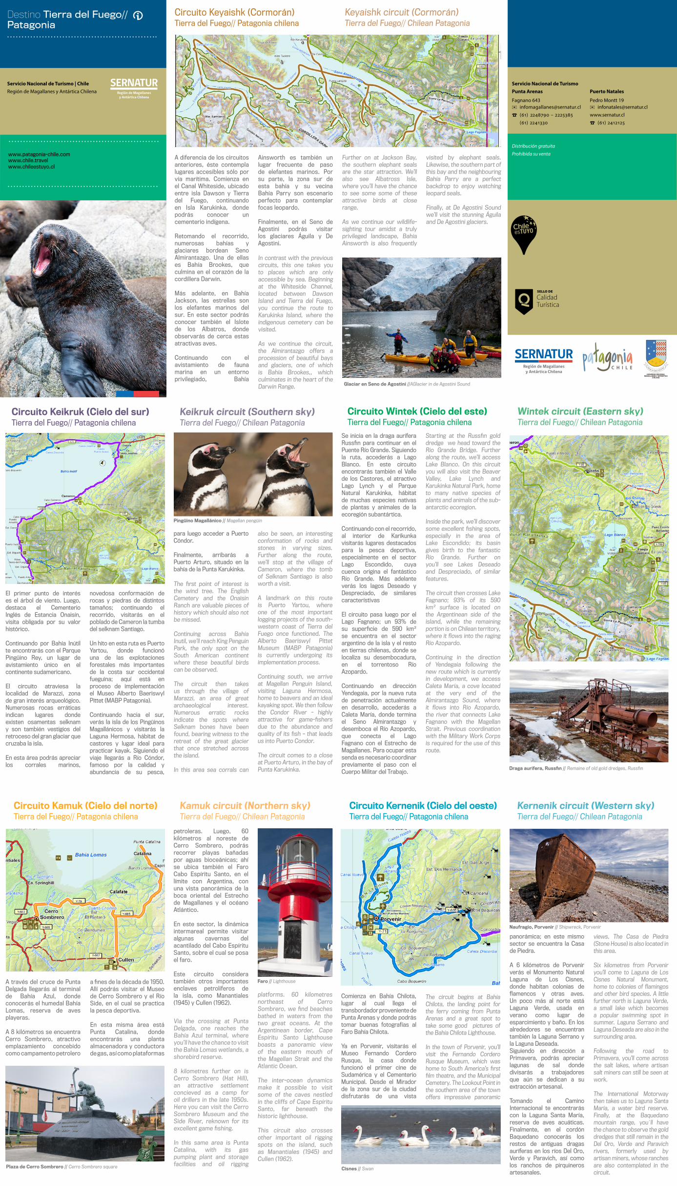
Circuito Keyaishk (Cormorán)Tierra del Fuego// Patagonia chilena
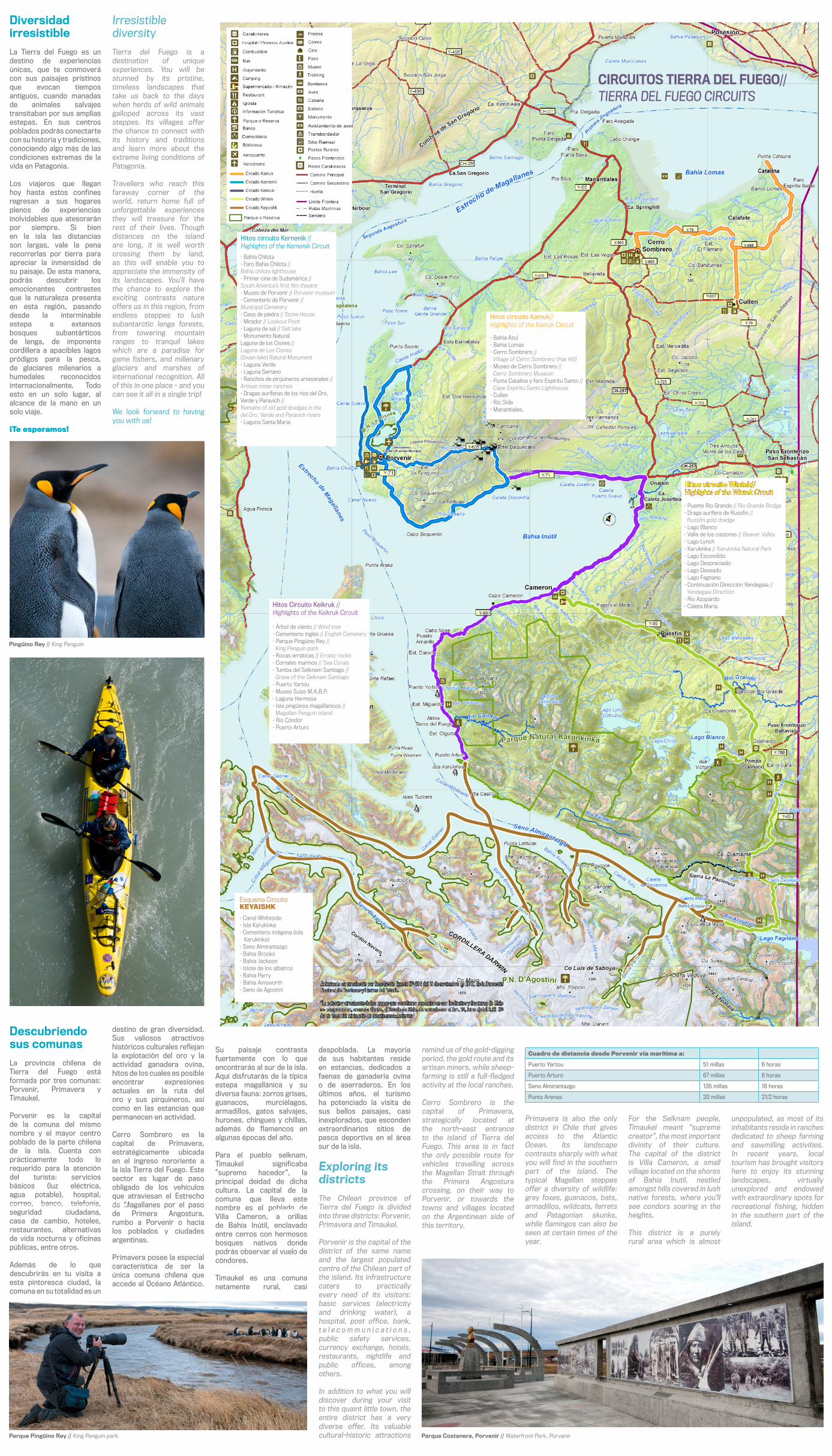
El primer punto de interés es el árbol de viento. Luego, destaca el Cementerio Inglés de Estancia Onaisín, visita obligada por su valor histórico.
Continuando por Bahía Inútil te encontrarás con el Parque Pingüino Rey, un lugar de avistamiento único en el continente sudamericano.
El circuito atraviesa la localidad de Marazzi, zona de gran interés arqueológico. Numerosas rocas erráticas indican lugares donde existen osamentas selknam y son también vestigios del retroceso del gran glaciar que cruzaba la isla.
En esta área podrás apreciar los corrales marinos,
novedosa conformación de rocas y piedras de distintos tamaños; continuando el recorrido, visitarás en el poblado de Cameron la tumba del selknam Santiago. Un hito en esta ruta es Puerto Yartou, donde funcionó una de las explotaciones forestales más importantes de la costa sur occidental fueguina; aquí está en proceso de implementación el Museo Alberto Baeriswyl Pittet (MABP Patagonia).
Continuando hacia el sur, verás la isla de los Pingüinos Magallánicos y visitarás la Laguna Hermosa, hábitat de castores y lugar ideal para practicar kayak. Siguiendo el viaje llegarás a Río Cóndor, famoso por la calidad y abundancia de su pesca,
a fines de la década de 1950. Allí podrás visitar el Museo de Cerro Sombrero y el Río Side, en el cual se practica la pesca deportiva.
En esta misma área está Punta Catalina, donde encontrarás una planta almacenadora y conductora de gas, así como plataformas
Comienza en Bahía Chilota, lugar al cual llega el transbordador proveniente de Punta Arenas y donde podrás tomar buenas fotografías al Faro Bahía Chilota.
Ya en Porvenir, visitarás el Museo Fernando Cordero Rusque, la casa donde funcionó el primer cine de Sudamérica y el Cementerio Municipal. Desde el Mirador de la zona sur de la ciudad disfrutarás de una vista
panorámica; en este mismo sector se encuentra la Casa de Piedra.
A 6 kilómetros de Porvenir verás el Monumento Natural Laguna de Los Cisnes, donde habitan colonias de flamencos y otras aves. Un poco más al norte está Laguna Verde, usada en verano como lugar de esparcimiento y baño. En los alrededores se encuentran también la Laguna Serrano y la Laguna Deseada. Siguiendo en dirección a Primavera, podrás apreciar lagunas de sal donde divisarás a trabajadores que aún se dedican a su extracción artesanal.
Tomando el Camino Internacional te encontrarás con la Laguna Santa María, reserva de aves acuáticas. Finalmente, en el cordón Baquedano conocerás los restos de antiguas dragas auríferas en los ríos Del Oro, Verde y Paravich, así como los ranchos de pirquineros artesanales.
A través del cruce de Punta Delgada llegarás al terminal de Bahía Azul, donde conocerás el humedal Bahía Lomas, reserva de aves playeras.
A 8 kilómetros se encuentra Cerro Sombrero, atractivo emplazamiento concebido como campamento petrolero
petroleras. Luego, 60 kilómetros al noreste de Cerro Sombrero, podrás recorrer playas bañadas por aguas bioceánicas; ahí se ubica también el Faro Cabo Espíritu Santo, en el límite con Argentina, con una vista panorámica de la boca oriental del Estrecho de Magallanes y el océano Atlántico.
En este sector, la dinámica intermareal permite visitar algunas cavernas del acantilado del Cabo Espíritu Santo, sobre el cual se posa el faro.
Este circuito considera también otros importantes enclaves petrolíferos de la isla, como Manantiales (1945) y Cullen (1962).
para luego acceder a Puerto Cóndor.
Finalmente, arribarás a Puerto Arturo, situado en la bahía de la Punta Karukinka.
www.chile.travelwww.patagonia-chile.com
www.chileestuyo.cl
Via the crossing at Punta Delgada, one reaches the Bahía Azul terminal, where you’ll have the chance to visit the Bahía Lomas wetlands, a shorebird reserve.
8 kilometres further on is Cerro Sombrero (Hat Hill), an attractive settlement concieved as a camp for oil drillers in the late 1950s. Here you can visit the Cerro Sombrero Museum and the Side River, reknown for its excellent game fishing.
In this same area is Punta Catalina, with its gas pumping plant and storage facilities and oil rigging
platforms. 60 kilometres northeast of Cerro Sombrero, we find beaches bathed in waters from the two great oceans. At the Argentinean border, Cape Espíritu Santo Lighthouse boasts a panoramic view of the eastern mouth of the Magellan Strait and the Atlantic Ocean.
The inter-ocean dynamics make it possible to visit some of the caves nestled in the cliffs of Cape Espíritu Santo, far beneath the historic lighthouse.
This circuit also crosses other important oil rigging spots on the island, such as Manantiales (1945) and Cullen (1962).
The circuit begins at Bahía Chilota, the landing point for the ferry coming from Punta Arenas and a great spot to take some good pictures of the Bahía Chilota Lighthouse.
In the town of Porvenir, you’ll visit the Fernando Cordero Rusque Museum, which was home to South America’s first film theatre, and the Municipal Cemetery. The Lookout Point in the southern area of the town offers impressive panoramic
The first point of interest is the wind tree. The English Cemetery and the Onaisin Ranch are valuable pieces of history which should also not be missed.
Continuing across Bahía Inutil, we’ll reach King Penguin Park, the only spot on the South American continent where these beautiful birds can be observed.
The circuit then takes us through the village of Marazzi, an area of great archaeological interest. Numerous erratic rocks indicate the spots where Selknam bones have been found, bearing witness to the retreat of the great glacier that once stretched across the island.
In this area sea corrals can
also be seen, an interesting conformation of rocks and stones in varying sizes. Further along the route, we’ll stop at the village of Cameron, where the tomb of Selknam Santiago is also worth a visit. A landmark on this route is Puerto Yartou, where one of the most important logging projects of the south-western coast of Tierra del Fuego once functioned. The Alberto Baeriswyl Pittet Museum (MABP Patagonia) is currently undergoing its implementation process.
Continuing south, we arrive at Magellan Penguin Island, visiting Laguna Hermosa, home to beavers and an ideal kayaking spot. We then follow the Condor River - highly attractive for game-fishers due to the abundance and quality of its fish – that leads us into Puerto Condor.
The circuit comes to a close at Puerto Arturo, in the bay of Punta Karukinka.
Se inicia en la draga aurífera Russfin para continuar en el Puente Río Grande. Siguiendo la ruta, accederás a Lago Blanco. En este circuito encontrarás también el Valle de los Castores, el atractivo Lago Lynch y el Parque Natural Karukinka, hábitat de muchas especies nativas de plantas y animales de la ecoregión subantártica.
Continuando con el recorrido, al interior de Karikunka visitarás lugares destacados para la pesca deportiva, especialmente en el sector Lago Escondido, cuya cuenca origina el fantástico Río Grande. Más adelante verás los lagos Deseado y Despreciado, de similares característivas
El circuito pasa luego por el Lago Fagnano; un 93% de su superficie de 590 km² se encuentra en el sector argentino de la isla y el resto en tierras chilenas, donde se localiza su desembocadura, en el torrentoso Río Azopardo.
Continuando en dirección Yendegaia, por la nueva ruta de penetración actualmente en desarrollo, accederás a Caleta María, donde termina el Seno Almirantazgo y desemboca el Río Azopardo, que conecta el Lago Fagnano con el Estrecho de Magallanes. Para ocupar esta senda es necesario coordinar previamente el paso con el Cuerpo Militar del Trabajo.
Starting at the Russfin gold dredge we head toward the Rio Grande Bridge. Further along the route, we’ll access Lake Blanco. On this circuit you will also visit the Beaver Valley, Lake Lynch and Karukinka Natural Park, home to many native species of plants and animals of the sub-antarctic ecoregion.
Inside the park, we’ll discover some excellent fishing spots, especially in the area of Lake Escondido; its basin gives birth to the fantastic Río Grande. Further on you’ll see Lakes Deseado and Despreciado, of similar features.
The circuit then crosses Lake Fagnano; 93% of its 590 km² surface is located on the Argentinean side of the island, while the remaining portion is on Chilean territory, where it flows into the raging Río Azopardo.
Continuing in the direction of Yendegaia following the new route which is currently in development, we access Caleta María, a cove located at the very end of the Almirantazgo Sound, where it flows into Río Azopardo, the river that connects Lake Fagnano with the Magellan Strait. Previous coordination with the Military Work Corps is required for the use of this route.
A diferencia de los circuitos anteriores, éste contempla lugares accesibles sólo por vía marítima. Comienza en el Canal Whiteside, ubicado entre isla Dawson y Tierra del Fuego, continuando en Isla Karukinka, donde podrás conocer un cementerio indígena. Retomando el recorrido, numerosas bahías y glaciares bordean Seno Almirantazgo. Una de ellas es Bahía Brookes, que culmina en el corazón de la cordillera Darwin.
Más adelante, en Bahía Jackson, las estrellas son los elefantes marinos del sur. En este sector podrás conocer también el Islote de los Albatros, donde observarás de cerca estas atractivas aves.
Continuando con el avistamiento de fauna marina en un entorno privilegiado, Bahía
Ainsworth es también un lugar frecuente de paso de elefantes marinos. Por su parte, la zona sur de esta bahía y su vecina Bahía Parry son escenario perfecto para contemplar focas leopardo.
Finalmente, en el Seno de Agostini podrás visitar los glaciares Águila y De Agostini.
In contrast with the previous circuits, this one takes you to places which are only accessible by sea. Beginning at the Whiteside Channel, located between Dawson Island and Tierra del Fuego, you continue the route to Karukinka Island, where the indigenous cemetery can be visited.
As we continue the circuit, the Almirantazgo offers a procession of beautiful bays and glaciers, one of which is Bahía Brookes,, which culminates in the heart of the Darwin Range.
Further on at Jackson Bay, the southern elephant seals are the star attraction. We’ll also see Albatross Isle, where you’ll have the chance to see some some of these attractive birds at close range.
As we continue our wildlife-sighting tour amidst a truly privileged landscape, Bahía Ainsworth is also frequently
visited by elephant seals. Likewise, the southern part of this bay and the neighbouring Bahía Parry are a perfect backdrop to enjoy watching leopard seals.
Finally, at De Agostini Sound we’ll visit the stunning Águila and De Agostini glaciers.
Keyaishk circuit (Cormorán)Tierra del Fuego// Chilean Patagonia
Glaciar en Seno de Agostini //AGlacier in de Agostini Sound
Circuito Keikruk (Cielo del sur)Tierra del Fuego// Patagonia chilena
Keikruk circuit (Southern sky)Tierra del Fuego// Chilean Patagonia
Pingüino Magallánico // Magellan pengüin
Circuito Wintek (Cielo del este)Tierra del Fuego// Patagonia chilena
Wintek circuit (Eastern sky)Tierra del Fuego// Chilean Patagonia
Draga aurifera, Russfin // Remaine of old gold dredges, Russfin
Circuito Kamuk (Cielo del norte)Tierra del Fuego// Patagonia chilena
Kamuk circuit (Northern sky)Tierra del Fuego// Chilean Patagonia
Plaza de Cerro Sombrero // Cerro Sombrero square
Faro // Lighthouse
Circuito Kernenik (Cielo del oeste)Tierra del Fuego// Patagonia chilena
Kernenik circuit (Western sky)Tierra del Fuego// Chilean Patagonia
Cisnes // Swan
Naufragio, Porvenir // Shipwreck, Porvenir
views. The Casa de Piedra (Stone House) is also located in this area.
Six kilometres from Porvenir you’ll come to Laguna de Los Cisnes Natural Monument, home to colonies of flamingos and other bird species. A little further north is Laguna Verde, a small lake which becomes a popular swimming spot in summer. Laguna Serrano and Laguna Deseada are also in the surrounding area.
Following the road to Primavera, you’ll come across the salt lakes, where artisan salt miners can still be seen at work.
The International Motorway then takes us to Laguna Santa María, a water bird reserve. Finally, at the Baquedano mountain range, you`ll have the chance to observe the gold dredges that still remain in the Del Oro, Verde and Paravich rivers, formerly used by artisan miners, whose ranches are also contemplated in the circuit.
Servicio Nacional de Turismo | ChileRegión de Magallanes y Antártica Chilena
Distribución gratuitaProhibida su venta
Puerto Natales
✉ [email protected] www.sernatur.cl
☎
Servicio Nacional de TurismoPunta Arenas
☎
Fagnano 643 Pedro Montt 19
Descubriendo sus comunas
La provincia chilena de Tierra del Fuego está formada por tres comunas: Porvenir, Primavera y Timaukel.
Porvenir es la capital de la comuna del mismo nombre y el mayor centro poblado de la parte chilena de la isla. Cuenta con prácticamente todo lo requerido para la atención del turista: servicios básicos (luz eléctrica, agua potable), hospital, correo, banco, telefonía, seguridad ciudadana, casa de cambio, hoteles, restaurantes, alternativas de vida nocturna y oficinas públicas, entre otros.
Además de lo que descubrirás en tu visita a esta pintoresca ciudad, la comuna en su totalidad es un
Hitos circuito Kamuk//
Hitos circuito Kernenik //
Hitos Circuito Keikruk //
Hitos circuito Wintek//Highlights of the Wintek Circuit
KEYAISHK
Diversidadirresistible
La Tierra del Fuego es un destino de experiencias únicas, que te conmoverá con sus paisajes prístinos que evocan tiempos antiguos, cuando manadas de animales salvajes transitaban por sus amplias estepas. En sus centros poblados podrás conectarte con su historia y tradiciones, conociendo algo más de las condiciones extremas de la vida en Patagonia.
Los viajeros que llegan hoy hasta estos confines regresan a sus hogares plenos de experiencias inolvidables que atesorarán por siempre. Si bien en la isla las distancias son largas, vale la pena recorrerlas por tierra para apreciar la inmensidad de su paisaje. De esta manera, podrás descubrir los emocionantes contrastes que la naturaleza presenta en esta región, pasando desde la interminable estepa a extensos bosques subantárticos de lenga, de imponente cordillera a apacibles lagos pródigos para la pesca, de glaciares milenarios a humedales reconocidos internacionalmente. Todo esto en un solo lugar, al alcance de la mano en un solo viaje.
¡Te esperamos!
destino de gran diversidad. Sus valiosos atractivos históricos culturales reflejan la explotación del oro y la actividad ganadera ovina, hitos de los cuales es posible encontrar expresiones actuales en la ruta del oro y sus pirquineros, así como en las estancias que permanecen en actividad.
Cerro Sombrero es la capital de Primavera, estratégicamente ubicada en el ingreso nororiente a la isla Tierra del Fuego. Este sector es lugar de paso obligado de los vehículos que atraviesan el Estrecho de Magallanes por el paso de Primera Angostura, rumbo a Porvenir o hacia los poblados y ciudades argentinas.
Primavera posee la especial característica de ser la única comuna chilena que accede al Océano Atlántico.
Su paisaje contrasta fuertemente con lo que encontrarás al sur de la isla. Aquí disfrutarás de la típica estepa magallánica y su diversa fauna: zorros grises, guanacos, murciélagos, armadillos, gatos salvajes, hurones, chingues y chillas, además de flamencos en algunas épocas del año.
Para el pueblo selknam, Timaukel significaba ”supremo hacedor”, la principal deidad de dicha cultura. La capital de la comuna que lleva este nombre es el poblado de Villa Cameron, a orillas de Bahía Inútil, enclavado entre cerros con hermosos bosques nativos donde podrás observar el vuelo de cóndores.
Timaukel es una comuna netamente rural, casi
despoblada. La mayoría de sus habitantes reside en estancias, dedicados a faenas de ganadería ovina o de aserraderos. En los últimos años, el turismo ha potenciado la visita de sus bellos paisajes, casi inexplorados, que esconden extraordinarios sitios de pesca deportiva en el área sur de la isla.
Exploring its districts
The Chilean province of Tierra del Fuego is divided into three districts: Porvenir, Primavera and Timaukel.
Porvenir is the capital of the district of the same name and the largest populated centre of the Chilean part of the island. Its infrastructure caters to practically every need of its visitors: basic services (electricity and drinking water), a hospital, post office, bank, t e l e c o m m u n i c a t i o n s , public safety services, currency exchange, hotels, restaurants, nightlife and public offices, among others.
In addition to what you will discover during your visit to this quaint little town, the entire district has a very diverse offer. Its valuable cultural-historic attractions
Cuadro de distancia desde Porvenir vía marítima a:
Puerto Yartou 51 millas 6 horas
Puerto Arturo 67 millas 8 horas
Seno Almirantazgo 135 millas 18 horas
Punta Arenas 20 millas 21/2 horas
Irresistiblediversity
Tierra del Fuego is a destination of unique experiences. You will be stunned by its pristine, timeless landscapes that take us back to the days when herds of wild animals galloped across its vast steppes. Its villages offer the chance to connect with its history and traditions and learn more about the extreme living conditions of Patagonia.
Travellers who reach this faraway corner of the world, return home full of unforgettable experiences they will treasure for the rest of their lives. Though distances on the island are long, it is well worth crossing them by land, as this will enable you to appreciate the immensity of its landscapes. You’ll have the chance to explore the exciting contrasts nature offers us in this region, from endless steppes to lush subantarctic lenga forests, from towering mountain ranges to tranquil lakes which are a paradise for game fishers, and millenary glaciers and marshes of international recognition. All of this in one place - and you can see it all in a single trip!
We look forward to having you with us!
Pingüino Rey // King Penguin
remind us of the gold-digging period, the gold route and its artisan miners, while sheep-farming is still a full-fledged activity at the local ranches.
Cerro Sombrero is the capital of Primavera, strategically located at the north-east entrance to the island of Tierra del Fuego. This area is in fact the only possible route for vehicles travelling across the Magellan Strait through the Primera Angostura crossing, on their way to Porvenir, or towards the towns and villages located on the Argentinean side of this territory.
Primavera is also the only district in Chile that gives access to the Atlantic Ocean. Its landscape contrasts sharply with what you will find in the southern part of the island. The typical Magellan steppes offer a diversity of wildlife: grey foxes, guanacos, bats, armadillos, wildcats, ferrets and Patagonian skunks, while flamingos can also be seen at certain times of the year.
For the Selknam people, Timaukel meant “supreme creator”, the most important divinity of their culture. The capital of the district is Villa Cameron, a small village located on the shores of Bahía Inutil, nestled amongst hills covered in lush native forests, where you’ll see condors soaring in the heights.
This district is a purely rural area which is almost
Parque Pingüino Rey // King Penguin park Parque Costanera, Porvenir // Waterfront Park, Porvenir
Autorizada su circulación por Resolución Exenta Nº 484 del 16 de noviembre de 2012. de la Dirección Nacional de Fronteras y Límites del Estado.
“La edición y circulación de los mapas que se refieren o relacionen con los límites y fronteras de Chile no comprometen, en modo alguno, al Estado de Chile, de acuerdo con el Art. 2º, letra g) del D.F.L Nº 83 de 1979 del Ministerio de Relaciones Exteriores.”
unpopulated, as most of its inhabitants reside in ranches dedicated to sheep farming and sawmilling activities. In recent years, local tourism has brought visitors here to enjoy its stunning landscapes, virtually unexplored and endowed with extraordinary spots for recreational fishing, hidden in the southern part of the island.
CIRCUITOS TIERRA DEL FUEGO//TIERRA DEL FUEGO CIRCUITS