Embed Size (px)
Citation preview

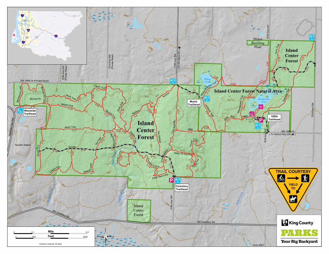
Map Legend (map on reverse)
Trailheads
hiking, mountain biking
hiking, horseback riding, mountain biking
Trails
maintained
forest maintenance road
approximate distance in miles between trail junctions
Facilities
parking area
picnic shelter
viewpoint (wetland overlook)
Publicly owned land
King County park land
Other basemap features
unincorporated King County
wetland
local street
gate
elevation contour (interval = 50 ft.)
0.24
Map created by the King County Parks and Recreation Division and the King County GIS Center: www.kingcounty.gov/gis.
Printed on recycled paper.
©2009, 2021 King County, Washington.The information included on this map has been compiled by King County staff from a variety of sources and is subject to change without notice. King County makes no representations or warranties, express or implied, as to accuracy, completeness, timeliness, or rights to the use of such information. This document is not intended for use as a survey product. King County shall not be liable for any general, special, indirect, incidental, or consequential damages including, but not limited to, lost revenues or lost profits resulting from the use or misuse of the information contained on this map. Any sale of this map or information on this map is prohibited except by written permission of King County.
June 2021
Island Center ForestIsland Center Forest features various forest stands, meadows, and the Mukai Pond and Meadowlake Pond wetlands, and it is home to the headwaters of Judd Creek. Island Center Forest provides habitat for a variety of wildlife, including more than 70 bird species. There are more than nine miles of trails for hikers, equestrians and moun-tain bikers. The wetlands are popular for bird watching and wildlife photography.
Area450 acres
Trail Length10 miles
UsesHiking, horseback riding, mountain biking, wildlife viewing and photography.
AccessIsland Center Forest is just southwest of the business center of Vashon Island. The best access to Island Center Forest is o� the Vashon Highway. Head west onto SW 188th Street to access a new parking lot at the end of 188th that can accommodate horse trailers.
Head west on SW Cemetery Road and then north on 115th Avenue SW to access another parking area that is limited to cars and trucks.
Parking is very limited on 115th Avenue SW o� of SW Bank Road.
You can also access the trails just north of the transfer station on the Westside Highway.
Island Center Forest is served by Metro bus routes 118 and 119 along Vashon Highway SW.
This information is availablein alternative formats upon request.Please call 206-477-4527or 1-800-325-6165.Washington Relay Service: 1-800-833-6388.
For information about King County Parks,please call 206-477-4527.
Visit King County Parks on the Internet at www.kingcounty.gov/parks.
Located in the center of Vashon Island, Island Center Forest is a 450-acre working forest and nature preserve that is managed to demonstrate sustainable forest management while protecting and restoring the health of the site's habitat. The property is owned and managed by King County Parks in collaboration with community partners who make up the Friends of Island Center Forest, a diverse group that includes the Vashon-Maury Island Land Trust, Vashon Forest Stewards, Vashon–Maury Island Audubon, equestrians and outdoor enthusiasts, among many other community members.
Want the map on your phone? Text KING ISLAND to 468311*Message & Data Rates May Apply
)
*
* 7
7 *
*
;
A
A
A
*
A
D
Island Center Forest Natural Area
125t
h Av
e S
W(P
rivat
e R
oad)
SW 184th St (Private Road)
115t
h Av
e SW
107t
h Av
e S
W
SW 188th St
115t
h Av
e SW
SW Cemetery Rd
Wes
tsid
e H
wy
SW
Middle Fork
Grinder
Mike's Cor
ner
Jack's Trail
Owl T
rail
Midd le Fork
MiddleFo r k
Techmo
The Gallops
Fore
stry
Loop
Ce
mete r y R un
Field View Loop
115t
hBy
pass
115 t
hB
ypas
s
Landtrust Trail
188th
188th
Fir H
ill
Trail
Muk
aiM
eadow T ra
il
Me a
dow
lake
Trail
188th
Techmo
MeadowlakePond
MukaiPond
SW Cemetery Rd
0.37
0.14 0.29
0.17
0.12
0.37
0.07
0.29
0.140.19 0.21
0.13
0.04
0.12
0.05
0.2
0.2
0.09
0.25
0.06
0.22
0.19
0.15
0.06
0.12
0.13
0.110.27
0.14
0.13
0.15
0.2
0.09
0.2
0.11
0.06
0.16
0.13
0.27
0.12
0.06
0.04
0.10
Borrow Pit
Judd
Cree
k
Judd C
reek
Judd C
reek
( To Vashon Hwy SW -> )
( To
SW B
ank
Rd
)
Judd
Creek
Transfer Station
North Trail
North
Tra
il0.33
0.10.
05
0.11
0.38
121s
t Ave
SW
(Priv
ate
Roa
d)
Mukai Trailhead
188thTrailhead
CemeteryTrailhead
WestsideTrailhead
Valley Of The Firs
North Tr a il
Fir Hill
Trai
l
Du
mp
Run
0.110.07
0.05
0.05
Borro
wP
itL
oop Borrow
Pi tLoop
0.07
0.06
0.07
0.04
107t
h Av
e S
W
IslandCenterForest
103r
d Av
e SW
0.36
0.22
0.09
0.13
0.08
0.150.03
Craig's Trail
Gate
way
Trai
l
0.11
Sunny'sTrail
Trail
0.08
0.23
0.06
MukaiBarreling
Plant
0.19
Tim
'sTr
ail
IslandCenterForest
IslandCenterForest
_
_
400
350
300
250350
300
250
200
350
400
350
300
350
450
450
450
350
350
450
400
350
300
250
400
400
350
350
400
350
300
350
400
Contour interval: 50 feet June 2021
§̈¦90
§̈¦5
§̈¦5
§̈¦405
UV18
UV520
UV167
UV2
0
0 500
0.1 0.4
2000
MileFeet