Embed Size (px)
Citation preview
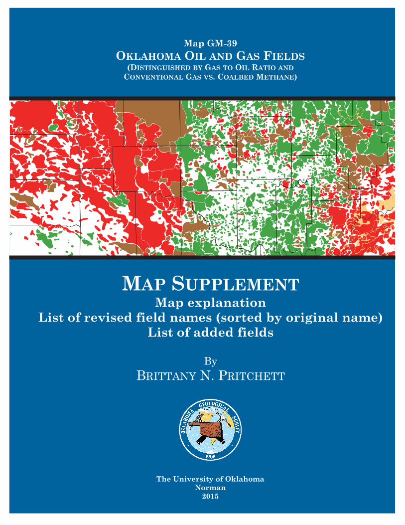
Map GM-39
OKLAHOMA OIL AND GAS FIELDS(DISTINGUISHED BY GAS TO OIL RATIO AND
CONVENTIONAL GAS VS. COALBED METHANE)
The University of OklahomaNorman
2015
MAP SUPPLEMENTMap explanation
List of revised field names (sorted by original name) List of added fields
By
BRITTANY N. PRITCHETT
1
Oklahoma Oil and Gas Fields (Distinguished by Gas to Oil Ratio and
Conventional Gas vs. Coalbed Methane)
Brittany N. Pritchett Oklahoma Geological Survey
Introduction
This map is an update of Dan T. Boyd’s GM 36 (2002) and Margaret R. Burchfield’s GM 28 (1985). It shows areas of oil, gas, and coalbed methane production in Oklahoma. The field colors on the map represent a calculated gas to oil ratio (GOR, cubic feet of gas per barrel of oil) based on cumulative production figures reported by IHS. Green signifies oil fields (GOR < 5,000); brown denotes oil and gas fields (GOR >=5,000 and <=20,000); and for GOR >20,000, red indicates conventional gas fields, whereas orange signifies coalbed methane (CBM) fields. Active, abandoned, producing, and non-producing fields are not distinguished on this map. All field locations are listed by township and range. The townships and ranges with N, S, E, and W directions use the Indian Meridian. When “C” is used in the range column, the Cimarron Meridian is used (only in the Panhandle).
Data
All well data and most of the production data, except for CBM, were supplied by IHS. Historical data from GM 36 was used when no production data were available. The CBM data used in this map come from a database maintained by OGS geologist Brian J. Cardott.(http://www.ogs.ou.edu/coaldb.php)
It does not contain wells with significant non-coal contributions.
IHS well and production data were used to construct this map. In some cases, field names attributed to specific wells in the IHS production database are different than the field names listed in the IHS wells database for the same well. In such cases, the field names cited in the well database are used. Wells with IHS’s Status Final Codes 0 (dry hole, temporarily abandoned), 8 (junked and abandoned well), 9 (injection, service, water-disposal well, CO2, storage, pseudo-original well, mining borehole), A (abandoned location), D (injection well), L (permitted well), S (suspended well), and W (water supply) were removed prior to map construction.
Map construction
Guidelines given by Boyd (2002) for GM 36 map construction were also followed for this map. All fields were hand drawn in ArcGIS 10.2.2. Lines were not allowed to overlap, other than in major gas areas in Cimarron, Texas, Beaver, and Kay Counties. When overlap occurred outside of major gas areas, clear boundaries were made and space was left between the fields. When overlap was extreme, fields were combined. Wells in unnamed fields within 2 ½ miles of an established field were added into the established field. If located over 2 ½ miles
2
from an established field, then a field name was assigned. Unnamed fields were labeled as Unnamed and given a corresponding number; wildcats were labeled as Wildcat and given a corresponding number; and if a new field was named in IHS then the name was kept as long as there were no previous fields of that name. Fields that were either removed or added after the publication of GM 36 are listed in the attached appendixes.
In contrast to GM 36, CBM fields are not named on this map. The Oklahoma Corporation Commission reports CBM wells by county, not field. Due to the continuous nature of coalbed methane producing areas, the fields are drawn as continuous as the data and geology allow.
Sources
IHS, Inc. https://www.ihs.com/
GM 28 http://ogs.ou.edu/fossilfuels/MAPS/GM-28.zip
GM 36 http://ogs.ou.edu/fossilfuels/MAPS/GM-36.pdf
OGS CBM well database http://www.ogs.ou.edu/coaldb.php
3
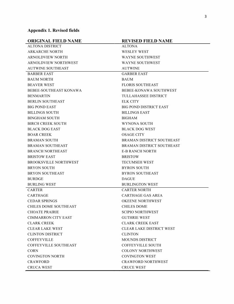
Appendix 1. Revised fields ORIGINAL FIELD NAME
REVISED FIELD NAME
ALTONA DISTRICT ALTONA ARKARCHE NORTH WESLEY WEST ARNOLDVIEW NORTH WAYNE SOUTHWEST ARNOLDVIEW NORTHWEST WAYNE SOUTHWEST AUTWINE SOUTHEAST AUTWINE BARBER EAST GARBER EAST BAUM NORTH BAUM BEAVER WEST FLORIS SOUTHEAST BEBEE-SOUTHEAST KONAWA BEBEE-KONAWA SOUTHWEST BENMARTIN TULLAHASSEE DISTRICT BERLIN SOUTHEAST ELK CITY BIG POND EAST BIG POND DISTRICT EAST BILLINGS SOUTH BILLINGS EAST BINGHAM SOUTH BIGHAM BIRCH CREEK SOUTH WYNONA SOUTH BLACK DOG EAST BLACK DOG WEST BOAR CREEK OSAGE CITY BRAMAN SOUTH BRAMAN DISTRICT SOUTHEAST BRAMAN SOUTHEAST BRAMAN DISTRICT SOUTHEAST BRANCH NORTHEAST E-B RANCH NORTH BRISTOW EAST BRISTOW BROOKSVILLE NORTHWEST TECUMSEH WEST BRYON SOUTH BYRON SOUTH BRYON SOUTHEAST BYRON SOUTHEAST BURDGE DAGUE BURLING WEST BURLINGTON WEST CARTER CARTER NORTH CARTHAGE CARTHAGE GAS AREA CEDAR SPRINGS OKEENE NORTHWEST CHILES DOME SOUTHEAST CHILES DOME CHOATE PRAIRIE SCIPIO NORTHWEST CIMMARRON CITY EAST GUTHRIE WEST CLARK CREEK CLARK CREEK EAST CLEAR LAKE WEST CLEAR LAKE DISTRICT WEST CLINTON DISTRICT CLINTON COFFEYVILLE MOUNDS DISTRICT COFFEYVILLE SOUTHEAST COFFEYVILLE SOUTH CORN COLONY NORTHWEST COVINGTON NORTH COVINGTON WEST CRAWFORD CRAWFORD NORTHWEST CRUCA WEST CRUCE WEST
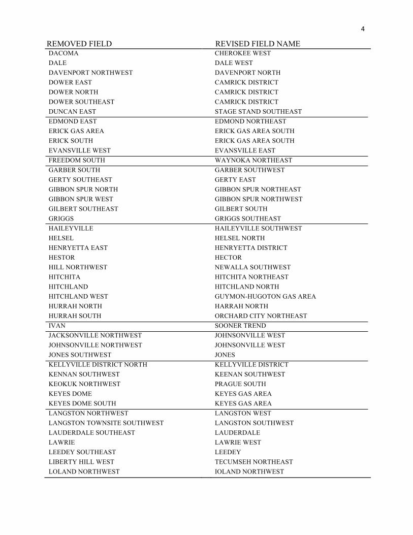
4
REMOVED FIELD REVISED FIELD NAME DACOMA CHEROKEE WEST DALE DALE WEST DAVENPORT NORTHWEST DAVENPORT NORTH DOWER EAST CAMRICK DISTRICT DOWER NORTH CAMRICK DISTRICT DOWER SOUTHEAST CAMRICK DISTRICT DUNCAN EAST STAGE STAND SOUTHEAST EDMOND EAST EDMOND NORTHEAST ERICK GAS AREA ERICK GAS AREA SOUTH ERICK SOUTH ERICK GAS AREA SOUTH EVANSVILLE WEST EVANSVILLE EAST FREEDOM SOUTH WAYNOKA NORTHEAST GARBER SOUTH GARBER SOUTHWEST GERTY SOUTHEAST GERTY EAST GIBBON SPUR NORTH GIBBON SPUR NORTHEAST GIBBON SPUR WEST GIBBON SPUR NORTHWEST GILBERT SOUTHEAST GILBERT SOUTH GRIGGS GRIGGS SOUTHEAST HAILEYVILLE HAILEYVILLE SOUTHWEST HELSEL HELSEL NORTH HENRYETTA EAST HENRYETTA DISTRICT HESTOR HECTOR HILL NORTHWEST NEWALLA SOUTHWEST HITCHITA HITCHITA NORTHEAST HITCHLAND HITCHLAND NORTH HITCHLAND WEST GUYMON-HUGOTON GAS AREA HURRAH NORTH HARRAH NORTH HURRAH SOUTH ORCHARD CITY NORTHEAST IVAN SOONER TREND JACKSONVILLE NORTHWEST JOHNSONVILLE WEST JOHNSONVILLE NORTHWEST JOHNSONVILLE WEST JONES SOUTHWEST JONES KELLYVILLE DISTRICT NORTH KELLYVILLE DISTRICT KENNAN SOUTHWEST KEENAN SOUTHWEST KEOKUK NORTHWEST PRAGUE SOUTH KEYES DOME KEYES GAS AREA KEYES DOME SOUTH KEYES GAS AREA LANGSTON NORTHWEST LANGSTON WEST LANGSTON TOWNSITE SOUTHWEST LANGSTON SOUTHWEST LAUDERDALE SOUTHEAST LAUDERDALE LAWRIE LAWRIE WEST LEEDEY SOUTHEAST LEEDEY LIBERTY HILL WEST TECUMSEH NORTHEAST LOLAND NORTHWEST IOLAND NORTHWEST
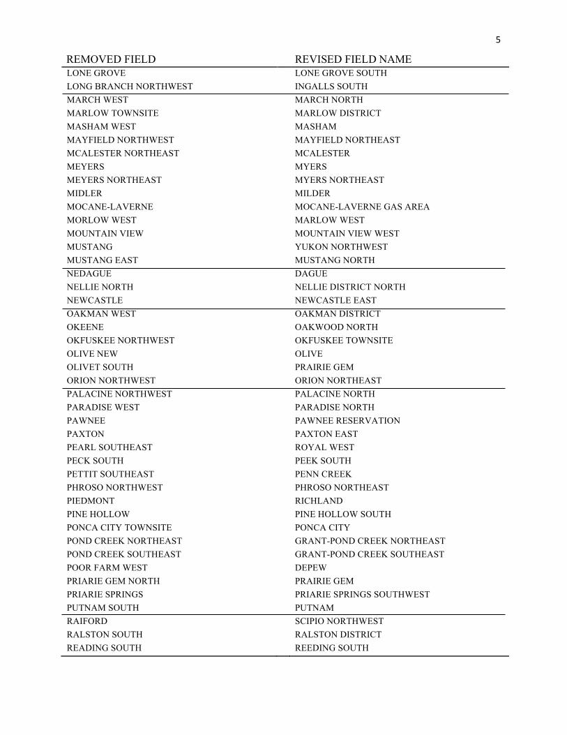
5
REMOVED FIELD REVISED FIELD NAME LONE GROVE LONE GROVE SOUTH LONG BRANCH NORTHWEST INGALLS SOUTH MARCH WEST MARCH NORTH MARLOW TOWNSITE MARLOW DISTRICT MASHAM WEST MASHAM MAYFIELD NORTHWEST MAYFIELD NORTHEAST MCALESTER NORTHEAST MCALESTER MEYERS MYERS MEYERS NORTHEAST MYERS NORTHEAST MIDLER MILDER MOCANE-LAVERNE MOCANE-LAVERNE GAS AREA MORLOW WEST MARLOW WEST MOUNTAIN VIEW MOUNTAIN VIEW WEST MUSTANG YUKON NORTHWEST MUSTANG EAST MUSTANG NORTH NEDAGUE DAGUE NELLIE NORTH NELLIE DISTRICT NORTH NEWCASTLE NEWCASTLE EAST OAKMAN WEST OAKMAN DISTRICT OKEENE OAKWOOD NORTH OKFUSKEE NORTHWEST OKFUSKEE TOWNSITE OLIVE NEW OLIVE OLIVET SOUTH PRAIRIE GEM ORION NORTHWEST ORION NORTHEAST PALACINE NORTHWEST PALACINE NORTH PARADISE WEST PARADISE NORTH PAWNEE PAWNEE RESERVATION PAXTON PAXTON EAST PEARL SOUTHEAST ROYAL WEST PECK SOUTH PEEK SOUTH PETTIT SOUTHEAST PENN CREEK PHROSO NORTHWEST PHROSO NORTHEAST PIEDMONT RICHLAND PINE HOLLOW PINE HOLLOW SOUTH PONCA CITY TOWNSITE PONCA CITY POND CREEK NORTHEAST GRANT-POND CREEK NORTHEAST POND CREEK SOUTHEAST GRANT-POND CREEK SOUTHEAST POOR FARM WEST DEPEW PRIARIE GEM NORTH PRAIRIE GEM PRIARIE SPRINGS PRIARIE SPRINGS SOUTHWEST PUTNAM SOUTH PUTNAM RAIFORD SCIPIO NORTHWEST RALSTON SOUTH RALSTON DISTRICT READING SOUTH REEDING SOUTH
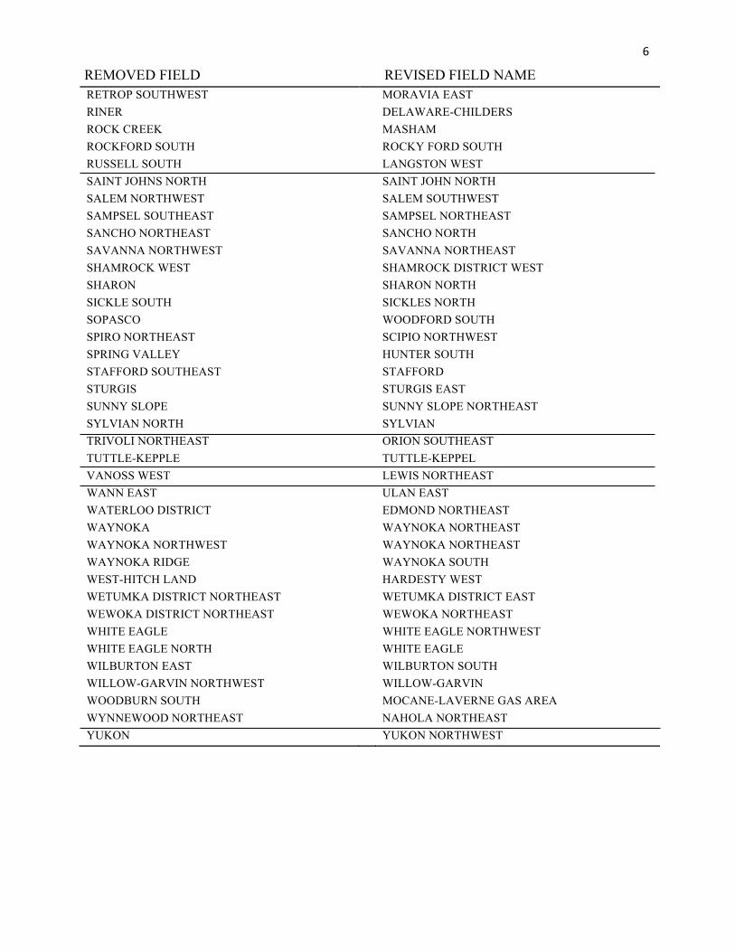
6REMOVED FIELD REVISED FIELD NAME
RETROP SOUTHWEST MORAVIA EAST RINER DELAWARE-CHILDERS ROCK CREEK MASHAM ROCKFORD SOUTH ROCKY FORD SOUTH RUSSELL SOUTH LANGSTON WEST SAINT JOHNS NORTH SAINT JOHN NORTH SALEM NORTHWEST SALEM SOUTHWEST SAMPSEL SOUTHEAST SAMPSEL NORTHEAST SANCHO NORTHEAST SANCHO NORTH SAVANNA NORTHWEST SAVANNA NORTHEAST SHAMROCK WEST SHAMROCK DISTRICT WEST SHARON SHARON NORTH SICKLE SOUTH SICKLES NORTH SOPASCO WOODFORD SOUTH SPIRO NORTHEAST SCIPIO NORTHWEST SPRING VALLEY HUNTER SOUTH STAFFORD SOUTHEAST STAFFORD STURGIS STURGIS EAST SUNNY SLOPE SUNNY SLOPE NORTHEAST SYLVIAN NORTH SYLVIAN TRIVOLI NORTHEAST ORION SOUTHEAST TUTTLE-KEPPLE TUTTLE-KEPPEL VANOSS WEST LEWIS NORTHEAST WANN EAST ULAN EAST WATERLOO DISTRICT EDMOND NORTHEAST WAYNOKA WAYNOKA NORTHEAST WAYNOKA NORTHWEST WAYNOKA NORTHEAST WAYNOKA RIDGE WAYNOKA SOUTH WEST-HITCH LAND HARDESTY WEST WETUMKA DISTRICT NORTHEAST WETUMKA DISTRICT EAST WEWOKA DISTRICT NORTHEAST WEWOKA NORTHEAST WHITE EAGLE WHITE EAGLE NORTHWEST WHITE EAGLE NORTH WHITE EAGLE WILBURTON EAST WILBURTON SOUTH WILLOW-GARVIN NORTHWEST WILLOW-GARVIN WOODBURN SOUTH MOCANE-LAVERNE GAS AREA WYNNEWOOD NORTHEAST NAHOLA NORTHEAST YUKON YUKON NORTHWEST
7
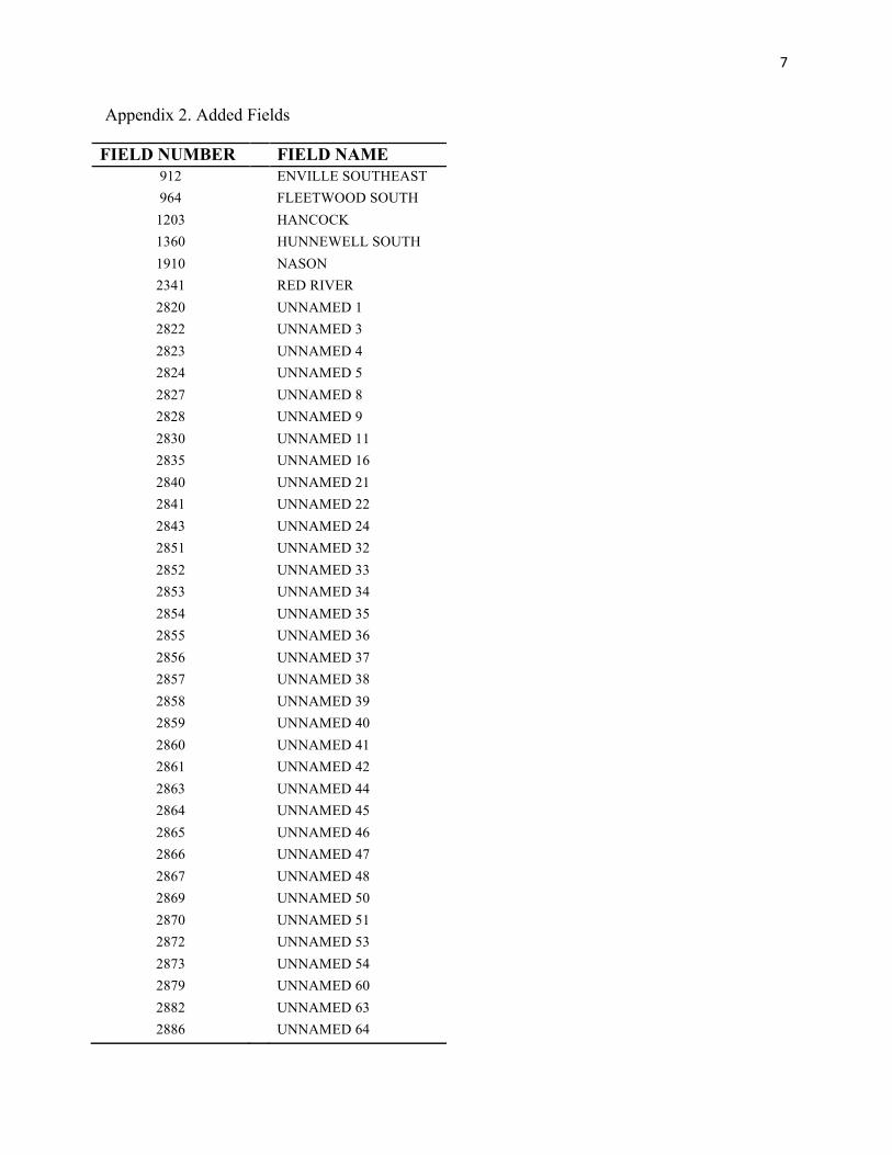
Appendix 2. Added Fields
FIELD NUMBER FIELD NAME 912 ENVILLE SOUTHEAST 964 FLEETWOOD SOUTH
1203 HANCOCK 1360 HUNNEWELL SOUTH 1910 NASON 2341 RED RIVER 2820 UNNAMED 1 2822 UNNAMED 3 2823 UNNAMED 4 2824 UNNAMED 5 2827 UNNAMED 8 2828 UNNAMED 9 2830 UNNAMED 11 2835 UNNAMED 16 2840 UNNAMED 21 2841 UNNAMED 22 2843 UNNAMED 24 2851 UNNAMED 32 2852 UNNAMED 33 2853 UNNAMED 34 2854 UNNAMED 35 2855 UNNAMED 36 2856 UNNAMED 37 2857 UNNAMED 38 2858 UNNAMED 39 2859 UNNAMED 40 2860 UNNAMED 41 2861 UNNAMED 42 2863 UNNAMED 44 2864 UNNAMED 45 2865 UNNAMED 46 2866 UNNAMED 47 2867 UNNAMED 48 2869 UNNAMED 50 2870 UNNAMED 51 2872 UNNAMED 53 2873 UNNAMED 54 2879 UNNAMED 60 2882 UNNAMED 63 2886 UNNAMED 64
8
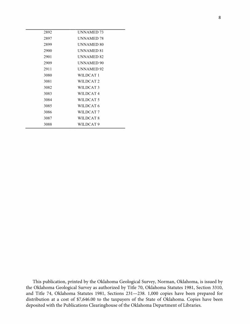
2892 UNNAMED 73 2897 UNNAMED 78 2899 UNNAMED 80 2900 UNNAMED 81 2901 UNNAMED 82 2909 UNNAMED 90 2911 UNNAMED 92 3080 WILDCAT 1 3081 WILDCAT 2 3082 WILDCAT 3 3083 WILDCAT 4 3084 WILDCAT 5 3085 WILDCAT 6 3086 WILDCAT 7 3087 WILDCAT 8 3088 WILDCAT 9
This publication, printed by the Oklahoma Geological Survey, Norman, Oklahoma, is issued by the Oklahoma Geological Survey as authorized by Title 70, Oklahoma Statutes 1981, Section 3310, and Title 74, Oklahoma Statutes 1981, Sections 231—238. 1,000 copies have been prepared for distribution at a cost of $7,646.00 to the taxpayers of the State of Oklahoma. Copies have been deposited with the Publications Clearinghouse of the Oklahoma Department of Libraries.