Embed Size (px)
Citation preview

Map-aided Dead-reckoning — A Study onLocational Privacy in Insurance Telematics
Johan Wahlstrom, Isaac Skog, Member, IEEE, Joao G. P. Rodrigues, Student Member, IEEE, Peter Handel, SeniorMember, IEEE, and Ana Aguiar, Member, IEEE
Abstract—We present a particle-based framework for estimat-ing the position of a vehicle using map information and mea-surements of speed. Two measurement functions are considered.The first is based on the assumption that the lateral force onthe vehicle does not exceed critical limits derived from physicalconstraints. The second is based on the assumption that thedriver approaches a target speed derived from the speed limitsalong the upcoming trajectory. Performance evaluations of theproposed method indicate that end destinations often can beestimated with an accuracy in the order of 100 [m]. These resultsexpose the sensitivity and commercial value of data collected inmany of today’s insurance telematics programs, and thereby haveprivacy implications for millions of policyholders. We end bydiscussing the strengths and weaknesses of different methods foranonymization and privacy preservation in telematics programs.
Index Terms—Vehicle positioning, dead-reckoning, insurancetelematics, map-matching, usage-based-insurance, privacy.
I. INTRODUCTION
The emergence of connected vehicles has opened up pos-sibilities for services which combine the power of cloudcomputing with the expanding capabilities of modern vehicletechnology. Connected vehicles not only enable remote anal-ysis of vehicle condition and driving behavior, but also allowdrivers to benefit from a multitude of convenience-relatedapplications such as theft tracking and accident detection.However, as the amounts of generated data and the meansof connectivity increases, so do the dangers related to privacyand security [1]. Recently, connected vehicles and associatedaftermarket devices have been shown to be vulnerable towireless hacking via a broad range of attack vectors [2]–[4]. Inthe worst case, the hacker will be able to remotely manipulateany of the vehicle’s electronic control units (ECUs). Moreover,privacy concerns have been raised about the large databasesof sensitive data collected from vehicle-installed telematicsunits [5]–[8]. As illustrated in Fig. 1, a telematics insurer usesdata on driving behavior to set the premium offered to eachpolicyholder [9]–[11]. Typically, the risk profile of each driverwill be based on e.g., the number of speeding or harsh brakingevents, as detected using measurements from vehicle-installedblack boxes or from the vehicle’s on-board-diagnostics (OBD)system [12], [13]. This study examines the locational privacyof such insurance telematics programs.
J. Wahlstrom, I. Skog, and P. Handel are with the ACCESS Linnaeus Center,Dept. of Signal Processing, KTH Royal Institute of Technology, Stockholm,Sweden. (e-mail: {jwahlst, skog, ph}@kth.se).
J. G. P. Rodrigues and A. Aguiar are with the Instituto de Telecomunicacoes,Departamento de Engenharia Eletrotecnica e de Computadores, Faculdadede Engenharia da Universidade do Porto, 4200-465 Porto, Portugal. (e-mail:{joao.g.p.rodrigues, anaa}@fe.up.pt)
sk
skInsurer
skpremiumIndividual
Fig. 1. Several insurance telematics providers are today collecting measure-ments of speed, here denoted by sk , from vehicles’ wheel speed sensors toadjust premiums and provide feedback to drivers.
A. Locational Privacy
The digital revolution has made violations of locationalprivacy both cheaper and harder to detect [14]. Temporallyisolated digital position inferences were first made possibleby the widespread usage of credit cards and access cards.Today, the abundance of e.g., global navigation satellite sys-tem (GNSS) receivers in smartphones and vehicles enablescontinuous streams of position measurements to be sent tocentral servers [15], [16]. In addition, it is often possibleto perform smartphone-based WiFi-localization by exploitingsystem permissions required by many popular apps [17].Although some might argue that consumers are willinglygiving up personal information in exchange for services andproducts, the actual privacy implications of sharing specificdata are often obscured. This is especially true when thedata itself does not include position measurements, but rather,information which in combination with additional databasescan be used for positional inference.
Initially, privacy and security were not major concerns in theinsurance telematics industry, and the amount of data collectedwas primarily determined by restrictions on transmission andstorage. However, these topics have received more attentionas the industry has matured, and privacy concerns have evenbeen cited as a contributing reason to suspend telematics trials[18]–[21]. Today, several telematics providers only collectmeasurements of speed. When responding to privacy concerns,these companies will refer to the fact that no position data isrecorded. However, as shown in [7], location-based informa-tion can still be extracted from many trips.
B. Contributions and Outline
In this article, we use map-aided dead-reckoning (DR) togeographically locate a vehicle purely based on its speed
arX
iv:1
611.
0791
0v1
[cs
.CR
] 1
4 N
ov 2
016

profile and digital map information. Since the study utilizesthe same type of information that is available for many of thecurrent insurance telematics providers, the results have privacyimplications for millions of policyholders. The estimationis carried out using a particle filter, and thereby parallelsprevious filtering-based approaches where measurements ofthe vehicle’s yaw rate have been available [22]–[25]. Thoughthe idea of estimating a vehicle’s position using only speedmeasurements and map information is not new [7], [8], thisis the first time that it has been formulated as a filteringproblem. In addition to making it possible to motivate theimplementation using optimality arguments, our hope is thatthis also will make the method more accessible, and facilitateextensions based on established methods for particle filtering.Previous algorithms have been very reliant on the matchingof vehicle stops in the speed data with intersections or trafficsignals in the map. For example, in [8], data where the vehiclemade a large number of stops due to traffic congestion orsimilar was removed altogether since this type of drivingwas not accounted for in the algorithm. In this study, weavoid these issues by processing the speed measurements one-by-one, rather than in segments delimited by vehicle stops.Moreover, the performance evaluations are made on data setswith significantly longer trip lengths than in previous studies.
Section II reviews the state-of-the-art in map-aided dead-reckoning and discusses how the problem is altered dependingon what sensor information is available. The employed systemmodel and the filter implementation are detailed in SectionIII. Section IV illustrates the performance characteristics ofthe proposed method by studying the accuracy of estimatedend positions and the dependence on a priori knowledgeof the initial position. The results indicate that GNSS orOBD measurements of speed often are sufficient to extract asubstantial amount personal information on daily activities andlocation-based behavior. Section V discusses the implicationsof the presented results and possible ways forward for privacy-aware telematics providers. Finally, the article is concluded inSection VI.
II. PRELIMINARIES ON MAP-AIDED DEAD-RECKONING
DR refers to the process of recursively estimating theposition of an object by numerically integrating measure-ments or estimates of velocity. The general concept has beenwidely used to navigate e.g., aircrafts, ships, submarines,robots, automobiles, and pedestrians [26]. Obviously, perfectintegration requires perfect knowledge of the velocity at alltime instances. In practice, this means that stand-alone dead-reckoning systems always will be subject to position errorsthat accumulate with time. To prevent the position error fromgrowing without bound, additional information is required.This type of information can be provided by, e.g., satellite-based positioning systems [12], WiFi fingerprinting systems[27], magnetic fingerprinting systems [28], terrain measure-ments [29], or road maps.
A. Map-aided DR with Sensor-based Yaw InformationDR aided only by information from road maps (and some
a priori knowledge of the initial position) have been the
topic of several studies within land-vehicle navigation [30].Historically, the primary motivation of these studies have beento increase the accuracy and integrity of existing low-costnavigation systems during failures or performance deteriora-tions of the employed positioning systems (e.g., during GNSSoutages). Assuming that measurements of both left and rightwheel speeds are available from the controller area network(CAN) bus, estimates of the vehicle’s longitudinal velocity andyaw rate can be obtained by means of differential geometry[22]. These estimates are then used for DR. If only a scalarspeed measurement is available at each sampling instance,measurements of the yaw angle or yaw rate can instead beobtained from the steering wheel angle sensor, from a vehicle-mounted gyroscope, or from a magnetometer [31]. The errorgrowth of the navigation solution is typically mitigated bycomparing the current position and yaw estimates with thecorresponding quantities at the nearest map segment [23],[32]. To avoid the logistics of accessing measurements ofwheel speed, DR can instead be performed by means ofinertial navigation. However, this will increase the numberof integration steps, and thereby also the rate of the positionerror growth. As a result, the position estimates will be verysensitive to e.g., mounting misalignments and sensor biases. Ingeneral, the performance of inertial measurement unit (IMU)-based methods can be expected to be inferior to that ofodometric methods [24].
B. Map-aided DR without Sensor-based Yaw Information
Since the standard parameters available from the vehicle’sOBD system do not include any information on the vehicle’syaw rate or yaw angle, it is interesting to see what levelof positioning accuracy that can be obtained by using onlyOBD measurements of speed. (As previously mentioned, theindustry of insurance telematics today includes several ac-tors, e.g., Progressive, Geico, and Allstate, that collect speedmeasurements from their policyholders [33], [34].) Relatedstudies were conducted in [7] and [8], which estimated theposition of a vehicle by matching intersections in the mapwith detected vehicle stops in the speed measurements. Alist of possible map traces was continuously updated byadding new traces after each vehicle stop, and deleting tracesdeemed infeasible after 1) comparing their lengths with thecorresponding distance implied by the speed measurements;2) comparing the measured speeds with speed limits; and 3)comparing the measured speeds with the maximum speedsas implied by the curvature of the road. The estimation wasnot statistically motivated and was not formulated within anyestablished estimation framework. In this study, we aim to fillthis gap.
The DR problem arising when only speed measurementsare available is fundamentally different from the DR problemwhen also sensor-based yaw information is available. In thelatter case, the position estimate can be propagated in two di-mensions using only sensor measurements. Spatial informationfrom the road map is then conveniently incorporated into theestimation as soft constraints. Usually, this information will besufficient to avoid filter divergence, and additional information,

Possible end positionsL
atit
ude
Longitude
0 [s]
30 [s]
60 [s]
90 [s]
Fig. 2. Possible positions 0 [s], 30 [s], 60 [s], and 90 [s] after initializingDR (using only measurements of speed and map information) from a knownstarting point. The example is taken from a trip in Porto, Portugal, and thefigure shows an area of about 3.5 [(km)2 ].
such as speed limits, will be of secondary importance [22],[23]. When only measurements of speed are available, theposition estimate cannot be propagated solely based on sensormeasurements. Instead, the vehicle’s yaw angle has to beestimated from the road map. In this case, sensor measure-ments and spatial information from the road map will never besufficient as the posterior distribution will continue to ”spreadout” at intersections (see Fig. 2). Additional models whichrelate the expected vehicle speed to the vehicle’s position onthe map are required, and speed limits will become of utmostimportance.
III. MODEL AND ESTIMATION FRAMEWORK
We present a filtering-based approach to the problem of es-timating a vehicle’s position using map information and mea-surements of speed. This section describes both the employedsystem model and the particle-based filter implementation.
A. Overview of System Model
The map data from OpenStreetMap (OSM) can be describedas a mathematical graph where each vertex (node) defines alatitude-longitude pair. The connectivity of the graph is definedby a set of ways, i.e., ordered lists of nodes indicating thatthere is an edge (link) between the first and the second node,between the second and the third node, etc. Each way can becharacterized by attributes specifying road type, speed limits,restrictions on travel direction, etc. The problem at hand isto use information from a digital map such as OSM, togetherwith measurements of speed, to estimate a vehicle’s position.The considered estimation framework is based on the model
xk+1 ∼ p(xk+1|xk, sk), (1a)y(S) ∼ p(y(S)|X). (1b)
Here, x is a state vector comprising the vehicle’s two-dimensional position r, and the vehicle’s direction of travel.Assuming that the vehicle always travels along links in thegraph, the state vector can be given as an ordered list of twoconnected nodes and a constant indicating the ratio of thevehicle’s distance to the first node and the distance between the
n(1)
n(2)
n(N)
rk
rk+1
rk+1
rk+1
Fig. 3. Illustration of the process model when the vehicle passes a roadjunction. If the probability of the initial position rk is p, the probability ofeach of the updated positions rk+1 are p/N where N denotes the numberof links along which rk+1 can be expected. The distance between rk and(any) rk+1, measured along the links, is equal to ∆tksk .
two nodes. The vehicle’s speed is denoted by s (no notationaldistinction is made between the true and measured speed). Ascan be seen, the speed measurements act both as input in thestate equation (1a) and as measurements in the measurementequation (1b). Moreover, p(·|·) is used to denote a conditionalprobability density function (pdf). All pdfs are implicitlyconditioned on the available map information. Throughout thepaper, we will follow the convention of using a subindex k todenote quantities at sampling instance k. The complete set ofstate vectors and speed measurements are then given by X ∆={...,xk−1, xk, xk+1, ...} and S ∆= {..., sk−1, sk, sk+1, ...},respectively. The employed measurements are collected in ageneric function y, and will be discussed more thoroughlyin Section III-C. For clarity, we will in the text differentiatebetween s and y by referring to speed measurements andmeasurements, respectively.
B. Process Model
The process model (1a) describes the time development ofthe vehicle’s position, using speed as input. The update isperformed by distributing the travelled distance ∆tksk alongthe upcoming links. We have here used ∆tk to denote thesampling interval between sampling instances k and k + 1.When the vehicle passes a road junction, it is modeled tocontinue along any of the connected links (excluding the linkit has just traversed) with equal probability. This is illustratedin Fig. 3. As may be realized, less probable events such as un-expected u-turns have been disregarded. If needed, the modelcan easily be modified to account for errors in the estimatedtravelled distance. Discrepancies between the estimated trav-eled distance ∆tksk and the true travelled distance can arisedue to map errors and off-road driving [25]. In addition, GNSSspeed measurements are subject to multipath propagation [35],whereas OBD measurements are affected by wheel slips,quantization errors in the measured speed [36], and scale factorerrors dependent on tire pressure [22]. Previous attempts toinclude the scale factor in the state vector did not result in anyimprovement in navigation performance, but rather, increasedthe risk of filter divergence [23], [25]. We further note that thespeed measured by the OBD system is the absolute value ofthe vehicle’s three-dimensional velocity, whereas the studiedmodel only considers two spatial dimensions (most nodes in

OSM do not include any altitude information). As a result, thetravelled distance in the two-dimensional plane of the map willtend to be overestimated when travelling along steep inclines[23]. For example, if the vehicle is traveling with a speed of25 [m/s] along a road where the angle of inclination is 5 [◦ ],the speed in the two-dimensional plane of the map will be25 · cos(5 [◦ ]) [m/s] ≈ 24.62 [m/s]. This error contributioncan be compensated for by using a commercial digital mapwith altitude information and extending the dimension of thestate vector accordingly.
Obviously, the estimated travelled distance ∆tksk is subjectto several modeling and measurement errors. Despite this, theresulting accumulated position error will in many cases benegligible in comparison to the position error resulting fromthe uncertainty of the vehicle path, i.e., the list of nodes orlinks that the vehicle has traversed.
C. Measurement Model
When propagating the state distribution as described in thepreceding subsection, the number of feasible vehicle pathsgrows exponentially as a function of the traveled distance[7]. To bound the number of paths, measurement updatesmust be employed. We will give two examples of possiblemeasurements. First, we the study the lateral forces exertedon the vehicle. When cornering, the lateral g-forces on thevehicle at sampling instance k can be approximated by [37]
y(1)(sk, sk+1) ∆=√a2k + s2kω
2k (2)
where a denotes the vehicle’s longitudinal acceleration and ωdenotes the vehicle’s yaw rate. The acceleration is approxi-mated by the difference quotient
ak∆=sk+1 − sk
∆tk. (3)
The yaw rate ω must be estimated from map data. We chooseto estimate the yaw rate in a separate Kalman filter based onthe state-space model
θk+1 = θk + ∆tkωk, (4a)ωk+1 = ωk + ηωk , (4b)
θk = θk + εθk. (4c)
Here, the noises ηωk and εθk are assumed to be white withvariances ∆tkσ
2ω and σ2
θ , respectively. Further, θ is the vehi-cle’s yaw angle, and θ is the direction of the current link.Due to the periodicity of the yaw angle, the measurementresiduals must be chosen within the interval [−180, 180] [◦ ].An alternative to using a Kalman filter is to estimate the yawrate directly from the difference quotients (θk+1 − θk)/∆tk.However, due to the limited resolution of the nodes in OSM(many sharp corners will have links meeting at a 90 [◦ ] angle)these difference quotients will be fairly unstable.
Typically, passenger cars are not designed for g-forceshigher than 0.8 g, and will seldom exceed 0.6 g during normaldriving. (A sufficiently high lateral force will cause the vehicleto rollover [37].) Here, g denotes the gravitational accelerationat the surface of the earth. Motivated by this, the distribution
of y(1) is heuristically modeled as
p(y(1)(sk, sk+1)|x1, ...,xk)
∝
1, y(1) < g(1)
y(1) − g(2)g(1) − g(2) , g(1) ≤ y(1) < g(2)
0, g(2) ≤ y(2).
(5)
The design parameters g(1) and g(2) are chosen so that thelateral forces fall below g(1) during the larger part of thedriving while allowing for outliers giving estimated lateralforces up to g(2).
To derive the second type of measurements, we note thatdrivers tend to maintain a speed close to the speed limit forthe larger part of the route. Hence, we propose the use of themeasurements
y(2)(sk, sk+1) ∆= ak + csk (6)
distributed according to
p(y(2)(sk, sk+1)|x1, ...,xk+K) = pC(y(2), csk+K , σ) (7)
where K ∈ N and pC denotes the pdf of the Cauchydistribution with location and scale parameters given by thesecond and third arguments, respectively. The probabilisticassumption in (7) is derived from the model
ak = c(sk+K − sk) + εsk (8)
which says that the vehicle’s acceleration will be approx-imately proportional to the difference between the currentspeed and the target speed sk+K . As should be obvious, wehave assumed that εsk is Cauchy distributed with location 0and scale σ. The design parameters c and σ describe thecharacteristics of each individual driver and car. Modeling theerror ε as distributed according to the the heavy-tailed Cauchydistribution will make the estimation robust to measurementerrors caused by unexpected driving behavior.
The target speed is, just as the yaw rate, estimated in aseparate Kalman filter. In this case, the state-space model is
sk+1 = sk + ηsk. (9a)sk = sk + εsk. (9b)
Here, the noises ηsk and εsk are white with variances ∆tkσ2s1
and σ2s2, respectively, while s is the speed limit of the current
link. By letting the target speed be dependent on the speedlimits on the road ahead, we are able to capture the forward-looking behavior of typical driving. At each iteration, theestimated target speed is projected to the closest speed in thespace
{sk :√a2k + s2kω
2k < g(1)}. (10)
In other words, the estimated target speed is adjusted so asto never imply an excessively large lateral force. This meansthat particles which pass sharp corners while the vehicle slowsdown often will have their weights increased, and hence, wecan detect the vehicle turning even though all nearby linkshave the same speed limit.
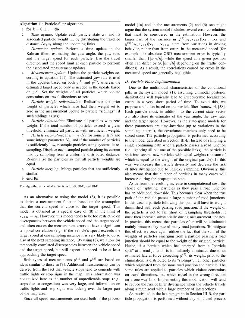
Algorithm 1 : Particle-filter algorithm.1: for k = 0, 1, . . . do2: Time update: Update each particle state xk and its
associated particle weight wk by distributing the travelleddistance ∆tksk along the upcoming links.
3: Parameter update: Perform a time update in theKalman filters estimating the yaw angle, the yaw rate,and the target speed for each particle. Use the traveldirection and the speed limit at each particle to performthe associated measurement updates.
4: Measurement update: Update the particle weights ac-cording to equation (11). The estimated yaw rate is usedin the updates based on both y(1) and y(2), whereas theestimated target speed only is needed in the update basedon y(2). Set the weights of all particles which violateconstraints on travel directions to zero.
5: Particle weight redistribution: Redistribute the priorweight of particles which have had their weight set tozero in the measurement update to particle ”siblings” (ifsuch siblings exists).
6: Particle elimination: Eliminate all particles with zeroweight. If the total number of particles exceeds a giventhreshold, eliminate all particles with insufficient weight.
7: Particle resampling: If k = n ·N0 for some n ∈ N andsome integer parameter N0, and if the number of particlesis sufficiently low, resample particles using systematic re-sampling. Displace each sampled particle along its currentlink by sampling from a uniformly distributed distance.Re-initialize the particles so that all particle weights areequal.
8: Particle merging: Merge particles that are sufficientlysimilar.
9: end for
The algorithm is detailed in Sections III-B, III-C, and III-D.
As an alternative to using the model (8), it is possibleto derive a measurement function based on the assumptionthat the current speed is close to the target speed. Thismodel is obtained as a special case of (8) in the limit ofsk+K = sk. However, this model tends to be too restrictive ondiscrepancies between the vehicle speed and the target speed,and often causes the measurement errors to have a significanttemporal correlation (e.g., if the vehicle’s speed exceeds thetarget speed at one sampling instance it is very likely to do soalso at the next sampling instance). By using (8), we allow fortemporally correlated discrepancies between the vehicle speedand the target speed, but still expect the speed to be at leastapproaching the target speed.
Both types of measurements y(1) and y(2) are based onideas similar to those in [7]. Additional measurements can bederived from the fact that vehicle stops tend to coincide withtraffic lights or stop signs in the map. This information wasnot utilized here as the number of unpredictable stops (e.g.,stops due to congestion) was very large, and information ontraffic lights and stop signs was lacking over the larger partof the map area.
Since all speed measurements are used both in the process
model (1a) and in the measurements (2) and (6) one mightargue that the system model includes several error correlationsthat must be considered in the estimation. However, thelarger part of the variance in y(1)(sk, sk+1)|x1, ...,xk andy(2)(sk, sk+1)|x1, ...,xk+K stem from variations in drivingbehavior, rather than from errors in the measured speed (forexample, the absolute OBD measurement error is typicallysmaller than 1 [km/h], while the speed at a given positionoften can differ by 20 [km/h] depending on the traffic con-ditions). As a result, the correlations caused by errors in themeasured speed are generally negligible.
D. Particle Filter ImplementationDue to the multimodal characteristics of the conditional
pdfs in the system model (1), assuming unimodal posteriordistributions will typically lead to irrecoverable localizationerrors in a very short period of time. To avoid this, wepropose a solution based on the particle filter framework [38].Each particle must, in addition to the current state vectorxk, also store its estimates of the yaw angle, the yaw rate,and the target speed. However, as the state-space models forthese parameters are time-invariant (up to variations in thesampling interval), the covariance matrices only need to bestored once. The particle propagation is performed accordingto the model described in Section III-B. Instead of sampling asingle continuing path when a particle passes a road junction(i.e., ignoring all but one of the possible links), the particle issplit into several new particles with equal weights (the sum ofwhich is equal to the weight of the original particle). In thisway, we increase the particle diversity and decrease the riskof filter divergence due to unlucky sampling. Obviously, thisalso means that the number of particles in many cases willincrease during the propagation step.
Aside from the resulting increase in computational cost, thechoice of ”splitting” particles as they pass a road junctionhas an additional downside. This becomes clear when the truepath of the vehicle passes a large number of road junctions.In this case, a particle following this path will have its weightdiminished with each passing road junction. If the weight ofthe particle is not to fall short of resampling thresholds, itmust then increase substantially during measurement updates.In practice, this means that particles often will be eliminatedmainly because they passed many road junctions. To mitigatethis effect, we once again utilize the fact that the sum of theweights of particles emerging from a particle passing a roadjunction should be equal to the weight of the original particle.Hence, if a particle which has emerged from a ”particlesplit” at a road junction is immediately eliminated due to anestimated lateral force exceeding g(2), its weight, prior to theelimination, is distributed to its ”siblings”, i.e., other particleswhich originated from the same road junction and particle. Thesame rules are applied to particles which violate constraintson travel directions, i.e., which travel in the wrong directionon a one-way link. Implementing this modification will tendto reduce the risk of filter divergence when the vehicle travelsalong a main road with a large number of intersections.
As motivated in the last paragraph in Section III-B, the par-ticle propagation is performed without any simulated process

TABLE IFILTER PARAMETERS.
Parameter ValueProcess noise σω 5 [◦/s2/
√Hz ]
σs1 0.5 [m/s2/√Hz ]
Measurement noise σθ 15 [◦ ]σs2 10 [m/s]
y(1) update g(1) 0.55 gg(2) 0.65 g
y(2) update K 12c 0.05 [1/s]σ 1.5 [m/s2 ]
Particle threshold (resampling trigger)† 100Weight threshold (elimination) 1/200Distance threshold (particle merge) 20 [m]Resampling displacement interval (−100, 100) [m]
† Checked every hundredth second.
noise in the travelled distance. Similar modeling choices havepreviously been discussed in [39] and references therein.
In the measurement update, each particle weight wk isupdated according to
wk+1 ∝ p(yk+1(S)|X)wk (11)
where the total set of measurements are
yk+1(S) ∆=[y(1)(sk, sk+1) y(2)(sk−K , sk+1−K)
]ᵀ. (12)
Note that the measurements y(2) use earlier speed mea-surements than y(1) as the conditional distribution ofy(2)(sk−K , sk+1−K) is modeled as dependent on the targetspeed at sampling instance k.
The filter is implemented with systematic resampling [40].New particles are resampled at equidistant points in timegiven that the number of particles is sufficiently low. Eachnew particle is displaced with a uniformly distributed distancealong its trajectory. This will make it possible to detect anyeventual accumulated errors in the total travelled distance.Particles with insufficient weight are eliminated whenever thetotal number of particles exceed a given threshold. However,particles which are given a zero weight are eliminated im-mediately. In addition, whenever two particles are sufficientlysimilar (i.e., are on the same link, have the same parameterestimates, and have sufficiently similar position estimates) theyare merged into a single particle which will have its weightequal to the sum of the original weights and its position equalto the weighted average of the original positions. This willease the computational burden somewhat as well as mitigateproblems with particle clustering [22]. The particle filter issummarized in Algorithm 1.
IV. FIELD STUDY
GNSS and OBD data were collected from five driversperforming a total of eighteen different trips in both ruraland urban areas in and around Porto, Portugal. No specifictrip was conducted for the purpose of this study, and hence,
the data represents a random sample of typical routes in thearea (however, for practical reasons, the trips were somewhatskewed towards more lengthy trips). All data was collectedusing the SenseMyCity app, which was developed as partof the Future Cities project [41]. The median and mean triplengths were 28.3 [km] and 49.5 [km], respectively. The updatedate rate of the GNSS data was 1 [Hz], while the update rateof the OBD data varied between 1 [Hz] and 3 [Hz] dependingon the car (the majority of the trips had an update rate close to1 [Hz]). Using a dedicated setup collecting OBD speeds witha higher update rate may improve the estimation performance.The GNSS position measurements were used as ground truth.Assuming knowledge of the vehicle’s initial position (this willoften be the driver’s home address, the driver´s work address,etc.), the filter was initialized by sampling particles on alllinks in a circle of radius 50 [m] centered at the true initialposition. Due to the stochastic nature of the filter, all displayedperformance measures have been averaged over 10 runs. Theparameters used in the field study are shown in Table I.
Occasionally, data was lost from either of the two sensors.In these cases, the missing data was replaced by data fromthe other sensor (GNSS replacing OBD or OBD replacingGNSS). The replacement data was scaled to take the OBDscale factor into account. The scale factor can be estimatedusing data from sampling instances where measurements fromboth sensors are available. While some GNSS outages alwayscan be expected, we stress that the larger part of the datacollection disruptions occurred in the OBD data and wasrelated to the chosen communications setup. In other words,data losses of this kind should not be expected in e.g., acommercial OBD-based insurance telematics program. In two(five) of the trips, data losses caused the measurements of thetrip to start (end) at nonzero speeds. If the data starts or endsclose to the motorway, this will usually simplify the estimationsince filter divergence is more prone to occur along roads withlower speed limits.
A. Results
The performance of the filter when using GNSS and OBDmeasurements of speed are shown in Fig. 4 and Fig. 5, respec-tively. The figures display the empirical distribution functions(edfs) of the horizontal ‖r−r‖ and relative horizontal positionerrors ‖r−r‖/L of the estimated end position. Here, we haveused L to denote the driving length of the trip. If all particleswere eliminated while running the filter, the horizontal positionerror was considered to be equal to the driving length of thetrip. The performance of two estimators are shown. These arethe maximum a posteriori (MAP) estimator, i.e., the positionof the particle with the largest weight, and the minimum meansquare error (MMSE) estimator, i.e., the weighted averageof all particle’s end points. In addition, we also display theaccuracy of the particle with the position estimate that isclosest to the true end position. This is called the best-particle(BP). Obviously, this is not a realizable estimator as we canonly find the BP by assuming knowledge of the true endposition. However, we still believe the accuracy of the BP isrelevant as it gives an indication of the performance that can be

100 101 102 103 104 1050
0.5
1
Ave
rag
e t
rip
le
ng
th
‖r− r‖ [m]
edf
(a) Horizontal position error
MAPMMSE
BP
10-5
10-4
10-3
10-2
10-1
100
101
0
0.5
1
‖r− r‖/L
edf
(b) Relative horizontal position error
MAPMMSE
BP
Fig. 4. The empirical distribution function of the horizontal and relative hori-zontal position errors of the end position. The filter used GNSS measurementsof speed.
100 101 102 103 104 1050
0.5
1
Ave
rag
e t
rip
le
ng
th
‖r− r‖ [m]
edf
(a) Horizontal position error
MAPMMSE
BP
10-5
10-4
10-3
10-2
10-1
100
101
0
0.5
1
‖r− r‖/L
edf
(b) Relative horizontal position error
MAPMMSE
BP
Fig. 5. The empirical distribution function of the horizontal and relative hor-izontal position errors of the end position. The filter used OBD measurementsof speed.
expected when additional information on likely end positionsare available (whereas the MAP and MMSE estimators givean indication of the performance that can be expected whenprocessing trips independently without access to any additionalpersonal information). Many drivers tend to start and end mostof their trips at a very limited number of locations. Hence,when a vehicle is detected to have stopped for an extendedperiod of time, the current particles can be evaluated based onpersonal information, previously extracted driving habits, andmap information (for example, a driver will seldom stop inthe middle of the motorway). Under ideal circumstances, onlyone particle will be considered to be a realistic end point.
As can be seen, the BP lies less than 200 [m] from the endposition in about a fourth of the trips, and lies less than 2 [km]from the end position in about half of the trips. If the trueend position is e.g., the driver’s home, this level of accuracywill often be sufficient to determine that the driver went homeduring the trip. Similarly, the MAP estimator is accurate towithin approximately 200 [m] in a tenth of the trips. Moreover,the errors of the MAP and MMSE estimators are about a fifthof the total trip length in about half of the trips. This means
200 400 600 800 1000 1200 1400 1600 1800 200010
1
102
103
104
105
Uncertainty radius [m]
edf−
1[m
]
Dependence on initial uncertainty
edf−1(0.25) GNSS
edf−1(0.25) OBD
edf−1(0.1) GNSS
edf−1(0.1) OBD
Fig. 6. The empirical 0.1 and 0.25 quantiles of the horizontal position errorof the end position of the BP, as dependent on the radius of the circle inwhich the initial particles were sampled.
that even though we are not be able to accurately estimatethe end position of a trip, we might still be able to estimatethe overall direction of travel (e.g., whether the driver drovetowards or away from the city center).
The dependence on the initial uncertainty is illustrated inFig. 6 which shows the quantiles edf−1(0.1) and edf−1(0.25)of the BP estimate as dependent on the uncertainty radius,i.e., the radius of the circle in which the initial particles weresampled. All other filter parameters were kept constant. Evenwith an uncertainty radius of 1 [km], a fourth of the trips havea horizontal position error below 600 [m]. This demonstratesthe capability to extract positional information from speedmeasurements even when there is significant uncertainty inthe inital position.
The estimated OBD scale factor had a sample mean andsample standard deviation (over the studied trips) of 1.012 and0.024, respectively. Despite this, the choice of using GNSS orOBD measurements of speed seem to have a limited effect onthe filter performance.
B. Filter Divergence
When no particle is closer than approximately 200 [m] to thetrue position, the filter should be considered to have diverged.In other words, the filter ultimately diverged in a majorityof the trips studied here. However, in many cases the thefilter did not diverge until late into the trip, and hence, theerror of the end position could still be small as comparedto the total driving length. The filter will usually diverge inurban environments where the road density is high and mostroads have the same speed limit. In these cases, the number ofpossible paths grows very fast and the measurement updatesprovide little information. While the rate of divergence mayseem rather high, the results (e.g., an MMSE estimator with amedian horizontal error of about a fifth of the driving length)are comparable to those obtained in [7] where the median triplength was 7.5 [km] (about four times shorter than in the dataused here), the maximum trip length was 16.0 [km] (shorterthan both the median and mean trip length in the data usedhere), and no uncertainty in the initial position was mentioned.It can also be noted that filter divergence occasionally canoccur even if measurements of yaw rate are available [22]–[24].
V. DISCUSSION
In the preceding section, digital map information and mea-surements of speed were used to geographically locate a

TABLE IICAPABILITY OF PROPOSED METHOD FOR NAVIGATION.
Inference of end destination Share of tripsExact location (∼ 200 [m]) 1/4Approximate region (∼ 2 [km]) 1/2
car during everyday trips. The estimates were shown to beaccurate enough to enable violations of the driver’s locationalprivacy in a substantial amount of the trips. (A summary ofthe indicated capability is provided in Table II.) As a result,this also means that the data collected in many of the currentinsurance telematics programs is far more sensitive than statedby the insurance companies themselves. While many of thesecompanies will have privacy policies that regulate their datapractices, the data can easily be misused if it falls into thewrong hands. Moreover, since the privacy risks will not alwaysbe obvious for someone without experience in navigation, thedata might not be treated as sensitive, thereby increasing therisk of data theft. Normally, the data is saved indefinitelywithout consideration of any ”right to be forgotten”.
Insurance companies offering telematics services will oftenhave years’ worth of data attributed to individual policy-holders, and can therefore make use of previously extractedpersonal information (e.g., commonly visited locations) toimprove the position estimation over time. One way to do thiscould be to apply more sophisticated weight distributions inthe propagation step presented in Section III-B. Put differently,the weights of different particles emerging from the crossing ofa road junction could be adjusted based on previous inferenceson driving habits.
The prospect of being able to extract positional informationfrom speed measurements does not only pose privacy risks, butalso means that insurance companies can use a larger numberof features to distinguish and characterize policyholders. Forexample, while speed measurements alone only enable stud-ies of absolute speeding, i.e., whether the driver exceeds agiven speed threshold, accurate knowledge of both speed andposition makes it possible for the insurer to directly identifyeventual speed limit violations. In addition, the insurer canpenalize driving in areas where accidents are prone to happen.
There are several ways to implement a privacy-preservinginsurance telematics program. For example, the data assembledat the central server does not need to reveal from which vehiclea specific set of data was gathered. This approach is takenin [42], which associates each collected data tuple with atime stamp and a random time-varying vehicle identifier. Anyinformation extraction (e.g., the computation of a driver score)requiring data from a single vehicle must then be performed asa secure multi-party computation involving both the server andthe vehicle-fixed client application. In this case, ideal privacypreservation means that the server data by itself cannot be usedto extract more information about an individual vehicle’s datathan can be done from the same set of data but without anyvehicle identifiers. However, if position data is collected, itmay still be possible to identify data from policyholders wholive in secluded areas (since they might be the only people
driving in this area) [43], [44]. The corresponding locationtraces may then be found by using that location updates closein time and space are likely to originate from the same vehicle[45]. Further, location traces from different drivers can beclustered by studying individual driving characteristics, socalled driver fingerprinting [46]. Obviously, it is possible toreduce the risk of inference attacks by simply reducing the dataquality, assuming that the primary privacy-preserving infor-mation extraction can still be performed with tolerable errors.This can be done by e.g., omitting samples or deliberatelyperturbing measurements [47].
Many insurance telematics providers are not interested inspeed measurements or location updates per se, but rather, inthe driver score or risk profile that can be extracted from them.Hence, it will often be sufficient to compute the measuresof interest directly on the telematics unit, send these to acentral server, and discard the original measurements [48].This will both reduce the required communications and therisks of privacy intrusion. On the downside, this may increasethe computational demands on the telematics units.
VI. CONCLUSIONS
We have considered the problem of estimating the positionof a vehicle using only map information and measurements ofspeed. As opposed to previous studies utilizing the same setof sensors, the problem was here formulated within the well-known particle filter framework. Particle-based estimationmakes it straightforward to 1) study the estimation accuracyusing estimators suited for multimodal posteriors; 2) draw useof experience from previous filter-based approaches wheresensor-based yaw information have been available; and 3)extend the presented framework with additional measurementfunctions. Performance evaluations of the proposed methodindicated that location-based information such as end destina-tions often can be estimated with an accuracy in the orderof 100 [m]. This level of accuracy will in many cases besufficient to extract information on e.g., visited locations orareas. As a result, the collection of speed measurements frompolicyholders in current insurance telematics programs bothposes privacy risks and makes it possible for the insurer todiscriminate among drivers based on visited areas. Telematicsproviders who wishes to decrease the risk of privacy infringe-ment for their policyholders can for example make use of time-varying vehicle identifiers, or perform the computations ofrelevant driver measures directly in the vehicle-fixed telematicsunits.
REFERENCES
[1] P. Lawson, “The connected car: Who’s in the driver’s seat?” Mar. 2015,FIPA.
[2] L. Pike, J. Sharp, M. Tullsen, P. C. Hickey, and J. Bielman, “Securingthe automobile: A comprehensive approach,” in Embedded Security inCars, Detroit, MI, May 2015.
[3] S. Checkoway, D. McCoy, B. Kantor, D. Anderson, H. Shacham, S. Sav-age, K. Koscher, A. Czeskis, F. Roesner, and T. Kohno, “Comprehensiveexperimental analyses of automotive attack surfaces,” in Proc. 20thUSENIX Conf. Security, Berkeley, CA, Aug. 2011.
[4] I. Foster, A. Prudhomme, K. Koscher, and S. Savage, “Fast and vulner-able: A story of telematic failures,” in Proc. 9th USENIX Workshop onOffensive Technol., Washington, D.C., Aug. 2015.

[5] S. Duri, J. Elliott, M. Gruteser, X. Liu, P. Moskowitz, R. Perez, M. Singh,and J.-M. Tang, “Data protection and data sharing in telematics,” Mob.Netw. Appl., vol. 9, no. 6, pp. 693–701, Dec. 2004.
[6] N. Rizzo, E. Sprissler, Y. Hong, and S. Goel, “Privacy-preserving drivingstyle recognition,” in Proc. IEEE Int. Conf. Connected Veh. Expo,Shenzhen, China, Oct. 2015.
[7] X. Gao, B. Firner, S. Sugrim, V. Kaiser-Pendergrast, Y. Yang, andJ. Lindqvist, “Elastic pathing: Your speed is enough to track you,” inProc. ACM Int. Joint Conf. Pervasive and Ubiquitous Comput., Seattle,WA, 2014.
[8] R. Dewri, P. Annadata, W. Eltarjaman, and R. Thurimella, “Inferring tripdestinations from driving habits data,” in Proc. 12th ACM Workshop onPrivacy in the Electron. Soc., Berlin, Germany, Nov. 2013, pp. 267–272.
[9] P. Handel, I. Skog, J. Wahlstrom, F. Bonawiede, R. Welch, J. Ohlsson,and M. Ohlsson, “Insurance telematics: Opportunities and challengeswith the smartphone solution,” IEEE Intell. Transport. Syst. Mag., vol. 6,no. 4, pp. 57–70, Oct. 2014.
[10] J. Wahlstrom, I. Skog, and P. Handel, “Driving behavior analysis forsmartphone-based insurance telematics,” in Proc. 2nd Workshop onPhysical Analytics, Florence, Italy, May 2015, pp. 19–24.
[11] J. Engelbrecht, M. J. Booysen, G.-J. van Rooyen, and F. J. Bruwer,“Survey of smartphone-based sensing in vehicles for intelligent trans-portation system applications,” IET Intell. Transport. Syst., vol. 9, no. 10,pp. 924–935, Dec. 2015.
[12] J. Wahlstrom, I. Skog, and P. Handel, “IMU alignment for smartphone-based automotive navigation,” in Proc. 18th IEEE Int. Conf. Inf. Fusion,Washington, DC, Jul. 2015, pp. 1437–1443.
[13] J. Engelbrecht, M. J. Booysen, and G.-J. van Rooyen, “Recognition ofdriving manoeuvres using smartphone-based inertial and GPS measure-ment,” in Proc.1st Int. Conf. Use of Mobile ICT, Stellenbosch, SouthAfrica, Dec. 2014.
[14] A. J. Blumberg and P. Eckersley, “On locational privacy, and how toavoid losing it forever,” Aug. 2009, Electron. Frontier Foundation.
[15] M. Iqbal and S. Lim, “Privacy implications of automated GPS trackingand profiling,” IEEE Technol. Soc. Mag., vol. 29, no. 2, pp. 39–46, Jun.2010.
[16] K. Michael, A. McNamee, M. G. Michael, and H. Tootell, “Location-based intelligence - Modeling behavior in humans using GPS,” in Proc.IEEE Int. Symp. Technol. Soc., Queens, NY, Jun. 2006, pp. 1–8.
[17] L. Nguyen, Y. Tian, S. Cho, W. Kwak, S. Parab, Y. Kim, P. Tague, andJ. Zhang, “UnLocIn: Unauthorized location inference on smartphoneswithout being caught,” in Proc. Int. Conf. Privacy and Security in MobileSyst., Atlantic City, NJ, Jun. 2013, pp. 1–8.
[18] C. Troncoso, G. Danezis, E. Kosta, J. Balasch, and B. Preneel,“PriPAYD: Privacy-friendly pay-as-you-drive insurance,” IEEE Trans.Dependable and Secure Comput., vol. 8, no. 5, pp. 742–755, Sep. 2011.
[19] J. Paefgen, T. Staake, and F. Thiesse, “Evaluation and aggregationof pay-as-you-drive insurance rate factors: A classification analysisapproach,” Decision Support Syst., vol. 56, pp. 192 – 201, Dec. 2013.
[20] M. Courtney, “Premium binds,” Eng. Technol., vol. 8, no. 6, pp. 68–73,Jul. 2013.
[21] J. Ohlsson, P. Handel, S. Han, and R. Welch, BPM - Driving Innovationin a Digital World. Springer, 2015, ch. Process Innovation withDisruptive Technology in Auto Insurance: Lessons Learned from aSmartphone-Based Insurance Telematics Initiative, pp. 85–101.
[22] P. Hall, “A Bayesian approach to map-aided vehicle positioning,”Master’s thesis, Linkoping University, Jan. 2001.
[23] N. Svenzen, “Real time implementation of map aided positioning usinga Bayesian approach,” Master’s thesis, Linkoping University, Dec. 2002.
[24] G. Hedlund, “Map aided positioning using an inertial measurement unit,”Master’s thesis, Linkoping University, Nov. 2008.
[25] J. Kronander, “Robust automotive positioning: Integration of GPS andrelative motion sensors,” Master’s thesis, Linkoping University, Dec.2004.
[26] P. D. Groves, Principles of GNSS, inertial, and multisensor integratednavigation systems, 1st ed. Artech House, 2008.
[27] Y. Chen and H. Kobayashi, “Signal strength based indoor geolocation,”in Proc. IEEE Int. Conf. Commun., vol. 1, Apr., New York, NY 2002,pp. 436–439.
[28] J. Haverinen and A. Kemppainen, “Global indoor self-localization basedon the ambient magnetic field,” Robot. Auton. Syst., vol. 57, no. 10, pp.1028 – 1035, Oct. 2009.
[29] N. Bergman, “A Bayesian approach to terrain-aided navigation,” in IEEEProc. 11th Symp. Syst. Identification, Fukuoka, Japan, Sep. 1997, pp.1531–1536.
[30] F. Gustafsson, U. Orguner, T. Schon, P. Skoglar, and R. Karlsson,Handbook of Intelligent Vehicles. Springer, 2012, ch. Navigation andtracking of road-bound vehicles, pp. 397–434.
[31] P. Davidson, J. Collin, J. Raquet, and J. Takala, “Application of particlefilters for vehicle positioning using road maps,” in Proc. 23rd Int. Tech.Meeting of the Satellite Division of the Institute of Navigation, Portland,OR, Sep. 2010, pp. 1653–1661.
[32] I. Skog and P. Handel, “In-car positioning and navigation technologies -A survey,” IEEE Trans. Intell. Transport. Syst., vol. 10, no. 1, pp. 4–21,Mar. 2009.
[33] “The state of usage based insurance today,” Apr. 2014, Ptolemus -Consulting Group.
[34] S. Derikx, M. D. Reuver, M. Kroesen, and H. Bouwman, “Buying-offprivacy concerns for mobility services in the internet-of-things era: Adiscrete choice experiment on the case of mobile insurance,” in 28thBled eConference, Bled, Slovenia, Jul. 2015.
[35] S. N. Sadrieh, A. Broumandan, and G. Lachapelle, “Doppler character-ization of a mobile GNSS receiver in multipath fading channels,” TheJ. Navigation, vol. 65, no. 7, pp. 477–494, Jul. 2012.
[36] F. Gustafsson, “Rotational speed sensors: limitations, pre-processing andautomotive applications,” IEEE Mag. Instrum. Meas., vol. 13, no. 2, pp.16–23, Apr. 2010.
[37] J. Wahlstrom, I. Skog, and P. Handel, “Detection of dangerous corneringin GNSS-data-driven insurance telematics,” IEEE Trans. Intell. Trans-port. Syst., vol. 16, no. 6, pp. 3073–3083, Dec. 2015.
[38] N. Gordon, D. Salmond, and A. Smith, “Novel approach tononlinear/non-Gaussian Bayesian state estimation,” IEEE Proc. Radarand Signal Process., vol. 140, no. 2, pp. 107–113, Apr. 1993.
[39] J.-O. Nilsson and P. Handel, “Recursive Bayesian initialization oflocalization based on ranging and dead reckoning,” in IEEE, Intell.Robots and Syst. Int. Conf., Tokyo, Japan, Nov. 2013, pp. 1399–1404.
[40] J. D. Hol, “Resampling in particle filters,” Linkoping University, Tech.Rep., May 2004.
[41] J. G. Rodrigues, A. Aguiar, and J. Barros, “SenseMyCity: Crowdsourc-ing an urban sensor,” CoRR, vol. arXiv:1412.2070, Dec. 2014.
[42] R. A. Popa, H. Balakrishnan, and A. J. Blumberg, “VPriv: Protectingprivacy in location-based vehicular services,” in Proc. 18th Int. Conf.USENIX Security Symp., Montreal, QC, Aug. 2009, pp. 335–350.
[43] B. Hoh, M. Gruteser, H. Xiong, and A. Alrabady, “Enhancing securityand privacy in traffic-monitoring systems,” IEEE Pervasive Comput.,vol. 5, no. 4, pp. 38–46, Oct. 2006.
[44] J. Krumm, “Inference attacks on location tracks,” in Proc. 5th Int. Conf.Pervasive Comput., Berlin, Germany, May 2007, pp. 127–143.
[45] M. Gruteser and B. Hoh, “On the anonymity of periodic locationsamples,” in Proc. 2nd Int. Conf. Security in Pervasive Comput., Berlin,Germany, Apr. 2005, pp. 179–192.
[46] K. K. Miro Enev, Alex Takakuwa and T. Kohno, “Automobile driverfingerprinting,” in Proc. Privacy Enhancing Technol., vol. 1, Jan. 2016,pp. 34–50.
[47] B. Hoh, M. Gruteser, H. Xiong, and A. Alrabady, “Preserving privacyin GPS traces via uncertainty-aware path cloaking,” in Proc. 14th ACMInt. Conf. Comput. Commun. Security, Alexandria, VA, Oct. 2007, pp.161–171.
[48] P. Handel, J. Ohlsson, M. Ohlsson, I. Skog, and E. Nygren,“Smartphone-based measurement systems for road vehicle traffic moni-toring and usage-based insurance,” IEEE Syst. J., vol. 8, no. 4, pp. 1238– 1248, Dec. 2014.
Johan Wahlstrom received his MSc degree in En-gineering Physics from the KTH Royal Institute ofTechnology, Stockholm, Sweden, in 2014. He subse-quently joined the Signal Processing Department atKTH, working towards his PhD. His main researchtopic is insurance telematics. In 2015, he receiveda scholarship from the Sweden-America foundationand spent six months at Washington University, St.Louis, USA.

Isaac Skog (S’09-M’10) received the BSc and MScdegrees in Electrical Engineering from the KTHRoyal Institute of Technology, Stockholm, Sweden,in 2003 and 2005, respectively. In 2010, he receivedthe Ph.D. degree in Signal Processing with a thesison low-cost navigation systems. In 2009, he spent 5months at the Mobile Multi-Sensor System researchteam, University of Calgary, Canada, as a visitingscholar and in 2011 he spent 4 months at the IndianInstitute of Science (IISc), Bangalore, India, as avisiting scholar. He is currently a Researcher at KTH
coordinating the KTH Insurance Telematics Lab. He was a recipient of a BestSurvey Paper Award by the IEEE Intelligent Transportation Systems Societyin 2013.
Joao G. P. Rodrigues (S’11) received the MScdegree in electrical and computer engineering fromthe University of Porto, Porto, Portugal, in 2009. Heis currently working toward the PhD degree withthe University of Porto. He develops his work atthe Institute for Telecommunications, and the maintopics of his thesis are data gathering and miningin intelligent transportation systems. His main re-search interests include sensor networks and intelli-gent transportation systems. He received a DoctoralScholarship from the Portuguese Foundation for
Science and Technology in 2009.
Peter Handel (S’88-M’94-SM’98) received a PhDdegree from Uppsala University, Uppsala, Sweden,in 1993. From 1987 to 1993, he was with UppsalaUniversity. From 1993 to 1997, he was with EricssonAB, Kista, Sweden. From 1996 to 1997, he wasa Visiting Scholar with the Tampere University ofTechnology, Tampere, Finland. Since 1997, he hasbeen with the KTH Royal Institute of Technology,Stockholm, Sweden, where he is currently a Pro-fessor of Signal Processing and the Head of theDepartment of Signal Processing. From 2000 to
2006, he held an adjunct position at the Swedish Defence Research Agency.He has been a Guest Professor at the Indian Institute of Science (IISc),Bangalore, India, and at the University of Gavle, Sweden. He is a co-founderof Movelo AB. Dr. Handel has served as an associate editor for the IEEETRANSACTIONS ON SIGNAL PROCESSING. He was a recipient of a BestSurvey Paper Award by the IEEE Intelligent Transportation Systems Societyin 2013.
Ana Aguiar (S’94-M’98-S’02-M’09) received theElectrical and Computer Engineering degree fromthe University of Porto, Porto, Portugal, in 1998,and the PhD in telecommunication networks fromthe Technical University of Berlin, Berlin, Germany,in 2008. Since 2009, she has been an Assistant Pro-fessor with the Faculty of Engineering, Universityof Porto. She began her career as an RF Engi-neer working for cellular operators, and she workedat Fraunhofer Portugal AICOS on service-orientedarchitectures and wireless technologies applied to
ambient assisted living. She is the author of several papers published andpresented in IEEE and ACM journals and conferences, respectively. Shecontributes to several interdisciplinary projects in the fields of intelligenttransportation systems and well-being (stress). Her research interests includewireless networking and mobile sensing systems, specifically vehicular net-works, crowd sensing, and machine-to-machine communications. She is aReviewer for several IEEE and ACM conferences and journals.