Embed Size (px)
Citation preview

1
Manitou or Spirit Stones, Their Meanings and Link to theNative American Cultural Landscape in North America
Herman E. BenderThe Hanwakan Center for Prehistoric Astronomy, Cosmology and Cultural Landscape
Studies, Inc.Fond du Lac, Wisconsin, USA
[email protected]© 2014
Key words. North America, American Indian, Manitou, landscape, spirit, water, trail, cairn, profile
Abstract
Since ancient times the Native or Indian people of North America have believed in theexistence of a supernatural, omnipresent and omniscient ‘force’ or ‘presence’. Allencompassing and pervasive, it is universal in scale. For many of the Native people livinghere, manifestations of the supernatural could be expressed by one word: Manitou.Manitou itself was seen to rest in rocks and boulders, sometimes referred to as ‘spirit’ or‘image’ stones. They were once a common feature of the landscape. Hilltops and othersignificant places considered important were favored locations for the manifestation ofManitou. On the cultural landscape, the stones together with their physical setting wereconsidered sacred.
Physically, both the hills and Manitou stones were, and are, generally associated withwater, e.g. springs, rapids and water falls, creeks, straits, river bends and drainagedivides. Association with springs, however, seems to have been most common. There isalso a definite trail or prehistoric footpath association, and the places venerated by thepresence of Manitou(s) may have functioned as part of a broad ‘trail-shrine’ network,identifying ‘place’ in both a spiritual and geographic context (Bender 2007&2008a&b).
Some Manitou stones and effigies can be dated back many millennia. Historically,early French explorers, Jesuit priests and the later missionaries frequently mentionedthem as did Henry Rowe Schoolcraft during his travels in the upper Midwest in the early19th century. Once the target of destruction by missionaries, a surprisingly high numberhave survived, discovered where originally erected. Recently discovered lithic Bisoneffigies and other distinctive shapes including rock outcrop resembling human andanimal profile styles can be considered as part of the phenomena.
This paper, the product of 25 years of continuing research, features an additionalnumber of Manitou stones, cairns, profile rocks and other occurrences found spreadacross the North American cultural landscape. Together with their meanings according toNative American traditions and cosmologies, emphasis will be given to those discoveredin the past few years since a previous report was written (Bender 2011a). Also included isan emphasis on the specific footpaths or trails, many now modern roadways, whichlinked Manitou as a means through which the ideal, traditions and ideas were transmitted.

2
Introduction
It was sometime between 1989 and 1990 that I was more fully introduced to thesubject of sacred rocks and boulders which, long before the coming of the Europeans, hadenhanced the North American landscape (Freeman et al 1990, Mavor and Dix 1989).Because of previous experience (Bender 2009) it was not a total revelation or epiphany,but did become a catalyst for delving more deeply into the phenomena of individual rocksversus petroform (Bender 2007). It is true that the 1989 publication, Manitou: TheSacred Landscape of New England’s Native Civilization (Mavor and Dix), had shownsome of the individual rocks, boulders and landscape features found in New Englandlikely encompassed the Native American (henceforth referred to as American Indian orIndian) ideal of Manitou. However, acceptance of some of the premises that Mavor andDix expressed was slow to emerge within the academic community. Furthermore andcritically so, the fuller picture on a larger geographic scale was lacking detail, much ofwhat was described considered speculation and on the fringe of archeological academia ifnot totally outside it.
Since those early days, a continuing interest and the quest for the myriad forms ofManitou became a decades long journey; one archival, the other systematically roamingthe physical landscape. During the span of years, I had written two articles whichdescribed the ideal, concepts and manifestation of Manitou in broader detail (Bender2003, Bender 2011a). The concepts that I described were or are nothing new in NorthAmerica. Ancient by all accounts, the very first European explorers who landed on theeastern shores of the North American continent recorded the word manitou, its meaning,traditions and abodes in a land they knew little about nor understood (Parkman 1983,Philbrick 2006).
Despite this early contact and careful explanations of Manitou by the nativeinhabitants, most non-Indians remained apathetic at best, ignorant at the worst, or acombination of the two. Carrying their Christianity like a sword, they considered itsuperior and the true religion even though the saints the Catholics prayed to, in essence,were no different than Manitou, i.e. a vehicle to God or the Creator, not the chief objectof worship. The overall bias was not kind to American Indian beliefs, the culture orlandscape. Kitchi Manitou, the Great Spirit (Leeming & Page 1998:70-71), had met aforce that its chief tenants, the Great Mystery and respect for nature would barely endureor survive. Under the same sun that shone on places inhabited by the spirit of Manitou,destruction of conquered cultures shrines is nothing new, a testament to religiousintolerance as ancient as the edicts in the Old Testament of the Bible, the Romans orthose issued by the Popes in the 7th century A.D. (Bender 2003).
Bearing this in mind, it is fortunate that the memory and knowledge of many of thesacred boulders, profile and effigy rocks, and individual Manitou stones survived. At onetime they were spread across the breadth of the North American landscape. Many ofthem, now long gone, are known only from the written record. Still others have beenfound, in situ, having survived the wrath of religious dogma, desecration, defacement oroutright destruction. Yet, all can tell us something if we choose to open our minds andsenses to an ancient past that embraced the numinous devoid of religious intolerance orbias and, instead, become one with the land at a special place or time where the veil hasthinned between this reality and another.

3
Brief History and Review
Rather then to rewrite what has already been published, thus making redundant theresults of a decades long effort to catalog known Manitou stones, sacred boulders, rocksand land marks, portions of this article will borrow select parts from two comprehensivearticles previously published on the concept or ideal of Manitou. The first article,Manitou Stones in Wisconsin, was published in The 3’rd Stone (Bender 2003). Thesecond, The Spirit of Manitou Across North America, Chapter Six in ArchaeologyExperiences Spirituality? (Bender 2011a), is a far more comprehensive piece whichidentifies and explores the various individual forms of Manitou spread across the breadthof the North American continent.
Because the word Manitou is derived from the Algonquin language core, one of themost widespread language groups in North America, it should come as no surprise thatboth the word and traditions related to a spiritual presence are encountered wherever theAlgonquin-speaking people were found living. Having lived in the State of Wisconsinfor almost my entire life, it was at the local level that I first encountered Manitou stonesand inherent place names derived from the Algonquin word (Bender 2003:26). However,Wisconsin is not a unique place regarding the reverence for and location of Manitoustones or as a derivative for place names in the United States or North America proper.Like the water, rocks and provocative physical settings often associated with Manitou, itwas present wherever Native people lived and traveled over thousands of years. Thedistribution of the macro-tradition is most prominent within the Algonquin language corearea, i.e. the northern mid-latitudes and central interior of North America. Early contactwith other language groups they came in contact with likely helped to spread thetradition. Accordingly, there is an ancient, documented tradition of ‘sacred’ bouldersamongst the Sioux or Lakota who, migrated north from the Ohio River valley, eventuallysettling in the upper Midwest and western Great Lakes area. Many places or locationswere identified by the Lakota solely by their association to a particular rock or boulder(Pond 1986:87, 89; Riggs 1883:149). To the Sioux, these rocks were imbued with wakan.Wakan is simply translated as “sacred”, but like the word Manitou, it does have a morecomplex definition outside the linguistic parameters of a one word meaning.
Through the eyes of the indigenous people of North America, the physical landscapewas an inseparable part of a spirit-filled landscape. It has been described as an “integratedcultural landscape” or cultural landscape (Bender 1996, 2008), a homogenous blend ofthe real or natural world lived on and in for generations with the realm of spirits. “Theyonly talk of Manito, always Manito” remarked Joseph Nicolet while traveling with theOjibway of Minnesota in the 1830‘s (Fertey 1970: 264). Roger Williams wrote, “at theapprehension of any excellency in men, women, birds, fish, etc., to cry out manitoo, thatis, ‘It is God’…” The reaction to ships, buildings and especially books and letters wassimilar and evoked the word Mannitowock, i.e. ‘They are Gods’ (Philbrick 2006: 190).During his 30,000 miles of journeys amongst the Indians on the eastern continent, theMoravian missionary John Heckewelder recorded some extended remarks in April, 1773about the reverence for Manitou (Wallace 1998:112). Heckewelder said, “The Indianconsiders himself as being created by an all-powerful, wise and benevolent Manitou, allthat he possesses, all that he enjoys, he looks upon as given to him or allotted for his useby the Great Spirit who gives him life; he therefore believes it to be his duty to adore and

4
worship in Creator and benefactor; to acknowledge with gratitude his past favours, thankhim for present blessings, and solicit the continuation of his good will.” This adorationwas many times performed by seeking those places where Manitou was thought to existor inhabit, places not separated from nature in a man-made setting like a church, butcocooned in the natural world with man as an integral part of a fully animate andphenomenological world.
On the cultural landscape, Manitou was omnipresent; recognized everywhere and inanything endowed with supernatural power (Parkman 1983:393). In the seventeenthcentury, the Jesuit priest Father Claude Allouez said that the Ottawa, an Algonquin-speaking tribe “… recognize no sovereign master of heaven and earth, but believe thereare many spirits … they call it Manitou and pay it … worship and veneration …”(Thwaites 1896:50,285-287). The Sun, moon, sky, stars, Aurora borealis, wind, rain,thunder, lightning, hail, rocks, lakes, rivers, streams, waterfalls, caverns, mountains,forest, plants, trees, animals, birds, fish, night and day or light and darkness, life itself andeven human breath all possessed or were identified as living Manitou (Bender 2003:26;Bowden 1981:74, 80, 109; Heming 1896:137; Parkman 1983:281, 385-387; Schlesier1987:4-15, Spence 1994:87, Terrell 1964:108,119,204,210). Rocks were probably recognized on as embodiments of Manitou more than just aboutany other physical object. As T. E. Mails (1985:31) has said, “even rock[s] played theirmedicine role by transferring unique abilities ... or [they] might speak to man by word oraction to transmit a message from above”. In the early French, Dutch and Englishaccounts, boulders were the most often described ‘medium’ where Manitou was said toreside and, according to the Natives, were found full of living blood and flesh whenbroken (Parkman 1983:386). In some cases, it was said that the spirit of an ancient chiefor some other person resided in the rocks (Spence 1994:87), those rocks being associatedwith a special place, e.g. the mouth of a river (Oliver 1903:24-25). The Chippewa(Ojibwa) cultural hero Nanabush was said to have marked his brother’s grave with asingle, unmodified stone, stones having the ability to be alive and sentient or full of spirit(Barnouw 1977).
The most likely boulders and rocks thought to be living embodiments of Manitou werethose particular rocks which exhibited attributes either calling attention to themselves orto a unique setting. Thinking it God’s work, the Jesuits took particular delight in castingmany into the rivers or falls whenever they encountered them (Bender 2003:26-27,Bender 2011a:158). Fortunately, many of these same boulders were documented andpictured in later 19th century town and county histories. Commonly known as “Manitoustones”, a number of those were large glacial erratics. Others were curiously shaped andhighly weathered bedrock outcrops or outliers. If designated as Manitou, all were lookedupon and said to be sacred (Bender 2003:26-31). Many times the venerated rocks werelocated upon a mountain or pinnacle, the high place and physical setting amplifying theassurance that prayers were heard and acceptable to the Great Spirit (Figure 1).

5
Figure 1. A lithograph titled “Hierogliphics” picturing the weathered and curiouslyshaped rock or tor (top left) engraved by E. Weber & Company, Baltimore, and publishedby W. H. Emory, Notes of a military reconnoissance, from Fort Leavenworth, inMissouri, to San Diego, in California..., Exec. Doc. Number 7, 30th Cong. (Senate), 1st
Session, Washington, 1848. Note the stick figures with outstretched arms and handsclimbing up toward the tor, a manifestation of Manitou. Herman Bender collection.
A frequent manifestation of Manitou, often times encountered but seldom, if ever,described in detail, were the stone pilings or cairns found scattered across many parts ofthe continent. Ethnographically, there are traditions connected to some beyond meremortuary practices although many were likely grave sites (Hubbard 1887). Still otherswere found in cleared fields and are most certainly remnants from agricultural practices,i.e. ‘stone picking’ and piling (Dunham et al 1998). However, votive use and a definitivelandscape association or connection to ‘place’ along an ancient, well-worn trail and othersalient features such as prominence and a view shed indicate more than a mundane stonepiling exercise.
Sacred Boulders, Rock Outcrops, Cairns and Trails
Eastern River Portages and Trail Associations
Since publication of the last article examining the manifestation of Manitou in NorthAmerica (Bender 2011a), on-going research has identified an additional number of sacredboulders and further landscape associations. Like those described in the two previouspublications, they also display phenomenal attributes and a sense of place, generally the‘unique setting’ calling attention to either a salient feature or the surrounding landscape.The profound sense of place in a unique setting is many times associated with water. Onthe cultural landscape lakes, rivers, eddies, water falls and rapids were all propitiated

6
(Bender 2011a:149-150). In addition to the water bodies, well known or frequentedportages and river or stream fords were sometimes marked by a Manitou stone, manyclearly defined by votive offerings, oral traditions or a name identifying its uniqueidentity.
One renowned portage marked with a stone existed in northeastern Manitoba, Canadauntil destroyed by Europeans. Of interest, the name Manitoba itself is a derivative fromthe Cree manitou-wapow or Ojibwa manidoobaa. Both mean "straits of Manitou, theGreat Spirit", a place referring to what is now called The Narrows in the center of LakeManitoba. Before its destruction the portage, on the height or ridge of land southeast ofHudson Bay which separates the Hayes River from the Nelson and Echimanmish Rivers,was marked with a (Manitou) stone known as the Painted Stone. While traveling in theCree Indian controlled area in 1786, one David Thompson commented that Painted Stonewas “… a manito stone in shape like a cobbler’s lapstone, but three times the size,painted red with ochre, to which they make … offerings.” The stone and offeringsaround it were reportedly desecrated and kicked into the river by one of Thompson’s‘tolerant’ people traveling with him, i.e. a non-Indian. Thirty three year later it was notedthat the stone had been removed years earlier and the spot ceased to be venerated.(Wilson 1951:81). Another portage marked with a Manitou stone is between Poplar Narrows andPikangikum, Berens River. Berens River is located along the eastern shore of LakeWinnipeg in Manitoba where it enters the lake after flowing west from the province ofOntario. Known as “our grandfather rock”, this large boulder is smoothly rounded andsimilar to ones used in Wabeno pavilions (Figure 2). Regarded as sacred, it has become ashrine where passers-by still leave tobacco offerings and other objects (Hallowell1992:58).
Figure 2. Chief William Berens with “our grandfather’s rock” and offerings on theportage between Poplar Narrows an Pigangikum, Berens River. Regarded as sacred, itbecame a shrine where passers-by left offerings. I. A. Hallowell photo, ca. 1932.
7
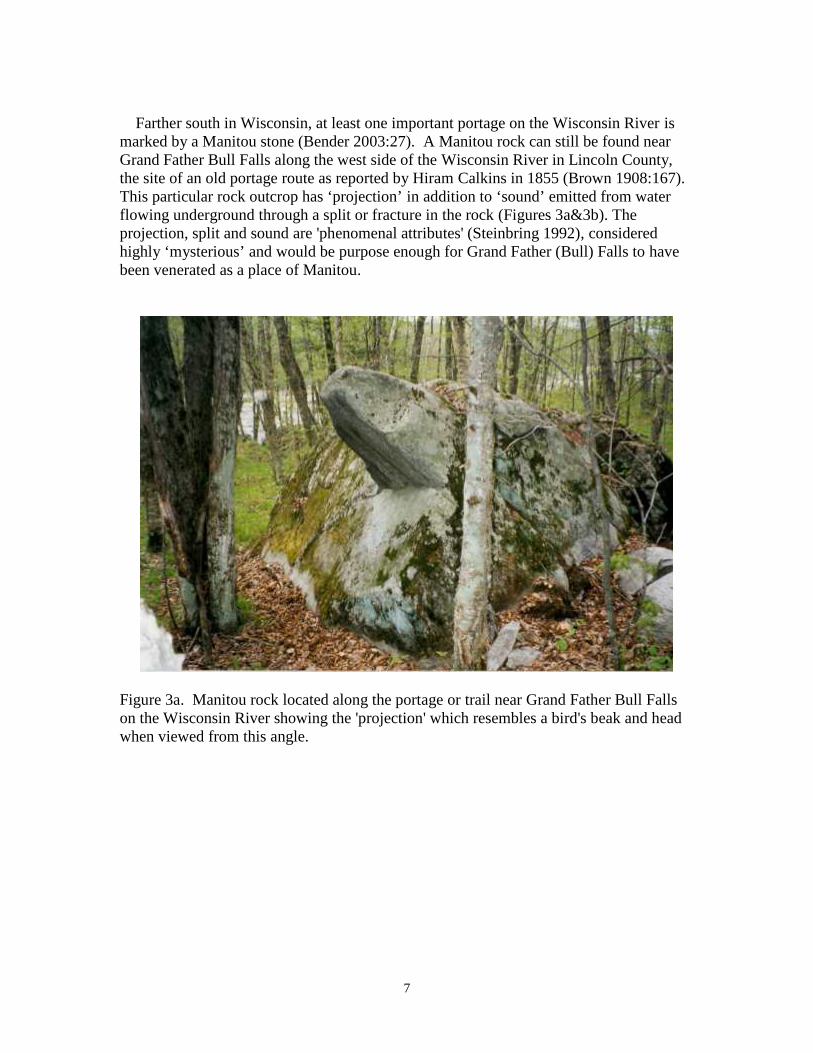
Farther south in Wisconsin, at least one important portage on the Wisconsin River ismarked by a Manitou stone (Bender 2003:27). A Manitou rock can still be found nearGrand Father Bull Falls along the west side of the Wisconsin River in Lincoln County,the site of an old portage route as reported by Hiram Calkins in 1855 (Brown 1908:167).This particular rock outcrop has ‘projection’ in addition to ‘sound’ emitted from waterflowing underground through a split or fracture in the rock (Figures 3a&3b). Theprojection, split and sound are 'phenomenal attributes' (Steinbring 1992), consideredhighly ‘mysterious’ and would be purpose enough for Grand Father (Bull) Falls to havebeen venerated as a place of Manitou.
Figure 3a. Manitou rock located along the portage or trail near Grand Father Bull Fallson the Wisconsin River showing the 'projection' which resembles a bird's beak and headwhen viewed from this angle.

8
Figure 3b. View of the Manitou rock or stone showing the split or Fracture (above thedog's tail and back) where water can be heard flowing underground, a phenomenalattribute associated with Manitou from which Manitowoc, Wisconsin derived its name.
Linked by the extensive prehistoric (Indian) trail network east of the Mississippi River,a portage and trail in south western Pennsylvania connected the Susquehanna Riverflowing into the Chesapeake Bay and Atlantic Ocean with the Ohio River and MississippiRiver drainage basins (Hulbert 1902, Wallace 1987:51,77,156). From an account writtenby William Rudolph Smith (n.d.) whose grandfather founded Huntingdon, Pennsylvania,the site of the village of Huntingdon was once occupied by a band of Indians who werealmost certainly Oneida, i.e., the nation of “the upright stone” (Bender 2003:29). TheirIndian camp or village was widely known in the western Pennsylvania area as “StoneTown” or rather “Standing Stone Town.” J. Simpson Africa’s History of Huntingdon andBlair Counties (1883:452) adds this information about the stone: “The early history of[Huntingdon] borough carries us back to the traditions of the Indian occupation andthe reminiscences of the early Indian traders…. They erected near the river … a tall, slimpillar of stone, covered with hieroglyphics, presumed to embody the history as well as arecord of the achievements of the tribe…” It is supposed that this stone was carried offby the Indians when they emigrated elsewhere, an Oneida tradition (Ball and Waggoner2010:42, Bender 2003:29), as they would have regarded it with great sanctity.
Standing Stone, sometimes called Standing Rock at Kent in Portage County, Ohio isyet another venerated ‘standing stone’ associated with a river. It was encountered alongthe Mahoning Path or trail, a short cut in the ‘Great Path’ to Detroit and western GreatLakes. Because it was the shortest route, this path was especially popular with couriers

9
traveling on foot between Detroit and the Pennsylvania frontier at the time. The path ranfrom Beaver’s Town in western Pennsylvania to Youngstown in Ohio “crossing theCuyahoga River at Standing Stone …” and from the ford, continuing on to Akron(Wallace 1987:96-97). Standing Stone was described by John Heckewelder (Wallace1998:253-254) in 1789 as “… a high rock in the middle of the stream … The base like apillar, broad at the bottom, then a ledge, then it gets quite thin as though it had beenplaned off; it widens again at the top, & has 3 small white pines standing on it.” (Figure4). Heckewelder, once across the stream, noticed a “peeled tree” with Native exploitsinscribed on it using charcoal and redstone (a form of ochre).
Figure 4. The Standing Stone in the Cuyahoga River near Kent, Portage County, Ohio.
Traveling a short distance up the Mahoning River connected by the Salt Lick Trail, aspur of the Mahoning Trail, Heckewelder and company camped by a huge salt spring or“Lick” at present day Niles where twelve separate deer and animal trails converged(Wallace 1998:254). A phenomenal attribute of the landscape, it is the place where thename Mahoning was derived, meaning “at the deer lick” (Wallace 1987:96). Both therock and ‘deer lick’ would have been looked upon by the Indians as manifestations ofManitou which embodied a particular phenomenal or animate belief.

10
Not to be confused with the standing stone at Kent is another rock outcrop in Ohionamed the Standing Stone. It is well worth examining, especially in the context of Nativebeliefs and cultural landscape associations. According to the Reverend David Jones(1774:64) who visited what is now Lancaster, Fairfield County in central Ohio inFebruary 1773, there was a Delaware (Lenape) village “… at the Standing Stone …situated on a creek called Hock-hok-in.” To the Delaware, it was “Ach-sin-sink” or the“Standing Stone” (Figure 5). Ach-sin-sink outcrops along the Belpre Trail whichintersected with the Sciota River and Trail. It exhibits prominence and presence, bothphenomenal attributes (Steinbring 1992). The Sciota Trail ran north to the SanduskyTrail, completing the communication and phenomenal landscape association network ofplaces associated with Manitou and sacred places (Bender 2003, 2007 & 2011a).
Figure 5. ‘Standing Stone’ of the Delaware, Fairfield County, Ohio from an 1846illustration by Henry Howe and named Mount Pleasant at that time.
Continuing north on the Mahoning Trail to Cleveland, northwest on the Great Path orfrom the south on the Sandusky Trail to Fort Sandusky, all three trails intersected theLake Shore path which skirted the south shore of Lake Erie (Wallace 1987:85-87). FortSandusky was strategically located near Indian towns and trading posts on the Great IndianTrail between Detroit and Pittsburgh. Traveling further west from the fort on the GreatPath toward present day Toledo, the trail split. The north branch went to Detroit past theStraits connecting Lakes Huron and Erie, the site of another Manitou stone deliberatelydestroyed by the Jesuits (Bender 2003:28, Parkman 1983:739). The southwestern branch,the Maumee Trail, crossed the Maumee River below the rapids near Roche de Bouef orthe ‘Buffalo Rock’ in the middle of the Maumee River (Figure 5 river slide). Now thesite of present day Waterville, Ohio, the name “Roche de Boeuf” was probably a Britishmisspelling and mistranslation of the French “Roche de Bout” meaning “rock on end”,but commonly accepted to mean “buffalo rock”, perhaps because the shape somewhatresembles a buffalo or bison (Figure 6a).

11
Figure 6a. A mid-19th century view of Roche de Boeuf or ‘Buffalo Rock’ at Waterville,Ohio.
A phenomenal landscape feature thought to be inhabited by Manitou, the Jesuit priestFather Claude Allouez noted that “At perilous places in the rivers, they propitiate theeddies and rapids by offering them presents (Thwaites [ed.] 1896:50, 285-287). Theonce-massive limestone rock outcropping standing in the Maumee River has markedmany events in the history of the valley. It was a legendary site for Native Americans andthe place where they gathered before the Battle of Fallen Timbers in August 1794.Furthermore, its importance as a landmark and spiritual qualities were noted in an 1807treaty where the ceded land by the Ottawa, Chippewa, Wyandot and Potawatomi includeda reserve “… above Roche de Bouef, to include the village where Tondaganie, (or theDog) now lives” (Royce: 1900:674). About one-third of the rock was destroyed when arailroad bridge was built which caused a great controversy (Fig. 6b).
Figure 6b. Roche de Bouef in the Maumee River with the railroad bridge which, whenbuilt, destroyed one-third of the sacred rock.

12
Cairns & Rock Pilings
Perhaps of little worth or note to some, we are fortunate that there are abundantreferences and mentions of rock piles or cairns throughout the North America continent,many of the descriptions dating from the early historic period. The French, who hadpenetrated into the interior of North America long before the English, noted in 1749 thata ‘cairnlike Seneca rock structure’ located at the mouth of a stream (the Apple River)entering Lake Erie (near present day Barcelona, Pennsylvania) marked a portage routeconnecting the eastern Great Lakes with Lake Chautauqua and the Ohio River drainagesystem (Eckert 1995:xxxvi, Wallace 1987:136-137). Without knowing it, they hadstumbled on to an ancient form of semiotics, one that could possess a duel identity. By1749 it had been known for well over a century that trail routes were marked with‘heaped stones’. As Barber (1844:97) said about the Indians and their trails in thenortheastern states, “When a company traveled together, they generally followed eachother ... scarcely ever two were seen by side of another … To know their walks again, inunfrequented woods, they heaped stones (cairns) and marked trees.” It was also knownthat many of the markers and, therefore, the trails themselves were of ancient origin,beginning as migratory paths for large animals, usually bison (Bender 2002). West of theMississippi River, especially in the generally featureless Central Great Plains, trails weremarked in much the same manner with special emphasis on the ridges and especially thedivides separating river drainage systems or springs (Blakeslee and Blasing 1988). Thesewere meant to be purely utilitarian ‘sign posts’ for the traveler needing guidance infinding trail spurs.
For the purposes of this article, only those cairns of a mainly non-utilitarian nature thatexhibit shared traits such as being built on a prominence and/or having a definite trail orportage association will be examined. Cairn placement along a trail could also conveyadditional information about the surrounding landscape, e.g the location of a veneratedspring (Figure 7). It is these attributes which may indicate the presence of Manitou,
Figure 7. The Senn Cairn in Fond du Lac County, Wisconsin was constructed as a turtlepetroform and aligned to point toward a sacred spring along the trail which connected thecontinental sub-divide (see Figure 19a).

13
elevating the cairn or locale to more than the mundane. At these places, Manitou mayimpose as the genius loci, a trail shrine or ‘center’ (Hall 1985:184-185, McLuhan1971:20).
With the establishment of a trail shrine system that marked through routes orconsecrating a spring or an important ‘place’ (Bender 2007, 2008a), some cairns grew toimmense size with the addition of ‘donations’ from passers-by who, seeking safe journeyfrom the spirit of place, left a rock as a votive offering (Dunham et al1998, Ruttenber1992:373-374). Moreover, a cairn’s structure and physical location along a trail is not sodifferent than in a word dating from antiquity and sometimes used for Old World stonepiles marking trails, i.e. hermes. Like the cairns, the hermes, named after the Greek godof commerce and travel the messenger Hermes, marked travel routes and were built upover time by passers-by who placed stones on them (Murray 2004:110). The parallelsbetween the Old and New World are striking and have sometimes led to misconceptionsof authorship, especially in the 19th century.
Standard English dictionaries state that the definition of the word cairn, meaning a “aman-made pile, heap or stack of stones,” comes to us from the Scottish Gaelic word carn.Henry Schoolcraft (1851:480) said that the Indian-made stone piles he saw on MackinacIsland were reminiscent of Celtic Cairns. Unlike some of his contemporaries, Schoolcraftfirmly attributed their construction and other stone work to the indigenous people. Fourscore years later, Wilbert Hinsdale (1931:111) noted that, “At certain places the Indianshad made stone piles, built up one stone at a time by passers-by.” He also observed thatthe stone piles commemorated the location of an important event or that they marked aformer spiritual presence or physical manifestation, perhaps a spirit tree (Dunham et al1998). One cairn on the shore of Thunder Bay on Lake Huron described by ThomasMcKenney (1959:402) was or is “… an oval figure, about twenty feet by ten, in thelongest, and broadest parts. In the center of it are about twenty stones, four of which arelarger the rest; and each of these, I should judge, would measure three feet every way.The path leading to this sacred place is well trod by those who come to make theirofferings to this pile of stones, which is Manitou! Upon the four principal stones wereofferings to of these benighted people, in tobacco, bits of iron, pieces of old kettles, pipesand various other things. The four large stones the Indians said had been there always,and the little ones had been gathered around them since.” In Hinsdale’s description, a number of important features associated with the Manitou
and cairn are evident; the surrounding landscape with Lake Huron is a prominent focalpoint, a connection with the trail or foot path, and the round cairn being built up overtime by ‘donation stones’ strewn around the four large stones. Of further importance andinterest, it should be noted that within the Woodland and Plains Indian cosmology andbeliefs, the number four is held as a sacred number (Bender 2003:14,16&17; Bender2011a:165). The number four can sometimes be discovered when encoded in cairns andother petroform oriented to the cardinal or cross-cardinal directions (Bender2008b:201&205). However, they do not necessarily have to have a trail association. The ‘donation’ cairns of interest for the purpose of this article were exclusivelylocated along well established trails or paths, usually at or near a stream or other waterfeature (Ruttenber 1992:374). As mentioned, many if not most of the paths and, byextension, the cairns, were of ancient origin (Bender 2003, 2007, 2008a; Freeman et all1990; Wallace 1987). Furthermore, geographic cairn placement could also convey

14
additional information about the surrounding landscape, e.g. the location of a spring, aportage or perhaps a rock art panel (Figure 1). With the establishment of what alsofunctioned as trail shrines along through routes such as a mountain pass or valley,consecrating a spring, or as suggested by some, a marker or petroform of spiritualimportance (Bender 2007&2008a, Schassfma 1980:98), the cairns grew in size withdonations from generations of passers-by traveling on foot (Ruttenber 1992:373).
What was not mentioned by Hinsdale was the oft heard story of a chief or warriorburied beneath virtually every stone pile. The seemingly ubiquitous legend of the cairnsbeing burial structures for a fallen chief or warrior is common in the eastern part of NorthAmerica and in the west. In New England and upstate New York, descriptions of‘donation’ cairns, originating (in legend) as burial monuments, were documented bytravelers early on. In a letter written by Dr. Noah Webster (20 January 1788) to Rev.Ezra Stiles, the President of Yale College, Webster noted that, “In the neighborhood ofmy fathers house, and about 7 miles from Hartford, on the public road to Farmington,there is one of these Carnedds [cairns] or heaps of stone. My present opinion is that itscircumference is about 25 feet. The inhabitants in the neighborhood report, as a traditionreceived from the natives, that an Indian was buried there, and that it is the custom forevery Indian that passes by, to cast a stone upon the heap. This custom I have never seenpractised; but have no doubt of its existence …”
In 1821 while traveling a well used and ancient trail in Massachusetts (the route ofmodern day U.S. Hwy. 7), the Reverend Timothy Dwight (Vol.2:380), President of YaleCollege said, “From [Great] Barrington, in our way to Stockbridge, we crossedMonument mountain: a spur from the Green Mountain range. The name is derived from apile of stones, about six or eight feet in diameter, circular at its base, and raised in theform of an obtuse cone over the grave of one of the aborigines. The manner, in which ithas been formed, is the following- Every Indian, who passes by the place, throws a stoneupon the [cairn] . . . it seems to be an expression of peculiar reverence, and an act ofobedience to the dictates of their religion.” Traveling farther north toward the intersection with an ancient path at Stockbridge,Dwight (Vol.3:403) further described another cairn in the same vicinity, “After we hadexamined the falls of this river, and its passage through the mountains below, mycompanions ascended the summit of that on the Eastern side, for the purpose of seeing amonument of stones … This is a circular enclosure, surrounding the grave. Both (this andthe ‘obtuse cone’ shaped cairn) were, however, gathered in the same manner. EveryIndian, at least of the tribe to which the deceased belonged, considered himself as under asacred obligation, whenever he passed by, to add one stone to the heap … It isremarkable, that both are on high, and solitary, grounds, remote from every Indiansettlement … places considered … as consecrated ground.” A sacred location on “high… grounds”, important traditions in the concept of Manitou, were likely of paramountimportance, something noted by Dwight (Vol.3:408) when he explained that, “These,monuments were plainly erected under the sanctions of Religion: for every Indian felthimself religiously obliged, when he passed by, to cast a stone upon them ... the Indians,in both these instances, consider themselves as having been released from it [theobligation] a good number of years. Both of them were also raised upon extraordinaryoccasions. What those occasions were it may now be impossible to determine.”

15
In 1753, almost three quarters of a century earlier than Reverend Dwight, the ReverendGideon Hawley of Marshpee [southeastern Massachusetts] remarked in a letter that, “Thelargest heap [cairn] I ever observed, is that large collection of small stones on themountain between Stockbridge and Great-Barrington [western Massachusetts]. We havea sacrifice rock, as it is termed, between Plymouth and Sandwich [easternMassachusetts], to which stones and sticks are always cast by Indians who pass it. Thiscustom or right is an acknowledgment of an invisible being. We may style him theunknown God, whom this people worship. This heap is his altar. The stone that iscollected is the oblation of the traveler, which, if offered with a good mind, may be asacceptable as a consecrated animal. But perhaps these heaps of stones may be erected to alocal deity, which is probably the case." (Hawley 1753, Ruttenber 1992:372) Whenasked, “To whom is this worship offered?” The answer was, “To a manito; and by manito…” (Kendal 1808). The sacrifice rock Reverend Marsh acknowledged as Manitou by theIndian people was also along an ancient Indian trail or foot path, the Bay Path, which rantoward the west from the tip of Cape Cod all the way to Springfield in westernMassachusetts and on to Stockbridge and thence on to Albany, New York (Russell,1980:200-203). There is, however, some confusion of which ‘heap’ near Great Barrington was therenowned Monument Mountain cairn of great size and those that Rev. Dwight described.According to Lion Miles (2006), it is highly probable that the “large heap” that the Rev.Gideon Hawley saw and not those described by Rev. Dwight was in the vicinity ofRisingdale (Massachusetts) approximately a half mile east of the Housatonic River. Itwas near an offshoot the main trail to Stockbridge, now the likely the route of State Hwy.183. Another cairn was documented in Great Barrington at the confluence/junction of theHousatonic and Green River. In a rigorous examination of the historic record by Miles(2006), it is obvious that placement of both cairns, i.e. ‘place’ could act as a boundarymarker. There are also historic accounts of ‘place’ at the confluence of rivers exhibitingthe profound attribute of a junction or ‘center’ of the earth below the center of heavenabove (Neill 1882:1). An informant at the time (1768) said that at the great stone heapwhich bore the Mohican name Wawanaquasick meaning “offering place,” the Indians“added Stones to it and when they did so they said “Grand father I recover you.” Writtenafter the fact, by August, 1762 despite a profound or profane purpose, the once huge cairnwas “all removed”, the individual rocks used to build settlers chimneys and foundations(Miles, 2006).
Crossing the Hudson River in New York State and continuing west, the Bay Path wassometimes called the Ambassadors Road (Shank 2002:5). More often, though, it wascalled the Iroquois trail or Mohawk Trail where it ran west up the Mohawk Valley acrossthe great watershed of New York to the Niagara River (Hulbert 1902:27). The formerhuman footpath is now the approximate route of modern day U.S. Highway 20 runningfrom eastern Massachusetts through New York (and west to Chicago). Along this path,one came to Schoharie Creek approximately 15 miles west of Albany. According to anearly history of New York (Barber & Howe: 1841), "Somewhere between Schohariecreek and Caughnawaga commenced an Indian road or foot path, which led to Schoharie.Near this road, and within the Northern bounds of Schoharie county, has been seen fromtime immemorial a large pile of stones, which has given the name ‘Stone heap patent’ tothe tract on which it occurs, as may be seen from ancient deeds." The trail was in fact the
16
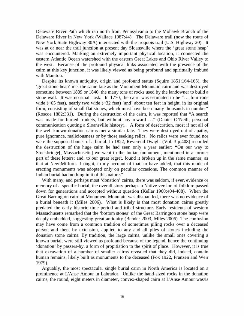
Delaware River Path which ran north from Pennsylvania to the Mohawk Branch of theDelaware River in New York (Wallace 1987:44). The Delaware trail (now the route ofNew York State Highway 30A) intersected with the Iroquois trail (U.S. Highway 20). Itwas at or near the trail junction at present day Sloansville where the ‘great stone heap’was encountered. Marking an extremely important physical location, it connected theeastern Atlantic Ocean watershed with the eastern Great Lakes and Ohio River Valley tothe west. Because of the profound physical links associated with the presence of thecairn at this key junction, it was likely viewed as being profound and spiritually imbuedwith Manitou.
Despite its known antiquity, origin and profound status (Squire 1851:164-165), the‘great stone heap’ met the same fate as the Monument Mountain cairn and was destroyedsometime between 1839 or 1840, the many tons of rocks used by the landowner to build astone wall. It was no small task. In 1770, the cairn was estimated to be “… four rodswide (~65 feet), nearly two wide (~32 feet) [and] about ten feet in height, in its originalform, consisting of small flat stones, which must have been many thousands in number”(Roscoe 1882:331). During the destruction of the cairn, it was reported that “A searchwas made for buried trinkets, but without any reward …” (Daniel O’Neill, personalcommunication quoting a Sloansville history). A form of desecration, most if not all ofthe well known donation cairns met a similar fate. They were destroyed out of apathy,pure ignorance, maliciousness or by those seeking relics. No relics were ever found norwere the supposed bones of a burial. In 1822, Reverend Dwight (Vol. 3 p.408) recordedthe destruction of the huge cairn he had seen only a year earlier: “On our way toStockbridge[, Massachusetts] we went to the Indian monument, mentioned in a formerpart of these letters; and, to our great regret, found it broken up in the same manner, asthat at New-Milford. I ought, in my account of that, to have added, that this mode oferecting monuments was adopted only on peculiar occasions. The common manner ofIndian burial had nothing in it of this nature.”
With many, and perhaps most ‘donation’ cairns, there was seldom, if ever, evidence ormemory of a specific burial, the overall story perhaps a Native version of folklore passeddown for generations and accepted without question (Kellar 1960:404-408). When theGreat Barrington cairn at Monument Mountain was dismantled, there was no evidence ofa burial beneath it (Miles 2006). What is likely is that most donation cairns greatlypredated the early historic time period and tribal structure. Early residents of westernMassachusetts remarked that the ‘bottom stones’ of the Great Barrington stone heap weredeeply embedded, suggesting great antiquity (Bender 2003, Miles 2006). The confusionmay have come from a common tradition of sometimes piling rocks over a deceasedperson and then, by extension, applied to any and all piles of stones including thedonation stone cairns. By tradition, the large cairns, unlike the small ones covering aknown burial, were still viewed as profound because of the legend, hence the continuing‘donation’ by passers-by, a form of propitiation to the spirit of place. However, it is truethat excavation of a number of smaller cairns revealed that they did, indeed, containhuman remains, likely built as monuments to the deceased (Fox 1922, Franzen and Weir1979).
Arguably, the most spectacular single burial cairn in North America is located on aprominence at L'Anse Amour in Labrador. Unlike the hand-sized rocks in the donationcairns, the round, eight meters in diameter, convex-shaped cairn at L'Anse Amour was/is

17
constructed of medium sized boulders (Figure 8). When excavated, the body of a childcovered in red ochre was discovered at its base. Based on dating of the human remainsand charcoal from two ritual fires near the body, the cairn was constructed approximately7500 years old, the oldest known burial cairn in North America. It is attributed to theancient Maritime Archaic culture (Fitzhugh 1978, Tuck 1976). However, despite theearly date of construction, the location on a prominence overlooking the waters of theStrait of Belle Isle was, without doubt, the primary attribute in site selection. Thecarefully chosen physical location helps to convey presence, a phenomenal attributeevoking the numinous experience of Manitou (Steinbring 1992). In addition, the east-west orientation of the burial and two large rocks set at right angles north and south of theburial upon which ritual fires were built created quartered/sacred space, a sacred form ofthe number four. In this special circumstance, the divine interposes and is linked to theconcepts of Manitou and establishment of (cosmic) order, attributes well beyond acommon burial or simple rock-pile memorial. The combination of the profound attributesof prominence, orientation toward the direction east and the color red extend well beyonda common burial or memorial (Bender 2009:6, Ritchie 1969:178).
Figure 8. The early Archaic age, Maritime Archaic cairn at L'Anse Amour, Labradorwhich covered a red ochre burial, the oldest known cairn burial in North America. TerryJ. Deveau photo.
If a temporal (proto-Algonquin) linguistic connection for transmitting sharedtraditions existed with the Maritime Archaic or ‘Red Paint People’ (5000-1000 B.C.), adistinct possibility (Maxwell 1978:31, Ritchie 1969:79-83), there may be a corollary

18
contemporary with them in Wisconsin. Seeking a cultural affiliation during a highwayupgrade project and required environmental impact survey in October, 1993 an upright,rounded triangular-shaped stone standing on a crescent-shaped cairn was brought to myattention by a member of the Wisconsin Department of Natural Resources (Figure 9). Itwas one of two cairns in Fond du Lac County that share a connection with each other andin part, possibly L'Anse Amour. Both cairns were discovered within a concentratedgeographic area or Archaic age ‘precinct’ in southeastern Wisconsin, the broad areaexhibiting a ‘definite Archaic presence’ (Bender 1995:6, Bender 2008a:66, Steinbring1997). The two cairns were emplaced along ancient, documented trails and/or aprehistoric trail route adjacent to a spring, each likely functioning as a trail shrine(Bender 1995:6&9, Steinbring 1997:24, Ralph Redfox and Leola One Feather, personalcommunication). Both trails, one an important human-induced feature within theprecinct, connect the continental sub-divide between the Great Lakes andMississippi/Missouri Rivers drainage basins. Each cairn also exhibits profound attributeswhich act to link the sky and cosmos. Furthermore, both the cairns and trails areconnected to sites within the (Archaic age) precinct where the distinctive MaritimeArchaic slate blades and their identical Old Copper Culture tool forms have beendiscovered (Bender 2011b:9 Steinbring 1997). Unlike the cairn at L'Anse Amour,however, the two cairns are not thought to cover burials, constructed instead to exhibitattributes associated with Manitou and landscape phenomena.
Figure 9. Crescent shaped cairn with a rounded, triangular-shaped upright or Manitoustone. The cairn sits on the north end of a small hill along an ancient trail in southeasternWisconsin. The view is looking west.

19
The cairn with a triangular upright, named the Hesselink site after the local landownershares two important connections with features and/or attributes at L'Anse Amour; theview shed and quartered space. Located on the north end of a small drumlin orprominence, there is a panoramic, 360° view of the surrounding countryside with acommanding view toward the Niagara escarpment on the eastern horizon. The axis of thecrescent-shaped cairn is aligned east-west. The fore mentioned upright stone which, whenviewed from the south has a pronounced triangular shape. It is extremely weathered onthe upper edges and is centered on the crescent-shaped cairn (Figure 10).
Figure 10. Frontal or south view (looking north) of the dolomite, triangular or conical-shape Manitou stone located on the north end of a small hill in Fond du Lac County,Wisconsin (see Figure 9). Note the abrasion or weathered surface on the apex or point ofthe Manitou produced by either long-term weathering, abrasion while being shaped, orboth. It is one of at least three large triangular-shape stones that once stood erect on thehilltop's north end.
On the south edge at the center of the cairn there is a saddle-shaped ‘altar’ stone which isat the end of a north-south aligned row of spaced stones. Two small triangular-shapedstones stood on both ends of the cairn (Figure 11a). In addition, two other approximatelyone meter tall, triangular shaped stones (now tipped) are on an east-west alignment southof the cairn (Figures 11b&c). There is a definite northward orientation viewed frombetween the two other triangular-shaped stones towards the ‘altar’ stone and triangular

20
upright. The entire scene creates what Hall (1985:184-185) describes as a 'center shrine'(Figure 11d). The northward alignment of the row of spaced stones terminating with the'altar' stone and then the triangular standing stone itself, pointing up, suggests an earthnavel or umbilical (Hall 1985:184-185). The alignment symbolically connects the earthwith the sky at the place where the stars revolve around one point in the night sky, the'hole-in-the-sky', now occupied by Polaris, the 'north star'. However, in its entirety, thecairn, stone row and uprights were designed to quarter space, establishing order inconjunction with the ideal of center.
Figure 11a. View looking approximately east of tipped triangular upright on the west endof the crescent-shaped cairn, the triangular upright in the cairn center and the ‘altar’ stoneon the center, south edge of the cairn. Another tipped triangular upright on the cairn eastend is not visible in the photo.

21
Figures 11b & c. The two, approximate meter high and wide, triangular-shaped stoneswhich once stood upright to the south of the cairn. Figure 11b (at left) is west of Figure11c (at right). North is to the top in Figure 11b and to the right in Figure 11c.
Figure 11d. View looking north between the two triangular stones (Figures 11 b&c)toward the ‘altar’ stone in-line with the triangular upright or Manitou stone standing inthe center of the east-west aligned, crescent-shaped mound creating a ‘center shrine’ withthe direction north as the focus. Note the tipped triangular upright to the left of theManitou stone (see Figure 11a).

22
Over the years, a farm field located about one half mile to the east of the hill and cairnhas yielded approximately 1000 artifacts, the vast majority Archaic in age, i.e. predating1500-2000 B.C. The artifact assemblage infers an Archaic age span of use or origin forthe area containing the cairn/trail shrine. It is also near the site where the distinctiveMaritime Archaic slate blade was discovered. A proposed Archaic age for the trail shrineestablishment and ritual use is further supported by other corroborating evidence (Bender2003:3, Bender 2013:54-56). While on a field trip during the 1999 International Rock ArtCongress (IRAC) held at Ripon, Mr. Ralph Redfox, a traditional Cheyenne elder andhealer, recounted an ancient Cheyenne oral tradition that upright stones like those at theHesselink site were placed on the north end of the hill as "guardians against the icereturning [from the north]". The Cheyenne believe that as a hill slopes up toward thenorth, it gets colder (Grinnell 1972:94). The story has been interpreted as suggesting alate Pleistocene or early Archaic period origin (10,000 – 8000 B.C.) for it and placementof the upright stones. There is additional evidence which may support the idea of an earlyto mid Archaic origin. During an inventory of the sacred rocks and boulders in southernAlberta, Canada, two-thirds of them were discovered to occupy a prominence with anorthward focus. Furthermore, the date or age of utilization firmly placed all in the earlyto mid Archaic (Freeman et al 1992:3, Steinbring 1991, Steinbring et al 1995). Accordingto ancient tradition, the Cheyenne primary direction of focus is north (Powell1969:27,467,617). It is considered by both the Algonquin and Siouan-speakingWoodland and Plains tribes, both of whom migrated west to the Great Plains from theupper Great Lakes area, to be the most ancient and primary direction (Bender2003b:28&30, Bender 2008a:67, Powell 1969:27,467&617; Schlesier:1987:62). 1
The second cairn of note is within the near center of the precinct constructed, in part,to mark the location of at least four spring discharges very near an ancient path windingalong the edge of an outcrop of the Niagara escarpment (Figure 12). Named the WagnerSite for the current landowner, the cairn is oval in shape, approximately 33 feet long bytwelve feet wide by four feet high. It is composed of medium to large-sized boulders,some of them likely ‘spirit’ or Manitou stones in their own right (Steinbring et al 1995).The main axis of the cairn is aligned to the winter solstice sunrise first gleam glimpsed inthe valley between two hills to the southeast (Figure 13). Here, again, Manitou imposestransforming the cairn and scene to a higher cosmic purpose and order beyond a simplerock pile marking a spring along a trail or footpath. Furthermore, artifacts discovered at anumber of former campsites in the vicinity of the springs and cairn during the 1995WEPCO survey (Bender 1995, Stenbring et al 1995) also exhibit the ‘definite Archaic
1 The proto-Algonquin language core is considered by many scholars to be one of the most ancientlanguages in North America whose distribution is related to Ice Age geography, glaciation and the north(Rogers et al 1990). It is also reflected by the rock art found in territory still occupied by Algonquin-speaking tribes such as the Cree who predated later migrations by the Anishinabe including the Chippewaor Ojibwe tribe (Honigman 1981, Rhodes & Todd 1981, Steinbring 1981). As Lanteigne (1989, 1990:127)remarked: “These proto-Algonkian populations are believed to have been present in the Lake-of-the-Woodsregion as early as 11,000-8,500 years ago and expanded northeast, north and northwest during the retreat ofthe Laurentian ice sheet and Glacial Lake Agassiz.” The early migrations and time period are likelyresponsible for any Ice Age ‘memories’ and/or oral traditions related to the direction north, ice and extremecold. Most if not all these tribes (including the Cheyenne) who have preserved memories of the north (i.e.cold and ice) thoroughly reject any mention of a migration from Asia over the Bering Land Bridge duringthe late Wisconsin glaciation as an origin of the stories (Deloria 1995:48,97-99) saying, if asked, that “wewere always here” and “are no second cousin to a Chinaman” (personal communication).

23
presence’ associated with the Hesselink site, other near-by habitation sites and throughoutvirtually the entire survey area and beyond.
Figure 12. Survey map of the ‘sacred’ precinct discovered during the 1995 WEPCOsurvey. The circle of hills or drumlins (at center) is to scale, based on a 7.5 Minutequadrangle topographic map. Note the springs, ‘sacred’ springs, shrines and petroform(including cairns) connected by the trails, a signature feature of the area. The eastern andnorthern parts of the map (at top and right) are within the Milwaukee River/GreatLakes/North Atlantic drainage basin. The Rock River in the western and southern partsof the map flows to the Mississippi River and Gulf of Mexico. The continental sub-divide formed by the distinctive topography runs at a northwest angle from Na Na WiGwan to the Niagara Escarpment. Its approximate center is the highest hill (at mapcenter), marked by a number of monoliths, bison effigy stones and other petroform. Thesummer solstice sunset line also runs along the continental sub-divide from Na Na WiGwan (a ‘medicine wheel’ or sun circle site) to the highest hill at center in the map to theedge of the Niagara Escarpment approximately eleven miles distant (Bender 2008a &2011b). A Cheyenne delegation performed a ceremony on top of the hill ‘pinning’ it as[a] ‘center’ (of the universe), establishing its importance, sanctity and ‘place’ inCheyenne cosmology and origins.

24
Figure 13. Photo of the cairn at the Wagner Site during the winter solstice sunrise. Notethe cairn long axis alignment with the winter solstice sun rise in the valley. The offset ofthe sun’s disk to the north (left) is consistent with the proposed Archaic date ofconstruction (2000-1500 B.C.), a consequence of the earth’s shift-of-the obliquity-of-theecliptic over time.
Triangular-Shaped Standing Stones
A salient feature at L'Anse Amour not generally discussed or shown in most photos isa triangular-shaped standing stone in the near vicinity of the cairn (Figure 14). InWisconsin, the Hesselink cairn with its triangular upright in the middle of the cairn sharesthis feature as does the Nehls cairn which also has a triangular-shaped upright centered inthe very top of the large cairn (Figure 15). The suggestive form is also found at numberof other sites in Wisconsin spreading west into the Great Plains. Therefore, the corollarywith L'Anse Amour would not be complete without a fuller discussion of the triangular-shaped upright or standing stones.

25
Figure 14. Triangular upright at L'Anse Amour standing near the cairn and visible fromthe sea. Terry J. Deveau photo.
Figure 15. The Nehls cairn with a Manitou stone in the center. The cairn is near thejunction of seven trails on the south end of the world-renowned Horicon Marsh.

26
Often described as Manitou stones (Bender 2003:27-28), these conical or rounded-toppyramidal uprights suggest the shape of a person with a blanket draped over their headand shoulders (Figure 16). The outline is sometimes perceived as the shape of a spirit orapparition, the inspiration for those wearing a bed sheet costume on Halloween nightdressed as a ghost. Some may have been worked to achieve the outline, most surelynatural. They sometimes had rock art on the surfaces. William Pidgeon (1858:180),while traveling through the area of southwestern Wisconsin near Prairie du Chien in the1830s, described a triangular upright he called Paint Rock which "presents a pyramidalform, standing five feet above the surface of the earth, gradually tapering from the groundupward ... covered with painted ... figures of various kinds."
Figure 16. Trail of Three ceramic plaque with blanket draped women showing therounded profile compared to a Manitou or ‘spirit’ stone profile (see detail from Figure 9at right).
The most massive triangular upright I have personally seen is in southern Wisconsinon a hill overlooking Goose Lake. It is a highly weathered gray, igneous rockapproximately a meter and half high with a base almost as wide (Figure 17a). A semi-circle of stones partially surrounds it (Figure 17b). Little is known of its origin orcultural history other than to note its great presence.

27
Figure 17a. The Goose Lake monolith, a massive triangular-shape upright on a hilloverlooking Goose Lake near Lake Mills, Wisconsin. The yellow board is one meter.View is looking north.
Figure 17b. The Goose Lake monolith and partial circle of boulders which surrounds it.View is looking east.

28
Although establishing a cultural context for Manitou stones can be difficult in the shortterm, a number of triangular uprights were discovered in southeastern Wisconsin at theso-called ‘medicine wheel’ site which was extensively studied over a six year period(Bender 2008a&b). Three of five known to be there have been described in a previouspublication (Bender 2008b:54-55). However, there are two others on site that meritfurther attention. One of the two presents a triangular form, the other a ‘pyramidal’ form.Both are imbued with Manitou and hold a spiritual connotation inherent with theirplacement when juxtaposed in relationship to other profound site features.
The triangular upright is located on the northeast side of the site’s primary feature, theapproximately 10 meter in diameter stone circle (Figures 18a&b). Its location to thenortheast of the large stone circle is, without doubt, highly intentional (Figure 18c).There are surviving traditions amongst the Plains Indian groups of this being a verysacred position to occupy. Northeast (NE) is the direction that thunder (and lightning)comes from in the Cheyenne tradition, of primary importance and representing a spiritnamed Nonoma (Schlesier 1987:5, 8, 96–97, 118; Bender 2008a:56, Bender 2011b:27).Together with the three other semi-cardinal directions (SE, NW, SW), NE also acts toquarter space on a cosmic scale with the sun at center that the ‘medicine wheel’ or main(sun) circle likely represents. All represent an ancient, spiritually charge metaphor whichwithin the Plains Indian universe and world view (Bender 2008b, Parks 1996:86-88,94).
Figure 18a. The approximately 60cm high, triangular upright located on the northeastside of the circle of stone at the ‘medicine wheel’ site now known as Na Na Wi Gwan(Bender 2008a).

29
Figure 18b. Photo showing the triangular upright on the northeast side of theapproximate 10m diameter stone circle at Na Na Wi Gwan (see map, Figure 12). View islooking north.
Figure 18c. Winter solstice sunset scene hi-lighting the triangular upright (at center ofphoto) and circle of stone at Na Na Wi Gwan. View is looking toward the south.

30
A short distance west of the ‘sacred’ spring on the site (Bender 1992), the ‘pyramidal’upright sits along side a well worn trail along the north base of the low hill where the suncircle is located (Figure 19a). The upright is approximately a meter or waist high andsurrounded by a partial circle of stones (Figure 19b).
Figure 19a. Photo of the approximately one meter high, ‘pyramidal’ upright along thetrail leading toward the ‘sacred’ spring at Na Na Wi Gwan. View is looking east.
Figure 19b. The ‘pyramidal’ upright and partial circle of spaced stones which surroundit. View is looking north.

31
Traveling a short distance east on the trail, to the west above the spring are a number ofpetroform, two earthen mounds where red ochre offerings were excavated and a tippedmonolith (Figure 20). The tipped monolith is about a meter high tapering to a small,rounded top and at the head of a stone row leading down toward the spring (Figures21a&b).
Figure 20. Survey and sketch map (Bender 1992) showing the position of the tippedmonolith. No. 8 is the ‘sacred’ spring and the pit by the mound (No. 7) is where the redochre was recovered.
Figure 21a. The tipped monolith showing its flat bottom on which it stood and rounded,knob-like top. View is looking east.

32
Figure 21b. Photo showing the location of the tipped monolith in relationship to theparallel rows of spaced rock (lower right) leading toward or from the ‘sacred’ spring or‘well’ (see Figure 20). View is looking approximately north.
The trail passing through this venerated site connects the many springs along it as itskirts the south edge of the ‘sacred’ precinct (Figure 12). Some of these springs wereconsidered sacred where offerings were sacrificed to them including Old Copper Cultureartifacts suggesting a time period well over 3500 years ago (Bender 1992, 2008a:48,2011b; Steinbring 1997). The trail can be looked at as a long east-west portage thatconnects the continental sub-divide of the Milwaukee River and Lake Michigan/GreatLakes drainage basin with the Horicon Marsh/Rock River and Mississippi River drainagebasin (Bender 1992, Bender 2008a:48). However, it was more than a long portage alsobeing a physical and spiritual conduit for the beliefs that were transported along it whichincluded the ideal of Manitou.
Resting alongside a north-south segment of the prehistoric trail network in easternFond du Lac County is another triangular-shaped stone that once stood upright, buthaving been toppled is now laying on its side (Figure 22a). Approximately a meter high,the rock is red-rhyolite porphyry, an intensely red-colored glacial erratic. The rock’sdeep red color, the sacred color for Native people since ancient times (Bender 2003:28,Bender 2004:9,13), and the natural triangular shape are attributes likely dictating why it

33
was chosen to be erected as a Manitou stone. When upright, it stood on a low earthenmound surrounded by a circle of spaced stones (Figure 22b).
Figure 22a. Tipped, approximately one meter high, red-rhyolite porphyry, triangular-shaped Manitou stone resting on a low, earthen mound. View is looking north.
Figure 22b. The tipped Manitou stone, mound and circle of stone that surrounded allpartially visible in the photo. View is looking east.

34
The mound is located at the east base of a hill defining a trail junction where a springonce discharged (Figure 22c). The short trail spur runs uphill, terminating near the top ofhill’s east slope where the Starman petroform was discovered (Bender 1994a, Bender2013:51-54). Because the Starman petroform is dated at ca. 2000-1500 B.C., as are thevast majority of all the artifacts recovered from the proximal habitation sites, the Manitoustone at the base of the hill is thought to be coeval. In addition, the extremely roughtexture of the vertical surfaces exposed to the weather when compared to the smooth,protected base it once stood on help support the premise, the differential weathering ofthe surfaces helping to make a compelling argument for its antiquity (Figure 22d).Furthermore, as a red-colored, triangular-shaped Manitou stone, it did not stand alone.
Figure 22c. Annotated aerial photo of the tipped monolith (Manitou), trails, stone circleand Starman headstone at the Starman site, Fond du Lac County, Wisconsin.
Figure 22d. Photo showing the remarkable degree of difference in differentialweathering between the tipped monolith’s smooth, flat bottom (at right) and the highlyweathered, exfoliated side exposed to the weather (at left) when standing.

35
First brought to my attention by a member of the family who owns an adjacent farm ashort distance north on the trail, four spaced red-colored uprights once stood in a north-south row on a low hill slope (Bender 1994b). One, a triangular shaped rock, is still inplace although it has slid down-hill (Figure 23). The second was likely buried, in place,near the hill slope. The third has a Manitou shape consistent with others that have moreof human-like profile (Figure 24). It was moved to a fence row but has been moved backto its original position and re-erected by the landowner. The fourth was moved to anadjacent property, placed as a dramatic centerpiece in the rock garden. The intensely redupright has been interpreted as a standing bison with its head down in outline (Figure 25).Not an isolated example, numerous other bison effigy stones have been identified insoutheastern Wisconsin (Bender 2013), the animal and iconography a tangible link to thewestern Great Plains beyond the Mississippi River.
Figure 23. Red granite or rhyolite triangular-shaped rock that once stood upright, but hasnow slid downhill and is laying on its side. View is looking south.

36
Figure 24. Red granite upright that may have been shaped to a triangular peak at top. Ithas now been returned to where it once stood in the north-south line of four spacedManitou or ‘spirit’ stones.
Figure 25. A massive red-rhyolite porphyry upright that was moved from the north-southline of spaced rocks to its present location. It is likely a bison effigy with the welldefined hump and head to the right.

37
Shifting focus west of the Mississippi River, descriptions and accounts oftriangular-shaped uprights dating from the 19th century are worth taking note of for theirsimilarity to those in the east. A remarkable combination of piled stones constructed inthe triangular-shape resembling a seated human profile was noted by the transcontinentalrailroad surveyors at Spring Creek in western Kansas shortly after the American CivilWar (Figure 26). Quoting the June 15, 1867 issue of Harper’s Weekly, “On the highestpoints, overlooking the country for miles, the Indians have built cairns or statues of roughstone, which at a short distance bear a wonderful resemblance to a warrior wrapped in ablanket.” The description with comparison to some of those in the east is remarkableconsidering the distance. As to purpose, the caption went on to say, “Whether these wereintended for beacons or breast-works, decoys or monuments, the Indians themselves bestknow.” Here in Kansas out on what was the frontier, the duality of a beacon for travelersintertwined with a spiritual purpose was glimpsed by the author, a correspondenttraveling with the railroad survey crew.
Figure 26. Harper’s Weekly illustration of triangular-shaped cairns at Spring Creek,Kansas resembling a person wrapped in a blanket. Herman Bender collection.
A second example of a cairn with an upright is in a class by itself because of theiconic imagery it projected. In the spiritually charged scene painted by Karl Bodmerduring the summer of 1833, the artist captured the image of a cairn with a standing stonecapped by a bison skull (Figure 27).

38
Figure 27. Print of the Assiniboin cairn and triangular upright capped by a bison skullpainted by Karl Bodmer near Fort Union, Williston, North Dakota. The large rocks orboulders supporting the cairn appear as lithic bison skulls in some versions of thepainting and prints.
Of great ritualistic significance to the Assiniboin, it stood on hill overlooking Fort Unionnear Williston, North Dakota at the confluence of the Missouri and the Yellowstonerivers. For the Assiniboin and other Plains tribes, the buffalo was an essential of life.Prince Maximilian described the cairn as a medicine sign of which there is little doubt.But the location on a hill or prominence at the junction of two major rivers in the semi-arid western Great Plains was likely intentional, and added phenomenal attributes to thedramatic scene, one meant to invoke blessings for the people.
Sacred Rocks, Boulders and Rock Outcrops
Many rocks and boulders considered sacred were spread across the mid-latitudes ofNorth America (Freeman et al 1990). Some were famous, others not, with a highpercentage of those mentioned in the northern tier of Midwest states glacial erratics(Bender 2011a). One of the more famous erratics was Spirit Rock which overlooked theFalls of St. Anthony near the Mendota/ St. Paul area in Minnesota (Figure 28).However, despite forgotten histories and gradually fading from tradition or memory,three rocks in Minnesota bear examination for their Manitou and sacred qualities. All areglacial erratics, remnants from another time and place which virtually stood alone on theprairie.

39
Figure 28. Illustration dating from 1894 of Spirit Rock in eastern Minnesota.
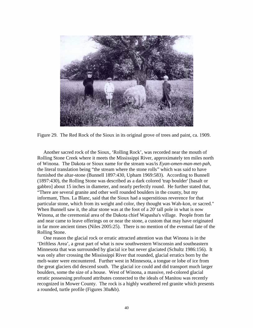
The ‘Red Rock’ of the Sioux is a glacial erratic that was sacred to Native Americanswho, before 1862, left many offerings at the boulder. It can still be seen, having finallybeen moved to Newport on the banks of the Mississippi River approximately eight milesdue east of Mendota where Spirit Rock was once venerated. Originally, Red Rock was ingrove of trees on the east side of the Mississippi River overlooking the river valley to thewest (Figure 29). The rock itself is a pink granite, now highly weathered to a dull graycolor. It is approximately 4 feet long, 2.5 feet wide, and 2.5 feet high (Callahan 1997a).To the Sioux it was known as Eyah-Shaw which, when translated, means “Red Rock.”Because the Indians had no explanation on how this rock the other glacial erratics got tothe prairie, they were a mystery and like Spirit Rock, said to “have dropped from theclouds” (Bender 2011a:161). Coming from the sky, the rock was imbued with wakan,the Sioux word for spirit (Bender 2003). Furthermore, like Spirit Rock, Red Rock wasenhanced with paint, a description by William Folsom (1888:384) saying, “It is painted instripes, twelve in number, two inches wide and from two to six inches apart. The northend has a rudely drawn picture of the sun, and a rude face with fifteen rays." The stripesalways faced the east. The Sioux often visited bringing it offerings and renewing itsvermillion paint (Upham 1969:570-571). The painted face and stripes were still clearlyvisible in the 1909 photo decades after the Sioux were expelled following the 1862uprising in Minnesota (Figure 29).
40
Figure 29. The Red Rock of the Sioux in its original grove of trees and paint, ca. 1909.
Another sacred rock of the Sioux, ‘Rolling Rock’, was recorded near the mouth ofRolling Stone Creek where it meets the Mississippi River, approximately ten miles northof Winona. The Dakota or Sioux name for the stream was/is Eyan-omen-man-met-pah,the literal translation being “the stream where the stone rolls” which was said to havefurnished the altar-stone (Bunnell 1897:430, Upham 1969:583). According to Bunnell(1897:430), the Rolling Stone was described as a dark colored 'trap boulder' [basalt orgabbro] about 15 inches in diameter, and nearly perfectly round. He further stated that,“There are several granite and other well rounded boulders in the county, but myinformant, Thos. La Blanc, said that the Sioux had a superstitious reverence for thatparticular stone, which from its weight and color, they thought was Wah-kon, or sacred."When Bunnell saw it, the altar stone was at the foot of a 20' tall pole in what is nowWinona, at the ceremonial area of the Dakota chief Wapasha's village. People from farand near came to leave offerings on or near the stone, a custom that may have originatedin far more ancient times (Niles 2005:25). There is no mention of the eventual fate of theRolling Stone.
One reason the glacial rock or erratic attracted attention was that Winona is in the‘Driftless Area’, a great part of what is now southwestern Wisconsin and southeasternMinnesota that was surrounded by glacial ice but never glaciated (Schultz 1986:156). Itwas only after crossing the Mississippi River that rounded, glacial erratics born by themelt-water were encountered. Further west in Minnesota, a tongue or lobe of ice fromthe great glaciers did descend south. The glacial ice could and did transport much largerboulders, some the size of a house. West of Winona, a massive, red-colored glacialerratic possessing profound attributes connected to the ideals of Manitou was recentlyrecognized in Mower County. The rock is a highly weathered red granite which presentsa rounded, turtle profile (Figures 30a&b).

41
Figure 30a. The Mower County red granite, glacial erratic showing its profound, turtle-like shape profile. The turtle is perceived as a representation of the earth by a majority ofAmerican Indians and in their creation epics. Scott Doblar photograph.
Figure 30b. Opposite side view of the Mower County glacial erratic with Robert Keiperfrom Winona, Minnesota for scale. Scott Doblar photograph.

42
From a geologic standpoint, the exfoliated surface expresses millennia of weathering inplace which has also helped to produce a deep fissure along a joint or bedding plane. It iswithin this wide cracks that other boulders were deposited as offerings (Figures 30c&d),harkening back to the donation cairn or the ‘split-wedge’ exploring the American Indianconcept of a yoni (Muller 2009:17).
Figure 30c. Photo of two rocks wedged into the weathered fissure of the Mower Countyred granite erratic. Scott Doblar Photograph.
Figure 30d. View of the opposite side of the Mower County erratic showing a deeplywedged rock in the fissure likely meant as an offering or yoni, i.e. a male form insertedinto the (female rock) fissure. Scott Doblar photograph.

43
The tradition of sacred boulders or ‘medicine rocks’ existed farther west on the GreatPlains extending to the foot hills of the Rocky Mountains and beyond. Kevin Callahan(1997b) compiled an inventory of the venerated rocks and boulders in his article,Petroglyph Boulders and Sacred Stones of the Upper Midwest. Gleaned from the historicrecord, the article included those found on the Plains in the northern United States andlower Canada. Two of note not mentioned by Callahan were recorded by George BirdGrinnell during his late 19th century travels while living with and recording the BlackfeetIndians stories and customs. Grinnell (1962:262-263) said, “Another sacred object is themedicine rock of the Marias [River]. It was a huge boulder of reddish sandstone …formerly … on top of the [river] bluff, but as the soil about it is worn away by the windand rain, it is slowly moving downhill. The Indians believe it to be alive, and makepresents to it.” One other sacred boulder Grinnell left a description of incorporated thehuman-like qualities many of the Manitou stones incorporated. “Down on the Milk River,east of the Sweet Grass Hills, is another medicine rock. It is shaped something like aman’s body, and looks like a person sitting on top the bluff. Whenever the Blackfeet passthis rock, they make presents to it.” When the passers-by gave an article of clothing, theywould sometimes put it on the rock and then say “when you look at it, it seems more likea person.” By this act, the transformation of the inanimate into the animate wascomplete, something the Indians so highly valued and regarded as sacred or an object ofworship.
Manitou or spiritually-charged rocks could, however, exist on a much larger scalethan boulders and glacial erratics (Bender 2011a). Medicine Rocks (State Park) in CarterCounty in eastern Montana is a natural rock outcrop of sandstone pillars sixty to eightyfeet (18 to 24 m) high. The undulations, holes, and tunnels formed in the sandstone aftermillions of years of weathering helped to draw attention to them (Figure 31).
Figure 31. Archival image of Medicine Rocks, Carter County, Montana.

44
Many Plains Indian tribes resided here permanently or temporarily, including the Arikara,Assiniboine Sioux, Cheyenne, Crow, Mandan, and Sioux. Considered a sacred holyplace by all, a Sioux Indian, Charging Bear, said Medicine Rocks was a place “where thespirits stayed and the medicine men prayed.” The sound of the wind, the natural,weathered shape of the rocks, the holes in the rocks, the cathedral-like setting and thesprings that flow year-round are all profound attributes identified with Manito or spirit.The Sioux Indian name for the unusual stone columns is Inyan-oka-la-ka, or “Rock witha Hole in It.” The holes in the rock and wind blowing in them produces whistling sounds,contributing to the phenomenal attribute of sound (Steinbring 1992). Native Americanswere also attracted to the site because of the many medicinal plants which grew there andthe fossil seashells which could be gathered for decorations (French 2005).
Profile Rocks
Rock outcrops and boulders that bear a somewhat eerie if not remarkable resemblanceto a human profile were highly regarded and considered to be spiritually endowed withManitou or Wakan (Bender 2011a:161-162,168). If a picture is indeed worth a thousandwords, then photographs of the large profile rocks scattered about the continent need littleexplanation. Curiously, the record and image of many has mainly survived in old PostCard images from the early part of the 20th century. All are natural rock outcrops orboulders worn by time and weather into what the human eye recognizes and mindperceives as an animate form, not inanimate rock. Their mystique is further enhanced bythe names people gave them, usually identified with an Indian chief or lore. Rather thanwrite a description, images of each are presented with a name or description and anyrelevant information concerning what is known about the individual rock and/or profile(Figures 32- 38).

45
Figure 32. Known as the Old Man of Joshua's Mountain, the Assonet profile rock is afifty foot high granite rock located in Freetown, Massachusetts just outside Assonetvillage and near the Freetown State Forest. The Wampanoag believed it to be an imageof Chief Massasoit who had befriended the Pilgrims.
Figure 33. The Old Man of the Valley near West Chesterfield, Massachusetts.

46
Figure 34a. An old postcard showing the Indian Head Lunch and Grounds, DelawareWater Gap, Pennsylvania.
Figure 34b. Photo showing the Indian Head outcrop at Delaware Water Gap,Pennsylvania.

47
Figure 35. A 1903 postcard showing the Rock Face of Washington, Mamaroneck, NewYork. It is “purely natural” according to the hand-written description.
Figure 36a. The Big Stone Face at Pipestone National Monument, Pipestone, Minnesota.Pipestone or ‘Catlinite’ was mined for millennia at this site and the profile wasconsidered profound and sacred by all the people and tribes who visited.

48
Figure 36b. Colored postcard image of the Big Stone Face at Pipestone, Minnesota.
Figure 37. The Old Man of the Dalles (Dells) at Interstate Park on the Mississippi River,Taylor Falls, Minnesota.

49
Figure 38. Perhaps one of the most profound profile rocks is the forty-four feet highIndian Head Sentinel on the Mississippi (River) near Winona, Minnesota.
Summary
The fate of many of the Manitou stones is not a kind story or legacy for futuregenerations, one generally with an unhappy end or outcome whether large or small. Thehuge profile rocks are no different, another vestige of world and landscape that is nowtotally disengaged from the modern world and society. Perhaps it is best if they remainin obscurity and silence. In that way, they can hopefully escape vandalism, the graffitiartists spray paint and otherwise mindless, wholesale desecration. We would do well totry and reconnect with the zeitgeist they represented together with the basic ideals ofManitou and learn to celebrate the spirit of being a part of the world we live in, not apartfrom it.
Acknowledgements: I would like to thank Dan O’Neill who sent letters with informationthe old-fashioned way before the internet came into being, Ralph Redfox and all thosekind souls who traveled the land with me over the years giving careful explanations andmeanings, Bill and (the late) Gloria Hackbarth for opening their home, land andmemories to me and lastly, all the kind landowners who allowed me to trespass withoutincident.

50
References Cited
Africa, J. Simpson, 1883. History of Huntingdon and Blair Counties. J. P. Lippincott &Co., Philadelphia.
Ball, Donald B. and Waggoner, John C., Jr., 2010. Megaliths in the Upland South:Imposing Stones of Uncertain Function. Journal of Alabama Archaeology, Vol. 56, No.1, pp. 33-63.
Barber, John Warner, 1844. The History and Antiquities of New England, New York,New Jersey and Pennsylvania. Allen S. Stillman & Co., Hartford.
Barber, John & Howe, Henry, 1841. Historical Collections of the State of New YorkContaining a General Collection of the Most Interesting Facts, Traditions, BiographicalSketches, Anecdotes. S. Tuttle, New York.
Barnouw, Victor, 1977. Wisconsin Chippewa Myths and Tales and the Relations to theChippewa Life. University of Wisconsin Press, Madison.
Bender, Herman E., 1992. Geophysical Survey and Investigation of a Petroform Site inFond du Lac County, Wisconsin. The Rock Art Quarterly - An International Journal ofCurrent Research and Theory with Open Peer Commentary, Volume 3, Summer, 1992.
—. 1994a. Unpublished field notes in Notebook No. 1, May 15-22, pp. 12-16. Updatedwith photographs in unpublished field notes, Field Book No. 2, May 15-22, pp. 46-51.
—. 1994b. Unpublished field notes in Notebook No. 1, October 15, pp. 135-37. Updatedwith photographs in unpublished field notes, Field Book No. 2, October, pp. 98-103.
—. 1995. Survey Results, Comments and Recommendations Regarding the Butternut-Auburn Transmission Line Project. Report on file at State Historical Society ofWisconsin, compliance chief; and Public Service Commission of Wisconsin, Madison,WI.
—. 2002. Macktown: A Link to the Native American Trail System of Northern Illinoisand a Continent. Unpublished report prepared for National Society Daughters of theAmerican Colonists, Illinois Chapter.
—. 2003. Manitou Stones in Wisconsin. The 3rd Stone 45: 26-31.
—. 2004. Star Beings and Stones: Origins and Legends, Indian Stories Indian Histories,edited by Fedora Giordano and Enrico Comba, Otto Editore, Torino, Italy, pp. 7-22.
—. 2007. Nature’s Attributes, Human Perceptions and a Sense of Place: An Integrationof the Natural and Cultural Landscape. Landscape Enquiries, The Proceedings of theClifton Antiquarian Club, Vol. 8, Clifton Antiquarian Club, Clifton, Bristol, UK, pp. 117-121.

51
—. 2008a. Seeking Place: Living on and Learning From the Cultural Landscape. pp. 45-70. In Nash, G. and Children, G. (eds.) The Archeology of Semiotics and the Social Orderof Things, BAR International Series 1833. Oxford: Archaeopress.
—. 2008b. Medicine Wheels or ‘Calendar Sites’: Indian Time or the Space/TimeContinuum. Time & Mind: The Journal of Archaeology, Consciousness and Culture,Vol. 1, Issue 2, pp. 195-206.
—. 2009. Caring for Creation: A Hierophany at Strawberry Island. pp. 137-156. In Nash,G. and Gheorghiu, D. (eds.) The Archaeology of People and Territory. Budapest:Archeolingua.
—. 2011a. The Spirit of Manitou Across North America. Archaeology ExperiencesSpirituality? Edited by Dragos Gheorghiu, Cambridge Scholars Publishing, Newcastleupon Tyne, UK, pp. 143-177.
—. 2011b. Prominence and Presence: The Co-opting and Re-consecration of High Placesin Southeastern Wisconsin. Time & Mind: The Journal of Archaeology, Consciousnessand Culture, Vol. 4, Issue 1, pp. 7-30.
—. 2013. Bison Effigy Stones in Wisconsin. IFRAO 2013 Proceedings, AmericanIndian Rock Art, Volume 40, American Rock Art Research Association, 2013, HermanBender Session Editor, Peggy Whitehead Volume Editor, pp. 43-80.
Blakeslee, Donald J. and Blasin, Robert, 1988. Indian Trails in the Central Plains.Plains Anthropologist – Journal of the Plains Anthropological Society, 33-119.
Bowden, Henry Warner, 1981. American Indias and Christian Missions. The Universityof Chicago Press, Chicago and London.
Brown, Charles E., 1914 . Aborginal Evidences in Northeastern Wisconsin. TheWisconsin Archeologist (old series) 14(1):7-59.
Bunnell, Lafayette Houghton, MD, 1897. Winona and Its Environs On The Mississippi InAncient and Modern Days, Jones & Kroger, Printers and Publishers.
Callahan, Kevin L., 1997a. Minnesota’s Sacred Red Rock Boulder. AnthropologyDepartment, University of Minnesota.http://www.sowashco.k12.mn.us/ne/About%20Us/Redrock/redrock.asp
Callahan, Kevin L., 1997b. Petroglyph Boulders and Sacred Stones of the UpperMidwest. Anthropology Department, University of Minnesota.http://www.reocities.com/Athens/Acropolis/5579/midwestboulders.html
Deloria, Vine, Jr., 1995. Red Earth, White Lies. Scribner, New York, London, Toronto,Sydney, Singapore.

52
Dunham, Sean B., Brashler, Janet G. & Cleland, Charles, E., 1998. Cobbles, Cairns andManitous: An Examination of the Use of Stone in Native American Landscapes. Paperpresented at the 43rd Midwest Archaeological Conference, Muncie, Indiana, 21-24October 1998.
Dwight, Rev. Timothy, 1821. Travels in New-England and New-York. Four Volumes,1821-1822.
Eckert, Allen W., 1995. That Dark and Bloody Ground. Bantam Books, New York,Toronto, London, Sydney, Auckland.
Fertey, A. 1970. The Journals of Joseph N. Nicollet. St. Paul: Minnesota HistoricalSociety.
Fitzhugh, William, 1978. Maritime Archaic Cultures of the Central and NorthernLabrador Coast. Arctic Anthropology, XV (no. 2, 1978): pp. 61-95.
Folsom, William H. C., 1888. Fifty Years in the Northwest. Pioneer Press Company.
Fox, George, 1922. Stoneworks and Garden Beds in Winnebago County. The WisconsinArcheologist 1 (2):47-62.
Franzen, John and Weir, Donald, 1979. 1982 Cultural Resource Survey Ottawa NationalForest, Michigan. United States Department of Agriculture, Forest Service, OttawaNational Forest, Cultural Resource Report 1, Ironwood, Michigan.
Freeman, Gordon S., Phyllis J. and Forbis, Richard G., 1990. Sacred Rocks of Alberta.The Rock Art Quarterly, Vol. 1, Nos. 1 & 2, pp. 2 – 11.
French, Brett, 2005. Rock of Ages. Montana Outdoors. July–August 2005.
Grinnell, George Bird, 1962. Blackfoot Lodge Tales. University of Nebraska Press,Lincoln /London.
Grinnel, George Bird, 1972. The Cheyenne Indians-Their History and Ways of Live,Vol.II, University of Nebraska Press, Lincoln/London.
Hall, Robert L., 1985. Medicine Wheels, Sun Circles, and the Magic of World CenterShrines. Plains Anthropologist (30)109:181- 193.
Hallowell, Irving A., 1992. The Ojibway of Berens River, Manitoba – Ethnography IntoHistory. Harcourt Brace College Publishers.
Hawley, Reverend Gideon, 1753. A letter containing a Narrative of his Journey toOnohoghgwage in 1753 from Doc. Hist. of NY vol III p. 1039, from 1 Mass. Coll. IV.
Heming, H. H., 1896. The History of the Catholic Church in Wisconsin. Milwaukee,Wisconsin, Catholic Historical Publishing Company.

53
Hinsdale, Wilbert B., 1931. Spirit Stones. Papers of the Michigan Academy of ScienceArts and Letters 14, pp. 103-112.
Honigmann, J. J., 1981. West Main Cree. In J. Helm (ed.), Handbook of North AmericanIndians, Vol. 6: Subarctic, pp. 217-230, Smithsonian Institution, Washington.
Hulbert, Archer Butler, 1902. Historic Highways of America: Volume 1 - Paths of theMound-Building Indians and Great Game Animals. The Arthur H. Clark Company,Cleveland, Ohio.
Jones, Reverend David, 1774. A Journal of Two Visits made to some Nations of Indianson the West side of the River Ohio, in the years 1772 and 1773. Burlington, New Jersey.
Kellar, James H., 1960. The C. S. Lewis Stone Mound and the Stone Mound Problem.Prehistory Research Series, Vol. III, No. IV, June, 1960, Indiana Historical Society,Indianapolis.
Kendall, Edward, 1808. Travels Through the Northern Parts of the United States in theYears 1807 and 1808, L. Riley New York, NY. Quoted in William S. Simmons, Spirit ofthe New England Tribes: Indian History and Folklore, 1620-1984: University Press ofNew England, , Hanover, NH, 1986, pp. 253-254.
Lanteigne, M. P., 1989. The bihedral core tradition of the central Precambrian Shield.Paper presented to the 22nd Annual Canadian Archaeological Association Meetings,Fredericton.
Lanteigne, M. P., 1990. [Review of] The Tie Creek Study: An Anishinabe Understandingof the Petroforms in Whiteshell Provincial Park, by the ROSEAU RIVER CHAPTER,Three Fires Society. Rock Art Quarterly, Vol. 1, Nos. 3-4, pp. 126-131.
Leeming, David and Page, Jake, 1998. The Mythology of Native North America.University of Oklahoma Press, Norman.
Mails, Thomas E., 1985. Plains Indians, Dog Soldiers, Bear Men and Buffalo Women.Bonanza Books, New York.
Mavor, James W., Jr. and Dix, Byron E., 1989. Manitou: The Sacred Landscape of NewEngland’s Native Civilization. Inner Traditions International.Vermont: Rochester.
Maxwell, James A., editor, 1978. America’s Fascinating Indian Heritage. The Reader’sDigest Association, Inc., Pleasantville, New York, Montreal.
McKenny, Thomas L., 1959. Sketches of a Tour the Lakes of the Character of theChippeway Indians, and of the Incidents with the Treaty of Fond du Lac. Ross andHaines, Inc., Minneapolis.

54
McLuhan, T. C., 1971. Touch the Earth. Simon & Schuster, New York, London,Toronto, Sydney, Tokyo, Singapore.
Miles, Lion, 2006. The Mystery of the Monument Mountain Stone Heap. The AdvocateWeekly. April 06, 2006.
Muller, Norman E., 2009. Stone Mound Investigations as of 2009. NEARA Journal,Vol. 43, No. 1, pp. 17-23.
Murray, Alexander S., 2004. Who’s Who in Mythology. CRW Publishing, London.
Neill, Rev. Edward D., 1882. History of the Minnesota Valley. North Star PublishingCompany, Minneapolis.
Niles, Myron A., 2005. A History of Wapasha's Prairie. Winona County HIstoricalSociety.
Oliver, D. D, 1903. Centennial History of Alpena County, Michigan. Argus PrintingHouse, Alpena.
Parkman, Francis, 1983, France and England in North America (2 volumes), Library ofAmerica, New York, N.Y.
Parks, Douglas R., 1996. Myths and Traditions of the Arikara Indians. University ofNebraska Press, Lincoln and London.
Philbrick, N. 2006. Mayflower. New York: Viking.
Pidgeon, William, 1858. Traditions of De-Coo-Dah. Published by Horace Thayer, NewYork.
Pond, Samuel W., 1986. The Dakota or Sioux in Minnesota as They Were in 1834,Minnesota Historical Society Press: 1908, 1986 reprint, St. Paul, MN.
Powell, Peter. J. 1969. Sweet Medicine, Vol. II. University of Oklahoma Press, Norman,OK.
Powers, William. K. 1977. Oglala Religion. University of Nebraska Press, Lincoln andLondon.
Rhodes, R. A. and Todd, E. M., 1981. Subarctic Algonquian languages. In J. Helm (ed.),Handbook of North American Indians, Vol. 6: Subarctic, pp. 52-56, SmithsonianInstitution, Washington.

55
Riggs, Stephen R., 1883, ‘Mythology of the Dakotas’, American Antiquarian 5(2):148-149.
Ritchie, William A., 1969. The Archaeology of New York State. The Natural HistoryPress, Garden City, New York.
Rogers, Richard A., Martin, Larry D. and Nicklas, T. Dale, 1990. Ice-Age geography andthe distribution of native North American languages. Journal of Biogeography, No. 17,pp. 131-143.
Roscoe, William D., 1882. History of Schoharie County, New York, 1713-1882. D.Mason & Company, Syracuse, NY.
Royce, Charles C., 1900. Indian Land Cessations in the United States. Extract from theEighteenth Annual Report of the Bureau of American Ethnology, Government PrintingOffice, Washington.
Russel, Howard S., 1980. Indian New England Before the Mayflower. University ofNew England Press; Hanover, New Hampshire and London, England.
Ruttenber, E. M., 1992. Indian Tribes of Hudson’s River 1700-1850. Hope Farms Press& Bookshop, Saugerties, NY.
Schaasfma, Polly, 1980. Indian Rock Art of the Southwest. University of New MexicoPress, Albuquerque.
Schlesier, Karl. H., 1987. The Wolves of Heaven. University of Oklahoma Press, Normanand London
Schoolcraft, Henry, 1851. Personal Memoirs of a Residence of 30 Years with the IndianTribes on the American Frontier. Lippincott, Grambo, Philadelphia.
Schultz, Gwen, 1986. Wiscsonsin’s Foundations. Kendall/Hunt Publishing Company,Dubuque, Iowa.
Shank, William H., P. E., 2002. Indian Trail to Super Highways (Revised). AmericanCanal & Transportation Center, York, Pennsylvania.
Smith, William Rudolph, n.d. William Rudolph Smith Papers, Wis Mss CV, WisconsinHistorical Society, Madison, Wisconsin.
Spence, Lewis, 1994. Myths of the North American Indians. Gramercy Books, New Yorkand Avenal.
Squier, E. G., 1851. Antiquities of the State of New York. Smithsonian Contributions toKnowledge, Vol. II, 1851; p. 164-5:

56
Steinbring, J. M.J., 1981. Salteaux of Lake Winnipeg. In J. Helm (ed.), Handbook ofNorth American Indians, Vol. 6: Subarctic, pp. 244-255, Smithsonian Institution,Washington.
—. 1991. The Swift Current Petroglyph Site (EbNw-15): ArchaeologicalStatus and Conservational Needs. Rock Art Quarterly, Vol. 2, No. 3-4, December, 1991.
—. 1992. Phenomenal Attributes: Site Selection Factors in Rock Art, American IndianRock Art 17: 102-113.
Steinbring, Jack, Bender, Herman E. and Behm, Jeffrey, 1995. Petroform Research in theNorth American Interior. Report on file at State Historical Society of Wisconsin,compliance chief; and Public Service Commission of Wisconsin, Madison, WI.
Steinbring, Jack, 1997. Successful Rock Art Conservation Projects: Two Cases.Pictogram, Vol. 9, No. 2, September, 1997.
Terrell, John Upton, 1964. Black Robe. Garden City, New York: Doubleday andCompany, Inc.
Thwaites, Rueben Gold (editor), 1896. The Jesuit Relations and Documents, 73Volumes, Burrows Brothers Company, Cleveland.
Tuck, James A., 1976. Ancient peoples of Port au Choix. The Excavation of an ArchaicIndian Cemetery in Newfoundland. Newfoundland Social and Economic Studies 17.
Upham, William, 1969. Minnesota Geographic Names. Minnesota Historical Society,St. Paul.
Wallace, Paul A. W., 1987. Indian Paths of Pennsylvania. Pennsylvania Historical adMuseum Commission, Harrisburg.
Wallace, Paul A. W., 1998. Thirty Thousand Miles With John Heckwelder.Wennawoods Publishing, Lewisburg, Pennsylvania.
Wilson, Hap, 1999. Wilderness Manitoba: Land Where the Spirit Lives. Boston MillsPress, Erin, Ontario.