Embed Size (px)
Citation preview
Object oriented database for a GIS
N. Posada & D. SolCENTIA, Universidad de las Americas, Puebla, Mexico
Abstract
This paper describes the design and implementation of geographic data in anobject/relational database. Infomix Universal Server (IUS) is a tool that permitsthe description of persistent geographic objects. The geographic objects weredesigned by using the OMT methodology. The application was built with theJava programming language. The objects were made persistent by using the IUSdatabase management system. A web user interface was developed to show thegeographic data. Data modeling was done by using points, lines, polylines andpolygons. The data stored in the database could be exported and used by a clientwho runs a web user interface. Our representation gives the description to havean homogeneous geographic data representation to be used in a geographicdatabase server. The user can then access and use the data stored in thedatabase.The web user interface runs on the client and the database manager runson the server. The object oriented geographic databases that use a standardrepresentation are the first step to build tools that will permit the interoperabilityof heterogeneous GIS.
1 Introduction
GIS (Geographic Information Systems) is the term to designate the systems thatwork with spatial and geographical data (15). The real world objects can berepresented by using several geometries. With the use of new geometries we willhave more accurate mechanisms to represent geographic data (10).
The databases are used normally to store different kind of data. The modeleddomain determines the kind of data that is represented. The models used today ina database assure consistensy, security, reduce redundancy and permit theconcurrent access. The data stored in a database is different from the data used ina real world. Mechanisms to store and to retrieve data must be developed.
Management Information Systems, C.A. Brebbia & P. Pascolo (Editors) © 2000 WIT Press, www.witpress.com, ISBN 1-85312-815-5

324 Management Information Systems
The development of the object oriented paradigm programming suggests the useof the object oriented approach to be considered in a database. The objectoriented DBMS are created to support CAD applications, multimedia systemslike GIS and to handle voice, video and normal data. This paper describes the useand management of geographic objects in a database. The DBMS used is theobject/relational Informix module. A web user interface developed in ourresearch group (3) presents the geographic data. The interface manages severalGIS aspects like pan, geometric operations (translation, zoom), scales andcoordinates. Our work can be a platform to test other aspects like queries,interoperability and sharing of geographic data.
2 Related work
The research developed in this area shows specific and general characteristics.An important aspect is the fact that interoperability needs the use of a standardformat for geographic data. The general characteristics show that there is aninterest to establish a standard. We try to indentify the important aspects to beincluded in our work. Table 1 shows the works that have been analyzed withtheir principals properties.
The principal characteristics are: aggregation, association, generalization,classification and inheritance. In particular (5) shows how the inheitance and theassociation are modeled.
GorrpUer CSrtcgapty for QS an Objectviewonthe Dspl Transfomnation (1)CBe3 Qierted Mxteling
Table 1 Features of work analyzed and system OOGIS proposed
3 Methodology
We used the OMT methodology (13) because it has the facility to manageobjects in the design step. These objects can be used in programming anddatabases in the object oriented approach. Our goal is to handle geographicobjects in three levels: design, programming and databases. At the same time wekeep the advantages offered by the relational model.
Management Information Systems, C.A. Brebbia & P. Pascolo (Editors) © 2000 WIT Press, www.witpress.com, ISBN 1-85312-815-5

Management Information Systems 325
4 Data Model
Two approaches were considered to implement our ideas:
• object oriented database systems• object/relational database systems
First we will describe some aspects of the relational approach that permit tounderstand easily the advantages of the object/relational approach.
4.1 Relational modelThe relational model is very popular because this is a very simple approach. Ithas only one structure: a table with tuples and attributes with atomic data types.The query language uses simple operations on the tables and the more complexlike joins don't need be understood by users (4). If the relational model is usedthe data needs to be atomized in rows and columns. The mechanisms to store andto retrieve data in the databases needs to be developed. To model one or twogeographic objects the representation can use 4 or 5 relational tables. A GIShandles its data by layers. A map can be composed by rivers, roads and cities.Each kind of geographic object is represented by a layer. In this context to modelseveral layers means that an important number of tables need to be implemented.For instance, a polygon is modeled by three or more segments and each segmentis modeled by two points. The tables to model polygons, segments and pointsshould be created. This kind of representation reduces the data clarity. It ispossible to guarantee integrity and consistency but at the expense of clarity. Theobject oriented approach propose an option that tries to keep integrity andconsistency but also clarity in the representation.
4.2 Object oriented modelThis approach was inspired from the object oriented programming languages.The principal object oriented languages are Smalltalk, C++ and Java (2). Theobject oriented paradigm includes the abstract data type concept. The abstractdata type declarations are public or private. In an object oriented language thetypes are implemented by classes. The object operations can also be public orprivate. An object is a black box, that is built and modified independently ofother objects. As the object oriented paradigm is developed new approaches areproposed to implement the concepts related to the object paradigm. Eachapproach can manage several object concepts in a different way (8). An exampleare the tools offered by an object oriented language to implement encapsulation.The approach used to model the objects could have an influence on the objectmanagement in the database.
4.3 Object/Relational modelThe more direct way to implement objects in a database and to keep the DBMSadvantages is the Object/Relational model (14). A standard for a multimedia datamanager is developed in the context of the SQL standard (11). To managegeographic data in an object database, the data types are first created. Ahierarchy is used to represent from the basic data types to the more complex. All
Management Information Systems, C.A. Brebbia & P. Pascolo (Editors) © 2000 WIT Press, www.witpress.com, ISBN 1-85312-815-5
326 Management Information Systems
the data types are then implemented by classes in an object oriented languageprogramming. In the context of an object database the data that reference the datatypes is stored in tables, but the structure of the data is represented by the types.
5 Geographic objects
The basic geographic objects that we use are:
• points• lines• polylines• polygons
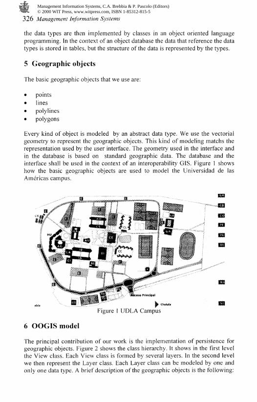
Every kind of object is modeled by an abstract data type. We use the vectorialgeometry to represent the geographic objects. This kind of modeling matchs therepresentation used by the user interface. The geometry used in the interface andin the database is based on standard geographic data. The database and theinterface shall be used in the context of an interoperability GIS. Figure 1 showshow the basic geographic objects are used to model the Universidad de lasAmericas campus.
Figure 1 UDLA Campus
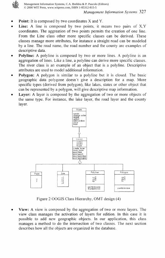
6 OOGIS model
The principal contribution of our work is the implementation of persistence forgeographic objects. Figure 2 shows the class hierarchy. It shows in the first levelthe View class. Each View class is formed by several layers. In the second levelwe then represent the Layer class. Each Layer class can be modeled by one andonly one data type. A brief description of the geographic objects is the following:
Management Information Systems, C.A. Brebbia & P. Pascolo (Editors) © 2000 WIT Press, www.witpress.com, ISBN 1-85312-815-5
Management Information Systems 327
Point: It is composed by two coordinates X and Y.Line: A line is composed by two points, it means two pairs of X,Ycoordinates. The aggreation of two points permits the creation of one line.From the Line class other more specific classes can be derived. Theseclasses manage more attributes, for instance a straight road can be modeledby a line. The road name, the road number and the county are examples ofdescriptive data.Polyline: A polyline is composed by two or more lines. A polyline is anaggregation of lines. Like a line, a polyline can derive more specific classes.The river class is an example of an object that is a polyline. Descriptiveattributes are used to model additional information.Polygon: A polygon is similar to a polyline but it is closed. The basicgeographic data polygone doesn't give a description for a map. Morespecific types (derived from polygon), like lakes, states or other object thatcan be represented by a polygon, will give descriptive map information.Layer: A layer is composed by the aggregation of two or more objects ofthe same type. For instance, the lake layer, the road layer and the countylayer.
Point Line
!!
1 3 y e rc o 1 o rn a metype
create layersave layer-paint linepaint pointpaint polylinepaint polygon/\
Pel
V!f'f
-intdrauvp
/line
II
ilylfne
Polygonxp 1
pamtpreview
Figure 2 OOGIS Class Hierarchy, OMT design (4)
View: A view is composed by the aggregation of two or more layers. Theview class manages the activation of layers for edition. In this case it ispossible to add new geographic objects. In our application, this classmanages a method to do the intersection of two classes. The next sectiondescribes how all the objects are organized in the database.
Management Information Systems, C.A. Brebbia & P. Pascolo (Editors) © 2000 WIT Press, www.witpress.com, ISBN 1-85312-815-5

328 Management Information Systems
7 Database construction
The database is composed by two parts, the data type description and the tables.The tables make reference to data types to describe their structure. The data typedescription shows their attributes. The objects are stored in the tables, but theymake reference to the corresponding data types for their description.
Name
point_tlayerj
layerpointjlayerline_tlayerpoly!ine_t
view
layer
Type
YesYes
YesYesYes
Table
YesYes
YesYesYes
Yes
Yes
Variable
x,yname, color, type
x, yend'l, end2num, endl, end2
name_view,namejayernamejayer, type
Inheritance
layer_tlayer_tlayerj
Association
point_tpointj
viewTable 2 OOGIS Types and Table used
The principal types used by our application are point and line. The types polylineand polygon are formed by aggregations of the basic types. More complex typesare formed by inheritance and association. Table 2 shows the data type name, theattributes and the relationships with the other data types. The tables of thedatabase will be created by reference on the data types. Two basic tables werecreated: View and Layer. These tables are built independently of any type. TheView table manages the name of the layers to describe a map. The Layer table isresponsible to manage its type. This table provides the access for any layer onthe map.
8 Prototype
Our model was tested by using the Java object oriented language program andIUS DBMS (7) on Solaris. Our application has the following modules:
• the operations manager• the database server• the interface manager• the modeling manager
Our prototype was tested with data from the Universidad de las Americas,campus. The prototype architecture is shown in figure 3. An example of thecreation of tables and the data insertion is as follows:
create table Circuit of type laycrpolyline t:insert into Circuit values ('Circuii','java.awt.C'oIor[r=0,g O,b=0]'.'polygon'.0,row(l08,93)::point_t, row(80,95)::point_t):
Management Information Systems, C.A. Brebbia & P. Pascolo (Editors) © 2000 WIT Press, www.witpress.com, ISBN 1-85312-815-5

Management Information Systems 329
create table Building of type layerpolyline_t;insert into Building values('Building','java.awt.Color[r=0,g=0,b=255]','polygon',0,row(58,69)::point_t,row(79,70)::point_t);
The spatial data are stored in the database in three steps:
1. The layer names are associated to one project name. The table thatimplements the view type store the layer and project name association. Thisoperation is done by the save method which belongs to the view class.
2. The view class save method calls the layer class save method. This methodfirst stores in the layer table (which implements the layer class) the type andthe name of the layer.
3. The same method (layer class save method) creates the table to store thelayer attributs like color, name and description data type. This tableimplements the different geographic object data types (point, line, polyline,polygon). For each layer the method generates one table.
OOGIS
Figure 3 OOGIS Architecture
The types created in the database match the classes implemented in Java. It ispossible to see that the types, the classes and the tables have a homogeneousdescription. The types described in the database are the same that the typesdescribed by the OMT design. With the use of a standard for geographic datalike OpenGis types our approach will be tested widely. In particularinteroperability and data exchange can be improved by this kind ofrepresentation.
Management Information Systems, C.A. Brebbia & P. Pascolo (Editors) © 2000 WIT Press, www.witpress.com, ISBN 1-85312-815-5

330 Management Information Systems
The user interface is shown in the figure 4. It is possible to see the tools tomanage zoom, pan and the geometric operations. On the right it is possible tocontrol the layer activation for quering and edition. The application managesonly a property format (points, lines, polylines and polygons). Actually it ismodified to manage the geographic data in the OpenGIS format (9). A module totranslate from shp Arc View is actually developed and very soon the applicationswill be capable to manage (in the database and in the interface) geographic dataimported from Arc View. The application will be then capable to sopport severaldatabase users.
Editable
C IK-Building
# iH Hail.
C; I*H Water^canection
Figure 4 OOGIS Interface
9 Conclusion
Our principal goal is a transparent management of geographic objects in adatabase. The geographic objects can then be persitent objects. The objects don'tneed to be stored and retrieved by the use of specific mechanisms. The data typescreated in the context of the database are referenced by the tables. The data typesare implemented by classes in the context of the application. The previous workimplemented geographic objects in applications but they don't manage thepersistence. The number of access to the database can be reduced. We think thatthe clarity of the representation is also improved. The objects represented in thedatabase are objects that can be exported and shared with other applications. Inparticular, the use of a standard representation permits this interoperability.Actually our group works in the implementation of geographic objects in ourdatabase modeled in the OpenGIS standard representation. Heterogeneousapplications could then share geographic objects.
Management Information Systems, C.A. Brebbia & P. Pascolo (Editors) © 2000 WIT Press, www.witpress.com, ISBN 1-85312-815-5

Management Information Systems 331
Our application at this stage is a prototype. The performance seems good. Fornot complex geometric objects the data can be stored and retrieved in seconds.For complex objects in the case of remote connection our prototype depends onthe network performance.
References
[1] Andrew U. Frank, Max J. Egenhofer, Computer Cartography for GIS: anObject-Oriented view on the Display Transformation, Computer &Geociences Vol 18, No.8 pp 975-987, 1992.
[2] Berard, Edward V. Basic Object-Oriented Concepts,http://www.toa.com/pub/html/oobasics/oobasics.html, 1996.
[3] Briones del Rio, Juan Luis, Interjaz grdfica para un Sistemas de InformacionGeogrdfico, Computer Engineer thesis, UDLA, December 1998.
[4] Cattell, Roderic Geoffrey Galton, Object Data Management: Object-Orientedand Extended Relational Database Systems, Addison-Wesley, United Statesof America, 1991.
[5] Egenhofer Max J., Frank Andrew U., Object-Oriented Modeling for GIS,URISA Journal, 1998.
[6] Fernandes, Alvaro A. A., Paton, W. Norman, Howard Williams M., ALogical Query Language for an Object-Oriented Data Model, Department ofComputing and Electrical Engineering, Heriot-Watt University, Edinburgh,UK, January 1999.
[7] Informix Software, Inc. Answer on line, http://ict2.udlap.mx/informix/, 1997.[8] Khoshafian Setray, Abnous Razmik, Object Orientation, Second Edition,
Jhon Wiley & Suns, Inc., United States of America, 1995.[9] Kottman, Cliff, OpenGis, Open Gis Consortium, Inc.,
http://www.opengis.org, 1995.[10] Lopez Ornelas, Erick de Jesus, Modelacion de Informacion Espacial y
Geogrdfica, Computer Engineer thesis, UDLA, May 1998.[11] Manola, Frank, Sutherland, Jeff, 5%%J OZ?/ccr MooW,
http://www.objs.com/x3h7/sql3.html, 1997.[12] Posada Toledo, Nidia, Modelado de Datos Orientado a Objeto para un
Sistema de Informacion Geogrdfica, Computer Engineer thesis, UDLA; May1999.
[13] Rumbaugh James, Blaha Michael, Premerlani William, Eddy Frededick,Lorensen William, Modelado y diseno orientados a objetos. Prentice Hall,Spain, 1996.
[14] Stonebraker, Michael, Paul Brown, Object Relation DBMS, Ed. Morgan-Kaufmann, 1999.
[15] Velez Macias, Fabio., Introduction to GIS, University of Antioquia,Department of Environment and Health Engineer,http://quimbaya.udea.edu.co/~fabiovel/, Medellin, September 1999.
Management Information Systems, C.A. Brebbia & P. Pascolo (Editors) © 2000 WIT Press, www.witpress.com, ISBN 1-85312-815-5

Section 8
Remote Sensing
Management Information Systems, C.A. Brebbia & P. Pascolo (Editors) © 2000 WIT Press, www.witpress.com, ISBN 1-85312-815-5