Embed Size (px)
Citation preview

Management Direction and Implementation
Chapter 4
Sunset on Umbagog Lake
Ed
Hen
ry/U
SFW
S

Chapter 4. Management Direction and Implementation 4-1
This CCP includes an array of management actions that, in our professional judgment, will be effective in achieving the refuge purposes, supporting the vision and goals for the refuge, making a major contribution to state and regional conservations plans, and addressing the issues identified in chapter 2. We believe it is reasonable, feasible, and practicable.
This plan is designed to emphasize the conservation of a mixed forest matrix landscape and its component habitat types for which we believe the refuge can make the most important ecological contribution within the Upper Androscoggin River watershed, the larger Northern Forest landscape, and the Refuge System. The habitat types we describe support a wide variety for Federal trust resources, in particular, birds of conservation concern identified in the BCR 14 ecoregional plan, including wetlands-dependent species. We identify “focal species” for each habitat type objective, whose life requirements will guide management activities in that respective habitat type. Focal species were selected because they are Federal trust resources whose habitat needs, in our opinion, broadly represent the habitat requirements for a majority of other Federal trust species and native wildlife dependent on that respective habitat type.
Appendix H describes in greater detail our process for selecting habitat types and focal species. Our objective statements for goals 1-3 below identify the habitat type, acres to be conserved, and the focal species that will be a target of our management. An accompanying rationale statement identifies each focal species’ particular habitat needs. The strategies represent potential management actions for accomplishing the objectives and meeting those habitat needs. Map 4-1 depicts the broad habitat types we predict would result after approximately 100 years of implementing our management objectives for upland habitats. Table 4.1 summarizes the acres by habitat type we expect to have on the refuge with full implementation of our management and refuge expansion plans.
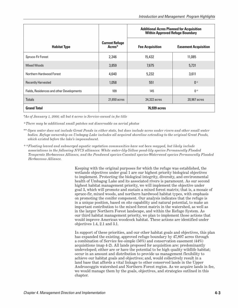
Table 4.1. Habitat types predicted under full implementation of the CCP
Habitat TypeCurrent Refuge
Acres*
Additional Acres Planned for AcquisitionWithin Approved Refuge Boundary
Fee Acquisition Easement Acquisition
Fen and Flooded Meadow 487 182 20
Boreal Fen and Bog 1,235 2,444 407
Northern White Cedar 829 202+ 0+
Scrub-Shrub Wetlands 682 1,048 77
Open Water** and Submerged Aquatic Vegetation++ 5,033 847 23
Wooded Floodplain 1,140 276 13
Lakeshore Pine-Hemlock 232 288+ 0+
Introduction and Management Program Highlights
Introduction and Management Program Highlights

Chapter 4. Management Direction and Implementation4-2
Introduction and Management Program Highlights Map 4-1
Chapter 4. Management Direction and Implementation 4-3
Habitat TypeCurrent Refuge
Acres*
Additional Acres Planned for AcquisitionWithin Approved Refuge Boundary
Fee Acquisition Easement Acquisition
Spruce-Fir Forest 2,346 15,432 11,085
Mixed Woods 3,859 7,675 5,731
Northern Hardwood Forest 4,640 5,232 3,611
Recently Harvested 1,058 551 0+
Fields, Residences and other Developments 109 145 0+
Totals 21,650 acres 34,322 acres 20,967 acres
Grand Total 76,939 acres
*As of January 1, 2008; all but 6 acres is Service-owned in fee title
+ There may be additional small patches not discernable on aerial photos
** Open water does not include Great Ponds in either state, but does include acres under rivers and other small water bodies. Refuge ownership on Umbagog Lake includes all acquired shoreline extending to the original Great Ponds, which existed before the lake’s impoundment.
++ Floating leaved and submerged aquatic vegetation communities have not been mapped, but likely include associations in the following NVCS alliances: White water-lily-Yellow pond-lily species Permanently Flooded Temperate Herbaceous Alliance, and the Pondweed species-Coontail species-Waterweed species Permanently Flooded Herbaceous Alliance.
Keeping with the original purposes for which the refuge was established, the wetlands objectives under goal 1 are our highest priority biological objectives to implement. Protecting the biological integrity, diversity, and environmental health of Umbagog Lake and its associated rivers is paramount. As our second highest habitat management priority, we will implement the objective under goal 3, which will promote and sustain a mixed forest matrix; that is, a mosaic of spruce-fir, mixed woods, and northern hardwood habitat types, with emphasis on promoting the conifer component. Our analysis indicates that the refuge is in a unique position, based on site capability and natural potential, to make an important contribution to the mixed forest matrix in the watershed, as well as in the larger Northern Forest landscape, and within the Refuge System. As our third habitat management priority, we plan to implement those actions that would improve American woodcock habitat. These actions are identified under objectives 1.4, 2.1 and 3.1.
In support of these priorities, and our other habitat goals and objectives, this plan has expanded the existing, approved refuge boundary by 47,807 acres through a combination of Service fee-simple (56%) and conservation easement (44%) acquisitions (map 4-2 ). All lands proposed for acquisition are: predominantly undeveloped; either are or have the potential to be high quality wildlife habitat; occur in an amount and distribution to provide us management flexibility to achieve our habitat goals and objectives; and, would collectively result in a land base that affords a vital linkage to other conserved lands in the Upper Androscoggin watershed and Northern Forest region. As we acquire lands in fee, we would manage them by the goals, objectives, and strategies outlined in this chapter.
Introduction and Management Program Highlights

Chapter 4. Management Direction and Implementation4-4
Introduction and Management Program Highlights Map 4-2

Chapter 4. Management Direction and Implementation 4-5Chapter 4. Management Direction and Implementation 4-5
Our land conservation objectives are the result of a very active regional partnership and fully complement the management on adjacent conserved lands, both public and private. The plan also complements the original purpose and intent for which the refuge was established. Appendix A, “Land Protection Plan” (LPP), identifies the significance of the refuge expansion in contributing to the current and planned network of conservation lands and wildlife resources in the regional landscape. Working in partnership with these surrounding landowners is critical to its successful implementation. The detailed strategies in the LPP were developed cooperatively with our state fish and wildlife agency partners, and supported by our other land conservation partners working in the Northern Forest region.
Regarding our visitor services programs, this CCP will enhance the existing priority public use opportunities for hunting and fishing by providing better outreach and information materials, and improving access and parking (maps 4-3
and 4-4). Opportunities for wildlife viewing, photography, and interpretation will be expanded primarily by providing new infrastructure such as trails and viewing areas. In addition, new roadside pullouts, informational kiosks, and viewing platforms are planned along the major travel corridors. Further, new visitor infrastructure, including a series of interpretive trails, will be developed in conjunction with the planned new location for a refuge administrative headquarters and visitor contact facility at the former Potter Farm site. We will also pursue a partner-managed, regional visitor contact facility in the Town of Errol.
Concerning other refuge uses, we will continue to allow snowmobiling on the existing designated trails. Remote camping on the existing, 12 designated lake sites will also continue to be allowed and managed cooperatively with NH DRED, although we will increase monitoring of individual sites, and rehabilitate or relocate those lake sites in need of restoration. We will eliminate the two river sites, and not replace them. In summary, we do not plan to increase opportunities for either snowmobiling or camping.
Lands we acquire in the future in the new approved refuge boundary area will be open to long-term public access for compatible, priority public uses such as: hunting, fishing, wildlife observation and photography, and environmental education and interpretation. We will maintain open the major road corridors as designated routes of public travel in the approved refuge expansion lands to facilitate access to these and other allowed, compatible refuge activities (maps 4-3 and 4-4 ).
Ian
Dre
w/U
SFW
S
Fishing on Umbagog Lake
Introduction and Management Program Highlights

Chapter 4. Management Direction and Implementation4-6
Introduction and Management Program Highlights Map 4-3

Chapter 4. Management Direction and Implementation 4-7
Map 4-4 Introduction and Management Program Highlights
Chapter 4. Management Direction and Implementation4-8
We primarily developed our management direction hierarchically, from goals to objectives to strategies. However, we also found that some important actions either relate to multiple goals or represent general administrative or compliance activities. We present those below.
We will continue to work cooperatively with the FERC licensee of the Errol Project, which is currently FPLE. Specifically, under Article 27 of the current license, we will continue to develop a yearly water level management plan with the licensee and other regulatory agencies “to benefit nesting wildlife.” While we and others have expressed concerns about the impacts from fluctuating water levels, these concerns have not been evaluated and researched in sufficient detail for us to seek to modify the current water level plan. As such, we will continue to promote stable water levels during the nesting season to the extent possible. We will also work to complete a Memorandum of Understanding (MOU) with FPLE to coordinate activities within the FERC boundary. In addition, although not binding under the current license, we will continue to recommend to FPLE that they voluntarily manage water levels at other critical times of the year (e.g. during fall migration) to benefit wildlife.
Under objective 1.5, we have identified several future studies and inventory and monitoring projects that will assist in evaluating the impacts from water level fluctuations. Implementing this activity supports refuge goals 1 and 7 relating to the conservation of open water, submerged aquatic vegetation, and wetlands habitats and developing our research program.
Within 3 years of CCP approval, we will facilitate the development of an Umbagog Lake Working Group. Members will include representatives from those state and federal agencies with management authority of the lake and its natural resources and recreational opportunities, as well as the holder of the FERC license, FPLE. The mission of the group will be to voluntarily coordinate, facilitate, and/or streamline management as a partnership to reduce resource threats and resolve user conflicts on the lake and associated rivers. This partnership will not function as a regulatory or enforcement entity, although members may propose changes in existing regulations to their respective regulatory authorities to facilitate a management goal. Some of the priority projects for the working group to consider are listed below; additional strategies are included under goal 6, objective 6.2.
■ Work with states to eliminate the use of lead fishing tackle; in conjunction, evaluate the potential for wildlife to ingest lead (bio-availability) from this and other sources in the surrounding lake and rivers;
■ Work with State of New Hampshire to evaluate no-wake exemption on Magalloway and Androscoggin rivers which allows high speed boat operation within 150 feet of shoreline;
■ Cooperatively evaluate area closures to determine if changes to current protection measures are warranted;
■ In coordination with states of Maine and New Hampshire agencies, conduct outreach at known user conflict sites such as the Rapid River, and boat launch sites;
■ Develop boater ethics programs for the lake and rivers and develop outreach materials for distribution at boat launch sites; and,
■ Identify sources of point and non-point sediment and nutrient loading (e.g. septic systems, erosion, forest and other land use practices, etc) impacting refuge wetlands, Umbagog Lake, and associated lakes and rivers, and address these impacts where possible.
General Refuge Management
Coordinating Umbagog Lake Water Level Management
Creating an Umbagog Lake “Working Group”
General Refuge Management
Chapter 4. Management Direction and Implementation 4-9
We support partnerships to the fullest extent possible, and therefore will maintain existing partnerships identified under goal 6, while also seeking new ones. These relationships are vital to our success in managing all aspects of the refuge, from conserving land, to managing habitats and protecting species, to outreach and education, and providing wildlife-dependent recreation. The NHFG and the MDIFW have been particularly important and valued partners. We will pursue new partnerships in areas of mutual interest that benefit refuge goals and objectives. We highlight two partnership efforts below. Implementing this program supports all refuge goals, with particular emphasis on goal 6 relating to conserving and managing wildlife resources through partnerships.
Land ConservationOne of our biggest partnership programs is focused on land conservation in the region. The decision document establishing the refuge (USFWS 1991) emphasized that the refuge was part of a larger conservation partnership to protect and manage timber, wetland, and wildlife resources of the Umbagog area. We carry that emphasis forward in the present plan. We will continue our participation in those partnerships with the goal to permanently protect and sustain Federal trust resources and other unique natural resource values in the Umbagog area and the Northern Forest ecosystem. An important component of this goal is an objective to improve connectivity between existing conservation tracts and preserve working forest and public access. Conservation partnerships in the region have evolved into a dynamic, landscape-level, multi-partner effort.
The list of partners is extensive and includes the Service, other Federal agencies, state agencies, private conservation organizations, local communities, private landowners, and private businesses. Appendix A, the LPP, includes a detailed description of some of the important accomplishments, as well as some current land conservation projects.
Community RelationsWe will continue to work within community forums such as the Umbagog Area Chamber of Commerce and town meetings, and other venues. In addition, we will host one informal meeting each quarter in the local area to share information or discuss topics of interest with residents, visitors and local officials.
In chapter 3 we describe the establishment of the Floating Island National Natural Landmark (FINNL) in 1972. It was chosen by the National Park Service (NPS) as an example of an exemplary native bog community. It is currently 860 acres and lies entirely within the refuge boundary.
In cooperation with the NPS, we will expand the boundary of the FINNL to one that is more ecologically-based using the 2002-2003 vegetation survey results (see map 4-5 ). This new boundary encompasses 2,181 acres. Within 5-10 years of CCP approval, we will conduct all administrative procedures with NPS to expand the boundary and convene a workshop with wetlands ecologists to determine what information should be collected and what monitoring should occur to document any potential loss or degradation of the area. We will also establish a baseline from which to compare subsequent information.
Implementing this program supports refuge goals 1 and 7 relating to the conservation of open water, submerged aquatic vegetation and wetland habitats, and research.
The Refuge System has identified management to control the establishment and spread of invasive species as a national priority. Fortunately, on this refuge, the threat is currently low. However, our objective is to ensure no new invasive species become established, and we will mange to control the spread of what does exist. To the extent possible, we will physically remove invasive species
Maintaining Partnerships
Expanding and Protecting the Floating Island National Natural Landmark
Controlling Invasive Species
General Refuge Management

Chapter 4. Management Direction and Implementation4-10
General Refuge Management Map 4-5

Chapter 4. Management Direction and Implementation 4-11
where they are encountered. Although we have not previously had the need, we propose to use approved herbicides when determined by the refuge manager to be necessary to control invasive plants, after regional office review and approval. Of particular concern on the refuge are purple loosestrife, Phragmites, Eurasian milfoil, and Japanese knotweed.
In conjunction with the HMP and IMP, we will develop a list of invasive species of greatest concern on the refuge, identify priority areas with which to be vigilant, and establish monitoring and treatment strategies. We will refer to the National Wildlife Refuge System Invasive Species Management Strategy released in May 2004 (USFWS 2004b) for additional tools, processes, and strategies. The 2004 report is complemented by a technical report issued in May 2005 by USGS, titled: The Invasive Species Survey: A Report on the Invasion of the National Wildlife Refuge System (USGS 2005). These reports together give both a status review and a management strategy for combating invasive species. In addition, we will stay abreast of Service policy revisions currently being reworked to facilitate implementation. Other strategies include:
■ Survey the Floating Island National Natural Landmark (FINNL) and other unique or rare plant communities as a priority to ensure invasive plants do not threaten the integrity of these sites and implement treatments as warranted (see additional discussion on FINNL below);
■ Institute proper care of all refuge equipment to avoid introduction or transport of invasive plants;
■ Require researchers on the refuge to take steps to prevent transport of aquatic invasive plants and pathogens;
■ Continue to work with state agencies to prevent introduction of invasive species to all water bodies on the refuge;
■ Increase enforcement to check boats and equipment to protect against invasive plant transport;
■ Implement outreach and education programs, including signage, where appropriate, and actively support state initiatives on this topic; and,
■ Develop special regulations on the refuge as warranted to control spread of invasive species.
Implementing this program supports refuge goals 1-3 relating to the conservation of open water and submerged aquatic vegetation, wetlands, floodplain and lakeshore, and upland forest habitats.
Establishing a foundation of information, or a baseline, from which to make management decisions is critical to achieving our goals. There is much we would like to know about the refuge’s resources, including how they function or move across the landscape, and what threatens them, including climate change. Unfortunately, there is not enough time or funding to accomplish all we would like to know. There are several studies we initiated recently, or plan to initiate, as soon as funding is available, including:
■ Visitor use (initiated in 2007);
■ Wildlife disturbance study (initiated in 2007);
■ Other top priority activities we have identified as funding allows include:
Implementing and Prioritizing a Biological Monitoring and Inventory Program
General Refuge Management

Chapter 4. Management Direction and Implementation4-12
✦ Conducting an ecological systems analysis to identify the ecological processes that historically and currently influence the lake, determine lake bathymetry, identify wetlands functions and measures of integrity, and evaluate water quality; and,
✦ Initiating a baseline contaminants assessment.
✦ Identifying what inventory methods should be implemented to confirm the status and critical components necessary to sustain focal species and habitats identified in objective statements. Prioritize list and begin implementing by re-directing refuge biologist’s time to priority inventory and monitoring activities;
✦ Continuing to coordinate with state agencies and FPLE in the monitoring of bald eagle, osprey, and loon nests, and to evaluate the effectiveness of our protection measures. Objectives 1.6 and 2.3 identify the protection measures we currently implement, or plan to implement, to protect these birds from human disturbance during the nesting season; pursue expanding this cooperative monitoring effort to forest dependent raptors suspected to be in decline;
✦ Determining whether a monitoring or inventory program on the refuge is warranted for lynx. Within 3 years of CCP approval, we will work in cooperation with the Lynx Recovery Team to evaluate refuge habitats. We will implement an inventory and/or monitoring program if there is consensus on habitat values. If survey results are favorable, and recovery experts agree the refuge can make an important contribution to lynx recovery, we will amend the HMP to include measures to sustain and enhance habitat for lynx; and,
✦ Developing a program to inventory and monitor unique areas. See discussion below on “deer wintering areas,” “vernal pools” and the “Floating Island National Natural Landmark.”
Implementing this program supports refuge goals 1-3 and goal 7, relating to the conservation of open water and submerged aquatic vegetation, wetlands, floodplain, lakeshore, and upland forest habitats, and developing a research program.
Vernal pools and other unique or rare natural communities are important to the health, integrity, and biodiversity of the Upper Androscoggin watershed. Despite the small size, patchiness, and ephemeral nature of some of these habitats, their value is disproportionately significant.
Our objective is to conserve and maintain all natural vernal pools, including those pools embedded in wetland or riparian habitats, on existing refuge lands and within the refuge expansion area. Also, we will conserve and protect cliffs, talus slopes, and other unique, significant, or rare upland habitat types identified by Maine Natural Areas Program (MNAP) and New Hampshire Natural Heritage Inventory (NH NHI) on these same lands.
Strategies: Within 5 years of CCP approval:
■ Complete inventory for vernal pools and map in GIS. At a minimum, prior to any forest management activities, survey stands for vernal pools and ensure best management practices are followed;
Protecting Vernal Pool Communities and other Unique or Rare Communities
General Refuge Management
Chapter 4. Management Direction and Implementation 4-13
■ Establish criteria for ranking vernal pools as to their conservation concern and need for management based on size, location, threats, productivity, seasonality, species diversity, and other parameters;
Within 7 years of CCP approval: ■ Develop and implement management standards and guidelines to conserve
vernal pool habitat; determine which pools should be protected by a no-disturbance buffer vs. those that should be managed and restored;
■ Evaluate effectiveness of management and protection zones;
■ Promote vernal pool conservation in refuge outreach programs;
■ Cooperate with NH NHI and MNAP to inventory and map the other rare and unique types in a GIS database; develop standards and guidelines for the protection and management of these types
Implementing this program supports refuge goals 1-3 relating to the conservation of open water and submerged aquatic vegetation, wetlands, floodplain and lakeshore, and upland forest habitats.
We will use forest management, including tree cutting, as one of several tools to achieve respective habitat objectives for the Federal trust resources, specifically the refuge focal species, identified in goal 3. All commercial and non-commercial tree cutting will adhere to accepted silvicultural prescriptions, and the best management practices in each respective state at a minimum. Management activities will be planned to ensure that habitat for species requiring large, unfragmented habitat blocks is not compromised. Appendix E, “Forest Management Guidelines” describes desired future conditions, silvicultural methods and treatments and other operational guidelines we will use, and identifies locations for management. However, these details may be refined as we acquire site-specific stand exam data.
We expect that forest management to support habitat and focal species objectives in the next 15 years will primarily occur on Service-owned fee lands within the current, approved refuge boundary and in the management units identified in appendix E. In particular, at this time we do not predict that we would conduct any commercial tree cutting in the expansion areas during the 15 year life of this CCP for several reasons. We cannot accurately predict, but assume it is years away, when we would acquire forest tracts large enough to make a meaningful forest management unit and to create an economically-viable, commercial harvest operation. In addition, once acquired, and assuming funds are available for project work, we would need to conduct a stand exam; map habitat management units and management operational zones; develop management prescriptions; conduct field site-prep and layout work; and, write and implement a contract. However, more importantly, it is our expectation that any forested lands acquired in the expansion areas within the next 15 years, would be harvested to a low stocking density by the current owner before property transfer, and thus, would preclude a commercial harvest in support of our management objectives. This has been our experience with past refuge acquisitions of forested lands. As a result, we predict at this time that our management activities in the expansion areas, within the 15 year life of this CCP, would be more pre-commercial operations in nature, such as thinning, habitat restoration (e.g. restoring log landings, slash piles, etc), and/or vegetation manipulations to create openings and enhance woodcock habitat in woodcock focus areas (map 4-6 ).
Implementing Forest Management to Achieve Habitat Objectives
General Refuge Management

Chapter 4. Management Direction and Implementation4-14
General Refuge Management Map 4-6
Chapter 4. Management Direction and Implementation 4-15
Prior to implementing any forest management, we will collect detailed stand-level information in forest management areas to ensure that management prescriptions and decisions are based on the best available information. We would also evaluate the effects of our management on a refuge-wide scale, to ensure that management activities do not adversely impact species requiring unfragmented habitat. Additional strategies are noted below in the detailed descriptions of objectives under goal 3. Implementing this program supports refuge goal 3 relating to the conservation of upland forest habitats.
Strategies: ■ Hire a forester and begin a detailed forest inventory and stand map on
currently owned refuge lands; within 4 years of CCP approval, complete a forest management plan, amending the HMP as warranted. Consider using a contractor to conduct field work if a forester position is not filled, so that timeframes can be met.
■ On lands we acquire in the future with management potential, and if they are acquired in at least 200 acre contiguous, viable management units, we would plan to complete a stand-level evaluation, and map habitat management units and management operational zones within 2 years of acquisition; amend the HMP as warranted.
Our objectives under goals 1 through 3 discuss specific habitat conditions and bird breeding densities (e.g. nesting pairs) and productivity goals. There are times when individual furbearing animals, or local concentrations of those animals, impact our ability to achieve priority resource objectives. Protecting human health and safety, maintaining roads, trails, houses and other infrastructure, as well as concerns with impacts on other native wildlife and habitats are a few of the other reasons furbearers might need to be managed. Both non-lethal and/or lethal techniques could be employed in any given situation.
We will analyze each situation where these techniques are needed and choose the most appropriate method to achieve our goals. Trapping is one tool that could be used at the refuge manager’s discretion to achieve an administrative or resource management objective. We intend to consider public trapping as an option in the future to achieve our goals if active management is identified; however, the actual details of developing and implementing a program would require further analysis of possible alternative methods, and would be laid out in a Furbearer Management Plan in a separate NEPA process. Implementing a comprehensive furbearer management program supports refuge goals 1-3 relating the conservation of open water and submerged aquatic vegetation, wetland, floodplain, lakeshore and upland forest habitats.
Strategies: ■ Within 3 years of CCP approval, begin NEPA analysis, including public
involvement, associated with developing a Furbearer Management Plan; establish furbearer management units as warranted; identify where habitat management or reintroductions, increases, or reductions of native furbearer species, such as beaver, is desirable.
■ Work with States of New Hampshire and Maine to determine population estimates and how refuge fits into the state’s management strategies.
Our management goals and objectives include restoring to natural conditions, as soon as practicable, developed sites that are no longer needed for refuge administration or programs.
Implementing a Furbearer Management Program
Removing Unnecessary Structures and Site Restoration
General Refuge Management

Chapter 4. Management Direction and Implementation4-16
Strategies: ■ Within 3 years of acquiring a new land parcel, remove dwellings, such as
cabins or other developed sites or structures, if determined they are surplus to refuge needs and assuming funding is available. Re-grade sites to natural topography and hydrology and re-vegetate to establish desirable conditions.
Within 3 years of CCP approval, complete demolition of the 12 camps with structures already acquired by the refuge.
■ Within 5 years of CCP approval, inventory and assess all access roads within the refuge, and on any newly acquired lands, and implement procedures to retire and restore unnecessary forest interior and secondary roads to promote watershed and resource protection. All off-road (ORV) and all–terrain vehicles (ATV) trails, and all unauthorized snowmobile trails, will be eliminated.
Implementing this program supports refuge goals 2-3 relating to the conservation of floodplain, lakeshore and upland forest habitats.
Annual staffing and operations and maintenance funds between 2002-2007 are presented in chapter 3. Below we describe activities related to staffing and administration; some are new, others are on-going. Implementing these activities supports all seven refuge goals.
Permanent Staffing and Operational Budgets Our objective is to sustain annual funding and staffing levels that allow us to achieve our refuge purposes, as interpreted by the goals, objectives, and strategies. Many of our most visible projects since refuge establishment, including land acquisition, were achieved through special project or “earmarked” funds that typically have a 1- to 2-year duration. While these funds are very important to us, they are limited in their flexibility since they typically can not be used for any other priority project that may arise.
In response to Refuge System operational funding declines nationwide, our region initiated a new base budget approach in 2007. The goal is to have a maximum of 75% of a refuge station’s budget cover salaries and fixed costs, while the remaining 25% or more will be operations dollars. The intent of this strategy is to improve the refuge manager’s capability to do the highest priority project work and not have the vast majority of a refuge’s budget tied up in inflexible, fixed costs. Unfortunately, in a stable or declining budget environment, this may also have implications to the level of permanent staffing.
Appendix F of the Final CCP/EIS lists our RONS and SAMMS construction and maintenance projects currently in those databases, and indicates the regional and refuge ranking. We also included new projects not yet in the databases, which we plan to implement as part of this CCP. If funding for these projects is not available, we will seek alternate means of accomplishing our projects; for example, through our volunteer program, challenge cost share grants, or other partnership grants, and internships. The SAMMS projects include a list of backlogged maintenance needs. Both databases will be updated in 2009. Contact refuge headquarters for the most up-to-date information.
Within the guidelines of the new base budget approach, we will seek to fill our currently approved, but vacant positions which we believe are needed to accomplish our highest priority projects. We plan to add additional staff to provide depth in our biological and visitor services programs. We identify our recommended priority order for new staffing in the RONS tables in appendix F of the Final CCP/EIS. We also seek an increase in our maintenance staff since they provide invaluable support to all program areas. Appendix D, “Staffing Chart,” identifies our plan for current and future staffing growth.
Assessing Refuge Staffing and Administration Needs
General Refuge Management

Chapter 4. Management Direction and Implementation 4-17
Facility and Fleet Maintenance Included in the following objectives and strategies are the plans for periodic maintenance and renovation of existing facilities to ensure the safety and accessibility for staff and visitors. Our current facilities are described in chapter 3. They include administrative facilities such as refuge quarters, refuge office and the maintenance shop off Mountain Pond road. Visitor facilities to be maintained include: the 1/3 mile Magalloway River trail and new ¼ mile extension, sign, and viewing platform; and, 2 roofed, wooden information kiosks. A Magalloway River canoe trail and launch site project will be completed in 2009 and will also require periodic maintenance. Any new facilities planned in this CCP, once constructed, will be placed on the maintenance schedule. All facilities and fleet maintenance and upgrades will incorporate ecologically beneficial technologies, tools, materials, and practices.
Refuge Operating Hours The refuge will be open for public use from ½-hour before sunrise to ½-hour after sunset, seven days a week, to ensure visitor safety and protect refuge resources. The only regular exception is for overnight use by visitors with camping permits in designated camping sites. However, the refuge manager does have the authority to issue a special use permit to allow others access outside these timeframes. For example, research personnel or hunters may be permitted access at different times, or organized groups may be permitted to conduct nocturnal activities, such as wildlife observation, and educational and interpretive programs.
The refuge manager must evaluate activities that require a special use permit for their appropriateness and compatibility on a case-by-case basis as applications for permits are received. All research, commercial or economic uses, and camp leases require special use permits. Implementing this program supports refuge goals 1-3 relating to the conservation of open water and submerged aquatic vegetation, wetland, floodplain, lakeshore and upland forest habitats, and goal 6, relating to conserving and managing wildlife resources through partnerships. Our intent with some of these activities is described below.
Research Research on species of concern and their habitats will continue as a priority, assuming the detailed proposals meet appropriateness and compatibility thresholds. Generally, we will approve permits that provide a direct benefit to the refuge, or for research that will strengthen our decisions on managing natural resources on the refuge. The refuge manager also may consider requests that do not relate directly to refuge objectives, but to the protection or enhancement of native species and biological diversity in the region and support the goals of the Umbagog Lake Working Group, or recognized ecoregional conservation team, such as the Atlantic Coast or Eastern Brook Trout joint ventures.
All researchers will be required to submit detailed research proposals following the guidelines established by Service policy and Refuge staff. Special use permits will also identify the schedules for progress reports, the criteria for determining when a project should cease, and the requirements for publication or other interim and final reports. All publications will acknowledge the Service and the role of Service staff as key partners in funding and/or operations. Researchers will be required to take steps to ensure that invasives and pathogens (particularly aquatic invasive plants and pathogens) are not inadvertently introduced or transferred to the Umbagog system. We will ask our refuge biologists, other divisions of the Service, USGS, select universities or recognized experts, and states of New Hampshire and Maine agencies to peer review and comment on research proposals and draft publications, and will share research results internally, with these reviewers, and other conservation agencies and organizations. To the extent practicable, and given the publication type, all research deliverables will conform to Service graphic standards.
Permitting Special Uses, Including Research, Economic Uses and Camp Leases
General Refuge Management
Chapter 4. Management Direction and Implementation4-18
Some projects, such as depredation and banding studies, require additional Service permits. The refuge manager will not approve those projects until all required permits are received and the consultation requirements under the Endangered Species Act (ESA) have been met.
Commercial and Economic UsesAll commercial and economic uses will adhere to 50 CFR, Subpart A, §29.1 and Service policy which allow these activities if they are necessary to achieve the Refuge System mission, or refuge purposes and goals. Allowing these activities also requires the Service to determine appropriateness and prepare a compatibility determination and an annual special use permit outlining terms, conditions, fees, and any other stipulations to ensure compatibility.
Cabin (Camp) Leases No modifications are planned for the 29 cabin lease agreements that currently exist under special use permit. These permits are renewed every year, assuming the terms of the permit are met, and until the 50 year lease is up. In addition, there are 4 properties under life-use agreements within the refuge boundary which are observed as private landholdings until the end of their life use.
■ The cabin leases include certain conditions, such as (1) the camps must be maintained in a manner compatible with the purposes of the refuge and produce the least amount of environmental disturbance; and, (2) no new permits will be issued for construction of new camps on the properties. Most of these structures were built as summer fishing camps or seasonal cottages, but some have become year-round cottages. All the camp leases expire in 50 years from date of Service acquisition.
With approval of this CCP, the name of the refuge will officially change to “Umbagog National Wildlife Refuge” for several reasons. The refuge consists of lake, riverine, and significant uplands habitats. The current name focuses entirely on the lake. In addition, the approved expansion includes more riverine and upland habitats, some of which lies as far as 6 miles from the lake. Also, this is a name recommended to us by local residents. We believe the new name is a better representation of the broader geographic context and management emphasis we pursued in developing this CCP.
In developing the Final CCP/EIS we evaluated a new location for the refuge headquarters office and visitor contact facility. In conjunction with our state partners, Service Visitor Service’s Specialists, and the core planning team, we identified a list of site selection criteria including:
■ a location on existing refuge lands, with ready access to the lake for both staff and visitors,
■ a site already developed or disturbed,
■ a site immersed in a natural setting with a diversity of habitats to facilitate an interpretive trail, visitor programs, and outreach on refuge purposes, management, and the refuge’s role in wildlife resource conservation in the Northern Forest.
Four prospective sites on current refuge lands met most, if not all, of these criteria. The four sites were all located at the southern end of the lake and referred to as: the Potter Farm site, two Thurston Cove sites (option A and B), and the State Border site. We hired Oak Point Associates to evaluate the feasibility and economics of constructing a facility at those four prospective sites, as well as compare them to upgrading our current headquarters office on Route 16 in Errol. Their January 21, 2005 final report can be reviewed at refuge headquarters.
Changing the Refuge’s Name
Constructing a New Refuge Headquarters and Visitor Contact Facility
General Refuge Management

Chapter 4. Management Direction and Implementation 4-19
With approval of this CCP, the Potter Farm site was chosen for implementation. We are planning a small office facility, as defined by the new Service facility standards. The existing headquarters building will be maintained as a research or auxiliary field office. In addition, we will remove the adjacent small cabin at the current headquarters site.
Our Director, via Director’s Order 144, and our regional leadership team have identified facility energy and resource conservation as a priority. As such, any new buildings or building upgrades will incorporate ecologically sound and environmentally beneficial technologies, tools, materials, and practices, including building design and construction, water and energy consumption, wastewater management, and solid and hazardous waste management.
In conjunction with the development of a new refuge headquarters and visitor contact facility, we plan to construct a series of interpretive trails at the Potter Farm site. A conceptual design and tentative location for a Potter Farm trail were identified by Oak Point Associates in their report. The trail is approximately 2 miles long, and will be designed to allow travel by people with disabilities.
Additional visitor facilities are also planned along major travel routes, including roadside pullouts on Routes 16 and a roadside pullout with overlook platform on Route 26. Each of these sites would have an information kiosk, and provide parking for several vehicles. This also includes a ¼-mile loop extension to the Magalloway River trail accessible to people with disabilities (see map 4-3). Each of these projects will facilitate wildlife observation, nature photography and interpretation of the refuge’s resources. Implementation of these activities will support goals 4 and 5 relating to opportunities for high quality hunting, fishing, wildlife observation and photography, and environmental education and interpretation.
The CCP deals with public road access similarly. Maps 4-3 and 4-4 depict which roads we will designate as public routes of travel on both current and approved refuge expansion lands. The public will be allowed access over these designated roads at their own risk and under the current conditions. It is our intention to maintain the designated roads in a way similar to how they were maintained under previous landowners. Major maintenance of designated roads will occur periodically, especially prior to, during, and post, logging operations. Otherwise, only minor maintenance will occur until the roads are needed again for management purposes. Road maintenance will be done both by refuge staff and private contractors.
Chapter 1 describes the requirements for determining whether an activity or action is appropriate and compatibility with the refuge purposes. This CCP includes final findings of appropriateness and compatibility determinations in appendix C for activities we evaluated. We will only allow on refuge lands those activities determined appropriate and compatible which meet or facilitate refuge purposes, goals, and objectives.
The following are stipulations to incorporate into existing or future compatibility determinations:
■ Access for non wildlife-dependent activities on the refuge will occur only on certain designated trails.
■ Visitor motorized vehicle access on refuge roads is limited to street-registered passenger vehicles up to one-ton hauling capacity in designated areas; no ORV or ATV use will be allowed.
Providing other Visitor Services Facilities
Assessing the Appropriateness and Compatibility of Activities
General Refuge Management
Chapter 4. Management Direction and Implementation4-20
■ When the Service acquires land in the approved expansion area in full, fee-simple ownership, we will allow public access and compatible public recreation, and other refuge uses, consistent with what we currently allow, or plan to allow, on existing refuge lands under this CCP.
■ When a conservation easement, or a partial interest, is purchased, the Service’s objective is to obtain all rights determined necessary to ensure protection of Federal trust resources on that parcel. Typically, at a minimum, the purchase would include development rights. However, we may also seek to obtain the rights to manage habitats, and/or to manage public use and access, if the seller is willing and we have funding available.
The refuge manager has determined that all six priority public uses are compatible, although some have stipulations as detailed in appendix C. Non-priority uses that the refuge manager proposes are compatible on this refuge with stipulations are also detailed in appendix C. These include forest management, research, camping, recreational gathering of blueberries, blackberries, strawberries, raspberries, mushrooms, fiddleheads, and antler sheds, snowmobiling, horseback riding, bicycling, and dog sledding.
Activities Not Allowed The 1997 Refuge Improvement Act states that “compatible wildlife-dependent recreation is a legitimate and appropriate general public use of the System.” Compatible hunting, fishing, wildlife observation and wildlife photography, and environmental education and interpretation are the priority general wildlife-dependent uses of the Refuge System. According to Service Manual 605 FW 1, these uses should receive preferential consideration in refuge planning and management before the refuge manager analyzes other recreational opportunities for appropriateness and compatibility.
We have received requests for non-priority, non-wildlife dependent activities that have never been allowed on this refuge. Activities evaluated by the refuge manager and determined not to be appropriate on refuge lands include: ATV, ORV or motorbike use, field trials for dogs and geocaching. Appendix C documents the refuge manager’s decision on their appropriateness. Most of these activities are sufficiently provided elsewhere nearby on other ownerships, so the lack of access on the refuge does not eliminate the opportunity in the Umbagog Lake area. According to Service policy 603 FW 1, if the refuge manager determines a use is not appropriate, it can be denied without determining compatibility.
For the next two years, we will continue to implement our current hunting program, which we describe in chapter 3, except for one minor change. Now, we will work with the local waterfowl club to evaluate placement of the existing six blinds.
Within two years of CCP approval, we will begin the administrative process to propose an expansion to our hunting program, in particular, for a turkey hunt in both states, and a bobcat hunt in New Hampshire. We will conduct a separate NEPA analysis and include public involvement during that evaluation. If an expanded hunt program is approved, we will update our Hunt Plan and complete all other administrative requirements to create an opening package.
We will formally open the refuge to fishing, which has not been done to date. Within 2 years of CCP approval, we will complete a Fishing Plan and all other Service administrative process requirements to officially open the refuge to fishing.
Providing Hunting and Fishing Programs
General Refuge Management

Chapter 4. Management Direction and Implementation 4-21
We will maintain the following boat access sites: the Upper Magalloway River car-top launch; the current office headquarters (Brown Owl) boat launch; and the Steamer Diamond boat launch. The Upper Magalloway launch site and restroom improvements will be completed in 2009. The current office headquarters site will have some minor improvements done to increase visibility for those using trailers and to provide additional signage to warn oncoming traffic.
We do not plan to utilize management-prescribed fire as a habitat management tool within the 15-year life of this CCP. While the chance of natural ignition is low, should a wildland fire occur, we plan to rapidly and aggressively suppress it in areas where property is likely to be threatened according to the guidance in appendix I of the Final CCP/EIS, “Fire Management Program Guidance.” This management direction will be refined after completion of a refuge Fire Management Plan to be developed within two years of CCP approval. Our suppression objective is to avoid property damage, minimize human health or safety concerns, and reduce the likelihood of resource damage. Fire is not a prevalent natural ecosystem process in the Northern Forest. It has been suggested by researchers that stand-replacement fire intervals are at 800+ year intervals in most regional forest types (Lorimer 1977). However, given Northeast Regional climate change predictions, the average temperatures may increase, especially in the summer, will be coupled with little change in summer rainfall and result in more frequent, short-term droughts (NECIA 2007). This, in turn, could alter the natural fire regime and result in more frequent fires, or a catastrophic one. We will use an adaptive management approach and monitor changing conditions. If necessary, we may conduct prescribed burns to minimize the threat of a catastrophic fire event.
We plan to maintain the annual youth conservation corps (YCC) program which has generally consisted of a crew of four to five persons (15-18 years old), and a crew leader. This has been a very popular program in the local community because youth employment opportunities are limited in this rural area. The crew accomplishes many important tasks in support of our biological and visitor services programs. If enough funding can be secured, we will expand this program to support two crews.
As we describe in chapter 1, Refuge System planning policy (602 FW 3) requires that we conduct a wilderness review during the CCP process. The first step in that review is to inventory all refuge lands and waters in Service fee simple ownership. Our inventory of this refuge determined that no areas currently meet the eligibility criteria for a wilderness study area as defined by the Wilderness Act. Therefore, we did not further analyze the refuge’s suitability for wilderness designation. The results of the wilderness inventory are included in appendix D of the Final CCP/EIS. The entire refuge will undergo another wilderness review in 15 years as part of the CCP revision. Specifically, any lands acquired in fee by the Service in the interim, along with existing refuge lands, will become part of that wilderness review in 15 years.
Service planning policy also requires that we conduct a wild and scenic rivers review during the CCP process. We inventoried the river and river segments which occur within the refuge acquisition boundary area and determined that five river segments met the criteria for wild and scenic river eligibility. These river segments and their immediate environments were determined to be free-flowing and possess at least one Outstandingly Remarkable Value. However, we are not pursuing further study to determine their suitability, or making a recommendation on these river segments at this time because we believe the entire river lengths should be studied (not just those on refuge lands) with full participation and involvement of our federal, state, local, and nongovernmental
Providing Boating Access
Implementing a Fire Management Program
Maintaining a Youth Conservation Corps
Conducting a Wilderness Review
Conducting a Wild and Scenic Rivers Review
General Refuge Management

Chapter 4. Management Direction and Implementation4-22
partners. The results of our Wild and Scenic River inventory are included in appendix E of the Final CCP/EIS. We will provide protection for free-flowing river values, and other river values, pending the completion of future comprehensive inter-jurisdictional eligibility studies.
As a Federal land management agency, we are entrusted with the responsibility to locate and protect all historic resources, specifically archeological sites and historic structures eligible for, or listed in, the National Register of Historic Places. This applies not only to refuge lands, but also on lands affected by refuge activities, and includes any museum properties. Consultation with the Maine and New Hampshire SHPOs indicates there are five recorded archeological sites within the refuge area. Considering the topography of the area and proximity to water courses, it is likely that additional prehistoric or historic sites may be located in the future. Archeological remains in the form of prehistoric camps sites or villages would most likely be located along streams and lakes where early inhabitants would have ample water, shelter, and good fishing and hunting opportunities.
We will conduct an evaluation on the potential to impact archeological and historical resources as required, and will consult with respective SHPOs. We will be especially thorough in areas along the lake and streams where there is a higher probability of locating a site. These activities will ensure we comply with section 106 of the National Historic Preservation Act. That compliance may require any or all of the following: a State Historic Preservation Records survey, literature survey, or field survey.
The Service will continue to pay the following localities annual refuge revenue sharing payments based on the acreage and the appraised value of refuge lands in their jurisdiction: Errol, Cambridge and Wentworth Location in New Hampshire; and, Upton and Magalloway Plantation in Maine. These annual payments are calculated by formula determined by, and with funds appropriated by, Congress. We will continue those payments in accordance with the law, commensurate with changes in the appraised market value of refuge lands, or new appropriation levels dictated by Congress. Additional towns may be added with future acquisitions.
The U.S. Fish and Wildlife Service Manual, Part 602, Chapter 4 (Refuge Planning Policy) lists more than 25 step-down management plans that may be developed for a refuge. Those plans “step down” goals and objectives to specific strategies and implementation schedules. Some require annual revisions; others are on a 5- to 10-year schedule. Some require additional NEPA analysis, public involvement, and compatibility determinations before we can implement them.
The following step-down management plans are scheduled for completion. That schedule depends on obtaining the staffing identified in appendix D and commensurate budgets.
■ A Habitat Management Plan (HMP), immediately following CCP approval (see discussion immediately below)
■ An Annual Habitat Work Plan(AHWP), within 1 year of CCP approval and annually thereafter (see discussion below)
■ A Inventory and Monitoring Plan (IMP), within 2 years of CCP approval (see discussion below)
Protecting Cultural Resources
Distributing Refuge Revenue Sharing Payments
Developing Refuge Operational Plans (“Step-down” Plans)
General Refuge Management

Chapter 4. Management Direction and Implementation 4-23
■ A Hunt Plan (last revised April 2007), within 2 years of CCP approval we will conduct separate NEPA analysis to update our Hunt Plan
■ A Fishing Plan, within 2 years of CCP approval
■ A Fire Management Plan, within 2 years of CCP approval
■ A Visitor Services Plan, within 3 years of CCP approval, and assuming a Visitor Services Professional (VSP) is hired; would incorporate hunt and fishing plans noted above
■ A Law Enforcement Plan, within 3 years of CCP approval
■ Facilities and Sign Plan, within 3 years of CCP approval
Habitat Management Plan An HMP for the refuge is the requisite first step to achieving the objectives of goals 1–3. For example, the HMP will incorporate the habitat objectives developed herein, and will also identify “what, which, how, and when” actions and strategies will be implemented over the 15 year time frame to achieve those objectives. Specifically, the HMP will define management areas, treatment units, identify type or method of treatment, establish the timing for management actions, and define how we will measure success over the next 15 years. In this CCP, the goals, objectives, and list of strategies identify how we intend to manage habitats on the refuge. Both the CCP and HMP are based on current resource information, published research, and our own field experiences. Our methods, timing, and techniques will be updated as new, credible information becomes available. To facilitate our management, we will regularly maintain our GIS database, documenting any major vegetation changes on at least a 5 year basis. As appropriate, actions listed under “General Refuge Management” will be incorporated into the HMP.
Annual Habitat Work Plan and Inventory and Monitoring Plan The AHWP and the IMP for the refuge are also priorities for completion upon CCP approval. These plans are vital for implementing habitat management actions and measuring our success in meeting the objectives. The AHWP is generated each year from the HMP, and will outline specific management activities to occur in that year. The IMP will outline the methodology to assess whether our original assumptions and management actions are, in fact, supporting our habitat and species objectives. Inventory and monitoring needs will be prioritized in the IMP. The results of inventories and monitoring will provide us with more information on the status of our natural resources and allow us to make more informed management decisions.
This plan will employ an adaptive management approach for improving resource management by learning from management outcomes. In 2007, Secretary of Interior Kempthorne issued Secretarial Order No. 3270 to provide guidance on policy and procedures for implementing adaptive management in departmental agencies. In response to that order, an intradepartmental working group developed a technical guidebook to assist managers and practioners: “Adaptive Management: The U.S. Department of Interior, Technical Guide.” It defines adaptive management, the conditions under which we should consider it, the process for implementing it in a structured framework, and evaluating its effectiveness (Williams et al. 2007). You may view the technical guidebook at http://www.doi.gov/initiatives/AdaptiveManagement/documents.html.
Implementing Adaptive Management
General Refuge Management

Chapter 4. Management Direction and Implementation4-24
The guidebook provides the following operational definition for adaptive management:
“Adaptive management is a decision process that promotes flexible decision making that can be adjusted in the face of uncertainties as outcomes from management actions and other events become better understood. Careful monitoring of these outcomes both advances scientific understanding and helps adjust policies or operations as part of an iterative learning process. Adaptive management also recognizes the importance of natural variability in contributing to ecological resilience and productivity. It is not a ’trial and error’ process, but rather emphasizes learning while doing. Adaptive management does not represent an end in itself, but rather a means to more effective decisions and enhanced benefits. Its true measure is in how well it helps meet environmental, social and economic goals, increase scientific knowledge, and reduces tensions among stakeholders.”
This definition gives special emphasis to the uncertainty about management impacts, iterative learning to reduce uncertainty, and improved management as a result of learning. At the refuge level, monitoring management actions and outcomes, and key resources, will be very important to implementing an adaptive management process. Our invasive species and forest management activities are examples of refuge programs or activities where an adaptive management approach may be implemented.
The refuge manager will be responsible for changing management actions and strategies if they do not produce the desired conditions. Significant changes from what we present in this CCP may warrant additional NEPA analysis and public comment. Minor changes will not, but we will document them in our project evaluation or annual reports. Implementing an adaptive management approach supports all seven goals of the refuge.
NEPA generally requires site-specific analysis and disclosure of impacts in either an EA or an EIS for all major federal actions. Other routine activities or general administration are categorically excluded from the NEPA requirements to prepare detailed environmental documents.
Many of the actions in this document are described and analyzed in enough detail to comply with NEPA, and would not require additional environmental analysis. Although this is not an all-inclusive list, the following project examples fall into this category: the HMP, including its forest and wetlands habitat management programs; the IMP; expanding or reducing priority public use programs, including the fishing program, but excepting the hunting program; new visitor services infrastructure planned; development of a new headquarters and visitor contact facility; and controlling invasive plants.
We acknowledge that the additions to the hunt programs and the implementation of a furbearer management program (assuming it includes a general public trapping season), are not analyzed in sufficient detail in this document to comply with NEPA and would require further environmental analysis before implementation.
Conducting Additional NEPA Analysis
General Refuge Management

Chapter 4. Management Direction and Implementation 4-25
Chapter 2 in the Final CCP/EIS should be reviewed for a discussion on actions that were considered outside the scope of preparing this CCP and to review the other management alternatives evaluated in detail. The analysis in the Final CCP/EIS fulfills NEPA requirements for adopting the actions approved in this CCP.
As we describe in chapter 1, our goals are intentionally broad, descriptive statements of desired future condition for refuge lands. By design, they are not quantitative, but are more prescriptive in defining the targets of our management. They also articulate the principle elements of refuge purposes and our vision statement, and provide the foundation for developing specific management objectives.
Objectives are incremental steps we take to achieve a goal and they further define the management targets in measurable terms. Objectives provide the basis for determining more detailed strategies, monitoring refuge accomplishments and evaluating our successes. Service guidance in “Writing Refuge Management Goals and Objectives: A Handbook (November 2003)” recommends that objectives possess five properties. They should be 1) specific; 2) measurable; 3) achievable; 4) results-oriented; and 5) time-fixed. Together these properties constitute the acronym referred to as “SMART” objectives.
The objectives we considered ranged from those that require only a minimum level of funding and staffing to those that would require a considerable increase in funding, staffing, infrastructure and partnership development. Some of our objectives directly relate to habitat management, while others strive to meet population targets tied to recovery plans, regional, or Umbagog Lake species and habitat goals. With each objective statement, we provide a background narrative so you can understand its context and why we think it is important. The objectives of this CCP will be used to develop refuge step-down plans, including the HMP and Visitor Services plan. Our successes will be based on how well we achieve our objectives.
Manage open water and submerged aquatic vegetation and wetlands to benefit Federal trust species and other species of conservation concern.
Objective 1.1 (Fen and Flooded Meadow) Manage up to 689 acres of fen and flooded meadow on Service-owned lands, including those planned for acquisition from willing sellers within the approved refuge boundary. Provide nesting and brood rearing habitat for American black and ring-necked ducks, pied-billed grebe and other marsh birds, and brood rearing habitat for wood duck and common goldeneye. Also, manage undisturbed staging areas for migrating waterfowl and stopover areas for migrating shorebirds from late August through mid-October.
Rationale The fen and flooded meadow habitat type encompasses medium fen, cattail marsh, seasonally flooded mixed graminoid meadow, eastern tussock sedge meadow, spikerush shallow emergent marsh, and few-seeded sedge-leatherleaf fen (appendix G). The wetter edges of these natural communities are functioning as “emergent marsh” habitat for waterfowl and other marsh and water birds.
The refuge currently owns, or has approval to acquire an interest in, 689 acres of this habitat type. Included are those lands in the LPP (appendix A), which is the latest, approved plan for a refuge expansion. It is primarily on the fee title lands that we plan to conduct active management. Our management emphasis over the next 15 years will be to identify the habitat attributes most important for sustaining the focal species identified in the objective statement, and enhancing,
Refuge Goals, Objectives and Strategies
GOAL 1:
Refuge Goals, Objectives and Strategies
Chapter 4. Management Direction and Implementation4-26
and/or restoring, those attributes. We describe some of those attributes in the species’ discussions below.
Umbagog Lake is identified as one of three waterfowl focus areas in New Hampshire under the NAWMP (Atlantic Coast Joint Venture 2005). The Refuge supports the highest concentrations of nesting black ducks and ring-necked ducks in New Hampshire (USFWS 1991). The black duck is a species of concern in the NAWMP because of the historic decline in their population, with habitat loss an important contributing factor. The regional importance of Umbagog Lake to black duck was one of the reasons the refuge was established. Though black duck populations are stable or increasing, they are listed as highest priority for conservation in BCR14 (Dettmers 2005).
Black duck pairs arrive in Maine by April with the peak hatch generally from June 1-10. They are quite intolerant of human disturbance even during brood stage; therefore, minimizing human disturbance from late May through June may be important. They are generalists in their nest site selection and locate well-concealed nests on the ground in uplands near beaver flowages, floodplains, alder-lined brooks, and other wetlands. On the refuge, black duck and other waterfowl brood rearing habitat is in the “emergent marsh” around the edges of Leonard Marsh, and Harper’s and Sweat Meadows, and the backwaters of the Magalloway and Dead Cambridge rivers. These shallow, permanent fens with abundant emergent vegetation, sedges, floating-leaved plants, pondweeds, and scrub-shrub vegetation rich in invertebrates, are favored brood rearing areas for waterfowl. Ducklings feed mostly on larvae of flies, caddisflies, mayflies, and other insects. Adult ducks eat the seeds of bur reed, sedges, pondweeds, and other aquatic plants as well as insects and other invertebrates (Longcore et al. 2000). In the expansion area, critical waterfowl areas planned for acquisitions include: the extension of the Magalloway River; Swift-Cambridge River; and Mollidgewock Brook.
Ring-necked ducks nest much closer to water than black ducks and are susceptible to water level changes. Therefore, the ring-necked duck may be an important indicator for the effects of water level fluctuations in Umbagog Lake. They build a nest usually on floating hummocks and islands in dense emergent vegetation, especially Carex sedges mixed with other herbaceous or woody plants. These ducks nest May through June, later than black ducks, with peak hatching occurring later in June. This diving duck forages in shallow water usually less than six feet deep. Their primary food sources are seeds and tubers of submerged and emergent plants and some aquatic invertebrates; the young depend entirely on aquatic invertebrates during their first two weeks (Bellrose 1976; Jerry Longcore, USGS, pers comm, 2004).
The bathymetric study of the lake will help determine the effects of water level changes on waterfowl habitat. Water level changes that occur after mid-July would likely not have a significant effect on duck broods. Ducks with broods are not territorial and will keep moving around in the large inter-connected waterways of Umbagog Lake (Jerry Longcore, USGS, pers comm, 2004).
Umbagog Lake is also an important migratory staging area for the waterfowl mentioned above as well as such species as scaup, scoters, and Canada geese. Many migrating waterfowl feed among the fen and flooded meadows on seeds and tubers of aquatic plants, while other species such as scoters, forage along the rocky shallow water areas of the lake.
Marsh birds using Leonard Marsh, Harper’s Meadow, and Chewonki Marsh include Wilson’s snipe, Virginia rail, American bittern, pied-billed grebe, and sora. The pied-billed grebe is listed as endangered in New Hampshire. The grebe typically builds a floating platform nest over shallow water attached to the stems
Refuge Goals, Objectives and Strategies

Chapter 4. Management Direction and Implementation 4-27
of emergent vegetation. There is some indication that water depth (>10 inches to enable predator escape and nest construction) and density of emergent vegetation (≥4 in2 of stem basal area/yd2) are important criteria and the pied-billed grebe may shift its nesting activity within and between nesting seasons in response to changes in water levels and availability of emergent vegetation cover (Muller and Storer 1999).
Our ability to benefit migratory shorebirds will depend on our ability to work with the holder of the FERC license for the Errol Project, FPLE, to affect water level management outside of June and July. Peak shorebird migration times for the Umbagog Lake area are mid-May to early June during spring, and late-August through mid-October for fall migration (Bob Quinn, private consultant, unpublished data, 2004). Shorebirds forage in exposed mudflats. Exposed mudflats occur irregularly in the fall depending on the lake levels, and occur most commonly where the Androscoggin River leaves Umbagog Lake in the Leonard Pond area. Inland freshwater wetlands and mudflats are thought to be particularly important for migrating spotted and solitary sandpipers. The most common shorebirds using the refuge are Wilson’s snipe, spotted sandpiper, greater yellowlegs, and solitary sandpiper. The North Atlantic Regional Shorebird Plan lists greater yellowlegs as a high conservation priority (Clark and Niles 2000).
Strategies In addition to those strategies listed under “General Refuge Management” affecting this habitat type:
Continue to: ■ Repeat the aquatic invertebrate survey at wetland edges every 5 years to
monitor system health and waterfowl food resources
■ Support research to determine the impacts of water level management on fen and flooded meadow habitat
■ Establish baseline inventory and permanent markers in this habitat type. Revisit these plots every 5 years.
■ Conduct spring and fall migratory shorebird and waterfowl surveys.
■ Conduct breeding marsh bird surveys according to Regional protocol
■ Acquire up to 202 acres of this habitat type still in private ownership within the approved refuge boundary, from willing sellers, and manage the fee land similar to current refuge lands under objective 1.1.
Within 5 years of CCP approval: ■ Design and implement an expanded waterfowl, shorebird, marsh, and wading
bird breeding survey program to include migration and brood surveys.
■ Evaluate, and implement where appropriate, opportunities to expand wild rice and other vegetative food sources for migratory waterfowl.
■ Survey aquatic invertebrate availability during spring and fall migration periods for shorebirds and waterfowl.
■ Evaluate isolated backwater areas with high potential for waterfowl brood rearing (e.g. quiet backwaters w/ combination of forest cover, submerged aquatic vegetation, and intermixed emergent wetlands in Dead Cambridge and Upper Magalloway rivers) to determine if seasonal boat access closures would reduce habitat disturbance; implement if beneficial.
Refuge Goals, Objectives and Strategies

Chapter 4. Management Direction and Implementation4-28
Within 5-10 years of CCP approval: ■ Initiate study to determine the water level regime most beneficial to waterfowl
at each important stage: breeding, brood rearing, and spring and fall migration.
Within 10-15 years of CCP approval: ■ Evaluate the impacts of various water levels on shorebirds, waterbirds, and
marsh birds.
■ If necessary, discuss with the hydropower facility owner/operator the possibility of altering water level management during waterfowl and shorebird migration periods to improve foraging and staging habitat conditions. This would occur voluntarily and within the bounds of, and during the remaining duration of, the current FERC license.
Objective 1.2 (Boreal Fen and Bog) Manage up to 4,086 acres of boreal fen and bog on Service-owned lands, including those planned for acquisition from willing sellers within the approved refuge boundary, to sustain the health and integrity, and uniqueness of the rare species and natural communities, such as the Floating Island National Natural Landmark, the circumneutral pattern fen, and other peatlands.
Rationale The boreal fen and bog habitat types encompasses leatherleaf poor fen, medium shrub fen, sub-boreal dwarf-shrub fen, circumneutral pattern fen, black spruce wooded bog, black spruce-larch swamp, and spruce-fir swamp (appendix G). “Peatlands” is another commonly used term to describe some of these plant communities. We recognize these plant communities as important components of the region’s native biological diversity and seek to maintain the health of these areas in keeping with the Service’s Biological Integrity, Diversity, and Environmental Health policy (601 FW 3).
The refuge currently owns, or has approval to acquire an interest in, 4,086 acres of this habitat type. Included are those lands in the LPP (appendix A) which is the latest, approved plan for refuge expansion. It is primarily on the fee title lands that we plan to conduct active management. Our management emphasis over the next 15 years will be to complete an inventory of the unique and rare community types, and establish what measures of ecological health and integrity should be monitored over time.
On the western side of Umbagog Lake is a large peatland complex encompassing four areas: Leonard Marsh, Sweat Meadow, Harper’s Meadow, and Chewonki Marsh. An 860-acre portion of the complex, known as “Floating Island,” was designated as a NNL in 1982 (Nazaire 2003). We plan to work with the NPS to expand this boundary up to 2,181 acres (re: General Refuge Management earlier in the chapter) (map 4-5). These areas and associated wetlands form one of the largest peatland complexes in New Hampshire and harbor a high diversity of vascular plants, mosses, and liverworts (Dan Sperduto, NHNHB, pers comm.). The peatland complex is impacted by water level fluctuations in Umbagog Lake, although the impacts on community structure and species diversity and abundance are unknown (Nazaire 2003). In a study of a similar ecosystem in Sweden, Nilsson and Keddy (1988) found a direct correlation between the duration of flooding and species diversity and abundance, with long flood periods reducing plant diversity and abundance.
A rare fen of high regional significance, the circumneutral patterned fen, is found near the center of Tidswell Point. Most of this fen is on land owned by the State of New Hampshire as part of the Umbagog State Park, with a portion on the refuge. Only a few locations of this natural community type are known to occur
Refuge Goals, Objectives and Strategies

Chapter 4. Management Direction and Implementation 4-29
in New England. A large, high quality northern white cedar swamp surrounds the fen (Dan Sperduto, NHNHB, pers comm).
Protecting and sustaining the floating bog, patterned fen, and other unique peatlands on the refuge requires increased efforts to identify and understand the factors that determine the occurrence and persistence of these peatland communities. We will monitor and manage the factors that affect the peatlands.
Many birds use peatland habitats for breeding, foraging, during migration, or in winter. These include palm warbler, rusty blackbird, black-backed woodpecker, yellow-rumped warbler, northern water thrush, and swamp sparrow, among others. Mink frog, a host of other amphibians, and a diverse suite of small mammals, including many shrew species and bog lemmings utilize this habitat as well. All of these species would benefit from the refuge’s objective of conserving the boreal fen and bog habitat.
Strategies In addition to those strategies listed under “General Refuge Management” affecting this habitat type:
Continue to: ■ Establish baseline inventory and permanent markers in this habitat type.
Re-survey and photograph plots every 5 years.
■ Survey for birds, especially birds of conservation concern known in this cover type, such as palm warblers and rusty blackbirds, to evaluate implications from management on their habitat requirements.
■ Acquire up to 2,851 acres of this cover type still in private ownership within the approved refuge boundary, from willing sellers, and manage the fee land similar to current refuge lands under objective 1.2.
Within 5 years of CCP approval: ■ Conduct a comprehensive inventory of the FINNL to better define criteria for
monitoring and managing its diversity and integrity over the long-term.
■ Work with the NHNHB and MNAP, and NPS to identify and refine monitoring and management criteria for the FINNL and the other unique wetlands.
■ Work closely with State Non-game and Natural Heritage programs to identify and monitor rare species occurrences in this habitat type.
■ Establish buffer zones around these sensitive natural communities based on best management practices published by both states; evaluate their effectiveness and appropriateness in protecting these habitats over the long-term.
Within 5-10 years of CCP approval: ■ Develop a proposal to NPS to modify the current natural landmark boundary
to more accurately encompass the natural system.
■ Initiate a detailed study to assess rare plants and animals, especially invertebrates, associated with this habitat type.
Pitcher plant
USF
WS
Refuge Goals, Objectives and Strategies

Chapter 4. Management Direction and Implementation4-30
Within 10-15 years of CCP approval: ■ Conduct a hydro-geologic study of groundwater and nutrient flow that are
maintaining these peatlands. Address issues or threats as necessary.
Objective 1.3 (Northern White Cedar) Manage up to 1,031 acres of northern white cedar on Service-owned lands, including those planned for acquisition from willing sellers within the approved refuge boundary, to sustain the health and diversity of natural and rare ecological communities in the Upper Androscoggin watershed.
Rationale Northern white cedar habitat encompasses a suite of natural communities, all dominated by northern white cedar (appendix G). Northern white cedar is a boreal species that occurs as far south as Carroll and Grafton counties in New Hampshire. NHNHB considers northern white cedar swamps a “signature community” of the north woods and hence an important component of the region’s biodiversity (Sperduto and Engstrom 1998). We recognize these plant communities as important components of the region’s native biological diversity and seek to maintain the health of these areas in keeping with the Service’s Biological Integrity, Diversity, and Environmental Health policy (601 FW 3).
The refuge currently owns, or has approval to acquire an interest in, 1,031 acres of this habitat type. Included are those lands in the LPP (appendix A) which is the latest, approved plan for refuge expansion. Additional small, scattered stands likely occur within the expansion area, but they are not discernable within the data sets that we used for our vegetation mapping. It is primarily on the fee title lands that we plan to conduct active management. Our management emphasis over the next 15 years will primarily be to complete an inventory of this habitat type, and establish what measures of ecological health and integrity should be monitored over time.
The largest (80-100 acres) northern white cedar swamp in New Hampshire surrounds the Whaleback Ponds and extends toward the Magalloway River. This wetland basin is within the refuge acquisition boundary but only a portion is currently under Service ownership (Dan Sperduto, NHNHB, pers comm).
Several northern bird species use this habitat type year-round including boreal chickadee, gray jay, black-backed woodpecker, spruce grouse, and more rarely, American three-toed woodpecker, (a New Hampshire threatened species). White-tailed deer find cover and forage in northern white cedar stands. Ten species of amphibians and 7 species of small mammals are known to occur in this habitat type on the refuge, and will directly benefit from our objective to maintain it.
Strategies In addition to those strategies listed under “General Refuge Management” affecting this habitat type:
Continue to: ■ Inventory small mammal and amphibians using this cover type
■ Acquire up to 202 acres of this cover type still in private ownership within the approved refuge boundary, from willing sellers, and manage the fee lands similar to current refuge lands under objective 1.3.
Within 5 years of CCP approval: ■ Establish buffer zones to protect these sensitive natural communities using
best management practices developed by states; evaluate their effectiveness and appropriateness in protecting this habitat type over the long-term.
Refuge Goals, Objectives and Strategies

Chapter 4. Management Direction and Implementation 4-31
■ Work closely with State Non-game and Natural Heritage programs to conduct more detailed surveys of rare plant and animal occurrences in, and the overall condition, of these natural communities.
■ Ensure that the HMP addresses competition from balsam fir and hardwoods resulting from disturbance or management actions.
Within 5-10 years of CCP approval: ■ Evaluate and monitor regeneration of northern white cedar including potential
impacts from deer, snowshoe hare, and moose browsing; ensure that the HMP addresses the effects of browsing by these species if relevant.
■ Evaluate the habitat requirements of boreal species utilizing this habitat type, such as black backed woodpecker, and if appropriate, manage to enhance habitat components for these species.
Within 10-15 years of CCP approval: ■ Evaluate land use changes and management actions (e.g., timber harvest) and
how they might affect the hydrology of northern white cedar swamps.
■ Restore up to 150 acres over 15 years of northern white cedar in areas where past land use practices have converted it to another habitat type; consider winter cutting and other accepted silvicultural practices that would promote cedar stands.
Objective 1.4 (Scrub-Shrub Wetland) Manage up to 1,807 acres of scrub-shrub wetland on Service-owned lands, including those planned for acquisition from willing sellers within the approved refuge boundary, as foraging and brood habitat for American woodcock, and to provide nesting and migratory habitat for birds of conservation concern, such as Canada warbler.
Rationale Scrub-shrub wetland encompasses speckled alder peatland lagg, speckled and/ or green alder shrubland, speckled alder swamp, and sweetgale mixed shrub thicket (appendix G). The refuge currently owns, or has approval to acquire an interest in, 1,807 acres of this habitat type. Included are those lands in the LPP (appendix A) which is the latest, approved plan for refuge expansion. It is primarily on the fee title lands that we plan to conduct active habitat management. Our management emphasis over the next 15 years will be to identify the habitat attributes most important for sustaining the focal species identified in the objective statement, and creating and/or enhancing those attributes, especially in woodcock focus areas (map 4-6). We describe some of those attributes in the species’ discussion below.
The Service developed the American Woodcock Management Plan in 1990 to help stem the decline in American woodcock (USFWS 1990). Long-term trends show a decline of –1.3% per year from 1993-2003 and –2.3% per year from 1968-2003 in the eastern United States. Between 2002 and 2003, Maine reported an increase in the breeding population, yet the overall trend in Maine since 1968 is still negative. New Hampshire showed no significant increase from 2002 to 2003, but it is the only eastern region state showing an increase from 1968 to 2003. Recruitment rates (number of immature birds per adult female) in recent years are 18% below the long-term regional average. The major causes for these declines are thought to be loss and degradation of habitat on the breeding and wintering grounds, resulting from forest succession and land use changes (Kelley 2003). The 2005 Maine CWCS identifies habitat conservation, and additional
Scrub-shrub wetland on Dead Cambridge River
Bill
Zin
ni/U
SFW
S
Refuge Goals, Objectives and Strategies

Chapter 4. Management Direction and Implementation4-32
surveys and monitoring, as the two highest priorities in the state for conserving woodcock populations (MDIFW 2005).
Functional foraging habitat for woodcock occurs on moist, rich soil dominated by dense shrub cover (75-90%); alder is ideal, although young aspen and birch are also suitable as feeding areas and daytime (diurnal) cover. Woodcock require several different habitat conditions that must be in close proximity to one another. These include clearings for courtship (singing grounds), large openings for night roosting, young second growth hardwoods (15-30 years) for nesting and brood-rearing, and functional foraging areas (Sepik et al. 1981; Keppie and Whiting 1994).
The Canada warbler is declining across much of its range and is listed as highest priority in BCR 14 (Dettmers 2005). PIF has a goal of increasing the Canada warbler continental population by 50% (Rich et al. 2004). It breeds in a range of habitat types including deciduous forested swamps, cool, moist, mature forest or streams and swamps with dense undergrowth, streamside thickets, and cedar bogs (Conway 1999). Although shrub-scrub is an important habitat component over some of its range, it may be of lesser importance in the northeast. It nests on or near the ground, generally near water. Suitable habitat often has a layer of moss and an uneven forest floor; however, they may be less common in shrub wetlands (Conway 1999). On the White Mountain National Forest in New Hampshire and Maine they occur in northern hardwoods with a softwood understory (DeGraaf and Yamasaki 2001). In central Maine, Collins (1983) found the Canada warbler in forests with a high percent shrub cover (70%), moderate canopy cover (64%), and minor component of conifers in the canopy. Hagan and Grove (1999) suggest the species is likely adapted to natural tree fall gaps, hence their positive response to forest management that creates dense deciduous understory with some overstory remaining. Canada warbler will also benefit from the management in mixed woods and northern hardwoods (see objective 3.1). The 2005 Maine CWCS identifies habitat conservation and research as the two highest priorities in the state for conserving Canada warbler populations (MDIFW 2005).
Other birds that nest in scrub-shrub habitat include swamp and song sparrows, common yellowthroat, yellow warbler, and alder flycatcher.
Beaver can be ecologically important to creating and maintaining scrub-shrub and other wetlands environments that also provide important habitat for woodcock and Canada warbler, other focal species such as black duck and wood duck, and culturally important species such as moose. Our plan to analyze opportunities for furbearer management will consider the impacts of managing local beaver populations to improve habitat and meet refuge goals. Beaver occupy small to large slowly flowing, wooded streams, rivers, or lakes and rarely occur in fast-moving waters. Howard and Larson (1985) described the best beaver habitat as occurring on relatively wide streams with low gradient on soil with poor drainage. Nearby food sources are also important including the roots and tubers of aquatic vegetation for summer diet and the bark of deciduous trees for fall and winter caching (DeGraaf and Yamasaki 2001). Stream gradients less than 3 percent are optimal, while narrow, steep valleys are less suitable.
Strategies In addition to those strategies listed under “General Refuge Management” affecting this habitat type:
Continue to: ■ Support research to determine the impacts of water level management on this
cover type
Refuge Goals, Objectives and Strategies

Chapter 4. Management Direction and Implementation 4-33
■ Acquire up to 1,125 acres of this cover type still in private ownership within the approved refuge boundary, from willing sellers, and manage the fee lands similar to current refuge lands under objective 1.4.
Within 5 years of CCP approval: Develop and implement a plan to improve habitat for nesting and migratory birds of conservation concern, such as Canada warbler.
If furbearer management plan is appropriate (see “implementing a furbearer management program” earlier in this chapter under “General Refuge Management”) implement strategies to manage beaver populations to achieve refuge habitat goals and objective.
Within 5-10 years of CCP approval: ■ In woodcock focus areas (map 4-6), develop and implement a plan to manage
this habitat in proximity to upland nesting areas. Create and maintain alder in suitable age/size class to maintain quality foraging and brood areas. Alder would be maintained on approximately 20-year rotations.
■ Manage concurrently for Canada warbler in woodcock focus areas.
Objective 1.5 (Open Water and Submerged Aquatic Vegetation) In partnership with the States of Maine and New Hampshire, and the holder of the FERC license for the Errol Project (currently FPLE), as appropriate, manage up to 5,903 acres of open water on Service-owned lands, including those planned for acquisition from willing sellers within the approved refuge boundary, to maintain floating-leaved and submerged aquatic vegetation (SAV) and native fish such as brook trout. Also, manage waters to provide loafing and foraging areas for water birds, and to maintain high water quality to benefit other native vertebrate and invertebrate aquatic life.
Rationale The refuge currently owns, or has approval to acquire an interest in, 5,903 acres of this habitat type. Included are those lands in the LPP (appendix A) which is the latest, approved plan for refuge expansion. The refuge’s open waters encompass the rivers and backwaters, small ponds, and the portion of Umbagog Lake that extends from the current shoreline to the original, pre-1851 shoreline, including the zone of floating-leaved and submerged aquatic vegetation. These open waters provide loafing areas for many birds and harbor important plant and other food resources below the surface. It is primarily on the fee title lands that we plan to conduct active management. Our management emphasis over the next 15 years will be to inventory and map the extent of SAV and mussel beds, and establish parameters, and implement a program, for monitoring water quality and the effects of water-level fluctuations on resources of concern.
Umbagog Lake has some unique features, perhaps related to its extensive shallow areas. The average depth of the lake is 15 feet. Aside from the Magalloway and Androscoggin rivers, most of Umbagog functions as a lake ecosystem. However, little is known about how the riverine and lake aquatic system functions. The lake has vast mussel beds that extend through much of the lake, at least on the New Hampshire side. The enormous collective filtering capacity of this community may contribute much to the high water clarity of the system. More study is needed to understand how the mussels affect the rest of the Umbagog Lake food web and how water level fluctuations affect the mussels (Jim Haney, University of New Hampshire, personal communication, 2005).
SAV, with their flexible stems and leaves, are rooted in the sediment and completely covered by water. These plants produce oxygen, filter and trap
Refuge Goals, Objectives and Strategies
Chapter 4. Management Direction and Implementation4-34
sediments, absorb nutrients, and provide food and shelter for fish and wildlife. Plants such as pondweeds, bulrushes, and wild celery produce seeds and tubers critical to foraging waterfowl. SAVs host many aquatic invertebrates that are, in turn, food for waterfowl and their broods. The distribution of these plants in the lake is affected by water depth, water clarity, and sediment type. SAVs typically occur on muddy or soft sediments rather than on sand or gravel sediments (Stevenson et al. 1979, Krischik et al. 2005). Different water levels on Umbagog Lake affect the extent of ice scouring and freezing of the lake bottom and consequently the distribution of SAVs.
The Magalloway River and Umbagog Lake are important wintering habitat for native brook trout from the Diamond River watershed (Diane Timmins, NHFG, personal communication, 2004) and Rapid River (Boucher 2005). MDIFW is concerned about potential recruitment of smallmouth bass into the Rapid River and the Cambridge River systems and the bass dominating critical habitat and food resources to the detriment of “an extraordinary brook trout resource” (Boucher 2005). Smallmouth bass were illegally introduced into Umbagog Lake around 1985. Prior to this release, the major fishery in the lake was a cold water fishery around the mouth of the Rapid River and warm water fishery for pickerel and yellow perch.
In addition to potential impacts to brook trout, there are indications that the number and behavior of anglers has changed on Umbagog Lake with the arrival of bass. Bass anglers fish more intensively than other anglers and tend to fish in shallower water, close to shore, and spend more time in one spot. The impacts to this increased fishing pressure on loons and other wildlife is unknown (Forrest Bonney, personal communication, 2002). The 2005 Maine CWCS identifies surveys/monitoring and research as the two highest priorities in the state for conserving brook trout populations (MDIFW 2005). In addition, we will work with our state partners to implement the goals and objectives of the Eastern Brook Trout Joint Venture, an interagency partnership which is currently developing a strategic plan.
Strategies In addition to strategies under “General Refuge Management” affecting this habitat type:
Within 5 years of CCP approval: ■ Initiate mapping project to determine distribution of submerged aquatic
vegetation – species, density, and size of beds.
■ Initiate mapping and monitoring program to evaluate native mussel beds; survey lake and associated rivers for rare and invasive species.
■ Determine, in cooperation with state partners, the holder of the FERC license for Errol Project, FPLE, and the Umbagog Working Group, how best to implement the Eastern Brook Trout Joint Venture goals and objectives in this area
Within 5-10 years of CCP approval: ■ Evaluate littoral zone sediments where submerged aquatic vegetation is sparse
or non-existent, and re-establish vegetation where appropriate to enhance or improve food resources for waterfowl.
■ Monitor water quality, chemistry, and water levels for potential effects on aquatic vegetation, fish, and waterfowl.
■ Inventory macro-invertebrates and fisheries resources.
Refuge Goals, Objectives and Strategies
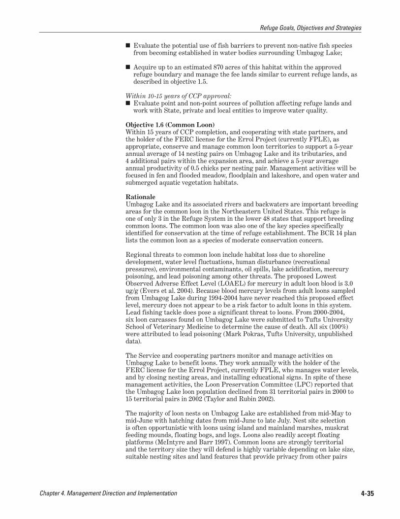
Chapter 4. Management Direction and Implementation 4-35
■ Evaluate the potential use of fish barriers to prevent non-native fish species from becoming established in water bodies surrounding Umbagog Lake;
■ Acquire up to an estimated 870 acres of this habitat within the approved refuge boundary and manage the fee lands similar to current refuge lands, as described in objective 1.5.
Within 10-15 years of CCP approval: ■ Evaluate point and non-point sources of pollution affecting refuge lands and
work with State, private and local entities to improve water quality.
Objective 1.6 (Common Loon) Within 15 years of CCP completion, and cooperating with state partners, and the holder of the FERC license for the Errol Project (currently FPLE), as appropriate, conserve and manage common loon territories to support a 5-year annual average of 14 nesting pairs on Umbagog Lake and its tributaries, and 4 additional pairs within the expansion area, and achieve a 5-year average annual productivity of 0.5 chicks per nesting pair. Management activities will be focused in fen and flooded meadow, floodplain and lakeshore, and open water and submerged aquatic vegetation habitats.
Rationale Umbagog Lake and its associated rivers and backwaters are important breeding areas for the common loon in the Northeastern United States. This refuge is one of only 3 in the Refuge System in the lower 48 states that support breeding common loons. The common loon was also one of the key species specifically identified for conservation at the time of refuge establishment. The BCR 14 plan lists the common loon as a species of moderate conservation concern.
Regional threats to common loon include habitat loss due to shoreline development, water level fluctuations, human disturbance (recreational pressures), environmental contaminants, oil spills, lake acidification, mercury poisoning, and lead poisoning among other threats. The proposed Lowest Observed Adverse Effect Level (LOAEL) for mercury in adult loon blood is 3.0 ug/g (Evers et al. 2004). Because blood mercury levels from adult loons sampled from Umbagog Lake during 1994-2004 have never reached this proposed effect level, mercury does not appear to be a risk factor to adult loons in this system. Lead fishing tackle does pose a significant threat to loons. From 2000-2004, six loon carcasses found on Umbagog Lake were submitted to Tufts University School of Veterinary Medicine to determine the cause of death. All six (100%) were attributed to lead poisoning (Mark Pokras, Tufts University, unpublished data).
The Service and cooperating partners monitor and manage activities on Umbagog Lake to benefit loons. They work annually with the holder of the FERC license for the Errol Project, currently FPLE, who manages water levels, and by closing nesting areas, and installing educational signs. In spite of these management activities, the Loon Preservation Committee (LPC) reported that the Umbagog Lake loon population declined from 31 territorial pairs in 2000 to 15 territorial pairs in 2002 (Taylor and Rubin 2002).
The majority of loon nests on Umbagog Lake are established from mid-May to mid-June with hatching dates from mid-June to late July. Nest site selection is often opportunistic with loons using island and mainland marshes, muskrat feeding mounds, floating bogs, and logs. Loons also readily accept floating platforms (McIntyre and Barr 1997). Common loons are strongly territorial and the territory size they will defend is highly variable depending on lake size, suitable nesting sites and land features that provide privacy from other pairs
Refuge Goals, Objectives and Strategies
Chapter 4. Management Direction and Implementation4-36
(Lang and Lynch 1996). Umbagog Lake’s large size and prevalence of coves and islands offers many potentially suitable territories for common loons.
Using summary data from LPC reports from 1991 to 2005, the number of nesting pairs were analyzed in 5 year intervals to develop a target number of
nesting pairs of common loons. From 1991-1995, the average number of nesting pairs was 17.4 + 3.44, from 1996-2000, the number was 18.4 + 2.30 and from 2001-2005, the number was 14.0 + 2.92. The historical average from 1976 to present (14 pairs) is reflected in the most current 5 year average. This number of nesting attempts by common loons also reflects current conditions with confounding variables including the presence of 4 nesting pairs of eagles. The refuge and cooperating partners will work to keep the number of nesting pairs at the approximate historical average of 14 pairs. The refuge and cooperating partners will also work toward increasing production of those 14 pairs to an average of 0.5 chicks per pair based on the rate of 0.48 chicks fledged per pair for a self-sustaining population (Evers 2004). This objective is not intended to maximize the number of common loons in the area, but to achieve a level which reduces negative interactions between common loons and between common loons and other waterfowl.
The four additional pairs within the expansion area include territories on: 1) Sturtevant Pond, 2) B Pond, 3) C Pond and 4) Pond in the River.
Strategies In addition to those strategies listed under “General Refuge Management” affecting this species:
Continue to: ■ Monitor loon populations in partnership with the states, conservation
organizations, and the holder of the FERC license for the Errol Project
■ Support research to determine causes and implications for decline in number of loon territories on Umbagog Lake
■ Participate in annual meetings with FERC licensee or representative to advise on lake water levels to benefit nesting loon, within the conditions of the FERC license and Article 27
■ Protect active loon nests in spring and summer from predators and human disturbance using outreach and visitor contact, buoy lines, restricted access, and other tools as warranted
■ Develop and maintain an Umbagog Lake loon dataset in partnership with NHFG, MDIFW, and private conservation organizations
Within 5 years of CCP approval: ■ As studies are completed on Umbagog Lake, validate the loon nesting and
territorial carrying capacities, and further determine whether 14 nesting pairs on the lake, and 4 nesting pairs in the expansion area, remain appropriate targets for these areas.
Within 5-10 years of CCP approval: ■ Monitor angler use. and map locations of fishing pressure and other
recreational users, in relation to common loon territories and other breeding wildlife
Ian
Dre
w/U
SFW
S
Common loons and chick on the Magalloway River
Refuge Goals, Objectives and Strategies

Chapter 4. Management Direction and Implementation 4-37
■ Develop and implement a study to evaluate interactions of loon with waterfowl during the breeding season; specifically, evaluate how waterfowl interact at high loon densities.
■ Develop and implement a study to examine interactions between loons and other piscivores (eagles, osprey, etc.), including competition for food and nest sites.
■ Evaluate the need for predator control around common loon sites; consider predator control measures targeted at individual animals
■ Evaluate the availability and quality of natural nesting habitat for common loon.
Manage floodplain and lakeshore habitats to benefit Federal trust species and other species of conservation concern.
Objective 2.1 (Wooded Floodplain) Manage up to 1,429 acres of wooded floodplain on Service-owned lands, including those planned for acquisition from willing sellers within the approved refuge boundary, to provide habitat for nesting cavity-dependent waterfowl and other priority bird species of regional conservation concern, including northern parula and rusty blackbird. In addition, manage perching areas for bald eagle, and brood foraging areas for American black duck and other waterfowl. Also, where this habitat type overlays woodcock focus areas, manage for feeding and nesting American woodcock.
Rationale Wooded floodplain habitat on the refuge includes the following National Vegetation Classification System (NVCS) associations: red maple floodplain forest, red maple-balsam fir floodplain forest, white spruce-balsam fir berm woodland, red maple-tussock sedge floodplain woodland, black ash-mixed hardwoods swamp, and red maple-black ash swamp (appendix G). This habitat type, which constitutes 5% of refuge acres, contributes significantly to the wildlife diversity known on the refuge. For example, we have detected over 75 bird species from point locations in this habitat type during our breeding bird surveys.
The Magalloway River floodplain, ranked as an S2 (imperiled) community by NHNHB, and approximately 245 acres in size, offers quality habitat for waterfowl, providing the combination of large cavity nesting trees and river bottomland areas with submerged and floating leaf aquatic plants and abundant substrate for invertebrates. Common goldeneye, wood duck, and hooded and common mergansers nest in cavities in live trees with a diameter at breast height (d.b.h.) of 18 inches or more (Tubbs et al. 1986).
The rusty blackbird, a watchlist species for BCR 14 and PIF 28 bird conservation planning areas, nests in riparian areas, boreal wooded wetlands, and beaver flowages (DeGraaf and Yamasaki 2001; Rich et al. 2004). According to the species profile in the 2005 NH WAP, this species has declined dramatically; BBS results from 1996-2001 indicate a 10.7% decline (NHFG 2005).
We have documented rusty blackbird breeding in the Magalloway River floodplain. It builds a nest near streams, ponds, bogs, and fens with a conifer component, usually less than 10 feet above the ground in thick foliage near the trunk of a young spruce or fir or in a shrub thicket. It will also utilize the spruce-fir and mixed woods habitat types between 1000 ft to 4,000 ft in elevation in refuge uplands. During migration rusty blackbirds congregate in flocks in wooded swamps (DeGraaf and Yamasaki 2001) and migrating flocks are documented for Umbagog Lake (Brewster 1937), although they may be
GOAL 2:
Refuge Goals, Objectives and Strategies
Chapter 4. Management Direction and Implementation4-38
less common now (Richards 1994). The rusty blackbird shows some aversion to clearcutting that creates suitable habitat for competitors including red-winged blackbird and common grackle (Dettmers 2005). Some disturbance (e.g., windthrow, beaver activity) creates forest openings allowing regeneration of softwoods and resulting in potential rusty blackbird nesting habitat (Avery 1995). The New Hampshire WAP identifies the use of pesticides on the breeding and wintering grounds, destruction of wintering habitat, acidification of water bodies on the breeding grounds and efforts to control blackbirds on winter roosts may be the contributing to the decline of this bird.
The northern parula is associated with mature moist forests and forested riparian habitats dominated by spruce, hemlock, and fir with an abundance of lichens (especially Usnea) in which they build their nests. There are indications that the northern parula population decline is related to the decline of Usnea, a lichen sensitive to air pollution (DeGraaf and Yamasaki 2001). PIF considers the northern parula a moderate priority for BCR 14, although the region supports 23% of the population (Dettmers 2005). The northern parula is rarely in deep woods, but also avoids clear cuts and may be sensitive to forest fragmentation (DeGraaf and Yamasaki 2001). It may require at least 250 acres to sustain a breeding population (Robbins et. al. 1989). The 2005 Maine CWCS identifies habitat conservation and research as the two highest priorities in the state for conserving rusty blackbird and northern parula populations (MDIFW 2005).
Through managing this habitat type, and the vernal pools embedded within it, other native species will benefit including a rich diversity of amphibians such as mink frog, spotted and blue-spotted salamanders, and wood frog. In addition, sustaining this habitat would benefit several bats including little brown, hoary, and northern long-eared that roost in tree cavities, under loose bark, or under dense foliage.
The refuge currently owns, or has approval to acquire an interest in, 1,416 acres if this habitat type. Included are those lands in the LPP (appendix A), which is the latest, approved plan for a refuge expansion. It is primarily on the fee title lands that we plan to conduct active management. Our management emphasis over the next 15 years will be to identify the habitat attributes most important for sustaining the focal species identified in the objective statement, and enhancing, and/or restoring, those attributes. We describe some of those attributes in the species’ discussions below. We will manage this habitat type on current refuge lands within the habitat management units we have identified in appendix E.
Given our habitat management and land acquisition objectives, we estimate the refuge (fee title lands only) could provide high quality breeding habitat to support 115 pair of northern parula (based on an estimated density of 12.35 ac/ pair), and 58 pair of rusty blackbird (based on an estimated density of 24.71 ac/ pair), thus contributing directly to the BCR 14 goals for both of these species of conservation concern (Randy Dettmers, personal communication, 2006). These values may be over-estimates, since not all wooded floodplain habitat is equally suitable for these two species.
Strategies In addition to those strategies listed under “General Refuge Management” affecting this habitat type:
Continue to: ■ Acquire up to 289 acres of this habitat type still in private ownership within
the approved refuge boundary, from willing sellers, and manage the fee lands similar to current refuge lands under objective 2.1
■ Restore natural vegetation on unauthorized campsites
Refuge Goals, Objectives and Strategies

Chapter 4. Management Direction and Implementation 4-39
■ Remove surplus cabins that we have acquired as funding allows. Restore site (e.g. loam, seed and/or plant) to native vegetation.
■ Implement vernal pool, small mammal and amphibian surveys
■ Include this habitat type in breeding bird surveys
Within 5 years of CCP approval: ■ Identify suitable habitat, and assess habitat quality and habitat use by
migratory birds such as northern parula and rusty blackbird. Document habitat use using regional Service protocol for breeding bird surveys, or other appropriate protocols.
■ Develop and implement a plan to improve habitat for nesting and migrating birds of conservation concern, such as northern parula and rusty blackbird.
■ Retain the majority of trees with cavities, standing dead trees, downed logs, large trees, and large super-canopy trees in the riparian areas.
■ In woodcock focus areas, develop prescriptions to enhance habitat type for this species.
Within 5-10 years of CCP approval: ■ Manage lowland hardwood and alder to provide adequate food resources for
beaver to promote a natural cyclical succession of this habitat type driven by beaver.
■ If furbearer management plan is appropriate (see “implementing a furbearer management program” earlier in this chapter) implement strategies to manage beaver populations to achieve refuge habitat goals and objective.
■ Map and monitor the rare floodplain forest type that occurs along the Magalloway River.
■ Evaluate isolated backwater areas with high potential for waterfowl brood rearing (e.g. quiet backwaters with the combination of forest cover, submerged aquatic vegetation, and intermixed emergent wetlands in Dead Cambridge and Upper Magalloway Rivers) to determine if seasonal boat access closures to reduce disturbance; implement closures if beneficial.
Within 10-15 years of CCP approval: ■ Maintain, enhance and/or create cavity trees within a range of diameter
classes in close proximity to water to provide roosting and nesting areas. Maintain suitable habitat between snags (standing dead trees) and feeding areas.
■ Restore the hydrology of the Day Flats area by plugging ditches and re-contouring the disturbed areas.
■ Evaluate the dynamics and succession of the red maple/black ash type and relate its importance to focal species. If warranted, restore and maintain it to sites where site capability is high for this type and it is part of the predicted potential natural vegetation.
Objective 2.2 (Lakeshore Pine-Hemlock) Maintain up to 520 acres of lakeshore pine-hemlock on Service-owned lands, including those planned for acquisition from willing sellers within the approved refuge boundary, to provide nesting and migrating habitat for birds of conservation concern; to sustain the vegetation diversity within this type, such as
Refuge Goals, Objectives and Strategies
Chapter 4. Management Direction and Implementation4-40
the jack pine component; to maintain nesting habitat for bald eagle, osprey, and other raptors; to protect water quality; and, to maintain the scenic and aesthetic values of the Umbagog Lake and other lake shorelines.
Rationale The lakeshore pine-hemlock habitat type is comprised of the following NVCS associations: hemlock mesic forest, hemlock-hardwoods forest, hemlock-white pine-red spruce forest, red pine-white pine forest, and jack pine/blueberry/ feathermoss forest (appendix G).
The refuge currently owns, or has approval to acquire an interest in, 520 acres of this habitat type. Small stands likely occur elsewhere in the approved refuge expansion area, but they were not discernable in the data set we used to map vegetation. It is primarily on the fee title lands that we plan to conduct active management. Our management emphasis over the next 15 years will be to protect and sustain existing and potential nest stands and perch trees for bald eagle and osprey, and to inventory and monitor the jack pine stands to serve as a basis for future management.
On the refuge, bald eagle and osprey often nest in large supercanopy trees (large white pines that stick up above the other canopy trees), or in tall snags (standing dead trees) in this habitat type. Additional information on bald eagles and osprey is discussed under objective 2.3. Jack pine communities are rare in New Hampshire and Maine and the stands around Umbagog Lake are the only low-elevation occurrences in New Hampshire (Publicover et al. 1997). The jack pine stands at Umbagog Lake are scattered along the rocky eastern shore and islands of the lake.
Through managing this habitat type, other native species will benefit, including nesting merlin and sharp-shinned hawk, olive-sided flycatcher, veery, and yellow-bellied sapsucker, among many other common species.
Strategies In addition to those strategies listed under “General Refuge Management” affecting this habitat type:
Continue to: ■ Monitor habitat impacts from public use
■ Mitigate significant recreational impacts as needed
■ Record wildlife use of this habitat type
■ Acquire up to 288 acres of this habitat type still in private ownership within the approved refuge boundary, from willing sellers, and manage fee title land similar to current refuge lands under objective 2.2
■ Also see objective 2.3.
Within 5 years of CCP approval: ■ Develop and implement a HMP to perpetuate this habitat type, giving priority
to water quality protection and aesthetic values
■ Maintain large diameter trees for raptor perch trees and future nest trees (also see objective 2.3 immediately below)
■ Ensure the HMP addresses recruitment of super-canopy pines.
Refuge Goals, Objectives and Strategies

Chapter 4. Management Direction and Implementation 4-41
Within 5-10 years of CCP approval: ■ Work with NGO’s and States to increase monitoring and protection of raptors,
and if feasible, implement cooperative procedures to protect merlin and other forest dependent raptors of conservation concern.
Within 10-15 years of CCP approval: ■ Where jack pine occurs, map and monitor this type, and consult with state
heritage program and other regional ecologists to determine if special management is warranted to sustain this rare ecological community in the Upper Androscoggin watershed; amend HMP to include management prescriptions.
Objective 2.3 (Bald Eagle and Osprey) Maintain forest stands on the refuge within one mile of high quality bald eagle foraging acres to support 3-4 nesting pairs of bald eagle with a minimum annual 1.0 chick/ pair productivity level over a 5 year average. Given this bald eagle density, and recognizing inter-specific competition, maintain habitat to support 15 nesting pair of osprey on existing and future refuge lands, with a minimum annual 1.0 chick/pair productivity level over a 5 year average.
Rationale The protection of these two species was a primary reason the refuge was established, and they have been a management priority since then. As such, we believe their management warrants special consideration in a separate objective statement.
Bald eagle The bald eagle is listed as endangered in New Hampshire and threatened in Maine and continues to be protected by both the Bald and Golden Eagle Protection and the Migratory Bird Treaty Acts. In New Hampshire and Maine, bald eagles are found along major rivers and lakes or near the coast in relatively
undisturbed forest patches. Bald eagles perch on, nest in, and hunt from tall, coniferous and deciduous trees or snags (standing dead trees) near water. In the Northeast, white pine is the most common nest tree. Nests are usually within 250 feet of open water near quality foraging areas.
Fish are the preferred food source, although eagles also take waterfowl, aquatic mammals, and scavenge for food. Eagles fish mostly in shallow, low-velocity waters. Chain pickerel, brown bullhead, suckers, white perch, and yellow perch are typical prey in interior Maine (Charles Todd, MDIFW, unpublished report).
In winter, some individuals may leave the breeding areas and congregate in areas with large expanses of unfrozen, open water. A forest stand that offers thermal protection from inclement winter weather is needed for communal night roosting. Night roosts are most often found near foraging areas, but may be further away if the roost is more protected. Umbagog Lake does not support a winter roost site, although some eagles remain in the area (along the Androscoggin River) and scavenge on the lake.
The main goal of national and state plans for bald eagles is to protect and maintain self-sustaining populations. Supporting breeding pairs with an average
USF
WS
Bald eagle
Refuge Goals, Objectives and Strategies

Chapter 4. Management Direction and Implementation4-42
annual productivity of at least 1.0 young per occupied nest is highly desired. From 1994-2002 the Leonard Pond nest on Umbagog Lake produced an average of 0.89 chicks/year. A second nest, near Tidswell Point, has produced 1.5 chicks/year from 2000-2005. Umbagog Lake is at the headwaters of the Androscoggin River, and as such, the eagles on the lake are an extension of the Maine eagle population.
Charlie Todd (MDIFW, personal communication, 2005) determined that Umbagog Lake has the potential to support two to three successful nesting pairs of bald eagles given the separation distance that eagles typically establish from one another. Todd (2005) evaluated several large live white pines near the dead nest tree in Leonard Pond to determine the potential for alternative nest sites in the area. Alternative nesting trees appear to be available to the eagles should they decide to use an alternative site.
Osprey The Upper Androscoggin River watershed is an important breeding area for osprey. At the core of this area, Umbagog Lake and its associated rivers and backwaters, was the only part of New Hampshire that maintained a breeding population of osprey through the region-wide decline from the 1950s through the 1970s (NHFG 2005). Osprey are listed by the State of New Hampshire as a threatened species. Regional threats to osprey include predation, shoreline development, human disturbance, electrocution, mercury, lead shot and sinkers, non-point source pollution (contaminants), and wetland loss (NHFG 2005). Osprey populations have experienced strong recoveries on the statewide scale since the early 1980s (Martin et. al. 2006).
Osprey nesting in the U.S. will winter in the Caribbean, Central America, and South America (Henry and VanVelzen 1972; Environment Canada 2001). Osprey breeding on the east coast of the U.S. will winter primarily in northern South America and sometimes in Cuba and Florida (Martel et. al. 2001). Female osprey generally winter farther south than males and individuals of both sexes show strong fidelity to wintering and breeding sites (NHFG 2005).
In northern New England, osprey will typically establish breeding territories near large lakes, major rivers, and coastal estuaries. A habitat model developed for the Gulf of Maine watershed (USFWS 2000) found that 90% of 200 osprey nests were located within 0.6 miles of major rivers or lakes greater than 100 acres in size. Osprey generally require areas with dependable fishing sources within 2 to 3 miles, standing trees or other suitable structures located in wetlands, and an ice-free period of no less than 20 weeks (NHFG 2005). Ospreys nest atop a variety of structures including natural snags (standing dead trees) and artificial poles in or near water with good visibility (DeGraaf and Yamasaki 2001).
Over the past 25 years, the Audubon Society of New Hampshire (ASNH), through a contract with NHFG, has monitored nesting attempts, and also began augmenting nesting sites with artificial nesting structures around the lake in 1977 (NHFG 2005). In 2005, through a contract with the refuge, ASNH and the Biodiversity Research Institute (BRI) conducted aerial surveys for osprey in addition to the ground surveys used from 1996 to 2004. A similar method of aerial surveys had been used by ASNH from the mid-1980’s to 1996 when they were discontinued due to a lack of aircraft and qualified pilots. Seven new nests were discovered (5 in New Hampshire, 2 in Maine) and field observations were conducted on 26 osprey nests in the study area. The 2005 survey data estimated 17 territorial pairs of osprey, with 14 of those pairs actively engaged in nesting and 12 of the 14 nesting pairs successfully fledged a total of 18 young (Martin, et. al. 2006). ASNH has found osprey numbers to be variable over time. The 14 nests discovered in 2005 more than doubles the number of active nests found in 2004 (Martin et. al. 2006).
Refuge Goals, Objectives and Strategies
Chapter 4. Management Direction and Implementation 4-43
Charlie Todd (MDIFW, personal communication, 2005) suggested a link between an increasing bald eagle population and declining osprey numbers as a result of increased competition and territoriality. He has observed that bald eagles will appear in an area with many ospreys; with time the osprey may decline and eventually there are osprey areas and eagle areas with no overlap. Bald eagle population recovery has been reported to displace osprey pairs to less optimal nesting areas that are further from preferred foraging areas (Ewins 1997).
Strategies In addition to those strategies listed under “General Refuge Management” affecting these species and objective 2.2 strategies immediately above:
Continue to: ■ Protect super-canopy nesting trees on current and future refuge lands.
■ Inventory active and historic nesting sites each year
■ Conduct bald eagle and osprey surveys in conjunction with the States of Maine and New Hampshire, and conservation partners
■ Protect active bald eagle and osprey nests from predators and human disturbance using outreach and visitor contact, buoy lines, restricted access, predator guards and other tools as warranted
■ Implement area closures around bald eagle nest trees; place visible floating buoys and signs to alert all boaters to closure area
■ Work cooperatively with State agencies and private conservation organizations on bald eagle and osprey management
■ Support efforts to eliminate practices that contribute lead and other contaminants to the environment
Within 5 years of CCP approval: ■ Identify and protect super-canopy trees within 1 mile of high quality foraging
habitat to support nesting and perching by bald eagles and osprey.
■ Protect individual nest trees with at least a 600-foot buffer area.
■ Protect historic nest sites, nest trees, and partially constructed nest trees.
Within 5-10 years of CCP approval: ■ Manipulate pines in high quality habitat areas to promote new nesting sites.
■ Develop and implement outreach methods designed to minimize discarded fishing tackle and lines.
Within 10-15 years of CCP approval: ■ Ensure recruitment of new nest trees; identify stands with potential.
Manage upland forest habitats, consistent with site capability, to benefit Federal trust species and other species of conservation concern
Objective 3.1 (Mixed Spruce-Fir/Northern Hardwood Forest) Conserve up to 59,611 acres of mixed spruce-fir/northern hardwood forest on Service-owned lands, including those planned for acquisition from willing sellers within the approved refuge boundary, to sustain well-distributed, high quality breeding and foraging habitat for species of conservation concern, including
GOAL 3:
Refuge Goals, Objectives and Strategies
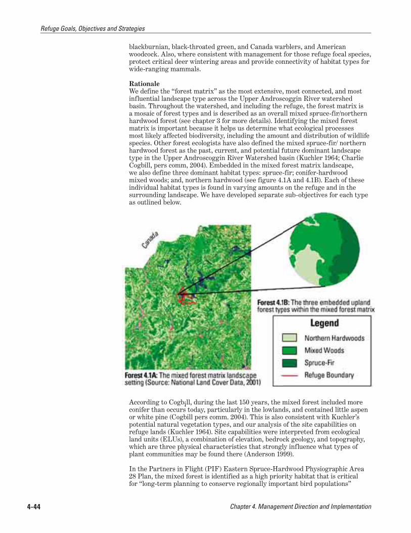
Chapter 4. Management Direction and Implementation4-44
blackburnian, black-throated green, and Canada warblers, and American woodcock. Also, where consistent with management for those refuge focal species, protect critical deer wintering areas and provide connectivity of habitat types for wide-ranging mammals.
Rationale We define the “forest matrix” as the most extensive, most connected, and most influential landscape type across the Upper Androscoggin River watershed basin. Throughout the watershed, and including the refuge, the forest matrix is a mosaic of forest types and is described as an overall mixed spruce-fir/northern hardwood forest (see chapter 3 for more details). Identifying the mixed forest matrix is important because it helps us determine what ecological processes most likely affected biodiversity, including the amount and distribution of wildlife species. Other forest ecologists have also defined the mixed spruce-fir/ northern hardwood forest as the past, current, and potential future dominant landscape type in the Upper Androscoggin River Watershed basin (Kuchler 1964; Charlie Cogbill, pers comm, 2004). Embedded in the mixed forest matrix landscape, we also define three dominant habitat types: spruce-fir; conifer-hardwood mixed woods; and, northern hardwood (see figure 4.1A and 4.1B). Each of these individual habitat types is found in varying amounts on the refuge and in the surrounding landscape. We have developed separate sub-objectives for each type as outlined below.
According to Cogbill, during the last 150 years, the mixed forest included more conifer than occurs today, particularly in the lowlands, and contained little aspen or white pine (Cogbill pers comm. 2004). This is also consistent with Kuchler’s potential natural vegetation types, and our analysis of the site capabilities on refuge lands (Kuchler 1964). Site capabilities were interpreted from ecological land units (ELUs), a combination of elevation, bedrock geology, and topography, which are three physical characteristics that strongly influence what types of plant communities may be found there (Anderson 1999).
In the Partners in Flight (PIF) Eastern Spruce-Hardwood Physiographic Area 28 Plan, the mixed forest is identified as a high priority habitat that is critical for “long-term planning to conserve regionally important bird populations”
Refuge Goals, Objectives and Strategies

Chapter 4. Management Direction and Implementation 4-45
(Rosenberg and Hodgman 2000). Our breeding bird survey data shows the elevated importance of the refuge’s mixed forest matrix for blackburnian, Canada, and black-throated green warblers in the area. We have selected these, and the American woodcock, as our refuge focal species for management. These species habitat requirements are described below.
The selection of our focal species resulted from a landscape analysis described in appendix H. It was after this analysis our planning team determined that sustaining a mature mixed forest, with a high conifer component and high structural diversity, was the most important ecological contribution the refuge could make through management to the Upper Androscoggin River watershed, the Northern Forest, and the Refuge System. As such, after goal 1, this goal is the next highest priority habitat management in this CCP.
To accomplish this, we will manage our forest to achieve a mix of regeneration, mid- and mature age classes, and retain snags (dead or dying trees that are still standing), and other wildlife trees, downed wood and super-canopy trees. Some areas in all forest habitat types may be retained as unmanaged ‘control’ or comparison areas, as part of forest management research projects. Additionally, forest industry inoperable and high resource sensitivity zones will receive little or no active management. In low and moderate resource sensitivity areas, we will primarily use uneven-aged management techniques to convert the existing, predominantly even-aged forest stands to a multi-aged, multi-structured condition. Even-aged management techniques may also be used in certain stands, such as those with healthy, advanced regeneration of spruce and fir, woodcock focus areas, or in deer wintering areas. Appendix E provides important details on how we plan to manage our forests. It includes additional information, supplementing what is provided below.
The 15 year scope of our CCP falls far short of the decades used to measure tree growth and stand development in the mixed forest. This objective requires consideration of a much longer timeframe within which to measure and achieve results. As such, our expectation is that it would take at least 100 years to accomplish this objective. This timeframe is based on our prediction of how long it would take to achieve the forest and stand composition and structural characteristics targeted for our refuge focal species identified in the objective statement.
Our habitat type classifications are based on grouped National Vegetation Classification System (NVCS) “associations.” A cross-walk between refuge forest habitat types, NVCS associations, Society of American Forester types, and other vegetation classification systems is included in appendix G.
Ge neral Strategies (also see strategies for the three specific habitat types in sub-objectives below)
Within 5 years of CCP approval: ■ Conduct breeding bird surveys according to regional Service protocols to
track breeding bird trends on the refuge.
■ Conduct a detailed inventory in each of the three habitat types to identify or refine specific silvicultural prescriptions.
■ Conduct resource surveys prior to forest management to ensure that resources of concern are identified and impacts minimized or eliminated
■ Perpetuate, through accepted silvicultural practices, the three habitat types through time, distributed within the refuge based on site capability and our ability to access and manage them. Ensure that habitat patch size and connectivity are sufficient for species requiring large blocks of unfragmented habitat
Refuge Goals, Objectives and Strategies

Chapter 4. Management Direction and Implementation4-46
■ Initiate acquisition from willing sellers on up to 48,766 acres (see sub-objectives below for breakdown of habitat type) of upland forest still in private ownership within the approved refuge boundary, and manage fee lands as described in objective 3.1.
Sub-Objective 3.1a (Spruce-Fir Habitat Type)Manage up to 28,863 acres of spruce-fir on Service-owned lands, including those planned for acquisition from willing sellers within the approved refuge boundary, to:
■ Sustain singing, nesting and feeding habitat for blackburnian and black-throated green warblers (refuge focal species) by perpetuating a high (>70%) crown closure, favoring spruce during stand improvement, and maintaining super canopy trees
■ Maintain at least 50% of deer wintering areas (map 4-7) as quality shelter at any given time, consistent with management of our focal species
■ Provide connectivity of forested habitat types for wide-ranging mammals, consistent with management for our focal species
■ Provide other structural characteristics to improve stand diversity for other native wildlife species dependent on this habitat type. This will include retention of approximately six live cavity trees or snags (standing dead trees/ acre), with at least 1 of these exceeding 18 inches/dbh, and three others exceeding 12 inches dbh, and retaining coarse woody debris and super dominant or super canopy trees.
■ Acquire up to 26,517 acres of this cover type from willing sellers within the approved refuge boundary, and manage fee title lands similar to current refuge lands under objective 3.1a.
■ Work with state partners to identify and protect critical deer wintering yards (see map 4-7 ).
The spruce-fir habitat type includes both high and low elevation spruce-fir. It is comprised of the following NVCS associations: lowland spruce-fir community, red spruce rocky summit, and a black spruce-red spruce community. It is an important ecological component of the diversity of the Upper Androscoggin River Watershed and supports many species of conservation concern.
The 1995 New Hampshire Forest Resources Plan describes the spruce-fir habitat type as supporting more rare animal species than other major habitat types and considers mature spruce-fir a rare habitat type (New Hampshire Division of Forests and Lands 1995).
While we believe this habitat type was much more dominant historically in the mixed forest matrix than we see on the landscape today, its extent and age class distribution in New Hampshire and Maine has been affected by natural disturbances such as spruce budworm and bark beetle outbreaks, and from human disturbances, primarily logging. The 2005 New Hampshire Wildlife Action Plan (WAP) identifies development, timber harvest, non-point pollution, and altered natural disturbance regimes as the most challenging issues currently facing the conservation of this habitat type (NHFG 2005).
Given the apparent decline in spruce-fir habitat, its significance to our mixed forest focal species (blackburnian and black-throated green warblers), and its importance in State conservation plans, the spruce-fir habitat type will be our highest priority for upland forest management. Since our management will tend
Refuge Goals, Objectives and Strategies
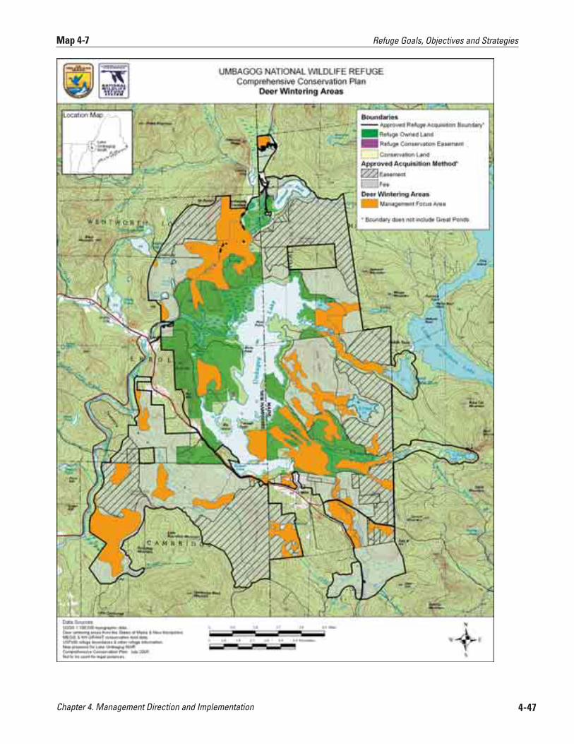
Chapter 4. Management Direction and Implementation 4-47
Map 4-7 Refuge Goals, Objectives and Strategies
Chapter 4. Management Direction and Implementation4-48
to create larger blocks of mature spruce-fir on the landscape, we anticipate that a by-product of our management will be the improvement of habitat quality for species more closely tied to this habitat, such as bay-breasted warbler, boreal chickadee, and gray jay, among others.
Specific Strategies for the Spruce-Fir Habitat Type (see appendix E for additional details)
■ Improve habitat structural diversity for refuge focal species through pre-commercial and commercial thinning and/or other stand improvement operations, as appropriate. We will favor spruce during all stand improvements.
■ Regenerate this habitat type through accepted silvicultural practices. Methods include, but are not limited to:
■ Utilize primarily single tree or group selection uneven-aged management techniques, and to a lesser extent, clearcutting, or shelterwood even-aged techniques, 2) treatments should be timed to optimize the ability of the site to regenerate spruce and other conifer, 3) target age class goals under management will range from 100-130 years; and, 4) the size of each treatment action and cutting interval will be determined by management unit size, silvicultural prescription, and rotation age.
■ In critical deer wintering areas (map 4-7), maintain updated maps of critical areas and manage these stands, to the extent compatible with management of Federal trust resources, to ensure long-term continuation of this habitat. The overall target would be to maintain a minimum of 50% of a deer wintering area as quality shelter at any point in time. Quality shelter includes softwood cover over 35 feet tall and 70% or higher crown closure (Reay et al. 1990). Refuge staff will assist state agencies with ground surveys of wintering deer areas on refuge lands.
Sub-Objective 3.1b (Conifer-Hardwood “Mixed Woods” Habitat Type)Manage up to 17,265 acres of conifer-hardwood mixed woods with a high conifer component on Service-owned lands, including those planned for acquisition from willing sellers within the approved refuge boundary, to:
■ Sustain singing, nesting and feeding habitat for blackburnian and black-throated green warblers (refuge focal species) by perpetuating a high (>70%) crown closure, favoring spruce during stand improvement, and maintaining super canopy trees. Enhance foraging habitat for the black-throated green warbler and other native species dependent on this habitat type by developing small gaps to promote a diverse, layered understory. We will favor conifers wherever possible based on site capability.
■ Provide connectivity of forested habitat types for wide-ranging mammals, consistent with management for our refuge focal species.
■ Provide other structural characteristics to improve stand diversity for other native wildlife species dependent on this habitat type. This will include retention of approximately 6 live cavity trees or snags (standing dead trees)/ acre, with at least 1 of these exceeding 18 inches/dbh, and 3 others exceeding 12 inches dbh, and retaining coarse woody debris and super dominant trees.
■ Acquire up to 13,406 acres of this cover type from willing sellers within the approved refuge boundary, and manage fee title lands similar to current refuge lands under objective 3.1b.
The conifer-hardwood mixed woods habitat type is comprised of the following NVCS associations: aspen-fir woodland, successional spruce-fir forest, and red
Refuge Goals, Objectives and Strategies
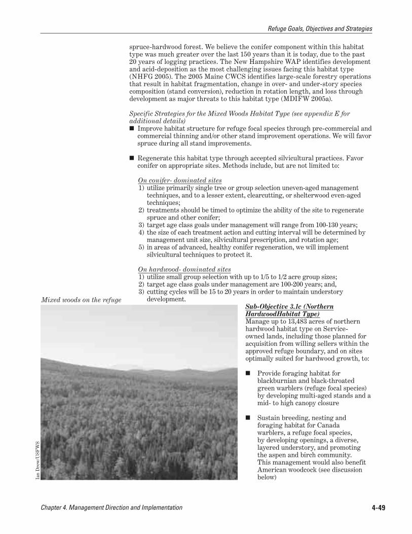
Chapter 4. Management Direction and Implementation 4-49
spruce-hardwood forest. We believe the conifer component within this habitat type was much greater over the last 150 years than it is today, due to the past 20 years of logging practices. The New Hampshire WAP identifies development and acid-deposition as the most challenging issues facing this habitat type (NHFG 2005). The 2005 Maine CWCS identifies large-scale forestry operations that result in habitat fragmentation, change in over- and under-story species composition (stand conversion), reduction in rotation length, and loss through development as major threats to this habitat type (MDIFW 2005a).
Specific Strategies for the Mixed Woods Habitat Type (see appendix E for additional details)
■ Improve habitat structure for refuge focal species through pre-commercial and commercial thinning and/or other stand improvement operations. We will favor spruce during all stand improvements.
■ Regenerate this habitat type through accepted silvicultural practices. Favor conifer on appropriate sites. Methods include, but are not limited to:
On conifer- dominated sites1) utilize primarily single tree or group selection uneven-aged management
techniques, and to a lesser extent, clearcutting, or shelterwood even-aged techniques;
2) treatments should be timed to optimize the ability of the site to regenerate spruce and other conifer;
3) target age class goals under management will range from 100-130 years; 4) the size of each treatment action and cutting interval will be determined by
management unit size, silvicultural prescription, and rotation age; 5) in areas of advanced, healthy conifer regeneration, we will implement
silvicultural techniques to protect it.
On hardwood- dominated sites1) utilize small group selection with up to 1/5 to 1/2 acre group sizes; 2) target age class goals under management are 100-200 years; and,3) cutting cycles will be 15 to 20 years in order to maintain understory
development.Sub-Objective 3.1c (Northern HardwoodHabitat Type)Manage up to 13,483 acres of northern hardwood habitat type on Service-owned lands, including those planned for acquisition from willing sellers within the approved refuge boundary, and on sites optimally suited for hardwood growth, to:
■ Provide foraging habitat for blackburnian and black-throated green warblers (refuge focal species) by developing multi-aged stands and a mid- to high canopy closure
■ Sustain breeding, nesting and foraging habitat for Canada warblers, a refuge focal species, by developing openings, a diverse, layered understory, and promoting the aspen and birch community. This management would also benefit American woodcock (see discussion below)
Mixed woods on the refuge
Ian
Dre
w/U
SFW
S
Refuge Goals, Objectives and Strategies

Chapter 4. Management Direction and Implementation4-50
■ Provide other structural characteristics to improve stand diversity for other native wildlife species dependent on this habitat type. This will include retention of approximately six live cavity trees or snags (standing dead trees)/ acre, with at least one of these exceeding 18 inches/dbh, and three others exceeding 12 inches dbh, and retaining coarse woody debris, and super dominant trees. Where possible, we will maintain and encourage the development of mast producing trees (e.g. black cherry, mountain ash, beech).
■ Acquire up to 8,843 acres of this cover type from willing sellers within the approved refuge boundary, and manage fee title lands similar to current refuge lands under objective 3.1c.
The northern hardwood habitat type is comprised of the following NVCS associations: red maple-yellow birch early successional woodland, northern hardwood forest, semi-rich northern hardwood forest, and paper birch talus woodland. This habitat type is more extensive on the landscape today than probably occurred over the last 150 years (Charlie Cogbill, personal communication, 2004). Similar to the spruce-fir type, its distribution is largely due to site capability and land-use changes over time. It is also an important ecological component of the diversity of the Upper Androscoggin River watershed.
The northern hardwood habitat type is a deciduous forest dominated by sugar maple, yellow birch and American beech on well-drained soils on mid-elevation slopes. American beech becomes more common in older stands. Most of the area covered by this community was logged at some time in the past (Rapp 2003). Aspen-birch is another forest component of this habitat type, although it can also be a temporary, early successional feature of any of the three broad upland habitat types on the refuge. White birch, quaking and bigtooth aspen, and pin cherry can dominate an area following a large disturbance such as fire or clearcut; however, these shade intolerant species are eventually replaced with more shade tolerant species characteristic of the particular site conditions.
Specific Strategies for the Northern Hardwood Habitat Type (see appendix E for additional details)
■ Improve habitat structure for refuge focal species through pre-commercial and commercial thinning and/or other stand improvement operations.
■ Regenerate these habitat types through accepted silvicultural practices. Methods include, but are not limited to: 1) Utilize single tree or small group selection of up to 1/2 acre group sizes, 2) target age class under management are 100-200 years; and, 3) cutting cycles of 15 to 20 years in order to maintain understory development.
Sub-Objective 3.1d (Woodcock Focus Areas)Manage 2,664 acres in woodcock focus areas to provide and sustain all life stage habitat requirements for woodcock.
■ Use accepted silvicultural practices in woodcock focus areas (map 4-2) to create openings, promote understory development, and sustain early successional habitat for American woodcock and Canada warbler. Generally, use group selection, clearcuts or patch cuts of up to 5 acres in size. Some larger roosting fields may also be maintained. Cutting cycles will be approximately 8-10 years on a 40 year rotation. Some 3-5 acre openings may be permanently maintained primarily by mowing and brush clearing using mechanized equipment.
Refuge Goals, Objectives and Strategies

Chapter 4. Management Direction and Implementation 4-51
■ Perpetuate aspen-birch communities where they exist, and strive to achieve an appropriate distribution of regenerating, young, mid and mature age classes
■ Conduct woodcock singing male surveys to document wildlife response to habitat management.
Focal Species Habitat Requirements The blackburnian warbler is associated with mature conifer habitats (> 80% canopy cover) of spruce, fir, hemlock, and pines, and in spruce-fir/hardwood mixed habitats including deciduous stands with patches of conifers. It nests and gleans insects in the upper canopy of conifers, especially spruce and hemlock, if present, and rarely pines (DeGraaf and Yamasaki 2001). Males sing from the tops of the tallest conifers, preferably over 60 feet. The blackburnian warbler is a moderate priority with a high regional responsibility within Bird Conservation Region (BCR) 14 (Dettmers 2005). Approximately 25% of the global population occurs in this region. This warbler is of conservation concern because of its relatively small total range, its preference for mature conifers, and its restricted winter range in the subtropical forests of northern South America. Declines are recorded for New England although the overall population appears to be stable. It is considered a forest interior species, susceptible to forest fragmentation and short rotation timber harvesting (50 years or less) (Hagen et al. 1996; Morse 2004). The effects of forest fragmentation, loss of hemlock to wooly adelgid, and deforestation on the wintering grounds are issues of concern to the conservation of this species (Morse 2004). The 2005 Maine CWCS lists the loss of hemlock as the chief threat to this species’ conservation in Maine and identifies habitat conservation and research as the two highest priorities in the state for conserving their population state-wide (MDIFW 2005a).
The Canada warbler is declining across much of its range and is listed as highest priority in BCR 14 (Dettmers 2005). This bird is found throughout the watershed, and is not tied specifically to any of the three refuge upland habitat types, but may be tied more directly to a well-developed understory or shrub layer. PIF also has a goal of increasing the Canada warbler continental population by 50% (Rich et al. 2004). The Maine CWCS identifies habitat conservation and research as the two highest priorities in the state for conserving Canada warblers (MDIFW 2005a).
The black-throated green warbler is one of the forest-interior species most closely associated with a mixed forest. Black-throated green warblers are a moderate priority in BCR 14, with a high regional responsibility (18.4% of the global population), and a moderate regional threat level. This species is generally abundant and stable in the region. Although it occupies a wide range of forested habitat types, in the Northeast, it occurs at highest densities in closed canopy mid-to-mature forest with a significant conifer component. This foliage-gleaning warbler generally forages high in the canopy, but at a lower height than blackburnian warblers (Morse 1967). Spruce (particularly red spruce) and paper birch are favored foraging substrates. Although it will nest in deciduous trees, preferred nest sites are in dense conifer foliage on a limb or tree fork, at a height of about 20 ft. (DeGraaf 2001; Foss 1994). Large spruce trees are favored male singing perches (Morse 1993). Black-throated green warblers appear to require fairly large forest patches and a generally forested landscape (Norton 1999). Askins and Philbrick (1987) found that they disappeared from a 250 acre forest tract that became isolated from other forested habitat. Black-throated green warbler densities also decline in heavily thinned forest (Morse 1993). However, structurally heterogeneous forests that include small gaps provide improved foraging opportunities for this warbler (Smith and Dallman 1996).
Refuge Goals, Objectives and Strategies

Chapter 4. Management Direction and Implementation4-52
The American woodcock is a highest priority species in BCR 14 (Dettmers 2005). Woodcock require several different habitat conditions that should be in close proximity to one another, and can consist of both uplands and wetlands habitat types. These include clearings for courtship (singing grounds), large openings for night roosting, young, second-growth hardwoods (15-30 years) for nesting and brood-rearing, and foraging areas (Sepik et al. 1981; Keppie and Whiting 1994). These habitat conditions occur naturally on the refuge and can be expanded through habitat manipulation. Lorimer and White (2003) estimate that natural disturbances in the pre-settlement forests created about 1-3% early successional habitat in mixed woods and northern hardwood forests and up to 7% in spruce flats that are more susceptible to blowdown.
Other Species Benefiting From Our Focal Species Management As we described in the introduction to this chapter, we selected focal species, in part, because we believe their habitat requirements also represent the habitat needs for many other Federal trust and native wildlife species dependent on that respective habitat type. For example, other birds of high conservation concern in BCR 14 that breed or forage in the mixed forest which we expect will benefit over the long-term from our management include: bay-breasted warbler (BCR highest priority), and boreal chickadee, Cape May and black-throated blue warblers (BCR high priority). Cape May and bay-breasted, in particular, prefer stands dominated by conifer, or pure conifer, which our management will emphasize. While these species do not presently occur at high densities in our area, we predict their presence and breeding pair numbers will increase as our forest management tends toward favoring spruce, and as we allow for some stands to tend toward older age classes. Specifically, we may begin to see direct benefits to Cape May and bay-breasted warblers after 25-50 years of forest management.
Our management for focal species on both current and future refuge lands will serve to ensure long-term conservation of critical deer wintering areas and provide habitat connectivity for wide-ranging mammals including American marten, fisher, bobcat, black bear (Ray 2000), and potentially for the Federal-listed lynx, although it has not been documented in the immediate area (re: chapter 3, mammals discussion). Both state agencies have identified certain deer wintering areas as critical to maintaining the region’s deer population and both have regulations and policies in place for their protection. In these areas, deer annually congregate in large numbers for protection and survival against wind, deep snow, and extreme cold. Typically, the deer wintering areas lie in lowland conifer or conifer-dominated mixed stands, 35 feet or taller, where there is a high crown closure, approximately 70% (Reay 1990). In addition, there are patches of hardwoods or softwoods within or near the core of the area at a height accessible to deer as browse. We predict that management strategies for our focal species would provide these stand attributes, and thus, management of deer wintering areas complements our habitat management priorities. Map 4-7 identifies critical deer wintering areas on or adjacent to the refuge provided by NHFG and MDIFW.
The 2005 New Hampshire WAP includes a list of “important wildlife” that may benefit from conserving mixed forest habitat types (NHFG 2005). Besides the species mentioned previously, species known on the refuge include: Cooper’s hawk, hoary bat, northern goshawk, American three-toed woodpecker, blue-spotted salamander, northern myotis, ruffed grouse, wild turkey, veery, wood thrush, yellow-bellied sapsucker, American redstart, ovenbird, blue-headed vireo, and rose-breasted grosbeak. Appendix H, table H.1, lists additional species of conservation concern that will benefit from our management by habitat type.
Summary of Upland Forest Management Proposal Our management emphasis over the next 15 years will be to maintain, enhance, create and/or restore the habitat attributes important for sustaining the focal species identified in the objective statement. Appendix E provides additional
Refuge Goals, Objectives and Strategies
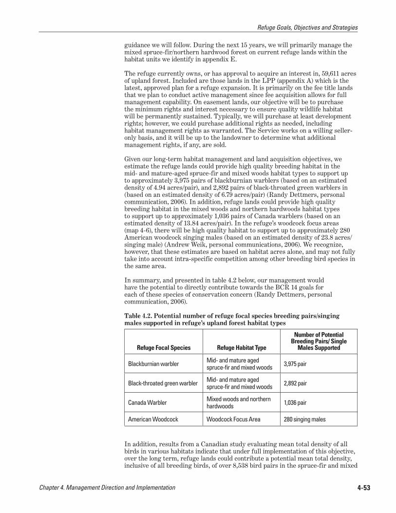
Chapter 4. Management Direction and Implementation 4-53
guidance we will follow. During the next 15 years, we will primarily manage the mixed spruce-fir/northern hardwood forest on current refuge lands within the habitat units we identify in appendix E.
The refuge currently owns, or has approval to acquire an interest in, 59,611 acres of upland forest. Included are those lands in the LPP (appendix A) which is the latest, approved plan for a refuge expansion. It is primarily on the fee title lands that we plan to conduct active management since fee acquisition allows for full management capability. On easement lands, our objective will be to purchase the minimum rights and interest necessary to ensure quality wildlife habitat will be permanently sustained. Typically, we will purchase at least development rights; however, we could purchase additional rights as needed, including habitat management rights as warranted. The Service works on a willing seller-only basis, and it will be up to the landowner to determine what additional management rights, if any, are sold.
Given our long-term habitat management and land acquisition objectives, we estimate the refuge lands could provide high quality breeding habitat in the mid- and mature-aged spruce-fir and mixed woods habitat types to support up to approximately 3,975 pairs of blackburnian warblers (based on an estimated density of 4.94 acres/pair), and 2,892 pairs of black-throated green warblers in (based on an estimated density of 6.79 acres/pair) (Randy Dettmers, personal communication, 2006). In addition, refuge lands could provide high quality breeding habitat in the mixed woods and northern hardwoods habitat types to support up to approximately 1,036 pairs of Canada warblers (based on an estimated density of 13.84 acres/pair). In the refuge’s woodcock focus areas (map 4-6), there will be high quality habitat to support up to approximately 280 American woodcock singing males (based on an estimated density of 23.8 acres/ singing male) (Andrew Weik, personal communications, 2006). We recognize, however, that these estimates are based on habitat acres alone, and may not fully take into account intra-specific competition among other breeding bird species in the same area.
In summary, and presented in table 4.2 below, our management would have the potential to directly contribute towards the BCR 14 goals for each of these species of conservation concern (Randy Dettmers, personal communication, 2006).
Table 4.2. Potential number of refuge focal species breeding pairs/singing males supported in refuge’s upland forest habitat types
Refuge Focal Species Refuge Habitat Type
Number of Potential Breeding Pairs/ Single
Males Supported
Blackburnian warbler Mid- and mature aged spruce-fir and mixed woods 3,975 pair
Black-throated green warbler Mid- and mature aged spruce-fir and mixed woods 2,892 pair
Canada Warbler Mixed woods and northern hardwoods 1,036 pair
American Woodcock Woodcock Focus Area 280 singing males
In addition, results from a Canadian study evaluating mean total density of all birds in various habitats indicate that under full implementation of this objective, over the long term, refuge lands could contribute a potential mean total density, inclusive of all breeding birds, of over 8,538 bird pairs in the spruce-fir and mixed
Refuge Goals, Objectives and Strategies

Chapter 4. Management Direction and Implementation4-54
woods habitat types combined (based on an estimated mean total density of 2.3 acres/pair), and 3,981 bird pairs in the northern hardwoods habitat types (based on an estimated mean total density of 2.48 acres/pair) (Kennedy et al. 1999).
Provide high quality wildlife-dependent activities such as hunting, fishing, wildlife observation and photography, as well as camping and boating in support of those activities.
Objective 4.1 (Hunting) Within 3 years of CCP approval, at least 80% of hunters on the refuge will report that they had a high-quality experience.
Rationale Hunting is identified in the 1997 Refuge Improvement Act as a priority public use. Priority public uses are to receive enhanced consideration when developing goals and objectives for refuges. Further, hunting is an established traditional use in the local area. We have implemented a hunt program on the refuge during the past 6 years.
In April 2007 we issued an amended Refuge Hunt Plan and environmental assessment after a 30 day public review and comment period. With our stated hunt program objectives, we intend to: 1) maintain a diversity of habitats within the refuge that are capable of supporting a diversity and abundance of wildlife species, and 2) provide wildlife-dependent recreational opportunities. We recognize hunting as a healthy, traditional, outdoor pastime that is deeply rooted in American heritage and, when managed appropriately, can instill a unique understanding and appreciation of wildlife, their behavior, and their habitat needs. It is also a priority public use on national wildlife refuges.
The refuge hunt program was first implemented during 2000, consistent with state regulations, and additional refuge regulations stipulated in 50CFR. Refuge lands were opened to migratory game bird and waterfowl and small and big game hunting. In April 2007, we amended the 2000 Refuge Hunt Plan and associated environmental assessment, and our Regional Director issued a new Finding of No Significant Impact. The amendment was completed to provide a more detailed analysis of the potential cumulative effects of the current hunt program.
Within two years we will evaluate the potential for new hunting seasons, such as a turkey hunting on refuge lands in both states, and a bobcat hunting on refuge lands in Maine, consistent with both states’ regulations. However, additional NEPA analysis and public involvement would need to occur before an expanded program could be implemented.
Providing a high-quality hunt on the refuge promotes visitor appreciation and support for refuge programs. A quality hunting experience is one that: 1) maximizes safety for hunters and other visitors; 2) encourages the highest standards of ethical behavior in taking or attempting to take wildlife; 3) is available to a broad spectrum of the hunting public; 4) contributes positively to or has no adverse effect on population management of resident or migratory species; 5) reflects positively on the individual refuge, the System, and the Service; 6) provides hunters uncrowded conditions by minimizing conflicts and competition among hunters; 7) provides reasonable challenges and opportunities for taking targeted species under the described harvest objective established by the hunting program; 8) minimizes the reliance on motorized vehicles and technology designed to increase the advantage of the hunter over wildlife; 9) minimizes habitat impacts; 10) creates minimal conflict with other priority wildlife-dependent recreational uses or refuge operations; and 11) incorporates a message of stewardship and conservation in hunting opportunities. These are all criteria we will use to evaluate our hunt program.
GOAL 4:
Refuge Goals, Objectives and Strategies
Chapter 4. Management Direction and Implementation 4-55
Strategies In addition to those strategies listed under “General Refuge Management” affecting this program:
Continue to: ■ Offer a hunt program following state of Maine and New Hampshire
regulations. The only exceptions are that we do not allow turkey hunting anywhere on the refuge and we do not allow bobcat hunting on refuge lands in Maine (on New Hampshire lands, bobcat hunting is not allowed by state or refuge regulations). Also, no special refuge permits are required for hunting on refuge lands.
■ Maintain six waterfowl hunt blinds; maintain a reservation system for the blinds where the maximum stay is one week
Within 2 years of CCP approval: ■ Evaluate the potential for a turkey hunt on refuge lands in both states, and a
bobcat hunt on refuge lands in Maine. If appropriate, develop a new Hunt Plan opening package, including new NEPA document, Federal Register notice, and public involvement opportunities. Both new hunt additions will be consistent with respective states’ regulations and refuge regulations.
Within 5 years of CCP approval: ■ Establish an inter-state (New Hampshire and Maine) and Service Umbagog
Lake Working Group to annually review hunting seasons in an effort to make seasons as consistent as possible
■ Develop annual hunt plan after annual state meetings
■ Evaluate numbers and distribution of waterfowl blinds each year, including placement of blinds on Maine side of refuge. Work with local waterfowl clubs to improve construction and placement of blinds, and evaluate and manage wood duck boxes.
■ Waterfowl hunters would have priority for using blinds during the hunt season
■ Establish additional parking areas off of the current road network to facilitate hunting in the expansion area as lands are acquired
Within 5-10 years of CCP approval: ■ Provide literature, training, and other outreach tools targeting accurate
identification of species of concern on the refuge (e.g. at check stations, kiosks, signage)
■ Conduct surveys, or develop reporting system such as check station or permit system, to collect data for evaluating numbers and quality of program
Within 10-15 years of CCP approval: ■ Evaluate pull-outs and parking areas for safety, and improve or relocate
where necessary; also evaluate opportunities to provide access for people with disabilities
■ Try to distribute the hunting pressure through use of maps and outreach
Objective 4.2 (Fishing) Within 4 years of CCP approval, in cooperation with the states of New Hampshire and Maine fish and wildlife agencies, provide opportunities such that at least 80% of anglers on the refuge, or anglers accessing the lake through the refuge, report they had a high-quality experience.
Refuge Goals, Objectives and Strategies

Chapter 4. Management Direction and Implementation4-56
Rationale Fishing is identified in the Refuge Improvement Act as a priority public use. Priority public uses are to receive enhanced consideration when developing goals and objectives for refuges. Providing high quality fishing opportunities for the public to engage in this activity on the refuge promotes visitor appreciation and support for refuge programs.
We will continue to allow access for fishing, in accordance with states of Maine and New Hampshire regulations, except in sensitive areas during nesting season. We will develop a new fishing access site on existing refuge lands at Mountain Pond, in conjunction with new trail and parking area plans. We define a high quality fishing program as one which: 1) maximizes safety for anglers and other visitors; 2) causes no adverse impact on populations of resident or migratory species, native species, threatened and endangered species, or habitat; 3) encourages the highest standards of ethical behavior in regard to catching, attempting to catch, and releasing fish; 4) is available to a broad spectrum of the public that visits, or potentially would visit, the refuge; 5) provides reasonable accommodations for individuals with disabilities to participate in refuge fishing activities; 6) reflects positively on the Refuge System; 7) provides uncrowded conditions; 8) creates minimal conflict with other priority wildlife-dependent recreational uses or refuge operations; 9) provides reasonable challenges and harvest opportunities; and 10) increases visitor understanding and appreciation for the fishery resource.
Strategies In addition to those strategies listed under “General Refuge Management” affecting this program:
Continue to: ■ Implement the annual “Take Me Fishing” event
■ Restrict fishing access around loon and bald eagle nesting sites
Within 5 years of CCP approval: ■ Assist partners in conducting creel and angler surveys
■ Work with partners to maintain or restore a quality brook trout fishery wherever appropriate in the Umbagog watershed, including the Rapid, Dead Diamond and Dead Cambridge rivers and tributaries, and C and B Ponds; cooperate with partners in maintaining and improving existing fish barriers to protect trout; work with Umbagog Working Group to implement recommendations from the Eastern Brook Trout Joint Venture once their strategic plan is completed
■ Officially open the refuge to fishing through 50CFR regulations and develop a fishing plan
■ Establish thresholds of acceptable change to define when access restrictions may be imposed to minimize impacts
■ Distribute angling pressure through maps and outreach
■ Work with states through interstate commission, or other forum (e.g. Umbagog Lake Working Group), to develop consistent fishing regulations on lead tackle
■ Increase educational outreach to public on dangers of lead tackle and other debris to wildlife and the environment.
Within 5-10 years of CCP approval: ■ Provide improved shoreline access (e.g. trails, docks, etc)
USF
WS
Preparing to fish on the lake
Refuge Goals, Objectives and Strategies

Chapter 4. Management Direction and Implementation 4-57
■ Improve opportunities for handicapped access to high quality fishing areas
■ Construct safe pullouts
■ Establish additional parking areas off of the current road network to facilitate fishing in the expansion area as lands are acquired
■ Provide walk-in fishing access to Mountain Pond in conjunction with new trails and parking area plans
Within 10-15 years of CCP approval: ■ Work with states to eliminate fishing tournaments on Umbagog Lake to
maintain reasonable solitude and a natural experience for anglers and other users.
Objective 4.3 (Wildlife Observation and Photography) Within 2 years of CCP approval, at least 80% of refuge visitors engaged in wildlife viewing and nature photography will report a high quality experience.
Rationale Wildlife observation and photography are identified in the Refuge Improvement Act as priority public uses. Priority public uses are to receive enhanced consideration when developing goals and objectives for refuges. Providing high quality opportunities for the public to engage in these activities on the refuge promotes visitor appreciation and support for refuge programs.
We define high quality wildlife observation and photography programs as those in which: 1) observation occurs in a primitive setting or use safe facilities and provide an opportunity to view wildlife and its habitats in a natural setting; 2) observation facilities or programs maximize opportunities to view the spectrum species and habitats of the refuge; 3) observation opportunities, in conjunction with interpretive and educational opportunities, promote public understanding of and increase public appreciation for America’s natural resources and the role of the Refuge System in managing and protecting these resources; 4) viewing opportunities are tied to interpretive and educational messages related to stewardship and key resource issues; 5) facilities, when provided, blend with the natural setting, station architectural style, and provide viewing opportunities for all visitors, including persons with disabilities; 6) observers understand and follow procedures that encourage the highest standards of ethical behavior; 7) viewing opportunities exits for a broad spectrum of the public; and 8) observers have minimal conflict with other priority wildlife-dependent recreational uses or refuge operations.
Opportunities to view and photograph wildlife in a natural setting abound on this refuge due to its rural, undeveloped landscape. Moose and loon are two popular attractions that can be viewed roadside or from boats on the refuge’s lakes and waters. The Magalloway River trail, with its viewing platform along an oxbow of the Magalloway River, is a popular walking trail maintained by the refuge. It is accessible to people with disabilities. A loop extension is planned.
Additional trails will be created on refuge lands in the Potter Farm and Thurston Cove areas, and Mountain Pond (see map 4-3). These trails will be supplemented with observation platforms and photography blinds. Location of the trail, platforms, and blinds will provide visitors with quality viewing opportunities without disturbing the wildlife. Refuge trails and roads will remain open year-round from a half hour before sunrise to a half hour after sunset, except as otherwise permitted under a special use permit. Access to trails is by foot travel, including snowshoeing and cross country skiing, or by snowmobile on refuge-designated snowmobile trails.
Refuge Goals, Objectives and Strategies

Chapter 4. Management Direction and Implementation4-58
We have also identified one trail in the expansion area we would like to develop for year round use once those lands are acquired. It parallels Route 16, connecting Wentworth Location to Errol, and we preliminarily refer to it as the potential “Long Pond Trail.” It is currently a snowmobile trail, but could also be developed to provide a year round viewing and photography opportunity. Also in the expansion area, generally, we will keep designated major gravel roads open to vehicle travel to afford additional opportunities for wildlife observation and photography.
Strategies In addition to those strategies listed under “General Refuge Management” affecting this program:
Continue to: ■ Maintain Magalloway River trail and viewing platform
■ Evaluate new opportunities upon request
Within 5 years of CCP approval: ■ Provide literature on wildlife viewing opportunities at kiosks and visitor
contact facilities
■ Designate self-guided canoe trail, with information on wildlife viewing, on Magalloway River
■ Close wildlife viewing sites as warranted during nesting season or other sensitive times of the year
■ Develop web-based or other wildlife viewing reporting system
Within 5-10 years of CCP approval: ■ With partners, promote an Upper Androscoggin watershed regional wildlife
viewing trail system (e.g. auto, boat, snowmobile, etc) across ownerships
■ Construct wildlife viewing pull-outs at safe, strategic locations (e.g. moose wallows) on Route 16 and 26
■ Provide sensitively placed access to view unique fens and bogs
■ Create webcam near loon, eagle, and osprey nests
■ Work with partners to identify and promote wildlife viewing opportunities on and off the refuge
■ Provide ADA compliant photo blinds
■ Consider use of temporary blinds for photography in certain sensitive locations where permanent blinds are not appropriate
■ Construct new trails: the Potter Farm and Thurston Cove group of loop trails, Mountain Pond area trails, and along Route 16 in the expansion area; make at least one of these ADA compliant to the extent feasible (see map 4-3)
Objective 4.4 (Camping) Maintain overnight lake experiences on refuge lands, on no more than 12 remote lake sites, to facilitate compatible, safe and unique hunting, fishing, wildlife observation, and photography opportunities.
Refuge Goals, Objectives and Strategies
Chapter 4. Management Direction and Implementation 4-59
Rationale We currently allow camping on refuge lands on 12 remote sites on Umbagog Lake. Two additional river sites are planned for elimination and rehabilitation. Our lake camping program is administered by NH DRED- Division of Parks and Recreation in conjunction with their management of other camping sites, on state and other ownerships, and the management of the Umbagog State campground. Remote camping on Umbagog Lake provides the unique opportunity for visitors to view moose, and hear loons during dusk and dawn when they are most actively calling, while allowing the visitor to be totally immersed in a quiet, private, primitive, and natural setting. Remote lake camping is becoming an increasingly rare experience in the Northeast, except in very remote northern areas. Similar to hunting and fishing, camping is an historic, traditional, and very popular activity on Umbagog Lake and in other rural parts of New Hampshire and Maine.
We will enhance our current camping program and increase site monitoring to ensure: site conditions are not deteriorating; wildlife is protected; and campers adhere to regulations. We will complete a formal cooperative agreement with NH DRED- Division of Parks and Recreation which will include the provision that we will not increase the current capacity for camping on refuge lands. In cooperation with NH DRED- Division of Parks and Recreation and other partners, we will establish thresholds on what is acceptable change to resources and determine when restrictions or mitigation measures should be imposed to reverse impacts before any damage is permanent. We will also require campers to adhere to “Leave No Trace” principles. The Leave No Trace program is a nationally recognized curriculum of outdoor values that promotes visitors’ ethical use of recreational lands. Our outreach program would include distribution of literature and demonstration of Leave No Trace principles.
Strategies Continue to:
■ Close certain campsites which lie adjacent to loon territories during active loon nesting periods
■ Work toward prohibiting pets
■ Prohibit gathering of firewood on refuge lands
■ Limit campsite size
■ Maintain and improve campsites on an annual basis
Within 5 years of CCP approval: ■ Complete cooperative agreement with NH DRED. It will include: 1) setting
fees; 2) limits on number of campers at individual sites; 3) sanitation requirements, 4) resource, and long-term site protection and restoration needs; 5) required orientation to campers; and, 6) boat access only, no personal water craft;
■ Manage camping through site locations, and scheduling of day and season lengths, to provide a quality experience while providing maximum protection for wildlife resources
■ Establish a program of increased outreach on-site, and increased enforcement of rules and regulations to minimize illegal camping
■ Consider designating some sites as “two nights only” for paddlers moving through the area
Refuge Goals, Objectives and Strategies

Chapter 4. Management Direction and Implementation4-60
■ Provide campers with an orientation and overview of rules and regulations and Leave No Trace program
■ Restore sites or seasonally close sites as needed to protect resources
■ Remove and rehabilitate to natural vegetation, the river camping sites at North 1 and North 2, administered through Mollidgewock State Campground along Route 16
■ No pets; no loud music (external speakers)
Within 5-10 years of CCP approval: ■ Establish inter-governmental and inter-jurisdictional Umbagog Lake Working
Group to develop formal cooperative management agreement encompassing cooperative management of the entire lake area.
■ Improve campsites to address safety, long term sustainability without degradation, provide a diversity of site locations and opportunities, and resolve social, environmental, and resource issues.
Objective 4.5 (Boating) Within 4 years of CCP approval, at least 80% of boaters passing through the refuge on the Magalloway and Androscoggin rivers and associated designated waterways, will report they had a high quality experience based on the following criteria: a) suitable access; b) minimal conflict with other users; c) safe experience; and d) a reasonable chance to view wildlife in a natural setting with minimal disturbance.
RationaleMotorized and non-motorized boating is an appropriate means of facilitating all six priority public uses on Umbagog Refuge. By allowing this use, we are providing opportunities and facilitating refuge programs in a manner and location that offer high quality, wildlife-dependent recreation and maintain the level of current fish and wildlife values.
Boating would be conducted consistent with refuge and New Hampshire and Maine regulations, with some additional restrictions to protect fish, wildlife
and habitat, and reduce potential conflicts among public uses. Boat access is available at a number of locations both on and off refuge ownership near Umbagog Lake. Two State of New Hampshire public boat launches provide boat trailer access to the upper Androscoggin River, Magalloway River, the mouth of the Rapid River, and Umbagog Lake. One launch is located upstream of the Errol Dam, the other is at the southern end of Umbagog Lake.
We provide additional boat-trailer access on refuge-owned land at the Steamer Diamond landing on the Androscoggin River and at refuge headquarters on the Magalloway River. A car-top boat launch is located at Parson’s landing on the Magalloway River, just south of refuge headquarters. The public occasionally launches canoes at other sites along Route 16, where it crosses or approaches the Magalloway and Androscoggin rivers. At some of those sites, inadequate parking or poor visibility of oncoming
Ian
Dre
w/U
SFW
S
Boating on the refuge
Refuge Goals, Objectives and Strategies
Chapter 4. Management Direction and Implementation 4-61
traffic presents safety hazards. We are constructing an additional car-top boat launch on the Magalloway River, north of refuge headquarters. The new site will provide parking, a dock, and a restroom. After completing that new site, we will close all refuge-owned boat access points along Route 16, except the present access at refuge headquarters and the Steamer Diamond Landing.
All boats launching or landings on refuge lands must follow state boating regulations and, if applicable, show registration with the appropriate state. The public must inspect all boats and boat trailers and clean them of aquatic invasive species before launching from refuge sites. That cleaning should take place on dry ground well away from the water. Exotic, nuisance plants or animals on boats, trailers, diving equipment, or in bait buckets can disrupt aquatic ecosystems and negatively affect native fish and plant species. Umbagog Lake and its associated rivers appear to be relatively free of aquatic invasive plants, and cleaning boats, trailers, and other equipment will help to keep them that way. Signs, education, and periodic enforcement will remind the public of these regulations.
Strategies In addition to those strategies listed under “General Refuge Management” affecting this program:
Continue to: ■ Maintain closures around certain bald eagle and loon nesting territories in
partnership with the states
■ Distribute pamphlet on recommended day-use canoe and kayak trails, which also alerts boaters to closed areas.
■ Monitor boat use by counting numbers from a fixed location on peak use days
■ Coordinate with states to address increased use
Within 5 years of CCP approval: ■ Develop an interpretive self-guided canoe/kayak trail for the Magalloway
River; interpret management activities and habitats visible from trail; promote a “Leave No Trace” boater ethic
■ Improve maps and interpretive literature for boaters
■ Place registration boxes at boat launches to obtain better information on group size, seasons of use, destination, etc.
■ Work with recreation specialists to determine the best way to document use and identify conflicts
■ Improve outreach program to alert boaters to closed areas and its purpose to protect nesting wildlife
Within 5-10 years of CCP approval: ■ Work with partners, including Umbagog Lake Working Group, to manage
boater access (types, numbers, and distribution) along lakes and rivers; establish thresholds of acceptable change identifying when restrictions may need to be imposed to maintain visitor experiences and protect natural resources
■ Seek opportunities with partners to evaluate visitor opportunities within an Upper Androscoggin River watershed regional context (e.g. regional auto, walking, and boat trails, visitor centers, tours, etc)
Refuge Goals, Objectives and Strategies
Chapter 4. Management Direction and Implementation4-62
■ Develop water ethics/etiquette brochure and interpretive literature at strategic locations (e.g. boat launches, kiosks, offices)
■ Provide restroom facilities for boaters at Steamer Diamond, Wentworth Location, current refuge office (Brown Owl), and the planned, new refuge office at Potter Farm
Develop high quality interpretive opportunities, and facilitate environmental education, to promote an understanding and appreciation for the conservation of fish and wildlife and their habitats, as well as the role of the refuge in the Northern Forest.
Objective 5.1 (Interpretative Programs: on-refuge emphasis) Every year, at least 80% of visitors contacted after attending refuge interpretive programs will be able to do one of the following: 1) identify the refuge purposes; 2) name at least one refuge focus species and a management action to benefit the species; 3) describe the refuge’s role in conserving the Northern Forest, 4) be able to relate the refuge’s contribution to the Refuge System and to regional migratory bird conservation.
Rationale The National Association of Interpreters defines “interpretation” as a communication process that forges emotional and intellectual connections between the interests of the audience and the inherent meanings in the resource. Interpretation is a priority public use identified in the 1997 Refuge Improvement Act and it is one of the most important ways we can raise our visibility, convey our mission, and identify the significant contribution the refuge makes to wildlife conservation. Public understanding of the Service and its activities in the states of New Hampshire and Maine is currently very low. Many are unaware of the Refuge System and its scope, and most do not understand the importance of the refuge in the conservation of migratory birds.
Providing high quality opportunities for the public to engage in environmental interpretative activities promotes stewardship of natural resources, and an understanding of the refuge’s purpose. They also garner support for refuge programs and help raise public awareness of the role of the refuge in Northern Forest and its contribution to migratory bird conservation.
We define high quality interpretive programs as those which: 1) increase public understanding and support for the Refuge System; 2) develop a sense of stewardship leading to actions and attitudes that reflect concern and respect for wildlife resources, cultural resources, and the environment; 3) provide and understanding of the management of our natural and cultural resources; and 4) provide safe, enjoyable, accessible, meaningful, and high quality experiences for visitors increasing their awareness, understanding, and appreciation of fish, wildlife, plants, and their habitats.
We have identified several new trail opportunities on current refuge lands and one in the expansion area. These were described under our wildlife observation and photography discussion above. As additional lands are acquired in the expansion area we would also evaluate their potential to provide high quality interpretive opportunities.
Strategies In addition to those strategies listed under “General Refuge Management” affecting this program:
Continue to: ■ Hire up to two seasonal interns/year, if resources allow, to help accomplish
visitor services program priorities
GOAL 5:
Refuge Goals, Objectives and Strategies

Chapter 4. Management Direction and Implementation 4-63
■ Offer programs on a request basis only; usually a minimum of 3, and up to a maximum of 12 annually, focused on presenting the Refuge System mission and refuge purposes. Typical audiences have been students or senior citizen groups
■ Develop and distribute standard interpretive brochures (e.g. refuge brochure, species lists, etc)
■ Seek funding to finish construction of the Magalloway River trail, with interpretive signage, and make it Americans with Disability Act (ADA) compliant
■ Develop/construct self-guided Magalloway River Canoe Trail and boat access
Within 5 years of CCP approval: ■ Hire a VSP to implement programs and develop a Visitor Service’s step-
down plan incorporating objectives, finalizing strategies, and coordinate the evaluation of visitor numbers, visitor satisfaction, visitor impacts, carrying capacity, and thresholds of acceptable change.
■ Improve on existing brochures and develop new ones interpreting management practices and focus species needs; also, develop self-guided walking trail guides as new trails are constructed
■ Establish a self-guided interpretive canoe/kayak trail along the Magalloway River
■ Establish self-guided interpretive signs along approved snowmobile trails in partnership with local snowmobile clubs and businesses
■ Assess interpretive opportunities in expansion areas as lands become available
■ Provide interpretation signs at the Magalloway River trail, including information at trailhead
■ Construct information and interpretive kiosks at boat launches, overlooks, roadside pullouts, and any new trailheads
Within 5-10 years of CCP approval: ■ Provide a limited number of interpretative programs at two State
campgrounds each year, in cooperation with State Parks Staff; utilize volunteers or Friends Group to the extent possible
■ Sponsor a limited number of guided interpretive programs on refuge via walks, canoes, kayaks, and/or pontoon boat; utilize volunteers or Friends Group to the extent possible
■ Incorporate into Visitor Services plan a procedure for evaluating effectiveness of programs by doing a pre-test, then a post test, or design an evaluation into each program
■ Continue to seek funding to finish construction of self-guided Magalloway River trail and new loop extension, and make it ADA compliant
■ Construct new interpretative trails: the Potter Farm and Thurston Cove group of loop trails, Mountain Pond area trails, and one along Route 16 in the expansion area trail; make at least one of these ADA compliant to the extent feasible
Refuge Goals, Objectives and Strategies

Chapter 4. Management Direction and Implementation4-64
Within 10-15 years of CCP approval: ■ Develop at least 2 pull-outs off Highways 16 and 26 on the refuge where
wildlife viewing opportunities exist
■ Develop an overlook at Route 26-New Hampshire state line
Objective 5.2 (Community Outreach) Each year, conduct at least 10 outreach efforts to elected officials, local community leaders, neighbors, and other stakeholders to improve their knowledge and raise their awareness about the refuge and its resources and our management priorities.
Rationale Greater outreach efforts will increase recognition of the refuge, the Refuge System, and the Service among neighbors, local leaders, conservation organizations, and elected officials. We will strive to annually increase outreach efforts toward the local citizenry. This publicity will also help generate support for similar conservation efforts in the region.
It is particularly important that local residents understand, appreciate, and support the Refuge System mission and this refuge’s unique contribution to that mission. In addition, our volunteer program could grow and our Friends group could see enhanced membership and support. The planned Refuge Headquarters and visitor contact facility will serve as an important resource for refuge visitors and local community, providing educational and recreational opportunities, as well as meeting and exhibit space for local conservation organizations.
Gaining support from local community, private landowners, private conservation groups, Congressional, State, and local elected officials, for refuge programs is essential to meeting our goals. This can only happen when these elected officials understand and appreciate the nationally significant contribution of the refuge and its programs to the permanent protection of Federal trust resources. We need to impress upon these individuals the importance of refuge lands to current and future generations of Americans.
Strategies In addition to those strategies listed under “General Refuge Management” affecting this program:
Continue to: ■ Coordinate a minimum of two visitor outreach events annually that showcase
refuge resources; for example, the Wildlife Festival and Take Me Fishing event
■ Distribute brochure and literature on impacts to loons and other wildlife from lead fishing tackle to discourage their use
Within 5 years of CCP approval: ■ Update refuge fact sheets
■ Create press kit continue to promote events scheduled on refuge
■ Respond to requests for presentations at local service organizational meetings, chamber events, etc
■ Participate in those community service, professional associations, and chamber events throughout Upper Androscoggin watershed that would provide the greatest benefit to achieving goals and objectives and furthering the mission of the Refuge System
Refuge Goals, Objectives and Strategies
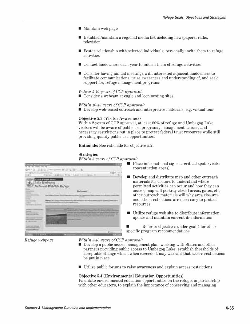
Chapter 4. Management Direction and Implementation 4-65
■ Maintain web page
■ Establish/maintain a regional media list including newspapers, radio, television
■ Foster relationship with selected individuals; personally invite them to refuge activities
■ Contact landowners each year to inform them of refuge activities
■ Consider having annual meetings with interested adjacent landowners to facilitate communications, raise awareness and understanding of, and seek support for, refuge management programs
Within 5-10 years of CCP approval: ■ Consider a webcam at eagle and loon nesting sites
Within 10-15 years of CCP approval: ■ Develop web-based outreach and interpretive materials, e.g. virtual tour
Objective 5.3 (Visitor Awareness) Within 2 years of CCP approval, at least 80% of refuge and Umbagog Lake visitors will be aware of public use programs, management actions, and necessary restrictions put in place to protect federal trust resources while still providing quality public use opportunities.
Rationale: See rationale for objective 5.2.
Strategies Within 5 years of CCP approval:
■ Place informational signs at critical spots (visitor concentration areas)
■ Develop and distribute map and other outreach materials for visitors to understand where permitted activities can occur and how they can access; map will portray closed areas, gates, etc; other outreach materials will why area closures and other restrictions are necessary to protect resources
■ Utilize refuge web site to distribute information; update and maintain current its information
■ Refer to objectives under goal 4 for other specific program recommendations
Within 5-10 years of CCP approval: ■ Develop a public access management plan, working with States and other
partners providing public access to Umbagog Lake; establish thresholds of acceptable change which, when exceeded, may warrant that access restrictions be put in place
■ Utilize public forums to raise awareness and explain access restrictions
Objective 5.4 (Environmental Education Opportunities) Facilitate environmental education opportunities on the refuge, in partnership with other educators, to explain the importance of conserving and managing
Refuge webpage
Refuge Goals, Objectives and Strategies

Chapter 4. Management Direction and Implementation4-66
the natural resources in the Northern Forest to students, teachers, and other visitors. All who participate in environmental education programs on the refuge will be able to 1) understand the need for migratory bird conservation; 2) identify the refuge’s role in the Refuge System and in conserving Northern Forest Federal trust resources, and 3) name at least one refuge focus species and a management action to benefit the species.
Rationale Environmental education is a process designed to develop a citizenry that has the awareness, concern, knowledge, attitudes, skills, motivations, and commitment to work toward solutions of current environmental problems and the prevention of new ones. Environmental education is identified in the 1997 Refuge Improvement Act as priority public use. Providing high quality environmental education opportunities for the public on a refuge can: promote stewardship of natural resources; develop an understanding of the refuge’s purposes and the mission of the National Wildlife Refuge System; and, help raise awareness, understanding, and an appreciation of the role of the refuge in the Northern Forest and its contribution to migratory bird conservation. It also can garner support for other refuge programs.
As we evaluated the future of this program, in comparison to our other priority public use programs, we determined our emphasis will be to facilitate the use of the refuge for educational programs, but look to our partners, Friends Group, and/or volunteers to develop any curriculum and to lead those programs. This recommendation is based on consideration of this plan’s 15-year timeframe and what we can reasonably expect for staffing and operational funds, and because we believe our other priority public use programs will be more effective in reaching more visitors. We do not want to imply that we do not value environmental education, but only wish to convey that, on this refuge, the majority of our limited visitor services resources would be best spent in other priority public use programs.
Strategies Within 5 years of CCP approval:
■ Provide educational materials on the refuge web site
■ Provide materials to local schools, upon request, as they develop curriculum related to refuge resources
■ Facilitate opportunities for state and local partners, colleges or universities, or other educational program coordinators to lead nature-based educational programs on refuge lands
Within 5-10 years of CCP approval: ■ Evaluate potential for state and other partners to provide opportunities for
adult education programs, such as Elder Hostel
■ Work with NHFG, MDIFW, and university extension and conservation education partners to facilitate complementary programs and to seek assistance in implementing program requests
Enhance the conservation and management of fish and wildlife resources in the Northern Forest Region through partnerships with public and private conservation groups, private landowners, State and local entities.
Objective 6.1 (Regional and Community Partnerships) Actively engage in regional and community economic development and conservation partnerships and initiatives, consistent with the Refuge System mission and refuge purposes.
GOAL 6:
Refuge Goals, Objectives and Strategies
Chapter 4. Management Direction and Implementation 4-67
Rationale: This objective will encourage broader cooperation between the Service and local communities. Partnerships are essential for this refuge to accomplish projects and programs. Further, the Service can provide valuable technical assistance to local conservation organizations, particularly on management of habitat for migratory birds. In addition, the potential for the creation of a regional Umbagog Area Friends Group would be explored.
We will foster relationships with elected officials and business leaders, thereby strengthening political support for the refuge and its programs. This objective will also raise the awareness of opportunities for compatible outdoor recreational uses. These uses will attract visitors to the area and contribute to the local economy.
Law enforcement staff plays an important outreach role on the refuge. Officers not only enforce regulations, but just as importantly, they conduct outreach and serve to raise the visibility of the Service in local communities while out on patrol. As a result of our new programs and regulations described in this CCP, it will be even more important in the future that we have the capability to alert people to these changes and enforce them, as necessary. We believe that a law enforcement partnership could substantially increase our ability to effectively manage and conserve refuge resources.
Strategies In addition to those strategies listed under “General Refuge Management” affecting this program:
Continue to: ■ Work with such partners as:
Conservation organizations: Trust for Public Lands, The Nature Conservancy, Audubon Society of New Hampshire (ASNH), Loon Preservation Committee, New England Forestry Foundation, Mahoosuc Land Trust, Society for the Protection of New Hampshire Forests, Androscoggin Watershed Council, Rangeley Lakes Heritage Trust, The Conservation Fund, Trout Unlimited;
Town and county governments: Towns of Upton, Errol, Magalloway Plantation, and Coos County;
Private entities: FPLE, Wagner Forest Management;
Universities and other educational institutions: Dartmouth College, University of Vermont, University of Massachusetts, Hurricane Island Outward Bound, The Chewonki Foundation, and the Northwoods Stewardship Center; and,
State agencies: MDIFW, NHFG, NH DRED; and, NH Office of Energy and Planning.
Within 5 years of CCP approval: ■ Share resources, equipment, and expertise with State and private landowners.
■ Become a member of established associations, such as the Upper Androscoggin Advisory Committee
Within 5-10 years of CCP approval: ■ Work with conservation partners to achieve common goals; establish
MOU, Memorandum of Agreement (MOA) and cooperative agreements as appropriate
Refuge Goals, Objectives and Strategies
Chapter 4. Management Direction and Implementation4-68
Objective 6.2 (Cooperative Management of Umbagog Lake) Promote responsible use and management of Umbagog Lake, associated rivers, and adjoining uplands in partnership with other jurisdictional and management agencies.
Rationale: See rationale for objective 6.1.
Strategies In addition to strategies under “General Refuge Management” affecting this program:
Within 5-10 years of CCP approval: ■ Exchange with partners, techniques and ideas on managing public use on
Umbagog lake, its tributaries, and associated uplands
■ Work with States of New Hampshire and Maine to establish an Umbagog Lake Working Group with responsibility to develop consistent regulations and best management practices for activities on the lake and rivers, including: a) wake zones; b) fishing regulations, including fishing tackle; c) boating regulations; d) allowed events/tournaments; e) invasive species management, such as plants and bass; f) outfitter and guide licensing; g) boater ethics program, including waste disposal protocol; h) camp site management; i) other motorized activities, including PWC, float planes; j) promote/develop appropriate locations for access; k) launch sites
■ Also, specifically work with Umbagog Lake Working Group to resolve the Rapid River user conflicts among anglers and boaters; develop management strategy (e.g. control access, require permits, schedule launches, limit numbers, etc)
Objective 6.3 (Partner-managed Visitor Facilities) Within 10 years of CCP approval, develop a visitor contact facility in Errol with partners, where all the visitors to this facility have access to information on outdoor opportunities in the Umbagog area. The Services’ role in the facility is to interpret the refuge’s contribution to the conservation and management of the Northern Forest and its wildlife resources.
Rationale: See rationale for objective 6.1.
Strategies Within 5 years of CCP approval:
■ Explore other opportunities to display refuge visitor contact information at strategic portal areas (e.g., Evans Notch Visitor Center, Colebrook center, Northern Forest Heritage Park)
■ Provide map of access sites and areas open to activities (e.g., roads, snowmobile trails, vehicle pull-outs, parking areas, boat launches, river trails)
Within 5-10 years of CCP approval: ■ Work with chamber of commerce, NHFG, MDIFW, and New Hampshire
Division of Parks and Recreation, Town of Errol, local businesses, conservation organizations to evaluate regional opportunities for visitors services that include the refuge
■ With partners, develop an MOU to create a staffed visitor contact facility in town; refuge would only provide supplemental support for staffing. Purpose of facility is to allow visitors to: 1) receive information on what nature-based opportunities are available in the local area; 2) know where to go; and 3) make whatever arrangements and contacts needed for their visit.
Refuge Goals, Objectives and Strategies
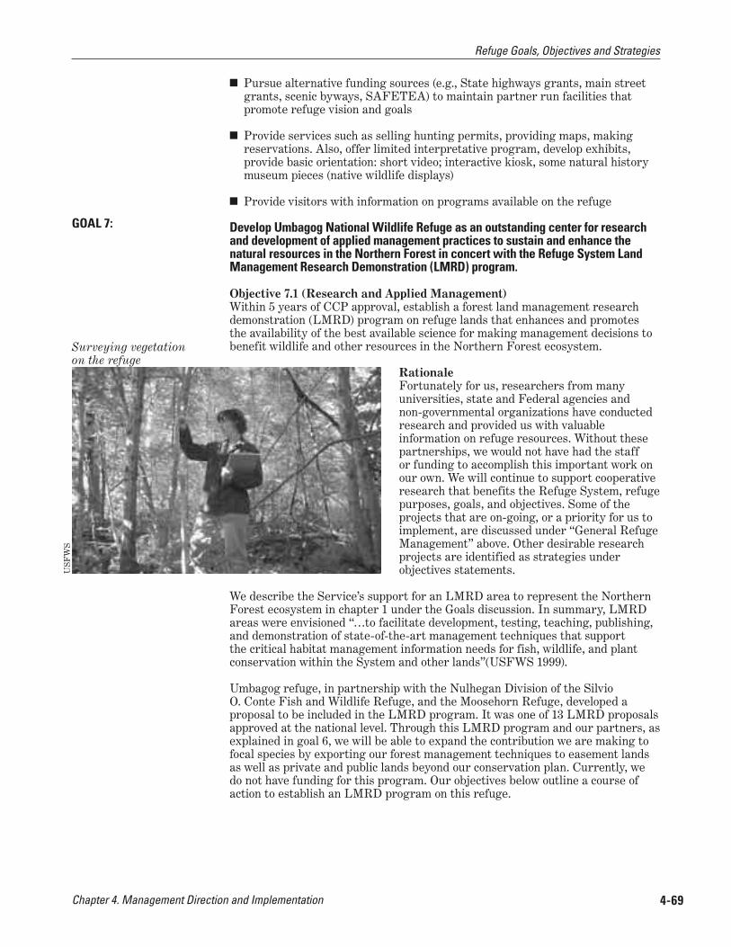
Chapter 4. Management Direction and Implementation 4-69
■ Pursue alternative funding sources (e.g., State highways grants, main street grants, scenic byways, SAFETEA) to maintain partner run facilities that promote refuge vision and goals
■ Provide services such as selling hunting permits, providing maps, making reservations. Also, offer limited interpretative program, develop exhibits, provide basic orientation: short video; interactive kiosk, some natural history museum pieces (native wildlife displays)
■ Provide visitors with information on programs available on the refuge
Develop Umbagog National Wildlife Refuge as an outstanding center for research and development of applied management practices to sustain and enhance the natural resources in the Northern Forest in concert with the Refuge System Land Management Research Demonstration (LMRD) program.
Objective 7.1 (Research and Applied Management) Within 5 years of CCP approval, establish a forest land management research demonstration (LMRD) program on refuge lands that enhances and promotes the availability of the best available science for making management decisions to benefit wildlife and other resources in the Northern Forest ecosystem.
Rationale Fortunately for us, researchers from many universities, state and Federal agencies and non-governmental organizations have conducted research and provided us with valuable information on refuge resources. Without these partnerships, we would not have had the staff or funding to accomplish this important work on our own. We will continue to support cooperative research that benefits the Refuge System, refuge purposes, goals, and objectives. Some of the projects that are on-going, or a priority for us to implement, are discussed under “General Refuge Management” above. Other desirable research projects are identified as strategies under objectives statements.
We describe the Service’s support for an LMRD area to represent the Northern Forest ecosystem in chapter 1 under the Goals discussion. In summary, LMRD areas were envisioned “…to facilitate development, testing, teaching, publishing, and demonstration of state-of-the-art management techniques that support the critical habitat management information needs for fish, wildlife, and plant conservation within the System and other lands”(USFWS 1999).
Umbagog refuge, in partnership with the Nulhegan Division of the Silvio O. Conte Fish and Wildlife Refuge, and the Moosehorn Refuge, developed a proposal to be included in the LMRD program. It was one of 13 LMRD proposals approved at the national level. Through this LMRD program and our partners, as explained in goal 6, we will be able to expand the contribution we are making to focal species by exporting our forest management techniques to easement lands as well as private and public lands beyond our conservation plan. Currently, we do not have funding for this program. Our objectives below outline a course of action to establish an LMRD program on this refuge.
GOAL 7:
USF
WS
Surveying vegetation on the refuge
Refuge Goals, Objectives and Strategies

Chapter 4. Management Direction and Implementation4-70
Strategies In addition to the strategies under “General Refuge Management” affecting this program:
Within 5 years of CCP approval: ■ Hire an LMRD coordinator, once sufficient project funding is secured, and
integrate with existing refuge staff. Coordinator will work with partners to: a) establish and prioritize forest research needs; b) identify and coordinate with on-going northern forest research projects at universities and other agencies (i.e. Forest Service) in order to complement on-going research and avoid duplication of effort) c) facilitate forest management research on Northern Forest public and private lands; d) coordinate the exchange of research results among Northern Forest landowners; e) publish research findings in peer-reviewed publications
■ Conduct a research needs assessment for the refuge; emphasize research projects that evaluate our assumptions, objectives, strategies, and techniques on focal species management.
Within 5-10 years of CCP approval: ■ Develop a mission and framework for a research program, including research
criteria, protocol, and approval for activities on refuge lands
■ Facilitate priority research and publish findings in peer-reviewed publications; all research products, including presentations, posters, and/or journal articles done by others will acknowledge the role of the Service, refuge staff and/or Refuge System lands, as appropriate, as key partners in the research effort.
Objective 7.2 (Outreach for Research and Applied Management Program) Demonstrate habitat management techniques to partners, the scientific community, and the public to promote conservation of wildlife in the Northern Forest. Distribute findings regularly through various media.
Rationale: See rationale for objective 7.1.
Strategies Within 5-10 years of CCP approval:
■ Facilitate demonstration areas on both refuge, and other ownerships, that showcase habitat management techniques for species of concern in the Northern Forest.
■ Cooperate with the Partners for Wildlife Program to accomplish outreach and applied management activities; coordinate with their staff, and funding sources
■ Provide forums to present and discuss research findings
■ Conduct a series of workshops and courses
■ Develop a website for others to access research findings; publish findings
Refuge Goals, Objectives and Strategies