Embed Size (px)
Citation preview
Pend Oreille Lake
Bear Lake
AmericanFalls
Reservoir
LakeCascade
Coeurd'Alene Lake
BenewahLake
PalisadesReservoir
LakeLowell
Walcott,Lake
BishopLake
DworshakReservoir
CoveArmLake
PayetteLake
MudLake
LakeWalcott
HaydenLake
ArrowrockReservoir
PriestLake
DeadwoodReservoir
SpiritLake
RirieLake
RedfishLake
UpperPriestLake
TwinLakes
Reservoir
PortneufReservoir
Blackfoot Reservoir
GraysLake
MagicReservoir
¬«51
¬«28
¬«75
¬«14
¬«46
¬«33
¬«31
¬«57
¬«11
¬«78
¬«3
¬«21
¬«162
¬«22
¬«36¬«34
¬«29
¬«9
¬«24
¬«55
¬«71
¬«38
¬«7
¬«8
¬«6
¬«99
¬«52
¬«32
¬«13
¬«200
¬«67
¬«1
¬«5
¬«37
¬«41
¬«62
¬«60
¬«77
¬«48
¬«87
¬«25
¬«45
¬«19
¬«39
¬«97
¬«16
¬«47
¬«43
¬«54
¬«81
¬«44
¬«58
¬«69
¬«53
¬«6
¬«36
¬«55
¬«8
¬«78
¬«34
¬«25
¬«27
£¤12
£¤95
£¤93
£¤20£¤26
£¤30
£¤91
£¤2
£¤89
£¤91
£¤20
£¤30
£¤20
£¤2
£¤26
£¤93
£¤95
£¤30
£¤20
£¤20
£¤26
§̈¦15
§̈¦90
§̈¦184
§̈¦86
§̈¦84
§̈¦15
§̈¦84
§̈¦84
§̈¦15
§̈¦15
§̈¦15
§̈¦84
§̈¦15
§̈¦84
£¤20
¬«75
£¤26¬«75
£¤30£¤93
¬«52
£¤95
£¤95
£¤95
£¤95
IdahoCounty
CusterCounty
LemhiCounty
ValleyCounty
ElmoreCounty
BlaineCounty
CassiaCounty
ButteCounty
BoiseCounty
ShoshoneCounty
BonnerCounty
ClarkCounty
BinghamCounty
ClearwaterCounty
CaribouCounty
FremontCounty
PowerCounty
Twin FallsCounty
AdamsCounty
BonnevilleCounty
OneidaCounty
LincolnCounty
LatahCounty
CamasCounty
KootenaiCounty
AdaCounty
BoundaryCounty
BannockCounty
WashingtonCounty
JeffersonCounty
Bear LakeCounty
Nez PerceCounty
BenewahCounty
OwyheeCounty
MinidokaCounty
FranklinCounty
JeromeCounty
CanyonCounty
GemCounty
LewisCounty
TetonCounty
MadisonCounty
PayetteCounty
GoodingCounty
110°W
111°W
111°W
112°W
112°W
113°W
113°W
114°W
114°W
115°W
115°W
116°W
116°W
117°W
117°W118°W49
°N
49°N
48°N
48°N
47°N
47°N
46°N
46°N
45°N
45°N
44°N
44°N
43°N
43°N
42°N
42°N
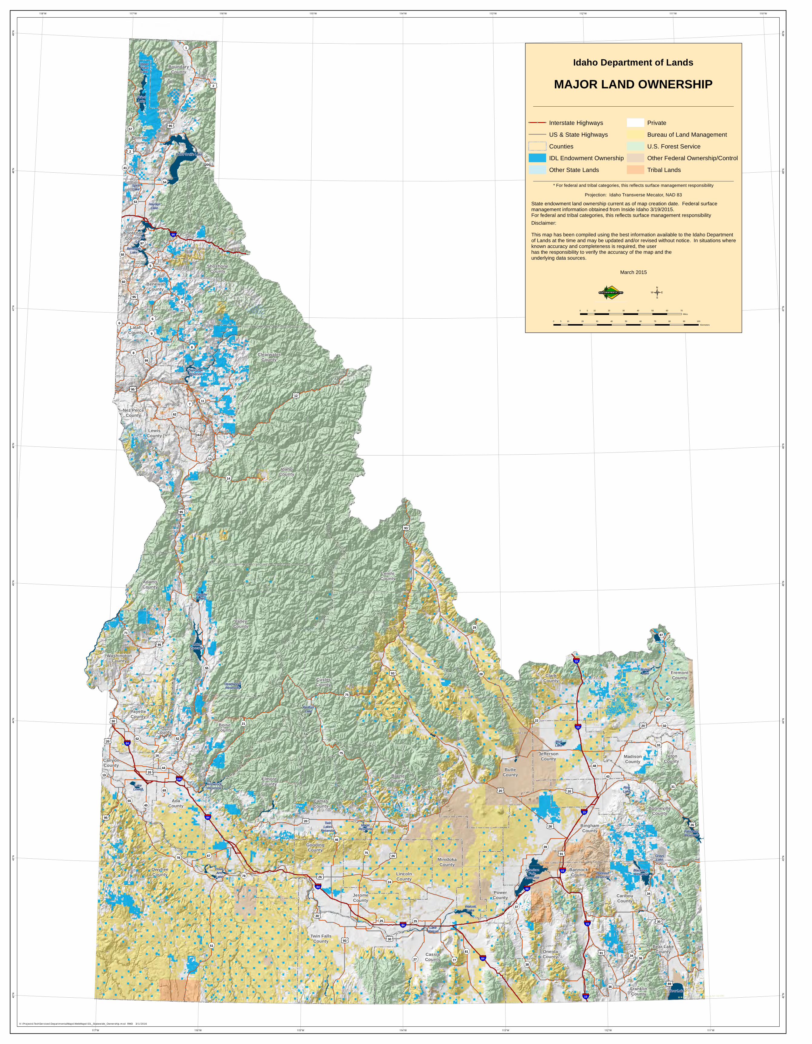
Idaho Department of Lands
MAJOR LAND OWNERSHIP
0 10 20 30 40 505Miles
Projection: Idaho Transverse Mecator, NAD 83
Disclaimer:This map has been compiled using the best information available to the Idaho Department of Lands at the time and may be updated and/or revised without notice. In situations where known accuracy and completeness is required, the user has the responsibility to verify the accuracy of the map and the underlying data sources.
August 2013
/
State endowment land boundaries current as of map creation date.Other ownership information obtained from Inside Idaho 7/8/2013.County Seats verified with the 2012 Idaho Blue Book.
0 10 20 30 40 50 60 70 80 90 1005Kilometers
* For federal and tribal categories, this reflects surface management responsibility
OWNERSHIP CATEGORY *
Legend! County Seats
IDL Endowment Ownership
Other State Lands
Private
Bureau of Land Management
U.S. Forest Service
Tribal Lands
Other Federal
Idaho Department of Lands
MAJOR LAND OWNERSHIP
Projection: Idaho Transverse Mecator, NAD 83
Disclaimer:This map has been compiled using the best information available to the Idaho Departmentof Lands at the time and may be updated and/or revised without notice. In situations whereknown accuracy and completeness is required, the userhas the responsibility to verify the accuracy of the map and the underlying data sources.
March 2015
State endowment land ownership current as of map creation date. Federal surfacemanagement information obtained from Inside Idaho 3/19/2015.For federal and tribal categories, this reflects surface management responsibility
* For federal and tribal categories, this reflects surface management responsibility
X:\Projects\TechServices\DepartmentalMaps\WebMaps\IDL_Statewide_Ownership.mxd RMD 3/1/2016
0 10 20 30 40 50 60 705Miles
0 10 20 30 40 50 60 70 80 90 1005Kilometers
/
Interstate HighwaysUS & State HighwaysCountiesIDL Endowment OwnershipOther State Lands
PrivateBureau of Land ManagementU.S. Forest ServiceOther Federal Ownership/ControlTribal Lands