Embed Size (px)
Citation preview

17602 HIGHWAY ENGG. Model Answer- Summer 2017 Page 1/18
MAHARASHTRA STATE BOARD OF TECHNICAL EDUCATION
(Autonomous)
(ISO/IEC -270001 – 2005 certified)
SUMMER -2017 EXAMINATION
Subject code: Highway Engg. (17602) Page No:01/18
Important Instructions to examiners:
1) The answer should be examined by keywords and not as word-to-word as given in the model answer
scheme.
2) The model answer and the answer written by candidate may vary but the examiner may try to assess
the understanding level of the candidate.
3) The language error such as grammatical, spelling errors should not be given more importance. (Not
applicable for subject English and communication skill).
4) While assessing figures, examiner may give credit for principal components indicated in the figure.
The figure drawn by candidate and model answer may vary. The examiner may give credit for any
equivalent figure drawn.
5) Credits may be given step wise for numerical problems. In the some cases, the assumed constants
values may vary and there may be some difference in the candidates answer and model answer.
6) In case of some questions credit may be given by judgment on part of examiner of relevant answer
based on candidates understanding
Question and Model Answers Marks
Q1(A) Attempt ANY Three : 12
(a) Classify road as per Nagpur plan.
In Nagpur road plan, roads are classified into five categories as per IRC recommendations
depending upon priority for development.
1. National Highway (NH) : The roads which runs through length and breadth of the
country connecting state capitals, major ports, foreign highways and strategic places across
country, which are called as National Highway.
2. State Highway (SH) :The roads which joins state capital to important cities within state,
are known as State Highway.
3. Major District Road (MDR) :The roads which connects market centers and important
places in within district, are considered as Major District Road.
4. Other District Road :The roads which joins Tahasil headquarters, block development
headquarters, market centres other than MDR, are known as Other District Road.
5. Village Road :The roads which connects the group of villages to higher type of road, are
called as Village Road.
4M

17602 HIGHWAY ENGG. Model Answer- Summer 2017 Page 2/18
(b) State the modes of transportation and explain any one
Modes of Transportation System
1. Roadway
2. Railway
3. Waterway
4. Airway
Roadways
Road transportation is the most suitable type for short haul passenger and
good transport. This is more so especially in the hilly terrain where other transport
modes cannot reach. Road transportation provides better accessibility and door-to-
door service.
Railway
The best alternative for land transportation of bulk goods over long distance
by vehicles is the railway. Traditionally, the railways have played a major role in
economic development of a region. Railways run on specific tracks prepared for this
purpose. Railways provide fairly comfortable and safe journey within the reach of
the common man.
Airways
The most sophisticated and has made the world a small place. In a matter of
hours persons and things can be moved from one part of the globe to other.
Waterways
Water transportation is probably the oldest mode of transportation. It is
suitable for transportation of bulk cargo where time is not important factor.
2M
(1/2
each)
2 M
any
one
( c ) State the objects of preliminary survey.
The preliminary survey for any road construction project is done for following objectives
1. To survey various alternative alignments proposed after the reconnaissance and to
collect all the necessary physical information and details of topography, drainage
and soil.
2. To estimate the quantity of earthwork materials and other construction aspects and to
work out cost of alternate proposal.
3. To compare the different proposals in view of the requirement of good alignment..
4. To finalize the best alignment from all consideration.
5 To know number of cross-drainage works and other obligatory points.
1 M
each
any
four

17602 HIGHWAY ENGG. Model Answer- Summer 2017 Page 3/18
(d) State the four factors affecting road alignment.
1. Unavoidable obstructions: The alignment is required to change in another direction due
to avoidable obstructions.
2. Connectivity of obligatory points :The selected alignment can be altered for better
connectivity to existing roads, important places and high population zone
3. Railway or Bridge crossing: The alignment is necessary to divert over railway or bridge
crossing at right angle.
4. Nature of ground :If ground is more steeper then alignment is required to change
towards fairly leveled ground
5. Type of foundation soil: If foundation soil available in the proposed alignment has less
bearing capacity, then alignment is changed through hard sub grade soil.
6. Cost of land: If cost of land in particular alignment more, it is necessary to pass it
through less costlier land.
7. Excessive cutting of rock: The alignment should be such that to avoid excessive cutting
of hill rocks coming in alignment.
8. Locally available materials: The alignment should be finalized to get continuous and
maximum availability of materials required for road construction.
1 M
each
any
four
(e) Define and states values of following term with IRS standard for
(i) Gradient (ii) Right of way
Gradient:–
It is the rate of rise or fall of ground with respective to horizontal, is known as
Gradient OR It is the longitudinal slope provided along the length of road, is known as
Gradient
*4M

17602 HIGHWAY ENGG. Model Answer- Summer 2017 Page 4/18
Right of way – The area of land acquired for construction of development of road along its
alignment, is known as Right of way or Permanent land width.
Note: Definition 1 M each, values of all the three gradients for any one terrain 1M,
value of right of way for any one specifying area for any one type of road 1M.
Q1 (B) Attempt Any One of the following 06
(a) Define super elevation and state the method of designing super elevation.
Super elevation:-The inward inclination provided to the cross –section of the road on the
horizontal curved portion is called Super-elevation.
Method of designing super elevation-
Super elevation is designed for 75% of deign speed ue to mixed traffic traffic condition and
limiting maximum super elevation to 1 in 15 or 6.7%.
Step-1 Super elevation for 75% of design speed is calculated by equation-
e = V2 225xR
Step-2 If calculated value of ‘ e ‘ is less than 1 in 15 or 6.7%, then the value so obtained is
provided. If it exceeds 1 in 15, then limiting value of super elevation i.e. 1 in 15 is provided
and further checking is done as below.
Step-3 For Maximum value of e= 0.067 (1 in15), value of coefficient of friction is
calculated by equation –
e+f = V2
127 x R
Step-4 If value of ‘f’ so calculated is less than prescribed limit of 0.15, the super elevation is safe for design speed, otherwise calculate limiting speed (Vr) by following
formula-
0.217 = Vr2
127 x R
2M
4M
(1M
for
each
step
with
correc
t
seque
nce)

17602 HIGHWAY ENGG. Model Answer- Summer 2017 Page 5/18
(b) Calculate the minimum sight distance required to avoid a head on collision of two
cars approaching from opposite direction, at 80 and 50 km/h. Assume a reaction time
2.5 sec , coeff. of friction of 0.7 and break efficiency of 50% in either case.
Stopping distance for one of the cars.
Stopping distance in meters =vt + 𝑣
V1 = 80 kmph.
V1 = . = 22.22 m/sec
V2 = 60 kmph.
V2 = . = 13.88 m/sec.
As the brake efficiency 50%
Coefficient of friction (f) = 0.5 x 0.7 = 0.35
The stopping distance
For the first car SD1 = 22.22 x 2.5 + . 2× . × . = 127.44 m
For the second car SD2 = 13.88 2.5 + . 2× . × . = 62.75 m
Sight distance to avoid head on Collision of two approaching cars = SD1 + SD2
= 127.44 + 62.75 = 190.19 m
1M
1M
1M
1M
1M
1M
Q2 Attempt Any Four :
16
a) State the objects of reconnaissance and location survey
Object of Reconnaissance Survey-
1) To collect the details of terrain soil conditions, geology of Area, nature of soil,
drainage condition and nature of hill slopes.
2) To locate the obligatory points along the alternative routes.
3) To determine approximate estimate of the total cost of construction.
4) To determine two or three best possible routes.
Object of Location Survey:-
1) To collect the data necessary for the acquisition of right of way.
2) To fix up the center line of the proposed road on the ground.
3) To determine the cost of the road project.
4) To collect data which is required for drafting of specifications, preparation of
detailed drawing for working out items and quantities
2M
(any
two)
2M
(any
two)

17602 HIGHWAY ENGG. Model Answer- Summer 2017 Page 6/18
b) Define cross drainage work. State necessity of cross drainage work.
Cross drainage work:
An efficient drainage system for disposing off the surface water collected in side drains or
that of the natural streams across a road or railway track or across a hill road is called cross
drainage.
Necessity of CD work:
1. Helps to maintain the continuity of a road or a railway track while going across the river,
streams, nala, depressions and valleys.
2. Maintain the gradient in undulating area in case of railway.
3. Provides continuous access to the surrounding villages and towns even at the time of flood
and heavy rain.
4. Maintains continuous communications.
2 M
1 M
each
(any
two)
c) State types of camber and explain any one with a neat sketch.
Types of Camber:
The road cambers can have four shapes as mentioned below:
a) Straight Camber
b) Parabolic/Elliptical Camber
c) Composite camber
d) Barrel Camber
a)Straight camber: Joining the crown of the road to its edges by straight lines forms
this camber. The straight camber can also be obtained by two straights of different
slopes. This shape is easy to construct the straight camber.
OR
b)Parabolic or Elliptical camber: The camber is given a continuous curve of parabolic
or elliptical shape from the edge to crown.
2 M
2M
Any
one
type

17602 HIGHWAY ENGG. Model Answer- Summer 2017 Page 7/18
OR
c) Composite camber: This camber is a combination of parabolic or elliptical and
straight camber. Central portion of the road is formed by curve-parabolic or elliptical
and edges are straight lines. Curved camber is difficult to construct for WBM road
surface. Due to curved camber road cross-section is rather flat and vehicles find this
cross-section more convenient.
OR
d) Barrel camber: This camber consists of a continuous curve that may be either
parabolic or elliptical.
d) Define Borrow pits, spoil bank, lead and lift.
Borrow pit: The trench excavated along the alignment of road for the use of excavated soil for
road construction, is known as Borrow pit.
Spoil banks: The storage or stock of surplus soil excavated for further use is known as Spoil
banks.
Lead: It is the horizontal distance up to which excavated material is transported for dumping,
for which extra payment is not required to pay to the contractor, such min. Distance is known as
Lead.
Lift:-It is the vertical distance through which materials are raised after excavation, for which
contractor need not to pay extra payment
1M
each

17602 HIGHWAY ENGG. Model Answer- Summer 2017 Page 8/18
e) State eight difference between rigid pavement and flexible pavement.
½M
each
point
F ) Describe procedure of construction of water macadam road
Procedure of WBM road construction is –
i. Preparation of Sub-grade- Sub-grade for WBM has to be Prepared carefully as any failure
of the sub –grade affects the upper layers. The top of sub grade is finished to the required
camber and grade. On clayey Sub-grade a layer of murum, gravel etc. is spread to a thickness of
10-15cm and is rolled properly.
2 M
for
sketch
2 M
for
proce
dure

17602 HIGHWAY ENGG. Model Answer- Summer 2017 Page 9/18
ii. Preparation of base Course- This is known as foundation course or soiling. It is formed by
boulder, rubble or over burnt bricks. The thickness of the layer may range from 15 cm to 25cm.
iii. Intermediate Layer- If the total thickness necessitates, an intermediate layer is provided
between the wearing surface and rolling and soiling. This layer consists of oversize aggregate of
the size 10 cm to 15 cm.
iv. Wearing Surface- This layer lay in one or two layers. The thickness of loose material in
each layer is restricted to 10 cm. Course aggregates are spread over specified length and
between templates. Partial dry rolling is done. On the top of this a layer of bindage comprising
of stone screenings of 12 mm size is spread. Screenings are dry rolled. Then wet rolling is done.
After final compaction , the surface is allowed to dry for a day. A layer of 6 mm thickness
consisting of sand or murum is spread , watered and lightly rolled. The surface is cured for 7 to
8 days
v. Shoulders- while the surface is being cured shoulders are provided by filling the earth
beyond the wearing surface to the desired cross slope.
Q.3 Attempt Any four of the following 16
a) The speed overtaking and overtaken vehicle are 80 Kmph and 40 Kmph .resp. on
two way traffic road . If the acceleration of overtaking vehicle is 0.99 m/sec2
i) Calculate safe of overtaking sight distance.
ii) Mention the minimum length of overtaking zone.
Given :
V1 = 80 kmph, V2 = 40 kmph, a = 0.99 m/s2
Find OSD =?
Solution: By formula of overtaking sight distance,
OSD = D1+ D2+ D3
Here D1=distance travelled during reaction time.
D1 = Vb.t
Where Vb=design speed of overtaken vehicle B and t= perception time
which is assumed as 2 sec
Vb = V2 /3.6
= 40 /3.6
Vb =11.1 m/s
D1=11.1 X 2 = 22.2 m
Now, D2 =distance travelled during overtaking
time
D2 = Vb.T + 2S
S = 0.7Vb + 6
= 0.7 X 11.1 + 6 = 13.77 m
T= √4xS/a
T= √4x13.77 / 0.99
T=7.45
D2= Vb x T +2 x S
D2= (11.1 x 7.45)+(2 x 13.8) = 110.295 m
1M
1M
17602 HIGHWAY ENGG. Model Answer- Summer 2017 Page 10/18
Now,
D3= distance travelled by opposite vehicle
D3 = VxT
Where V = Design speed of overtaking vehicle A
V = V1/3.6
= 80 /3.6
= 22.22 m/s
D3 = 22.22 x 7.45 = 165.55 m
OSD = 22.22+110.235+165.55= 298.06m
Minimum length of Overtaking zone = 3xOSD = 3x298.06 =
= 894.18 m
1M
1M
b) The radius of horizontal circular curve is 100 m. The design speed is 50 kmph. And
the design coefficient of lateral friction is 0.15.
i) Calculate the super elevation required if full lateral friction is assumed to developed
ii) Calculate the coeff. friction needed if no super elevation is provided
Given Data,
Radius (R) = 100m
Super elevation (e) =?
Coefficient of friction(f) = 0.15
Design speed(V) = 50 kmph
i) Superelevation required if full lateral friction is assumed to developed
e + f = ( V2/127) R
e + 0.15=( 502 / 127 ) x100
e= 0.046 per meter of carriage way
ii) The coeff. of friction needed if no superelevation is provided
e + f = V2/127R
e + f = ( V2/127) R
0+ f = ( 502 / 127) x100
f = 0.196
1M
1M
1M
1M
c) Describe in brief causes of landslides.
Causes of land slide – The causes of landslides are as follows.
1. Increase in water content of soil during rainy season.
2. Undermining caused by erosion or excavation.
3. Vibrations and shocks caused by blasting or earthquakes.
4. Hair cracking due to alternate swelling and shrinkage of the soil mass.
5. Formation of faults in bedding planes of the strata due to vibrations.
6. Due to seepage pressure of percolating ground water.
7. Due to failure of breast wall constructed for hill roads.
1M
each
any
four
d) State objectives and functions of pavement.
Objective & function of Pavement:
1) To carry superimposed moving or dynamic loads of vehicles.
2) To distribute the vehicular load in different sub layers without exceeding bearing
capacity of subgrade soil.
3) To absorb the shocks and vibrations exerted by dynamic loads.
4) To dispose off rainwater away from road surface by avoiding entry of water in road
substructure.
5) To avoid ground water table rise for keeping road in dry condition.
6) To provide the passage of actual movement of vehicle on it.
7) To provide a smooth surface.
8) To prevent ill effects of weathering agencies on subgrade soil
1M
each
any
four

17602 HIGHWAY ENGG. Model Answer- Summer 2017 Page 11/18
e) Describe in brief joints in rigid pavement.
Following are the joints in Rigid Pavements
a) Longitudinal joints
b)Transverse Joints
Longitudinal joints:
The joints provided in the longitudinal direction between two strips of the road slab, when
the pavement width exceeds 4.5 m are known as longitudinal joints.
Types of Longitudinal joints are
a) Plain Butt joint.
b) Butt joint with tie bar.
c) Tongue and groove warping joint.
Transverse joints:
The joints provided in the Transverse direction between two strips of the road slab,
maximum at 5 m intervals are known as transverse joints.
Types of Transverse joints are
a) Expansion joint.
b) Contractions joints.
c) Warping joints.
d) Construction joints.
Note: If students have written objects of joints and sketches are drawn marks may
be given.
1M
1M
1M
1M
Q.4 (A)Attempt Any three of the following 12
(a) Define:- asphalt, emulsion, cutback, tar
Asphalt: - It is defined as a material or mechanical mixture in which bitumen is associated
with inert mineral matter.
Emulsion: - It is defined as a liquid product obtained by vigorously stirring up a mixture of
two unmixable liquids.
Cut back: - The solution of bituminous materials in a volatile solvent is known as cut back.
Tar:- The residual product obtained by destructive distillation of organic matter such as
coal, oil , wood , etc. is known as tar.
1M
each
b)Define:- PCU , Traffic control device
PCU: - Practically, the passenger car is considered as standard vehicle to convert the other
vehicle classes is known as “Passenger Car Unit. OR
In order to convert different vehicle class to one class such as passenger car conversion
factor known as PCU
Traffic control device:-
The arrangements or provisions made to the road users so as to avoid accidents on the
road and for the free and effective traffic flow are known as traffic control device.
2M
2M

17602 HIGHWAY ENGG. Model Answer- Summer 2017 Page 12/18
c) define:- Traffic island and draw a sketch of circular rotary island
Traffic island: - These are the raised areas constructed within the roadways to establish
physical channels through which vehicular traffic may be guided
2M
2M
( d) define:- road drainage and state its purpose
Road drainage:
A system by which efficient collection, removal and disposal of surface and sub- surface
water can be properly done is called as road drainage.
The purpose of providing road drainage:
1) Road drainage is necessary to collect surface water in side drains and to keep road
surface in dry condition.
2) It is also required to carry sub surface water away from sub layers in heavy rainfall
regions.
3) It helps to reduce occurrence of road defects due to rainwater and rise of groundwater.
4) It is beneficial to minimize landslides and related undesirable effects.
5) It increases load carrying capacity due to dry condition and maintained density of sub
layers. 6) It also results a good durable road with lesser maintenance as well.
2M
1M
any
two
Q 4 B) Attempt Anyone of the following 06
a ) Describe with neat sketch of CBR test on soil as subgrade material.
CBR test
1) This method combines a load penetration test performed in the laboratory or in-situ with
the empirical design charts to determine the thickness of pavements and of its constituents
layers
2) This is the most widely used method for the design of flexible pavements.
3) Observation are taken between the Penetration resistance i.e. test load Vs penetration of
plunger.
4) Penetration resistance of the plunger into a std. sample of crushed stone for the
corresponding penetration is called standard load.
5) C.B.R. is defined as the ratio of test load to the standard load expressed as percentage for
given penetration of plunger
6 ) C.B.R.= (test load / Standard load)*100
3M*

17602 HIGHWAY ENGG. Model Answer- Summer 2017 Page 13/18
(Note-* If the students write the procedure of CBR test full 3M may be given)
3M
b) Define Soil Stabilized road. Explain one method of soil stabilization.
Soil Stabilized road : The Engineering properties of poor soils can be improved by the use
physical, chemical or physiochemical method is known as soil stabilization and the road
constructed in this way is called soil stabilized road.
Methods of soil stabilization are : i. Mechanical soil stabilization
ii. Soil-lime stabilization
iii. Soil-cement stabilization
iv. Soil-bitumen stabilization
v. Stabilization by heating
vi. Stabilization by grouting
vii. Stabilization by freezing
viii. Stabilization by chemicals.
Mechanical soil stabilization: i. Excavation of subgrade soil should be done by JCB.
ii. Pulverization should be done to form fine particles.
iii.A specific size of aggregate as per IRC are added in soil to improve soil particles.
iv. Then suitable compaction should be done using heavy compaction roller followed by
curing.
v. After alternate curing and compaction for minimum 7 days, the road is said to be
stabilized.
(Note- If the students explain any other method then marks may be given accordingly)
2M
4M
for
expl.
17602 HIGHWAY ENGG. Model Answer- Summer 2017 Page 14/18
Q 5 Attempt ANY four of the following 16
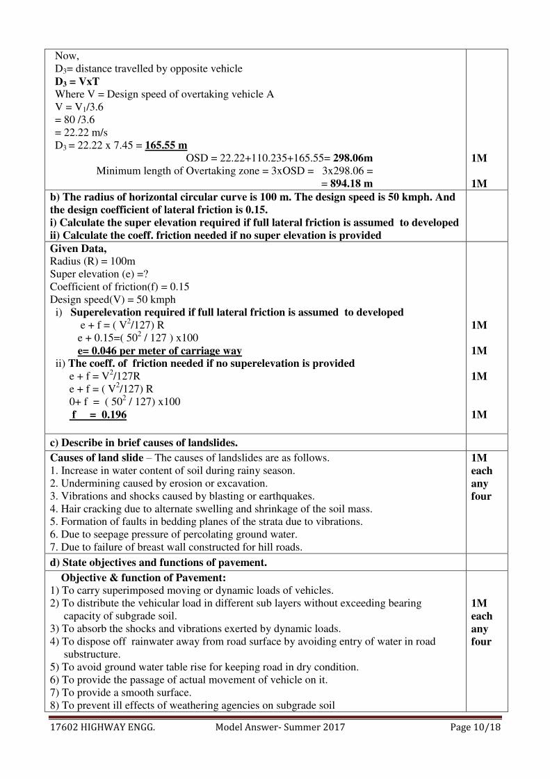
a) Draw a cross section of Highway embankment and label its complement
( Note - 2 marks for sketch and 2 marks for labeling )
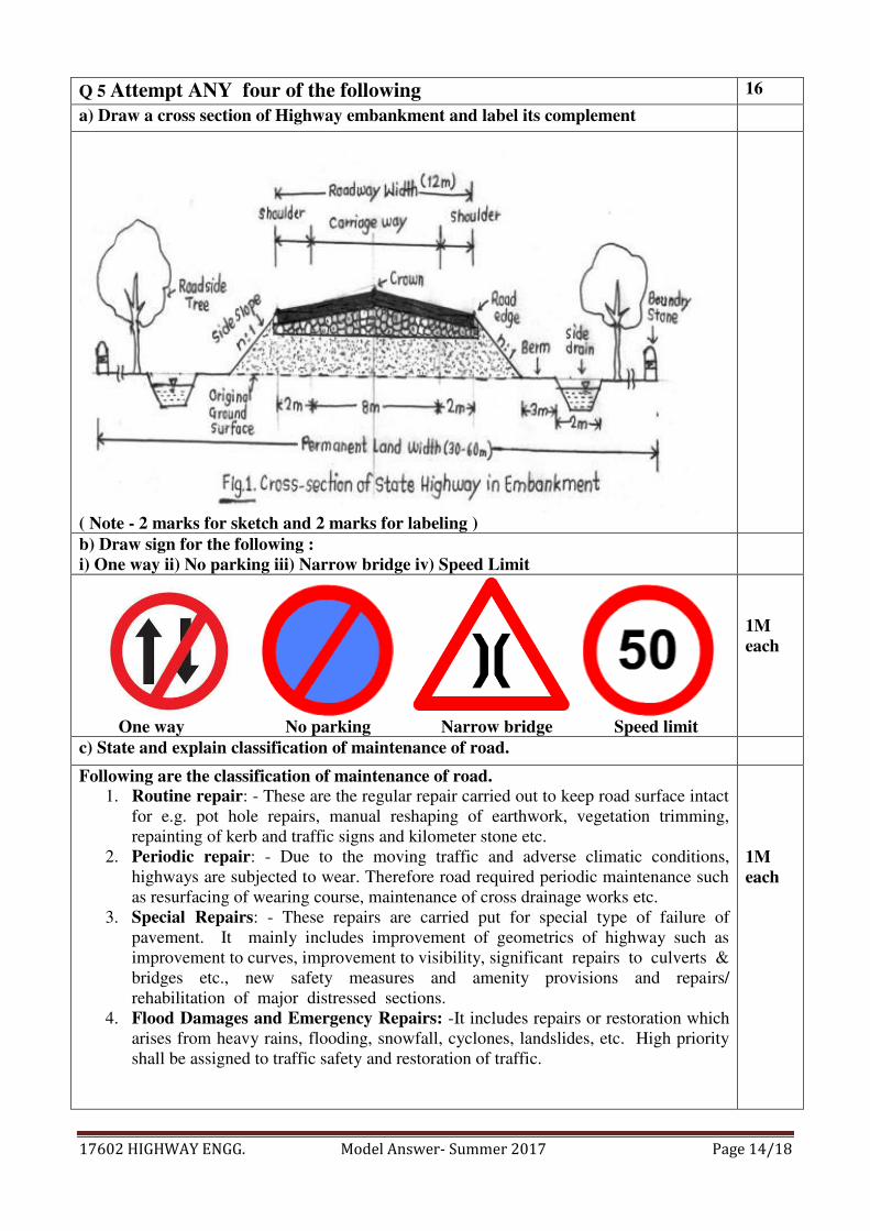
b) Draw sign for the following :
i) One way ii) No parking iii) Narrow bridge iv) Speed Limit
One way No parking Narrow bridge Speed limit
1M
each
c) State and explain classification of maintenance of road.
Following are the classification of maintenance of road.
1. Routine repair: - These are the regular repair carried out to keep road surface intact
for e.g. pot hole repairs, manual reshaping of earthwork, vegetation trimming,
repainting of kerb and traffic signs and kilometer stone etc.
2. Periodic repair: - Due to the moving traffic and adverse climatic conditions,
highways are subjected to wear. Therefore road required periodic maintenance such
as resurfacing of wearing course, maintenance of cross drainage works etc.
3. Special Repairs: - These repairs are carried put for special type of failure of
pavement. It mainly includes improvement of geometrics of highway such as
improvement to curves, improvement to visibility, significant repairs to culverts &
bridges etc., new safety measures and amenity provisions and repairs/
rehabilitation of major distressed sections.
4. Flood Damages and Emergency Repairs: -It includes repairs or restoration which
arises from heavy rains, flooding, snowfall, cyclones, landslides, etc. High priority
shall be assigned to traffic safety and restoration of traffic.
1M
each

17602 HIGHWAY ENGG. Model Answer- Summer 2017 Page 15/18
d) Explain working of power shovel with suitable line sketch.
Power shovel is also called as dipper shovel ,it represents shovel family of rope operated
excavators. It is used for digging above machine level. The working of power shovel is
explained below
i) First step is release the hoist to bring bucket down and stick in vertical position
so as to bucket teeth rest on ground
ii) Now the bucket is moved forward and downward by lifting hoist
iii) Next step is to fill the bucket with material by giving power
iv) Next step is to swing the stick and dump the excavated material at suitable
position
The above cycle is repeated again and again
Line sketch of Power Shovel
( Bucket and dipper are the extensions provided to the shovel)
2M
2M
e) State the component parts of hill road with their function
Following are the component parts of hill road :
1. Road Pavement: - The main function of pavement is to carry vehicular load and
distribute it evenly.
2. Parapet wall :- Parapet wall is to provide to provide protection to the traffic against
falling down in valley
3. Breast wall :- Breast wall is provided at the upslope side of the road to prevent
Lateral pressure of earth.
4. Retaining wall: - This wall is constructed at the downslope side to resist pressure
from earth filling of pavement due to traffic load and other load.
5. Catch water drain :- These drains are provide on hill slope to collect or intercept the
rainwater and divert them to nearby cross drainage work
6. Side Drainage :- These drains are provided at the foot of hill slope to collect
rainwater from carriageway and from hill slope and divert it to the nearby cross
drainage work
7. Cross drainage works: - Cross drainage works are provided at regular intervals in
hill road to drain off rain water across the road.
1M
each
any
four

17602 HIGHWAY ENGG. Model Answer- Summer 2017 Page 16/18
f) Describe in brief component parts of a Hot mixed bitumen plant.
A typical modern hot mix bitumen plant consist following parts:
1. Cold feed bins -:- These bins are provided to store cold aggregates in different sizes.
Each bins has different size material.
2. Vibrating screen :- Theses screen separates the oversize material.
3. Weighing conveyer :- These conveyors transfer the aggregates from cold bin to
drying drum
4. Drying and mixing drum: - In first half of drum aggregate is heated at required
temperature and in second half bitumen is mixed with aggregate.
5. Bitumen storage tanks :- These tanks are used to store and heat the bitumen and
supply it to mixing drum.
6. Filler silo :- Filler silo store and supply the additional binder material if required.
7. Dust collector :- This unit collects the dust from drier which is formed by heating of
aggregate .
8. Control panel :- This unit controls the all operations of hot mix bitumen plant.
1M
each
any
four
Q 6 Attempt any four of the following 16
a) Enlist eight types of equipment’s used for excavation in construction of road.
Following are the equipment’s used for excavation in road construction
1. Bulldozer
2. Scrapper
3. Grader
4. Power shovel
5. Back hoe
6. Dragline
7. Clamshell
8. Loaders
9. Excavators
10. Ripper
½M
each
any
eight
b) State four compacting equipment and its suitability.
Types and suitability of different types of compactors are tabulated below.
Sr
No
Type of Compactors Suitability
1 Static three wheeled self-
propelled compactors
1. For compacting of thick layer of
earth,Gravel and stone/aggregates
2. For compacting layer of bitumen
(These are used on soils which does not
require great pressure for compaction. These
rollers are generally used for finishing the
upper surface of the soil)
2 Pneumatic Tyred roller 1. For compacting cold laid bituminous
pavements(used specially for final pass
of compaction of bituminous road)
2. For compacting soft base course
materials or layers of loose soil.
1M
each

17602 HIGHWAY ENGG. Model Answer- Summer 2017 Page 17/18
3 Sheep footed roller 1. This type of roller mostly used for
compaction of cohesive soils such as
heavy clays and silty clays
2. Sheep foot rollers are used for
subgrade layers in pavements
4 Vibratory Roller 1. This types of roller is use when higher
level of compaction is required at
greater depth.(Specially used for sandy
soil)
2. A vibratory roller is used for
compacting granular base courses. It is
sometimes used for asphaltic concrete
work also.
c) Draw neat sketch of side drain and catch water drain.
(Note :- 3 marks for figure and 1 marks for labeling)
*4M
d) Explain maintenance of water bound macadam road.
W.B.M road faces dust formation in dry weather and mud formation in rainy season. Pot
holes and ruts is formed in WBM road due to combined effect of traffic and rain water.
By spreading thin layer of moist soil binder periodically, prevention loosening of aggregate
soil is possible.
Dust formation can be prevented by providing thin bituminous layer over WBM pavement.
Patch repair work is carried out to treat ruts and pot holes. In this cutting of effected portion
of road is carried out and then coarse aggregate and binder is placed and get well
compacted.
If the road extensively fails or after the useful period of WBM road ,resurfacing is carried
out
4M
17602 HIGHWAY ENGG. Model Answer- Summer 2017 Page 18/18
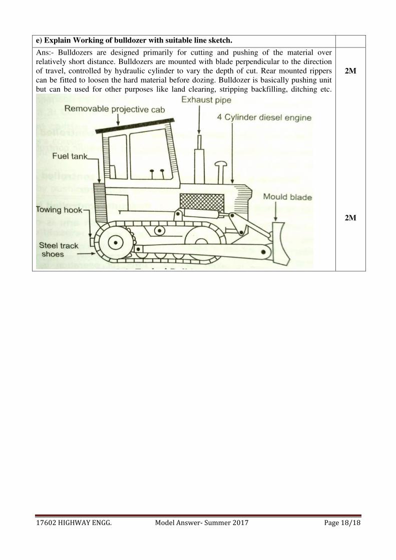
e) Explain Working of bulldozer with suitable line sketch.
Ans:- Bulldozers are designed primarily for cutting and pushing of the material over
relatively short distance. Bulldozers are mounted with blade perpendicular to the direction
of travel, controlled by hydraulic cylinder to vary the depth of cut. Rear mounted rippers
can be fitted to loosen the hard material before dozing. Bulldozer is basically pushing unit
but can be used for other purposes like land clearing, stripping backfilling, ditching etc.
2M
2M