Embed Size (px)
Citation preview

MADRID’S MINING LANDSCAPEMADRID, NEW MEXICO April 25, 2011
TASK THREE REPORT - FINAL DRAFT

ACKNOWLEDGEMENTS
Abandoned Mine Land Program - New MexicoJohn Kretzmann, Program ManagerLloyd Moiola, Project Manager/ArchaeologistRaymond Rodarte, Project Manager
Madrid Civic GroupsMadrid Cultural ProjectsMadrid Landowners AssociationMadrid Merchants AssociationMadrid Water Co-operativeMadrid Volunteer Fire Department
Santa Fe County StaffRobert Griego, Planning ManagerDuncan Sill, Economic Development Beth Mills, Open Space PlannerColleen Baker, Project Manager Arnold Valdez, Senior PlannerRenee Villarreal, Community Planner
Anthony GonzalesShannon HakimCarl HansenSarah HendersonFelix HernandezBill HogrebeOscar HuberMel and Diana JohnsonDenise JonesMark KaltenbachClif and Ede KitzrowLori LindseyJulie MarekWaz McDanielDan McDermottBruce McIntoshLynn McLaneJoanna MuthRebecca NafeyGlenn NeffJosh NovakPaul OlsenLana PaolilloPatty PepplarMarcia ReifmanPatricia RobertsLaurie RobinsonMike Roedel
New Mexico Historic Preservation DivisionMichelle Ensey, ArchaeologistTerry Moody, State and National Register Coordinator
New Mexico Department of TranpsortationPhillip Gallegos, Assistant District EngineerWilliam Hutchinson, Landscape Architect
Galisteo Watershed PartnershipJan-Willem Jansens, Executive Diretor
Office of Surface Mining Reclamation and EnforcementVernon Maldonado, AML and Regulatory Program Specialist
The Planning TeamKen Romig, Associate, Dekker Perich Sabatini (DPS)Tim Karpoff, Principal, Karpoff and AssociatesDoug Romig, Senior Soil Scientist, Golder Associates, Inc.Will Gleason, Associate, DPSRenee Euler, Landscape Architect, DPSMaia Mullen, Architect, DPS
Clinton AndersonKent BlackGlen BardenMelinda BonewellAmanda BrambleMark BremerPeter BuscoJeff CarrollBob ChapelLisa ConleyNigel and Sabine ConwayJo CookStephanie CoulthardElizabeth DavisSilvianne DelmasFlor DelunaEllen DietrichPaul DicksonDennis and Linda DoddCasey DuncanNancyy DuncanLinda DunhillRichard DuvalDale EdwardsGreg FlynnBeth ForloneyMatt FrenchDanette Garcia
Neil RupeRobert SelbySteve ShepherdGavin and Eleanor StrathdeeDick ThomasPhil UndercufflerAlex ValenzuelaGerry WawrekArt WelterGary WinderMike WrightGwendolyn ZaxusJohn Zellmer
COMMUNITY PARTICIPANTS
MADRID ’S MINING LANDSCAPE
Executive Summary
List of Figures
1.1 Introduction. . . . . . . . . . . . . . . . . . . . . . . . . . . . . . . . . . . . . . . . . . . . . . . . . . . . . . . . . . . . . . . . . . . . . . . . 1
1.2 Community Outreach. . . . . . . . . . . . . . . . . . . . . . . . . . . . . . . . . . . . . . . . . . . . . . . . . . . . . . . . . . . . . . . 7
1.3 Proposed Projects . . . . . . . . . . . . . . . . . . . . . . . . . . . . . . . . . . . . . . . . . . . . . . . . . . . . . . . . . . . . . . . . . 13
1.4 The Path Forward . . . . . . . . . . . . . . . . . . . . . . . . . . . . . . . . . . . . . . . . . . . . . . . . . . . . . . . . . . . . . . . . . . 31
Appendices . . . . . . . . . . . . . . . . . . . . . . . . . . . . . . . . . . . . . . . . . . . . . . . . . . . . . . . . . . . . . . . . . . . . . . . . . . . . . .
TABLE OF CONTENTS

MADRID ’S MINING LANDSCAPE
MADRID ’S MINING LANDSCAPE
EXECUTIVE SUMMARY
This report summarizes the Madrid Mining Landscape Proj-ect tha was initiated by the New Mexico Abandoned Mines Land Program (AML). AML undertook the project to address the legacy of coal mining in Madrid. Dekker/Perich/Sabatini (DPS), a planning consultant, was hired by AML to create a community-based plan to comprehensively address the envi-ronmental impacts of coal mining on Madrid’s landscape. Over an eighteen month period in 2010 and 2011, DPS worked with Karpoff and Associates, a mediation and planning firm based in Albuquerque, and Golder and Associates, an environmental engineering firm, to develop a plan that had strong community support and well-articulated goals.
This is the third and final report for the project. The Task One Report summarized the process and strategy for implement-ing a community plan. It also presented precedent projects in other communities that could be useful to developing solutions in Madrid. The Task Two Report focused on the results of the three community meetings held in 2010. Copies of these reports can be accessed at: http://www.madridmininglandscape.org/projects.html
This Task Three Report has four parts:
1. Introduction – Overall summary of the project’s goals and objectives
2. Community Outreach – Summary of the results of the community input and meetings
3. Proposed Projects – Detailed discussion of two watershed restoration/stormwater management projects including exist-ing conditions, objectives and reclamation strategies
4. Implementation Steps – General overview of the com-munity and agency roles and responsibilities for successful completion of the proposed projects
The Introduction explains the purpose of the plan and provides a short synopsis of AML’s mission and prior work in Madrid. It also introduces the challenges of the legacy of coal mining in Madrid, particularly community impacts due to uncontrolled stormwater runoff and excessive sedimentation.
Section 2 details the community outreach process used throughout the project. Through a series of well attended com-munity meetings, an interactive website and personal inter-views, the project team established a good rapport and working relationship with key community leaders. Madrid, with its loose coalition of civic groups and no formal governing structure, requires different strategies for generating community support. The project team established an informal advisory board and
made presentations to the five established civic groups in town. Individual interviews throughout of the project helped establish a level of trust that proved useful in larger meeting settings. Section 3 outlines the projects that were generated from the community planning process. The project goals include restor-ing the watershed, mitigating stormwater-related damage to property, improving public open space, and strengthening Madrid’s identity. Specific project strategies include stabilizing gob piles, utilizing stormwater as a community resource, and developing recreational opportunities and community interpre-tive elements.
The project team identified two significant projects to improve the quality of life for Madrid residents. The first project is the East Slope Catchment which will stabilize slopes, protect property from flooding and sedimentation and safely convey water to the arroyo. The second project will restore the hydro-logic function of central drainage in Madrid, increasing channel length and sinuosity, and provide water for community food source development. Proposed remediation strategies include geomorphic reclamation and low impact development design in combination with traditional civil engineering solutions such as drop inlets and conveyance piping.
Section 4 proposes strategies for implementing the proposed projects. Successful implementation will require coordination and cooperation from county, state, and local agencies. It will take approximately two years to complete technical studies and receive the appropriate environmental clearances to be able to start construction on the proposed projects. Resources to po-tentially finance or support ancillary restoration efforts that fall outside AML’s mission and funding are also identified.
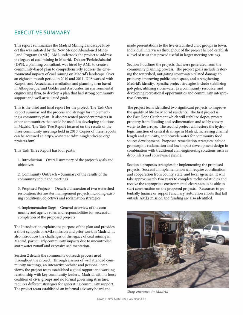
Shop entrance in Madrid

MADRID ’S MINING LANDSCAPEMADRID ’S MINING LANDSCAPE

MADRID ’S MINING LANDSCAPE
Figure 1.1 . . . . . . . . . . . . . . . . . . . . . . . . . . . . . . . . . . . . . . . . . . . . . . . . . . Location Map 3
Figure 1.2 . . . . . . . . . . . . . . . . . . . . . . . . . . . . . . . . . . . . . . . . . . . . . . . . . . . . . . Base Map 5
Figure 1.3 . . . . . . . . . . . . . . . . . . . . . . . . . . . . . . . . . . . . . . . . . . . . . . East Slope Project 19
Figure 1.4 . . . . . . . . . . . . . . . . . . . . . . . . . . . . . . . Historic Channelization of Arroyo 25
Figure 1.5 . . . . . . . . . . . . . . . . . . . . . . . . . . . . . . . . . . . . . .Arroyo Restoration Project 29
LIST OF FIGURES

MADRID ’S MINING LANDSCAPE

1
Intr
oduc
tion
MADRID ’S MINING LANDSCAPE
1.1 INTRODUCTION

MADRID ’S MINING LANDSCAPE

3
Intr
oduc
tion
MADRID ’S MINING LANDSCAPE
The Abandoned Mine Land Program (AML) funded and supported the Madrid Mining Landscape Project as a means to comprehensively address the legacy of coal mining in this historic mining town. From the 1800’s to the 1960’s, coal extraction drove the economy and shaped the landscape. From the 1960’s to today the village of Madrid has thrived as a unique, self-sufficient town by promoting its unique history and becoming known as a haven for artists.
Figure 1.1 - Location Map
INTRODUCTION
PLAN PURPOSEThe purpose of this report is twofold: to summarize the results of a community-based plan for Madrid, New Mexico and to recommend implementation strategies for realizing the plan. In 2010, AML and its consultants worked with the community of Madrid to create a comprehensive strategy for mitigating the effects of past mining practices in and around Madrid, New Mexico. With extensive community input, the project team proposed a series of measures designed to address environmental degradation associated with past coal mining. The implementation portion of this report provides a framework for initiating projects and working with stakeholders for their successful completion. AML’s mission to reclaim abandoned mines follows a hierarchy of priorities:
Protection of public health, safety, general welfare 1. and property from extreme danger resulting from the adverse effects of past mineral mining practices.Protection of public health, safety and general welfare 2. from adverse effects of past mineral mining and
Stone grade break in arroyo behind the Mineshaft Tavern, an AML sponsored project.
processing practices, which do not constitute an extreme danger.Restoration of eligible lands and waters and the 3. environment previously degraded by adverse effects of past mineral mining and processing practices, including measures for the conservation and development for soil, water (excluding channelization), woodland, fish and wildlife, recreation resources, and agricultural productivity.
For the past thirty years, AML has focused on Priority One and Two projects: safety hazards associated with abandoned coal mines, such as closing adits and removing dangerous structures and addressing reclamation issues such as those illustrated below. This has typically required that AML work with individual landowners, often in a reactive mode, to address issues that pose an immediate hazard. This approach successfully addressed hazards to public safety, but did not resolve the larger, long term environmental legacy of past coal mining activities. With most of the extreme hazards resolved, AML can now focus on Priority Two and Three issues, namely how to reclaim an environment that has been degraded by coal mining practices. The Madrid Mining Landscape Project represents a comprehensive and community driven approach to addressing Madrid’s mining legacy, By taking a comprehensive approach, AML can address the secondary effects of mining in Madrid such as localized flooding,

MADRID ’S MINING LANDSCAPE
4
Intr
oduc
tion
Historic photo: The Jones tipple Historic photo: Huber Motors
Historic photo: Mining shacksHistoric photo: The Madrid tipple
sedimentation, and erosion.1 The village of Madrid benefits from, and is challenged by, its coal mining legacy. The town’s identity is rooted in its mining history: vestiges of coal processing and mining practices – particularly the gob piles and the town’s historic structures, help define the sense of place. Tourism, the mainstay of Madrid’s economy, relies upon the town’s historic character to attract visitors to its art galleries and restaurants. At the same time, the legacy of coal mining has left behind a compromised landscape, resulting in uncontrolled stormwater runoff and excessive sedimentation. The challenge for Madrid is how to address the negative impacts of mining without compromising the identity of the town that attracts tourists and drives the economy. The village of Madrid also faces challenges in implementing reclamation projects as detailed later in this plan. Madrid is an unincorporated community and relies upon a network of individual civic groups and Santa Fe County for essential services. The civic groups, which oversee property covenants, fire and water services, business concerns and cultural activities, constitute an informal governing structure for the community. However, except for the Madrid Water Co-operative, the Madrid civic groups’ formal responsibilities do not extend to community wide
solutions across private property boundaries. The County, while responsible for planning, public safety, Open Space and other services, has limited resources to devote to one community. This report proposes recommendations on how AML can work with the village, the County, and various stakeholders to build and maintain watershed improvements.This document reflects the community’s consensus on how best to address environmental and quality of life issues within the AML framework. The consensus resulted from months of stakeholder consultations, meetings with community groups, and a series of well-attended public forums. During that time, the community worked to identify projects that both addressed environmental issues and have the potential to make enduring changes in the overall quality of life.
1New Mexico is an uncertified AML program, meaning that the state program has, or intends to, address all remaining abandoned coal mine problems in its jurisdiciton. Uncertified program funds may only be used for priority one and two coal reclamation (activities) and for priority three reclamation that is a part of priority one and two coal reclamation (activities).

Mad
rid’s
Min
ing
Land
scap
e / M
adrid
, NM
/ 4.
25.1
1
5
Intr
oduc
tion
Figu
re 1
.2: B
ASE
MA
PM
adri
d's M
inin
g La
ndsc
ape
/ M
adri
d, N
M /
COM
MU
NIT
Y P
RO
JECT
S B
OU
ND
AR
Y
4.
5.11
Tas
k 3
Repo
rt
00
.25
0.5
0.1
25
Mile
s
LEG
END
��
�C
OM
MU
NIT
Y P
RO
JEC
TS B
OU
ND
ARY
��
��
�ST
UD
Y A
REA
��
�H
ISTO
RIC
DIS
TRIC
T B
OU
ND
ARY
��
�G
OB
PIL
E LO
CAT
ION
��
�R
OA
DS
��
�N
EW M
EXIC
O 1
4
��
�C
OU
NTY
OPE
N S
PAC
E
NM 14 - TURQUOISE TRAIL
WIN
DCATCHER RD
NA
NA
NN
MADRID HEIGHTS TRL
TIPPLE WAY
FIREHOUSE LN
CAVE RD
KEMP RD
MESA VIENTO
MESA VIEW RD
SUNSET STRIP MILLER GULCH RD
WILD DOG RD
OLD
WIN
DMIL
L TR
L
OLD WINDMILL RD
OLD MADRID RD
WALDO MESA RD
WHITE WOLF RD
OCEAN VIEW DR
ROCINANTE RD
WIL
D M
OUNT
AIN
RD
CEDAR MOUNTAIN RD
ROGERSVILLE RD
VISTA DEL MAR
GOLDMINE RD
OLD GOAT RD
N
7
Com
mun
ity O
utre
ach
MADRID ’S MINING LANDSCAPE
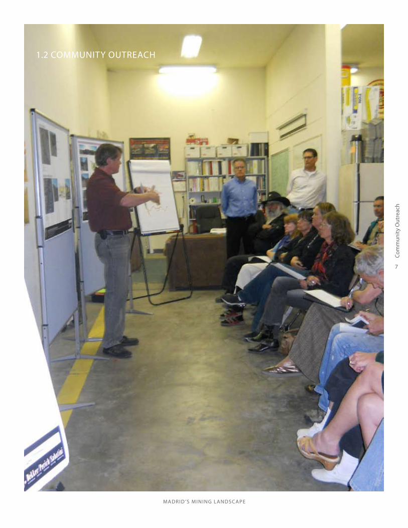
1.2 COMMUNITY OUTREACH

MADRID ’S MINING LANDSCAPE
8
Com
mun
ity O
utre
ach

9
Com
mun
ity O
utre
ach
MADRID ’S MINING LANDSCAPE
COMMUNITY OUTREACH
COMMUNITY OUTREACH PROCESSThe Madrid Mining Landscape project represents an evolu-tion in AML’s approach to accomplishing its mission. To state again, AML’s three priorities are:
Priority One- Protecting people and property from extreme danger;
Priority Two- Protecting people and property from other adverse effects; and,
Priority Three- Restoring the environment previously degraded by mining and processing practices.
The Madrid project was the first community-based plan-ning effort sponsored by the New Mexico AML Program, and offered AML and the project team opportunities for new approaches, while operating within AML’s mission and funding parameters. This section of the report outlines the objectives, principles and strategies of the project’s commu-nity outreach process.
COMMUNITY OUTREACH OBJECTIVESThe project team, in conjunction with AML, identified sev-eral objectives for the community outreach process:
• To identify and work with a broad range of stake-holders;
• To understand the community’s social and historical context, and the key issues ; and
• To work jointly with Madrid community stakeholders to design an effective planning process that results in a useful plan.
COMMUNITY OUTREACH PRINCIPLESIt is important that all community outreach activities are based on core principles. The core principles that governed the Madrid Project team’s approach included:Collaborative design. “People support what they create.” That is, people support activities that they have an influen-tial part in designing and creating. It is important to genu-inely consult with key stakeholders throughout the project, on the planning process as well as the plan’s content—how the project is undertaken has a significant impact on its results, and a collaborative approach in its design helps build broad-based confidence in the plan’s usefulness and successful implementation.Balance of “outside” and “local” knowledge. Professionals on the project team and at AML bring important technical information. Community residents bring important local perspective. Carefully integrating anecdotal and qualita-tive experience with technical and quantitative assessments builds the basis for good dialogue and well-informed deci-sions. It is essential to consider local values and perspec-tives as well as to rely on empirical data.Alignment with local values and patterns. Project team members are guests in the community. Also, participative planning processes ask community members to make time in addition to business and family obligations, on a vol-unteer basis. For both reasons, it is courteous to work, as much as possible, according to local schedules and routines, and to “go to people” rather than “have them come to us.” One example is that meetings should be scheduled locally and as conveniently as possible for local residents.Good personal relationships. Building and maintaining positive relationships with local leaders and other stake-holders is an essential first step and an ongoing component of the planning process.Willingness to learn. The outreach approach should remain collaborative and flexible, and not become mechani-cal and prescriptive. The project team should learn as the project moves forward. Multiple avenues for participation. In general, residents of local communities appreciate having a variety of ways to offer their ideas in planning processes for several reasons, including:
• Time/scheduling constraints • Personal preferences, e.g., for small or large group processes• Negative past experiences with public meetings or other participation avenues.
Common complaints about public processes include “com-munity meetings are non productive,” or “not everyone has email,” echo this concern. If a planning process relies too
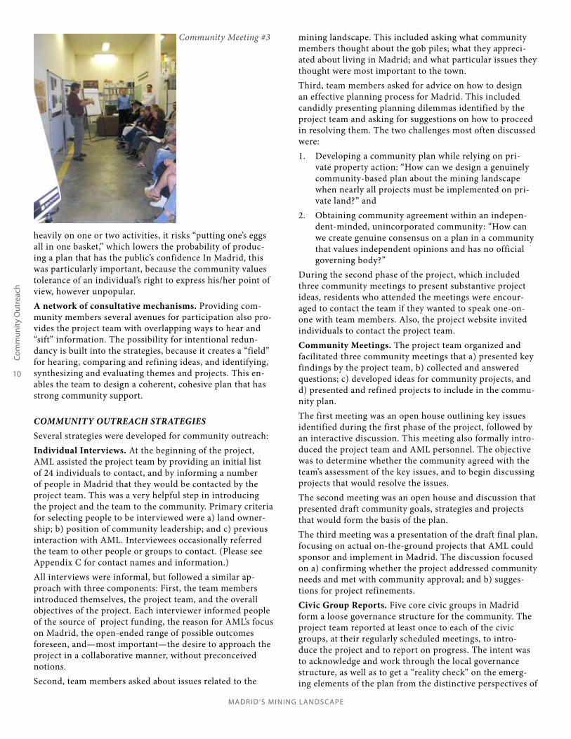
Community Meeting #2
MADRID ’S MINING LANDSCAPE
10
Com
mun
ity O
utre
ach
heavily on one or two activities, it risks “putting one’s eggs all in one basket,” which lowers the probability of produc-ing a plan that has the public’s confidence In Madrid, this was particularly important, because the community values tolerance of an individual’s right to express his/her point of view, however unpopular.A network of consultative mechanisms. Providing com-munity members several avenues for participation also pro-vides the project team with overlapping ways to hear and “sift” information. The possibility for intentional redun-dancy is built into the strategies, because it creates a “field” for hearing, comparing and refining ideas, and identifying, synthesizing and evaluating themes and projects. This en-ables the team to design a coherent, cohesive plan that has strong community support.
COMMUNITY OUTREACH STRATEGIESSeveral strategies were developed for community outreach:Individual Interviews. At the beginning of the project, AML assisted the project team by providing an initial list of 24 individuals to contact, and by informing a number of people in Madrid that they would be contacted by the project team. This was a very helpful step in introducing the project and the team to the community. Primary criteria for selecting people to be interviewed were a) land owner-ship; b) position of community leadership; and c) previous interaction with AML. Interviewees occasionally referred the team to other people or groups to contact. (Please see Appendix C for contact names and information.)All interviews were informal, but followed a similar ap-proach with three components: First, the team members introduced themselves, the project team, and the overall objectives of the project. Each interviewer informed people of the source of project funding, the reason for AML’s focus on Madrid, the open-ended range of possible outcomes foreseen, and—most important—the desire to approach the project in a collaborative manner, without preconceived notions. Second, team members asked about issues related to the
mining landscape. This included asking what community members thought about the gob piles; what they appreci-ated about living in Madrid; and what particular issues they thought were most important to the town. Third, team members asked for advice on how to design an effective planning process for Madrid. This included candidly presenting planning dilemmas identified by the project team and asking for suggestions on how to proceed in resolving them. The two challenges most often discussed were:
Developing a community plan while relying on pri-1. vate property action: “How can we design a genuinely community-based plan about the mining landscape when nearly all projects must be implemented on pri-vate land?” andObtaining community agreement within an indepen-2. dent-minded, unincorporated community: “How can we create genuine consensus on a plan in a community that values independent opinions and has no official governing body?”
During the second phase of the project, which included three community meetings to present substantive project ideas, residents who attended the meetings were encour-aged to contact the team if they wanted to speak one-on-one with team members. Also, the project website invited individuals to contact the project team.Community Meetings. The project team organized and facilitated three community meetings that a) presented key findings by the project team, b) collected and answered questions; c) developed ideas for community projects, and d) presented and refined projects to include in the commu-nity plan.The first meeting was an open house outlining key issues identified during the first phase of the project, followed by an interactive discussion. This meeting also formally intro-duced the project team and AML personnel. The objective was to determine whether the community agreed with the team’s assessment of the key issues, and to begin discussing projects that would resolve the issues. The second meeting was an open house and discussion that presented draft community goals, strategies and projects that would form the basis of the plan. The third meeting was a presentation of the draft final plan, focusing on actual on-the-ground projects that AML could sponsor and implement in Madrid. The discussion focused on a) confirming whether the project addressed community needs and met with community approval; and b) sugges-tions for project refinements. Civic Group Reports. Five core civic groups in Madrid form a loose governance structure for the community. The project team reported at least once to each of the civic groups, at their regularly scheduled meetings, to intro-duce the project and to report on progress. The intent was to acknowledge and work through the local governance structure, as well as to get a “reality check” on the emerg-ing elements of the plan from the distinctive perspectives of
Community Meeting #3

11
Com
mun
ity O
utre
ach
MADRID ’S MINING LANDSCAPE
each of these groups. In addition, a significant number of people offered their suggestions for the plan at these meet-ings, rather than attend the open community meetings. For reference, the five groups are:
Madrid Landowners Association (MLA). The MLA was formed by the Albuquerque and Cerrillos Coal Com-pany in 1975 to enforce covenants and restrictions on development in Madrid. The purpose of the covenants is to assure “insofar as possible, that each lot shall be developed, improved, and used in such fashion as to cause the least disturbance to and distractions from the natural environment and the overall appearance of Madrid from within and without.” Madrid Cultural Projects (MCP). The MCP is a 501(c)(3) organization, “with a mission to preserve and pro-tect Madrid’s historical structures and foster cultural projects which support and promote the community.” The MCP has a number of committees that oversee the Ballpark redevelopment, the Historical Society, the Community Garden (which provides free vegetables for people in need), and other community projects.Madrid Merchants Association (MMA). The MMA operates VisitMadridNM.com, which provides detailed information on 80% of the businesses in Madrid, and supports the town as an art destination for visitors from around the world.Madrid Water Cooperative (Co-op). The Co-op oversees the drinking water system in Madrid. This includes monitoring water supply, maintaining compliance with water regulations, setting and collecting assessments for operation, and repayment of the bond on the town well.Madrid Volunteer Fire Department (VFD). The VFD has 23 members and operates two engines, a tender-tanker, rescue/EMS ambulance, and two other utility/rescue vehicles.
Informal Advisory Board. During the interviews and initial group presentations in Task One of the project, the project team identified and formed good relationships with several community leaders. The team looked on these people as advisors, and periodically met or called them to a) be a sounding board for ideas, b) provide feedback from the community, and c) speaking on behalf of the project team within the community. These advisors were consulted informally and individually, because of the number of regu-lar monthly community meetings and variation in people’s schedules.Project Website. The project team created a simple web-site to post the plan’s objectives, process, scheduled activi-ties and progress, and to post graphics of the area and the emerging projects. The site invited opportunities for com-ments and suggestions, as well. County Staff Consultation. The project team met periodi-cally with staff from Santa Fe County, including the Open Spaces Program, the Planning Department, and the Techni-cal Advisory Team. Although AML plans to underwrite the
capital costs of several projects, it cannot provide funding for operations and maintenance. A constructive partnership between AML, County agencies and Madrid residents and groups increases the likelihood that projects can be sus-tained over the long term. AML Consultation. While not formally a part of “com-munity outreach”, the project team’s relationship with AML formed a significant part of the outreach process. This was of particular importance on this project, because the design of a community-based plan represented a departure for AML’s typical approach.
LESSONS LEARNEDIndividual interviews are an essential first step for suc-cess. • Talking with people one-on-one or in small groups estab-lishes a tone for the project, helps understanding, allows for informal exchange of ideas, and helps create trust. • At the beginning of the project, it allows project team members to introduce themselves, the project and its objec-tives, as well as their principles and approach.• It allows team members to build relationships and to un-derstand local issues and context, and creates opportunities to design the entire process collaboratively. • If done with a sense of courtesy and openness, it can demonstrate that the values outlined above are really im-portant to the project team, and builds trust in the com-munity. • Maintaining contact with individuals throughout the project, project team members can create an iterative feedback loop, vetting and refining provisional ideas on an informal basis.
An open-ended approach engages people and helps to build good relationships. • During initial interviews, demonstrating the project team’s approach sparked engaging and lengthy conversa-
Community Meeting #2

MADRID ’S MINING LANDSCAPE
12
Com
mun
ity O
utre
ach
The Project Team also learned the following from its work with stakeholders:
• Stakeholder outreach must embrace local organiza-tional and individual knowledge to generate communi-ty-based solutions to environmental problems.• Stakeholder outreach benefits from honest assess-ments of environmental conditions of concern to stakeholders. • Reclamation of disturbed landscapes must be inter-woven with community identity, and the town’s physi-cal and organizational resources. • The methods, scale, and type of proposed improve-ments must consider the stakeholder and partner com-mitments for maintenance and operations.• Iterative consultation, education and consensus building with stakeholders and AML is a key to suc-cessful planning and project implementation.
As found in the Task I precedent research, this plan resembles a small-scale community-based watershed restoration plan. Planning and restoration on a watershed scale has been successful in numerous communities whose goals were to improve their water quality and stabilize their stream system. For instance, the Sierra Nevada Alliance states the following applicable principles: - Restoration must be consistent with watershed level assessment, analysis and evaluation; restoration includes protection of existing healthy conditions - Restoration should be staged, moving outward and downward generally from the top of the watershed, from core healthy or restored areas; exceptions are limited to work designed to link core healthy areas - Restoration projects should be prioritized within each watershed for effectiveness on the basis of maximum ecological benefit and on the benefits to sustainable local community economics and/or revitalization - Restoration that alters environments should give highest priority to project results that use natural processes.
tions. Many residents expressed initial skepticism about the intent of the project. Everyone offered a number of analyses of issues and suggestions about process design. Without ex-ception, people in Madrid appreciated the open-ended and collaborative values displayed in the approach. • Throughout the planning process, remaining open to new ideas reinforced the perception within the community that the project team was carrying through on its principles. Also, it required the project team to re-think its approach and the actual projects to propose. This resulted in a stron-ger plan overall.
Meetings with the local civic groups were effective as ad-ditional “community meetings.” • Engaging people in familiar settings allowed for open and productive exchanges of ideas.• Attendance at civic group meetings reflected a broader cross section of the community than conventional commu-nity meetings.
A focus on substantive, critical issues gains interest and trust.• While the sponsoring agency may have ideas to propose, presenting these in a provisional manner and remaining open to other ideas reinforces the local support for the final product—even if the sponsoring agency cannot meet all lo-cal requests because of funding guidelines or limits.
The project website was not used extensively. • However, in other communities, having a project website may be more important.
Maintaining close communication was especially impor-tant on this project.• Because the design of a community-based plan was a new venture for AML, the agency and the project team were “learning as we go,” in a sense, to understand what could be included in the plan. • AML leadership willingly listened to community based input and shaped the planning within the defined limits of its mission.• “Community-based” is a term that implies allowing the community significant influence in the content of the plan. However, AML was required, at all times, to remain within the parameters of its mission. This required the agency and the project team to learn together the distinction between what was allowed under AML’s mission and what was merely precedent-setting. • Good communication was necessary to explore what was possible for AML to sponsor, on one hand, and what would meet community-identified needs, on the other.
13
Prop
osed
Pro
ject
s
MADRID ’S MINING LANDSCAPE
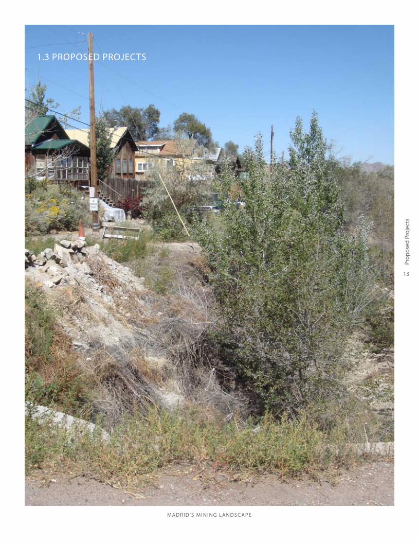
1.3 PROPOSED PROJECTS

MADRID ’S MINING LANDSCAPE
14
Prop
osed
Pro
ject
s

15
Prop
osed
Pro
ject
s
MADRID ’S MINING LANDSCAPE
PROPOSED PROJECTS
OVERVIEW OF PROJECTSTwo reclamation projects emerged as meaningful to the quality of life for Madrid residents and fulfill the AML mandates: the East Slope Catchment Project and the Arroyo Restoration project. General project boundaries indicated in Figure 1.2 correspond with the dominant physiographic elements of the watershed. The overarching goal for both projects is to improve water-shed conditions and to restore hydrologic function within developed areas of the Madrid watershed. The East Slope Project tackles the stormwater drainage problems associat-ed with the eastern escarpment and built environment. The Arroyo Restoration Project seeks to reestablish a healthy and stable stream system within Madrid’s public open space or “greenbelt”.Community benefits associated with these projects may also include improvements to water quality, revegetation for dust and erosion control, improvements to emergency vehicle access, recreational amenities, and community food source development.The most complex project is the East Slope Project. It requires the cooperation of large numbers of stakeholders to be successful and would likely be phased within small drainages. The majority of the Arroyo Restoration projects oriented in a north/south direction in the arroyo flood-plain, thus requiring the cooperation of fewer landowners.
HYDROLOGY ALTERED BY MININGThe hydrologic function of the Madrid watershed has been significantly impaired by mine-related activities. Railroad construction, underground mine development and the dis-posal of coal mine wastes (gob, slag and red dog), highway construction, human habitation, and uncoordinated public infrastructure particularly related to stormwater manage-ment have all disrupted the surface water hydrology in the vicinity of the village. RESTORATION GOALS
1. Restore watershed- Improve stormwater management within the village and, to the extent practicable, restore a more balanced hydrologic function to the Madrid watershed. 2. Protect private property.3. Improve public open space.4. Support community history and identity- Balance general community consensus that gob piles should not be removed, yet reclaim those gob piles that contribute to the damage of property.
RESTORATION STRATEGIES1. Reclaim/stabilize some gob piles2. Stabilize and naturalize drainages3. Assure long-term sustainability of improvements4. Utilize stormwater as a community resource5. Develop recreational/interpretative elements
Bridge Road drainage
Healthy stream systems are defined as those capable of transporting sediment loads without aggrading or degrading while maintaining a relatively constant cross section, pattern (sinuosity) and longitudinal profile over time. Stable channels are in a dynamic balance be-tween local scour and deposition, adjusting to changes in stream flow, sediment load, stream slope and veg-etation. Stable streams are continuously evolving in response to climatic, landscape and geologic processes and maintain a balance with their natural components- water, sediment, energy and vegetation. In the Southwest, healthy ephemeral stream systems have a main channel with low banks, high flow chan-nels that carry water infrequently during large storm events and a wide floodplain that accomodates a sinu-ous channel . (See page 25 for additional information.)

MADRID ’S MINING LANDSCAPE
16
Prop
osed
Pro
ject
s
LOW IMPACT DEVELOPMENT (LID)LID practices, though engineered, are better suited for rural village conditions and small watershed restora-tion, emphasizing water conservation and protection of water quality. LID is a comprehensive land planning and engineering design approach with a goal of main-taining and enhancing the pre-development hydrologic regime of urban and developing watersheds.LID approaches include the following:
•minimizing land disturbance during development, •incorporating and preserving natural features in the development, •decentralizing stormwater management and treat-ing it at the source •reducing and disconnecting impervious surfaces in the development •understanding and mimicking pre-development hydrology.
Pedestrian bridge, beyond, and arroyo escarpment. This por-tion of the Madrid arroyo was channelized and straightened in the 1930’s by the US Army Corp of Engineers.
TECHNICAL APPROACHEach project description below provides an assessment of existing conditions and outlines potential solutions broadly divided into technical and organizational approaches. Technical solutions considered are a range of engineering and design techniques, including geomorphic reclamation, low impact development (LID) and more traditional engi-neering solutions to reclamation and stormwater convey-ance.
- Geomorphic reclamation techniques are frequently used by the AML program in more remote locations and may have limited applicability to built environ-ments.
- Conventional stormwater solutions are designed to handle large precipitation events (e.g. the 100 year flood) and rapidly convey, manage and treat stormwa-ter. These traditional designs often employ large and costly facilities (flumes, pipes and basins) and require more maintenance.
Madrid residents expressed a desire to use LID techniques wherever possible. LID techniques are particularly suited to capturing stormwater and its use as a community resource with a specific ability to help develop community food source production. Projects which use stormwater for ben-
eficial purposes such as passive irrigation of landscaping and food producing shrubs or trees should be incorporated at every opportunity. Although low impact development approaches are com-monly used in today’s design professions, the planning team understood Madrid’s approach to LID as based in permaculture principles. Permaculture is a sustainable land use design approach based on ecological and biological principles and patterns that occur in nature. Permaculture aims to create stable, productive human settlements and agricultural systems that are harmoniously integrated with the land. Successful LID design may also succeed in linking the historical aesthetics of the Town of Madrid with the func-tional requirements of drainage and conveyance struc-tures. Infrastructure within Madrid is built with a unique historic aesthetic or vernacular style, which suits the spirit of the village of Madrid. Vernacular constructs include stone flumes and walls, stone swales, cast in place concrete walls, reclaimed scrap steel walls and clapboard buildings. Although some of these materials are not suited for drain-age facility design, these vernacular elements are a design language that should be respected and utilized.
GEOMORPHIC RECLAMATIONGeomorphic Reclamation is a landscape design ap-proach to restore stable slope profiles and construct natural drainages/landforms in reclaimed ecosystems modeled after natural landscape and hydrological processes and patterns. In southwestern reclamation, geomorphic reclamation involves the construction of talus slopes and rock outcrops, the use of suitable soil substitutes, variable topdressing thickness, the ad-dition of surface rock on slopes, and reconstructing complex hillslopes and more sinuous drainage patterns. Geomorphic reclamation has the potential to enhance landscape diversity while reducing short-term con-struction costs and long-term maintenance costs.

17
Prop
osed
Pro
ject
s
MADRID ’S MINING LANDSCAPE
Stone drainage flume on Main Street - an example of vernacular design
Damaged and abandoned wood flume below Ice House Road
PROJECT 1: THE EAST SLOPE CATCHMENTThe East Slope Catchment Project begins on the east ridge of the valley, extends north and south to encompass the village and properties significantly affected by past mining practices and west to the arroyo. (See Figure 1.3) Multiple small watersheds generally drain from east to west into the uncoordinated and poorly engineered drainage system of the village, its roads and drives, across NM Highway 14, through yet more residential parcels, and empties into the Madrid arroyo.Stormwater management and sedimentation are the pri-mary issues to address within the project area. Disturbed areas above the village have increased runoff and erosion and essentially all natural drainages between Ice House Road and the arroyo are interrupted, causing water to either pond in the roadways or flow uncontrolled through private property. The East Slope project is complex because of the extensive terrain alterations by past mining practices, the village’s built environment, and the need to coordinate multiple landowners for project reconnaissance, design and implementation. To effectively implement the project, it is anticipated that the work will be phased within smaller watersheds. While restoration designs would consider the entire project area, it is recommended that work progress from upland areas and move down to the floodplain of the Madrid arroyo. To better define the issues of the East Slope project this re-port divides up the reach into three zones; the Slope Zone, the Village Zone and the Arroyo Zone. These zones more or less correspond to specific physiographic characteristics of the watershed and its function, mine related disturbances and the built environment, each requiring different treat-ment options to improve conditions. The treatment or remediation goal for the zones are: the Slope Zone -Stabi-lize and Infiltrate, the Village Zone- Capture and Convey, the Arroyo Zone- Detain and Reuse.
THE SLOPE ZONE: STABILIZE AND INFILTRATESlope stabilization and water infiltration are strategic reclamation goals to be accomplished in the Slope Zone. The steep to very steep sloping topography in combination with medium-textured/low-permeability soils and generally sparse vegetation results in naturally high rates of runoff and erosion. The east slope has been significantly affected by mining activity that have changed the escarpment’s drainage pattern further exacerbating local stormwater issues. Specifically, over-steepened slopes and changes in surface runoff patterns associated with the gob piles; poorly engineered slope cuts and other grade modifications; and little or no vegetative cover in disturbed areas allows for water to concentrate on slopes, leading to excessive erosion and sedimentation. More recently, individual landown-ers have altered the drainage patterns to protect or access their property. There is also evidence of off-road vehicle disturbance on the slopes and gob piles. The cumulative effects of past and recent terrain disturbance are numerous ranging from muddy roads that are impassable for personal
MADRID ’S MINING LANDSCAPE
18
Prop
osed
Pro
ject
s
Potential Slope Zone treatment to steep road cut
Potential gabions, stone check dams, one-rock dams and stabilization on the east slope
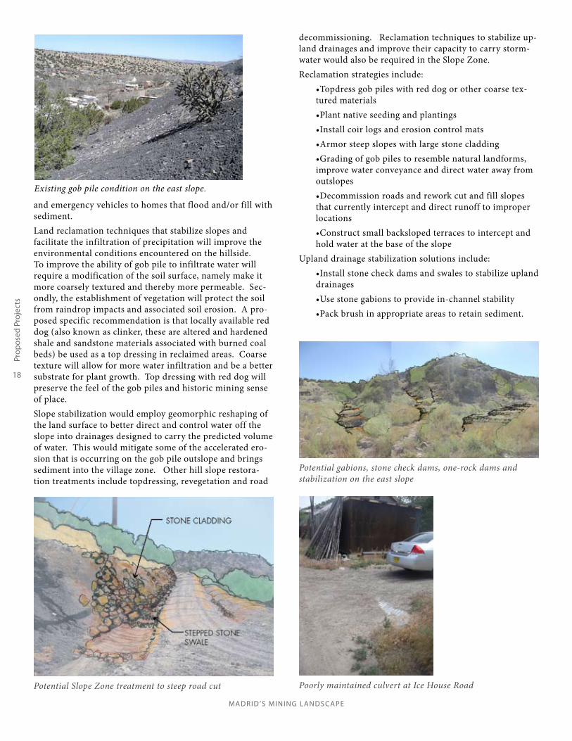
and emergency vehicles to homes that flood and/or fill with sediment.Land reclamation techniques that stabilize slopes and facilitate the infiltration of precipitation will improve the environmental conditions encountered on the hillside. To improve the ability of gob pile to infiltrate water will require a modification of the soil surface, namely make it more coarsely textured and thereby more permeable. Sec-ondly, the establishment of vegetation will protect the soil from raindrop impacts and associated soil erosion. A pro-posed specific recommendation is that locally available red dog (also known as clinker, these are altered and hardened shale and sandstone materials associated with burned coal beds) be used as a top dressing in reclaimed areas. Coarse texture will allow for more water infiltration and be a better substrate for plant growth. Top dressing with red dog will preserve the feel of the gob piles and historic mining sense of place.Slope stabilization would employ geomorphic reshaping of the land surface to better direct and control water off the slope into drainages designed to carry the predicted volume of water. This would mitigate some of the accelerated ero-sion that is occurring on the gob pile outslope and brings sediment into the village zone. Other hill slope restora-tion treatments include topdressing, revegetation and road
decommissioning. Reclamation techniques to stabilize up-land drainages and improve their capacity to carry storm-water would also be required in the Slope Zone. Reclamation strategies include:
•Topdress gob piles with red dog or other coarse tex-tured materials•Plant native seeding and plantings•Install coir logs and erosion control mats •Armor steep slopes with large stone cladding•Grading of gob piles to resemble natural landforms, improve water conveyance and direct water away from outslopes •Decommission roads and rework cut and fill slopes that currently intercept and direct runoff to improper locations •Construct small backsloped terraces to intercept and hold water at the base of the slope
Upland drainage stabilization solutions include:•Install stone check dams and swales to stabilize upland drainages•Use stone gabions to provide in-channel stability •Pack brush in appropriate areas to retain sediment.
Poorly maintained culvert at Ice House Road
Existing gob pile condition on the east slope.

Mad
rid’s
Min
ing
Land
scap
e / M
adrid
, NM
/ 4.
25.1
1
19
Pro
pose
d Pr
ojec
ts
Figu
re 1
.3: E
AST
SLO
PE P
ROJE
CT

21
Prop
osed
Pro
ject
s
MADRID ’S MINING LANDSCAPE
Sediment impacting a historic building at the Coal Mine Museum
Culvert in arroyo impaired by sediment
Existing concrete flume. Note sedimentation and conditions.
THE VILLAGE ZONE: CAPTURE AND CONVEYPlatted in 1976 by the heirs of Oscar Huber, the Village Zone lies between the steep slopes of the escarpment on the East and the relatively flat arroyo plain and is populated with homes and businesses with an occasional vacant par-cel. The Village Zone is best characterized as rural, com-prised of new, historic and renovated homes and businesses where density decreases as one moves outward from the central core. While there is a significant amount of devel-opment in the zone, roadways and drives are predominately unimproved, packed soil except for some stone drives stabi-lized with red dog and NM 14. This zone is the most affect-ed by stormwater due to its topographic position, disrupted drainage patterns, undersized stormwater infrastructure and ongoing private property changes. Development in this zone has decreased the ability of the area soils to infiltrate water. Rooftops and compacted/paved surfaces collect and concentrate stormwater. The unimproved, undersized and badly maintained drainage infrastructure is incapable of conveying the quantity of stormwater to an appropriate outlet location. As topogra-phy changes from the steep slopes in the Slope Zone, storm water tends to slow and drop its sediments evidenced by the accumulated sediment on Ice House Road and against stuructures along the eastern edge of town. Water con-centrates on roads as it moves towards the arroyo where it often either cuts deep rills in the road or ponds. Road maintenance , which is the responsibility of the Madrid Landowners Association, is infrequent. Water has also found its way into the basements of several homes and busi-nesses presumably because localized flooding saturates soil and then moves laterally into structures when it encounters less permeable materials below the surface.
The general condition of the conveyance structures are poor and do not adequately collect and discharge water to prevent flooding. The remains of the mining company’s stormwater conveyance system are evident along Hwy 14. At least one drop inlet into a flume carries storm water under Hwy 14. Residents have noted that water will stand in the area following a large rain event, suggesting that the
inlet is undersized or full of sediment. Further, the flume dissipates into an area that does not appear to be directly connected to a downstream outlet on Cave Road, and it is assumed that water is left to find its own course through private property. A second flume under the Mining Mu-seum is used to convey water from a previous AML/DOT joint project.
There are two important community goals that may be served by work within the Village Zone. The residents of Madrid are interested in utilizing stormwater as a com-munity resource and it is recommended that strategies to capture, detain and infiltrate stormwater in the Village Zone be employed at every opportunity. Additionally, after precipitation events the roads and drives are difficult to navigate for emergency vehicles and other vehicles. It is recommended that the grading, drainage and conveyance solutions correct these access issues.Because of the relatively dense built environment, resto-ration solutions in the Village Zone will need significant engineering. However, there are ample opportunities to employ LID technologies to decentralize stormwater man-agement in conjunction with more traditional engineered approaches. One possibility is to design water harvesting and infiltration features that effectively capture water from

MADRID ’S MINING LANDSCAPE
22
Prop
osed
Pro
ject
s
Potential Village Zone treatment to Ice House Road
Village Zone treatment to NM 14
2The New Mexico Department of Transportation currently maintains the drop inlet from above the Mineshaft Tavern, under NM 14 and to the arroyo. There may be operations and maintenance agreements developed between the NMDOT, the Village and the County for those facilities that traverse the NM 14 public right of way.
Existing drop inlet on the east side of NM 14.
smaller storm events. These structures could be placed within a more conventional stormwater drainage system that would handle larger storm events where it is impera-tive to move water quickly for public safety and property protection. Madrid potentially offers more opportunities to be creative with LID stormwater drainage and conveyance techniques relative to more urban environments because there are fewer stormwater regulations and, more physical space. However, these stormwater facilities may require a more engineered level of design to safely handle a range of flows. Operations and maintenance also present a chal-lenge because the village is not incorporated and may rely on county support. For instance, LID-built rock swales and infiltration areas may need the occasional shovel to remove sediment whereas a drop inlet and piping will peri-odically require a jet/vacuum system for periodic mainte-nance. This increased level of maintenance, its funding and coordination, is a challenge for stakeholders.
LID strategies include:•Detention basins•Cobble swales•Gravel Roadways•Infiltration galleries or French Drains•Cisterns•Rain Gardens
Conventional engineered strategies include:•Drop Inlets and drainage piping/culverts2 •Valley Gutters, roll and standard concrete curbing
This report does not concern itself with infrastructure other than stormwater conveyance infrastructure; however, engineers and contractors ought to be fully cognizant of the uncoordinated nature of the village’s utilities. The utility easements (as depicted in the Morrison Plat, 1975, amend-ed 1976) are access drives and roads and have potable water, fire protection, electrical service, and telecommuni-cations. There are no community wastewater facilities. The condition of existing electrical utilities is unknown. In addition, there is a high probability that construction may encounter underground coal mine workings. Geotechnical investigations may be required to clear construction zones for any potential mine hazards.

23
Prop
osed
Pro
ject
s
MADRID ’S MINING LANDSCAPE
Abandoned culvert in gabion structure at NM 14 crossing
3Dedication of roadway to the County is contingent upon the roadways being in compliance with County standards.4County approvals require agreements between stakeholders for operations and maintenance.
THE ARROYO ZONE: DETAIN AND REUSEThe Arroyo Zone is illustrated in figure 1.4 and stretches from the beginnings of the watershed to Waldo Canyon. The Arroyo Zone in the village proper is almost entirely made up of properties owned by Santa Fe County Open Space and was originally platted as the Albuquerque Coal Company Operations and Maintenance Easement. South of Hwy 14, land is privately owned. Historic mining-related operations have significantly altered the arroyo topogra-phy. The mining company and Army Corps of Engineers filled the arroyo and moved the channel to the west to make room for the coal processing and freight facilities. The coal companies, particularly near the Jones Tipple, utilized the relatively level areas within the arroyo for gob and slag dumping. There are building and bridge remnants scattered about the arroyo and there are likely to be other cultural artifacts throughout the floodplain. The Arroyo Zone is generally well vegetated except in those areas that have coal waste and/or are dedicated to vehicular traffic. Dirt roads within the Arroyo zone often have stand-ing water in the right-of-way following precipitation, com-plicating vehicular access. There are no readily identifiable engineered stormwater conveyances or detention facilities within the zone that manage water and move it effectively to the arroyo. The village residents have several walk-ing paths and a footbridge to cross the arroyo, and their community garden is located between Cave and Bridge roads. There is at least one water line for the Madrid Water Coop within the Arroyo Zone that roughly follows the old railroad grade and one bridge that crosses the arroyo to the north.For the purposes of the East Slope project, the modifica-tions to the arroyo landscape by the railroad grade and other development activities have complicated stormwa-ter conveyance from the Village and Slope Zones into the Madrid arroyo. Essentially all natural drainages between Ice House and Cave Road are interrupted and water either ponds in the roadways or is uncontrolled as it travels through private property. Moreover, there are no engi-neered stormwater conveyance or detention facilities within the zone that manage water and move it effectively to the arroyo. Reclamation solutions within the Arroyo Zone may
be subject to disturbance due to pedestrian and vehicular traffic and thus would require more resilient and perma-nent reclamation techniques.LID Strategies include:
•Detention/infiltration ponds•Rain gardens•Cisterns or other rain collection devices•Cobble Swales
Conventional engineering strategies include:•Drop inlets and drainage piping•Valley gutters, roll and standard concrete curbing
IMPLEMENTATION STEPS•Kleinfelder has finished a geotechnical study of under-ground workings on the east slope of the Village. This work verified that water in the mine workings are not contributing to any flooding conditions.•Wilson and Company engineers are surveying the Vil-lage to develop maps.•URS Corporation is providing engineering and techni-cal services to develop a drainage master plan of the Village
Steps to take:•Environmental and Archaeological clearances may be required for those areas not covered by previous efforts.•Contracting Engineering firm for design•Design Approvals3 •Bidding/negotiation/contract development•Construction
Regulatory Steps:• Implement Santa Fe County Open Land and Trail Plan• Dedicate public rights-of way within Madrid to the County for operations and maintenance4 • Involve the Madrid community and/or civic groups in the County Road Advisory Committee• Negotiate a maintenance agreement(s) with the New Mexico Department of Transportation for drainage and conveyance under NM 14• Implement Santa Fe County’s terrain management ordinance.
MADRID ’S MINING LANDSCAPE
24
Prop
osed
Pro
ject
s
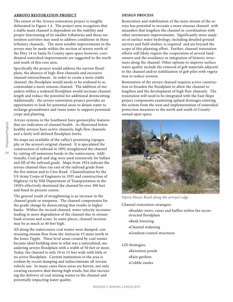
Opera House Road along the arroyo’s edge
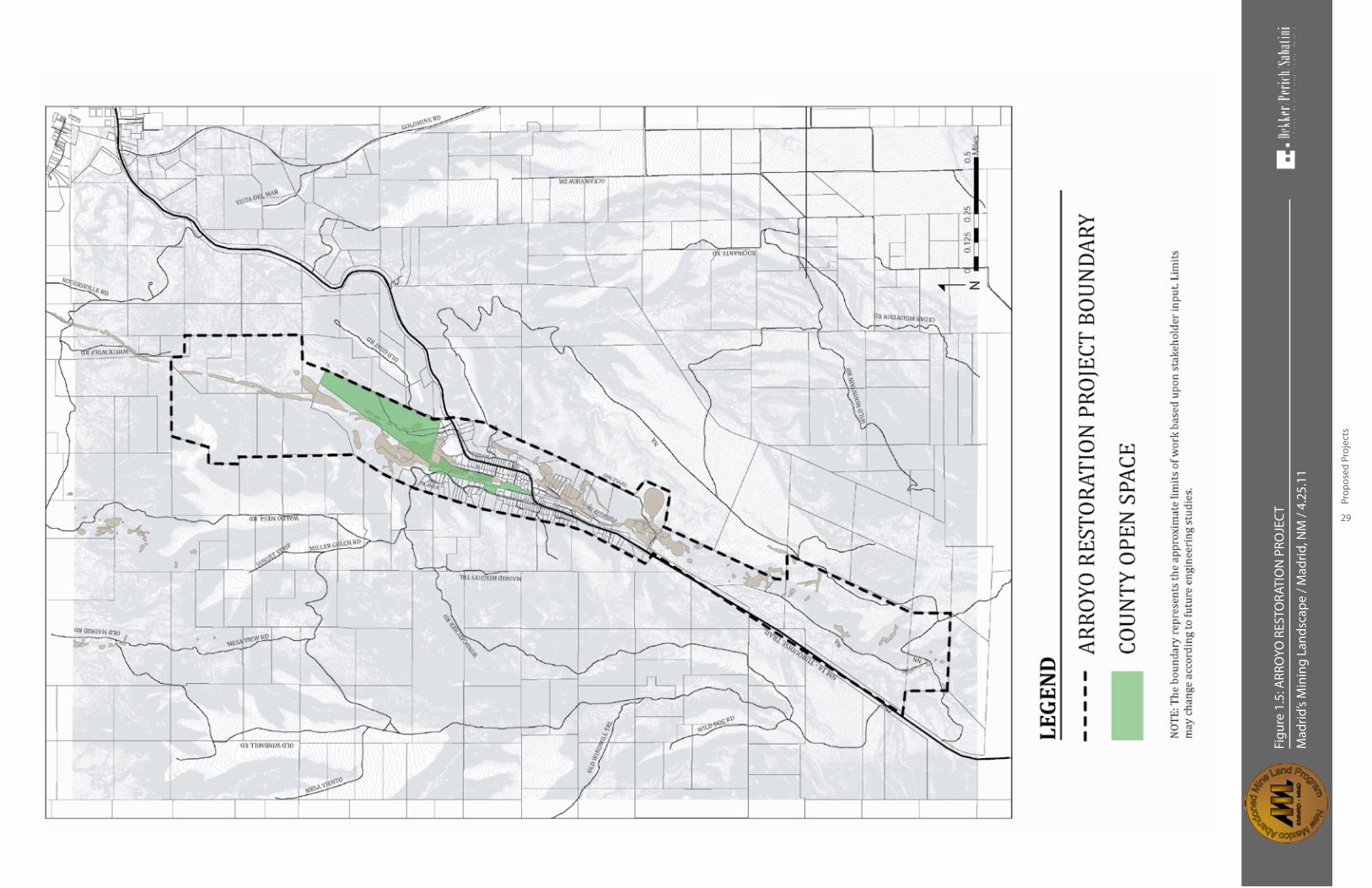
ARROYO RESTORATION PROJECTThe extent of the Arroyo restoration project is roughly delineated in Figure 1.4. The project area recognizes that a stable main channel is dependent on the stability and proper functioning of its smaller tributaries and those res-toration activities may need to address conditions in these tributary channels. The most notable improvements to the arroyo may be made within the section of arroyo north of the Hwy 14 in Santa Fe County open space however, coor-dinated watershed improvements are suggested to the north and south of this core area.Specifically the project would address the narrow flood-plain, the absence of high-flow channels and excessive channel entrenchment. In order to create a more stable channel, the floodplain would needs to be widened to ac-commodate a more sinuous channel. The addition of me-anders within a widened floodplain would increase channel length and reduce the potential for additional downcutting. Additionally , the arroyo restoration project provides an opportunity to look for potential areas to detain water to recharge groundwater and reuse water to support perennial crops and planting.Arroyo systems in the Southwest have geomorphic features that are indicators of channel health. As illustrated below healthy arroyos have active channels, high flow channels and a fairly well defined floodplain limits. No maps are available of the valley’s premining topogra-phy or the arroyo’s original channel. It is speculated the construction of railroad in 1892 straightened the channel by cutting off numerous bends in the watercourse. Addi-tionally, Coal gob and slag were used extensively for ballast and fill of the railroad grade. Maps from 1924 indicate the arroyo channel then ran east of the railroad grade from the fire station and to Cave Road. Channelization by the US Army Corps of Engineers in 1935 and construction of Highway 14 by NM Department of Transportation in the 1950’s effectively shortened the channel by over 300 feet and fixed its present course. The general result of straightening is an increase in the channel grade or steepness. The channel compensates for the grade change by downcutting that results in higher banks. Within the incised channel, water velocity increases leading to more degradation of the channel due to stream-bank erosion and scour. In some places, channel incision may be as much as 40 feet high.All along the watercourse coal wastes were dumped, con-straining stream flow from the Antracite #3 mine north to the Jones Tipple. These level areas created by coal wastes became ideal building sites in what was a naturalized, me-andering arroyo floodplain with a width of 50 feet or more. Today, the channel is only 10 to 15 feet wide with little or no active floodplain. Current inattention to the area is evident by recent dumping and indiscriminate all-terrain vehicle use. In many cases these areas are barren, not only creating excessive dust during high winds, but also increas-ing the delivery of coal mining wastes to the channel and potentially impacting water quality.
DESIGN PROCESSRestoration and stabilization of the main stream of the ar-royo has potential to recreate a more sinuous channel with meanders that lengthen the channel in coordination with other stormwater improvements. Significantly more analy-sis of surface water hydrology, including detailed ground surveys and field studies, is required and are beyond the scope of this planning effort. Further, channel restoration efforts will likely require the cooperation of several land-owners and the avoidance or integration of historic struc-tures along the channel. Other options to improve surface water quality include the removal of gob materials adjacent to the channel and/or stabilization of gob piles with vegeta-tion to reduce erosion. Restoration of the arroyo channel requires active construc-tion to broaden the floodplain to allow the channel to lengthen and the development of high flow channels. The restoration will need to be integrated with the East Slope project components examining upland drainages entering the system from the west and implementation of watershed protection measures to the north and south of County-owned open space.
Channel restoration strategies:•Boulder weirs, vanes and baffles within the recon-structed floodplain•Bank lowering•Channel widening•Gradient control structures
LID Strategies:•Retention ponds•Rain gardens•Cobble swales

Mad
rid’s
Min
ing
Land
scap
e / M
adrid
, NM
/ 4.
25.1
1
25
Pro
pose
d Pr
ojec
ts
Figu
re 1
.4: H
ISTO
RIC
CHA
NN
ELIZ
ATIO
N O
F A
RRO
YO

27
Prop
osed
Pro
ject
s
MADRID ’S MINING LANDSCAPE
Potential arroyo restoration with gabion gradient control structures
Potential arroyo restoration includes passive water harvesting in detention areas that feed community gardens and enhance the water table
Potential arroyo treatment with trails and intrepretive exhibit
Conventional engineering strategies:•Stormwater conveyance to move high flows safely to the main channel of the arroyo•Road grade improvement to better handle water con-veyance
IMPLEMENTATION STEPSCurrent steps underway:
•Wilson and Company engineers are surveying the vil-lage to develop maps.•URS corporation is providing engineering and techni-cal services to develop a drainage master plan for the village
Regulatory Strategies:•Limit dumping, and ATV use to open space lands in Madrid•Implement (amend) County Open Spaces and Trails master plan to include the Arroyo Restoration•Dedicate public rights-of way •EA/Archaeological clearances •Contracting Engineering firm for design•Design Approvals•Bidding/negotiation/contract development•Construction

MADRID ’S MINING LANDSCAPE
28
Part
ners
hips
Mad
rid’s
Min
ing
Land
scap
e / M
adrid
, NM
/ 4.
25.1
1
29
Pro
pose
d Pr
ojec
ts
Figu
re 1
.5: A
RRO
YO R
ESTO
RATI
ON
PRO
JEC
T
31
The
Path
For
war
d
MADRID ’S MINING LANDSCAPE
1.4 THE PATH FORWARD

MADRID ’S MINING LANDSCAPE
32
Tim
elin
e

33
The
Path
For
war
d
MADRID ’S MINING LANDSCAPE
THE PATH FORWARD
For the Abandoned Mine Land Program, the Madrid Mining Landscape Plan represents not only an innovative approach to accomplishing its mission, but a much broader view of what the restoration of historic mine lands can achieve. This is evident in both the projects identified with the community, and how the planning process was executed. These innovations include:
•Working with a broad range of stakeholders to identify projects through a community-based planning process; •Selecting and developing mine reclamation projects on a watershed basis;•Promoting projects that involve multiple property owners and provide benefits to the larger community as well as to individual property owners;•Applying low-impact development technologies in a rural area and within a local context;•Integrating the cultural landscape and the physical land-scape in the scope and type of projects; and•Encouraging the use of local materials in project implemen-tation.
These innovations, taken together, suggest a path to take dur-ing the plan’s implementation. They were helpful to both the community and AML, and continuing to follow them will help assure project success. For example, it will be useful to continue to work with a broad range of stakeholders during the imple-mentation of each project, as increasingly specific and technical information is developed, and other consultants and organiza-tions are involved. This manner of outreach and planning will reinforce the sense of investment the community has in the plan, and recognizes the importance of ongoing cooperation among individual property owners. The process and manner of communication and planning, therefore, are substantively part of the engineering, funding and construction of the projects. This begins with clearly outlining the roles and responsibilities of various groups.
ORGANIZATIONAL ROLES AND RESPONSIBILITIES Successful implementation of this plan will require coopera-tion between agencies—including AML, NMDOT, and Santa Fe County—and local landowners and community groups. Poten-tial roles and responsibilities for each group are outlined below. In addition, Appendix B lists these in a matrix format. The planning team also envisions these groups to forming partner-ships to secure and manage additional funds for value-added, or community specific projects to AML’s more focused efforts. Prospective grants and loan programs are identified in the ap-pendix. Potential roles and responsibilities are outlined below:Landowners- Because project geography is watershed based, projects will require close cooperation among landowners. Parcels owned by non-participating landowners will be ex-cluded from the design and may result in less effective solutions. Landowners will be asked to participate in project design and may need to allow some level of access to their property. Access may mean engineering assessments and possible constructed improvements. Civic groups- Civic groups have the capability of leading project planning and implementation efforts. Planning assis-tance may include communications, outreach and introduc-tions, advocacy and organization. Implementation efforts may include organizing volunteers, acting as a community liaisons at construction meetings or taking over the Madrid Mining Land-scape website. Also, the Madrid civic groups may write grants for additional funding for construction, maintenance or opera-tions of built facilities. In addition, the Madrid civic groups may take a leadership role in seeking and acquiring funding for cisterns to actively reuse harvested stormwater. Non-Governmental Organizations (NGO)- Non-governmen-tal and non-profit groups may be resources for grant writing, proposal development, project administration, and outreach to volunteers. Utilizing another organizations’ proven track record of project administration is a method Madrid residents may use to leverage and broaded access to resources.County- Staff at Santa Fe County have been actively involved in the planning for AML projects and are anticipating continuing involvement through the design and construction of improve-ments. AML, the County and the Planning Team are actively defining the scope of county involvement in the operations and maintenance of drainage facilities. The County may also play a role in advocating and enforcing codes that support the projects in this plan.AML– AML will be the sponsor of engineering, geotechnical, and drainage reports, engineering and design, construction and minor maintenance of improvements. Though AML’s orga-nizational authority sunsets in 2021, it has the opportunity to develop relationships with multiple stakeholders to perpetuate its mission.
A cobble-lined swale emptying onto Cave Road
MADRID ’S MINING LANDSCAPE
34
Tim
elin
e
viewshed analyses will be used to guide project-specific deci-sions that may impact the overall historic landscape. Santa Fe County. The village of Madrid is not an incorporated municipality so Santa Fe County reviews requests for changes in land uses and building permits. The County is also respon-sible for the County Open Space. Representatives from Santa Fe County, most notably Beth Mills, Open Space Planner, has participated in the overall planning process. In January of 2011, John Kretzmann, Ken Romig and community repressenta-tives presented an overview of the Madrid’s Mining Landscape project to the Santa Fe County Commission, with a request for a more active partnership between AML and the County. The County Commission directed the County Manager to work with AML on the implementation of the projects. As project plans move from concept to schematic design, coordination with the County will range from conceptual review to technical review of proposed watershed improvements, County review of proposed drainage structures and open space lands, and consultation on any projects impacting County lands. New Mexico Department of Transportation (NMDOT). The NMDOT has jurisdiction over New Mexico State Road 14. Any projects that impact the roadway, such as culverts, swales, and other stormwater management improvements, will require co-ordination and review with NMDOT. NMDOT may ultimately assume ownership and control of some improvements such as drainage structures adjacent to the roadway. Early consultations on project designs will help identify potential conflicts between proposed improvements and NMDOT standards. At the very least, NMDOT District Five engineers and officials shall receive courtesy copies of reclamation plans.
AML may need assistance to have the Madrid Mining Land-scape plan succeed . As community projects begin to take shape, AML may require community liaison support to facili-tate communication between themselves, stakeholders and landowners. Liaison activities may take the form of individual conversations, civic group presentations, meetings with county staff and officials, state interagency meetings, or community meetings Good communications are crucial to realizing the vision of the community plan. This report recommends that AML and its consultants and stakeholders share schedules, milestones and significant information (including reports and assessments) on a regular basis. Access and distribution of this information may follow the same paths established by this plan or other, more appropriate venues as determined by AML.
COORDINATION WITH LANDOWNERSAs part of the geotechnical and stormwater studies, the con-sultants may need access to private property. Property owners will receive requests for entry which will allow the engineers to collect information. Once solutions are proposed, they will be presented to the community and AML will request permission from various property owners to do work on their property. If a property owner does not allow work on their property, the engineers will design around that property owner to make it work for the entire community. As much as possible, the designs will not impede upon private property owners, but will attempt to push all infrastructure into the public right-of-way.
COORDINATION WITH STATE AND LOCAL AGENCIESDue to their comprehensive nature, the East Slope Reclamation Project and the Arroyo Restoration projects will require coor-dination and review by multiple agencies. Listed below are the agencies and elements of the projects that may require review, coordination, and approvals. It is assumed that the community-based planning approach used during project planning plan-ning is important for successful project implementation, and that AML will continue to solicit input from stakeholders and Madrid’s civic groups. The State Historic Preservation Office (SHPO). Since the Village of Madrid Historic District is on the National Register of Historic Places, alterations to not only buildings but also the overall “cultural landscape” may require review by SHPO. Dur-ing the course of the planning phase, the project team conduct-ed a preliminary viewshed analysis to identify which gob piles are most prominent and contribute to the overall identity of the town. (The exhibits from the Viewshed Analysis can be found in the Task Two Report) As part of the community planning process, the project team consulted with SHPO about proposed improvements and the implications on SHPO’s responsibility to preserve the historic landscape. In September of 2011 repre-sentatives of SHPO and project team members toured Madrid to better understand what aspects of the landscape may be impacted by improvements to the watershed and arroyo. As a result of the consultations with SHPO, AML requests that SHPO receive and provide courtesy reviews of reclamation plans. The

35
The
Path
For
war
d
MADRID ’S MINING LANDSCAPE
BENEFITS OF THE PLANS’ IMPLEMENTATIONWith the plans’ implementation, we foresee several gen-eral, specific and intangible benefits to the quality life for residents of Madrid; and the accomplishment of the Abandoned Mine Land programs mission. General benefits relate to those improvements affecting the larger quality of life for all community members. Specific benefits are those attributed to an individual landowner.
General Benefits:Critical stormwater and flooding issues are corrected• Surface water quality and air quality may improve• Stormwater is managed as a community resource• Public open space is revegetated and upgraded • History of Madrid is interpreted by signage describing • AML reclamationWildlife corridors from the Galisteo River to the Ortiz • Mountains are enhanced.Access by public safety vehicles is improved•
Specific Benefits:Vehicular access to homes and businesses is improved • Property damage from sedimentation and stormwater • is reduced
Madrid may choose to measure or monitor these elements as indicators as watershed health with the help of water-shed groups. It is likely however, that these benefits will be assessed in community conversations and partnership dialogues as improvements are constructed.
We are HERE (as of the date of this plan)
TIMELINEWork has already begun on the implementation of this community plan. AML has undertaken a stormwater management study and a geotechnical study It is anticipated that the various engineering studies, environmental clearances, archaeological surveys, and preparation of the construction documents will take approximately two years. See the associated timeline below.
Intangible Benefits:This plan may give planning partners the opportunity to begin constructive dialogues that address issues that do not fall under AML’s funding parameters.The NM Abandoned Mine Land program confidently addressed its obligations to the legacy of coal mining in Madrid