Embed Size (px)
Citation preview

PCF XXX PRODUCT NAME | VERSION 1.0 | 25 SEPTEMBER 2013 | 5124654
[Scheme Name] [Scheme Number TR100xx]
1.3 Introduction to the Application APFP Regulation 5(2)(q)
Planning Act 2008
Infrastructure Planning (Applications: Prescribed Forms and Procedure)
Regulations 2009
Volume [x]
[M th/ ]
Regulation 5(2)(a)
Planning Act 2008
Infrastructure Planning (Applications: Prescribed Forms and Procedure) Regulations 2009
January 2019
M42 Junction 6 Improvement Scheme Number TR010027
Volume 6 6.3 Environmental Statement
Appendix 7.2 Ground Investigation Archaeological Monitoring Report

M42 Junction 6 Improvement Environmental Statement
Planning Inspectorate Scheme Ref: TR010027 Application Document Ref: TR010027/APP/6.3
Infrastructure Planning
Planning Act 2008
The Infrastructure Planning (Applications: Prescribed Forms and Procedure) Regulations 2009
M42 Junction 6 Improvement Development Consent Order 201[- ]
6.3 Environmental Statement
Appendix 7.2 Ground Investigation Archaeological Monitoring Report
Regulation Number Regulation 5(2)(a) Planning Inspectorate Scheme Reference
TR010027
Application Document Reference 6.3 Author M42 Junction 6 Improvement Project Team and
Highways England
Version Date Status of Version 1 January 2019 DCO Application

MFTJ18
M42 Junction 6 Improvement Scheme
Solihull, Birmingham
Ground Investigation Monitoring
Prepared on behalf of Interserve Construction Ltd

PROJECT SUMMARY SHEET
Client Interserve
National Grid Reference
N. G. R 418564, 280373
Address Solihull, Birmingham, Warwickshire
Parish: Solihull Council: Solihull Council
OASIS ref.: 317425
Archive will be deposited with: Warwick Museum
Project Manager: Michael Tierney
Author: Beth Doyle
Edited and approved by: Michael Tierney
Fieldwork: Hayley L. Goacher, Bonnie Knapp, Beth Doyle
and Astrid L. Nathan
Graphics: Julia Bastek-Michalska
Schedule
Fieldwork: 26/01/18-22/02/18 and 08/05/18-14/05/18
Report: May 2018

Headland Archaeology
M42 Junction 6 Improvement Scheme Solihull, Birmingham MFTJ18
- 2 -
CONTENTS
1 ....... INTRODUCTION .......................................................................................................................... 4
2 ....... SITE LOCATION AND DESCRIPTION ...................................................................................... 4
3 ....... ARCHAEOLOGICAL AND HISTORICAL BACKGROUND .................................................... 4
4 ....... METHODOLOGY ......................................................................................................................... 4
4.1 Recording ............................................................................................................................. 4
5 ....... CONCLUSION .............................................................................................................................. 5
6 ....... REFERENCES ............................................................................................................................... 5
7 APPENDICES .................................................................................................................................. 6
APPENDIX 1 TEST PIT DESCRIPTIONS ........................................................................................... 6
APPENDIX 2 PHOTOGRAPHIC REGISTER ................................................................................... 16
APPENDIX 3 OASIS FORM .............................................................................................................. 23

Headland Archaeology
M42 Junction 6 Improvement Scheme Solihull, Birmingham MFTJ18
- 3 -
M42 JUNCTION 6 IMPROVEMENT SCHEME
Ground Investigation Monitoring
Summary
Headland Archaeology (UK) Ltd undertook archaeological monitoring of groundworks associated with the improvement
scheme works on the M42 at Junction 6 near Solihull, Birmingham. This work was undertaken to provide information on
the archaeological potential of the site and consisted in monitoring geotechnical investigation (GI) alongside the
geotechnical contractor.
No archaeological remains or finds were identified.

Headland Archaeology
M42 Junction 6 Improvement Scheme Solihull, Birmingham MFTJ18
- 4 -
1 INTRODUCTION
Headland Archaeology Ltd was commissioned by Intererve to undertake a programme of archaeological works in
connection with the improvement works at Junction 6 of the M42 near Solihull, Birmingham.
A brief was prepared by Rachel Wood, Archaeological Consultant with AECOM outlining the archaeological works
needed to fulfil the Planning Inspectorate requirements. AECOM then prepared a Written Scheme of Investigation (WSI)
(AECOM, 2017, 5) on behalf of Highways England setting out the proposed strategy for archaeological mitigation.
There were no archaeological features found.
2 SITE LOCATION AND DESCRIPTION
The proposed scheme is located to the west of the existing M42 Junction in the area of green belt between Junction 5 and
Junction 6; the development creates tie-in points to the existing Strategic Road Network (SRN) at the following locations;
M42 Clock Interchange (SP: 18778 82970) and a proposed junction (SP: 19307 81306); and junction enhancements at the
existing M42 Junction 6 (SP: 19819 83061) (AECOM, 2017, 5).
The bedrock geology of the site consists of Branscombe and Sidmouth formations of mudstone as well as Arden Sandstone
Formation. The superficial geology consists of Glaciofluvial deposits (sand and gravel) and alluvium (clay, silt, sand and
gravel), although these are patchy (http://mapapps.bgs.ac.uk/geologyofbritain/home.html). (AECOM, 2017, 5).
3 ARCHAEOLOGICAL AND HISTORICAL BACKGROUND
The following summary is collated from the WSI. The archaeological remains found in the area include those dating from
the Mesolithic (10,000 BC-3,500 BC) up to the Modern (1901-Present). Evidence for the Prehistoric include small finds
such as flint blades and a copper palstave axe (AECOM, 2017, 5). Evidence of Roman (43 AD-450 AD) activity is mostly
limited to pottery, although some of the cropmarks may be from Romano-British activity. (AECOM, 2017, 5-6)
The Early Medieval (450 AD-1066 AD) activity is represented by the evidence of woodland clearances and expansion of
land cultivation (AECOM, 2017, 6). The Medieval period (1066 AD-1500 AD) was a time of great expansion as
settlements were established in the area such as the nearby Hampton-in-Arden and Bickenhill, as well as three further
Deserted Medieval Villages. (AECOM, 2017, 6)
There were also three moated sites including two scheduled monuments in the study area, Moat House (List number:
10172430) and the Moated site at Eastcote Hall (List number: 1017529) (AECOM, 2017, 5).
In the Post-medieval period (1500-1900) the area stayed largely rural despite the industrial expansion of Birmingham
nearby. The most significant change came about when Birmingham airport was opened in the early 20th century (AECOM,
2017, 6).
4 METHODOLOGY
Monitoring was carried out in accordance with the WSI (AECOM, 2017) and involved archaeological observation,
investigation and recording during all geotechnical investigation groundworks. The numbering for the Test Pits follows
that of the ground investigations team.
Archaeological monitoring was undertaken over the course of two periods of activity 26/01/18-22/02/18 and 08/05/18-
14/05/18 during which the excavation of 31 test pits were monitored.
4.1 Recording
All recording was in accordance with the code of practice of the Chartered Institute for Archaeologists (CIfA, 2014a and
2014b). Contexts were given unique numbers. All recording was undertaken on pro forma record cards that conform to
accepted archaeological standards. All stratigraphic relationships were recorded.

Headland Archaeology
M42 Junction 6 Improvement Scheme Solihull, Birmingham MFTJ18
- 5 -
An overall site plan at an appropriate scale and relative to the National Grid was compiled. The site plan was accurately
tied in to the National Grid and a scale version is shown in (Illus 1).
A digital photographic record was taken and a metric scale was clearly visible in record photographs.
The technical detail of contextual information can be found in Appendix 1. Context numbers for deposits are expressed in
parenthesis, i.e. (001), cuts of features are expressed in brackets, i.e. [003].
Where no archaeological remains are encountered, a photographic record was taken of the trial pit and a written description
with sketch section were produced (AECOM, 2017, 8).
4.2 Results
Thirty-one test pits were excavated across the scheme in clusters of up to five test pits in one field (Illus. 2 and 3). The test
pits were between 3.0m-5.00m long, 0.40m-1.00m wide and 2.50m-4.50m deep (Appendix 1). The excavations in late
January to late February had difficult ground conditions due to heavy rains, which resulted in high ground water and Health
and Safety restrictions. The excavations were postponed to later in the year to benefit from early May optimal ground
conditions.
Subsoil was present in 26 of the test pits; the exceptions being test pits 502, 504, 513 and 703. Test pit 702 did not contain
any geological substrate as it was excavated within a thick made ground bank adjacent to the M42 motorway and the
geological substrate was not reached by mechanical excavation.
Of the 31 test pits, seven contained one or more modern land drains: 303, 307, 500, 509, 511, 513 and 702. The drains
consisted of either a red ceramic or a plastic pipe (Illus. 4). Six of the land drains were less than 1.00m below the surface;
the exception being the one that was below the made ground in test pit 702 at depth of c1.3m.
Three of the test pits, 700, 701 and 702, consistently contained a made ground which was between 0.77m-2.2m thick. This
is likely from the original works to build the M42. The made ground contained plastic sheeting, brick fragments, concrete
and other modern debris within a sand, clay silt matrix (Illus. 5).
5 CONCLUSION
No archaeological remains were found during the investigation and no further archaeological investigations are required at
these locations based on these results.
6 REFERENCES
AECOM, 2017. M42 Junction 6 Improvement Scheme Written Scheme of Investigation Ground Investigation Monitoring
Highways England.
Chartered Institute for Archaeologists (CIfA) 2014b. Standard and guidance for archaeological field evaluation.
https://www.archaeologists.net/sites/default/files/CIfAS&GFieldevaluation_1.pdf. Accessed 18/05/18

Headland Archaeology
M42 Junction 6 Improvement Scheme Solihull, Birmingham MFTJ18
- 6 -
7 APPENDICES
APPENDIX 1 – TEST PIT DESCRITPTIONS
TP101
L (m) W (m) Max. D (m)
3.50m 0.62m 4.00m
Context Description
10101 Topsoil - Mid greyish brown silty clay
with occasional amounts of small sub-
rounded pebbles, occasional amounts of
charcoal fragments and occasional
amounts of modern pottery fragments
0.26m
10102 Subsoil - Light yellowish grey sandy clay
with occasional amounts of small angular
stones
0.11m
10103 Geological substrate - Light grey/ blue
sandy clay with occasional amounts of
medium sized pebbles, mixed with bands
of light brownish red sandy clay
0.37m-
4.00m
Summary
No archaeological remains.
TP102
L (m) W (m) Max. D (m)
3.50m 0.70m 4.50m
Context Description
10201 Topsoil - Dark greyish brown silty clay
with rooting and occasional/ moderate
amounts of pebbles
0.30m
10202 Subsoil - Light yellowish grey silty clay
with occasional amounts of small sub-
rounded pebbles
0.55m
10304 Geological substrate - Mid reddish brown
sandy clay with no inclusions
0.55m-
4.50m
Summary
No archaeological remains.
TP103
L (m) W (m) Max. D (m)
3.00m 0.65m 4.50m
Context Description
10301 Topsoil - Dark greyish brown silty clay
with rooting and occasional amounts of
pebbles
0.35m
10302 Subsoil - Light yellowish grey silty clay
with occasional amounts of small
rounded pebbles
0.25m

Headland Archaeology
M42 Junction 6 Improvement Scheme Solihull, Birmingham MFTJ18
- 7 -
10303 Geological substrate - Light reddish grey
sandy clay
0.60m-
4.50m
Summary
No archaeological remains.
TP104
L (m) W (m) Max. D (m)
5.00m 2.00m 4.50m
Context Description
10401 Topsoil - Greyish brown slightly silty
clay with occasional amounts of pebbles
and occasional farming debris
0.35m
10402 Subsoil - Light yellowish grey slightly
silty clay undulating over natural with
occasional amounts of pebble inclusions
0.10m
10403 Geological substrate- Brownish red
slightly sandy clay with occasional
amounts of pebbles and bands of bluish
grey clay. Very sterile
0.45m-
4.50m
Summary
No archaeological remains.
TP300
L (m) W (m) Max. D (m)
3.20m 0.70m 4.00m
Context Description
30001 Topsoil - Mid dark brownish grey silty
clay with occasional amounts of small/
medium pebbles
0.23m
30002 Subsoil - Light yellowish grey sandy clay
with occasional amounts of small
rounded stones and occasional-moderate
amounts of charcoal fragments
0.09m
30003 Geological Substrate- Light reddish
brown sandy clay. Sterile
0.32m-
4.00m
Summary
No archaeological remains.
TP301
L (m) W (m) Max. D (m)
3.00m 0.60m 4.20m
Context Description
30101 Topsoil - Light brownish grey sandy clay
with a moderate amount of moderately
sorted small- medium sized rounded
pebbles
0.21m
30102 Subsoil - Thin band of light yellowish
grey sandy clay with moderate amounts
of small rounded pebbles
0.16m

Headland Archaeology
M42 Junction 6 Improvement Scheme Solihull, Birmingham MFTJ18
- 8 -
30103 Geological substrate - Mid brownish red
sandy clay with occasional amounts of
small rounded pebbles. Clean deposit
0.37m-
4.20m
Summary
No archaeological remains.
TP303
L (m) W (m) Max. D (m)
3.20m 0.62m 4.20m
Context Description
30301 Topsoil - Mid brownish grey silty clay
with occasional amounts of rounded
pebbles and moderate amounts of
charcoal fragments
0.30m
30302 Subsoil - Light greyish yellow with
occasional- moderate amounts of
medium sized pebbles
0.10m
30303 Fill of modern drain - Mid greyish brown
silty clay with moderate amounts of
medium sized pebbles
0.02m
30304 Cut of shallow linear - Modern land drain 0.02m
30305 Geological substrate - Mid brown sandy
clay with occasional amounts of pebbles
0.40m-
4.20m
Summary
No archaeological remains.
TP305
L (m) W (m) Max. D (m)
3.90m 0.70m 4.20m
Context Description
30501 Topsoil - Mid brownish grey sandy silt 0.44m
30502 Subsoil - Light orangy grey sandy silt 0.16m
30503 Geological substrate - Dark orangy red
silty sand with moderate amounts of
rounded gravel and occasional grey
patches
0.60m-
4.20m
Summary
No archaeological remains.
TP306
L (m) W (m) Max. D (m)
3.00m 0.75 4.00m
Context Description
30601 Topsoil - Mid brown grey silty clay with
occasional amounts of rounded pebbles
0.33m
30602 Subsoil - Light greyish yellow sandy clay
with occasional to moderate amounts of
pebbles
0.22m

Headland Archaeology
M42 Junction 6 Improvement Scheme Solihull, Birmingham MFTJ18
- 9 -
30603 Geological substrate - Mid reddish brown
sandy clay with sandy light yellowish-
brown clay bands
0.55m-
4.00m
Summary
No archaeological remains.
TP307
L (m) W (m) Max. D (m)
3.00m 0.70m 3.60m
Context Description
30701 Topsoil - Dark greyish brown silty clay
with moderately small pebbles
0.32m
30702 Subsoil - Light greyish yellow sandy clay
with occasional amounts of small pebbles
0.30m
30703 Geological substrate - Light yellow
sandy clay band. Sterile.
0.62m-
3.60m
30704 Fill of modern land drain - Light grey
brown silty clay with occasional amounts
of small angular gravels and moderate
amounts of bright red ceramic fragments
0.25m
30705 Cut of modern land drain 0.25m
Summary
No archaeological remains.
TP308
L (m) W (m) Max. D (m)
3.00m 0.85m 4.50m
Context Description
30801 Topsoil - Mid greyish brown silty clay
with occasional - moderate amounts of
sub-rounded pebbles
0.35m
30802 Subsoil - Light greyish yellow sandy clay
with moderate amounts of small sub-
rounded pebbles
0.15m
30803 Geological substrate - Clean mid reddish
brown sandy clay
0.50m-
4.50m
Summary
No archaeological remains.
TP309
L (m) W (m) Max. D (m)
3.00m 0.70m 2.50m
Context Description
30901 Topsoil - Mid brownish grey silty clay
with moderate amounts of small rounded
pebbles
0.30m
30902 Subsoil - Mid greyish yellow sandy clay
with moderate amounts of small sub-
rounded pebbles
0.21m

Headland Archaeology
M42 Junction 6 Improvement Scheme Solihull, Birmingham MFTJ18
- 10 -
30903 Geological substrate - Mid reddish brown
clean sandy clay with occasional
amounts of small rounded pebbles
0.51m-
2.50m
Summary
No archaeological remains.
TP310
L (m) W (m) Max. D (m)
3.80m 0.72m 3.20m
Context Description
31001 Topsoil - Dark brownish grey silty clay
occasional amounts of small roundish
pebbles
0.40m
31002 Subsoil - Light yellowish grey sandy clay
with occasional amounts of small- large
sized pebbles
0.14m
31003 Geological substrate - Light reddish
brown sandy clay. Sterile deposit
0.60m-
3.20m
Summary
No archaeological remains.
TP311
L (m) W (m) Max. D (m)
3.00m 0.70m 4.50m
Context Description
31101 Topsoil - Mid grey brown silty clay with
occasional- moderate amounts of small -
medium sized sub- rounded pebbles
0.40m
31102 Subsoil - Light greyish yellow sandy clay
with moderate- frequent amounts of
medium- large sized pebbles
0.20m
31103 Geological substrate - Clean mid orange
sandy clay with patches of light grey
sandy clay
0.60m-
4.50m
Summary
No archaeological remains.
TP316
L (m) W (m) Max. D (m)
N/A N/A N/A
Context Description
N/A N/A N/A
Summary
There is no written record of this test pit
TP317
L (m) W (m) Max. D (m)

Headland Archaeology
M42 Junction 6 Improvement Scheme Solihull, Birmingham MFTJ18
- 11 -
3.30m 0.70m 4.00m
Context Description
31701 Topsoil - Light brownish grey friable
silty clay with occasional amounts of
small rounded pebbles
0.28m
31702 Subsoil - Light yellowish grey silty clay
with moderate amounts of small rounded
pebbles
0.18m
31703 Geological substrate - Light yellowish
brown sandy clay with occasional
amounts of small- medium sized sub-
rounded pebbles
0.46m-
4.00m
Summary
No archaeological remains.
TP319
L (m) W (m) Max. D (m)
3.30m 0.78m 4.20m
Context Description
31901 Topsoil - Dark greyish brown silty clay
with occasional- moderate amounts of
small sub- rounded pebbles, occasional
Victorian porcelain fragments and
charcoal fragments
0.23m
31902 Subsoil - Light greyish yellow sandy clay
with small- medium amounts of sub-
rounded pebbles
0.12m
31903 Geological substrate - Mid brownish red
sandy clay with occasional amounts of
charcoal fragments and occasional-
moderate amounts of rounded pebbles
0.35m-
4.20m
Summary
No archaeological remains.
TP320
L (m) W (m) Max. D (m)
3.30m 0.70m 4.00m
Context Description
32001 Topsoil - Light greyish brown silty clay
with moderate amounts of small rounded
pebbles
0.21m
32002 Subsoil - Light greyish yellow sandy clay
with moderate amounts of small-
medium sized sub- rounded pebbles and
occasional charcoal flecks
0.11m
32003 Geological substrate - Light yellowish
brown sandy clay with occasional
amounts of small- medium sized rounded
pebbles
0.32m-
4.00m
Summary
No archaeological remains.
Headland Archaeology
M42 Junction 6 Improvement Scheme Solihull, Birmingham MFTJ18
- 12 -
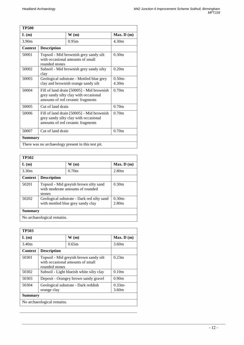
TP500
L (m) W (m) Max. D (m)
3.90m 0.95m 4.30m
Context Description
50001 Topsoil - Mid brownish grey sandy silt
with occasional amounts of small
rounded stones
0.30m
50002 Subsoil - Mid brownish grey sandy silty
clay
0.20m
50003 Geological substrate - Mottled blue grey
clay and brownish orange sandy silt
0.50m-
4.30m
50004 Fill of land drain [50005] - Mid brownish
grey sandy silty clay with occasional
amounts of red ceramic fragments
0.70m
50005 Cut of land drain 0.70m
50006 Fill of land drain [50005] - Mid brownish
grey sandy silty clay with occasional
amounts of red ceramic fragments
0.70m
50007 Cut of land drain 0.70m
Summary
There was no archaeology present in this test pit.
TP502
L (m) W (m) Max. D (m)
3.30m 0.70m 2.80m
Context Description
50201 Topsoil - Mid greyish brown silty sand
with moderate amounts of rounded
stones
0.30m
50202 Geological substrate - Dark red silty sand
with mottled blue grey sandy clay
0.30m-
2.80m
Summary
No archaeological remains.
TP503
L (m) W (m) Max. D (m)
3.40m 0.65m 3.60m
Context Description
50301 Topsoil - Mid greyish brown sandy silt
with occasional amounts of small
rounded stones
0.23m
50302 Subsoil - Light blueish white silty clay 0.10m
50303 Deposit - Orangey brown sandy gravel 0.90m
50304 Geological substrate - Dark reddish
orange clay
0.33m-
3.60m
Summary
No archaeological remains.
Headland Archaeology
M42 Junction 6 Improvement Scheme Solihull, Birmingham MFTJ18
- 13 -
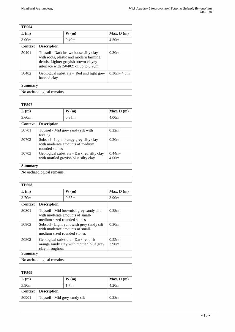
TP504
L (m) W (m) Max. D (m)
3.00m 0.40m 4.50m
Context Description
50401 Topsoil - Dark brown loose silty clay
with roots, plastic and modern farming
debris. Lighter greyish brown clayey
interface with (50402) of up to 0.20m
0.30m
50402 Geological substrate - Red and light grey
banded clay.
0.30m- 4.5m
Summary
No archaeological remains.
TP507
L (m) W (m) Max. D (m)
3.60m 0.65m 4.00m
Context Description
50701 Topsoil - Mid grey sandy silt with
rooting
0.22m
50702 Subsoil - Light orangy grey silty clay
with moderate amounts of medium
rounded stones
0.20m
50703 Geological substrate - Dark red silty clay
with mottled greyish blue silty clay
0.44m-
4.00m
Summary
No archaeological remains.
TP508
L (m) W (m) Max. D (m)
3.70m 0.65m 3.90m
Context Description
50801 Topsoil - Mid brownish grey sandy silt
with moderate amounts of small-
medium sized rounded stones
0.25m
50802 Subsoil - Light yellowish grey sandy silt
with moderate amounts of small-
medium sized rounded stones
0.30m
50802 Geological substrate - Dark reddish
orange sandy clay with mottled blue grey
clay throughout
0.55m-
3.90m
Summary
No archaeological remains.
TP509
L (m) W (m) Max. D (m)
3.90m 1.7m 4.20m
Context Description
50901 Topsoil - Mid grey sandy silt 0.28m

Headland Archaeology
M42 Junction 6 Improvement Scheme Solihull, Birmingham MFTJ18
- 14 -
50902 Subsoil - Light yellowy grey silty clay 0.08m
50903 Geological substrate - Light blueish grey
clay in a thick layer with dark orangy red
sandy clay underneath
0.36m-
4.20m
50904 Fill of modern land drain [50905] - a mix
of (50901), (50802) and (50903).
0.47m
50905 Cut of modern land drain 0.47m
Summary
No archaeological remains.
TP511
L (m) W (m) Max. D (m)
4.00m 0.70m 4.20m
Context Description
51101 Topsoil - Mid brownish grey sandy clay
with occasional amounts of small
rounded stones and moderate amounts of
ceramic building material (CBM)
0.38m
51102 Subsoil - Mid grey silty clay with
occasional amounts of small rounded
stones
0.17m
51103 Geological substrate - Light blueish grey
and mottled yellow sandy clay with
moderate amounts of medium rounded
stones
0.55m-
4.20m
51104 Fill of modern land drain [51105] - Mid
greyish brown silty clay
1.15m
51105 Cut of modern land drain 1.15m
Summary
No archaeological remains.
TP513
L (m) W (m) Max. D (m)
4.00m 0.65m 4.10m
Context Description
51301 Topsoil - Mid brownish grey sandy silt
with moderate amounts of small-
medium sized rounded stones
0.25m
51302 Geological substrate - Dark orangy red
with veins of blue grey sandy clay
0.25m-
4.10m
51303 Fill of modern land drain [51304] - Dark
orangy red with mottled blueish grey
0.50m
51304 Cut of modern land drain 0.50m
Summary
No archaeological remains.
TP700

Headland Archaeology
M42 Junction 6 Improvement Scheme Solihull, Birmingham MFTJ18
- 15 -
L (m) W (m) Max. D (m)
4.00m 1.00m 4.30m
Context Description
70001 Topsoil - Mid greyish brown with
demolition debris
0.25m
70002 Made ground - Mid brown grey rubble-
rich deposit into clayey silty sand matrix
with frequent amounts of brick
fragments, large lumps of broken
concrete, electric fence pegs, plastic
sheeting and other similar debris
1.25m
70003 Original topsoil - Dark brown grey peaty
deposit with occasional- medium
amounts of rounded pebbles
0.30m
70004 Original subsoil - Mid brown grey
alluvium
0.70m
70005 Geological substrate - Mid blueish grey
sand and river gravels
2.50m-
4.30m
Summary
No archaeological remains.
TP701
L (m) W (m) Max. D (m)
3.80m 0.70m 4.10m
Context Description
70101 Topsoil - Mid greyish brown with
occasional amounts of pebbles and red
brick fragments
0.33m
70102 Made ground - Mid brown grey sandy
silt matrix with gravel, concrete
fragments, brick fragments and
occasional cindery material and bits of
metal, wood, plastic and stones
0.67m
70103 Original ground surface - Very dark
brownish grey peaty deposit with
occasional amounts of pebbles
0.50m
70104 Original subsoil - Mixed deposit
composed of mid- dark greyish brown
alluvium clays and small- medium sized
gravels
0.40m
70105 Geological substrate - River clays and
gravels starting in a mid-blueish grey to a
reddish brown as it goes deeper
1.90m-
4.10m
Summary
No archaeological remains.
TP702
L (m) W (m) Max. D (m)
4.30m 0.70m 3.80m
Context Description

Headland Archaeology
M42 Junction 6 Improvement Scheme Solihull, Birmingham MFTJ18
- 16 -
70201 Topsoil - Mid grey sand silt with
frequent amounts of sub- rounded stones,
rooting, plastic sheeting and glass
0.10m
70202 Made ground - Mid reddish orange silty
clay with moderate amounts of small-
medium sized stones, plastic and small
lenses of blue grey clay
2.20m
70203 Original topsoil - Mid grey silty clay
with frequent amounts of sub- angular
gravel
0.60m
70204 Original subsoil - Dark blue- grey sandy
silt alluvium with moderate amounts of
rounded stones
2.90m-
3.80m
70205 Fill of modern land drain [70206] - Dark
blue- grey sandy silt alluvium with
moderate amounts of rounded stones
1.30m
70206 Cut of modern land drain 1.30m
Summary
No archaeological remains.
TP703
L (m) W (m) Max. D (m)
3.70m 0.70m 3.40m
Context Description
70301 Topsoil - Mid reddish brown sandy silt
with moderate rounded stones
0.36m
70302 Geological substrate - Light orangey red
silty clay with occasional blueish grey
silty clay
0.36m-
3.40m
Summary
No archaeological remains.
APPENDIX 2 PHOTOGRAPHIC REGISTER
Photo No Direction Description
1 E Pre-Ex TP307
2 N Pre-Ex TP307
3 SE Working shot TP307
4 S Working shot TP307
5 S Working shot TP307
6 E W-facing section TP307
7 S Test Pit Shot TP307
8 E W-facing section TP307
9 S Test Pit Shot TP307
10 E Modern drain in W-facing TP307 section
11 E Modern drain in W-facing TP307 section
12 E W-facing section TP307 without scale

Headland Archaeology
M42 Junction 6 Improvement Scheme Solihull, Birmingham MFTJ18
- 17 -
13 SE Working shot TP307
14 E Working shot TP307
15 S Fully excavated TP307
16 E TP307 Backfilled
17 E TP307 Backfilled
18 W Pre-Ex TP311
19 S Working shot TP311
20 SW Working shot TP311
21 SW Working shot TP311
22 E W-facing section TP311
23 E W-facing section TP311
24 NE W-facing section TP311
25 E W-facing section TP311
26 SW Working shot TP311
27 SW Backfilled TP311
28 SW Backfilled TP311
29 E Pre-Ex TP308
30 S Working shot TP308
31 S Working shot TP308
32 S Working shot TP308
33 SE NW-facing section TP308
34 SE NW-facing section TP308
35 SE NW-facing section TP308
36 SW Test Pit Shot TP308
37 SW Test Pit Shot TP308
38 SE NW-facing section TP308
39 SW Fully excavated TP308
40 SE Backfilled TP308
41 SW Backfilled TP308
42 S Pre-Ex TP306
43 S Pre-Ex TP306
44 SW Working shot TP306
45 SE Working shot TP306
46 SE W-facing section TP306
47 E W-facing section TP306
48 S Test Pit Shot TP306
49 E W-facing section TP306
50 S Fully excavated TP306
51 SW Backfilled TP306
52 W Backfilled TP306
53 NE Pre-Ex TP309
54 S Working shot TP309
55 S Working shot TP309

Headland Archaeology
M42 Junction 6 Improvement Scheme Solihull, Birmingham MFTJ18
- 18 -
56 S Working shot TP309
57 S Working shot TP309
58 SE NW-facing section TP309
59 NE Test Pit Shot TP309
60 SE NW-facing section TP309
61 SE NW-facing section TP309
62 SW Backfilled TP309
63 SE Working shot TP310
64 SW Working shot TP310
65 S Working shot TP310
66 S Working shot TP310
67 S Test Pit Shot TP310
68 S Test Pit Shot TP310
69 E W-facing section TP310
70 E W-facing section TP310
71 S Test Pit Shot TP310
72 S Test Pit Shot TP310
73 E W-facing section TP310
74 S Test Pit Shot TP310
75 E W-facing section TP310
76 E W-facing section TP310
77 SW Working shot TP310
78 SW Backfilled TP310
79 SW Pre-Ex TP301
80 S Working shot TP301
81 SW Test Pit Shot TP301
82 SW Test Pit Shot TP301
83 SE NW-facing section TP301
84 SE NW-facing section TP301
85 NE Test Pit Shot TP301
86 SW Test Pit Shot TP301
87 SE NW-facing section TP301
88 SE NW-facing section TP301
89 SE Backfilled TP301
90 SW Pre-Ex TP303
91 NW Working shot TP303
92 NW Working shot TP303
93 N Test Pit Shot TP303
94 N Test Pit Shot TP303
95 N Test Pit Shot TP303
96 W E-facing section TP303
97 SW E-facing section TP303
98 S Test Pit Shot TP303

Headland Archaeology
M42 Junction 6 Improvement Scheme Solihull, Birmingham MFTJ18
- 19 -
99 N Test Pit Shot TP303
100 W Plan shot of modern drain TP303
101 N Plan shot of modern drain TP303
102 N Plan shot of modern drain TP303
103 N Plan shot of modern drain TP303
104 S Plan shot of modern drain TP303 - half section
105 NW Working shot TP303
106 N Test Pit Shot TP303
107 NW Backfilled TP303
108 SW Pre-Ex TP319
109 SW Working shot TP319
110 W Test Pit Shot TP319
111 S N-facing section TP319
112 E Test Pit Shot TP319
113 W Test Pit Shot TP319
114 S N-facing section TP319
115 W Test Pit Shot TP319
116 S N-facing section TP319
117 W Test Pit Shot TP319
118 NW Backfilled TP319
119 S Working shot TP101
120 SE Working shot TP101
121 SE Working shot TP101
122 E W-facing section TP101
123 E W-facing section TP101
124 E W-facing section TP101
125 E W-facing section TP101
126 E W-facing section TP101
127 S Test Pit Shot TP101
128 SE Working shot TP101
129 E W-facing section TP101
130 E W-facing section TP101
131 S Test Pit Shot TP101
132 S Test Pit Shot TP101
133 S Working shot TP300
134 S Working shot TP300
135 S Test Pit Shot TP300
136 S Test Pit Shot TP300
137 S Test Pit Shot TP300
138 E W-facing section TP300
139 E W-facing section TP300
140 E W-facing section TP300
141 S Test Pit Shot TP300

Headland Archaeology
M42 Junction 6 Improvement Scheme Solihull, Birmingham MFTJ18
- 20 -
142 S Test Pit Shot TP300
143 SE Working shot TP300
144 W E-facing section TP300
145 W E-facing section TP300
146 S Test Pit Shot TP300
147 S Test Pit Shot TP300
148 W E-facing section TP300
149 SW Working shot TP317
150 SW Working shot TP317
151 SE NW-facing section TP317
152 SE NW-facing section TP317
153 SE Test Pit Shot TP317
154 SE Test Pit Shot TP317
155 SE Test Pit Shot TP317
156 SE Test Pit Shot TP317
157 SE Test Pit Shot TP317
158 SE NW-facing section TP317
159 SW Test Pit Shot TP317
160 SW Working shot TP317
161 SW Working shot TP317
162 SW Working shot TP317
163 SW Test Pit Shot TP320
164 SW Test Pit Shot TP320
165 SE NW-facing section TP320
166 SE NW-facing section TP320
167 SW Working shot TP320
168 SE NW-facing section TP320
169 SE NW-facing section TP320
170 SW Test Pit Shot TP320
171 SW Working shot TP320
172 SW Working shot TP320
173 SW Working shot TP320
174 S Backfilled TP320
175 SE Test Pit Shot TP103
176 SW NE-facing section TP103
177 SE Test Pit Shot TP103
178 E Backfilled TP103
179 E Working shot TP502
180 E Working shot TP502
181 SW NE-facing section TP502
182 NE SW-facing section TP502
183 NW Fully excavated TP502
184 NE Backfilled TP502

Headland Archaeology
M42 Junction 6 Improvement Scheme Solihull, Birmingham MFTJ18
- 21 -
185 SE Pre-Ex TP503
186 SE Test Pit Shot TP503
187 SE Working shot TP503
188 SW NE-facing section TP503
189 NE SW-facing section TP503
190 NE Pre-Ex TP305
191 NE Working shot TP305
192 NE Test Pit Shot TP305
193 SE NW-facing section of TP305
194 NW SE-facing section of TP305
195 NE Backfilled TP305
196 N Pre-Ex TP500
197 N Test Pit Shot TP500
198 E W-facing section of TP500
199 W E-facing section of TP500
200 E W. facing shot of land drain [50005]
201 W E-facing shot of land drain [50007]
202 N Fully excavated TP500
203 N Backfilled TP500
204 N Backfilled TP316
205 SE Pre-Ex TP509
206 NE SW-facing section of TP509 with land drain [50905]
207 N Working shot TP509
208 W NE-facing section of TP509
209 SE Fully excavated TP509
210 SE Backfilled TP509
211 S Pre-Ex TP511
212 S Test Pit Shot TP511
213 x Overhead shot of land drain [51105]
214 NE SW-facing section of TP511
215 SE Working shot TP511
216 NE SW-facing section of TP511
217 SW NE-facing section of TP511
218 SE Fully excavated TP511
219 SE Backfilled TP511
220 N Pre-Ex TP513
221 N Test Pit Shot TP513
222 x Overhead shot of land drain [51304]
223 W E-facing section of TP513
224 E W-facing section of TP513
225 NE Working shot TP513
226 N Fully excavated TP513
227 N Backfilled TP513

Headland Archaeology
M42 Junction 6 Improvement Scheme Solihull, Birmingham MFTJ18
- 22 -
228 W Pre-Ex TP507
229 W Test Pit Shot TP507
230 N S-facing section of TP507
231 N S-facing section of TP507
232 S N-facing section of TP507
233 W Fully excavated TP507
234 W Backfilled TP507
235 S Pre-Ex TP508
236 S Test Pit Shot TP508
237 E W-facing section of TP508
238 W E-facing section of TP508
239 SW Working shot TP508
240 S Fully excavated TP508
241 N Pre-Ex TP700 and 702
242 SSW Pre-Ex TP700
243 S Working shot TP701
244 S Test Pit Shot TP701
245 W Working shot TP701
246 W W-facing section TP701
247 NE Water course and made ground near TP701
248 SSW Other side of water course showing partially buried fence
249 S Fully excavated TP701
250 S Backfilled TP701
251 E Pre-Ex TP700
252 S Pre-Ex TP700
253 S Test Pit Shot TP700
254 E E-facing section TP700
255 S Working shot TP700
256 SW Working shot TP700
257 S Test Pit Shot TP700 without scale
258 S Test Pit Shot TP700
259 S Test Pit Shot TP700
260 W W-facing section TP700
261 S Fully excavated TP700
262 S Fully excavated TP700
263 SSW Fully excavated TP700
264 SSW Fully excavated TP700
265 SSE Backfilled TP700
266 S Backfilled TP508
267 N Pre-Ex TP702
268 E Test Pit Shot TP702
269 N S-facing section of TP702
270 NW Working shot TP702

Headland Archaeology
M42 Junction 6 Improvement Scheme Solihull, Birmingham MFTJ18
- 23 -
271 E Working shot TP702
272 E Test Pit Shot TP702
273 E Backfilled TP702
274 NE Pre-Ex TP703
275 NE Test Pit Shot TP703
276 SE NW-facing section of TP703
277 NW SE-facing section of TP703
278 N Working shot TP703
279 NE Fully excavated TP703
280 N Backfilled TP703
281 S Fully excavated TP503
282 S Backfill TP503
283 E Working shot of motorway
284 E Working shot TP104
285 E Working shot TP104
286 S N-facing section TP104
287 N Working shot TP104
288 SE Working shot TP104
289 NW Test Pit Shot TP504
290 NW Test Pit Shot TP504
291 NW Working shot TP504
292 NE SW-facing section TP504
293 W Test Pit Shot TP504
APPENDIX 3 OASIS FORM
OASIS ID: headland4-317425
Project details

Headland Archaeology
M42 Junction 6 Improvement Scheme Solihull, Birmingham MFTJ18
- 24 -
Project name M42 Junction 6 improvement scheme- Solihull, Birmingham
Short description of
the project
Headland was commissioned to monitor ground works associated with the improvement works on the
M42 Junction 6 near Solihull, Birmingham. The works consisted of 31 Geo-technical test pits in advance
of the improvement scheme.
Project dates Start: 26-01-2018 End: 14-05-2018
Previous/future work No / No
Type of project Recording project
Site status None
Current Land use Grassland Heathland 2 - Undisturbed Grassland
Cultivated Land 2 - Operations to a depth less than 0.25m
Grassland Heathland 3 - Disturbed
Project location
Site location WEST MIDLANDS SOLIHULL M42 Junction 6 improvement scheme
Postcode HR2 6JR
Study area 50 Hectares
Site coordinates 418564 280373 418564 00 00 N 280373 00 00 E Point
Height OD/ Depth Min: 2.5m Max: 4.5m
Project creators
Name of
Organisation
Headland Archaeology Ltd
Project brief
originator
Contractor (design and execute)
Project design
originator
Headland Archaeology Ltd
Project
director/manager
Michael Tierney
Project supervisor Beth Doyle
Project archives
Physical Archive
recipient
Warwickshire Museum
Entered by Beth Doyle ([email protected])
Entered on 18 May 2018

© 2018 by Headland Archaeology (UK) Ltd
This report contains OS data © Crown copyright and database right 2018. Superseded maps have been reproduced by permission of the Trustees of the National Library of Scotland.
This report adheres to the quality standard of ISO 9001:2015
LIST OF ILLUSTRATIONSILLUS 1 SITE LOCATION
ILLUS 2 SOUTH FACING SHOT OF TEST PIT 310
ILLUS 3 EAST FACING SHOT OF COMPLETED TEST PIT 500
ILLUS 4 NORTH-EAST FACING SECTION OF TEST PIT 509 INCLUDING PLASTIC LAND DRAIN [50906]
ILLUS 5 EAST FACING SHOT OF MADE GROUND (70002) IN TEST PIT 700

ILLUS 1 Site location419000 420000 421000
2810
0028
2000
2830
0028
4000
TP703
TP502
TP104TP104
TP103TP103
TP102TP102
TP101TP101
TP300TP300
TP301TP301
TP303TP303TP310TP310
TP309TP309
TP308TP308
TP306TP306
TP307TP307
TP316TP316
TP500TP500
TP503TP503
TP311TP311
TP305TP305
TP319TP319TP320TP320
TP317TP317
TP507TP507
TP513TP513TP509ExtTP509Ext
TP508TP508
TP511TP511
TP703TP703
TP702TP702
TP701TP701
TP700TP700
Cath
erin
e D
e Ba
rnes
Lan
e
Cath
erin
e D
e Ba
rnes
Lan
eCa
ther
ine
De
Barn
es L
ane
Cath
erin
e D
e Ba
rnes
Lan
e
Middle Bickenhill Lane
Middle Bickenhill Lane
Shadow Brook LaneShadow Brook Lane
Shadowbrook Lane
Shadowbrook Lane
Stonebridge Road
Stonebridge Road
Old Station Road
Old Station Road
Old Station Road
Old Station Road
Did
ding
ton
Lane
Did
ding
ton
Lane
Did
ding
ton
Lane
Did
ding
ton
Lane
Packington Lane
Packington Lane
Vang
uard
Roa
dVa
ngua
rd R
oad
Belle
mer
e Ro
adBe
llem
ere
Road
Perimeter RoadPerimeter Road
The Underpass
The Underpass
Bickenhill LaneBickenhill Lane
Bick
enhi
ll La
neBi
cken
hill
Lane
Coventry
Road
Coventry
Road
Coventry RoadCoventry Road
Cove
ntry
Roa
d
Cove
ntry
Roa
d
Coventry RoadCoventry RoadCoventry RoadCoventry Road
M42
M42
M42
M42
M42
M42
Coventry RoadCoventry Road Coventry RoadCoventry Road
Coventry RoadCoventry Road
Meadow DriveMeadow Drive
St Peters Lane
St Peters Lane
Meriden Road
Meriden Road
Meriden Road
Meriden Road
North Av
North Av
Fishpool Lane
Fishpool Lane
East
cote
Lan
eEa
stco
te L
ane
Pendigo Way
Pendigo WayPendigo W
ay
Pendigo Way
Pendigo WayPendigo Way
Pend
igo
Way
Pend
igo
Way
Elm Tree RiseElm Tree Rise
Pendigo Way
Pendigo Way
Chester Road
Chester Road
Chester RoadChester Road
Solihull RoadSolihull Road
The Crescent
The Crescent
Station Road
Station Road
Church
Lane
Church
Lane
Airp
ort W
ayAi
rpor
t Way
Starley WayStarley Way
Marsh LaneMarsh Lane
Ramp Road
Ramp Road
Marsh Lane
Marsh Lane
Morris WayMorris Way
Friday LaneFriday Lane
South Way
South Way
Clock LaneClock Lane
The GroveThe Grove
Peel
Clo
sePe
el C
lose
Northw
ayN
orthway
Northway
Northway
East WayEast Way
East WayEast Way
HAMPTON IN ARDENHAMPTON IN ARDEN
M42
M42
M42
M42
BICKENHILLBICKENHILL
SPSP7979
8080
8181
8282
8383
8484
1616 1717 1818 1919 2020 2121 2222 2323
Hampton in ArdenHampton in Arden
Bradnock's MarshBradnock's Marsh
Elmdon HeathElmdon Heath
Lode HeathLode Heath
Walsal EndWalsal End
BICKENHILLBICKENHILL
BIRMINGHAMBIRMINGHAMBIRMINGHAM
EastcoteEastcote
ElmdonElmdon
SOLIHULLSOLIHULL
Headland Archaeology South & EastBuilding 68C | Wrest Park | Silsoe | Bedfordshire MK45 4HSt 01525 861 578e [email protected] www.headlandarchaeology.com
1:12,500 @ A31:12,500 @ A3
250m250m00
1:10,000,000 @ A31:10,000,000 @ A3
200km200km00
M42 Junction 6 Improvement Scheme SolihullBirmingham
development boundary
test pit

©
2018
by
Hea
dlan
d Ar
chae
olog
y (U
K) L
td
MFT
J17-
Illus
1-5-
jbm
4 5
ILLUS 2 South facing shot of Test Pit 310 ILLUS 3 East facing shot of completed Test Pit 500 ILLUS 4 North-east facing section of Test Pit 509 including plastic land drain [50906] ILLUS 5 East facing shot of made ground (70002) in Test Pit 700
32