Embed Size (px)
Citation preview

1
This project is consistent with the Montgomery College District recommendations in the Germantown Employment Area Sector Plan; and the Germantown Urban Design Guidelines. The Holy Cross Hospital facilities provide health care to the regional up-county population, anchor the Science and Technology (S&T) Park component for the entire property and the surrounding I-270 Technology Corridor, and establish a link between the business and academic communities. The following topics were considered and analyzed by Staff during the time of review. Any future expansion projects considered for the development phasing of Land Units 4A & 4B. Any potential impacts to the neighboring residential properties from noise pollution by the exterior
mechanical equipment and the occasional operation of the helicopter pad. The review of Adequate Public Facilities (APF) during the Site Plan process. APF is typically reviewed during
the Preliminary Plan process; however Holy Cross Hospital is responsible for the construction of this project.
Summary
MONTGOMERY COUNTY PLANNING DEPARTMENT
THE MARYLAND-NATIONAL CAPITAL PARK AND PLANNING COMMISSION
MCPB Item No. xxxxx Date: 10-20-11
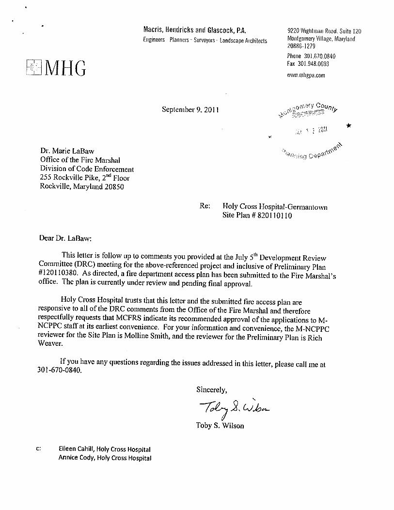
Site Plan: 820110110 Holy Cross Hospital Staff Report Date 10-7-11
Molline Smith, Senior Planner, [email protected], 301.495.4573
Richard Weaver, Area 3 Acting Supervisor, [email protected], 301.495.4544
John Carter, Area 3 Chief, [email protected], 301.495.4575
*D. Site Plan: 820110110 Holy Cross Hospital Located on approximately 18.27 acres of the Science and Technology Park on the Montgomery College Germantown Campus along the east side of Observation Drive near the intersection with Middlebrook Road, hospital building of approximately 237,200 square feet, medical office building (MOB) of approximately 80,000 square feet, and associated landscape and parking facilities within the LSC Zone, Germantown Employment Area Sector Plan. Staff recommendation: Approval with conditions
Description
2
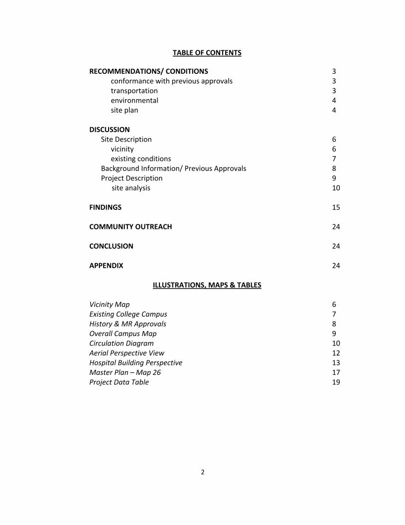
TABLE OF CONTENTS
RECOMMENDATIONS/ CONDITIONS 3 conformance with previous approvals 3 transportation 3 environmental 4 site plan 4 DISCUSSION
Site Description 6 vicinity 6 existing conditions 7
Background Information/ Previous Approvals 8 Project Description 9 site analysis 10
FINDINGS 15 COMMUNITY OUTREACH 24 CONCLUSION 24
APPENDIX 24
ILLUSTRATIONS, MAPS & TABLES Vicinity Map 6 Existing College Campus 7 History & MR Approvals 8 Overall Campus Map 9 Circulation Diagram 10 Aerial Perspective View 12 Hospital Building Perspective 13 Master Plan – Map 26 17 Project Data Table 19
3
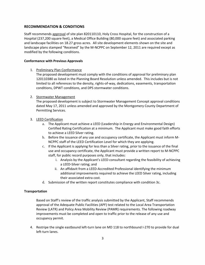
RECOMMENDATION & CONDITIONS
Staff recommends approval of site plan 820110110, Holy Cross Hospital, for the construction of a Hospital (237,200 square feet), a Medical Office Building (80,000 square feet) and associated parking and landscape facilities on 18.27 gross acres. All site development elements shown on the site and landscape plans stamped “Received” by the M-NCPPC on September 12, 2011 are required except as modified by the following conditions. Conformance with Previous Approvals
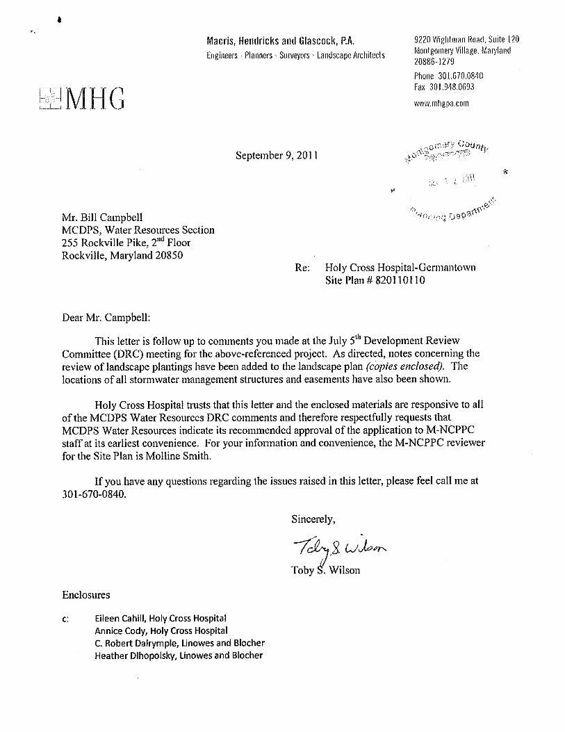
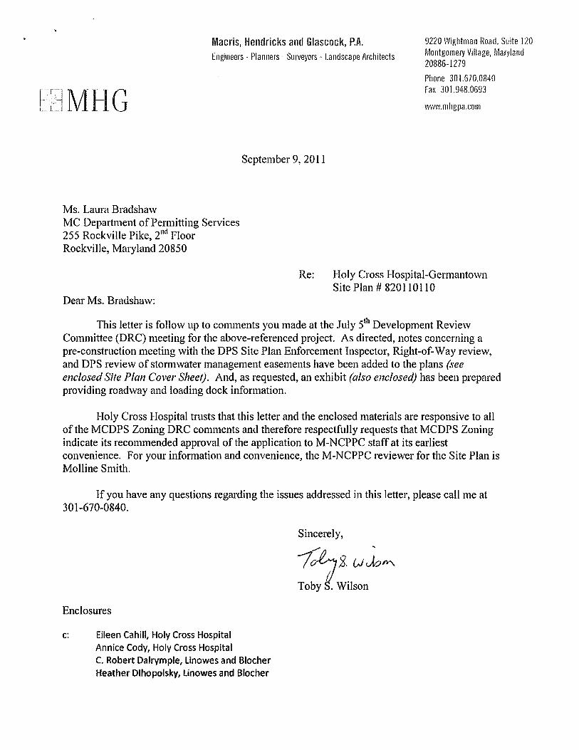
1. Preliminary Plan Conformance The proposed development must comply with the conditions of approval for preliminary plan 120110380 as listed in the Planning Board Resolution unless amended. This includes but is not limited to all references to the density, rights-of-way, dedications, easements, transportation conditions, DPWT conditions, and DPS stormwater conditions.
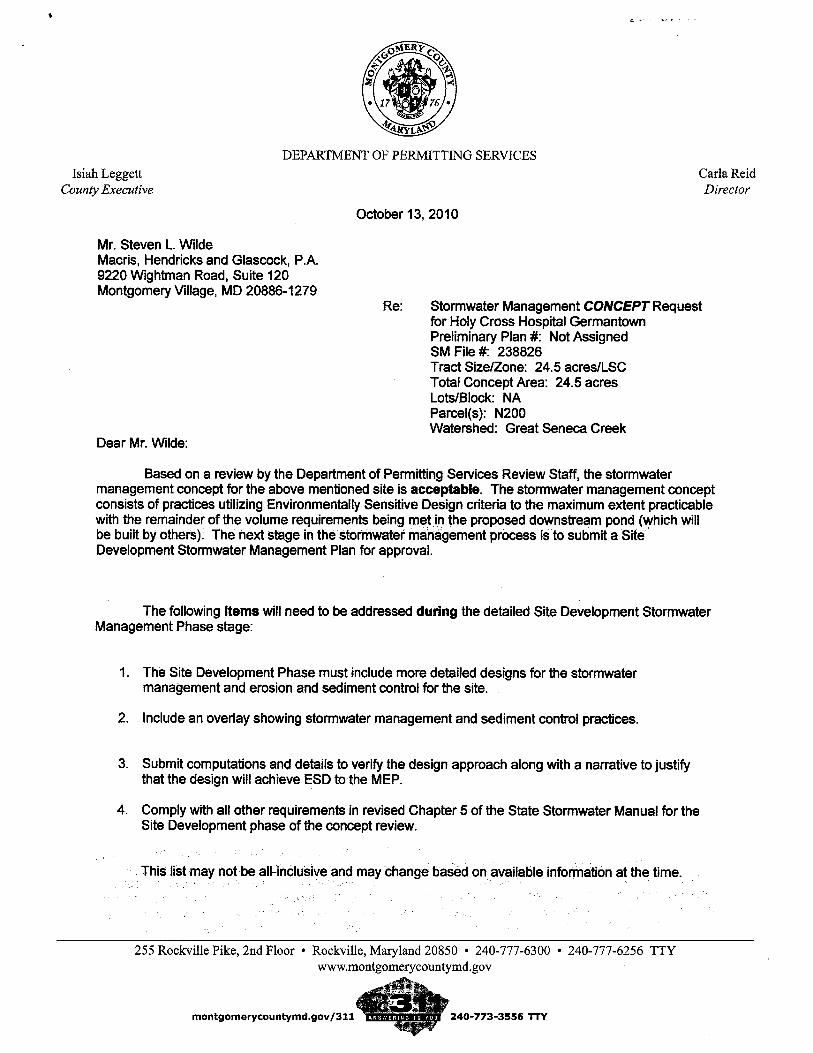
2. Stormwater Management
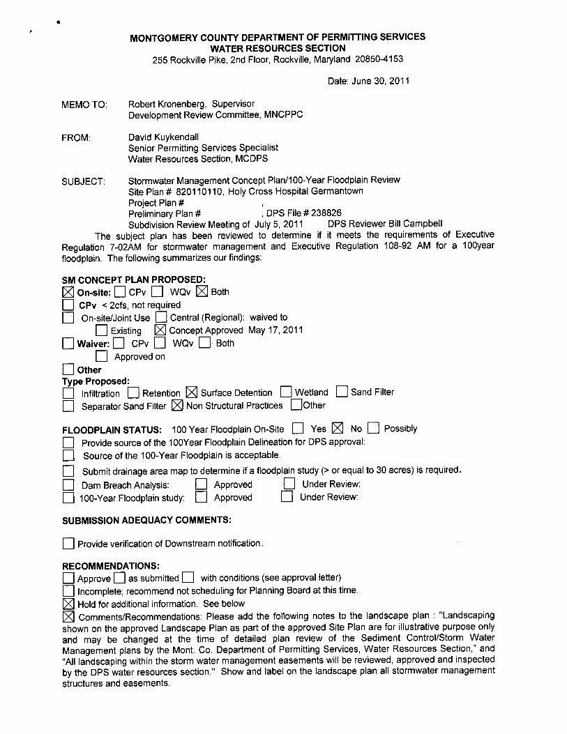
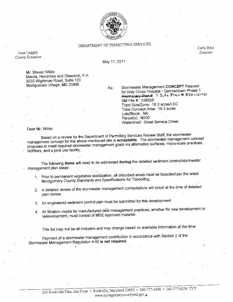
The proposed development is subject to Stormwater Management Concept approval conditions dated May 17, 2011 unless amended and approved by the Montgomery County Department of Permitting Services.
3. LEED Certification a. The Applicant must achieve a LEED (Leadership in Energy and Environmental Design)
Certified Rating Certification at a minimum. The Applicant must make good faith efforts to achieve a LEED Silver rating.
b. Before the issuance of any use and occupancy certificate, the Applicant must inform M-NCPPC staff of the LEED Certification Level for which they are applying.
c. If the Applicant is applying for less than a Silver rating, prior to the issuance of the final use and occupancy certificate, the Applicant must provide a written report to M-NCPPC staff, for public record purposes only, that includes:
i. Analysis by the Applicant’s LEED consultant regarding the feasibility of achieving a LEED-Silver rating; and
ii. An affidavit from a LEED-Accredited Professional identifying the minimum additional improvements required to achieve the LEED Silver rating, including their associated extra cost.
d. Submission of the written report constitutes compliance with condition 3c. Transportation
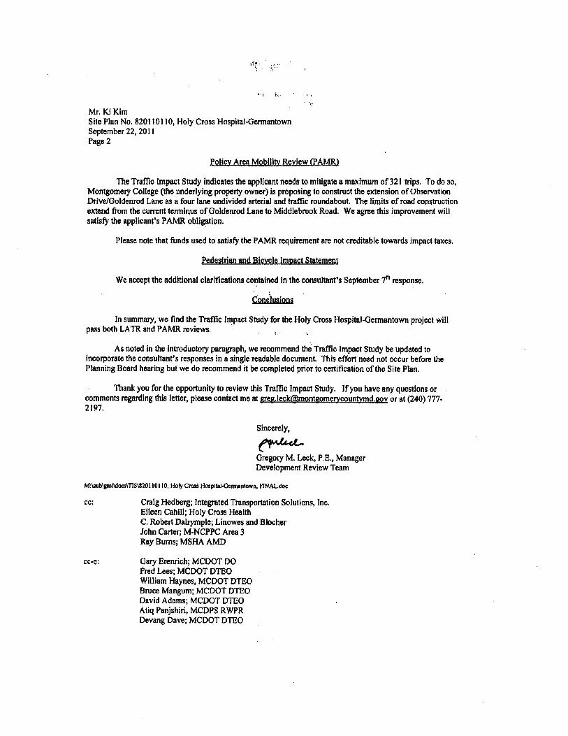
Based on Staff’s review of the traffic analysis submitted by the Applicant, Staff recommends approval of the Adequate Public Facilities (APF) test related to the Local Area Transportation Review (LATR) and Policy Area Mobility Review (PAMR) requirements. The following roadway improvements must be completed and open to traffic prior to the release of any use and occupancy permit.
4. Restripe the single eastbound left-turn lane on MD 118 to northbound I-270 to provide for dual
left-turn lanes.
4
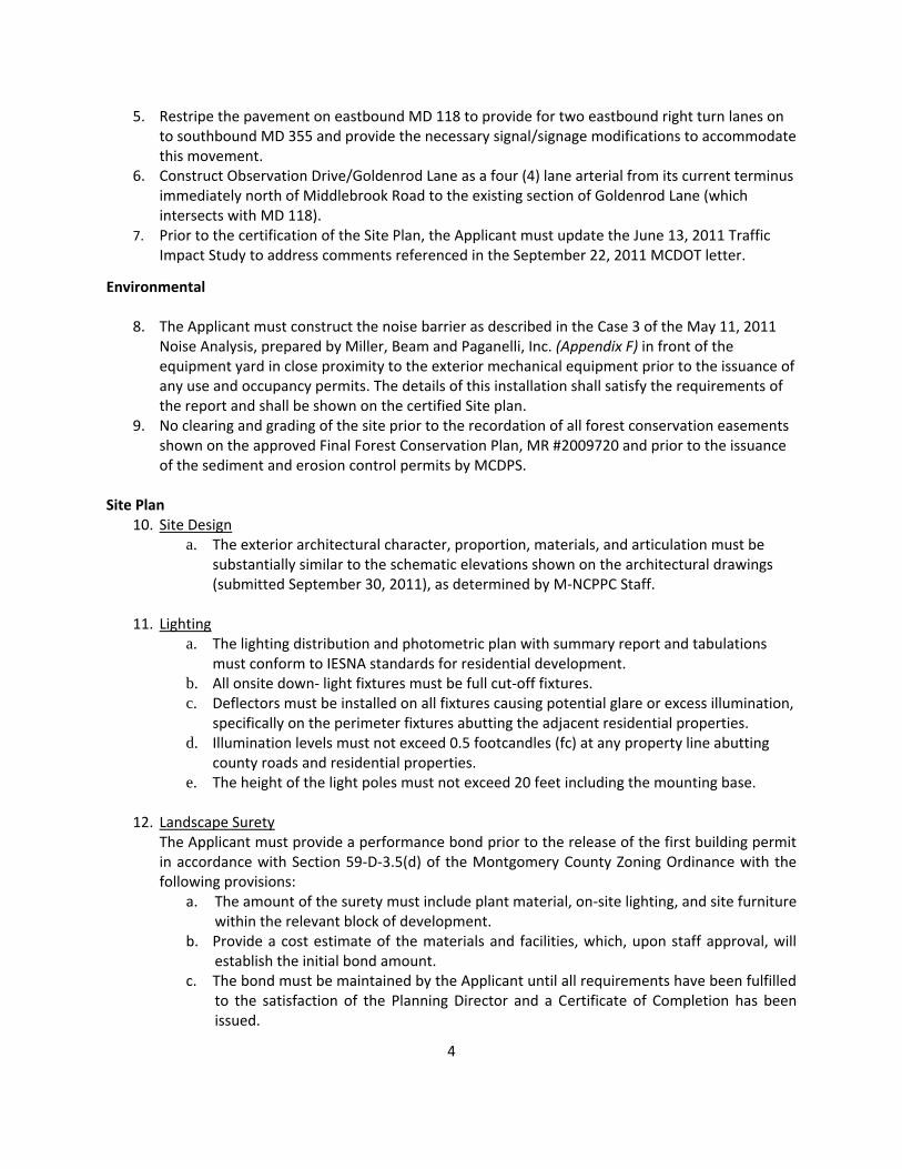
5. Restripe the pavement on eastbound MD 118 to provide for two eastbound right turn lanes on to southbound MD 355 and provide the necessary signal/signage modifications to accommodate this movement.
6. Construct Observation Drive/Goldenrod Lane as a four (4) lane arterial from its current terminus immediately north of Middlebrook Road to the existing section of Goldenrod Lane (which intersects with MD 118).
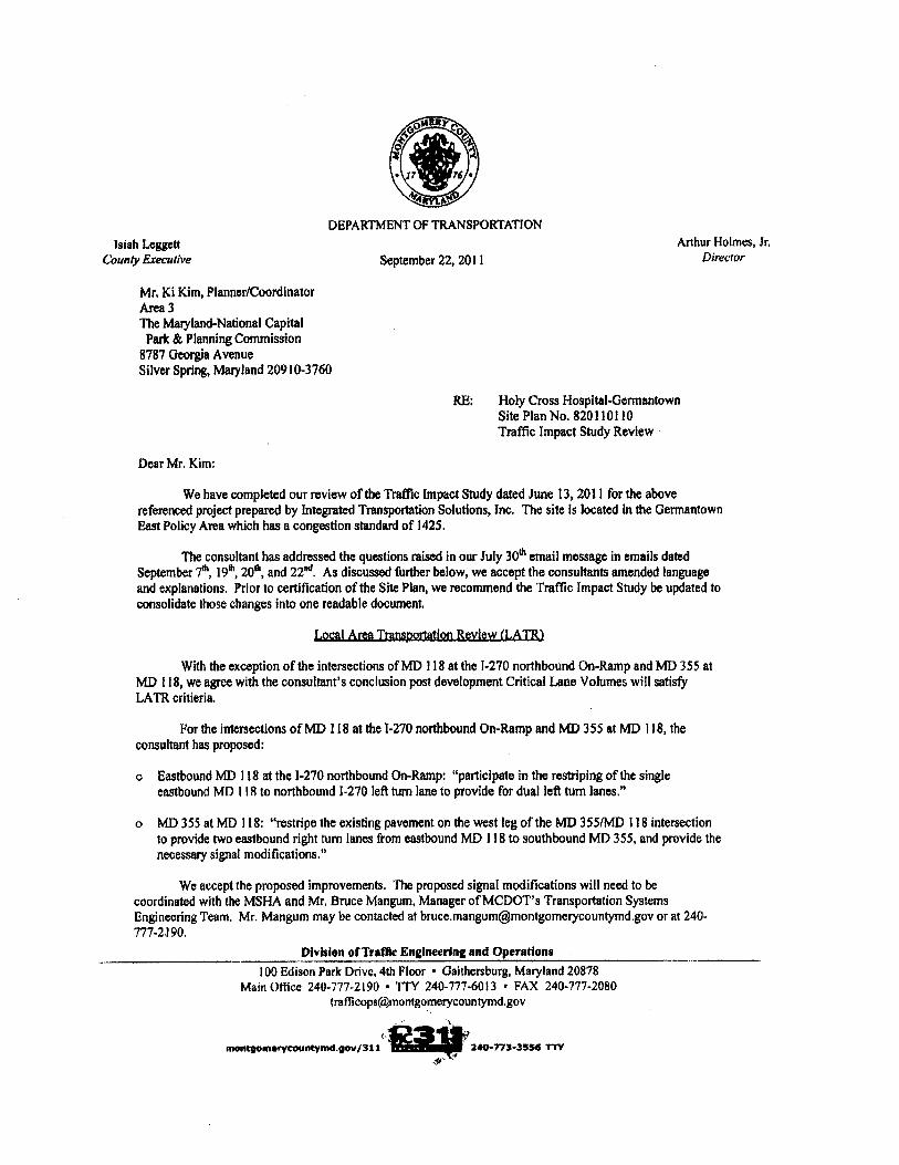
7. Prior to the certification of the Site Plan, the Applicant must update the June 13, 2011 Traffic Impact Study to address comments referenced in the September 22, 2011 MCDOT letter.
Environmental
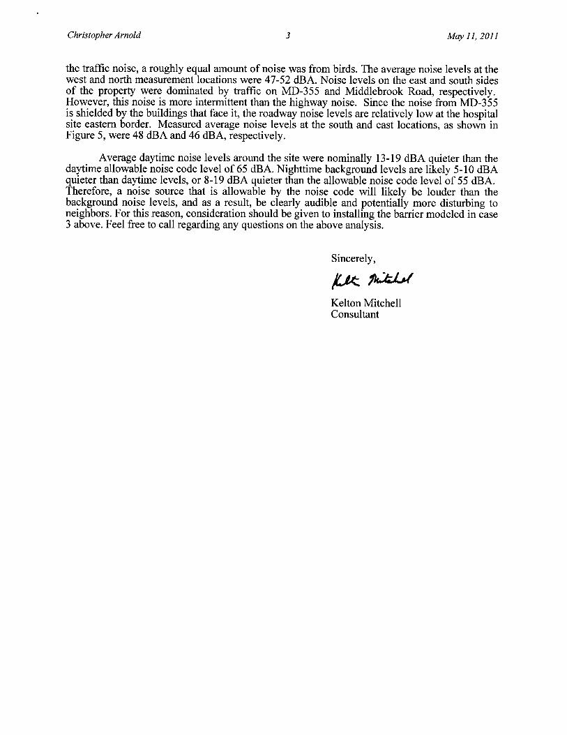
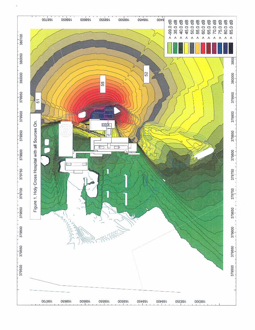
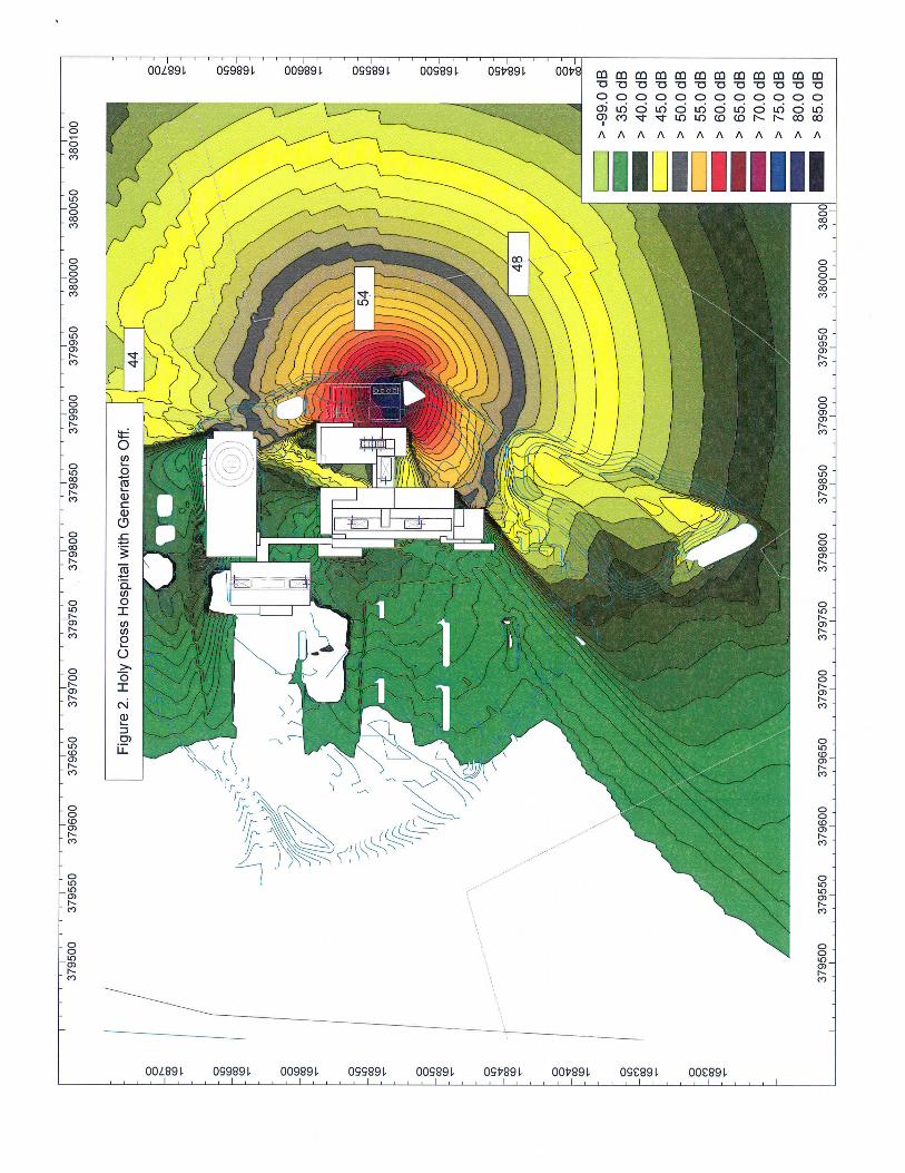
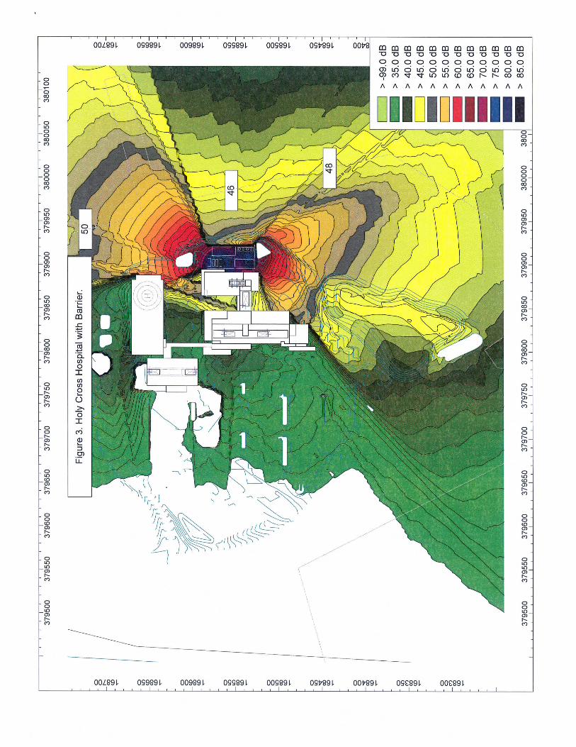
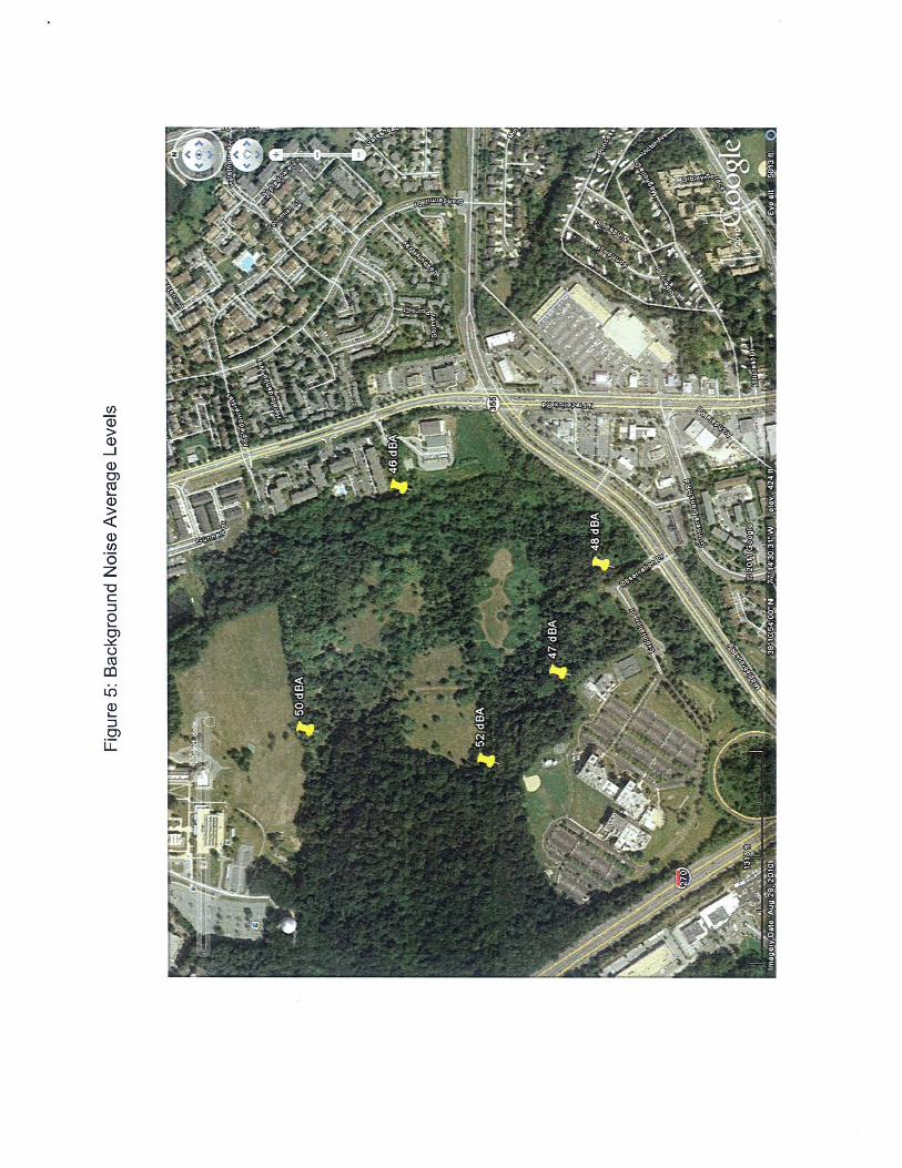
8. The Applicant must construct the noise barrier as described in the Case 3 of the May 11, 2011 Noise Analysis, prepared by Miller, Beam and Paganelli, Inc. (Appendix F) in front of the equipment yard in close proximity to the exterior mechanical equipment prior to the issuance of any use and occupancy permits. The details of this installation shall satisfy the requirements of the report and shall be shown on the certified Site plan.
9. No clearing and grading of the site prior to the recordation of all forest conservation easements shown on the approved Final Forest Conservation Plan, MR #2009720 and prior to the issuance of the sediment and erosion control permits by MCDPS.
Site Plan
10. Site Design a. The exterior architectural character, proportion, materials, and articulation must be
substantially similar to the schematic elevations shown on the architectural drawings (submitted September 30, 2011), as determined by M-NCPPC Staff.
11. Lighting
a. The lighting distribution and photometric plan with summary report and tabulations must conform to IESNA standards for residential development.
b. All onsite down- light fixtures must be full cut-off fixtures. c. Deflectors must be installed on all fixtures causing potential glare or excess illumination,
specifically on the perimeter fixtures abutting the adjacent residential properties. d. Illumination levels must not exceed 0.5 footcandles (fc) at any property line abutting
county roads and residential properties. e. The height of the light poles must not exceed 20 feet including the mounting base.
12. Landscape Surety
The Applicant must provide a performance bond prior to the release of the first building permit in accordance with Section 59-D-3.5(d) of the Montgomery County Zoning Ordinance with the following provisions:
a. The amount of the surety must include plant material, on-site lighting, and site furniture within the relevant block of development.
b. Provide a cost estimate of the materials and facilities, which, upon staff approval, will establish the initial bond amount.
c. The bond must be maintained by the Applicant until all requirements have been fulfilled to the satisfaction of the Planning Director and a Certificate of Completion has been issued.

5
d. Provide a Site Plan Surety and Maintenance Agreement that outlines the responsibilities of the Applicant and incorporates the cost estimate. Agreement to be executed prior to issuance of the first building permit.
13. Development Program The Applicant must construct the proposed development in accordance with a development program that will be reviewed and approved prior to the approval of the Certified Site Plan. The development program must include the following items in its phasing schedule:
a. Street lamps and sidewalks must be installed within six months after street construction is completed. Street tree planting must be completed by the end of the next growing season.
b. On-site amenities associated with each building, but not limited to, sidewalks, benches, trash receptacles, and bicycle facilities must be installed prior to release of any building occupancy permit.
c. Clearing and grading must correspond to the construction phasing to minimize soil erosion and must not occur prior to approval of the Final Forest Conservation Plan, Sediment Control Plan, and M-NCPPC inspection and approval of all tree-save areas and protection devices.
d. The development program must provide phasing for installation of on-site landscaping and lighting.
e. Landscaping associated with each parking lot and building shall be completed as construction of each facility is completed.
f. Pedestrian pathways and seating areas associated with each facility must be completed as construction of each facility is completed.
g. The development program must provide phasing of dedications, stormwater management, sediment and erosion control, afforestation, trip mitigation, and other features.
14. Certified Site Plan Prior to approval of the Certified Site Plan the following revisions must be made and information provided subject to Staff review and approval:
a. Include the final forest conservation approval, stormwater management concept approval, development program, inspection schedule, and site plan resolution on the approval or cover sheet.
b. Add a note to the site plan stating that “M-NCPPC staff must inspect all tree-save areas and protection devices prior to clearing and grading”.
c. Modify data table to reflect development standards enumerated in the staff report. d. Ensure consistency of all details and layout between site plan and landscape plan.

6
DISCUSSION
SITE DESCRIPTION Vicinity The Montgomery College Germantown Campus is located along Observation Drive in Germantown, Maryland. The campus site is approximately 224 acres; and currently zoned LSC (Life Sciences Center). Bordered on all four sides by major roadways: I-270 is located towards the western boundary; Germantown Road (MD 118) is located towards the northern boundary, Frederick Road (MD 355) is located towards the eastern boundary; and Middlebrook Road is located towards the southern boundary.
Vicinity Map

7
Within the surrounding area the Frederick Road (MD 355) corridor is framed with densely developed residential properties. Towards the north of the site are multi-family townhouse units; most which are zoned R-60/TDR. The Ayrlawn Property (819800340), Cider Barrel (820040030), Eton Square (820040330), Mary Boland Subdivision (819970090), and Oak Mill Apartments (819830780); are the closest neighboring properties along the eastern property boundary. Germantown Town East Park and Middle Village Shopping Center are located towards the southern boundary at the intersection of Middlebrook Road and Frederick Road. Existing Conditions The Montgomery College Campus is located within the Seneca Creek Watershed; which the state of Maryland has designed the waters as a Class I-P. This water classification is suitable for water contact recreation, protection of aquatic life and public water supply. Less than 50 percent of the property is currently developed; and reforestation areas, stream valley buffers and high priority forest are preserved along both the western and eastern portions of the property. The forest conservation areas serve a dual function; to protect and treat the stormwater runoff; and provide a densely planted buffer between the different uses.
Existing College Campus

8
The college campus is accessed from Germantown Road at two locations: Goldenrod Lane/Germantown Road intersection (secondary entrance) or the Observation Road/Germantown Road intersection (primary entrance). The existing conditions on campus consist of five academic buildings, parking facilities, and related/ ancillary facilities. The southern portion of the site (i.e. the location of the subject site) is currently undeveloped.
BACKGROUND INFORMATION/ PREVIOUS APPROVALS
History: Montgomery College was originally started in 1946 as “Montgomery Junior College” with the main campus located in Bethesda Maryland (i.e. currently known as Bethesda Chevy Chase High School). The main campus was relocated to Takoma Park in 1950, absorbing the Bliss Electrical School; which had occupied the site. The College is accredited by the Middle States Commission on Higher Education, and offers two-year associate’s degrees and a variety of professional certifications. The College currently serves nearly 60,000 students a year, through both credit and noncredit programs, in more than 100 areas of study. The Germantown Campus is one of three sites created and owned by the state; thereby establishing it as a public entity. The Germantown Campus opened in 1975, and has had minor site adjustments since taking permanent occupancy in 1978.
Mandatory Referrals:
MR 02306-M-1 This modification was approved by the Planning Board in October 2002 for the construction of a 40 acre Biotechnology Business Park at Germantown Road and Goldenrod Lane. A Natural Resource Inventory/Forest Stand Delineation (NRI/FSD #420062160 was approved October 13, 2006 and was later recertified on January 30, 2009.
MR 09720-M-1& MR 10712-M-1
This project was approved May 14, 2010 for the construction of the Montgomery College Bioscience Building and Childcare Center. The Childcare was a single-story rectangular facility built to accommodate 40 students. The Bioscience Education Center is a 3-story (approximately 127,000 sq. ft.) L-shaped building containing classrooms, laboratories, facility offices and conference center.
MR 2009734 This project was approved May 20, 2010 for the permanent preservation of an additional 2.88 acres of high priority forest along I-270. The revised Forest Conservation Plan formally established and provided protection of the existing and future forests. The Final Forest Conservation Plan was approved June 24, 2010. In accordance with this approval and separate from the Mandatory Referral process; the College is required to submit individual forest conservation plans that demonstrate compliance with the approved Forest Conservation Plan.
9
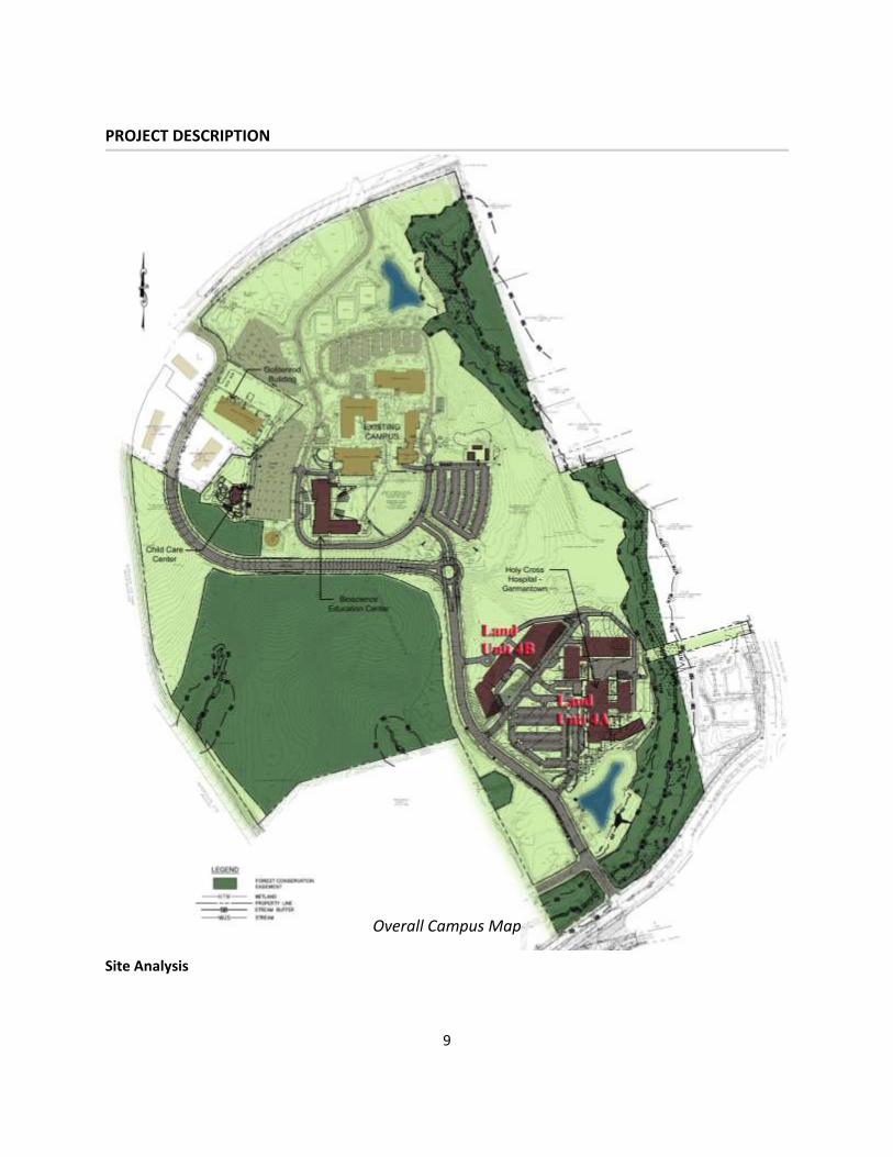
PROJECT DESCRIPTION
Overall Campus Map Site Analysis

10
The recorded land condominium on the Montgomery College property (i.e. the Preliminary Plan process) will legally permit the ground leasing of Land Units 4A and B to a private developer. In accordance with the Preliminary Plan; Observation Drive will be extended (towards the south) to connect into Middlebrook Road. This roadway is the physical link to the existing campus and the new tenant(s). The physical connection of the roadways will initiate the partnership with similar activities related to the Science and Technology (S&T) Park within Montgomery College. The Holy Cross Hospital will have an instrumental role in supporting the College’s specific goal to cultivate private partnerships with medical facilities. This link is not only beneficial to Montgomery College, but it also has the potential to help meet biotechnology educational, economic and workforce development needs. Fostering the healthy relationships between gaining knowledge, professional training and work experience with businesses specifically located in the I-270 Technology Corridor will further promote the overall intent of the LSC zone. Therefore the primary mission of this medical facility is to provide adequate and convenient health care services to the expanding up-county population within the region; while simultaneously strengthening the partnership between Montgomery College, the S&T Park and the Germantown Employment Area.
Circulation Diagram Circulation

11
Observation Drive will be constructed to meet public road standards prior to the use and occupancy permit for any buildings on the Hospital lot. This roadway will serve as the major corridor from the existing northern campus to the subject site. The majority of the proposed development will occur on the southern portion of the proposed lot (Land Unit 4A); while the northern portion (Land Unit 4B) will be reserved for a future expansion of the Hospital facilities. Any future expansion of the Hospital or MOB will require an amendment to the certified Preliminary and Site Plans.
The public and private areas are strategically designed with limited overlap; which should reduce the potential for conflicts between emergency services and routine visits. The property has two (2) points of ingress/egress from Observation Drive that will serve as the primary vehicular circulation systems. The first driveway, in the southeast corner, runs along the front façade of the proposed Hospital building; connecting into the entrance drop-off, the surface parking lots and the second access driveway. This access functions as the main entrance point for the patients and visitors. The second driveway (located at the northwestern corner) runs along the proposed MOB; connecting into the second entrance drop-off, the proposed 5-level parking garage and the Ambulatory Service entrance. This access functions as the primary entrance point for the service vehicles, employees and physicians. Fire & Rescue and service vehicles may access the loading docks to the rear of the Hospital. The dual driveways are anticipated to be 3-lane interior roads that will also connect into a transit bus stop near the main entrance of the Hospital. As this Hospital will not be designated as a trauma center, the helistop (located on the top level of the parking garage) will be used infrequently for emergency transport of patients outbound from the Hospital to another healthcare facility. The helipad is only anticipated to be use approximately twice a month. The restrictions placed on the Hospital were intended to reduce the impacts (i.e. noise pollution, traffic, etc.) on the surrounding residential communities. The helipad will be safely secured on the upper level by a locked gate to provide visible separation from the parking areas. The external pedestrian pathways within the right-of-way and outside of the property boundary consist of a 10-feet wide shared use pathway that run along Observation Drive and connect into an existing pathway along Middlebrook Road. The 10-foot shared use path is intended to accommodate both bike riders and walkers, and will be planted with large canopy street trees to provide shade along the street edge. The proposed internal sidewalks vary in width from 5 feet to7 feet wide. They are designed to loop around the surface parking lots along the front facades of the Hospital and MOB and connect into the active public spaces. An alternative regional natural surface trail was discussed during the time of Site Plan review. However, due to the potential for the area to be redeveloped in the near future, the trail design was postponed until such time as the other areas of the S&T Park are further developed. The parking garage is connected to the MOB and Hospital building by a covered pedestrian corridor. The loading docks between the parking garage and the northern façade of the Hospital building are large enough to accommodate several different types of deliveries at the same time. The turning radii throughout the site have been tested for safety and efficiency by the Fire & Rescue Department.
12
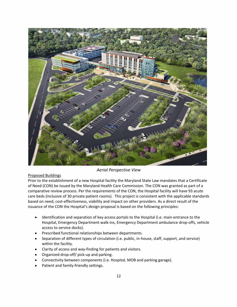
Aerial Perspective View Proposed Buildings Prior to the establishment of a new Hospital facility the Maryland State Law mandates that a Certificate of Need (CON) be issued by the Maryland Health Care Commission. The CON was granted as part of a comparative review process. Per the requirements of the CON, the Hospital facility will have 93 acute care beds (inclusive of 30 private patient rooms). This project is consistent with the applicable standards based on need, cost-effectiveness, viability and impact on other providers. As a direct result of the issuance of the CON the Hospital’s design proposal is based on the following principles:
Identification and separation of key access portals to the Hospital (i.e. main entrance to the Hospital, Emergency Department walk-ins, Emergency Department ambulance drop-offs, vehicle access to service docks).
Prescribed functional relationships between departments.
Separation of different types of circulation (i.e. public, in-house, staff, support, and service) within the facility.
Clarity of access and way-finding for patients and visitors.
Organized drop-off/ pick-up and parking.
Connectivity between components (i.e. Hospital, MOB and parking garage).
Patient and family-friendly settings.

13
Appropriate use of materials, landscape elements, signage and finishes.
Infrastructure to receive new and changing medical equipment.
Working environment conducive to staff recruitment and retention.
Site strategy for addressing program growth change and future development.
The Hospital is approximately 237,200 square feet. The interior layout of the proposed building is such that the main level (i.e. the first floor) will include a public lobby, registration, a café and the cafeteria. The Emergency Department and clinical services (i.e. psychiatry unit, an observation unit, and the radiology department) are also included on the main level; while the majority of the remaining floors are primarily intended to service the more private functions of the hospital (i.e. critical care, maternal and infant center, etc.). A future expansion space will be constructed on the sixth floor in the initial development phasing for future fit-out as patient needs evolve. The external shell will be designed with a contemporary façade composed of block masonry units, curtain wall and channel-glass. The building’s super-structure will be built using cast-in-place concrete slabs and columns.
Hospital Building Perspective The MOB (approximately 80,000 square feet) is a 4-story office building located near the northwest corner of the Hospital. The MOB is intended to be an extension of the medical care services ancillary to the Hospital. The covered pedestrian corridor1 between buildings is an important connection that will allow visitors, patients, students and physicians the opportunity to safely and efficiently transition between spaces. The services within the MOB are designed to complement the available services offered within the Hospital. 1 The total square footage of this area is referenced in the Project Data Table page 19 of this report.
14
The proposed parking garage is a five level structure; providing a total of approximately 580 parking spaces. A surface parking lot is proposed in front of the Hospital; providing additional parking for the patients, visitors, student interns, employees (395 people), and physicians both for the Hospital and the MOB. Proposed Public Use Spaces and Environmental Site Design There are five (5) featured landscape areas immediately adjacent to the Hospital: the main entrance plaza, the healing garden, the cafeteria plaza, the meditation garden and the MOB garden. Considering the hierarchy of the Hospital (located at the center of the site); the associated landscaped areas directly adjacent to the building form structured patterns. Stretching out towards the property boundaries the structured patterns start to transition into more natural forms. At the outer edges of the property, the proposed planting beds and open spaces are informal and mainly function to address quality control for the stormwater management (SWM) facilities. The designs for these spaces are strongly influenced by the architecture of the buildings and the natural environment. Unifying elements such as rows of trees, landscape walls and plant material help to emphasize the overall design concept and organize the surrounding natural landscape. All five garden areas will be open to the public; as well as the staff and employees. The entrance to the Hospital is pronounced with a covered drop-off area, bollards, enriched paving, a large plaza with seating, and canopy trees. The organization of this space is convenient and clearly introduces the space as the primary access point. The plaza reaches out toward the shared SWM pond (on the adjacent parcel) and the surface parking lot towards the west side of the property. Just north of the main entrance to the Hospital is the healing garden. The healing garden is intended to create a private space for reflection; thereby the space is fully enclosed by the front façade of the Hospital, vegetated Greenscreen fencing, evergreen hedges and block masonry walls. The interior garden space is heavily planted with diverse and calming plant material with adequate seating provided along the edges. The cafeteria plaza is located on the southern side of the Hospital. The plaza further emphasizes the linear pattern, close to the building edge, with planted walkways and masonry walls that control major views and reach out into the enhanced meadow. Dining areas are clustered in an organized pattern near the building. The meditation garden is a courtyard space located on the north side of the Hospital, enclosed on three sides by the Emergency Department and the administrative wing. Heavily planted with a bosque of trees and low growing understory; this space is broken up by low freestanding masonry walls and impromptu seating. The surface of the garden space consists of decomposed granite to provide layering textures and sounds. The MOB garden is located between the rear of the MOB and the enclosed pedestrian corridor. At the center of the space is a dry streambed that is not only proposed to be a site amenity and focal point, but also functions as a SWM design feature. The streambed will meander from a dry pool at the upper side of the garden (near the parking garage) through the space leading into the Emergency entrance to the Hospital. Landscape boulders will be placed along the stream edge with lush plantings. Similar to the other garden spaces, the design concept is reemphasized with paved streambed crossings, low masonry walls, and linear design elements. The remaining landscaped areas are intended to enhance the surface parking facility, entrance features, and open spaces surrounding the Hospital. Landscaped islands are used in the surface parking facility to create a strong linear pattern that lead patients and visitors toward the front entrance of the Hospital. These islands will also function as both SWM micro-bioretention facilities, and strong design elements. The landscape features and proposed signage highlight the important entrances that help to facilitate instinctive way-finding throughout the site.
15
FINDINGS
1. The Site Plan conforms to all non-illustrative elements of a development or diagrammatic plan,
and all binding elements of a schematic development plan, certified by the Hearing Examiner under Section 59D-1.64, or is consistent with an approved project plan for the optional method of development if required, unless the Planning Board expressly modifies any element of the project plan. In accordance with Section 59C-5.476(a), the site plan consistent with the recommendations of the applicable Master or Sector Plan, including general design principles recommended by the applicable master or sector plan and design guidelines adopted by the Planning Board to implement the applicable Master or Sector Plan. No development, diagrammatic, schematic development, and/or project plans were required for this project. However; this Site Plan application is in accordance with the Master Plan requirement for private sector facilities. The Sectional Map Amendment (SMA) No. G-887 was adopted by the County Council on May 18, 2010. Montgomery College property was rezoned to the LSC zone, and included in the 919 acres of land (Parcel 29) rezoned during hearing. There are no binding elements associated with this approval. Sector Plan and Design Guidelines
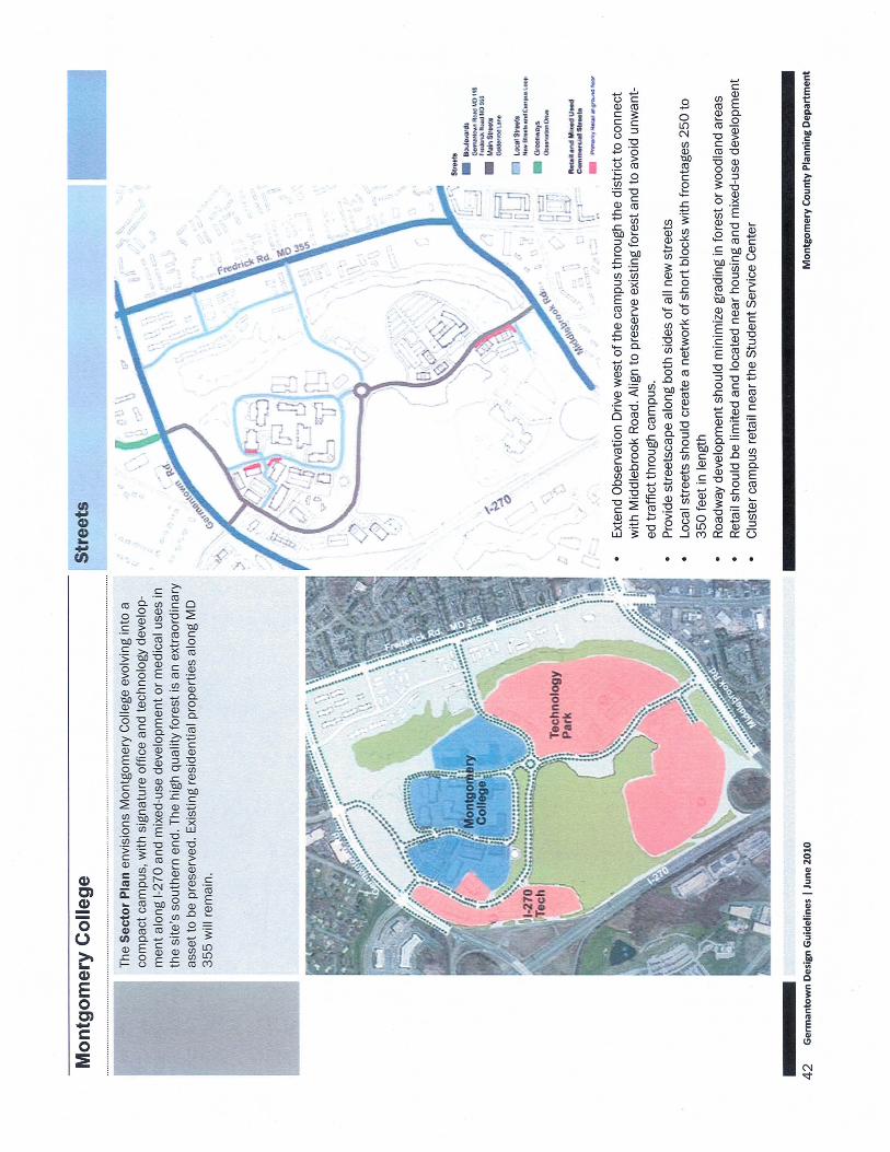
The Germantown Employment Area Sector Plan makes specific recommendations for the Montgomery College Campus (page 70-72). The Montgomery College Campus is identified as an important community resource within the Montgomery College District, intended to serve approximately 20,000 students. The future development of the 334 acres of the Campus is a key component to the preservation of the site’s natural features and fostering links between business and education in the I-270 Technology Corridor. The following land use, urban form and transportation recommendations are specific to the Montgomery College District:
Land Use
Expand Montgomery College’s academic facilities to 1.1 million square feet and provide up to one million square feet for a technology park linking the business and academic communities. Private sector facilities on the campus will be subject to Site Plan review; academic facilities are subject to the Mandatory Referral process under the Regional District Act.
The proposed development is well within the one million square feet for non-academic uses within the S&T Park. This project is the first to provide 32 percent (320,800 sf.) of this recommendation on Land Use 4A. Land Unit 4B is approximately 6.23 acres (271,379 sf.); however the type and amount of use area is not included in this Site Plan. The remaining area is subject to Site Plan review should the proposed facility be a non-academic use.
The Sector Plan recommends rezoning the entire property to the I-3 zone (for development under the standard of optional method); which appear to provide the greatest flexibility to meet the College’s needs. Current revisions being considered for the Life Science Center (LSC) Zone could also make this zone appropriate for the College property.

16
As implemented by the SMA and in accordance with the Sector Plan (adopted October 2009); the subject property was rezoned to LSC on May 18, 2010.
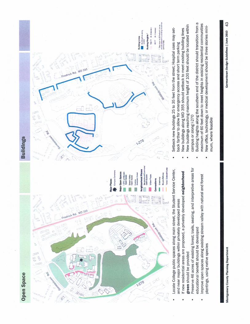
Preserve 46 acres of high priority forest along I-270 and other high priority forested areas on the property.
This was specifically addressed with the approved FFCP dated June 24, 2010. Forty-six acres of forest was protected in the area west of Observation Drive.
Develop technology and office uses with signature architecture that takes advantage of the visibility from I-270. Use structured parking facilities to reduce impervious surface areas and improve water quality in the Gunners Branch watershed.
The signature architecture proposed for the buildings and the public use spaces are adequately designed to human scale. The Hospital is located at the center of the site and the front façade of the building; more specifically the main entrance, is appropriately oriented towards Observation Drive and the I-270 Corridor towards the west. Major views from I-270 will most likely be obstructed by an existing development (Digital Community Corporation) and high priority forest; however proposed signage will efficiently guide visitors to the Hospital.
A 5-story structured parking facility is proposed to contain 575 spaces; which is 62 percent of the total number of parking spaces proposed. The surface parking facility will contain 347 spaces, and incorporates SWM facilities to improve the water quality of the surface runoff prior to reaching the Gunners Branch watershed.

17
Master Plan – Map 26
Urban Form
Design the campus expansion and orient buildings to create a compact educational village that promotes interaction between buildings, synergy between public and private uses, reduces the amount of disturbed land, and creates an appealing and safe campus setting.
The MOB and parking garage are clustered around the Hospital, and proposed to be linked together by an enclosed pedestrian corridor. Public and private spaces are strategically deigned with minimal overlap, per the specific requirements of the CON. The “campus-like” setting experienced on the existing campus is adequately duplicated within this project. The 10 foot shared use pathway along Observation Drive will provide a safe and adequate connection between the existing campus to the north and the Hospital. Large shade trees along the roadway will provide shade to walkers and bikers. Internal pedestrian sidewalks are linked to the 10 foot shared pathway and the public use spaces.

18
The street network shall provide pedestrian connections that create a walkable campus.
The ten foot wide shared use pathway will accommodate pedestrians and bicyclists. Opportunities for off street trails or sidewalks will be evaluated as other private developments come in for review.
Provide open spaces that are buffered from the residential communities to the east.
The Forest Conservation Plan protects a wide forested edge between these two uses.
Use building placement and site design to create smaller usable outdoor spaces that are characteristic of urban areas.
The plan accomplishes this by creating small outdoor seating areas and green spaces.
Limit the building height to 100 feet (eight stories) and cluster new development to provide a dense and cohesive campus.
The maximum height of the Hospital building is 105 feet with 6 stories. The unique design needs of a hospital building, including the specialized equipment needed to provide start of the art service, dictate higher floor to ceiling heights than would be typically expected in an office building. The Hospital building is the tallest of the three buildings but steps down in height towards the east, and connects into the administrative wing; which is approximately 35 feet tall (2 stories). A stream valley buffer screens most major views of the administrative wing from the nearest adjacent property, the Boys and Girls Club, approximately 620 feet to the east of the administrative wing. The Zoning Ordinance (Section 59C-5.31a) specifies a maximum height of 200 feet within the LSC zone. Given the support for such a medical facility in the Sector Plan, and the specialized design needs of a hospital facility, staff finds that the height of the Hospital building is in substantial compliance with the Sector Plan recommendation. The MOB and parking garage are clustered around the Hospital to ensure a dense and cohesive campus.
Maintain building setbacks from 1-270 of 200 feet and 100 feet from any interchange right-of-ways.
The proposed development is setback approximately 0.45 miles (2,200 feet) from I-270 and is separated from I-270 by the 46 acres of high priority forest protected by easement.
2. The site plan meets all of the requirements of the zone in which it is located, and where
applicable conforms to an urban renewal plan approved under Chapter 56. With respect to building height, and density the proposed development is under all the maximum standards allowed. There are no required setbacks of this zone; however in

19
accordance with the Sector Plan adequate landscape buffering of the major views from I-270 and the surrounding residential communities have been provided. With respect to the 20 percent public use space requirement; five different garden/plazas areas were efficiently and adequately designed to highlight major views, serve as relaxing areas of retreat, and provide landscape buffers between abutting uses.
Development Standards
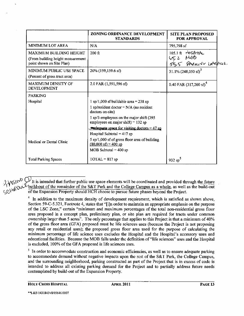
The subject site is zoned Life Science Center (LSC). The purpose of the LSC Zone is to promote research, academic and clinical facilities that advance the life sciences, health care services, and applied technologies. It is also the purpose of this zone is to provide opportunities for the development of uses that support a Life Sciences Center while retaining as environment conducive to high technology research, development and production. The proposed development meets the purpose and requirements of the zone as detailed in the Findings section of this report. The following data table indicates the proposed development’s compliance with the Zoning Ordinance.
Project Data Table
Development Standard
Permitted/Required Sector Plan Rec’s
Proposed for Approval
Lot Area (sf.) N/A N/A 795,798 sf.
Maximum Building Height (feet)
Hospital 200 feet 100 feet
(8 stories)
105 feet2
(6 stories)
MOB 200 feet 100 feet 65.2 feet
Parking Garage 200 feet 100 feet 55.5 feet
Proposed Use (sf.)
Hospital N/A N/A 237,200 sf.
MOB N/A N/A 80,000 sf.
Pedestrian Linkage N/A N/A 3,600 sf.
Total N/A 1,000,000 sf3. 320,800 sf.
Minimum Coverage Limitation (%)
Public Use Space 20% N/A 31.1%
Maximum Density of
Development
2.0 FAR N/A 0.44 FAR
2 Referenced in the Sector Plan under the urban form recommendations (page 73); see page 18 of this report for further explanation. 3 Referenced in the Sector plan under the land use recommendations (page71); one million square feet will be dedicated to the technology park. 4 In accordance with Section 59C-5.321 (revised January 2011).

20
Off-Street Parking and Loading
Surface Parking Facility
Area (sf.)
N/A N/A 123,732 sf.
Internal Landscaping (%) 5% (6,187 sf.)5 N/A 22.9% (28,385 sf.)
Parking Spaces
Hospital Building 416 spaces6 N/A N/A
MOB 400 spaces7 N/A N/A
Total Spaces 816 spaces N/A 932 spaces8
3. The locations of buildings and structures, open spaces, landscaping, pedestrian and vehicular circulation systems are adequate, safe, and efficient. The buildings and structures of the proposed development are located to the east of Observation Drive and to the west of Frederick Road (behind the residential communities), which is appropriate for the character envisioned by the Sector Plan. The central location of the proposed buildings provides easy access to the building from adjoining sidewalks and parking facilities. The locations of the buildings and structures are adequate and efficient, while meeting the aesthetic concerns of the area, and do not pose any safety concerns on the site. The five different open space areas identify the main access points within the buildings, provide aesthetic appeal, enhance the natural conditions surrounding the site and introduce calming spaces for retreat outside of the building. The covered pedestrian provides an efficient and safe connection to the proposed buildings. The plant materials function as a screen for the parking facilities and open space areas, emphasize and articulate the overall site design concept, and add repetition and shade along the street edges. Street trees and lighting are provided along the street and within the parking facilities to enhance the pedestrian environment. Interior lighting will create enough visibility to provide safety, but not so much as to cause glare on the adjacent roads or neighboring properties. There are no recreational facilities required for this site plan; however, seating areas which include bicycle racks adequately fulfill the 20 percent minimum requirement for public use space in the LSC zone. The open spaces, landscaping, and site details efficiently address the need for the proposed use and efficiently provide a safe and comfortable environment. Two access points to the Holy Cross Hospital/MOB site are proposed from Observation Drive which will be constructed as a four lane arterial roadway with a 10’ shared use path on the east side. This roadway will provide both local traffic accessibility, and facilitates future bus service and additional pedestrian and bicycle access. The proposed alignment of Observation Drive as shown on the site plan is compatible with the master plan alignment. Staff finds the proposed
5 The square footage is based on the area of the surface parking facility. 6 The total parking requirement is based on the proposed square of the Hospital building divided by 1 per every 1,000 sf. Plus one space for the resident/ visiting doctor, and one space for every 3 employees. The total number of employees is 395. 7 The total parking requirement is based the MOB building square footage divided by 5 space per every 1,000 sf. 8 The total number of parking spaces included surface and garage facilities, 20 motorcycle spaces (10 surface space and 10 garage spaces), and ADA spaces. Bicycle racks (30) have also been provided.

21
access points to the campus have been reviewed for adequate site distance and will be safe and adequate. Transportation
The College’s planned expansion and technology park require additional access and transportation capacity. Extend Observation Drive as a four lane 80 foot right-of-way with a shared use path through the College Property to connect Germantown Road with Middlebrook Road. Locate the road on the west and south sides of the campus with future connections to MD 355 (page 73 of the Sector Plan).
The plan requires that Observation Drive be completed from Goldenrod Lane to Middlebrook Road as a 4 lane road within a minimum 80 foot wide right-of-way. It will be located on the west and south sides of the campus. The future connection to MD 355 for Observation Drive is not required at this time for LATR or PAMR purposes and the property required for dedication of this connection is not part of this application. This connection should be fully evaluated for engineering and final alignment when additional expansion of the College or other private development is under review.
Extend Cider Press Place to connect MD 355 with the extension of Observation Drive (page 73 of the Sector Plan).
The dedication and construction of the connection to Cider Press Place is not required to be built at this time. The land required to dedicate this connection is not part of this application. The LATR and PAMR requirements for the Holy Cross Hospital and office building are satisfied by the extension of Observation from Goldenrod Lane to Middlebrook Road as shown on the preliminary plan. Further, the location of the Hospital lot in no way jeopardizes the future dedication of Cider Press Place on to the Campus. The need for this future connection and its final alignment should await development on the Campus that will cause it to be fully evaluated for traffic capacity, alignment, engineering, and neighborhood/property impacts. Pedestrian access from adjacent sidewalks efficiently integrates this site into the surrounding area. Proposed sidewalks are adequately connected into existing circulation systems. The vehicular circulation design efficiently directs traffic into and through the site with minimal impacts to pedestrian circulation.
Adequate Public Facilities Review
The Adequate Public Facilities (APF) shall be considered at the Preliminary Plan and Site Plan stages. Montgomery College is the Applicant for the Preliminary and is responsible for the construction of the roadway and platting of the lot, while Holy Cross Hospital is the Applicant for the Site Plan and is responsible for the implementation of the construction of the project.
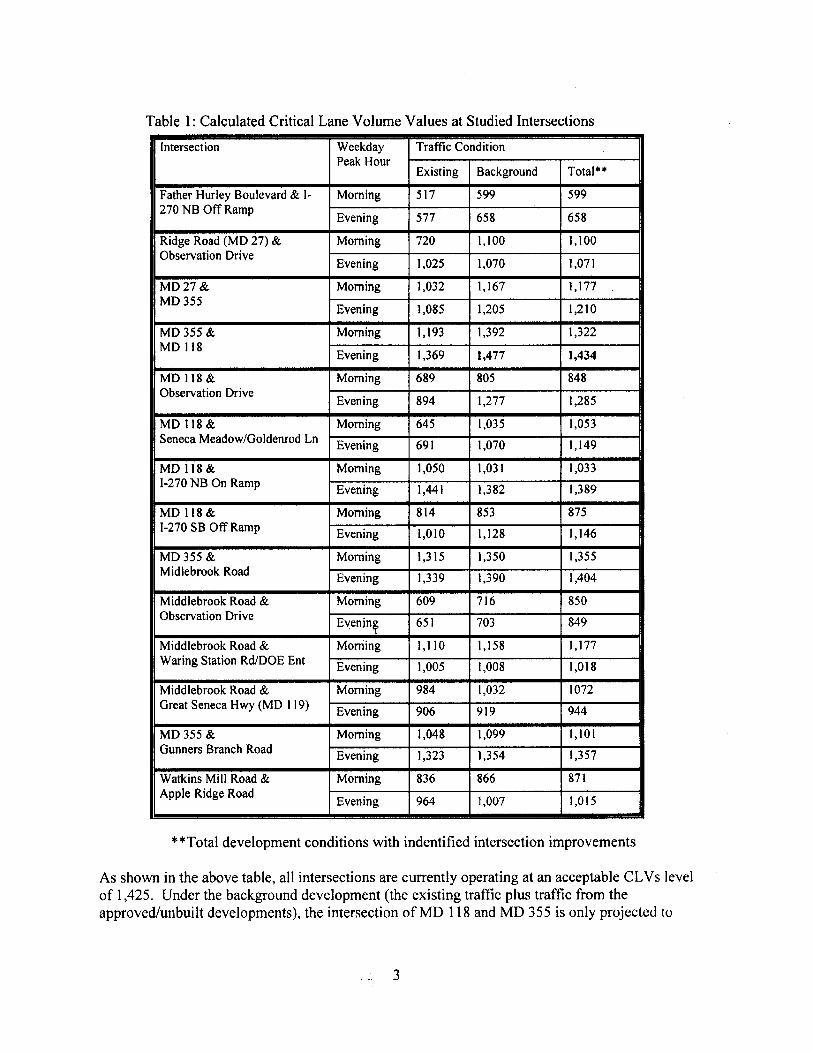
Local Area Transportation Review (LATR) A traffic study was submitted to determine the impact of the proposed development on area transportation systems. Fourteen intersections were identified as critical intersections affected by the proposed development and were examined in the traffic study to determine whether
22
they meet the applicable congestion standard for this area. The congestion standard in the Germantown East/Germantown West Policy Areas is 1,425 Critical Lane Volumes (CLV). All intersections are currently operating at an acceptable CLV level of 1,425. Under the background development (the existing traffic plus traffic from the approved but undeveloped projects), the intersection of MD 118 and MD 355 is projected to operate at an unacceptable CLV level during the weekday PM peak hour while all other intersections continue to operate at acceptable CLV standards. In the projection of the background development traffic analysis levels, all intersection improvements required to be built as conditions of approval for the recent Milestone Business Park project (Preliminary Plan No. 11987271B, approved by the Planning Board on January 27, 2011) were assumed to be built and open to traffic.
Under the total future development, which includes the background traffic plus traffic from the site, the implementation of the intersection improvements identified by the applicant in the traffic study will allow all intersections to operate at an acceptable or better than acceptable level of traffic conditions, compared to the background development (1,434 vs 1,477 for the MD 355/MD 118 intersection during the PM peak hour) during both the weekday AM and PM peak hours. With the implementation of the identified intersections improvements, this application meets the LATR requirements.
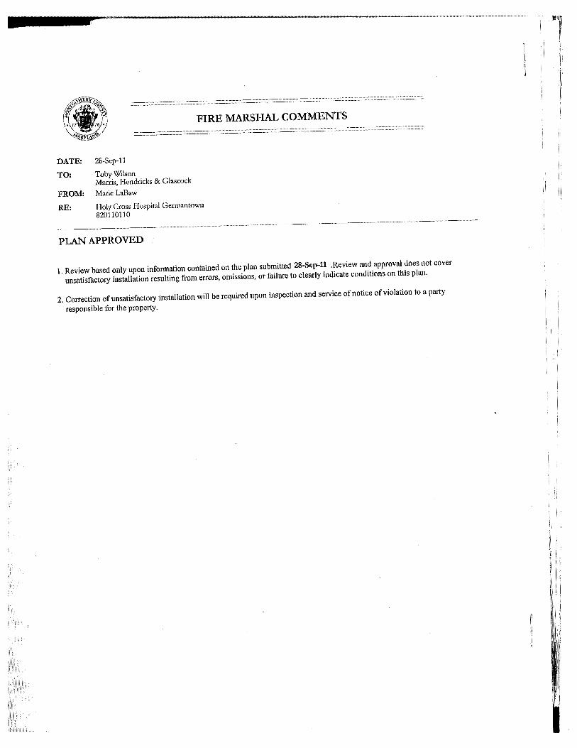
Policy Area Mobility Review (PAMR) The site is located within the Germantown East Policy Area where 50 percent of new trips must be mitigated as part of the PAMR requirements according to the Growth Policy. The site will generate 641 new PM peak hour trips subject to PAMR requirements of which the applicant is required to mitigate 50 percent, or 321 trips. The traffic study proposes to construct Observation Drive/Goldenrod Lane as a four (4) lane arterial from its current terminus immediately north of Middlebrook Road to the existing section of Goldenrod Lane (which intersects with MD 118) to meet the PAMR requirements. Staff has reviewed the PAMR trip mitigation analysis contained in the submitted Traffic Impact Study and found that this construction project will allow the project to meet the PAMR requirements. In the PAMR mitigation analysis, the Montgomery College’s approve Biosciences Center development was included, i.e., the construction of Observation Drive/Goldenrod Lane as proposed will provide sufficient PAMR mitigation for both the Montgomery College’s Biosciences Center and the Holy Cross Hospital/MOB. Other Public Facilities and Services All other major public utility providers have indicated that their respective utility is available and that there are no capacity or system limitations that would hinder service. Local extensions of utility services will need to be constructed mostly within the public utility easements established adjacent to the right-of-way for future Observation Drive. The application has been reviewed by the Montgomery County Fire and Rescue Service who have determined that the Property has appropriate access for fire and rescue vehicles. Other public facilities and services, such as schools, police stations, firehouses and health services are currently operating within the standards set by the Growth Policy Resolution currently in effect. The application generates no school aged children as a non-residential project and is therefore, not subject to a school facility payment.

23
4. Each structure and use is compatible with other uses and other site plans and with existing and proposed adjacent development. This development adequately fulfills the Sector Plan’s vision, specifically in the Montgomery College District. The establishment of this partnership will serve as an anchor for the S&T Park, and will therefore further enhance the Montgomery College experience. The linkage between the type of uses (i.e. the academic knowledge and the professional experience) presents the opportunity to develop new jobs and internships for the community as a whole. The overall design concept and building layout were strategically blended into the surrounding natural environment, and the stream valley buffer and forest adequately buffer the proposed buildings from the adjacent properties toward the east. The proposed signage systems (i.e. way-finding tools) help to safely guide the visitors through the site, and therefore support the efficiency of the pedestrian and vehicular circulation systems.
5. The site plan meets all applicable requirements of Chapter 22A regarding forest conservation,
Chapter 19 regarding water resource protection, and any other applicable law. The preliminary plan (120110380) complies with Chapter 22A, the Montgomery County Forest Conservation law. A Forest Conservation Plan (FCP) was approved for the Montgomery College – Germantown Campus under FCP #MR2009720. This FCP designated forest conservation easements for the entire Campus and provided areas available for development within this Science and Technology Park. The location of the lot proposed under this application and the development proposed on the lot are in conformance with the easements and limits of disturbance shown on FCP #MR2009720.
The Forest Conservation Plan approved for the Montgomery College – Germantown Campus under FCP #MR2009720 protects all sensitive environmental features on the Campus in conformance with Section 50-32 of the Subdivision Regulations. No other sensitive features were identified on the proposed lot.
Additionally, the Applicant has submitted an exterior mechanical noise analysis. The conclusion of this report recommended the installation of the noise barrier in front of the equipment yard. Staff is in support of this installation by Miller Beam, and Pagenelli Inc. The noise associated with the helistop was not included in this study; however, because this amenity is proposed for occasional emergency use only. In accordance with the Zoning Ordinance (pages 59A-25 and C5-12); the occasional use of the helistop is permitted in this zone. The stormwater management concept proposes to meet required SWM goals via alternative surfaces, micro-scale practices, bio-filters, and a joint use facility. The following items will need to be addressed during the detailed sediment control/stormwater management plan stage.
Prior to permanent vegetative stabilization, all disturbed areas will be topsoiled per the latest Montgomery County Standards and Specifications for Topsoiling
A detailed review of the SWM computations will occur at the time of detailed plan review.
An engineered sediment control plan will be submitted for this development.

24
All filtration media for manufactured Best Management Practices (BMPs), whether for new development or redevelopment, will be consist of MDE approved materials.
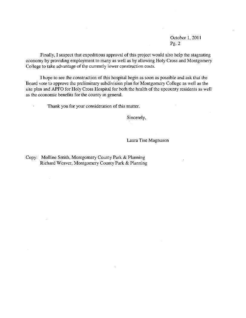
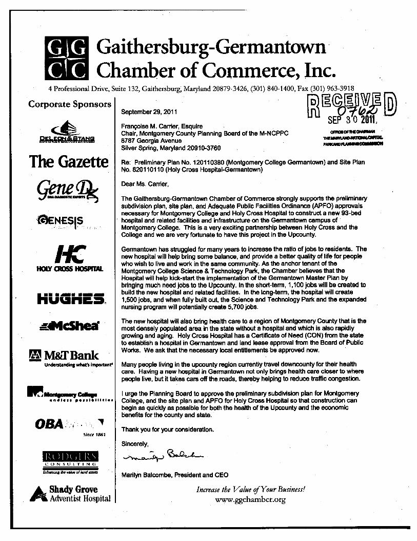
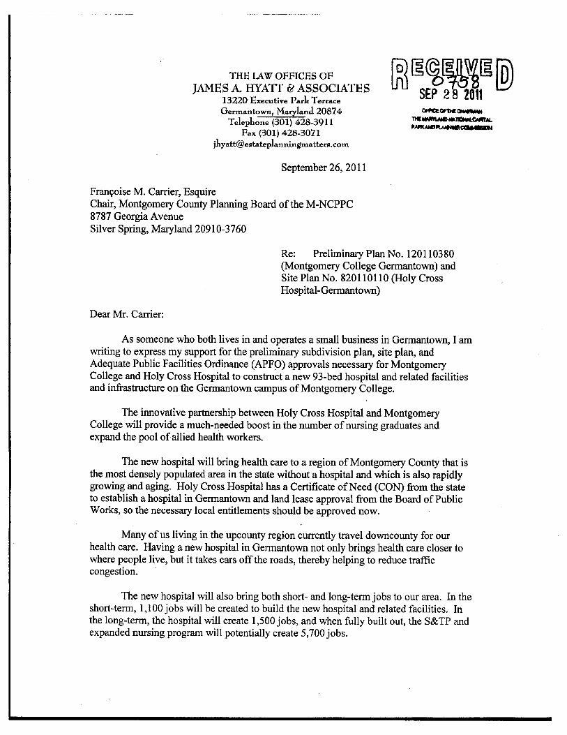
COMMUNITY OUTREACH The Applicant has met all proper signage, noticing, and submission meeting requirements. Staff has received phone calls and emails regarding this application. Staff has spoken and met with the attorney for Washington Adventist Hospital (David Brown) on September 27, 2011. No strong opposition was expressed; however, the attorney had questions regarding the submitted traffic study and the Final Forest Conservation Plan. Any issues raised during the meeting were addressed by Staff, and the meeting was concluded with the understanding that any other outstanding issues/ questions will be presented/ emailed in time for the public hearing. Staff also received several emails and letters in support of this project, all of which speak very highly of the partnership between Montgomery College and Holy Cross Hospital. They are also in favor of the new job opportunities and the ability to provide convenient health care to the surrounding communities. Staff has responded to these letters and the written copies have been attached (see Appendix D). CONCLUSION Staff concludes that the development of the Hospital, MOB and the associated landscape and parking facilities are in substantial conformance with the recommendations of the Germantown Employment Area Sector Plan and the Montgomery County Zoning Ordinance. APPENDIX
A. Site Plan Justification Statement
B. Agency Approvals
C. Adopted Design Guidelines (pages 42-43)
D. Community Correspondence Letters of Support
E. Site Details/ LEED
F. Exterior Mechanical Noise Analysis (by Miller, Beam & Paganelli, Inc.)