Embed Size (px)
Citation preview
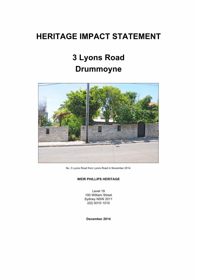
HERITAGE IMPACT STATEMENT
3 Lyons Road Drummoyne
No. 3 Lyons Road from Lyons Road in November 2014.
WEIR PHILLIPS HERITAGE
Level 19 100 William Street Sydney NSW 2011
(02) 9310 1010
December 2014
No. 3 Lyons Road, Drummoyne- Heritage Impact Statement i
CONTENTS PAGE
1.0 INTRODUCTION 1
1.1 Preamble 1 1.2 Authorship 1 1.3 Limitations 1 1.4 Methodology 1 1.5 References 2 1.5.1 General References 2 1.5.2 Historic Maps and Plans 2 1.5.3 Newspaper Articles 2 1.5.4 Historic Photographs 2 1.5.5 Heritage Inventory Sheets 2 1.5.6 NSW LPI Certificate of Titles 2 1.5.7 Planning Documents 2 1.6 Site Location 3
2.0 HISTORICAL DEVELOPMENT 3
2.1 Original Occupation 3 2.2 Surgeon Harris’ Five Dock Farm 3 2.3 Samuel Lyons and the Subdivision of Five Dock Farm 4 2.4 The Dawson Estate Subdivision 7 2.5 No. 3 Lyons Road 9
3.0 SITE ASSESSMENT 11
3.1 The Site 11 3.2 The Dwelling 13 3.2.1 Exterior 13 3.2.2 Interior 18 3.3 The Surrounding Area 24 3.3.1 Lyons Road 25 3.3.2 Albert Street 27
4.0 ASSESSMENT OF SIGNIFICNACE 29
4.1 Existing Heritage Listings and Citations 29 4.1.1 The Site 29 4.1.2 Heritage Items in the Vicinity of the Site 30 4.2 Identification of View Corridors 30 4.3 Integrity 31 4.3.1 The Site 31 4.3.2 The Dwelling 32 4.4 Comparative Analysis 33 4.5 Assessment Under NSW Heritage Branch Criteria 35 4.5.1 Criterion (a) 36 4.5.2 Criterion (b) 36 4.5.3 Criterion (c) 37 4.5.4 Criterion (d) 37 4.5.5 Criterion (e) 38 4.5.6 Criterion (f) 38
5.0 HERITAGE IMPACT ASSESSMENT 39
5.1 Scope of Works 39 5.2 Method of Assessment 39 5.3 Effect of Work on the Conservation Area 40 5.3.1 Impact of the Proposed Demolition Works 40 5.3.2 Impact of the Proposed New Works 41
6.0 CONCLUSION 47
No. 3 Lyons Road, Drummoyne- Heritage Impact Statement 1
1.0 INTRODUCTION
1.1 Preamble
This Heritage Impact Statement for No. 3 Lyons Road, Drummoyne, New South Wales has been prepared to accompany an application for the demolition of the existing structures on the site and the construction of a new dwelling, with associated landscaping.
No. 3 Lyons Road is located within the City of Canada Bay. The principal planning control for the site is the Canada Bay Local Environmental Plan 2013, hereafter referred to as the Canada Bay LEP 2013. The site is not listed as a heritage item by Schedule 5 Part 1 of the Canada Bay LEP 2013. It is, however, located within the Birkenhead and Dawson Estates Conservation Area as defined by Schedule 5 Part 2 of this plan. Under the clauses of Part 5.10 of the Canada Bay LEP 2013
(4) Effect of proposed development on heritage significance
The consent authority must, before granting consent under this clause in respect of a heritage item or heritage conservation area, consider the effect of the proposed development on the heritage significance of the item or area concerned. This subclause applies regardless of whether a heritage management document is prepared under subclause (5) or a heritage conservation management plan is submitted under subclause (6).
(5) Heritage assessment
The consent authority may, before granting consent to any development:
(a) on land on which a heritage item is located, or
(b) on land that is within a heritage conservation area, or
(c) on land that is within the vicinity of land referred to in paragraph (a) or (b),
require a heritage management document to be prepared that assesses the extent to which the carrying out of the proposed development would affect the heritage significance of the heritage item or heritage conservation area concerned.
The appropriate heritage management document in this instance is a heritage impact statement (HIS).
This statement has been prepared at the request of the owners and accompanies plans prepared by Weir Phillips Architects.
1.2 Authorship
This statement was prepared by Alice Fuller, B.App.Sc. (CCM), M.Hert.Cons. (Hons.) and James Phillips, B.Sc. (Arch.) B. Arch., M.Hert.Cons. (Hons), of Weir Phillips, Architects and Heritage Consultants.
1.3 Limitations
No historical archaeology was carried out on the site.
1.4 Methodology
This assessment has been prepared with an understanding of the NSW Heritage Office (now Division) publications Assessing Heritage Significance (2001) and Statements of Heritage Impact (2002). The general references and Council documents listed in Section 1.5 were referred to.
Site visits were conducted in 2014. Unless otherwise stated, the photographs contained in this assessment were taken by the authors on these occasions.
No. 3 Lyons Road, Drummoyne- Heritage Impact Statement 2
1.5 References
1.5.1 General References • Apperly, Richard, Robert Irving and Peter Reynolds, A Pictorial Guide to
Identifying Australian Architecture: Styles and Terms from 1788 to the Present, Sydney, Angus and Robertson 1989.
• Fletcher, B.H., ‘Harris, John’, in Douglas Pike (gen. ed.), Australian Dictionary of Biography Volume 1, Victoria, Melbourne University Press, 1966.
• Kelly, Max (ed.), Sydney City of Suburbs, NSW University Press, 1987. • Le Roy, Paul Edwin, ‘Lyons, Samuel’, in Douglas Pike (gen.ed.), Australian
Dictionary of Biography, Volume 2, Victoria, Melbourne University Press, 1967.
• Russell, Eric, Drummoyne: A Western Suburbs’ History 1794, 1871, 1971, NSW, Council of the Municipality of Drummoyne, 1971.
• Stapleton, Maisy and Ian, Australian House Styles, NSW, The Flannel Flower Press, 1997.
1.5.2 Historic Maps and Plans • Plan of the Parish of Concord, County of Cumberland, New South Wales,
undated. NSW Parish Map Preservation Project. • Richardson and Wrench Dawson Estate, Drummoyne: First Subdivision,
1901. National Library of Australia. • Sketch of the Five Dock Farm Estate Shewing the Situation of Lot CXIV, 184?
National Library of Australia. • Richardson and Wrench, Dawson Estate, Drummoyne, National Library of
Australia, [19]08.
1.5.3 Newspaper Articles • ‘To Capitalists, Gentleman in Public or Private Offices…’, The Sydney
Monitor, 28 September, 1836.
1.5.4 Historic Photographs • Aerial photograph over Drummoyne, 1943. Online reference:
maps.six.nsw.gov.
1.5.5 Heritage Inventory Sheets • Birkenhead and Dawson Estates Conservation Area. State Heritage Inventory
Database No.: 2891198.
1.5.6 NSW LPI Certificate of Titles • Primary Application No. 11404. • Certificate of Title, Volume 1325 Folio 70. • Certificate of Title Volume 1348 Folio 180. • Certificate of Title Volume 1386 Folio 84. • Certificate of Title, Volume 1631, Folio 204. • Certificate of Title, Volume 1998, Folio 59.
1.5.7 Planning Documents • City of Canada Bay Local Environmental Plan 2013. • City of Canada Bay Development Control Plan 2013. • NSW Heritage Office, Assessing Heritage Significance, NSW, Heritage Office,
2001.
No. 3 Lyons Road, Drummoyne- Heritage Impact Statement 3
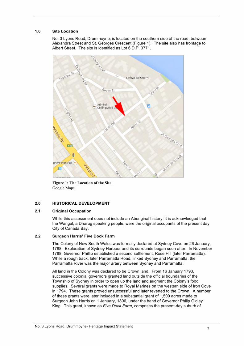
1.6 Site Location
No. 3 Lyons Road, Drummoyne, is located on the southern side of the road, between Alexandra Street and St. Georges Crescent (Figure 1). The site also has frontage to Albert Street. The site is identified as Lot 6 D.P. 3771.
Figure 1: The Location of the Site. Google Maps.
2.0 HISTORICAL DEVELOPMENT
2.1 Original Occupation
While this assessment does not include an Aboriginal history, it is acknowledged that the Wangal, a Dharug speaking people, were the original occupants of the present day City of Canada Bay.
2.2 Surgeon Harris’ Five Dock Farm
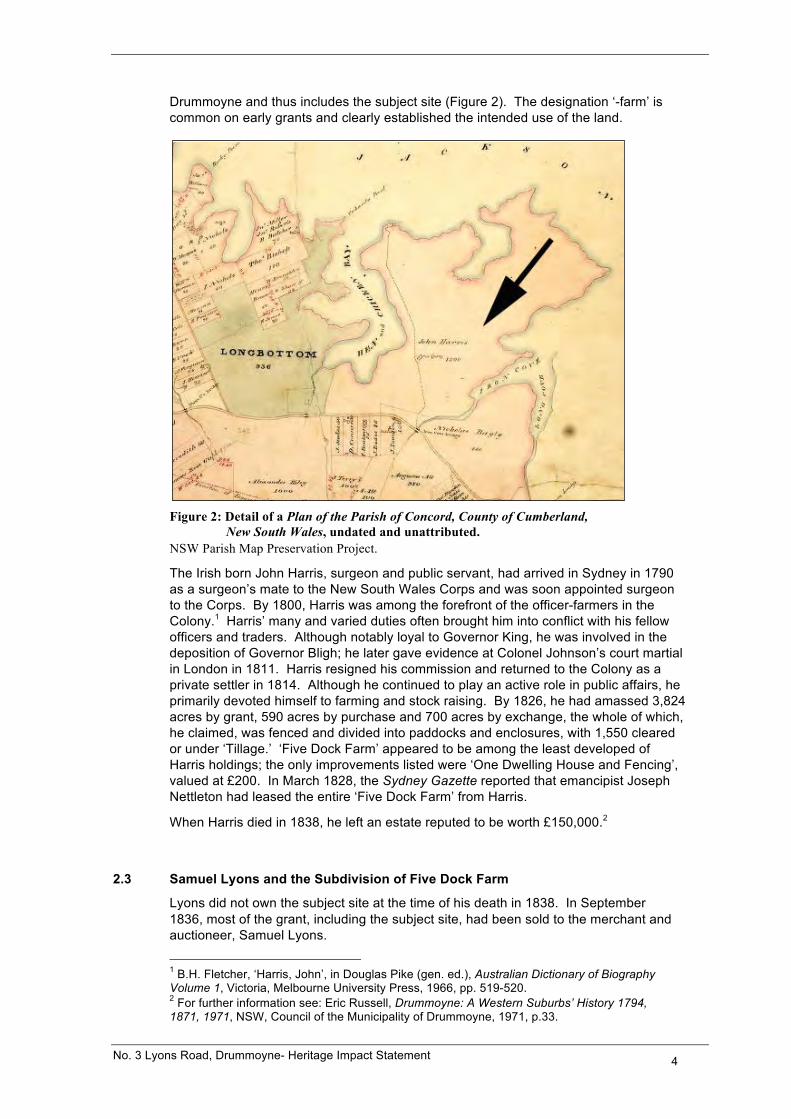
The Colony of New South Wales was formally declared at Sydney Cove on 26 January, 1788. Exploration of Sydney Harbour and its surrounds began soon after. In November 1788, Governor Phillip established a second settlement, Rose Hill (later Parramatta). While a rough track, later Parramatta Road, linked Sydney and Parramatta, the Parramatta River was the major artery between Sydney and Parramatta.
All land in the Colony was declared to be Crown land. From 16 January 1793, successive colonial governors granted land outside the official boundaries of the Township of Sydney in order to open up the land and augment the Colony’s food supplies. Several grants were made to Royal Marines on the western side of Iron Cove in 1794. These grants proved unsuccessful and later reverted to the Crown. A number of these grants were later included in a substantial grant of 1,500 acres made to Surgeon John Harris on 1 January, 1806, under the hand of Governor Philip Gidley King. This grant, known as Five Dock Farm, comprises the present-day suburb of
No. 3 Lyons Road, Drummoyne- Heritage Impact Statement 4
Drummoyne and thus includes the subject site (Figure 2). The designation ‘-farm’ is common on early grants and clearly established the intended use of the land.
Figure 2: Detail of a Plan of the Parish of Concord, County of Cumberland,
New South Wales, undated and unattributed. NSW Parish Map Preservation Project.
The Irish born John Harris, surgeon and public servant, had arrived in Sydney in 1790 as a surgeon’s mate to the New South Wales Corps and was soon appointed surgeon to the Corps. By 1800, Harris was among the forefront of the officer-farmers in the Colony.1 Harris’ many and varied duties often brought him into conflict with his fellow officers and traders. Although notably loyal to Governor King, he was involved in the deposition of Governor Bligh; he later gave evidence at Colonel Johnson’s court martial in London in 1811. Harris resigned his commission and returned to the Colony as a private settler in 1814. Although he continued to play an active role in public affairs, he primarily devoted himself to farming and stock raising. By 1826, he had amassed 3,824 acres by grant, 590 acres by purchase and 700 acres by exchange, the whole of which, he claimed, was fenced and divided into paddocks and enclosures, with 1,550 cleared or under ‘Tillage.’ ‘Five Dock Farm’ appeared to be among the least developed of Harris holdings; the only improvements listed were ‘One Dwelling House and Fencing’, valued at £200. In March 1828, the Sydney Gazette reported that emancipist Joseph Nettleton had leased the entire ‘Five Dock Farm’ from Harris.
When Harris died in 1838, he left an estate reputed to be worth £150,000.2
2.3 Samuel Lyons and the Subdivision of Five Dock Farm
Lyons did not own the subject site at the time of his death in 1838. In September 1836, most of the grant, including the subject site, had been sold to the merchant and auctioneer, Samuel Lyons.
1 B.H. Fletcher, ‘Harris, John’, in Douglas Pike (gen. ed.), Australian Dictionary of Biography Volume 1, Victoria, Melbourne University Press, 1966, pp. 519-520. 2 For further information see: Eric Russell, Drummoyne: A Western Suburbs’ History 1794, 1871, 1971, NSW, Council of the Municipality of Drummoyne, 1971, p.33.
No. 3 Lyons Road, Drummoyne- Heritage Impact Statement 5
Samuel Lyons had arrived in Sydney in 1815 as a convict, serving a life sentence for theft. Lyons received a conditional pardon in 1825 and an absolute pardon in 1832. Upon obtaining his freedom, he established himself as a successful auctioneer, becoming the owner of one of Sydney’s largest auction houses. Lyon’s business interests were diverse and included property development, money lending and banking; he was also active in public affairs, later becoming a prominent member of Sydney’s Jewish community.3
Lyons wasted little time in seeking to profit from Five Dock Farm. In September 1836, he advertised his intent to sell the whole of the grant in lots of a ‘convenient size’, directing his notices in several Sydney newspapers ‘To Capitalists, Gentlemen in Private or Public Offices, Tradesmen and Others.’4 The picturesque qualities of the estate and its proximity to Sydney Township were particularly mentioned. Trespassers were evidently a problem for Lyons at this time. In late 1836, he issued notices that those found cutting timber, quarrying stone or depasturing cattle on ‘Five Dock Farm’ would be prosecuted.5
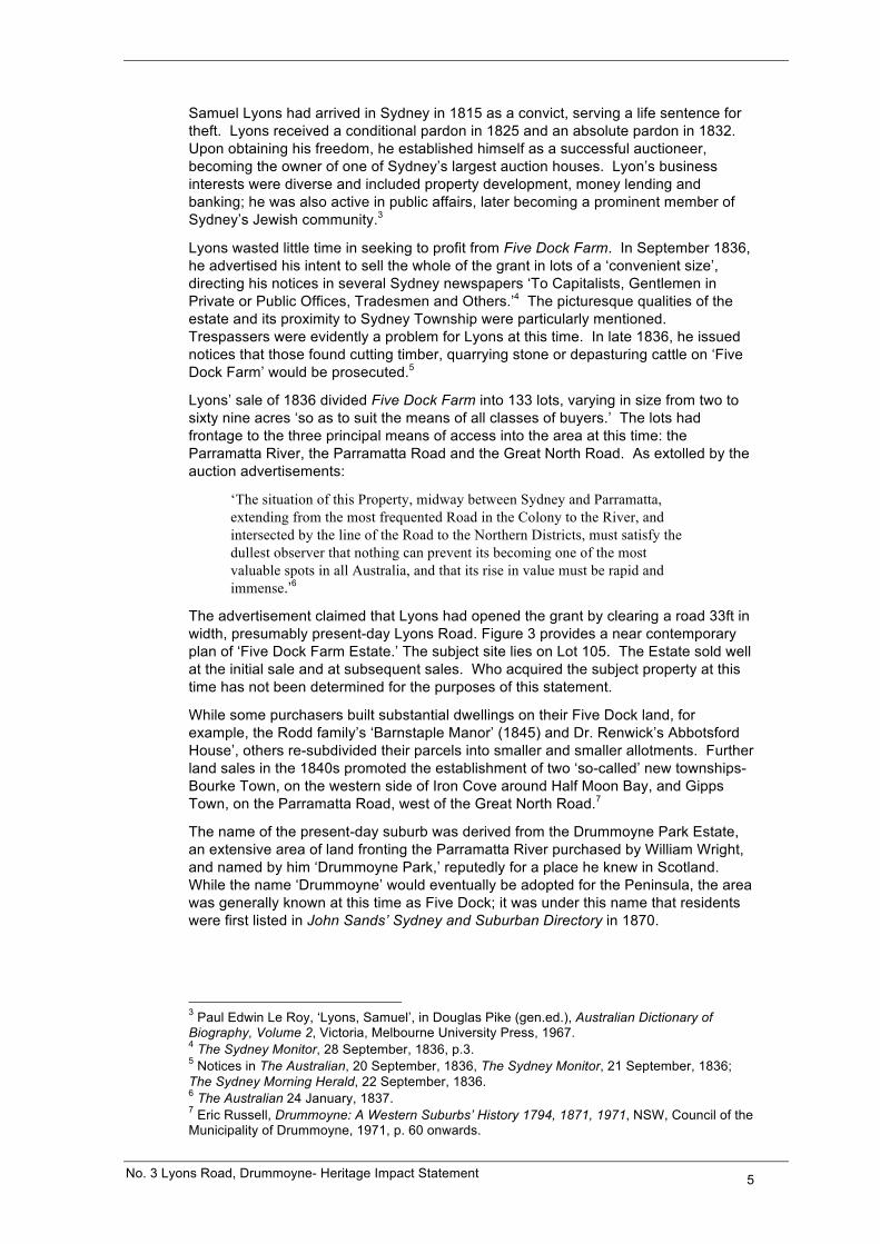
Lyons’ sale of 1836 divided Five Dock Farm into 133 lots, varying in size from two to sixty nine acres ‘so as to suit the means of all classes of buyers.’ The lots had frontage to the three principal means of access into the area at this time: the Parramatta River, the Parramatta Road and the Great North Road. As extolled by the auction advertisements:
‘The situation of this Property, midway between Sydney and Parramatta, extending from the most frequented Road in the Colony to the River, and intersected by the line of the Road to the Northern Districts, must satisfy the dullest observer that nothing can prevent its becoming one of the most valuable spots in all Australia, and that its rise in value must be rapid and immense.’6
The advertisement claimed that Lyons had opened the grant by clearing a road 33ft in width, presumably present-day Lyons Road. Figure 3 provides a near contemporary plan of ‘Five Dock Farm Estate.’ The subject site lies on Lot 105. The Estate sold well at the initial sale and at subsequent sales. Who acquired the subject property at this time has not been determined for the purposes of this statement.
While some purchasers built substantial dwellings on their Five Dock land, for example, the Rodd family’s ‘Barnstaple Manor’ (1845) and Dr. Renwick’s Abbotsford House’, others re-subdivided their parcels into smaller and smaller allotments. Further land sales in the 1840s promoted the establishment of two ‘so-called’ new townships- Bourke Town, on the western side of Iron Cove around Half Moon Bay, and Gipps Town, on the Parramatta Road, west of the Great North Road.7
The name of the present-day suburb was derived from the Drummoyne Park Estate, an extensive area of land fronting the Parramatta River purchased by William Wright, and named by him ‘Drummoyne Park,’ reputedly for a place he knew in Scotland. While the name ‘Drummoyne’ would eventually be adopted for the Peninsula, the area was generally known at this time as Five Dock; it was under this name that residents were first listed in John Sands’ Sydney and Suburban Directory in 1870.
3 Paul Edwin Le Roy, ‘Lyons, Samuel’, in Douglas Pike (gen.ed.), Australian Dictionary of Biography, Volume 2, Victoria, Melbourne University Press, 1967. 4 The Sydney Monitor, 28 September, 1836, p.3. 5 Notices in The Australian, 20 September, 1836, The Sydney Monitor, 21 September, 1836; The Sydney Morning Herald, 22 September, 1836. 6 The Australian 24 January, 1837. 7 Eric Russell, Drummoyne: A Western Suburbs’ History 1794, 1871, 1971, NSW, Council of the Municipality of Drummoyne, 1971, p. 60 onwards.
No. 3 Lyons Road, Drummoyne- Heritage Impact Statement 6
Figure 3: Sketch of the Five Dock Farm Estate Shewing the Situation of Lot CXIV, 184? National Library of Australia.
As the population of the area began to increase, the first moves were made to incorporate the area and establish local government. In 1870, the petitioners who sought the creation of a municipality claimed that they represented a population of more than 500 people within boundaries roughly comparable to the original ‘Five Dock Farm.’ When the Municipality of Five Dock was declared on 25 July 1871, the population was given as 850 people, in 101 houses.8
The new Municipality of Five Dock was short-lived. By the late 1880s, there was a strong movement to separate the North Ward, in which the subject property was located, on the basis that the area generally known as ‘Drummoyne’ was more heavily populated than Five Dock. The Municipality of Drummoyne came into being on 18 January, 1890. The numerous advantages enjoyed by the newly created municipality were enumerated in an article in The Echo newspaper in August of that year:
‘A government wharf on the Parramatta River is where the Parramatta steamers call, and the Council has wharfs at Cary Street, Birkenhead and Thompson Street…. This portion of the Borough is also well served by a line of steamers run by the Balmain Steam Ferry Company to Drummoyne and Leichhardt, the fare being only 3d. The Ryde and Gladesville (horse-) omnibuses run through the Borough…Drummoyne, with its busy road, is a prosperous looking place, and the population is rapidly rising.’9
Five Dock, on the other hand, was still a ‘quiet looking rural district.’ Drummoyne inherited numerous problems from the Five Dock Municipality. Some thoroughfares were impassable, local dairies were considered a serious health risk and straying horse and cattle, as well as travelling stock, continued to be a problem.
Small lot subdivision began in earnest in the late nineteenth and early twentieth centuries. Part of the Conservation Area in which the subject property is located (the area bound by
8 Eric Russell, op.cit., 1971, pp. 99-102. 9 The Echo, 28 August, 1890, cited in ibid, p.119.
No. 3 Lyons Road, Drummoyne- Heritage Impact Statement 7
Lyons Road, Victoria Road, Ferry Lane, Ferry Road and Iron Cove) formed part of the Birkenhead Estate subdivision of 1882.
2.4 The Dawson Estate Subdivision
By 1900, the subject property was part of a larger estate of 42 acres, 0 roods and 5 perches (i.e. Lot 105) owned by Emma Fox Dawson. In her application to bring the lands under the provision of the Real Property Act, Emma Dawson states that she is in occupation and that the land is valued at over £23,118.10
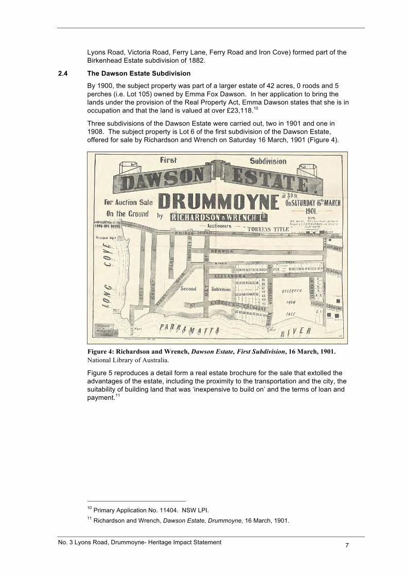
Three subdivisions of the Dawson Estate were carried out, two in 1901 and one in 1908. The subject property is Lot 6 of the first subdivision of the Dawson Estate, offered for sale by Richardson and Wrench on Saturday 16 March, 1901 (Figure 4).
Figure 4: Richardson and Wrench, Dawson Estate, First Subdivision, 16 March, 1901. National Library of Australia.
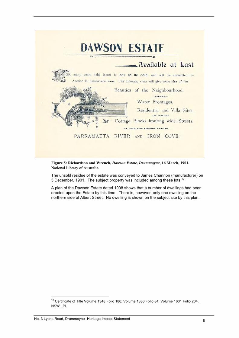
Figure 5 reproduces a detail form a real estate brochure for the sale that extolled the advantages of the estate, including the proximity to the transportation and the city, the suitability of building land that was ‘inexpensive to build on’ and the terms of loan and payment.11
10 Primary Application No. 11404. NSW LPI. 11 Richardson and Wrench, Dawson Estate, Drummoyne, 16 March, 1901.
No. 3 Lyons Road, Drummoyne- Heritage Impact Statement 8
Figure 5: Richardson and Wrench, Dawson Estate, Drummoyne, 16 March, 1901. National Library of Australia.
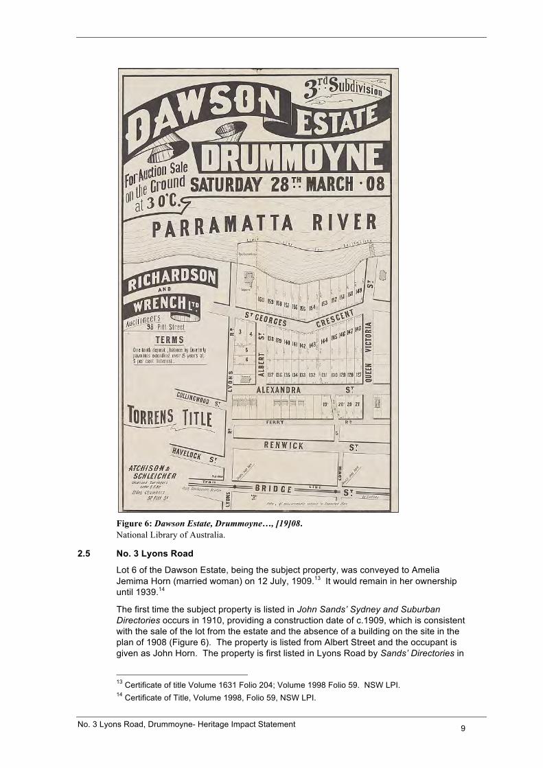
The unsold residue of the estate was conveyed to James Channon (manufacturer) on 3 December, 1901. The subject property was included among these lots.12
A plan of the Dawson Estate dated 1908 shows that a number of dwellings had been erected upon the Estate by this time. There is, however, only one dwelling on the northern side of Albert Street. No dwelling is shown on the subject site by this plan.
12 Certificate of Title Volume 1348 Folio 180; Volume 1386 Folio 84; Volume 1631 Folio 204. NSW LPI.
No. 3 Lyons Road, Drummoyne- Heritage Impact Statement 9
Figure 6: Dawson Estate, Drummoyne…, [19]08. National Library of Australia.
2.5 No. 3 Lyons Road
Lot 6 of the Dawson Estate, being the subject property, was conveyed to Amelia Jemima Horn (married woman) on 12 July, 1909.13 It would remain in her ownership until 1939.14
The first time the subject property is listed in John Sands’ Sydney and Suburban Directories occurs in 1910, providing a construction date of c.1909, which is consistent with the sale of the lot from the estate and the absence of a building on the site in the plan of 1908 (Figure 6). The property is listed from Albert Street and the occupant is given as John Horn. The property is first listed in Lyons Road by Sands’ Directories in
13 Certificate of title Volume 1631 Folio 204; Volume 1998 Folio 59. NSW LPI. 14 Certificate of Title, Volume 1998, Folio 59, NSW LPI.
No. 3 Lyons Road, Drummoyne- Heritage Impact Statement 10
1912. For a brief period, it is listed in both streets, before being listed solely from Lyons Road. John Horn is listed as the occupant until the last published Sands’ Directory in 1932/33. The numbering of the properties in this part of Lyons Road in Sands’ Directories begins in 1917. In this year, the subject site was listed as No. 5 Lyons Road. It remained known by this number beyond the last published Sands’ Directory.
Following Amelia’s death in 1939, the property was transferred to John Durwood Horn (chemist) on 9 September, 1939.15 On the same day, the property was transferred to Charles James Lewin (electrician), who retained ownership until 1943. No information about the Horn family has been located during the course of research for this statement.
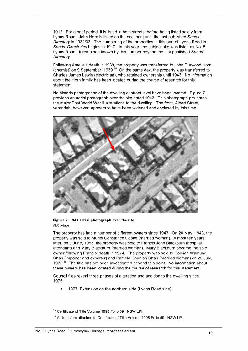
No historic photographs of the dwelling at street level have been located. Figure 7 provides an aerial photograph over the site dated 1943. This photograph pre-dates the major Post World War II alterations to the dwelling. The front, Albert Street, verandah, however, appears to have been widened and enclosed by this time.
Figure 7: 1943 aerial photograph over the site. SIX Maps.
The property has had a number of different owners since 1943. On 20 May, 1943, the property was sold to Muriel Constance Cooke (married woman). Almost ten years later, on 3 June, 1953, the property was sold to Francis John Blackburn (hospital attendant) and Mary Blackburn (married woman). Mary Blackburn became the sole owner following Francis’ death in 1974. The property was sold to Colman Waihung Chan (importer and exporter) and Pamela Chunlan Chan (married woman) on 25 July, 1975.16 The title has not been investigated beyond this point. No information about these owners has been located during the course of research for this statement.
Council files reveal three phases of alteration and addition to the dwelling since 1975:
• 1977: Extension on the northern side (Lyons Road side).
15 Certificate of Title Volume 1998 Folio 59. NSW LPI. 16 All transfers attached to Certificate of Title Volume 1998 Folio 59. NSW LPI.
No. 3 Lyons Road, Drummoyne- Heritage Impact Statement 11
• 1983: New basement study in the southern corner; a new car port, steel fence and pool (Albert Street side).
• 1986: Ground floor and basement extension on the eastern side of the dwelling.17
As set out below, these alterations have had a considerable impact on the dwelling.
3.0 SITE ASSESSMENT
3.1 The Site
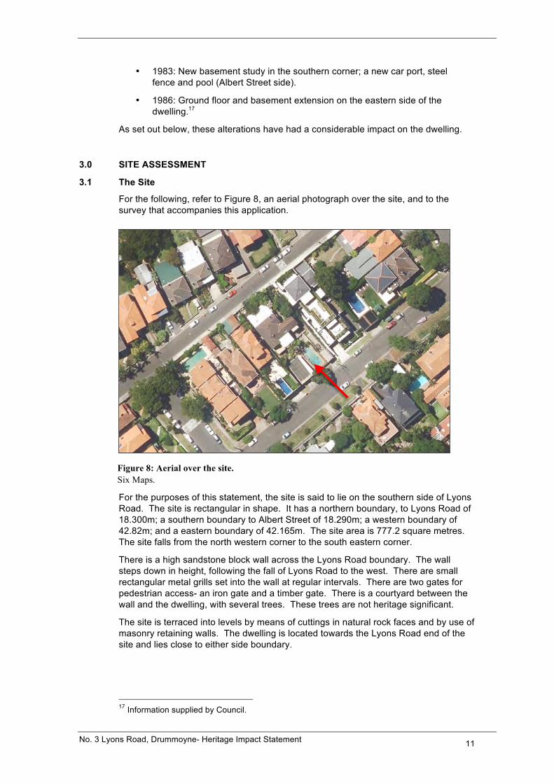
For the following, refer to Figure 8, an aerial photograph over the site, and to the survey that accompanies this application.
Figure 8: Aerial over the site. Six Maps.
For the purposes of this statement, the site is said to lie on the southern side of Lyons Road. The site is rectangular in shape. It has a northern boundary, to Lyons Road of 18.300m; a southern boundary to Albert Street of 18.290m; a western boundary of 42.82m; and a eastern boundary of 42.165m. The site area is 777.2 square metres. The site falls from the north western corner to the south eastern corner.
There is a high sandstone block wall across the Lyons Road boundary. The wall steps down in height, following the fall of Lyons Road to the west. There are small rectangular metal grills set into the wall at regular intervals. There are two gates for pedestrian access- an iron gate and a timber gate. There is a courtyard between the wall and the dwelling, with several trees. These trees are not heritage significant.
The site is terraced into levels by means of cuttings in natural rock faces and by use of masonry retaining walls. The dwelling is located towards the Lyons Road end of the site and lies close to either side boundary.
17 Information supplied by Council.
No. 3 Lyons Road, Drummoyne- Heritage Impact Statement 12
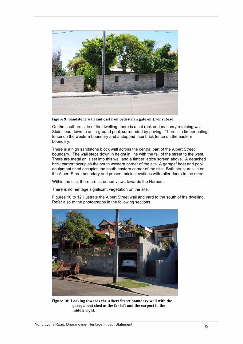
Figure 9: Sandstone wall and cast iron pedestrian gate on Lyons Road.
On the southern side of the dwelling, there is a cut rock and masonry retaining wall. Stairs lead down to an in-ground pool, surrounded by paving. There is a timber paling fence on the western boundary and a stepped face brick fence on the eastern boundary.
There is a high sandstone block wall across the central part of the Albert Street boundary. The wall steps down in height in line with the fall of the street to the west. There are metal grills set into this wall and a timber lattice screen above. A detached brick carport occupies the south western corner of the site. A garage/ boat and pool equipment shed occupies the south eastern corner of the site. Both structures lie on the Albert Street boundary and present brick elevations with roller doors to the street.
Within the site, there are screened views towards the Harbour.
There is no heritage significant vegetation on the site.
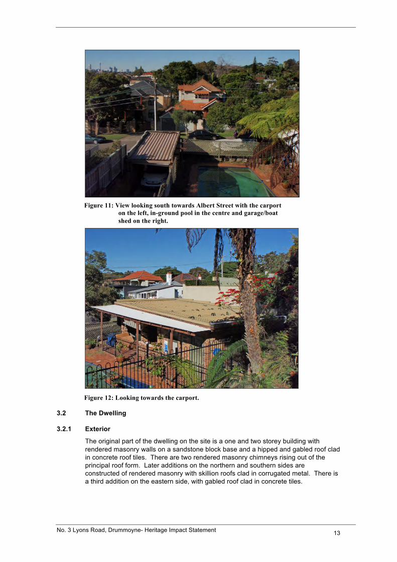
Figures 10 to 12 illustrate the Albert Street wall and yard to the south of the dwelling. Refer also to the photographs in the following sections.
Figure 10: Looking towards the Albert Street boundary wall with the
garage/boat shed at the far left and the carport in the middle right.
No. 3 Lyons Road, Drummoyne- Heritage Impact Statement 13
Figure 11: View looking south towards Albert Street with the carport
on the left, in-ground pool in the centre and garage/boat shed on the right.
Figure 12: Looking towards the carport.
3.2 The Dwelling
3.2.1 Exterior
The original part of the dwelling on the site is a one and two storey building with rendered masonry walls on a sandstone block base and a hipped and gabled roof clad in concrete roof tiles. There are two rendered masonry chimneys rising out of the principal roof form. Later additions on the northern and southern sides are constructed of rendered masonry with skillion roofs clad in corrugated metal. There is a third addition on the eastern side, with gabled roof clad in concrete tiles.
No. 3 Lyons Road, Drummoyne- Heritage Impact Statement 14
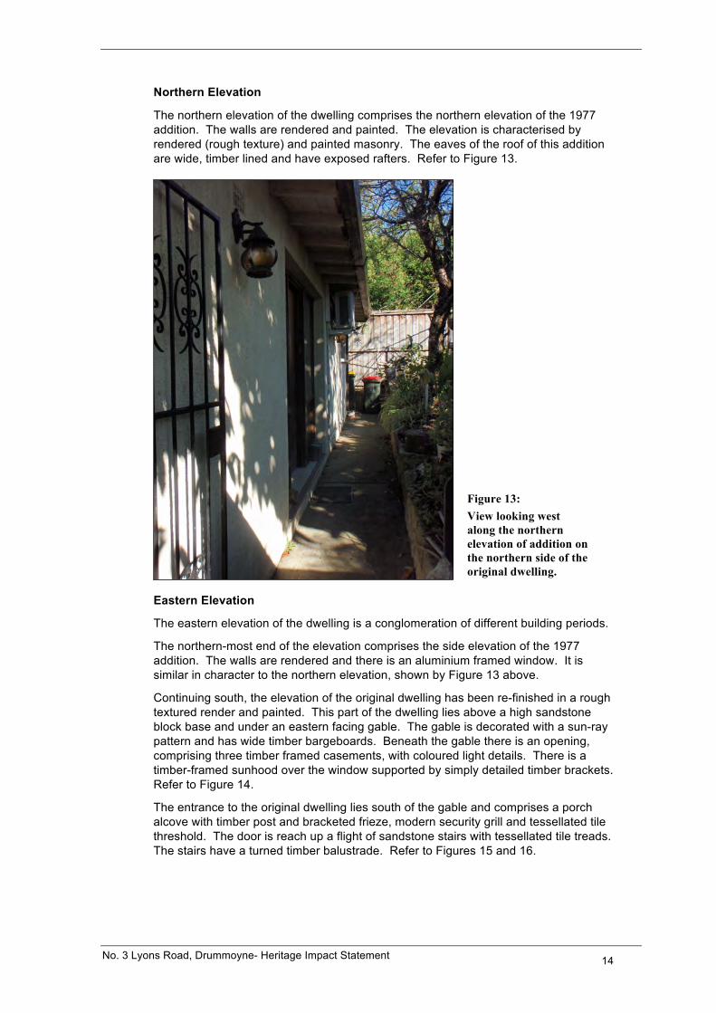
Northern Elevation
The northern elevation of the dwelling comprises the northern elevation of the 1977 addition. The walls are rendered and painted. The elevation is characterised by rendered (rough texture) and painted masonry. The eaves of the roof of this addition are wide, timber lined and have exposed rafters. Refer to Figure 13.
Figure 13: View looking west along the northern elevation of addition on the northern side of the original dwelling.
Eastern Elevation
The eastern elevation of the dwelling is a conglomeration of different building periods.
The northern-most end of the elevation comprises the side elevation of the 1977 addition. The walls are rendered and there is an aluminium framed window. It is similar in character to the northern elevation, shown by Figure 13 above.
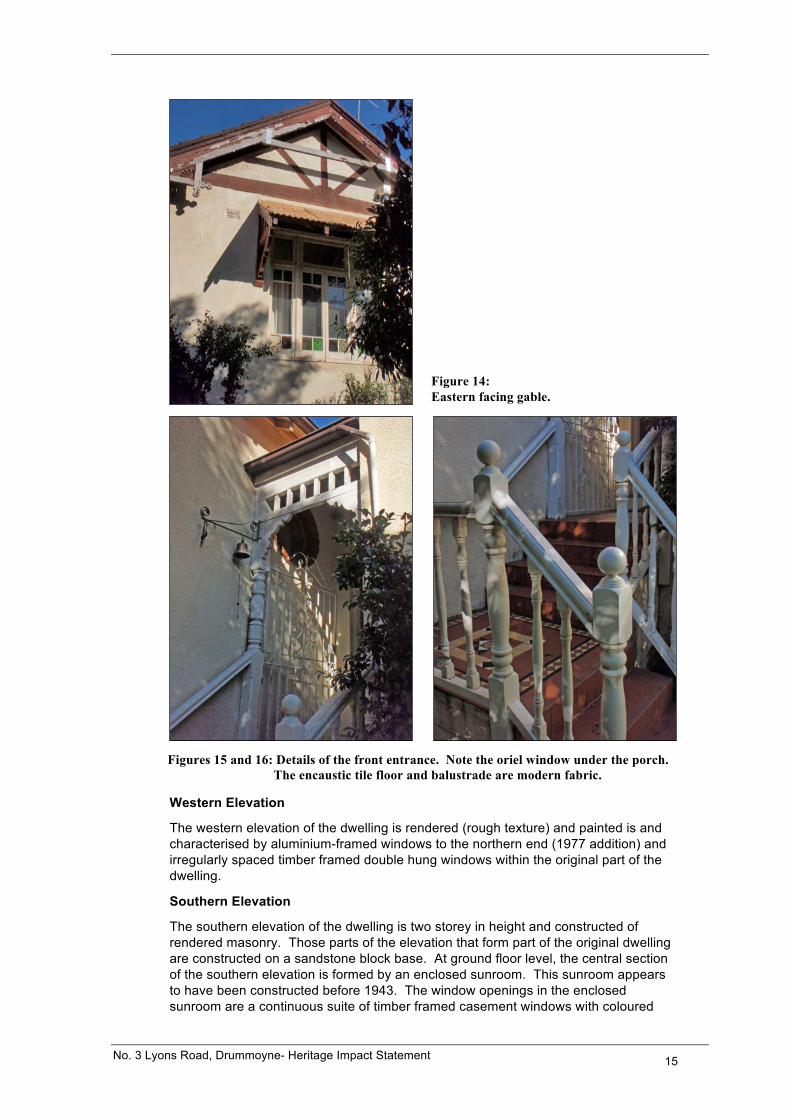
Continuing south, the elevation of the original dwelling has been re-finished in a rough textured render and painted. This part of the dwelling lies above a high sandstone block base and under an eastern facing gable. The gable is decorated with a sun-ray pattern and has wide timber bargeboards. Beneath the gable there is an opening, comprising three timber framed casements, with coloured light details. There is a timber-framed sunhood over the window supported by simply detailed timber brackets. Refer to Figure 14.
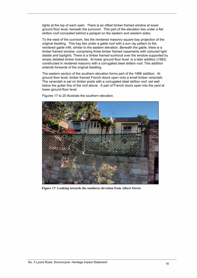
The entrance to the original dwelling lies south of the gable and comprises a porch alcove with timber post and bracketed frieze, modern security grill and tessellated tile threshold. The door is reach up a flight of sandstone stairs with tessellated tile treads. The stairs have a turned timber balustrade. Refer to Figures 15 and 16.
No. 3 Lyons Road, Drummoyne- Heritage Impact Statement 15
Figure 14: Eastern facing gable.
Figures 15 and 16: Details of the front entrance. Note the oriel window under the porch.
The encaustic tile floor and balustrade are modern fabric.
Western Elevation
The western elevation of the dwelling is rendered (rough texture) and painted is and characterised by aluminium-framed windows to the northern end (1977 addition) and irregularly spaced timber framed double hung windows within the original part of the dwelling.
Southern Elevation
The southern elevation of the dwelling is two storey in height and constructed of rendered masonry. Those parts of the elevation that form part of the original dwelling are constructed on a sandstone block base. At ground floor level, the central section of the southern elevation is formed by an enclosed sunroom. This sunroom appears to have been constructed before 1943. The window openings in the enclosed sunroom are a continuous suite of timber framed casement windows with coloured
No. 3 Lyons Road, Drummoyne- Heritage Impact Statement 16
lights at the top of each sash. There is an offset timber framed window at lower ground floor level, beneath the sunroom. This part of the elevation lies under a flat skillion roof concealed behind a parapet on the eastern and western sides.
To the west of the sunroom, lies the rendered masonry square bay projection of the original dwelling. This bay lies under a gable roof with a sun ray pattern to the rendered gable infill, similar to the eastern elevation. Beneath the gable, there is a timber framed window, comprising three timber framed casements with coloured light details and toplights. There is a timber framed sunhood over the window supported by simply detailed timber brackets. At lower ground floor level, is a later addition (1983) constructed in rendered masonry with a corrugated steel skillion roof. This addition extends forwards of the original dwelling.
The eastern section of the southern elevation forms part of the 1986 addition. At ground floor level, timber framed French doors open onto a small timber verandah. The verandah is set on timber posts with a corrugated steel skillion roof, set well below the gutter line of the roof above. A pair of French doors open into the yard at lower ground floor level.
Figures 17 to 20 illustrate the southern elevation.
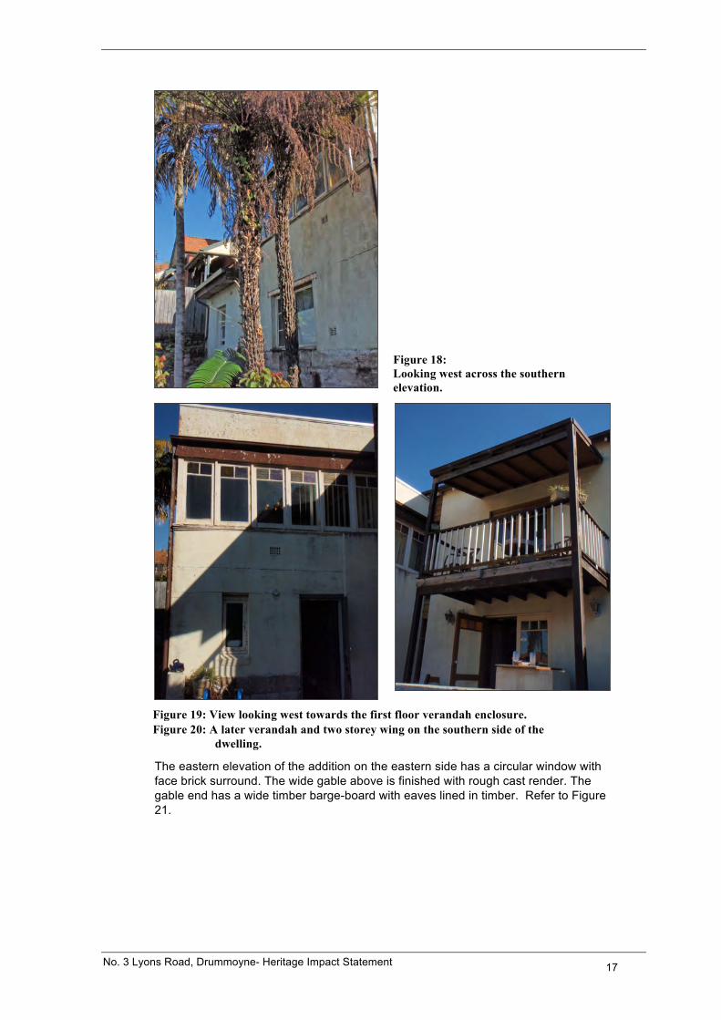
Figure 17: Looking towards the southern elevation from Albert Street.
No. 3 Lyons Road, Drummoyne- Heritage Impact Statement 17
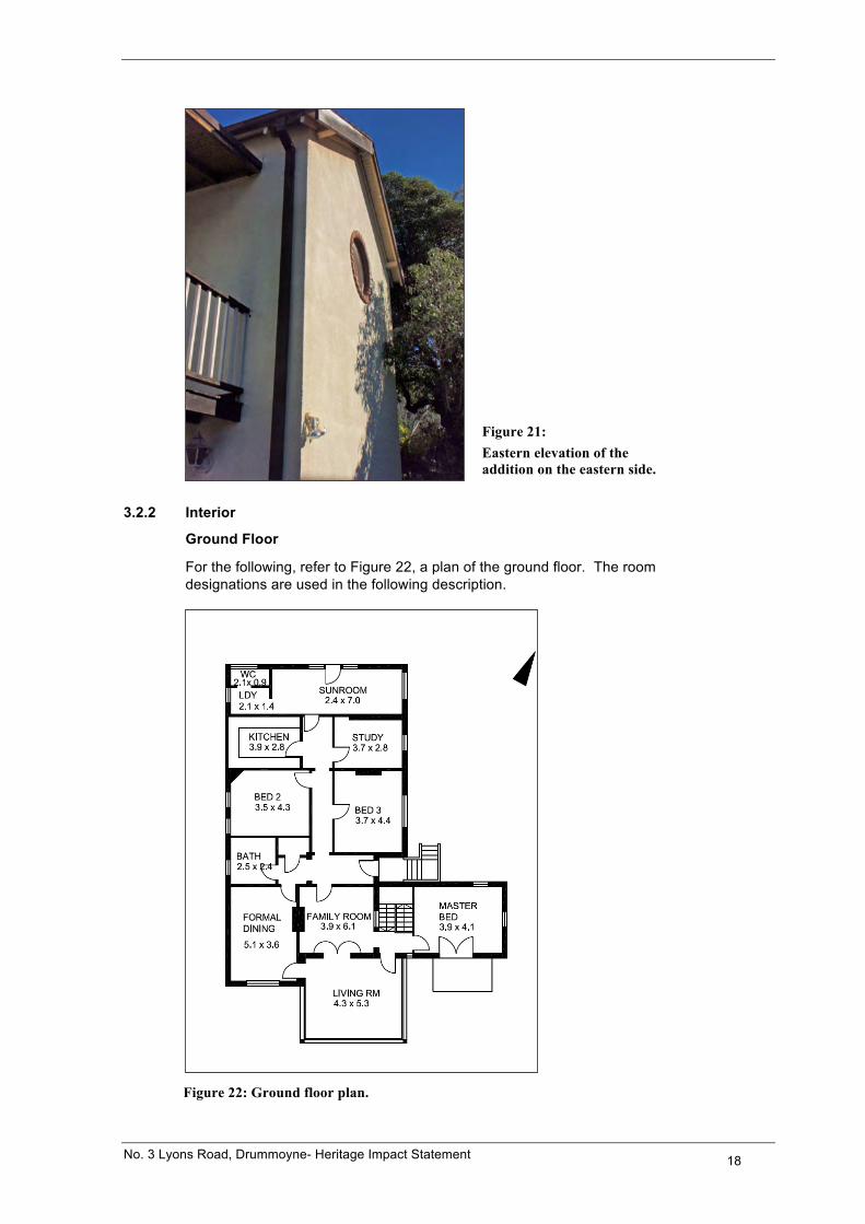
Figure 18: Looking west across the southern elevation.
Figure 19: View looking west towards the first floor verandah enclosure. Figure 20: A later verandah and two storey wing on the southern side of the
dwelling.
The eastern elevation of the addition on the eastern side has a circular window with face brick surround. The wide gable above is finished with rough cast render. The gable end has a wide timber barge-board with eaves lined in timber. Refer to Figure 21.
No. 3 Lyons Road, Drummoyne- Heritage Impact Statement 18
Figure 21: Eastern elevation of the addition on the eastern side.
3.2.2 Interior
Ground Floor
For the following, refer to Figure 22, a plan of the ground floor. The room designations are used in the following description.
Figure 22: Ground floor plan.
No. 3 Lyons Road, Drummoyne- Heritage Impact Statement 19
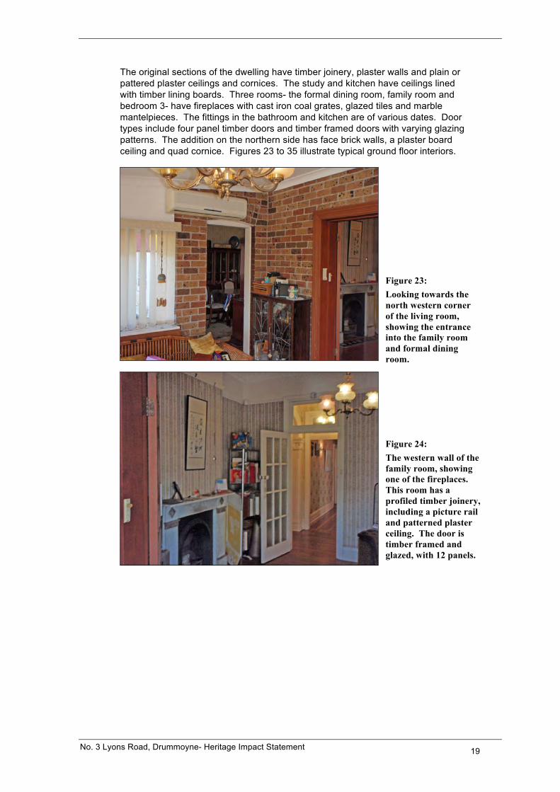
The original sections of the dwelling have timber joinery, plaster walls and plain or pattered plaster ceilings and cornices. The study and kitchen have ceilings lined with timber lining boards. Three rooms- the formal dining room, family room and bedroom 3- have fireplaces with cast iron coal grates, glazed tiles and marble mantelpieces. The fittings in the bathroom and kitchen are of various dates. Door types include four panel timber doors and timber framed doors with varying glazing patterns. The addition on the northern side has face brick walls, a plaster board ceiling and quad cornice. Figures 23 to 35 illustrate typical ground floor interiors.
Figure 23: Looking towards the north western corner of the living room, showing the entrance into the family room and formal dining room.
Figure 24: The western wall of the family room, showing one of the fireplaces. This room has a profiled timber joinery, including a picture rail and patterned plaster ceiling. The door is timber framed and glazed, with 12 panels.
No. 3 Lyons Road, Drummoyne- Heritage Impact Statement 20
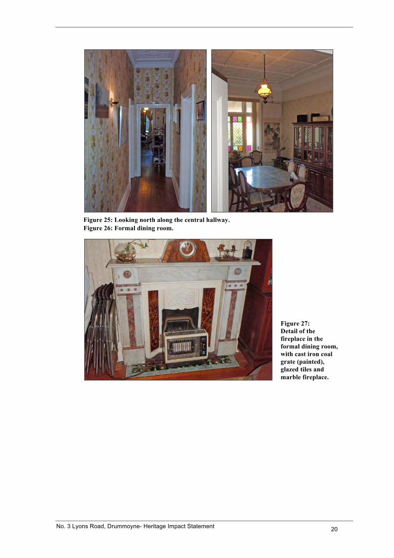
Figure 25: Looking north along the central hallway. Figure 26: Formal dining room.
Figure 27: Detail of the fireplace in the formal dining room, with cast iron coal grate (painted), glazed tiles and marble fireplace.
No. 3 Lyons Road, Drummoyne- Heritage Impact Statement 21
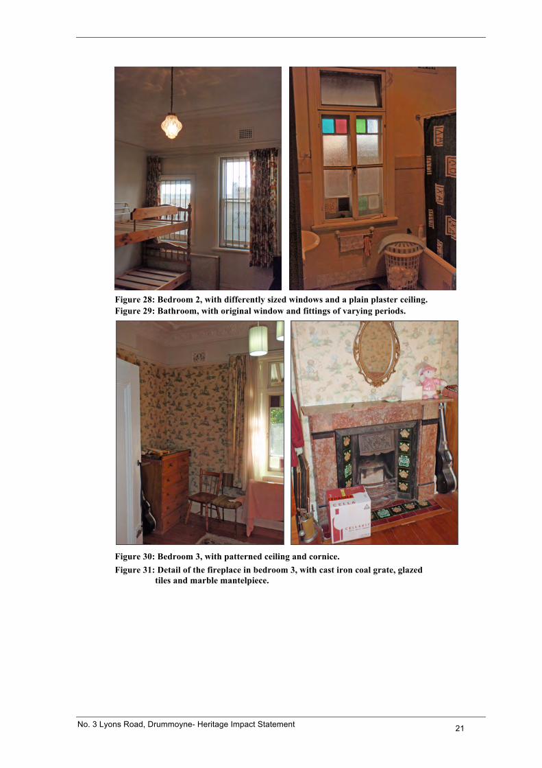
Figure 28: Bedroom 2, with differently sized windows and a plain plaster ceiling. Figure 29: Bathroom, with original window and fittings of varying periods.
Figure 30: Bedroom 3, with patterned ceiling and cornice. Figure 31: Detail of the fireplace in bedroom 3, with cast iron coal grate, glazed
tiles and marble mantelpiece.
No. 3 Lyons Road, Drummoyne- Heritage Impact Statement 22
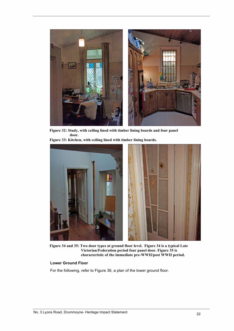
Figure 32: Study, with ceiling lined with timber lining boards and four panel
door. Figure 33: Kitchen, with ceiling lined with timber lining boards.
Figure 34 and 35: Two door types at ground floor level. Figure 34 is a typical Late
Victorian/Federation period four panel door. Figure 35 is characteristic of the immediate pre-WWII/post WWII period.
Lower Ground Floor
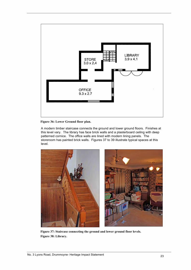
For the following, refer to Figure 36, a plan of the lower ground floor.
No. 3 Lyons Road, Drummoyne- Heritage Impact Statement 23
Figure 36: Lower Ground floor plan.
A modern timber staircase connects the ground and lower ground floors. Finishes at this level vary. The library has face brick walls and a plasterboard ceiling with deep patterned cornice. The office walls are lined with modern lining panels. The storeroom has painted brick walls. Figures 37 to 39 illustrate typical spaces at this level.
Figure 37: Staircase connecting the ground and lower ground floor levels. Figure 38: Library.
No. 3 Lyons Road, Drummoyne- Heritage Impact Statement 24
Figure 39: Office.
3.3 The Surrounding Area
For the following, refer to Figure 40, an aerial photograph over the site and the surrounding area. Refer also to the separate Streetscape Character Analysis that accompanies this application.
Figure 40: Aerial photograph over the site and the surrounding area. SIX Maps.
No. 3 Lyons Road, Drummoyne- Heritage Impact Statement 25
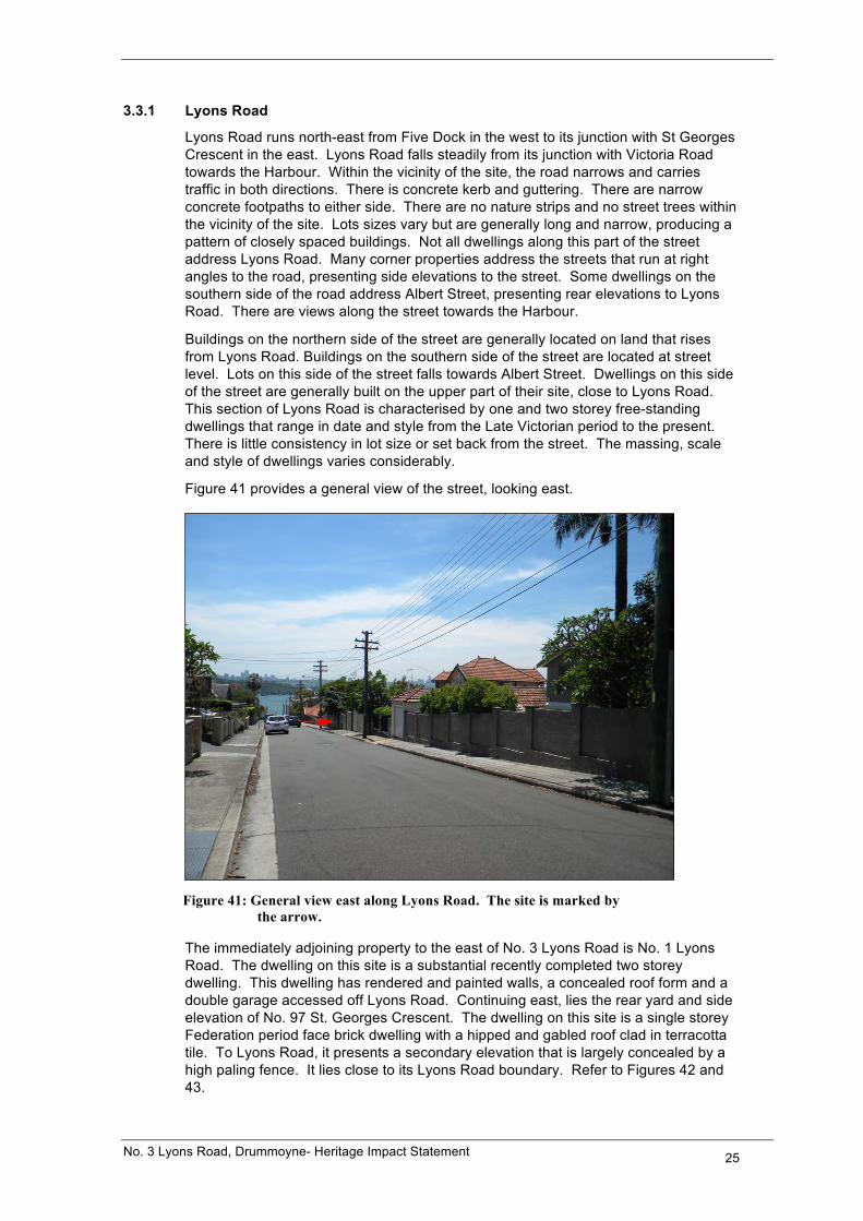
3.3.1 Lyons Road
Lyons Road runs north-east from Five Dock in the west to its junction with St Georges Crescent in the east. Lyons Road falls steadily from its junction with Victoria Road towards the Harbour. Within the vicinity of the site, the road narrows and carries traffic in both directions. There is concrete kerb and guttering. There are narrow concrete footpaths to either side. There are no nature strips and no street trees within the vicinity of the site. Lots sizes vary but are generally long and narrow, producing a pattern of closely spaced buildings. Not all dwellings along this part of the street address Lyons Road. Many corner properties address the streets that run at right angles to the road, presenting side elevations to the street. Some dwellings on the southern side of the road address Albert Street, presenting rear elevations to Lyons Road. There are views along the street towards the Harbour.
Buildings on the northern side of the street are generally located on land that rises from Lyons Road. Buildings on the southern side of the street are located at street level. Lots on this side of the street falls towards Albert Street. Dwellings on this side of the street are generally built on the upper part of their site, close to Lyons Road. This section of Lyons Road is characterised by one and two storey free-standing dwellings that range in date and style from the Late Victorian period to the present. There is little consistency in lot size or set back from the street. The massing, scale and style of dwellings varies considerably.
Figure 41 provides a general view of the street, looking east.
Figure 41: General view east along Lyons Road. The site is marked by
the arrow.
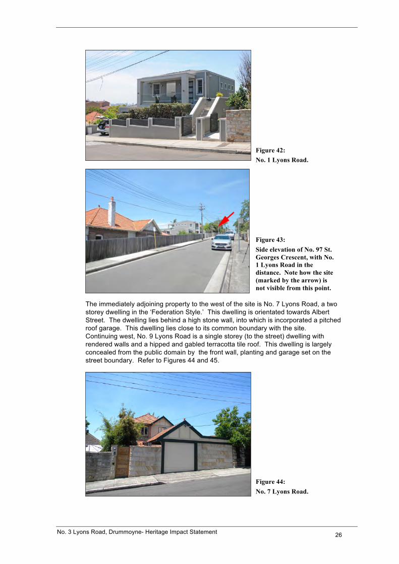
The immediately adjoining property to the east of No. 3 Lyons Road is No. 1 Lyons Road. The dwelling on this site is a substantial recently completed two storey dwelling. This dwelling has rendered and painted walls, a concealed roof form and a double garage accessed off Lyons Road. Continuing east, lies the rear yard and side elevation of No. 97 St. Georges Crescent. The dwelling on this site is a single storey Federation period face brick dwelling with a hipped and gabled roof clad in terracotta tile. To Lyons Road, it presents a secondary elevation that is largely concealed by a high paling fence. It lies close to its Lyons Road boundary. Refer to Figures 42 and 43.
No. 3 Lyons Road, Drummoyne- Heritage Impact Statement 26
Figure 42: No. 1 Lyons Road.
Figure 43: Side elevation of No. 97 St. Georges Crescent, with No. 1 Lyons Road in the distance. Note how the site (marked by the arrow) is not visible from this point.
The immediately adjoining property to the west of the site is No. 7 Lyons Road, a two storey dwelling in the ‘Federation Style.’ This dwelling is orientated towards Albert Street. The dwelling lies behind a high stone wall, into which is incorporated a pitched roof garage. This dwelling lies close to its common boundary with the site. Continuing west, No. 9 Lyons Road is a single storey (to the street) dwelling with rendered walls and a hipped and gabled terracotta tile roof. This dwelling is largely concealed from the public domain by the front wall, planting and garage set on the street boundary. Refer to Figures 44 and 45.
Figure 44: No. 7 Lyons Road.
No. 3 Lyons Road, Drummoyne- Heritage Impact Statement 27
Figure 45: No. 7 Lyons Road.
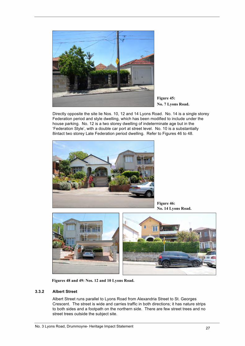
Directly opposite the site lie Nos. 10, 12 and 14 Lyons Road. No. 14 is a single storey Federation period and style dwelling, which has been modified to include under the house parking. No. 12 is a two storey dwelling of indeterminate age but in the ‘Federation Style’, with a double car port at street level. No. 10 is a substantially 8intact two storey Late Federation period dwelling. Refer to Figures 46 to 48.
Figure 46: No. 14 Lyons Road.
Figures 48 and 49: Nos. 12 and 10 Lyons Road.
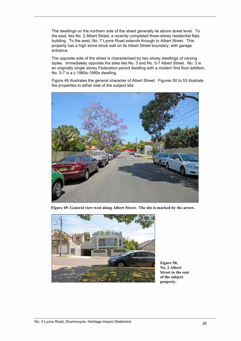
3.3.2 Albert Street
Albert Street runs parallel to Lyons Road from Alexandria Street to St. Georges Crescent. The street is wide and carries traffic in both directions; it has nature strips to both sides and a footpath on the northern side. There are few street trees and no street trees outside the subject site.
No. 3 Lyons Road, Drummoyne- Heritage Impact Statement 28
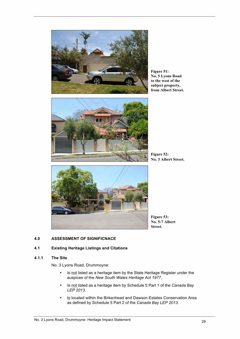
The dwellings on the northern side of the street generally lie above street level. To the east, lies No. 2 Albert Street, a recently completed three-storey residential flats building. To the west, No. 7 Lyons Road extends through to Albert Street. This property has a high stone block wall on its Albert Street boundary, with garage entrance.
The opposite side of the street is characterised by two storey dwellings of varying styles. Immediately opposite the sites lies No. 3 and No. 5-7 Albert Street. No. 3 is an originally single storey Federation period dwelling with a modern first floor addition. No. 5-7 is a c.1980s-1990s dwelling.
Figure 49 illustrates the general character of Albert Street. Figures 50 to 53 illustrate the properties to either side of the subject site.
Figure 49: General view west along Albert Street. The site is marked by the arrow.
Figure 50: No. 2 Albert Street to the east of the subject property.
No. 3 Lyons Road, Drummoyne- Heritage Impact Statement 29
Figure 51: No. 5 Lyons Road to the west of the subject property, from Albert Street.
Figure 52: No. 3 Albert Street.
Figure 53: No. 5-7 Albert Street.
4.0 ASSESSMENT OF SIGNIFICNACE
4.1 Existing Heritage Listings and Citations
4.1.1 The Site
No. 3 Lyons Road, Drummoyne:
• Is not listed as a heritage item by the State Heritage Register under the auspices of the New South Wales Heritage Act 1977.
• Is not listed as a heritage item by Schedule 5 Part 1 of the Canada Bay LEP 2013.
• Is located within the Birkenhead and Dawson Estates Conservation Area as defined by Schedule 5 Part 2 of the Canada Bay LEP 2013.
No. 3 Lyons Road, Drummoyne- Heritage Impact Statement 30
• Is identified as a contributory item in the Conservation Area by the plan in Appendix B of the Canada Bay Development Control Plan 2013 (DCP 2013). This is further discussed in Section 4.4 below.
The State Heritage Inventory and Appendix B of the DCP 2013 provide the following statement of significance for the Birkenhead and Dawson Estates Conservation Area:
‘The Birkenhead and Dawson Estates Conservation Area is of high heritage significance for the very intact and complete streetscapes reflecting the intense development of Drummoyne in the late nineteenth and early twentieth century. The styles of housing clearly reflect the pattern of subdivision of the area.
This Conservation Area includes extensive groups of Federation and Edwardian housing interspersed with Victorian cottages and some larger two storey homes. The narrow allotments and generally consistent scale of development create a cohesive and interesting streetscape.’18
4.1.2 Heritage Items in the Vicinity of the Site
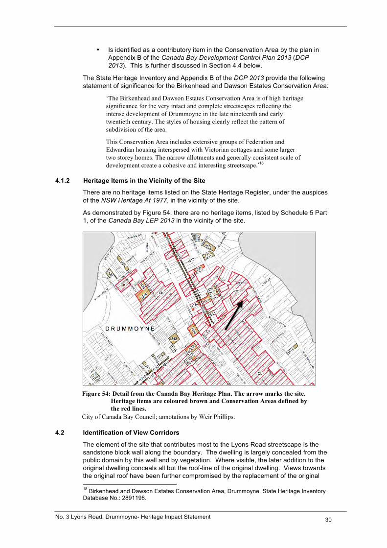
There are no heritage items listed on the State Heritage Register, under the auspices of the NSW Heritage At 1977, in the vicinity of the site.
As demonstrated by Figure 54, there are no heritage items, listed by Schedule 5 Part 1, of the Canada Bay LEP 2013 in the vicinity of the site.
Figure 54: Detail from the Canada Bay Heritage Plan. The arrow marks the site.
Heritage items are coloured brown and Conservation Areas defined by the red lines.
City of Canada Bay Council; annotations by Weir Phillips.
4.2 Identification of View Corridors
The element of the site that contributes most to the Lyons Road streetscape is the sandstone block wall along the boundary. The dwelling is largely concealed from the public domain by this wall and by vegetation. Where visible, the later addition to the original dwelling conceals all but the roof-line of the original dwelling. Views towards the original roof have been further compromised by the replacement of the original 18 Birkenhead and Dawson Estates Conservation Area, Drummoyne. State Heritage Inventory Database No.: 2891198.
No. 3 Lyons Road, Drummoyne- Heritage Impact Statement 31
roof covering with concrete tiles. Through the iron pedestrian gate, there are screened views towards the eastern elevation, which, as noted above, is a conglomeration of at least two different construction periods.
View corridors towards the site on approach along Lyons Road from the west are restricted by the proximity of the neighbouring dwelling (No. 7 Lyons Road), the high boundary walls of the subject site and its neighbours and by vegetation. View corridors on approach along Lyons Road from the east are blocked by the substantial dwelling at No. 1 Lyons Road. The boundary wall dominates any view corridors; the dwelling is not generally visible. The narrowness of the road limits oblique angle views across the boundary wall on approach in either direction until relatively close to the site. Refer to the front cover and to Figures 41 and 43 above.
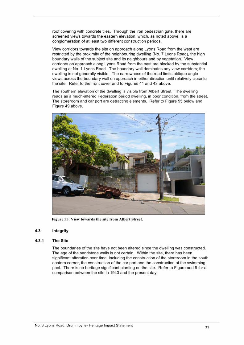
The southern elevation of the dwelling is visible from Albert Street. The dwelling reads as a much-altered Federation period dwelling, in poor condition, from the street. The storeroom and car port are detracting elements. Refer to Figure 55 below and Figure 49 above.
Figure 55: View towards the site from Albert Street.
4.3 Integrity
4.3.1 The Site
The boundaries of the site have not been altered since the dwelling was constructed. The age of the sandstone walls is not certain. Within the site, there has been significant alteration over time, including the construction of the storeroom in the south eastern corner, the construction of the car port and the construction of the swimming pool. There is no heritage significant planting on the site. Refer to Figure and 8 for a comparison between the site in 1943 and the present day.
No. 3 Lyons Road, Drummoyne- Heritage Impact Statement 32
4.3.2 The Dwelling
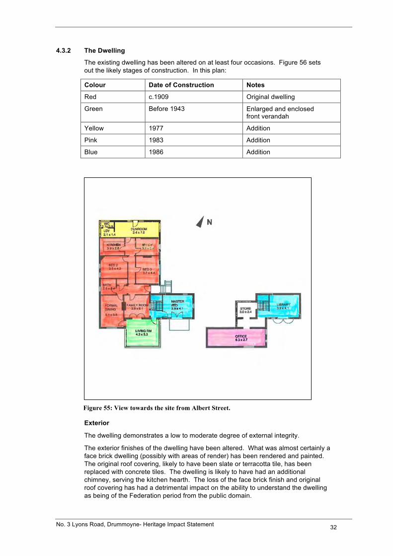
The existing dwelling has been altered on at least four occasions. Figure 56 sets out the likely stages of construction. In this plan:
Colour Date of Construction Notes
Red c.1909 Original dwelling
Green Before 1943 Enlarged and enclosed front verandah
Yellow 1977 Addition
Pink 1983 Addition
Blue 1986 Addition
Figure 55: View towards the site from Albert Street.
Exterior
The dwelling demonstrates a low to moderate degree of external integrity.
The exterior finishes of the dwelling have been altered. What was almost certainly a face brick dwelling (possibly with areas of render) has been rendered and painted. The original roof covering, likely to have been slate or terracotta tile, has been replaced with concrete tiles. The dwelling is likely to have had an additional chimney, serving the kitchen hearth. The loss of the face brick finish and original roof covering has had a detrimental impact on the ability to understand the dwelling as being of the Federation period from the public domain.
No. 3 Lyons Road, Drummoyne- Heritage Impact Statement 33
The original front elevation is the southern elevation, addressing Albert Street. From Albert Street today the dwelling reads as a much-altered Federation period dwelling. The principal additions and alterations to this elevation are as follows:
• Widening and enclosure of the front verandah to create a sunroom (before 1943). The verandah most likely ran from the western gabled bay across the elevation, before returning to the front entrance.
• The lower ground floor elevation has been altered overtime as habitable rooms were created at this level. The extent of the original habitable space at this level and the original pattern of openings at this level is not clear. The major alterations at this level were carried out in 1983.
• Extension on the eastern side (1986).
The original northern elevation, once the rear of the dwelling, addressing Lyons Road has been lost as a result of the 1977 addition. With the exception of what can be seen of the original roof form and chimneys, the dwelling no longer readily reads as being a Federation period dwelling from Lyons Road.
The eastern elevation is a conglomeration of the original dwelling, the 1977 addition and the 1986 addition.
The western elevation is not generally visible from the public domain because of the proximity of the neighbouring dwelling. With the exception of the addition at the northern end and rendering and painting, it appears to be substantially intact.
Interior
The dwelling demonstrates a higher degree of internal integrity.
The floor plan of the original part of the dwelling remains discernable despite later alterations and addition. Original finishes and fixtures that remain include architraves and skirting boards, fibrous plaster ceilings and cornices, fireplaces, a number original timber four panelled doors and casement windows with coloured lights.
4.4 Comparative Analysis
No. 3 Lyons Road is not a rare item within the City of Canada Bay. It is one of a large number of Federation period dwellings. The best examples are those dwellings that are listed as individual heritage items by Schedule 5 Part 1 of the Canada Bay LEP 2013. Many others are considered by Council to be contributory to a Conservation Area. Contributory is defined by the Canada Bay DCP 2013 as:
‘Was built during a period directly relating to the significance of the conservation area as identified in the statement of significance for the conservation area. The original form of the building is substantially intact or where additions have been made to the building that are visible in the main streetscape, the additions have respected the original style and form of the building.’19
Council have two other rankings for properties within Conservation Areas:
‘Neutral: Was built during a period directly relating to the significance of the Conservation Area as identified in the statement of significance for the Conservation Area, but has been substantially altered so that the original style of the character of the building is obscured and the alterations are unlikely to be reversed.
19 City of Canada Bay DCP 2013, Section 4.4.
No. 3 Lyons Road, Drummoyne- Heritage Impact Statement 34
Infill: Was built in a period later than any directly relating to the significance of the Conservation Area or is a detracting element.’20
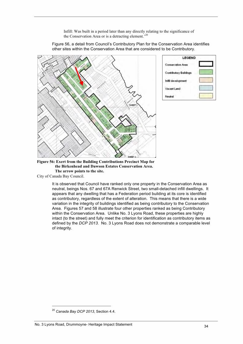
Figure 56, a detail from Council’s Contributory Plan for the Conservation Area identifies other sites within the Conservation Area that are considered to be Contributory.
Figure 56: Exert from the Building Contributions Precinct Map for the Birkenhead and Dawson Estates Conservation Area. The arrow points to the site.
City of Canada Bay Council.
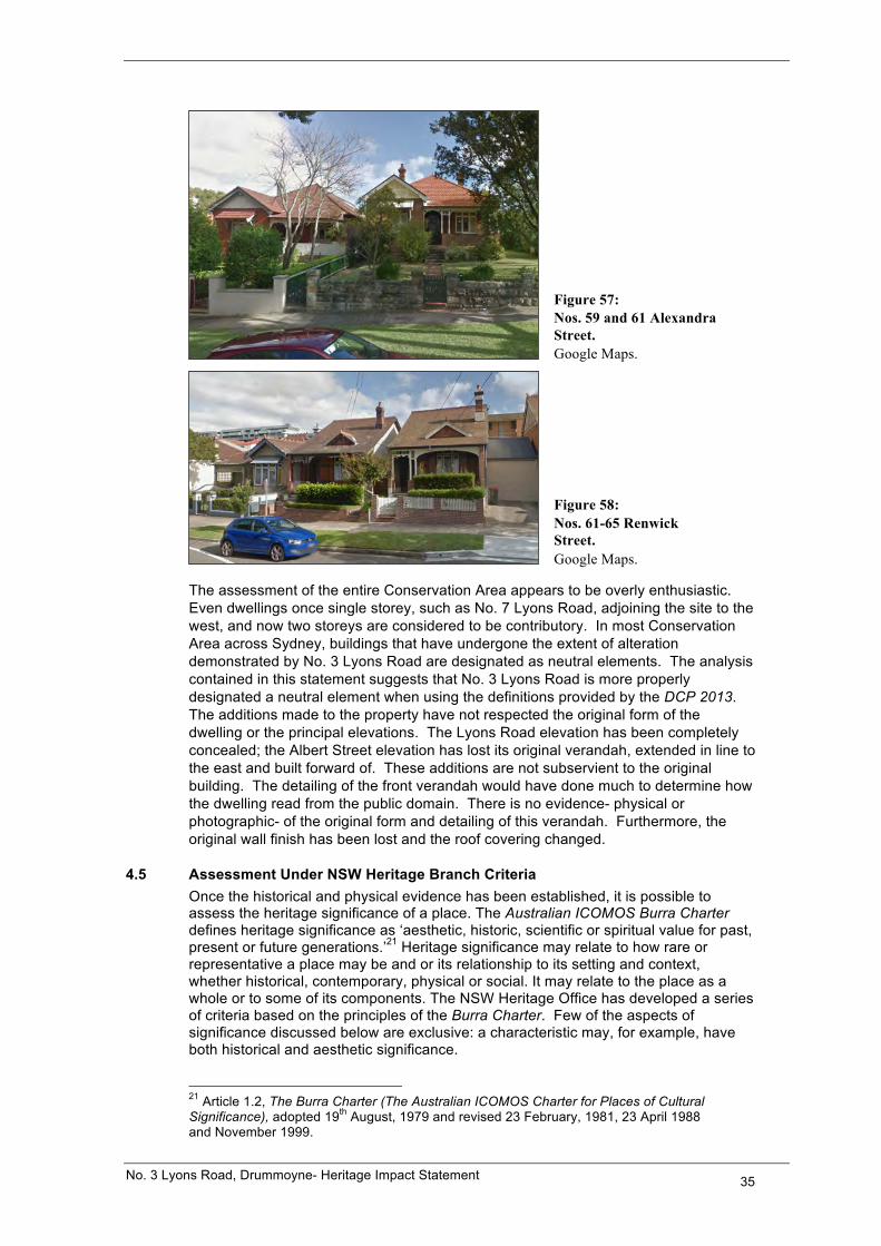
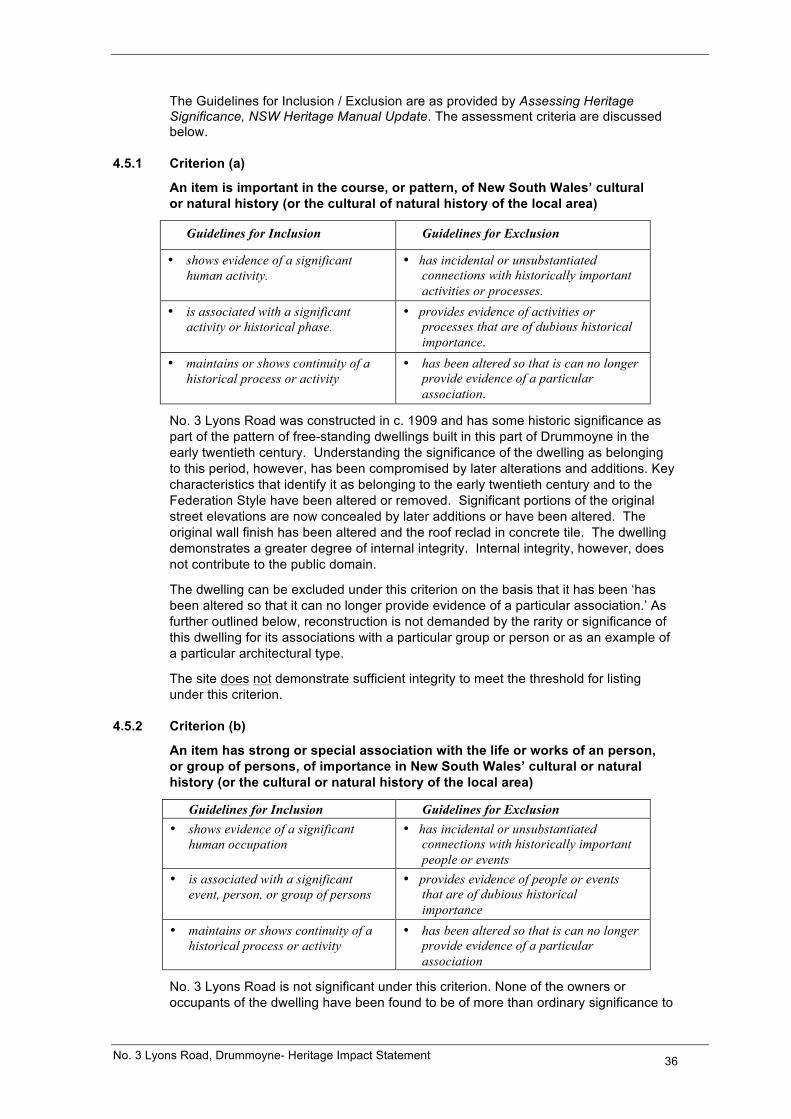
It is observed that Council have ranked only one property in the Conservation Area as neutral, beings Nos. 67 and 67A Renwick Street, two small-detached infill dwellings. It appears that any dwelling that has a Federation period building at its core is identified as contributory, regardless of the extent of alteration. This means that there is a wide variation in the integrity of buildings identified as being contributory to the Conservation Area. Figures 57 and 58 illustrate four other properties ranked as being Contributory within the Conservation Area. Unlike No. 3 Lyons Road, these properties are highly intact (to the street) and fully meet the criterion for identification as contributory items as defined by the DCP 2013. No. 3 Lyons Road does not demonstrate a comparable level of integrity.
20 Canada Bay DCP 2013, Section 4.4.
No. 3 Lyons Road, Drummoyne- Heritage Impact Statement 35
Figure 57: Nos. 59 and 61 Alexandra Street. Google Maps.
Figure 58: Nos. 61-65 Renwick Street. Google Maps.
The assessment of the entire Conservation Area appears to be overly enthusiastic. Even dwellings once single storey, such as No. 7 Lyons Road, adjoining the site to the west, and now two storeys are considered to be contributory. In most Conservation Area across Sydney, buildings that have undergone the extent of alteration demonstrated by No. 3 Lyons Road are designated as neutral elements. The analysis contained in this statement suggests that No. 3 Lyons Road is more properly designated a neutral element when using the definitions provided by the DCP 2013. The additions made to the property have not respected the original form of the dwelling or the principal elevations. The Lyons Road elevation has been completely concealed; the Albert Street elevation has lost its original verandah, extended in line to the east and built forward of. These additions are not subservient to the original building. The detailing of the front verandah would have done much to determine how the dwelling read from the public domain. There is no evidence- physical or photographic- of the original form and detailing of this verandah. Furthermore, the original wall finish has been lost and the roof covering changed.
4.5 Assessment Under NSW Heritage Branch Criteria Once the historical and physical evidence has been established, it is possible to assess the heritage significance of a place. The Australian ICOMOS Burra Charter defines heritage significance as ‘aesthetic, historic, scientific or spiritual value for past, present or future generations.’21 Heritage significance may relate to how rare or representative a place may be and or its relationship to its setting and context, whether historical, contemporary, physical or social. It may relate to the place as a whole or to some of its components. The NSW Heritage Office has developed a series of criteria based on the principles of the Burra Charter. Few of the aspects of significance discussed below are exclusive: a characteristic may, for example, have both historical and aesthetic significance. 21 Article 1.2, The Burra Charter (The Australian ICOMOS Charter for Places of Cultural Significance), adopted 19th August, 1979 and revised 23 February, 1981, 23 April 1988 and November 1999.
No. 3 Lyons Road, Drummoyne- Heritage Impact Statement 36
The Guidelines for Inclusion / Exclusion are as provided by Assessing Heritage Significance, NSW Heritage Manual Update. The assessment criteria are discussed below.
4.5.1 Criterion (a)
An item is important in the course, or pattern, of New South Wales’ cultural or natural history (or the cultural of natural history of the local area)
Guidelines for Inclusion Guidelines for Exclusion
• shows evidence of a significant human activity.
• has incidental or unsubstantiated connections with historically important activities or processes.
• is associated with a significant activity or historical phase.
• provides evidence of activities or processes that are of dubious historical importance.
• maintains or shows continuity of a historical process or activity
• has been altered so that is can no longer provide evidence of a particular association.
No. 3 Lyons Road was constructed in c. 1909 and has some historic significance as part of the pattern of free-standing dwellings built in this part of Drummoyne in the early twentieth century. Understanding the significance of the dwelling as belonging to this period, however, has been compromised by later alterations and additions. Key characteristics that identify it as belonging to the early twentieth century and to the Federation Style have been altered or removed. Significant portions of the original street elevations are now concealed by later additions or have been altered. The original wall finish has been altered and the roof reclad in concrete tile. The dwelling demonstrates a greater degree of internal integrity. Internal integrity, however, does not contribute to the public domain.
The dwelling can be excluded under this criterion on the basis that it has been ‘has been altered so that it can no longer provide evidence of a particular association.’ As further outlined below, reconstruction is not demanded by the rarity or significance of this dwelling for its associations with a particular group or person or as an example of a particular architectural type.
The site does not demonstrate sufficient integrity to meet the threshold for listing under this criterion.
4.5.2 Criterion (b)
An item has strong or special association with the life or works of an person, or group of persons, of importance in New South Wales’ cultural or natural history (or the cultural or natural history of the local area)
Guidelines for Inclusion Guidelines for Exclusion • shows evidence of a significant
human occupation • has incidental or unsubstantiated
connections with historically important people or events
• is associated with a significant event, person, or group of persons
• provides evidence of people or events that are of dubious historical importance
• maintains or shows continuity of a historical process or activity
• has been altered so that is can no longer provide evidence of a particular association
No. 3 Lyons Road is not significant under this criterion. None of the owners or occupants of the dwelling have been found to be of more than ordinary significance to
No. 3 Lyons Road, Drummoyne- Heritage Impact Statement 37
the local or wider community, nor is there any evidence that identifies the original architect.
The site does not meet the threshold for listing under this criterion.
4.5.3 Criterion (c)
An item is important in demonstrating aesthetic characteristics and/or a high degree of technical achievement in New South Wales (or the local area)
Guidelines for Inclusion Guidelines for Exclusion • shows or is associated with, creative
or technical innovation or achievement
• is not a major work by an important designer or artist
• is the inspiration for creative or technical innovation or achievement
• has lost its design or technical integrity
• is aesthetically distinctive or has landmark qualities
• its positive visual or sensory appeal or landmark and scenic qualities have been more than temporarily degraded
• exemplifies a particular taste, style or technology
• has only a loose association with a creative or technical achievement
No. 3 Lyons Road was once an example of a Federation period and style dwelling. This style dominated domestic architecture across Sydney between c.1895 and 1915. The dwelling, however:
• Has not been identified as the major work of an important designer or architect. Even when first constructed, the dwelling was relatively modest in size and detail.
• Has undergone extensive alteration, particularly with regard to the front and rear elevations, to the extent that it has lost significant elements of its design. Its qualities are more than temporarily degraded.
• Was not, and is not, a landmark for reasons of aesthetic significance.
• Is no longer a good example of the Federation Style.
The site does not meet the threshold for listing under this criterion.
4.5.4 Criterion (d)
An item has strong or special association with a particular community or cultural group in New South Wales (or the local area) for social, cultural or spiritual reasons
Guidelines for Inclusion Guidelines for Exclusion • is important for its association with an
identifiable group • is only important to the community
for amenity reasons • is important to a community’s sense of
place • is retained only in preference to a
proposed alternative No. 3 Lyons Road does not have significance under this criterion, aside from any inherent significance that arises out of it being identified as part of a Conservation Area.
The site does not meet the threshold for listing under this criterion.
No. 3 Lyons Road, Drummoyne- Heritage Impact Statement 38
4.5.5 Criterion (e)
An item has potential to yield information that will contribute to an understanding of New South Wales’ cultural or natural history (or the cultural or natural history of the local area)
Guidelines for Inclusion Guidelines for Exclusion • has the potential to yield new or further
substantial scientific and/or archaeological information
• has little archaeological or research potential
• is an important benchmark or reference site or type
• only contains information that is readily available from other resources of archaeological sites
• provides evidence of past human cultures that is unavailable elsewhere
• the knowledge gained would be irrelevant to research on science, human history of culture
No. 3 Lyons Road does not demonstrate sufficient integrity to provide information that cannot be readily obtained from other sources. There are better and more intact examples of this type, style and size of dwelling within Drummoyne. The dwelling is not, and has never been, an important benchmark or reference site.
The site does not meet the threshold for listing under this criterion.
4.5.6 Criterion (f)
An item possesses uncommon, rare or endangered aspects of New South Wales’ cultural or natural history (or the cultural or natural history of the local area)
Guidelines for Inclusion Guidelines for Exclusion • provides evidence of a defunct custom,
way of life or process • is not rare
• demonstrate a process, custom or other human activity that is in danger of being lost
• is numerous but under threat
• shown unusually accurate evidence of a significant human activity
• is the only example of its type • demonstrate designs or techniques of
exceptional interest
• shown rare evidence of a significant human activity important to a community
No. 3 Lyons Road is not of an uncommon size, type or style in the local or wider area. Given the lack of integrity, it does not provide unusually accurate information about a significant human activity. There are better preserved examples of Federation period and style dwellings in the area.
The site does not meet the threshold for listing under this criterion.
No. 3 Lyons Road, Drummoyne- Heritage Impact Statement 39
4.5.7 Criterion (g)
An item is important in demonstrating the principle characteristics of a class of New South Wales (or a class of the local areas):
• Cultural or natural places; or • Cultural or natural environments
Guidelines for Inclusion Guidelines for Exclusion • is a fine example of its type • is a poor example of its type • has the potential characteristics of an
important class or group of items • does not include or has lost the range
of characteristics of a type • has attributes typical of a particular way
of life, philosophy, custom, significant process, design, technique of activity
• does not represent well the characteristics that make up a significant variation of type
• is a significant variation to a class of items
• is part of a group which collectively illustrates a representative type
• is outstanding because of its setting, condition or size
• is outstanding because of its integrity or the esteem in which it is held
The alterations made to No. 3 Lyons Road over time mean that it can no longer be considered to be a good, intact example of a late Federation Style dwelling. It has lost many of the key characteristics that made it a Federation Style dwelling, particularly with regards to the front and rear elevations and its roof cladding.
The site does not meet the threshold for listing under this criterion.
5.0 HERITAGE IMPACT ASSESSMENT
The following should be read in conjunction with the plans that accompany this application prepared by Weir Phillips Architects.
5.1 Scope of Works
It is proposed to demolish the existing dwelling on the site and to construct a new two/three storey dwelling, pool and associated landscaping. The dwelling will have rendered and painted walls; aluminium framed windows; a copper roof and timber screens. Landscaping will include the reconstruction of the stone walls along the Lyons Road and Albert Street boundaries.
5.2 Method of Assessment The proposed works are assessed against the objectives and controls provided by Section 4.4 Development in and within the vicinity of Conservation Areas of the Canada Bay DCP 2013. The following does not assess compliance or otherwise with Council’s numerical controls, except where a non-compliance would impact upon heritage significance. For such an assessment, refer to the Statement of Environmental Effects that accompanies this application.
No. 3 Lyons Road, Drummoyne- Heritage Impact Statement 40
5.3 Effect of Work on the Conservation Area
5.3.1 Impact of the Proposed Demolition Works
Section 4.4.12 of the DCP 2013 provides the objectives and controls relating to demolition. The objective is to retain contributory buildings. The controls are as follows:
C1 Contributory buildings within a conservation area should not be demolished.
The proposal does not comply with this control because it seeks the demolition of a building deemed contributory by Council. Demolishing this building will have an acceptable impact on the Conservation Area for the following reasons:
• The dwelling at No. 3 Lyons Road no longer presents to the public domain as a good and intact example of a Federation Style and period dwelling. The assessment contained in this report does not support the Council’s designation of the subject property as a ‘Contributory Building’ in the Birkenhead and Dawson Estates Conservation Area.
• It is not practical to restore the dwelling in terms of the level of integrity (external) that would be achieved or the economic costs involved. With regard to the level of integrity: • The original form of the dwelling has been highly modified through the
construction of a number of additions throughout the mid to late twentieth century that have modified and/or concealed the two street facing elevations. The original front verandah form and detailing would have played a vital role in determining the dwelling’s appearance from Albert Street. There is no documentary or physical evidence of the form and detailing of this verandah, beyond the likelihood that it returned around the eastern side. Was the verandah roof, for example, an extension of the principal roof; constructed with a break in pitch of the principal roof; or a completely separate roof? Was the verandah roof covered in tile or corrugated iron? Were the verandah posts, presumably of timber, squared or turned? What was the balustrade detail? Any reconstruction would be conjectural and would create a dwelling of limited integrity (when seen from the public domain) that would confuse the fabric record provided by more intact dwellings within the area. Reconstructing a verandah that returns around the eastern side would necessitate the removal of the later additions forward of the building line and on the eastern side. The only place this removed floor area could be reconstructed is to the rear of the dwelling, addressing Lyons Road. The size of this addition would be restricted by the setback requirements from Lyons Road, providing no gain in terms of floor space and thus no incentive to carry out this work. If such an addition was constructed without reconstructing the Albert Street verandah, thereby retaining the existing floor space, there is no benefit to the streetscape. Refer to the plan in Appendix 1. With regard to the economic costs involved:
• As demonstrated by the table in Appendix 2, reconstruction is not economically viable.
• The significance of the site under the other NSW Heritage Office (now Division) criterion is not such to justify the costs of reconstruction or the compromised integrity that would result.
• The costs of restoration are not justified on the basis of the integrity of the streetscapes. There is there is little consistency in the style, form, massing and scale of buildings addressing this part of Lyons Road or Albert Street. To the east, for example, lies the contemporary No. 1 Lyons Road and No. 2 Albert
No. 3 Lyons Road, Drummoyne- Heritage Impact Statement 41
Street; to the west, an altered Federation period dwelling. Refer to the separate Streetscape Character Analysis that accompanies this application.
• The costs of restoration are not justified on the basis that there are no other examples of Federation period dwellings in the Conservation Area. They are not justified on the basis that this dwelling has significant historical associations.
• The walls have been rendered. This is not likely to be the original finish and is not reversible.
• The roof covering has been replaced with concrete tiles. Although reversible, replacing the roof covering will not solve the issue of overall integrity.
The existing dwelling could be demolished without detriment to the cultural heritage of Drummoyne or the City of Canada Bay. If required, a full archival recording to NSW Heritage Branch standards could be carried out to provide a permanent record of the existing dwelling and the extent of change. Any new dwelling should demonstrate an equal or greater architectural merit than the existing. As set about below, the proposed new dwelling has considerable architectural merit.
C2 Post WWII additions to contributory buildings in a conservation area that are not visible from the public realm may be demolished subject to assessment of the contribution, if any, that the additions make to the heritage value of the conservation area.
See under C1.
C3 Demolition of rear outbuildings in conservation areas is generally acceptable. For places listed as heritage items, additional restrictions might apply.
The outbuildings to be demolished were erected in the 1980s. They do not contribute to understanding the historic significance of the Conservation Area or to the streetscape.
5.3.2 Impact of the Proposed New Works
The proposed new works are assessed against the controls provided by the remaining sections in Section 4.4.
4.4.1 Setting
C1 The side and front setbacks of new development in a conservation area should be typical of the spacing of existing contributory buildings in the vicinity of the proposed development in that conservation area, such that the rhythm of buildings in the streetscape is retained.
The proposed works are orientated towards Lyons Road. Lyons Road is considered to be the front of the dwelling for the purposes of this statement. The front setbacks of the dwellings along Lyons Road between Alexandra Street and St. Georges Crescent are not easily read because of the high boundary walls and garages that characterise this part of the street. The proposed dwelling is set back just over 4.5m (which is the minimum setback) and in line with the recently completed dwelling at No. 1 Lyons Road. It is set slightly forward of the front wall of its western neighbour, No. 5 Lyons Road. It is noted that this dwelling is set back behind a garage built to the boundary line. Setting the proposed dwelling forward of this dwelling will not block any historically significant view corridors nor impact a pattern visible from the street.
The proposed side setbacks will fit within the existing pattern of building along this side of Lyons Road.
C2 No new structures should be built forward of the established street building line.
No new structures will be built forward of the established street line to Lyons Road.
No. 3 Lyons Road, Drummoyne- Heritage Impact Statement 42
The proposed garage on the street boundary of Albert Street will be one of several similar structures on this side of the street.
C3 The established landscape character of the locality including the height of canopy and density of boundary landscape plantings should be retained in any new development.
There is no heritage significant planting on the site. The proposed planting will contribute to the Conservation Area as it matures.
With regard to the objectives for this section:
The proposal respects the established patterns in Lyons Road and Albert Street in terms of the setbacks, siting of the dwelling on the site, fencing and location of car parking. The proposed landscaping will contribute to the Conservation Area as it matures.
4.4.2 Scale
C1 The scale of new development adjacent to or within a conservation area should relate to the scale of the adjacent or nearest contributory elements of the conservation area.
As demonstrated by the plan DA04, the proposed new dwelling will sit comfortably within the Lyons Road and Albert Street streetscapes. It moderates between the massing and scale of No. 7 Lyons Road to the west and No. 1 Lyons Road to the east. With the exception of the chimney, the proposed dwelling lies within the building height envelope; the building lies within the 8.5m height restriction. The roof heights of the three buildings will fall in line with the fall of the street.
C2 Development of a larger scale is allowable only if it can be demonstrated that the new development will not adversely impact publicly available views of the conservation area.
The proposed dwelling will not impact upon publically available views of the Conservation Area.
C3 New development that obscures important views of or within a heritage conservation area should not be permitted.
The proposed dwelling and associated landscaping will not obscure important views of or within the Conservation Area.
With regard to the objectives for this section:
The proposed dwelling is consistent with the scale of nearby dwellings within the area ranked by Council as being contributory to the area.
4.4.3 Form
C1 Important elements of the form of a contributory building in a conservation area such as the main roof forms…
This control is not applicable to this proposal because it is proposed to demolish the existing dwelling.
C2 The roof forms of new development in a conservation area are to complement the original roof forms of existing nearby buildings that contribute to the Conservation Area.
Most of the contributory buildings within the Conservation Area have hipped and/or gabled roof forms. The roof of the proposed dwelling is a skillion roof that is concealed from the public domain. The impact is acceptable because this is a facet of the contemporary design of the dwelling. Contemporary design is an acceptable approach to new buildings in Conservation Area because it preserves the integrity of
No. 3 Lyons Road, Drummoyne- Heritage Impact Statement 43
the fabric record. Concealed roofs help to reduce visual massing and scale and do not compete with the more complex roof forms of Federation and Interwar period buildings. It is noted that the recently completed building at No. 1 Lyons Road has a concealed roof.
C3 Chimneys and roof features such as ventilation gablets should not be removed…
This control is not applicable to this proposal because it is proposed to demolish the existing dwelling.
C4 Dormer windows….
No dormer windows are proposed.
C5 Additions and alterations to existing buildings
This control is not applicable to this proposal because it is proposed to demolish the existing dwelling.
C6 The treatment of the street façade of new development in a conservation area should relate to existing nearby buildings that contribute to the Conservation Area. This should include consideration of the massing of the building, proportions of verandahs and height.
The proposed new street elevations are contemporary in character, as is appropriate for new buildings in a Conservation Area. The proposed elevations relate to the earlier buildings through the breaking up of the elevations into different forms; the use of vertically proportioned openings; and the use of alleviating horizontal elements. Floor levels are expressed in the elevations.
C7 Verandahs on the fronts and sides of buildings…
This control is not applicable to this proposal because it is proposed to demolish the existing dwelling.
With regard to the objectives for this section
While contemporary in character, the proposed development relates positively to the character of the Conservation Area.
4.4.4 Siting
C1 The front setback of new development (including alterations and additions) in Conservation Areas should match the adjacent contributory development. Where adjacent development has different setbacks, new development should align with the greater setback.
Lyons Road is set to be the front of the site with regards to the new dwelling. Setbacks vary along this side of Lyons Road in the vicinity of the site. The adjoining property to the west as a nil setback from Lyons Road because of the attached garage. The proposed dwelling matches the set back of No. 1 Lyons Road to the east. It will sit comfortably within the streetscape.
C2 Side setbacks of new development (including alterations and additions) in conservation areas should match the pattern of adjacent and/or nearby contributory development. This will often include a greater setback on one side of the development to provide vehicular access at the side of the property.
There is no regular pattern of side setbacks along this part of Lyons Road/Albert Street. The proposed side setbacks will sit comfortably within the street.
No. 3 Lyons Road, Drummoyne- Heritage Impact Statement 44
C3 Orientation of new development should follow the established pattern of development in the Conservation Area.
The proposed dwelling addresses both Lyons Road and Albert Street in the same way that adjoining dwellings with frontage to both streets do. The front entrance into the dwelling is from Lyons Road, as for the existing.
C4 Where trees are important to a Conservation Area, new buildings should be sited away from the drip line of the trees.
There are no significant trees on the site.
With regard to the objectives for this section
The proposed dwelling will sit comfortably within the established pattern with regard to front and side setbacks and orientation.
4.4.5 Materials and Colours
C1 Original materials of contributory buildings in conservation areas…
This control is not applicable to this proposal because it is proposed to demolish the existing dwelling.
C2 Non-original materials of existing dwellings…
This control is not applicable to this proposal because it is proposed to demolish the existing dwelling.
C3 Painting, rendering or bagging of face brickwork…
This control is not applicable to this proposal because it is proposed to demolish the existing dwelling.
C4 The texture of original rendered finishes…
This control is not applicable to this proposal because it is proposed to demolish the existing dwelling.
C5 Materials for new development in conservation areas should not contrast with the original materials of the dominant contributory buildings in the Conservation Area.
The proposed rendered and painted masonry finish for the walls, with timber screens, compliments the finishes found in surrounding contributory buildings. The proposed use of aluminium framed doors and windows and a copper roof is a function of the contemporary design of the dwelling. They will sit comfortably with the predominant materials and colours of the Conservation Area and not detract from the appreciation of original finishes and materials in the area.
C6 Colour schemes for existing and new development in conservation areas should have a hue and tonal relationship with traditional colour schemes for the dominant style of development found in the conservation area.
The proposed colour scheme is neutral. The copper roof, timber and colour chosen for the aluminium window frames will sit comfortably with the brick, terracotta tiling and timber of the Federation and Interwar period dwellings in the immediate area without detracting from them.
C7 The use of fluorescent paint and primary colours on buildings in Conservation Areas is not permitted.
No such colours are proposed.
No. 3 Lyons Road, Drummoyne- Heritage Impact Statement 45
C8 The use of modern finishes including stencilled concrete for driveways in conservation areas is not permitted.
No such finish is proposed.
With regard to the objectives of this section
The proposed external materials are part of the contemporary character of the dwelling. They will, however, compliment the existing contributory buildings in the Conservation Area.
4.4.6 Doors and Windows
C1 Extensive areas of glazing are not permitted for doors and windows visible from the public realm on buildings within a Conservation Area.
The proposed Lyons Road elevation exhibits a good balance between solid masonry and glazing.
A greater percentage of glazing is proposed for the Albert Street elevation. This is a function of the contemporary design and provides a high level of amenity to the principal living spaces. The impact is acceptable because the elevation is set back well into the site, has a strong stone base that anchors it to the site and the glazing is set back behind deep balconies. The amount of glazing is consistent with the recently completed building at No. 2 Albert Street.
C2 Original door and window openings…
This control is not applicable to this proposal because it is proposed to demolish the existing dwelling.
C3 Original door and window joinery visible…
This control is not applicable to this proposal because it is proposed to demolish the existing dwelling.
C4 New door and window openings to contributory buildings in a conservation area…
This control is not applicable to this proposal because it is proposed to demolish the existing dwelling.
C5 Where non-original joinery to doors and windows of building….
This control is not applicable to this proposal because it is proposed to demolish the existing dwelling.
C6 Skylights should be located on roof slopes where they will not be visible from the public realm.
No skylights are proposed.
With regard to the objectives in this section
The proposed fenestration patterns are a function of the contemporary design of the building, but will sit comfortably within the streetscapes as set out above.
4.4.7 Car parking
C1 Garages and carports must be located as far behind the front building alignment as possible
This side of Albert Street has an established pattern of garages/carports on the street boundary. The proposal follows this pattern.
No. 3 Lyons Road, Drummoyne- Heritage Impact Statement 46
C2 Garages should not be incorporates into the front façade of a building in a conservation area.
The garage is not incorporated into the front elevation of the building as seen from the public domain.
C3 Where a new garage or carport is on the same side of a building as a front verandah, the garage or carport must be located entirely behind the verandah.
Not applicable to this proposal.
C4 Garages in a conservation area will not be allowed in front of the front building alignment unless they can be built into an existing retaining wall on the street boundary. Gardens are not to be built up to allow the construction of garages behind a retaining wall.
The new retaining wall will be built in place of the existing. The garage entrance will be incorporated into this wall.
C5 Carports will only be allowed….
No carport is proposed.
With regard to the objectives in this section
The proposed garage will have a minimal impact on the streetscape and follows the pattern already established for this side of Albert Street.
4.4.8 Fencing
C1 Fencing and gates that are contemporary with a contributory building within a Conservation Area should not be demolished.
The age of the existing sandstone walls to Lyons Road and Albert Street is not known. The new walls will be constructed of sandstone and follow the fall of the streets as for the existing. The wall to Lyons Road is lower than the existing, in line with Council’s height controls.
C2 New fencing and gates to contributory housing….
This control is not applicable to this proposal because it is proposed to demolish the existing dwelling.
C3 New fencing and gates to infill development in a conservation area shall be in keeping with the dominant character of the Conservation Area
The proposed stone walls, stepping down in line with the fall of the street, to Lyons Road and Albert Street replicate the character of the existing walls and will sit comfortably within both streetscapes. Nos. 7 and 9 Lyons Road have high stone walls or stone elements in their fencing to Lyons Road and Albert Street. The proposed wall to Lyons Road is lower than the existing, in line with Council controls.
C4 Unless documentary or physical evidence is provided to establish a greater height, fencing constructed of a solid material such as masonry forward of the building line should be no greater than 900mm in height above the adjacent public footpath level. In all cases, the height of the fencing should relate to the style of the house and width of the allotment.
The height of the stone wall to Lyons Road is lower than the existing stone wall to improve sight lines into the site. It is lower than the neighouring dwellings to the west. It steps down to match the height of the wall of the adjoining property, No. 1 Lyons Road.

No. 3 Lyons Road, Drummoyne- Heritage Impact Statement 47
C5 Original face brick or sandstone fencing in a conservation area should not be painted.
Not applicable to this site.
With regard to the objectives in this section
The proposed retaining walls/fences are consistent with the character of the immediate streetscape.
4.4.9 Landscape elements including paving and driveways
C1 Street trees in conservation areas should not be removed to allow for new development.
No street trees will be removed.
C2 Existing driveways and footpath crossings that relate to original development in a Conservation Area should not be relocated.
No such work will occur.
C3 Double driveways and footpaths crossing will not be permitted in conservation areas. The driveway crossing to be removed was added in the 1980s.
A single driveway crossing is proposed.
With regard to the objectives in this section
Street trees are retained.
4.4.10 Outbuildings
No outbuildings are proposed.
4.4.11 Modern Technologies
The proposed solar panels will not be visible from the public domain.
4.4.12 Demolition
See under Section 5.3.1 above.
4.4.13 Subdivision
No subdivision is proposed.
4.4.14 Signs
No signage is proposed.
6.0 CONCLUSION
This heritage impact statement has outlined the history and assessed the significance of a dwelling at No. 3 Lyons Road, Drummoyne. The existing dwelling was erected in c.1909. The dwelling has a long history of alteration and addition. These additions have not respected the original form and character of the building and have obscured or significantly altered the principal elevations. The dwelling no longer reads from the public domain as a good and intact example of a Federation period and style dwelling. There is insufficient physical and documentary evidence to restore the dwelling. Some alterations, such as the rendering of the walls, are irreversible. Any reconstruction would be conjectural in nature. In any event, the extent of restoration required would result in a building of dubious integrity that has the potential to confuse the fabric record of the conservation area.
No. 3 Lyons Road, Drummoyne- Heritage Impact Statement 48
The dwelling has been assessed against the criterion of the NSW Heritage Office (now Division). It is not of sufficient significance under any of the six criterion to warrant the considerable expense of restoration. The dwelling addresses two streetscapes- Lyons Road and Albert Street- that are mixed in character. The integrity of these streetscapes similarly does not justify the expense of restoration. The demolition of the existing dwelling on the site will have an acceptable impact on the Conservation Area and the heritage of Drummoyne. An archival recording to Heritage Division criterion can be carried out to record the existing dwelling and the extent of change. As much of the original fabric as possible should be carefully removed and offered to a reputable salvage yard.
As a well-designed building with coherent forms and elevations, the proposed new dwelling has greater architectural merit than a Federation period dwelling that has been unsympathetically modified. A contemporary design is an appropriate response to new works within a Conservation Area because it preserves the integrity of the fabric record. The building demonstrates appropriate setbacks and orientation. It moderates between the massing and scale of its neighbours on the eastern and western sides. The principal elevations demonstrate both vertical and horizontal elements. The finishes, while modern, compliment the colours and textures of the Conservation Area.
The proposal fulfils the objectives for new buildings in Conservation Areas set out in the DCP 2013.
No. 3 Lyons Road, Drummoyne- Heritage Impact Statement
7.0 APPENDIX 1
Plan showing the additions to the dwelling over time and the likely configuration of the original verandah
No. 3 Lyons Road, Drummoyne- Heritage Impact Statement
8.0 APPENDIX 2
Plan showing the location of a possible addition to the existing dwelling
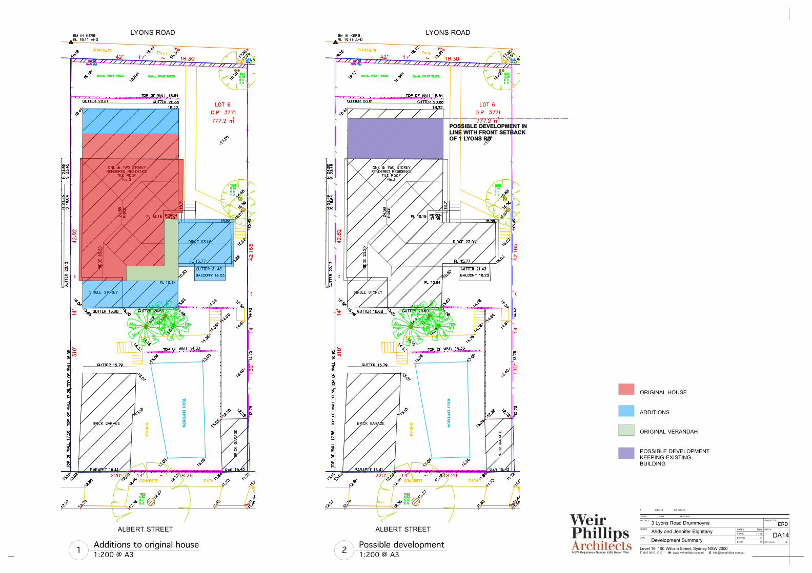
Possible development 1:200 @ A32
ALBERT STREET
ALBERT STREET
ALBERT STREET
POSSIBLE DEVELOPMENT IN LINE WITH FRONT SETBACKOF 1 LYONS RD
ALBERT STREET
LYONS ROAD LYONS ROAD
ORIGINAL HOUSE
ADDITIONS
POSSIBLE DEVELOPMENTKEEPING EXISTINGBUILDING
Additions to original house1:200 @ A31
ORIGINAL VERANDAH
Level 19, 100 William Street, Sydney NSW 2000 T: 612 9310 1010 W: www.weirphillips.com.au E: [email protected]
PROJECT
CLIENT
DWG
ISSUE DATE REVISION
PROJECT #
DWG #
REVISION
DATE #
SCALE
DRAWN
CHKD
NSW Registration Number 6385 Robert Weir
DA ISSUE1/12/14A
Development Summary
3 Lyons Road Drummoyne
Ahdy and Jennifer ElghitanyERD
DA14Date
1:100
??
?? A
Estimated Restoration Costs
Item Qty Rate Description Amount
1.1 Preliminaries $120,000.00
1.2 Demolition (demolish additions, garages, ground works)
$60,000
1.3 Re-roof in slate or terracotta tiles $100,000.00
1.4 Construct a new verandah $250,000.00
1.5 Construct a new basement $150,000.00
1.6 80sq m $6,000.00 Re-build demolished accommodation
$480,000.00
1.7 Professional fees $90,000.00
1.8 GST $133,100.00
Total Cost $1,383,100.00


![WELCOME! [] · WELCOME! Online Public Information Centre #1 Montrose Road and Lyons Creek Road/Biggar Road Municipal Class Environmental ASSESSMENT Wednesday June 24, 2020](https://img.dokumen.tips/doc/110x75/603c21c86d9f8e59045da1cb/welcome-welcome-online-public-information-centre-1-montrose-road-and-lyons.jpg)


