Embed Size (px)
Citation preview

Site/Project :
Lynch’s Castle
Conservation Project
Industry:
Private Sector
Client :
AIB Bank
Locat ion:
Galway City
Site Type:
Medieval Tower House
Deliverables:
3D Laser Scan survey
2-D output drawings
3-D models
Benef i ts:
Cost Effective
Quick turnaround
Non contact – remote
survey
Unparalleled accuracy and
detail
Detailed CAD output
Detailed digital archive.
Value added applications
such as production of
scaled 3D models
Introduction Measured Building Survey
Lynch’s Castle is one of Galway’s iconic
buildings located centrally within the city
representing one of the finest surviving
examples of an urban tower-house dating to
the 16th
century. This stone block built
structure contains on its façade a series of
very detailed ornamental carvings, hood
moldings and detailed panels.
Previous conservation works of the structure
had involved the use of abrasive cleaning of
the façade of the building resulting in the
“washing out” of some elements of the stone
work. An up to date building survey at “stone-
by-stone” level of detail as well as a detailed
survey of the decorative panels was required
by the National Monuments Service (Ireland)
to provide both detailed 2D scaled drawings
of the building and also provide information
for a base-line survey of the current condition
of the building and its historic features. This
information was used for both archival and
stone conservation purposes with high
resolution scaled photography and 3D models
of each of the decorative panels augmenting
the laser scan survey to provide the facility to
re-construct existing stone detail in the
future..
The main building survey consisted of a 3D laser
scan survey of the entire external façade of the
building using a Leica C10 laser scanner to
collect a sub centimeter accurate 3-dimensional
measured survey of the building and each of its
constituent building blocks. This was
augmented by a photogrammetric survey of
each of the detailed panels using a fixed lens
high resolution digital camera.
The survey was carried out with one operator
and assistant over a period of 1 day within the
confines of a busy city center street scape.
I S S U E
06 FarrimondMacManus Ltd ARCHAEOLOGY − SURVEY − GIS
This issue Measured Building Survey as
an aid to Restoration Project
Lynch’s Castle, Galway
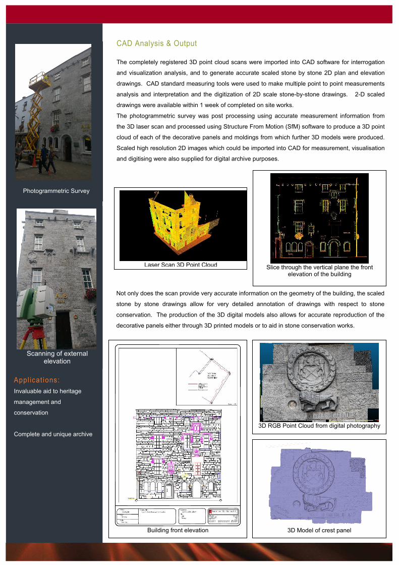
CAD Analysis & Output
The completely registered 3D point cloud scans were imported into CAD software for interrogation
and visualization analysis, and to generate accurate scaled stone by stone 2D plan and elevation
drawings. CAD standard measuring tools were used to make multiple point to point measurements
analysis and interpretation and the digitization of 2D scale stone-by-stone drawings. 2-D scaled
drawings were available within 1 week of completed on site works.
The photogrammetric survey was post processing using accurate measurement information from
the 3D laser scan and processed using Structure From Motion (SfM) software to produce a 3D point
cloud of each of the decorative panels and moldings from which further 3D models were produced.
Scaled high resolution 2D images which could be imported into CAD for measurement, visualisation
and digitising were also supplied for digital archive purposes.
Appl icat ions:
Invaluable aid to heritage
management and
conservation
Complete and unique archive
Photogrammetric Survey
Laser Scan 3D Point Cloud
Slice through the vertical plane the front
elevation of the building
Not only does the scan provide very accurate information on the geometry of the building, the scaled
stone by stone drawings allow for very detailed annotation of drawings with respect to stone
conservation. The production of the 3D digital models also allows for accurate reproduction of the
decorative panels either through 3D printed models or to aid in stone conservation works.
Building front elevation
3D RGB Point Cloud from digital photography
3D Model of crest panel
Scanning of external
elevation