Embed Size (px)
Citation preview

Lower Great Lakes/St. Lawrence Plain
North American Bird Conservation Region 13
Ontario Landbird Conservation Plan

Please cite this document as: Ontario Partners in Flight. 2008. Ontario Landbird Conservation Plan: Lower Great Lakes/St. Lawrence Plain, North American Bird Conservation Region 13. Ontario Ministry of Natural Resources, Bird Studies Canada, Environment Canada. Draft Version 2.0. Front Cover: TOP: Belted Kingfisher Photo © Ken Newcomb; BOTTOM: Baltimore Oriole Photo © Ethan Meleg; INSET: Bobolink Photo © Ethan Meleg

Ontario Landbird Conservation Plan:
Lower Great Lakes/St. Lawrence Plain North American Bird Conservation Region 13
December 2008 Draft
Version 2.0

Ontario Landbird Conservation Plan: Lower Great Lakes/St. Lawrence Plain (BCR 13) ii
Acknowledgements
This plan is the result of a collaborative planning, writing, consultation and review process that involved numerous individuals, organizations and agencies with an interest in helping to coordinate landbird conservation efforts in southern Ontario. This project was funded and led by Environment Canada Ontario Region (EC) and the Ontario Ministry of Natural Resources (OMNR), under the direction of a Project Steering Committee consisting of Rick Pratt (EC), Kevin Loftus, Deb Pella Keen and Eva Kennedy (OMNR); and Michael Bradstreet and George Finney (Bird Studies Canada). Bird Studies Canada (BSC), a non-profit bird research organization, was contracted to carry out the technical analysis and plan writing functions. Wildlife Habitat Canada acted as the banker for project funding. The Project Organizing Committee members played a crucial role in guiding and managing the plan development and review process: Brigitte Collins (EC), Cynthia Pekarik (EC) and Lyle Friesen (EC), Julie Simard (OMNR), Martha Allen (OMNR) and Rebecca Zeran (OMNR) and Peter Blancher (BSC and EC), Audrey Heagy (BSC) and Steve Wilcox (BSC). Copy-editing was done by Francine Geraci. Final layout and editing was completed by Rebecca Zeran. This plan benefited greatly from the contributions of the Technical Advisory Committee members (Appendix A), who shared their knowledge and expertise at two technical workshops and provided comments on this document. Valuable input was also received from members of Partners in Flight (PIF) initiatives outside Ontario. Newly revised PIF assessment scores and prioritization methods were provided by the PIF Science Committee (Canada, US, Mexico). Brian Collins (EC) provided the Breeding Bird Survey (BBS) trend analysis software that was used to generate BBS trends and indices for Ontario BCR 13. Denis Lepage (BSC) provided data from the Ontario Breeding Bird Atlas (BBA), and Andrew Couturier (BSC) generated habitat land cover data for atlas squares and for atlas point count locations. Range maps in the species accounts were derived from shapefiles provided by NatureServe in collaboration with Robert Ridgely, James Zook, The Nature Conservancy – Migratory Bird Program, Conservation International – Center for Applied Biodiversity Science, World Wildlife Fund – US, and Environment Canada – WildSpace. PIF Ontario is grateful to all these individuals and organizations for their assistance. A big thank-you to all the volunteers who collected bird survey data (Breeding Bird Survey, Ontario Breeding Bird Atlas, Christmas Bird Counts and other surveys) that made the analyses presented in this plan possible. A special thank-you to Saul Bocian, Michael Butler and Simon Dodsworth for donating photographs for use in this plan.

Ontario Landbird Conservation Plan: Lower Great Lakes/St. Lawrence Plain (BCR 13) iii
Acronyms ANSI – Area of Natural and Scientific Interest BBA – Ontario Breeding Bird Atlas projects BBA1 – Ontario Breeding Bird Atlas, 1981–1985 BBA2 – Ontario Breeding Bird Atlas, 2001–2005 BBS – Breeding Bird Survey BCR – Bird Conservation Region BMP – Best Management Practice BSC – Bird Studies Canada CAR – Census of Agricultural Regions CBC – Christmas Bird Count CCA – Canadian Census of Agriculture CMMN – Canadian Migration Monitoring Network COSARRO – Committee on the Status of Species at Risk in Ontario COSEWIC – Committee on the Status of Endangered Species in Canada CWS – Canadian Wildlife Service dbh – diameter at breast height EC – Environment Canada EHJV – Eastern Habitat Joint Venture ELC – Ecological Land Classification FBMP – Forest Bird Monitoring Program FRI – Forest Resource Inventory HMANA – Hawk Migration Association of North America IBA – Important Bird Area MAPS – Monitoring Avian Productivity and Survivorship NABCI – North American Bird Conservation Initiative NHIC – Natural Heritage Information Centre NWA – National Wildlife Area OLC – Ontario Land Cover mapping OMMAH – Ontario Ministry of Municipal Affairs and Housing OMNR – Ontario Ministry of Natural Resources ONRS – Ontario Nest Records Scheme PFW – Project FeederWatch PIF – Partners in Flight PPS – Provincial Policy Statement on Natural Heritage PSW – Provincially Significant Wetland SAR – Species at Risk SARA – Species at Risk Act SARO – Species at Risk in Ontario

Ontario Landbird Conservation Plan: Lower Great Lakes/St. Lawrence Plain (BCR 13) ii
Executive Summary
Southern Ontario is home to a great diversity of bird life, with species richness rivalling anywhere else in Canada or the United States during the breeding season. It also houses much of Canada’s human population, with a landscape heavily influenced by agriculture, urban development and industry. The purpose of this plan is to guide landbird conservation efforts in order to sustain the distribution, diversity and abundance of birds in this settled landscape.
The Planning Area The plan covers Ontario’s share of the Lower Great Lakes/St. Lawrence Plain, Bird Conservation Region 13 (ON BCR 13), which generally corresponds to Ontario south of the Precambrian Shield (but includes the Frontenac Axis). This is the first of four landbird plans being developed by Ontario Partners in Flight (PIF). Each focuses on Ontario’s share of a single Bird Conservation Region (BCR), planning regions developed by the North American Bird Conservation Initiative (NABCI). Together these four plans will contribute to continentwide efforts by PIF and NABCI to sustain the distribution, diversity and abundance of all North American landbirds. Read Chapter 1 to learn more about the scope and objectives of this plan, and how it fits into continental conservation initiatives for birds. Chapter 2 provides an overview of the physical, biological and cultural setting of the planning region. Most of the plan – Chapters 3 through 10 – is devoted to three topics: � Identifying priority species and habitats; � Setting measurable objectives for the conservation of priority species; and � Recommending conservation actions to achieve objectives.
Landbird Conservation Priorities Forty-two (25%) of the 168 species of landbirds that regularly breed or winter in southern Ontario are identified as priority species (see Chapter 4 for a complete list) on the basis of a detailed species assessment (Chapter 3 outlines the approach; appendices provide details). Reasons for listing are diverse. Some species are of concern continentwide and have important populations in southern Ontario (e.g., Willow Flycatcher, Short-eared Owl). A few have small global range and populations, and thus are considered vulnerable to future change (e.g., Golden-winged and Cerulean Warblers), while many are relatively abundant and widespread but are declining rapidly, with continued declines a strong possibility (e.g., Vesper Sparrow, Eastern Meadowlark). Other species are listed because southern Ontario has a high global responsibility for the species’ population in combination with other concerns (e.g., Bobolink, Baltimore Oriole). Southern Ontario is also home to many of Canada’s, and Ontario’s, listed Endangered and Threatened species (e.g., Prothonotary Warbler, Northern Bobwhite), which are also included as priority species in this plan. Most of these priority species depend on one of three general habitat types, each of which has been listed as a priority for attention in southern Ontario:
� Forest landbirds – 13 priority species (see Chapter 5); � Grassland/agricultural landbirds – 13 priority species (see Chapter 6); and � Shrub/successional landbirds – 10 priority species (see Chapter 7).

Ontario Landbird Conservation Plan: Lower Great Lakes/St. Lawrence Plain (BCR 13) iii
Species with other habitat affinities are covered separately in Chapter 8. A fourth group of landbirds identified as a priority for attention in this plan is the aerial-foraging insectivores – birds that feed on flying insects captured while “on the wing” (see Chapter 9). This group includes swallows, swifts and nighthawks. Though only three species are individually on the priority list, all nine aerial insectivores that breed regularly in southern Ontario are showing signs of decline. Landbird Conservation Objectives Overall objectives are set for each priority species to give general guidance to conservation efforts. These objectives depend on whether the species is already the subject of a Species at Risk recovery strategy (objective is recovery), is poorly monitored (assess status), has declined to a less desirable level (reverse decline), has declined but is still at an acceptable level (halt decline) or appears to be stable or increasing (maintain current). The objectives respond to current realities and conservation circumstances. For example, we recognize that reversing the long-term declines in priority grassland birds resulting from a decrease in agricultural grasslands in southern Ontario is not an achievable conservation objective. Nonetheless, halting these declines and maintaining current population and distribution levels is important because this region is an important refuge for North America’s declining grassland birds. Specific measurable objectives are also set for the abundance of each species, where the species is monitored by the North American Breeding Bird Survey, as well as for the distribution of each species across four subregions of southern Ontario, using changes between successive Breeding Bird Atlases as a benchmark. Similar measurable objectives are set for each priority group of birds, i.e., all forest birds, all aerial-foraging insectivores, etc. These specific objectives provide a means of evaluating progress against the overall objectives above. See Chapter 3 for the approach to objectives, and Chapters 4 through 9 for objectives specific to each guild of birds. Conservation Actions The plan proposes a wide range of actions for the conservation of landbirds in southern Ontario, including actions related to monitoring, research and evaluation, planning and policy, outreach and education and applied conservation. General actions that apply to many groups of landbirds are found in Chapter 4, actions specific to habitat and foraging guilds are listed in Chapters 5 to 9, and actions specific to each priority species are contained in species accounts in Appendix F, which also contains details of species status, reasons for concern, ecology and objectives. It is expected that the proposed actions will be implemented by a range of conservation partners in coordination with other conservation initiatives, including all-bird conservation initiatives under the NABCI umbrella, biodiversity conservation initiatives under the Ontario Biodiversity Strategy and Species at Risk recovery programs. Conservation actions outside of southern Ontario may also be necessary to contribute to these objectives, as all but one priority species (Northern Bobwhite) are migratory.

Ontario Landbird Conservation Plan: Lower Great Lakes/St. Lawrence Plain (BCR 13) iv
SOMMAIRE
Le sud de l’Ontario constitue l’habitat d’une grande diversité d’oiseaux et la richesse de leurs espèces peut rivaliser avec celle de n’importe quelle autre région du Canada et des États-Unis durant la saison de la reproduction. C’est également là que vit une bonne partie de la population du Canada sur un territoire façonné par l’agriculture, le développement urbain et l’industrie. Le but de ce plan est d’orienter les efforts en matière de conservation des oiseaux terrestres afin de maintenir la répartition, la diversité et l’abondance des oiseaux sur ce territoire habité. Région couverte par ce plan Le plan englobe la partie ontarienne des Grands Lacs inférieurs et de la plaine du Saint-Laurent, soit la région de conservation des oiseaux 13 (ON RCO 13), qui correspond de façon générale à la partie de l’Ontario située au sud du bouclier précambrien (mais incluant l’axe de Frontenac). Ceci est le premier de quatre plans concernant les oiseaux terrestres élaborés par l’Ontario Partner in Flight (PIF). Chacun d’eux se concentre sur la portion ontarienne d’une région de conservation des oiseaux (RCO), la planification de ces régions a été élaborée par l’Initiative de conservation des oiseaux de l’Amérique du Nord (ICOAN). Pris dans leur ensemble, ces quatre plans apporteront un appui aux efforts déployés par le PIF et l’ICOAN pour maintenir, sur toute l’étendue du continent, la répartition, la diversité et l’abondance de tous les oiseaux terrestres d’Amérique du Nord. Le chapitre 1 permet de mieux apprécier l’ampleur et les objectifs de ce plan et de voir comment il s’insère dans les initiatives de conservation des oiseaux à l’échelle continentale. Le chapitre 2 donne une vue d’ensemble du cadre physique, biologique et culturel de la région d’application du plan. La plus grande partie du plan, soit les chapitres 3 à 10, est consacrée à trois sujets : � l’identification des espèces prioritaires et de leurs habitats; � l’établissement d’objectifs mesurables pour la conservation des espèces prioritaires; � les recommandations quant aux actions susceptibles d’atteindre les objectifs de
conservation. Priorités en matière de conservation des oiseaux terrestres Quarante-deux (soit 23%) des cent-soixante-huit espèces d’oiseaux terrestres qui se reproduisent ou hivernent de façon régulière dans le sud de l’Ontario ont été identifiées comme espèces prioritaires (le chapitre 4 en donne la liste complète) sur la base d’une évaluation précise des espèces (le chapitre 3 en explique l’approche et les annexes en donnent les détails). Diverses raisons expliquent leur inclusion. Quelques espèces sont cause de préoccupation sur l’étendue du continent et ont d’importantes colonies dans le sud de l’Ontario (par exemple, la moucherolle des saules et le hibou des marais), alors que quelques-unes ont une aire de répartition et une population restreintes et, par conséquent, sont considérées comme vulnérables aux changements à venir (par exemple, la paruline à ailes dorées et la paruline azurée). D’autres, relativement abondantes et répandues sur un vaste territoire, décroissent rapidement et, selon toute vraisemblance, continueront à décliner (par exemple, le bruant vespéral et la sturnelle de l’Est).

Ontario Landbird Conservation Plan: Lower Great Lakes/St. Lawrence Plain (BCR 13) v
D’autres encore apparaissent sur la liste parce que le sud de l’Ontario a, entre autres préoccupations, une responsabilité d’ensemble importante à l’endroit de la population de cette espèce (par exemple, le goglu des prés et l’oriole de Baltimore). Le sud de l’Ontario abrite aussi beaucoup d’espèces qui figurent sur les listes canadienne et ontarienne des espèces en voie de disparition ou menacées (par exemple, la paruline orangée et le colin de Virginie), lesquelles sont également incluses en tant qu’espèces prioritaires dans ce plan. La plupart de ces espèces prioritaires dépendent de l’un des trois genres d’habitats généraux, chacun apparaissant sur la liste des priorités sujettes à attention dans le sud de l’Ontario. � Oiseaux terrestres des forêts – 13 espèces prioritaires (voir le chapitre 5); � Oiseaux terrestres des prairies et des terres agricoles – 13 espèces prioritaires (voir le
chapitre 6); � Oiseaux terrestres des sous-bois et petits arbres – 10 espèces prioritaires (voir le
chapitre 7). Les espèces ayant des affinités différentes quant à leur habitat sont traitées de façon séparée au chapitre 8. Les insectivores aériens constituent un quatrième groupe d’oiseaux terrestres inclus parmi les priorités de ce plan; ce sont des oiseaux qui se nourrissent d’insectes volants capturés « en plein vol » (voir le chapitre 9). Ce groupe comprend les hirondelles, les martinets et les engoulevents. Bien que seules trois espèces fassent nommément partie de la liste de priorité, l’ensemble des neuf catégories d’insectivores aériens qui se reproduisent régulièrement dans le sud de l’Ontario montre des signes de déclin. Objectifs pour la conservation des oiseaux terrestres Des objectifs d’ensemble ont été établis pour chaque espèce prioritaire afin de servir de guide général aux efforts de conservation. Ces objectifs ne seront pas les mêmes si l’espèce fait déjà l’objet d’une stratégie de rétablissement des espèces en péril (objectif : le rétablissement), si elle est peu surveillée (évaluation de la situation), si elle a décliné pour atteindre un niveau peu souhaitable (renverser le déclin), si elle a décliné tout en demeurant à un niveau acceptable (arrêter le déclin), ou si elle semble être stable ou en croissance (maintenir la tendance). Ces objectifs correspondent aux réalités présentes et aux circonstances affectant la conservation. Par exemple, on doit reconnaître qu’un objectif de conservation comme le renversement du déclin des oiseaux des prairies prioritaires ne peut être considéré comme réaliste en raison de la diminution des terres agricoles dans le sud de l’Ontario. Toutefois, il est important d’arrêter cette décroissance et de maintenir le niveau de la population et sa distribution parce que cette région constitue un refuge important pour les populations d’oiseaux des prairies en déclin en Amérique du Nord. Des objectifs spécifiques mesurables quant à l’abondance de chacune des espèces ont été déterminés là où elles sont suivies de près par le North American Breeding Survey (Étude sur la reproduction des oiseaux d’Amérique du Nord), de même que pour la répartition de chaque espèce dans les quatre sous-régions du sud de l’Ontario en utilisant comme point de référence les

Ontario Landbird Conservation Plan: Lower Great Lakes/St. Lawrence Plain (BCR 13) vi
éditions successives des atlas de reproduction des oiseaux. Des objectifs mesurables similaires ont été établis pour chaque groupe de priorité, c’est-à-dire pour tous les oiseaux des forêts, tous les insectivores aériens, etc. Ces objectifs spécifiques fourniront le moyen d’évaluer les progrès face aux objectifs généraux mentionnés plus haut. Le chapitre 3 traite de l’approche des objectifs, alors que les chapitres 4 à 9 énumèrent les objectifs propres à chaque grande famille d’oiseaux. Mesures de conservation Ce plan propose un vaste éventail de mesures de conservation pour les oiseaux terrestres du sud de l’Ontario, y compris des mesures concernant la surveillance, la recherche et l’évaluation, la planification et les politiques, le travail d’information et d’éducation, de même que la conservation appliquée. Le chapitre 4 contient des mesures de nature générale qui s’appliquent à de nombreux groupes d’oiseaux terrestres; les chapitres 5 à 9 contiennent des mesures propres aux habitats et aux guildes d’oiseaux; l’annexe F (compte rendu des espèces) énumère des mesures spécifiques pour chaque espèce de priorité et contient des renseignements sur le statut de chaque espèce, les motifs de préoccupation, l’écologie et les objectifs. On espère que les mesures proposées ici seront mises en œuvre par une gamme de partenaires en matière de conservation, en coordination avec d’autres initiatives comprenant celles prises pour l’ensemble des oiseaux en vertu de l’ICOAN ainsi que celles pour la conservation de la biodiversité dans le cadre de la Stratégie ontarienne pour la biodiversité, et les programmes de rétablissement des espèces en péril. Comme toutes ces espèces sont migratoires, à l’exception du colin de Virginie, il sera nécessaire d’adopter diverses mesures de conservation à l’extérieur de l’Ontario si l’on veut atteindre ces objectifs.

Ontario Landbird Conservation Plan: Lower Great Lakes/St. Lawrence Plain (BCR 13) vii
Table of Contents
1. Introduction 1 Purpose 1 Plan Objectives 2 The Importance of Landbird Conservation 2 The PIF North American Landbird Conservation Plan 3 PIF in Ontario 4
2. Overview of the Lower Great Lakes/St. Lawrence Plain (BCR 13) in Ontario 5 Description 5 Subregions of ON BCR 13 5 Physical Features 7 Physiographic Features 8 Natural Vegetation 9 Current Land Cover 10 Avifauna 12 Human Population 13 Land Ownership and Management 14 Land Use 14 Conservation Planning in Southern Ontario 15
3. The PIF Ontario Planning Approach 16 Plan Development 16 Sources of Information 16 Assessing Species Vulnerability 17 Identifying Priority Species 17 Identifying Priority Habitats and Ecological Guilds 18 Setting Objectives 18 Identifying Landbird Conservation Issues and Actions 19
4. Landbird Conservation Priorities in Ontario BCR 13 22 Priority Species 22 Priority Guilds 24 Migration Linkages 26 Monitoring and Evaluation 27 Landbird Conservation Issues 29 Conservation Focus 29 Recommended Conservation Actions 30
5. Conservation of Forest Landbirds 32 Landbirds in Forest Habitats 32 Forest Priority Species 32 Forest Habitats in ON BCR 13 34 Conservation Objectives for Priority Forest Landbirds 36 Conservation Objectives for the Forest Guild 37 Conservation Focus 40 Recommended Conservation Actions for Forest Landbirds 41
Ontario Landbird Conservation Plan: Lower Great Lakes/St. Lawrence Plain (BCR 13) viii
6. Conservation of Grassland/Agricultural Landbirds 43 Landbirds in Grassland and Agricultural Habitats 43 Priority Landbirds in Grassland and Agricultural Habitats 43 Grassland and Agricultural Habitats 45 Conservation Objectives for Priority Grassland/Agricultural Landbirds 50 Conservation Objectives for the Grassland/Agricultural Guild 50 Conservation Focus 53 Recommended Conservation Actions for Grassland/Agricultural Landbirds 53
7. Conservation of Shrub/Successional Landbirds 55 Landbirds in Shrub and Early Successional Habitats 55 Shrub/Successional Habitats 55 Conservation Objectives for Priority Shrub/Successional Landbirds 59 Conservation Focus 61 Recommended Conservation Actions for Shrub/Successional Landbirds 61
8. Conservation of Landbirds in Other Habitats 64 Landbirds Breeding in Other Habitats 64 Factors Affecting Priority Landbirds in Other Habitats 64 Conservation Objectives for Priority Landbirds in the Other Habitats Group 65 Recommended Conservation Actions for Landbirds in Other Habitats 66
9. Conservation of Aerial-foraging Insectivorous Landbirds 68 Aerial-foraging Insectivorous Landbirds 68 Threats 68 Conservation Objectives for Aerial Insectivores 69 Conservation Focus 70 Recommended Conservation Actions for Aerial Insectivores 70
10. Implementation Philosophy 71 Implementation Strategy 71 Evaluating Progress 72 Next Steps 72
11. References 73
12. Glossary 87
Appendix A: Ontario BCR 13 Landbird Conservation Plan Technical Advisory Committee 91 Appendix B: Avian Data Sets and Data Analyses 92 Appendix C: Identifying Priority Species at a Regional Scale – the PIF Approach 94 Appendix D: Landbirds Occurring Regularly in Ontario BCR 13 during the Breeding and/or Wintering Seasons 99 Appendix E: PIF Species Assessment Scores for Landbirds in Ontario BCR 13 107

Ontario Landbird Conservation Plan: Lower Great Lakes/St. Lawrence Plain (BCR 13) ix
Appendix F: Priority Species Accounts 115
Figure F1: Template for the priority species accounts 116 Acadian Flycatcher 117 American Kestrel 118 Bald Eagle 119 Baltimore Oriole 120 Bank Swallow 121 Barn Owl 122 Belted Kingfisher 123 Black-billed Cuckoo 124 Blue-winged Warbler 125 Bobolink 126 Brown Thrasher 127 Canada Warbler 128 Cerulean Warbler 129 Chimney Swift 130 Eastern Kingbird 131 Eastern Meadowlark 132 Eastern Towhee 133 Eastern Wood-Pewee 134 Field Sparrow 135 Golden-winged Warbler 136 Grasshopper Sparrow 137 Henslow’s Sparrow 138 Hooded Warbler 139 Kirtland’s Warbler 140 Loggerhead Shrike 141 Louisiana Waterthrush 142 Northern Bobwhite 143 Northern Flicker 144 Northern Harrier 145 Peregrine Falcon 146 Prairie Warbler 147 Prothonotary Warbler 148 Red-headed Woodpecker 149 Red-shouldered Hawk 150 Rose-breasted Grosbeak 151 Savannah Sparrow 152 Short-eared Owl 153 Vesper Sparrow 154 Whip-poor-will 155 Willow Flycatcher 156 Wood Thrush 157 Yellow-breasted Chat 158
Appendix G: Wetland-associated Priority Landbirds in Ontario BCR 13 159 Appendix H: Importance of Ontario BCR 13 to Landbirds during Migration 160

Ontario Landbird Conservation Plan: Lower Great Lakes/St. Lawrence Plain (BCR 13) x
Appendix I: Accuracy and Precision of Population Abundance Objectives and Estimated Population Size for Priority Species Breeding in Ontario BCR 13 162 Appendix J: Evaluation of Current Monitoring Coverage for Landbirds in Ontario BCR 13, and Proposed Monitoring-related Actions 164
List of Boxes Box 1: Partners in Flight (PIF) 2 Box 2: The North American Bird Conservation Initiative (www.nabci.net) 3 Box 3: North American Bird Conservation Regions (BCRs) 4 Box 4: Categories used for including species in PIF regional priority species lists 17 Box 5: Landbird monitoring objectives for ON BCR 13 20 Box 6: Conservation objectives for priority species and guilds in ON BCR 13 21 Box 7: Why are landbirds breeding in agricultural grasslands a conservation priority in southern Ontario? 45 Box 8: Key facts about birds and agriculture in southern Ontario 46 Box 9: Recent trends in agricultural land use in Ontario, 1991 to 2001 49
List of Figures Figure 1: Map showing the extent of the four Bird Conservation Regions (BCRs) that fall within Ontario, including the ON BCR 13 Planning Region 1 Figure 2: Map of species richness of breeding landbirds in Canada and the United States 3 Figure 3: Lower Great Lakes/St. Lawrence Plain Bird Conservation Region (BCR 13) 5 Figure 4: Location map of Ontario portion of BCR 13 showing BCR boundaries, ecodistrict boundaries and general land cover 6 Figure 5: Subregions of ON BCR 13 used in this plan 7 Figure 6: Distribution of general land cover in ON BCR 13 by subregion 12 Figure 7: ON BCR plan development process 16 Figure 8: Distribution of priority species in ON BCR 13, by reasons for priority status 22 Figure 9: Distribution of priority species by conservation objective 24 Figure 10: Map showing relative breeding density of priority species in ON BCR 13 25 Figure 11: Distribution of priority species by habitat association 26 Figure 12: Map of wintering distribution of ON BCR 13 landbirds with high non-breeding threat scores 27 Figure 13: Map showing wintering distribution of declining Ontario BCR 13 landbirds 27 Figure 14: Forest cover (%) by forest type in ON BCR 13 by subregion 34 Figure 15: Distribution of forest cover in ON BCR 13 35 Figure 16: Long-term BBS trend, 1968–2003, and guild abundance objective for priority forest birds in ON BCR 13 37 Figure 17: Changes in forest landbird species richness and preliminary guild distribution objectives (=Atlas 2) in ON BCR 13 subregions 37 Figure 18: Map showing relative density of priority forest birds in Southern Ontario 40 Figure 19: Map showing distribution of alvar land cover in ON BCR 13 48 Figure 20: Map showing distribution of fields (pasture and old fields land cover) in ON BCR 13 48 Figure 21: Agricultural land use in southern Ontario, by Census Agricultural Region 49 Figure 22: Long-term BBS trend, 1968–2003, and guild abundance objective for grassland landbirds in ON BCR 13 50

Ontario Landbird Conservation Plan: Lower Great Lakes/St. Lawrence Plain (BCR 13) xi
Figure 23: Changes in grassland landbird species richness and preliminary guild distribution objectives (=Atlas 2) in ON BCR 13 subregions 53 Figure 24: Long-term BBS trend, 1968–2003, and preliminary guild abundance objective for shrub/successional landbirds in Ontario BCR 13 59 Figure 25: Changes in shrub/successional landbird species richness and preliminary guild distribution objectives (=Atlas 2) in ON BCR 13 subregions 61 Figure 26: Map showing relative density of priority shrub/successional birds in ON BCR 13 62 Figure 27: Long-term BBS trend, 1968–2003, and guild abundance objective for aerial insectivores in Ontario BCR 13 69 Figure 28: Changes in aerial insectivore species richness and preliminary guild distribution objectives (=Atlas 1) in ON BCR 13 subregions 69
List of Tables Table 1: Relationship of the Ontario land cover classes with the general land cover categories used in this plan 11 Table 2: Distribution of general land cover (c. early 1990s) in ON BCR 13 by subregions 11 Table 3: Priority landbird species in ON BCR 13, sorted by reasons for priority status, and showing overall objective and priority guld designation 23 Table 4: Priority species guilds used in ON BCR 13 plan 26 Table 5: Conservation threats facing landbirds in ON BCR 13 28 Table 6: Forest priority breeding landbirds in ON BCR 13, sorted by reasons for priority status 32 Table 7: Summary of habitat needs of priority forest landbirds in ON BCR 13 33 Table 8: Summary of conservation objectives, focus and actions for priority forest landbirds in ON BCR 13 38 Table 9: Grassland/Agricultural priority breeding landbirds in ON BCR 13, sorted by reasons for priority status 43 Table 10: Grassland/Agricultural priority wintering landbirds in ON BCR 13, sorted by reasons for priority status 43 Table 11: Summary of habitat needs of priority grassland/agricultural landbirds in ON BCR 13 44 Table 12: Summary of conservation objectives, focus and actions for priority grassland/agricultural landbirds in southern Ontario 51 Table 13: Shrub/successional priority breeding landbirds in ON BCR 13, sorted by reasons for priority status 55 Table 14: Summary of habitat needs of priority shrub/successional landbirds in ON BCR 13 56 Table 15: Summary of conservation objectives, focus and actions for shrub/successional priority landbirds in southern Ontario 60 Table 16: Priority landbirds in other habitats in ON BCR 13, sorted by reasons for priority status 64 Table 17: Summary of conservation objectives, focus and actions for priority landbirds in other habitats in southern Ontario 67 Table 18: Changes in the abundance and distribution of aerial-foraging insectivores breeding in Ontario BCR 13 68

Ontario Landbird Conservation Plan: Lower Great Lakes/St. Lawrence Plain (BCR 13) 1
1.1 Purpose The purpose of this plan is to guide landbird conservation efforts in those parts of Ontario that lie within the Great Lakes/St. Lawrence Plain region, also known as Bird Conservation Region 13 (Figure 1). This is the first of four such plans being developed to cover the four Bird Conservation Regions (BCRs) within Ontario. The conservation goals of this plan are twofold: � To sustain the distribution, diversity and
abundance of native landbirds and their habitats in Ontario portions of BCR 13 (ON BCR 13); and
� To contribute to continentwide efforts to sustain the distribution, diversity and abundance of all North American landbirds.
This is a biological plan, aimed chiefly at: � Identifying priority landbird species and habitats; � Setting measurable and attainable objectives for
the conservation of these priority species; and � Recommending conservation actions to help
achieve those objectives. Figure 1: Map showing the extent of the four Bird Conservation Regions (BCRs) that fall within Ontario, including the ON BCR 13 Planning Region.
Source: www.bsc-eoc.org/international/bcrcanada.html
The plan is complementary to, and does not duplicate or replace, current recovery strategies and actions for those landbird species that have been officially designated as Endangered or Threatened, according to federal or provincial Species at Risk (SAR) legislation. To be successful, this plan should be used to guide the actions of a variety of partners, including: � Conservation planners at federal, provincial and
municipal levels; � Public and private land owners and managers; � Project proponents, consultants and
environmental assessment practitioners; � Scientists and volunteers involved in wildlife
research and monitoring; and � Individuals and organizations interested in
making a difference for landbirds in their communities.
These partners are the primary audience for this plan, as their actions will influence the fate of Ontario’s landbirds. Many of these partners have been directly or indirectly involved in the development of this plan.
1 Introduction
Landbirds include a broad variety of species that rely primarily on terrestrial habitats throughout the year, including: vultures,
eagles, hawks, falcons, grouse, quail, doves, cuckoos, owls, nightjars, swifts,
hummingbirds, kingfishers, woodpeckers, and passerines (songbirds).

Ontario Landbird Conservation Plan: Lower Great Lakes/St. Lawrence Plain (BCR 13) 2
1.2 Plan Objectives The specific objectives of this plan are to use existing data, information and expert knowledge to: � Identify priority landbird species by following a
comprehensive, objective, science-based assessment process;
� Provide concise summaries of relevant information on the status, ecology, management and conservation needs of priority landbird species;
� Describe priority habitats used by several of these priority species, and summarize key issues affecting these habitats;
� Establish realistic, measurable population objectives for the conservation of priority landbirds in this region, where possible;
� Recommend conservation actions that will assist in achieving these objectives, including: � Monitoring; � Research and evaluation; � Planning and policy; � Outreach initiatives to educate and inform
target audiences; � Applied conservation actions;
� Describe an implementation strategy to foster integration of this plan with other existing regional and international conservation initiatives.
The information in this plan is designed to guide the conservation of landbirds in ON BCR 13. Ideally the actions recommended in this plan will be implemented in coordination with similar conservation planning efforts directed at waterfowl, waterbird and shorebird populations in BCR 13 (Hayes et al. 2002), the continental-scale Partners in Flight (PIF, Box 1) and North American Bird Conservation Initiative (NABCI, Box 2) programs. The provincial and federal biodiversity strategies (OMNR 2005; Environment Canada 1995) provide overall frameworks for coordinating the conservation of all biodiversity in Ontario and Canada.
1.3 The Importance of Landbird Conservation
Birds are the most familiar and widely enjoyed elements of nature in North America, with more people watching and feeding birds than ever before. Birds bring beauty, song and joy into the lives of many people. Birds fill critical roles in ecological systems through seed dispersal, pollination, control of pest species, and as prey for other wildlife. They also serve as a valuable early warning system for
Box 1: Partners in Flight (PIF). In 1990, Partners In Flight (PIF) was launched in the US in response to growing concerns about declines in the populations of neotropical migrant landbirds (www.partnersinflight.org). Later, PIF expanded to include all landbirds, and PIF initiatives began in Canada and Latin America. At its broadest level, PIF is a coalition of countries, government agencies, conservation groups, academic institutions, industry and concerned citizens who share a common vision: to maintain the health of landbird populations and their habitats. In Canada, PIF activities are coordinated by a National Working Group, composed of representatives from several national organizations and regional PIF groups. Activities and products of this group include the Framework for Landbird Conservation in Canada (PIF Canada 1996) and the Canadian Landbird Monitoring Strategy (Downes et al. 2000). (See www.cws-scf.ec.gc.ca/birds/lb_ot_e.cfm). Landbirds are one of the four pillars under the North American Bird Conservation Initiative (NABCI) framework (the other pillars are: waterfowl, shorebirds, and waterbids). The landbird pillar is implemented chiefly through PIF activities which support the conservation of migratory and resident landbirds throughout their yearly ranges.
PIF Mission To sustain the distribution, diversity and abundance of landbirds in their natural numbers and natural habitats, throughout their natural geographic ranges.
1) Keeping common birds common. Native birds, both resident and migratory, must be retained in healthy numbers throughout their natural ranges.
2) Helping species at risk. Species must be
conserved before they become imperiled: allowing species to become threatened or endangered results in long-term and costly recovery efforts whose success is far from guaranteed.
3) Working in partnerships for birds, habitats
and people. Conservation of landbirds and their habitats cannot be undertaken alone.

Ontario Landbird Conservation Plan: Lower Great Lakes/St. Lawrence Plain (BCR 13) 3
health of the environment, as demonstrated by declines in populations of Peregrine Falcon, Osprey and other birds in the DDT era. The residents of southern Ontario enjoy one of the richest assemblages of breeding birds in eastern North America, including more than 150 species of landbirds (Figure 2). Tremendous numbers of migrants also pass through southern Ontario, en route to breeding areas to the north and west and wintering areas that, for some species, may extend all the way to the extreme southern tip of South America. Many sites in southern Ontario are identified as Important Bird Areas (IBAs) because they provide essential habitat for breeding or non-breeding birds, based on international and national significance criteria (www.ibacanada.com). Over the past several decades, populations of many common landbirds have undergone long-term declines, in this region and elsewhere. The reasons for these declines are complex, but habitat-related factors (habitat conversion, fragmentation and degradation) are considered the primary cause of the observed declines in many landbirds. As a first step in addressing concerns regarding declining landbird populations and the loss of landbird habitats, PIF promoted the development of regional landbird conservation plans and produced a major North American landbird conservation plan, establishing continental-scale priorities (Rich et al. 2004).
1.4 The PIF North American Landbird Conservation Plan
The first iteration of the PIF North American Landbird Conservation Plan was completed in March 2004 (Rich et al. 2004). This landmark document established a vision and planning framework for the conservation of all North American landbirds. Some 195 Species of Continental Importance were identified in the continental plan, including: � PIF Watch List species – characterized by a high
level of vulnerability and concern; and � PIF Stewardship species – those species for
which a region has high responsibility because a high percentage of its global population occurs in a single biome.
Figure 2: Map of species richness of breeding landbirds in Canada and the United States.
Source: Rich et al. 2004.
Box 2: The North American Bird Conservation Initiative (www.nabci.net). The North American Bird Conservation Initiative (NABCI) is a tri-national initiative involving Canada, the United States and Mexico. It was launched in 1999 by the Commission for Environmental Cooperation (an international organization created by Canada, Mexico and the United States under the North American Agreement on Environmental Cooperation) to address the need for coordinated bird conservation efforts that benefit “all birds in all habitats.” NABCI advocates an approach to bird conservation that is regionally based, biologically driven and landscape oriented. It draws together the major bird conservation plans already in existence for waterbirds, shorebirds, waterfowl and landbirds (i.e., Partners in Flight plans such as this one), fills in knowledge gaps and builds a coalition of groups and agencies to execute the plans. In Ontario, NABCI activities are coordinated through the Eastern Habitat Joint Venture. It is anticipated that conservation plans for landbirds and other birds will be implemented through the Joint Venture and other partnership initiatives.
No. of Breeding Landbird Species

Ontario Landbird Conservation Plan: Lower Great Lakes/St. Lawrence Plain (BCR 13) 4
Key links between the North American plan and this ON BCR 13 plan include: � Priority species list – Ontario’s BCR 13 list
includes species of regional interest and concern as well as species of continental importance identified in the PIF North American plan (those with relatively high density in southern Ontario);
� Population objectives – For the most part, this Ontario plan adopts the continental approach of aiming to reverse declines observed in priority species. As a result, achieving objectives in Ontario will contribute directly to achieving North Americawide objectives for these same species.
1.5 PIF in Ontario In 1995, a partnership of government and non-governmental agencies produced a bird conservation plan for Ontario that was published in 1997 as the Ontario “Flight Plan” (Cheskey 1995; Lounds et al. 1997). Priority species lists for southern Ontario were subsequently produced (Couturier 1999). The current plan builds on these earlier efforts and puts them within the NABCI BCR planning framework. The updated priority species list, objectives and recommended actions in this plan will be used to facilitate and evaluate the implementation of landbird conservation efforts in ON BCR 13. The current Ontario Partners in Flight planning initiative is being led by Environment Canada – Ontario Region and Ontario Ministry of Natural Resources, in partnership with Bird Studies Canada. This regional partnership is in keeping with PIF’s grassroots approach, in which regions develop their own goals and strategies towards achieving the overall goal of keeping common birds common (for more PIF information, see www.bsc-eoc.org/PIF/PIFOntario.html).
Box 3: North American Bird Conservation Regions (BCRs). A shared concept of geography and landscapes is critical to effective planning. To that end, participants in the North American Bird Conservation Initiative have adopted a map of North America (see below) that delineates a set of 66 geographic areas called Bird Conservation Regions (BCRs) (US NABCI Committee 2000). Each BCR encompasses landscapes having similar bird communities, habitats and resource issues. The BCR framework is now widely used for PIF planning, and by other initiatives under the NABCI umbrella. All, or part, of 12 BCRs are located in Canada. The province of Ontario encompasses parts of four BCRs (Figure 1). Like birds, BCRs cross political borders: the success of current North American all-birds conservation efforts will ultimately depend on cooperation among jurisdictions. Regional plans such as this one are intended to facilitate multi-jurisdictional and multi-species conservation efforts, such as BCR 13 all-birds planning (Hayes et al. 2002).
North American Bird Conservation Regions (BCRs)
Source: www.bsc-eoc.org/international/bcrmain.html

Ontario Landbird Conservation Plan: Lower Great Lakes/St. Lawrence Plain (BCR 13) 5
2.1 Description The entire Lower Great Lakes/St. Lawrence Plain Bird Conservation Region, BCR 13, encompasses 201 300 km2 of generally flat, low-lying land to the south of the Canadian Shield in Ontario and Quebec, and north of various highland systems in four eastern US states (Figure 3). The Ontario portion is the largest, comprising 42% of the total BCR. Smaller portions lie within New York (27%), Quebec (14%), Ohio (11%), Pennsylvania (4%) and Vermont (2%).
The Ontario portion of BCR 13 encompasses 84 700 km2, including all of southwestern Ontario, Manitoulin Island, a 50- to 100-km-wide strip along the north shore of Lake Ontario and the upper St. Lawrence River, and the lower Ottawa Valley (Figure 4). The Canadian boundaries of this BCR coincide closely with those of Environment Canada’s Mixedwood Plain Ecozone (Wiken 1986; Marshall and Schut 1999). The portion within Ontario encompasses two of the Ontario Ministry of Natural Resource’s Ecoregions (Hills 1959; Jalava et al. 1997; Crins 2002): Ecoregion 6E (Lake Simcoe – Rideau) and Ecoregion 7E (lakes Erie – Ontario, also
known as the Carolinian Ecoregion). These ecoregions represent different forest regions. Ecoregion 7E is in the deciduous forest region. Ecoregion 6E includes the southern portion of the Great Lakes – St. Lawrence Forest Region (OMNR 2002b). Where there were small discrepancies between the BCR and ecoregion boundaries, the BCR boundaries were used (e.g., in GIS analyses) with one notable exception: Cockburn Island (located west of Manitoulin Island) has been included within this ON BCR 13 plan (as in the OMNR’s ecoregions), rather than in BCR 12. This same ecologically defined planning unit is widely used for other conservation planning purposes in Ontario, and is often referred to as “Ontario south and east of the Canadian Shield,” or just “southern Ontario.” In this plan, the terms “Ontario portion of BCR 13,” “southern Ontario” and “ON BCR 13” are used interchangeably.
2.2 Subregions of ON BCR 13 The conservation needs for priority landbirds are not uniform across southern Ontario because people, land uses, habitats and landbirds are unevenly distributed across the region. In recognition of these differences, four subregions of ON BCR 13 have been defined for purposes of this plan (Figure 5): Southwest (SW), Central (CE), East (EA) and Northwest (NW). The boundaries of these four subregions are ecologically defined, based on OMNR ecoregion and ecodistrict boundaries (Jalava et al. 1997; Crins 2002). Adjacent ecodistricts with similar land cover patterns are grouped together to form the four subregions. Differences among these subregion units are described in various parts of this section (e.g., current land cover). These geographic units also are used to describe regional differences in landbird distribution and to define distribution objectives.
2 Overview of the Lower Great Lakes/St. Lawrence Plain (BCR 13) in Ontario
Figure 3: Lower Great Lakes/St. Lawrence Plain Bird Conservation Region (BCR 13).
Source: www.bsc-eoc.org/international/bcrmain.html

Ont
ario
Lan
dbird
Con
serv
atio
n P
lan:
Low
er G
reat
Lak
es/S
t. La
wre
nce
Pla
in (B
CR
13)
6
Figu
re 4
: Loc
atio
n m
ap o
f Ont
ario
por
tion
of B
CR
13
show
ing
BC
R b
ound
arie
s, ec
odis
tric
t bou
ndar
ies a
nd g
ener
al la
nd c
over
.
Sour
ce: C
rins 2
002
over
laid
on
Ont
ario
land
cov
er, 1
990s
edi
tion.

Ontario Landbird Conservation Plan: Lower Great Lakes/St. Lawrence Plain (BCR 13) 7
2.3 Physical Features The following summary of the physical features of the region that affect the current distribution and abundance of landbirds and their habitats is based on information presented in Chapman and Putnam (1984), Wiken (1986) and Phillips (1990). The overall topography of ON BCR 13 is quite subdued, with elevations ranging from just under 50 m above sea level at the confluence of the Ottawa and St. Lawrence rivers, to a high of 541 m in the Blue Mountains south of Collingwood. The local topography generally consists of flat to gently sloping plains, with the notable exception of the Niagara Escarpment, a 30- to 50-m-high bedrock scarp that meanders for some 500 km across the landscape of southwestern Ontario. The bedrock of the Lower Great Lakes/ St. Lawrence Plain region consists of gently sloping sedimentary rocks deposited in two basins separated by a southeast-trending ridge of Precambrian metamorphic rocks known as the Frontenac Axis. Granitic bedrock knobs and outcroppings are frequent along the Frontenac Axis, and there are a number of areas where the sedimentary bedrock is at or near the surface. Over most of the region, the bedrock is beneath thick deposits laid down during the last continental
glaciation event. These unconsolidated materials include glacial till deposited directly by the ice; sand and gravels deposited in meltwater rivers; and sand, silt and clay sediments deposited in lakes formed as the glacier receded. Marine clay beds deposited in the Champlain Sea are present in the Ottawa Valley and eastern Ontario. The soils across much of this region are deep and fertile. However, many areas of less easily worked soils are also present, including poorly drained clay soils, drought-prone sandy soils, stony soils and areas with very thin soils. The temperate climate of this region is influenced by the Great Lakes. Summers are relatively warm and winters cool. Annual precipitation of 720 to 1000 mm is spread throughout the year. Snowfall is particularly heavy in “snowbelt” areas located downwind of the Great Lakes. Weather conditions affect landbird populations directly (e.g., high mortality during severe weather events) and indirectly by affecting food availability (e.g., strong link between weather conditions and insect outbreaks). Weather events such as tornadoes, ice storms, floods, droughts and hurricanes create habitat for disturbance-dependent species.
Figure 5: Subregions of ON BCR 13 used in this plan.

Ontario Landbird Conservation Plan: Lower Great Lakes/St. Lawrence Plain (BCR 13) 8
2.4 Physiographic Features Key physiographic features that affect the distribution of bird habitats in this region are described below. Canadian Shield Interface Most of the northern boundary of this BCR lies along the transition between the Precambrian rocks of Canadian Shield and the overlying sedimentary rocks. This physical interface marks a very distinct ecological transition, but is very irregular in outline. This area has the highest average forest cover of any part of ON BCR 13. Breeding bird species richness is high along this ecologically diverse interface (Cadman et al. 1987). Frontenac Axis The Frontenac Axis is a low, southeast-trending ridge of Precambrian rock that connects the Algonquin Highlands in eastern Ontario with the Adirondack Mountains in New York. The surface expression of the axis includes the numerous bedrock knolls surrounded by clay flats in the Leeds–Grenville area, and the Thousand Islands in the St. Lawrence River. Relative to other parts of southern Ontario, the Frontenac Axis has a high proportion of forest, shrubland and low-intensity agricultural habitats. The number of breeding bird species found in this area is exceptionally high (Cadman et al. 1987). Limestone Plains Extensive areas of limestone plain are found near Napanee and Smiths Falls in the East subregion, near Carden (east of Orillia) in the Central subregion and on Manitoulin Island and the Bruce Peninsula in the Northwest subregion. A high proportion of these limestone plains are in a relatively natural state or subject to low-intensity agricultural uses because of shallow, stony, drought-prone soils. Many of these areas support alvar habitats, a globally rare ecosystem (Brownell and Riley 2000). Alvar ecosystems include a variety of open habitat types including rock pavement, grassland, shrubland and savannah. These open alvar areas are thought to represent one of the historical (pre-settlement) habitats for eastern grassland birds such as the Loggerhead Shrike, Grasshopper Sparrow and Upland Sandpiper. They continue to be important refuges for these and other declining grassland and shrubland species.
Niagara Escarpment Because of its rugged topography and the protection afforded by the Niagara Escarpment Plan, lands along the Niagara Escarpment are relatively undeveloped. This feature forms a fairly continuous ribbon of green, with several larger nodes of natural areas such as Short Hills, Dundas Valley, Hilton Falls, Horseshoe Valley, Bruce Peninsula National Park and portions of Manitoulin Island. Landbird habitats associated with the escarpment include forest, shrubland and low-intensity agricultural lands. Forested ravines along the escarpment provide breeding habitat for the Louisiana Waterthrush. In spring, migrating hawks make use of the updrafts created along the cliff face, particularly along the Niagara Peninsula and Bruce Peninsula sections of the escarpment. Glacial Till Landforms Large parts of this region are underlain by glacial till. In general, fertile soils have developed on the till, and these are mostly intensively farmed. However, the hummocky moraine ridges and hilly drumlin fields include many areas with stony soils, rolling topography and/or poor drainage that have been taken out of production or are subject to low-intensity agricultural uses only. Forest, shrub/successional, grassland and wetland habitats are commonly associated with moraine and drumlin features (e.g., Oak Ridges Moraine, Peterborough drumlin field and Waterloo hills). Clay Plains Despite poor drainage, the easily worked soils of the various clay plains in this region are intensively used for agriculture (hay, corn, soybeans and seeded pasture). Upwards of 90% of the land in some of these areas (e.g., St. Clair plain) has been cleared. The few remnant natural areas typically consist of low-lying wetlands, some of which are quite large, e.g., Wainfleet Bog in Niagara Region, shoreline marshes near Rondeau and Lake St. Clair and the Alfred and Mer Bleue bogs in the Ottawa Valley clay flats. Sand Plains Most sand plain areas in southern Ontario were cleared in the 19th century, but many parts subsequently were abandoned because the sandy soils were found to be droughty, easily eroded and not very productive. Between 1910 and 1950, extensive areas of sandy soils were planted with pine seedlings to hold the soils. Many of these conifer plantations

Ontario Landbird Conservation Plan: Lower Great Lakes/St. Lawrence Plain (BCR 13) 9
subsequently have been logged and have been replaced by mixed and deciduous forests. Several of the largest Carolinian forest complexes in southwestern Ontario (e.g., Lambton County forest; Newbury Swamp/Skunk’s Misery forest complex in Middlesex/Lambton; Backus, St. Williams and South Walsingham forests in Norfolk County) are associated with sand plains. Extensive plantation forests also are present on sand plains in eastern Ontario (e.g., Larose forest in Prescott and Russell counties). Great Lakes Shoreline, Connecting Rivers and Islands This area includes the Canadian shorelines of lakes Ontario, Erie, St. Clair and Huron, as well as the south shore of Georgian Bay. The Canadian shores of the St. Clair River, Detroit and Niagara rivers and the upper St. Lawrence River are included in this region. Other major river systems include the Ottawa, Grand, Thames, Sydenham, Maitland and Saugeen. Manitoulin Island, Pelee Island, the Thousand Islands archipelago and numerous smaller coastal islands are included in this region. These shoreline and riparian features provide important habitat for several riparian landbirds, such as Bald Eagles, as well as stopover sites for the concentrations of migrating landbirds that funnel past the Great Lakes in spring and fall. Particularly large concentrations of migrants have been recorded at promontories along the north shores of Lake Erie (e.g., Point Pelee, Rondeau, Long Point, Point Abino) and Lake Ontario (e.g., Presqu’ile, Point Petre, Prince Edward Point).
2.5 Natural Vegetation 2.5.1 Pre-European Settlement
Historically, the landscape of this region was dominated by a patchwork of forest environments (OMNR 1999). Prior to European contact, the aboriginal people of this region developed agricultural settlements in areas with easily worked soils suitable for growing crops. It has been estimated that at most 5.2% of the land south of the Canadian Shield was at some time cultivated by the Iroquois (Campbell and Campbell 1994). The aboriginal inhabitants also used fire to manage vegetation and to maintain extensive areas of open habitats for hunting game. During the 200-year period following first European contact around 1600, and before the start of extensive
European settlement, the aboriginal population was decimated owing to the combined effects of disease, warfare and displacement. Following the collapse of the agrarian aboriginal societies, forest cover in southern Ontario increased. At the time of the first land surveys in the late 1700s and early 1800s, over 90% of southern Ontario was covered by deciduous and mixed woodlands (forest and shrub/successional habitats); more than 70% of this was upland forest (Larson et al. 1999). The pre-settlement forests of southern Ontario experienced relatively low levels of natural disturbances, and old-growth conditions predominated (OMNR 1997; Larson et al. 1999). Common forms of natural disturbance included insect and disease outbreaks, tornadoes and other high wind events, ice storms, wildfires, seasonal flooding and flooding caused by beaver dams. The impact of most of these disturbances is very localized. Interspersed within the forest matrix were patches of shrub/successional and open-habitat types including marsh, alvar and tallgrass prairie and savannah. Owing to the low level of natural disturbance, only about 5% of the pre-settlement landscapes of southern Ontario consisted of shrub and early successional habitats (Larson et al. 1999). Wetland communities (mostly swamp forest, swamp thicket/carr and marsh) comprised about 25% of the land area in Ontario south of the Canadian Shield (Snell 1987). Open alvar, prairie and savannah habitats occupied at least 1.3% of the upland areas in southern Ontario, including at least 800 km2 of tallgrass prairie (Rodger 1998). Small patches of rock barrens, cliff, shoreline dune, fen and bog habitats were present locally, where suitable physical conditions existed. 2.5.2 Habitat Change Following
European Settlement
Intensive European settlement of this region began towards the end of the 18th century. As land was settled, it was systematically cleared of natural vegetation and converted to agricultural production. In most areas, all trees were clear-cut, with some logs salvaged for lumber and fuel, and the remaining slash burned. Between the mid-1700s and the early 1900s, about 90% of the landscape was converted from a natural state to agricultural production (Larson et al. 1999). Total forest cover in southern Ontario reached an all-

Ontario Landbird Conservation Plan: Lower Great Lakes/St. Lawrence Plain (BCR 13) 10
time low of approximately 10.6% by 1920 (Larson et al. 1999). Most of that forest cover consisted of working woodlots that were periodically logged, and less than 1% of the land base was in original older-growth forest. Several studies have estimated the proportion of pre-settlement natural habitats in southern Ontario that have been lost since 1800, for example: � 68% loss of wetlands in Ontario south of the
Precambrian Shield by 1982 (Snell 1987); � 97% loss of prairie and savannah habitats
(Rodger 1998); and � 94% loss of the original upland woodland by
about 1920 (Larson et al. 1999). Despite this grim picture of habitat loss, some landbird habitats are more extensive now than in 1800. Shrub/successional habitats have likely increased overall, owing to natural succession of abandoned farmlands and frequent logging in working forests (Larson et al. 1999). Open alvar grasslands and shrublands have increased in areas (e.g., Manitoulin Island, Bruce Peninsula) affected by a series of large, intense forest fires in the early 1900s that were fuelled by waste wood left by previous logging activities (Brownell and Riley 2000). Various native and introduced landbird species have adapted to using the extensive agricultural croplands and grasslands created by the European settlers, or to the associated farmsteads and urban settlement areas. These human-tolerant or human-adapted landbirds are among the most abundant birds in the region today. Habitat conditions continue to change relatively rapidly in southern Ontario, and habitat-related factors are among the most common limiting factors for priority landbirds in this region. More information on habitats of importance to priority landbirds is presented in Chapters 5 to 8.
2.6 Current Land Cover In general, the Ontario Land Cover (OLC) spatial database provides the best available information on the extent and distribution of landbird habitats in this region (Spectranalysis 1999; White 2002). More detailed and more current information on habitat conditions and vegetation communities is available for some areas and some habitat types (see specific habitat chapters). For example, wetland inventory mapping is available for most parts of this region.
The OLC database is a land cover classification derived from LandsatTM satellite images acquired during the early 1990s. The provincial-scale database uses 28 consistent land cover classes, including vegetated (dense deciduous forest, cropland) and non-vegetated (bedrock outcrops and quarries, developed land) cover types. Fourteen of the land cover classes have been combined into seven general land cover categories for the purposes of this plan (Table 1). Other land cover classes are rare (open fen, treed bog, recent burns) or absent (tundra heath) in this region. The current distribution of the general land cover categories in this planning region and the four subregions is presented in various formats in Figure 4, Table 2 and Figure 6. Over half of the land base of ON BCR 13 currently consists of agricultural croplands (Table 2). Much of the land included in the “fields” category (Table 2) is agricultural grassland (e.g., pasture), but this land cover category also includes natural grasslands (alvar) and some shrub (old fields) habitats. Of the four subregions, the Southwest has the highest percentage of crops (75%) and the lowest proportion of fields (4%), the Northwest has the lowest proportion of crops (11%) and the East has the highest percentage of fields (22%) (Table 2, Figure 6). Overall, 30% of the land cover is classified as forested, mostly consisting of dense upland forests but also including lands classified as sparse and swamp forests (Table 2). Major differences in forest cover exist among the four subregions, ranging from 14% in the Southwest to 67% in the Northwest (Figure 6). The forest land cover category includes a range of treed habitats that support both forest and shrub/successional landbirds (see Chapters 5 and 7). Marshes and other wetland habitats account for only a small proportion of the total land cover in southern Ontario. The classification methods used to produce the land cover figures in Table 2 underestimate some types of wetlands (e.g., coastal marshes, swamp thickets) (Riley and Snell 1997). Analyses based on land use mapping found that in 1982 wetlands comprised 8.3% of the land area in Ontario south of the Canadian Shield, of which 82% was forested wetland (mostly swamps) (Snell 1987). Urban land cover in southern Ontario is concentrated in the Southwest subregion (7% compared to 3% overall).

Ontario Landbird Conservation Plan: Lower Great Lakes/St. Lawrence Plain (BCR 13) 11
Table 1: Relationship of the Ontario land cover classes with the general land cover categories used in this plan.
Ontario Land Cover Classes General Land Cover Categories
� Dense Deciduous Forest � Dense Coniferous Forest � Mixed Forest, mainly deciduous � Mixed Forest, mainly coniferous � Coniferous Plantation
Dense Forest
� Sparse Deciduous Forest (30–40% canopy closure) � Sparse Coniferous Forest (30–40% canopy closure) Sparse Forest
� Deciduous Swamp � Coniferous Swamp Swamp
� Pasture and Abandoned Fields � Alvar Fields
� Cropland (row crops, open soil) Crops
� Freshwater Coastal Marsh/Inland Marsh Marsh
� Settlement and Developed Land (includes major transportation routes) Urban
Source: OLC satellite data, 1990s edition
Table 2: Distribution of general land cover (c. early 1990s) in ON BCR 13 by subregions.
ON BCR 13 Subregions General Land
Cover Category ON BCR
13 Southwest (SW)
Central (CE)
East (EA)
Northwest (NW)
Dense Forest 24% 12% 23% 34% 48%
Sparse Forest 3% 1% 3% 3% 17%
Swamp 3% <1% 4% 6% 2%
Marsh 1% 1% 1% 2% 1%
Fields 12% 4% 11% 22% 18%
Crops 54% 75% 56% 32% 11%
Urban 3% 7% 2% 2% <1%
Source: OLC database, 1990s edition.

Ontario Landbird Conservation Plan: Lower Great Lakes/St. Lawrence Plain (BCR 13) 12
2.7 Avifauna From a continental perspective, the avifauna of this region exhibits relatively high species richness during the breeding season (Figure 2). High diversity results from the conjunction of three extensive biomes: eastern deciduous forest, northern mixed forest and western grasslands, each with distinctive avifaunas. In addition, several non-native species now breed here, particularly in urban settings. Wintering diversity is much lower, though still high by Canadian standards. Because most of the species that occur here are widespread, few are highly reliant on ON BCR 13. Only a handful of birds have more than 5% of their global population here. Bobolink and Ring-billed
Gull are the two species with the highest reliance in terms of proportion of global population breeding in ON BCR 13, at about 20% and 17%, respectively (PIF Continental Database). The breeding birds in this region are largely migratory. While the emphasis in this plan is on breeding season conservation actions, the vital link to wintering grounds in other countries is also recognized. Stopover habitat within ON BCR 13 also is very important to migratory birds that breed farther north. This BCR hosts some of the largest concentrations of migrant passerines, hawks, shorebirds and waterbirds in eastern North America. As birds funnel through this region in spring and fall, many stop to rest and
Figure 6: Distribution of general land cover in ON BCR 13 by subregion.
Southwest
FIELDS 4%
FOREST 14%
MARSH 1%
URBAN 7%
CROPS 75%
CentralFIELDS
11%
FOREST 30%
MARSH 1%
URBAN 2%
CROPS 56%
Eastern
FIELDS 22%
FOREST 43%
MARSH 2%
URBAN 2%
CROPS 32%
Northwest
CROPS 11%
URBAN 1%
MARSH 1%
FOREST 67%
FIELDS 18%
Source: OLC database, 1990s edition (Note: Forest includes Dense Forest, Sparse Forest and Swamps).

Ontario Landbird Conservation Plan: Lower Great Lakes/St. Lawrence Plain (BCR 13) 13
feed, particularly in areas along the shores of the Lower Great Lakes. Southern Ontario is home to a high proportion of Canada’s listed Species at Risk (SARs), including 19 bird species (COSEWIC 2005). Other bird species formerly occurred here: the Passenger Pigeon was very common in southern Ontario but is now extinct (Kirk 1985), and the Greater Prairie-Chicken was native to the extreme southwestern corner of this region but is now extirpated (Hjertaas et al. 1993). The number of SAR birds in southern Ontario is high partly because the jurisdictional boundary includes the northern range limit for several species (particularly those restricted to the Carolinian life zone), but also because of the extensive habitat alteration and environmental degradation caused by the large number of people living within this relatively small region. The avifauna of this region has undergone many major adjustments in the past, in response to radical changes in the biological environment. Glaciers covered this entire area about 15 000 years ago. Plants and birds rapidly colonized the land as it emerged from under the ice and melt waters, as did humans. By 13 000 years ago, spruce forests were well established in southwestern Ontario (Karrow and Warner 1990). As the climate warmed, spruce forests were replaced by a sequence of pine forests, mixed forests and deciduous forests (Karrow and Warner 1990). The temporal succession of forest types in this region corresponds to the current latitudinal gradient in forest types in Ontario. It is likely that the historic avifauna shows a similar relationship, with the breeding distribution of most species shifting north over time, in close association with their preferred habitats. Scattered remnants of northern forests persist in the form of isolated bogs and similar habitats, and these continue to support more northern avifauna (e.g., Palm Warbler at Alfred Bog). Humans have influenced habitats in this region on a large scale for more than 1000 years, but the fundamental change from a forest-dominated to an agriculture-dominated landscape occurred in the 19th century. The avifauna of this region has continued to adapt to changes in land use and habitat availability since 1800. For example, the breeding range of Lark Sparrow expanded into southern Ontario following extensive forest clearing in the 1800s, but then declined in the 1900s as agricultural grasslands habitat decreased and forest cover increased. Lark Sparrow has not been reported as a breeding species in Ontario since 1976 (Hussell 1987).
Many changes in bird abundance and distribution have been documented in the literature (see McNicholl and Cranmer-Byng 1994), but few quantitative data sets were available until relatively recently (avian data sets are described in Appendix B). Changes in the relative abundance of most common birds since 1968 can now be measured using the North American Breeding Bird Survey (BBS) data set. Changes in species distribution in Ontario over the past two decades can be measured by comparing the results of the first and second Ontario Breeding Bird Atlas (BBA) projects. Even over these relatively short time spans, there have been dramatic changes – both increases and losses – in the abundance and distribution of the avifauna of this BCR. Since 1968, bird species show slightly more long-term population increases than decreases. In particular, most (but not all) forest birds are increasing, whereas most grassland birds are declining. This pattern mirrors changes in the availability of forest and grassland habitat in southern Ontario.
2.8 Human Population Although ON BCR 13 comprises less than 1% of the Canadian landmass, it is home to more than 10 million people – about a third of the total Canadian human population. Nine out of 10 Ontarians currently live within ON BCR 13. Population centres are mostly concentrated along the main transportation routes, including the Golden Horseshoe (QEW), the Windsor–Cornwall axis (Highway 401), the Ottawa Valley (417) and the Toronto–Barrie (400) corridors. Population growth rates in this region are expected to continue to be higher than in the rest of the province, e.g., the population of ON BCR 13 has increased by 13% over the 1996–2004 period and is projected to increase 35% over the 2004–2031 period, compared to 12% and 33% increases for same time periods for all of Ontario (Ontario Ministry of Finance 2005). Population growth within this region is expected to occur near existing urban areas. The population of the Greater Toronto Area (GTA) is expected to grow by approximately 44% by 2031. The highest growth projections are Census Divisions in the Greater Golden Horseshoe area. Population declines are projected for only one Census Division: Chatham–Kent. Municipal and provincial land use policies and strategies, such as Ontario’s Smart Growth Strategy

Ontario Landbird Conservation Plan: Lower Great Lakes/St. Lawrence Plain (BCR 13) 14
(www.smartgrowth.on.ca), and regional growth plans developed under the province’s Places to Grow Act 2005, will influence the future distribution of the human population in this region.
2.9 Land Ownership and Management Unlike the situation elsewhere in Ontario, 90% of all lands in southern Ontario are privately owned. The conservation of landbirds in this region therefore depends to a large extent on the actions and involvement of private landowners. Government and non-governmental organizations can advance landbird conservation in this region by encouraging, supporting and recognizing the stewardship efforts of private landowners. Several programs in Ontario support private land stewardship efforts (OMNR 2003, www.ontariostewardship.org). Local, regional, provincial and federal government policies, plans and programs are important tools for coordinating and guiding the ways in which individual landowners use and manage their land. Many areas that have been identified as significant conservation lands by the province, such as Areas of Natural and Scientific Interest (ANSIs) and Provincially Significant Wetlands (PSWs), are important to landbirds. These conservation lands, many of which are privately owned, are protected from development or alteration under the Provincial Policy Statement with respect to the protection of natural heritage in Ontario, issued under the Planning Act (Ontario Ministry of Municipal Affairs and Housing 2005). These significant conservation lands are eligible for property tax reductions. Currently, about 150 000 ha (1.8% of the land base) of private conservation land are subject to conservation agreements under the province’s Conservation Land Tax Incentive Program (www.mnr.gov.on.ca/MNR/cltip). Additional private lands are protected by conservation easements or managed for wildlife under other voluntary programs. Municipal official plans are one of the primary instruments for influencing private land use decisions and are central to implementing the Provincial Policy Statement. The Province also has developed land use plans for certain key areas of southern Ontario, including the Niagara Escarpment, the Oak Ridges Moraine and the Greater Golden Horseshoe Greenbelt. Publicly owned lands of importance to landbirds include national and provincial parks, national and provincial wildlife areas, conservation reserves,
locally managed working forests (e.g., Conservation Authority and county forests), military bases, recreational areas and road rights-of-way. Protected areas managed for conservation purposes by the provincial or federal governments comprise less than 1% of the land base of southern Ontario (OMNR 2002b; Henson et al. 2005).
2.10 Land Use Almost all lands in southern Ontario are “working” lands, subject to some level of active land use. Agriculture is the predominant land use in ON BCR 13, with almost two-thirds of all lands being used either as cropland (especially corn and soybeans) or fields (Table 2, Figure 6). Non-agricultural land uses are predominant only in the Northwest subregion. Most mature forests throughout the region are “working forests,” used to produce lumber and firewood. Urban and industrial development constitutes a major land use in parts of the region.
All lands in southern Ontario support some landbirds. Within the broad range of land uses – including agricultural fields, managed forests, protected natural areas and developed urban areas – the type and intensity of land use have a major influence on the composition and health of landbird populations. Some land uses are more “bird-friendly” than others, in that they are more compatible with the overall goal of supporting diverse, healthy, native landbird populations. In general, lands subject to “intensive” land uses, such as annual crop production and urban development, are of lower value in terms of their ability to support landbirds than lands subject to less intensive uses, such as grazing or recreation. However, there are exceptions to this rule. For example, grassland birds such as Bobolink commonly breed in seeded hayfields or small grain crops. Elevated numbers of predators (native and introduced) in urban parklands and suburban woodlots can make these semi-natural habitats function as biological “sinks” that depend on immigration from other areas to maintain breeding bird populations. Land management practices also greatly affect the ability of land to support healthy and diverse bird populations. For example, no-till management of croplands is more bird-friendly than conventional tillage practices. In contrast, early harvesting of hay crops can result in high mortality and low productivity for grassland birds breeding in hayfields. Widespread changes in land use and management practices across the working landscape likely affect

Ontario Landbird Conservation Plan: Lower Great Lakes/St. Lawrence Plain (BCR 13) 15
overall landbird populations in southern Ontario more than direct habitat loss through conversion. Substantial landbird conservation gains can be achieved through the adoption of bird-friendly best management practices. Habitat loss is a particular concern for species with very specialized habitat needs, especially in the Southwest subregion.
2.11 Conservation Planning in Southern Ontario
This regional landbird conservation plan is one of many biodiversity and natural heritage conservation planning initiatives being undertaken by government and non-governmental conservation organizations in southern Ontario. There are many opportunities for synergy among these initiatives, and coordination is essential.
Just as PIF (Box 1) and NABCI (Box 2) provide continental-level frameworks for coordinating landbird and all-bird conservation planning in North America, respectively, the new provincial biodiversity strategy (OMNR 2005) provides an umbrella framework for integrating this landbird conservation plan with other initiatives that focus on the conservation of particular species, habitats, ecosystems, natural areas or ecoregions in southern Ontario.
EA
STE
RN
KIN
GB
IRD
© S
aul W
Boc
ian

Ontario Landbird Conservation Plan: Lower Great Lakes/St. Lawrence Plain (BCR 13) 16
3.1 Plan Development This regional PIF plan is focused on the conservation of those landbird species and habitats in ON BCR 13 that are most in need of conservation attention. Priority species include species of continental importance (Rich et al. 2004), for which this BCR has a high responsibility, species of regional importance, Species at Risk occurring in ON BCR 13 and other species of regional management interest (Box 4). This document is the result of a multi-staged development process (Figure 7) that is designed to be objective, build consensus and develop support for landbird conservation in Ontario. In keeping with the overall PIF approach, this plan was developed using the best available science, data and regional expertise. This planning initiative was led by Environment Canada – Ontario Region (EC) and the Ontario Ministry of Natural Resources (OMNR), in partnership with Bird Studies Canada (BSC). Members of the Ontario BCR 13 Landbird Technical Advisory Committee (Appendix A) shared their knowledge and expertise at two technical workshops and reviewed the draft plan. Wildlife Habitat Canada (WHC) acted as the central banker for this project.
3.2 Sources of Information 3.1.1 Avian Data Sets Information on the distribution, abundance and trends of landbirds in the Ontario portion of BCR 13 is
generally good. Breeding season data sets are particularly robust. Few monitoring programs collect standardized data on the distribution and abundance of wintering landbirds in this region. Standardized migration monitoring data sets are available for some locations within ON BCR 13, but comparable data are not available elsewhere. The avian data sets used in preparing this plan include: � North American Breeding Bird Survey (BBS); � First and second Ontario Breeding Bird Atlases
(BBAs); and � Christmas Bird Count (CBC).
These data sets, and the analyses done in support of this plan, are outlined in Appendix B. An evaluation of current monitoring coverage in southern Ontario is presented in Appendix J. 3.1.2 Habitat Data Sets Existing habitat data sets for southern Ontario are of limited value in determining the quantity, quality and trends in landbird habitat because the data are generally not comprehensive and consistent, and/or or do not provide a sufficient level of detail or accuracy. The Ontario Land Cover (OLC) spatial database (White 2002; see Chapter 2) was the only habitat data set used in developing this plan. The OLC mapping is the most comprehensive source of information on the extent and distribution of habitat, particularly for landbirds associated with woodlands and grassland
3 The PIF Ontario Planning Approach
Figure 7: ON BCR 13 plan development process.
Assess the
Vulnerability of all
Breeding and Wintering Landbird Species in
ON BCR 13
Identify Species in
Greatest Need of
Conservation Attention
Identify Habitats and
Other Ecological Needs of Priority Species
Set Conservation Objectives for
Priority Species and
Guilds
Identify Recommended Conservation
Actions
Review and Publication of Conservation
Plan
Consult with technical experts and potential partners throughout process

Ontario Landbird Conservation Plan: Lower Great Lakes/St. Lawrence Plain (BCR 13) 17
habitats. At the time of writing, only the 1990s edition of the OLC mapping was available. A newer version using more recent satellite data is in preparation, which will allow for direct comparison of changes in land cover.
3.3 Assessing Species Vulnerability The PIF species assessment methods (Rich et al. 2004) were used to identify those landbird species most in need of conservation attention. The PIF methods use a standardized approach that combines the best available data and expert knowledge for six biological factors to objectively assess the status and vulnerability of each species. Assessment methods used in this regional plan are consistent with the current continental PIF methods, as of January 2005. See Appendix C for details of the assessment methods. All of the 180 species of landbirds that regularly breed and/or winter in BCR 13 were assessed
initially. Several species were subsequently removed from the list as they do not occur regularly in the Ontario portion of BCR 13. The list of 168 landbird species that regularly breed and/or winter in ON BCR 13 is presented in Appendix D. Species assessment scores for the breeding and wintering seasons are presented in Appendix E. The status of species passing through this region on migration was not assessed.
3.4 Identifying Priority Species Species were initially identified as priority species in this BCR if they met the PIF criteria for Species of Continental or Regional Importance, because of high conservation concern/vulnerability and/or high stewardship responsibility scores (Box 4;see Appendix C for details of assessment methodology). The results of this initial BCR-wide assessment were then reviewed in a southern Ontario context. Some species (e.g., Rusty Blackbird) were screened out as
Box 4: Categories used for including species in PIF regional priority species lists.
(See Appendix C for further details of the species assessment and prioritization methods.) Species of Continental Importance:
� Continental Concern Species: Species on the PIF Continental Watch List (Rich et al. 2004) for which the BCR has some conservation responsibility.
� Continental Stewardship Species: Species identified in Rich et al. (2004) as PIF Stewardship species for
which the BCR has high stewardship responsibility. Species of Regional Importance:
� Regional Concern: Species of regional concern in this BCR because of combined regional population decline and high threat score.
� Regional Stewardship Responsibility: Species of regional stewardship responsibility in this BCR because of
high regional density score and/or BCR contains a high proportion of the global population. Species at Risk:
� National Species at Risk: Species at Risk as identified by COSEWIC and/or listed under the Canadian Species at Risk Act (SARA).
� Provincial Species at Risk: Species at Risk as identified by OMNR and/or listed under Ontario’s
Endangered Species Act (ESA), also protected by other provincial legislation. Additional Species of Regional Management Interest:
� Species (or subspecies/populations) not included above that are of regional management interest or importance for any of a variety of reasons. Species were included in this category if there was evidence of substantial local (ON BCR 13) declines in abundance or distribution, combined with elevated threats to future conditions.

Ontario Landbird Conservation Plan: Lower Great Lakes/St. Lawrence Plain (BCR 13) 18
priority species because they do not breed regularly in meaningful numbers in southern Ontario. Others were added as priority species because they are listed under federal or provincial Species at Risk legislation (e.g., Acadian Flycatcher) or because of regional declines and other specific concerns (e.g., Chimney Swift). PIF priority species include species of high conservation responsibility, as well as species of high concern. Not all priority species require immediate conservation attention. For some, ongoing monitoring and periodic assessments to ensure that populations remain stable are sufficient. Other priority species require more direct conservation action to identify and remedy factors causing population declines or limiting population growth.
3.5 Identifying Priority Habitats and Ecological Guilds
Landbirds in southern Ontario face many threats (see Chapter 4, Table 5). Habitat loss and fragmentation are generally considered the most serious threats to biodiversity in southern Ontario. However, other ecological factors or processes may be driving population declines in some priority landbird species. Information on the general habitat requirements and other ecological needs (food supply, nest site requirements) of each priority species was compiled from the literature (see Appendix F). In the plan that follows, various guilds of priority species that share habitats or other ecological needs are identified. These ecological guilds serve to focus attention on priority habitats used by multiple priority landbirds, and draw attention to conservation issues or ecological factors that may be adversely affecting many priority species. In addition, the guilds make it easier to identify conservation actions that will benefit multiple species, thereby increasing efficiency. As in other BCR plans, habitat is used as the primary basis for structuring the contents of this plan. Habitat provides a useful and efficient means of integrating the conservation needs of landbirds with those of the other bird groups and other wildlife. For example, the NABCI all-birds planning initiative for BCR 13 (Hayes et al. 2002) uses habitat as the primary basis for coordinating the conservation needs of the priority species identified in the various landbird, waterfowl, waterbird and shorebird plans that encompass BCR 13.
3.6 Setting Objectives This plan establishes an overall objective and quantitative conservation objectives for each priority species and priority guild in ON BCR 13. These objectives will be used to focus conservation action, and to evaluate progress towards the goal of sustaining the distribution, diversity and abundance of native landbirds and their habitats in southern Ontario. For Species of Continental Importance for which this region has some conservation responsibility, the continental population objectives set in the North American Landbird Conservation Plan (Rich et al. 2004) are included in this plan. The ability of this region to contribute to these continental-level objectives will vary depending on local circumstances (e.g., this region may be better able to contribute to achieving continental population increases in a forest species than for a grassland species). 3.6.1 General Approach In this plan, “current” levels of landbird abundance, distribution and habitat availability are used as the point of reference for setting objectives. This benchmark differs from that used in the PIF North American landbird plan and other regional BCR plans, which take the late 1960s (beginning of the BBS survey) as the benchmark. In southern Ontario, current conditions are considered a better point of reference than the late 1960s for two reasons: � Many of the changes observed in landbird
populations and habitats in this region over the past 35 years reflect a long-term shift towards more natural conditions (e.g., increase in forest since 1920 as described in Chapter 2); and
� Given the current landscape and future land use projections for this region, attempting to “roll back the clock” for all species and habitats to a particular time period (35 years, 100 years, pre-settlement conditions) is neither achievable nor reasonable.
3.6.2 Overall Objectives The overall objective for most priority species in ON BCR 13 is to maintain current levels of abundance, distribution and habitat availability for landbirds in southern Ontario. However, there are various circumstances where a different overall objective was considered more appropriate for some priority species:

Ontario Landbird Conservation Plan: Lower Great Lakes/St. Lawrence Plain (BCR 13) 19
� For priority species that are designated as Endangered or Threatened under federal or provincial Species at Risk legislation, the overall objective is recovery to a more secure status, as specified in current or future Species at Risk recovery strategies.
� For other rare and uncommon species whose current status in this region is unknown or uncertain, the overall objective is set as assess status.
� For priority species that have experienced population declines and/or distribution losses in this planning region, the overall objective is to reverse recent declines, provided that objective is achievable and reasonable. Unless otherwise specified, the time-frame for reversing a decline is equivalent to the duration of the decline, e.g., 30 years to reverse long-term BBS population declines, 20 years to reverse BBA distribution declines. In some instances, a longer time-frame is necessary, e.g., it could require 50 years or more to reverse declines caused by forest fragmentation.
� Options for reversing declines caused by habitat loss in southern Ontario are constrained by the many competing land uses in the intensively developed landscape. Not only must wildlife needs be balanced with the needs of the growing human population, it is often necessary to strike a balance between the conflicting needs of different wildlife species and groups. Modifying habitat to benefit one set of species usually occurs at the expense of a different set of species (e.g., creating forest habitat can reduce habitat availability for grassland and shrubland species). For priority species where reversing habitat losses is not considered an appropriate or realistic objective, the objective is set as halt decline, to avoid further losses. For priority species where reversing habitat losses is not considered an appropriate or realistic objective, the objective is set as halt decline, to avoid further losses.
3.6.3 Monitoring Objectives Our ability to set and evaluate quantitative conservation objectives depends on comprehensive monitoring efforts for birds and their habitats. An inclusive set of seven monitoring objectives are proposed (Box 5). Not all of these monitoring
objectives are currently attainable (see also Appendix J). 3.6.4 Conservation Objectives Quantitative conservation objectives are set for all priority species and guilds identified in this plan, except for species that are the subject of SAR recovery strategies and species with insufficient information (Box 5). Habitat and demographic objectives are not set owing to insufficient information. The explicit conservation objectives set in this plan should help coordinate actions for landbirds with other conservation efforts in southern Ontario. For example, it will be easier to identify which wetland habitat restoration projects also advance landbird conservation priorities, and the objectives will help land managers decide on appropriate conservation actions.
3.7 Identifying Landbird Conservation Issues and Actions
Various methods were used to identify the general and specific landbird conservation issues that threaten landbirds in ON BCR 13, and to develop a list of the recommended conservation actions to address these threats and achieve the objectives set in this plan:
� Key conservation issues affecting landbirds in southern Ontario were identified by the ON BCR 13 Landbird Technical Advisory Committee (TAC) at the first technical workshop (Appendix A).
� Regional threat scores for all landbirds in BCR 13 were reviewed by the TAC at the technical workshops.
� Numerous conservation actions were proposed by the TAC at the second technical workshop (Appendix A).
� A literature and Internet search was carried out to identify and review relevant species accounts, species and habitat management summaries, and best management practice documents;
� Input on threats, action needs and priorities were solicited from technical reviewers during their review of the draft plan.

Ontario Landbird Conservation Plan: Lower Great Lakes/St. Lawrence Plain (BCR 13) 20
.
Box 5: Landbird monitoring objectives for ON BCR 13.
(See Appendix J for additional details.) Trend Monitoring Objectives: Monitoring Objective 1: Maintain adequate monitoring coverage (able to detect severe population decline) for at least 80% of landbirds breeding regularly in ON BCR 13 (Relative Density >1; see Appendices C and E). Monitoring Objective 2: Maintain current precision of BBS population abundance indices for all priority species and priority guilds that use BBS indices as the basis for population abundance objectives. Monitoring Objective 3: Periodic status assessments (at least every five years) for all other priority species not currently tracked by BBS [includes several listed Species at Risk, and a few other uncommon species]. Monitoring Objective 4: Contribute to rangewide monitoring for species poorly monitored at continental level by conducting non-breeding season monitoring to detect trends in migrants and wintering species, especially PIF Species of Continental Importance (Rich et al. 2004). Distribution Monitoring Objective: Monitoring Objective 5: Maintain ability to detect moderate changes in breeding distribution for at least 80% of landbirds breeding in ON BCR 13 (Relative Density >1) and an ability to detect a severe decrease in size of breeding range for all priority species, including those with Relative Density = 1 (relatively rare in southern Ontario). Demographic Monitoring Objective: Monitoring Objective 6: Track productivity, survival and fidelity for species or study areas of high management concern/interest – e.g., selected Species at Risk, or birds within selected protected areas. Habitat Monitoring Objective: Monitoring Objective 7: Measure and report changes in general land cover and land use, for the entire planning area, at regular intervals (approx. five years), ensuring data are directly comparable among time periods.

Ontario Landbird Conservation Plan: Lower Great Lakes/St. Lawrence Plain (BCR 13) 21
Box 6: Conservation objectives for priority species and guilds in ON BCR 13. Measurable conservation objectives are set for each priority species and priority guild identified in this plan, where information is currently available. Progress in achieving these objectives can be measured, provided that comparable monitoring information is available in the future. Population Abundance Objectives: Data from the Breeding Bird Survey (BBS) are used to establish quantitative objectives for breeding distribution of priority species and guilds. Species abundance indices have been converted to population estimates to show the magnitude of population change needed to reach objectives, using methods described in Appendix B of the PIF continental plan (Rich et al. 2004). Priority Species � Current population levels: Average BBS species abundance indices in 2001 to 2003. � Past population levels: Average BBS species abundance indices over the first 10 years of the BBS, 1968–
77. � Future population levels: Annual BBS indices will provide an indication of short-term progress. In the
longer term, the next BBA could provide a finer-scale measure of changes in abundance, by comparing point counts with those collected in the current atlas.
Priority Guilds � Current population levels: Average BBS guild abundance indices in 2001 to 2003. � Past population levels: Average BBS guild abundance indices over the first 10 years of the BBS, 1968–
77. � Future population levels: Annual BBS guild indices will provide an indication of short-term progress. In
the longer term, a third Ontario BBA could provide a finer-scale measure of changes in abundance. Breeding Distribution Objectives: Data from the Breeding Bird Atlas (BBA) projects are used to establish quantitative objectives for breeding distribution. Only those atlas squares receiving at least 20 hours of atlas effort were used. Preliminary objectives have been provided based on the first four years (2001–04) of the current atlas. Priority Species � Current distribution levels: The proportion of atlas squares (10 x 10 km) reporting breeding evidence
during the second BBA in each of four subregions of ON BCR 13. � Past distribution levels: The proportion of atlas squares in each subregion reporting breeding evidence
during the first BBA in 1981–85. � Future distribution levels: A third BBA, proposed for 2021–25, will measure changes in bird distribution
over the next 20 years. In the interim, BBS trends within the four subregions of southern Ontario will indicate the extent of progress being made on distribution goals.
Priority Guilds � Current guild species richness levels: Average number of species in a guild per atlas square in each
subregion during the second BBA. � Past distribution levels: Average number of species in a guild per atlas square (with adequate coverage)
in each subregion during the first BBA (1981–85). � Future distribution levels: A third BBA, proposed for 2021–25, will measure changes in species richness
over the next 20 years. BBS guild abundance trends within the four subregions of southern Ontario will indicate the extent of progress being made on distribution goals.

Ontario Landbird Conservation Plan: Lower Great Lakes/St. Lawrence Plain (BCR 13) 22
4.1 Priority Species Forty-two landbirds have been identified as priority species in ON BCR 13 (Table 3). This represents 25% of the 168 landbird species that regularly breed or winter in ON BCR 13 (Appendix D). The reasons for considering these 42 species priorities, and the overall conservation objectives set in this plan, are summarized in Table 3 and discussed below. Priority species were selected using the PIF assessment criteria outlined in Appendix C. Additional details are provided in subsequent chapters of this plan, and in the priority species accounts (Appendix F). 4.1.1 Residency Status All the priority species occur in southern Ontario during the breeding season. Forty-one of the 42 priority species are migratory – highlighting the need for coordinated, international conservation efforts. Northern Bobwhite is the only priority species that is a permanent resident in this region. Two migratory species (Short-eared Owl and Bald Eagle) are priority species in this region during both the breeding and winter seasons (likely higher numbers during the winter). No species was identified as a priority species only in winter. 4.1.2 Reasons for Priority Status Most species on the priority list are included because they are of conservation concern at the regional (22 species) or continental (11 species) level (Figure 8). Only five of the priority species are of high regional stewardship responsibility. None of the continental Stewardship species has more than 5% of its North American population within ON BCR 13. Fifteen (36%) of the priority species are designated as Species at Risk (SAR) in Canada and Ontario. One additional species (Bald Eagle) is listed as a Species at Risk in Ontario (SARO) but not nationally. Three species (Chimney Swift, Grasshopper Sparrow and Vesper Sparrow) are included as species of regional management interest because of steep regional declines. The large number of high concern and SAR species in this region reflects the high pressures on landbirds and their habitats in this intensively settled landscape.
Many of these species are also affected by changing conditions they encounter elsewhere, during migration and on their wintering grounds. Since Stewardship species are those species particularly representative of large avifaunal biomes (Rich et al. 2004), the low number of Stewardship species is not unexpected given that this BCR marks the northernmost extension of the Eastern Forest avifaunal biome, and is characterized by diverse but highly disrupted ecosystems.
4.1.3 Conservation Objectives for Priority Species
The overall conservation objectives for the priority species are varied (Table 3 and Figure 9). The objective for the 10 priority landbirds that are currently designated as Endangered or Threatened is recovery, as specified in SAR recovery strategies. Their inclusion as priority species in this plan is intended to ensure that actions taken on behalf of all priority landbirds are coordinated with ongoing recovery actions for listed Species at Risk in southern Ontario. The objective for six priority species is to assess status, as reliable population status data for this region are not available. All but one of these species (Prairie Warbler) are currently designated as Special Concern.
4 Landbird Conservation Priorities in Ontario BCR 13
Figure 8: Distribution of priority species in ON BCR 13 by reasons for priority status.
0 5 10 15 20 25
Management Interest
Species at Risk
Regional Stewardship
Continental Stewardship
Regional Concern
Continental Concern
Number of Priority Species

Ontario Landbird Conservation Plan: Lower Great Lakes/St. Lawrence Plain (BCR 13) 23
Table 3: Priority landbird species in ON BCR 13, sorted by reasons for priority status, and showing overall objective and guild designation.
Reason(s) for Priority Status
Priority Species
Con
tinen
tal
Con
cern
R
egio
nal
Con
cern
C
ontin
enta
l St
ewar
dshi
p R
egio
nal
Stew
ards
hip
At R
isk
– C
anad
a A
t Ris
k –
O
ntar
io
Man
agem
ent
Inte
rest
Overall Objective
Guild
(Boldface indicates habitat obligates)
Aerial- foraging
InsectivoreGuild
Canada Warbler Y Y UR Reverse Decline Forest Cerulean Warbler Y Y SC SC Assess Status Forest Golden-winged Warbler Y Y UR Maintain Current Shrub/Successional Henslow’s Sparrow Y Y EN EN Recovery Grassland/Agricultural Red-headed Woodpecker Y Y SC SC Reverse Decline Forest Wood Thrush Y Y Maintain Current Forest Blue-winged Warbler Y Maintain Current Shrub/Successional Kirtland’s Warbler Y EN EN Recovery Shrub/Successional Prothonotary Warbler EN EN Recovery Forest Prairie Warbler Y Assess Status Shrub/Successional Short-eared Owl Y Y SC SC Assess Status Grassland/Agricultural Willow Flycatcher Y Maintain Current Shrub/Successional Baltimore Oriole Y Y Reverse Decline Other Habitats Black-billed Cuckoo Y Y Halt Decline Shrub/Successional Bobolink Y Y Halt Decline Grassland/Agricultural American Kestrel Y Halt Decline Grassland/Agricultural Belted Kingfisher Y Reverse Decline Other Habitats Brown Thrasher Y Halt Decline Shrub/Successional Eastern Kingbird Y Halt Decline Grassland/Agricultural Eastern Meadowlark Y Halt Decline Grassland/Agricultural Eastern Towhee Y Halt Decline Shrub/Successional Eastern Wood-Pewee Y Reverse Decline Forest Field Sparrow Y Halt Decline Shrub/Successional Northern Flicker Y Reverse Decline Forest Northern Harrier Y Maintain Current Grassland/Agricultural Savannah Sparrow Y Halt Decline Grassland/Agricultural Whip-poor-will Y Reverse Decline Forest Yes Bank Swallow Y Reverse Decline Other Habitats Yes Rose-breasted Grosbeak Y Maintain Current Forest Hooded Warbler TH TH Recovery Forest Peregrine Falcon TH TH Recovery Other Habitats Louisiana Waterthrush SC SC Assess Status Forest Red-shouldered Hawk SC SC Assess Status Forest Acadian Flycatcher EN EN Recovery Forest Barn Owl EN EN Recovery Grassland/Agricultural Loggerhead Shrike EN EN Recovery Grassland/Agricultural Northern Bobwhite EN EN Recovery Grassland/Agricultural Bald Eagle EN Recovery Other Habitats Yellow-breasted Chat SC SC Assess Status Shrub/Successional Chimney Swift UR Y Reverse Decline Other Habitats Yes Grasshopper Sparrow Y Halt Decline Grassland/Agricultural Vesper Sparrow Y Halt Decline Grassland/Agricultural Notes: Priority Reasons: See Box 4 for an explanation of the priority reasons categories. At Risk Status: EN = Endangered; TH = Threatened; SC = Special Concern, UR = Under review by COSEWIC. Overall Objective: Overall conservation objective for the species as established by this plan, see Chapters 5 to 9 for additional information. Guild: Breeding habitat guild; see Chapter 4 and Chapters 5 to 8 for additional information. Boldface guild indicates species is a habitat obligate and is dependent on that breeding habitat category.

Ontario Landbird Conservation Plan: Lower Great Lakes/St. Lawrence Plain (BCR 13) 24
Reverse decline is the overall objective set for nine priority species that have undergone significant declines in population and/or distribution. Eleven other priority species in the grassland and shrub/early successional guild also show long-term declines, but the objective for these grassland species is to halt declines, as reversing the changes in habitat availability for these species is not considered an appropriate or achievable objective. Six priority species appear to have stable or expanding populations in southern Ontario. The objective for these species is to maintain current levels. The small number of species in this category is largely a reflection of the low number of priority species included on the list for stewardship reasons.
4.1.4 Specific Conservation Objectives
for Priority Species This plan sets measurable objectives for the 32 priority species that are not the focus of SAR recovery strategies (Appendix F). Abundance objectives are set for 26 priority species, for which BBS-based population abundance indices are available. Distribution objectives are set for 32 priority species based on the first fours years (2001-2004) of BBA2. Demographic and habitat objectives for priority species have not been determined in this plan (insufficient monitoring information to set objectives). 4.1.5 Current Distribution of Priority
Species The preliminary BBA2 point count data show high concentrations of priority species in some areas of
ON BCR 13 (Figure 10). Most of these “hot spots” are rural areas with a high diversity of habitat types and/or good representation of a particular habitat such as mature forest, agricultural grassland or alvar.
4.2 Priority Guilds 4.2.1 Priority Habitats Thirty-six of the 42 priority landbird species (Table 3, Figure 11) are assigned to one of three broad habitat guilds: � Forest habitats; � Grassland and agricultural habitats; and � Shrub and early successional habitats.
These three habitat categories are identified as priority habitats for landbird conservation in ON BCR 13. In total, 75 landbird species (priority and non-priority species) in ON BCR 13 breed primarily in forest habitats (Table 6; Appendix D). The 13 priority species that breed in forest habitats are referred to in this plan as the priority forest guild. Similarly, the priority species breeding in grassland and agricultural habitats, or in shrub and early successional habitats, are referred to as the grassland/agriculture and the shrub/successional priority guilds, respectively. The conservation of the landbirds associated with each of these priority species and habitat guilds is the subject of several chapters in this plan (Chapters 5, 6 and 7). 4.2.2 Priority Species in Other Habitats Six priority species are found in habitats other than the three broad priority habitats identified above. Four of these species are associated with riparian or shoreline habitats because of their feeding strategy or nest site requirements. The other two priority species, Chimney Swift and Peregrine Falcon, have very specific nesting requirements that, in southern Ontario, are more commonly found in urban situations than in natural settings. Chapter 8 covers the conservation of the six priority species found in these other habitats. 4.2.3 Wetland-associated Landbirds Although landbirds are by definition found mostly in terrestrial ecosystems, many landbird species do use a variety of wetland habitats in southern Ontario including marshes, wet meadows, swamp thickets and swamp forests. The three priority habitats (see section 4.2.1) include both wetland and upland
Figure 9: Distribution of priority species by conservation objective.
0 2 4 6 8 10 12
Maintain Current
Halt Decline
Reverse Decline
Assess Status
Recovery
Number of Priority Species

Ontario Landbird Conservation Plan: Lower Great Lakes/St. Lawrence Plain (BCR 13) 25
components. For example, priority species that breed in swamp forests are included in the forest guild, those that use wet thickets are included in the shrub/ successional guild, and birds that use marsh and wet meadows are included in the grassland/ agricultural guild. A comprehensive list of the priority landbird species that make the most use of wetland habitats in this region is included in Appendix G. The species listed there could benefit from wetland conservation projects designed to create, restore or enhance wetland habitat.
4.2.4 Aerial Insectivore Guild One additional group of landbirds is highlighted in this plan: aerial-foraging insectivorous landbirds. This grouping is based on a foraging strategy rather than a habitat guild. Aerial insectivores share a common feeding strategy of capturing and eating flying insects while in continuous flight. This particular guild of landbirds has recently been recognized as one of high conservation concern in Ontario because of widespread declines (Heagy and McCracken 2004, 2005). Three priority species (Bank Swallow, Chimney Swift and Whip-poor-will) are included in this priority foraging guild. The six other regularly occurring landbirds in this guild are also showing alarming recent declines. The conservation of aerial-foraging insectivorous landbirds is the focus of Chapter 9.
Figure 10: Map showing relative breeding density of priority species in ON BCR 13.
Source: Preliminary BBA2 Point Count Data, 2001–2004. Grey shading indicates areas with insufficient coverage (squares with <10 point counts) in preliminary BBA2 database.

Ontario Landbird Conservation Plan: Lower Great Lakes/St. Lawrence Plain (BCR 13) 26
4.3 Migration Linkages 4.3.1 Stopover Habitat in ON BCR13 Many northern-breeding landbirds rely on migratory stopover habitat in southern Ontario to rest, feed and wait out unfavourable flying conditions (OMNR 2000a). The quantity, quality and distribution of stopover habitat in ON BCR 13 is of particular importance to the conservation of the 20 PIF Species of Continental Importance (Rich et al. 2004) that breed to the north of BCR 13 and migrate through southern Ontario in substantial numbers (see
Appendix H). Most of these migrants breed in the boreal forest. 4.3.2 Migration Links Outside
ON BCR13 Approximately 86% of the 158 species of landbirds refularly breeding and/or wintering in ON BCR13 are migratory. An even higher proportion, approximately 98%, of the priority species are migratory. Many of these birds winter in the eastern United States; others migrate farther south to Mexico, the West Indies, Central America or northern South America. The entire population of at least one species, Bobolink, winters south of the equator (see range map in species account, Appendix F). Many of the landbirds breeding in southern Ontario that have high non-breeding season threat scores winter in northern South America (Figure 12). Many of the declining landbirds in ON BCR 13 winter in the southeastern United States (Figure 13). These distribution patterns suggest where conservation actions on wintering grounds might benefit Ontario’s landbirds. Migration staging areas in the eastern United States and Central America are also critical links in the annual life cycle of Ontario’s migratory landbirds.
Table 4: Priority species guilds used in ON BCR 13 plan.
Ecological Basis for the Grouping
Guild Categories as Used in This Plan
Number of Landbird Species
in the Guild
Number (%) of Priority Species in
the Guild Forest 75 13 (17%) Grassland/Agriculture 23 13 (57%) Shrub/Successional 28 10 (36%)
Habitat Association
Other Habitats 32 6 (19%) Foraging Strategy Aerial Insectivores 9 3 (33%)
Notes: See Appendix D for list of guilds assignments for all landbirds in southern Ontario.
Figure 11: Distribution of priority species by habitat association.
NUMBER OF PRIORITY LANDBIRDS IN ONTARIO BCR 13 BY HABITAT
6
10
13
13
FORESTGRASSLAND & AGRICULTURALSHRUB & SUCCESSIONALOTHER

Ontario Landbird Conservation Plan: Lower Great Lakes/St. Lawrence Plain (BCR 13) 27
4.4 Monitoring and Evaluation Ongoing monitoring and evaluation are essential elements of any conservation plan. Local monitoring is needed to determine the outcomes of individual conservation actions. Broad-scale monitoring is needed to track the status of the conservation objectives for priority species. Monitoring results must be regularly evaluated to determine whether conservation objectives are being achieved and whether conservation actions need to be modified. 4.4.1 Current Monitoring Coverage Our ability to evaluate progress towards population objectives is limited by our ability to measure changes in population abundance levels. An evaluation of the accuracy and precision of the population abundance objectives and estimated population size for priority species is presented in Appendix I. The accuracy rating of the population estimates presented in this plan (for 26 of the 42 priority species) range from moderate (14 species) to very poor (1 species, Whip-poor-will) (see Appendix B in Rich et al. 2004 for explanation of accuracy ratings). An evaluation of current landbird monitoring coverage in southern Ontario was undertaken to deterimine where we are in terms of the monitoring
objectives proposed in Chapter 3 (Box 5). The results of this evaluation are presented in Appendix J. The monitoring coverage evaluation found that overall population monitoring coverage in ON BCR 13 is adequate, as it is capable of detecting major declines in population abundance or distribution, respectively, for 87% and 84% of all regularly breeding landbirds with relative density scores higher than 1. 4.4.2 Monitoring Needs A comprehensive list of monitoring-related action needs is presented in Appendix J, along with the monitoring coverage evaluation. Recommended monitoring actions that apply to all landbirds in this region include:
� Actively maintain current BBS coverage in southern Ontario;
� Measure bias in landscape/habitat coverage by BBS route across southern Ontario;
� Continue to repeat Breeding Bird Atlases at 20-year intervals, ensuring coverage is comparable, at a minimum, to the current atlas;
Figure 13: Map showing wintering distribution of declining ON BCR 13 landbirds.
Figure 12: Map of wintering distribution of ON BCR 13 landbirds with high non-breeding threat scores.

Ontario Landbird Conservation Plan: Lower Great Lakes/St. Lawrence Plain (BCR 13) 28
General Threat Examples of Specific Issues Affecting Landbirds in ON BCR 13
Habitat loss
� Conversion of natural lands to urban, industrial and land uses � Conversion of agricultural grasslands to row crops � Removal of hedgerows due to agricultural intensification � Natural succession of old field and shrub habitats (mature into forest unless
periodic disturbance) � Loss of natural grassland and shrubland habitats due to fire suppression and flood
control (lack of natural disturbance) � Loss or degradation of migration stopover habitats outside southern Ontario � Loss or degradation of wintering areas outside southern Ontario
Habitat fragmentation
� Fragmentation and isolation of forest habitats due to linear developments such as transportation and utility corridors
� Fragmentation and isolation of grasslands due to conversion of adjacent grasslands to row crops, urban development or successional habitats
Habitat quality alteration
� Agricultural intensification � Poor logging and silviculture practices � Drainage of wetlands and wet fields � High populations of human-tolerant native predators that feed on birds and nests
(e.g., Blue Jay, American Crow, Common Grackle, raccoon, skunk, opossum, squirrels)
� High populations of human-tolerant native herbivores that affect ground vegetation and shrubs (e.g., deer, rabbits, rodents)
� Degradation of water quality affecting riparian habitats and associated birds � Outdoor recreational activities that disturb nesting, feeding and roosting birds
Spread of exotic and invasive species
� Impact of invasive species (e.g., insects, plants, fungi) on natural habitats and food supply
� Impact of introduced predators (e.g., feral and domestic cats) on productivity and survivorship
� Impact of competition from introduced birds (e.g., House Sparrow, European Starling) on nest availability and productivity
� Impact of nest parasitism by Brown-headed Cowbirds on productivity � Emerging avian diseases including West Nile Virus, avian malaria and
conjunctivitis (House Finch eye disease)
Competition � Inter-specific competition with generalist species (e.g., House Wrens competing with other cavity-nesting species)
Direct mortality due
to exploitation and
anthropogenic factors
� Collisions with structures (e.g., towers, buildings, windows, wind turbines, transmission lines), especially during migration
� Collisions with moving vehicles � Incidental destruction or disturbance to nests and nesting birds during farming,
forestry and recreational activities � Legal and illegal over-harvesting (e.g., capture of wintering neotropical landbirds
for pet trade) � Legal and illegal control of nuisance birds (e.g., blackbirds, Belted Kingfisher) � Direct toxicological impact of pesticides and other toxic substances on non-target
species
Environmental contaminants and pollution
� Bioaccumulation of contaminants (e.g., mercury, organochlorine compounds) leading to reduced productivity and longevity
� Indirect impact of toxins and environmental contaminants on food supply (pesticides reduce availability of insect and weed seeds, increased ultraviolet radiation due to ozone-depleting chemicals damages aquatic organisms)
Climate change
� Changes in the pattern of temperature (hotter summers), precipitation (decrease), number of extreme weather events (increase), frequency and severity of droughts (increase) affect habitat and food supply
� Increased stress to vegetation could lead to increase in insect outbreaks and disease
� Potential long-term (hundreds of years) shift in vegetation communities could affect the distribution of associated bird communities
Table 5: Conservation threats facing landbirds in ON BCR 13.

Ontario Landbird Conservation Plan: Lower Great Lakes/St. Lawrence Plain (BCR 13) 29
� Ensure that the status of all priority species that are not currently tracked by the BBS is assessed regularly (at least every five years);
� Assess the ability of other bird surveys (breeding season, Christmas Bird Counts) to monitor regional population trends in species not adequately monitored by the BBS;
� Assess the ability of migration hawk watch counts and migration monitoring stations to monitor population trends in species not adequately monitored by the BBS, including PIF Species of Continental Importance breeding to the north of BCR 13; and
� Identify or develop habitat, land cover or land use data sets that could be used, in combination with information on species habitat requirements, to set and measure habitat objectives for priority species and guilds.
Additional details are presented in Appendix J.
4.5 Landbird Conservation Issues presents an overview of the major threats and conservation issues affecting landbird populations and habitats in the Ontario portion of BCR 13. Many landbirds in this region are migratory and face additional threats during migration and on their wintering grounds. Additional information on conservation issues and threats facing particular priority guilds, habitats or species are presented in Chapters 5, 6, 7, 9 and the species accounts (Appendix F).
4.6 Conservation Focus A wide range of conservation actions are needed to address the various conservation threats facing landbirds in this region and achieve the conservation goals and objectives set in this plan. These actions are directed towards five general strategies: monitoring, research and evaluation, planning and policy, outreach and education, and applied conservation. To help focus action on the highest-priority action needs, this plan highlights a conservation focus in each species account (Appendix F) and guild chapter (Chapters 5 to 9). As described below, the conservation focus shifts depending on which needs – those of individual priority species, priority guilds, all landbirds or overall biodiversity – are being considered. For most priority species, the conservation focus is on research and/or improved habitat management. While the general threats to landbird populations are
fairly well known, in many cases the specific factors causing population declines and/or limiting the population growth of the priority species of regional concern are not understood. Even when the factors driving past population declines are known with some certainty (e.g., loss of agricultural grassland habitat leading to the decline in the grassland guild), a more precise understanding of the response of landbird populations to particular land use practices is needed to identify which applied actions are needed and where, in order to achieve the desired population objective (e.g., maintaining populations of grassland birds on remaining agricultural grasslands). In many cases, research and habitat management should be carried out in tandem, using an adaptive management approach. For the priority habitat guilds, the main conservation focus is outreach to provide landowners and landowner associations with the information and support they need to implement bird-friendly management practices in forest, grassland/agriculture, shrub/successional and other habitats on private land across ON BCR 13. Given the many competing demands on available lands in this region, increasing the amount of a particular habitat type to benefit landbird populations is not generally considered a practical conservation objective with one exception: Where possible and feasible, increasing regional forest cover in areas with less than 30% forest cover is considered a priority conservation need for forest birds in ON BCR 13. In the case of the aerial foraging insectivore guild, the conservation focus is research to determine the factors causing the observed population declines. Achieving the landbird conservation goals in this plan will require outreach and education to raise awareness of landbird conservation needs and engage the many partners needed to implement the recommended actions. Planning is needed to set overall priorities and coordinate landbird conservation activities with Species at Risk recovery efforts and other biodiversity conservation initiatives. Landbird conservation priorities must be considered within the context of overall biodiversity conservation needs. Despite the high number of at-risk landbird species in southern Ontario, none of the regularly occurring landbirds in this region are considered globally rare or Threatened. In contrast, the alvar and prairie/savannah habitats in this region support many globally significant plant and insect species.

Ontario Landbird Conservation Plan: Lower Great Lakes/St. Lawrence Plain (BCR 13) 30
4.7 Recommended Conservation Actions Conservation actions that apply to all priority landbirds in ON BCR 13 are summarized here. Additional conservation actions specific to the priority guilds are presented in subsequent chapters. Species-specific conservation actions are included in the individual species accounts (Appendix F). 4.7.1 Research and Evaluation Although information on landbird distribution and population trends in southern Ontario generally is very good, information on population demographics and regionally specific habitat requirements is available only from various site-specific projects that often look at a limited number of species, habitats and/or time periods. Proposed research and evaluation actions: � Promote demographic research to identify factors
causing declines and/or limiting population growth in the aerial foraging guild and the 19 priority species that show long-term population declines but are not presently designated as Endangered or Threatened.
� Demographic research also is needed to assess whether areas of high relatively density for priority species are source populations, and to assess the effects of land use and habitat attributes on population demographics.
� Evaluate various approaches to demographic monitoring (nest monitoring, MAPS, focal species, focal sites) in different habitats.
� Identify critical knowledge gaps and promote applied research to fill these specific gaps.
� Promote research to increase understanding of the effects of land uses and habitat management activities on landbird population in southern Ontario.
� Evaluate the response of priority species to recommended habitat management actions at demonstration sites.
� Encourage long-term species- and site-specific studies that can be used to understand and assess species response to fluctuating or long-term changes in environmental conditions (climate, food supply, etc.).
� Undertake raptor population analyses for long-term trends using data from raptor migration counts (www.hmana.org) and the Ontario Red-shouldered Hawk Survey (operated by Bird Studies Canada).
4.7.2 Policy and Planning
� Encourage all levels of government to include all-birds values in future land use and natural heritage conservation plans and policies.
� Improve coordination of existing stewardship incentive programs for private landowners and encourage governments to develop/expand incentive programs for specific needs (e.g., for bird-friendly stewardship of agricultural grasslands).
� Work with the provincial and municipal governments to develop and/or implement regional growth and development strategies and landscape-level management plans that ensure adequate protection of a full range of interconnected natural habitats across the landscape, including native grassland and shrubland habitats.
� Coordinate implementation of this regional landbird conservation plan with national and international PIF and NABCI planning processes, and with national and provincial SAR planning processes.
� Help provincial and municipal governments identify and protect areas and processes of importance to landbird conservation including breeding, wintering and stopover habitat for regionally and continentally important priority species.
� Encourage municipalities to identify and protect natural heritage features, significant wildlife habitat and other important natural areas in Official Plan documents in keeping with the current Provincial Policy Statement and existing guidelines (OMMAH 2005; OMNR 1999; OMNR 2000a).
� Encourage the identification and protection of natural heritage systems across the region such as envisioned by the 2002 Big Picture (NHIC 2003) and Southern Ontario Greenway Strategy (Ontario Nature 2004a, 2005).
� Evaluate existing federal, provincial, municipal policies to identify tools that can contribute to PIF objectives (e.g., land use planning policies, tax incentives, tree-cutting bylaws, building codes) and policies that may interfere with natural processes important to landbird conservation (agricultural drains, fire suppression, flood control, snag management).

Ontario Landbird Conservation Plan: Lower Great Lakes/St. Lawrence Plain (BCR 13) 31
4.7.3 Outreach and Education
� Use existing communication tools and strategies to deliver key landbird conservation messages (keeping common birds common, links between breeding and wintering areas, bird-friendly architecture, bird-friendly land management practices).
� Work with partners to develop and deliver information for landowners, land managers, government agencies and funding organizations to help them identify and protect species, habitats, areas and processes of importance to landbird conservation.
� Work with partners to ensure that the needs of landbirds, including priority species and their habitats, are incorporated in relevant best management practices documents and programs (agricultural BMPs, silvicultural BMPs, pits and quarries BMPs, rights-of-way BMPs, etc.).
� Facilitate communications among researchers, conservation organizations and agencies, and land owners and managers to promote the transfer of new scientific knowledge and foster an adaptive management approach.
� Promote landbird monitoring and support the development of new birders to maintain a trained corps of volunteer participants in bird monitoring programs.
3.1.4 Applied Conservation
� Promote the protection and restoration of native grassland, forest, shrub and riparian habitats in situations where they formerly occurred, particularly in the Southwest subregion, where habitat loss is greatest.
� Assess the distribution and abundance of PIF priority species in current protected areas (parks, wildlife areas), Important Bird Areas and other areas of conservation interest to identify management opportunities and gaps.
� Use results of gap analysis, demographic and habitat research and habitat databases to identify additional sites that could be designated and managed to achieve PIF conservation objectives.
Promote the following bird-friendly practices throughout the landscape of southern Ontario:
� Reduce habitat fragmentation and increase connectivity of natural areas.
� Encourage the protection and restoration of natural habitats.
� Encourage use of native vegetation in restoration efforts and landscape plantings.
� Maintain, restore or emulate natural processes and disturbance regimes that are important to priority landbirds and their habitats.
� Prevent and control the spread of invasive and exotic species (including feral and free-ranging domestic cats).
� Prevent damage to bird populations and habitats caused by locally overabundant native species such as white-tailed deer and raccoons.
� Minimize use of chemical pesticides.
SA
VA
NN
AH S
PAR
RO
W ©
Eth
an M
eleg

Ontario Landbird Conservation Plan: Lower Great Lakes/St. Lawrence Plain (BCR 13) 32
5.1 Landbirds in Forest Habitats Although forests comprise less than a third of the land cover in southern Ontario today, almost half of all landbirds breeding in southern Ontario (Appendix D) are forest-associated species. The high diversity of forest birds reflects the forest-dominated natural landscape of this region and its location at the transition of two major forest regions.
5.2 Forest Priority Species Almost a third (13 species) of the priority landbirds are included in the forest habitat guild (Table ). Species that breed in shrub-dominated forest canopy gaps (e.g., Hooded Warbler) are included in this guild, whereas species that breed in early successional forests (e.g., Prairie Warbler) or in forest-edge situations (e.g., Blue-winged Warbler) are included in the shrub/successional guild. Black-billed Cuckoo often uses forest habitats, but is included in the shrub/successional habitats guild as it is more frequently associated with shrubland.
Most of the species in the forest guild are priority species because of high regional and/or continental concern and/or because they are Species at Risk (Table 6). One forest species, Rose-breasted Grosbeak, is a regional Stewardship species. Many of the priority forest species have specialized habitat needs (Table ). Eight are forest-obligate species that depend on forest habitats and tend to avoid wooded hedgerows or open areas with sparse trees. Eight are considered area-sensitive. Some forest priority landbirds breed in a broad range of treed habitats including forests, open woodlands and treed habitat strips (e.g., riparian corridors, fencerows). Despite these differences, all the priority forest landbirds in this region are affected by similar conservation issues, particularly regional forest cover and the effect of forest management practices on habitat quality.
5 Conservation of Forest Landbirds
Table 6: Forest priority breeding landbirds in ON BCR 13, sorted by reasons for priority status.
Reason(s) for Priority Status Concern Stewardship At Risk Priority Species
Cont Reg Cont Reg CA ON
Add Species of Mgmt Interest
Canada Warbler Y Y UR Cerulean Warbler Y Y SC SC Red-headed Woodpecker Y Y SC SC Wood Thrush Y Y Eastern Wood-Pewee Y Northern Flicker Y Whip-poor-will Y Rose-breasted Grosbeak Y Prothonotary Warbler EN EN Acadian Flycatcher EN EN Hooded Warbler TH TH Louisiana Waterthrush SC SC Red-shouldered Hawk SC SC
Notes: Cont = Continental level, Reg = Regional (ON BCR 13) level, CA = Canada, ON = Ontario, Add Species of Mgmt Interest = Additional Species of Regional Management Interest. See Appendix C for details. EN = Endangered, TH = Threatened, SC = Special Concern, UR = Under Review.

Ont
ario
Lan
dbird
Con
serv
atio
n P
lan:
Low
er G
reat
Lak
es/S
t. La
wre
nce
Pla
in (B
CR
13)
33
Tab
le 7
: Su
mm
ary
of h
abita
t nee
ds o
f pri
ority
fore
st la
ndbi
rds i
n O
N B
CR
13.
Prio
rity
Spec
ies
Bre
edin
g H
abita
t Fo
rest
O
blig
ate
Are
a-Se
nsiti
ve
Den
se
Gro
und
Cov
er
Den
se
Shru
b La
yer
Clo
sed
Can
opy
Snag
s St
and
Com
posi
tion
Stan
d Ag
e
Acad
ian
Flyc
atch
er
Larg
e tra
cts
of m
atur
e de
cidu
ous
swam
p fo
rest
or
fore
sted
ravi
ne
Y
Y
X
Y
D
ecid
uous
M
atur
e to
Old
Can
ada
War
bler
M
atur
e sw
amp
fore
st in
la
rge
(>40
0 ha
) for
est
patc
hes
Y
Y
Y
Y
M
atur
e to
Old
Cer
ulea
n W
arbl
er
Larg
e tra
cts
of m
atur
e de
cidu
ous
fore
sts
Y
Y
X
Dec
iduo
us
Mat
ure
to O
ld
Eas
tern
Woo
d-Pe
wee
In
term
edia
te-a
ged
fore
sts
with
littl
e un
ders
tore
y
X X
Inte
rmed
iate
Hoo
ded
War
bler
M
atur
e de
cidu
ous
or m
ixed
fo
rest
with
pat
ches
of
dens
e sh
rub
Y
Y
Dec
iduo
us o
r M
ixed
M
atur
e to
Old
Loui
sian
a W
ater
thru
sh
Fore
sted
ripa
rian
syst
ems
and
larg
e sw
amp
fore
sts
Y
Y
Y
D
ecid
uous
or
Mix
ed
Mat
ure
to O
ld
Nor
ther
n Fl
icke
r La
rge
snag
s fo
r nes
ting
cavi
ties
X Y
>3
0 cm
Pro
thon
otar
y W
arbl
er
Mat
ure
deci
duou
s sw
amp
fore
st o
r rip
aria
n fo
rest
with
w
ater
and
nes
t cav
ities
Y
Y
X
Y
>10
cm
Dec
iduo
us
Mat
ure
to O
ld
Red
-hea
ded
Woo
dpec
ker
Larg
e sn
ags
for n
estin
g ca
vitie
s
X X
Y
>40
cm
Dec
iduo
us
Red
-sho
ulde
red
Haw
k
Larg
e tra
cts
of m
atur
e fo
rest
with
wet
land
or
ripar
ian
feat
ures
Y
Y
X Y
Dec
iduo
us o
r M
ixed
M
atur
e to
Old
Ros
e-br
east
ed
Gro
sbea
k Yo
ung
and
early
su
cces
sion
al fo
rest
s
Y
Dec
iduo
us
Imm
atur
e or
M
atur
e
Whi
p-po
or-w
ill
Dry
dec
iduo
us o
r mix
ed
fore
sts
with
ope
n ca
nopy
Y
X X
X
Dec
iduo
us o
r M
ixed
Woo
d Th
rush
D
ecid
uous
or m
ixed
fore
sts
with
tall
trees
and
thic
k un
ders
tory
Y
Y
D
ecid
uous
or
Mix
ed
Mat
ure
Not
es: S
peci
es li
sted
in a
lpha
betic
al o
rder
. Y =
Req
uire
s or
pre
fers
this
hab
itat f
eatu
re, X
= A
void
s th
is h
abita
t fea
ture
.

Ontario Landbird Conservation Plan: Lower Great Lakes/St. Lawrence Plain (BCR 13) 34
5.3 Forest Habitats in ON BCR 13 5.3.1 Description Terrestrial upland forests and wetland swamp forests with greater than 60% tree cover are the most widespread forest habitats in southern Ontario. Other less frequent or more localized treed community series in this region include plantations, tallgrass savannah woodlands (on dry sand plains), treed cliffs (along the Niagara Escarpment), treed alvar (on limestone plains) and treed bogs and fens (in kettle depressions on moraines) (Lee et al. 1998). Deciduous forests are predominant in the Southwest subregion, whereas other parts of the region contain a mosaic of deciduous, mixed and coniferous forests (Figure 14).
In the southern portion of ON BCR 13 (SW subregion, Ecoregion 7E), most forest stands are classified as tolerant hardwoods (OMNR 2002b). Dominant tree species are Sugar Maple, White Elm, American Beech, Black Cherry, White Ash, Red Oak, White Oak, Red Ash and Butternut (Lee et al. 1998). The SW subregion also contains tree species that are characteristic of the Carolinian zone (e.g., Tulip-tree, Sassafras, Black Walnut, Sycamore, Black Oak) (Lee et al. 1998). The natural vegetation in the remainder of this ON BCR 13 (Ecoregion 6E), is characterized by mixed forests of White Pine and Red Pine, Eastern Hemlock, Sugar Maple, Red Maple, Yellow Birch, Red Oak, Basswood and White Elm. Other wide-ranging species include Eastern White Cedar,
Largetooth Aspen, American Beech, White Oak, Butternut and White Ash (Lee et al. 1998). The main working forest types include tolerant hardwoods, mixed conifers and poplar (OMNR 2002b). 5.3.2 Historical Perspective Forest habitats in southern Ontario have undergone many drastic changes in the past two centuries. As a direct result of European settlement, total forest cover in this region plummeted from more than 90% of the land base in 1801 to an all-time low of 10.6% by 1920 (Larson et al. 1999). Since 1920, overall forest cover has increased as a result of reforestation of former agricultural lands, particularly in the East and Northwest subregions. However, the amount of “original” forest, on lands that have never been cleared and ploughed, has continued to decrease. Historically, the forests in this region were relatively undisturbed and mostly in a mature state, with many large trees over 200 years old (Larson et al. 1999). By 1986, original woodlands were present on about 6% of the land base of southern Ontario, but most of these were working forests and less than 1% of the land base supported original old-growth or mature forests (Larson et al. 1999). 5.3.3 Current Status Forest and woodland habitats currently comprise about 30% of the land cover in southern Ontario (based on Ontario land cover data from 1990s). A portion of the area classified as forest in the land cover mapping includes patchy shrub and early successional habitats created as a result of anthropogenic or natural disturbances, especially intensive logging practices. Forest habitats are unevenly distributed within the region (Figure 14). In general, the amount of forest cover increases from south to north and from west to east across this region. Total forest cover ranges from less than 14% in the Southwest subregion to 67% in the Northwest subregion (Figure 13). Less than 3% of forest cover remains in Essex County, at the extreme southwest corner of the SW subregion of ON BCR 13 (Riley and Mohr 1994). Most present-day forests in southern Ontario are “replacement forests,” created through a combination of natural succession and reforestation on lands that had at some point been cleared for agriculture. Owing to the high level of past disturbance, an estimated 25% of existing woodlands in southern Ontario are in an early successional stage, and less than 5% are in an old-growth or older growth state (Larson et al.
Figure 14: Forest cover (%) by forest type in ON BCR 13 by subregion.
Source: Ontario land cover data, 1990 edition.
Forest Cover and Type by Sub-region
0102030405060708090
100
SW CE EA NWSub-region
% c
over
Deciduous Mixed Coniferous

Ontario Landbird Conservation Plan: Lower Great Lakes/St. Lawrence Plain (BCR 13) 35
1999). A very high proportion of the forest stands in this region are in relatively young age classes, less than 80 years old (OMNR 2002b). Almost all forests outside parks and other protected areas, including most publicly owned forests, are working forests that are logged on a regular basis. Forest management practices are the main determinant of the age, composition and structure of forest habitats in this region. Forests also are influenced by natural disturbances, such as ice storms, high wind events, disease or pest outbreaks, fire and flooding, but most of these natural disturbances are localized or infrequent. 5.3.4 Recent Trends Forest bird populations in this region have benefited greatly as a result of the threefold increase in forest cover between 1920 and the 1990s. Forest cover has continued to increase in recent years (Riley and Mohr 1994). The forest bird guild population trend over the past 35-year period shows an increasing trend (Figure 16), presumably in response to the ongoing increase in forest cover. A similar increasing trend is observed when the analysis is restricted to forest-obligate species.
5.3.5 Threats Because of the disparity in forest cover in different parts of this region, the threats affecting forest birds and forest habitats vary across the region. Despite the overall pattern of increasing forest cover, habitat loss continues to be an issue for forest landbirds in some areas, particularly near urban centres and in the most productive agricultural areas (e.g., Essex County). Fragmentation of forest habitats is a particular concern in the extensive areas of southern Ontario with less than 30% forest cover, including almost the entire Southwest subregion (Figure 15). Many forest birds are sensitive to habitat fragmentation and avoid small woodlots and forest edges, or suffer low productivity in these habitats owing to elevated rates of nest predation, nest parasitism by Brown-headed Cowbird, reduced food supply or other factors (Hagen and Johnston 1992; Robinson et al. 1995; Austen et al. 2001; Burke and Nol 2000). Land use surrounding forests can also affect the composition of birds in the forest. For example, neotropical migrant landbirds are negatively affected by urban development within 2 km of woodlots (Dunford and Freemark 2005).
Figure 15: Distribution of forest cover in ON BCR 13.
Source: Ontario land cover data, 1990 edition.

Ontario Landbird Conservation Plan: Lower Great Lakes/St. Lawrence Plain (BCR 13) 36
The size and configuration of forested patches are considered less critical to forest birds in areas with more than 30% forest cover, where small patches typically occur near larger forest tracts (Environment Canada 2004d). Conversely, forest bird abundance and species richness are generally lower in areas with less than 30% regional forest cover. Area-sensitive forest birds are particularly vulnerable to forest fragmentation (Appendix D). In terms of habitat quality, forest landbirds respond to changes in forest structure (vertical layering, canopy closure and age). Forest management practices therefore greatly influence habitat quality and suitability for various forest landbirds (Holmes et al. 2004). For example, Acadian Flycatchers prefer closed forests with little understorey, Whip-poor-wills prefer barrens with scattered trees, Wood Thrush and Rose-breasted Grosbeaks prefer younger forests with more understorey vegetation, and Northern Flickers and Red-headed Woodpecker require large snags for nesting cavities (Appendix G in OMNR 2000a). The OMNR silvicultural guidelines for southern Ontario recommend selection cuts as the preferred harvesting method in southern Ontario (OMNR 2000b), as it emulates natural disturbance processes that typically create only small gaps in the canopy. Diameter-cut harvests that reduce canopy cover and remove most mature trees are also common in this region. The intensity and frequency of forest harvest affect bird communities, particularly species that require mature, closed-canopy forests. To minimize direct mortality and reduced productivity to landbirds, breeding seasons need to be considered when scheduling logging activities. Habitat loss, fragmentation and alteration are of particular concern for Carolinian forest species, whose Canadian range is restricted to the 14% existing forest cover in the Southwest subregion. The Canadian populations of four priority forest landbirds (Acadian Flycatcher, Hooded Warbler, Louisiana Waterthrush, Prothonotary Warbler) are concentrated within these Carolinian forests. Outbreaks of forest insects and tree diseases are an ongoing concern. The introduction and spread of exotic invasive species is of particular concern. In the past century, some diseases had drastic effects on specific common tree species (chestnut blight, Dutch elm disease), resulting in a long-term change in forest composition and a short-term increase in the availability of dead trees. Other pest outbreaks (e.g., tent caterpillar outbreaks) result in local or short-term
impacts on forests and bird communities. Forest pests and diseases of current concern in this region include Emerald Ash Borer (Ash specialist), Asian Long-horned Beetle (hardwood trees), butternut canker (Butternut) and beech bark disease (American Beech) (OMNR 2002a). Dogwood anthracnose is decimating Flowering Dogwood, an important element of the forest understorey in parts of the Southwest subregion (D.A. Sutherland, NHIC, pers. comm.). Severe pest outbreaks can have a variety of short- and long-term impacts on forest birds, with some bird species benefiting (e.g., woodpeckers benefiting from increased food availability and increased snag availability) and others negatively affected (e.g., defoliation making cup nests more vulnerable to predation, loss of preferred tree species).
5.4 Conservation Objectives for Priority Forest Landbirds
Species-level objectives for forest landbirds are presented in the species accounts (Appendix F) and summarized in Table . 5.4.1 Recovery The three Endangered/Threatened forest birds (Acadian Flycatcher, Hooded Warbler, Prothonotary Warbler) are Carolinian species that reach the northern limit of their breeding range in southern Ontario, where they occur mostly in the Southwest subregion. The recovery of these rare species depends on protecting and enhancing large tracts of mature forest that meet their specialized habitat requirements. Abundance and distribution objectives for these species are based on current recovery strategies. 5.4.2 Assess Status Three priority forest species (Cerulean Warbler, Louisiana Waterthrush, Red-shouldered Hawk) are not detected in sufficient numbers on BBS surveys for trend analyses. All these species are currently designated as Special Concern. The status of these species should be periodically assessed (at least every five years). Preliminary atlas results indicate a slight reduction in the distribution of Cerulean Warbler in the Southwest and Northwest subregions, a trend that, if substantiated, should be reversed. 5.4.3 Reverse Declines Four priority forest landbirds (Eastern Wood-Pewee, Northern Flicker, Red-headed Woodpecker, Whip-poor-will) have experienced significant population declines over the past 35-years. One additional forest species, Canada Warbler, shows a significant

Ontario Landbird Conservation Plan: Lower Great Lakes/St. Lawrence Plain (BCR 13) 37
decrease in distribution (but not in population). The immediate objective for these five declining species is to reverse these declines. Population and distribution objectives have been set for all these species based on past levels as indicated by the BBS or BBA, respectively. One common species, Northern Flicker, remains ubiquitous (present in all squares with 20 hours’ coverage) despite a significant long-term population decline. 5.4.4 Maintain Current Levels The overall objective for the two priority forest landbirds that do not appear to have experienced significant declines in ON BCR 13 (Rose-breasted Grosbeak, Wood Thrush) is to maintain current abundance levels.
5.5 Conservation Objectives for the Forest Guild
5.5.1 Guild Population Objective Forest bird abundance in southern Ontario has increased by 31% between 1968–77 and 2001–03 (Figure 16). Forest-obligate species increased by 40% over this period. The abundance objective for the forest guild is therefore to maintain the current abundance level, as measured by a BBS Guild Index of 62.5.
5.5.2 Guild Distribution Objective Interim results from the second BBA (through 2004) show a significant increase in forest species richness between atlases in all subregions except the Northwest, which has experienced no change (Figure 17). The greatest increase (13%) was in the Central subregion. The average number of forest-obligate species also shows a significant increase of 12%
overall in ON BCR 13 because of increases in the Central (20%) and East (9%) subregions The guild distribution objective is to maintain current forest bird species richness levels in all subregions, which are 27.5 in SW, 35.8 in CE, 36.3 in EA and 37.4 in NW subregion. The gradient in forest species richness seen in Figure 17 is similar to the gradient in forest cover (Figure 15), with increasing species richness in areas with high forest cover and a depauperate forest bird fauna in the Southwest subregion.
Figure 17: Changes in forest landbird species richness and preliminary guild distribution objectives (=Atlas 2) in ON BCR 13 subregions.
Source: BBA1 (1981–85) and BBA2 (2001–04 preliminary) data. Figure 16: Long-term BBS trend, 1968–2003, and
guild abundance objective for priority forest birds in ON BCR 13.
010203040506070
1968 1978 1988 1998
BBS Index
BBS IndexObjective
0
10
20
30
40
SWest Central East NWest
Atlas 1
Atlas 2 = Objective
# of
Spe
cies
RO
SE-B
RE
AS
TED G
RO
SB
EAK
© M
ichael Butler

Ont
ario
Lan
dbird
Con
serv
atio
n P
lan:
Low
er G
reat
Lak
es/S
t. La
wre
nce
Pla
in (B
CR
13)
38
Tab
le 8
: Sum
mar
y of
con
serv
atio
n ob
ject
ives
, foc
us a
nd a
ctio
ns fo
r pr
iori
ty fo
rest
land
bird
s in
ON
BC
R 1
3.
Prio
rity
Spec
ies
Gen
eral
O
bjec
tive
Popu
latio
n O
bjec
tive
Dis
trib
utio
n O
bjec
tive
Con
serv
atio
n Fo
cus
Con
serv
atio
n A
ctio
ns
Acad
ian
Flyc
atch
er
Rec
over
y To
be
dete
rmin
ed b
y S
AR
reco
very
stra
tegy
R
ecov
ery
Hab
itat P
rote
ctio
n an
d S
tew
ards
hip;
M
onito
ring;
Res
earc
h an
d E
valu
atio
n
Hoo
ded
War
bler
R
ecov
ery
To b
e de
term
ined
by
SA
R re
cove
ry s
trate
gy
Rec
over
y H
abita
t Pro
tect
ion
and
Ste
war
dshi
p;
Mon
itorin
g; R
esea
rch
and
Eva
luat
ion
Pro
thon
otar
y W
arbl
er
Rec
over
y To
be
dete
rmin
ed b
y S
AR
reco
very
stra
tegy
R
ecov
ery
Hab
itat P
rote
ctio
n an
d S
tew
ards
hip;
M
onito
ring;
Hab
itat R
esto
ratio
n
Cer
ulea
n W
arbl
er
Ass
ess
Sta
tus
Per
iodi
cally
ass
ess
abun
danc
e an
d tre
nd o
f br
eedi
ng p
opul
atio
n
Res
tore
to B
BA
1 di
strib
utio
n le
vels
in
SW
and
NW
sub
regi
ons;
Mai
ntai
n cu
rrent
BB
A2
leve
ls in
Cen
tral a
nd
Eas
t sub
regi
ons
Hab
itat
Man
agem
ent
Mon
itorin
g; P
repa
re S
AR
man
agem
ent
plan
to in
clud
e: O
utre
ach,
Pla
nnin
g,
Mon
itorin
g, a
nd R
esea
rch
actio
ns
Loui
sian
a W
ater
thru
sh
Ass
ess
Sta
tus
Ever
y 5
year
s as
sess
ab
unda
nce,
dis
tribu
tion
and
stat
us o
f bre
edin
g po
pula
tion
Mai
ntai
n cu
rrent
BB
A2
dist
ribut
ion
leve
ls in
all
subr
egio
ns
Hab
itat
Pro
tect
ion
Mon
itorin
g; P
repa
re S
AR
man
agem
ent
plan
to in
clud
e: M
onito
ring,
Pla
nnin
g,
Out
reac
h an
d R
esea
rch
actio
ns
Red
-sh
ould
ered
H
awk
Ass
ess
Sta
tus
Perio
dica
lly a
sses
s po
pula
tion
stat
us
Mai
ntai
n cu
rrent
BB
A1
dist
ribut
ion
leve
ls in
all
subr
egio
ns
Hab
itat
Pro
tect
ion
Pre
pare
SA
R m
anag
emen
t pla
n to
in
clud
e: M
onito
ring
and
Hab
itat
Man
agem
ent a
ctio
ns
Can
ada
War
bler
R
ever
se
Dec
line
Mai
ntai
n po
pula
tion
at o
r ab
ove
curre
nt B
BS
Inde
x of
0.
10, ~
3000
bird
s
Res
tore
to B
BA
1 di
strib
utio
n le
vels
in
all
subr
egio
ns
Hab
itat
Pro
tect
ion
Res
earc
h; H
abita
t Pro
tect
ion
Eas
tern
W
ood-
Pew
ee
Rev
erse
D
eclin
e
Res
tore
to B
BS
Inde
x of
4.0
, ~1
20 0
00 b
irds
(cur
rent
inde
x of
2.7
, ~80
,000
)
Res
tore
to B
BA
1 di
strib
utio
n le
vels
in
all
subr
egio
ns
Res
earc
h R
esea
rch

Ont
ario
Lan
dbird
Con
serv
atio
n P
lan:
Low
er G
reat
Lak
es/S
t. La
wre
nce
Pla
in (B
CR
13)
39
Prio
rity
Spec
ies
Gen
eral
O
bjec
tive
Popu
latio
n O
bjec
tive
Dis
trib
utio
n O
bjec
tive
Con
serv
atio
n Fo
cus
Con
serv
atio
n A
ctio
ns
Nor
ther
n Fl
icke
r R
ever
se
Dec
line
Res
tore
to B
BS
Inde
x of
6.5
, ~2
50 0
00 (c
urre
nt In
dex
2.5,
~
90 0
00)
Mai
ntai
n cu
rrent
BB
A2
dist
ribut
ion
leve
ls in
all
subr
egio
ns
Hab
itat
Enha
ncem
ent/
Eval
uatio
n
Hab
itat E
nhan
cem
ent/E
valu
atio
n;
Res
earc
h
Red
-hea
ded
Woo
dpec
ker
Rev
erse
D
eclin
e
Res
tore
to B
BS
Inde
x of
0.6
5,
~25
000
(cur
rent
Inde
x 0.
07,
~250
0)
Res
tore
to B
BA
1 di
strib
utio
n le
vels
in
all
subr
egio
ns
Hab
itat
Enha
ncem
ent/
Eval
uatio
n
Pre
pare
SA
R m
anag
emen
t pla
n to
in
clud
e: R
esea
rch
and
Hab
itat
Man
agem
ent/E
nhan
cem
ent a
ctio
ns
Whi
p-po
or-
will
R
ever
se
Dec
line
Res
tore
to B
BS
Inde
x of
0.1
8,
~20
000
(cur
rent
Inde
x 0.
02,
~250
0)
Res
tore
to B
BA
1 di
strib
utio
n le
vels
in
all
subr
egio
ns
Res
earc
h M
onito
ring;
Res
earc
h
Ros
e-br
east
ed
Gro
sbea
k
Mai
ntai
n C
urre
nt
Mai
ntai
n cu
rrent
pop
ulat
ion
(BB
S In
dex
of 3
.4, ~
100
000)
Mai
ntai
n cu
rrent
BB
A2
dist
ribut
ion
leve
ls in
SW
, Cen
tral a
nd E
ast
subr
egio
ns. R
esto
re to
BB
A1
leve
ls
in N
W s
ubre
gion
.
Mon
itorin
g M
onito
ring;
Res
earc
h
Woo
d Th
rush
M
aint
ain
Cur
rent
Mai
ntai
n po
pula
tion,
at o
r ab
ove
curre
nt B
BS
Inde
x of
2.
7, ~
160
000
Res
tore
to B
BA
1 le
vels
in E
ast
subr
egio
n. M
aint
ain
curr
ent B
BA
2 le
vels
in S
W, C
entra
l and
NW
su
breg
ions
.
Hab
itat
Man
agem
ent
Hab
itat R
esto
ratio
n; P
lann
ing;
O
utre
ach
FOR
EST
GU
ILD
M
aint
ain
Cur
rent
Mai
ntai
n cu
rrent
abu
ndan
ce
leve
ls (B
BS
Gui
ld In
dex
of
62.5
)
Mai
ntai
n cu
rrent
spe
cies
rich
ness
le
vels
, of 3
3.8
over
all,
incl
udin
g 27
.5
in S
W, 3
5.8
in C
E, 3
6.3
in E
and
37
.4 in
NW
sub
regi
ons
Hab
itat E
nhan
cem
ent:
Ach
ieve
at l
east
30%
regi
onal
fo
rest
cov
er in
all
subr
egio
ns b
y st
rate
gica
lly in
crea
sing
fo
rest
cov
er in
SW
sub
regi
on a
nd m
aint
aini
ng c
urre
nt
fore
st c
over
els
ewhe
re
Not
es: S
orte
d by
ove
rall
obje
ctiv
e. S
ee p
riorit
y sp
ecie
s acc
ount
s (A
ppen
dix
F) fo
r fur
ther
det
ails
.

Ontario Landbird Conservation Plan: Lower Great Lakes/St. Lawrence Plain (BCR 13) 40
5.5.3 Forest Habitat Objective The general habitat objective is to have at least 30% regional forest cover in all four subregions, as this is considered the minimum threshold for maintaining forest bird diversity, abundance and productivity throughout southern Ontario (Environment Canada 2004d). This is a long-term objective that may require 40 or more years to achieve. Forest cover in the SW subregion (c. 14%) is substantially below the 30% threshold; therefore, protection of existing forests and reforestation of areas that were historically forested are high priorities in the Southwest subregion. Strategic reforestation efforts, based on current ecological restoration and landscape ecology principles, will be most effective in improving forest landbird habitat in this region. Forest cover in the Central subregion is currently about 30%, and protection of existing forests is a high priority in that subregion. In the Northwest and
Eastern subregions, the current priority is to identify and protect the most significant woodlands, including large (>100 ha) and high-quality (intact, mature, uncommon) forest habitats. Additional guidelines on forest size, shape and connectivity for forest birds, particularly for area-sensitive species, are provided in existing habitat guidelines for southern Ontario (OMNR 2000a; EC 2004d; Ontario Nature 2004b). OMNR silvicultural guidelines provide additional information on maintaining various aspects of forest habitat quality (stand structure, snags, downed woody debris) that are important to landbirds (OMNR 2000b).
5.6 Conservation Focus The overall increase in forest birds in response to increased forest cover indicates that most forest landbirds in this region will readily use replacement forests and do not require old-growth original forests. Nonetheless, habitat quantity and/or quality may be a limiting factor for some priority forest landbirds,
Figure 18: Map showing relative density of priority forest birds in Southern Ontario.
Source: Preliminary BBA2 point count data, 2001–2004. Grey shading indicates areas with insufficient coverage (squares with <10 point counts) in preliminary BBA2 database.
Ontario Landbird Conservation Plan: Lower Great Lakes/St. Lawrence Plain (BCR 13) 41
particularly those that are area-sensitive or have specialized habitat requirements (Table ). The distribution of priority forest birds (Figure 18) shows only a general similarity to the distribution of forest cover (Figure 15). Observed population declines in some priority forest species may be due to reduced food supply, reduced snag availability and/or conditions on the wintering grounds. Priority conservation actions for this guild include increasing forest habitat in areas with less than 30% regional forest cover (especially the Southwest subregion), identifying and protecting existing source populations and habitats for priority species with specialized habitat needs, research to better understand limiting factors and evaluating the response of priority species to habitat enhancement efforts at demonstration sites.
5.7 Recommended Conservation Actions for Forest Landbirds
5.7.1 Monitoring
� Maintain monitoring efforts for Endangered and Threatened forest landbirds, including Acadian Flycatcher, Hooded Warbler and Prothonotary Warbler.
� Develop more standardized surveys to assess population abundance, distribution and trends for Cerulean Warbler and Louisiana Waterthrush.
� Evaluate suitability of other existing breeding season surveys (Red-shouldered Hawk and Spring Woodpecker survey, Forest Bird Monitoring Program, Nocturnal Owl Survey) for monitoring forest species that are not well monitored by BBS (especially forest interior species).
� Develop and maintain a system for mapping and tracking the distribution and condition of forest habitats in southern Ontario.
5.7.2 Research and Evaluation
� Promote demographic and habitat research to identify cause(s) of the observed or apparent declines in Canada Warbler, Cerulean Warbler, Eastern Wood-Pewee, Northern Flicker Red-headed Woodpecker and Whip-poor-will.
� Promote research to increase understanding of the effects of forest condition (size, structure, composition, health), forest management practices and landscape variables (proximity for forests, regional forest cover) on the abundance,
distribution and demographics of priority forest birds (expand on current research by OMNR in southwestern Ontario).
� Identify species whose populations are likely to be limited during the non-breeding season.
5.7.3 Planning and Policy
� Encourage municipalities to identify and protect significant woodlands and other important forested natural areas in official plan documents in keeping with existing guidelines (e.g., OMNR 1999; OMNR 2000a).
� Encourage municipalities to develop and enforce appropriate tree-cutting bylaws that retain large trees and snags (where not a safety hazard) across the landscape.
� Restrict residential development in and adjacent to forests and natural areas.
� Review provincial policies related to the protection of trees with unoccupied stick nests.
� Update provincial planning guides to consider the needs of PIF priority landbirds.
5.7.4 Outreach and Education
� Promote the development and use of updated forest management guidelines (site, stand and landscape scales) and/or silvicultural guides (OMNR 2000b; OMNR 2004) appropriate for the protection of priority forest birds by public and private forest managers in southern Ontario (i.e., update existing OMNR habitat guidelines such as James 1984a and 1984b, incorporate other BMP documents such as Rosenberg et al. 1999 and 2003, incorporate results of research projects such as Holmes et al. 2003).
� Promote the development of relevant educational materials for woodlot owners.
� Work to change public perceptions about the value of leaving standing dead trees and limbs (where not a safety hazard).
� Work with partners in the United States and Latin America to protect priority forest landbirds during migration and on wintering grounds, making use of NABCI and PIF initiatives.
5.7.5 Applied Conservation
� Implement conservation actions outlined in the recovery strategies for Acadian Flycatcher, Hooded Warbler and Prothonotary Warbler.

Ontario Landbird Conservation Plan: Lower Great Lakes/St. Lawrence Plain (BCR 13) 42
� Implement proposed habitat enhancement or management actions for declining priority forest birds at select demonstration sites (e.g., increase snags for Northern Flickers and Red-headed Woodpeckers) and evaluate effects on their abundance, distribution and productivity.
� Promote the identification and management of significant, high-quality woodlands that support source populations of priority species, including large intact forest tracts and mature and old-growth forests.
� Promote the strategic restoration of forest cover and natural ecological processes at sites that were historically forested in areas with less than 30% regional forest cover using site-appropriate native species and such strategies as: o Planting to create large blocks of forest; o Planting to close canopy gaps and increase
forest interior; o Planting to create connecting corridors; o Fencing to exclude livestock and restore
ecological function; o Retiring unused agricultural drains to restore
swamp forests; and
� Promote the restoration and protection of key forest complexes, including the following areas that support priority forest species and habitats in the Southwest subregion: o Clear Creek Forest o Rondeau o Little Otter Creek Complex o Holiday Beach/Big Creek o Norfolk Forest Complex o Point Abino o Port Franks/Pinery Forested Dunes o Skunk’s Misery Complex o Southwest Elgin Forest Complex o Springwater Conservation Area o Dundas Valley Forest o Twelve Mile Creek Headwaters
BA
LD E
AG
LE ©
Sim
on D
odsw
orth

Ontario Landbird Conservation Plan: Lower Great Lakes/St. Lawrence Plain (BCR 13) 43
6.1 Landbirds in Grassland and Agricultural Habitats
Grassland/agricultural birds represent a relatively small portion of the avifauna of southern Ontario, with some 22 landbirds included in this guild (Appendix D). About 60% of all grassland-associated landbirds in this region are considered priority species, a higher proportion than for any of the other priority guilds. Grassland birds are native to southern Ontario but are now more frequently associated with habitats of cultural origin than natural settings. Landbirds that use agricultural grasslands in southern Ontario are considered conservation priorities because grassland birds have undergone significant and serious declines across Canada (Downes and Collins 2003) and North
America (Blancher 2003), and the regional populations represent a substantial portion of the global population of some grassland species (e.g., Bobolink) (see Appendix E). 6.2 Priority Landbirds in
Grassland/Agricultural Habitats Thirteen priority breeding landbirds are included in this guild (Table ). Two of these species (Table ) are also priority wintering species (Northern Bobwhite is a permanent resident; winter aggregations of Short-eared Owls may include resident and migrant individuals). Eight of the priority species in this guild (Table ) are grassland-obligate species, depending almost entirely on grassland habitats.
6 Conservation of Grassland/Agricultural Landbirds
Table 9: Grassland/Agricultural priority breeding landbirds in ON BCR 13, sorted by reasons for priority status.
Reason(s) for Priority Status Concern Stewardship At Risk Prioritty Breeding
Species Cont Reg Cont Reg CA ON Add Species of Mgmt Interest
Henslow’s Sparrow Y Y EN EN Short-eared Owl Y Y SC SC American Kestrel Y Bobolink Y Y Eastern Kingbird Y Eastern Meadowlark Y Northern Harrier Y Savannah Sparrow Y Barn Owl EN EN Loggerhead Shrike EN EN Northern Bobwhite EN EN Vesper Sparrow Y Grasshopper Sparrow Y
Notes: Cont = Continental level, Reg = Regional (ON BCR 13) level, CA = Canada, ON = Ontario, Add Species of Mgmt Interest = Additional Species of Regional Management Interest. See Appendix C for details. EN = Endangered, TH = Threatened, SC = Special Concern.
Table 10: Grassland/Agricultural priority wintering landbirds in ON BCR 13, sorted by reasons for priority status.
Reason(s) for Priority Status Concern Stewardship At Risk Priority Wintering
Species Cont Reg Cont Reg CA ON Add Species of Mgmt Interest
Short-eared Owl SC SC Northern Bobwhite EN EN
Notes: Cont = Continental level, Reg = Regional (ON BCR 13) level, CA = Canada, ON = Ontario, Add Species of Mgmt Interest = Additional Species of Regional Management Interest. See Appendix C for details. EN = Endangered, TH = Threatened, SC = Special Concern.

Ont
ario
Lan
dbird
Con
serv
atio
n P
lan:
Low
er G
reat
Lak
es/S
t. La
wre
nce
Pla
in (B
CR
13)
44
Tab
le 1
: Sum
mar
y of
hab
itat n
eeds
of p
rior
ity g
rass
land
/agr
icul
tura
l lan
dbir
ds in
ON
BC
R 1
3.
Gro
und
Cov
er
Prio
rity
Spec
ies
Bre
edin
g H
abita
t G
rass
land
O
blig
ate
Are
a-Se
nsiti
ve
Shor
t/ Sp
arse
Med
ium
H
eigh
t/ M
oder
ate
Den
sity
Tall/
D
ense
Woo
dy
Vege
tatio
n N
est
Site
Am
eric
an K
estre
l O
pen
agric
ultu
ral a
nd ru
ral a
reas
with
hun
ting
perc
hes,
nes
t cav
ities
Y
Y
Y C
avity
Bar
n O
wl
Ope
n ag
ricul
tura
l gra
ssla
nd a
nd m
arsh
ha
bita
ts w
ith n
est s
ites
(bar
ns, n
ext b
oxes
, na
tura
l cav
ities
) Y
X
C
avity
Bob
olin
k La
rge
bloc
ks o
f mod
erat
ely
tall,
den
se
gras
slan
d w
ith h
igh
gras
s-to
-forb
ratio
Y
Y
Y Y
X
Gro
und
Eas
tern
Kin
gbird
O
pen
agric
ultu
ral,
rura
l and
wet
land
are
as w
ith
hunt
ing
perc
hes
and
nest
tree
s
Y S
hrub
Eas
tern
Mea
dow
lark
La
rge
bloc
ks o
f gra
ssla
nd a
nd s
avan
nah
habi
tats
with
goo
d gr
ass
and
litte
r cov
er
Y Y
Y
Y X
G
roun
d
Gra
ssho
pper
Spa
rrow
D
ry, s
pars
e gr
assl
ands
and
alv
ars
with
littl
e sh
rub
cove
r Y
Y Y
X
Gro
und
Hen
slow
’s S
parr
ow
Larg
e bl
ocks
of w
et g
rass
land
with
den
se li
tter
laye
r, si
ngin
g pe
rche
s Y
Y
Y Y
X
Gro
und
Logg
erhe
ad S
hrik
e
Mod
erat
ely
graz
ed p
astu
res
or s
pars
e gr
assl
ands
with
tree
s an
d sh
rubs
for n
est a
nd
hunt
ing
perc
hes,
esp
ecia
lly o
n lim
esto
ne
plai
ns
Y
Y Y
Y
Shr
ub
Nor
ther
n B
obw
hite
In
ters
pers
ed g
rass
land
s, a
gric
ultu
ral f
ield
s an
d ea
rly s
ucce
ssio
nal h
abita
ts; o
pen
pine
-ha
rdw
ood
fore
st
Y
Gro
und
Nor
ther
n H
arrie
r G
rass
land
s, h
ayfie
lds,
wet
mea
dow
s an
d m
arsh
hab
itats
with
ade
quat
e ro
dent
sup
ply
Y
Y
Y X
Gro
und
Sav
anna
h S
parr
ow
Ope
n gr
assl
ands
and
agr
icul
tura
l hab
itats
with
m
ix o
f gra
sses
and
forb
s Y
Y Y
Y
X G
roun
d
Sho
rt-ea
red
Ow
l La
rge
bloc
ks o
f wet
gra
ssla
nd o
r mar
sh w
ith
high
rode
nt p
opul
atio
ns
Y Y
X
Gro
und
Ves
per S
parr
ow
Dry
gra
ssla
nds,
with
som
e sh
rubs
, tre
es o
r fo
rest
edg
e Y
Y
Y
Gro
und
Not
es: S
peci
es li
sted
in a
lpha
betic
al o
rder
. Y =
Req
uire
s or
pre
fers
this
hab
itat f
eatu
re, X
= A
void
s th
is h
abita
t fea
ture
.

Ontario Landbird Conservation Plan: Lower Great Lakes/St. Lawrence Plain (BCR 13) 45
American Kestrel and Eastern Kingbird require a mix of open and forest-edge habitats that, in southern Ontario, are most commonly found in agricultural landscapes. Northern Bobwhite requires various habitats through the year, including grasslands, croplands, early successional/shrub habitats and open forest. Northern Harrier, Short-eared Owl and Eastern Kingbird also frequently use wet meadow and marsh habitats. Many species in this guild have fine-scale habitat preferences that are not necessarily compatible with other grassland priority species (Table ). All priority species in this guild are strongly influenced by agricultural land use practices that affect the quantity and quality of their breeding and/or wintering habitats in this region.
6.3 Grassland and Agricultural Habitats 6.3.1 Description Grassland/agricultural landbirds are typically found in open areas dominated by non-woody vegetation consisting of some combination of graminoids (grasses and sedges) and broad-leaved forbs. Most present-day grassland habitats in southern Ontario are “tame” grasslands of agricultural origin (i.e., pastures and hayfields that are dominated by non-native vegetation and maintained by a combination of mowing and grazing). This region does, however, encompass significant native grassland habitats that are biologically diverse and of high conservation value. As noted above, a few of the priority landbirds in this guild occur in a broad range of open agricultural habitat types. For conservation planning purposes, it is important to distinguish among three habitat subcategories within this general habitat grouping: natural grasslands, agricultural grasslands and other agricultural habitats. Many priority landbirds occur in more than one setting. 6.3.1.1 Natural Grasslands Natural grassland vegetation communities occur in various specialized situations in southern Ontario. Alvar communities (Brownell and Riley 2000) are found locally in areas of limestone plain with very shallow soils. Tallgrass prairie and savannah communities are found mostly in the extreme southwestern part of this region, in sand plain areas and along railway rights-of-way (Rodger 1998). Grazing and/or periodic fires are necessary to maintain these natural grasslands and control the growth of woody vegetation.
Box 7: Why are landbirds breeding in agricultural grasslands a conservation priority in southern Ontario?
� Grasslands were an important, albeit minor, component of the predominantly forested landscape of southern Ontario prior to European settlement (Bakowsky and Riley 1994; Rodger 1998).
� Only small remnants of natural grassland habitats in southern Ontario, including globally rare tallgrass prairie and alvar communities, have persisted – and most of these remnants are in a disturbed condition due to combination of land conversion, fire suppression, grazing and the encroachment of both exotic and woody plants.
� Native grassland birds were an important part of the biodiversity of eastern North America, including this region, prior to European settlement (Askins 2002).
� Despite the loss of natural grassland habitats following European settlement in this region, many grassland birds were able to adapt to the surrogate agricultural grasslands created by the settlers.
� BCR 13 currently supports significant numbers (>1% of the global population) of many native grassland landbirds, including some 20% of all Bobolinks (PIF database), and therefore has a high responsibility for conserving these species.
� Over the past 35 years, BBS data show that North American grassland birds have experienced steeper, more consistent and more widespread population declines than other avian guilds in North America (Vickery et al. 1999; Blancher 2003).
� Grassland birds have undergone a similar serious long-term decline in BCR 13 (Figure 22).
� Loss, fragmentation and degradation of agricultural grasslands (i.e., conversion of pasture to cropland, early-season cutting of hayfields and natural succession of unmanaged grasslands) have been identified as the primary causes of the observed declines in eastern North America (Vickery et al. 1999).
� Conservation of grassland birds is a priority in this region because of the level of continental concern and the relatively high numbers of grassland birds that breed in agricultural habitats in southern Ontario.
� Active management of agricultural grasslands is the most effective means of conserving grassland bird populations in eastern North America and preventing further declines of priority landbird species identified in this plan.

Ontario Landbird Conservation Plan: Lower Great Lakes/St. Lawrence Plain (BCR 13) 46
Some priority grassland landbirds show a clear preference for natural over cultural grasslands. For example, most of the current breeding areas for the endangered Loggerhead Shrike in this region are associated with limestone plains that support alvar grasslands communities. Within these core areas, active nesting territories typically are in disturbed alvars that are being used as summer pasture for cattle. Historically, tallgrass prairies in Ontario likely supported small populations of Northern Bobwhite, Henslow’s Sparrow, Loggerhead Shrike and Greater Prairie-Chicken (Rodger 1998). The only remaining native population of Northern Bobwhite in Canada is on Walpole Island, an area with extensive high-quality tallgrass prairie and savannah habitats as well as extensive low-intensity agricultural areas (James and Cannings 2003; Rodger 1998). 6.3.1.2 Agricultural Grasslands Agricultural grasslands (also referred to as tame, cultural or surrogate grasslands) include pastures and hayfields that have been seeded with non-native forage plants that are maintained as a permanent land cover (versus croplands that are cultivated annually). Fallow fields and retired farmland are also included in this category. The distinction between agricultural and natural grasslands is sometimes blurred because many alvars are used for pasture. Few grassland birds prefer agricultural over native grasslands, but the former are by far the most common and widespread form of grassland habitat in the region. Consequently, agricultural grasslands support the bulk of the population of most grassland landbirds. More information on the importance of agricultural habitats appears in Box 8. 6.3.1.3 Other Agricultural Habitats Most agricultural lands in southern Ontario are cultivated croplands used for the annual production of grain crops including corn, beans, barley, winter wheat and mixed grains (Census of Agriculture 2001, Statistics Canada). Some agricultural areas are used almost exclusively for row crops, particularly in the Southwestern subregion (light-coloured area on Figure 20). Other agricultural areas are much more diversified, with a mix of crops, fields and other open habitat types such as ponds, wetlands, fencerows, stream corridors and transportation and utility corridors.
Many farms in this region also include a farm woodlot used to produce lumber, firewood, maple syrup or other forest products.
Box 8: Key facts about birds and agriculture
in southern Ontario.
� Agriculture is the dominant land use in this region, accounting for two-thirds of all land cover in ON BCR 13 (54% cropland and 12% fields). In some counties (e.g., Essex). more than 90% of the land base is agricultural.
� Many bird species are found in agricultural areas, but avian biodiversity on farmlands is strongly influenced by land management practices (e.g., crop types, tillage, pesticide use, chemical fertilizers, field size) and landscape composition (e.g., availability and distribution of pasture, hayfields, woodland, fencerows, riparian corridors) (Best et al. 2001).
� Relatively few landbird species (e.g., Song Sparrow, Horned Lark, Red-winged Blackbird, Common Grackle, European Starling) occur regularly in the breeding season in intensively farmed cropland (e.g., corn, soybeans) in this region (Boutin et al. 1999).
� Some additional landbird species (Snow Bunting, Horned Lark, Lapland Longspur) feed on crop residue, weed seeds and insect material during migration and winter (McGauley 2004).
� Several “nuisance” landbird species also are associated with agricultural habitats (e.g., European Starling, Brown-headed Cowbird, Common Grackle, Red-winged Blackbird).
� No-till and other soil conservation management techniques that leave crop residues on the ground result in habitats that are intermediate between tilled cropland and permanent cover in terms of supporting breeding landbirds (and are also used by many migrants and some wintering landbirds) (Boutin et al. 1999; Best et al. 2001).

Ontario Landbird Conservation Plan: Lower Great Lakes/St. Lawrence Plain (BCR 13) 47
6.3.2 Historical Perspective Grassland habitats were a minor but important component of the historic landscape of southern Ontario. At the time of the first land surveys around 1800, natural tallgrass communities comprised at least 1.3% of upland areas, including at least 800 km2 of tallgrass prairie (Bakowsky and Riley 1994; Roger 1998). Extensive alvar grasslands were present on limestone plains (see map in Brownell and Riley 2000). Grasslands may have been much more extensive before European contact because First Nations actively used fire to create and maintain open grassland and savannah (Lumsden 1966). Most natural grasslands were converted to agriculture in the 19th century; the amount of surrogate grassland habitat increased greatly as extensive forested areas were cleared of trees and converted to numerous small farms, each with diverse crops, including areas of pasture and hay for livestock. Over the past century, farming has become more specialized, and changes in crops and farmland management techniques have affected grassland and agricultural birds. Grassland bird populations have undergone major changes over time, initially decreasing following European contact (1600 to 1800) owing to the cessation of deliberate use of fire to manage habitats by aboriginal people, then increasing dramatically because of widespread clearing of forest habitats (1800 to 1910), followed by a gradual long-term decrease due to the return of marginal agricultural lands to a forest condition and changing farming practices that were less favourable to grassland birds. 6.3.3 Current Status Information on the status of grassland and agricultural habitats is available from three sources, as described below. Ontario Land Cover Mapping The Ontario land cover database includes information on the amount and distribution of three categories of grassland/agricultural habitats, as interpreted from remote sensing data: � Alvar, totalling about 1% of the land base
(Figure 19); � Fields, about 12% (Figure 20); and � Croplands, covering 54% of the total land base
of southern Ontario. There are some limitations to the land cover data, and the cover categories are not necessarily consistent
with those used in other data sets. Only clusters of open grasslands on limestone bedrock are classified as alvar in the land cover mapping (many other smaller alvar areas are missed). The “fields” category (pasture and abandoned field class) includes pasture, hayfield, old fields and orchards. Croplands include row crops and bare cultivated fields (but not hayfields, as included in agricultural census cropland data). Tallgrass prairie grasslands are not distinguished in the land cover data. The three categories of grassland/agricultural land cover are unevenly distributed across the region. Large alvars are found locally everywhere except in the Southwest subregion (Figure 19). The Southwest subregion also has the lowest number of fields (Figure 20) but the highest proportion of cropland (see Figure 6). Natural Heritage Information Centre Data The historical and current extent of native grassland habitat in southern Ontario is generally well known as a result of past efforts to map the distribution and evaluate the quality of these significant vegetation communities (Brownell and Riley 2000; Bakowsky and Riley 1994). The Natural Heritage Information Centre (NHIC) tracks the status of all known alvar, prairie and savannah communities, as well as occurrences of rare plants and animal species associated with these communities. Canadian Census of Agriculture The national Census of Agriculture (www.statcan.ca/english/agcensus2001/index.htm), conducted every fifth year by Statistics Canada, contains accurate information on the extent and distribution of agricultural crops (including pasture and croplands) and land use management practices (pesticide use, tillage practices). Data on the extent and subregional distribution of cropland, pasture and other agricultural land uses as reported on the 2001 agricultural census are summarized in Figure 21.
EASTERN
KING
BIRD ©
Saul W
Bocian

Ontario Landbird Conservation Plan: Lower Great Lakes/St. Lawrence Plain (BCR 13) 48
Figure 19: Map showing distribution of alvar land cover in ON BCR 13.
Source: Ontario land cover data, 1990 edition.
Figure 20: Map showing distribution of fields (pasture and old fields land cover) in ON BCR 13.
Source: Ontario land cover data, 1990 edition.

Ontario Landbird Conservation Plan: Lower Great Lakes/St. Lawrence Plain (BCR 13) 49
6.3.4 Recent Trends Current tallgrass prairie and savannah habitats in southern Ontario are reduced to just a few thousand hectares (only 3% of historic extent) (Rodger 1998). Many native prairie and savannah remnants in protected areas and on private lands are being actively managed to restore their ecological integrity and protect the globally significant flora and fauna present. These management efforts benefit grassland birds, even though they are not a high management concern at these sites. Alvar habitats in protected areas (e.g., Bruce Peninsula National Park, Stone Road alvar) are being managed to maintain their ecological integrity, but most alvars on private lands are used as pasture. Rock quarries result in the permanent loss of alvar habitat. Some alvar habitats are being actively managed to protect habitat for the endangered Loggerhead Shrike. Grassland birds have been identified as management objectives in some other blocks of public lands (e.g., Prince Edward Point NWA and Ostrander Block property in Prince Edward County, Meaford Tank Range).
Changes in agricultural land use in Ontario between 1991 and 2001 that affect grassland and agricultural landbirds in ON BCR 13 are summarized in Box 9. (Data are for all of Ontario, but over 95% of all farmland in the province is within this BCR [Census of Agriculture 2001, Statistics Canada]). 6.3.5 Threats Habitat loss, degradation and fragmentation are affecting grassland bird populations in natural and agricultural grasslands in southern Ontario. Native grasslands continue to be adversely affected by encroachment of woody vegetation in the absence of wildfires, grazing or active management; planting trees in native grassland and savannah habitats; and expansion of rock quarries in alvar habitats. Agricultural grassland habitat is being lost primarily because of conversion of pasture to cropland, but also
Box 9: Recent trends in agricultural land use in Ontario, 1991 to 2001.
� Total farm area was stable. � Average farm size increased 15%, from 78 to 90 ha
(196 acres to 226 acres). � Amount of land used for pasture decreased by 18%
(now 15% of all farmland). � Amount of land used for summer fallow decreased
by 78%. � Amount of land used for hay and fodder crops
decreased by 3% (but remained the number one field crop by area at 19% of all farmland).
� Amount of land used for crops other than hay increased by 12%, mostly through a 60% increase in soybean acreage (now the number two field crop by area).
� Amount of land classified as “other farmlands” (includes farm woodlots, Christmas tree plantations and non-productive agricultural lands) remained stable.
� The amount of land being treated with herbicides increased by 23%, but there was no increase in area being treated with commercial fertilizer or being irrigated.
� There was a dramatic increase in the amount of cropland managed using no-till (up 609%) or conservation tillage (up 31%) practices that leave crop residues on the surface (benefits many bird species), whereas the area managed using conventional tillage fell by 29%.
Source: Census of Agriculture 1991, 1995 and 2001, Statistics Canada.
Figure 21: Agricultural land use in southern Ontario, by Census Agricultural Region.
0
500
1,000
1,500
2,000
SW NW CE EAcropland pasture other
ha (thousands)
Source: 2001 Census of Agriculture, Statistics Canada.
Notes: Data are for Census Agricultural Regions (CARs),which are only roughly equivalent to ON BCR 13 subregions, as follows: SW = Southern Ontario CAR; NW = Western Ontario CAR; CE = Central Ontario CAR; and EA = Eastern Ontario CAR.

Ontario Landbird Conservation Plan: Lower Great Lakes/St. Lawrence Plain (BCR 13) 50
through urbanization and natural succession of idle agricultural lands. The ability of remaining grasslands to support grassland birds is being degraded owing to: � Changing grassland management practices that
are less bird-friendly (use of early-maturing hay varieties, early season mowing, change in seeded forage species mixtures, pesticide use);
� More intensive use of agricultural pastures (trampling, overgrazing, seeding with non-native species); and
� Agricultural intensification (larger fields, monocultures, removal of fencerows, increased use of herbicides and pesticides resulting in reduced number and diversity of insects and weed).
On the positive side, migrant and wintering birds are benefiting from the increase in crop residue on the surface due to increase in conservation tillage and no-till practices. As grassland habitat is lost, the remaining areas of grassland are increasingly isolated and fragmented. Area-sensitive species that require extensive contiguous tracts of grassland (Table 11) are particularly vulnerable to habitat fragmentation.
6.4 Conservation Objectives for Priority Grassland/Agricultural Landbirds
Population and distribution objectives for priority grassland/agricultural birds are presented in the species accounts (Appendix F) and summarized in Table 12. 6.4.1 Recovery The conservation objective for the four priority grassland landbirds that are designated as Endangered (Table ) is recovery, as specified in SAR recovery strategies (currently in preparation). 6.4.2 Assess Status Trends in the abundance and distribution of breeding and wintering populations of Short-eared Owl in southern Ontario are not known, as this species is uncommon and difficult to monitor. The objective for this Special Concern species is, therefore, to assess the current population status in ON BCR 13 at least every five years. 6.4.3 Halt Decline As is the pattern elsewhere in North America, populations of most priority grassland landbirds in this region are in decline. These changes have been
linked to declines in the amount and quality of agricultural grassland habitats. Increasing the amount of agricultural grassland in order to reverse the long-term declines in grassland birds is not considered practical or necessary. Most of these grassland birds (except those designated as endangered) are still common to abundant, with population estimates ranging from more than 10 000 individuals (American Kestrel, Grasshopper Sparrow) to about a million birds (Bobolink, Savannah Sparrow). Current populations are considered to be well above those present before European settlement. Owing to the widespread pattern of grassland bird decline and the high relative densities of these species present in southern Ontario, the conservation objective for seven priority grassland birds is to halt declines and maintain current abundance and distribution levels over the next 20 years. 6.4.4 Maintain Current The only grassland bird that is not showing significant declines in this region is the Northern Harrier, a ground-nesting hawk that is uncommon and not very well monitored in southern Ontario because of low breeding densities. The conservation objective for this species is to maintain current abundance and distribution levels.
6.5 Conservation Objectives for the Grassland/Agricultural Guild
6.5.1 Guild Abundance Objective The BBS guild index for grassland/agricultural landbirds in ON BCR 13 has decreased by 41% over the past three decades (Figure 22). The immediate objective set for this guild is to halt this long-term decline and maintain the overall grassland/agricultural guild at its current abundance levels (BBS guild index of 75.5).
Figure 22: Long-term BBS trend, 1968–2003, and guild abundance objective for grassland landbirds in ON BCR 13.
Grassland / Ag Birds
020406080
100120140
1968 1973 1978 1983 1988 1993 1998 2003
BBS Index
BBS Index
Objective

Ont
ario
Lan
dbird
Con
serv
atio
n P
lan:
Low
er G
reat
Lak
es/S
t. La
wre
nce
Pla
in (B
CR
13)
51
Tab
le 1
2: S
umm
ary
of c
onse
rvat
ion
obje
ctiv
es, f
ocus
and
act
ions
for
prio
rity
gra
ssla
nd/a
gric
ultu
ral l
andb
irds
in so
uthe
rn O
ntar
io.
Prio
rity
Spec
ies
Gen
eral
O
bjec
tive
Abu
ndan
ce O
bjec
tive
Dis
trib
utio
n O
bjec
tive
C
onse
rvat
ion
Focu
s C
onse
rvat
ion
Act
ions
Bar
n O
wl
Rec
over
y To
be
dete
rmin
ed b
y S
AR
reco
very
stra
tegy
R
ecov
ery;
O
utre
ach
and
Educ
atio
n
Impl
emen
t act
ions
from
SA
R
reco
very
stra
tegy
, inc
ludi
ng:
Mon
itorin
g, H
abita
t M
anag
emen
t/Enh
ance
men
t and
O
utre
ach/
Edu
catio
n
Hen
slow
’s S
parro
w
Rec
over
y To
be
dete
rmin
ed b
y S
AR
reco
very
stra
tegy
R
ecov
ery
Impl
emen
t act
ions
from
SA
R
reco
very
stra
tegy
, inc
ludi
ng:
Mon
tiorin
g, a
nd H
abita
t P
rote
ctio
n/M
anag
emen
t
Logg
erhe
ad S
hrik
e R
ecov
ery
To b
e de
term
ined
by
SA
R re
cove
ry s
trate
gy
Rec
over
y
Impl
emen
t act
ions
from
SA
R
reco
very
stra
tegy
, inc
ludi
ng:
Res
earc
h, M
onito
ring,
Pop
ulat
ion
Pre
serv
atio
n an
d H
abita
t R
esto
ratio
n
Nor
ther
n B
obw
hite
R
ecov
ery
To b
e de
term
ined
by
SA
R re
cove
ry s
trate
gy
Rec
over
y Pl
anni
ng; M
onito
ring
Sho
rt-ea
red
Ow
l A
sses
s S
tatu
s D
eter
min
e st
atus
of b
reed
ing
and
win
terin
g po
pula
tions
M
aint
ain
curre
nt B
BA
2 di
strib
utio
n le
vels
in a
ll su
breg
ions
H
abita
t M
anag
emen
t
Pre
pare
SA
R m
anag
emen
t pla
n to
in
clud
e: M
onito
ring,
Res
earc
h an
d H
abita
t Pro
tect
ion/
Man
agem
ent
actio
ns
Am
eric
an K
estre
l H
alt
Dec
line
Mai
ntai
n cu
rrent
pop
ulat
ion
(BB
S In
dex
of 0
.59,
~20
000
) M
aint
ain
curre
nt B
BA
2 di
strib
utio
n le
vles
in a
ll su
breg
ions
R
esea
rch
Mon
tiorin
g; R
esea
rch;
Hab
itat
Man
agem
ent
Bobo
link
Hal
t D
eclin
e
Mai
ntai
n cu
rrent
pop
ulat
ion
(BB
S In
dex
of 2
6.0,
~1
000
000
)
Mai
ntai
n cu
rrent
BB
A2
dist
ribut
ion
leve
ls in
all
subr
egio
ns
Out
reac
h
Res
earc
h; O
utre
ach
and
Educ
atio
n
Eas
tern
Kin
gbird
H
alt
Dec
line
Mai
ntai
n cu
rrent
pop
ulat
ion
(BB
S In
dex
of 7
.2, ~
200
000)
M
aint
ain
curre
nt B
BA
2 di
strib
utio
n le
vels
in a
ll su
breg
ions
R
esea
rch
Res
earc
h
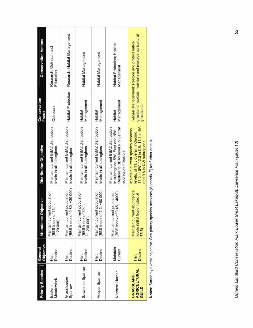
Ont
ario
Lan
dbird
Con
serv
atio
n P
lan:
Low
er G
reat
Lak
es/S
t. La
wre
nce
Pla
in (B
CR
13)
52
Prio
rity
Spec
ies
Gen
eral
O
bjec
tive
Abu
ndan
ce O
bjec
tive
Dis
trib
utio
n O
bjec
tive
C
onse
rvat
ion
Focu
s C
onse
rvat
ion
Act
ions
Eas
tern
M
eado
wla
rk
Hal
t D
eclin
e
Mai
ntai
n cu
rrent
pop
ulat
ion
(BB
S In
dex
of 1
3.1,
~1
20 0
00)
Mai
ntai
n cu
rrent
BB
A2
dist
ribut
ion
leve
ls in
all
subr
egio
ns
Out
reac
h R
esea
rch;
Out
reac
h an
d Ed
ucat
ion
Gra
ssho
pper
S
parro
w
Hal
t D
eclin
e M
aint
ain
curre
nt p
opul
atio
n (B
BS
Inde
x of
0.8
9, ~
30 0
00)
Mai
ntai
n cu
rrent
BB
A2
dist
ribut
ion
leve
ls in
all
subr
egio
n H
abita
t Pro
tect
ion
Res
earc
h; H
abita
t Man
agem
ent
Sav
anna
h S
parr
ow
Hal
t D
eclin
e
Mai
ntai
n cu
rrent
pop
ulat
ion
(BB
S In
dex
of 3
0.1,
~1
200
000
)
Mai
ntai
n cu
rrent
BB
A2
dist
ribut
ion
leve
ls in
all
subr
egio
ns
Hab
itat
Man
agem
ent
Hab
itat M
anag
emen
t
Ves
per S
parr
ow
Hal
t D
eclin
e M
aint
ain
curre
nt p
opul
atio
n (B
BS
Inde
x of
2.2
, ~80
000
) M
aint
ain
curre
nt B
BA
2 di
strib
utio
n le
vels
in a
ll su
breg
ions
H
abita
t M
anag
emen
t H
abita
t Man
agem
ent
Nor
ther
n H
arrie
r M
aint
ain
Cur
rent
Mai
ntai
n cu
rrent
pop
ulat
ion
(BB
S In
dex
of 0
.45,
~40
00)
Mai
ntai
n cu
rrent
BB
A2
dist
ribut
ion
in s
ubre
gion
s S
W, E
ast a
nd N
W.
Res
tore
to B
BA
1 le
vel s
in C
entra
l su
breg
ion
if fe
asib
le
Hab
itat
Man
agem
ent
Hab
itat P
rote
ctio
n; H
abita
t M
anag
emen
t
GR
ASS
LAN
D/
AG
RIC
ULT
UR
AL
GU
ILD
H
alt
Dec
line
Mai
ntai
n cu
rrent
abu
ndan
ce
leve
ls (B
BS
Gui
ld In
dex
of
75.5
)
Mai
ntai
n cu
rrent
spe
cies
rich
ness
le
vels
, of 1
1.5
over
all,
incl
udin
g 11
.0 in
SW
, 12.
0 in
CE
, 11.
3 in
EA
an
d 9.
8 in
NW
sub
regi
ons
Hab
itat M
anag
emen
t: R
esto
re a
nd p
rote
ct n
ativ
e gr
assl
and
habi
tats
; mai
ntai
n an
d m
anag
e ag
ricul
tura
l gr
assl
ands
N
otes
: Sor
ted
by o
vera
ll ob
ject
ive.
See
prio
rity
spec
ies
acco
unts
(App
endi
x F)
for f
urth
er d
etai
ls.

Ontario Landbird Conservation Plan: Lower Great Lakes/St. Lawrence Plain (BCR 13) 53
6.5.2 Guild Distribution Objective Preliminary BBA2 results show a significant 11% decrease in the average number of grassland species per atlas square since the first atlas, from 12.5 to ~11.5 species/square (Figure 23). Grassland species richness has declined in all subregions, especially the Southwest (–14%) and East (–14%). The distribution objective for the grassland guild is to halt the loss of grassland species and maintain species richness in each subregion at current levels (BBA2).
6.6 Conservation Focus Protection and restoration of native grassland communities is a very high priority in terms of the conservation of the overall biodiversity and at-risk species, but the extent of native grassland habitat is not sufficient to maintain current populations of most grassland landbirds. Grassland bird conservation in this region is closely linked to the management of agricultural lands, particularly agricultural grasslands. Communicating the importance of agricultural habitats to landbirds (and other wildlife) and how the suitability of these habitats is affected by various land use practices is essential to achieving the grassland/agriculture landbird conservation objectives. An effective outreach and education strategy to reach the agricultural community could be developed in cooperation with agricultural organizations, such as the Ontario Farm Environmental Coalition, an umbrella organization representing over 30 farm groups.
Grassland/agricultural landbird conservation actions should be coordinated with other environmental stewardship initiatives targeting agro-ecosystems. Recent trends in agricultural land use and management that have adversely affected landbirds are largely driven by economic forces. Incentive programs may be necessary to balance these forces in order to sustain grassland habitats for landbirds. The voluntary Canada–Ontario Environmental Farm Plan program is an effective tool for raising awareness on a wide range of environmental issues related to agriculture, promoting appropriate actions to address these issues and providing assistance to farmers implementing actions that will benefit the environment. Conservation actions for this habitat guild should focus on sites with native prairie and alvar grassland communities, and areas with extensive agricultural grasslands as these habitats support high concentrations of priority species. Additional research is needed to determine appropriate guidelines for the amount, type, size, configuration, distribution and management of grassland habitats to maintain grassland bird biodiversity in ON BCR 13. Agricultural croplands also provide habitat for nesting and foraging for landbirds. More study is needed to determine the productivity of birds nesting in these habitats, and the extent to which croplands in southern Ontario are currently being used for foraging during the breeding, wintering and migration seasons.
6.7 Recommended Conservation Actions for Grassland/ Agricultural Landbirds
6.7.1 Monitoring
� Maintain or increase surveillance, inventory and monitoring efforts for rare breeding grassland birds, including Barn Owl, Henslow’s Sparrow, Loggerhead Shrike, Northern Bobwhite and Short-eared Owl.
� Develop special surveys to determine the abundance and distribution of the wintering Short-eared Owl population
6.7.2 Research and Evaluation
� Identify and quantify those factors other than habitat loss that are contributing to the decline of grassland birds in ON BCR 13.
Figure 23: Changes in grassland landbird species richness and preliminary guild distribution objectives (=Atlas 2) in ON BCR 13 subregions.
0
3
6
9
12
15
SWes t Central East NWest
Atlas 1 Atlas 2 = Objective
Source: BBA1 (1981–85) and BBA2 (2001–04 preliminary) data.
No.
of S
peci
es

Ontario Landbird Conservation Plan: Lower Great Lakes/St. Lawrence Plain (BCR 13) 54
� Evaluate the results of available grassland/agricultural bird research to develop a synthesis of the current understanding as to how grassland condition (size, structure, composition) and management practices affect the abundance, distribution and demographics of priority grassland birds in southern Ontario.
� Evaluate the impact of various agricultural practices on the abundance, distribution and productivity of priority grassland/agriculture landbirds in ON BCR 13.
6.7.3 Planning and Policy
� Coordinate grassland landbird conservation actions with conservation efforts targeting native grassland ecosystems and other grassland species.
� Coordinate grassland/agriculture landbird conservation efforts with other environmental stewardship programs targeting the agro-ecosystem (e.g., Canada-Ontario Environmental Farm Plan).
� Investigate options for developing an incentive-based grassland habitat program (similar to the US Conservation Reserve Program) to maintain sufficient agricultural grassland habitat to sustain grassland bird populations in this region.
6.7.4 Outreach and Education
� Promote the development and use of BMPs for tame grasslands and croplands as appropriate for the protection of priority grassland birds by public and private landowners in southern Ontario (e.g., Solymar 2005).
� Promote the development of educational materials for rural landowners and land managers, such as the Birds on the Farm booklet (McGauley 2004).
� Promote the value of prescribed burns as a safe, beneficial and cost-effective land management practice for restoring and maintaining natural grasslands.
� Encourage ranchers to adjust the timing and duration of livestock grazing activities and the timing of haying operations to minimize adverse effects on landbirds.
6.7.5 Applied Conservation
� Implement conservation actions in SAR recovery strategies for Barn Owl, Henslow’s Sparrow, Loggerhead Shrike and Northern Bobwhite.
� Identify and protect core areas of high-quality grasslands that support important populations of priority grassland birds.
� Promote the restoration and protection of large blocks of natural grassland habitats, including the following priority areas: o Carden Plain (alvar), o Napanee Limestone Plain (alvar), o Manitoulin Island (alvar), o Cabot Head (alvar), o Eastern Lake St. Clair (prairie/savannah), o Rice Lake Plains (prairie).
� Promote efforts to maintain agricultural grassland habitats in areas that support important breeding populations of grassland birds (and other significant wildlife species), including: o Carden Limestone Plain, o Napanee Limestone Plain, o Prince Edward County, o Amherst Island, o Wolfe Island, o Luther Marsh, o Haldimand County, o Bruce County, o Manitoulin Island.
� Promote efforts to maintain agricultural grassland habitats in areas that support important wintering raptor populations, including the following priority sites: o Prince Edward Point, o Amherst Island, o Wolfe Island, o Haldimand Clay Plain (Fisherville).
BA
RN
OW
L © R
ebecca Zeran

Ontario Landbird Conservation Plan: Lower Great Lakes/St. Lawrence Plain (BCR 13) 55
7.1 Landbirds in Shrub and Early Successional Habitats
Almost a fifth of the landbird species breeding in southern Ontario (Appendix D) are associated with shrub and early successional habitats. About a third of these shrub/successional species are considered priority species. 7.1.1 Priority Landbirds Breeding in
Shrub/Successional Habitats Nine of the 10 priority landbirds in this guild (Table ) are habitat obligates, dependent on early successional and shrubland habitats. The one exception, Black-billed Cuckoo, shows a slight preference for shrub/successional habitats but also uses forest habitats. Shrub/successional habitats are also important to some grassland priority species (e.g., Loggerhead Shrike, Eastern Kingbird and Northern Bobwhite) and to post-breeding and migrating landbirds (Askins 2002). Shrub thickets provide breeding habitat for American Woodcock, a shorebird species of conservation concern in this BCR (Ross et al. 2003).
The particular habitat requirements of the priority landbirds in the shrub/successional guild are varied (Table ). Some have specialized habitat requirements (e.g., Golden-winged Warbler), whereas others (e.g., Brown Thrasher) use a broad range of shrub/successional habitats. Most shrub/successional-associated landbirds are adapted to finding and colonizing small habitat patches and are not considered area-sensitive. Many of the priority species in this guild are edge-tolerant and will use shrub habitat along fencerows, or at the interface of forest and open agricultural habitats.
7.2 Shrub/Successional Habitats 7.2.1 Description Early successional and shrubland habitats used by priority landbirds encompass a range of terrestrial and wetland vegetation communities, with at least 25% of the cover consisting of shrubs, saplings (1–3 m) and woody vines. Most shrub/successional habitats are created by natural or anthropogenic disturbances.
7 Conservation of Shrub/Successional Landbirds
Table 13: Shrub/successional priority breeding landbirds in ON BCR 13, sorted by reasons for priority status.
Reason(s) for Priority Status Concern Stewardship At Risk Priority Species
Cont Reg Cont Reg CA ON
Add Species of Mgmt Interest
Golden-winged Warbler Y Y UR Kirtland’s Warbler Y EN EN Prairie Warbler Y Willow Flycatcher Y Blue-winged Warbler Y Black-billed Cuckoo Y Y Brown Thrasher Y Eastern Towhee Y Field Sparrow Y Yellow-breasted Chat SC SC
Notes: Cont = Continental level, Reg = Regional (ON BCR 13) level, CA = Canada, ON = Ontario, Add Species of Mgmt Interest = Additional Species of Regional Management Interest. See Appendix C for details. EN = Endangered, SC = Special Concern, UR = under review.

Ont
ario
Lan
dbird
Con
serv
atio
n P
lan:
Low
er G
reat
Lak
es/S
t. La
wre
nce
Pla
in (B
CR
13)
56
Tab
le 1
4: S
umm
ary
of h
abita
t nee
ds o
f pri
ority
shru
b/su
cces
sion
al la
ndbi
rds i
n O
N B
CR
13.
Prio
rity
Spec
ies
Bre
edin
g H
abita
t Sh
rub/
Su
cces
sion
al
Obl
igat
e A
rea
Sens
itive
D
ense
G
roun
d C
over
D
ense
Shr
ub
Laye
r N
est S
ite
Bla
ck-b
illed
Cuc
koo
Ran
ge o
f suc
cess
iona
l for
ests
, dec
iduo
us
thic
kets
, rip
aria
n an
d fo
rest
edg
e se
tting
s
Sh
rub
or
tree
Blu
e-w
inge
d W
arbl
er
Ran
ge o
f ear
ly to
mid
-suc
cess
iona
l shr
ub
habi
tats
Y
On
or n
ear
grou
nd
Bro
wn
Thra
sher
W
ide
rang
e of
shr
ub/s
ucce
ssio
nal h
abita
ts
Y
S
hrub
or o
n gr
ound
Eas
tern
Tow
hee
Shr
ub/s
ucce
ssio
nal h
abita
ts w
ith d
ense
cov
er
and
wel
l-dev
elop
ed li
tter l
ayer
Y
Y
Y
On
or n
ear
grou
nd
Fiel
d S
parr
ow
Dry
, shr
ubby
gra
ssla
nds
or s
hrub
-dom
inat
ed
area
s ne
ar g
rass
land
s Y
X
On
or n
ear
grou
nd
Gol
den-
win
ged
War
bler
P
atch
es o
f shr
ub h
abita
t with
den
se p
atch
es o
f fo
rbs/
shru
bs fo
r nes
ting
and
a tre
ed p
erim
eter
Y
Y
Y
Gro
und
Kirt
land
’s W
arbl
er
Ext
ensi
ve s
tand
s of
you
ng, e
ven-
aged
Jac
k pi
ne s
tand
s Y
Y
G
roun
d
Pra
irie
War
bler
D
ry, s
hrub
by a
reas
in p
ine
plan
tatio
ns, a
lvar
s an
d ol
d fie
lds.
For
mer
ly b
reed
in o
pen
oak–
pine
–jun
iper
com
mun
ities
on
sand
dun
es
Y
Shru
b
Will
ow F
lyca
tche
r D
ecid
uous
shr
ubla
nds,
esp
ecia
lly ri
paria
n th
icke
ts, s
wam
p th
icke
ts a
nd s
ucce
ssio
nal f
ield
s Y
Y
S
hrub
Yel
low
-bre
aste
d C
hat
Ear
ly s
ucce
ssio
nal h
abita
t with
den
se s
hrub
th
icke
ts
Y
Y
Shr
ub
Not
es: S
peci
es li
sted
in a
lpha
betic
al o
rder
. Y =
Req
uire
s or
pre
fers
this
hab
itat f
eatu
re, X
= A
void
s th
is h
abita
t fea
ture
.

Ontario Landbird Conservation Plan: Lower Great Lakes/St. Lawrence Plain (BCR 13) 57
Natural shrub-dominated communities in southern Ontario (Lee et al. 1998) include: � Swamp thickets in wetland areas with seasonally
high water-tables; � Riparian thickets in flood-prone areas; � Shrub dune and shrub shoreline communities in
erosion-prone areas; � Shrub alvar and shrub savannah on drought- and
fire-prone limestone plains and sand plains, respectively; and
� Shrub/successional communities in forest gaps caused by tree fall, wind downbursts, ice storms, etc.
Most present-day shrub/successional habitats in this region are the result of anthropogenic disturbances. These “cultural” shrublands include: � Old field habitats developed on abandoned
farmlands through natural regeneration; � Post-logging successional communities created
in canopy gaps following intensive diameter-limit harvests or group selection cuts;
� Linear shrub/successional habitats along fence lines, power-line right-of-ways and other utility and transportation corridors;
� Agricultural shrubland surrogates, including Christmas tree plantations, orchards and vineyards; and
� Young plantations on former farmlands, quarries and gravel pits that have been seeded or planted with shrubs and trees to create wildlife habitat and/or to promote reforestation.
Some natural shrub habitats are able to persist owing to periodic natural disturbances (e.g., seasonal flooding of swamp thickets), but most shrub/successional habitats are ephemeral, maturing into forest. Some cultural shrublands are actively managed to control tree growth (e.g., tree-cutting or herbicide applications along power-line right-of-ways). More so than for other habitat types, cultural shrub/successional habitats used by priority landbirds vary in size (0.1 ha canopy gaps to 10+ ha old fields), shape (regular block, linear strip, irregular patches) and matrix (forest, agricultural, wetland, urban, various). Management practices also are highly variable as to intensity (no management to intensive management), frequency (annual to multi-year cycles) and objectives (maximize tree growth, limit tree height, maximize crop production, minimize erosion, maximize game or non-game wildlife values, etc.).
7.2.2 Historical Perspective Information on the historical extent of shrub/successional habitat in this region is limited. The following description is based on past patterns of environmental and anthropogenic disturbance and natural succession processes. In the extensive pre-settlement forests, shrub/successional habitats were created by windfall, fire, ice storm and flooding events. Such natural disturbances were local and infrequent, and it is estimated that early successional habitats comprised only about 5% of the pre-settlement landscape of southern Ontario (Larson et al. 1999). Fire-dependent native shrub and grassland ecosystems in this region benefited from active fire management by the aboriginal inhabitants, a practice that ended following European contact. Historical riparian and wetland shrub thickets would have been considerably more extensive than at present. Extensive land clearing for agriculture and settlement during the 19th century resulted in the direct removal or alteration of most natural shrub/successional habitats. These losses were offset by the creation of anthropogenic shrub/successional habitats in cleared areas, such as fencerows and along field edges, and from logging in the remaining forested areas. In many parts of southern Ontario, land clearing was followed by the abandonment of marginal farmlands. Over the past two centuries, extensive areas of abandoned farmland have undergone a natural succession in land cover, from agricultural fields and grasslands, to old field shrub/successional, to young forest, to mature forest. The timing and extent of farmland retirement varied in the different subregions of southern Ontario. There is no question that farmland abandonment, followed by natural succession processes, has had a major impact on shrubland bird populations in southern Ontario, given the threefold increase in forest cover, from 10% to 30%, since 1920 (Larson et al. 1999). At the same time, there has been a shift towards more intensive farming on productive agricultural lands. Agricultural intensification has resulted in the loss of fencerows, shrubby pastures and other shrubby agricultural habitats favoured by many shrubland birds (e.g., Brown Thrasher, Eastern Towhee, Song Sparrow). During the 20th century, most natural shrubland ecosystems continued to be adversely affected by anthropogenic forces:

Ontario Landbird Conservation Plan: Lower Great Lakes/St. Lawrence Plain (BCR 13) 58
� Increased fire suppression activities have reduced the extent and quality of fire-dependent shrubland ecosystems.
� Wetland drainage has reduced the extent of swamp thicket habitat.
� Flood and erosion control measures (e.g., construction of dams, river bank hardening) over the past 50 years have further reduced the extent of riparian shrubland habitats.
� Shoreline development has affected shrub dune and shrub shoreline communities.
7.2.3 Current Status The current extent of shrub/successional habitats in southern Ontario is difficult to measure because these habitats are: � Hard to distinguish using remote sensing data
(e.g., “sparse” forest and field categories in the Ontario Land Cover mapping may include some shrub/successional habitats); and
� Inherently unstable and can change rapidly and drastically owing to natural succession or new disturbances.
Larson et al. (1999) estimated that present-day forests and woodlands in southern Ontario contain about 25% shrub/early successional habitats and that about 7.5% of the current land base consists of shrub/successional habitats within a forest matrix. The current extent of other shrub habitats is not known. 7.2.4 Recent Trends Trends in the amount and distribution of shrub/successional habitat are not available. Even the overall trend direction in recent years is not known, as quantitative information on the relative magnitude of habitat creation (e.g., farmland retirement, canopy-opening logging, quarry rehabilitation) versus habitat loss (e.g., forest maturation, fencerow removal, conversion to urban and other land uses) is not available. A better understanding of past and future trends in the availability of shrub/successional habitat in southern Ontario is needed to determine the extent to which habitat is a limiting factor for priority species in this guild. Predicting the future supply of cultural shrub/successional habitat is particularly difficult, as the rate of habitat creation will vary depending on environmental and socio-economic factors. In the northeast US, decreased availability of old field habitats due to forest maturation has been linked to the observed decline of shrub/
successional landbirds (Hunter et al. 2001). In southern Ontario, some shrub species (e.g., Willow Flycatcher, Northern Cardinal) are increasing, whereas others (e.g., Brown Thrasher, Song Sparrow) are decreasing. Differences in specific habitat requirements and other factors must also be considered. 7.2.5 Threats Although the birds in this guild use a diverse range of specific habitat types, all shrub/successional habitats depend on periodic disturbance to prevent natural succession, rejuvenate existing habitat or create replacement habitat. Habitat loss is the primary threat to most shrub species. Other threats affecting particular types of shrub/successional habitats (and priority species that are adversely affected): � Fire suppression, which is detrimental to fire-
dependent (Kirtland’s Warbler) and fire-adapted (Prairie Warbler, Field Sparrow, Yellow-breasted Chat) species;
� Drainage and flood control, which reduce extent of wetland and riparian shrub habitats (Willow Flycatcher, Black-billed Cuckoo);
� Forest silviculture practices that result in fewer, smaller canopy gaps or reduce the time it takes for these gaps to close (Eastern Towhee, Golden-winged Warbler) [forest bird species may benefit];
� Re-forestation of old fields with close-packed even-aged conifer monocultures (Blue-winged Warbler);
� Pesticide spraying to control caterpillar outbreaks (Black-billed Cuckoo);
� Use of herbicides along roadsides, ditches and power-line right-of-ways to prevent growth of woody plants (Field Sparrow, Blue-winged Warbler); and
� Spread of invasive non-native shrub species (e.g., Buckthorn, Multiflora Rose, Honeysuckle, Black Alder) may be detrimental to some species.
Shrub/successional habitats are relatively easy to create, and several opportunities exist to increase the amount of shrub/successional habitats by changing current management practices at select sites, such as: � Strategic use of periodic cutting (rather than
herbicides) to prevent tree growth along roadsides, ditches and power-line rights-of-way;
� Strategic use of group selection logging to create canopy gaps in forests;

Ontario Landbird Conservation Plan: Lower Great Lakes/St. Lawrence Plain (BCR 13) 59
� Creating or enhancing riparian buffer strips in pastures and urban areas; and
� Converting unused areas of public and private lands that are currently being intensively managed as manicured lawns to bird-friendly shrubland habitat.
7.3 Conservation Objectives for Priority Shrub/Successional Landbirds
Abundance and distribution objectives for the priority landbird species in this group are presented in the species accounts (Appendix F) and summarized in Table . 7.3.1 Recovery The conservation goal for the endangered Kirtland’s Warbler is recovery to a more secure status. As this species does not currently breed in southern Ontario, the presence of even one breeding pair anywhere in southern Ontario would be considered a significant advance. 7.3.2 Assess Status Abundance and distribution trends for Prairie Warbler and Yellow-breasted Chat in ON BCR 13 are unknown or uncertain. The overall objective for these species is to periodically assess their current status. There is some evidence of a decline in distribution of both these species, especially in the Southwest subregion (preliminary BBA data and COSEWIC status reports). 7.3.3 Halt Decline Halt decline is the overall objective for four priority shrub/successional species that have experienced significant long-term declines in abundance and/or distribution in southern Ontario (Table ). Abundance and distribution objectives have been set at the current population levels, as measured by the BBS and BBA. Past declines in these priority species, which have been most severe in the Southwest and East subregions, are attributed to natural succession of old field habitat created by farmland retirement. Gains in forest cover over the past century were preceded by a temporary increase in shrub/successional habitats. 7.3.4 Maintain Current The overall objective for the three priority shrub species with stable or increasing population trends (Blue-winged Warbler, Golden-winged Warbler and Willow Flycatcher) is to maintain current levels. Abundance objectives for these species are set at the current BBS Index (2001–03). Distribution objectives
will be based on the current BBA (2001–05), with one exception. The overall distribution of the Golden-winged Warbler has declined owing to substantial losses in the Southwest (from 26% to ~10% of atlas squares) and Northwest (from 23% to ~13%) subregions. The distribution objective for the Golden-winged Warblers is to reverse these subregional declines. The Blue-winged Warbler is the only priority species in this guild to show an increase in distribution in all subregions over the past 20 years. The observed changes in distribution for Golden-winged and Blue-winged Warblers in southern Ontario are generally consistent with the general pattern elsewhere in eastern North America, i.e., a northward range expansion of Golden-wings followed by Blue-wings. However, the magnitude of the decline in distribution of Golden-winged Warblers in both the Southwest and Northwest subregions appears to be substantially greater than the increase in distribution of Blue-winged Warblers. This finding suggests that habitat maturation may be the limiting factor for Golden-winged Warblers in those subregions, rather than direct competition or displacement by Blue-winged Warblers. 7.3.5 Guild Abundance Objective The shrub/successional landbird guild shows a 22% increase in abundance over the past three decades, from an average BBS Guild Index of 78.1 to 95.2 (Figure 24). The guild abundance objective is to maintain the current levels, as measured by a BBS Guild Index of 95.2.
Figure 24: Long-term BBS trend, 1968–2003, and preliminary guild abundance objective for shrub/successional landbirds in ON BCR 13.
Shrub / Successional Birds
0
20
40
60
80
100
120
1968 1973 1978 1983 1988 1993 1998 2003
BBS Index
BBS Index
Objective

Ont
ario
Lan
dbird
Con
serv
atio
n P
lan:
Low
er G
reat
Lak
es/S
t. La
wre
nce
Pla
in (B
CR
13)
60
Tab
le 1
5: S
umm
ary
of c
onse
rvat
ion
obje
ctiv
es, f
ocus
and
act
ions
for
shru
b/su
cces
sion
al p
rior
ity la
ndbi
rds i
n so
uthe
rn O
ntar
io.
Prio
rity
Spec
ies
Ove
rall
Obj
ectiv
e Po
pula
tion
Obj
ectiv
e D
istr
ibut
ion
Obj
ectiv
e C
onse
rvat
ion
Focu
s C
onse
rvat
ion
Act
ions
Kirt
land
’s W
arbl
er
Rec
over
y To
be
dete
rmin
ed b
y S
AR
reco
very
stra
tegy
R
ecov
ery
Impl
emen
t SA
R re
cove
ry
stra
tegy
, inc
ludi
ng M
onito
ring
actio
ns
Pra
irie
War
bler
A
sses
s S
tatu
s P
erio
dica
lly s
sess
pop
ulat
ion
abun
danc
e an
d tre
nd o
f bre
edin
g po
pula
tion
in O
ntar
io
Mai
ntai
n or
incr
ease
dis
tribu
tion
in a
ll su
breg
ions
M
onito
ring
Mon
itorin
g; H
abita
t Eva
luat
ion
and
Res
tora
tion;
Res
earc
h
Yello
w-b
reas
ted
Cha
t A
sses
s S
tatu
s D
eter
min
e po
pula
tion
stat
us.
Mai
ntai
n po
pula
tion
at o
r abo
ve
curre
nt le
vels
.
Res
tore
to B
BA
1 di
strib
utio
n le
vels
in
SW
and
Cen
tral s
ubre
gion
s H
abita
t M
anag
emen
t
Pre
pare
SA
R m
anag
emen
t pl
an to
incl
ude:
Mon
itorin
g,
Hab
itat M
anag
emen
t and
R
esea
rch
actio
ns
Bla
ck-b
illed
Cuc
koo
Hal
t Dec
line
Mai
ntai
n cu
rrent
pop
ulat
ion
(BB
S
Inde
x 0.
85, ~
40 0
00)
Mai
ntai
n cu
rrent
BB
A 2
dis
tribu
tion
leve
ls in
all
subr
egio
ns; e
nsur
e no
fu
rther
dec
line
in E
ast s
ubre
gion
R
esea
rch
Res
earc
h
Bro
wn
Thra
sher
H
alt D
eclin
e M
aint
ain
curre
nt p
opul
atio
n (B
BS
In
dex
of 2
.4, ~
80 0
00)
Mai
ntai
n cu
rrent
BB
A2
dist
ribut
ion
leve
ls in
all
subr
egio
ns; e
nsur
e no
fu
rther
dec
line
Hab
itat
Man
agem
ent a
nd
Eva
luat
ion
Hab
itat M
anag
emen
t; R
esea
rch
Eas
tern
Tow
hee
Hal
t Dec
line
Mai
ntai
n cu
rrent
pop
ulat
ion
(BB
S
Inde
x of
0.7
4, ~
25 0
00)
Mai
ntai
n cu
rrent
BB
A2
dist
ribut
ion
leve
ls; e
nsur
e no
furth
er d
eclin
e
Hab
itat
Man
agem
ent a
nd
Eva
luat
ion
Mon
itorin
g; R
esea
rch;
Hab
itat
Man
agem
ent/E
valu
atio
n
Fiel
d S
parr
ow
Hal
t Dec
line
Mai
ntai
n cu
rrent
pop
ulat
ion
(BB
S
Inde
x 2.
4, ~
60 0
00)
Mai
ntai
n cu
rrent
BB
A2
dist
ribut
ion
leve
ls; e
nsur
e no
furth
er d
eclin
es in
S
W a
nd E
ast s
ubre
gion
s
Hab
itat
Man
agem
ent a
nd
Eva
luat
ion
Hab
itat M
anag
emen
t; R
esea
rch
Blu
e-w
inge
d W
arbl
er
Mai
ntai
n C
urre
nt
Mai
ntai
n cu
rrent
pop
ulat
ion
(BB
S
Inde
x 0.
07, ~
2000
) M
aint
ain
curre
nt B
BA
2 di
strib
utio
n le
vels
in a
ll su
breg
ions
R
esea
rch
Mon
itorin
g; R
esea
rch
Gol
den-
win
ged
War
bler
M
aint
ain
Cur
rent
Mai
ntai
n at
or a
bove
cur
rent
po
pula
tion
leve
l (B
BS
Inde
x of
0.
13, ~
5000
)
Res
tore
to B
BA1
dist
ribiti
on le
vels
in
SW
and
NW
sub
regi
ons;
Mai
ntai
n cu
rren
t BB
A2 le
vels
in C
entra
l and
E
ast s
ubre
gion
s
Res
earc
h M
onito
ring;
Res
earc
h
Willo
w F
lyca
tche
r M
aint
ain
Cur
rent
Mai
ntai
n cu
rrent
pop
ulat
ion
at o
r ab
ove
curr
ent l
evel
(BB
S In
dex
1.6,
~50
000
)
Mai
ntai
n cu
rrent
BB
A2
dist
ribut
ion
leve
ls in
all
subr
egio
ns
Hab
itat
Man
agem
ent
Hab
itat M
anag
emen
t; R
esea
rch
SHR
UB
/ SU
CC
ESSI
ON
AL
GU
ILD
M
aint
ain
Cur
rent
M
aint
ain
curre
nt a
bund
ance
le
vels
(BB
S G
uild
Inde
x of
95.
2)
Mai
ntai
n cu
rrent
spe
cies
rich
ness
le
vels
of 1
6.6
over
all,
and
15.6
in S
W
(no
furth
er lo
ss),
17.6
in C
E, 1
6.2
in E
A
and
15.3
in N
W s
ubre
gion
s
Hab
itat M
anag
emen
t: M
anag
e ha
bita
t to
mai
ntai
n su
pply
of e
arly
- to
mid
-suc
cess
iona
l hab
itat
Not
es: S
peci
es s
orte
d by
ove
rall
obje
ctiv
e. S
ee p
riorit
y sp
ecie
s ac
coun
ts (A
ppen
dix
F) fo
r fur
ther
det
ails
.

Ontario Landbird Conservation Plan: Lower Great Lakes/St. Lawrence Plain (BCR 13) 61
7.3.6 Guild Distribution Objective Interim BBA results indicate that the average species richness for the shrub/successional guild in southern Ontario has increased slightly, from 16.3 to 16.6 species per square. However, this increase has occurred only in the Central (+5%) and Northwest (+6%) subregions (Figure 25). Shrub/successional species richness has declined significantly in the Southwest (–3%) and is unchanged in the East subregions. The guild distribution objective is to maintain current shrub/successional species richness in all subregions and, if possible, to increase species richness in the Southwest subregion to levels comparable to the first atlas.
7.4 Conservation Focus Despite the overall increasing trend for this guild, habitat availability is an important limiting factor for all shrub/successional species because of the inherently short-lived nature of successional habitats. Habitat is a particular concern for the declining priority species. However, relatively little is known about the specific habitat requirements of the priority shrub/successional species in southern Ontario, or how to create and manage shrub/successional habitat to benefit declining landbirds. The main conservation focus for this priority guild is therefore applied research at select sites to evaluate the effects of increasing or managing shrub/successional habitat on the abundance, productivity and site fidelity of priority shrub/ successional landbirds. The current distribution of priority shrub/ successional species (Figure 19) shows areas of high relative density that appear to be associated with the following physiographic regions (Chapman and Putnam 1984):
� Frontenac Axis � Napanee Plain � Carden Limestone Plain � Prince Edward Peninsula � Norfolk Sand Plain � Bothwell Sand Plain Different shrub/successional habitat management prescriptions are needed in different areas owing to the different substrates (sand versus limestone or granitic bedrock). General guidelines for how much shrub habitat is needed to sustain shrub/ successional landbirds are not available. Given the difficulty in measuring successional habitat availability, it may be more practical to set habitat objectives for this guild by measuring and modelling levels of natural and anthropogenic disturbance (e.g., extent of flooding and fires, intensive logging, farmland retirement, managed rights-of-way).
7.5 Recommended Conservation Actions for Shrub/Successional Landbirds
7.5.1 Monitoring
� Periodically assess (every five years) the abundance, distribution and population status of Golden-winged Warbler, Prairie Warbler and Yellow-breasted Chat.
� Investigate the feasibility of using information on land use change and/or disturbance rates as surrogate measures for monitoring some shrub/successional habitats.
7.5.2 Research and Evaluation
� Identify factors causing declines and/or limiting population growth of Black-billed Cuckoo, Brown Thrasher, Eastern Towhee, Field Sparrow, Golden-winged Warbler (in SW and NW subregions) and Yellow-breasted Chat.
� Research the interactions of Blue-winged Warbler and Golden-winged Warblers in areas of overlap.
� Assess the effect of alternative right-of-way management techniques on the abundance and diversity of shrub/successional landbirds.
� Determine an appropriate guideline for the minimum threshold needed to maintain shrubland bird biodiversity throughout this region.
Figure 25: Changes in shrub/successional landbird species richness and preliminary guild distribution objectives (=Atlas 2) in ON BCR 13 subregions.
0
5
10
15
20
SWest Central East NWest
Atlas 1
Atlas 2 = Objective
Source: BBA1 (1981–85) and BBA2 (2001–04 preliminary) data.
No.
of S
peci
es

Ontario Landbird Conservation Plan: Lower Great Lakes/St. Lawrence Plain (BCR 13) 62
7.5.3 Planning and Policy
� Coordinate shrub/successional landbird conservation actions with those for non-landbird shrubland species, such as American Woodcock, and habitat management actions to maintain grassland habitat or increase forest cover.
� Develop landscape-level management plans for rights-of-way and other managed shrub/successional habitats to ensure an adequate and diverse supply of shrub/successional habitat.
7.5.4 Outreach/Education
� Promote the development and use of BMP guidelines for the conservation of priority shrubland birds on managed shrublands (e.g., roadsides and utility corridors).
� Promote the value of riparian and lakeshore thickets as both stream buffers and important habitat for breeding and migrant landbirds.
� Promote the value of prescribed burns as a safe, beneficial and cost-effective land management practice for restoring and maintaining natural shrubland habitats (shrub alvar, savannah).
� Promote the development of educational materials to increase awareness of the conservation value of “scrubby” lands in all landscapes (e.g., Birds on the Farm booklet by McGauley 2004).
� Encourage ranchers to adjust the timing and duration of livestock grazing activities to minimize adverse effects on shrubland birds and habitats.
7.5.5 Applied Conservation
� Restore and manage native shrub species along roadsides, rights-of-way, riparian corridors.
� Adopt practices that avoid the use of herbicides, retain snags and downed woody debris and leaf litter, and control the spread of exotic vegetation.
Figure 26: Map showing relative density of priority shrub/successional birds in ON BCR 13.
Source: Preliminary BBA2 point count data, 2001–04. Grey shading indicates areas with insufficient coverage (squares with <10 points counts) in the preliminary BBA2 database.
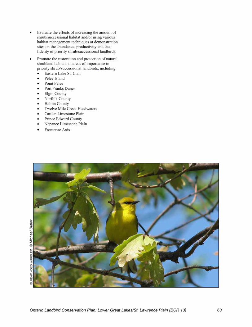
Ontario Landbird Conservation Plan: Lower Great Lakes/St. Lawrence Plain (BCR 13) 63
� Evaluate the effects of increasing the amount of shrub/successional habitat and/or using various habitat management techniques at demonstration sites on the abundance, productivity and site fidelity of priority shrub/successional landbirds.
� Promote the restoration and protection of natural shrubland habitats in areas of importance to priority shrub/successional landbirds, including: � Eastern Lake St. Clair � Pelee Island � Point Pelee � Port Franks Dunes � Elgin County � Norfolk County � Halton County � Twelve Mile Creek Headwaters � Carden Limestone Plain � Prince Edward County � Napanee Limestone Plain � Frontenac Axis
BLU
E-W
ING
ED W
AR
BLE
R ©
Mic
hael
But
ler

Ontario Landbird Conservation Plan: Lower Great Lakes/St. Lawrence Plain (BCR 13) 64
8.1 Landbirds Breeding in Other Habitats Thirty-three (20%) of the 166 landbird species breeding in southern Ontario (Appendix D) are not closely associated with any of the three priority habitats discussed in Chapters 5, 6 and 7. Many of these species are habitat generalists and breed in a wide variety of habitats, but some are associated with particular habitat categories, such as open wetlands, riparian and shoreline areas, or urban areas. 8.1.1 Priority Landbirds in Other
Habitats The six priority landbirds (Table 16) in the “other habitat” guild all occur in Ontario in the breeding season. The Bald Eagle is also a priority wintering species, as significant numbers winter locally in southern Ontario. Bank Swallow and Chimney Swift are also included in the aerial-foraging insectivores guild (see Chapter 8). Reasons for the priority status of the various species included in this chapter are diverse (Table 16), as are their habitat preferences. Four of these priority species (Bald Eagle, Baltimore Oriole, Bank Swallow and Belted Kingfisher) show at least some preference for riparian or shoreline habitats. Shoreline habitats, particularly along the shores of the Lower Great Lakes in this region, are also of critical importance to many landbird species during migration (see Appendix H).
The other two species, Peregrine Falcon and Chimney Swift, are found primarily in urban settings in southern Ontario (nesting on ledges of tall building or in chimneys, respectively). Both will also nest in natural settings with suitable nesting sites (cliffs or hollow trees, respectively), but these features are scarce in this region.
8.2 Factors Affecting Priority Landbirds in Other Habitats
8.2.1 Riparian and Shoreline Features Four priority species are associated with riparian and/or shoreline features. Issues affecting riparian and shoreline habitats in this region: � Shorelines are attractive features for new
development, and there is relatively little undeveloped shoreline in southern Ontario.
� Many riparian areas lack adequate buffer strips, particularly in agricultural and urban settings.
� Riparian habitats are affected by flood control and drainage measures and by the cumulative impacts of development and habitat alteration in the watershed.
� Climate change models indicate that riparian and shoreline habitats in this area could be affected by greater fluctuations in stream flow, increased number of high flow and storm events, and lower lake levels.
8 Conservation of Landbirds in Other Habitats
Table 16: Priority landbirds in other habitats in ON BCR 13, sorted by reasons for priority status.
Reason(s) for Priority Status Concern Stewardship At Risk Priority Species
Cont Reg Cont Reg CA ON
Add Species of Mgmt Interest
Baltimore Oriole Y Y Belted Kingfisher Y Peregrine Falcon TH TH Bank Swallow Y Bald Eagle EN Chimney Swift UR Y
Notes: Cont = Continental level, Reg = Regional (ON BCR 13) level, CA = Canada, ON = Ontario, Add Species of Mgmt Interest = Additional Species of Regional Management Interest. See Appendix C for details. EN = Endangered, TH = Threatened.
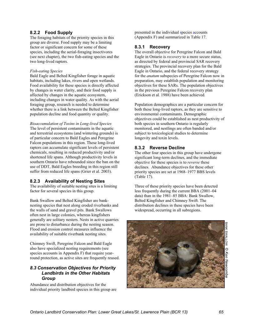
Ontario Landbird Conservation Plan: Lower Great Lakes/St. Lawrence Plain (BCR 13) 65
8.2.2 Food Supply The foraging habitats of the priority species in this group are diverse. Food supply may be a limiting factor or significant concern for some of these species, including the aerial-foraging insectivores (see next chapter), the two fish-eating species and the two long-lived raptors. Fish-eating Species Bald Eagle and Belted Kingfisher forage in aquatic habitats, including lakes, rivers and open wetlands. Food availability for these species is directly affected by changes in water clarity, and their food supply is affected by changes in the aquatic ecosystem, including changes in water quality. As with the aerial foraging group, research is needed to determine whether there is a link between the Belted Kingfisher population decline and food quantity or quality. Bioaccumulation of Toxins in Long-lived Species The level of persistent contaminants in the aquatic and terrestrial ecosystems (and wintering grounds) is of particular concern to Bald Eagles and Peregrine Falcon populations in this region. These long-lived raptors can accumulate significant levels of persistent chemicals, resulting in reduced productivity and/or shortened life spans. Although productivity levels in southern Ontario have rebounded since the ban on the use of DDT, Bald Eagles breeding in this region still suffer from reduced life spans (Grier et al. 2003). 8.2.3 Availability of Nesting Sites The availability of suitable nesting sites is a limiting factor for several species in this group. Bank Swallow and Belted Kingfisher are bank-nesting species that nest along eroded riverbanks and the walls of sand and gravel pits. Bank Swallows often nest in large colonies, whereas kingfishers generally are solitary nesters. Nests in active quarries are prone to disturbance during the nesting season. Flood and erosion control measures influence the availability of suitable riverbank nesting sites. Chimney Swift, Peregrine Falcon and Bald Eagle also have specialized nesting requirements (see species accounts in Appendix F) that require year-round protection, as active sites are frequently reused.
8.3 Conservation Objectives for Priority Landbirds in the Other Habitats Group
Abundance and distribution objectives for the individual priority landbird species in this group are
presented in the individual species accounts (Appendix F) and summarized in Table 17. 8.3.1 Recovery The overall objective for Peregrine Falcon and Bald Eagle in Ontario is recovery to a more secure status, as directed by federal and provincial SAR recovery strategies. The provincial recovery plan for the Bald Eagle in Ontario, and the federal recovery strategy for the anatum subspecies of Peregrine Falcon now in preparation, may establish population and monitoring objectives for these SARs. The population objectives in the previous Peregrine Falcon recovery plan (Erickson et al. 1988) have been achieved. Population demographics are a particular concern for both these long-lived raptors, as they are sensitive to environmental contaminants. Demographic objectives could be established as nest productivity of both species in southern Ontario is regularly monitored, and nestlings are often banded and/or subject to toxicological studies to determine longevity and toxin levels. 8.3.2 Reverse Decline The other four species in this group have undergone significant long-term declines, and the immediate objective for these species is to reverse these declines. Abundance objectives for these other priority species are set at 1968–1977 BBS levels (Table 17). Three of these priority species have been detected less frequently during the current BBA (2001–04 data) than in the 1981–85 BBA: Bank Swallow, Belted Kingfisher and Chimney Swift. The distribution declines in these species have been widespread, occurring in all subregions.
BA
NK S
WA
LLOW
© K
en New
combe

Ontario Landbird Conservation Plan: Lower Great Lakes/St. Lawrence Plain (BCR 13) 66
Distribution objectives for these declining species have been set based on levels during the first atlas (Table17). Despite the apparent population decline, there is no evidence of a decline in the distribution of Baltimore Oriole in southern Ontario. 8.3.3 Conservation Focus The primary conservation focus (Table 17) of the six priority species included in this chapter involves monitoring the recovery of the two Endangered/Threatened species, and research to identify the factors causing the observed declines in the other four species. Possible causal factors that need to be assessed include food availability, food quality (contaminants), severe weather events, climate change and/or the availability of suitable nesting sites. See individual species accounts (Appendix F) for additional details and specific conservation actions.
8.4 Recommended Conservation Actions for Landbirds in Other Habitats
8.4.1 Monitoring
� Complete, comprehensive regionwide mapping of riparian habitats, including an assessment of current condition, vegetation structure and restoration potential.
8.4.2 Research and Evaluation
� Identify the cause(s) of the observed or apparent declines in the population and/or distribution of the following priority species in southern Ontario: Baltimore Oriole, Bank Swallow, Belted Kingfisher and Chimney Swift.
� Study the impact of aquatic and landscape factors on the productivity and survivorship of priority riparian/shoreline landbirds, including Bald Eagle, Bank Swallow, Baltimore Oriole and Belted Kingfisher.
8.4.3 Outreach/Education
� Include guidelines for the protection of bank-nesting species, such as Bank Swallow and Belted Kingfisher, in BMPs for operators of sand and gravel pits.
� Continue to develop and implement a communications and reporting strategy to draw attention to the links between toxin levels in Bald Eagle and Peregrine Falcon populations, and human and ecosystem health.
8.4.4 Applied Conservation
� Identify and protect specialized nesting sites, including Bald Eagle nest trees, Peregrine Falcon nesting sites, large Bank Swallow nesting colonies and large post-breeding roost sites for Chimney Swift and Bank Swallow.
� Enhance water clarity in water bodies by implementing remedial measures such as creation of buffer strips and fencing to keep livestock out of streams.
BA
LTIM
OR
E O
RIO
LE ©
Sim
on D
odsw
orth

Ont
ario
Lan
dbird
Con
serv
atio
n P
lan:
Low
er G
reat
Lak
es/S
t. La
wre
nce
Pla
in (B
CR
13)
67
Tab
le 1
7: S
umm
ary
of c
onse
rvat
ion
obje
ctiv
es, f
ocus
and
act
ions
for
prio
rity
land
bird
s in
othe
r ha
bita
ts in
sout
hern
Ont
ario
.
Prio
rity
Spec
ies
Ove
rall
Obj
ectiv
e Po
pula
tion
Obj
ectiv
e D
istr
ibut
ion
Obj
ectiv
e C
onse
rvat
ion
Focu
s C
onse
rvat
ion
Act
ions
Bal
d E
agle
R
ecov
ery
To b
e de
term
ined
by
SA
R re
cove
ry s
trate
gy
Mon
itorin
g
Mon
itorin
g; R
esea
rch;
O
utre
ach/
Edu
catio
n; H
abita
t P
rote
ctio
n; N
est S
ite
Pro
tect
ion
Per
egrin
e Fa
lcon
R
ecov
ery
To b
e de
term
ined
by
SA
R re
cove
ry s
trate
gy
Mon
itorin
g
Impl
emen
t SA
R re
cove
ry
stra
tegy
, inc
ludi
ng:
Mon
itorin
g, N
est S
ite
Pro
tect
ion
and
Out
reac
h/E
duca
tion
actio
ns
Balti
mor
e O
riole
R
ever
se D
eclin
e R
esto
re to
BB
S In
dex
of 9
.8,
~250
000
(cur
rent
Inde
x of
7.4
, ~2
00 0
00)
Mai
ntai
n cu
rren
t BB
A2
dist
ribut
ion
leve
ls in
all
subr
egio
ns
Res
earc
h R
esea
rch;
Hab
itat
Man
agem
ent
Bank
Sw
allo
w
Rev
erse
Dec
line
Res
tore
to B
BS
Inde
x of
22.
1,
~600
000
(cur
rent
Inde
x 8.
8,
~250
000
)
Res
tore
to B
B1
dist
ribut
ion
leve
ls in
all
subr
egio
ns
Res
earc
h R
esea
rch;
Out
reac
h; H
abita
t M
anag
emen
t
Belte
d Ki
ngfis
her
Rev
erse
Dec
line
Res
tore
to B
BS
Inde
x of
0.8
9,
~30
000
(cur
rent
Inde
x 0.
45,
~15
000)
Res
tore
to B
BA
1 di
strib
utio
n le
vels
in a
ll su
breg
ions
O
utre
ach
Res
earc
h; H
abita
t M
anag
emen
t; O
utre
ach
Chi
mne
y S
wift
R
ever
se D
eclin
e R
esto
re to
BB
S In
dex
of 1
.7,
~60
000
(cur
rent
Inde
x 0.
43,
~10
000)
Res
tore
to B
BA
1 di
strib
utio
n le
vels
in a
ll su
breg
ions
Nes
t Site
P
rote
ctio
n,
Enha
ncem
ent
and
Mon
itorin
g
Nes
t Site
Pro
tect
ion,
En
hanc
emen
t and
M
onito
ring;
Res
earc
h
Not
es: S
orte
d by
ove
rall
obje
ctiv
e. S
ee p
riorit
y sp
ecie
s ac
coun
ts (A
ppen
dix
F) fo
r fur
ther
det
ails
.

Ontario Landbird Conservation Plan: Lower Great Lakes/St. Lawrence Plain (BCR 13) 68
9.1 Aerial-foraging Insectivorous Landbirds
The abundance and distribution of most aerial-foraging insectivorous landbirds breeding in southern Ontario (Table ) have declined over the past two decades for unknown reasons (Heagy and McCracken 2004, 2005). Three priority landbirds are in this foraging guild: Whip-poor-will (also in the forest habitat guild), Bank Swallow (in other habitats group) and Chimney Swift (in other habitats group). The nine landbirds in this guild (Table ) are taxonomically and ecologically diverse. All forage “on the wing” (in flight), capturing and eating flying insects. Most are diurnal feeders, but the two nightjars (Common Nighthawk and Whip-poor-will) are crepuscular, feeding mostly at dawn and dusk. The various species in this guild have diverse and somewhat specialized nesting requirements, but are generally widespread as breeding birds in southern Ontario. All aerial insectivores require large open areas for foraging, such as marshes, agricultural fields or urban settings. All species in this guild require a steady supply of flying insects and are, therefore, highly vulnerable to periods of cold, wet or windy weather that can impede foraging and reduce their food
supply. Many flying insects have an aquatic stage, and insect populations can be affected by pollution of the land, air or water.
9.2 Threats The species in this group share a common feeding strategy but are otherwise dissimilar. Consequently, food availability on the breeding grounds is suspected to be a possible common factor causing the recent population declines. This foraging guild is vulnerable to stochastic severe weather events. Episodes of mass mortality of Purple Martins and swallows have been documented as a result of severe weather in late spring or early summer. For example, in June 2002, there were widespread reports of dead and dying swallows, Purple Martins and Eastern Bluebirds following two days of unseasonable below-freezing temperatures (Bannon et al. 2002; Hussell 2003). Any increase in the frequency of these events would be of particular concern. In addition to direct mortality due to episodic food shortages caused by severe weather, the observed declines may be linked to reduced productivity due to reduced numbers of flying insects. Factors that have the potential to contribute to a decline in flying insect populations:
9 Conservation of Aerial-foraging Insectivorous Landbirds
Table 18: Changes in the abundance and distribution of aerial-foraging insectivores breeding in ON BCR 13.
Species BBS Trend, 1968–2003
(%/year)
BBS Trend, 1983–2003
(%/year)
BBA Change, 1981–85 to 2001–04
(% of squares) Bank Swallow –3.7% * –5.4% –19% ** Barn Swallow –0.6% –1.7% ** –1% Chimney Swift –4.6% ** –7.7% ** –34% ** Cliff Swallow +1.8% –2.7% –6% * Common Nighthawk –1.7% –1.3% –45% ** Purple Martin –2.3% * –3.9% ** –26% ** N. Rough-winged Swallow –0.6% –3.7% ** –13% ** Tree Swallow +2.3% ** +0.6% –0.3% Whip-poor-will –4.7% –6.2% –43% ** All Aerial-foraging Insectivores –0.2% –1.3% ** –17% **
Notes: Priority species shown in boldface. **Significant trend (p<=0.05); *Near-significant trend (p<=0.1).

Ontario Landbird Conservation Plan: Lower Great Lakes/St. Lawrence Plain (BCR 13) 69
� Climate change (insect productivity, survival rates and emergence dates are influenced by temperature and moisture conditions).
� Degradation of aquatic habitats used by insect larvae and nymphs (e.g., some species are sensitive to water quality).
� Use of insecticides to control mosquitoes (to limit spread of West Nile Virus) may also affect other flying insects, as not enough is known about their specificity.
� Changes in livestock and manure management practices (more animals kept indoors in screened barns, covered manure storage facilities) have reduced the number of flies around barns.
� Aerial spraying of insecticides for forest pests (e.g., gypsy moth) or agricultural pests (soybean aphid).
No one of the above factors can adequately explain the decline of the diverse species in this group. Food supply on the wintering grounds could also be a factor, but the various species in this guild winter in different areas. For at least some species in this group, other factors are thought to be contributing to recent declines, including: � Loss of nesting sites for Chimney Swift,
Common Nighthawk and Barn Swallow; � Atmospheric pollution, which may be a factor in
Common Nighthawk declines in urban areas; and � Degradation of nesting habitat (forest
fragmentation, increased predation on ground nests), which may affect Whip-poor-will productivity (Brown et al. 1999b).
At present, very little information is available on the proximate cause(s) of the observed decline in aerial-foraging insectivores, and further research is needed.
9.3 Conservation Objectives for Aerial Insectivores
The overall objective for this guild is to reverse recent abundance and distribution declines. 9.3.1 Guild Abundance Objective The BBS Guild Index for aerial-foraging insectivores in southern Ontario has decreased by 15% since the 1968–77 period, from 24.0 to 20.4 (Figure 27). The guild abundance objective is to reverse this decline and restore the aerial-foraging insectivore BBS Guild Index to its previous level of 24.0.
Figure 27: Long-term BBS trend, 1968–2003, and guild abundance objective for aerial insectivores in ON BCR 13.
05
101520253035
1968 1978 1988 1998
BBS Index
BBS Index
Objective
9.3.2 Guild Distribution Objective Almost all landbirds in this guild were reported less frequently during the second Breeding Bird Atlas than in the first, and none are more widespread (Table ). Interim results from the second atlas show a significant decrease in the average number of aerial insectivores detected across southern Ontario (6.8 to 5.6 species per atlas square) and in each subregion (Figure 28). There appears to be a north–south gradient to the declines, with the greatest change in the Northwest (–33%), and the least in the Southwest (–11%). The distribution objective for this foraging guild is to reverse these declines and restore aerial insectivore species richness to the 1981–85 BBA1 levels by 2021–25: 6.7 in SW, 7.0 in CE, 6.6 in EA and 6.3 in NW subregions.
Figure 28: Changes in aerial insectivore species richness and preliminary guild distribution objectives (=Atlas 1) in ON BCR 13 subregions.
0
2
4
6
8
SWest Central East NWest
Atlas 1 = Objective
Atlas 2
Source: BBA1 (1981–85) and BBA2 (2001–04 preliminary) data.
No.
of S
peci
es

Ontario Landbird Conservation Plan: Lower Great Lakes/St. Lawrence Plain (BCR 13) 70
9.4 Conservation Focus Research is needed to increase understanding of the factors causing the general decline of aerial-foraging insectivores in this region. Several of the species in this guild are readily studied during the breeding season. Existing data sets for intensively studied species such as Tree Swallow and Purple Martin may be useful in understanding past declines. Additional demographic studies, covering a range of species and sites, would yield useful information on productivity and survival rates. Crepuscular species in this guild are not well monitored by the BBS. Population information for these species could be improved by developing additional surveys, such as crepuscular breeding season surveys post-breeding roost counts for Chimney Swift, and migration counts for Common Nighthawk.
9.5 Recommended Conservation Actions for Aerial Insectivores
9.5.1 Monitoring
� Develop and implement crepuscular bird survey protocol(s) to improve understanding of the
abundance, distribution and population trends in crepuscular species including Whip-poor-will, Common Nighthawk and Chimney Swift.
� Encourage submission of current and historic nest record data to the Ontario Nest Records Scheme/Project NestWatch to improve understanding of changes in productivity, especially for Barn Swallows, Tree Swallows and Purple Martins.
9.5.2 Research and Evaluation
� Identify factors causing population decline and/or limiting population growth of aerial-foraging insectivores.
� Analyze long-term data sets and broad-scale nest record data sets to evaluate the importance of weather and other factors in the decline of aerial insectivores. Potentially important data sets in southern Ontario include the Ontario Nest Records Scheme data (Peck 2005; www.birdsontario.org/onrs/onrsmain.html) and site-specific long-term data sets (e.g., long-term Tree Swallow study at Long Point Bird Observatory includes 30+ years of data on nest box occupancy rates, productivity, survivorship and insect availability at three sites).
WH
IP-P
OO
R-W
ILL
© S
imon
Dod
swor
th

Ontario Landbird Conservation Plan: Lower Great Lakes/St. Lawrence Plain (BCR 13) 71
10.1 Implementation Strategy This landbird conservation plan sets out a comprehensive set of priorities, conservation objectives and recommended actions aimed at sustaining native landbirds and their habitats in the Ontario portion of the Lower Great Lakes/ St. Lawrence Plain (BCR 13) and contributing to continentwide efforts to sustain all North American landbirds. Some of the actions in this plan can be implemented directly by local groups and individuals. However, many of the recommended actions are intended as a starting point for further consultations with the many agencies, organizations and partners that have relevant mandates and programs. The overall implementation of this plan will require a strategic approach that includes a strong outreach program, engaging the support and cooperation of numerous partners and participants, and careful planning to coordinate and integrate landbird-focused activities with other existing conservation partnerships and programs. An effective communications strategy is needed to: � Increase awareness of the landbird conservation
priorities identified in this plan; � Build consensus on high-priority actions; � Identify practical and strategic opportunities for
implementing priority actions; � Strengthen and broaden participation in
conservation efforts that benefit landbirds; and � Provide regular progress reports for participants
and partners. The successful implementation of this plan ultimately will depend on the allocation of resources and engaging a wide range of participants, including all levels of government, industry associations (e.g., agriculture, forestry and utilities), non-profit conservation organizations, research institutions, SAR recovery teams and individual landowners and citizen scientists. Fortunately, many groups and individuals are already actively engaged in conservation activities and initiatives that benefit landbirds. Recognizing and celebrating the success of current activities, programs and partnerships are important steps in developing the support and capacity needed to implement this plan. Coordination on many fronts is essential to the effective implementation of this plan.
Coordination on a provincial scale is particularly important because different guilds (early successional versus forest-associated species) and species (e.g., open-canopy versus closed-canopy forest species) often have conflicting needs and overall biodiversity conservation needs, and options must be considered before deciding on a course of action for a particular region or site. Implementation of this plan will focus on preventive action to halt or reverse declines in the priority species that are not currently considered Species at Risk. Timely action when a species is still common is more effective and much less expensive than trying to recover a species that is critically Endangered. Sixteen of the 42 priority species identified in this plan are currently designated as Endangered, Threatened or of Special Concern under the federal Species at Risk Act (SARA). Under SARA, SAR recovery strategies must be developed for all Endangered and Threatened species (including 10 of the priority landbird species) and SAR management plans are required for all Special Concern species (including six landbird species). Recovery plans are also being prepared for threatened ecosystems in southern Ontario, including Carolinian woodlands. With proper planning and coordination, many of the recovery and management actions that are urgently needed for at-risk species and ecosystems could address the needs of other priority landbird species as well. It is anticipated that existing regional partnerships will play a major role in coordinating delivery of the actions identified in this plan. In particular, the Eastern Habitat Joint Venture (www.on.ec.gc.ca/wildlife/ehjv/oehjv-e.html) provides a proven model for building effective partnerships to deliver the conservation actions identified in this plan, and for coordinating landbird conservation actions in southern Ontario with NABCI’s all-birds conservation initiatives in BCR 13. This plan is expected to guide implementation activities under emerging Ontario EHJV landbird conservation initiatives. Because most landbirds in this region are migratory, their conservation also depends on influencing conservation activities outside Ontario. The existing Canadian and international Partners in Flight
10 Implementation Philosophy

Ontario Landbird Conservation Plan: Lower Great Lakes/St. Lawrence Plain (BCR 13) 72
partnerships provide for developing cooperation across jurisdictional boundaries, necessary to ensuring the conservation of landbirds throughout their annual life cycles.
10.2 Evaluating Progress Landbird conservation priorities, and the ensuing objectives and recommended actions, are expected to change over time as bird populations respond to changes in the environment. This plan is, therefore, a working document and will need to be revised and reviewed periodically as follows:
� The priority species lists will be revisited regularly as new data and analyses become available (e.g., following completion of the second atlas project, any changes to SAR status or posting of new species assessment data in the PIF continental database).
� Progress reports will be prepared periodically (every five years) to measure progress towards achieving the population, distribution and other objectives set out in this plan, to revisit these objectives in light of new data and to adjust objectives, if necessary.
� Conservation actions will be updated regularly and adapted based on information resulting from evaluating monitoring results (adaptive management feedback) and new research, with a complete review scheduled approximately every five years.
Updates and five-year reviews will be undertaken by the Ontario PIF partnership, coordinated through the Canadian Wildlife Service-Ontario Region and the Ontario Ministry of Natural Resources.
10.3 Next Steps This plan establishes priorities, objectives and recommended actions for the conservation of landbirds in southern Ontario. Some of the next steps needed to expand and follow up on the information in this plan include:
� Use the landbird density maps produced by the second BBA to highlight geographic areas supporting important concentrations of priority landbirds.
� Develop landbird priorities and objectives at the ecodistrict and/or municipal levels, using data from the current atlas to update and refine an earlier analysis by Couturier (1999).
� Develop measurable habitat objectives for those priority species and guilds where habitat availability is considered a limiting factor.
� Develop a modelling approach to estimate the impact on priority species of local changes in habitat, as might occur through active management, and as a decision support tool for comparing the expected effects of alternative land management options.
� Organize an implementation workshop to engage key partners in prioritizing the conservation actions identified in this plan, and developing strategies and specific tactics for implementation of high-priority actions and other aspects of this plan.
EA
STE
RN
ME
ADO
WLA
RK
© E
than
Mel
eg

Ontario Landbird Conservation Plan: Lower Great Lakes/St. Lawrence Plain (BCR 13) 73
Aird, P. and D. Pope. 1987. Kirtland’s Warbler. In M.D. Cadman, P.F.J. Eagles and F.M. Helleiner, eds. Atlas of the Breeding Birds of Ontario. Federation of Ontario Naturalists and Long Point Bird Observatory. University of Waterloo Press, Waterloo, ON. p. 388.
Askins, R.A. 2002. Restoring North America’s Birds: Lessons from Landscape Ecology. 2nd edition. Yale University Press, New Haven, CT.
Austen, M.J.W, M.D. Cadman and R.D. James. 1994. Ontario Birds at Risk: Status and Conservation Needs. Federation of Ontario Naturalists. 165 pp.
Austen, M., R. Pratt, M. Cadman, D. Cuddy and R. Knapton. 1997. National Recovery Plan for the Henslow’s Sparrow. Report No. 17. Recovery of Nationally Endangered Wildlife, Ottawa. 45 pp.
Austen, M.J.W., C.M. Francis, D.B. Burke and M.S.W. Bradstreet. 2001. Landscape context and fragmentation effects on forest birds in southern Ontario. The Condor 103: 701–714.
Badzinski, D.S. 2004. Red-shouldered Hawk and Spring Woodpecker Survey. 2004 Final Report. Unpublished report prepared by Bird Studies Canada for OMNR – Wildlife Assessment Program, October 2004. 24 pp.
Badzinski, D.S. and C.M. Francis. 2000. An evaluation of species coverage by the Canadian Migration Monitoring Network. Unpublished report by Bird Studies Canada. 31 pp. www.bsc-eoc.org/download/CMMNrep99A.pdf
Bakowsky, W.D. and J.L. Riley. 1994. A survey of prairies and savannas in southern Ontario. Pages 7-16. In R.G. Wickett, P.D. Lewis, A. Woodliffe, and P. Pratt, eds. Proc. 13th North American Prairie Conference: Spirit of the Land, Our Prairie Legacy (pp. 7–16). Department of Parks and Recreation, Windsor, ON.
Bannon, P., S. Denault, Y. Aubry, N. David. 2002. Regional Reports: Quebec. North American Birds 56(2): 282–283.
Bart, J., K.P. Burnham, E.H. Dunn, C.M. Francis and C.J. Ralph. 2004. Goals and strategies for estimating trends in landbird abundance. Journal of Wildlife Management 68(3): 611–626.
Bartgis, R., J. Soule, G. Hammerson and D.W. Mehlman. 1992. Loggerhead Shrike (Lanius ludovicianus). Species Management Abstract, The Nature Conservancy, Arlington, VA. www.conserveonline.org/coldocs/2001/05/losh.doc
Best, L.B., T.M. Bergin and K.E. Freemark. 2001. Influence of landscape composition on bird use of rowcrop fields. Journal of Wildlife Management 65(3): 442–449.
Bird Studies Canada. 2001. The Prothonotary Warbler in Canada: On the road to recovery? Bird Studies Canada. 6 pp.
Blancher, P. 2003. The Importance of North America’s Grasslands to Birds. Bird Studies Canada unpublished report to the Commission for Environment Cooperation, May 2003. www.bsc-eoc.org/grassbirdsrpt.html
Bortolotti, G.R. 1987. Bald Eagle. In M.D. Cadman, P.F.J. Eagles and F.M. Helleiner, eds. Atlas of the Breeding Birds of Ontario. Federation of Ontario Naturalists and Long Point Bird Observatory. University of Waterloo Press, Waterloo, ON. p. 110.
Boutin, C., K.E. Freemark and D.A. Kirk. 1999. Spatial and temporal patterns of bird use in farmland in southern Ontario. Canadian Field-Naturalist 113(1): 430–460.
Brennan, L.A. 1999. Northern Bobwhite (Colinus virginianus). In A. Poole and F. Gill, eds. The Birds of North America, No. 397. The Birds of North America, Inc., Philadelphia, PA.
Brewer, D. 1987. Bank Swallow. In M.D. Cadman, P.F.J. Eagles and F.M. Helleiner, eds. Atlas of the Breeding Birds of Ontario. Federation of Ontario Naturalists and Long Point Bird Observatory. University of Waterloo Press, Waterloo, ON.
Brown, B., M. Koenen and D.W. Mehlman. 1999a. Blue-winged Warbler (Vermivora pinus). Species Management Abstract. The Nature Conservancy, Arlington, VA. www.conserveonline.org/coldocs/2001/03/bwwa.doc
11 References

Ontario Landbird Conservation Plan: Lower Great Lakes/St. Lawrence Plain (BCR 13) 74
Brown, B., M. Koenen and D.W. Mehlman. 1999b. Louisiana Waterthrush (Seiurus motacilla). Species Management Abstract, The Nature Conservancy, Arlington, VA. www.conserveonline.org/coldocs/2001/05/lowa.doc
Brown, B., M. Koenen and D.W. Mehlman. 1999c. Red-headed Woodpecker (Melanerpes erythrocpehalus) Species Management Abstract, The Nature Conservancy, Arlington, VA. www.conserveonline.org/docs/2001/05/rhwo.doc
Brown, B., M. Koenen, and D.W. Mehlman. 1999d. Whip-poor-will (Caprimulgus vociferus). Species Management Abstract, The Nature Conservancy, Arlington, VA. www.conserveonline.org/docs/2001/06/wpwi.doc
Brownell, V.R. and J.L. Riley. 2000. The Alvars of Ontario: Significant Alvar Natural Areas in the Ontario Great Lakes Region. Federation of Ontario Naturalists.
Buehler, D.A. 2000. Bald Eagle (Haliaeetus leucocephalus). In A. Poole and F. Gill, eds. The Birds of North America, No. 506. The Birds of North America, Inc., Philadelphia, PA.
Burke, D. and E. Nol. 2000. Landscape and fragment size effects on reproductive success of forest breeding birds. Ecological Applications 10: 1749–1761.
Cadman, M.D. 1987. Loggerhead Shrike. In M.D. Cadman, P.F.J. Eagles and F.M. Helleiner, eds. Atlas of the Breeding Birds of Ontario. Federation of Ontario Naturalists and Long Point Bird Observatory. University of Waterloo Press, Waterloo, ON. p. 340.
Cadman, M.D. 1994. The Status of the Short-eared Owl (Asio flammeus) in Ontario. COSEWIC, Ontario Rare Breeding Bird Program prepared for the OMNR, Terrestrial Ecosystems Branch. 32 pp.
Cadman, M.D., P.F.J. Eagles and F.M. Helleiner, eds. 1987. Atlas of the Breeding Birds of Ontario. Federation of Ontario Naturalists and Long Point Bird Observatory. University of Waterloo Press, Waterloo, ON. www.birdsontario.org/atlas/firstatlas.html
Cadman, M. and A.M. Page. 1994. Status report on the Yellow-breasted Chat (Icteria virens) in Canada. Committee on the Status of Endangered Wildlife in Canada.
Campbell, I.D. and C. Campbell. 1994. The impact of Late Woodland land use on the forest landscape of southern Ontario. Great Lakes Geographer 1: 21–29.
Carey, M., D.E. Burnhans, and D.A. Nelson. 1994. Field Sparrow (Spizella pusilla). In A. Poole and F. Gill, eds. The Birds of North America, No. 104. Philadelphia: The Academy of Natural Sciences, Washington, DC: The American Ornithologists’ Union.
Catlin, D., M. Koenen and D.W. Mehlman. 1999. Canada Warbler (Wilsonia canadensis) Species Management Abstract, The Nature Conservancy, Arlington, VA. www.conserveonline.org/coldocs/2001/08/cawa.doc
Cavitt, J.F. and C.A. Haas. 2000. Brown Thrasher (Toxostoma rumum). In A. Poole and F. Gill, eds. The Birds of North America, No. 557. The Birds of North America, Inc., Philadelphia, PA.
Census of Agriculture. 2001. 2001 Census of Agriculture, Farm Data, Initial Release. Statistics Canada. www.statcan.ca/english/freepub/95F0301XIE/tables.htm
Chapman, L.J. and D.F. Putnam. 1984. The physiography of Ontario. 3rd edition. Special Volume 2. Ontario Research Foundation, Ontario Geological Survey. 270 pp. and 1 map.
Cheskey, E.D. 1995. Towards Conserving the Birds of Ontario. Federation of Ontario Naturalists, Long Point Bird Observatory, Canadian Wildlife Service, Ministry of Natural Resources. 48 pp.
Cink, C.L. 2002. Whip-poor-will (Caprimulgus vociferus). In A. Poole and F. Gill, eds. The Birds of North America, No. 620. The Birds of North America, Inc., Philadelphia, PA.
Cink, C.L. and C.T. Collins. 2002. Chimney Swift (Chaetura pelagica). In A. Poole and F. Gill, eds. The Birds of North America, No. 646. The Birds of North America, Inc., Philadelphia, PA.
Confer, J.L. 1992. Golden-winged Warbler (Vermivora chrysoptera). In A. Poole and F. Gill, eds. The Birds of North America, No. 20. The Academy of Natural Sciences, Washington, DC: The American Ornithologists’ Union.
Ontario Landbird Conservation Plan: Lower Great Lakes/St. Lawrence Plain (BCR 13) 75
Confer, J.L., G. Hammerson, and D.W. Mehlman. 1992 . Golden-winged Warbler (Vermivora chrysoptera). Species Management Abstract, The Nature Conservancy, Arlington, VA.
Conway, C.J. 1999. Canada Warbler (Wilsonia canadensis). In A. Poole and F. Gill, eds. The Birds of North America, No. 421. The Birds of North America, Inc., Philadelphia, PA.
COSEWIC 2000. COSEWIC assessment and update status report on the Kirtland’s Warbler Dendroica kirtlandii in Canada. Committee on the Status of Endangered Wildlife in Canada. Ottawa. 25 pp.
COSEWIC 2003a. COSEWIC assessment and update status report on the Cerulean Warbler Dendroica cerulean in Canada. Committee on the Status of Endangered Wildlife in Canada. Ottawa. 10 pp.
COSEWIC 2003b. COSEWIC assessment and update status report on the Northern Bobwhite Colinus virginianus in Canada. Committee on the Status of Endangered Wildlife in Canada. Ottawa. 20 pp.
COSEWIC 2005. Canadian Species at Risk, Committee on the Status of Endangered Wildlife in Canada. 68 pp. www.cosewic.gc.ca/eng/sct0/rpt/rpt_csar_e.cfm
COSEWIC 2006. COSEWIC Status Reports in Preparation, last updated January 6, 2006. www.cosewic.gc.ca/pdf/English/Reports_in_preparation_e.pdf
Couturier, A. 1999. Conservation Priorities for the Birds of Southern Ontario. Bird Studies Canada. 17 pp. plus appendices.
Crins, W.J. 2002. Ecozones, Ecoregions and Ecodistricts of Ontario, Map produced for the ELC Working Group, Queen’s Printer. 1 p.
Crocoll, S.T. 1994. Red-shouldered Hawk (Buteo lineatus). In A. Poole and F. Gill, eds. The Birds of North America, No. 107. The Academy of Natural Sciences, Philadelphia, PA and The American Ornithologists’ Union, The Birds of North America, Inc., Washington, DC.
Curry, R. 1987. Brown Thasher. In M.D. Cadman, P.F.J. Eagles and F.M. Helleiner, eds. Atlas of the Breeding Birds of Ontario. Federation of Ontario Naturalists and Long Point Bird Observatory. University of Waterloo Press, Waterloo, ON. p. 336.
Dale, B. 2005 Vesper Sparrow. In Dunn, E.H. 2005. National Action Needs of Canadian Landbird Conservation, Version 1. Canadian Wildlife Service Landbird Committee, Ottawa, Canada. www.cws-scf.ec.gc.ca/birds/action/index_e.cfm
Dechant, J.A., M.L. Sondreal, D.H. Johnson, L.D Igl, C.M. Goldade, A.L. Zimmerman and B.L. Euliss. 1999a. Bobolink (Dolichonyx oryzivorus). Species Management Abstract, The Nature Conservancy, Arlington, VA.
Dechant, J.A., M.L. Sondreaul, D.H. Johnson, L.D. Igl, C.M. Goldade, B.D. Parkin, B.R. Euliss, M. Koenen, G. Hammerson and D.W. Mehlman. 1999b. Field Sparrow (Spizella pusilla). Species Management Abstract, The Nature Conservancy, Arlington, VA.
Dechant, J.A., M.L. Sondreal, D.H. Johnson, L.D Igl, C.M. Goldade, A.L. Zimmerman and B.L. Euliss. 2003a. Effects of management practices on grassland birds: Bobolink. Northern Prairie Wildlife Research Center, Jamestown, ND. Northern Prairie Research Center Online. www.npwrc.usgs.gov/resource/literatr/grasbird/bobo/bobo.htm (Version 12DEC2003).
Dechant, J.A., M.L. Sondreaul, D.H. Johnson, L.D. Igl, C.M. Goldade, B.D. Parkin and B.R. Euliss. 2003b. Effects of management practices on grassland birds: Field Sparrow. Northern Prairie Wildlife Research Center, Jamestown, ND. www.npwrc.usgs.gov/resource/literatr/grasbird/fisp/fisp.htm (Version 12DEC2003).
Dechant, J.A., M.L. Sondreal, D.H. Johnson, L.D. Igl, C.M. Goldade, M.P. Nenneman and B.R. Euliss. 2003c. Effects of management practices on grassland birds: Grasshopper Sparrow. Northern Prairie Wildlife Research Center, Jamestown, ND. Northern Prairie Research Center Online. www.npwrc.usgs.gov/resource/literatr/grasbird/grsp/grsp.htm (Version 12DEC2003).
Dechant, J.A., M.L. Sondreaul, D.H. Johnson, L.D. Igl, C.M. Goldade, M.P. Nenneman, A.L. Zimmerman and B.R. Euliss. 2003d. Effects of management practices on grassland birds: Loggerhead Shrike. Northern Prairie Wildlife Research Center, Jamestown, ND. Northern Prairie Research Center Online. www.npwrc.usgs.gov/resource/literatr/grasbird/losh/losh.htm (Version 12AUG2004).

Ontario Landbird Conservation Plan: Lower Great Lakes/St. Lawrence Plain (BCR 13) 76
Dechant, J.A., M.L. Sondreaul, D.H. Johnson, L.D. Igl, C.M. Goldade, M.P. Nenneman and B.R. Euliss. 2003e. Effects of management practices on grassland birds: Northern Harrier. Northern Prairie Wildlife Research Center, Jamestown, ND. Northern Prairie Research Center Online. www.npwrc.usgs.gov/resource/literatr/grasbird/noha/noha.htm (Version 12AUG2004).
Dechant, J.A., M.L. Sondreaul, D.H. Johnson, L.D. Igl, C.M. Goldade, M.P. Nenneman and B.R. Euliss. 2003f. Effects of management practices on grassland birds: Short-eared Owl. Northern Prairie Wildlife Research Center, Jamestown, ND. www.npwrc.usgs.gov/resource/literatr/grasbird/seow/seow.htm (Version 12DEC2003).
Dechant, J.A., M.F. Dinkins, D.H. Johnson, L.D.Igl, C.M. Goldade and B.R. Euliss. 2003g. Effects of management practices on grassland birds: Vesper Sparrow. Northern Prairie Wildlife Research Center, Jamestown, ND. Northern Prairie Research Center Online. www.npwrc.usgs.gov/resource/literatr/grasbird/vesp/vesp.htm (Version 28MAY2004).
Deeble, B., M. Koenen and D.W. Mehlman. 2001. Black-billed Cuckoo (Coccyzus erythropthalmus). Species Management Abstract, The Nature Conservancy, Arlington, VA. www.conserveonline.org/coldocs/2001/03/bbcu.doc
Donaldson, G.M., J.L. Shutt and P. Hunter. 1999. Organochlorine contamination in Bald Eagle eggs and nestlings in the Canadian Great Lakes. Archives of Environmental Contamination and Toxicology 36: 781–793.
Downes, C.M. and B.T. Collins. 2003. The Canadian Breeding Bird Survey, 1967–2000. Canadian Wildlife Service, Environment Canada, Ottawa. Progress Note No. 219.
Downes, C.M., E.H. Dunn and C.M. Francis. 2000. Canadian Landbird Monitoring Strategy: monitoring needs and priorities in the new millennium. Partners in Flight – Canada, Ottawa. 64 pp.
Dunford, W. and K. Freemark. 2005. Matrix matters: effects of surrounding land uses on forest birds near Ottawa, Canada. Landscape Ecology (accepted).
Dunn, E.H. 2005. National Action Needs of Canadian Landbird Conservation, Version 1. Canadian Wildlife Service Landbird Committee, Ottawa, ON. www.cws-scf.ec.gc.ca/birds/action/index_e.cfm
Eagles, P.F.J. 1987a. Yellow-breasted Chat. In M.D. Cadman, P.F.J. Eagles and F.M. Helleiner, eds. Atlas of the Breeding Birds of Ontario. Federation of Ontario Naturalists and Long Point Bird Observatory. University of Waterloo Press, Waterloo, ON. p. 424.
Eagles, P.F.J. 1987b. Cerulean Warbler. In M.D. Cadman, P.F.J. Eagles and F.M. Helleiner, eds. Atlas of the Breeding Birds of Ontario. Federation of Ontario Naturalists and Long Point Bird Observatory. University of Waterloo Press, Waterloo, ON. p. 396.
Eagles, P.F.J. 1987c. Louisiana Waterthrush. In M.D. Cadman, P.F.J. Eagles and F.M. Helleiner, eds. Atlas of the Breeding Birds of Ontario. Federation of Ontario Naturalists and Long Point Bird Observatory. University of Waterloo Press, Waterloo, ON. p. 408.
Eagles, P.F.J. 1987d. Rose-breasted Gorsbeak. In M.D. Cadman, P.F.J. Eagles and F.M. Helleiner, eds. Atlas of the Breeding Birds of Ontario. Federation of Ontario Naturalists and Long Point Bird Observatory. University of Waterloo Press, Waterloo, ON. p. 432.
Eckerle, K.P. and C.F. Thompson. 2001. Yellow-breasted Chat (Icteria virens). In A. Poole and F. Gill, eds. The Birds of North America, No. 575. The Birds of North America, Inc., Philadelphia, PA.
Environment Canada.1995. Canadian Biodiversity Strategy: Canada’s Response to the Convention on Biological Diversity. Ministry of Supply and Services. 86 pp.
Environment Canada. 2004a. Henslow’s Sparrow account on the Species at Risk website. Last update: 2004-11-10. www.speciesatrisk.gc.ca.
Environment Canada. 2004b. Kirtland’s Warbler account on the Species at Risk website. Last update: 2004-11-10. www.speciesatrisk.gc.ca.
Environment Canada. 2004c. Loggerhead Shrike account on the Species at Risk website. Last update: 2004-11-10. www.speciesatrisk.gc.ca.
Environment Canada. 2004d. How Much Habitat is Enoug?: A Framework for Guiding Habitat Rehabilitation in Great Lakes Areas of Concern. Second Edition. Ministry of Pulbic Works and Government Services Canada. 80pp.

Ontario Landbird Conservation Plan: Lower Great Lakes/St. Lawrence Plain (BCR 13) 77
Erickson, G., R. Fyfe, R. Bromley, G.L. Holroyd, D. Mossop, B. Munro, R. Nero, C. Shank and T. Wiens, 1988. Anatum Peregrine Falcon Recovery Plan. Ottawa: Environment Canada, Canadian Wildlife Service. 52 pp.
Evans Ogden, L.J. and B.J. Stutchbury. 1994. Hooded Warbler (Wilsonia citrina). In A. Poole and F. Gill, eds. The Birds of North America, No. 110. The Academy of Natural Sciences, Philadelphia, PA and The American Ornithologists’ Union, The Birds of North America, Inc., Washington, DC.
Flood, N. 1987. Northern Oriole. In M.D. Cadman, P.F.J. Eagles and F.M. Helleiner, eds. Atlas of the Breeding Birds of Ontario. Federation of Ontario Naturalists and Long Point Bird Observatory. University of Waterloo Press, Waterloo, ON. p. 486.
Friesen, L. 2005. Cerulean Warbler. In Dunn, E.H. 2005. National Action Needs of Canadian Landbird Conservation, Version 1. Canadian Wildlife Service Landbird Committee, Ottawa, Canada. www.cws-scf.ec.gc.ca/birds/action/index_e.cfm
Friesen, L. and M. Stabb. 2001. Preserve Endangered Songbirds: Acadian Flycatchers and Hooded Warblers. Factsheet. Bird Studies Canada. 8 pp.
Friesen, L., M. Cadman, P. Carson, K. Elliott, M. Gartshore, D. Martin, J. McCracken, J. Oliver, P. Prevett, B. Stutchbury, D. Sutherland and A. Woodliffe. 2000. National Recovery Plan for Acadian Flycatcher (Empidonax virescens) and Hooded Warbler (Wilsonia citrina). National Recovery Plan No. 20. Recovery of National Endangered Wildlife (RENEW). Ottawa, Ontario. 33 pp.
Garrison, B.A. 1999. Bank Swallow (Riparia riparia). In A. Poole and F. Gill, eds. The Birds of North America, No. 414. The Birds of North America, Inc., Philadelphia, PA.
Gill, F.B., R.A. Cantebury and J.L. Confer. 2001. Blue-winged Warbler (Vermivora pinus). In A. Poole and F. Gill, eds. The Birds of North America, No. 584. The Birds of North America, Inc., Philadelphia, PA.
Greenlaw, J.S. 1996. Eastern Towhee (Pipilo erythrophthlamus). In A. Poole and F. Gill, eds. The Birds of North America, No. 262. Philadelphia: The Academy of Natural Sciences, Washington, DC: The American Ornithologists’ Union.
Grier, J.W., T. Armstrong, P. Hunter, S. Lockhart and B. Ranta. 2003. Draft Report on the Status of Bald Eagles in Ontario. Ontario Ministry of Natural Resources, Committee on the Status of Species at Risk in Ontario. 86 pp.
Hagan, J.M. and D.W. Johnston, eds. 1992. Ecology and conservation of neotropical migrant landbirds. Smithsonian Institution Press, Washington, DC. 609 pp.
Hamas, M.J. 1994. Belted Kingfisher (Ceryle alcyon). In A. Poole and F. Gill, eds. The Birds of North America, No. 84. Philadelphia: The Academy of Natural Sciences, Washington, DC: The American Ornithologists’ Union.
Hamel, P.B. 2000. Cerulean Warbler (Dendroica cerulea). In A. Poole and F. Gill, eds. The Birds of North America, No. 511. The Birds of North America, Inc., Philadelphia, PA.
Hamel, P.B., F.J. Dirrigl, G. Hammerson, D.W. Mehlman. 1992. Species Management Abstract, The Nature Conservancy, Arlington, VA. www.conserveonline.org/coldocs/2001/03/cerw.doc
Hayes, C., A. Milliken, R. Dettmers, K. Loftus, B. Collins and I. Ringuet. 2002. Integrated Migratory Bird Planning in the Lower Great Lakes/St. Lawrence Plain Bird Conservation Region. USDA Forest Service General Technical Report PSW-GTR-191.
Heagy, A.E. and J. McCracken. 2004. State of Ontario’s Migratory Landbirds. Bird Studies Canada. www.bsc-eoc.org/download/StateofONbirds.pdf
Heagy, A.E. and J.D. McCracken. 2005. Ontario: State of the Region: North American Birds 58(4): 521
Heckscher, C.M. and D.W. Mehlman. 1999. Hooded Warbler (Wilsonia citrina). Species Management Abstract, The Nature Conservancy, Arlington, VA. www.conserveonline.org/docs/2001/04/howa.doc
Helleiner, F.M. 1987a. Black-billed Cuckoo. In M.D. Cadman, P.F.J. Eagles and F.M. Helleiner, eds. Atlas of the Breeding Birds of Ontario. Federation of Ontario Naturalists and Long Point Bird Observatory. University of Waterloo Press, Waterloo, ON. p. 198.

Ontario Landbird Conservation Plan: Lower Great Lakes/St. Lawrence Plain (BCR 13) 78
Helleiner, F.M. 1987b. Chimney Swift. In M.D. Cadman, P.F.J. Eagles and F.M. Helleiner, eds. Atlas of the Breeding Birds of Ontario. Federation of Ontario Naturalists and Long Point Bird Observatory. University of Waterloo Press, Waterloo, ON. p. 226.
Helleiner, F.M. 1987c. Eastern Kingbird. In M.D. Cadman, P.F.J. Eagles and F.M. Helleiner, eds. Atlas of the Breeding Birds of Ontario. Federation of Ontario Naturalists and Long Point Bird Observatory. University of Waterloo Press, Waterloo, ON. p. 268.
Hensen, B.L., K.E. Brodribb, and J.L. Riley. 2005. Great Lakes Conservation Blueprint for Terrestrial Biodiversity, Volume 1. Nature Conservancy of Canada. 157 pp.
Herkert, J.R. 2003. Effects of management practices on grassland birds: Henslow’s Sparrow. Northern Prairie Wildlife Research Center, Jamestown, ND. Northern Prairie Research Center Online. www.npwrc.usgs.gov/resource/literatr/grasbird/hesp/hesp.htm (Version 12DEC2003).
Herkert, J.R., P.D. Vickery and D.E. Kroodsma. 2002. Henslow’s Sparrow (Ammodramus henslowii). In A. Poole and F. Gill, eds. The Birds of North America, No. 672. The Birds of North America, Inc., Philadelphia, PA.
Hills, G.A. 1959. A Ready Reference to the Description of the Land of Ontario and Its Productivity (A compendium of maps, charts, tables and brief comments). Division of Research, Ontario Department of Lands and Forests. Maple, ON. 142 pp.
Hjertaas, D. et al. 1993. National Recovery Plan for the Greater Prairie-Chicken. Report No. 5. Ottawa: Recovery of Nationally Endangered Wildlife Committee. 18 pp.
Holmes, S.B., D.M. Burke, K.A. Elliott, M.D. Cadman and L. Friesen. 2004. Partial cutting of woodlots in an agriculture-dominated landscape: effects on forest bird communities. Canadian Journal of Forest Resources 34: 2467–2476.
Holt, D.W. and S.M. Leasure. 1993. Short-eared Owl (Asio flammeus). In A. Poole and F. Gill, eds. The Birds of North America, No. 62. Philadelphia: The Academy of Natural Sciences, Washington, DC: The American Ornithologists’ Union.
Hughes, J. 2001. Black-billed Cuckoo (Coccyzus erythropthalmus). In A. Poole and F. Gill, eds. The Birds of North America, No. 587. The Birds of North America, Inc., Philadelphia, PA.
Hull, S.D. 2003. Effects of management practices on grassland birds: Eastern Meadowlark. Northern Prairie Wildlife Research Center, Jamestown, ND. Northern Prairie Research Center Online. www.npwrc.usgs.gov/resource/literatr/grasbird/eame/eame.htm (Version 12DEC2003).
Hunter, W.C., D.A. Buehler, R.A. Cantebury, J.L. Confer and P.B. Hamel. 2001. Conservation of disturbance-dependent birds in eastern North America. Wildlife Society Bulletin 29(2): 440–455.
Hussell, D.J.T. 1987. Lark Sparrow. In M.D. Cadman, P.F.J. Eagles and F.M. Helleiner, eds. Atlas of the Breeding Birds of Ontario. Federation of Ontario Naturalists and Long Point Bird Observatory. University of Waterloo Press, Waterloo, ON. p. 553.
Hussell, D.J.T. 2003. Report on the 2002 Tree Swallow Program, Long Point Bird Observatory Program Report. Unpublished report for Bird Studies Canada.
Inch, H. and S. Inch. 1987. Rufous-sided Towhee. In M.D. Cadman, P.F.J. Eagles and F.M. Helleiner, eds. Atlas of the Breeding Birds of Ontario. Federation of Ontario Naturalists and Long Point Bird Observatory. University of Waterloo Press, Waterloo, ON. p. 438.
Jalava, J.V., J.L. Riley, D.G. Cuddy and W.J. Crins. 1997. Natural Heritage Resources of Ontario: Revised Site Districts in Ecological Site Regions 6E and 7E, Part I: Rationale & Methodology. Natural Heritage Information Centre, Ontario Ministry of Natural Resources, Peterborough, ON. Manuscript. 18 pp. + 1 map
James, R.D. 1984a. Habitat Management Guidelines for Cavity-nesting Birds in Ontario. Ontario Ministry of Natural Resources. 40 pp.
James, R.D. 1984b. Habitat Management Guidelines for Ontario’s Forest Nesting Accipters, Buteos and Eagles. Ontario Ministry of Natural Resources. 23 pp.
James, R.D. 1991. Annotated Checklist of the Birds of Ontario. 2nd edition. Royal Ontario Museum, Life Sciences Miscellaneous Publications, Toronto. 128 pp.

Ontario Landbird Conservation Plan: Lower Great Lakes/St. Lawrence Plain (BCR 13) 79
James, R.D. 1999a. Updated COSEWIC Status Report on the Kirtland’s Warbler, Dendroica kirtlandii. Committee on the Status of Endangered Wildlife in Canada. 11 pp.
James, R.D. 1999b. Updated COSEWIC Status Report on the Prairie Warbler, Dendroica discolor, Committee on the Status of Endangered Wildlife in Canada. 7 pp.
James, R.D. 2000a. Update COSEWIC Status Report on Acadian Flycatcher, Empidonax virescens, in Canada. Committee on the Status of Endangered Wildlife in Canada. 10 pp.
James, R.D. 2000b. Update COSEWIC Status Report on Henslow’s Sparrow, Ammodramus henslowii, in Canada. Committee on the Status of Endangered Wildlife in Canada. 8 pp.
James, R.D. 2000c. Update COSEWIC Status Report on Hooded Warbler, Wilsonia citrina, in Canada. Committee on the Status of Endangered Wildlife in Canada. 9 pp.
James, R.D. 2000d. Update COSEWIC Status Report on Loggerhead Shrike (eastern race), Lanius excubitor migrans, in Canada. Committee on the Status of Endangered Wildlife in Canada. 11 pp.
James, R.D. and R. Cannings. 2003. COSEWIC update status report on the Northern Bobwhite (Colinus virginianus) in Canada. Committee on the Status of Endangered Species in Canada. www.sararegistry/gc/ca/status/status_e.cfm
Johns, B., E. Telfer, M. Cadman, D. Bird, R. Bjorge, K. De Smet, W. Harris, D. Hjertaas, P. Laporte and R. Pittaway. 1994. National Recovery Plan for the Loggerhead Shrike. Recovery Plan No. 7. Recovery of Nationally Endangered Wildlife. Ottawa. 32 pp.
Johnson, D.H., L.D. Igl, A. Dechant, M.L. Sondreal, C.M. Goldade, M.P. Nenneman, B.R. Euliss, C. Rosenburg, G. Hammerson, J. Michaud, M. Koenen and D.W. Mehlman. 1998. Grasshopper Sparrow (Ammodramus savannarum). Species Management Abstract, The Nature Conservancy, Arlington, VA.
Johnstone, R.M. 1998. Updated COSEWIC Status Report on the Anatum Peregrine Falcon, Falco peregrinus anatum. Committee on the Status of Endangered Wildlife in Canada. 42 pp.
Jones, S.L. and J.E. Cornely. 2002. Vesper Sparrow (Pooecetes gramineus). In A. Poole and F. Gill, eds. The Birds of North America, No. 624. The Birds of North America, Inc., Philadelphia, PA.
Karrow, P.F. and B.G. Warner. 1990. The Geological and Biological Environment for Human Occupation in Southern Ontario. In C.J. Ellis and N. Ferris, eds. The Archaeology of Southern Ontario to AD 1650 (pp. 5–25). Occasional Publications of the London Chapter, Ontario Archaelogical Society Inc., London, ON.
Kirk, D.A. 1985. Status Report on the Passenger Pigeon, Ectopistes migratorius, in Canada. Committee on the Status of Endangered Wildlife in Canada. 24 pp.
Kirk, D.A. 1999. Updated COSEWIC Status Report on the Barn Owl, Tyto alba. Committee on the Status of Endangered Wildlife in Canada. 11 pp.
Knapton, R. Eastern Meadowlark. 1987a. In M.D. Cadman, P.F.J. Eagles and F.M. Helleiner, eds. Atlas of the Breeding Birds of Ontario. Federation of Ontario Naturalists and Long Point Bird Observatory. University of Waterloo Press, Waterloo, ON. p. 470.
Knapton, R. Field Sparrow. 1987b. In M.D. Cadman, P.F.J. Eagles and F.M. Helleiner, eds. Atlas of the Breeding Birds of Ontario. Federation of Ontario Naturalists and Long Point Bird Observatory. University of Waterloo Press, Waterloo, ON. p. 444.
Knapton, R. Henslow’s Sparrow. 1987c. In M.D. Cadman, P.F.J. Eagles and F.M. Helleiner, eds. Atlas of the Breeding Birds of Ontario. Federation of Ontario Naturalists and Long Point Bird Observatory. University of Waterloo Press, Waterloo, ON. p. 452.
Konze, K. 1998. Wildlife Monitoring Programs and Inventory Techniques for Ontario. NEST Technical Manual TM-009. 142 pp.
Laing, D.K. and D.S. Badzinski. 2005. Southern Ontario Bald Eagle Monitoring Project: 2004 Final Report. Bird Studies Canada. 24 pp.
Lambert, A.B. 1987. Prairie Warbler. In M.D. Cadman, P.F.J. Eagles and F.M. Helleiner, eds. Atlas of the Breeding Birds of Ontario. Federation of Ontario Naturalists and Long Point Bird Observatory. University of Waterloo Press, Waterloo, ON. p. 390.

Ontario Landbird Conservation Plan: Lower Great Lakes/St. Lawrence Plain (BCR 13) 80
Lambert, A.B. and R.B.H. Smith. 1985. Status report on the Prairie Warbler (Dendroica discolor). Committee on the Status of Endangered Wildlife in Canada. 312 pp.
Lanyon, W.E. 1995. Eastern Meadowlark (Sturnella magna). In A. Poole and F. Gill, eds. The Birds of North America, No. 160. Philadelphia: The Academy of Natural Sciences, Washington, DC: The American Ornithologists’ Union.
Larson, B., J.L. Riley, E.A. Snell and H.G. Godschalk. 1999. The Woodland Heritage of Southern Ontario: A study of ecological change, distribution and significance. Federation of Ontario Naturalists.
Lee, H.T., W.D. Bakowsky, J. Riley, J. Bowles, M. Puddister, P. Uhlig and S. McMurray. 1998. Ecological Land Classification of Southern Ontario: First approximation and its application. Ontario Ministry of Natural Resources, Southcentral Science Section, Science Development and Transfer Branch, SCSS Field Guide FG-02.
Lounds, J., E. Cheskey and M. Bradstreet. 1997. The flight plan. Seasons (Spring 1997): 12–16.
Lumsden, H.G. 1966. The prairie chicken in southwestern Ontario. The Canadian Field Naturalist 80: 33–45.
Lumsden, H.G. 1987. Northern Bobwhite. In M.D. Cadman, P.F.J. Eagles and F.M. Helleiner, eds. Atlas of the Breeding Birds of Ontario. Federation of Ontario Naturalists and Long Point Bird Observatory. University of Waterloo Press, Waterloo, ON. p. 144.
MacWhirter, R.B and K.L. Bildstein. 1996. Northern Harrier (Circus cyaneus). In A. Poole and F. Gill, eds. The Birds of North America, No. 210. Philadelphia: The Academy of Natural Sciences, Washington, DC: The American Ornithologists’ Union.
Marshall, I.P. and P.H. Schut. 1999. A National Ecological Framework for Canada. Ecosystems Science Directorate, Environment Canada and Research Branch, Agriculture and Agri-food Canada. http://sis.agr.gc.ca/cansis/nsdb/ecostrat/intro.html
Marti, C.D. 1992. Barn Owl (Tyto alba). In A. Poole and F. Gill, eds. The Birds of North America, No. 1. Philadelphia: The Academy of Natural Sciences, Washington, DC: The American Ornithologists’ Union.
Martin, D. et al.. In prep. National Recovery Strategy for the Acadian Flycatcher (Empidona virescens) and Hooded Warbler (Wilsonia citrina). National Recovery Strategy, Recovery of Nationally Endangered Wildlife (RENEW), Ottawa, ON.
Martin, S.G. and T.A. Gavin. 1995. Bobolink (Dolichonyx oryzivorus). In A. Poole and F. Gill, eds. The Birds of North America, No. 176. The Academy of Natural Sciences, Washington, DC: The American Ornithologists’ Union.
Mayfield, H.F. 1992. Kirtland’s Warbler (Dendroica kirtlandii). In A. Poole and F. Gill, eds. The Birds of North America, No. 19. The Academy of Natural Sciences, Philadelphia, PA. and The American Ornithologists’ Union, Washington, DC
McCarty, J.P. 1996. Eastern Wood-Pewee (Contopus virens). In A. Poole and F. Gill, eds. The Birds of North America, No. 245. The Academy of Natural Sciences, Philadelphia, PA and The American Ornithologists’ Union, The Birds of North America, Inc., Washington, DC.
McCracken, J.D. 1987. Prothonotary Warbler. In M.D. Cadman, P.F.J. Eagles and F.M. Helleiner, eds. Atlas of the Breeding Birds of Ontario. Federation of Ontario Naturalists and Long Point Bird Observatory. University of Waterloo Press, Waterloo, ON. p. 402.
McCracken, J., P. Burns, M. Cadman, J. Robinson, D. Sutherland and A. Woodliffe. 1997. National Recovery Plan for the Prothonotary Warbler in Canada: Agency Review Final Draft. Report prepared for the Recovery of Nationally Endangered Wildlife Committee, Ontario Ministry of Natural Resources and World Wildlife Fund Canada. 39 pp.
McCracken, J.D., J. Dobbyn, L. Friesen, D. Lebedyk, J. Robinson, D. Ware and D. Wills. In prep. National Recovery Strategy for the Prothonotary Warbler (Protonotaria citrea). National Recovery Strategy, Recovery of Nationally Endangered Wildlife (RENEW), Ottawa, ON.

Ontario Landbird Conservation Plan: Lower Great Lakes/St. Lawrence Plain (BCR 13) 81
McGauley, E. 2004. Birds on the Farm: A Stewardship Guide. Ontario Nature, Toronto.
McHattie, B., M. Taylor, D. Hoysak, C. Seburn, D. Seburn, D. Dennis, C.A. Bishop, P.J. Ewins and D.V. Weseloh. 1995. Habitat Rehabilitation in the Great Lakes: Techniques for Enhancing Biodiversity. Canadian Wildlife Service, Government of Canada. Toronto, ON.
McIlveen, W.D. 1987. Northern Flicker. In M.D. Cadman, P.F.J. Eagles and F.M. Helleiner, eds. Atlas of the Breeding Birds of Ontario. Federation of Ontario Naturalists and Long Point Bird Observatory. University of Waterloo Press, Waterloo, ON. p. 246.
McLaren, P.L. 1987. Canada Warbler. In M.D. Cadman, P.F.J. Eagles and F.M. Helleiner, eds. Atlas of the Breeding Birds of Ontario. Federation of Ontario Naturalists and Long Point Bird Observatory. University of Waterloo Press, Waterloo, ON. p. 422.
McNicholl, M.K. and J.L. Cranmer-Byng. 1994. Ornithology in Ontario: Historical Overview. In M.K. McNicholl and J.L. Cranmer-Byng, eds. Ornithology in Ontario (pp. 1–29). Ontario Field Ornithologists, Special Publications No. 1., Hawk Owl Publishing, Whitby, ON.
Mills, A. 1987a. Blue-winged Warbler. In M.D. Cadman, P.F.J. Eagles and F.M. Helleiner, eds. Atlas of the Breeding Birds of Ontario. Federation of Ontario Naturalists and Long Point Bird Observatory. University of Waterloo Press, Waterloo, ON. p. 356.
Mills, A. 1987b. Golden-winged Warbler. In M.D. Cadman, P.F.J. Eagles and F.M. Helleiner, eds. Atlas of the Breeding Birds of Ontario. Federation of Ontario Naturalists and Long Point Bird Observatory. University of Waterloo Press, Waterloo, ON. p. 358.
Mills, A. 1987c. Whip-poor-will. In M.D. Cadman, P.F.J. Eagles and F.M. Helleiner, eds. Atlas of the Breeding Birds of Ontario. Federation of Ontario Naturalists and Long Point Bird Observatory. University of Waterloo Press, Waterloo, ON. p. 224.
Moore, W.S. 1995. Northern Flicker (Colaptes auratus). In A. Poole and F. Gill, eds. The Birds of North America, No. 166. The Academy of Natural Sciences, Philadelphia, PA and The American Ornithologists’ Union, The Birds of North America, Inc., Washington, DC.
Murphy, M.T. 1996. Eastern Kingbird (Tyrannus tyrannus). In A. Poole and F. Gill, eds. The Birds of North America, No. 253. The Academy of Natural Sciences, Philadelphia, PA and The American Ornithologists’ Union, The Birds of North America, Inc., Washington, DC.
Natural Heritage Information Centre (NHIC). 2003. The Big Picture 2002. Electronic files. Natural Heritage Information Centre, Peterborough, ON. http://nhic.mnr.gov.on.ca/MNR/nhic/projects/bp/bigpict_2002_main.cfm
NatureServe 2005. NatureServe: An online encyclopedia of life [web application]. Version 4.2. NatureServe, Arlington, VA. Available at www.natureserve.org/explorer (October 2004 update).
Nolan, V. Jr., E.D. Ketterson and C.A. Buerkle. 1999. Prairie Warbler (Dendroica discolor). In A. Poole and F. Gill, eds. The Birds of North America, No. 455. The Birds of North America, Inc., Philadelphia, PA.
Ontario Ministry of Finance. 2005. Ontario Population Projections, 2004–2031, Ontario and Its 49 Census Divisions. Ontario Ministry of Finance, February 2005. 102 pp. www.fin.gov.on.ca/english/demographics/demog05.html
Ontario Ministry of Municipal Affairs and Housing. 2005. Provincial Policy Statement. Order in Council No. 140/2005. 38 pp.
Ontario Ministry of Natural Resources (OMNR). 1987a. Bald eagle habitat management guidelines. Ontario Ministry of Natural Resources, Wildlife Branch, Toronto. 15 pp.
OMNR. 1987b. Peregrine Falcon habitat management guidelines. Ontario Ministry of Natural Resources, Wildlife Branch, Toronto. 10 pp.
OMNR. 1997. Forest History in Eastern Ontario. Landowner Resource Centre, Extension Notes. 6 pp.
OMNR. 1999. The Old-Growth Forests of Southern Ontario. Landowner Resource Centre, Extension Notes. 8 pp.
OMNR. 2000a. Significant Wildlife Habitat Technical Guide. 151 pp.

Ontario Landbird Conservation Plan: Lower Great Lakes/St. Lawrence Plain (BCR 13) 82
OMNR. 2000b. A Silvicultural Guide to Managing Southern Ontario Forests, version 1.1. Ontario Ministry of Natural Resources. Queen’s Printer for Ontario. Toronto. 648 pp.
OMNR. 2002a. State of the forest report, 2001. Queen’s Printer for Ontario, Toronto, ON.
OMNR. 2002b. Forest Resources of Ontario 2001, State of the Forest Report 2001, Appendix 1. Queen’s Printer for Ontario, Toronto, ON. 137 pp.
OMNR. 2003. A Guide to Stewardship Planning for Natural Areas. Ontario Ministry of Natural Resources, Natural Resource Information Centre. 35 pp.
OMNR. 2004. Ontario Tree Marking Guide, Version 1.1. Ontario Ministry of Natural Resources, Queen’s Printer for Ontario, Toronto. 252 pp.
OMNR. 2005. Protecting what sustains us: Ontario’s Biodiversity Strategy 2005. Ontario Ministry of Natural Resources. 43 pp. www.mnr.gov.on.ca/MNR/biodiversity/
OMNR. 2006 (June 2006). Species at Risk in Ontario List. OMNR, Species at Risk Unit. 9 pp. www.mnr.gov.on.ca/mnr/speciesatrisk/status_list.html
Ontario Nature. 2004a. Southern Ontario Greenway Strategy: A cooperative approach to protect natural cores and corridors. March 31, 2004. www.ontarionature.org/pdf/Southern_Ontario_Greenway_Strategy.pdf
Ontario Nature. 2004b (August). Suggested Conservation Guidelines for the Identification of Significant Woodlands in Southern Ontario. www.ontarionature.org/pdf/Significant_Woodlands_Guidelines(Draft%20Aug%202004).pdf
Ontario Nature. 2005. A Smart Future for Ontario: How to Create Greenways and Curb Urban Sprawl in Your Community. www.ontarionature.org/enviroandcons/smart_growth/index.html#smart
Page, A.M. 1996a. Updated Status Report on the Prothonotary Warbler, Protonotaria citrea, in Canada. Committee on the Status of Endangered Wildlife in Canada. 26 pp.
Page, A.M. 1996b. Status Report on the Red-headed Woodpecker, Melanerpes erythrocephalus, in Canada. Committee on the Status of Endangered Wildlife in Canada. 55 pp.
Paige, C., M. Koenen and D.W. Mehlman. 1999. Willow Flycatcher (Empidonax trailli). Species Management Abstract, The Nature Conservancy, Arlington, VA. www.conserveonline.org/coldocs/2001/06/wifl.doc
Palis, J. and S. Cannings. 2000a. Chimney Swift (Chaetura pelagica). Species Management Abstract, The Nature Conservancy, Arlington, VA. www.conserveonline.org/coldocs/2001/03/chsw.doc
Palis, J. and S. Cannings. 2000b. Eastern Wood-Pewee (Contopus virens). Species Management Abstract, The Nature Conservancy, Arlington, VA. www.conserveonline.org/coldocs/2001/03/ewpe.doc
Palis, J., D.W. Mehlman and S. Cannings. 2000. Northern Bobwhite (Colinus virginianus). Species Management Abstract, The Nature Conservancy, Arlington, VA.
Panjabi, A. 2001 (December). The Partners in Flight Handbook on Species Assessment & Prioritization. Ver. 1.1. Rocky Mountain Bird Observatory.
Panjabi, A., E.H. Dunn, P.J. Blancher, W.C. Hunter, B. Altman, J. Bart, C.J. Beardmore, H. Berlanga, G.S. Butcher, S.K. Davis, D.W. Demarest, R. Dettmers, W. Easton, H. Gomez de Silva Garza, E.E. Inigo-Elias, D.N. Pashley, C.J. Ralph, T.D. Rich, K.V. Rosenberg, C.M Rustay, J.M. Ruth, J.S. Wendt and T.C. Will. 2005. The Partners in Flight Handbook on Species Assessment. Version 2005. Partners in Flight Technical Series No. 3, Rocky Mountain Bird Observatory website: www.rmbo.org/pubs/downloads/Handbook2005.pdf
Peck, G.K. 2005. Ontario Nest Records Scheme: 36th Report (1956–2004). Spring/Summer 2005. Royal Ontario Museum. 17 pp.
Peterson, J.M.C., G. Hammerson and D.W. Mehlman. 1995. Red-shouldered Hawk (Buteo lineatus). Species Management Abstract, The Nature Conservancy, Arlington, VA.
Petit, L.J. 1999. Prothonotary Warbler (Protonotaria citrea). In A. Poole and F. Gill, eds. The Birds of North America, No. 408. The Birds of North America, Inc., Philadelphia, PA.

Ontario Landbird Conservation Plan: Lower Great Lakes/St. Lawrence Plain (BCR 13) 83
Phillips, D. 1990. The Climates of Canada. Minister of Supply and Services Canada. 176 pp.
PIF Canada (Partners in Flight – Canada). 1996. Framework for Landbird Conservation in Canada. Canadian Landbird Conservation Working Group, Ottawa. 24 pp.
PIF 2005. Continental Watch List Species Research and Monitoring Needs species accounts. [web resource]. www.partnersinflight.org/WatchListNeeds/
Prescott, D.R.C. 1987. Willow Flycatcher. In M.D. Cadman, P.F.J. Eagles and F.M. Helleiner, eds. Atlas of the Breeding Birds of Ontario. Federation of Ontario Naturalists and Long Point Bird Observatory. University of Waterloo Press, Waterloo, ON. p. 260.
Read, P. 1987. Belted Kingfisher. In M.D. Cadman, P.F.J. Eagles and F.M. Helleiner, eds. Atlas of the Breeding Birds of Ontario. Federation of Ontario Naturalists and Long Point Bird Observatory. University of Waterloo Press, Waterloo, ON. p. 230.
Rich, T.D., C.J. Beardmore, H. Berlanga, P.J. Blancher, M.S.W. Bradstreet, G.S. Butcher, D.W. Demarest, E.H. Dunn, W.C. Hunter, E.E. Inigo-Elias, J.A. Kennedy, A.M. Martell, A.O. Panjabi, D.N. Pashley, K.V. Rosenberg, C.M. Rustay, J.S. Wendt and T.C. Will. 2004. Partners in Flight North American Landbird Conservation Plan. Cornell Lab of Ornithology, Ithaca, NY.
Ridgely, R.S., T.F. Allnutt, T. Brooks, D.K. McNicol, D.W. Mehlman, B.E. Young and J.R. Zook. 2003. Digital Distribution Maps of the Birds of the Western Hemisphere, version 1.0. NatureServe, Arlington, VA.
Riley, J.L. and P. Mohr. 1994. The Natural Heritage of Southern Ontario’s Settled Landscapes. Discussion Paper. Ontario Ministry of Natural Resources, Aurora, ON.
Riley, J.L. and E. Snell. 1997. Remote Sensing and Wetlands: Workshop Proceedings and Analysis. 30 pp.
Rising, J.D. 1987a. Eastern Wood-Pewee. In M.D. Cadman, P.F.J. Eagles and F.M. Helleiner, eds. Atlas of the Breeding Birds of Ontario. Federation of Ontario Naturalists and Long Point Bird Observatory. University of Waterloo Press, Waterloo, ON. p. 252.
Rising, J.D. 1987b. Grasshopper Sparrow. In M.D. Cadman, P.F.J. Eagles and F.M. Helleiner, eds. Atlas of the Breeding Birds of Ontario. Federation of Ontario Naturalists and Long Point Bird Observatory. University of Waterloo Press, Waterloo, ON. p. 450.
Rising, J.D. 1987c. Savannah Sparrow. In M.D. Cadman, P.F.J. Eagles and F.M. Helleiner, eds. Atlas of the Breeding Birds of Ontario. Federation of Ontario Naturalists and Long Point Bird Observatory. University of Waterloo Press, Waterloo, ON. p. 448.
Rising, J.D. 1987d. Vesper Sparrow. In M.D. Cadman, P.F.J. Eagles and F.M. Helleiner, eds. Atlas of the Breeding Birds of Ontario. Federation of Ontario Naturalists and Long Point Bird Observatory. University of Waterloo Press, Waterloo, ON. p. 446.
Rising, J.D. and N.J. Flood. 1998. Baltimore Oriole (Icterus galbula). In A. Poole and F. Gill, eds. The Birds of North America, No. 384. The Birds of North America, Inc., Philadelphia, PA.
Robinson, S.K., F.R. Thompson, T.M. Donovan, D.R. Whitehead and J. Faaborg. 1995. Regional forest fragmentation and nesting success of migratory birds. Science 267: 1987–1990.
Robinson, W.D. 1995. Louisiana Waterthrush (Seiurus motacilla). In A. Poole and F. Gill, eds. The Birds of North America, No. 151. Philadelphia: The Academy of Natural Sciences, Washington, DC: The American Ornithologists’ Union.
Rodger, L. 1998. Tallgrass Communities of Southern Ontario: A Recovery Plan. World Wildlife Fund. 68 pp.
Rosenberg, K.V., R.W. Rohrbaugh, S. Barker, R.S. Hames, J.D. Lowe and A.A. Dhondt. 1999. A Land Manager’s Guide to Improving Habitat for Scarlet Tanager and other Forest-interior Birds. Cornell Lab of Ornithology. 24 pp.
Rosenberg, K.V., R.S. Hames, R.W. Rohrbaugh, S. Barker Swarthout, J.D. Lowe and A.A. Dhondt. 2003. A Land Manager’s Guide to Improving Habitat for Forest Thrushes. Cornell Lab of Ornithology. 30 pp.
Rosenburg, C., G. Hammerson, M. Koenen and D.W. Mehlman. 1992. Barn Owl (Tyto alba). Species Management Abstract, The Nature Conservancy, Arlington, VA. www.conserveonline.org/coldocs/2001/03/brno.doc

Ontario Landbird Conservation Plan: Lower Great Lakes/St. Lawrence Plain (BCR 13) 84
Ross, K., K. Abraham, R. Clay, B. Collins, J. Iron, R. James, D. McLachlin and R. Weeber. 2003. Ontario Shorebird Conservation Plan. Environment Canada. 50 pp.
Roth, R.R., M.S. Johnson and T.J. Underwoods. 1996. Wood Thrush (Hylocichla mustelina). In A. Poole and F. Gill, eds. The Birds of North America, No. 246. The Academy of Natural Sciences, Philadelphia, PA and The American Ornithologists’ Union, The Birds of North America, Inc., Washington, DC.
Rowell, P., G.L. Holroyd and U. Banasch. 2003. The 2000 Canadian Peregrine Falcon Survey. Journal of Raptor Research 37(2).
Sadler, D.C. 1987. Wood Thrush. In M.D. Cadman, P.F.J. Eagles and F.M. Helleiner, eds. Atlas of the Breeding Birds of Ontario. Federation of Ontario Naturalists and Long Point Bird Observatory. University of Waterloo Press, Waterloo, ON. p. 328.
Sallabanks, R., G. Hammerson and D.W. Mehlman. 1993a. Acadian Flycatcher (Empidonax virescens). Species Management Abstract, The Nature Conservancy, Arlington, VA. www.conserveonline.org/docs/2001/02/acfl.doc
Sallabanks, R., F.J. Dirrigl, G. Hammerson and D.W. Mehlman. 1993b. Prothonotary Warbler (Protonotaria citrea). Species Management Abstract, The Nature Conservancy, Arlington, VA. www.conserveonline.org/docs/2001/05/prow.doc
Sallabanks, R., F. Dirrigl, G.Hammerson and D.W. Mehlman. 1993c. Wood Thrush (Hylocichla mustelina) . Species Management Abstract, The Nature Conservancy, Arlington, VA. www.conserveonline.org/docs/2001/06/woth.doc
Sauer, J.R., D.K. Niven and W.A. Link. 2004. Statistical analyses make the Christmas Bird Count relevant for conservation. American Birds 58: 21–25.
Sedgwick, J.A. 2000. Willow Flycatcher (Empidonax traillii). In A. Poole and F. Gill, eds. The Birds of North America, No. 533. The Birds of North America, Inc., Philadelphia, PA.
Serrentino, P., K. Schneider, G. Hammerson, M. Koenen and D.W. Mehlman. 1992. Northern Harrier (Circus cyaneus). Species Management Abstract, The Nature Conservancy, Arlington, VA.
Smallwood, J.A. and D.M. Bird. 2002. American Kestrel (Falco sparverius). In A. Poole and F. Gill, eds. The Birds of North America, No. 602. The Birds of North America, Inc., Philadelphia, PA.
Smith, D.R. and D.W. Mehlman. 1992. Henslow’s Sparrow (Ammodramus henslowii). Species Management Abstract, The Nature Conservancy, Arlington, VA. www.conserveonline.org/coldocs/2000/12/hesp.doc
Smith, K.G., J.H. Withgott and P.G. Rodewald. 2000. Red-headed Woodpecker (Melanerpes erythrocephalus). In A. Poole and F. Gill, eds. The Birds of North America, No. 518. The Birds of North America, Inc., Philadelphia, PA.
Smith, M.C. 2002. Canadian Recovery Strategy for the Eastern Loggerhead Shrike (Lanius ludovicianus migrans). Final draft, July 2002. 56 pp.
Snell, E. 1987. Wetland Distribution and Conversion in Southern Ontario. Working Paper 48, Inland Waters and Lands Directorate, Environment Canada, Ottawa.
Solymar, B. 2005. A Stewardship Guide to Grasslands in Southern Ontario: An Introduction for Farmers and Rural Landowneers. Ontario Barn Owl Recovery Project. www.bsc-eoc.org/regional/barnowl.html
Solymar, B. and J.D. McCracken. 2002. Draft National Recovery Plan for the Barn Owl and Its Habitat: Ontario Population, Ontario Barn Owl Recovery Team. 48 pp.
Spectranalysis Inc. 1999 (October). Ontario Land Cover Data Base, User’s Manual. Revised edition. Prepared for OMNR Information Branch. 37 pp.
Staicer, C.A., F.J. Dirrigl Jr., C. Staicer, G. Hammerson and D.W. Mehlman. 1995. Prairie Warbler (Dendroica discolor). Species Management Abstract, The Nature Conservancy, Arlington, VA.
Sutherland, D.A. and M.E. Gartshore. 1987. Hooded Warbler. In M.D. Cadman, P.F.J. Eagles and F.M. Helleiner, eds. Atlas of the Breeding Birds of Ontario. Federation of Ontario Naturalists and Long Point Bird Observatory. University of Waterloo Press, Waterloo, ON. p. 418.

Ontario Landbird Conservation Plan: Lower Great Lakes/St. Lawrence Plain (BCR 13) 85
Swanson, D.A. 2003. Effects of management practices on grassland birds: Savannah Sparrow. Northern Prairie Wildlife Research Center, Jamestown, ND. Northern Prairie Research Center Online. www.npwrc.usgs.gov/resource/literatr/grasbird/savs/savs.htm (Version 12AUG2004).
Swanson, D.A., G. Hammerson, J. Michaud, M. Koenen and D.W. Mehlman. 1998. Savannah Sparrow (Passerculus sandwichensis). Species Management Abstract, The Nature Conservancy, Arlington, VA. www.conserveonline.org/coldocs/2001/05/savs.doc
Tate, G.R., G. Hammerson and D.W. Mehlman. 1997. Short-eared Owl (Asio flammeus). Species Management Abstract, The Nature Conservancy, Arlington, VA. www.conserveonline.org/coldocs/2001/05/seow.doc
Thompson, C.F., G. Hammerson, G.F. Dirrigl Jr. and D.W. Mehlman. 1996. Yellow-breasted Chat (Icteria virens). Species Management Abstract, The Nature Conservancy, Arlington, VA.
US NABCI Committee. 2000. North American Bird Conservation Initiative: Bringing it all together. 5 pp. brochure plus map.
Vickery, P.D. 1996. Grasshopper Sparrow (Ammodramus savannarum). In A. Poole and F. Gill, eds. The Birds of North America, No. 239. Philadelphia: The Academy of Natural Sciences, Washington, DC: The American Ornithologists’ Union.
Vickery, P.D., J.R. Herkert, K.L. Knopf, J. Ruth and C.E. Keller. 1999. Grassland Birds: An Overview of Threats and Recommended Strategies. In R. Bonney, D.N. Pashley, R.J. Cooper and L. Niles, eds., Strategies for Bird Conservation: The Partners in Flight Planning Process, Cornell Lab of Ornithology, www.birds.cornell.edu/pifcapemay/vickery.htm
Weatherhead, P.J. 1987. Bobolink. In M.D. Cadman, P.F.J. Eagles and F.M. Helleiner, eds. Atlas of the Breeding Birds of Ontario. Federation of Ontario Naturalists and Long Point Bird Observatory. University of Waterloo Press, Waterloo, ON. p. 466.
Weir, R.D. 1987a. American Kestrel. In M.D. Cadman, P.F.J. Eagles and F.M. Helleiner, eds. Atlas of the Breeding Birds of Ontario. Federation of Ontario Naturalists and Long Point Bird Observatory. University of Waterloo Press, Waterloo, ON. p. 129.
Weir, R.D. 1987b. Barn Owl. In M.D. Cadman, P.F.J. Eagles and F.M. Helleiner, eds. Atlas of the Breeding Birds of Ontario. Federation of Ontario Naturalists and Long Point Bird Observatory. University of Waterloo Press, Waterloo, ON. p. 202.
Weir, R.D. 1987c. Northern Harrier. In M.D. Cadman, P.F.J. Eagles and F.M. Helleiner, eds. Atlas of the Breeding Birds of Ontario. Federation of Ontario Naturalists and Long Point Bird Observatory. University of Waterloo Press, Waterloo, ON. p. 112.
Weir, R.D. 1987d. Peregrine Falcon. In M.D. Cadman, P.F.J. Eagles and F.M. Helleiner, eds. Atlas of the Breeding Birds of Ontario. Federation of Ontario Naturalists and Long Point Bird Observatory. University of Waterloo Press, Waterloo, ON. p. 130.
Weir, R.D. 1987e. Red-shouldered Hawk. In M.D. Cadman, P.F.J. Eagles and F.M. Helleiner, eds. Atlas of the Breeding Birds of Ontario. Federation of Ontario Naturalists and Long Point Bird Observatory. University of Waterloo Press, Waterloo, ON. p. 120.
Weir, R.D. 1987f. Short-eared Owl. In M.D. Cadman, P.F.J. Eagles and F.M. Helleiner, eds. Atlas of the Breeding Birds of Ontario. Federation of Ontario Naturalists and Long Point Bird Observatory. University of Waterloo Press, Waterloo, ON. p. 214.
Wheelwright, N.T. and J.D. Rising. 1993. Savannah Sparrow (Passerculus sandwichensis). In A. Poole and F. Gill, eds. The Birds of North America, No. 45. The Academy of Natural Sciences, Philadelphia, PA and The American Ornithologists’ Union, Washington, DC.
White, C.M., N.J. Clum, T.J. Cade and W.G. Hunt. 2002. Peregrine Falcon (Falco peregrinus). In A. Poole and F. Gill, eds. The Birds of North America, No. 660. The Birds of North America, Inc., Philadelphia, PA.
White, D. 2002. Introduction to the Ontario Land Cover Database. In Forest Resources of Ontario 2001, State of the Forest Report 2001, Appendix 1 (OMNR). Queen’s Printer for Ontario, Toronto, ON. pp. 135–136.
Whitehead, D.R. and T. Taylor. 2002. Acadian Flycatcher (Empidonax virescens). In A. Poole and F. Gill, eds. The Birds of North America, No. 614. The Birds of North America, Inc., Philadelphia, PA.

Ontario Landbird Conservation Plan: Lower Great Lakes/St. Lawrence Plain (BCR 13) 86
Wiken, E.B. (compiler). 1986. Terrestrial Ecozones of Canada. Ecological Land Classification Series No. 19. Environment Canada, Hull, Que. 26 pp. and map.
Wildlife Habitat Management Institute and Wildlife Habitat Council. 1999 (April). American Kestrel (Falco sparverius). Fish and Wildlife Habitat Management Leaflet, No. 3. 12 pp. www.mt.nrcs.usda.gov/technical/ecs/biology/technotes/biotechnoteMT5.html
Woodliffe, P.A. 1987a. Acadian Flycatcher (Empidonax virescens). In M.D. Cadman, P.F.J. Eagles and F.M. Helleiner, eds. Atlas of the Breeding Birds of Ontario. Federation of Ontario Naturalists and Long Point Bird Observatory. University of Waterloo Press, Waterloo, ON. p. 256.
Woodliffe, P.A. 1987b. Red-headed Woodpecker. In M.D. Cadman, P.F.J. Eagles and F.M. Helleiner, eds. Atlas of the Breeding Birds of Ontario. Federation of Ontario Naturalists and Long Point Bird Observatory. University of Waterloo Press, Waterloo, ON. p. 232.
Wyatt, V.E. and C.M. Francis. 2002. Rose-breasted Grosbeak (Pheucticus ludovicianus). In A. Poole and F. Gill, eds. The Birds of North America, No. 692. The Birds of North America, Inc., Philadelphia, PA.
Yosef, R. 1996. Loggerhead Shrike (Lanius ludovicianus). In A. Poole and F. Gill, eds. The Birds of North America, No. 231. Philadelphia: The Academy of Natural Sciences, Washington, DC: The American Ornithologists’ Union.

Ontario Landbird Conservation Plan: Lower Great Lakes/St. Lawrence Plain (BCR 13) 87
Alvar: A distinctive set of rare vegetation types formed on thin soils overlying a limestone plain.
Area of Natural and Scientific Interest (ANSI): An area of land and water containing natural landscapes or features that have been identified as having life science or earth science value related to protection, scientific study or education under the Provincial Policy Statement. These areas can be situated on public or private land.
Avifaunal biome: Clusters of Bird Conservation Regions (BCRs) with a high degree of shared landbird avifauna as identified in the PIF North American Landbird Conservation Plan (Rich et al. 2004).
BBS Guild Index: A measure of the frequency with which a species or guild is detected based on the sum of species/stops across all 50 stops on a BBS route, corrected for which routes were run, using BBS software developed by Brian Collins.
Biodiversity/biological diversity: The variability among living organisms from all sources including, among other things, terrestrial, marine and other aquatic ecosystems and the ecological complexes of which they are a part. This includes diversity within species, between species and among ecosystems.
Bird Conservation Region (BCR): A set of 66 ecoregions across North America that have similar biophysical elements, such as soil type, vegetation and associated bird species, and are used as the basis for planning and evaluation of integrated bird conservation.
Bird Studies Canada: A national, member-based, not-for-profit ornithological research organization in Port Rowan, Ontario: www.bsc-eoc.org
Best Management Practice or Beneficial Management Practice (BMP): A proven, practical and affordable method, measure or practice that, if implemented, will prevent or reduce a known adverse environmental impact (e.g., conservation tillage practices that reduce soil erosion).
Breeding Bird Survey (BBS): The primary large-scale, long-term bird monitoring program in North America (www.pwrc.usgs.gov/bbs/; for Canada, see http://www.bsc-eoc/org/bbsont.html.
Canadian Migration Monitoring Network (CMMN): A network of stations counting northern-breeding landbirds at migration concentration points across southern Canada: www.bsc-eoc.org/volunteer/cmmn/index.jsp?lang=EN&targetpg=index
Christmas Bird Count (CBC): An annual one-day count of wintering birds conducted across North America: www.audubon.org/bird/cbc/
Committee on the Status of Endangered Species in Canada (COSEWIC): An independent body of experts responsible for identifying and assessing species considered to be at risk in Canada. COSEWIC reports its results to the Canadian government and the public. Species that have been designated by COSEWIC may then qualify for legal protection and recovery under the federal Species at Risk Act (SARA): http://www.cosewic.gc.ca
Committee on the Status of Species at Risk in Ontario (COSARRO): An OMNR committee that had legal status under the provincial Endangered Species Act (1971) to evaluate the conservation status of species in Ontario and classify them. COSSARO regulates Endangered species, and lists Threatened and Special Concern (formerly Vulnerable) species.
Conservation Land Tax Incentive Program (CLTIP): A provincial program that offers a reduction in property taxes to landowners who agree to protect the Natural Heritage features identified by OMNR on their land. Activities that would degrade, destroy or result in the loss of natural values of the site may not be carried out. Eligible lands include those that possess Provincial Significant Wetlands or Areas of Natural and Scientific Interest, habitat for Endangered species and community conservation lands.
Conservation lands: Natural areas that are managed or regulated (e.g., through land use policy) for the long-term protection of their significant natural heritage values. Conservation lands in the Ontario portion of BCR 13 that may be of importance to landbirds include National Wildlife Areas, Migratory Bird Sanctuaries, National Parks and Park Reserves, Provincial Parks and Conservation Reserves, Provincially Significant Wetlands, Provincially Significant Areas of Natural and Scientific Interest, Conservation Authority lands and private conservation lands.
12 Glossary

Ontario Landbird Conservation Plan: Lower Great Lakes/St. Lawrence Plain (BCR 13) 88
Continental Concern species: Species identified in the PIF North American Landbird Conservation Plan (Rich et al. 2004) as PIF Watch List species that have multiple reasons for conservation concern across their entire ranges.
Continental Stewardship species: Species identified in the PIF North American Landbird Conservation Plan (Rich et al. 2004) as having a high proportion of their global population within a single avifaunal biome during either the breeding or wintering season.
Crown land: Land vested in Her Majesty in right of Ontario.
Disturbance: A significant change in the structure and/or composition of ecosystems, communities or populations through natural or human-induced events.
Ecodistrict: A subunit of an ecoregion that is defined by a characteristic set of physiographic features that play a major role in determining successional pathways, patterns of species association and the habitats that may develop. Local climatic patterns, such as higher areas of snowfall caused by the effect of a lake, also may characterize ecodistricts.
Ecological Land Classification (ELC): A hierarchical approach developed in Ontario to classifying and mapping land that is based on a consistent framework of landscape-scale through site-scale ecosystems by combinations of geographic, climatic, vegetative, soil and landform features. Major levels include the ecozone (3 in Ontario), ecoregion (7 in Ontario), ecodistrict and ecosite (88 in southern Ontario).
Ecoregion: An ecological landscape unit (nested within an ecozone) characterized by distinct patterns of responses to climate as expressed by soils, hydrology, vegetation (species ranges and productivity) and fauna.
Ecosystem approach: As much a philosophy as it is a planning and management tool. It aims to understand the interrelationships that may exist between the elements that are considered when evaluating projects. Furthermore, it encourages people to consider the elements of ecosystem composition, structure and function; understand how peoples’ actions affect the human and natural environment; ensure that human actions and disturbance mimic the natural processes to the greatest extent possible; recognize the wide range of resource values; and use ecological classifications to map ecosystems.
Ecosystem health: An approach to environmental management that recognizes the importance of maintaining ecosystem structure, function and biodiversity, as well as the relationships between healthy functioning ecosystems and a healthy functioning society.
Ecosystem management: The management of human activities so that ecosystems, their structure, composition and function, and the processes that shaped them, can continue at appropriate temporal and spatial scales.
Ecozone: An ecological land classification unit at the most general level, characterized by interacting abiotic and biotic factors. Three ecozones have been defined in Ontario. ON BCR 13 corresponds to the Mixedwood Plains ecozone.
Endangered species: A species that is facing imminent extirpation or extinction, as determined by COSEWIC and/or COSSARO. Endangered species are regulated under the federal Species at Risk Act and/or the provincial Endangered Species Act.
Exotic: A non-native species. Also known as an alien, non-indigenous or introduced species.
Extinct species: A wildlife species that no longer exists.
Extirpated species: A wildlife species that no longer exists in the wild in Canada, but exists elsewhere in the wild.
Forb: A broad-leaved herbaceous (non-woody) plant.
Forest dynamics: The natural processes involved in the development of a forest and associated with growth and change in its structure and composition over time.
Forest resource inventory (FRI): A resource inventory conducted by OMNR for each forest management unit on average every 20 years. The FRI divides the area into a number of components, such as water, non-forested, non-productive forest and productive forest, and further classifies each component by ownership/land use categories. The FRI provides descriptive information about the timber resource on each management unit (e.g., stand age, stand height, species composition, stocking level) in the form of interpreted aerial photographs, forest stand maps and a set of standard inventory ledgers referred to as reports.
Fragmentation: Breaking up a widespread habitat type into isolated patches, such as the fragmentation of forest due to clearing for agriculture or urban development.

Ontario Landbird Conservation Plan: Lower Great Lakes/St. Lawrence Plain (BCR 13) 89
Graminoids: Grasses (family Gramineae or Poaceae) and grasslike plants such as sedges (family Cyperaceae) and rushes (family Juncaceae).
Guild: A group of species that share a common habitat need, foraging strategy or migration strategy or other ecological feature or process.
Habitat obligate: A species that is dependent on or closely associated with a particular habitat, such as forest-dependent species.
Important Bird Areas (IBAs): Areas that have been identified as vital to the long-term conservation of the world’s birds. In Canada, the IBA program was initiated in 1996 in conjunction with the launch of parallel programs in the United States and Mexico.
Integrated management approach: Approach that considers and systematically assesses the full range of environmental, social and economic factors when decisions are made about the use of natural resources in all program areas.
Landbirds: This term encompasses a broad variety of species that rely primarily on terrestrial habitats throughout the year, including vultures, eagles, hawks, falcons, grouse, quail, doves, cuckoos, owls, nightjars, swifts, hummingbirds, kingfishers, woodpeckers and passerines (songbirds).
Mature: In even-aged management, those trees or stands that are sufficiently developed to be harvestable and that are at or near rotation age (includes over-mature trees and stands for which an over-mature class has not been recognized).
Migration monitoring: Monitoring bird population trends by systematically counting migrants at concentration areas.
Natural disturbance regimes: The historic patterns (frequency and extent) of fire, insects, wind, landslides and other natural processes in an area.
Natural heritage features and areas: Features and areas, such as significant wetlands, fish habitat, significant woodlands, significant valleylands south of the Canadian Shield, significant portions of the habitat of Endangered and Threatened species, significant wildlife habitat and significant and social values as a legacy of the natural landscapes of an area.
Natural Heritage Information Centre (NHIC): A part of the Fish and Wildlife Branch of OMNR that compiles, maintains and provides information on rare, Threatened and Endangered species and spaces in Ontario: http://nhic.mnr.gov.on.ca/nhic_.cfm
Natural Heritage System: A system made up of core conservation lands and waters linked by natural corridors and restored connections, and that are identified as landscape networks for the conservation of biological diversity, natural functions and viable populations of indigenous species and ecosystems.
Old-growth forest: A stand of mature or over-mature trees relatively uninfluenced by human activity.
Ontario Breeding Bird Atlas (BBA, the atlas): A volunteer-based, five-year project to gather data on the breeding distribution and abundance of all the bird species that breed in Ontario. Data collection for the second atlas (OBBA2) occurred between 2001 and 2005: www.birdsontario.org/atlas/atlasmain.html
Ontario Land Cover (OLC): Provincial digital land cover maps derived from LANSAT satellite data: www.spectraanalysis.com/HTM/landcov.htm.
Ontario Nest Records Scheme (ONRS): A volunteer-based project that compiles data on bird nests and productivity.
Project NestWatch: See Ontario Nest Records Scheme.
Protected area: Refers to a provincial or federal park, wilderness area, ecological reserve, recreation area, or conservation reserve, either existing in regulation, or recommended through an approved land use direction such as the Ontario Living Legacy Use Strategy (1999) or District Land Use Guidelines. Protected areas are land and freshwater or marine areas set aside to protect the province’s diverse natural and cultural heritage.
Provincial Policy Statement (PPS): A key element in Ontario’s land use planning system that provides direction on matters of provincial interest related to land use planning and development, and promotes the provincial “policy-led” planning system. The PPS recognizes the complex interrelationships among economic and environmental factors and embodies good planning principles.
Restoration: Changing existing function and structure of habitat to those resembling some historical condition. The term encompasses rehabilitation, remediation, creation and enhancement.
Riparian: An area of land adjacent to a stream, river, lake or wetland that contains vegetation that, because of the presence of water, is distinctly different from the vegetation of adjacent upland areas.

Ontario Landbird Conservation Plan: Lower Great Lakes/St. Lawrence Plain (BCR 13) 90
SAR action plan: A document that defines the project or activities required to meet the goals and objectives outlined in the recovery strategy for a wildlife species.
SAR management plan: A document that sets goals and objectives for maintaining sustainable population levels of one or more species that are particularly sensitive to environmental factors, but which are not in danger of becoming extinct.
SAR recovery strategy: A document created as part of a recovery plan that identifies any threats to the survival of a species (including any loss of habitat) listed as Extirpated, Endangered, or Threatened. The document describes a broad strategy to be taken – including time-frames – to address the threats to a species. Recovery strategies must be developed within one year of designation for Endangered species and within two years of designation for Threatened species.
SAR Schedule 1: The official list of species that are classified as Extirpated, Endangered, Threatened, and of Special Concern.
SAR Schedule 2: The official list of species that have been designated as Endangered or Threatened and have yet to be reassessed by COSEWIC using revised criteria. Once these species have been reassessed, they may be considered for inclusion in Schedule 1.
SAR Schedule 3: The official list of species that had been designated as Special Concern and have yet to be reassessed by COSEWIC using revised criteria. Once these species have been reassessed, they may be considered for inclusion in Schedule 1.
Silviculture: The theory and practice of controlling the establishment, composition, constitution and growth of forests.
Smart Growth: An OMMAH initiative to manage growth in Ontario and promote a strong economy, strong communities and a clean and healthy environment. Smart Growth provides a coordinated approach to growth, linking decisions about infrastructure, the natural environment, transportation and public investment.
Special Concern species: A wildlife species that may become a Threatened or Endangered species because of a contribution of biological characteristics and identified threats. Formerly described as Vulnerable from 1990 to 1999 or Rare prior to 1990.
Species at Risk (SAR): Species with a conservation status of Special Concern, Threatened or Endangered, as well as Extirpated or Extinct. The status of species in Ontario is determined by COSEWIC (federally) and COSSARO (provincially). Species may be regulated under Ontario’s Endangered Species Act (1971).
Species of Continental Importance: Species identified in the PIF North American Landbird Conservation Plan (Rich et al. 2004) as Watch List and/or Stewardship species that deserve special consideration in conservation planning and implementation at the continental scale.
Status report: A report containing a summary of the best available information on the status of a wildlife species, including scientific knowledge, community knowledge and aboriginal traditional knowledge.
Stewardship: The responsible use of resources based on a balance of economic, environmental and social values, in order to sustain production of these amenities and values to people, and all life, today and for the future.
Threatened: Any native species that is at risk of becoming Endangered through all or a portion of its Ontario range if the limiting factors are not removed.
Valleylands: A natural area that occurs in a valley or other landform depression that has water flowing through or standing for some period of the year.
Watch List species: Species identified in the PIF North American Landbird Conservation Plan (Rich et al. 2004) as having multiple reasons for conservation concern across their entire ranges.

Ontario Landbird Conservation Plan: Lower Great Lakes/St. Lawrence Plain (BCR 13) 91
Name Organization Role
Ken Abraham Ontario Ministry of Natural Resources (OMNR) Workshop 1
Alain Baril Environment Canada (EC) Provided comments on the Draft Plan
Rhonda Barkley Ontario Federation of Anglers and Hunters (OFAH) Workshops 1 & 2
Gregor Beck Ontario Nature
Workshop 1, Provided comments on the Draft Plan
John Boos OMNR Provided comments on the Draft Plan Dawn Burke OMNR Workshops 1 & 2 Mike Cadman EC Workshop 1
Bill Crins OMNR Workshops 1 & 2, Provided comments on the Draft Plan
Martin Damus EC Workshops 1 & 2, Provided comments on the Draft Plan
Sherry Hambly OMNR Workshop 1
Jean Iron Ontario Field Ornithologists (OFO) Workshops 1 & 2, Provided comments on the Draft Plan
Eva Kennedy OMNR
Dan Kraus Nature Conservancy of Canada (NCC)
Workshop 2, Provided comments on the Draft Plan
Kathryn Lindsay EC, National Wildlife Research Centre (NWRC) Workshops 1 & 2
Marg McLaren OMNR Workshops 1 & 2, Provided comments on the Draft Plan
Deb Pella Keen OMNR Workshop 2 Robert Pineo OFAH Workshop 2
Peter Roberts Ontario Ministry of Agriculture, Food and Rural Affairs (OMAFRA) Provided comments on the Draft Plan
Deb Stetson OMNR Workshop 1
Mark Stabb Wildlife Habitat Canada (WHC) – Wetland Habitat Fund
Workshops 1 & 2, Provided comments on the Draft Plan
Don Sutherland OMNR Workshops 1 & 2, Provided comments on the Draft Plan
Ken Towle Ganaraska Region Conservation Authority
Workshops 1 & 2, Provided comments on the Draft Plan
Steve Wendt EC, Partners in Flight National Working Group Workshop 1
Sarah Wren Nature Canada Workshops 1 & 2
BCR 13 Technical Workshop 1: 28–29 October 2003, OMNR, Peterborough, ON BCR 13 Technical Workshop 2: 15–16 April 2004, OMNR, Peterborough, ON
Appendix A: Ontario BCR 13 Landbird Conservation Plan Technical Advisory Committee

Ontario Landbird Conservation Plan: Lower Great Lakes/St. Lawrence Plain (BCR 13) 92
Information on the distribution, abundance and trends of landbirds in the Ontario portion of BCR 13 is generally good as the result of existing landbird monitoring programs, as described in the Canadian Landbird Monitoring Strategy (Downes et al. 2000) and the Ontario Wildlife Monitoring Programs summary (Konze 1998). Breeding season data sets are particularly robust. Few monitoring programs collect standardized data on the distribution and abundance of wintering landbirds in this region. Standardized migration monitoring data sets are available for some locations within ONBCR 13, but comparable data are not available elsewhere. Only the avian data sets used in preparing this plan are described below. Breeding Bird Survey (BBS) The Breeding Bird Survey (BBS) is the primary large-scale, long-term bird monitoring program in North America (see http://www.bsc-eoc.org/bbsont.html). BBS data are used for several purposes in this plan: � To determine population trends used in species assessment; � To establish the relative importance of southern Ontario to the species; and � To set measurable population abundance objectives.
BBS coverage in southern Ontario is generally very good. A total of 66 routes has been surveyed at least once and 48 are run regularly (at least five times in the past 10 years). Count data from all 66 BBS routes within ON BCR 13 were converted to annual abundance indices, using the current Canadian BBS trend program (provided by Brian Collins, EC) to remove the effect of different routes being surveyed in a given year. Use of annual indices allows annual assessment of progress towards objectives. BBS trend data for the 1968–2003 period from the Ontario portion of BCR 13 could be calculated for 142 species, including 115 landbirds. Ontario Breeding Bird Atlases (BBA) The other major, comprehensive data sets for Ontario’s breeding birds are the Ontario Breeding Bird Atlases. The first Ontario atlas (Cadman et al. 1987) provided a snapshot of breeding bird distribution for each 10 km x 10 km square across southern Ontario during the 1981–1985 period. The second atlas project (www.birdsontario.org/atlas/atlasmain.html) will provide a comparable picture for the 2001–2005 period. The second atlas is also collecting bird abundance (point count) data. Atlas coverage across southern Ontario ranges from good to excellent. BBA data are used for several purposes in this plan: � To measure changes in bird distribution over the past 20 years for comparison with BBS long-term population
trend information; � To set measurable population distribution objectives; � To identify areas within southern Ontario of particular importance to the various priority landbird suites.
All data from the first atlas and preliminary data from the first four years (2001–04) of the current atlas project were used in several technical analyses for this plan. To compensate for differences in survey effort, only squares with a minimum of 20 hours of survey coverage in both atlas periods were included in the analyses. Christmas Bird Counts (CBC) Christmas Bird Count (CBC) data (www.audubon.org/bird/cbc/index.html) are the best available source of information on the abundance and distribution of wintering landbirds in southern Ontario. CBC data from ON BCR 13 for the 1990/91 to 1997/98 period were analyzed, along with comparable data from elsewhere in North America, to determine the relative density scores for wintering landbirds in this BCR.
Appendix B: Avian Data sets and Data Analyses

Ontario Landbird Conservation Plan: Lower Great Lakes/St. Lawrence Plain (BCR 13) 93
Trend information from the CBC data is not currently available. New statistical analysis methods (Sauer et al. 2004) have the potential to make the CBC data set more relevant for conservation purposes (e.g., could be used to set objectives and evaluate progress for priority wintering birds).

Ontario Landbird Conservation Plan: Lower Great Lakes/St. Lawrence Plain (BCR 13) 94
Partners In Flight uses standard methods to identify species most in need of attention in a region (Panjabi 2001, Panjabi et al. 2005). Species assessment methods and data continue to evolve and be updated over time, as it is important to ensure that priorities are based on the latest and most objective data and methods available. The PIF methods used in this Ontario plan are described below. They have been updated to include revisions adopted by the PIF Science Committee as of January 2005. In particular, they incorporate Species of Continental Importance, identified for Canada and the United States in the PIF North American Landbird Conservation Plan (Rich et al. 2004). Criteria for Species Assessment PIF uses six measures of species status to assess the vulnerability of each species. Together, these measures reflect a species’ vulnerability to current and future conditions, the direction of the population trend is headed and the importance of the region to the bird’s global population. Species are assessed separately in breeding and non-breeding seasons. Species Vulnerability – Two Global Measures: A) Distribution – Breeding Distribution (BD) and Non-breeding Distribution (ND) Underlying assumption: Broadly distributed species are less vulnerable to a variety of known and unanticipated impacts than species with a restricted geographic range. Species vulnerability is a measure of the geographic extent of a species’ global range during the breeding and wintering periods. Distribution or degree of concentration during migration is not assessed at this time, though it could be in the future.
Scores range from 1 (least vulnerable) to 5 (most vulnerable), as follows:
1 Range size > 4 000 000 km2 2 Range size > 2 000 000 km2 3 Range size > 1 000 000 km2 4 Range size > 500 000 km2 5 Range size < 500 000 km2
B) Population Size (PS) Underlying assumption: Species with large populations are generally less vulnerable than species with small populations. This score is based on an estimate of the size of the world breeding population (methods in Rich et al. 2004). A global estimate is used to reflect the potential for regional populations to be replenished (in numbers and genetic diversity) from elsewhere in the species’ range.
Scores range from 1 (least vulnerable) to 5 (most vulnerable), as follows: 1 World breeding population > 50 000 000 2 World breeding population > 5 000 000 3 World breeding population > 500 000 4 World breeding population > 50 000 5 World breeding population < 50 000
Appendix C: Identifying Priority Species at a Regional Scale – the PIF Approach

Ontario Landbird Conservation Plan: Lower Great Lakes/St. Lawrence Plain (BCR 13) 95
Concern for Species Population – Two Measures, Each Scored Globally and BCR-wide: C) Population Trend – Global (PT_G) and BCR-wide (PT_B) Underlying assumption: Conditions that resulted in recent population declines may continue to cause declines in future. Declining populations may be significantly below natural levels of abundance and distribution. The direction and magnitude of change in a species population over the past 30 years is measured, across its range and within the BCR. For most landbirds, Breeding Bird Survey (BBS) data have been used, supplemented by Christmas Bird Count trends and other sources (e.g., censuses of Endangered species) for species without BBS trends.
Scores range from 1 (least concern) to 5 (greatest concern), as follows:
1 Population Increase > 50% over 30 years 2 Population Increase > 15% over 30 years, or Pop’n Stable (<15% change) 3 Population Trend is Unknown (no trend data) or Uncertain (highly variable) 4 Population Decrease > 15% over 30 years 5 Population Decrease > 50% over 30 years
D) Threats – Global Breeding (TB_G) and Non-breeding (TN_G), BCR Breeding (TB_L) and Non-
breeding (TN_L) Underlying assumption: Knowledge of changing environmental conditions, and of potential threats facing birds in future, helps identify birds and habitats that may decline in future without corrective action now. Threats to species due to current and probable future conditions are assessed by landbird experts as a measure of how a species population is expected to fare in the future, both rangewide and within the BCR, and on the breeding and wintering grounds.
Scores range from 1 (least concern) to 5 (greatest concern), as follows:
1 Expected future conditions for breeding/non-breeding populations are enhanced by human activities or land uses.
2 Future conditions are expected to remain stable; no known threats. 3 Slight to moderate decline in the future suitability of conditions is expected. 4 Severe deterioration in the future suitability of conditions is expected. 5 Extreme deterioration in the future suitability of conditions is expected; species is in
danger of regional extirpation or major range contraction, or has a low probability of successful reintroduction where already extirpated.
Area Importance – Two Regional Measures: E) Relative Density – Breeding (RD_B) and Non-breeding (RD_N) Underlying assumption: Regions with densities approaching maximum for the species are assumed to have highest importance to rangewide population; management action here will affect highest numbers of birds per unit area. Density of a species across the full BCR is measured relative to the BCR with highest density for that species, for the breeding and non-breeding seasons. Relative densities (RDs) for most species have been

Ontario Landbird Conservation Plan: Lower Great Lakes/St. Lawrence Plain (BCR 13) 96
calculated from BBS data for the breeding season, and using CBC data for the non-breeding season. Other sources of data and expert opinion have been used for species with few rangewide abundance data.
Scores range from 1 (lowest area importance) to 5 (highest area importance), as follows:
1 BCR density < 1% of maximum density 2 BCR density 1–10% of maximum density 3 BCR density 10–25% of maximum density 4 BCR density 25–50% of maximum density 5 BCR density > 50% of maximum density across all other BCRs
F) Percentage of World Population (% Pop) – Breeding and Non-breeding Underlying assumption: Regions with high proportions of a species population are assumed to have high importance to rangewide population; regionwide actions will affect largest numbers of birds in these regions. The percentage of a species’ world population in each BCR has been estimated by PIF (Rich et al. 2004) as an alternative measure of area importance. Unlike RD, % Pop is area-dependent, so the two measures provide complementary perspectives on area importance across the spectrum of BCR sizes: RD emphasizes BCRs with high regionwide density, whereas % Pop highlights BCRs with high total numbers of birds.
Species with at least 25% of their world or western hemisphere population in a single BCR are highlighted.
Applying Criteria for the Selection of Priority Species
PIF highlights those species that are in most need of conservation attention in a region, in order to focus efforts where they are needed most. Species are included on a region’s priority list for a variety of reasons. All Species of Continental Importance (Rich et al. 2004) that have significant populations in the BCR are included on the regional list, so that local efforts will contribute to continental conservation. Results of BCR-wide species assessment (above) are used to add species with high vulnerability and concern at the regional level, and species with high area importance in the BCR. Listed Species at Risk that occur in the region are also included on the list .Finally, species lists are screened to ensure that all species on the list occur regularly and in significant numbers in the planning area (i.e., in the Ontario portion of the BCR), and additional species of management interest/concern in Ontario may be added. Criteria for each of these categories of priority species are outlined below. Species of Continental Importance – Two Categories: A) Continental Concern: Species must meet all of the following criteria:
� Listed on PIF Continental Watch List (Rich et al. 2004); � Occurs regularly in significant numbers in the BCR, i.e., RD > 1; and � Future conditions are not enhanced by human activities, i.e., Threat score > 1.
B) Continental Stewardship: Species must meet all of the following criteria:

Ontario Landbird Conservation Plan: Lower Great Lakes/St. Lawrence Plain (BCR 13) 97
� Listed as a PIF Continental Stewardship species (Rich et al. 2004); � High Area Importance in the BCR; % Pop � 25% OR (RD=5, % Pop � 5%); and � Future conditions are not enhanced by human activities, i.e., Threat Score > 1.
Species Identified by PIF Regional Species Assessment – Two Categories: For these two categories, a Total Assessment Score (maximum of 25) is calculated for the species in the BCR by summing scores for Distribution, Population Size, Population Trend, Threats and Relative Density. Scores pertinent to each season are used, as shown in this table:
C) Regional Concern: Species must meet all criteria in the season(s) for which it is listed:
� Total Assessment Score > 13; � High Regional Threats (>3) or Moderate Regional Threat (3) combined with significant
Population Decline (PT>3); and � Occurs regularly in significant numbers in the BCR, i.e., RD > 1.
D) Regional Stewardship: Species must meet all criteria in the season(s) for which it is listed:
� High Area Importance in the BCR; % Pop � 25% OR (RD=5, Pop > 5%); � Total Assessment Score > 13; and � Future conditions are not enhanced by human activities, i.e., Threat Score � 1.
Species at Risk – Two Categories: Listed species at risk that currently occur or potentially occur in the Ontario portion of the BCR are included, regardless of their Total Score, population density (RD) or Threat Score. E) Federal Species at Risk: Listed according to Canada’s Species At Risk Act F) Provincial Species at Risk: Listed Species at Risk in Ontario (SARO)
Bre
edin
g D
istri
butio
n
Non
-bre
edin
g D
istri
butio
n
Popu
latio
n Si
ze
Popu
latio
n Tr
end
- G
loba
l
Popu
latio
n Tr
end
B
reed
ing
– lo
cal
Reg
iona
l Thr
eats
- B
reed
ing
Reg
iona
l Thr
eats
- N
on-b
reed
ing
Rel
ativ
e D
ensi
ty
- Bre
edin
g
Rel
ativ
e D
ensi
ty
- Non
-bre
edin
g
BD ND PS PT_G PT_B TB_L TN_L RD_B RD_NTotal Breeding Score � � � � �Total Non-breeding Score (permanent resident) � � � � �
Total Non-breeding Score (winter resident only) � � � � �

Ontario Landbird Conservation Plan: Lower Great Lakes/St. Lawrence Plain (BCR 13) 98
Other Species of Management Concern: Following input from two PIF Workshops in southern Ontario, any landbird species not already on the BCR 13 priority list was added if it is showing steep, long-term declines (PT=5) in combination with elevated Threat Scores (3 or higher) and regular occurrence in significant numbers in the Ontario portion of the BCR (RD>1).These are species for which there is concern that steep declines will continue into the future, if corrective actions are not taken now. For this category, species were included if they have shown 1) steep declines according to BBS, or 2) statistically significant steep declines in the number of atlas squares with breeding evidence between the first (1981–85) and second (2001–04 preliminary) atlases. Steep declines in both BBS and atlas exceeded rates equivalent to a 50% decline over 30 years.

Ontario Landbird Conservation Plan: Lower Great Lakes/St. Lawrence Plain (BCR 13) 99
Table D1 lists all 168 landbirds occurring regularly (see below) in ON BCR 13 during the breeding and/or wintering seasons, along with additional information on their residency status, Species at Risk (SAR) status and breeding habitat guild assignments and other habitat requirements. An explanation of the information in the columns and the various codes used in Table D1 is provided below, along with the sources of information used in developing this table. Some of the breeding species included in this list occur regularly, but only at a few sites in ON BCR 13 (e.g., Palm Warbler and Yellow-headed Blackbird). Irruptive winter finches (e.g., Pine Grosbeak) are included as regular wintering birds, even though their numbers vary markedly from year to year. The list also includes a few Endangered species that do not currently occur regularly in this region, but did in the past (e.g., Henslow’s Sparrow) or could potentially become established at a few sites in the future (e.g., Kirtland’s Warbler). Explanatory Notes for Table D1 Bold = Priority species in ON BCR 13; [species enclosed in square brackets] = Introduced species Residency Status: PR = Permanent resident in ON BCR 13; B = Resident during breeding season only; W = Resident during wintering season only; BW = Species is resident during breeding and wintering seasons, but not a permanent resident. (Source: James 1991.) SAR Status CA/ON: Federal (CA) and Provincial (ON) Species at Risk status designations: EN = Endangered; TH = Threatened; SC = Special Concern; (SC) = Special Concern on Schedule 3 of Species at Risk Act; UR = Under review by COSEWIC (and not currently listed). (Sources: SARA Public Registry January 2006; COSEWIC 2005, 2006; OMNR 2006.) Habitat Guilds: Breeding habitat associations as used for guild analyses in this plan. Many species (other than habitat obligates) also use other habitat types. See Appendix F for additional information on the habitat needs of priority species. Forest = Includes closed forests, treed swamps and open woodlands; Shrub = Includes thickets, carrs and early successional stages of forests; Grass/ag = Includes native and agricultural grasslands, other agricultural fields and other open rural lands; Wetland = Includes marshes, riparian habitats, shoreline and open water but not treed swamps; Other = Includes habitat generalist species that use a variety of habitats and species found primarily in human-dominated urban areas or suburban/parkland. (Source: Modified from habitat assignments used in BBS guild analyses, as per BBS website, 2005.) Habitat Obligate – Yes = Species is dependent on, or largely restricted to, a particular habitat during breeding season. (Source: Ontario BCR 13 Technical Workshop, April 2004.) Area-Sensitive – Yes = Species requires large blocks of suitable habitat and/or is potentially sensitive to habitat fragmentation. (Source: Appendix G in OMNR 2000a).
Appendix D: Landbirds Occurring Regularly in Ontario BCR 13 during the Breeding and/or Wintering Seasons

Ont
ario
Lan
dbird
Con
serv
atio
n P
lan:
Low
er G
reat
Lak
es/S
t. La
wre
nce
Pla
in (B
CR
13)
10
0
Tabl
e D
1: L
ist o
f lan
dbird
s oc
curr
ing
regu
larly
in O
ntar
io B
CR
13
durin
g br
eedi
ng a
nd/o
r win
terin
g se
ason
s, a
long
with
add
ition
al
info
rmat
ion
on re
side
ncy
stat
us, S
peci
es a
t Ris
k st
atus
, and
bre
edin
g ha
bita
t req
uire
men
ts.
B
reed
ing
Hab
itat
Com
mon
Nam
e Sc
ient
ific
Nam
e R
esid
ency
St
atus
SA
R S
tatu
s C
A/O
N
Hab
itat
Gui
ld
Hab
itat
Obl
igat
e A
rea-
Sens
itive
[Gra
y P
artri
dge]
P
erdi
x pe
rdix
P
R
gr
ass/
ag
[Rin
g-ne
cked
Phe
asan
t] P
hasi
anus
col
chic
us
PR
gras
s/ag
R
uffe
d G
rous
e B
onas
a um
bellu
s P
R
fo
rest
S
harp
-taile
d G
rous
e Ty
mpa
nuch
us p
hasi
anel
lus
PR
gras
s/ag
Yes
W
ild T
urke
y M
elea
gris
gal
lopa
vo
PR
fore
st
Nor
ther
n B
obw
hite
C
olin
us v
irgin
ianu
s P
R
EN
/EN
gr
ass/
ag
Turk
ey V
ultu
re
Cat
harte
s au
ra
B
ot
her
Osp
rey
Pan
dion
hal
iaet
us
B
w
etla
nd
Bal
d Ea
gle
Hal
iaee
tus
leuc
ocep
halu
s B
W
— /E
N
wet
land
Yes
N
orth
ern
Har
rier
Circ
us c
yane
us
BW
gras
s/ag
Yes
Sh
arp-
shin
ned
Haw
k A
ccip
iter s
triat
us
BW
fore
st
Y
es
Coo
per’s
Haw
k A
ccip
iter c
oope
rii
BW
fore
st
Y
es
Nor
ther
n G
osha
wk
Acc
ipite
r gen
tilis
B
W
fo
rest
Yes
R
ed-s
houl
dere
d H
awk
But
eo li
neat
us
B
(SC
)/SC
fo
rest
Y
es
Yes
B
road
-win
ged
Haw
k B
uteo
pla
typt
erus
B
fore
st
Yes
Y
es
Red
-taile
d H
awk
But
eo ja
mai
cens
is
BW
othe
r
R
ough
-legg
ed H
awk
But
eo la
gopu
s W
A
mer
ican
Kes
trel
Fa
lco
spar
veriu
s B
W
gr
ass/
ag
Mer
lin
Falc
o co
lum
bariu
s B
W
fo
rest
Pe
regr
ine
Falc
on
Falc
o pe
regr
inus
B
W
TH/E
N
othe
r
[R
ock
Pig
eon]
C
olum
ba li
via
PR
othe
r
M
ourn
ing
Dov
e Ze
naid
a m
acro
ura
BW
othe
r
B
lack
-bill
ed C
ucko
o C
occy
zus
eryt
hrop
thal
mus
B
shru
b
Y
ello
w-b
illed
Cuc
koo
Coc
cyzu
s am
eric
anus
B
shru
b
B
arn
Ow
l Ty
to a
lba
B
EN
/EN
gr
ass/
ag
Yes

Ont
ario
Lan
dbird
Con
serv
atio
n P
lan:
Low
er G
reat
Lak
es/S
t. La
wre
nce
Pla
in (B
CR
13)
10
1
Bre
edin
g H
abita
t C
omm
on N
ame
Scie
ntifi
c N
ame
Res
iden
cy
Stat
us
SAR
Sta
tus
CA
/ON
H
abita
t G
uild
H
abita
t O
blig
ate
Are
a-Se
nsiti
ve
Eas
tern
Scr
eech
-Ow
l M
egas
cops
asi
o P
R
fo
rest
G
reat
Hor
ned
Ow
l B
ubo
virg
inia
nus
PR
fore
st
Sno
wy
Ow
l B
ubo
scan
diac
us
W
Bar
red
Ow
l S
trix
varia
P
R
fo
rest
Y
es
Yes
Lo
ng-e
ared
Ow
l A
sio
otus
B
W
fo
rest
Sh
ort-e
ared
Ow
l A
sio
flam
meu
s B
W
(SC
)/SC
gr
ass/
ag
Yes
Y
es
Nor
ther
n S
aw-w
het O
wl
Aeg
oliu
s ac
adic
us
BW
fore
st
Com
mon
Nig
htha
wk
Cho
rdei
les
min
or
B
UR
fo
rest
W
hip-
poor
-will
C
aprim
ulgu
s vo
cife
rus
B
fo
rest
Yes
C
him
ney
Swift
C
haet
ura
pela
gica
B
U
R
othe
r
R
uby-
thro
ated
Hum
min
gbird
A
rchi
loch
us c
olub
ris
B
fo
rest
B
elte
d K
ingf
ishe
r C
eryl
e al
cyon
B
W
w
etla
nd
Red
-hea
ded
Woo
dpec
ker
Mel
aner
pes
eryt
hroc
epha
lus
B
(SC
)/SC
fo
rest
R
ed-b
ellie
d W
oodp
ecke
r M
elan
erpe
s ca
rolin
us
PR
fore
st
Yel
low
-bel
lied
Sap
suck
er
Sph
yrap
icus
var
ius
B
fo
rest
Y
es
Yes
D
owny
Woo
dpec
ker
Pic
oide
s pu
besc
ens
PR
fore
st
Hai
ry W
oodp
ecke
r P
icoi
des
villo
sus
PR
fore
st
Y
es
Nor
ther
n Fl
icke
r C
olap
tes
aura
tus
BW
fore
st
Pile
ated
Woo
dpec
ker
Dry
ocop
us p
ileat
us
PR
fore
st
Y
es
Oliv
e-si
ded
Flyc
atch
er
Con
topu
s co
oper
i B
U
R
fore
st
East
ern
Woo
d-Pe
wee
C
onto
pus
vire
ns
B
fo
rest
Y
ello
w-b
ellie
d Fl
ycat
cher
E
mpi
dona
x fla
vive
ntris
B
fore
st
Aca
dian
Fly
catc
her
Em
pido
nax
vire
scen
s B
E
N/E
N
fore
st
Yes
Y
es
Ald
er F
lyca
tche
r E
mpi
dona
x al
noru
m
B
sh
rub
Yes
Will
ow F
lyca
tche
r E
mpi
dona
x tra
illii
B
sh
rub
Yes
Leas
t Fly
catc
her
Em
pido
nax
min
imus
B
fore
st
Yes
Y
es
Eas
tern
Pho
ebe
Say
orni
s ph
oebe
B
othe
r

Ont
ario
Lan
dbird
Con
serv
atio
n P
lan:
Low
er G
reat
Lak
es/S
t. La
wre
nce
Pla
in (B
CR
13)
10
2
Bre
edin
g H
abita
t C
omm
on N
ame
Scie
ntifi
c N
ame
Res
iden
cy
Stat
us
SAR
Sta
tus
CA
/ON
H
abita
t G
uild
H
abita
t O
blig
ate
Are
a-Se
nsiti
ve
Gre
at C
rest
ed F
lyca
tche
r M
yiar
chus
crin
itus
B
fo
rest
Ea
ster
n K
ingb
ird
Tyra
nnus
tyra
nnus
B
gras
s/ag
Lo
gger
head
Shr
ike
Lani
us lu
dovi
cian
us
B
EN
/EN
gr
ass/
ag
Y
es
Nor
ther
n S
hrik
e La
nius
exc
ubito
r W
W
hite
-eye
d Vi
reo
Vire
o gr
iseu
s B
shru
b
Y
ello
w-th
roat
ed V
ireo
Vire
o fla
vifro
ns
B
fo
rest
Y
es
Yes
B
lue-
head
ed V
ireo
Vire
o so
litar
ius
B
fo
rest
Y
es
Yes
W
arbl
ing
Vire
o V
ireo
gilv
us
B
fo
rest
P
hila
delp
hia
Vire
o V
ireo
phila
delp
hicu
s B
fore
st
Red
-eye
d V
ireo
Vire
o ol
ivac
eus
B
fo
rest
B
lue
Jay
Cya
noci
tta c
rista
ta
BW
othe
r
A
mer
ican
Cro
w
Cor
vus
brac
hyrh
ynch
os
BW
othe
r
C
omm
on R
aven
C
orvu
s co
rax
PR
fore
st
Hor
ned
Lark
E
rem
ophi
la a
lpes
tris
BW
gras
s/ag
Y
es
P
urpl
e M
artin
P
rogn
e su
bis
B
ot
her
Tree
Sw
allo
w
Tach
ycin
eta
bico
lor
B
w
etla
nd
Nor
ther
n R
ough
-win
ged
Swal
low
S
telg
idop
tery
x se
rrip
enni
s B
othe
r
B
ank
Swal
low
R
ipar
ia ri
paria
B
othe
r
C
liff S
wal
low
P
etro
chel
idon
pyr
rhon
ota
B
ot
her
Bar
n S
wal
low
H
irund
o ru
stic
a B
gras
s/ag
B
lack
-cap
ped
Chi
ckad
ee
Poe
cile
atri
capi
llus
PR
fore
st
Tufte
d Ti
tmou
se
Bae
olop
hus
bico
lor
PR
fore
st
Y
es
Red
-bre
aste
d N
utha
tch
Sitt
a ca
nade
nsis
B
W
fo
rest
Yes
W
hite
-bre
aste
d N
utha
tch
Sitt
a ca
rolin
ensi
s P
R
fo
rest
Yes
B
row
n C
reep
er
Cer
thia
am
eric
ana
BW
fore
st
Yes
Y
es
Car
olin
a W
ren
Thry
otho
rus
ludo
vici
anus
P
R
sh
rub
Hou
se W
ren
Trog
lody
tes
aedo
n B
shru
b

Ont
ario
Lan
dbird
Con
serv
atio
n P
lan:
Low
er G
reat
Lak
es/S
t. La
wre
nce
Pla
in (B
CR
13)
10
3
Bre
edin
g H
abita
t C
omm
on N
ame
Scie
ntifi
c N
ame
Res
iden
cy
Stat
us
SAR
Sta
tus
CA
/ON
H
abita
t G
uild
H
abita
t O
blig
ate
Are
a-Se
nsiti
ve
Win
ter W
ren
Trog
lody
tes
trogl
odyt
es
BW
fore
st
Yes
Y
es
Sed
ge W
ren
Cis
toth
orus
pla
tens
is
B
gr
ass/
ag
Mar
sh W
ren
Cis
toth
orus
pal
ustri
s B
wet
land
Y
es
G
olde
n-cr
owne
d K
ingl
et
Reg
ulus
sat
rapa
B
W
fo
rest
Y
es
R
uby-
crow
ned
Kin
glet
R
egul
us c
alen
dula
B
fore
st
Blu
e-gr
ay G
natc
atch
er
Pol
iopt
ila c
aeru
lea
B
fo
rest
Yes
E
aste
rn B
lueb
ird
Sia
lia s
ialis
B
othe
r
V
eery
C
atha
rus
fusc
esce
ns
B
fo
rest
Y
es
Yes
S
wai
nson
’s T
hrus
h C
atha
rus
ustu
latu
s B
fore
st
Yes
Her
mit
Thru
sh
Cat
haru
s gu
ttatu
s B
fore
st
Yes
Y
es
Woo
d Th
rush
H
yloc
ichl
a m
uste
lina
B
fo
rest
Y
es
Yes
A
mer
ican
Rob
in
Turd
us m
igra
toriu
s B
W
ot
her
Gra
y C
atbi
rd
Dum
etel
la c
arol
inen
sis
B
sh
rub
Nor
ther
n M
ocki
ngbi
rd
Mim
us p
olyg
lotto
s P
R
ot
her
Bro
wn
Thra
sher
To
xost
oma
rufu
m
BW
shru
b Y
es
[E
urop
ean
Sta
rling
] S
turn
us v
ulga
ris
BW
othe
r
B
ohem
ian
Wax
win
g B
omby
cilla
gar
rulu
s W
C
edar
Wax
win
g B
omby
cilla
ced
roru
m
BW
fore
st
Blu
e-w
inge
d W
arbl
er
Ver
miv
ora
pinu
s B
shru
b Y
es
G
olde
n-w
inge
d W
arbl
er
Ver
miv
ora
chry
sopt
era
B
UR
sh
rub
Yes
Nas
hville
War
bler
V
erm
ivor
a ru
ficap
illa
B
sh
rub
Nor
ther
n P
arul
a P
arul
a am
eric
ana
B
fo
rest
Yes
Y
ello
w W
arbl
er
Den
droi
ca p
etec
hia
B
sh
rub
Che
stnu
t-sid
ed W
arbl
er
Den
droi
ca p
ensy
lvan
ica
B
sh
rub
Yes
Mag
nolia
War
bler
D
endr
oica
mag
nolia
B
fore
st
Yes
Y
es
Cap
e M
ay W
arbl
er
Den
droi
ca ti
grin
a B
fore
st
Bla
ck-th
roat
ed B
lue
War
bler
D
endr
oica
cae
rule
scen
s B
fore
st
Yes
Y
es

Ont
ario
Lan
dbird
Con
serv
atio
n P
lan:
Low
er G
reat
Lak
es/S
t. La
wre
nce
Pla
in (B
CR
13)
10
4
Bre
edin
g H
abita
t C
omm
on N
ame
Scie
ntifi
c N
ame
Res
iden
cy
Stat
us
SAR
Sta
tus
CA
/ON
H
abita
t G
uild
H
abita
t O
blig
ate
Are
a-Se
nsiti
ve
Yel
low
-rum
ped
War
bler
D
endr
oica
cor
onat
a B
W
fo
rest
B
lack
-thro
ated
Gre
en W
arbl
er
Den
droi
ca v
irens
B
fore
st
Yes
Y
es
Bla
ckbu
rnia
n W
arbl
er
Den
droi
ca fu
sca
B
fo
rest
Y
es
Yes
P
ine
War
bler
D
endr
oica
pin
us
B
fo
rest
Yes
K
irtla
nd’s
War
bler
D
endr
oica
kirt
land
ii B
E
N/E
N
shru
b Y
es
Yes
Pr
airie
War
bler
D
endr
oica
dis
colo
r B
shru
b Y
es
P
alm
War
bler
D
endr
oica
pal
mar
um
B
sh
rub
Bay-
brea
sted
War
bler
D
endr
oica
cas
tane
a B
fore
st
Cer
ulea
n W
arbl
er
Den
droi
ca c
erul
ea
B
SC
/SC
fo
rest
Y
es
Yes
B
lack
-and
-whi
te W
arbl
er
Mni
otilt
a va
ria
B
fo
rest
Yes
A
mer
ican
Red
star
t S
etop
haga
rutic
illa
B
fo
rest
Yes
Pr
otho
nota
ry W
arbl
er
Pro
tono
taria
citr
ea
B
EN
/EN
fo
rest
Y
es
Yes
O
venb
ird
Sei
urus
aur
ocap
illa
B
fo
rest
Y
es
Yes
N
orth
ern
Wat
erth
rush
S
eiur
us n
oveb
orac
ensi
s B
fore
st
Yes
Y
es
Loui
sian
a W
ater
thru
sh
Sei
urus
mot
acill
a B
(S
C)/S
C
fore
st
Yes
Y
es
Mou
rnin
g W
arbl
er
Opo
rorn
is p
hila
delp
hia
B
sh
rub
Com
mon
Yel
low
thro
at
Geo
thly
pis
trich
as
B
sh
rub
Hoo
ded
War
bler
W
ilson
ia c
itrin
a B
TH
/TH
fo
rest
Y
es
C
anad
a W
arbl
er
Wils
onia
can
aden
sis
B
fo
rest
Y
es
Yes
Ye
llow
-bre
aste
d C
hat
Icte
ria v
irens
B
S
C/S
C
shru
b Y
es
S
carle
t Tan
ager
P
irang
a ol
ivac
ea
B
fo
rest
Y
es
Yes
Ea
ster
n To
whe
e P
ipilo
ery
thro
phth
alm
us
BW
shru
b Y
es
A
mer
ican
Tre
e S
parr
ow
Spi
zella
arb
orea
W
C
hipp
ing
Spa
rrow
S
pize
lla p
asse
rina
B
ot
her
Cla
y-co
lore
d S
parr
ow
Spi
zella
pal
lida
B
sh
rub
Yes
Fiel
d Sp
arro
w
Spi
zella
pus
illa
BW
shru
b Y
es
Ve
sper
Spa
rrow
P
ooec
etes
gra
min
eus
B
gr
ass/
ag
Yes

Ont
ario
Lan
dbird
Con
serv
atio
n P
lan:
Low
er G
reat
Lak
es/S
t. La
wre
nce
Pla
in (B
CR
13)
10
5
Bre
edin
g H
abita
t C
omm
on N
ame
Scie
ntifi
c N
ame
Res
iden
cy
Stat
us
SAR
Sta
tus
CA
/ON
H
abita
t G
uild
H
abita
t O
blig
ate
Are
a-Se
nsiti
ve
Sava
nnah
Spa
rrow
P
asse
rcul
us s
andw
iche
nsis
B
gras
s/ag
Y
es
Yes
G
rass
hopp
er S
parr
ow
Am
mod
ram
us s
avan
naru
m
B
gr
ass/
ag
Yes
Y
es
Hen
slow
’s S
parr
ow
Am
mod
ram
us h
ensl
owii
B
EN
/EN
gr
ass/
ag
Yes
Y
es
Son
g S
parr
ow
Mel
ospi
za m
elod
ia
BW
shru
b
Li
ncol
n's
Spa
rrow
M
elos
piza
linc
olni
i B
wet
land
S
wam
p S
parr
ow
Mel
ospi
za g
eorg
iana
B
W
w
etla
nd
Yes
Whi
te-th
roat
ed S
parr
ow
Zono
trich
ia a
lbic
ollis
B
W
sh
rub
Dar
k-ey
ed J
unco
Ju
nco
hyem
alis
B
W
fo
rest
La
plan
d Lo
ngsp
ur
Cal
cariu
s la
ppon
icus
W
S
now
Bun
ting
Ple
ctro
phen
ax n
ival
is
W
Nor
ther
n C
ardi
nal
Car
dina
lis c
ardi
nalis
P
R
sh
rub
Ros
e-br
east
ed G
rosb
eak
Phe
uctic
us lu
dovi
cian
us
B
fo
rest
In
digo
Bun
ting
Pas
serin
a cy
anea
B
shru
b Y
es
D
ickc
isse
l S
piza
am
eric
ana
B
gr
ass/
ag
Bob
olin
k D
olic
hony
x or
yziv
orus
B
gras
s/ag
Y
es
Yes
R
ed-w
inge
d B
lack
bird
A
gela
ius
phoe
nice
us
BW
othe
r
Ea
ster
n M
eado
wla
rk
Stu
rnel
la m
agna
B
gras
s/ag
Y
es
Yes
W
este
rn M
eado
wla
rk
Stu
rnel
la n
egle
cta
B
gr
ass/
ag
Yes
Y
es
Yel
low
-hea
ded
Bla
ckbi
rd
Xan
thoc
epha
lus
xant
hoce
phal
us
B
w
etla
nd
Bre
wer
’s B
lack
bird
E
upha
gus
cyan
ocep
halu
s B
gras
s/ag
C
omm
on G
rack
le
Qui
scal
us q
uisc
ula
BW
othe
r
B
row
n-he
aded
Cow
bird
M
olot
hrus
ate
r B
W
gr
ass/
ag
Orc
hard
Orio
le
Icte
rus
spur
ious
B
othe
r
B
altim
ore
Orio
le
Icte
rus
galb
ula
B
ot
her
Pine
Gro
sbea
k P
inic
ola
enuc
leat
or
W
Purp
le F
inch
C
arpo
dacu
s pu
rpur
eus
BW
fore
st
[Hou
se F
inch
] C
arpo
dacu
s m
exic
anus
B
W
ot
her

Ont
ario
Lan
dbird
Con
serv
atio
n P
lan:
Low
er G
reat
Lak
es/S
t. La
wre
nce
Pla
in (B
CR
13)
10
6
Bre
edin
g H
abita
t C
omm
on N
ame
Scie
ntifi
c N
ame
Res
iden
cy
Stat
us
SAR
Sta
tus
CA
/ON
H
abita
t G
uild
H
abita
t O
blig
ate
Are
a-Se
nsiti
ve
Red
Cro
ssbi
ll Lo
xia
curv
irost
ra
BW
fore
st
Whi
te-w
inge
d C
ross
bill
Loxi
a le
ucop
tera
B
W
fo
rest
C
omm
on R
edpo
ll C
ardu
elis
flam
mea
W
H
oary
Red
poll
Car
duel
is h
orne
man
ni
W
Pin
e S
iski
n C
ardu
elis
pin
us
BW
fore
st
Am
eric
an G
oldf
inch
C
ardu
elis
tris
tis
BW
shru
b
E
veni
ng G
rosb
eak
Coc
coth
raus
tes
vesp
ertin
us
BW
fore
st
[Hou
se S
parro
w]
Pas
ser d
omes
ticus
P
R
ot
her

Ontario Landbird Conservation Plan: Lower Great Lakes/St. Lawrence Plain (BCR 13) 107
See Appendix C and Panjabi et al. 2005 for a detailed explanation of the PIF scoring system. Seasonal assessment scores are provided for all species that occur regularly in ON BCR 13 during the breeding and/or wintering seasons (Appendix D). Explanatory Notes for Table E1 Bold = Priority species in ON BCR 13; [species in square brackets] = Introduced (non-native) species Breeding Assessment Scores: 1 (low) to 5 (high vulnerability, concern or responsibility) Total: Sum of BD + PS + PT Breeding + TB + RD Breeding BD = Breeding Distribution Score, based on global range PS = Population Size Score, based on estimated global breeding population PT = Population Trend Score, based on BCR-wide BBS trend since 1966 * = Large loss in % squares with breeding between 1st and 2nd BBA, equivalent to PT score of 5 TB = Threats Breeding Score, based on BCR-wide assessment of threats RD = Relative Density Score, based on BCR-wide breeding density relative to density in other North American BCRs WHem %Pop = Estimated percentage of western hemisphere population breeding in BCR 13 Breeding Evidence = % of surveyed Ontario atlas squares (20+ hours’ effort) with breeding evidence. 1st Atlas = 1981-85; 2nd Atlas = 2001–04 (i.e., preliminary results from first four years in squares with 20+ hours of effort) Wintering Assessment Scores: 1 (low) to 5 (high vulnerability, concern or responsibility) Total: Sum of ND + PS + PT Non-breeding + TN + RD Non-breeding ND = Non-breeding Distribution Score, based on global range in winter PS = Population Size Score, based on estimated global breeding population PT = Population Trend Score, based on global trend TN = Threats Non-Breeding Score, based on global assessment of threats in the non-breeding season RD = Relative Density Score, based on BCR-wide wintering density relative to density in other North American BCRs WHem %Pop = Estimated percentage of western hemisphere population wintering in BCR 13
Appendix E: PIF Species Assessment Scores for Landbirds in Ontario BCR 13

Ont
ario
Lan
dbird
Con
serv
atio
n P
lan:
Low
er G
reat
Lak
es/S
t. La
wre
nce
Pla
in (B
CR
13)
10
8
Tabl
e E1
: PIF
spe
cies
ass
essm
ent s
core
s fo
r lan
dbird
s in
Ont
ario
’s p
ortio
n of
BC
R 1
3.
B
reed
ing
Ass
essm
ent S
core
s B
reed
ing
Evid
ence
W
inte
r Ass
essm
ent S
core
s C
omm
on N
ame
Tota
l B
D
PS
PT
TB
RD
WH
em%
Pop
1st
Atla
s 2n
d A
tlas
Tota
lN
DPS
PT
TN
R
D
WH
em%
Pop
[Gra
y P
artri
dge]
11
1
3 3*
3
1 1%
12
%
6%
11
1 3
3 3
1 1%
[R
ing-
neck
ed P
heas
ant]
12
1 2
5 2
2 <1
%
35%
28
%
12
1 2
5 2
2 <1
%
Ruf
fed
Gro
use
13
2 2
3 3
3 1%
83
%
72%
12
2
2 3
2 3
1%
Sha
rp-ta
iled
Gro
use
12
2 3
3 3
1 <1
%
1%
1%
11
2 3
3 2
1 <1
%
Wild
Tur
key
11
2 3
1 2
3 2%
2%
67
%
11
2 3
1 2
3 2%
N
orth
ern
Bob
whi
te
14
2 2
5*
4 1
<1%
8%
3%
14
2
2 5
4 1
<1%
Tu
rkey
Vul
ture
9
1 3
1 2
2 <1
%
72%
84
%
O
spre
y 13
1
4 3
3 2
1%
20%
36
%
B
ald
Eagl
e 13
2
4 3
3 1
<1%
1%
10
%
11
1 4
1 3
2 <1
%
Nor
ther
n H
arrie
r 15
1
3 3
4 4
1%
79%
77
%
13
1 3
4 3
2 <1
%
Sha
rp-s
hinn
ed H
awk
15
1 3
3 3
5 2%
36
%
59%
10
1
3 2
2 2
1%
Coo
per’s
Haw
k 11
1
3 1
2 4
2%
17%
53
%
10
1 3
1 2
3 2%
N
orth
ern
Gos
haw
k 14
1
4 3
3 3
1%
13%
18
%
14
1 4
3 3
3 1%
R
ed-s
houl
dere
d H
awk
13
2 3
3 3
2 1%
22
%
23%
Bro
ad-w
inge
d H
awk
13
1 3
3 3
3 1%
35
%
37%
Red
-taile
d H
awk
11
1 3
3 1
3 1%
94
%
92%
8
1 3
1 1
2 2%
R
ough
-legg
ed H
awk
11
1
3 2
2 3
1%
Am
eric
an K
estr
el
14
1 2
4 3
4 1%
96
%
89%
9
1 2
2 2
2 <1
%
Mer
lin
11
1 3
3 2
2 <1
%
3%
18%
9
1 3
1 2
2 <1
%
Pere
grin
e Fa
lcon
11
1
3 3
3 1
<1%
<1
%
2%
9 1
3 1
3 1
<1%
[R
ock
Pig
eon]
12
1
1 4
1 5
6%
93%
94
%
12
1 1
4 1
5 6%
M
ourn
ing
Dov
e 8
1 1
1 1
4 2%
98
%
100%
8
1 1
2 1
3 3%
B
lack
-bill
ed C
ucko
o 18
2
3 5
3 5
6%
75%
75
%
Y
ello
w-b
illed
Cuc
koo
11
1 2
3 3
2 <1
%
32%
29
%
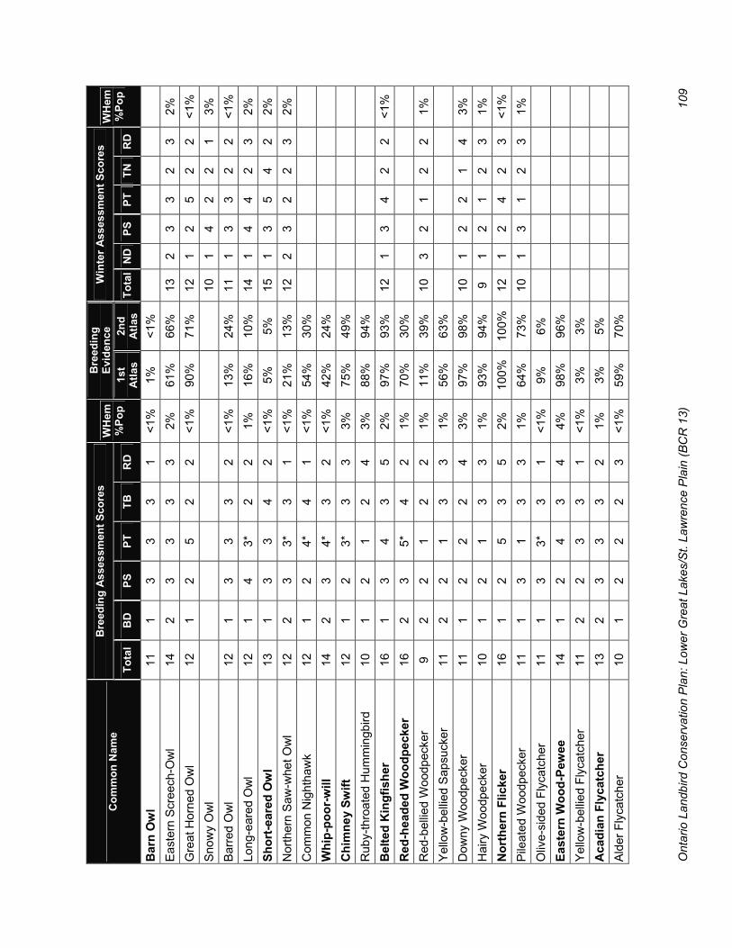
Ont
ario
Lan
dbird
Con
serv
atio
n P
lan:
Low
er G
reat
Lak
es/S
t. La
wre
nce
Pla
in (B
CR
13)
10
9
Bre
edin
g A
sses
smen
t Sco
res
Bre
edin
g Ev
iden
ce
Win
ter A
sses
smen
t Sco
res
Com
mon
Nam
e To
tal
BD
PS
PT
TB
R
D
WH
em%
Pop
1st
Atla
s 2n
d A
tlas
Tota
lN
DPS
PT
TN
R
D
WH
em%
Pop
Bar
n O
wl
11
1 3
3 3
1 <1
%
1%
<1%
Eas
tern
Scr
eech
-Ow
l 14
2
3 3
3 3
2%
61%
66
%
13
2 3
3 2
3 2%
G
reat
Hor
ned
Ow
l 12
1
2 5
2 2
<1%
90
%
71%
12
1
2 5
2 2
<1%
S
now
y O
wl
10
1
4 2
2 1
3%
Bar
red
Ow
l 12
1
3 3
3 2
<1%
13
%
24%
11
1
3 3
2 2
<1%
Lo
ng-e
ared
Ow
l 12
1
4 3*
2
2 1%
16
%
10%
14
1
4 4
2 3
2%
Shor
t-ear
ed O
wl
13
1 3
3 4
2 <1
%
5%
5%
15
1 3
5 4
2 2%
N
orth
ern
Saw
-whe
t Ow
l 12
2
3 3*
3
1 <1
%
21%
13
%
12
2 3
2 2
3 2%
C
omm
on N
ight
haw
k 12
1
2 4*
4
1 <1
%
54%
30
%
W
hip-
poor
-will
14
2
3 4*
3
2 <1
%
42%
24
%
C
him
ney
Swift
12
1
2 3*
3
3 3%
75
%
49%
Rub
y-th
roat
ed H
umm
ingb
ird
10
1 2
1 2
4 3%
88
%
94%
Bel
ted
Kin
gfis
her
16
1 3
4 3
5 2%
97
%
93%
12
1
3 4
2 2
<1%
R
ed-h
eade
d W
oodp
ecke
r 16
2
3 5*
4
2 1%
70
%
30%
Red
-bel
lied
Woo
dpec
ker
9 2
2 1
2 2
1%
11%
39
%
10
3 2
1 2
2 1%
Y
ello
w-b
ellie
d S
apsu
cker
11
2
2 1
3 3
1%
56%
63
%
D
owny
Woo
dpec
ker
11
1 2
2 2
4 3%
97
%
98%
10
1
2 2
1 4
3%
Hai
ry W
oodp
ecke
r 10
1
2 1
3 3
1%
93%
94
%
9 1
2 1
2 3
1%
Nor
ther
n Fl
icke
r 16
1
2 5
3 5
2%
100%
10
0%
12
1 2
4 2
3 <1
%
Pile
ated
Woo
dpec
ker
11
1 3
1 3
3 1%
64
%
73%
10
1
3 1
2 3
1%
Oliv
e-si
ded
Flyc
atch
er
11
1 3
3*
3 1
<1%
9%
6%
East
ern
Woo
d-Pe
wee
14
1
2 4
3 4
4%
98%
96
%
Y
ello
w-b
ellie
d Fl
ycat
cher
11
2
2 3
3 1
<1%
3%
3%
Aca
dian
Fly
catc
her
13
2 3
3 3
2 1%
3%
5%
Ald
er F
lyca
tche
r 10
1
2 2
2 3
<1%
59
%
70%

Ont
ario
Lan
dbird
Con
serv
atio
n P
lan:
Low
er G
reat
Lak
es/S
t. La
wre
nce
Pla
in (B
CR
13)
11
0
Bre
edin
g A
sses
smen
t Sco
res
Bre
edin
g Ev
iden
ce
Win
ter A
sses
smen
t Sco
res
Com
mon
Nam
e To
tal
BD
PS
PT
TB
R
D
WH
em%
Pop
1st
Atla
s 2n
d A
tlas
Tota
lN
DPS
PT
TN
R
D
WH
em%
Pop
Will
ow F
lyca
tche
r 13
1
3 2
2 5
6%
69%
73
%
Le
ast F
lyca
tche
r 13
1
2 4
3 3
1%
89%
85
%
E
aste
rn P
hoeb
e 12
1
2 2
2 5
4%
88%
96
%
G
reat
Cre
sted
Fly
catc
her
12
1 2
3 2
4 4%
98
%
98%
East
ern
Kin
gbird
15
1
2 4
3 5
3%
99%
99
%
Lo
gger
head
Shr
ike
14
1 3
4*
5 1
<1%
13
%
4%
N
orth
ern
Shr
ike
12
1
4 2
2 3
2%
Whi
te-e
yed
Vire
o 10
2
2 3
2 1
<1%
2%
2%
Yel
low
-thro
ated
Vire
o 14
2
3 3
3 3
2%
32%
27
%
B
lue-
head
ed V
ireo
9 2
2 1
2 2
1%
7%
21%
War
blin
g V
ireo
10
1 2
1 2
4 2%
94
%
94%
Phi
lade
lphi
a V
ireo
12
2 3
3 2
2 <1
%
2%
5%
R
ed-e
yed
Vire
o 10
2
1 1
2 4
2%
98%
99
%
B
lue
Jay
10
1 2
2 1
4 3%
99
%
100%
12
2
2 4
1 3
4%
Am
eric
an C
row
10
1
2 1
1 5
4%
100%
10
0%
10
1 2
2 1
4 7%
C
omm
on R
aven
9
1 2
2 2
2 <1
%
9%
32%
8
1 2
2 1
2 <1
%
Hor
ned
Lark
10
1
1 3
3 2
<1%
88
%
76%
10
1
1 4
2 2
<1%
P
urpl
e M
artin
11
1
2 3
3 2
1%
71%
53
%
Tr
ee S
wal
low
11
1
2 1
2 5
6%
100%
99
%
N
orth
ern
Rou
gh-w
inge
d Sw
allo
w
12
1 2
3 2
4 1%
85
%
74%
Ban
k Sw
allo
w
14
1 2
3 3
5 5%
84
%
69%
Clif
f Sw
allo
w
9 1
1 3
2 2
<1%
70
%
66%
Bar
n S
wal
low
12
1
1 2
3 5
4%
99%
99
%
B
lack
-cap
ped
Chi
ckad
ee
11
1 2
1 2
5 5%
96
%
99%
10
1
2 1
1 5
5%
Tufte
d Ti
tmou
se
10
2 2
1 2
3 2%
2%
9%
9
2 2
1 1
3 2%

Ont
ario
Lan
dbird
Con
serv
atio
n P
lan:
Low
er G
reat
Lak
es/S
t. La
wre
nce
Pla
in (B
CR
13)
11
1
Bre
edin
g A
sses
smen
t Sco
res
Bre
edin
g Ev
iden
ce
Win
ter A
sses
smen
t Sco
res
Com
mon
Nam
e To
tal
BD
PS
PT
TB
R
D
WH
em%
Pop
1st
Atla
s 2n
d A
tlas
Tota
lN
DPS
PT
TN
R
D
WH
em%
Pop
Red
-bre
aste
d N
utha
tch
8 1
2 1
2 2
<1%
45
%
63%
9
1 2
1 2
3 1%
W
hite
-bre
aste
d N
utha
tch
9 1
2 1
2 3
3%
89%
90
%
9 1
2 1
2 3
3%
Bro
wn
Cre
eper
11
1
2 3
3 2
1%
47%
49
%
13
1 2
3 2
5 2%
C
arol
ina
Wre
n 8
2 2
1 2
1 <1
%
4%
21%
8
2 2
1 2
1 <1
%
Hou
se W
ren
12
1 2
3 1
5 3%
95
%
96%
Win
ter W
ren
10
1 2
2 3
2 <1
%
46%
50
%
9 1
2 1
2 3
1%
Sed
ge W
ren
13
3 2
3 4
1 <1
%
17%
18
%
M
arsh
Wre
n 12
2
2 3
3 2
1%
37%
39
%
G
olde
n-cr
owne
d K
ingl
et
12
2 2
3 3
2 <1
%
15%
18
%
10
1 2
3 2
2 1%
R
uby-
crow
ned
Kin
glet
8
1 1
3 2
1 <1
%
8%
7%
B
lue-
gray
Gna
tcat
cher
9
1 1
3 2
2 <1
%
23%
32
%
E
aste
rn B
lueb
ird
9 1
2 1
2 3
1%
46%
83
%
V
eery
13
2
2 2
3 4
3%
89%
82
%
S
wai
nson
’s T
hrus
h 7
1 1
2 2
1 <1
%
7%
7%
H
erm
it Th
rush
9
1 1
2 3
2 <1
%
19%
33
%
W
ood
Thru
sh
15
2 2
4 3
4 6%
92
%
92%
Am
eric
an R
obin
10
1
1 2
1 5
3%
100%
10
0%
7 1
1 2
1 2
<1%
G
ray
Cat
bird
12
1
2 3
2 4
8%
99%
99
%
N
orth
ern
Moc
king
bird
6
1 2
1 1
1 <1
%
13%
29
%
6 1
2 1
1 1
<1%
B
row
n Th
rash
er
14
1 2
5 3
3 2%
98
%
93%
12
3
2 4
2 1
<1%
[E
urop
ean
Sta
rling
] 12
1
1 4
1 5
8%
99%
10
0%
12
1 1
4 1
5 2%
B
ohem
ian
Wax
win
g
11
1 3
2 2
3 <1
%
Ced
ar W
axw
ing
11
1 2
1 2
5 7%
99
%
99%
9
1 2
2 2
2 1%
B
lue-
win
ged
War
bler
17
3
4 3
3 4
10%
14
%
21%
Gol
den-
win
ged
War
bler
18
4
4 3
4 3
5%
22%
18
%

Ont
ario
Lan
dbird
Con
serv
atio
n P
lan:
Low
er G
reat
Lak
es/S
t. La
wre
nce
Pla
in (B
CR
13)
11
2
Bre
edin
g A
sses
smen
t Sco
res
Bre
edin
g Ev
iden
ce
Win
ter A
sses
smen
t Sco
res
Com
mon
Nam
e To
tal
BD
PS
PT
TB
R
D
WH
em%
Pop
1st
Atla
s 2n
d A
tlas
Tota
lN
DPS
PT
TN
R
D
WH
em%
Pop
Nas
hville
War
bler
12
2
2 3
3 2
<1%
56
%
55%
Nor
ther
n P
arul
a 11
2
2 3
3 1
<1%
5%
6%
Yel
low
War
bler
12
1
2 2
2 5
3%
99%
10
0%
C
hest
nut-s
ided
War
bler
11
2
2 2
2 3
2%
66%
73
%
M
agno
lia W
arbl
er
9 1
2 2
2 2
<1%
20
%
38%
Cap
e M
ay W
arbl
er
12
2 3
3 3
1 <1
%
2%
2%
B
lack
-thro
ated
Blu
e W
arbl
er
14
3 3
2 3
3 2%
11
%
28%
Yel
low
-rum
ped
War
bler
9
1 1
3 2
2 <1
%
32%
49
%
8 1
1 2
2 2
<1%
B
lack
-thro
ated
Gre
en W
arbl
er
12
2 2
3 3
2 1%
31
%
57%
Bla
ckbu
rnia
n W
arbl
er
10
2 2
1 3
2 1%
25
%
28%
Pin
e W
arbl
er
9 3
2 1
2 1
<1%
23
%
51%
Kirt
land
’s W
arbl
er
--
5 5
3 4
--
<1%
<1
%
0%
Pr
airie
War
bler
14
3
3 3
3 2
<1%
1%
1%
Pal
m W
arbl
er
10
2 2
3 2
1 <1
%
<1%
<1
%
B
ay-b
reas
ted
War
bler
14
3
3 3
3 2
<1%
1%
2%
Cer
ulea
n W
arbl
er
17
4 3
3 4
3 4%
8%
6%
Bla
ck-a
nd-w
hite
War
bler
12
2
2 1
3 4
2%
62%
67
%
A
mer
ican
Red
star
t 11
1
2 2
3 3
2%
83%
84
%
Pr
otho
nota
ry W
arbl
er
13
3 3
3 3
1 <1
%
2%
2%
O
venb
ird
12
2 2
2 3
3 2%
89
%
86%
Nor
ther
n W
ater
thru
sh
10
1 2
2 3
2 <1
%
58%
62
%
Lo
uisi
ana
Wat
erth
rush
14
2
4 3
3 2
1%
4%
4%
M
ourn
ing
War
bler
12
3
2 3
2 2
1%
63%
60
%
C
omm
on Y
ello
wth
roat
12
1
2 2
2 5
4%
99%
98
%
H
oode
d W
arbl
er
11
2 3
1 3
2 2%
2%
8%

Ont
ario
Lan
dbird
Con
serv
atio
n P
lan:
Low
er G
reat
Lak
es/S
t. La
wre
nce
Pla
in (B
CR
13)
11
3
Bre
edin
g A
sses
smen
t Sco
res
Bre
edin
g Ev
iden
ce
Win
ter A
sses
smen
t Sco
res
Com
mon
Nam
e To
tal
BD
PS
PT
TB
R
D
WH
em%
Pop
1st
Atla
s 2n
d A
tlas
Tota
lN
DPS
PT
TN
R
D
WH
em%
Pop
Can
ada
War
bler
15
2
3 5
3 2
1%
32%
29
%
Ye
llow
-bre
aste
d C
hat
13
1 2
5*
4 1
<1%
5%
2%
Sca
rlet T
anag
er
13
2 3
2 3
3 4%
76
%
74%
East
ern
Tow
hee
14
2 2
5 3
2 1%
67
%
62%
12
2
2 4
2 2
<1%
A
mer
ican
Tre
e S
parr
ow
13
2
2 4
2 3
4%
Chi
ppin
g S
parr
ow
10
1 1
2 1
5 2%
10
0%
100%
Cla
y-co
lore
d S
parr
ow
10
2 2
3 2
1 <1
%
11%
25
%
Fi
eld
Spar
row
15
2
2 5
3 3
3%
83%
80
%
13
2 2
5 2
2 <1
%
Vesp
er S
parr
ow
13
1 2
5 3
2 1%
91
%
77%
Sava
nnah
Spa
rrow
14
1
1 4
3 5
3%
97%
96
%
G
rass
hopp
er S
parr
ow
13
1 2
5 3
2 <1
%
45%
41
%
H
ensl
ow’s
Spa
rrow
19
3
4 5*
4
3 3%
4%
1%
Son
g S
parr
ow
13
1 1
4 2
5 7%
10
0%
100%
10
1
1 4
2 2
1%
Linc
oln'
s S
parr
ow
10
1 2
3 3
1 <1
%
2%
5%
S
wam
p S
parr
ow
12
2 2
1 2
5 2%
83
%
84%
9
2 2
1 2
2 1%
W
hite
-thro
ated
Spa
rrow
11
2
1 4
2 2
<1%
69
%
66%
11
2
1 4
2 2
<1%
D
ark-
eyed
Jun
co
9 1
1 4
2 1
<1%
8%
9%
11
1
1 4
2 3
1%
Lapl
and
Long
spur
9 1
1 3
2 2
<1%
S
now
Bun
ting
11
1
2 2
2 4
4%
Nor
ther
n C
ardi
nal
7 1
1 1
1 3
2%
76%
94
%
7 1
1 1
1 3
2%
Ros
e-br
east
ed G
rosb
eak
15
2 3
3 2
5 5%
96
%
96%
Indi
go B
untin
g 10
1
2 2
2 3
1%
97%
95
%
D
ickc
isse
l 11
2
2 3
3 1
<1%
<1
%
0%
B
obol
ink
16
2 2
4 3
5 20
%
97%
96
%
R
ed-w
inge
d B
lack
bird
12
1
1 4
2 4
4%
100%
10
0%
10
1 1
4 2
2 <1
%
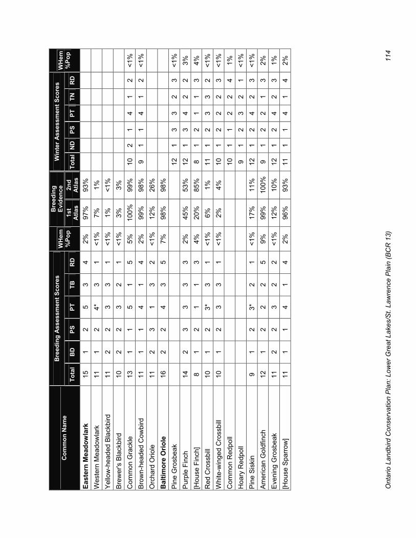
Ont
ario
Lan
dbird
Con
serv
atio
n P
lan:
Low
er G
reat
Lak
es/S
t. La
wre
nce
Pla
in (B
CR
13)
11
4
Bre
edin
g A
sses
smen
t Sco
res
Bre
edin
g Ev
iden
ce
Win
ter A
sses
smen
t Sco
res
Com
mon
Nam
e To
tal
BD
PS
PT
TB
R
D
WH
em%
Pop
1st
Atla
s 2n
d A
tlas
Tota
lN
DPS
PT
TN
R
D
WH
em%
Pop
East
ern
Mea
dow
lark
15
1
2 5
3 4
2%
97%
93
%
W
este
rn M
eado
wla
rk
11
1 2
4*
3 1
<1%
7%
1%
Yel
low
-hea
ded
Bla
ckbi
rd
11
2 2
3 3
1 <1
%
1%
<1%
Bre
wer
's B
lack
bird
10
2
2 3
2 1
<1%
3%
3%
Com
mon
Gra
ckle
13
1
1 5
1 5
5%
100%
99
%
10
2 1
4 1
2 <1
%
Bro
wn-
head
ed C
owbi
rd
11
1 1
4 1
4 2%
99
%
98%
9
1 1
4 1
2 <1
%
Orc
hard
Orio
le
11
2 3
1 3
2 <1
%
12%
26
%
B
altim
ore
Orio
le
16
2 2
4 3
5 7%
98
%
98%
Pin
e G
rosb
eak
12
1
3 3
2 3
<1%
P
urpl
e Fi
nch
14
2 3
3 3
3 2%
45
%
53%
12
1
3 4
2 2
3%
[Hou
se F
inch
] 8
1 2
1 1
3 4%
20
%
85%
8
1 2
1 1
3 4%
R
ed C
ross
bill
10
1 2
3*
3 1
<1%
6%
1%
11
1
2 3
3 2
<1%
W
hite
-win
ged
Cro
ssbi
ll 10
1
2 3
3 1
<1%
2%
4%
10
1
2 2
2 3
<1%
C
omm
on R
edpo
ll
10
1 1
2 2
4 1%
H
oary
Red
poll
9
1 2
3 2
1 <1
%
Pin
e S
iski
n 9
1 2
3*
2 1
<1%
17
%
11%
12
1
2 4
2 3
<1%
A
mer
ican
Gol
dfin
ch
12
1 2
2 2
5 9%
99
%
100%
9
1 2
2 1
3 2%
E
veni
ng G
rosb
eak
11
2 2
3 2
2 <1
%
12%
10
%
12
1 2
4 2
3 1%
[H
ouse
Spa
rrow
] 11
1
1 4
1 4
2%
96%
93
%
11
1 1
4 1
4 2%

Ontario Landbird Conservation Plan: Lower Great Lakes/St. Lawrence Plain (BCR 13) 115
The species accounts in this Appendix summarize the conservation status, ecology, threats, objectives and recommended actions for each of the 42 priority species identified in the Ontario BCR 13 Landbird Conservation Plan. The accounts follow a standard format as shown in the template (Figure F1). Additional information on the format, content and sources of information used in these accounts is provided below. Additional Information on the Format of the Priority Species Accounts: General Status
� PIF Continental Watch List Species: Identified as Watch List species in the North American Landbird Conservation Plan (Rich et al. 2004)
� PIF Continental Stewardship Species: Identified as Stewardship species in the North American Landbird Conservation Plan (Rich et al. 2004), with at least 5% of global population in BCR 13.
� SAR Status: Identified as Endangered, Threatened or Special Concern on Schedule 1, 2 or 3 of the Species at Risk Act (SARA Public Registry www.sararegistry.gc.ca/species/default_e.cfm, September 2005)
� OMNR Status: Identified as Endangered, Threatened or Special Concern by the Ontario Ministry of Natural Resources, December 2005 (OMNR 2006, www.mnr.gov.on.ca/mnr/speciesatrisk/status_list.html).
� COSEWIC Under Review: COSEWIC status report currently under review or in preparation (COSEWIC www.cosewic.gc.ca/eng/sct2/sct2_4_e.cfm, 6 January 2005)
� ON BCR 13 Priority Species (Breeding/Wintering): Identified as a priority breeding or wintering species in
this plan Reason(s) for ON BCR 13 Priority Status List of the priority categories and the reasons that species is considered a priority species in BCR 13 (see Table 3). See Appendix C for an explanation of the PIF approach to identifying priority species at a regional scale. ON BCR 13 Population Summary of the current status of the species in southern Ontario, including relative abundance (from James 1991), available quantitative information on current population abundance, distribution and trend, and proportion of global population occurring in ON BCR 13. Range Map Range maps constructed by Bird Studies Canada using data provided by NatureServe in collaboration with Robert Ridgely, James Zook, The Nature Conservancy – Migratory Bird Program, Conservation International – Center for Applied Biodiversity Science, World Wildlife Fund – US and Environment Canada – WildspaceTM (Ridgely et al. 2003). Objectives Objectives for the conservation of the priority species in southern Ontario, as established in this plan, are provided. Objectives for Endangered and Threatened species are to be established by the SAR recovery strategies. Conservation Actions “Fine filter” priority actions specific to the conservation of the particular species in southern Ontario are included in the species accounts. “Coarse filter” actions that apply to all or most species in a particular habitat suite or foraging guild are included in the relevant chapter in the plan. Key References The main sources of information (mostly secondary references) used in preparing the species account.
Appendix F: Priority Species Accounts

Ontario Landbird Conservation Plan: Lower Great Lakes/St. Lawrence Plain (BCR 13) 116
Figure F1: Template for the priority species accounts
Common Name Scientific Name
HABITAT GUILD FORAGING GUILD (IF APPLICABLE)
General Status � PIF Status in North America (Continental Watch List
or Continental Stewardship Species in Rich et al. 2004)
� SAR Status in Canada (COSEWIC 2005) � SAR Status in Ontario (OMNR 2006) � Priority Status in ON BCR 13 (Breeding or Wintering
Priority Species as identified in this plan)
Reason(s) for ON BCR13 Priority Status � Continental Concern: Supporting criteria � Regional Concern: Supporting criteria � Regional Stewardship: Supporting criteria � Species at Risk: Reasons for designation � Management Interest: Supporting criteria � BBS population trend in BCR 13 � % of global population in BCR 13
ON BCR 13 Population � % of global population in ON BCR 13 (based on
population estimates in this report and comparable estimates in Rich et al. 2004)
� Relative abundance in southern Ontario (James 1991)
� Current BBS Index (2001–03) and population estimate (or best available population estimate)
� BBS population trend (1968–2003) in ON BCR 13, or other available trend information
� Breeding distribution (% of atlas squares with minimum of 20 hours of coverage with breeding evidence) in each subregion during BBA1 (1981–85) and BBA2 (preliminary data from 2001–04 period). Change: Up – significant increase (P<0.05); Up – near-significant increase (P<0.1); Down – significant decrease; Down – near-significant decrease
Range Map Red = breeding range; Yellow = passage migrant; Blue = wintering range; Purple = year-round range
Ecology � Key ecological factors such as area sensitivity,
breeding habitat, specific nesting requirements, foraging strategy, etc.
Limiting Factors and Threats Main factors that affect the conservation of this species, such as: � Habitat Loss, Habitat Fragmentation, Habitat
Alteration, Brood Parasitism, Competition
Overall Objective(s) � General description of overall objective for this
species � PIF Continental Population Objective (Rich et al.
2004), if relevant
Population Objective(s) � Quantitative population objective and graph of BBS
indices (1968–2003) and population objective, where available
Distribution Objective � Quantitative distribution objective based on BBA
data. Distribution objectives are often based on preliminary (BBA2 2001–04) data.
Conservation Focus � Main limiting factor(s) that need to be rectified to
proceed with conservation of this species
Conservation Actions Priority actions in one or more of the following categories: � Monitoring � Research and Evaluation � Planning and Policy � Outreach � Habitat Management and/or Protection
Key References BBA1: Ontario Breeding Bird Atlas (1987) species account ORBBP: Ontario Rare Breeding Bird Program (1994) species account BNA: Birds of North America species accounts COSEWIC: COSEWIC Status Report RENEW: RENEW Recovery Plan SARRS: SAR recovery strategy NANCLC: National Action Needs of Canadian Landbird Conservation, v.1 CWLRMN: PIF Continental Watch List Research and Monitoring Needs species accounts NPWRC: Grassland species accounts by Northern Prairie Wildlife Research Center TNC SMA: Species Management Abstract prepared by The Nature Conservancy Other: Additional references

Ontario Landbird Conservation Plan: Lower Great Lakes/St. Lawrence Plain (BCR 13) 117
Acadian Flycatcher Empidonax virescens
FOREST
General Status � Endangered in Canada and Ontario � ON BCR 13 Priority Species (Breeding)
Reason(s) for ON BCR13 Priority Status � Species at Risk: Very small population in Canada
(southern Ontario only) with specialized breeding habitat requirements that are relatively scarce (Friesen et al. 2000)
� Small winter range (ND=4) � BBS population trend in BCR 13 uncertain, tending
downwards � ~1% of global population in BCR 13
ON BCR 13 Population � <1% of global population in ON BCR 13 � Rare (James 1991) � Recent population estimate of 35–50 nesting pairs
(Friesen and Stabb 2001) � Current BBA2 distribution (preliminary) of 15% of
squares in SW, and 2% in CE subregions (absent elsewhere)
� BBS population trend in ON BCR 13 unknown; population is considered relatively stable (D.A. Martin, RENEW, pers. comm. 2005)
�
Ecology � Forest-obligate � Area-sensitive (20 ha minimum patch size but
prefers >100 ha) � Prefers >80% regional forest cover � Breeds only in relatively undisturbed mature forests
with open understorey including upland deciduous forest, deciduous swamp forest and deciduous or mixed wooded ravines
� High fidelity to breeding sites
Limiting Factors and Threats � Monitoring: Not well sampled by BBS � Restricted Range: Most of the Canadian population
is restricted to Southwest subregion of ON BCR 13
Limiting Factors Threats (cont’d) � Fragmentation: Negatively affected by forest
fragmentation owing to higher cowbird parasitism and higher predation rates
� Wintering Habitat: Loss of mature forest on wintering grounds a concern
Overall Objectives � Recovery: Finalize and implement the draft SAR
recovery strategy for this Endangered species (in conjunction with Hooded Warbler)
Population Objectives � To be determined by SAR recovery strategy
Conservation Focus � Recovery: Implementation of the SAR recovery
strategy (in conjunction with Hooded Warbler)
Conservation Actions Priority actions in the draft recovery strategy include: � Habitat Protection and Stewardship: Identification,
protection and appropriate management of known and potential breeding habitat in ON BCR 13
� Monitoring: Periodic monitoring of population at occupied and potential sites in ON BCR 13 (e.g., extensive survey every five years)
� Research and Evaluation: Evaluate the risks to critical habitat posed by invasive plants and exotic forest insects and tree diseases
Key References BBA1: Woodliffe 1987a. ORBBP: Austen et al. 1994. BNA: Whitehead and Taylor 2002. COSEWIC: James 2000a. RENEW: Friesen et al. 2000. SARRS: In prep. NANCLC: Dunn 2005. TNC SMA: Sallabanks et al. 1993a. Other: Friesen and Stabb 2001.

Ontario Landbird Conservation Plan: Lower Great Lakes/St. Lawrence Plain (BCR 13) 118
American Kestrel Falco sparverius
GRASSLAND/AGRICULTURAL
General Status � ON BCR 13 Priority Species (Breeding)
Reason(s) for ON BCR13 Priority Status � Regional Concern: Regional population decline (PT=4)
and high relative density (RD=4) in BCR 13 � ~1% of global population in BCR 13
ON BCR 13 Population � <1% of global population in ON BCR 13 � Common (James 1991) � Current BBS Index of 0.59, ~20 000 birds � BBS population trend in ON BCR 13 uncertain, tending
downwards � BBA distribution (BBA2 preliminary):
Distribution SW CE EA NW BBA1 97% 98% 98% 84% BBA2 90% 91% 88% 81% Change Down Down Down
Ecology � Breeds in range of open settings, including grasslands
and agricultural habitats, roadsides, utility corridors and suburban areas
� Cavity nester that uses existing cavities in snags or trees >30 cm dbh, or nest boxes
� Forages in patches of short ground vegetation with hunting perches
� During breeding season, feeds primarily on insects (grasshoppers and crickets); also eats voles, mice, small birds and frogs
Threats � Loss of Habitat: Decrease in open areas due to increased
forest cover; also loss of agricultural grasslands and fencerow habitats
� Habitat Alteration: Agricultural intensification leading to loss of snags, hunting perches and a decrease in food availability
Limiting Factors and Threats (cont’d) � Nest Site Availability: Availability of nesting cavities and/or
hunting perches may limit breeding population in some areas
� Competition: Competes with European Starling and squirrels for nest sites
� Direct Mortality: Mortality rate due to collisions with vehicles a concern
Overall Objective � Halt Decline
Population Objective � Maintain current (2001–03) population level, BBS Index of
0.59, ~20 000 birds
Distribution Objective � Maintain current breeding distribution (BBA 2001–05) in all
subregions. Objectives: 90% of atlas squares in SW subregion, 91% in Centrall 88 % in East and 81% in NW
Conservation Focus � Research: Identify factors causing population decline and
limiting population growth
Conservation Actions � Monitoring: Compile and analyze productivity data collected
by nest box monitors � Research: Determine factors (nest cavities, perches,
habitat, and/or food supply) limiting population abundance and productivity
� Habitat Management: Retain large snags and mature trees in open grassland/agricultural settings for nesting cavities and hunting perches; Install nest boxes in areas of suitable habitat where natural cavities are lacking
Key References BBA1: Weir 1987a. BNA: Smallwood and Bird 2002. Other: James 1984a; WHMI & WHC 1999.
American Kestrel
0
10,000
20,000
30,000
40,000
50,000
60,000
70,000
80,000
1968 1973 1978 1983 1988 1993 1998 2003
Pop'n Estimate
0.0
0.5
1.0
1.5
2.0
BBS Index
Pop'n ObjectiveBBS Index &Pop'n Estimate
`

Ontario Landbird Conservation Plan: Lower Great Lakes/St. Lawrence Plain (BCR 13) 119
Bald Eagle Haliaeetus leucocephalus
OTHER HABITATS
General Status � Endangered in Ontario (south of the Mattawa & French
Rivers; Special Concern in northern Ontario) � ON BCR 13 Priority Species (Breeding and Wintering)
Reason(s) for ON BCR13 Priority Status � Species at Risk: Southern Ontario population recovering
from severe decline due to pesticide (DDT) contamination but faces ongoing threats from emerging diseases (West Nile virus, botulism), bioaccumulation of toxins (heavy metals) and habitat pressures
� BBS population trend in BCR 13 unknown � <1% of global population in BCR 13
ON BCR 13 Population � <1% of global population in ON BCR 13 � Rare (James 1991) � Current breeding population of ~50 pairs in ON BCR 13,
increasing (Laing and Badzinski 2005; BBA2 data) � Current BBA2 distribution (preliminary) of 14% of squares
in SW, 4% in CE, 9% in EA and 35% in NW subregions � Winter population estimate and trend are not available
Ecology � Associated with water, including shoreline and riparian
habitats � Large forested nesting territory (c. 260 ha) close to large
lake or river with large tall trees and/or platform for nest sites (frequently reused) and additional super-canopy trees or snags for perching and roosting
� Feeds primarily on fish, also carrion, small mammals and waterfowl
Limiting Factors and Threats � Monitoring: Not monitored by BBS � Habitat Alteration: Modification of shoreline or riparian
nesting habitat or nest trees due to logging, marinas, development or other activities a threat in some areas
� Habitat Degradation: Food supply quality depends on the health of aquatic ecosystems
Limiting Factors and Threats (cont’d) � Disturbance: Sensitive to disturbance near nest site during
breeding season � Toxic Contaminants: Bioaccumulation of toxins (e.g.,
mercury, lead) may be reducing the adult life span of birds in this region
� Direct Mortality: Vulnerable to disease (e.g., West Nile virus, botulism) and to collisions with vehicles, power lines and tall structures
Overall Objective � Recovery: Goal to be determined by updated provincial
recovery strategy
Population Objectives � To be determined by provincial recovery strategy
Conservation Focus: � Monitoring: Continue monitoring the recovery of this
biosentinel species
Conservation Actions Complete provincial recovery strategy, continue to implement provincial habitat management guidelines and continue recovery activities, including:
� Monitoring: Continue volunteer-based monitoring of nest site activity and productivity in southern Ontario study area
� Monitoring: Establish and implement a protocol to survey and assess wintering population in southern Ontario
� Research: Toxicological and foraging studies to determine cause of shortened life span of adult eagles in southern Ontario
� Outreach/Education: Continue communications and reporting on linkages of Bald Eagle populations, toxins, human populations and ecosystem health,
� Habitat Protection: Conserve and restore suitable nesting habitat, including nest trees and additional large super-canopy trees for nesting, perching and roosting
� Nest Site Protection: Avoid disturbance of active nest sites (February to mid-June), and avoid destruction of nest trees at any time
Key References BBA1: Bortolotti 1987. ORBBP: Austen et al. 1994. BNA: Buehler 2000. COSSARO: Draft report by Grier et al. 2003. Other: Donaldson et al. 1999; Laing and Badzinski 2005; OMNR 1987a, 2005a.

Ontario Landbird Conservation Plan: Lower Great Lakes/St. Lawrence Plain (BCR 13) 120
Baltimore Oriole Icterua galbula
OTHER HABITATS
Genearl Status � ON BCR 13 Priority Species (Breeding)
Reason(s) for ON BCR13 Priority Status � Rangewide population decline (PT=4) � Regional Concern: Regional population decline
(PT=4) and moderate threats (TB=3) in BCR 13 � Regional Stewardship Species: Very high relative
density (RD=5) and moderate concern (total score of 16) in BCR 13
� BBS trend indicates a long-term population decline in BCR 13
� 7% of global population in BCR 13
ON BCR 13 Population � ~3% of global population in ON BCR 13 � Common (James 1991) � Current BBS Index (2001–03) of 7.4, ~200 000
birds � BBS trend indicates a long-term population decline
in ON BCR 13 � BBA distribution (BBA2 preliminary):
Distribution SW CE EA NW BBA1 100% 100% 99% 79% BBA2 100% 99% 99% 84% Change
Ecology � Breeds in open riparian woodlands, edges of
deciduous forest and in suburban and parkland settings
� Strong preference for deciduous trees � During breeding season feeds on caterpillars, fruits,
adult insects, spiders and nectar
Limiting Factors and Threats � Habitat Loss and Alteration: Concern about habitat
conditions on the wintering grounds, particularly loss of shaded coffee and cacao plantations
� Environmental Contaminants: Vulnerable to pesticide poisoning and to decreased food supply due to insect control measures
Limiting Factors and Threats (cont’d) � Climate Change: Severe weather in spring and early
summer increases mortality due to exposure and reduces productivity
� Direct Mortality: Vulnerable to collisions with vehicles, particularly during early spring
Overall Objective � Reverse Decline
Population Objective � Restore population to 1968–77 level, BBS Index 9.8,
~250 000 birds
Distribution Objective � Maintain current distribution in all subregions of
southern Ontario. Objectives: 100% of atlas squares in SW subregion, 99% in Central, 99% in East, and 84% in NW.
Conservation Focus � Research: Identify factors causing population
decline and/or limiting population growth
Conservation Actions � Research: Quantify the impact of pesticides and
climate on nesting populations, and the impact of coffee and cacao plantation management on wintering populations
� Habitat Management: Maintain large deciduous trees in riparian, roadside, suburban and forest-edge settings
Key References BBA1: Flood 1987. BNA: Rising and Flood 1998. NatureServe: NatureServe 2005.
Baltimore Oriole
100
200
300
400
1968 1978 1988 1998
Pop'n Estimate
(thousands)
0
3
6
9
12
15
BBS Index
Pop'n Objective BBS Index & Pop'n Estimate

Ontario Landbird Conservation Plan: Lower Great Lakes/St. Lawrence Plain (BCR 13) 121
Bank Swallow Riparia riparia
OTHER HABITATS; AERIAL-FORAGING INSECTIVORE
General Status � ON BCR 13 Priority Species (Breeding)
Reason(s) for ON BCR13 Priority Status � Regional Stewardship Species: Very high relative density (RD=5) and moderate concern (total score of 14) in BCR 13 � BBS population trend in BCR 13 uncertain, tending downwards � 2% of global population in BCR 13
ON BCR 13 Population � <1% of global population in ON BCR 13 � Locally common to abundant (James 1991) � Current BBS Index (2001–03) of 8.8, ~250 000 birds � BBS population trend in ON BCR 13 uncertain, tending strongly downwards � BBA distribution (BBA2 preliminary):
Distribution SW CE EA NW BBA1 85% 92% 78% 52% BBA2 70% 78% 56% 30% Change Down Down Down Down
Ecology � Associated with water, including shoreline and
riparian habitats � Nests in burrows dug into vertical surfaces
composed of soft sand or silt sediments, including eroded riverbanks and excavated quarry faces
� Usually nests in small colonies of 5–100 pairs, rarely more than 1000 pairs
� Diurnal aerial-foraging insectivore
Limiting Factors and Threats � Direct or Indirect Mortality: Vulnerable to
disturbance at nesting colonies during breeding season (late May–July), particularly at active quarries
Limiting Factors and Threats (cont’d) � Habitat Loss: Loss of nesting sites in riverbanks
due to flood and erosion control measures
Overall Objective � Reverse Decline
Population Objective � Restore population to 1968–77 level, BBS Index 22.1, ~600 000 birds
Distribution Objective � Restore distribution to 1981–85 BBA levels in all subregions. Objectives: 85% of atlas squares in SW subregion, 92% in Central, 78% in East, and 52% in NW
Conservation Focus � Research: Identify factors causing population decline and limiting population growth
Conservation Actions � Research: Investigate potential causes of the population decline, including changes in the availability of nest sites, and population demographics at a variety of nesting sites throughout southern Ontario � Outreach: Develop and promote BMPs for bank-nesting birds to minimize destruction or disturbance of nest sites during the breeding season � Habitat Management: Maintain availability of suitable nesting sites, particularly for large colonies � Research: Investigate habitat use during migration and winter
Key References BBA1: Brewer 1987. BNA: Garrison 1999. NANCLC: Dunn 2005. NatureServe: NatureServe 2005.
Bank Swallow
0
200,000
400,000
600,000
800,000
1,000,000
1,200,000
1968 1973 1978 1983 1988 1993 1998 2003
Pop'n Estimate
0
5
10
15
20
25
30
35
40
BBS Index
Pop'n ObjectiveBBS Index &Pop'n Estimate
`

Ontario Landbird Conservation Plan: Lower Great Lakes/St. Lawrence Plain (BCR 13) 122
Barn Owl Tyto alba
GRASSLAND/AGRICULTURAL
General Status � Endangered in Canada and Ontario � ON BCR 13 Priority Species (Breeding)
Reason(s) for ON BCR13 Priority Status � Species at Risk: Very small and declining population in southern Ontario � BBS population trend in BCR 13 unknown � <1% of global population in BCR 13
ON BCR 13 Population � Rare (James 1991) � No recent breeding records from Ontario, but a few recent roadkill and sighting records � BBS population trend in ON BCR 13 is unknown � <1% of global population in ON BCR 13
Ecology � Grassland-obligate � Found in open habitats, including agricultural
grasslands, native grasslands and marshes � Cavity nester that will nest in hollow trees (>50 cm
dbh), nest boxes and human structures � Requires high densities of voles and other prey
species
Limiting Factors and Threats � Knowledge Gap: Rare, nocturnal species; not
monitored by general surveys � Nest and Roost Site Availability: Decrease in
availability of accessible livestock barns or other shelters suitable for nesting and roosting
� Habitat Loss and Alteration: Decrease in pastures and agricultural intensification have resulted in loss of high-quality foraging habitat
Limiting Factors and Threats (cont’d) � Direct Mortality: Vulnerable to severe winter weather (does not appear to overwinter in Ontario) and to collisions with vehicles � Public Profile: Considered a flagship species for grassland birds owing to high level of public interest, particularly in rural areas
Overall Objective � Recovery: Finalize and implement the SAR recovery strategy for this Endangered species
Population Objectives � To be determined by SAR recovery strategy
Conservation Focus � Recovery: Implement SAR recovery strategy � Outreach and Education: Promote this popular, charismatic species as a flagship species for focusing interest in grassland conservation in rural communities
Conservation Actions Implement priority actions as identified in the SAR recovery strategy. Priority actions in draft recovery plan (2002) include: � Monitoring: Monitoring Barn Owl nest boxes in SW
subregion (over 300 boxes installed in 1999–2000) � Habitat Management and Enhancement: Promote
best management practices for grassland birds (e.g., Solymar 2005)
� Outreach and Education: Develop and distribute communication materials to inform rural residents about Barn Owl and grassland biodiversity conservation needs
Key References BBA1: Weir 1987b. ORBBP: Austen et al. 1994. BNA: Marti 1992. COSEWIC: Kirk 1999. RENEW: Solymar and McCracken 2002 (draft). NANCLC: Dunn 2005. TNC SMA: Rosenburg et al. 1992. Other: James 1984a.

Ontario Landbird Conservation Plan: Lower Great Lakes/St. Lawrence Plain (BCR 13) 123
Belted Kingfisher Ceryle alcyon
OTHER HABITATS
General Status � ON BCR 13 Priority Species (Breeding)
Reason(s) for ON BCR13 Priority Status � Rangewide population decline (PT=4) � Regional Concern: Regional population decline (PT=4) and very high relative density (RD=5) in BCR 13 � 2% of global population in BCR 13
ON BCR 13 Population � <1% of global population in ON BCR 13 � Common (James 1991) � Current (2001–03) BBS Index of 0.45, ~15 000 birds � BBS trend indicates a long-term population decline in ON BCR 1 � BBA distribution (BBA2 preliminary):
Distribution SW CE EA NW BBA1 95% 99% 96% 89% BBA2 88% 98% 92% 78% Change Down Down
Ecology � Riparian obligate, occurs in shoreline, riparian and wetland habitats � Nests in burrows dug into vertical surfaces composed of soft sand or silt sediments, including eroded riverbanks and excavated quarry faces � Forages primarily on small fish, also crayfish, tadpoles, insects and other prey in clear, slow-moving water � Uses hunting perches
Limiting Factors and Threats � Habitat Quality: Water quality and clarity affects food availability � Direct or Indirect Mortality: Sensitive to disturbance at nest sites during breeding season (April–July), particularly at active quarries � Nest Site Availability: Erosion and flood control measures may reduce availability of riverbank nest sites � Direct Mortality: Active control measures may be occurring at some fish hatcheries
Limiting Factors and Threats (cont’d) � Monitoring: Indicator species that can be used to evaluate stream rehabilitation and management efforts (McHattie et al. 1995)
Overall Objective � Reverse Decline
Population Objective � Restore population to 1968–77 level, BBS Index 0.89, ~30 000 birds
Distribution Objective � Restore distribution to 1981–85 levels in all subregions. Objectives: 95% of atlas squares in SW subregion, 99% in Central, 96% in East, and 89% in NW.
Conservation Focus � Outreach: Develop and promote BMPs for bank-nesting birds to minimize destruction or disturbance of active nest sites
Conservation Actions � Research: Investigate potential causes of the population decline and study population demographics at variety of sites in ON BCR 13 � Habitat Management: Promote measures to maintain or restore water quality and food availability in riparian systems (e.g., buffer strips) � Outreach: Develop and promote BMPs for bank-nesting birds to minimize destruction or disturbance of active nest sites
Key References BBA1: Read 1987. BNA: Hamas 1994 NANCLC: Dunn 2005. Other: McHattie et al. 1995.
Belted Kingfisher
0
5,000
10,000
15,000
20,000
25,000
30,000
35,000
40,000
45,000
50,000
1968 1973 1978 1983 1988 1993 1998 2003
Pop'n Estimate
0.0
0.2
0.4
0.6
0.8
1.0
1.2
1.4
BBS Index
Pop'n ObjectiveBBS Index &Pop'n Estimate
`

Ontario Landbird Conservation Plan: Lower Great Lakes/St. Lawrence Plain (BCR 13) 124
Black-billed Cuckoo Coccyzus erythropthalmus
SHRUB/SUCCESSIONAL
General Status � ON BCR 13 Priority Species (Breeding)
Reason(s) for ON BCR13 Priority Status � Rangewide population decline (PT=4) � Regional Concern: Severe long-term regional population decline (PT=5) and moderate regional threats (TB=3) in BCR 13 � Regional Stewardship Species: High relative density (RD=5) and >5% of global population in BCR 13 � ~6% of global population in BCR 13
ON BCR 13 Population � ~4% of global population in ON BCR 13 � Uncommon to locally common (James 1991) � Current BBS Index of 0.85, ~40 000 birds � BBS trend indicates a long-term population decline in ON BCR 13 � BBA distribution (BBA2 preliminary):
Distribution SW CE EA NW BBA1 74% 74% 85% 69% BBA2 73% 80% 69% 64% Change Up Down
Ecology � Uses variety of early successional forests, dense deciduous thickets, open woodland, riparian and forest-edge habitats � Insectivore, feeding primarily on large insects including caterpillars, cicadas, katydids, tree crickets and grasshoppers � Breeding densities vary in apparent response to caterpillar and cicada outbreaks, resulting in irruptive distribution pattern � Facultative brood parasite
Limiting Factors and Threats � Habitat Loss: Deforestation in winter range may be
an issue � Direct and Indirect Mortality: Use of pesticides to
control insect outbreaks may have adverse impact on survival and/or productivity
� Direct Mortality: Vulnerable to collisions with vehicles when foraging, collisions with lighted structures during migration
Overall Objective � Halt Decline
Population Objective � Maintain current population, BBS Index of 0.85, ~40 000 birds
Distribution Objective � Maintain current distribution in all subregions. Objectives: 73% of atlas squares in SW subregion, 80% in Central, 69% in East, and 64% in NW. Ensure no further decline in East subregion.
Conservation Focus � Research needed to determine factors causing long-term population decline in this region and elsewhere in North America
Conservation Actions � Research: Determine factors causing regional and rangewide population decline � Research: Research needed on breeding ecology, winter ecology, sensitivity to pesticides and response to habitat management
Key References BBA1: Helleiner 1987a. BNA: Hughes 2001. NANCLC: Dunn 2005. TNC SMA: Deeble et al. 2001.
Black-billed Cuckoo
0
20,000
40,000
60,000
80,000
100,000
120,000
140,000
1968 1973 1978 1983 1988 1993 1998 2003
Pop'n Estimate
0.0
0.5
1.0
1.5
2.0
2.5
3.0
BBS Index
Pop'n ObjectiveBBS Index &Pop'n Estimate
`

Ontario Landbird Conservation Plan: Lower Great Lakes/St. Lawrence Plain (BCR 13) 125
Blue-winged Warbler Vermivora pinus
SHRUB/SUCCESSIONAL
General Status � PIF Continental Watch List Species � PIF Continental Stewardship Species � ON BCR 13 Priority Species (Breeding)
Reason(s) for ON BCR13 Priority Status � Continental Concern: Small global population (PS=4), small wintering range (ND=4) and rangewide population decline (PT=4) � Moderate relative density in BCR 13 (RD=4) � BBS population trend in BCR 13 uncertain � 10% of global population in BCR 13
ON BCR 13 Population � <1% of global population in ON BCR 13 � Rare to locally uncommon (James 1991) � Current BBS Index of 0.07, ~2000 birds � BBS population trend in ON BCR 13 uncertain but suggests increase. Other evidence (e.g., BBA data) also points to population increase. � BBA distribution (BBA2 preliminary):
Distribution SW CE EA NW BBA1 35% 9% 1% 1% BBA2 43% 20% 1% 3% Change Up Up
Ecology � Uses range of natural or disturbed, early- to mid-successional shrub habitats including overgrown old fields, clear-cuts, power-line right-of-ways and forest-field edges � Nests on or near the ground in dense patches of forbs, graminoids or shrubs � Breeding range has been shifting northwards for more than a century, apparently displacing Golden-winged Warblers � Feeds on insects and spiders, and is adapted to extracting leaf-rolling insect larvae
Limiting Factors and Threats � Monitoring: Difficult to monitor, as song types shared with Golden-winged Warbler � Interspecific Competition: Hybridization with, and/or displacement of, Golden-winged Warbler in areas of overlap
Overall Objectives � Maintain Current � Where possible, contribute to continental objective of increasing population by 50%
Population Objective � Maintain current population: BBS Index 0.07, ~2000 birds
Distribution Objective � Maintain current BBA distribution in all subregions. Objectives: 43% of atlas squares in SW subregion, 20% in Central, 1% in East, and 3% in NW.
Conservation Focus � Research: Increase understanding of interspecific
competition, habitat partitioning and hybridization between Blue-winged and Golden-winged Warblers in southern Ontario
Conservation Actions � Monitoring: Improve precision of BBS trends in southern Ontario, if feasible � Monitoring: Periodically assess status of population in southern Ontario � Research: Increase understanding of interspecific competition, habitat partitioning and hybridization between Blue-winged and Golden-winged Warblers in southern Ontario � Research: Assess the effect of silvicultural and successional habitat (right-of-way) management practices on the abundance, productivity, recruitment and site fidelity of Blue-winged and Golden-winged Warblers and other shrubland birds
Key References BBA1: Mills 1987a. BNA: Gill et al. 2001. NANCLC: Dunn 2005. CWLRMN: PIF 2005. TNC SMA: Brown et al. 1999a.
Blue-winged Warbler
0
1,000
2,000
3,000
4,000
5,000
6,000
1968 1973 1978 1983 1988 1993 1998 2003
Pop'n Estimate
0.00
0.04
0.08
0.12
0.16
0.20
BBS Index
Pop'n ObjectiveBBS Index &Pop'n Estimate
`

Ontario Landbird Conservation Plan: Lower Great Lakes/St. Lawrence Plain (BCR 13) 126
Bobolink Dolichonyx oryzivorus
GRASSLAND/AGRICULTURAL
General Status � ON BCR 13 Priority Species (Breeding)
Reason(s) for ON BCR13 Priority Status � Rangewide population decline (PT=4) � Regional Concern: Regional population decline
(PT=4) and moderate threats on breeding and wintering grounds (TB=3, TN=3)
� Regional Stewardship: Very high relative density (RD=5) and 20% of global population in BCR 13
ON BCR 13 Population � ~13% of global population in ON BCR 13 � Common (James 1991) � Current BBS Index of 26.0, ~1 000 000 birds � BBS trend indicates a long-term population
decline in ON BCR 13 � BBA distribution (BBA2 preliminary):
Distribution SW CE EA NW BBA1 95% 99% 99% 85% BBA2 93% 98% 99% 86% Change Down
Ecology � Grassland-dependent � Area-sensitive, minimum of 2 ha of grassland
habitat but higher abundance and productivity in large (100+ ha) tracts
� Breeds in native or agricultural grasslands, especially hayfields and pastures, but also grassy meadows, fallow fields and small-grain crops
� Nests in large patches of moderately tall, dense grasslands, such as hayfields, with high grass-to-forb ratio, moderately dense litter and no woody vegetation
� Ground-nesting
Limiting Factors and Threats � Habitat Loss: Loss of high-quality habitat due to
conversion of pasture to cropland and natural succession on inactive grasslands
Limiting Factors and Threats (cont’d) � Habitat Quality: Periodic mowing, burning or light
grazing treatments are important to maintaining habitat suitability
� Indirect Mortality: Reduced or no productivity if disturbed during nesting period (mid-May to mid-July)
� Direct Mortality: Control measures, trapping for cage bird trade are potential concerns on wintering grounds
Overall Objective � Halt Decline
Population Objective � Maintain current (2001–03) population level, BBS
Index of 26.0, ~1 000 000 birds
Distribution Objective � Maintain current breeding distribution (BBA 2001–05)
in all subregions. Objectives: 93% of atlas squares in SW subregion, 98% in Central, 99% in East, and 86% in NW.
Conservation Focus � Outreach: Promote BMPs for grassland birds
Conservation Actions � Research: Study population demographics and identify
source populations in ON BCR 13 � Outreach and Education: Information to farmers and
land managers on BMPs for grassland birds (e.g., Solymar 2005)
Key References BBA1: Weatherhead 1987. BNA: Martin and Gavin 1995. NANCLC: Dunn 2005. TNC SMA: Dechant et al. 1999a. NPWRC: Dechant et al. 2003a. Other: Solymar 2005.
Bobolink
0
500,000
1,000,000
1,500,000
2,000,000
2,500,000
3,000,000
1968 1973 1978 1983 1988 1993 1998 2003
Pop'n Estimate
0
10
20
30
40
50
60
70
80
BBS Index
Pop'n ObjectiveBBS Index &Pop'n Estimate
`

Ontario Landbird Conservation Plan: Lower Great Lakes/St. Lawrence Plain (BCR 13) 127
Brown Thrasher Toxostoma rufum
SHRUB/SUCCESSIONAL
General Status � PIF Continental Stewardship Species � ON BCR 13 Priority Species (Breeding)
Reason(s) for ON BCR13 Priority Status � Rangewide population decline (PT=4) � Regional Concern: Severe regional population decline (PT=5) and moderate regional threats (TB=3) � ~2% of global population in BCR 13
ON BCR 13 Population � ~1% of global population in ON BCR 13 � Common (James 1991) � Current BBS Index of 2.4, ~80 000 birds � BBS trend indicates a long-term population decline in ON BCR 13 � BBA distribution (BBA2 preliminary):
Distribution SW CE EA NW BBA1 99% 100% 98% 80% BBA2 88% 95% 93% 89% Change Down Down Down
Ecology � Breeds in thickets, hedgerows, forest edges, alvars, shrubby pastures and shrubby clearings, and open deciduous forest. A strong preference for early successional habitat � Forages on, or near, the ground on insects, other invertebrates and fruit
Limiting Factors and Threats � Habitat Loss: Decrease in shrub/early successional habitat due to natural succession, removal of hedgerows, development � Predation: Nesting and foraging birds are vulnerable to cats and other predators
Overall Objective � Halt Decline
Population Objective � Maintain population at current levels: BBS Index 2.4, ~80 000 birds
Distribution Objective � Maintain current distribution in all subregions. Objectives: 88% of atlas squares in SW subregion, 95% in Central, 93% in East, and 89% in NW. Ensure no further losses in SW, Central and East subregions.
Conservation Focus � Habitat Management/Evaluation: Evaluate the effects of increasing the amount of shrub/early successional habitat at select sites
Conservation Actions � Habitat Management: Increase the amount of shrub/successional habitat at select sites to evaluate the effect on the abundance and productivity of Brown Thrasher and other shrub/successional birds � Research: Determine the effects of land management practices on productivity, determine predation rates, assess the species’ susceptibility to agricultural chemicals
Key References BBA1: Curry 1987. BNA: Cavitt and Hass 2000. NANCLC: Dunn 2005.
Brown Thrasher
0
50,000
100,000
150,000
200,000
250,000
1968 1973 1978 1983 1988 1993 1998 2003
Pop'n Estimate
0.0
1.0
2.0
3.0
4.0
5.0
6.0
7.0
BBS Index
Pop'n ObjectiveBBS Index &Pop'n Estimate
`

Ontario Landbird Conservation Plan: Lower Great Lakes/St. Lawrence Plain (BCR 13) 128
Canada Warbler Wilsonia canadensis
FOREST
General Status � PIF Continental Watch List Species � COSEWIC status report in prep. � ON BCR 13 Priority Species (Breeding)
Reason(s) for ON BCR13 Priority Status � Continental Concern: Rangewide population decline (PT=4) and high threats on wintering grounds (TN=4) � Regional Concern: Severe long-term regional population decline (PT=5) and moderate threats (TB=3) in BCR 13 � ~1% of global population in BCR 13
ON BCR 13 Population � <1% of global population in ON BCR 13 � Uncommon to rare (James 1991) � Current BBS Index of 0.10, ~3000 birds � BBS population trend in ON BCR 13 is uncertain � BBA distribution (BBA2 preliminary):
Distribution SW CE EA NW BBA1 19% 36% 32% 52% BBA2 10% 39% 24% 41% Change Down
Ecology � Forest-obligate, area-sensitive � Most abundant in cool, moist, mixed forest with dense understorey and abundant moss cover, but will use a range of forest types � Preferred habitat in southern Ontario is coniferous swamp (D. Sutherland, OMNR, pers. comm.) � Nests on or near the ground Limiting Factors Threats � Habitat Loss: Loss of breeding (forested wetland/swamps) and wintering habitat � Monitoring: Not well sampled by BBS � Fragmentation: Sensitive to fragmentation of forest patches
Overall Objectives � Reverse Decline � Contribute to continental objective of increasing population by 100%
Population Objective � Maintain population at or above current level, BBS Index of 0.10, ~3000 birds
Distribution Objective � Restore distribution to 1981–85 levels in all subregions. Objectives: 19% of atlas squares in SW subregion, 36% in Central, 32% in East, and 52% in NW.
Conservation Focus � Habitat Protection: Protect mature, coniferous swamp forest with dense understorey within large forest patches in southern Ontario, also overwintering habitat in the northern Andes
Conservation Actions � Research: Determine cause of general population decline, including impact of forest management treatments on breeding density, productivity and survivorship � Habitat Protection: Prevent further habitat loss on breeding and wintering grounds
Key References BBA1: McLaren 1987. BNA: Conway 1999. NANCLC: Dunn 2005. CWLRMN: PIF 2005. TNC SMA: Catlin et al. 1999.
Canada Warbler
0
2,000
4,000
6,000
8,000
10,000
12,000
14,000
16,000
1968 1973 1978 1983 1988 1993 1998 2003
Pop'n Estimate
0.0
0.1
0.2
0.3
0.4
0.5
BBS Index
Pop'n ObjectiveBBS Index &Pop'n Estimate
`

Ontario Landbird Conservation Plan: Lower Great Lakes/St. Lawrence Plain (BCR 13) 129
Cerulean Warbler Dendroica cerulea
FOREST
General Status � PIF Continental Watch List Species � Special Concern in Canada and Ontario � ON BCR 13 Priority Species (Breeding)
Reason(s) for ON BCR13 Priority Status � Continental Concern: Severe rangewide population decline (PT=5), small breeding range (BD=4), small wintering range (ND=4), high threats on breeding ground (TB=4) and high threats on wintering grounds (TN=4) � Regional Concern: High regional threats (TB=4) in BCR 13 � Species at Risk: Special Concern status due to low numbers in Canada, population declines elsewhere, and habitat loss and fragmentation on breeding, migration and wintering grounds � BBS population trend in BCR 13 uncertain � ~4% of global population in BCR 13
ON BCR 13 Population � <1% of global population in ON BCR 13 � Rare to locally uncommon (James 1991) � Population estimate of 500 to 1000 pairs in Canada, mostly in eastern Ontario (BCRs 13 and 12), fewer than 100 pairs in southwestern Ontario (COSEWIC 2003) � BBS population trend in ON BCR 13 is unknown; Ontario population trend is considered stable or possibly declining (COSEWIC 2003) � BBA distribution (BBA2 preliminary):
Distribution SW CE EA NW BBA1 19% 3% 7% 4% BBA2 10% 5% 7% 2% Change Down
Ecology � Forest-obligate; usually considered area-sensitive, though found in tracts �10 ha in eastern Ontario � Breeds in large mature and older deciduous forests with broken canopies and an open understorey � Nest situated between 7.5 m and 18 m high in trees
Limiting Factors and Threats � Loss and Fragmentation of Breeding/Wintering Habitats: Conversion of mature deciduous forests to young even-aged stands or non-forested land use, fragmentation of deciduous forests; loss and fragmentation of montane forests
Limiting Factors and Threats (cont’d) � Restricted Breeding Distribution: E. Ontario population vulnerable to stochastic events (e.g., ice storms) that could significantly affect breeding habitat � Brood Parasitism: Cowbird parasitism may affect productivity in some populations � Monitoring: Not well sampled by BBS
Overall Objectives � Assess Status � Where possible, contribute to continental objective of increasing population by 100%
Population Objective � Periodically assess abundance and trend of breeding population in Ontario
Distribution Objective � Restore distribution to 1981–85 levels in SW (19%) and NW (4%) subregions.. Maintain current distribution in Central (5%) and East (7%) subregions..
Conservation Focus � Habitat Management: Encourage forest owners to use forest management prescriptions that maintain habitat for this species
Conservation Actions SAR Management: Prepare a SAR management plan for this Special Concern species as follows: � Outreach: Encourage woodlot owners and forest managers to adopt forest management prescriptions that maintain or enhance suitable breeding habitat for this and other forest interior species � Planning: Identify protected areas that support important populations (e.g., Awenda, Charleston Lake and Frontenac PPs) and include species management prescriptions in park management plans � Monitoring: Continue periodic (every 5 years) assessment of population status and distribution in Ontario (and Quebec)
� Research: Determine effects of silvicultural and land use on breeding density, productivity and survivorship � Research: Study ecology and habitat needs on wintering grounds
Monitoring: Develop standardized surveys to assess population abundance, distribution and trends
Key References BBA1: Eagles 1987b. ORBBP: Austen et al. 1994. BNA: Hamel 2000. COSEWIC: COSEWIC 2003a. NANCLC: Friesen 2005, in Dunn 2005. CWLRMN: PIF 2005. TNC SMA: Hamel et al. 1992.

Ontario Landbird Conservation Plan: Lower Great Lakes/St. Lawrence Plain (BCR 13) 130
Chimney Swift Chaetura pelagica
OTHER HABITATS; AERIAL-FORAGING INSECTIVORE
General Status � COSEWIC Status Report under review � ON BCR 13 Priority Species (Breeding)
Reason(s) for ON BCR13 Priority Status � <1% of global population � Rangewide population decline (PT=4) � BBS population trend in BCR 13 uncertain � Management Interest: Severe decline in breeding
population and distribution in ON BCR 13, moderate threats (TB=3) and significant numbers present (RD=3)
� 3% of global population in BCR 13
ON BCR 13 Population � < 1% of global population in ON BCR 13 � Uncommon (James 1991) � Current BBS (2001–03) Index of 0.43, ~10 000 birds � BBS trend indicates a severe population and distribution decline in ON BCR 13 � BBA distribution (BBA2 preliminary):
Distribution SW CE EA NW BBA1 85% 75% 67% 61% BBA2 68% 47% 42% 17% Change Down Down Down Down
Ecology � Habitat generalist found in urban and rural
settings � Nests principally in chimneys, also in hollow trees and on the interior vertical surfaces of human-made structures � Diurnal aerial-foraging insectivore
Limiting Factors and Threats � Habitat Loss: Loss of nesting habitat due to
demolition of chimneys, installation of screening and lack of suitable nesting sites on most new buildings and structures, but will colonize new human-made structures if dark, rough-textured vertical surfaces are available
Limiting Factors and Threats (cont’d) � Direct Mortality/Climate Change: Episodic high mortality
due to lack of flying insects during severe weather Overall Objective � Reverse Decline
Population Objective � Restore population to 1968–77 level, BBS Index 1.7, ~60 000 birds
Distribution Objective � Restore distribution to 1981–85 BBA levels in all subregions. Objectives are: 85% of atlas squares in SW subregion, 75% in Central, 67% in East, and 61% in NW.
Conservation Focus � Nest Site Protection, Enhancement and Monitoring: Identify, monitor and protect existing nesting sites (chimneys and hollow trees) and construct and monitor artificial nesting structures to offset losses
Conservation Actions � Nest Site Protection, Enhancement and Monitoring: Identify, monitor and protect existing nesting sites (chimneys and hollow trees) and construct and monitor artificial nesting structures to offset losses � Research: Identify factors causing population decline and/or limiting population growth � Research: Breeding, migration and wintering ecology studies, including determining availability of nest sites and post-breeding roosts, and the impact of weather and food availability on productivity and survival
Key References BBA1: Helleiner 1987b. BNA: Cink and Collins 2002. NANCLC: Dunn 2005. TNC SMA: Palis and Cannings 2000a.
Chimney Swift
0
20,000
40,000
60,000
80,000
100,000
120,000
1968 1973 1978 1983 1988 1993 1998 2003
Pop'n Estimate
0.0
0.5
1.0
1.5
2.0
2.5
3.0
3.5
BBS Index
Pop'n ObjectiveBBS Index &Pop'n Estimate
`

Ontario Landbird Conservation Plan: Lower Great Lakes/St. Lawrence Plain (BCR 13) 131
Eastern Kingbird Tyrannus tyrannus
GRASSLAND/AGRICULTURAL
General Status � ON BCR 13 Priority Species (Breeding)
Reason(s) for ON BCR13 Priority Status � BBS trend indicates a rangewide population decline (PT=4) � Regional Concern: Regional population decline (PT=4) and very high relative density (RD=5) in BCR 13 � 3% of global population in BCR 13
ON BCR 13 Population � ~2% of global population in ON BCR 13 � Common to abundant (James 1991) � Current BBS Index 7.2, ~200 000 birds � BBS population trend in ON BCR 13 uncertain, recent decrease after earlier increase � BBA distribution (BBA2 preliminary):
Distribution SW CE EA NW BBA1 99% 100% 100% 99% BBA2 98% 100% 100% 95% Change
Ecology � Breeds mostly in open agricultural settings with small trees and shrubs for nesting and foraging perches (e.g., orchards, hedgerows, forest edges), also savannahs, parkland, open wetlands with scattered trees, extensive burn areas and along shorelines � Aerial hawking insectivore, feeding on large to medium sized flying insects
Limiting Factors and Threats � Habitat Loss: Decrease in breeding habitat due to agricultural intensification (loss of hedgerows), human development and natural succession
Limiting Factors and Threats (cont’d) � Food Supply: Availability of flying insects, particularly during cool wet weather, may limit annual productivity � Overwintering Survival: Adult survivorship during migration and winter may limit population size � Direct Mortality: Vulnerable to collisions with vehicles when foraging along roadsides � Toxins: Pesticides are considered a possible source of egg and nestling mortality
Overall Objective � Halt Decline
Population Objective � Maintain current population level, BBS Index 7.2, ~200 000 birds
Distribution Objective � Maintain current breeding distribution (BBA 2001–05) in all subregions. Objectives: 98% of atlas squares in SW subregion, 100% in Central, 100% in East, and 95% in NW.
Conservation Focus � Research: Increase understanding of factors causing rangewide and regional population decline
Conservation Actions � Research: Determine causes of population decline in southern Ontario and elsewhere � Research: Study winter ecology, distribution and mortality
Key References BBA1: Helleiner 1987c. BNA: Murphy 1996. NANCLC: Dunn 2005.
Eastern Kingbird
0
100,000
200,000
300,000
400,000
500,000
1968 1973 1978 1983 1988 1993 1998 2003
Pop'n Estimate
0
2
4
6
8
10
12
14
16
BBS Index
Pop'n ObjectiveBBS Index &Pop'n Estimate
`

Ontario Landbird Conservation Plan: Lower Great Lakes/St. Lawrence Plain (BCR 13) 132
Eastern Meadowlark Sturnella magna
GRASSLAND/AGRICULTURAL
General Status � ON BCR 13 Priority Species (Breeding)
Reason(s) for ON BCR13 Priority Status � BBS trend indicates a rangewide population decline (PT=4) and moderate threats on wintering grounds (TN=3) � Regional Concern: Severe regional population decline (PT=5), moderate threats on breeding grounds (TB=3) and high relative density in BCR 13 (RD=4) � 2% of global population in BCR 13
ON BCR 13 Population � ~1.5% of global population in ON BCR 13 � Common (James 1991) � Current BBS Index of 13.1, ~120 000 birds � BBS trend indicates a severe population decline in ON BCR 13 � BBA distribution (BBA2 preliminary):
Distribution SW CE EA NW BBA1 95% 100% 98% 84% BBA2 87% 97% 98% 81% Change Down Down
Ecology � Area-sensitive, requiring minimum of 5 ha of grassland habitat and preferring larger areas � Breeds in moderately tall grasslands and savannah habitats with moderate forb density, abundant litter cover and little woody vegetation, such as hayfields, idle pasture, roadsides, alvar, old orchards and riparian meadows � Ground-nesting
Limiting Factors and Threats � Habitat Loss: Decrease in habitat due to agricultural intensification, development and natural succession
� Direct Mortality: Reduced or no productivity if haying, heavy grazing, habitat management or other disturbances occur during nesting period (mid-May to mid-July)
Limiting Factors and Threats (cont’d) � Brood Parasitism: Cowbird parasitism may affect productivity in some areas � Direct Mortality: High mortality during severe winters in eastern US � Other: Very sensitive to disturbance when nesting
Overall Objective � Halt Decline
Population Objective � Maintain current (2001–03) population level, BBS Index of 13.1, ~120 000 birds
Distribution Objective � Maintain current breeding distribution (BBA 2001–05) in all subregions. Objectives: 87% of atlas squares in SW subregion, 97% in Central, 98% in East, and 81% in NW.
Conservation Focus � Outreach: Promote adoption of BMPs for grassland birds
Conservation Actions � Research: Conduct demographic studies to identify the location of source populations in southern Ontario � Outreach and Education: Information to farmers on BMP for grassland birds
Key References BBA1: Knapton 1987a. BNA: Lanyon 1995. NANCLC: Dunn 2005. NPWRC: Hull 2003.
Eastern Meadowlark
0
50,000
100,000
150,000
200,000
250,000
300,000
350,000
400,000
1968 1973 1978 1983 1988 1993 1998 2003
Pop'n Estimate
0
5
10
15
20
25
30
35
40
45
BBS Index
Pop'n ObjectiveBBS Index &Pop'n Estimate
`

Ontario Landbird Conservation Plan: Lower Great Lakes/St. Lawrence Plain (BCR 13) 133
Eastern Towhee Pipilo erythrophthalmus
SHRUB/SUCCESSIONAL
General Status � PIF Continental Stewardship Species � ON BCR 13 Priority Species (Breeding)
Reason(s) for ON BCR13 Priority Status � BBS trend indicates a rangewide population decline (PT=4) � Regional Concern: Severe population decline in BCR 13 (PT=5) and moderate threats on breeding grounds in BCR 13 (TB=3) � ~1% of global population in BCR 13
ON BCR 13 Population � <1% of global population in ON BCR 13 � Uncommon (James 1991) � BBS Index of 0.74, ~25 000 birds � BBS population trend in ON BCR 13 uncertain, tending downwards � BBA distribution (BBA2 preliminary):
Distribution SW CE EA NW BBA1 84% 69% 48% 40% BBA2 74% 69% 38% 30% Change Down
Ecology � Breeds in a variety of mid- to late-stage successional upland habitats including open second-growth forest, old field thickets, alvar, sand dune scrub and shrubby savannah � Nests on, or near, ground in areas of dense shrub/small tree cover with well-developed leaf litter layer
Limiting Factors and Threats � Habitat Loss: Decrease in early successional habitat due to natural succession and development � Habitat Alteration: Lower densities in areas with heavy grazing by White-tailed Deer � Brood Parasitism: Cowbird parasitism a major concern in areas outside of southern Ontario
Overall Objective � Halt Decline
Population Objective � Maintain current population levels, BBS Index of 0.74, ~25 000 birds.
Distribution Objective � Maintain current distribution in all subregions. Objectives: 74% of atlas squares in SW subregion, 69% in Central, 38% in East, and 30% in NW. Ensure no further decline in SW, East and NW subregions.
Conservation Focus � Habitat Management/Evaluation: Increase understanding of the effects of shrub/successional habitat types and management techniques on the distribution, abundance and productivity of this and other shrubland species
Conservation Actions � Monitoring: Improve precision of BBS trends in southern Ontario, if feasible � Research: Determine productivity and survivorship at important sites in southern Ontario � Research: Identify possible factors causing declines and/or limiting population growth
� Habitat Management/Evaluation: Evaluate the effect of shrub/successional habitat types and management techniques on the distribution, abundance and productivity of this and other shrubland species
Key References BBA1: Inch and Inch 1987. BNA: Greenlaw. 1996. NANCLC: Dunn 2005.
Eastern Towhee
0
5,000
10,000
15,000
20,000
25,000
30,000
35,000
40,000
45,000
50,000
1968 1973 1978 1983 1988 1993 1998 2003
Pop'n Estimate
0.0
0.2
0.4
0.6
0.8
1.0
1.2
1.4
BBS Index
Pop'n ObjectiveBBS Index &Pop'n Estimate
`

Ontario Landbird Conservation Plan: Lower Great Lakes/St. Lawrence Plain (BCR 13) 134
Eastern Wood-Pewee Contopus virens
FOREST
General Status � ON BCR 13 Priority Species (Breeding)
Reason(s) for ON BCR13 Priority Status � Rangewide population decline (PT=4) � Regional Concern: Regional population decline (PT=4) and high relative density (RD=4) in BCR 13 � 4% of global population in BCR 13
ON BCR 13 Population � ~1.5% of global population in ON BCR 13 � Common (James 1991) � Current BBS Index of 2.7, ~80 000 birds � BBS population trend in ON BCR 13 uncertain, tending downwards � BBA distribution (BBA2 preliminary):
Distribution SW CE EA NW BBA1 99% 99% 99% 91% BBA2 97% 99% 97% 78% Change Down
Ecology � Breeds in a wide range of forests, including very small patches and forested strips � Prefers intermediate-aged forests with little understorey � Aerial hawking/sallying insectivore
Limiting Factors and Threats � Habitat Alteration: May be sensitive to changes in forest structure due to high deer populations � Brood Parasitism: Some populations experience high levels of Brown-headed Cowbird parasitism
Overall Objective � Reverse Decline
Population Objective � Restore population to 1968–77 levels, BBS Index of 4.0, ~120 000 birds
Distribution Objective � Restore distribution to 1981–85 levels. Objectives are: 99% of atlas squares in SW asubregion, 99% in Central, 99% in East, and 91% in NW.
Conservation Focus � Research: Identify factors causing population decline and limiting population growth
Conservation Actions � Research: Study the nesting ecology and demographics of breeding populations at various sites in southern Ontario � Research: Study the winter ecology and threats to wintering birds � Habitat Management: Maintain large tracts of intermediate-aged forest with closed canopy and limited openings
Key References BBA1: Rising 1987a. BNA: McCarty 1996. NANCLC: Dunn 2005 TNC SMA: Palis and Canning 2000b.
Eastern Wood-Pewee
0
20,000
40,000
60,000
80,000
100,000
120,000
140,000
160,000
1968 1973 1978 1983 1988 1993 1998 2003
Pop'n Estimate
0.0
1.0
2.0
3.0
4.0
5.0
BBS Index
Pop'n ObjectiveBBS Index &Pop'n Estimate
`

Ontario Landbird Conservation Plan: Lower Great Lakes/St. Lawrence Plain (BCR 13) 135
Field Sparrow Spizella pusilla
SHRUB/SUCCESSIONAL
General Status � ON BCR 13 Priority Species (Breeding)
Reason(s) for ON BCR13 Priority Status � BBS trend indicates a severe rangewide population decline (PT=5) � Regional Concern: Severe regional population decline in BCR 13 (PT=5) and moderate threats on breeding grounds (TB=3) � ~3% of global population
ON BCR 13 Population � <1% of global population in ON BCR 13 � Common (James 1991) � Current BBS Index 2.4, ~60 000 birds � BBS population trend in ON BCR 13 uncertain, apparently stable � BBA distribution (BBA2 preliminary):
Distribution SW CE EA NW BBA1 94% 87% 78% 43% BBA2 87% 88% 64% 37% Change Down Down
Ecology � Breeds in shrubby successional fields, pastures, orchards, alvars, other shrubby grasslands or shrub-dominated areas bordering grasslands; also uses power-line corridors and young conifer plantations � Nests on or near the ground
Limiting Factors and Threats � Habitat Loss: Decrease in shrub/successional habitat due to natural succession and development � Brood Parasitism: High rates of cowbird parasitism in some populations but generally a poor host
Overall Objective � Halt Decline
Population Objective � Maintain current population levels, BBS Index 2.4, ~60 000 birds
Distribution Objective � Maintain current distribution in all subregions. Objectives: 87% of atlas squares in SW, 88% in Central, 64% in East, and 37% in NW. Ensure no further declines in SW and East subregions.
Conservation Focus � Habitat Management/Evaluation: Evaluate the effects of increasing the amount of shrubby grassland or shrub thickets adjacent to grassland habitat.
Conservation Actions � Habitat Management: Maintain availability of shrubby grassland habitat and avoid management practices that totally remove woody vegetation � Research: Identify possible factors causing declines and/or limiting population growth
Key References BBA1: Knapton 1987b. BNA: Carey et al. 1994. TNC SMA: Dechant et al. 1999b. PWRC: Dechant et al. 2003b. NANCLC: Dunn 2005
Field Sparrow
0
20,000
40,000
60,000
80,000
100,000
120,000
140,000
1968 1973 1978 1983 1988 1993 1998 2003
Pop'n Estimate
0.0
1.0
2.0
3.0
4.0
5.0
BBS Index
Pop'n ObjectiveBBS Index &Pop'n Estimate
`

Ontario Landbird Conservation Plan: Lower Great Lakes/St. Lawrence Plain (BCR 13) 136
Golden-winged Warbler Vermivora chrysoptera
SHRUB/SUCCESSIONAL
General Status � PIF Continental Watch List Species � ON BCR 13 Priority Species (Breeding) � COSEWIC Status Report under review
Reason(s) for ON BCR13 Priority Status � Continental Concern: Small global population (PS=4), small
global breeding range (BD=4), small global wintering range (ND=4), high threats to breeding range (TB=4) and severe rangewide population decline (PT=5)
� Regional Concern: High threats to breeding range in BCR 13 (TB=4)
� ~5% of global population in BCR 13
ON BCR 13 Population � ~2% of global population in ON BCR 13 � Rare to locally uncommon (James 1991) � Current BBS Index of 0.13, ~5000 birds � BBS population trend in ON BCR 13 uncertain, tending upwards � BBA distribution (BBA2 preliminary):
Distribution SW CE EA NW BBA1 26% 23% 11% 23% BBA2 10% 25% 16% 13% Change Down
Ecology � Breeds in disturbed or natural shrub and early-successional habitats, including regenerating abandoned fields, clear-cuts, utility rights-of-way, alder swamps and bogs. � Nests on the ground in dense patches of herbs and shrubs with scattered trees and a forested perimeter � Breeding range has been shifting northward for more than a century. Shift coincides with the Blue-winged Warbler’s range expansion.
Limiting Factors and Threats � Monitoring: Shared song types with Blue-winged Warbler creates problem for song-based monitoring programs such as BBS � Inter-specific Competition: Hybridization with and/or displacement by Blue-winged Warbler in areas of overlap; more specific habitat requirements than Blue-winged Warbler � Habitat Loss: Decrease in early successional habitat due to natural succession; loss of wintering habitat may be an issue � Brood Parasitism: Nest parasitism by cowbirds may be an issue
Overall Objectives � Maintain Current � Where possible, contribute to continental objective of increasing population by 100%
Population Objective � Maintain population at or above current population level (2001–03), BBS Index of 0.13, ~5000 birds
Distribution Objective � Restore distribution to 1981-85 levels in SW (26%) and NW (23%) subregions. Maintain current distribution in Central (25%) and East(16%) subregions.
Conservation Focus � Research: Increase understanding of interspecific competition, habitat partitioning and hybridization between Blue-winged and Golden-winged Warblers in southern Ontario
Conservation Actions � Monitoring: Promote participation in the Golden-winged Warbler atlas project, www.birds.cornell.edu/gowap/index.html � Monitoring: Periodic surveys to monitor changes in distribution and abundance, especially along the northern portion of range � Research: Study interspecific competition, habitat partitioning and hybridization between Blue-winged and Golden-winged Warblers in southern Ontario � Research: Assess the effect of silvicultural and successional habitat (right-of-way) management practices on the abundance, productivity, recruitment and site fidelity of Blue-winged and Golden-winged Warblers and other shrubland birds � Research: Determine overwinter survival rates. � Research: Identify possible factors causing declines and/or limiting population growth
Key References BBA1: Mills 1987b. BNA: Confer 1992. TNC SMA: Confer et al. 1992. COSEWIC: In prep. NANCLC: Dunn 2005. CWLRMN: PIF 2005.
Golden-winged Warbler
0
2,000
4,000
6,000
8,000
10,000
12,000
1968 1973 1978 1983 1988 1993 1998 2003
Pop'n Estimate
0.00
0.05
0.10
0.15
0.20
0.25
0.30
BBS Index
Pop'n ObjectiveBBS Index &Pop'n Estimate
`

Ontario Landbird Conservation Plan: Lower Great Lakes/St. Lawrence Plain (BCR 13) 137
Grasshopper Sparrow Ammodramus savannarum
GRASSLAND/AGRICULTURAL
General Status � PIF Continental Stewardship Species � ON BCR 13 Priority Species (Breeding)
Reason(s) for ON BCR13 Priority Status � Rangewide population decline (PT=4) � Management Interest: Severe regional population decline (PT=5) and moderate threats to breeding grounds (TB=3) � Moderate threats on wintering grounds (TN=3) � <1% of global population in BCR 13
ON BCR 13 Population � <1% of global population in ON BCR 13 � Uncommon (James 1991) � Current BBS Index of 0.89, ~30 000 birds � BBS population trend in ON BCR 13 uncertain, tending downwards � BBA distribution (BBA2 preliminary):
Distribution SW CE EA NW BBA1 37% 58% 30% 24% BBA2 23% 57% 28% 27% Change
Ecology � Grassland-dependent � In southern Ontario, breeds in dry, sparse native or agricultural grassland habitats with little shrub cover, especially alvars and sparse pasture, but also in well-drained grassland growing in sandy soil, unmowed fields, hayfields and grain fields � Area-sensitive, requiring at least 10–30 ha of suitable habitat � Ground-nesting
Limiting Factors and Threats � Habitat Loss and Fragmentation: Loss and fragmentation of breeding habitat due to conversion of agricultural grasslands to row crops and natural succession of abandoned agricultural lands � Habitat Alteration: Habitat quality declines without active management such as mowing, light to moderate grazing, or prescribed burns � Brood Parasitism: Cowbird parasitism high in some populations
Overall Objective � Halt Decline
Population Objective � Maintain current (2001–03) population level, BBS Index of 0.89, ~30 000 birds
Distribution Objective � Maintain current breeding distribution (BBA 2001–05) in all subregions. Objectives: 23% of atlas squares in SW subregion, 57% in Central, 28% in East, and 27% in NW.
Conservation Focus � Habitat Protection: Identify and conserve sites with important populations
Conservation Actions � Research: Conduct breeding ecology studies to identify habitat associations and population demographics at a range of sites in southern Ontario � Research: Study the winter ecology and sources of winter mortality � Habitat Management: Identify and conserve large sites with important populations in each subregion of southern Ontario
Key References BBA1: Rising 1987b. BNA: Vickery 1996. NANCLC: Dunn 2005. NPWRC GB: Dechant et al. 2003c. TNC SMA: Johnson et al. 1998.
Grasshopper Sparrow
0
20,000
40,000
60,000
80,000
100,000
1968 1973 1978 1983 1988 1993 1998 2003
Pop'n Estimate
0.0
0.5
1.0
1.5
2.0
2.5
3.0
BBS Index
Pop'n ObjectiveBBS Index &Pop'n Estimate
`

Ontario Landbird Conservation Plan: Lower Great Lakes/St. Lawrence Plain (BCR 13) 138
Henslow’s Sparrow Ammodramus henslowii
GRASSLAND/AGRICULTURAL
General Status � PIF Continental Watch List Species � Endangered in Canada and Ontario � ON BCR 13 Priority Species (Breeding)
Reason(s) for ON BCR13 Priority Status � Continental Concern: Small global population
(PS=4), very small wintering range (ND=5), high threats on breeding range (TB=4) and wintering range (TN=4), severe rangewide population decline (PT=4)
� Regional Concern: Severe regional population decline (PT=5) and high threats on breeding range (TB=4) in BCR 13
� Species at Risk: Population and number of breeding sites have declined to the point where species has disappeared from most of its former limited breeding range in Canada
� 3% of global population in BCR 13
ON BCR 13 Population � <1% of global population in ON BCR 13 � Rare to absent (James 1991) � Current Canadian population, all in ON BCR 13,
estimated at fewer than 10 pairs with no regularly occupied sites
� Current BBA2 distribution (preliminary) of 1% of squares in SW, 1%in CE, 0% in EA and 2% in NW subregions (9 squares total)
� BBS population trend in ON BCR 13 unknown, but other evidence indicates that the population has been declining since 1950s to point of actual or apparent extirpation
Ecology � Grassland-obligate; area-sensitive (requires
minimum of 30 ha of suitable habitat). � Breeds in small, loose colonies in large grasslands that have not been disturbed for several years including idle fields, lightly grazed pastures, wet meadows, fallow hayfields and tallgrass prairie. � Avoids wooded edges and areas that have been burned or grazed
Ecology (cont’d) � Nests in areas with thick litter layer, and in tall dense
grasses with occasional forbs � Low site fidelity � Ground-nesting
Limiting Factors and Threats � Habitat Loss, Fragmentation and Alteration: Loss and
degradation of idle grassland habitats on breeding grounds considered leading cause of population decline
� Wintering Habitat: Loss and alteration of wintering habitat also are of concern
Overall Objectives � Recovery: Finalize and implement the draft SAR
recovery strategy for this Endangered species � Contribute to continental objective of increasing
population by 100%
Population Objectives � To be determined by SAR recovery strategy
Conservation Focus � Recovery: Implementation of the SAR recovery strategy
Conservation Actions Implement actions in national recovery strategy, including: � Monitoring: Continue periodic surveillance surveys of
suitable habitat � Habitat Protection and Management: Protect, restore
and manage areas of suitable grassland habitat at historic breeding sites in southern Ontario
Key References BBA1: Knapton 1987c. ORBBP: Austen et al. 1994. BNA: Herkert et al. 2002. COSEWIC: James 2000b. RENEW: Austen et al. 1997. SARRS: Environment Canada 2004a. NANCLC: Dunn 2005. CWLRMN: PIF 2005. NPWRC: Herkert 2003. TNC SMA: Smith and Mehlman 1992.

Ontario Landbird Conservation Plan: Lower Great Lakes/St. Lawrence Plain (BCR 13) 139
Hooded Warbler Wilsonia citrina
FOREST
General Status � PIF Continental Stewardship Species � Threatened in Canada and Ontario � ON BCR 13 Priority Species (Breeding)
Reason(s) for ON BCR13 Priority Status � Species at Risk: Small population in Canada
(southern Ontario only) with specialized breeding habitat requirements that are relatively scarce (Friesen et al. 2000)
� Small wintering range (ND=4) � Strong population increase in BCR 13 � 2% of global population in BCR 13
ON BCR 13 Population � <1% of global population in ON BCR 13 � Rare to locally uncommon (James 1991) � Current population estimate of 150–210 nesting
pairs (Friesen and Stabb 2001) � Current BBA2 distribution (preliminary) of 24% of
squares in SW and 3% in CE subregions (absent elsewhere)
� BBS population trend in ON BCR 13 unknown, but other evidence (e.g., BBA data, SAR surveys) indicate population increase
Ecology � Area-sensitive, forest-obligate species generally
restricted to large woodlots (>100 ha), but minimum patch size of 15 ha in areas with high regional forest cover
� Breeds in large mature deciduous or mixed forests or, less commonly, in pine plantations
� Nests in dense shrub understorey created by tree fall gaps or selective logging
Limiting Factors and Threats � Restricted Range: Canadian population is restricted to
southern Ontario, mostly in the Southwest subregion of ON BCR 13
� Habitat Fragmentation: Forest fragmentation is the main threat in southern Ontario
� Brood Parasitism: Cowbird parasitism can result in lower productivity
Overall Objective � Recovery: Finalize and implement the draft SAR
Recovery Strategy for this Threatened species (in conjunction with Acadian Flycatcher)
Population Objectives � To be determined by SAR Recovery Strategy
Conservation Focus � Recovery: Implementation of the SAR Recovery
Strategy (in conjunction with Acadian Flycatcher)
Conservation Actions Priority actions in the draft Recovery Strategy include: � Habitat Protection and Stewardship: Identification,
protection and appropriate management of known and potential breeding habitat in ON BCR 13
� Monitoring: Periodic monitoring of population at occupied and potential sites in ON BCR 13 (e.g., extensive survey every 5 years)
� Research and Evaluation: Evaluate and mitigate the risks to critical habitat posed by invasive plants, exotic forest insects and disease pest species
Key References BBA1: Sutherland and Gartshore 1987. ORBBP: Austen et al. 1994. BNA: Evans et al. 1994. COSEWIC: James 2000c. RENEW: Friesen et al. 2000. SARRS: In prep. NANCLC: Dunn 2005. TNC SMA: Heckscher and Mehlman 1999. Other: Friesen and Stabb 2001.

Ontario Landbird Conservation Plan: Lower Great Lakes/St. Lawrence Plain (BCR 13) 140
Kirtland’s Warbler Dendroica kirtlandii
SHRUB/SUCCESSIONAL
General Status � Endangered in Canada and Ontario � PIF Continental Watch List Species � ON BCR 13 Priority Species (Breeding)
Reason(s) for ON BCR13 Priority Status � Continental Concern: Very small global population,
very small breeding range, very small wintering range, high threats on breeding grounds, very high threats on wintering grounds, severe rangewide population decline prior to 1990; large population increase since 1990
� SAR in Canada and Ontario: No recent breeding records in Canada, limited historic breeding evidence from NW subregion of ON BCR 13 and very few areas of suitable or potential habitat in this BCR
ON BCR 13 Population � <1% of global population in ON BCR 13 � Extremely rare or absent as a breeding bird in
Ontario, but single birds are seen occasionally in suitable habitat (James 1999)
Ecology � Fire-dependent habitat specialist � Requires extensive stands of homogenous, even-
aged Jack pine � Area-sensitive (minimum 30 ha, higher productivity
in patches >200 ha) � Breeds in dense clumps of young Jack pine, 2–7
m high with low branches, interspersed with grassy areas
� Ground-nesting
Limiting Factors and Threats � Habitat Loss: Decrease in breeding habitat due to fire suppression � Brood Parasitism: Cowbird parasitism reduces productivity � Wintering Grounds: Low overwinter survival
Overall Objective � Recovery: Finalize and implement the SAR recovery
strategy for this Endangered species
Population Objectives � To be determined by SAR recovery strategy
Conservation Focus � Recovery: Implementation of the SAR recovery strategy
(in development)
Conservation Actions Implement recovery strategy actions, including: � Monitoring: Periodically identify and survey areas of
suitable habitat for presence of breeding birds
Key References BBA1: Aird and Pope 1987. ORBBP: Austen et al. 1994. BNA: Mayfield 1992. COSEWIC: COSEWIC 2000; James 1999a. SAR: Environment Canada 2004b. CWLRMN: PIF 2005. NatureServe: NatureServe 2005.

Ontario Landbird Conservation Plan: Lower Great Lakes/St. Lawrence Plain (BCR 13) 141
Loggerhead Shrike Lanius ludovicianus
GRASSLAND/AGRICULTURAL
General Status � Eastern migrans subspecies is Endangered in Canada and Ontario � ON BCR 13 Priority Species (Breeding)
Reason(s) for ON BCR13 Priority Status � Severe rangewide and regional population decline (PT=5), very high threats on breeding range (TB=5) in BCR 13 but very low relative density (RD=1) � Species at Risk: Canadian population is very small, declining and faced with several threats on breeding and wintering grounds � <1% of global population in BCR 13
ON BCR 13 Population � <1% of global population in ON BCR 13 � Rare (James 1991) � Current estimate of ~40 pairs breeding in Ontario (Environment Canada 2004c), mostly in BCR 13 � Current BBA2 distribution (preliminary) of 0% of squares in SW, 6% in CE, 3% in EA and 2% in NW subregions � BBS and BBA trends indicate a severe population decrease in ON BCR 13
Ecology � In southern Ontario, breed primarily in moderately grazed pastures, alvars or sparse grasslands with hunting perches, areas of short grass and suitable nest sites � Area-sensitive, minimum of 5–25 ha � Nests in dense prickly shrubs or small trees, typically hawthorn or juniper � Feed on variety of prey including insects (grasshoppers, beetles), mice, voles, small birds, snakes and frogs
Limiting Factors and Threats � Habitat Loss, Fragmentation and Alteration: Decrease in habitat quantity and quality on breeding and wintering grounds due to changing land use, particularly conversion of pastures to croplands, natural succession of abandoned pastures and changes in pasture management
Limiting Factors and Threats (cont’d) � Habitat Loss: Intensive agriculture practices that remove hedgerows and cultivate the land � Direct Mortality: Vulnerable to collisions with vehicles when foraging along roadsides � Toxins: Use of pesticides reduces food availability, and bioaccumulation of toxins is also a potential concern
Overall Objective � Recovery: Finalize and implement the draft SAR recovery strategy for this Endangered species
Population Objectives � To be determined by SAR recovery strategy
Conservation Focus � Recovery: Implementation of the SAR recovery strategy
Conservation Actions Continue to implement actions in draft recovery strategy, including; � Research: Identify factors causing population decline and limiting population growth � Monitoring: Continue to monitor abundance, distribution, productivity and survivorship � Population Preservation: Maintain a captive population to preserve genetic diversity � Habitat Restoration: Maintain or restore extensive tracts of grassland habitats with scattered small trees
Key References BBA1: Cadman 1987. ORBBP: Austen et al. 1994. BNA: Yosef 1996. COSEWIC: James 2000d. RENEW: Johns et al. 1994. SARRS: Smith 2002; Environment Canada 2004c. NANCLC: Dunn 2005. NPWRC: Dechant et al. 2003d. TNC SMA: Bartgis et al.1992.
Loggerhead Shrike
0.00
0.05
0.10
0.15
0.20
0.25
0.30
0.35
0.40
0.45
1968 1973 1978 1983 1988 1993 1998 2003
BBS Index

Ontario Landbird Conservation Plan: Lower Great Lakes/St. Lawrence Plain (BCR 13) 142
Louisiana Waterthrush Seiurus motacilla
FOREST
General Status � PIF Continental Stewardship Species � Special Concern in Canada and Ontario � ON BCR 13 Priority Species (Breeding)
Reason(s) for ON BCR13 Priority Status � Species at Risk: Small population in Canada with specialized breeding habitat requirements � Small global population (PS=4) � High threats on wintering grounds (TN=4) � BBS population trend in BCR 13 uncertain � 1% of global population in BCR 13
ON BCR 13 Population � <1% of global population in ON BCR 13 � Rare (James 1991). � Current population estimate of 150–300 pairs in southern Ontario, mostly in SW subregion (COSEWIC in prep.) � BBS population trend in ON BCR 13 unknown, but apparently stable (McCracken, EC, pers. comm. 2005) � BBA distribution (BBA2 preliminary):
Distribution SW CE EA NW BBA1 11% 1% 0% 1% BBA2 10% 3% 1% 3% Change
Ecology � Area-sensitive, forest-obligate habitat specialist � Requires large (>100 ha) patches of mature deciduous or mixed riparian forest with cold, clean running water, or flooded deciduous swamp forest � In Ontario, breeds primarily along wooded ravines on the Norfolk Sand Plain, on wooded headwater streams along the Niagara Escarpment and Oak Ridges Moraine and in large swamp forests � Ground-nesting
Limiting Factors and Threats � Monitoring Needs: Not well sampled by BBS � Habitat Degradation: Sensitive to declining water quality (affects food availability), loss of wooded riparian buffer, flash flooding due to development of watershed and fragmentation
Limiting Factors and Threats (cont’d) � Wintering Habitat: Deforestation on wintering grounds a concern
Overall Objective � Assess Status
Population Objective � Periodically (every 5 years) assess the abundance, distribution and status of breeding population in Ontario
Distribution Objective � Maintain current distribution of 10% of atlas squares in SW subregion, 3% in Central, 1% in East and 3% in NW.
Conservation Focus � Habitat Protection: Identify and protect forested cold-water riparian corridors and large tracts of mature deciduous swamp forests
Conservation Actions SAR Management: Prepare a SAR management plan for this Special Concern species that considers the following actions: � Monitoring: Periodically assess population status in
Canada, including periodic surveys of known and potential sites to track population abundance and distribution in southern Ontario
� Planning: Encourage municipalities in southern Ontario to identify and protect wooded headwater and coldwater stream systems, including a riparian corridor at least 100 m wide, as Significant Wildlife Habitat for this Special Concern species and other species of concern
� Outreach: Encourage landowners to manage forested stream systems and large tracts of swamp forest to maintain or enhance suitable breeding habitat for this riparian and wetland forest species
� Research: Research needed on wintering ecology � Monitoring: Develop standardized surveys to assess
population abundance, distribution and trends
Key References BBA1: Eagles 1987c. ORBBP: Austen et al. 1994. BNA: Robinson 1995. COSEWIC: In prep. NANCLC: Dunn 2005. TNC SMA: Brown et al. 1999b.

Ontario Landbird Conservation Plan: Lower Great Lakes/St. Lawrence Plain (BCR 13) 143
Northern Bobwhite Colinus virginianus
GRASSLAND/AGRICULTURAL
General Status � Endangered in Canada and Ontario � ON BCR 13 Priority Species (Breeding and Wintering)
Reason(s) for ON BCR13 Priority Status � Severe rangewide population decline (PT=5) � Severe regional population decline (PT=5) and high threats on breeding grounds (TB=4) but low relative density (RD=1) in BCR 13 � Species at Risk: Drastic population decline over past 30 years due to loss of tallgrass prairie and old meadow habitats; has reduced Canadian population to single viable native population in southern Ontario (James and Cannings 2003) � <1% of global population in BCR 13
ON BCR 13 Population � <1% of global population � Uncommon permanent resident (James 1991), but now considered rare � Current population estimate is <1000 birds, probably <500, including only one natural viable population on Walpole Island (James and Cannings 2003); additional birds elsewhere are considered the result of releases of pen-reared birds � Current BBA2 distribution (preliminary) of 7% of squares in SW and 3% in CE subregions (includes released birds, absent elsewhere) � BBS trend indicates a severe decrease in population and breeding distribution in ON BCR 13
Ecology � Requires interspersion of tallgrass prairie or agricultural grasslands, cropland and areas of brushy cover or early successional habitat � Ground-nesting � Forms coveys containing 10 to 15 birds
Limiting Factors and Threats � Habitat Loss: Decrease in grasslands, fencerows and brushy cover due to agricultural intensification � Habitat Alteration: Depletion of food sources by pesticides and herbicides, increased populations of mammalian predators � Other: Dilution of the native gene pool due to interbreeding with non-native pen-reared birds
Overall Objective � Recovery: Prepare and implement a SAR recovery strategy for this Endangered species
Population Objectives � To be determined by SAR recovery strategy
Conservation Focus � Recovery: Implementation of the SAR recovery strategy
Conservation Actions � Planning: CWS and/or MNR to form a Recovery Team and prepare and implement a recovery strategy � Monitoring: Continue periodic species-specific surveys (roadside whistling surveys) of known sites and potential habitat to monitor and assess Northern Bobwhite abundance and distribution in southern Ontario
Key References BBA1: Lumsden 1987. ORBBP: Austen et al. 1994. BNA: Brennan 1999. COSEWIC: James and Cannings 2003; COSEWIC 2003b. NANCLC: Dunn 2005. TNC SMA: Palis et al. 2000.
Northern Bobwhite
0.0
1.0
2.0
3.0
4.0
5.0
6.0
7.0
1968 1973 1978 1983 1988 1993 1998 2003
BBS Index

Ontario Landbird Conservation Plan: Lower Great Lakes/St. Lawrence Plain (BCR 13) 144
Northern Flicker Colaptes auratus
FOREST
General Status � ON BCR 13 Priority Species (Breeding)
Reason(s) for ON BCR13 Priority Status � Regional Concern: Severe regional population decline (PT=5) and very high relative density (RD=5) � Rangewide population decline (PT=4) � 2% of global population in BCR 13
ON BCR 13 Population � <1% of global population in ON BCR 13 � Common (James 1991) � Current BBS Index of 2.5, ~90 000 birds � BBS trend indicates a severe long-term population decline in ON BCR 13 � BBA distribution (BBA2 preliminary):
Distribution SW CE EA NW BBA1 100% 100% 99% 98% BBA2 100% 100% 100% 97% Change
Ecology � Uses forest edges, open woodlands and savannahs, including suburban and rural areas � Primary cavity nester that usually excavates nests in large (>30 cm dbh) dead or diseased trees � This species plays a key ecological role in creating cavities for hole-dwelling species and as the primary predator on ants
Limiting Factors and Threats � Nest Site Availability: Availability of nesting substrate (snags >30 cm dbh, dead limbs, diseased trees) may limit population in some areas � Competition: Competes with European Starling for nest cavities (impact on productivity not known)
Overall Objective � Reverse Decline
Population Objective � Restore population to 1968–77 levels, BBS Index of 6.5, ~250 000 birds
Distribution Objective � Maintain current BBA distribution in all subregions. Objectives: 100% of atlas squares in SW subregion, 100% in Central, 100% in East, and 97% in NW.
Conservation Focus � Habitat Enhancement/Evaluation: Evaluate the effects of increasing the supply of nest sites at selected study sites
Conservation Actions � Habitat Enhancement/Evaluation: Evaluate the impact of increasing the availability of large snags (>30 cm dbh) and/or nest boxes on Northern Flicker abundance and productivity at several sites throughout southern Ontario � Research: Investigate effect of fire ant control on the wintering grounds and other insecticide use on wintering ecology
Key References BBA1: McIlveen 1987. BNA: Moore 1995 NANCLC: Dunn 2005. Other: James 1984a.
Northern Flicker
0
50,000
100,000
150,000
200,000
250,000
300,000
1968 1973 1978 1983 1988 1993 1998 2003
Pop'n Estimate
0.0
1.0
2.0
3.0
4.0
5.0
6.0
7.0
8.0
BBS Index
Pop'n ObjectiveBBS Index &Pop'n Estimate
`

Ontario Landbird Conservation Plan: Lower Great Lakes/St. Lawrence Plain (BCR 13) 145
Northern Harrier Circus cyaneus
GRASSLAND/AGRICULTURAL
General Status � ON BCR 13 Priority Species (Breeding)
Reason(s) for ON BCR13 Priority Status � Rangewide population decline (PT=4) � Regional Concern: High threats on breeding grounds (TB=4) and high relative density (RD=4) in BCR 13 � BBS population trend in BCR 13 is uncertain, apparently stable � 1% of global population in BCR 13
ON BCR 13 Population � <1% of global population in ON BCR 13 � Uncommon (James 1991) � Current BBS Index of 0.45, ~4000 birds � BBS population trend in ON BCR 13 uncertain, apparently stable � BBA distribution (BBA2 preliminary):
Distribution SW CE EA NW BBA1 54% 91% 89% 65% BBA2 59% 85% 87% 70% Change Down
Ecology � Breeds in open habitats, including wetlands (marshes and wet meadows) and rough grasslands (alvar, pasture and hayfield) with dense cover and infrequent disturbance � Area-sensitive, prefers areas with high regional grassland cover or contiguous habitat blocks of >100 ha � Nomadic; local population density varies with prey (primarily voles) availability
Limiting Factors and Threats � Habitat Loss: Decrease in habitat quantity and quality due to wetland drainage, agricultural intensification, reforestation and development � Direct Mortality: Nests are vulnerable to predation and disturbance (mowing, trampling)
Overall Objective � Maintain Current
Population Objective � Maintain current population (2001–03) levels, BBS Index 0.45, ~4000 birds
Distribution Objective � Maintain current breeding distribution in all subregions SW, East, and NW. Restore distribution in Central subregion if feasible. Objectives: 59% of atlas squares in SW subregion, 91% in Central, 87% in East, and 70% in NW.
Conservation Focus � Habitat Management: Maintain large (>100 ha) blocks of marsh, wet meadow, rough pasture, alvar or hayfields with thick vegetation and abundant prey (particularly voles)
Conservation Actions � Habitat Protection: Maintain availability of dense nesting habitat with high prey populations nearby � Habitat Management: Avoid disturbing nesting areas during nesting season, mid-April through mid-July
Key References BBA1: Weir 1987c. BNA: MacWhirter and Bildstein 1996. NANCLC: Dunn 2005. NPWRC: Dechant et al. 2003e. TNC SMA: Serrentino et al.1992.
Northern Harrier
0
2,000
4,000
6,000
8,000
10,000
12,000
1968 1973 1978 1983 1988 1993 1998 2003
Pop'n Estimate
0.0
0.2
0.4
0.6
0.8
1.0
1.2
BBS Index
Pop'n ObjectiveBBS Index &Pop'n Estimate
`

Ontario Landbird Conservation Plan: Lower Great Lakes/St. Lawrence Plain (BCR 13) 146
Peregrine Falcon Falco peregrinus
OTHER HABITATS
General Status � anatum subspecies listed as Threatened in Canada and Ontario � ON BCR 13 Priority Species (Breeding) � PIF Continental Stewardship Species
Reason(s) for ON BCR13 Priority Status � Species at Risk: Population recovering from severe regional population decline due to pesticide contamination (DDT) but faces ongoing threats, especially on the wintering grounds, due to vulnerability to bioaccumulation of toxins � BBS population trend in BCR 13 unknown, likely increasing � <1% of global population in BCR 13
ON BCR 13 population � <1% of global population in ON BCR 13 � Rare (James 1991) � 10 breeding pairs in southern Ontario in 2000 survey (Rowell et al. 2003) � BBA2 distribution (preliminary) of 6% of squares in SW, 0.2% in CE, 2% in EA and 0% in NW subregions � Periodic surveys show population increase in ON BCR 13
Ecology � Rare and local (James 1991) � Most current nests in ON BCR 13 are on structures in urban settings, but a few are on natural cliffs near large lakes or rivers � Requires vertical faces with ledges for nesting, including natural cliff faces and anthropogenic structures found in quarries and on structures (buildings, bridges, smokestacks) � Requires open area with adequate food supply (mostly birds) for hunting
Limiting Factors and Threats � Toxins: Bioaccumulation of toxins an ongoing concern � Direct Mortality: Recently fledged young are vulnerable to collisions with buildings, vehicles and power lines � Falconry: The taking of eggs or young poses a threat in parts of the breeding range
Overall Objective � Recovery: Finalize and implement an updated SAR recovery strategy for this Threatened species
Population Objectives � To be determined in SAR recovery strategy
Conservation Focus � Monitoring: Continue periodic surveys to monitor the recovery of this biosentinel species
Conservation Actions Implement recovery strategy actions, including: � Monitoring: Periodic surveys (every 5 years) of current and historic sites to monitor population recovery � Monitoring: Monitor productivity and survivorship of this high-profile biosentinel species at select sites � Nest Site Protection: Avoid destruction or disturbance of active and historic natural nest sites � Outreach/Education: Continue communications and reporting on linkages of Bald Eagle populations, toxins, human populations and ecosystem health,
Key References BBA1: Weir 1987d. ORBBP: Austen et al. 1994. BNA: White et al. 2002. COSEWIC: Johnstone 1998. RENEW: Erickson et al. 1988. SARRS: In prep. NANCLC: Dunn 2005. Other: OMNR 1987b, 2005a; Rowell et al. 2003.

Ontario Landbird Conservation Plan: Lower Great Lakes/St. Lawrence Plain (BCR 13) 147
Prairie Warbler Dendroica discolor
SHRUB/SUCCESSIONAL
General Status � PIF Continental Watch List Species � ON BCR 13 Priority Species (Breeding)
Reason(s) for ON BCR13 Priority Status � Continental Concern: Small wintering range (ND=4) and rangewide population decline (PT=4) � Occurs regularly in BCR 13 in small (<1% of global population) but significant numbers (RD=2) � BBS population trend in BCR 13 uncertain � Very small population in Ontario (<500 pairs in 1985, mostly in BCR 12) with specialized habitat needs (Lambert and Smith 1985)
ON BCR 13 Population � <1% of global population in ON BCR 13 � Rare (James 1991) � BBS population trend in ON BCR 13 unknown, but overall pattern of decline (D.A. Sutherland, OMNR, pers. comm. 2005) � BBA distribution (BBA2 preliminary):
Distribution SW CE EA BBA1 3% 1% 1% BBA2 1% 1% 1% Change
Ecology � Current breeding habitat in southern Ontario consists of dry, shrubby, early- to mid-successional habitats on sand plains or alvars, including pine plantations, old fields and utility rights-of-way � Formerly bred locally in juniper–oak savannahs on sand dune complexes along Great Lakes shoreline in ON BCR 13 � Many recent breeding locations appear to be ephemeral, with exception of persistent small population (<10 pairs) at St. Williams Crown Forests in Norfolk County (D.A. Sutherland, OMNR, pers. comm. 2005)
Limiting Factors and Threats � Monitoring: Regional population trends are not adequately monitored by BBS � Habitat Loss: Loss and alteration of natural sand dune shrub habitats due to cottage development and increased human disturbance a factor at some former sites � High Site Fidelity: Small isolated populations are vulnerable to stochastic events
Overall Objectives � Assess Status � Where possible, contribute to continental objective of increasing population by 50%
Population Objective � Periodically assess abundance and trend of breeding population in Ontario
Distribution Objective � Maintain or increase current distribution in all subregions. Objectives: 3% of atlas squares in SW subregion, 1% in Central, and 1% in East.
Conservation Focus � Monitoring: Periodically assess status of this species in Canada, including southern Ontario
Conservation Actions � Monitoring: Assess the status of this species in Canada at 5–10 year intervals � Habitat Evaluation and Restoration: Survey former sites on sand dunes at Pinery and Nottawasaga Bay and assess current status and potential for restoration � Research: Determine the persistence, productivity and habitat requirements of Prairie Warblers breeding in juniper old fields, alvar shrublands and managed habitats (pine plantations, utility right-of-ways) in ON BCR 13
Key References BBA1: Lambert 1987. ORBBP: Austen et al. 1994. BNA: Nolan et al. 1999. COSEWIC: Lambert and Smith 1985; James 1999b. NANCLC: Dunn 2005. CWLRMN: PIF 2005. TNC SMA: Staicer et al. 1995.

Ontario Landbird Conservation Plan: Lower Great Lakes/St. Lawrence Plain (BCR 13) 148
Prothonotary Warbler Protonotaria citrea
FOREST
General Status � PIF Continental Watch List Species � Endangered in Canada and Ontario � ON BCR 13 Priority Species (Breeding)
Reason(s) for ON BCR13 Priority Status � Species at Risk: Very small population and breeding range in Canada (mostly along north shore of Lake Erie) with specialized breeding habitat requirements � BBS population trend in BCR 13 unknown � <1% of global population in BCR 13
ON BCR 13 Population � <1% of global population in ON BCR 13 � Rare (James 1991) � Current population estimate of ~5–25 nesting pairs (McCracken, EC, pers. comm. 2005) � Current BBA2 distribution (preliminary) of 5% of squares in SW and 1% in CE subregions � BBS population trend in ON BCR 13 is unknown; evidence of declines over the past 20 years.
Ecology � Forest-obligate, habitat specialist � Possibly area-sensitive (avoids forests <100 ha or riparian forests <30 m wide) � Breeds in mature, deciduous swamp forests and riparian floodplains with seasonal or permanent standing or slow-moving water � Secondary cavity nester; uses nest boxes
Limiting Factors and Threats � Habitat Loss: Habitat loss on wintering grounds a particular concern � Habitat Alteration: Sensitive to changes in drainage patterns and forest management practices that change water levels, open the canopy or remove old trees and stumps
Limiting Factors and Threats (cont’d) � Competition: Nest site competition with House Wrens affects productivity � Brood Parasitism: Nests are frequently parasitized by Brown-headed Cowbirds � Availability of Nest Sites: Requires old trees or stumps with cavities, or nest boxes
Overall Objective � Recovery: Finalize and implement the draft SAR Recovery Strategy for this Endangered species (in conjunction with Acadian Flycatcher)
Population Objectives � To be determined by SAR Recovery Strategy
Conservation Focus � Recovery: Implementation of the SAR Recovery Strategy
Conservation Actions Priority actions in the draft Recovery Strategy include: � Habitat Protection and Stewardship: Identification, protection and appropriate management of critical habitat in ON BCR 13 � Monitoring: Annual demographic monitoring of the breeding population at known sites in ON BCR 13 � Habitat Restoration: Restore large tracts of mature, deciduous swamp forest and riparian forest at suitable sites, especially in the Southwest subregion
Key References BBA1: McCracken 1987. ORBBP: Austen et al. 1994. BNA: Petit 1999. COSEWIC: Page 1996. RENEW: McCracken et al. 1997. SARRS: McCracken et al. in prep. NANCLC: Dunn 2005. CWLRMN: PIF 2005. TNC SMA: Sallabanks et al. 1993b. Other: Bird Studies Canada 2001.
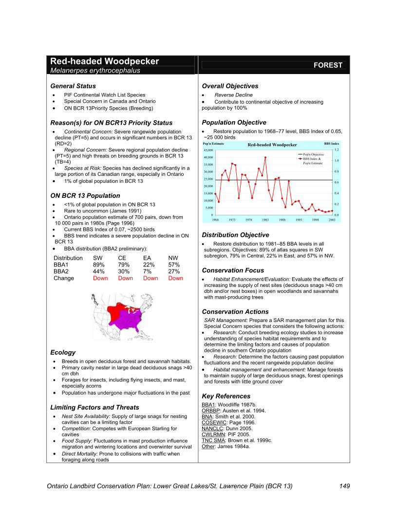
Ontario Landbird Conservation Plan: Lower Great Lakes/St. Lawrence Plain (BCR 13) 149
Red-headed Woodpecker Melanerpes erythrocephalus
FOREST
General Status � PIF Continental Watch List Species � Special Concern in Canada and Ontario � ON BCR 13Priority Species (Breeding)
Reason(s) for ON BCR13 Priority Status � Continental Concern: Severe rangewide population decline (PT=5) and occurs in significant numbers in BCR 13 (RD=2) � Regional Concern: Severe regional population decline (PT=5) and high threats on breeding grounds in BCR 13 (TB=4) � Species at Risk: Species has declined significantly in a large portion of its Canadian range, especially in Ontario � 1% of global population in BCR 13
ON BCR 13 Population � <1% of global population in ON BCR 13 � Rare to uncommon (James 1991) � Ontario population estimate of 700 pairs, down from 10 000 pairs in 1980s (Page 1996) � Current BBS Index of 0.07, ~2500 birds � BBS trend indicates a severe population decline in ON BCR 13 � BBA distribution (BBA2 preliminary):
Distribution SW CE EA NW BBA1 89% 79% 22% 57% BBA2 44% 30% 7% 27% Change Down Down Down Down
Ecology � Breeds in open deciduous forest and savannah habitats. � Primary cavity nester in large dead deciduous snags >40
cm dbh � Forages for insects, including flying insects, and mast,
especially acorns � Population has undergone major fluctuations in the past
Limiting Factors and Threats � Nest Site Availability: Supply of large snags for nesting
cavities can be a limiting factor � Competition: Competes with European Starling for
cavities � Food Supply: Fluctuations in mast production influence
migration and wintering locations and overwinter survival � Direct Mortality: Prone to collisions with traffic when
foraging along roads
Overall Objectives � Reverse Decline � Contribute to continental objective of increasing population by 100%
Population Objective � Restore population to 1968–77 level, BBS Index of 0.65, ~25 000 birds
Red-headed Woodpecker
0
5,000
10,000
15,000
20,000
25,000
30,000
35,000
40,000
45,000
1968 1973 1978 1983 1988 1993 1998 2003
Pop'n Estimate
0.0
0.2
0.4
0.6
0.8
1.0
1.2
BBS Index
Pop'n ObjectiveBBS Index &Pop'n Estimate
`
Distribution Objective � Restore distribution to 1981–85 BBA levels in all subregions. Objectives: 89% of atlas squares in SW subregion, 79% in Central, 22% in East, and 57% in NW.
Conservation Focus � Habitat Enhancement/Evaluation: Evaluate the effects of increasing the supply of nest sites (deciduous snags >40 cm dbh and/or nest boxes) in open woodlands and savannahs with mast-producing trees
Conservation Actions SAR Management: Prepare a SAR management plan for this Special Concern species that considers the following actions: � Research: Conduct breeding ecology studies to increase understanding of species habitat requirements and to determine the limiting factors and causes of population decline in southern Ontario population � Research: Determine the factors causing past population fluctuations and the recent rangewide population decline � Habitat management and enhancement: Manage forests to maintain supply of large deciduous snags, forest openings and forests with little ground cover
Key References BBA1: Woodliffe 1987b. ORBBP: Austen et al. 1994. BNA: Smith et al. 2000. COSEWIC: Page 1996. NANCLC: Dunn 2005. CWLRMN: PIF 2005. TNC SMA: Brown et al. 1999c. Other: James 1984a.

Ontario Landbird Conservation Plan: Lower Great Lakes/St. Lawrence Plain (BCR 13) 150
Red-shouldered Hawk Buteo lineatus
FOREST
General Status � PIF Continental Stewardship Species � Special Concern in Canada and Ontario � On BCR 13 Priority Species (Breeding)
Reason(s) for ON BCR13 Priority Status � Species at Risk: Population in Canada and Ontario
is relatively small but fairly stable, although considerably lower than historic status. Faces ongoing threats from urban expansion and cottage developments that fragment forest blocks (Badzinksi 2004; COSEWIC in prep.)
� BBS population trend in BCR 13 uncertain, tending downwards
� ~1% of global population in BCR 13
ON BCR 13 Population � <1% of global population in ON BCR 13 � Rare to locally uncommon (James 1991) � Current population estimate of about 5000 birds in
Ontario (COSEWIC in prep.), mostly in BCR12 � BBS population trend in ON BCR 13 is unknown � No significant long-term change (1991–2004) in
population detected by species-specific surveys covering core of Ontario range (Badzinski 2004)
� BBA distribution (BBA2 preliminary):
Distribution SW CE EA NW BBA1 8% 24% 35% 23% BBA2 7% 27% 36% 29% Change
Ecology � Area-sensitive (minimum of 10 ha but prefer
100+ ha) � Forest-obligate; favours extensive, mature, closed-
canopy, deciduous or mixed forest with little understorey, especially riparian and swamp forests
� Stick nest is often used for several years. May build alternative nest in same territory
Limiting Factors and Threats � Monitoring Needs: Not well sampled by BBS � Habitat Alteration: Vulnerable to forest management
practices that reduce the availability of extensive, mature, closed-canopy forests
� Competition: In the more fragmented landscapes of ON BCR13, this species is displaced and/or predated by Red-tailed Hawks and Great Horned Owls
Overall Objective � Assess Status
Population Objective � Periodically assess population status in southern Ontario (currently considered stable)
Distribution Objective � Maintain current breeding distribution in all subregions. Objectives: 7% of atlas squares in SW subregion, 27% in Central, 36% in East, and 29% in NW.
Conservation Focus � Habitat Protection: Maintain extensive tracts (>100 ha) of mature, closed-canopy, mixed or deciduous forest habitat with riparian and swamp forest habitats
Conservation Actions SAR Management: Prepare a SAR management plan for this Special Concern species that includes the following actions: � Monitoring: Continue to monitor population trends using combination of annual roadside playback survey in core of Ontario range (BCRs 13 and 12) and hawk watch migration counts (e.g., Grimsby, ON and Derby Hill, NY) � Monitoring: Every 5–10 years, assess status of entire Canadian breeding population of this species � Habitat Management: Update OMNR Habitat Management Guidelines for this species (James 1984b) and encourage stewardship organizations to promote use of these guidelines by private landowners
Key References BBA1: Weir 1987e. ORBBP: Austen et al. 1994. BNA: Crocoll 1994. COSEWIC: Draft status update 2004. NANCLC: Dunn 2005. TNC SMA: Peterson et al. 1995.

Ontario Landbird Conservation Plan: Lower Great Lakes/St. Lawrence Plain (BCR 13) 151
Rose-breasted Grosbeak Pheucticus ludovicianus
FOREST
General Status � ON BCR 13 Priority Species (Breeding)
Reason(s) for ON BCR13 Priority Status � Regional Stewardship: Rangewide population decline (PT=4), very high relative density (RD=5) and 5% of global population in BCR 13 � BBS population trend in BCR 13 uncertain; shows a pattern of increase followed by decline
ON BCR 13 Population � ~2% of global population in ON BCR 13 � Common (James 1991) � Current BBS Index of 3.4, ~100 000 birds � BBS population trend in ON BCR 13 uncertain � BBA distribution (BBA2 preliminary):
Distribution SW CE EA NW BBA1 90% 99% 100% 92% BBA2 96% 98% 97% 81% Change Up Down
Ecology � Breeds in wide range of primary and secondary, deciduous and mixed forests and thickets, including suburban settings � Nests typically located in forest openings
Limiting Factors and Threats � Habitat Loss: Maturation of forests may reduce nesting opportunities � Direct Exploitation: This neotropical migrant is captured on migration and on wintering grounds for the cage bird trade
Overall Objective � Maintain Current
Population Objective � Maintain current population, BBS Index of 3.4, ~100 000 birds
Distribution Objective � Maintain current distribution in subregions SW, CE and EA. Restore distribution in NW subregion. Objectives: 96% of atlas squares in SW subregion, 98% in Central, 97% in East and 92% in NW.
Conservation Focus � Monitoring: Re-evaluate change in distribution in NW subregion
Conservation Actions � Monitoring: Re-evaluate change in distribution in NW
subregion once BBA is complete � Research: Further research needed on impact of
forest fragmentation on productivity
Key References BBA1: Eagles 1987d. BNA: Wyatt and Francis 2002. NANCLC: Dunn 2005.
Rose-breasted Grosbeak
0
50,000
100,000
150,000
200,000
250,000
1968 1973 1978 1983 1988 1993 1998 2003
Pop'n Estimate
0.0
1.0
2.0
3.0
4.0
5.0
6.0
7.0
8.0
BBS Index
Pop'n ObjectiveBBS Index &Pop'n Estimate
`
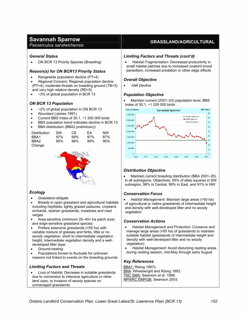
Ontario Landbird Conservation Plan: Lower Great Lakes/St. Lawrence Plain (BCR 13) 152
Savannah Sparrow Passerculus sandwichensis
GRASSLAND/AGRICULTURAL
General Status � ON BCR 13 Priority Species (Breeding)
Reason(s) for ON BCR13 Priority Status � Rangewide population decline (PT=4) � Regional Concern: Regional population decline (PT=4), moderate threats on breeding ground (TB=3) and very high relative density (RD=5) � ~3% of global population in BCR 13
ON BCR 13 Population � ~2% of global population in ON BCR 13 � Abundant (James 1991) � Current BBS Index of 30.1, ~1 200 000 birds � BBS population trend indicates decline in BCR 13 � BBA distribution (BBA2 preliminary):
Distribution SW CE EA NW BBA1 97% 99% 97% 87% BBA2 95% 98% 99% 90% Change
Ecology � Grassland-obligate � Breeds in open grassland and agricultural habitats including hayfields, lightly grazed pastures, cropland, orchards, riparian grasslands, meadows and road verges � Area-sensitive (minimum 20–40+ ha patch size) and edge-sensitive grassland species � Prefers extensive grasslands (>50 ha) with variable mixture of grasses and forbs, little or no woody vegetation, short to intermediate vegetation height, intermediate vegetation density and a well-developed litter layer � Ground-nesting � Populations known to fluctuate for unknown reasons not linked to events on the breeding grounds
Limiting Factors and Threats � Loss of Habitat: Decrease in suitable grasslands due to conversion to intensive agriculture or other land uses, or invasion of woody species on unmanaged grasslands
Limiting Factors and Threats (cont’d) � Habitat Fragmentation: Decreased productivity in small habitat patches due to increased cowbird brood parasitism, increased predation or other edge effects
Overall Objective � Halt Decline
Population Objective � Maintain current (2001–03) population level, BBS Index of 30.1, ~1 200 000 birds
Distribution Objective � Maintain current breeding distribution (BBA 2001–05) in all subregions. Objectives: 95% of atlas squares in SW subregion, 98% in Central, 99% in East, and 91% in NW.
Conservation Focus � Habitat Management: Maintain large areas (>50 ha) of agricultural or native grasslands of intermediate height and density with well-developed litter and no woody vegetation
Conservation Actions � Habitat Management and Protection: Conserve and manage large areas (>50 ha) of grasslands to maintain suitable habitat (grasslands of intermediate height and density with well-developed litter and no woody vegetation) � Habitat Management: Avoid disturbing nesting areas during nesting season, mid-May through early August
Key References BBA1: Rising 1987c. BNA: Wheelwright and Rising 1993. TNC SMA: Swanson et al. 1998. NPWRC EMPGB: Swanson 2003.
Savannah Sparrow
0
500,000
1,000,000
1,500,000
2,000,000
2,500,000
3,000,000
3,500,000
1968 1973 1978 1983 1988 1993 1998 2003
Pop'n Estimate
0
10
20
30
40
50
60
70
80
90
BBS Index
Pop'n ObjectiveBBS Index &Pop'n Estimate
`

Ontario Landbird Conservation Plan: Lower Great Lakes/St. Lawrence Plain (BCR 13) 153
Short-eared Owl Asio flammeus
GRASSLAND/AGRICULTURAL
General Status � PIF Continental Watch List Species � Special Concern in Canada and Ontario � ON BCR 13 Priority Species (Breeding amd Wintering)
Reason(s) for ON BCR13 Priority Status � Continental Concern for Winter Population: High threats
on wintering grounds (TN=4) and severe rangewide population decline (PT=5)
� Regional Concern for Wintering Population: High threats (TN=4), severe population decline (PT=5) and significant numbers (RD=2) on wintering grounds in BCR 13
� Species at Risk: Long-term, widespread decline in Canada, including Ontario, due to loss of preferred breeding and wintering habitat
� <1% of global population breeding or wintering in BCR 13
ON BCR 13 Population � <1% of global population in ON BCR 13 � Rare breeder; Uncommon wintering (James 1991) � Wintering population estimates not available � Current population in southern Ontario unknown, likely
<100 breeding pairs � BBS population trend in ON BCR 13 is unknown � BBA distribution (BBA2 preliminary):
Distribution SW CE EA NW BBA1 3% 7% 7% 1% BBA2 3% 5% 9% 5% Change
Ecology � Breeds and winters in large open grasslands or wetlands
including hayfields, idle pastures, alvars, wet meadows and marsh
� Area-sensitive (requires patches >100 ha but will use smaller patches if additional habitat nearby)
� Ground-nesting � Both diurnal and nocturnal; most active around dusk � During winter, will roost communally on the ground or in
trees or thickets � Nomadic behaviour in response to fluctuating food supply
(voles and other prey items)
Limiting Factors and Threats � Monitoring: Breeding and wintering populations are difficult
to monitor, as species is hard to detect and is nomadic, moving to areas with high prey availability
� Habitat Loss: Decrease in extent of suitable hayfields, pasture and open wetland habitats with abundant food supply
� Direct Mortality: Early haying of nesting area and collisions with vehicles, fences, power lines
Overall Objectives � Assess Status � Where possible, contribute to continental objective of
increasing population by 100%
Population Objectives � Determine status of breeding and wintering populations
Distribution Objective � Maintain current breeding distribution (BBA 2001–05) in all
subregions. Objectives: 3% of atlas squares in SW subregion, 5% in Central, 9% in East, and 5% in NW.
Conservation Focus � Habitat Management: Conserve and manage large areas of
grassland and open wetland, supporting high densities of voles
Conservation Actions SAR Management: Prepare a SAR management plan for this Special Concern species that considers the following actions: � Monitoring: Periodic surveys and assessments of the status
of breeding and wintering populations in southern Ontario � Research: Information needed on the demographics of
wintering and breeding populations in southern Ontario � Habitat Protection and Management: Conserve and
manage large (>100 ha) grassland and open wetland areas
Key References BBA1: Weir 1987f. ORBBP: Austen et al. 1994. BNA: Holt and Leasure 1993. COSEWIC: Cadman 1994. NANCLC: Dunn 2005. CWLRMN: PIF 2005. NPWRC: Dechant et al. 2003f. TNC SMA: Tate et al. 1997.

Ontario Landbird Conservation Plan: Lower Great Lakes/St. Lawrence Plain (BCR 13) 154
Vesper Sparrow Pooecetes gramineus
GRASSLAND/AGRICULTURAL
General Status � ON BCR 13 Priority Species (Breeding)
Reason(s) for ON BCR13 Priority Status � Rangewide population decline (PT=4) � Regional Management Interest: Severe regional
population decline (PT=5) and moderate threats on breeding grounds in BCR 13 (but total score 13)
� 1% of global population in BCR 13
ON BCR 13 Population � <1% of global population in ON BCR 13 � Common (James 1991) � Current BBS Index of 2.2, ~80 000 birds � BBS trend shows severe population decline in ON
BCR 13 � BBA distribution (BBA2 preliminary):
Distribution SW CE EA NW BBA1 91% 95% 86% 77% BBA2 78% 86% 59% 57% Change Down Down Down Down
Ecology � Grassland-obligate � Breeds in dry, short native and agricultural
grasslands, often interspersed with shrubs, trees or near forest edge as uses woody vegetation as singing perches. Also found in open conifer plantations, grain fields, pastures, hayfields and grassy road verges
� Ground-nesting
Limiting Factors and Threats � Loss of Habitat: Decrease in suitable habitat due to
conversion to intensive agriculture and natural succession of abandoned farmland
� Brood Parasitism: High rates of cowbird parasitism in some areas, particularly near habitat edges
Overall Objective � Halt Decline
Population Objective � Maintain current (2001–03) population level, BBS
Index of 2.2, ~80 000 birds
Distribution Objective � Maintain current breeding distribution (BBA 2001–
05) in all subregions. Objectives: 78% of atlas squares in SW subregion, 86% in Central, 59% in East, and 57% in NW.
Conservation Focus � Habitat Management: Maintain and manage for
suitable habitat for this species in grassland/ agricultural areas.
Conservation Actions � Habitat Management: Maintain supply of areas of
dry, sparse grassland vegetation with scattered woody vegetation
� Habitat Management: Identify and encourage sustainable land management practices that maintain the abundance and productivity of this species
Key References BBA1: Rising 1987d. BNA: Jones and Cornely 2002. NANCLC: Dale 2005, in Dunn 2005. NPWRC: Dechant et al. 2003g.
Vesper Sparrow
0
100,000
200,000
300,000
400,000
500,000
600,000
1968 1973 1978 1983 1988 1993 1998 2003
Pop'n Estimate
0
3
6
9
12
15
BBS Index
Pop'n ObjectiveBBS Index &Pop'n Estimate
`

Ontario Landbird Conservation Plan: Lower Great Lakes/St. Lawrence Plain (BCR 13) 155
Whip-poor-will Caprimulgus vociferus
FOREST; AERIAL-FORAGING INSECTIVORE
General Status � ON BCR 13 Priority Species (Breeding)
Reason(s) for ON BCR13 Priority Status � Regional Concern: Regional population decline
(PT=4), severe decline in distribution within ON BCR 13 and moderate threats on breeding grounds in BCR 13 (TB=3)
� Rangewide population decline (PT=4) � <1% of global population in BCR 13
ON BCR 13 Population � <1% of global population in ON BCR 13Rare to
uncommon (James 1991) � Current BBS Index of 0.02, ~2500 birds � BBS population trend in ON BCR 13 uncertain,
tending downwards � BBA distribution (BBA2 preliminary):
Distribution SW CE EA NW BBA1 23% 44% 56% 67% BBA2 10% 27% 35% 27% Change Down Down Down Down
Ecology � Breeds in dry deciduous or mixed forests with little
or no underbrush and an open canopy � Crepuscular aerial-foraging insectivore feeds on
moths and other flying insects � Ground-nesting
Limiting Factors and Threats � Monitoring Needs: Not well sampled by BBS � Research: Cause of population decline in Ontario
and elsewhere not known; possible factors include: � Decrease in food availability due to insect control
or other reasons o Increased nest predation near rural housing o Habitat loss (development or forest maturation) o Increased collisions with vehicles
Overall Objective � Reverse Decline
Population Objective � Restore population to 1968–77 level, BBS Index 0.18, ~20 000 birds
Distribution Objective � Restore distribution to 1981–85 levels in all
subregions. Objectives: 23% of atlas squares in SW subregion, 44% in Central, 56% in East, and 67% in NW.
Conservation Focus � Research: Determine cause of regional and
rangewide population decline, including impact of land use and food supply on breeding density, productivity and survivorship
Conservation Actions � Monitoring: Periodic crepuscular surveys needed to
determine abundance, distribution and assess status � Research: Determine cause of regional and
rangewide population decline
Key References BBA1: Mills 1987c. BNA: Cink 2002. NANCLC: Dunn 2005. TNC SMA: Brown et al. 1999d.
Whip-poor-will
0
10,000
20,000
30,000
40,000
50,000
60,000
70,000
80,000
1968 1973 1978 1983 1988 1993 1998 2003
Pop'n Estimate
0.0
0.1
0.2
0.3
0.4
0.5
0.6
BBS Index
Pop'n ObjectiveBBS Index &Pop'n Estimate
`

Ontario Landbird Conservation Plan: Lower Great Lakes/St. Lawrence Plain (BCR 13) 156
Willow Flycatcher Empidonax traillii
SHRUB/SUCCESSIONAL
General Status � PIF Continental Watch List Species � ON BCR 13 Priority Species (Breeding)
Reason(s) for ON BCR13 Priority Status � Continental Concern: Small global wintering range (ND=4) and rangewide population decline (PT=4) � Very high relative density in BCR 13 (RD=5) � ~6.5% of global population in BCR 13 � BBS long-term population trend in BCR 13 uncertain, tending upwards
ON BCR 13 Population � ~1.5% of global population in ON BCR 13 � Locally common (James 1991) � Current BBS Index of 1.6, ~50 000 bird � BBS trend shows strong population increase in ON BCR13 � Breeding range may be expanding northwards in Ontario (Sedgwick 2000; BBA2) � BBA distribution (BBA2 preliminary):
Distribution SW CE EA NW BBA1 94% 70% 52% 15% BBA2 91% 75% 60% 25% Change Up
Ecology � Breeds in deciduous shrublands, especially riparian thickets, wetland carrs and successional fields. Also common in abandoned farmland and low-lying areas � Feeds primarily on flying insects
Limiting Factors and Threats � Brood Parasitism: Cowbird parasitism a major concern for some populations elsewhere � Habitat Alteration: Potential for loss or degradation of riparian shrub habitats due to flood control measures or cattle grazing
Overall Objectives � Maintain Current � Where possible, contribute to continental objective of increasing population by 50%
Population Objective � Maintain population at or above current level, BBS Index 1.6, ~50 000 birds
Distribution Objective � Maintain current distribution based on BBA 2001–05 data. Objectives: 91% of atlas squares in SW subregion, 75% in Central, 60% in East, and 25% in NW.
Conservation Focus � Habitat Management: Maintain riparian and wetland shrub thicket habitat.
Conservation Actions � Habitat Management: Maintain and restore un-grazed riparian buffer strips with native shrubs along watercourses as habitat for this and other wet shrub species (and to improve water quality) � Research: Research needed on the winter and migration ecology of this species
Key References BBA1: Prescott 1987. BNA: Sedgwick 2000. NANCLC: Dunn 2005. CWLRMN: PIF 2005. TNC SMA: Paige et al. 1999.
Willow Flycatcher
0
10,000
20,000
30,000
40,000
50,000
60,000
70,000
1968 1973 1978 1983 1988 1993 1998 2003
Pop'n Estimate
0.0
0.3
0.6
0.9
1.2
1.5
1.8
2.1
2.4
BBS Index
Pop'n ObjectiveBBS Index &Pop'n Estimate
`

Ontario Landbird Conservation Plan: Lower Great Lakes/St. Lawrence Plain (BCR 13) 157
Wood Thrush Hylocichla mustelina
FOREST
General Status � PIF Continental Watch List Species � ON BCR 13 Priority Species (Breeding)
Reason(s) for ON BCR13 Priority Status � Continental Concern: Rangewide population decline
(PT=4), small wintering range (ND=4) and high threats on wintering grounds (TN=4)
� Regional Concern: Regional population decline (PT=4) and high relative density (RD=4) in BCR 13
� 6% of global population in BCR 13
ON BCR 13 Population � ~1% of global population in ON BCR 13 � Common (James 1991) � Current BBS Index of 2.7, ~160 000 birds � BBS population trend in ON BCR 13 uncertain � BBA distribution (BBA2 preliminary):
Distribution SW CE EA NW BBA1 94% 93% 97% 63% BBA2 96% 94% 92% 63% Change Down
Ecology � Area-sensitive; forest-obligate � Breeds in upland deciduous and mixed forests with
moderate to dense understorey � Breeds in woodlands as small as 5 ha, but large
patches support higher densities and generally have higher productivity
Limiting Factors and Threats � Habitat Fragmentation and Alteration: Reduced
productivity due to fragmentation and degradation (increased predators and parasitism) of forest habitat on breeding grounds
� Habitat Loss: Loss of forest habitat on breeding and wintering grounds a concern
Overall Objectives � Maintain Current � Where possible, contribute to continental objective
of increasing population by 50%
Population Objective � Maintain population at or above current level, BBS
Index 2.7, ~160 000 birds
Distribution Objective � Restore BBA distribution to 1981–85 level in EA
subregion and maintain current levels in all other subregions. Objectives: 96% of atlas squares in SW subregion, 94% in Central, 97% in East, and 63% in NW.
Conservation Focus � Habitat Management: Forest planning and
management to maintain supply of upland deciduous or mixed forest with dense understorey
Conservation Actions � Habitat Restoration: Promote ecologically sound,
strategic forest restoration projects that increase forest cover and reduce forest fragmentation in landscapes with less than 30% regional forest cover
� Planning: Discourage construction of rural housing in and adjacent to forested areas
� Outreach: Encourage use of silvicultural practices that protect habitat for this species and other area-sensitive forest birds (Roseburg et al. 2003)
Key References BBA1: Sadler 1987. BNA: Roth et al.1996. NANCLC: Dunn 2005. TNC SMA: Sallabanks et al. 1993c. Other: Rosenberg et al. 2003.
Wood Thrush - Breeding Birds
0
50,000
100,000
150,000
200,000
250,000
300,000
1968 1973 1978 1983 1988 1993 1998 2003
Pop'n EstimateObjective

Ontario Landbird Conservation Plan: Lower Great Lakes/St. Lawrence Plain (BCR 13) 158
Yellow-breasted Chat Icteria virens
SHRUB/SUCCESSIONAL
General Status � Special Concern in Canada and Ontario � ON BCR 13 Priority Species (Breeding)
Reason(s) for ON BCR13 Priority Status � Apparent severe regional population decline (PT=5) and high threats (TB=4) in BCR 13, where it is a rare breeding species (RD=1) � SAR Species: Special Concern Status in Ontario and Canada � <1% of global population in BCR 13
ON BCR 13 Population � <1% of global population in ON BCR 13 � Rare, local breeder in SW subregion of ON BCR 13 � Ontario population estimate of 30 to 60 pairs (Cadman and Page 1994), but the current population may be much lower (B. Crins, D.A. Sutherland, OMNR, pers. comm. 2005) � BBS population trend in ON BCR 13 unknown; other evidence indicates recent decline (D.A. Sutherland, OMNR, pers. comm. 2005) � BBA distribution (BBA2 preliminary):
Distribution SW CE EA NW BBA1 15% 2% 0% 0% BBA2 9% 0% 0% 0% Change Down
Ecology � Nests close to ground in dense shrub thickets or tangles along woodland edges, and in forest gaps, riparian areas and hedgerows � Forages for insects and berries � Able to colonize small, short-lived patches of suitable habitat � Local populations are often small and sporadic, and are hard to monitor because of cryptic nature of the species
Limiting Factors and Threats (cont’d) � Monitoring: Ontario population not monitored by BBS � Habitat Loss: Reduction in dense shrub and early successional habitat due to natural succession and reforestation � Brood Parasitism: High rates of cowbird parasitism observed elsewhere but low impact on productivity
Overall Objective � Assess Status
Population Objective � Determine population status and maintain population at or above current levels
Distribution Objective � Restore distribution to 1981–85 levels. Objectives: 15% of atlas squares in SW subregion and 2% in Central subregion.
Conservation Focus � Habitat Management: Assess feasibility of managing for dense shrub thicket habitat at known breeding sites in ON BCR 13
Conservation Actions SAR Management: Prepare a SAR management plan for this Special Concern species that considers the following actions: � Monitoring: Periodically assess species status in Ontario and Canada (every 5 years) � Monitoring: Develop and implement a species-specific monitoring protocol, including periodic monitoring of known sites and other areas with suitable habitat in southern Ontario � Habitat Management: Assess feasibility of restoring dense shrub habitat at former breeding sites (e.g., in Point Pelee NP) to support this and other shrub species � Research: Identify possible factors causing declines and/or limiting population growth
Key References BBA1: Eagles 1987a. ORBBP: Austen et al. 1994. BNA: Eckerle and Thompson 2001. COSEWIC: Cadman and Page 1994. NANCLC: Dunn 2005. TNC SMA: Thompson et al.1996.

Ontario Landbird Conservation Plan: Lower Great Lakes/St. Lawrence Plain (BCR 13) 159
Conservation efforts for waterfowl, waterbirds and shorebirds often focus on wetlands and surrounding landscapes. These efforts can be effective in aiding wetland-associated landbirds too. In the interests of promoting all-bird conservation, Table G1 shows which of the priority landbirds in BCR 13 stand to benefit most from conservation of wetlands in southern Ontario. In addition, southern Ontario wetlands are very important to swallows, martins and blackbirds, as post-breeding roosts (marshes, swamp thickets) serve as concentration areas for hordes of passing migrants (especially lakeshore wetlands) and provide essential foraging sites for swallows on cold days early in the breeding season (wetlands with open water).
Table G1: Wetland-associated priority landbirds in BCR 13.
Species Wetland Habitats and Associated
Landscape Settings Used by Priority Landbirds
Seasonal Usage
Acadian Flycatcher Swamp forest, riparian Breeding Bald Eagle Lakeshore, riparian Breeding, Wintering, Migration Baltimore Oriole Riparian habitats Breeding Bank Swallow Riparian, lakeshore Breeding Belted Kingfisher Riparian, lakeshore Breeding, Migration Blue-winged Warbler Swamp thicket, riparian Breeding, Migration Canada Warbler Swamp forest, riparian Breeding, Migration Cerulean Warbler Swamp forest Breeding
Eastern Kingbird Marsh edges, treed bog, treed fens, lakeshore Breeding, Migration
Golden-winged Warbler Swamp thicket Breeding, Migration Henslow’s Sparrow Wet meadows/fields Breeding Louisiana Waterthrush Swamp forest, riparian Breeding Northern Harrier Marsh, wet meadows, fens Breeding, Wintering, Migration Peregrine Falcon Lakeshore, marsh Migration Prothonotary Warbler Swamp forest Breeding Red-shouldered Hawk Swamp, riparian, lakeshore Breeding, Migration? Short-eared Owl Marsh, wet meadows, fens Breeding, Wintering, Migration Willow Flycatcher Swamp thicket, riparian Breeding, Migration
Notes: “Wetland” includes: marsh, swamp forest, swamp thicket (carr), bog, fen, wet meadow and shallow open water. Many of these wetlands occur in riparian or lakeshore settings. See species accounts (Appendix F) for further information on habitat needs.
Appendix G: Wetland-associated Priority Landbirds in Ontario BCR 13

Ontario Landbird Conservation Plan: Lower Great Lakes/St. Lawrence Plain (BCR 13) 160
Huge numbers of migrating landbirds funnel through southern Ontario every spring and fall. The conservation implications of these large concentrations of landbirds are twofold: � The quantity, quality and distribution of migratory stopover habitat in BCR 13 is of critical
importance to the conservation of migratory landbirds breeding in more northern BCRs, including several Species of Continental Importance (Rich et al. 2004); and
� Many landbirds that are not adequately monitored by the BBS or otherwise (Rich et al. 2004) are monitored at migration monitoring stations in southern Ontario.
Landbird Migratory Stopover Areas All habitats in southern Ontario provide shelter and food for landbirds during migration. Forest, shrubland, grassland and wetland habitats within 2–10 km of Great Lakes shorelines, especially along the north shores of lakes Erie and Ontario, are considered particularly important as rest stops and refuelling areas as they consistently support the highest concentrations and highest diversity of migrants (OMNR 2000). Many migrating grassland birds feed in agricultural fields, especially no-till croplands (Boutin et al. 1999, Best et al. 2001). Linear features such as riparian corridors and the ribbon of forest along the Niagara Escarpment form natural corridors for migrating landbirds (OMNR 2000a).
Twenty PIF Species of Continental Importance (Rich et al. 2004) that breed mainly in boreal and boreal transition forests to the north of BCR 13 migrate through southern Ontario in substantial numbers (Box H1). Most of these species are neotropical migrants.
Migration Monitoring Some 48 small landbird species with continentally important gaps in monitoring coverage (Mo3 species in Rich et al. 2004) are monitored at Canadian Migration Monitoring Network (CMMN) stations in southern Ontario, according to a 1999 analysis that included data from four CMMN stations in Ontario BCR 13 (Badzinski and Francis 2000) (Box H2). Most of these species are neotropical migrants. The coverage analysis requires updating to include data from additional CMMN stations in this region.
Nine raptor species with continentally important gaps in monitoring coverage are counted at hawk watch stations in southern Ontario (www.hmana.org).
Appendix H: Importance of Ontario BCR 13 to Landbirds during Migration
Box H1: PIF Species of Continental Importance that breed mainly in boreal forests to the north of BCR 13 and migrate through BCR 13 in substantial numbers. PIF Watch List species: Bay-breasted Warbler Canada Warbler Rusty Blackbird PIF Stewardship Species: Yellow-bellied Sapsucker Yellow-bellied Flycatcher Alder Flycatcher Blue-headed Vireo Philadelphia Vireo Tennessee Warbler
Nashville Warbler Chestnut-sided Warbler Magnolia Warbler Cape May Warbler Black-throated Green Warbler Blackburnian Warbler
Palm Warbler Mourning Warbler Lincoln's Sparrow Swamp Sparrow White-throated Sparrow
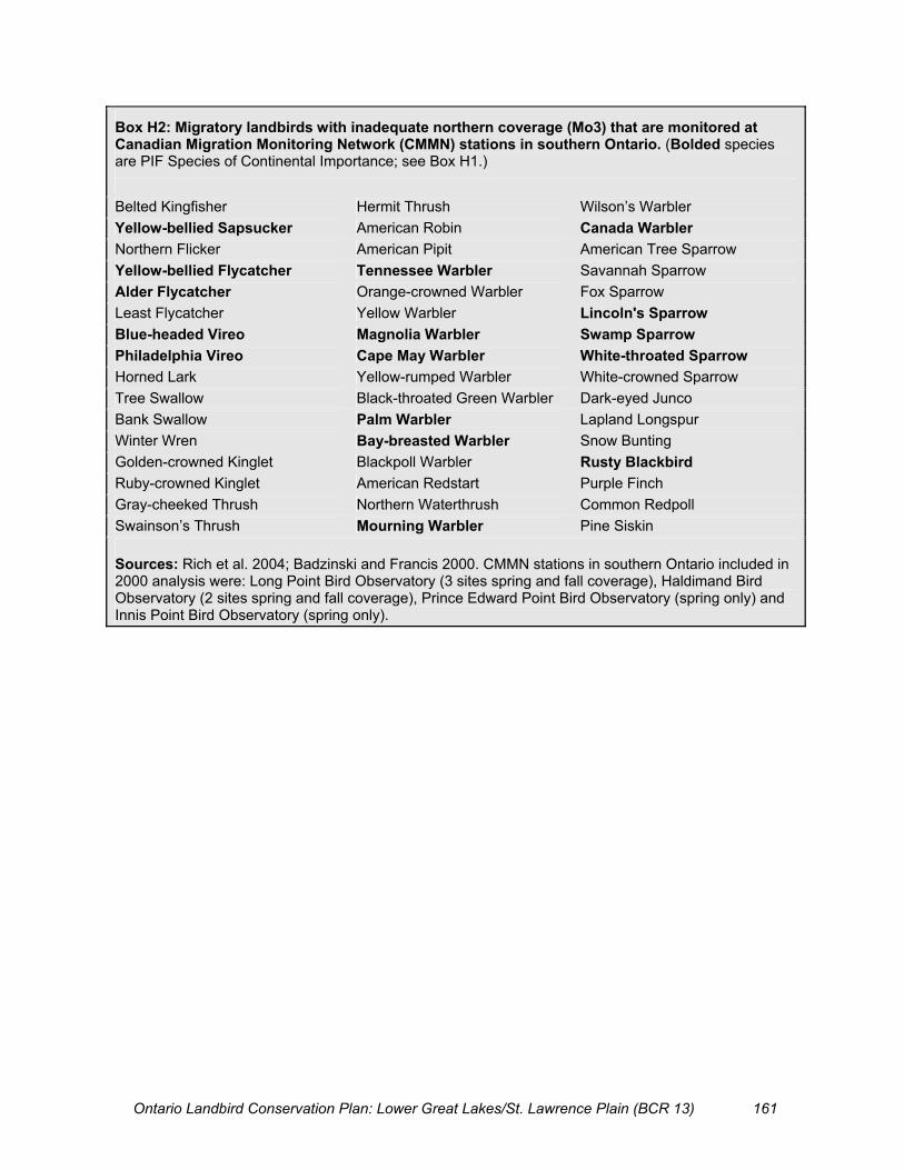
Ontario Landbird Conservation Plan: Lower Great Lakes/St. Lawrence Plain (BCR 13) 161
Box H2: Migratory landbirds with inadequate northern coverage (Mo3) that are monitored at Canadian Migration Monitoring Network (CMMN) stations in southern Ontario. (Bolded species are PIF Species of Continental Importance; see Box H1.) Belted Kingfisher Hermit Thrush Wilson’s Warbler Yellow-bellied Sapsucker American Robin Canada Warbler Northern Flicker American Pipit American Tree Sparrow Yellow-bellied Flycatcher Tennessee Warbler Savannah Sparrow Alder Flycatcher Orange-crowned Warbler Fox Sparrow Least Flycatcher Yellow Warbler Lincoln's Sparrow Blue-headed Vireo Magnolia Warbler Swamp Sparrow Philadelphia Vireo Cape May Warbler White-throated Sparrow Horned Lark Yellow-rumped Warbler White-crowned Sparrow Tree Swallow Black-throated Green Warbler Dark-eyed Junco Bank Swallow Palm Warbler Lapland Longspur Winter Wren Bay-breasted Warbler Snow Bunting Golden-crowned Kinglet Blackpoll Warbler Rusty Blackbird Ruby-crowned Kinglet American Redstart Purple Finch Gray-cheeked Thrush Northern Waterthrush Common Redpoll Swainson’s Thrush Mourning Warbler Pine Siskin Sources: Rich et al. 2004; Badzinski and Francis 2000. CMMN stations in southern Ontario included in 2000 analysis were: Long Point Bird Observatory (3 sites spring and fall coverage), Haldimand Bird Observatory (2 sites spring and fall coverage), Prince Edward Point Bird Observatory (spring only) and Innis Point Bird Observatory (spring only).

Ontario Landbird Conservation Plan: Lower Great Lakes/St. Lawrence Plain (BCR 13) 162
Count data from all Breeding Bird Survey (BBS) routes within Ontario BCR 13 were used to establish population abundance objectives for 26 of the 42 priority species and the four priority guilds (Table I1). All population indices were converted to population estimates to show the magnitude of population change needed to reach objectives. These estimates are derived from BBS indices using methods described in Rich et al. (2004, Appendix B). Table I1 presents the BBS sample size, abundance objective, a measure of the standard deviation (precision) of the objective, the estimated population size at the objective and an accuracy rating of the population estimate for the 26 priority species with BBS-based population objectives. The BBS sample size and abundance objectives for the four priority guilds are also included in Table I1. Accuracy ratings (Moderate, Fair, Poor, Very Poor) for the estimated population sizes at abundance objectives were assigned using methods outlined in Rich et al. (2004, Appendix B). These ratings are based on species-specific survey sample sizes, number of birds detected on surveys, variance in counts across BBS routes within southern Ontario and diurnal activity level (i.e., lower accuracy for primarily nocturnal species). BBS-based abundance objectives were not set for 16 priority species, including 10 species listed as Endangered or Threatened federally and/or in Ontario (objectives set through SAR recovery strategies), and six species that occur at low densities in southern Ontario and are not adequately monitored by the BBS. Five of these six unmonitored species are currently designated as Special Concern. Under SARA regulations, the population status of current and former Special Concern species must be reassessed at least every 10 years. The population status of the other species, Prairie Warbler, is also periodically assessed, as it was formerly designated as of Special Concern. Explanatory Notes for Table I1 BBS Routes: � Trends 68–03: Number of BBS routes in Southern Ontario with trends for 1968–2003 period � 1990s: Number of BBS routes in Southern Ontario with abundance data for 1990s
BBS Index: � Objective: BBS-based population abundance objective � St. Error: Standard Error, a measure of the standard deviation (precision) of the population
abundance objective Estimated Population Size � At Objective: Estimate of the magnitude of the population (number of breeding birds) in southern
Ontario at the abundance objective level � Accuracy: A rating of the accuracy of the population estimate
Appendix I: Accuracy and Precision of Population Abundance Objectives and Estimated Population Size for Priority Species Breeding in Ontario BCR 13

Ontario Landbird Conservation Plan: Lower Great Lakes/St. Lawrence Plain (BCR 13) 163
Table I1: BBS sample size, BBS objective and standard error, estimated population size and accuracy rating for priority species in Ontario BCR 13.
BBS Routes BBS Index Estimated Population Size Priority Species
Trends ’68–03 1990s Objective St. Error
At Objective Accuracy
Northern Harrier 57 47 0.45 0.07 4 000 Fair
American Kestrel 60 51 0.59 0.13 20 000 Fair
Black-billed Cuckoo 60 50 1.4 0.08 60 000 Moderate
Whip-poor-will 16 4 0.18 0.05 20 000 Very Poor
Chimney Swift 45 31 1.7 0.18 60 000 Fair / Poor
Belted Kingfisher 54 47 0.89 0.07 30 000 Fair
Red-headed Woodpecker 37 22 0.65 0.08 25 000 Poor
Northern Flicker 62 58 6.5 0.20 250 000 Moderate
Eastern Wood-Pewee 62 57 4.0 0.14 120 000 Moderate
Willow Flycatcher 47 41 1.6 0.06 50 000 Moderate
Eastern Kingbird 63 59 7.2 0.29 200 000 Moderate
Bank Swallow 52 47 22.1 1.66 600 000 Poor
Wood Thrush 60 54 2.7 0.20 160 000 Moderate
Brown Thrasher 61 56 5.9 0.29 200 000 Moderate
Blue-winged Warbler 14 11 0.08 0.01 2 500 Poor
Golden-winged Warbler 18 12 0.13 0.01 5 000 Poor
Canada Warbler 18 12 0.10 0.01 3 000 Poor
Eastern Towhee 48 36 0.90 0.07 30 000 Fair
Field Sparrow 60 52 3.0 0.19 80 000 Moderate
Vesper Sparrow 62 57 2.2 0.01 80 000 Moderate
Savannah Sparrow 63 59 30.1 3.13 1 200 000 Moderate
Grasshopper Sparrow 47 33 0.89 0.08 30 000 Poor
Rose-breasted Grosbeak 62 57 3.4 0.15 100 000 Moderate
Bobolink 63 59 26.0 2.44 1 000 000 Moderate
Eastern Meadowlark 62 58 13.1 1.06 120 000 Moderate
Baltimore Oriole 62 58 9.8 0.59 250 000 Moderate
Guilds:
Forest Associated Spp. 63 59 62.5 0.86
Grassland Associated Spp. 63 59 75.5 1.47
Shrub Associated Spp. 63 59 95.2 0.69
Aerial-foraging Insectivores 63 59 24.0 0.99

Ontario Landbird Conservation Plan: Lower Great Lakes/St. Lawrence Plain (BCR 13) 164
Trend Monitoring Objectives Objective 1: For at least 80% of landbirds breeding regularly in ON BCR 13 (Relative Density >1): � 80% power to detect 50% decline over 20 years within ON BCR 13; or � 80% power to detect 50% decline over 20 years in eastern BBS range AND less precise
trend available for ON BCR 13 (df>5). The objective of attaining 80% power to detect a 50% decline at P<0.1 (two-tailed) incorporates a 0.8%/year estimate of potential bias, following the approach suggested by Bart et al. 2004. Evaluation: Current monitoring coverage of all landbirds regularly breeding in southern Ontario was evaluated using BBS data from southern Ontario and in eastern North America (Table J2). Power estimates used species-specific variance from past BBS trends as the basis for predicting trend variance, and power, of future trends. Variance for eastern North America was taken from 1966–2003 BBS trends; for southern Ontario we used 1983–2003 BBS trends. Of the 113 breeding landbirds with Relative Density (RD) score of 2 or more in ON BCR 13: � 33 species have trends with �80% power to detect 50% decline in 20 years in ON BCR 13; � 29 species have trends with 50–80% power to detect 50% decline in 20 years in ON BCR 13; and � 36 species have trends with <50% power in ON BCR 13, but �80% power in eastern North
America. Objective 1 is met (87% of regularly breeding landbirds have trends of sufficient power). Proposed Actions � Maintain BBS coverage at current participation level in southern Ontario (63 BBS routes with
usable trend data, 61 in the past 20 years), adding one route in NW subregion if feasible (there are currently five routes with trend data in NW).
� Continue active recruitment and training of new BBS volunteers to replace retiring participants. � Measure bias in landscape/habitat coverage by BBS routes across southern Ontario.
Of the remaining 15 species (13%) not meeting the Monitoring Objective 1 power criteria: � Six have imprecise trends in southern Ontario and in eastern North America (Ruffed Grouse, Wild
Turkey, Sharp-shinned Hawk, Winter Wren, Marsh Wren, Nashville Warbler); � Four are hawks that are counted at migration hawk watch sites (Sharp-shinned Hawk, Coopers
Hawk, Northern Goshawk, Merlin); � Four are forest species with some Forest Bird Monitoring Program (FBMP) trend data (Brown
Creeper, Winter Wren, Nashville Warbler, Cerulean Warbler) and one is a Wetland species with some Marsh Monitoring (MMP) trend data (Marsh Wren);
� Three are listed Species at Risk (SARs) in Canada and Ontario (Cerulean Warbler, Louisiana Waterthrush, Henslow’s Sparrow), subject to periodic status reassessments; and
� Two are owls (Long-eared Owl, Eastern Screech-Owl).
Appendix J: Evaluation of Current Monitoring Coverage for Landbirds in Ontario BCR 13, and Proposed Monitoring-related Actions

Ontario Landbird Conservation Plan: Lower Great Lakes/St. Lawrence Plain (BCR 13) 165
Proposed Actions � Evaluate adequacy of trends from migration hawk watches to track Sharp-shinned Hawk, Cooper’s
Hawk, Northern Goshawk and Merlin in southern Ontario. � Evaluate adequacy of trends from Forest Bird Monitoring and Marsh Bird Monitoring to track
Brown Creeper, Winter Wren, Nashville Warbler, Cerulean Warbler (FBMP) and Marsh Wren (MMP) in southern Ontario.
� Rely on Breeding Bird Atlases at 20-year intervals to track owl populations and to validate population changes in species with trends from BBS, migration monitoring, FBMP and MMP.
� Assess ability of Christmas Bird Counts to track Long-eared Owl populations in southern Ontario. Objective 2: Maintain current precision of BBS population abundance indices for all Priority Species and Priority Guilds that use BBS indices as the basis for population abundance objectives. Evaluation: BBS-based population abundance objectives are set for 26 of the 32 priority species that are not the subject of SAR recovery strategies. The current precision of these indices (and the accuracy of the associated population estimates) is presented in Appendix I. Proposed Action � Continue current BBS coverage in southern Ontario (as above).
Objective 3: Periodic status assessments (at least every five years) for all other Priority Species not currently tracked by BBS. Of the 16 priority landbirds without BBS-based population abundance objectives: � Ten species are listed as Endangered or Threatened federally and/or in Ontario, with objectives set
through SAR recovery programs as required (Northern Bobwhite, Bald Eagle, Peregrine Falcon, Barn Owl, Acadian Flycatcher, Loggerhead Shrike, Kirtland’s Warbler, Prothonotary Warbler, Hooded Warbler, Henslow’s Sparrow);
� Five species are currently listed as Special Concern federally and/or in Ontario (Red-shouldered Hawk, Short-eared Owl, Cerulean Warbler, Louisiana Waterthrush, Yellow-breasted Chat); and
� One species (Prairie Warbler) occurs at low density in the Ontario portion of BCR 13 and was formerly listed as Special Concern.
Proposed Action � Ensure that all these species are assessed regularly (at least every five years) to track changes in
population status and threats. Objective 4: Contribute to rangewide monitoring for species poorly monitored at continental level by conducting non-breeding season monitoring to detect trends in migrants and wintering species, especially PIF Species of Continental Importance (Rich et al. 2004). � Conduct migration monitoring and/or winter surveys (e.g., CBC) to detect trends in
poorly monitored species breeding farther north. Evaluation: At least 48 species of small landbirds with continentally important gaps in monitoring coverage (Mo3 species in Rich et al. 2004) are monitored during migration through southern Ontario. An additional nine poorly monitored raptor species are counted regularly at hawk watch stations in

Ontario Landbird Conservation Plan: Lower Great Lakes/St. Lawrence Plain (BCR 13) 166
southern Ontario. Twenty PIF Species of Continental Importance (Rich et al. 2004) that breed mainly in boreal and boreal transition forests to the north of BCR 13 are currently monitored at migration monitoring stations in southern Ontario. See Appendix H for details. Proposed Actions � Maintain current network of migration monitoring stations in southern Ontario, regularly
assessing population trends. � Update 1999 assessment of those landbird species that are adequately tracked through
migration monitoring at each station in southern Ontario. � Develop means for combining migration trends across network of stations, making use of the
results of recent isotope analyses to guide stratification of stations. � Use results of comprehensive trend analysis for Christmas Bird Counts (currently underway)
to guide actions with respect to CBC in southern Ontario. Distribution Objective Objective 5: For all landbirds breeding in ON BCR 13: � Maintain ability to detect 15% change in size of breeding range at intervals of 20 years for
at least 80% of landbirds with Relative Density >1 (15% decline matches PIF PT = 4 criterion);
� Develop ability to detect 50% change in size of breeding range (PT= 5) for all priority species including those with Relative Density = 1 (relatively rare in southern Ontario).
Evaluation: A comparison of the preliminary results of the current Breeding Bird Atlas (2001–04 data) with the results of the first atlas (1981–85) indicates that of the 113 breeding landbird species with RD>1: � 15% declines and/or increases would have been detected at P<0.1 in 95 species in southern
Ontario. The first part of Objective 5 is met (distribution changes can be detected for 84% of regularly breeding landbirds; see Table J1). Of the 42 priority landbirds, 36 meet the distribution monitoring objective, as follows: � 15% declines and/or increases would have been detected at P<0.1 in 26 species; � 50% declines and/or increases would have been detected at P<0.1 in an additional 10
species (with the exception of Blue-winged Warbler, all these species are listed Species at Risk);
� 50% declines or increases would not have been detected at P<0.1 in six species. Five of these are listed Endangered species in Ontario (Bald Eagle, Barn Owl, Kirtland’s Warbler, Peregrine Falcon, Prothonotary Warbler); Prairie Warbler is unlisted.
Proposed Actions � Continue to repeat Breeding Bird Atlases at 20-year intervals, aiming to achieve at least the
same level of coverage as attained in 2001–04 of the current atlas. � Additional periodic distributional surveys are needed to supplement information on rare
priority species, including listed Species at Risk, as well as rarer shrub-nesting species – Prairie Warbler, and possibly Blue-winged Warbler and Golden-winged Warbler.

Ontario Landbird Conservation Plan: Lower Great Lakes/St. Lawrence Plain (BCR 13) 167
Demographic Objective Objective 6: Productivity, survival and fidelity tracked for species or study areas of high management concern or interest. This plan does not set any demographic objectives, but demographic research is a proposed conservation action for many of the priority species (see species accounts in Appendix F). Proposed Actions � Assess the value and feasibility of setting demographic objectives for priority species or study
areas of high management concern or interest. Habitat Monitoring Objective Objective 7: Measure and report changes in general land cover and land use, for the entire planning area, at regular intervals (c. five years), ensuring data are directly comparable among time periods. This plan does not set specific habitat objectives for priority species of guilds, primarily because suitable habitat data are not available. Many of the proposed conservation actions for priority species involve research into species habitat requirements to provide a basis for setting habitat objectives in the future (see species accounts in Appendix F). Proposed Actions � Identify or develop land cover, land use and habitat monitoring program (e.g., Ontario Land
Cover mapping, Agricultural Census data, Forest Resource Inventory, wetland mapping, Ecological Land Classification mapping) that could be used to set and measure habitat objectives for priority species and guilds.
� Investigate the feasibility of using information on land use change and/or disturbance rates (urban development, farmland retirement, extent of prescribed burns and wildfires, extent of intensive logging, right-of-way management activities) as surrogate measures for monitoring shrub/successional habitat.

Ontario Landbird Conservation Plan: Lower Great Lakes/St. Lawrence Plain (BCR 13) 168
Explanatory Notes for Table J1 Bold = Priority species in ON BCR 13; [species in square brackets] = introduced species; Italics = species with Relative Density in Ontario BCR 13 of <2 during the breeding season (see Appendix C for an explanation of Relative Density). ON B13 RD>1 – Yes: Indicates Relative Density (RD) score of 2 or higher in Ontario BCR 13; these species are the target of monitoring objectives. ON B13 BBS Trend – Power of the Breeding Bird Survey (1968–2003) to measure population trends within southern Ontario. Yes: �80% power to detect 50% decline in 20 years at P�0.1 in Ontario BCR 13; Y: �50% power; (y): trend calculated, but with <50% power to detect 50% decline in 20 years in Ontario. East NA BBS Trend – Power of the Breeding Bird Survey (1968–2003) to measure population trends within eastern North America. Yes: �80% power to detect 50% decline in 20 years at P�0.1 in eastern North America; Y: �50% power; (y): trend calculated, but with <50% power to detect 50% decline in 20 years in eastern North America. ON B13 Atlas Dist. – Power of the Breeding Bird Atlases (1981–85 and 2001–05) to measure changes in breeding distribution in southern Ontario. Yes: �15% increase and/or decrease in squares with breeding evidence detectable between atlases in Ontario BCR 13; Y: �50% increase and/or decrease detectable; (y): larger increases/decreases may be detectable. *Kirtland’s Warbler: Trend in eastern North American known from intensive surveys and banding programs on the breeding grounds in Michigan.

Ontario Landbird Conservation Plan: Lower Great Lakes/St. Lawrence Plain (BCR 13) 169
Table J1: Monitoring coverage of landbirds breeding in Ontario BCR 13.
Common Name ON BCR13 RD>1
ON BCR13 BBS Trend
East NA BBS Trend
ON BCR13 BBA Dist.
[Gray Partridge] (y) Y [Ring-necked Pheasant] Yes (y) Yes Yes Ruffed Grouse Yes (y) (y) Yes [Sharp-tailed Grouse] (y) (y) Wild Turkey Yes (y) (y) Y Northern Bobwhite (y) Yes Y Turkey Vulture Yes (y) Yes Yes Osprey Yes (y) Yes Y Bald Eagle (y) (y) Northern Harrier Yes Y Yes Yes Sharp-shinned Hawk Yes (y) (y) Yes Cooper's Hawk Yes (y) Y Northern Goshawk Yes (y) Y Red-shouldered Hawk Yes Yes Broad-winged Hawk Yes (y) Yes Yes Red-tailed Hawk Yes Y Yes Yes American Kestrel Yes Y Yes Yes Merlin Yes (y) Y Peregrine Falcon (y) [Rock Pigeon] Yes Yes Yes Yes Mourning Dove Yes Yes Yes Yes Black-billed Cuckoo Yes Y Yes Yes Yellow-billed Cuckoo Yes (y) Yes Yes Barn Owl (y) Eastern Screech-Owl Yes (y) Yes Great Horned Owl Yes (y) Yes Yes Barred Owl Yes Y Long-eared Owl Yes Y Short-eared Owl Y Northern Saw-whet Owl Yes Common Nighthawk (y) Yes Yes Whip-poor-will Yes (y) Yes Yes Chimney Swift Yes (y) Yes Yes Ruby-throated Hummingbird Yes (y) Yes Yes Belted Kingfisher Yes Y Yes Yes Red-headed Woodpecker Yes (y) Yes Yes Red-bellied Woodpecker (y) Yes Y Yellow-bellied Sapsucker Yes (y) Yes Yes Downy Woodpecker Yes Yes Yes Yes Hairy Woodpecker Yes Y Yes Yes Northern Flicker Yes Yes Yes Yes Pileated Woodpecker Yes (y) Yes Yes Olive-sided Flycatcher Yes Y Eastern Wood-Pewee Yes Yes Yes Yes Yellow-bellied Flycatcher Yes Y

Ontario Landbird Conservation Plan: Lower Great Lakes/St. Lawrence Plain (BCR 13) 170
Common Name ON BCR13 RD>1
ON BCR13 BBS Trend
East NA BBS Trend
ON BCR13 BBA Dist.
Acadian Flycatcher Yes Y Alder Flycatcher Yes Y Yes Yes Willow Flycatcher Yes Y Yes Yes Least Flycatcher Yes Y Yes Yes Eastern Phoebe Yes Yes Yes Yes Great Crested Flycatcher Yes Yes Yes Yes Eastern Kingbird Yes Yes Yes Yes Loggerhead Shrike (y) Yes Y White-eyed Vireo Yes Y Yellow-throated Vireo Yes (y) Yes Yes Blue-headed Vireo Yes (y) Yes Y Warbling Vireo Yes Yes Yes Yes Philadelphia Vireo (y) Y Red-eyed Vireo Yes Yes Yes Yes Blue Jay Yes Yes Yes Yes American Crow Yes Yes Yes Yes Common Raven Yes (y) Yes Y Horned Lark Yes Y Yes Yes Purple Martin Yes Y Yes Yes Tree Swallow Yes Yes Yes Yes Northern Rough-winged Swallow Yes Y Yes Yes Bank Swallow Yes (y) Yes Yes Cliff Swallow Yes Y Yes Yes Barn Swallow Yes Yes Yes Yes Black-capped Chickadee Yes Yes Yes Yes Tufted Titmouse Yes Y Red-breasted Nuthatch Yes (y) Yes Yes White-breasted Nuthatch Yes Y Yes Yes Brown Creeper Yes (y) (y) Yes Carolina Wren Yes Y House Wren Yes Yes Yes Yes Winter Wren Yes (y) (y) Yes Sedge Wren Yes (y) Yes Y Marsh Wren Yes (y) (y) Yes Golden-crowned Kinglet (y) Y Ruby-crowned Kinglet Yes Y Blue-gray Gnatcatcher (y) Yes Yes Eastern Bluebird Yes (y) Yes Yes Veery Yes Yes Yes Yes Swainson's Thrush Yes Y Hermit Thrush Yes (y) Yes Y Wood Thrush Yes Y Yes Yes American Robin Yes Yes Yes Yes Gray Catbird Yes Yes Yes Yes Northern Mockingbird (y) Yes Y Brown Thrasher Yes Y Yes Yes

Ontario Landbird Conservation Plan: Lower Great Lakes/St. Lawrence Plain (BCR 13) 171
Common Name ON BCR13 RD>1
ON BCR13 BBS Trend
East NA BBS Trend
ON BCR13 BBA Dist.
[European Starling] Yes Yes Yes Yes Cedar Waxwing Yes Y Yes Yes Blue-winged Warbler Yes (y) Yes Y Golden-winged Warbler Yes (y) Yes Yes Tennessee Warbler (y) (y) Orange-crowned Warbler (y) (y) Nashville Warbler Yes (y) (y) Yes Northern Parula Yes Y Yellow Warbler Yes Yes Yes Yes Chestnut-sided Warbler Yes Y Yes Yes Magnolia Warbler Yes (y) Yes Y Cape May Warbler (y) Y Black-throated Blue Warbler Yes (y) Yes Y Yellow-rumped Warbler Yes (y) Yes Yes Black-throated Green Warbler Yes (y) Yes Yes Blackburnian Warbler Yes (y) Yes Yes Pine Warbler Yes (y) Yes Yes Kirtland's Warbler* * (y) Prairie Warbler Yes (y) Palm Warbler (y) (y) Bay-breasted Warbler (y) (y) Cerulean Warbler Yes Yes Y Black-and-white Warbler Yes Y Yes Yes American Redstart Yes (y) Yes Yes Prothonotary Warbler Yes (y) Worm-eating Warbler Yes (y) Ovenbird Yes Y Yes Yes Northern Waterthrush Yes (y) Yes Yes Louisiana Waterthrush Yes Yes Y Kentucky Warbler Yes (y) Mourning Warbler Yes Y Yes Yes Common Yellowthroat Yes Yes Yes Yes Hooded Warbler Yes Y Wilson's Warbler (y) (y) Canada Warbler Yes (y) Yes Yes Yellow-breasted Chat Yes Y Summer Tanager Yes (y) Scarlet Tanager Yes (y) Yes Yes Eastern Towhee Yes Y Yes Yes Chipping Sparrow Yes Yes Yes Yes Clay-colored Sparrow (y) Yes Y Field Sparrow Yes Y Yes Yes Vesper Sparrow Yes Y Yes Yes Savannah Sparrow Yes Yes Yes Yes Grasshopper Sparrow Yes (y) Yes Yes Henslow's Sparrow Yes (y) Y

Ontario Landbird Conservation Plan: Lower Great Lakes/St. Lawrence Plain (BCR 13) 172
Common Name ON BCR13 RD>1
ON BCR13 BBS Trend
East NA BBS Trend
ON BCR13 BBA Dist.
Le Conte's Sparrow (y) (y) Song Sparrow Yes Yes Yes Yes Lincoln's Sparrow (y) Y Swamp Sparrow Yes Y Yes Yes White-throated Sparrow Yes Y Yes Yes Dark-eyed Junco Yes Y Northern Cardinal Yes Y Yes Yes Rose-breasted Grosbeak Yes Y Yes Yes Indigo Bunting Yes Y Yes Yes Dickcissel Yes (y) Bobolink Yes Yes Yes Yes Red-winged Blackbird Yes Yes Yes Yes Eastern Meadowlark Yes Yes Yes Yes Western Meadowlark (y) (y) Y Yellow-headed Blackbird (y) (y) Rusty Blackbird (y) (y) Brewer's Blackbird (y) Yes Y Common Grackle Yes Yes Yes Yes Brown-headed Cowbird Yes Yes Yes Yes Orchard Oriole Yes (y) Yes Y Baltimore Oriole Yes Yes Yes Yes Purple Finch Yes (y) Yes Yes [House Finch] Yes (y) Yes Y Red Crossbill (y) Y White-winged Crossbill (y) (y) Pine Siskin Yes Y American Goldfinch Yes Yes Yes Yes Evening Grosbeak (y) Y [House Sparrow] Yes Yes Yes Yes