Embed Size (px)
Citation preview
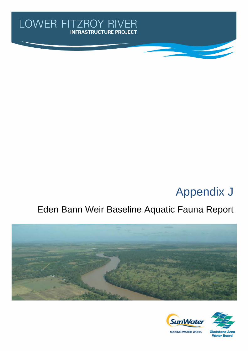
Appendix J Eden Bann Weir Baseline Aquatic Fauna Report

Gladstone Area Water Board and SunWater
Lower Fitzroy River Infrastructure Project
Eden Bann Weir Baseline Aquatic Fauna Report
June 2015

GHD | Report for Gladstone Area Water Board and SunWater - Lower Fitzroy River Infrastructure Project, 41/20736 | i
Executive summary
An aquatic ecology study was conducted for the proposed raising of Eden Bann Weir. The study
aims to provide sufficient baseline information to enable identification and assessment of the
potential impacts of the Lower Fitzroy River Infrastructure Project on the existing environmental
values of the Fitzroy River upstream and downstream of Eden Bann Weir. Data for the study
was collected from literature reviews and seasonal field surveys to achieve this objective.
The literature review included a study of relevant scientific and grey literature, database
searches, and previously prepared technical reports. Field surveys were conducted to
supplement the findings from the desktop assessments. Surveys were conducted in wet and dry
seasons to document seasonal changes in the ecosystems. Habitat assessments were
undertaken at accessible sites representing major aquatic habitats throughout the Project
footprint. These were selected on the basis of digital topography, aerial photographs, access
and safety constraints and field reconnaissance. The results of habitat assessments, combined
with an aerial overflight of the study area, provided the basis for the assessment of the likely
ecological values of these habitats.
The aquatic ecological assessment aims to describe aquatic fauna present or likely to be
present in the Project footprint, as well as the environmental values of the aquatic system.
These may encompass habitat composition and conditions, stream geomorphology and
characteristics, presence or absence of macrophytes and adjacent land use. Findings of these
searches and surveys inform the impact assessment on aquatic fauna, identifying potential
impacts that construction and operation of Eden Bann Weir may have on environmental values
such as species diversity, habitat, nesting habits and movement behaviour. Management
measures have then been developed to avoid, minimise or mitigate these impacts.
Upstream of the existing weir, the dominant aquatic habitat type is the impounded pool. The
linear extent of this habitat type varies seasonally, and is also dependent on operation of the
storage. Upstream of the impounded pool habitat, and downstream of Eden Bann Weir to the
upper limit of the Fitzroy Barrage impoundment, in-stream habitats are dominated by
seasonally-dynamic recurring pool-riffle-run sequences. These sequences represent the natural
hydrological and geomorphologic regime of the rivers in the study area.
Through habitat assessments, variable water velocity, depth, bank characteristics, in-stream
habitat features (woody debris, macrophytes) and stream substrate were observed within and
between the in-channel aquatic habitat types of the Project footprint. Seasonal variability
markedly alters the characteristics and linear extent of these habitats – a regime to which the
aquatic species of the Fitzroy Basin catchment are adapted. The less variable, more
homogenising influence of the impoundment upstream of Eden Bann Weir somewhat dampens
the seasonal temporal variability in habitat characteristics and extent immediately upstream of
the existing weir.
A number of creeks and off-stream water bodies provide further aquatic habitat beyond the main
channel of the Fitzroy River. Creek habitats in the proposed Project footprint were observed to
provide a high abundance of microhabitat resources such as overhanging vegetation and in-
stream woody debris and rocks. These habitats potentially provide resources for an array of
aquatic species, including small cryptic fish species, freshwater turtles and juvenile crocodiles. It
was also observed that areas where cattle access to the river was currently prevented tended to
produce a highly quality of marginal aquatic habitats, though this was not quantifiably assessed.
i i | GHD | Report for Gladstone Area Water Board and SunWater - Lower Fitzroy River Infrastructure Project, 41/20736
Off-stream water bodies were not readily accessible during the field surveys; however, one
large off-stream water body west of Marlborough Creek was assessed. It was assessed that this
water body had good coverage, excellent bank and vegetative stability and fair streamside
cover. These water bodies have been identified as important reservoirs of fish biomass, nursery
habitat for juvenile fish, and provide potential habitat for crocodiles and long-necked turtles.
Desktop reviews and field surveys undertaken to inform this baseline assessment of the aquatic
ecology within and downstream of the Eden Bann Weir Project footprint revealed that 34 fish
species, seven aquatic reptiles (six turtles, one crocodile), one aquatic mammal, 86
macroinvertebrate taxa and 105 macrophytes have the potential to occur within the Project
footprint, based on previous records from the study area and the results of field surveys. Of
particular note are conservation significant species which were confirmed present during field
surveys, or are known / predicted to occur based on a review of relevant literature. These
include the Fitzroy River turtle, white-throated snapping turtle, estuarine crocodile, southern
saratoga, leathery grunter, golden perch and the platypus.
Overall, the general characteristics of aquatic habitats within the Eden Bann Weir Project
footprint, and the aquatic species they support, appear to represent a continuum of habitats
downstream to the Fitzroy Barrage, and are not unique in the values and resources they provide
in the context of the wider study area. Aquatic habitats (and the species they support) within and
downstream of the Eden Bann Weir Project footprint have been impacted and altered by human
processes occurring at the local to catchment-wide scale. Such impacts include degradation of
riparian habitats by livestock, changes to water quality (agriculture and mining) and disruption to
natural flow regimes and connectivity of aquatic systems. Notably, the aquatic habitats up and
downstream of Eden Bann Weir are influenced by the operations of the existing structure.

GHD | Report for Gladstone Area Water Board and SunWater - Lower Fitzroy River Infrastructure Project, 41/20736 | i ii
Table of contents
1. Introduction .................................................................................................................. 1
1.1 Project overview .................................................................................................. 1
1.2 Report context ..................................................................................................... 3
2. Aquatic assessment scope, approach and methodology...................................................... 4
2.1 Assessment aim and scope ................................................................................... 4
2.2 Nomenclature ...................................................................................................... 5
2.3 Literature review .................................................................................................. 6
2.4 Field survey......................................................................................................... 7
2.4.1 Overview ................................................................................................. 7
2.4.2 Constraints and limitations.......................................................................... 8
2.4.3 Animal ethics and approvals ....................................................................... 9
2.4.4 Timing of field surveys ............................................................................... 9
2.4.5 Climatic conditions .................................................................................... 9
2.4.6 Site selection .......................................................................................... 13
2.4.7 Aquatic habitat assessments..................................................................... 14
2.4.8 Habitat segment analysis ......................................................................... 17
2.4.9 Fish ...................................................................................................... 18
2.4.10 Freshwater turtles ................................................................................... 19
2.4.11 Crocodiles.............................................................................................. 22
2.4.12 Other fauna ............................................................................................ 23
2.4.13 Macroinvertebrates.................................................................................. 23
2.4.14 Macrophytes .......................................................................................... 23
2.4.15 Summary of aquatic survey effort............................................................... 25
2.5 Aquatic habitat calculation ................................................................................... 25
3. Aquatic ecology existing environmental values ................................................................ 27
3.1 Fitzroy Basin catchment ...................................................................................... 27
3.2 Field survey climatic conditions ............................................................................ 28
3.2.1 Wet season ............................................................................................ 28
3.2.2 Dry season............................................................................................. 28
3.3 Aquatic habitats ................................................................................................. 29
3.3.1 Overview ............................................................................................... 29
3.3.2 Aquatic habitat segment analysis............................................................... 29
3.3.3 Impounded pools .................................................................................... 32
3.3.4 Pools..................................................................................................... 33
3.3.5 Runs ..................................................................................................... 34
3.3.6 Riffles.................................................................................................... 36
3.3.7 Off-stream water bodies ........................................................................... 37
3.3.8 Creeks .................................................................................................. 37
3.3.9 Upstream habitats ................................................................................... 40
iv | GHD | Report for Gladstone Area Water Board and SunWater - Lower Fitzroy River Infrastructure Project, 41/20736
3.3.10 Habitat dynamics .................................................................................... 40
3.4 Aquatic fauna and flora ....................................................................................... 43
3.4.1 Overview ............................................................................................... 43
3.4.2 Fish ...................................................................................................... 43
3.4.3 Freshwater turtles ................................................................................... 70
3.4.4 Crocodiles.............................................................................................. 86
3.4.5 Platypus ................................................................................................ 88
3.4.6 Macroinvertebrates.................................................................................. 89
3.4.7 Macrophytes .......................................................................................... 92
4. Summary ................................................................................................................... 95
5. References ................................................................................................................ 97
Table index
Table 2-1 Summary of literature reviewed and study approach / field survey effort ..................... 10
Table 2-2 AusRiVAS River Bioassessment Program habitat variables and criteria rankings ......... 16
Table 2-3 Summary of aquatic habitat assessment survey sites .............................................. 16
Table 2-4 Summary of fish sampling effort in Eden Bann Weir Project footprint .......................... 19
Table 2-5 Summary of targeted turtle nesting bank survey sites .............................................. 21
Table 2-6 Description of artificial substrate locations .............................................................. 24
Table 3-1 Linear extent of in-channel aquatic habitats within and downstream of Eden
Bann Weir Project footprint .................................................................................. 29
Table 3-2 Habitat characteristic ratings of impounded pool habitats.......................................... 32
Table 3-3 Habitat characteristic ratings of run habitats ........................................................... 35
Table 3-4 Habitat characteristic ratings of riffle habitat ........................................................... 36
Table 3-5 Habitat characteristic ratings of the off-stream water body habitat .............................. 37
Table 3-6 Habitat characteristic ratings of the creek habitats ................................................... 38
Table 3-7 Location of named creeks downstream of and within Eden Bann Weir Project
footprint ............................................................................................................ 39
Table 3-8 Typical dynamics of aquatic habitats in the study area ............................................. 41
Table 3-9 Examples of wet and dry season aquatic habitat dynamics in the Eden Bann
Weir Project footprint .......................................................................................... 42
Table 3-10 Total number of fauna species predicted to occur or recorded in the study area ........... 44
Table 3-11 Fish species known to occur within the study area based on current study and
past reports ....................................................................................................... 45
Table 3-12 Wet and dry season fish captures in the Eden Bann Weir Project footprint .................. 48
Table 3-13 Ecology of the fish species in the Fitzroy Basin catchment........................................ 51
Table 3-14 Sensitivity of fish migration to hydrology ................................................................ 64

GHD | Report for Gladstone Area Water Board and SunWater - Lower Fitzroy River Infrastructure Project, 41/20736 | v
Table 3-15 Known distribution of freshwater turtles within the Fitzroy Basin catchment ................. 71
Table 3-16 Ecology of freshwater turtle species in the Fitzroy Basin catchment ........................... 83
Table 3-17 Location of crocodile sightings in Eden Bann Weir during aquatic surveys .................. 86
Figure index
Figure 1-1 Project location .................................................................................................... 2
Figure 2-1 Eden Bann Weir aquatic ecology footprint and aquatic survey sites ........................... 15
Figure 3-1 Linear extent of in-channel aquatic habitats within and downstream of Eden
Bann Weir Project footprint .................................................................................. 30
Figure 3-2 Spatial distribution of in-channel aquatic habitats within and downstream of the
Eden Bann Weir Project footprint .......................................................................... 31
Figure 3-3 Relationship between fish migration and flow in the Fitzroy River .............................. 63
Figure 3-4 Location of potential turtle nesting banks within the Eden Bann Weir Project
footprint ............................................................................................................ 79
Plate index
Plate 2-1 Potential turtle nesting bank surveyed during field assessments ................................ 21
Plate 3-1 Hyrtl’s tandan (Neosilurus hyrtlii) .......................................................................... 49
Plate 3-2 Sleepy cod (Oxyeleotris lineolata) ......................................................................... 49
Plate 3-3 Potential turtle nesting bank in Eden Bann Weir Project footprint ............................... 78
Plate 3-4 White-throated snapping turtle captured in the Fitzroy Barrage impoundment
(July 2009) ........................................................................................................ 81
Plate 3-5 Crocodile slide observed on sand bank within Eden Bann Weir Project footprint .......... 87
Plate 3-6 Diptera, Chironominae ........................................................................................ 91
Plate 3-7 Ephemeroptera, Baetidae .................................................................................... 91
Plate 3-8 Ephemeroptera, Caenidae................................................................................... 91
Plate 3-9 Ephemeroptera, Leptophebiidae........................................................................... 91
Plate 3-10 Gastropoda, Thiaridae ........................................................................................ 91
Plate 3-11 Floating and emergent macrophytes on a large off-stream water body (left), and
along the margins of an adjoining creek ................................................................. 93
Appendices
Appendix A – Eden Bann Weir aquatic desktop search results

vi | GHD | Report for Gladstone Area Water Board and SunWater - Lower Fitzroy River Infrastructure Project, 41/20736
Acronym Term
AHD Australian Height Datum
AusRivAS Australia Rivers Assessment System
BoM Australian Bureau of Metrology
DEEDI Department of Employment, Economic Development and Innovation
DEHP Department of Environment and Heritage Protection
DERM Department of Environment and Resource Management
DEWHA Department of Environment, Water, Heritage and the Arts
DNRW Department of Natural Resources and Water
EIS Environmental Impact Statement
EPBC Act Environmental Protection and Biodiversity Conservation Act 1999
FSL Full Supply Level
GHD GHD Pty Ltd
NC Act Nature Conservation Act 1992

GHD | Report for Gladstone Area Water Board and SunWater - Lower Fitzroy River Infrastructure Project, 41/20736 | 1
1. Introduction
1.1 Project overview
The Lower Fitzroy River Infrastructure Project (Project) comprises the construction and
operation of a raised Eden Bann Weir and/or a new weir at Rookwood on the Fitzroy River,
Central Queensland to facilitate capture and storage of all high priority unallocated water
(76,000 ML/a) in the Fitzroy system. The Fitzroy River forms at the confluence of the Mackenzie
(flowing from the north) and Dawson (flowing from the south) Rivers. The Fitzroy River flows out
into the Coral Sea including the Great Barrier Reef World Heritage Area and Marine Park, some
300 km downstream. The Fitzroy River passes through the city of Rockhampton which lies
approximately 59 km from the river mouth.
Key Project components include the following:
Eden Bann Weir
– Eden Bann Weir Stage 2 – a raise of the existing Eden Bann Weir to a full supply level
(FSL) 18.2 m Australian Height Datum (AHD) and associated impoundment of the
Fitzroy River.
– Eden Bann Weir Stage 3 – the addition of 2 m high flap gates to achieve FSL 20.2 m
AHD and associated impoundment of the Fitzroy River.
Rookwood Weir
– Rookwood Weir Stage 1 – a new build to FSL 45.5 m AHD, saddle dams and
associated impoundment of the Fitzroy, Mackenzie and Dawson Rivers.
– Rookwood Weir Stage 2 – the addition of 3.5 m high flap gates to achieve FSL 49.0 m
AHD and associated impoundment of the Fitzroy, Mackenzie and Dawson Rivers.
– Any combination of the above.
Fish passage infrastructure and turtle passage infrastructure, namely fish locks and a
turtle bypass, respectively, at each weir.
Other infrastructure components associated with the Project include:
Augmentation to and construction of access roads (public and private) to and from the
weir sites for construction and operations and upgrades to intersections.
Construction of low level bridges in areas upstream of weir infrastructure impacted by the
impoundments, specifically at Glenroy, Riverslea and Foleyvale crossings.
Installation of culverts at Hanrahan Crossing downstream of Rookwood Weir to facilitate
access during operation releases.
Relocation of existing and/or installation of new gauging stations
Removal and decommissioning of existing low level causeways and culverts at river
crossings described above.
Water supply for construction will be sourced directly from nearby rivers and creeks and
will not require the construction of additional water supply infrastructure.
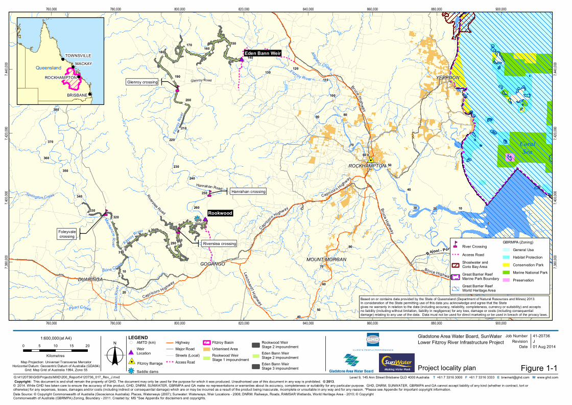
The location of Project components is shown on Figure 1-1.
#*
#*
#0
nm
nm
nm
nm !(
!(!(
!(
!(
!(
!(
!(
!(
!(
!(
!(
!(
!(
!(
!(
!(
!(
!(
!(
!(
!(
!(
!(!(
!(
!(
!(
!(
!(
!(
!(
!(
!(!(
!(
!(
!(
!(
!(
!(
!(
!(
!(
!(
!(
!(
!(
!(
!(
!(
!(
!(
!(
!(
!(
kj
Fitzroy River
Riverslea Road
Daws
o nR iv
e r
Fitzro
y Rive
r
Mackenzi eRive r Fitzroy River
Glenroy crossing
Hanrahan crossing
Riverslea crossing
Foleyvalecrossing
0
0
0
50
20
10
90 80
70
60
80
90
1030 20
40
350
360
370
340
320330
300
310
260
270
280290
250
240
230
210
190
200
170180
160
130
140
110
100
Rookwood
Springton Creek
Pearl Creek
Bon e CreekAlligato r Creek
Raglan Creek
Capricorn Highway
Bruce Highway
Leichhard t H ighway
Bruce Hig hwa y
Capricorn
Highway Bruce Highway
Bruce Highway
Capricorn Highway
Bajool - Port Alma Road
4050
60
70
420
410
400390
380
220
150
120
Eden Bann Weir
GOGANGO
YEPPOON
DUARINGA
ROCKHAMPTON
MOUNT MORGAN
760,000
760,000
780,000
780,000
800,000
800,000
820,000
820,000
840,000
840,000
860,000
860,000
880,000
880,000
900,000
900,000
7,380,
000
7,380,
000
7,400,
000
7,400,
000
7,420,
000
7,420,
000
7,440,
000
7,440,
000
Job NumberRevision J
41-20736
G:\41\20736\GIS\Projects\MXD\200_Report\4120736_017_Rev_J.mxd
Map Projection: Universal Transverse MercatorHorizontal Datum: Geocentric Datum of Australia (GDA94)
Grid: Map Grid of Australia 1994, Zone 55
0 5 10 15 20
Kilometres o© 2014. While GHD has taken care to ensure the accuracy of this product, GHD, DNRM, SUNWATER, GBRMPA and GA make no representations or warranties about its accuracy, completeness or suitability for any particular purpose. GHD, DNRM, SUNWATER, GBRMPA and GA cannot accept liability of any kind (whether in contract, tort or otherwise) for any expenses, losses, damages and/or costs (including indirect or consequential damage) which are or may be incurred as a result of the product being inaccurate, incomplete or unsuitable in any way and for any reason. *Please see Appendix for important copyright information.
Date 01 Aug 2014
Gladstone Area Water Board, SunWaterLower Fitzroy River Infrastructure Project
Project locality plan
Data Source: © Copyright Commonwealth of Australia (Geoscience Australia): Places, Waterways (2007); Sunwater: Waterways, Weir Locations - 2008; DNRM: Railways, Roads, RAMSAR Wetlands, World Heritage Area - 2010; © Copyright Commonwealth of Australia (GBRMPA) Zoning, Boundary - 2011. Created by: MS *See Appendix for disclaimers and copyrights.
Level 9, 145 Ann Street Brisbane QLD 4000 Australia T +61 7 3316 3000 F +61 7 3316 3333 E [email protected] W www.ghd.com
!( AMTD (km)
#*WeirLocation
#0 Fitzroy Barrage
kj Saddle dams
HighwayMajor RoadStreets (Local)Access Road
Fitzroy BasinUrbanised AreaRookwood Weir Stage 1 impoundment
Rookwood Weir Stage 2 impoundmentEden Bann Weir Stage 2 impoundmentEden Bann Weir Stage 3 impoundment
1:600,000(at A4)
Figure 1-1Copyright: This document is and shall remain the property of GHD. The document may only be used for the purpose for which it was produced. Unauthorised use of this document in any way is prohibited. © 2013.
LEGEND
CoralSea
BRISBANE
MACKAY
ROCKHAMPTON
TOWNSVILLE
QueenslandQueensland
Based on or contains data provided by the State of Queensland (Department of Natural Resources and Mines) 2013. In consideration of the State permitting use of this data you acknowledge and agree that the State gives no warranty in relation to the data (including accuracy, reliability, completeness, currency or suitability) and accepts no liability (including without limitation, liability in negligence) for any loss, damage or costs (including consequential damage) relating to any use of the data. Data must not be used for direct marketing or be used in breach of the privacy laws.
nm River CrossingAccess RoadShoalwater and Corio Bay AreaGreat Barrier Reef Marine Park BoundaryGreat Barrier Reef World Heritage Area
GBRMPA (Zoning)General UseHabitat ProtectionConservation ParkMarine National ParkPreservation
Glenroy Road
Hanrahan Road
GHD | Report for Gladstone Area Water Board and SunWater - Lower Fitzroy River Infrastructure Project, 41/20736 | 3
Operationally, the Project comprises the maintenance and management of the new or raised
weir infrastructure, private access roads and impoundments, inclusive of a flood buffer. Water
releases will be made through ‘run of river’ methods (as is currently the case) and no water
distribution infrastructure is required as part of the Project. Water releases will be made to
satisfy environmental and water security objectives in accordance with the Water Resource
(Fitzroy Basin) Plan 2011. Operating regimes will be developed and implemented through the
Fitzroy Basin Resource Operations Plan 2004 (as augmented).
The development of weir infrastructure (and associated works), the resultant storage of water
(inundation of the river bed and banks) and the transfer of water between storages through ‘run
of river’ methods on the Fitzroy River comprise the scope of the Project. Abstraction,
transmission and distribution to end users are not considered as part of the proposed Project
and are subject to their own environmental investigations.
1.2 Report context
In accordance with the Program of Works Notification (No 3) 2007, the investigations and
studies for the Project commenced in late 2008 with most technical studies and reporting being
undertaken in 2009. At that time, the target completion date for final development of a Project
Business Case was 2009- 2010. It was however acknowledged that this would be dependent on
the urgency associated with drought conditions in the region.
Since 2009, Central Queensland has experienced above average rainfalls and water supply
infrastructure in the region has been operating at capacity. This has resulted in extended Project
timeframes. Furthermore, the State had commissioned a number of investigations and
assessments prior to 2008 which were used as a basis for the current environmental impact
statement (EIS). Consequently, the EIS reporting spans a change of Government and
subsequent reconfiguration of government departments. Names as were applicable to the
specific reference are therefore used and not referenced as ‘former’, ‘prior’ or ‘the then’.
The Eden Bann Weir baseline aquatic fauna assessment commenced in 2009. Relevant and
applicable updates have been made to the present (2014) as appropriate and necessary.
4 | GHD | Report for Gladstone Area Water Board and SunWater - Lower Fitzroy River Infrastructure Project, 41/20736
2. Aquatic assessment scope, approach
and methodology
2.1 Assessment aim and scope
The aim of the aquatic ecology study was to provide sufficient baseline information to enable
identification and assessment of the potential impacts of the Project on the existing environmental
values of the Fitzroy River and lower sections of the Mackenzie and Dawson rivers.
The study area in relation to aquatic ecology values was broad. It included areas upstream of the
Rookwood Weir site; downstream of the Rookwood Weir site to the existing Eden Bann Weir
impoundment; downstream of the existing Eden Bann Weir and downstream reaches of the Fitzroy
River to the Fitzroy Barrage. The estuarine environment immediately downstream of the Fitzroy
Barrage and the marine environment into Keppel Bay are discussed in Volume 2, Chapter 7
Existing environment and indirect impacts are assessed in Volume 2, Chapters 8 through 11.
Project footprints comprise the Eden Bann Weir site (and immediate downstream reaches) and
associated impoundment; reaches between Eden Bann Weir and the Rookwood Weir site; the
Rookwood Weir site itself and associated impoundment along with river crossing locations.
To achieve this objective, desktop and literature reviews were conducted for the study area to
provide information on aquatic habitats and species occurring or predicted to occur. The literature
review included a study of relevant scientific and grey literature, database searches, and
previously prepared technical reports.
Wet and dry season field surveys were conducted within the Project footprints to supplement and
ground-truth findings from the desktop assessments and, where possible, fill any knowledge gaps.
Results of the desktop and literature reviews and field surveys specific to the Eden Bann Weir
Project footprint along with values of the aquatic environment downstream to the Fitzroy Barrage
are presented herein (unless otherwise stated). Aquatic values for the Rookwood Weir Project
footprint (that is upstream of the Eden Bann Weir Project footprint) are described in Appendix K.
The distribution and extent of aquatic habitats downstream of Eden Bann Weir were primarily
assessed through a desktop analysis of aerial photography. An aerial overflight of the study area,
in conjunction with the results of aquatic habitat assessments within the Project footprint, were
used to assess the likely ecological values of these habitats. Information gathered from the
literature review regarding potential aquatic fauna species assemblages and utilisation of
downstream habitats was reviewed.
GHD | Report for Gladstone Area Water Board and SunWater - Lower Fitzroy River Infrastructure Project, 41/20736 | 5
The scope of the aquatic ecological assessment was as follows:
Describe the aquatic fauna present or likely to be present within the Project footprint
including:
– Diversity of fish, turtles, crocodiles, macroinvertebrates and other aquatic fauna (i.e.
platypus)
– Species which are poorly known but suspected of being threatened
– The existence of conservation significant or otherwise noteworthy species or
communities, including discussion regarding species range, habitat, breeding,
recruitment, feeding and movement requirements, and the current level of protection
– Habitat requirements for aquatic fauna including movement, foraging and breeding
requirements
– The existence and habitat utilisation of introduced species.
Describe the environmental values of the aquatic system in terms of:
– The integrity of ecological processes, including habitat composition, structure and
function (particularly for conservation significant species)
– Stream geomorphology, including channel width, channel depth, substrate and bank
height
– Stream characteristics (e.g. pool, impounded pool, riffle etc.)
– General condition of riparian habitats, including bank vegetative stability and streamside
cover
– Presence / absence of aquatic macrophytes
– Adjacent land use.
Baseline findings and conditions have informed the preparation of an impact assessment that:
Identifies and assesses potential impacts that construction and operation of a raised Eden
Bann Weir may have on the aquatic environmental values upstream and downstream of the
structure
Outlines strategies and management recommendations to avoid, minimise and / or mitigate
these potential impacts.
2.2 Nomenclature
Scientific names for aquatic species are consistent with those used in the following sources:
A Field Guide to the Freshwater Fishes of Australia (Allen et al. 2003)
Freshwater Fishes of North-Eastern Australia (Pusey et al. 2004)
A Field Guide to Reptiles of Queensland (Wilson 2005)
A Complete Guide to Reptiles of Australia (Wilson and Swan 2008)
Australian Freshwater Turtles (Cann 1998)
Mayfly Nymphs of Australia. A Guide to Genera. No. 7. (Dean and Suter 1996)
The Mammals of Australia (Van Dyck and Strahan 2008).
6 | GHD | Report for Gladstone Area Water Board and SunWater - Lower Fitzroy River Infrastructure Project, 41/20736
2.3 Literature review
To inform field surveys, a literature review was conducted to document the known aquatic
environmental values within the study area and to also identify any conservation significant
species that have been historically recorded or have the potential to occur within the study area.
This review underpinned the description of the baseline aquatic environmental values of the
Project footprint presented here. The literature review included searches of:
The former Commonwealth Department of Environment, Water, Heritage and the Arts
(DEWHA) Environment Protection and Biodiversity Conservation Act 1999 (EPBC Act)
Environmental Reporting Tool (now the EPBC Act Protected Matters Search Tool) to identify
species and / or their habitat listed under the EPBC Act, that are predicted to occur within
the Project footprint area and downstream to the Fitzroy Barrage, and also to identify
invasive species of national significance. The search area was defined by a 2 km buffer
following the Fitzroy River
The former Queensland Department of Environment and Resource Management (DERM)
(now the Department of Environment and Heritage Protection (DEHP)) Wildlife Online
Database to identify fauna species that have been historically recorded in or surrounding the
Project footprints, including threatened species listed under the Queensland Nature
Conservation Act 1992 (NC Act). Records (in 2009) were returned for a search area within a
10 km radius of the Eden Bann Weir. Additional searches were undertaken in 2013 as
reported in Volume 1, Chapter 7 Aquatic ecology
The Essential Habitat Mapping Database (Version 3.0, 2009) to identify essential habitats
within the Project footprint, or in the vicinity of the Project footprints
The DEWHA EPBC Act Environmental Reporting Tool (now the EPBC Act Protected
Matters Search Tool) to identify any Nationally Important Wetlands (recorded in the
Directory of Important Wetlands in Australia) that occur specifically within the Project
footprint and within the wider study area. The search area was defined by a 2 km buffer
following the Fitzroy River
The Queensland Museum’s Specimen Database to obtain a record of aquatic vertebrates
previously recorded in the study area in general and within the Project footprint specifically.
Data is stored for discrete regions on the Queensland Museum database, and as such, a
“search rectangle” encompassing the area around the Eden Bann Weir, and upstream to the
maximum proposed impoundment extent was queried for aquatic fauna species records.
The coordinates of the search rectangle were as follows: 150° 7’, -22° 59’ (top right corner)
and 149° 48’, -23° 41’ (bottom left corner)
Threatened species profiles and field guides
Previous studies and reports1 conducted in the region, including (but not limited to):
– Impact assessment of modified water infrastructure (Fitzroy Barrage) on the Fitzroy River
saltwater crocodile – Potential implications and proposed mitigation measures for
saltwater crocodiles (Crocodylus porosus) (Britton 2007a)
– Proposal for raising Eden Bann Weir and construction of Rookwood Weir – An
assessment of the potential implications and proposed mitigation measures for saltwater
crocodiles (Crocodylus porosus) (Britton 2007b)
1 Not all material referenced is publically available having been produced as “commercial in confidence”.

GHD | Report for Gladstone Area Water Board and SunWater - Lower Fitzroy River Infrastructure Project, 41/20736 | 7
– Proposal for raising Eden Bann Weir and construction of Rookwood Weir – An
assessment of the potential requirements for fish passage (Marsden and Power, 2007)
– Assessment of potential implications of modified water infrastructure on Fitzroy River fish
passage and the fishway (Earth Tech 2007)
– Do fish locks have potential in tropical rivers? (Stuart et al. 2007)
– The assessment of Eden Bann Weir Fishlock, Fitzroy River, Queensland (Long and
Meager 2000)
– Freshwater fishes of the Fitzroy Basin catchment, Central Queensland (Berghuis and
Long 1999)
– Lower Fitzroy weirs discussion paper on fishway facilities for raised Eden Bann Weir
(SunWater 2008a)
– Proposal for raising Eden Bann Weir and construction of Rookwood Weir – An
assessment of the potential implications and mitigation measures for Fitzroy turtles
(Elseya albagula and Rheodytes leukops) (Limpus et al. 2007)
– Fitzroy River Water, Modified Water Infrastructure EIS and Management Plan: Turtles
(Rheodytes leukops and Elseya albagula) (frc environmental 2007)
– Lower Fitzroy Weirs discussion paper on turtle passage facilities for raised Eden Bann
Weir and Rookwood (SunWater 2008b)
– Lower Fitzroy Weirs literature review and gap analysis (frc environmental 2008).
Further to this list, a wide range of studies focussing on various aspects of the aquatic ecology of
the study area, and of the ecology of species known to occur in the study area, were sourced from
the scientific literature and other relevant material and reviewed.
2.4 Field survey
2.4.1 Overview
Field surveys were conducted in order to ground-truth information acquired through the literature
review regarding species and communities expected to occur within the Project footprint, and to
verify the likely occurrence of EPBC Act and NC Act listed aquatic fauna species. Verification was
based on direct and indirect (e.g. suitable habitat) observations. Where possible, given the
limitations and constraints on the field studies outlined in Section 2.4.2, attempts were made to fill
knowledge gaps identified through the literature review, including those highlighted by frc
environmental (2008) in their literature review and gap analysis.
Areas of focus for the field survey effort included:
Assessments of aquatic habitat characteristics and values throughout the Project footprint
Assessment and mapping of potential turtle nesting banks throughout the Project footprint,
including ranking of potential value
Fish trapping to sample species diversity in impounded habitats to be impacted by
increased inundation, as a supplement to information acquired through the literature review
Opportunistic recordings of conservation significant fauna (including Fitzroy River turtle,
estuarine crocodile and platypus)
Macroinvertebrate sampling within the Project footprint. Macroinvertebrate sampling was
also undertaken in downstream reaches of Fitzroy Barrage to supplement information
acquired through the literature review.
8 | GHD | Report for Gladstone Area Water Board and SunWater - Lower Fitzroy River Infrastructure Project, 41/20736
Surveys were conducted in the wet and dry season (refer to Section 2.4.4) to document seasonal
changes in aquatic fauna assemblages, habitat condition and utilisation. Survey timing and design
considered seasonal variation and the ecology of targeted threatened species.
A summary of the literature reviewed and the study approach / field survey effort is provided in
Table 2-1.
2.4.2 Constraints and limitations
As specified in Section 2.1, the aim of this assessment was to provide sufficient information to
inform the assessment of impacts and identification of appropriate mitigation measures. As such,
habitat assessments and fauna trapping efforts were focussed on providing information that would:
Ground-truth and supplement existing information on the ecological values of the Project
footprint
Assist in filling knowledge gaps revealed during the literature review
Fulfil the assessment scope outlined in Section 2.1.
There were three main limitations that influenced field survey methodologies and effort:
Flooding and wet weather access. On several field survey occasions (namely during the wet
season aquatic fauna survey – 13/14 February 2009), field effort and accessibility was
severely limited by flood activity. For example, macroinvertebrates were not able to be
sampled via kick-sampling and standard Australian Rivers Assessment System (AusRivAS
2001) methodology as was intended, due to safety concerns associated with trying to
access suitable substrate in flood conditions. For this reason, artificial substrates were
deployed as surrogate measures (Section 3.4.6). The use of colonisation of artificial
substrates to infer macro invertebrate assemblage structure does have associated
limitations, however, this approach provided data which would otherwise not have been
obtainable.
Flooding events and heavy rainfall leading up to and during the wet season fauna trapping
survey (13/14 February 2009), restricted road access and created significant difficulties in
launching and retrieving the survey boat from the one accessible launch site. In the wet
season survey, a number of propeller blades (both on boats and spares) were broken
attempting to traverse rapidly flowing shallow sections of the Fitzroy River. Therefore only
four fish trapping sites within the impoundment were able to be established safely. Flooding
and high flows also resulted in high turbidity in the Fitzroy River, thereby limiting survey
options for freshwater turtles reliant on visual detection (dip-netting).
Dry weather access. Due to the large size of the Project footprint and study area, and the
relative paucity of vehicle access points, boat travel was the most expedient form of
transport with which to establish and access survey sites. However, in the dry season the
ability to traverse by boat was hampered by the lack of water in the river (particularly in
shallow runs and riffles), snags and submerged structures. As a result, the assessment of
the Fitzroy River downstream of the Rookwood Weir site to the upstream limit of the Eden
Bann Weir Project footprint was undertaken via aerial photography analysis (refer to Section
2.4.8 - aquatic habitat segment analysis).
GHD | Report for Gladstone Area Water Board and SunWater - Lower Fitzroy River Infrastructure Project, 41/20736 | 9
Safety concerns and requirements. The occurrence of estuarine crocodiles in the Eden
Bann Weir Project footprint represented a safety concern when conducting aquatic habitat
assessments and fauna trapping. Therefore activities that involved wading in the river, such
as seine netting, backpack electrofishing, snorkelling for turtles and in-stream
macroinvertebrate sampling (kick-sampling) were not undertaken. Access to very remote
areas, requiring long travel times over unsealed roads was also not undertaken for safety
reasons, however, the use of boats as a mode of transportation was implemented (albeit
with its own limitations) in an attempt to circumvent this.
In addition, landholder permission was required to access launching sites and riparian habitats
throughout the Project footprint, and while in most cases this was granted, where it was not,
survey could not be undertaken.
The field survey approach employed in this assessment (considering access limitations) did not
attempt to sample all potential species, or all available habitats, that may occur within the Project
footprint over the duration of the study. Rather, the approach allowed for the sampling of species
that may have been poorly described in the literature, confirmation of the presence of conservation
significant species (and/or their habitats), and the description of the general aquatic habitat values
based on assessments of representative habitat types at a number of locations in the Eden Bann
Weir Project footprint. Despite limitations, given the body of literature reviewed and coverage
achieved it is considered that sufficient baseline data was attained to provide a valid description of
existing aquatic ecology values.
2.4.3 Animal ethics and approvals
Aquatic fauna surveys were conducted under Section 52 of the Animal Care and Protection Act
2001 (General Fisheries Permit - 113990) and supported by the former Queensland Department of
Employment, Economic Development and Innovation (DEEDI) animal ethics committee (CA
2008/07/280).
2.4.4 Timing of field surveys
Wet and dry season field surveys were conducted in order to document seasonal changes in the
ecosystems within the Project footprint. A reconnaissance of the study area was undertaken on 20
January 2009 (aerial overflight) and subsequent wet season surveys were conducted between 28
January and 2 February 2009 (habitat assessments) and 13 to 14 February 2009 (aquatic fauna
trapping). The dry season survey for aquatic fauna was undertaken between 12 and 14 July 2009.
Turtle nesting bank surveys were also conducted between 15 and 18 December 2008 in addition
to during the wet and dry season surveys (refer to Section 2.4.10).
2.4.5 Climatic conditions
Climatic data was sourced from the Australian Bureau of Meteorology (BoM), recorded at the
Rockhampton Airport weather station (039083) (BoM 2009). This data is considered to be
indicative of the general climatic conditions in the study area, yet it does not necessarily represent
the precise meteorological conditions prevailing at survey sites when the field surveys were
undertaken due to the separation distance from the sites to the Bureau of Meteorology station
(approximately 60 km).
10 | GHD | Report for Gladstone Area Water Board and SunWater - Lower Fitzroy River Infrastructure Project, 41/20736
Table 2-1 Summary of literature reviewed and study approach / field survey effort
Parameter Information in literature to
inform impacts
References Current know ledge gaps Field effort Study approach and f ield effort
Freshwater turtles
(including conservation
signif icant Fitzroy River
turtle)
Species diversity
Distribution in
catchment
Aquatic habitat
requirements
Breeding ecology
Threatening
processes
Key reference
Limpus et al. 2007
Other references
Cann 1998
Clark 2008
Clark et al. 2008
frc environmental 2007
frc environmental 2008
Gordos 2004
Gordos et al. 2003a,b
Gordos et al. 2007
Hamann et al. 2007
Legler and Cann 1980
Legler and Georges 1993
Limpus et al. 2006
Mathie and Franklin 2006
Priest 1997
Priest and Franklin 2002
Rogers 2000
SunWater 2008b
Thomson et al. 2006
Tucker 2000
Tucker et al. 2001
Venz et al. 2002
Specif ic nesting bank
requirements
Nesting bank locations
(including locations of
any aggregated nesting
sites)
Movement behaviours
Aquatic habitat
assessments
Opportunistic
recordings of species
(including conservation
signif icant species)
Identif ication,
assessment and
mapping of potential
nesting banks for
conservation signif icant
turtles
A signif icant body of literature on freshw ater turtles of the Fitzroy Basin catchment exists. This includes a
comprehensive assessment for the Project undertaken by DERM (Limpus et al.) in 2007. This assessment drew on a
number of previous studies and included detailed f ield assessments w ithin the proposed inundation areas of a raised
Eden Bann Weir and the proposed w eir at Rookw ood.
In light of the availability of information on species diversity, distribution in the Fitzroy Basin catchment and aquatic
habitat requirements, trapping in the Project footprint w as not deemed necessary.
Given that potential nesting banks are poorly know n from the Project footprint, that these habitats are likely to be
impacted by the proposed raising of Eden Bann Weir, and that lack of recruitment has been cited as a major threat to
these species’ (Limpus et al. 2007), targeted surveys for the Fitzroy River turtle and w hite-throated snapping turtle
focussed on the identif ication, assessment and mapping of potential turtle nesting in the Project footprint. Due to the
diff iculty in trapping the Fitzroy River turtle and w hite-throated snapping turtle, the distribution and abundance of these
species w ithin the Project footprint and study area w as assessed based on the results of the past surveys detailed
above. Where insuff icient information w as available, species occurrence w as assessed based on habitat suitability.
Estuarine crocodile Distribution in
catchment
Relative abundance
in catchment
Aquatic habitat
requirements
Breeding ecology
Threatening
processes
Key references
Britton 2007a
Britton 2007b
Other references
DERM 2009
Environmental Protection
Agency 2007
frc environmental 2008
Walsh and Whitehead
1993
Movement behaviours
Recruitment into
population
Aquatic habitat
assessments
Opportunistic
recordings of crocodiles
(including characteristic
slides on banks)
Opportunistic
recordings of crocodile
nests
Tw o comprehensive studies w ere undertaken to describe potential impacts (and associated mitigation measures) on
estuarine crocodiles from w ater infrastructure development on the Fitzroy River (Britton 2007a; Britton 2007b). These
studies provide a thorough description of estuarine crocodile populations (including abundance) and habitat utilisation
in the Fitzroy River (including the Eden Bann Weir Project footprint), based upon the results of detailed f ield
assessments.
Given the amount of information on estuarine crocodile ecology in the Fitzroy River, specif ic targeted f ield surveys
w ere not deemed necessary for this species. Habitat assessments documented potentially suitable habitat, w hile
opportunistic recordings w ere noted.
GHD | Report for Gladstone Area Water Board and SunWater - Lower Fitzroy River Infrastructure Project, 41/20736 | 11
Parameter Information in literature to
inform impacts
References Current know ledge gaps Field effort Study approach and f ield effort
Fish Species diversity in
catchment
General habitat
preferences of f ish
species
Barriers to
movement in the
Fitzroy River / use
of f ish passage
devices
Key references
Berghuis and Long 1999
Long and Meager 2000
Marsden and Pow er 2007
Pusey et al. 2004
Stuart et al. 2007
Other references
Allen et al. 2003
DEEDI 2009
Earth Tech 2007
frc environmental 2008
Heindenreich and
Broadfoot 2001
Long 2000
Stuart and Mallen-Cooper
1999
Stuart 1997
SunWater 2008a
Species assemblages
in specif ic aquatic
habitat types
Aquatic habitat
assessments
Fish sampling in
margins of Eden Bann
Weir impoundment
The f ish diversity of the Fitzroy Basin catchment has been studied in detail in a number of other studies. In particular,
the impacts of movement barriers on f ish in the system has received notable attention, including a specif ic study on
potential requirements for f ish passage relating to the raising of Eden Bann Weir and the construction of the proposed
w eir at Rookw ood (Marsden and Pow er 2007). Habitat preferences for f ish species in the Fitzroy Basin catchment is
generally w ell-described, based on the volume of sampling that has occurred throughout the catchment, including
various aquatic habitats in the Fitzroy River.
A number of constraints during EIS surveys limited both w et and dry season fish sampling in the Eden Bann Weir
Project footprint (refer Section 2.4.2). Fish sampling in accessible parts of the Project footprint (namely w ithin the
existing Eden Bann Weir impoundment) w as undertaken to characterise species assemblages at the margins of the
impoundment. Likely species assemblages in other in-stream and off-stream aquatic habitat types w ere derived based
on an analysis of the individual ecology of species, information contained w ithin the literature, and from an
extrapolation of results obtained from dow nstream fish sampling (i.e. betw een Eden Bann Weir and the Fitzroy
Barrage).
Platypus Occurrence in the
Daw son, Mackenzie
and Fitzroy rivers
References
Fish et al. 2001
frc environmental 2008
Gardner and Serena 1995
Grant and Temple-Smith
1998
Otley et al. 2000
Serena et al. 1998
Distribution and
abundance in the
Daw son, Mackenzie
and Fitzroy Rivers
Aquatic habitat
assessments
Opportunistic
recordings
Platypus are know n to occur in the study area. A general characterisation of potentially suitable habitats for the
platypus (based on the know n ecology of the species from the literature) w as ascertained through aquatic habitat
assessments. Targeted searches for this species w ere not undertaken, although any opportunistic recordings of this
species w ere noted.
Macroinvertebrates General
characterisation of
diversity of
macroinvetrebrate
taxa in the study
area
Non-occurrence of
listed threatened
species in the study
area
References
Duivenvoorden et al. 2000
Duivenvoorden and
Roberts 1997
frc environmental 2008
Description of species
assemblages occurring
in specif ic aquatic
habitat types w ithin the
Eden Bann Weir Project
footprint
Habitat requirements of
key species
Non-systematic
deployment of artif icial
substrates in various
aquatic habitat types
throughout study area
to supplement existing
information about
macorinvertebrate
diversity in study area
Macro-invertebrate sampling in the Eden Bann Weir Project footprint w as severely limited by several constraints (refer
to Section 2.4.2). Where possible, sampling w as undertaken through deployment of artif icial substrates, to contribute
additional information regarding the general diversity of macro-invertebrates in the study area. It is recognised that
there are limitations associated w ith the use of colonisation of artif icial substrates to infer macro-invertebrate
assemblage structure, how ever, this approach provided data w hich w ould otherw ise not have been obtainable.
As no threatened aquatic macro-invertebrates w ere identif ied from the literature review , a general characterisation of
macro-invertebrate diversity from the literature (and supplemented, w here possible, by f ield data) w as considered
suff icient to inform potential impacts on these animals from the Project.
Macrophytes General description
of macrophytes
know n to occur in
the study area
Pest species know n
to occur in study
area
References
Duivenvoorden 1992
Noble et al. 1997
frc environmental 2008
Houston and
Duivenvoorden 2002
Species presence,
diversity and
distribution in various
aquatic habitat types
Temporal patterns in
macrophyte distribution
Aquatic habitat
assessments
The presence of macrophytes w as noted during aquatic habitat assessments throughout the Eden Bann Weir Project
footprint. A general description of macrophytes w as recorded, how ever species-level identif ication w as not
undertaken. As the primary aim of recording macrophyte presence / absence and general characteristics w as to
inform potential value to aquatic fauna (i.e. provision of shelter and foraging resources), species level identif ication
w as deemed unnecessary at the environmental impact assessment level.
12 | GHD | Report for Gladstone Area Water Board and SunWater - Lower Fitzroy River Infrastructure Project, 41/20736
Parameter Information in literature to
inform impacts
References Current know ledge gaps Field effort Study approach and f ield effort
Aquatic habitats Potential utilisation
by aquatic fauna,
including threatened
species
References
All references related to
aquatic ecology of study
area
Distribution and extent
of aquatic habitats
General characteristics
of aquatic habitats
Values of aquatic
habitats for fauna
Aquatic habitat
assessments and f ield
observations
Aerial overflight of study
area
Habitat assessments w ere undertaken at accessible sites representing major aquatic habitats throughout the Project
footprint. Creek and off-stream w ater body habitats w ere assessed w here access permitted. Where these habitats
could not be accessed in the f ield (refer to limitations Section 2.4.2), a desktop approach to assessing the spatial
distribution / extent of these habitat types w as undertaken. Specif ically, this involved an assessment of the
Queensland Government’s WetlandInfo Mapping service in conjunction w ith satellite imagery of the study area.
In the absence of being able to access all habitats, habitat segment analysis w as utilised to assess the extent of
aquatic habitats, w ithin and dow nstream of the Eden Bann Weir Project footprint. The distribution and linear extent of
aquatic habitat types w ithin and dow nstream of the Project footprint w as quantif ied and mapped from aerial
photographs, and w here possible, verif ied in the f ield (including during the reconnaissance aerial overflight).
Upstream and
downstream habitats
Potential utilisation
by aquatic fauna,
including threatened
species
References
All references related to
aquatic ecology of study
area
Distribution and extent
of aquatic habitats
Values of aquatic
habitats for fauna
Aquatic habitat
assessments w ithin
Project footprint
Aerial overflight of study
area
The distribution and extent of aquatic habitats w ithin and dow nstream of the Project footprint w as primarily assessed
through a desktop analysis of aerial photography. An aerial overflight of the study area, in conjunction w ith the results
of aquatic habitat assessments in the Eden Bann Weir Project footprint w as used to infer the likely ecological values of
these habitats. Information from the literature about potential aquatic fauna species assemblages and utilisation of
upstream and dow nstream habitats w as review ed.
Habitats upstream of the Project footprint, w hich are predicted to suffer minimal impacts from the proposed w eir, w ere
inferred to be similar to those described w ithin the Project footprint (based on aerial photo interpretation, f ield
observations and literature review s), and w ere not specif ically addressed. How ever, upstream and dow nstream
habitats of signif icant values identif ied in the literature review s are discussed in subsequent sections of this report.
As construction of a w eir at Rookw ood w ould impact aquatic habitats upstream of the Eden Bann Weir impoundment,
this section of the Fitzroy River is described in the Rookw ood Weir Baseline Aquatic Fauna Report.
GHD | Report for Gladstone Area Water Board and SunWater - Lower Fitzroy River Infrastructure Project, 41/20736 | 13
2.4.6 Site selection
Aquatic survey sites (for habitat assessments, turtle nesting bank surveys and aquatic fauna
trapping) were selected based on a review of digital topography, georeferenced aerial
photographs, streambed geology, road and boat access, safety constraints and field
reconnaissance, including an aerial overflight. Site selection was also influenced by logistical
constraints associated with boat operation. These included safety concerns in fast-flowing waters
(wet season) and low water levels preventing boat access (dry season) and the potential presence
of estuarine crocodiles in the Project footprint (Section 2.4.2).
Habitat assessments were conducted at sites representing major aquatic habitats within the study
area. These were defined as:
Impounded pool (impounded water upstream of existing Eden Bann Weir): generally non-
flowing, typically deep water impounded within the bed and banks of a river upstream of a
weir; distinct from a ‘natural’ pool in an unregulated river. Water depth and linear extent of
the impounded pool is variable, and dependent on operations of the infrastructure, climatic
factors (rainfall / evaporation) and extraction by adjacent land users
Pools: zones of relatively deep, still or very slow flowing water over variable substrates (i.e.
silt, sand, stony or rocky) that occur naturally within the riverine environment (as opposed to
upstream of man-made structures) (AusRivAS 2001). This aquatic habitat type occurs in the
main channel, and may become isolated into a series of discrete water holes during dry
conditions when flow ceases and water levels drop. The low (or zero) velocity of water flow
differentiates a pool habitat from a faster flowing run habitat (AusRivAS 2001)
Riffles: shallow (<0.3 m), fast-flowing (>0.2 m/s) water over a stony bed (AusRivAS 2001)
Runs: relatively deep, fast flowing unbroken water over a sandy, stony or rocky bed
(AusRivAS 2001). These habitats may occur immediately upstream and downstream of a
riffle zone. Fast flowing water during high flow / flood conditions may result in the conversion
of generally sluggish pool habitats and generally shallow riffle habitats into runs (AusRivAS
2001)
Off-stream water bodies including:
– Palustrine wetlands (vegetated swamps, billabongs), oxbow lakes, and farm dams in the
floodplain adjacent to the main channel2
– Flood-runners / secondary channels within the bed and banks (i.e. including the riparian
zone)
Creeks: small tributaries adjoining the main river channel that persist for varying distances
across the adjacent floodplain and beyond. This does not include minor drainage lines that
may only flow intermittently after rainfall.
Where possible, sites for deployment of nets and traps were selected to sample aquatic fauna in
each of the habitat types, and in locations that allowed safe operation and had suitable structures
(e.g. projecting branches or roots for attachment). Where appropriate, trapping sites were
coincident with those of habitat assessments, but this was not always possible. For example, traps
could not be deployed in areas with very fast flows due to the risk of trap loss and subsequent
wildlife entrapment.
2 For the purposes of this assessment, off-stream water bodies within 1 km of the main channel and adjoining creeks were
considered.
14 | GHD | Report for Gladstone Area Water Board and SunWater - Lower Fitzroy River Infrastructure Project, 41/20736
Turtle nesting bank surveys were conducted at targeted sites based on the current knowledge of
species preferences for particular substrate, slope, elevation and vegetation cover (refer to Section
2.4.10). Locations of habitat assessment, turtle nesting bank surveys and fauna trapping sites are
provided in Figure 2-1.
2.4.7 Aquatic habitat assessments
Habitat assessments were undertaken at accessible sites representing major aquatic habitats
throughout the Project footprint. Each survey site was identified in relation to habitat type
described above in section 2.4.6 and the following parameters recorded:
Stream channel and bank morphology (e.g. channel width, depth and bank height)
Bank profile
Substrate description (e.g. bedrock, gravel, sand or silt)
Presence of plant material (e.g. aquatic plants, algae and submerged logs)
Riparian vegetation description (e.g. width and length of stream side vegetation,
overhanging and native vegetation)
Adjacent land use
Water velocity (e.g. deep and shallow areas)
Position in relation to existing or proposed impoundment.
Creek and off-stream water body habitats were assessed where access permitted. Where these
habitats could not be accessed in the field (refer to limitations Section 2.4.2), a desktop approach
to assessing the spatial distribution / extent of these habitat types was undertaken. Specifically,
this involved an assessment of the Queensland Government’s WetlandInfo Mapping Service in
conjunction with satellite imagery of the study area.
Habitat characteristics of each survey site were assessed from excellent to poor according to
criteria of the AusRivAS River Bioassessment Program from which a sub sample of habitat
variables relevant to the Project were selected (Table 2-2).
A summary of the aquatic habitat assessment survey sites is provided in Table 2-3 below.
Riverslea Road
Fitzro
y Rive
r
Fitzroy River
Bruce Highway
Glenroy crossing
Eden Bann Weir
Glenroy Road
Comm
anch
e Roa
d
Glenroy M
arlbo
rough
Road
Redbank Road
Ridgelands Road
Ridgelands Road
Ridgelands Road
Ridgelands Road
Alligator Creek
Marlborough Creek
Melaleuca
Cree
k
Ten M ile Creek
Develin Creek
Plante
d Creek
Four Mile
Creek
Black Gin Creek
Glen
roy
Creek
L imestone Creek
CoffeyCreek
Ridgelands CreekTwo MileCre
ek
Oaky Creek
Sand
y Cree
k
Native
Bear Creek
Templeton Creek
Yemiappo Creek
Two M
ileCre
ek
Oaky Creek
Ten Mile Creek
780,000
780,000
790,000
790,000
800,000
800,000
810,000
810,000
820,000
820,000
830,000
830,000
840,000
840,000
850,000
850,000
860,000
860,000
7,410,
000
7,410,
000
7,420,
000
7,420,
000
7,430,
000
7,430,
000
7,440,
000
7,440,
000
7,450,
000
7,450,
000
Job NumberRevision C
41-20736
G:\41\20736\GIS\Projects\MXD\900_Baseline Terrestrial Fauna Report\4120736_909_Eden_Bann_Survey_Sites_Rev_C.mxd
Map Projection: Transverse MercatorHorizontal Datum: Geocentric Datum of Australia (GDA)
Grid: Map Grid of Australia 1994, Zone 55
0 2.5 5 7.5 10
Kilometres
© 2014. While GHD has taken care to ensure the accuracy of this product, GHD, DNRM, SUNWATER and GA make no representations or warranties about its accuracy, completeness or suitability for any particular purpose. GHD, DNRM, SUNWATER and GA cannot accept liability of any kind (whether in contract, tort or otherwise) for any expenses, losses, damages and/or costs (including indirect or consequentialdamage) which are or may be incurred as a result of the product being inaccurate, incomplete or unsuitable in any way and for any reason.
Date 19 Aug 2014
Gladstone Area Water Board, SunWaterLower Fitzroy River Infrastructure Project
Data Source: © Copyright Commonwealth of Australia (Geoscience Australia): Waterways, State (2007); Sunwater: Waterways, Weir Locations - 2008; DNRM: Roads - 2010, Railways - 2010, Imagery/2005; GHD Fauna Survey - 2009. Created by IH,MS
Level 9, 145 Ann St Brisbane QLD 4000 T 61 7 3316 3000 F 61 7 3316 3333 E [email protected] W www.ghd.com.au
1:300,000(at A4)
Figure 2-1Eden Bann Weir Aquatic Ecology Footprint and Aquatic Survey Sites
Existing Eden Bann WeirImpoundment 184 km AMTD
LEGENDWeirLocationFitzroy Barrage
River Crossing
HighwayMinor RoadRailwayImpoundment AreaWaterway
Aquatic Fauna Trapping Site (GHD)Turtle Nesting Bank Survey Site (GHD)Habitat Assessment Site (GHD)
Macroinvertebrate articial substrate sites (GHD)Principal study sites (Limpus et al 2011)
Based on or contains data provided by the State of Queensland (DNRM) 2013. In consideration of the State permitting use of this data you acknowledge and agree that the State gives no warranty in relation to the data (including accuracy,reliability, completeness, currency or suitability) and accepts no liability (including without limitation, liability in negligence)for any loss, damage or costs (including consequential damage) relating to any use of the data. Data must not be usedfor direct marketing or be used in breach of the privacy laws.
Princ
heste
rCre
ek
16 | GHD | Report for Gladstone Area Water Board and SunWater - Lower Fitzroy River Infrastructure Project, 41/20736
Table 2-2 AusRiVAS River Bioassessment Program habitat variables and
criteria rankings
Habitat
variable
Excellent Good Fair Poor
1. Bottom
Substrate /
Available
cover
> 50% rubble,
gravel,
submerged logs,
undercut banks,
or other stable
habitat.
30-50% rubble,
gravel or other
stable habitat.
10-30% rubble,
gravel or other
stable habitat.
<10% rubble, gravel or
other stable habitat.
Lack of habitat is
obvious.
2. Bank
Stability
Stable. No
evidence of
erosion or bank
failure. Side
slopes generally
<30%.
Moderately stable.
Infrequent small
areas of erosion.
Side slopes up to
40% on some
banks.
Moderately unstable.
Moderate frequency
and size of erosion
areas. Side slopes
up to 60% on some
banks.
Unstable. Many
eroded areas. Side
slopes >60% are
common. Exposed
‘raw ’ areas frequent
along straight sections
and bends.
3. Bank
Vegetative
Stability
Over 80% of the
streambank
covered by
vegetation or
boulders and
cobble.
50-79% of the
streambank
covered by
vegetation, gravel
or larger material.
25-49% of the
streambank covered
by vegetation, gravel
or larger material.
<25% of the
streambank covered
by vegetation, gravel
or larger material.
4.
Streamside
Cover
Dominant
vegetation is of
tree form.
Dominant
vegetation is shrub
form.
Dominant vegetation
is grass, sedge,
ferns.
Over 50% of stream
bank has no
vegetation and
dominant material is
soil, rock, bridge
materials or culverts.
Table 2-3 Summary of aquatic habitat assessment survey sites
Sampling
site name
Coordinate Site location Aquatic habitat type
at time of survey
Sampling
period*
EBA1 -23.174 , 149.922 Glenroy Crossing Riff le Wet
EBA2 -23.161 , 149.916 Dow nstream of Glenroy Crossing Run Wet
EBA3 -23.144 , 149.902 Betw een Glenroy Crossing and
Redbank Crossing
Run Wet
EBA4 -23.121 , 149.880 Betw een Glenroy Crossing and
Redbank Crossing
Run Wet
EBA5 -23.110 , 149.866 Betw een Glenroy Crossing and
Redbank Crossing
Run Wet
EBA6 -23.094 , 149.871 Dow nstream of Redbank Crossing Run Wet
EBA7 -23.080 , 149.887 Betw een Redbank Crossing and
Marlborough Creek
Run Wet
EBA8 -23.099 , 149.909 Betw een Redbank Crossing and
Marlborough Creek
Run Wet
EBA9 -23.088 , 149.926 Just upstream of Marlborough
Creek
Run Wet
EBA10 -23.062 , 149.934 Marlborough Creek Creek Wet

GHD | Report for Gladstone Area Water Board and SunWater - Lower Fitzroy River Infrastructure Project, 41/20736 | 17
Sampling
site name
Coordinate Site location Aquatic habitat type
at time of survey
Sampling
period*
EBA11 -23.065 , 149.937 Small creek just upstream of
Marlborough Creek
Creek Wet
EBA12 -23.069 , 149.930 Adjacent to Marlborough Creek Off-stream w ater
body (billabong)
Wet
EBA13 -23.065 , 149.937 Just dow nstream of Marlborough
Creek
Run Wet
EBA14 -23.060 , 149.941 Betw een Marlborough Creek and
Princhester Creek
Run / Riff le Wet / Dry
EBA15 -23.078 , 149.964 Betw een Marlborough Creek and
Princhester Creek
Impounded pool Wet
EBA16 -23.087 , 149.997 Betw een Marlborough Creek and
Princhester Creek
Impounded pool /
Run
Wet / Dry
EBA17 -23.065 , 150.026 Betw een Marlborough Creek and
Princhester Creek
Impounded pool Wet
EBA18 -23.042 , 150.039 Betw een Marlborough Creek and
Princhester Creek
Impounded pool Wet
EBA19 -23.028 , 150.056 Princhester Creek Impounded low er
reaches of creek
Wet
EBA20 -23.055 , 150.075 Betw een Princhester Creek and
Eden Bann Weir
Impounded pool Wet
EBA21 -23.082 , 150.066 Betw een Princhester Creek and
Eden Bann Weir
Impounded pool /
Impounded pool
Wet / Dry
EBA22 -23.089 , 150.113 Betw een Princhester Creek and
Eden Bann Weir
Impounded pool Wet
EBA23 -23.085 , 150.067 Betw een Princhester Creek and
Eden Bann Weir
Impounded pool /
Impounded pool
Wet / Dry
*Wet: surveys conducted late January / early February 2009; Dry: surveys conducted July 2009
2.4.8 Habitat segment analysis
In the absence of being able to access all habitats, habitat segment analysis was utilised to
assess the extent of aquatic habitats, within, upstream and downstream of the Eden Bann Weir
Project footprint.
The distribution and linear extent of aquatic habitat types within the Project footprint (i.e.
upstream of Eden Bann Weir) as well as downstream, were quantified and mapped from aerial
photographs, and where possible, verified in the field (within Project footprint during field studies
and during the reconnaissance aerial overflight). Habitat boundaries were estimated based on
the visual characteristics observed.
The extent of each habitat type in the main river channel within and downstream of the Eden
Bann Weir Project footprint was then calculated based on the percentage of river length covered
by each habitat (off-stream water bodies and adjoining creeks were not included). As habitat
boundaries (e.g. the difference between a riffle and a run) vary between seasons, the
percentages of each habitat type within the Project footprint provide an example of aquatic
habitat extent. These values are likely to fluctuate substantially in response to seasonal
variability in water flows and management of the storage.
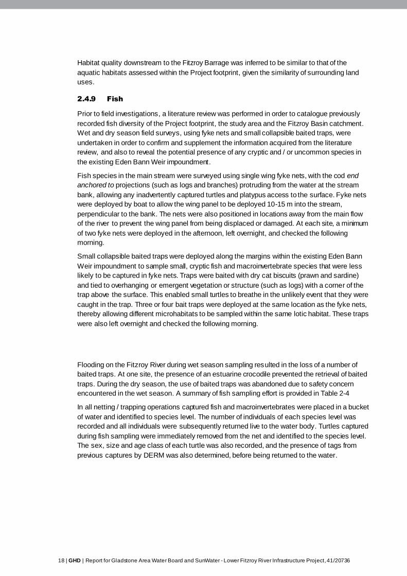
18 | GHD | Report for Gladstone Area Water Board and SunWater - Lower Fitzroy River Infrastructure Project, 41/20736
Habitat quality downstream to the Fitzroy Barrage was inferred to be similar to that of the
aquatic habitats assessed within the Project footprint, given the similarity of surrounding land
uses.
2.4.9 Fish
Prior to field investigations, a literature review was performed in order to catalogue previously
recorded fish diversity of the Project footprint, the study area and the Fitzroy Basin catchment.
Wet and dry season field surveys, using fyke nets and small collapsible baited traps, were
undertaken in order to confirm and supplement the information acquired from the literature
review, and also to reveal the potential presence of any cryptic and / or uncommon species in
the existing Eden Bann Weir impoundment.
Fish species in the main stream were surveyed using single wing fyke nets, with the cod end
anchored to projections (such as logs and branches) protruding from the water at the stream
bank, allowing any inadvertently captured turtles and platypus access to the surface. Fyke nets
were deployed by boat to allow the wing panel to be deployed 10-15 m into the stream,
perpendicular to the bank. The nets were also positioned in locations away from the main flow
of the river to prevent the wing panel from being displaced or damaged. At each site, a minimum
of two fyke nets were deployed in the afternoon, left overnight, and checked the following
morning.
Small collapsible baited traps were deployed along the margins within the existing Eden Bann
Weir impoundment to sample small, cryptic fish and macroinvertebrate species that were less
likely to be captured in fyke nets. Traps were baited with dry cat biscuits (prawn and sardine)
and tied to overhanging or emergent vegetation or structure (such as logs) with a corner of the
trap above the surface. This enabled small turtles to breathe in the unlikely event that they were
caught in the trap. Three or four bait traps were deployed at the same location as the fyke nets,
thereby allowing different microhabitats to be sampled within the same lotic habitat. These traps
were also left overnight and checked the following morning.
Flooding on the Fitzroy River during wet season sampling resulted in the loss of a number of
baited traps. At one site, the presence of an estuarine crocodile prevented the retrieval of baited
traps. During the dry season, the use of baited traps was abandoned due to safety concern
encountered in the wet season. A summary of fish sampling effort is provided in Table 2-4
In all netting / trapping operations captured fish and macroinvertebrates were placed in a bucket
of water and identified to species level. The number of individuals of each species level was
recorded and all individuals were subsequently returned live to the water body. Turtles captured
during fish sampling were immediately removed from the net and identified to the species level.
The sex, size and age class of each turtle was also recorded, and the presence of tags from
previous captures by DERM was also determined, before being returned to the water.
GHD | Report for Gladstone Area Water Board and SunWater - Lower Fitzroy River Infrastructure Project, 41/20736 | 19
Table 2-4 Summary of fish sampling effort in Eden Bann Weir Project
footprint
Sampling
site
Coordinates Habitat sampled Date Number
of fyke
nets
Number of baited
traps
Wet season
EBA14 -23.058,
149.941
Eden Bann Weir
impoundment on bend,
just dow nstream of
Marlborough Creek
13/02/2009-
14/02/2009
3 3 (all traps w ashed
aw ay in f lood – river
rose 2 m overnight)
EBA16 -23.087,
149.997
Eden Bann Weir
impoundment on bend,
just upstream of Eight
Mile Creek
13/02/2009-
14/02/2009
2 3
EBA21 -23.082,
150.066
Eden Bann Weir
impoundment (f irst bend
upstream of w eir)
13/02/2009-
14/02/2009
2 4 (2 abandoned due
to presence of
crocodile)
EBA23 -23.082,
150.066
Eden Bann Weir
impoundment (f irst bend
upstream of w eir) –
opposite bank to EBA21
13/02/2009-
14/02/2009
3 4
Dry season
EBA14 -23.058,
149.941
Eden Bann Weir
impoundment on bend,
just dow nstream of
Marlborough Creek
13/07/2009 –
14/07/2009
3 No bait traps used in
dry season due to
safety concerns
(crocodiles)
EBA16 -23.087,
149.997
Eden Bann Weir
impoundment on bend,
just upstream of Eight
Mile Creek
13/07/2009 –
14/07/2009
2 No bait traps used in
dry season due to
safety concerns
(crocodiles)
EBA21 -23.082,
150.066
Eden Bann Weir
impoundment (f irst bend
upstream of w eir)
12/07/2009 –
13/07/2009
2 No bait traps used in
dry season due to
safety concerns
(crocodiles)
EBA23 -23.082,
150.066
Eden Bann Weir
impoundment (f irst bend
upstream of w eir) –
opposite bank to EBA21
12/07/2009 –
13/07/2009
3 No bait traps used in
dry season due to
safety concerns
(crocodiles)
2.4.10 Freshwater turtles
An assessment of freshwater turtle populations within the Fitzroy Basin catchment was
conducted by DERM in 2007, specifically focusing on the proposal for raising Eden Bann Weir
and constructing a new weir at Rookwood (Limpus et al. 2007). The DERM assessment
(Limpus et al. 2007) involved field studies, as well as a review of the results of past studies
undertaken throughout the catchment (and in nearby catchments) since 1997. Past studies
included:
Cumulative effects of dams and weirs on freshwater turtles: Fitzroy, Kolan, Burnett and
Mary Catchments. DERM study 1997-1999 (Tucker 2000)
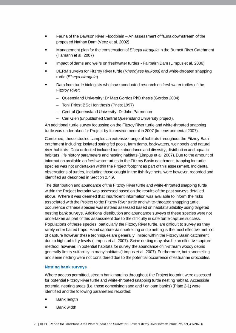
20 | GHD | Report for Gladstone Area Water Board and SunWater - Lower Fitzroy River Infrastructure Project, 41/20736
Fauna of the Dawson River Floodplain – An assessment of fauna downstream of the
proposed Nathan Dam (Venz et al. 2002)
Management plan for the conservation of Elseya albagula in the Burnett River Catchment
(Hamann et al. 2007)
Impact of dams and weirs on freshwater turtles - Fairbairn Dam (Limpus et al. 2006)
DERM surveys for Fitzroy River turtle (Rheodytes leukops) and white-throated snapping
turtle (Elseya albagula)
Data from turtle biologists who have conducted research on freshwater turtles of the
Fitzroy River:
– Queensland University: Dr Matt Gordos PhD thesis (Gordos 2004)
– Toni Priest BSc Hon thesis (Priest 1997)
– Central Queensland University: Dr John Parmenter
– Carl Glen (unpublished Central Queensland University project).
An additional turtle survey focussing on the Fitzroy River turtle and white-throated snapping
turtle was undertaken for Project by frc environmental in 2007 (frc environmental 2007).
Combined, these studies sampled an extensive range of habitats throughout the Fitzroy Basin
catchment including: isolated spring fed pools, farm dams, backwaters, weir pools and natural
river habitats. Data collected included turtle abundance and diversity, distribution and aquatic
habitats, life history parameters and nesting habitats (Limpus et al. 2007). Due to the amount of
information available on freshwater turtles in the Fitzroy Basin catchment, trapping for turtle
species was not undertaken within the Project footprint as part of this assessment. Incidental
observations of turtles, including those caught in the fish fkye nets, were however, recorded and
identified as described in Section 2.4.9.
The distribution and abundance of the Fitzroy River turtle and white-throated snapping turtle
within the Project footprint was assessed based on the results of the past surveys detailed
above. Where it was deemed that insufficient information was available to inform the risks
associated with the Project to the Fitzroy River turtle and white-throated snapping turtle,
occurrence of these species was instead assessed based on habitat suitability using targeted
nesting bank surveys. Additional distribution and abundance surveys of these species were not
undertaken as part of this assessment due to the difficulty in safe turtle capture success.
Populations of these species, particularly the Fitzroy River turtle, are difficult to survey as they
rarely enter baited traps. Hand capture via snorkelling or dip netting is the most effective method
of capture however these techniques are generally limited within the Fitzroy Basin catchment
due to high turbidity levels (Limpus et al. 2007). Seine netting may also be an effective capture
method, however, in potential habitats for survey the abundance of in-stream woody debris
generally limits suitability in many habitats (Limpus et al. 2007). Furthermore, both snorkelling
and seine netting were not considered due to the potential occurrence of estuarine crocodiles.
Nesting bank surveys
Where access permitted, stream bank margins throughout the Project footprint were assessed
for potential Fitzroy River turtle and white-throated snapping turtle nesting habitat. Accessible
potential nesting areas (i.e. those comprising sand and / or loam banks) (Plate 2-1) were
identified and the following parameters recorded:
Bank length
Bank width
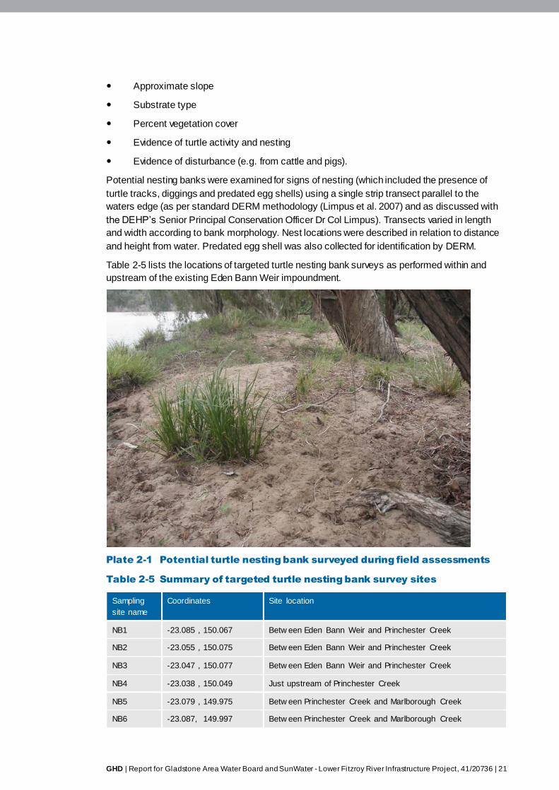
GHD | Report for Gladstone Area Water Board and SunWater - Lower Fitzroy River Infrastructure Project, 41/20736 | 21
Approximate slope
Substrate type
Percent vegetation cover
Evidence of turtle activity and nesting
Evidence of disturbance (e.g. from cattle and pigs).
Potential nesting banks were examined for signs of nesting (which included the presence of
turtle tracks, diggings and predated egg shells) using a single strip transect parallel to the
waters edge (as per standard DERM methodology (Limpus et al. 2007) and as discussed with
the DEHP’s Senior Principal Conservation Officer Dr Col Limpus). Transects varied in length
and width according to bank morphology. Nest locations were described in relation to distance
and height from water. Predated egg shell was also collected for identification by DERM.
Table 2-5 lists the locations of targeted turtle nesting bank surveys as performed within and
upstream of the existing Eden Bann Weir impoundment.
Plate 2-1 Potential turtle nesting bank surveyed during field assessments
Table 2-5 Summary of targeted turtle nesting bank survey sites
Sampling
site name
Coordinates Site location
NB1 -23.085 , 150.067 Betw een Eden Bann Weir and Princhester Creek
NB2 -23.055 , 150.075 Betw een Eden Bann Weir and Princhester Creek
NB3 -23.047 , 150.077 Betw een Eden Bann Weir and Princhester Creek
NB4 -23.038 , 150.049 Just upstream of Princhester Creek
NB5 -23.079 , 149.975 Betw een Princhester Creek and Marlborough Creek
NB6 -23.087, 149.997 Betw een Princhester Creek and Marlborough Creek
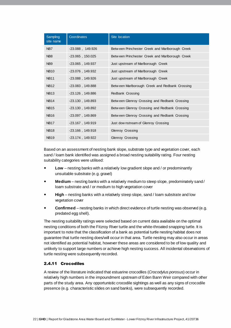
22 | GHD | Report for Gladstone Area Water Board and SunWater - Lower Fitzroy River Infrastructure Project, 41/20736
Sampling
site name
Coordinates Site location
NB7 -23.088 , 149.926 Betw een Princhester Creek and Marlborough Creek
NB8 -23.065 , 150.025 Betw een Princhester Creek and Marlborough Creek
NB9 -23.065 , 149.937 Just upstream of Marlborough Creek
NB10 -23.076 , 149.932 Just upstream of Marlborough Creek
NB11 -23.088 , 149.926 Just upstream of Marlborough Creek
NB12 -23.083 , 149.888 Betw een Marlborough Creek and Redbank Crossing
NB13 -23.126 , 149.886 Redbank Crossing
NB14 -23.130 , 149.893 Betw een Glenroy Crossing and Redbank Crossing
NB15 -23.130 , 149.892 Betw een Glenroy Crossing and Redbank Crossing
NB16 -23.097 , 149.869 Betw een Glenroy Crossing and Redbank Crossing
NB17 -23.167 , 149.919 Just dow nstream of Glenroy Crossing
NB18 -23.166 , 149.918 Glenroy Crossing
NB19 -23.174 , 149.922 Glenroy Crossing
Based on an assessment of nesting bank slope, substrate type and vegetation cover, each
sand / loam bank identified was assigned a broad nesting suitability rating. Four nesting
suitability categories were utilised:
Low – nesting banks with a relatively low gradient slope and / or predominantly
unsuitable substrate (e.g. gravel)
Medium – nesting banks with a relatively medium to steep slope, predominately sand /
loam substrate and / or medium to high vegetation cover
High – nesting banks with a relatively steep slope, sand / loam substrate and low
vegetation cover
Confirmed – nesting banks in which direct evidence of turtle nesting was observed (e.g.
predated egg shell).
The nesting suitability ratings were selected based on current data available on the optimal
nesting conditions of both the Fitzroy River turtle and the white-throated snapping turtle. It is
important to note that the classification of a bank as potential turtle nesting habitat does not
guarantee that turtle nesting does/will occur in that area. Turtle nesting may also occur in areas
not identified as potential habitat, however these areas are considered to be of low quality and
unlikely to support large numbers or achieve high nesting success. All incidental observations of
turtle nesting were subsequently recorded.
2.4.11 Crocodiles
A review of the literature indicated that estuarine crocodiles (Crocodylus porosus) occur in
relatively high numbers in the impoundment upstream of Eden Bann Weir compared with other
parts of the study area. Any opportunistic crocodile sightings as well as any signs of crocodile
presence (e.g. characteristic slides on sand banks), were subsequently recorded.
GHD | Report for Gladstone Area Water Board and SunWater - Lower Fitzroy River Infrastructure Project, 41/20736 | 23
2.4.12 Other fauna
The platypus (O. anatinus) is known to occur within the Fitzroy Basin catchment (Grant and
Temple-Smith 1998). A general characterisation of potentially suitable habitats for the platypus
(based on the known ecology of the species from the literature) was ascertained through
aquatic habitat assessments. Any opportunistic observations of this species were subsequently
recorded. Other fauna that utilise aquatic habitats, including water birds, amphibians, eastern
water dragon (Physignathus lesuerii) and water rat (Hydromys chrysogaster) were not
considered in this aquatic assessment.
2.4.13 Macroinvertebrates
Information on macroinvertebrate assemblages in the Fitzroy River system was acquired from a
review of the literature and supplemented by the results of field studies. Literature reviews were
verified by opportunistic sampling for large macroinvertebrates during fish trapping whilst small
and cryptic macroinvertebrates were sampled by deploying artificial substrates at locations
within the Eden Bann Weir Project footprint, Rookwood Weir Project footprint and in
downstream reaches to the Fitzroy Barrage as presented in Table 2-6. Artificial substrates were
utilised at the time of the surveys, due to the inability to undertake kick-sampling as a result of
flooding and other logistical and safety concerns (Section 2.4.2).
The artificial substrates were ‘rock basket’ substrates based upon De Pauw et al. (1986)
substrates. The substrates were approximately 2500 cm3 in volume, made of an open mesh and
filled with plastic potato / orange bags and rocks to the size of half a house brick. These
substrates were placed into the water at depths no greater than five metres and allowed to be
colonised for three to six weeks. Variation in duration of substrate colonisation was related to
logistical issues associated with retrieving the samples. Five substrates were deployed at each
survey site.
The substrates were collected into a 250 µm sweep net and rinsed, then placed into suitable
sample jars and preserved with 70% ethanol. Samples were identified using a stereoscope and
keys listed in Hawking (2000). Individuals from every sample jar were identified to family level
and preserved in individual vials containing 90% ethanol.
Within the Eden Bann Weir Project footprint, artificial substrates were deployed at two sites in
the Eden Bann Weir impoundment in the wet season and four sites in the dry season. Artificial
substrates were also deployed throughout the broader study area, including sites upstream of
the Fitzroy Barrage (six during the wet, and three during the dry season) and one site in the
Rookwood Weir Project footprint (wet season only).
2.4.14 Macrophytes
A review of the literature provided baseline information on the aquatic plant assemblages
typically encountered in the Fitzroy Basin catchment. Marcophytes were infrequently
encountered throughout the Project footprint during field studies. If present, aquatic plant
assemblages were recorded at locations in which habitat assessments were performed. While
not identifying macrophytes to species level, a general description of the plants, including
whether they were emergent, submergent or floating was noted.

24 | GHD | Report for Gladstone Area Water Board and SunWater - Lower Fitzroy River Infrastructure Project, 41/20736
Table 2-6 Description of artificial substrate locations
Site
name
River Site location Site
coordinate
Aquatic habitat
type
Season
sampled
FBA1 Fitzroy
River
Creek adjoining Fitzroy Barrage w eir
pool betw een Fitzroy Barrage and
Alligator Creek
-23.237,
150.409
Creek adjoining
Fitzroy Barrage
impounded pool
Dry
FBA2 Fitzroy
River
Creek adjoining Fitzroy Barrage w eir
pool betw een Fitzroy Barrage and
Alligator Creek
-23.251,
150.381
Creek adjoining
Fitzroy Barrage
impounded pool
Dry
FBA3 Alligator
Creek
Alligator Creek -23.246,
150.417
Creek Dry
FBA6 Fitzroy
River
Fitzroy Barrage impoundment
betw een Fitzroy Barrage and
Alligator Creek
-23.242,
150.342
Impounded pool Wet
FBA6A Fitzroy
River
Fitzroy Barrage impoundment
betw een Fitzroy Barrage and
Alligator Creek
-23.242,
150.342
Impounded pool Wet
FBA9 Fitzroy
River
Fitzroy River betw een Fitzroy
Barrage impoundment and Eden
Bann Weir
-23.146,
150.362
Pool Wet
FBA10 Fitzroy
River
Fitzroy River betw een Fitzroy
Barrage impoundment and Eden
Bann Weir
-23.145,
150.376
Impounded pool Wet
FBA11 Fitzroy
River
Off-stream billabong adjacent to
Fitzroy Barrage Impoundment
-23.248,
150.377
Off-stream w ater
body
Wet
FBA13 Fitzroy
River
Fitzroy Barrage impoundment
betw een Fitzroy Barrage and
Alligator Creek
-23.241,
150.342
Impounded pool Wet
EBA14 Fitzroy
River
Eden Bann Weir impoundment on
bend, just dow nstream of
Marlborough Creek
-23.058,
149.941
Impounded pool Dry
EBA16 Fitzroy
River
Eden Bann Weir impoundment on
bend, just upstream of Eight Mile
Creek
-23.087,
149.997
Impounded pool Dry
EBA21 Fitzroy
River
Eden Bann Weir impoundment (f irst
bend upstream of w eir)
-23.082,
150.066
Impounded pool /
Impounded pool
Wet / Dry
EBA23 Fitzroy
River
Eden Bann Weir impoundment (f irst
bend upstream of w eir) – opposite
bank to EBA21
-23.082,
150.066
Impounded pool /
Impounded pool
Wet / Dry
Riverslea Fitzroy
River
Upstream of Riverslea Crossing -23.578,
149.934
Pool Wet
GHD | Report for Gladstone Area Water Board and SunWater - Lower Fitzroy River Infrastructure Project, 41/20736 | 25
2.4.15 Summary of aquatic survey effort
The following survey effort was conducted within the Eden Bann Weir Project footprint:
23 habitat assessments (23 wet season, 4 replicated in dry season)
19 targeted turtle nesting bank surveys (19 wet season)
20 fyke trap nights (10 wet season; 10 dry season)
14 baited trap nights (14 wet season)
Artificial substrates throughout entire study area including six sites within Eden Bann Weir
Project footprint (two sites in the wet season, and four sites in the dry season).
The survey effort employed in this assessment sought to combine existing information with data
and observations recorded from field studies, in the context of the assessment objectives and
identified limitations. Most importantly, this methodology allowed for the characteristics, value
and spatial distribution of aquatic habitat types to be described, such that the loss / alteration of
these habitats due to raising Eden Bann Weir could be assessed. Furthermore, the assessment
considered a large amount of existing information on aquatic species in the Fitzroy Basin
catchment, including previously prepared reports that have investigated the potential impacts of
raising Eden Bann Weir and / or constructing a weir at Rookwood on conservation significant
aquatic species (namely the Fitzroy River turtle and estuarine crocodile). The baseline
environmental values detailed in these reports, and other studies relating to the aquatic fauna
and flora of the Fitzroy Basin catchment (including comparative studies of riverine and weir
environments), were ground-truthed and supplemented through the implementation of the
survey effort outlined above. As a result of this combined desktop and field based assessment
approach, the risks associated with raising Eden Bann Weir on aquatic habitats and species
(most notably, conservation significant fauna known or predicted to occur within the Project
footprint) have been identified, thereby allowing for a thorough assessment of potential impacts
and the development of appropriate migration strategies.
2.5 Aquatic habitat calculation
Aquatic habitat types included in the calculation of aquatic habitat within the Project footprint
consist of pool, riffle, run habitats and creeks adjoining the main river. Aquatic habitat already
impacted by the existing Eden Bann Weir impoundment was excluded for the purpose of
quantifying the area of natural aquatic habitat within the Project footprint.
The Fitzroy River transports a substantial sediment load during periods of flood with high
erosion and deposition rates which change the river and its boundaries overtime. Elsewhere in
the EIS, cadastral boundaries have been used to define the extent of watercourse areas and
adjacent landholdings however this was considered inappropriate for determining areas of
aquatic habitat as land title boundaries in some cases are over 100 years old and the physical
river channel as well as survey techniques and legislation defining watercourse boundaries
have changed in that time. There was found to be no existing watercourse data that was
suitable in terms of accuracy for use in calculating aquatic habitat. Cadastral data, Queensland
land use mapping program data and regional ecosystem mapping data proved highly inaccurate
when overlayed on satellite imagery as these mapped watercourse boundaries included land
outside of the river channel, rocky outcrops in the river channel and sand banks.
In the absence of suitable GIS data, aquatic habitat was manually digitised using satellite
imagery (Digital Globe World View 2, July 2010) based on the discernible boundaries of water
within the river channel (excluding rock and sand banks) between the upper limit of the existing
26 | GHD | Report for Gladstone Area Water Board and SunWater - Lower Fitzroy River Infrastructure Project, 41/20736
and proposed Eden Bann Weir impoundment. The digitised data was then cross-checked
against river bed level cross-section data at 23 locations. The cross-section data was available
from the hydraulic model developed for the Project as described in Chapter 9 Surface water
resources. Land survey cross-sections which enable calibration of the hydraulic model were
used to validate the river width determined by the digitised river channel polygon. The cross -
sections distinctly show where the river channel is and what profile the channel takes. The
average difference between the digitised width and cross-section width is –0.9 m which is
considered to show good correlation.
Water levels in the system fluctuate seasonally, as such July was considered the most
appropriate time to represent near to stable water levels early in the dry season that are not
influenced by wet season flood flows. While satellite imagery for other months was not available
for use, aerial imagery captured in August and September 2009 was also assessed showing an
average decrease in river width of 6 m at cross-sections when compared to the July 2010 data.
The Fitzroy River is susceptible to seasonal high flow events during the wet season
(approximately November to April), and occasional flooding in instances where intensive rainfall
events occur within and up-stream of the Fitzroy subcatchment (Chapter 9 Surface water
resources). As such, the use of imagery captured during the wet season would not be
representative of flow conditions.
GHD | Report for Gladstone Area Water Board and SunWater - Lower Fitzroy River Infrastructure Project, 41/20736 | 27
3. Aquatic ecology existing environmental
values
3.1 Fitzroy Basin catchment
The Fitzroy Basin catchment is the largest catchment on the eastern seaboard of Australia, and is
second only to the Murray-Darling Basin as Australia’s largest catchment. It extends over an area
of approximately 142,000 km2 of Central and Eastern Queensland about the Tropic of Capricorn,
and drains into the Great Barrier Reef World Heritage Area. It consists of s ix major sub-
catchments, namely:
Isaac / Connors
Nogoa
Comet
Mackenzie
Dawson
Fitzroy.
Strongly seasonal climatic factors heavily influence flows within the Fitzroy Basin catchment, with
the sub-tropical climate fostering the majority of rainfall during the wet season (approximately
November to April). The warm, wet season is generally interspersed with long, dry periods during
the dry season (approximately May to October). Mean annual rainfall is generally higher in eastern
parts of the catchment (800 – 1000 mm), and slightly lower inland to the west (600 mm) (Johnston
et al. 2008). Total evaporation within the Fitzroy Basin catchment significantly exceeds rainfall,
thereby resulting in prevailing dry conditions and variable stream flow (Marsden and Power 2007).
Severe flooding occasionally occurs within the Fitzroy Basin catchment as a result of intensive
rainfall events associated with severe storms, cyclones and tropical low pressure systems.
Prolonged dry conditions and drought are also characteristic features of the highly variable and
unpredictable nature of the Fitzroy Basin catchment climate is exposed to. Mean annual discharge
from the catchment is 5 million ML, however flows can be as low as 100, 000 ML in dry years
(Department of Natural Resources and Water (DNRW) 2008).
Although sparsely populated, large tracts of land within the Fitzroy Basin catchment have been
modified for human land use practices, principally agriculture, which accounts for almost 90% of
catchment land use (Johnston et al. 2008). Of this agricultural use, 81.7% is livestock grazing
(Johnston et al. 2008). Other notable land uses within the Fitzroy Basin catchment include State
Forest (6.65%), nature conservation (4.54%) and mining (0.38%) (Johnston et al. 2008). Although
only a comparatively small component of land use, existing mining activities within the Fitzroy
Basin catchment are concentrated in the northern and western parts of the catchment. As of 2008,
85% of the state’s operational coal mines were located in the Fitzroy Basin catchment (Johnston et
al. 2008).

28 | GHD | Report for Gladstone Area Water Board and SunWater - Lower Fitzroy River Infrastructure Project, 41/20736
Major water infrastructure has been constructed at a number of sites along rivers within the Fitzroy
Basin catchment in order to meet irrigation, urban and industrial demands. Infrastructure includes:
Mackenzie-Nogoa system: Tartrus Weir, Bingegang Weir, Bedford Weir, Fairbairn Dam
Dawson River: Neville Hewitt Weir, Moura Weir, Theodore Weir, Orange Creek Weir,
Gyranda Weir, Glebe Weir
Fitzroy River: Eden Bann Weir, Fitzroy Barrage.
The freshwater fish community within the Fitzroy Basin catchment contains a unique combination
of semi-arid / temperate and tropical / sub-tropical species, including two endemic species
(southern saratoga (Scleropages leichardti) and leathery grunter (Scortum hillii)), and one endemic
sub-species (golden perch (Macquaria ambigua oriens)) (Stuart et al. 2007).
The Fitzroy Basin catchment supports one of the highest diversities of freshwater turtles in
Australia, with six species occurring throughout the catchment, including two regionally endemic
species (Fitzroy River turtle and white-throated snapping turtle). The Fitzroy River turtle is listed as
‘Vulnerable’ under the NC Act and the EPBC Act. Other conservation significant species occurring
within the Fitzroy Basin catchment include the estuarine crocodile, listed as ‘Vulnerable’ under the
NC Act and ‘Migratory’ and ‘Marine’ under the EPBC Act (Britton 2007a; Britton 2007b), and the
platypus (Ornithorhynchus anatinus) which is protected under the NC Act as a ‘Special Least
Concern’ species.
3.2 Field survey climatic conditions
3.2.1 Wet season
Conditions during the initial wet season habitat assessment survey (28 January - 2 February
2009), were generally warm and dry. Temperatures ranged between 21.9ºC and 31.3ºC with
averages of 22.9ºC (min) and 30.2ºC (max). Days were generally cloudy with moderate relative
humidity (average 60% recorded at 3 pm). Total rainfall during the survey period was 3.4 mm.
Forty-one millimetres of rain was recorded in the two-week period prior to the surveys while 131.6
mm of rain fell in the two months prior (December 2008 and January 2009). During the wet season
aquatic fauna trapping survey (13-14 February 2009) the temperature did not drop below 22.8ºC,
and the maximum recorded temperature was 31.5ºC. Conditions were overcast and humid, with
37.4 mm of rain recorded and an average relative humidity (at 3 pm) of 73%. In the two weeks
prior to the survey 123 mm of rainfall was recorded, including 87.4 mm on February 11.
3.2.2 Dry season
Conditions during the dry season survey (12 - 14 July 2009) were typified by warm days, and cool
to mild nights. Temperatures ranged between 7.5ºC and 26.6ºC with averages of 8.7ºC (min) and
26.1ºC (max). Days were generally clear (i.e. little cloud cover) with high relative humidity in the
mornings (average 74.3 % recorded at 9 am) and low relative humidity in the afternoons (average
33.3 % recorded at 3 pm). No rainfall was recorded during the survey period, nor in the two-week
period prior to the surveys, however 16.8 mm of rain occurred in the two months prior (13 May
2009 and 12 July 2009).
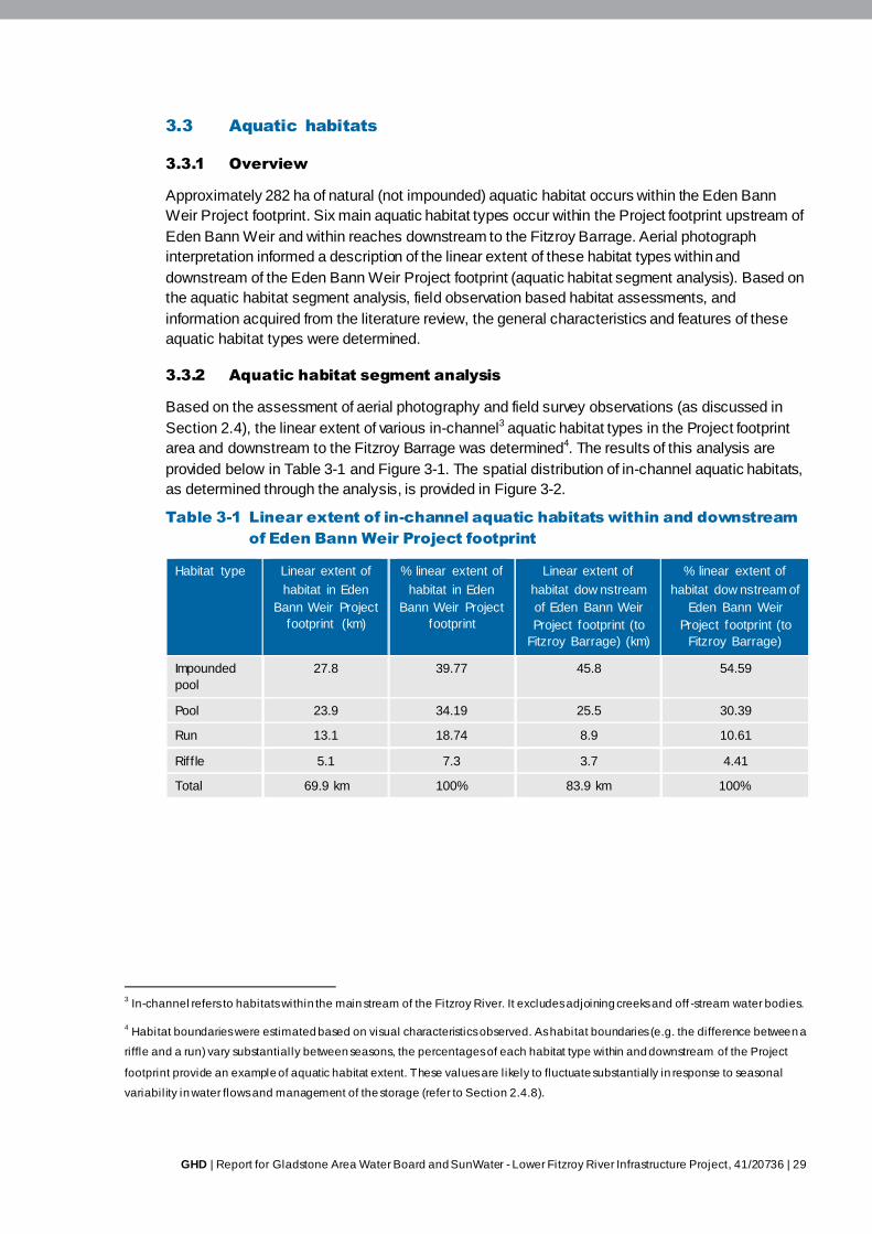
GHD | Report for Gladstone Area Water Board and SunWater - Lower Fitzroy River Infrastructure Project, 41/20736 | 29
3.3 Aquatic habitats
3.3.1 Overview
Approximately 282 ha of natural (not impounded) aquatic habitat occurs within the Eden Bann
Weir Project footprint. Six main aquatic habitat types occur within the Project footprint upstream of
Eden Bann Weir and within reaches downstream to the Fitzroy Barrage. Aerial photograph
interpretation informed a description of the linear extent of these habitat types within and
downstream of the Eden Bann Weir Project footprint (aquatic habitat segment analysis). Based on
the aquatic habitat segment analysis, field observation based habitat assessments, and
information acquired from the literature review, the general characteristics and features of these
aquatic habitat types were determined.
3.3.2 Aquatic habitat segment analysis
Based on the assessment of aerial photography and field survey observations (as discussed in
Section 2.4), the linear extent of various in-channel3 aquatic habitat types in the Project footprint
area and downstream to the Fitzroy Barrage was determined4. The results of this analysis are
provided below in Table 3-1 and Figure 3-1. The spatial distribution of in-channel aquatic habitats,
as determined through the analysis, is provided in Figure 3-2.
Table 3-1 Linear extent of in-channel aquatic habitats within and downstream
of Eden Bann Weir Project footprint
Habitat type Linear extent of
habitat in Eden
Bann Weir Project
footprint (km)
% linear extent of
habitat in Eden
Bann Weir Project
footprint
Linear extent of
habitat dow nstream
of Eden Bann Weir
Project footprint (to
Fitzroy Barrage) (km)
% linear extent of
habitat dow nstream of
Eden Bann Weir
Project footprint (to
Fitzroy Barrage)
Impounded
pool
27.8 39.77 45.8 54.59
Pool 23.9 34.19 25.5 30.39
Run 13.1 18.74 8.9 10.61
Riff le 5.1 7.3 3.7 4.41
Total 69.9 km 100% 83.9 km 100%
3 In-channel refers to habitats within the main stream of the Fitzroy River. It excludes adjoining creeks and off -stream water bodies.
4 Habitat boundaries were estimated based on visual characteristics observed. As habitat boundaries (e.g. the difference between a
riffle and a run) vary substantially between seasons, the percentages of each habitat type within and downstream of the Project
footprint provide an example of aquatic habitat extent. These values are likely to fluctuate substantially in response to seasonal
variabil ity in water flows and management of the storage (refer to Section 2.4.8).
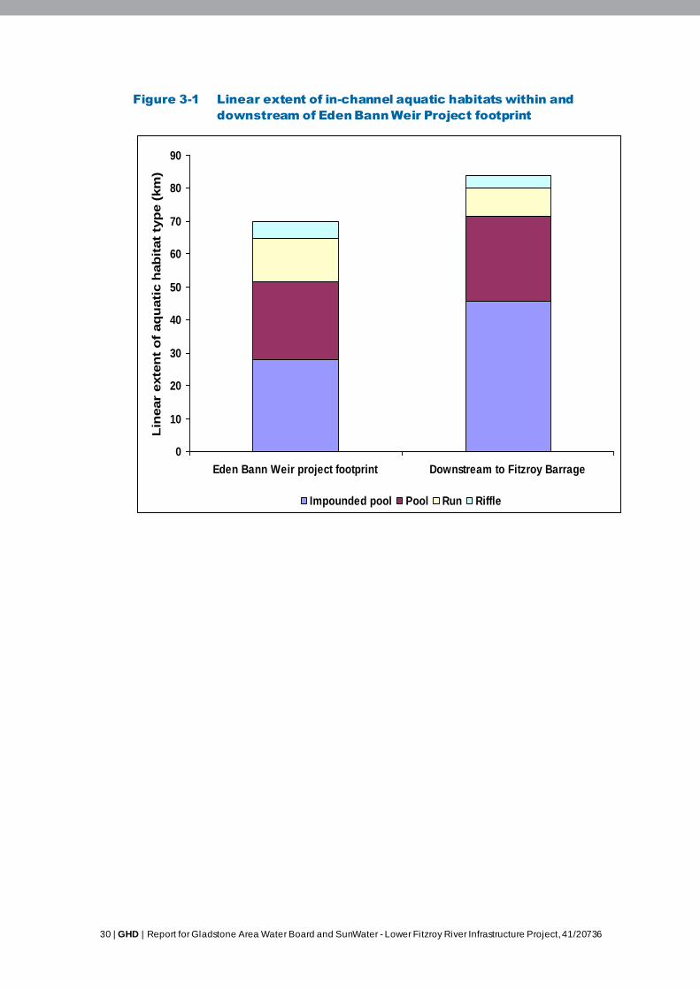
30 | GHD | Report for Gladstone Area Water Board and SunWater - Lower Fitzroy River Infrastructure Project, 41/20736
Figure 3-1 Linear extent of in-channel aquatic habitats within and
downstream of Eden Bann Weir Project footprint
0
10
20
30
40
50
60
70
80
90
Eden Bann Weir project footprint Downstream to Fitzroy Barrage
Lin
ear
exte
nt
of
aq
uati
c h
ab
itat
typ
e (
km
)
Impounded pool Pool Run Riffle
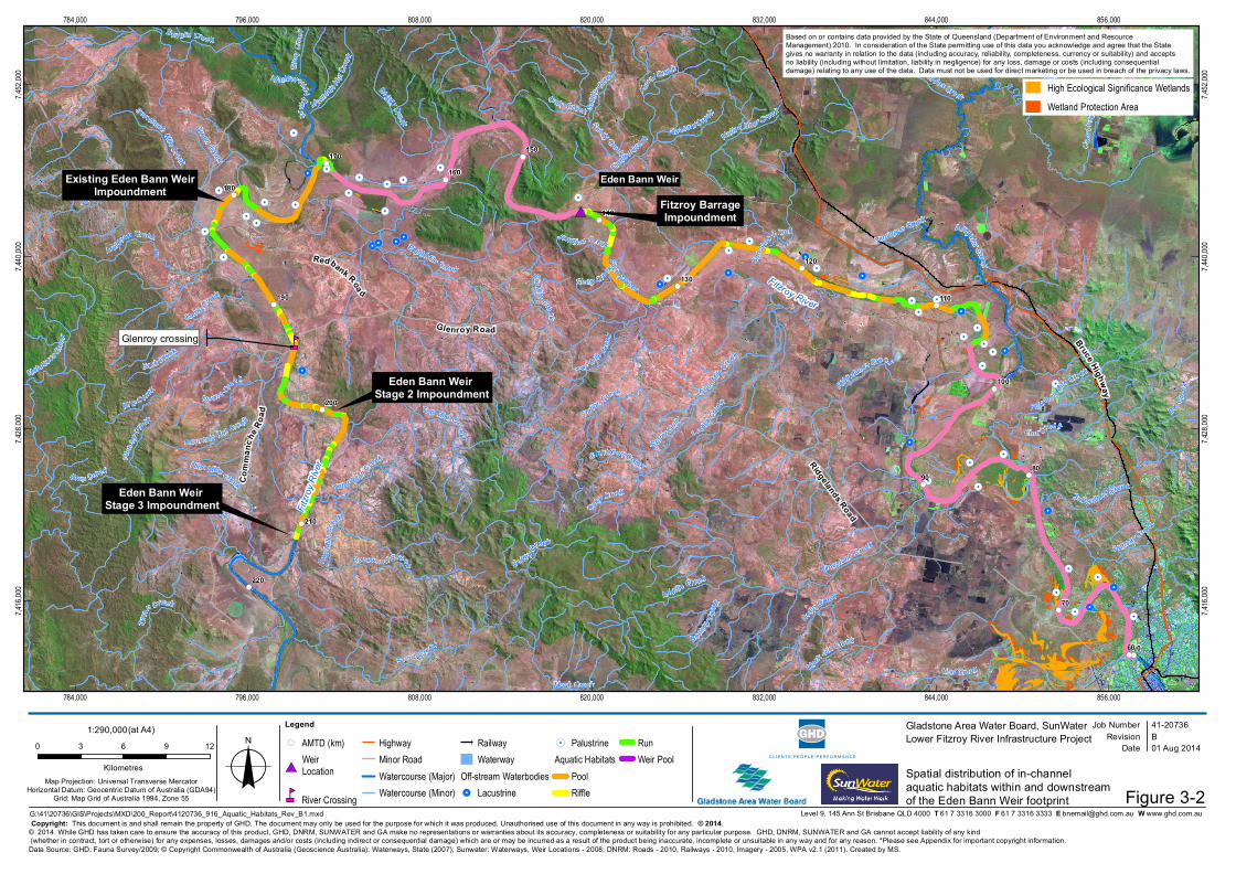
!.!.
!.!.
!.
!.
!.
!.
!.
!.!.
!.
!.
!.
!.
!.
!.
!.!.
!.
!.!.
!.!.
!.!.
!.
!.!.
!.!.!.
!.
!.
!. !.
!.
!.!.
!. !.
!.
!.
!.!.
!.!.!.
!.!.
!.
!.
!.
!.!.
!.
#*
nm
!(!(
!(
!(
!(
!(
!(
!(
!(
!(
!(
!(
!(
!(
!(
!(
!(
!(
!(!(
Fitzro
y Rive
r
Fitzroy River
Bruce Highway
Eden Bann Weir
Glenroy crossing
Fitzroy River
Ten Mile Cree k
Mela leuca Cree
k
Scrub C reek
Alligator Creek
D e velin Cree k
Planted Creek
Four Mile
Creek
Lou isaCree
k
Black
Gin Creek
Glen
royCr
eek
Limestone Creek
Cana
lCree
k
M uldo
on Creek
DeepCreek
Coffe y Creek
Station Creek
Middle Creek
Ridgelands Creek
Two Mile Creek
D o wns Creek
Ra msay Creek
Camp Creek
Back Creek
Boggy Creek
OakyCreek
Six Mi le C reek
Nine Mile Creek
Cano
onaCreek
B onney C ree
k
Lion Creek
Sut h e rland Creek
Sand
y Creek
Mile C reek
Etna Creek
Bills Cree k
Native Bear Creek
Fourteen Mile Creek
Gle n Creek
S torer Gully
Mountain Hut Cre ekEight Mile Creek
Templeton Creek
Pleasant Creek
Seventeen Mile Creek
B K C reek
Tyna
n Creek
Stony
Cree
k
Green Creek
Junct ion Creek
Kerr
al Creek
Chinaman Creek
Rosewood Creek
Duck Holes Creek
Yemiappo Creek
Moah Creek
Ten Mile Creek
Oaky Creek
B ack Creek
Sandy Creek
MountainH ut
Cree
k
Two M
il eC r
eek
Stony C ree
k
0
9080
70
60
210
190
200
180
130
140
120
110
100
Glenroy Road
Comm
anch
e Road
Redbank Roa d
Ridgelands Road
220
170160
150
784,000
784,000
796,000
796,000
808,000
808,000
820,000
820,000
832,000
832,000
844,000
844,000
856,000
856,000
7,416,
000
7,416,
000
7,428,
000
7,428,
000
7,440,
000
7,440,
000
7,452,
000
7,452,
000
Job NumberRevision B
41-20736
G:\41\20736\GIS\Projects\MXD\200_Report\4120736_916_Aquatic_Habitats_Rev_B1.mxd
Map Projection: Universal Transverse MercatorHorizontal Datum: Geocentric Datum of Australia (GDA94)
Grid: Map Grid of Australia 1994, Zone 55
0 3 6 9 12
Kilometres o© 2014. While GHD has taken care to ensure the accuracy of this product, GHD, DNRM, SUNWATER and GA make no representations or warranties about its accuracy, completeness or suitability for any particular purpose. GHD, DNRM, SUNWATER and GA cannot accept liability of any kind (whether in contract, tort or otherwise) for any expenses, losses, damages and/or costs (including indirect or consequential damage) which are or may be incurred as a result of the product being inaccurate, incomplete or unsuitable in any way and for any reason. *Please see Appendix for important copyright information.
Date 01 Aug 2014
Gladstone Area Water Board, SunWaterLower Fitzroy River Infrastructure Project
Data Source: GHD: Fauna Survey/2009; © Copyright Commonwealth of Australia (Geoscience Australia): Waterways, State (2007); Sunwater: Waterways, Weir Locations - 2008; DNRM: Roads - 2010, Railways - 2010, Imagery - 2005, WPA v2.1 (2011). Created by MS.
Level 9, 145 Ann St Brisbane QLD 4000 T 61 7 3316 3000 F 61 7 3316 3333 E [email protected] W www.ghd.com.au
1:290,000(at A4)
Figure 3-2Copyright: This document is and shall remain the property of GHD. The document may only be used for the purpose for which it was produced. Unauthorised use of this document in any way is prohibited. © 2014.
Legend!( AMTD (km)
#*WeirLocation
nm River Crossing
HighwayMinor RoadWatercourse (Major)Watercourse (Minor)
RailwayWaterway
Off-stream Waterbodies!. Lacustrine
!. PalustrineAquatic Habitats
PoolRiffle
RunWeir Pool
Based on or contains data provided by the State of Queensland (Department of Environment and Resource Management) 2010. In consideration of the State permitting use of this data you acknowledge and agree that the State gives no warranty in relation to the data (including accuracy, reliability, completeness, currency or suitability) and accepts no liability (including without limitation, liability in negligence) for any loss, damage or costs (including consequential damage) relating to any use of the data. Data must not be used for direct marketing or be used in breach of the privacy laws.
Spatial distribution of in-channel aquatic habitats within and downstreamof the Eden Bann Weir footprint
M arlboroughCreek
Existing Eden Bann WeirImpoundment
Eden Bann Weir Stage 2 Impoundment
Eden Bann Weir Stage 3 Impoundment
High Ecological Significance WetlandsWetland Protection Area
Fitzroy BarrageImpoundment

32 | GHD | Report for Gladstone Area Water Board and SunWater - Lower Fitzroy River Infrastructure Project, 41/20736
3.3.3 Impounded pools
General characteristics
Impounded pool habitats are defined as generally non-flowing, typically deep water impounded
within the bed and banks of a river upstream of a weir. The depth and linear extent of this habitat
type is variable, and dependent on local to catchment-wide climatic factors as well as operations of
the infrastructure.
Within the Project footprint, the following characteristics of impounded pool habitat were identified
based on eight aquatic habitat assessments:
Average stream width approximately 172.5 m (range 120-250 m)
Average channel depth approximately 8.7 m (6.5-10 m)
Average bank height approximately 7.8 m (3-20 m)
Typical substrate: clay / silt (<0.006 mm)
Logs and coarse-woody debris occurred at the margins of the impoundment at all but one
site, and were plentiful at two sites
Aquatic macrophytes were encountered occasionally (four of eight sites) – these were
generally attached to the substrate rather than free floating
Water was not flowing.
As described in Section 2.4.7, the habitat characteristics of the impounded pool habitat was
assessed from excellent to poor according to the AusRivAS River Bioassessment Program (Table
3-2).
Table 3-2 Habitat characteristic ratings of impounded pool habitats
Habitat
assessment
site
Bottom substrate /
available cover
Bank stability Bank vegetative
stability
Streamside cover
Left bank Right
bank
Left bank Right
bank
Left bank Right
bank
Left bank Right
bank
EBA15 Poor Poor Excellent Excellent Good Excellent Fair Fair
EBA16 Poor Poor Excellent Good Excellent Excellent Fair Fair
EBA17 Poor Poor Good Excellent Good Good Fair Fair
EBA18 Poor Poor Fair Fair Fair Fair Fair Fair
EBA20 Good Fair Excellent Good Excellent Excellent Good Fair
EBA21 Fair Poor Good Excellent Excellent Excellent Fair Good
EBA22 Good Good Excellent Excellent Excellent Excellent Fair Good
EBA23 Fair Fair Good Good Good Good Fair Fair
GHD | Report for Gladstone Area Water Board and SunWater - Lower Fitzroy River Infrastructure Project, 41/20736 | 33
Assessment of the habitat characteristics within the Eden Bann Weir Project footprint revealed that
bottom substrate / available cover within the impounded pool habitat was generally fair, with
habitat features such as submerged logs and rocks, largely confined to the margins of the
impounded pool habitat. Bank stability and bank vegetative stability were ranked as being good –
excellent with few areas of exposed/unstable banks. Whilst high grass/weed cover on the river
banks served to stabilise banks, the low abundance of trees and shrubs resulted in 13 of the 16
banks assessed, receiving a poor streamside covering rating (Table 3-2).
While not quantifiably assessed, a notable field observation throughout the Eden Bann Weir
Project footprint (and indeed the entire study area) was that the quality of marginal aquatic habitats
(in terms of likely value for fauna) was higher where cattle access to the river was prevented or
restricted. This observation not only applies to the impounded pool habitat, but to all aquatic
habitats, including off-stream water bodies and adjoining creeks.
Spatial distribution and extent of habitat
Impounded pool habitat occurs in the Fitzroy River (and the lower reaches of adjoining creeks)
upstream of Eden Bann Weir. While the maximum impoundment extent of the existing structure is
184 km adopted middle thread distance (approximately 43 km upstream of the weir), field
observations and aquatic habitat segment analysis indicated that the impounded pool habitat does
not necessarily extend upstream as far as this. Aquatic habitat assessments and aerial photograph
interpretation indicated that the impounded pool habitat prevails upstream from Eden Bann Weir to
approximately Marlborough Creek (28 km upstream). It is important to note that this conclusion is
based on observations made at the time of survey, and may, therefore, be subject to variation in
response to the highly variable and seasonal climatic factors for the catchment.
Downstream of Eden Bann Weir, the impounded pool habitat created by water contained within
the Fitzroy Barrage is the most dominant aquatic habitat type (approximately 54.6 per cent). Based
on the aquatic habitat segment analysis, this habitat extends 45.8 km upstream.
3.3.4 Pools
General characteristics
Pool habitats are defined as relatively deep, still / very slow flowing water over variable substrates
(i.e. silt, sand, stone or rock) that occur naturally within the riverine environment (as opposed to
upstream of man-made structures) (AusRivAS 2001). This aquatic habitat type occurs in the main
river channel, and may become isolated into a series of discrete water holes during dry conditions
when flow ceases and water levels drop. The low (or zero) velocity of water flow differentiates a
pool habitat from a faster flowing run habitat (AusRivAS 2001).
During the wet season surveys, the pool habitats that normally occur within the Project footprint
during the dry season, were converted to run habitats due to the level and flow of water within the
Fitzroy River. These habitats within and upstream of the Project footprint could not be accessed
for assessment during the dry season (refer to Section 2.4.2) and as a result aquatic habitat
assessments could not be undertaken for this habitat type. Observations from the broader study
area (i.e. upstream of the Rookwood Weir site) indicated that, like the impounded pool habitat, the
most significant habitat features of pools are concentrated along the margins of the waterway. The
provision of a variety of habitat resources and microhabitats due to the presence of undercut
banks, woody debris, macrophytes, variable substrates, and overhanging and inundated riparian
vegetation, has the potential to support a diversity of aquatic fauna, including freshwater turtles,
fish, platypus and macroinvertebrates.
34 | GHD | Report for Gladstone Area Water Board and SunWater - Lower Fitzroy River Infrastructure Project, 41/20736
Spatial distribution and extent of habitat
The spatial distribution and extent of pool habitat within the Project footprint was assessed from
aerial photographs. This assessment revealed that pools are the second most dominant aquatic
habitat type within the Eden Bann Weir Project footprint (total linear extent of 23.9 km; 34.19 % of
habitat). The pool habitats are typically interspersed by riffle and / or run habitats. Based on the
habitat segment analysis, the largest pool in the Eden Bann Weir Project footprint extends
upstream of Marlborough Creek (for a length of approximately 6.8 km).
Aquatic habitat segment analysis indicated that pools are also the second most dominant habitat
type downstream of the Project footprint (total linear extent of 25.5 km; 30.39% of habitat between
Fitzroy Barrage and Eden Bann Weir).
3.3.5 Runs
General characteristics
Run habitats are defined as relatively deep, flowing, unbroken water over a sandy, stony or rocky
bed (AusRivAS 2001). These habitats may occur immediately upstream and downstream of a riffle
zone. Fast flowing water during high flow / flood conditions may result in the conversion of sluggish
pool habitats and shallow riffle habitats into runs (AusRivAS 2001).
Within the Project footprint, the following characteristics of run habitats were identified based on
ten aquatic habitat assessments:
Average stream width approximately 113.5 m (range 60-200 m)
Average channel depth approximately 4.15 m (3-6 m)
Average bank height approximately 5.8 m (2-13.5 m)
Typical substrate: clay / silt (<0.006 mm), some sites also had a combination of clay / silt
and sand (2-0.006 mm)
Logs and coarse-woody debris occurred at the margins of run habitats at seven of ten sites,
and were plentiful at one site
Aquatic macrophytes were absent at all sites assessed
Water velocity was generally slow to moderate at the time of habitat assessments.
As described in Section 2.4.7, the habitat characteristics of the run habitats were assessed from
excellent to poor according to the AusRivAS River Bioassessment Program. The results of this
assessment are provided in Table 3-3 and summarised below.
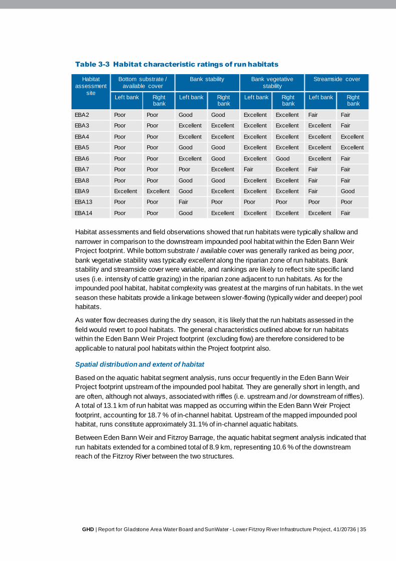
GHD | Report for Gladstone Area Water Board and SunWater - Lower Fitzroy River Infrastructure Project, 41/20736 | 35
Table 3-3 Habitat characteristic ratings of run habitats
Habitat
assessment
site
Bottom substrate /
available cover
Bank stability Bank vegetative
stability
Streamside cover
Left bank Right bank
Left bank Right bank
Left bank Right bank
Left bank Right bank
EBA2 Poor Poor Good Good Excellent Excellent Fair Fair
EBA3 Poor Poor Excellent Excellent Excellent Excellent Excellent Fair
EBA4 Poor Poor Excellent Excellent Excellent Excellent Excellent Excellent
EBA5 Poor Poor Good Good Excellent Excellent Excellent Excellent
EBA6 Poor Poor Excellent Good Excellent Good Excellent Fair
EBA7 Poor Poor Poor Excellent Fair Excellent Fair Fair
EBA8 Poor Poor Good Good Excellent Excellent Fair Fair
EBA9 Excellent Excellent Good Excellent Excellent Excellent Fair Good
EBA13 Poor Poor Fair Poor Poor Poor Poor Poor
EBA14 Poor Poor Good Excellent Excellent Excellent Excellent Fair
Habitat assessments and field observations showed that run habitats were typically shallow and
narrower in comparison to the downstream impounded pool habitat within the Eden Bann Weir
Project footprint. While bottom substrate / available cover was generally ranked as being poor,
bank vegetative stability was typically excellent along the riparian zone of run habitats. Bank
stability and streamside cover were variable, and rankings are likely to reflect site specific land
uses (i.e. intensity of cattle grazing) in the riparian zone adjacent to run habitats. As for the
impounded pool habitat, habitat complexity was greatest at the margins of run habitats. In the wet
season these habitats provide a linkage between slower-flowing (typically wider and deeper) pool
habitats.
As water flow decreases during the dry season, it is likely that the run habitats assessed in the
field would revert to pool habitats. The general characteristics outlined above for run habitats
within the Eden Bann Weir Project footprint (excluding flow) are therefore considered to be
applicable to natural pool habitats within the Project footprint also.
Spatial distribution and extent of habitat
Based on the aquatic habitat segment analysis, runs occur frequently in the Eden Bann Weir
Project footprint upstream of the impounded pool habitat. They are generally short in length, and
are often, although not always, associated with riffles (i.e. upstream and /or downstream of riffles).
A total of 13.1 km of run habitat was mapped as occurring within the Eden Bann Weir Project
footprint, accounting for 18.7 % of in-channel habitat. Upstream of the mapped impounded pool
habitat, runs constitute approximately 31.1% of in-channel aquatic habitats.
Between Eden Bann Weir and Fitzroy Barrage, the aquatic habitat segment analysis indicated that
run habitats extended for a combined total of 8.9 km, representing 10.6 % of the downstream
reach of the Fitzroy River between the two structures.
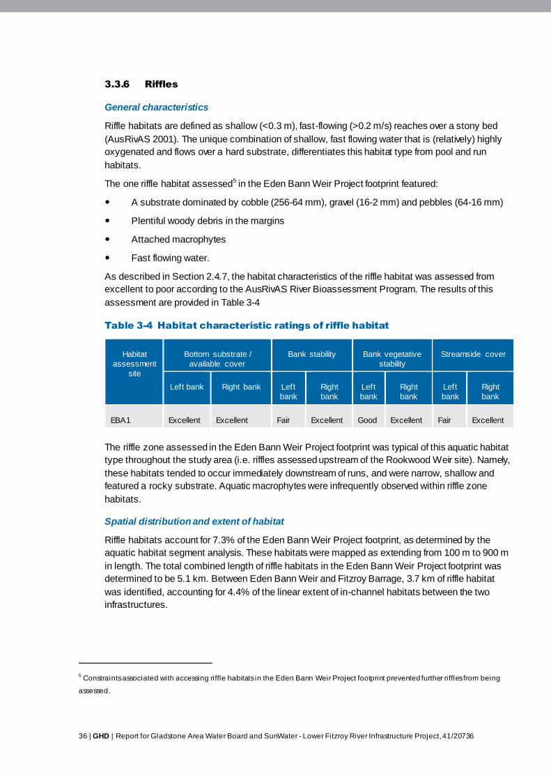
36 | GHD | Report for Gladstone Area Water Board and SunWater - Lower Fitzroy River Infrastructure Project, 41/20736
3.3.6 Riffles
General characteristics
Riffle habitats are defined as shallow (<0.3 m), fast-flowing (>0.2 m/s) reaches over a stony bed
(AusRivAS 2001). The unique combination of shallow, fast flowing water that is (relatively) highly
oxygenated and flows over a hard substrate, differentiates this habitat type from pool and run
habitats.
The one riffle habitat assessed5 in the Eden Bann Weir Project footprint featured:
A substrate dominated by cobble (256-64 mm), gravel (16-2 mm) and pebbles (64-16 mm)
Plentiful woody debris in the margins
Attached macrophytes
Fast flowing water.
As described in Section 2.4.7, the habitat characteristics of the riffle habitat was assessed from
excellent to poor according to the AusRivAS River Bioassessment Program. The results of this
assessment are provided in Table 3-4
Table 3-4 Habitat characteristic ratings of riffle habitat
Habitat
assessment
site
Bottom substrate /
available cover
Bank stability Bank vegetative
stability
Streamside cover
Left bank Right bank Left
bank
Right
bank
Left
bank
Right
bank
Left
bank
Right
bank
EBA1 Excellent Excellent Fair Excellent Good Excellent Fair Excellent
The riffle zone assessed in the Eden Bann Weir Project footprint was typical of this aquatic habitat
type throughout the study area (i.e. riffles assessed upstream of the Rookwood Weir site). Namely,
these habitats tended to occur immediately downstream of runs, and were narrow, shallow and
featured a rocky substrate. Aquatic macrophytes were infrequently observed within riffle zone
habitats.
Spatial distribution and extent of habitat
Riffle habitats account for 7.3% of the Eden Bann Weir Project footprint, as determined by the
aquatic habitat segment analysis. These habitats were mapped as extending from 100 m to 900 m
in length. The total combined length of riffle habitats in the Eden Bann Weir Project footprint was
determined to be 5.1 km. Between Eden Bann Weir and Fitzroy Barrage, 3.7 km of riffle habitat
was identified, accounting for 4.4% of the linear extent of in-channel habitats between the two
infrastructures.
5 Constraints associated with accessing riffle habitats in the Eden Bann Weir Project footprint prevented further riffles from being
assessed.
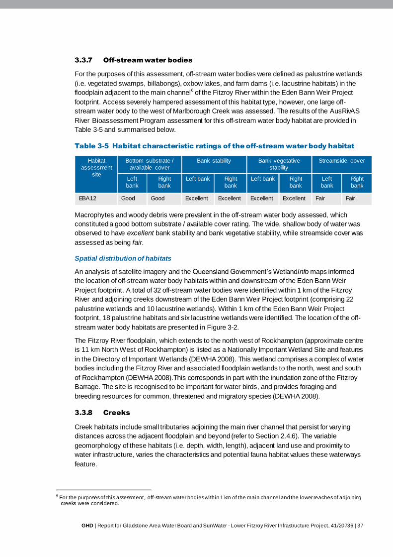
GHD | Report for Gladstone Area Water Board and SunWater - Lower Fitzroy River Infrastructure Project, 41/20736 | 37
3.3.7 Off-stream water bodies
For the purposes of this assessment, off-stream water bodies were defined as palustrine wetlands
(i.e. vegetated swamps, billabongs), oxbow lakes, and farm dams (i.e. lacustrine habitats) in the
floodplain adjacent to the main channel6 of the Fitzroy River within the Eden Bann Weir Project
footprint. Access severely hampered assessment of this habitat type, however, one large off-
stream water body to the west of Marlborough Creek was assessed. The results of the AusRivAS
River Bioassessment Program assessment for this off-stream water body habitat are provided in
Table 3-5 and summarised below.
Table 3-5 Habitat characteristic ratings of the off-stream water body habitat
Habitat
assessment
site
Bottom substrate /
available cover
Bank stability Bank vegetative
stability
Streamside cover
Left
bank
Right
bank
Left bank Right
bank
Left bank Right
bank
Left
bank
Right
bank
EBA12 Good Good Excellent Excellent Excellent Excellent Fair Fair
Macrophytes and woody debris were prevalent in the off-stream water body assessed, which
constituted a good bottom substrate / available cover rating. The wide, shallow body of water was
observed to have excellent bank stability and bank vegetative stability, while streamside cover was
assessed as being fair.
Spatial distribution of habitats
An analysis of satellite imagery and the Queensland Government’s WetlandInfo maps informed
the location of off-stream water body habitats within and downstream of the Eden Bann Weir
Project footprint. A total of 32 off-stream water bodies were identified within 1 km of the Fitzroy
River and adjoining creeks downstream of the Eden Bann Weir Project footprint (comprising 22
palustrine wetlands and 10 lacustrine wetlands). Within 1 km of the Eden Bann Weir Project
footprint, 18 palustrine habitats and six lacustrine wetlands were identified. The location of the off-
stream water body habitats are presented in Figure 3-2.
The Fitzroy River floodplain, which extends to the north west of Rockhampton (approximate centre
is 11 km North West of Rockhampton) is listed as a Nationally Important Wetland Site and features
in the Directory of Important Wetlands (DEWHA 2008). This wetland comprises a complex of water
bodies including the Fitzroy River and associated floodplain wetlands to the north, west and south
of Rockhampton (DEWHA 2008).This corresponds in part with the inundation zone of the Fitzroy
Barrage. The site is recognised to be important for water birds, and provides foraging and
breeding resources for common, threatened and migratory species (DEWHA 2008).
3.3.8 Creeks
Creek habitats include small tributaries adjoining the main river channel that persist for varying
distances across the adjacent floodplain and beyond (refer to Section 2.4.6). The variable
geomorphology of these habitats (i.e. depth, width, length), adjacent land use and proximity to
water infrastructure, varies the characteristics and potential fauna habitat values these waterways
feature.
6 For the purposes of this assessment, off-stream water bodies within 1 km of the main channel and the lower reaches of adjoining
creeks were considered.
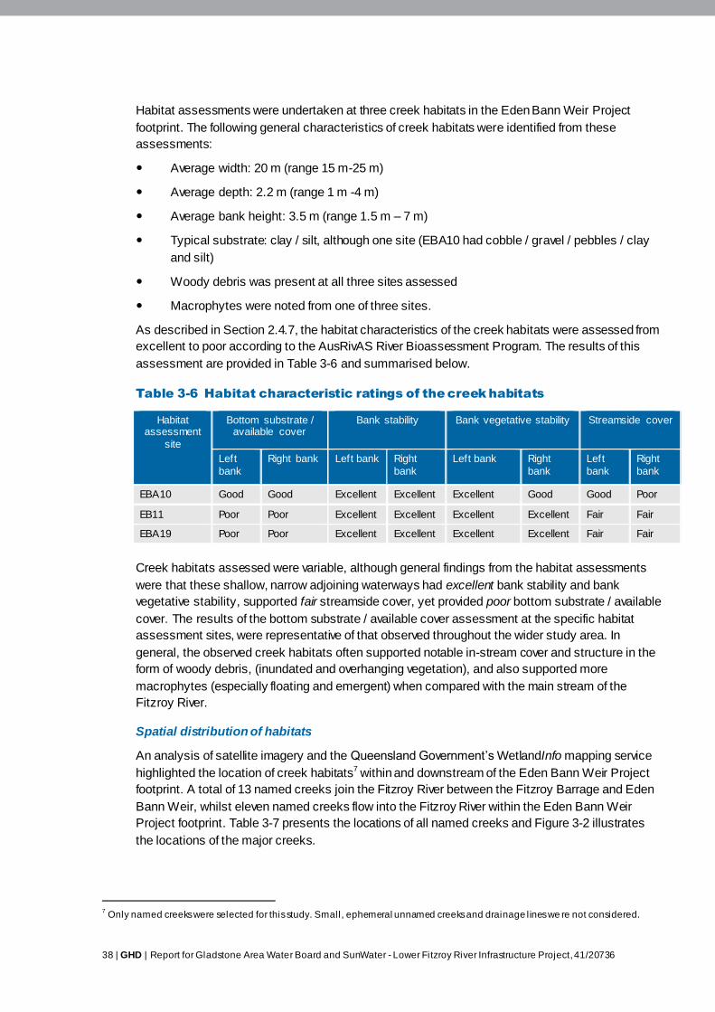
38 | GHD | Report for Gladstone Area Water Board and SunWater - Lower Fitzroy River Infrastructure Project, 41/20736
Habitat assessments were undertaken at three creek habitats in the Eden Bann Weir Project
footprint. The following general characteristics of creek habitats were identified from these
assessments:
Average width: 20 m (range 15 m-25 m)
Average depth: 2.2 m (range 1 m -4 m)
Average bank height: 3.5 m (range 1.5 m – 7 m)
Typical substrate: clay / silt, although one site (EBA10 had cobble / gravel / pebbles / clay
and silt)
Woody debris was present at all three sites assessed
Macrophytes were noted from one of three sites.
As described in Section 2.4.7, the habitat characteristics of the creek habitats were assessed from
excellent to poor according to the AusRivAS River Bioassessment Program. The results of this
assessment are provided in Table 3-6 and summarised below.
Table 3-6 Habitat characteristic ratings of the creek habitats
Habitat assessment
site
Bottom substrate / available cover
Bank stability Bank vegetative stability Streamside cover
Left
bank
Right bank Left bank Right
bank
Left bank Right
bank
Left
bank
Right
bank
EBA10 Good Good Excellent Excellent Excellent Good Good Poor
EB11 Poor Poor Excellent Excellent Excellent Excellent Fair Fair
EBA19 Poor Poor Excellent Excellent Excellent Excellent Fair Fair
Creek habitats assessed were variable, although general findings from the habitat assessments
were that these shallow, narrow adjoining waterways had excellent bank stability and bank
vegetative stability, supported fair streamside cover, yet provided poor bottom substrate / available
cover. The results of the bottom substrate / available cover assessment at the specific habitat
assessment sites, were representative of that observed throughout the wider study area. In
general, the observed creek habitats often supported notable in-stream cover and structure in the
form of woody debris, (inundated and overhanging vegetation), and also supported more
macrophytes (especially floating and emergent) when compared with the main stream of the
Fitzroy River.
Spatial distribution of habitats
An analysis of satellite imagery and the Queensland Government’s WetlandInfo mapping service
highlighted the location of creek habitats7 within and downstream of the Eden Bann Weir Project
footprint. A total of 13 named creeks join the Fitzroy River between the Fitzroy Barrage and Eden
Bann Weir, whilst eleven named creeks flow into the Fitzroy River within the Eden Bann Weir
Project footprint. Table 3-7 presents the locations of all named creeks and Figure 3-2 illustrates
the locations of the major creeks.
7 Only named creeks were selected for this study. Small, ephemeral unnamed creeks and drainage lines we re not considered.
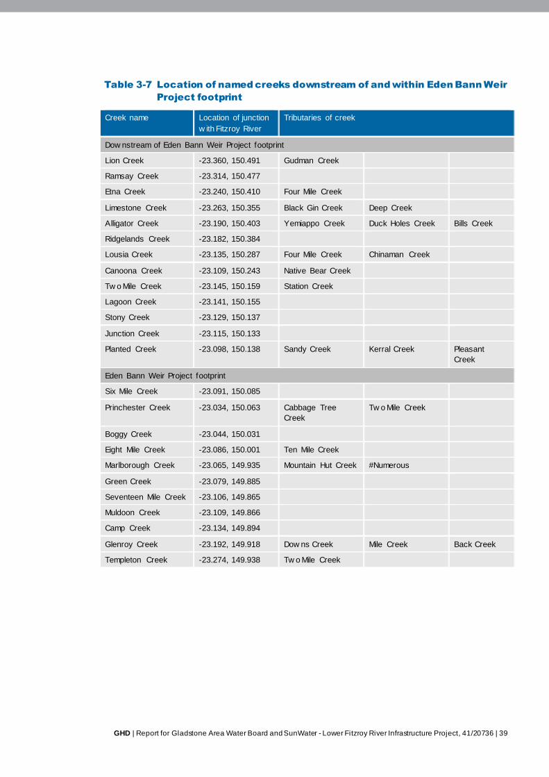
GHD | Report for Gladstone Area Water Board and SunWater - Lower Fitzroy River Infrastructure Project, 41/20736 | 39
Table 3-7 Location of named creeks downstream of and within Eden Bann Weir
Project footprint
Creek name Location of junction
w ith Fitzroy River
Tributaries of creek
Dow nstream of Eden Bann Weir Project footprint
Lion Creek -23.360, 150.491 Gudman Creek
Ramsay Creek -23.314, 150.477
Etna Creek -23.240, 150.410 Four Mile Creek
Limestone Creek -23.263, 150.355 Black Gin Creek Deep Creek
Alligator Creek -23.190, 150.403 Yemiappo Creek Duck Holes Creek Bills Creek
Ridgelands Creek -23.182, 150.384
Lousia Creek -23.135, 150.287 Four Mile Creek Chinaman Creek
Canoona Creek -23.109, 150.243 Native Bear Creek
Tw o Mile Creek -23.145, 150.159 Station Creek
Lagoon Creek -23.141, 150.155
Stony Creek -23.129, 150.137
Junction Creek -23.115, 150.133
Planted Creek -23.098, 150.138 Sandy Creek Kerral Creek Pleasant
Creek
Eden Bann Weir Project footprint
Six Mile Creek -23.091, 150.085
Princhester Creek -23.034, 150.063 Cabbage Tree
Creek
Tw o Mile Creek
Boggy Creek -23.044, 150.031
Eight Mile Creek -23.086, 150.001 Ten Mile Creek
Marlborough Creek -23.065, 149.935 Mountain Hut Creek #Numerous
Green Creek -23.079, 149.885
Seventeen Mile Creek -23.106, 149.865
Muldoon Creek -23.109, 149.866
Camp Creek -23.134, 149.894
Glenroy Creek -23.192, 149.918 Dow ns Creek Mile Creek Back Creek
Templeton Creek -23.274, 149.938 Tw o Mile Creek
40 | GHD | Report for Gladstone Area Water Board and SunWater - Lower Fitzroy River Infrastructure Project, 41/20736
3.3.9 Upstream habitats
Upstream aquatic habitats (in-channel, adjoining and off-stream) were assessed as being similar
to those described within the Project footprint (based on aerial photo interpretation, field
observations from the study area and literature reviews). As the landscape (i.e. topography,
gradient) and adjacent human land use along the Fitzroy River upstream of the Project footprint is
similar to that within the Eden Bann Weir Project footprint, it is likely that the aquatic habitat types,
and the general characteristics of these habitats (including value to fauna) would persist upstream
of the Project footprint. Subsequent sections of this report discuss some upstream habitats that
literature reviews identified as having significant values (i.e. known populations of habitat for
conservation significant fauna).
3.3.10 Habitat dynamics
Aquatic habitats in the Fitzroy River are highly dynamic. The temporal distribution and spatial
extent of aquatic habitat types are related to fluctuating water levels driven by factors including
climate (i.e. rainfall or lack thereof with the Fitzroy River sub-catchment and upstream
catchments); management of water storages (i.e. such as Eden Bann Weir and the Fitzroy
Barrage); extraction of water from waterways by adjacent land holders; evaporation and ground
seepage. Due to the highly unpredictable nature of these individual factors, and the combined
influence of the variable interactions of these factors, aquatic habitat distribution and extent is in a
constant state of flux. A generalised description of the typical dynamics of the system, as observed
in the field (both within the Eden Bann Weir Project footprint, and throughout the wider study area),
and as described in the literature, is outlined below, and summarised in Table 3-8. Examples of
aquatic habitat diversity by season are provided in Table 3-9.
During and post wet season – approximately November to April
During periods of high rainfall (i.e. during and post-wet season), the linear extent of the impounded
pool habitat upstream of Eden Bann Weir is at its greatest. Unregulated reaches of the Fitzroy
River primarily exist as a deep fast-flowing channel (run habitat) in which in-channel aquatic
habitats such as pools and riffles are inundated as a result of a significant increase in water depth
and velocity. This was evident upstream of the impounded pool habitat within the Eden Bann Weir
Project footprint during wet season field surveys. Depending of localised rainfall patterns, creek
habitats may increase in depth and width as flow rates increase. Off-stream water body habitats
such as billabongs may also be inundated during flooding events as river levels rise above bank
height (observed downstream of the Eden Bann Weir during wet season surveys). This periodic
flooding is important for off-stream water bodies to recharge water levels, provide flushing and
allow for biological connectivity with the main stream.
Dry and pre-wet season – approximately April to October
As flows decline following the wet season, the river channel is transformed into a series of pool-
riffle-run sequences. These sequences were prevalent upstream of the Eden Bann Weir
impoundment and upstream of the Rookwood Weir site during dry season field surveys. Off-
stream water bodies lose connection with the main channel, and, unless recharged by
groundwater (or unseasonal rainfall), begin to recede. As the dry season persists, many of the
riffle and run habitats dry out and much of the river exists as a series of isolated non-flowing pools
(Limpus et al. 2007; Marsden and Power 2007). These isolated pools act as refuge for aquatic
fauna during the dry season (Limpus et al. 2007).
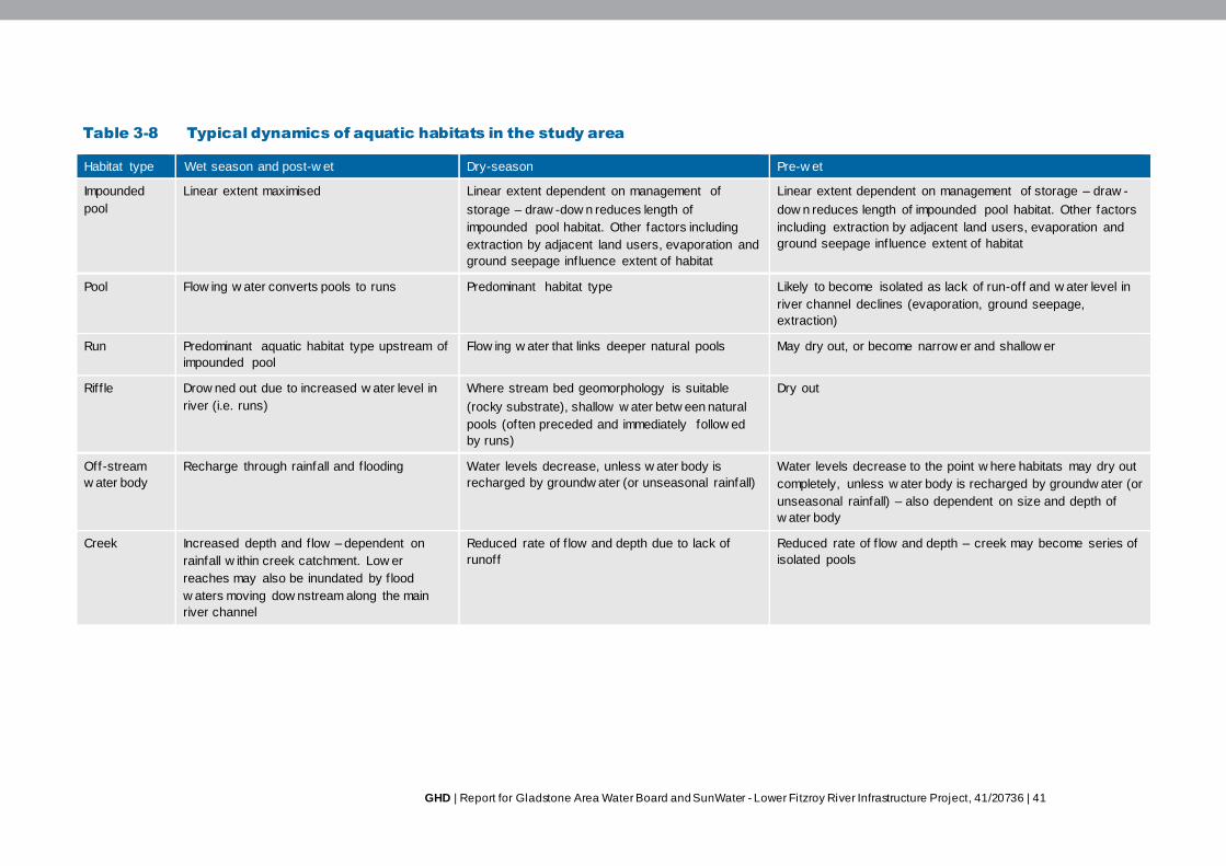
GHD | Report for Gladstone Area Water Board and SunWater - Lower Fitzroy River Infrastructure Project, 41/20736 | 41
Table 3-8 Typical dynamics of aquatic habitats in the study area
Habitat type Wet season and post-w et Dry-season Pre-w et
Impounded
pool
Linear extent maximised Linear extent dependent on management of
storage – draw -dow n reduces length of
impounded pool habitat. Other factors including
extraction by adjacent land users, evaporation and
ground seepage influence extent of habitat
Linear extent dependent on management of storage – draw -
dow n reduces length of impounded pool habitat. Other factors
including extraction by adjacent land users, evaporation and
ground seepage influence extent of habitat
Pool Flow ing w ater converts pools to runs Predominant habitat type Likely to become isolated as lack of run-off and w ater level in
river channel declines (evaporation, ground seepage,
extraction)
Run Predominant aquatic habitat type upstream of
impounded pool
Flow ing w ater that links deeper natural pools May dry out, or become narrow er and shallow er
Riff le Drow ned out due to increased w ater level in
river (i.e. runs)
Where stream bed geomorphology is suitable
(rocky substrate), shallow w ater betw een natural
pools (often preceded and immediately follow ed
by runs)
Dry out
Off-stream
w ater body
Recharge through rainfall and f looding Water levels decrease, unless w ater body is
recharged by groundw ater (or unseasonal rainfall)
Water levels decrease to the point w here habitats may dry out
completely, unless w ater body is recharged by groundw ater (or
unseasonal rainfall) – also dependent on size and depth of
w ater body
Creek Increased depth and f low – dependent on
rainfall w ithin creek catchment. Low er
reaches may also be inundated by f lood
w aters moving dow nstream along the main
river channel
Reduced rate of f low and depth due to lack of
runoff
Reduced rate of f low and depth – creek may become series of
isolated pools
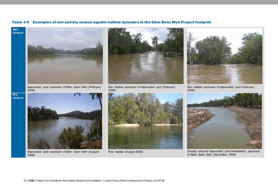
42 | GHD | Report for Gladstone Area Water Board and SunWater - Lower Fitzroy River Infrastructure Project, 41/20736
Table 3-9 Examples of wet and dry season aquatic habitat dynamics in the Eden Bann Weir Project footprint
Wet season
Impounded pool upstream of Eden Bann Weir (February 2009)
Run habitat upstream of impounded pool (February 2009)
Run habitat upstream of impounded pool (February 2009)
Dry
season
Impounded pool upstream of Eden Bann Weir (August
2009)
Pool habitat (August 2009)
Greatly reduced impounded pool immediately upstream
of Eden Bann Weir (November 2009)

GHD | Report for Gladstone Area Water Board and SunWater - Lower Fitzroy River Infrastructure Project, 41/20736 | 43
3.4 Aquatic fauna and flora
3.4.1 Overview
Aquatic species recorded or predicted to occur in the study area include: 34 fish species, seven
reptiles, one mammal, 86 taxa of macroinvertebrates and 105 species of macrophytes8. Desktop
surveys and field assessments identified a number of threatened and other conservation
significant species that occur in the Project footprint, have been previously recorded in the study
area, or are predicted to occur based on bioclimatic modeling. Fauna species considered as rare,
threatened with extinction, or as having high conservation value, are protected under both
Commonwealth and State legislation. At the national level, fauna are protected under the EPBC
Act. Within Queensland, rare and threatened fauna are listed under the NC Act and its subordinate
legislation (namely the Nature Conservation (Wildlife) Regulation 2006). At a regional level, priority
conservation significant fauna have been identified in the ‘Back on Track’ prioritisation framework
for conservation management of Queensland’s wildlife in the Fitzroy Natural Resource
Management area. While this tool has no legislative power, it outlines management and recovery
actions for selected priority species. The habitat preference of each conservation significant
species and their likely occurrence within the Project footprint and wider study area is discussed in
the relevant sections below.
Table 3-10 summarises the total number of aquatic fauna and flora species recorded according to
information source or survey method. Full desktop database search results are presented in
Appendix A.
3.4.2 Fish
Species diversity
A total of 34 fish species have been previously recorded in the study area (i.e. the lower Dawson,
lower Mackenzie and Fitzroy Rivers). The species recorded include two endemic species, the
southern saratoga (Scleropages leichardti) and the leathery grunter (Scortum hillii), and one
endemic subspecies of golden perch (Macquaria ambigua oriens). Table 3-11 details the fish
species data attained during wet and dry season field surveys, as well as previous records from
various studies reported in Marsden and Power (2007).
An additional six fish species, i.e. pacific short-finned eel (Anguilla obscura); freshwater mullet
(Myxus petardi); striped gudgeon (Gobiomorphus australis); Marjorie’s hardyhead
(Craterocephalus marjoriae); guppy (Poecilia reticulata) and silver perch (Bidyanus bidyanus),
have been recorded in the broader Fitzroy Basin catchment and although not observed in the
study area to date, these species have the potential to occur. The silver perch, which was
recorded in the Fitzroy Basin catchment by Berghuis and Long (1999), was also listed as
‘Vulnerable’ in 1996 on the IUCN (International Union for the Conservation of Nature) Red List of
Threatened Species. A native of the Murray-Darling system, the silver perch is likely to have been
introduced into the Fitzroy Basin catchment, where it does not naturally occur. It is not known to
occur within the Eden Bann Weir Project footprint.
The Fitzroy Basin catchment has a relatively low diversity of introduced / pest fish species with
only three species (i.e. mosquitofish, goldfish and guppy) known to occur throughout the system.
8 105 species of macrophyte previously recorded within the broader Fitzroy Basin catchment

44 | GHD | Report for Gladstone Area Water Board and SunWater - Lower Fitzroy River Infrastructure Project, 41/20736
Table 3-10 Total number of fauna species predicted to occur or recorded in the study area
DEWHA Environmental Reporting Tool
(predicted to occur)
DERM Wildlife Online Database
(historically recorded)
Queensland Museum Specimen Database
(historically recorded)
Previous studies
(historically recorded)
Field surveys
(recorded w ithin Project
footprint)
Species Diversity - 24 f ish
5 reptiles
2 reptiles 34 f ish
7 reptiles
1 mammal (predicted to occur)
86 macroinvertebrate taxa
105 macrophytes
10 f ish
3 reptiles
59 macroinvertebrate taxa
(from study area)
EPBC Act, NC Act Threatened Species
1 reptile
3 reptiles 1 reptile 3 reptiles 2 reptiles
EPBC Act Marine and /
or Migratory Species
1 reptile 1 reptile - 1 reptile 1 reptile
Endemic / Range
Restricted Species
1 reptile 2 f ish
2 reptiles
1 reptile 3 f ish
2 reptiles
1 reptile
Introduced / Pest
Species
- - - 3 f ish -
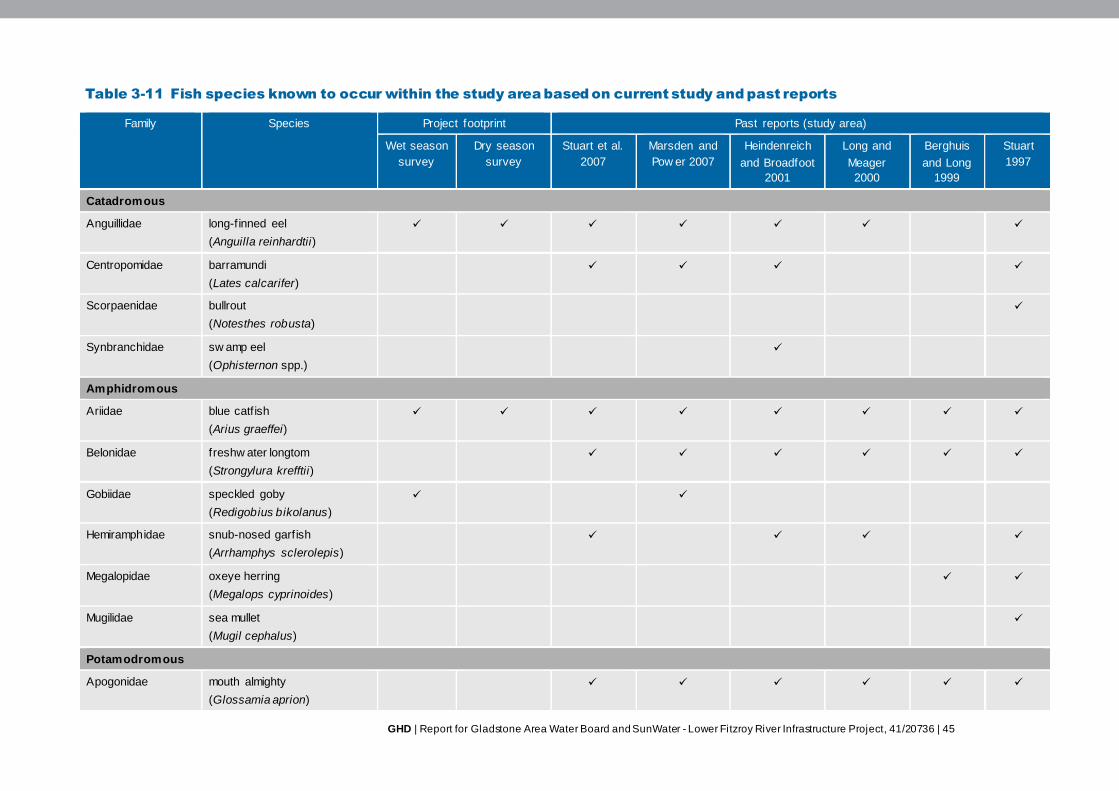
GHD | Report for Gladstone Area Water Board and SunWater - Lower Fitzroy River Infrastructure Project, 41/20736 | 45
Table 3-11 Fish species known to occur within the study area based on current study and past reports
Family Species Project footprint Past reports (study area)
Wet season
survey
Dry season
survey
Stuart et al.
2007
Marsden and
Pow er 2007
Heindenreich
and Broadfoot
2001
Long and
Meager
2000
Berghuis
and Long
1999
Stuart
1997
Catadromous
Anguillidae long-finned eel
(Anguilla reinhardtii)
Centropomidae barramundi
(Lates calcarifer)
Scorpaenidae bullrout
(Notesthes robusta)
Synbranchidae sw amp eel
(Ophisternon spp.)
Amphidromous
Ariidae blue catf ish
(Arius graeffei)
Belonidae freshw ater longtom
(Strongylura krefftii)
Gobiidae speckled goby
(Redigobius bikolanus)
Hemiramphidae snub-nosed garfish
(Arrhamphys sclerolepis)
Megalopidae oxeye herring
(Megalops cyprinoides)
Mugilidae sea mullet
(Mugil cephalus)
Potamodromous
Apogonidae mouth almighty
(Glossamia aprion)
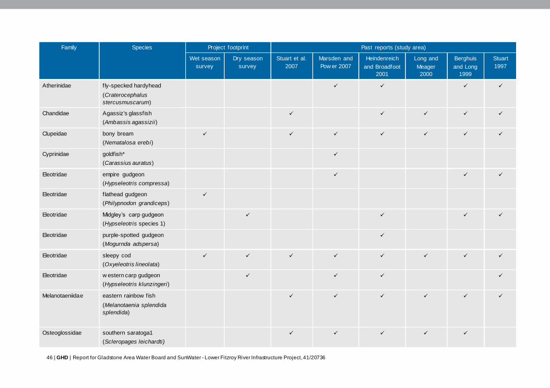
46 | GHD | Report for Gladstone Area Water Board and SunWater - Lower Fitzroy River Infrastructure Project, 41/20736
Family Species Project footprint Past reports (study area)
Wet season
survey
Dry season
survey
Stuart et al.
2007
Marsden and
Pow er 2007
Heindenreich
and Broadfoot
2001
Long and
Meager
2000
Berghuis
and Long
1999
Stuart
1997
Atherinidae f ly-specked hardyhead
(Craterocephalus
stercusmuscarum)
Chandidae Agassiz's glassfish
(Ambassis agassizii)
Clupeidae bony bream
(Nematalosa erebi)
Cyprinidae goldfish*
(Carassius auratus)
Eleotridae empire gudgeon
(Hypseleotris compressa)
Eleotridae f lathead gudgeon
(Philypnodon grandiceps)
Eleotridae Midgley’s carp gudgeon
(Hypseleotris species 1)
Eleotridae purple-spotted gudgeon
(Mogurnda adspersa)
Eleotridae sleepy cod
(Oxyeleotris lineolata)
Eleotridae w estern carp gudgeon
(Hypseleotris klunzingeri)
Melanotaeniidae eastern rainbow fish
(Melanotaenia splendida
splendida)
Osteoglossidae southern saratoga1
(Scleropages leichardti)
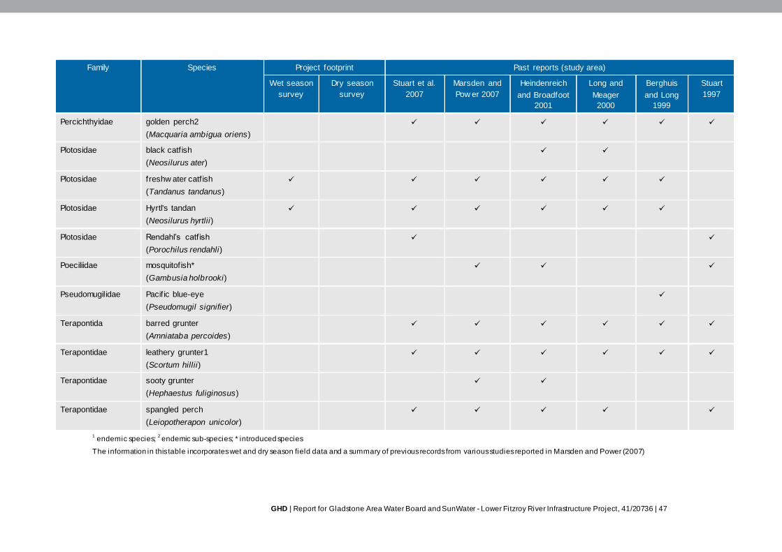
GHD | Report for Gladstone Area Water Board and SunWater - Lower Fitzroy River Infrastructure Project, 41/20736 | 47
Family Species Project footprint Past reports (study area)
Wet season
survey
Dry season
survey
Stuart et al.
2007
Marsden and
Pow er 2007
Heindenreich
and Broadfoot
2001
Long and
Meager
2000
Berghuis
and Long
1999
Stuart
1997
Percichthyidae golden perch2
(Macquaria ambigua oriens)
Plotosidae black catf ish
(Neosilurus ater)
Plotosidae freshw ater catf ish
(Tandanus tandanus)
Plotosidae Hyrtl's tandan
(Neosilurus hyrtlii)
Plotosidae Rendahl’s catf ish
(Porochilus rendahli)
Poeciliidae mosquitofish*
(Gambusia holbrooki)
Pseudomugilidae Pacif ic blue-eye
(Pseudomugil signifier)
Terapontida barred grunter
(Amniataba percoides)
Terapontidae leathery grunter1
(Scortum hillii)
Terapontidae sooty grunter
(Hephaestus fuliginosus)
Terapontidae spangled perch
(Leiopotherapon unicolor)
1 endemic species;
2 endemic sub-species; * introduced species
The information in this table incorporates wet and dry season field data and a summary of previous records from various studies reported in Marsden and Power (2007)
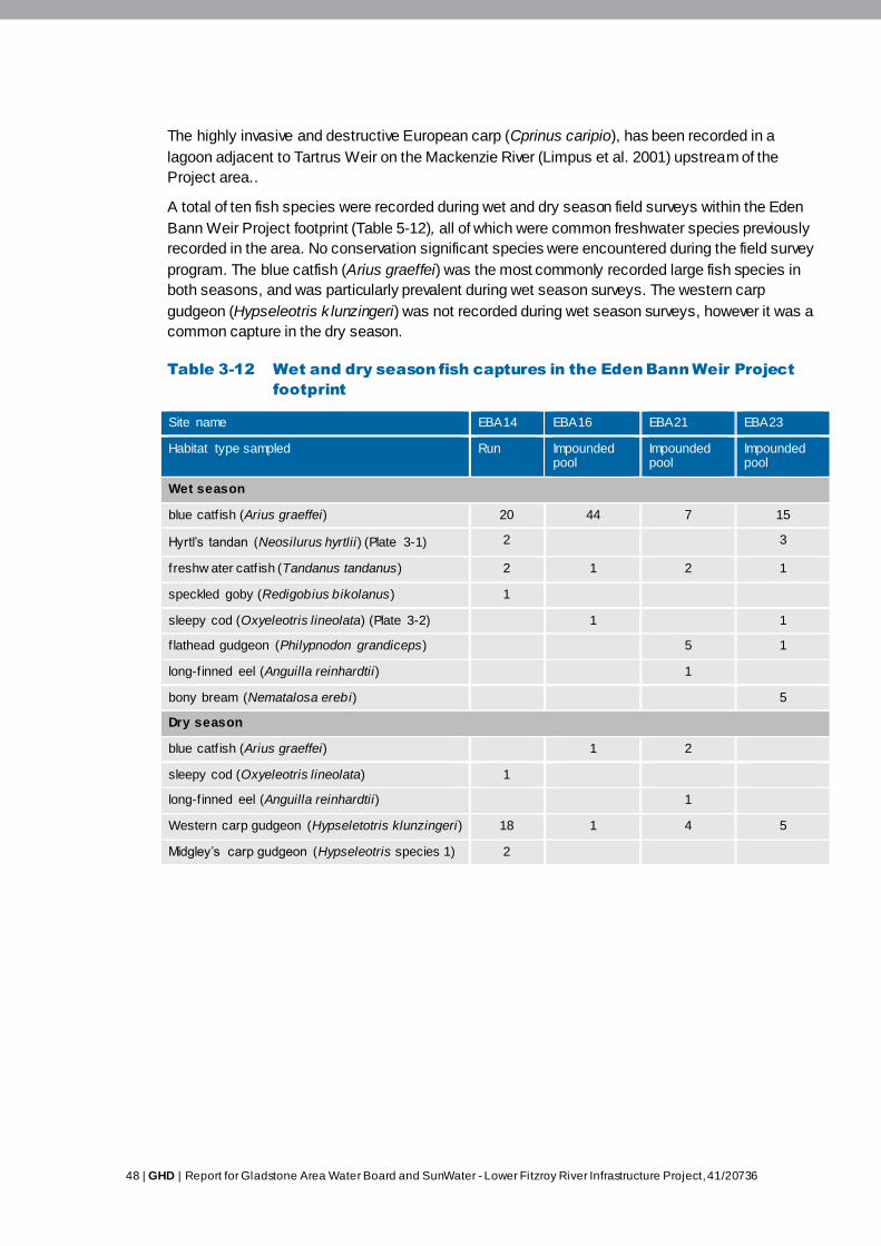
48 | GHD | Report for Gladstone Area Water Board and SunWater - Lower Fitzroy River Infrastructure Project, 41/20736
The highly invasive and destructive European carp (Cprinus caripio), has been recorded in a
lagoon adjacent to Tartrus Weir on the Mackenzie River (Limpus et al. 2001) upstream of the
Project area..
A total of ten fish species were recorded during wet and dry season field surveys within the Eden
Bann Weir Project footprint (Table 5-12), all of which were common freshwater species previously
recorded in the area. No conservation significant species were encountered during the field survey
program. The blue catfish (Arius graeffei) was the most commonly recorded large fish species in
both seasons, and was particularly prevalent during wet season surveys. The western carp
gudgeon (Hypseleotris k lunzingeri) was not recorded during wet season surveys, however it was a
common capture in the dry season.
Table 3-12 Wet and dry season fish captures in the Eden Bann Weir Project
footprint
Site name EBA14 EBA16 EBA21 EBA23
Habitat type sampled Run Impounded pool
Impounded pool
Impounded pool
Wet season
blue catf ish (Arius graeffei) 20 44 7 15
Hyrtl’s tandan (Neosilurus hyrtlii) (Plate 3-1) 2 3
freshw ater catf ish (Tandanus tandanus) 2 1 2 1
speckled goby (Redigobius bikolanus) 1
sleepy cod (Oxyeleotris lineolata) (Plate 3-2) 1 1
f lathead gudgeon (Philypnodon grandiceps) 5 1
long-finned eel (Anguilla reinhardtii) 1
bony bream (Nematalosa erebi) 5
Dry season
blue catf ish (Arius graeffei) 1 2
sleepy cod (Oxyeleotris lineolata) 1
long-finned eel (Anguilla reinhardtii) 1
Western carp gudgeon (Hypseletotris klunzingeri) 18 1 4 5
Midgley’s carp gudgeon (Hypseleotris species 1) 2

GHD | Report for Gladstone Area Water Board and SunWater - Lower Fitzroy River Infrastructure Project, 41/20736 | 49
Plate 3-1 Hyrtl’s tandan (Neosilurus
hyrtlii)
Plate 3-2 Sleepy cod (Oxyeleotris
lineolata)
Ecology
A species specific description of the ecology of all 41 species known and predicted to occur in the
study area (including habitat preferences, dietary requirements and movement behaviour), is
provided in Table 5-13, while a broad summary is detailed below.
Habitat preferences
Fish species in the Fitzroy Basin catchment have adapted to the highly dynamic and variable
nature of this system (Long 2000), represented by the specific foraging, breeding and sheltering
preferences of the species that occur. A review of the ecology of fish species known to occur
within the Fitzroy Basin catchment revealed that most species prefer (or are tolerant of) the still or
slow flowing conditions that are present in pool habitats (Pusey et al. 2004; Allen et al. 2003;
Marsden and Power 2007). The relatively deep water areas within large pools provide habitat for
larger-bodied pelagic (e.g. freshwater longtom, southern saratoga and golden perch) and benthic
(e.g. freshwater catfish and Rendahl’s catfish) species, while the shallow water margins are
preferred by smaller bodied species such as western carp gudgeon, eastern rainbowfish and fly -
specked hardyhead. Whilst generalist species such as the long-finned eel, striped gudgeon and
barred grunter are known to inhabit the fast-flowing conditions of riffles and runs, few species in
the Fitzroy Basin catchment are specifically adapted to these habitats. Species that are known to
prefer flowing conditions include Marjorie’s hardyhead, silver perch, and sooty grunter. None of
these species were recorded during wet and dry season surveys, however the sooty grunter had
been previously recorded in the study area (Table 3-11 and Table 3-12).
Foraging and breeding in the majority of fish species is associated with in-stream microhabitats in
the form of fallen logs, undercut banks, root masses, complex substrates (i.e. cobble) and
macrophytes. Creeks and off-stream water bodies such as floodplains and billabongs generally
contain a high diversity of in-stream microhabitats and as a result provide habitat for a range of
species including spangled perch, black catfish, southern saratoga, eastern rainbowfish and
purple-spotted gudgeon. Off-stream water bodies also provide breeding and nursery habitat for
fish species. The breeding season of a number of species (i.e. barramundi, long-finned eel, oxeye
herring, spangled perch, eastern rainbowfish and empire gudgeon) is known to occur during the
wet season when flows within the river are increased and off-stream water bodies are connected
to the river system, facilitating access to these microhabitat environments (Reynolds 1983; Pusey
et al. 2004; Stuart 1999; Stuart and Berghuis 1997).
50 | GHD | Report for Gladstone Area Water Board and SunWater - Lower Fitzroy River Infrastructure Project, 41/20736
Field surveys conducted within the Project footprint confirmed the general habitat preferences
detailed from the literature review. The assemblage of species caught (Table 3-12) indicates that
the impounded pool habitat provides resources for predominantly benthic species (i.e. sleepy cod,
blue catfish, freshwater catfish), cryptic small-bodied species (i.e. western carp gudgeon,
Midgley’s carp gudgeon, flathead gudgeon) and habitat generalists (i.e. bony bream, Hyrtl’s
tandan). Off-stream waterbody habitats downstream of Eden Bann Weir support predominantly
small-bodied native fish including Agassiz’s glassfish, Midgley’s carp gudgeon, fly -speckled
hardyhead, purple-spotted gudgeon, spangled perch and eastern rainbow fish.
The Fitzroy Basin catchment is a highly regulated system and much of the natural aquatic habitat
has been inundated as a result of weir / dam operations. Long (2000) investigated the impact of
such river regulation on the spatial and temporal trends in fish habitat utilisation. Specifically, Long
(2000) compared species diversity and abundance in weir and riverine environments in the
Dawson River. Of the 19 species caught during the two year study, 16 were caught in both the
weir and riverine habitats (Long 2000).
A notable finding of Long’s study was that while species diversity between weir and riverine
habitats was similar, the relative abundance of most species inhabiting these environments (as
deduced from catch rates) differed. This difference was not consistent across species. For
example:
Golden perch: number caught in riverine environments twice that of weirs
Leathery grunter: number caught in riverine environments five times that of weirs
Hyrtl's tandan: number caught in riverine environments half that of weirs
Spangled perch: number caught in riverine environments eight times that of weirs
Eel-tailed catfish (freshwater catfish): number caught in riverine environments twice that of
weirs.
Bony bream, the most commonly encountered species at all sites in Long’s study (2000), were
equally as prevalent in weir environments as riverine habitats. This species has been documented
to increase in numbers in modified waterways of the Murray-Darling Basin, in spite of river
regulation (Long 2000; Puckridge and Walker 1990). The bony bream is an important prey item for
higher level consumers (Pusey et al. 2004) such as larger predatory fish, piscavorous birds and
crocodiles, and as such, this species is an important component of aquatic trophic systems within
impounded habitats.
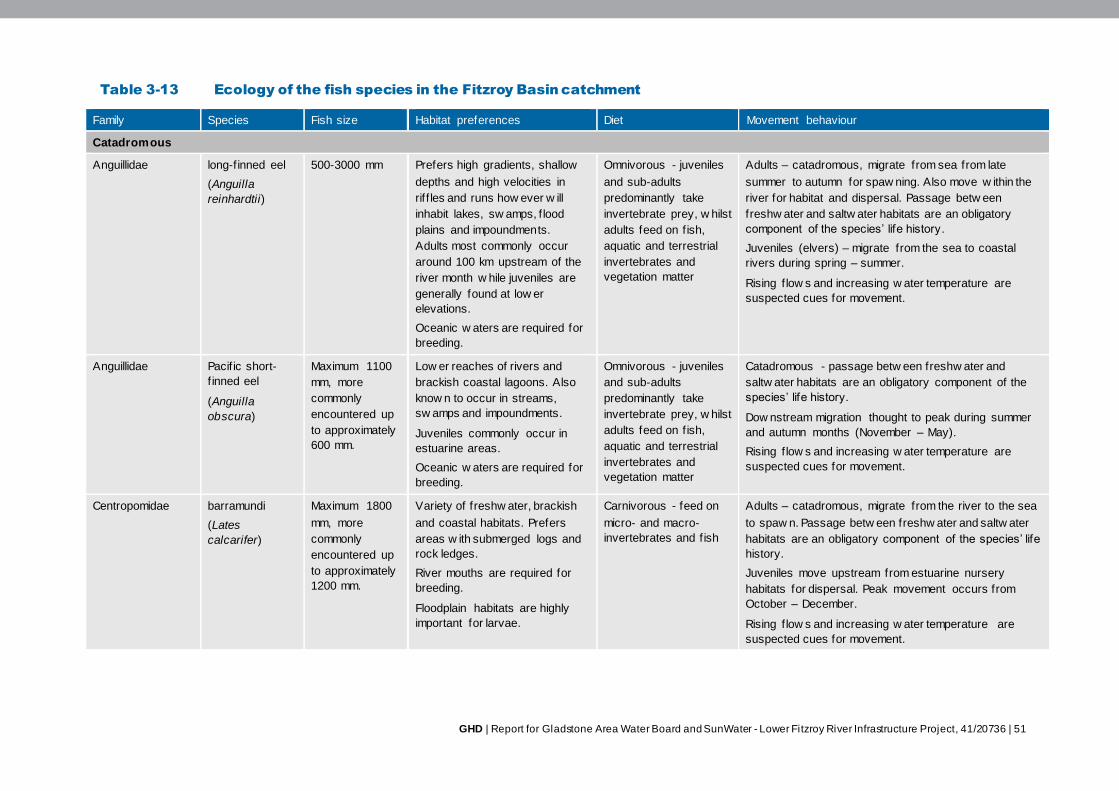
GHD | Report for Gladstone Area Water Board and SunWater - Lower Fitzroy River Infrastructure Project, 41/20736 | 51
Table 3-13 Ecology of the fish species in the Fitzroy Basin catchment
Family Species Fish size Habitat preferences Diet Movement behaviour
Catadromous
Anguillidae long-finned eel
(Anguilla
reinhardtii)
500-3000 mm Prefers high gradients, shallow
depths and high velocities in
rif f les and runs how ever w ill
inhabit lakes, sw amps, f lood
plains and impoundments.
Adults most commonly occur
around 100 km upstream of the
river month w hile juveniles are
generally found at low er
elevations.
Oceanic w aters are required for
breeding.
Omnivorous - juveniles
and sub-adults
predominantly take
invertebrate prey, w hilst
adults feed on f ish,
aquatic and terrestrial
invertebrates and
vegetation matter
Adults – catadromous, migrate from sea from late
summer to autumn for spaw ning. Also move w ithin the
river for habitat and dispersal. Passage betw een
freshw ater and saltw ater habitats are an obligatory
component of the species’ life history.
Juveniles (elvers) – migrate from the sea to coastal
rivers during spring – summer.
Rising f low s and increasing w ater temperature are
suspected cues for movement.
Anguillidae Pacif ic short-
f inned eel
(Anguilla
obscura)
Maximum 1100
mm, more
commonly
encountered up
to approximately
600 mm.
Low er reaches of rivers and
brackish coastal lagoons. Also
know n to occur in streams,
sw amps and impoundments.
Juveniles commonly occur in
estuarine areas.
Oceanic w aters are required for
breeding.
Omnivorous - juveniles
and sub-adults
predominantly take
invertebrate prey, w hilst
adults feed on f ish,
aquatic and terrestrial
invertebrates and
vegetation matter
Catadromous - passage betw een freshw ater and
saltw ater habitats are an obligatory component of the
species’ life history.
Dow nstream migration thought to peak during summer
and autumn months (November – May).
Rising f low s and increasing w ater temperature are
suspected cues for movement.
Centropomidae barramundi
(Lates
calcarifer)
Maximum 1800
mm, more
commonly
encountered up
to approximately
1200 mm.
Variety of freshw ater, brackish
and coastal habitats. Prefers
areas w ith submerged logs and
rock ledges.
River mouths are required for
breeding.
Floodplain habitats are highly
important for larvae.
Carnivorous - feed on
micro- and macro-
invertebrates and f ish
Adults – catadromous, migrate from the river to the sea
to spaw n. Passage betw een freshw ater and saltw ater
habitats are an obligatory component of the species’ life
history.
Juveniles move upstream from estuarine nursery
habitats for dispersal. Peak movement occurs from
October – December.
Rising f low s and increasing w ater temperature are
suspected cues for movement.

52 | GHD | Report for Gladstone Area Water Board and SunWater - Lower Fitzroy River Infrastructure Project, 41/20736
Family Species Fish size Habitat preferences Diet Movement behaviour
Mugilidae freshw ater
mullet
(Myxus petardi)
Maximum 800
mm, more
commonly
encountered
betw een 300-
400 mm.
Prefers gently f low ing rivers
channels.
Estuarine and oceanic habitats
are required for breeding.
Largely herbivorous
w ith algae and other
plant material
constituting the bulk of
the diet
Catadromous - passage betw een freshw ater and
saltw ater habitats are an obligatory component of the
species’ life history.
Spaw ns in estuaries and the sea, peaking in February.
Scorpaenidae bullrout
(Notesthes
robusta)
Up to 300 mm Occurs in still or slow -flowing
w aters, often associated w ith
underw ater structures such as
vegetation and logs.
Estuarine habitats required for
breeding.
Carnivorous – a benthic
ambush predator.
Aquatic insects and
crustaceans are the
primary prey items for
this species
Catadromous - passage betw een freshw ater and
saltw ater habitats are an obligatory component of the
species’ life history.
Spaw ns in estuarine w aters during w inter months (May
to September). Peak upstream movement in the Fitzroy
River has been recorded betw een July and November.
Low flow s and cooler temperatures are suspected cues
for movement.
Synbranchidae sw amp eel
(Ophisternon
spp.)
Up to 600 mm Well-vegetated backw aters of
estuarine and low er freshw ater
reaches of rivers. Habitats w ill
an abundance of leaf litter and
overhanging riparian vegetation
are preferred.
Feeding biology poorly
know n – probably
carnivorous, w ith f ish
and aquatic
macroinvertebrates
dominating the diet
Catadromous - passage betw een freshw ater and
saltw ater habitats are an obligatory component of the
species’ life history.
Amphidromous
Ariidae blue catf ish
(Arius graeffei)
Up to 600 mm Variety of habitats including
coastal marine w aters,
estuaries, and freshw ater rivers.
Also know n to inhabit
impoundments.
Omnivorous generalist
feeder, bulk of diet
comprising invertebrate
prey.
Amphidromous – although adults can complete entire
life cycle in river.
Rising f low s and increasing w ater temperature are
suspected cues for movement.
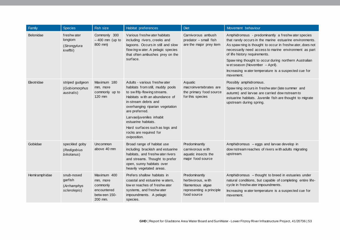
GHD | Report for Gladstone Area Water Board and SunWater - Lower Fitzroy River Infrastructure Project, 41/20736 | 53
Family Species Fish size Habitat preferences Diet Movement behaviour
Belonidae freshw ater
longtom
(Strongylura
krefftii)
Commonly 300
– 400 mm (up to
800 mm)
Various freshw ater habitats
including rivers, creeks and
lagoons. Occurs in still and slow
flow ing w ater. A pelagic species
that often ambushes prey on the
surface.
Carnivorous ambush
predator – small f ish
are the major prey item
Amphidromous - predominantly a freshw ater species
that rarely occurs in the marine estuarine environments.
As spaw ning is thought to occur in freshw ater, does not
necessarily need access to marine environment as part
of life history requirements.
Spaw ning thought to occur during northern Australian
w et season (November – April).
Increasing w ater temperature is a suspected cue for
movement.
Eleotridae striped gudgeon
(Gobiomorphus
australis)
Maximum 180
mm, more
commonly up to
120 mm
Adults - various freshw ater
habitats from still, muddy pools
to sw iftly-flowing streams.
Habitats w ith an abundance of
in-stream debris and
overhanging riparian vegetation
are preferred.
Larvae/juveniles inhabit
estuarine habitats.
Hard surfaces such as logs and
rocks are required for
oviposition.
Aquatic
macroinvertebrates are
the primary food source
for this species
Possibly amphidromous.
Spaw ning occurs in freshw ater (late summer and
autumn) and larvae are carried dow nstream to
estuarine habitats. Juvenile f ish are thought to migrate
upstream during spring.
Gobiidae speckled goby
(Redigobius
bikolanus)
Uncommon
above 40 mm
Broad range of habitat use
including brackish and estuarine
habitats, and freshw ater rivers
and streams. Thought to prefer
open, sunny habitats over
heavily vegetated areas.
Predominantly
carnivorous w ith
aquatic insects the
major food source
Amphidromous – eggs and larvae develop in
dow nstream reaches of rivers w ith adults migrating
upstream.
Hemiramphidae snub-nosed
garfish
(Arrhamphys
sclerolepis)
Maximum 400
mm, more
commonly
encountered
betw een 150-
200 mm.
Prefers shallow habitats in
coastal and estuarine w aters,
low er reaches of freshw ater
systems, and freshw ater
impoundments. A pelagic
species.
Predominantly
herbivorous, w ith
f ilamentous algae
representing a principle
food source
Amphidromous – thought to breed in estuaries under
natural conditions, but capable of completing entire life-
cycle in freshw ater impoundments.
Increasing w ater temperature is a suspected cue for
movement.
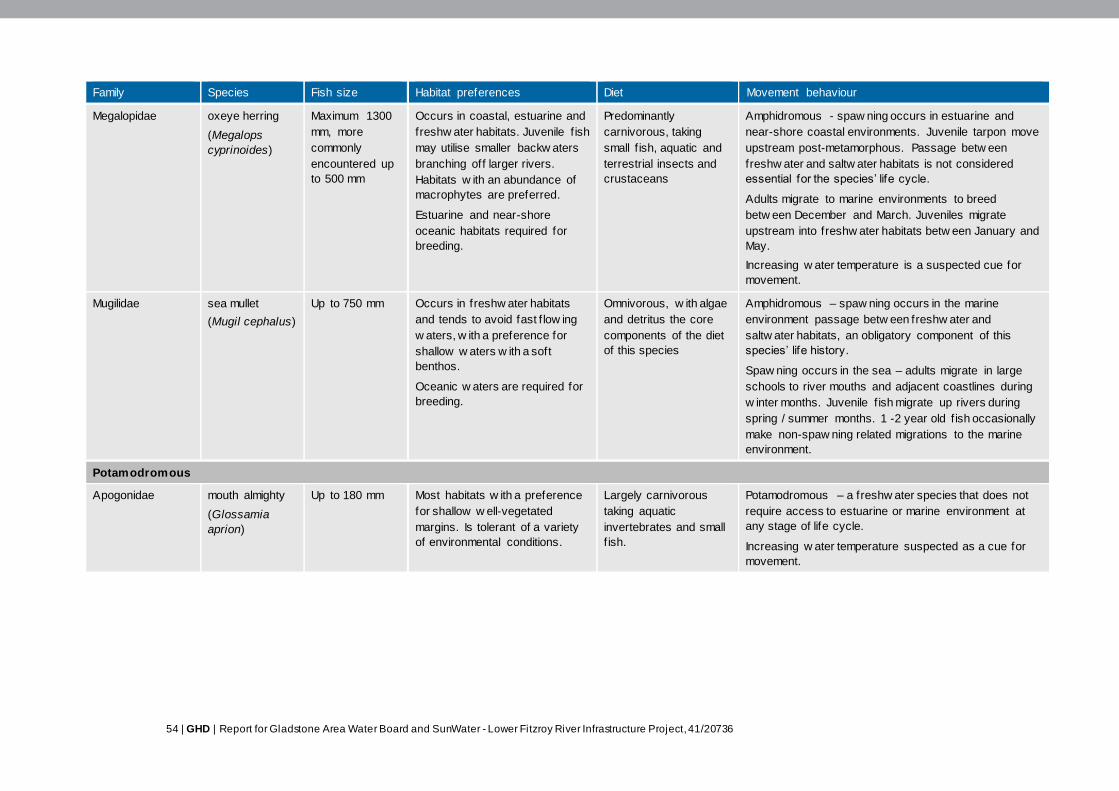
54 | GHD | Report for Gladstone Area Water Board and SunWater - Lower Fitzroy River Infrastructure Project, 41/20736
Family Species Fish size Habitat preferences Diet Movement behaviour
Megalopidae oxeye herring
(Megalops
cyprinoides)
Maximum 1300
mm, more
commonly
encountered up
to 500 mm
Occurs in coastal, estuarine and
freshw ater habitats. Juvenile f ish
may utilise smaller backw aters
branching off larger rivers.
Habitats w ith an abundance of
macrophytes are preferred.
Estuarine and near-shore
oceanic habitats required for
breeding.
Predominantly
carnivorous, taking
small f ish, aquatic and
terrestrial insects and
crustaceans
Amphidromous - spaw ning occurs in estuarine and
near-shore coastal environments. Juvenile tarpon move
upstream post-metamorphous. Passage betw een
freshw ater and saltw ater habitats is not considered
essential for the species’ life cycle.
Adults migrate to marine environments to breed
betw een December and March. Juveniles migrate
upstream into freshw ater habitats betw een January and
May.
Increasing w ater temperature is a suspected cue for
movement.
Mugilidae sea mullet
(Mugil cephalus)
Up to 750 mm Occurs in freshw ater habitats
and tends to avoid fast f low ing
w aters, w ith a preference for
shallow w aters w ith a soft
benthos.
Oceanic w aters are required for
breeding.
Omnivorous, w ith algae
and detritus the core
components of the diet
of this species
Amphidromous – spaw ning occurs in the marine
environment passage betw een freshw ater and
saltw ater habitats, an obligatory component of this
species’ life history.
Spaw ning occurs in the sea – adults migrate in large
schools to river mouths and adjacent coastlines during
w inter months. Juvenile f ish migrate up rivers during
spring / summer months. 1 -2 year old f ish occasionally
make non-spaw ning related migrations to the marine
environment.
Potamodromous
Apogonidae mouth almighty
(Glossamia
aprion)
Up to 180 mm Most habitats w ith a preference
for shallow w ell-vegetated
margins. Is tolerant of a variety
of environmental conditions.
Largely carnivorous
taking aquatic
invertebrates and small
f ish.
Potamodromous – a freshw ater species that does not
require access to estuarine or marine environment at
any stage of life cycle.
Increasing w ater temperature suspected as a cue for
movement.
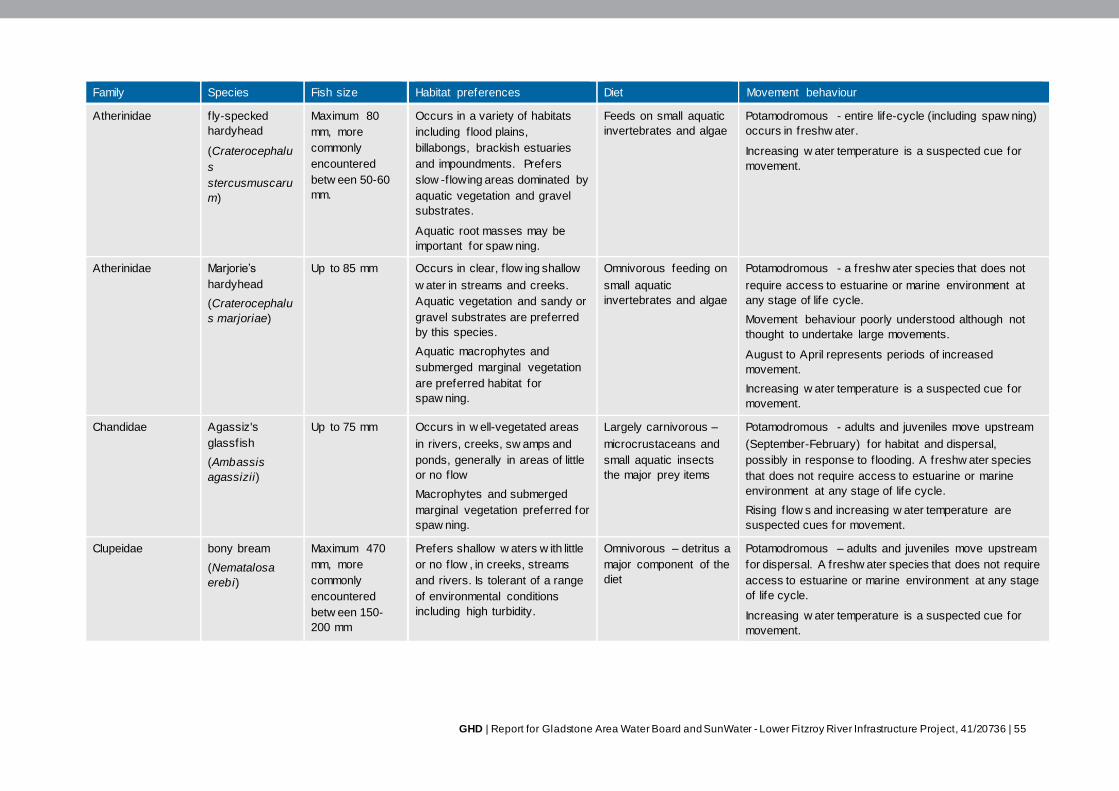
GHD | Report for Gladstone Area Water Board and SunWater - Lower Fitzroy River Infrastructure Project, 41/20736 | 55
Family Species Fish size Habitat preferences Diet Movement behaviour
Atherinidae f ly-specked
hardyhead
(Craterocephalu
s
stercusmuscaru
m)
Maximum 80
mm, more
commonly
encountered
betw een 50-60
mm.
Occurs in a variety of habitats
including f lood plains,
billabongs, brackish estuaries
and impoundments. Prefers
slow -flowing areas dominated by
aquatic vegetation and gravel
substrates.
Aquatic root masses may be
important for spaw ning.
Feeds on small aquatic
invertebrates and algae
Potamodromous - entire life-cycle (including spaw ning)
occurs in freshw ater.
Increasing w ater temperature is a suspected cue for
movement.
Atherinidae Marjorie’s
hardyhead
(Craterocephalu
s marjoriae)
Up to 85 mm Occurs in clear, f low ing shallow
w ater in streams and creeks.
Aquatic vegetation and sandy or
gravel substrates are preferred
by this species.
Aquatic macrophytes and
submerged marginal vegetation
are preferred habitat for
spaw ning.
Omnivorous feeding on
small aquatic
invertebrates and algae
Potamodromous - a freshw ater species that does not
require access to estuarine or marine environment at
any stage of life cycle.
Movement behaviour poorly understood although not
thought to undertake large movements.
August to April represents periods of increased
movement.
Increasing w ater temperature is a suspected cue for
movement.
Chandidae Agassiz's
glassfish
(Ambassis
agassizii)
Up to 75 mm Occurs in w ell-vegetated areas
in rivers, creeks, sw amps and
ponds, generally in areas of little
or no f low
Macrophytes and submerged
marginal vegetation preferred for
spaw ning.
Largely carnivorous –
microcrustaceans and
small aquatic insects
the major prey items
Potamodromous - adults and juveniles move upstream
(September-February) for habitat and dispersal,
possibly in response to f looding. A freshw ater species
that does not require access to estuarine or marine
environment at any stage of life cycle.
Rising f low s and increasing w ater temperature are
suspected cues for movement.
Clupeidae bony bream
(Nematalosa
erebi)
Maximum 470
mm, more
commonly
encountered
betw een 150-
200 mm
Prefers shallow w aters w ith little
or no f low , in creeks, streams
and rivers. Is tolerant of a range
of environmental conditions
including high turbidity.
Omnivorous – detritus a
major component of the
diet
Potamodromous – adults and juveniles move upstream
for dispersal. A freshw ater species that does not require
access to estuarine or marine environment at any stage
of life cycle.
Increasing w ater temperature is a suspected cue for
movement.
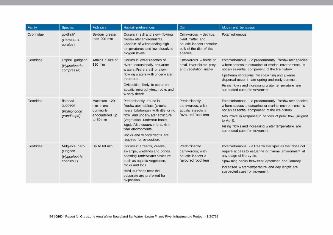
56 | GHD | Report for Gladstone Area Water Board and SunWater - Lower Fitzroy River Infrastructure Project, 41/20736
Family Species Fish size Habitat preferences Diet Movement behaviour
Cyprinidae goldfish*
(Carassius
auratus)
Seldom greater
than 200 mm
Occurs in still and slow -flowing
freshw ater environments.
Capable of w ithstanding high
temperatures and low dissolved
oxygen levels.
Omnivorous – detritus,
plant matter and
aquatic insects form the
bulk of the diet of this
species
Potamodromous
Eleotridae Empire gudgeon
(Hypseleotris
compressa)
Attains a size of
120 mm
Occurs in low er reaches of
rivers, occasionally estuarine
w aters. Prefers still or slow -
flow ing w aters w ith underw ater
structure.
Oviposition likely to occur on
aquatic macrophytes, rocks and
w oody debris.
Omnivorous – feeds on
small invertebrate prey
and vegetation matter
Potamodromous - a predominantly freshw ater species
w here access to estuarine or marine environments is
not an essential component of the life history.
Upstream migrations for spaw ning and juvenile
dispersal occur in late spring and early summer.
Rising f low s and increasing w ater temperature are
suspected cues for movement.
Eleotridae f lathead
gudgeon
(Philypnodon
grandiceps)
Maximum 120
mm, more
commonly
encountered up
to 80 mm
Predominantly found in
freshw ater habitats (creeks,
rivers, billabongs) w ith little or no
f low , and underw ater structure
(vegetation, undercut banks,
logs). Also occurs in brackish
tidal environments.
Rocks and w oody debris are
required for oviposition.
Predominantly
carnivorous, w ith
aquatic insects a
favoured food item
Potamodromous - a predominantly freshw ater species
w here access to estuarine or marine environments is
not an essential component of the life history.
May move in response to periods of peak f low (August
to April).
Rising f low s and increasing w ater temperature are
suspected cues for movement.
Eleotridae Midgley’s carp
gudgeon
(Hypseleotris
species 1)
Up to 60 mm Occurs in streams, creeks,
sw amps, w etlands and ponds
boasting underw ater structure
such as aquatic vegetation,
rocks and logs.
Hard surfaces near the
substrate are preferred for
oviposition.
Predominantly
carnivorous, w ith
aquatic insects a
favoured food item
Potamodromous - a freshw ater species that does not
require access to estuarine or marine environment at
any stage of life cycle.
Spaw ning peaks betw een September and January.
Increased w ater temperature and day length are
suspected cues for movement.
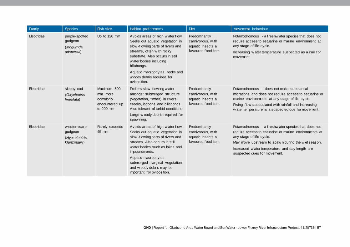
GHD | Report for Gladstone Area Water Board and SunWater - Lower Fitzroy River Infrastructure Project, 41/20736 | 57
Family Species Fish size Habitat preferences Diet Movement behaviour
Eleotridae purple-spotted
gudgeon
(Mogurnda
adspersa)
Up to 120 mm Avoids areas of high w ater f low .
Seeks out aquatic vegetation in
slow -flowing parts of rivers and
streams, often w ith rocky
substrate. Also occurs in still
w ater bodies including
billabongs.
Aquatic macrophytes, rocks and
w oody debris required for
oviposition.
Predominantly
carnivorous, w ith
aquatic insects a
favoured food item
Potamodromous - a freshw ater species that does not
require access to estuarine or marine environment at
any stage of life cycle.
Increasing w ater temperature suspected as a cue for
movement.
Eleotridae sleepy cod
(Oxyeleotris
lineolata)
Maximum 500
mm, more
commonly
encountered up
to 200 mm
Prefers slow -flow ing w ater
amongst submerged structure
(vegetation, timber) in rivers,
creeks, lagoons and billabongs.
Also tolerant of turbid conditions.
Large w oody debris required for
spaw ning.
Predominantly
carnivorous, w ith
aquatic insects a
favoured food item
Potamodromous – does not make substantial
migrations and does not require access to estuarine or
marine environments at any stage of life cycle.
Rising f low s associated w ith rainfall and increasing
w ater temperature is a suspected cue for movement.
Eleotridae w estern carp
gudgeon
(Hypseleotris
klunzingeri)
Rarely exceeds
45 mm
Avoids areas of high w ater f low .
Seeks out aquatic vegetation in
slow -flowing parts of rivers and
streams. Also occurs in still
w ater bodies such as lakes and
impoundments.
Aquatic macrophytes,
submerged marginal vegetation
and w oody debris may be
important for oviposition.
Predominantly
carnivorous, w ith
aquatic insects a
favoured food item
Potamodromous - a freshw ater species that does not
require access to estuarine or marine environments at
any stage of life cycle.
May move upstream to spaw n during the w et season.
Increased w ater temperature and day length are
suspected cues for movement.

58 | GHD | Report for Gladstone Area Water Board and SunWater - Lower Fitzroy River Infrastructure Project, 41/20736
Family Species Fish size Habitat preferences Diet Movement behaviour
Melanotaeniidae eastern
rainbow fish
(Melanotaenia
splendida
splendida)
Maximum 140
mm, more
commonly
encountered up
to 80 mm
A habitat generalist that occurs
in a w ide array of still to slow -
flow ing freshw ater habitats,
including creeks, sw amps,
w etlands, rivers and
impoundments.
Aquatic vegetation and root
masses preferred for oviposition.
Omnivorous – algae
and aquatic
invertebrates the major
component of this
species’ diet
Potamodromous – a freshw ater species that does not
require access to estuarine or marine environments at
any stage of life cycle.
Recorded moving upstream of the Fitzroy Barrage
throughout the year, particularly betw een November
and April. The number of f ish recorded ascending the
Fitzroy Barrage w as low .
Rising f low s and increasing w ater temperature are
suspected cues for movement.
Osteoglossidae southern
saratoga1
(Scleropages
leichardti)
Maximum 1000
mm, more
commonly
encountered up
to 550 mm
Occurs in Billabongs, large
pools, impoundments and slow -
flow ing rivers and streams.
Submerged structure and turbid
w aters are favoured by this
species.
A pelagic carnivorous
predator that takes
insects, crustaceans,
f ish and frogs
Potamodromous - strictly a freshw ater species –
unknow n w hether migration occurs w ithin freshw ater
systems.
Percichthyidae golden perch2
(Macquaria
ambigua oriens)
Maximum 760
mm, more
commonly
encountered up
to 400 mm
Inhabits rivers, creeks,
billabongs and lakes. Favours
deeper, slow -flow ing, turbid
habitats w ith an abundance of
in-stream debris and shade.
Carnivorous – primarily
preys on aquatic
invertebrates and small
f ish
Potamodromous - a freshw ater species that does not
require access to estuarine or marine environments at
any stage of life cycle.
Movement recorded in the Fitzroy River (through the
Fitzroy Barrage) during spring and summer months.
Spaw ning and recruitment triggered by increased f low s
and w ater temperatures above 23° C.
Plotosidae black catf ish
(Neosilurus ater)
Maximum 470
mm, more
commonly
encountered up
to 250 mm.
A benthic species that prefers
fast-f low ing w aters in streams
and rivers. Also occurs in
w etlands, pools, and slow -
flow ing tributaries and side-
channels of rivers.
Omnivorous, although
diet dominated by
aquatic invertebrates
Potamodromous – a freshw ater species that does not
require access to estuarine or marine environments at
any stage of life cycle.
Migrations upstream thought to coincide w ith spaw ning
at the outset of the w et season (January-February).
Dow nstream migration of adults and juveniles post-
spaw ning is poorly understood.
Rising f low s and increasing w ater temperature are
suspected cues for movement.
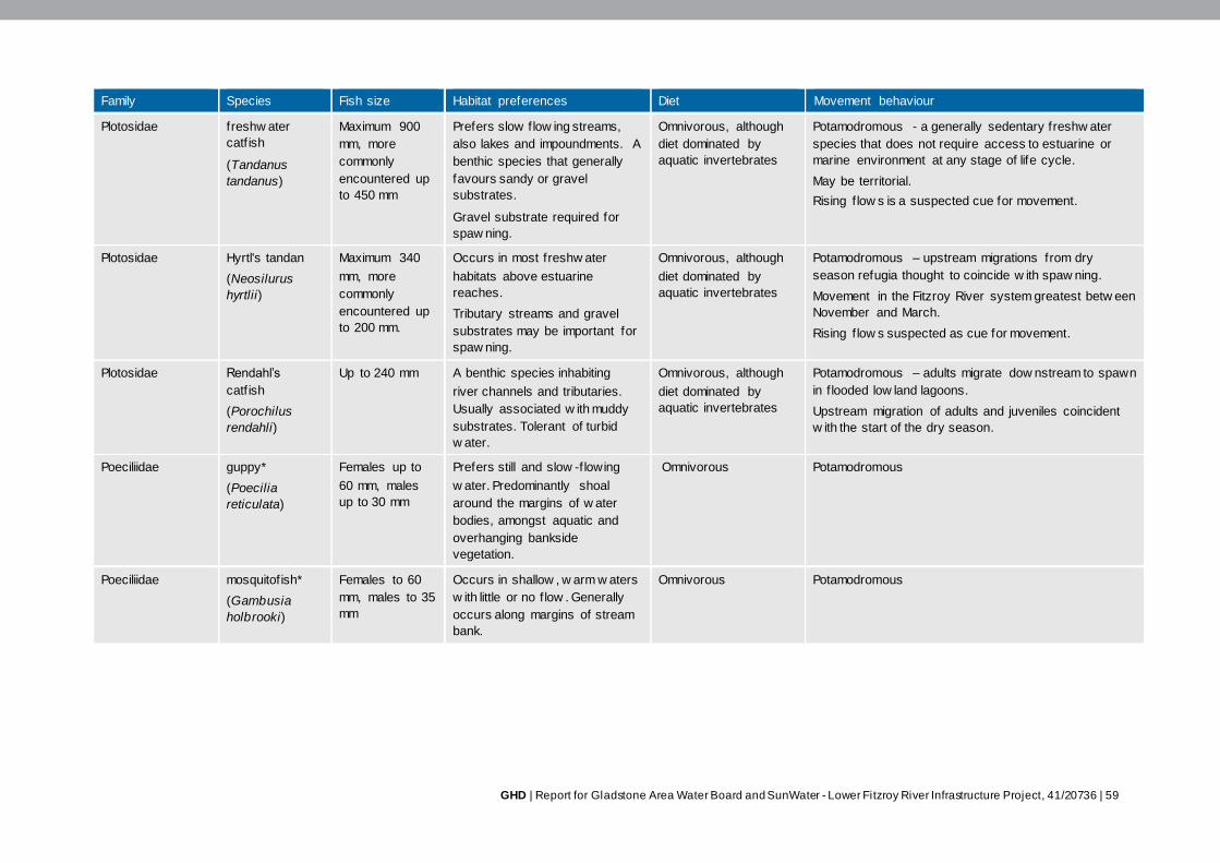
GHD | Report for Gladstone Area Water Board and SunWater - Lower Fitzroy River Infrastructure Project, 41/20736 | 59
Family Species Fish size Habitat preferences Diet Movement behaviour
Plotosidae freshw ater
catf ish
(Tandanus
tandanus)
Maximum 900
mm, more
commonly
encountered up
to 450 mm
Prefers slow flow ing streams,
also lakes and impoundments. A
benthic species that generally
favours sandy or gravel
substrates.
Gravel substrate required for
spaw ning.
Omnivorous, although
diet dominated by
aquatic invertebrates
Potamodromous - a generally sedentary freshw ater
species that does not require access to estuarine or
marine environment at any stage of life cycle.
May be territorial.
Rising f low s is a suspected cue for movement.
Plotosidae Hyrtl's tandan
(Neosilurus
hyrtlii)
Maximum 340
mm, more
commonly
encountered up
to 200 mm.
Occurs in most freshw ater
habitats above estuarine
reaches.
Tributary streams and gravel
substrates may be important for
spaw ning.
Omnivorous, although
diet dominated by
aquatic invertebrates
Potamodromous – upstream migrations from dry
season refugia thought to coincide w ith spaw ning.
Movement in the Fitzroy River system greatest betw een
November and March.
Rising f low s suspected as cue for movement.
Plotosidae Rendahl’s
catf ish
(Porochilus
rendahli)
Up to 240 mm A benthic species inhabiting
river channels and tributaries.
Usually associated w ith muddy
substrates. Tolerant of turbid
w ater.
Omnivorous, although
diet dominated by
aquatic invertebrates
Potamodromous – adults migrate dow nstream to spawn
in f looded low land lagoons.
Upstream migration of adults and juveniles coincident
w ith the start of the dry season.
Poeciliidae guppy*
(Poecilia
reticulata)
Females up to
60 mm, males
up to 30 mm
Prefers still and slow -flowing
w ater. Predominantly shoal
around the margins of w ater
bodies, amongst aquatic and
overhanging bankside
vegetation.
Omnivorous Potamodromous
Poeciliidae mosquitofish*
(Gambusia
holbrooki)
Females to 60
mm, males to 35
mm
Occurs in shallow , w arm w aters
w ith little or no f low . Generally
occurs along margins of stream
bank.
Omnivorous Potamodromous
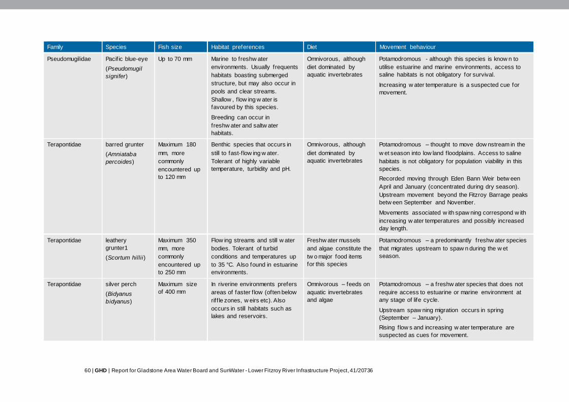
60 | GHD | Report for Gladstone Area Water Board and SunWater - Lower Fitzroy River Infrastructure Project, 41/20736
Family Species Fish size Habitat preferences Diet Movement behaviour
Pseudomugilidae Pacif ic blue-eye
(Pseudomugil
signifer)
Up to 70 mm Marine to freshw ater
environments. Usually frequents
habitats boasting submerged
structure, but may also occur in
pools and clear streams.
Shallow , f low ing w ater is
favoured by this species.
Breeding can occur in
freshw ater and saltw ater
habitats.
Omnivorous, although
diet dominated by
aquatic invertebrates
Potamodromous - although this species is know n to
utilise estuarine and marine environments, access to
saline habitats is not obligatory for survival.
Increasing w ater temperature is a suspected cue for
movement.
Terapontidae barred grunter
(Amniataba
percoides)
Maximum 180
mm, more
commonly
encountered up
to 120 mm
Benthic species that occurs in
still to fast-f low ing w ater.
Tolerant of highly variable
temperature, turbidity and pH.
Omnivorous, although
diet dominated by
aquatic invertebrates
Potamodromous – thought to move dow nstream in the
w et season into low land f loodplains. Access to saline
habitats is not obligatory for population viability in this
species.
Recorded moving through Eden Bann Weir betw een
April and January (concentrated during dry season).
Upstream movement beyond the Fitzroy Barrage peaks
betw een September and November.
Movements associated w ith spaw ning correspond w ith
increasing w ater temperatures and possibly increased
day length.
Terapontidae leathery
grunter1
(Scortum hillii)
Maximum 350
mm, more
commonly
encountered up
to 250 mm
Flow ing streams and still w ater
bodies. Tolerant of turbid
conditions and temperatures up
to 35 °C. Also found in estuarine
environments.
Freshw ater mussels
and algae constitute the
tw o major food items
for this species
Potamodromous – a predominantly freshw ater species
that migrates upstream to spaw n during the w et
season.
Terapontidae silver perch
(Bidyanus
bidyanus)
Maximum size
of 400 mm
In riverine environments prefers
areas of faster f low (often below
riff le zones, w eirs etc). Also
occurs in still habitats such as
lakes and reservoirs.
Omnivorous – feeds on
aquatic invertebrates
and algae
Potamodromous – a freshw ater species that does not
require access to estuarine or marine environment at
any stage of life cycle.
Upstream spaw ning migration occurs in spring
(September – January).
Rising f low s and increasing w ater temperature are
suspected as cues for movement.
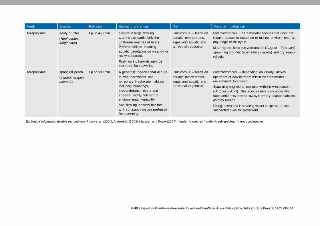
GHD | Report for Gladstone Area Water Board and SunWater - Lower Fitzroy River Infrastructure Project, 41/20736 | 61
Family Species Fish size Habitat preferences Diet Movement behaviour
Terapontidae sooty grunter
(Hephaestus
fuliginosus)
Up to 450 mm Occurs in large f low ing
w aterw ays, particularly the
upstream reaches of rivers.
Prefers habitats boasting
aquatic vegetation on a sandy or
rocky substrate.
Fast-f low ing habitats may be
important for spaw ning.
Omnivorous – feeds on
aquatic invertebrates,
algae and aquatic and
terrestrial vegetation
Potamodromous - a freshw ater species that does not
require access to estuarine or marine environments at
any stage of life cycle.
May migrate betw een w et season (August – February)
spaw ning grounds (upstream in rapids) and dry season
refugia.
Terapontidae spangled perch
(Leiopotherapon
unicolor)
Up to 300 mm A generalist species that occurs
in most permanent and
temporary freshw ater habitats
including billabongs,
impoundments, rivers and
streams. Highly tolerant of
environmental variability
Non-flow ing, shallow habitats
w ith soft substrate are preferred
for spaw ning.
Omnivorous – feeds on
aquatic invertebrates,
algae and aquatic and
terrestrial vegetation
Potamodromous – depending on locality, moves
upstream or dow nstream w ithin the freshw ater
environment to spaw n.
Spaw ning migrations coincide w ith the w et season
(October – April). This species may also undertake
substantial movements aw ay from dry season habitats
as they recede.
Rising f low s and increasing w ater temperature are
suspected cues for movement.
Ecological information in table sourced from Pusey et al . (2004); Allen et al . (2003); Marsden and Power (2007); 1 endemic species;
2 endemic sub-species; * introduced species
62 | GHD | Report for Gladstone Area Water Board and SunWater - Lower Fitzroy River Infrastructure Project, 41/20736
Movement behaviour and hydrological requirements
Fish species within the Fitzroy Basin catchment regularly move among spawning, feeding and
refuge habitats. Movement behaviours can be classified into one of three groups:
Catadromous: fish that spend the majority of their lives in freshwater, but migrate to the sea
to breed
Amphidromous: fish that move between freshwater and estuarine/marine environments at
defined periods of their life cycle, but not for the purposes of reproduction
Potamodromous: fish that carry out their entire life cycle within the freshwater environment.
Fish species diversity recorded in the Project footprint was dominated by potamodromous species
(83%) with a small number of amphidromous species also recorded (17%). No catadromous
species were captured during the field surveys however four catadromous species (i.e. long-finned
eel, barramundi, bullrout and swamp eel) have been previously recorded in the study area.
The Fitzroy system is typical of many dry tropical rivers in northern Australia where local fish
migration is strongly associated with hydrological changes (Hogan et al. 1997; Renfree and
Marsden 2006). Other factors or combinations of environmental factors which stimulate migration
include water temperature, day length, food availability, fish biomass and water chemistry. The
hydrological cue, however, is recognised as one of the most important for influencing tropical river
fish communities and their migrations (Baran 2006; Sheaves et al. 2007). Hydrology can be
divided into a number of different, but related, factors including: variation in river height, variation in
discharge, turbidity, and first rainfalls of the (pre)-wet season.
Golden perch is highlighted as the species most sensitive to high flow and flood migration triggers
(Stuart and Mallen-Cooper 1999; Mallen-Cooper and Edwards 1991; Marsden and Power 2007).
Nevertheless, the majority of species that inhabit the Fitzroy Basin catchment demonstrate a
strong migratory tie to large flood events (>120,000 ML/d) and many others respond to increased
flows (Stuart and Mallen-Cooper 1999; Mallen-Cooper and Edwards 1991; Marsden and Power
2007). A migration model demonstrating the temporal relationship between migratory behaviour of
fish in the Fitzroy River system and river flow is provided in Figure 3-3.
As shown in Figure 3-3 the first post winter flood is likely to trigger spawning and dispersal
migrations for a number of species and these are likely to continue during summer flows (Marsden
and Power 2007). For catadromous fish (e.g. barramundi and eels), high flows and floods are
especially important for spawning migrations to downstream estuarine and marine waters.
Barramundi have shown increased recruitment and strong year-classes associated with high flows
when fish can migrate laterally into off-stream water bodies (Staunton-Smith et al. 2004). Low flow
events are important for upstream dispersal migrations of several juvenile fish species including
sea mullet, leathery grunter, Hyrtl’s tandan and empire gudgeon (Marsden and Power 2007).
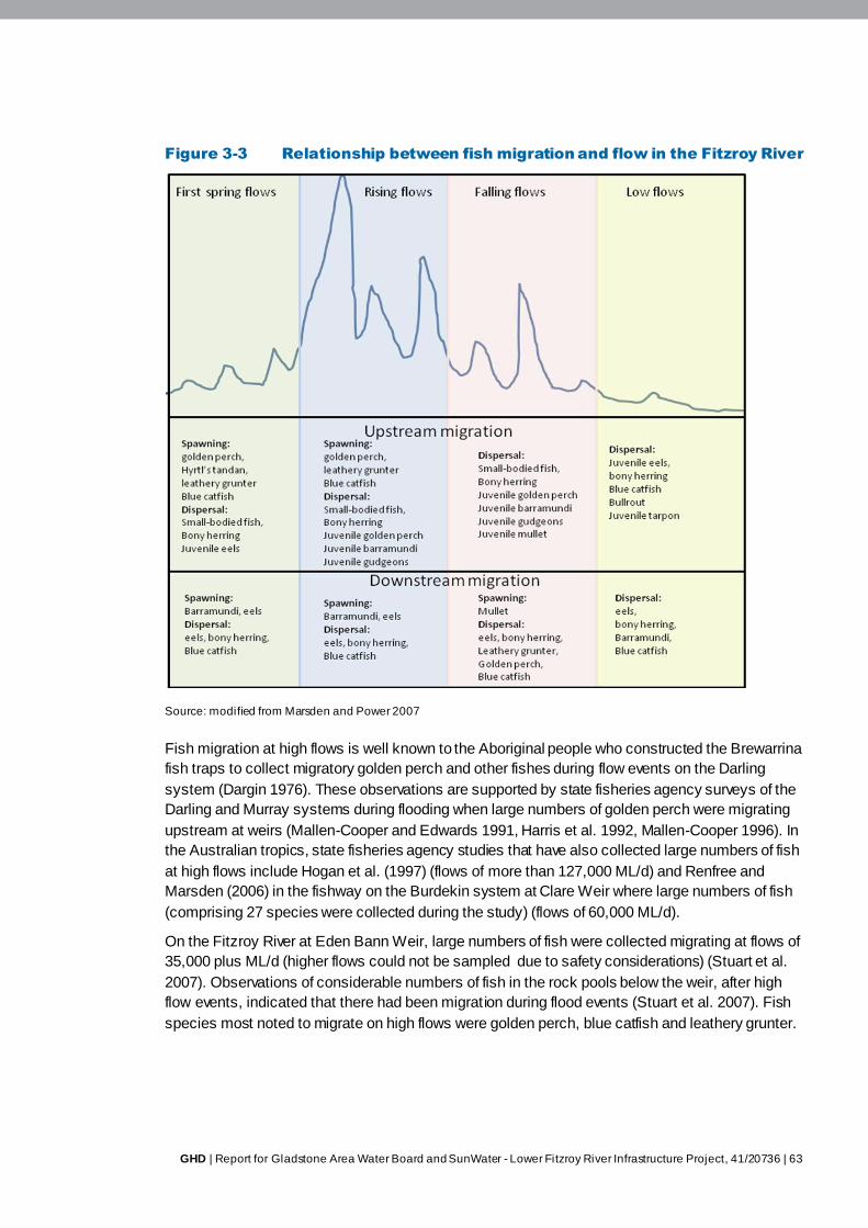
GHD | Report for Gladstone Area Water Board and SunWater - Lower Fitzroy River Infrastructure Project, 41/20736 | 63
Figure 3-3 Relationship between fish migration and flow in the Fitzroy River
Source: modified from Marsden and Power 2007
Fish migration at high flows is well known to the Aboriginal people who constructed the Brewarrina
fish traps to collect migratory golden perch and other fishes during flow events on the Darling
system (Dargin 1976). These observations are supported by state fisheries agency surveys of the
Darling and Murray systems during flooding when large numbers of golden perch were migrating
upstream at weirs (Mallen-Cooper and Edwards 1991, Harris et al. 1992, Mallen-Cooper 1996). In
the Australian tropics, state fisheries agency studies that have also collected large numbers of fish
at high flows include Hogan et al. (1997) (flows of more than 127,000 ML/d) and Renfree and
Marsden (2006) in the fishway on the Burdekin system at Clare Weir where large numbers of fish
(comprising 27 species were collected during the study) (flows of 60,000 ML/d).
On the Fitzroy River at Eden Bann Weir, large numbers of fish were collected migrating at flows of
35,000 plus ML/d (higher flows could not be sampled due to safety considerations) (Stuart et al.
2007). Observations of considerable numbers of fish in the rock pools below the weir, after high
flow events, indicated that there had been migration during flood events (Stuart et al. 2007). Fish
species most noted to migrate on high flows were golden perch, blue catfish and leathery grunter.

64 | GHD | Report for Gladstone Area Water Board and SunWater - Lower Fitzroy River Infrastructure Project, 41/20736
At the Fitzroy Barrage, fish (primarily catfish species and long-finned eels) were collected on major
flow events (more than 197, 000 ML/d (exceeded 0.5 per cent of the time)) before the fishway
drowned-out and sampling was suspended (Stuart and Mallen-Cooper 1999). These represent
some of the highest flows ever sampled because these conditions usually present insurmountable
safety hazards to field staff.
For catadromous fish, high flows and floods are especially important for downstream migration,
often over weirs on their journey to estuarine and marine waters for spawning. Barramundi have
shown increased recruitment and strong year-classes associated with high flows when fish migrate
laterally into connected floodplains (Staunton-Smith et al. 2004). Hence, catadromous fish have
evolved a migration strategy to take advantage of flooding.
In the order of 30 per cent of species in the Fitzroy River migrate strongly on large floods (defined
as being more than 120,000 ML/d) and many others respond to increasing flows as shown in
Table 3-14.
Table 3-14 Sensitivity of fish migration to hydrology
Fish species Flood
migration
First spring
f low migration
Maximum discharge w hen observed (w here
available)
Diadromous
Long-finned eel +195,757 ML/d (+2265 m3/s)
1, 3
Sw amp eel 127,457 ML/d (1475 m3/s)
1
Bullrout 6,937 ML/d (80 m3/s)
3
Barramundi 127,457 ML/d (1475 m3/s)
1
Blue catf ish 195,757 ML/d (2265 m3/s)
1
Striped mullet 127,457 ML/d (1475 m3/s)
1
Oxeye herring 127,457 ML/d (1475 m3/s)
1
Freshw ater longtom 660 ML/d (8 m3/s)
1
Snub-nosed garfish 660 ML/d (8 m3/s)
1
Potamodromous
Spangled perch 127,457 ML/d (1475 m3/s)
1
Sooty grunter 660 ML/d (8 m3/s)
1
Banded grunter 127,457 ML/d (1475 m3/s)
1
Leathery grunter +195,757 ML/d* (+2265 m3/s)
3, 5
Golden perch 119,581 ML/d (1384 m3/s)
2, 3, 5
Bony herring 127,457 ML/d (1475 m3/s)
1, 3, 5
Fly-specked hardyhead 65,466 ML/d (758 m3/s)
1
Olive perchlet 65,466 ML/d (758 m3/s)
1
Rendahl’s catf ish
Hyrtl’s tandan 195,757 ML/d (2265 m3/s)
3
Black catf ish 127,457 ML/d (1475 m3/s)
1
Mouth almighty 65,466 ML/d (758 m3/s)
1
Eastern rainbow fish 119,581 ML/d (1384 m3/s)
1, 3, 5

GHD | Report for Gladstone Area Water Board and SunWater - Lower Fitzroy River Infrastructure Project, 41/20736 | 65
Fish species Flood
migration
First spring
f low migration
Maximum discharge w hen observed (w here
available)
Sleepy cod 127,457 ML/d (1475 m3/s)
1, 5
Empire gudgeon 127,457 ML/d (1475 m3/s)
1, 4
Purple-spotted gudgeon 65,466 ML/d (758 m3/s)
1
Midgley’s carp gudgeon
Western carp gudgeon
Eel-tail catf ish
*=small numbers
References: 1 Hogan et al. 1997;
2 Mallen-Cooper and Edwards 1991;
3 Stuart and Mallen-Cooper 1999;
4 Renfree and
Marsden 2006; 5 Marsden and Power 2007.
Hydrological requirements for key large-bodies fish species are summarised:
Golden perch
Golden perch from the Fitzroy basin are a genetically and morphologically distinct sub-
species from the southern population. The species is distributed widely throughout the sub-
catchments and has been observed moving through the fishways at the Fitzroy Barrage
(Stuart 1997), Eden Bann (Stuart et al. 2007) and other weirs (Marsden and Power 2007).
Migratory requirements include the need to migrate upstream and downstream to breed
(Reynolds 1983; Pusey et al. 2004; O’Çonnor et al. 2005). The flood recruitment model has
been proposed in the past as the main mechanism for recruitment for golden perch in the
Murray-Darling Basin but they can also recruit during rising flows within the river channel
(Lake 1967; Mallen-Cooper and Stuart 2003). In the Fitzroy River system, there is strong
recruitment in years associated with high flows and floods in late spring and summer
(Roberts et al. 2008). The degree of river regulation can also depress recruitment patterns.
This strategy potentially allows larvae to benefit from the floodplain at times of maximum
inundation, and maximum exposure to larval food supplies (O’Connor et al. 2003)
Migration often occurs in the spring and summer months but has also been recorded after
flow events in autumn and winter (Stuart and Berghuis 1999; pers. com. Dawson River Fish
Stocking Group). This indicates that migrations are most likely temperature independent and
more driven by opportunistic flow events (Marsden & Power 2007).Migration is triggered by
environmental cues such as temperature and flow events but is not necessarily restricted to
initial or periods of high flow (Marsden and Power 2007). This species has been witnessed
moving through the Fitzroy River barrage over a wide range of flows (Stuart 1997). It has
been determined that 1.83 m/s is an appropriate water velocity in fishways for an adult
golden perch (Mallen-Cooper 1994).
Barramundi
Barramundi spawn in saltwater and the juveniles often migrate upstream into freshwater
(Mallen-Cooper 1992). Juveniles move upstream on high flow events preferably on the tail
of the hydrograph, at least three days after the peak flow but they can also move upstream
opportunistically at lower flows (Marsden and Power 2007).
Barramundi generally move during spring and summer with sub-adult fish (100-400 mm)
forming the majority of migrating fish (Stuart 1999, Renfree and Marsden 2006). Individuals
will still continue migrations throughout the cooler months but in lower numbers (Marsden

66 | GHD | Report for Gladstone Area Water Board and SunWater - Lower Fitzroy River Infrastructure Project, 41/20736
and Power 2007). There is limited fish movement when water temperature is below 22.5°C.
In other rivers, upstream movement has not been recorded at low flows. In the Fitzroy River
movement has been observed at a range of flows up to about 8,000 ML/day (Pusey,
Kennard and Arthington 2004). Juvenile barramundi (43 mm) have been recorded moving
through laboratory fishways with a swimming speed of 0.66 m/s (Mallen-Cooper 1992). This
is thought to be a conservative estimate of barramundi swimming speed due to the low
water temperature used in the experiment. Within the Fitzroy River, barramundi were
observed negotiating a fishway with a maximum water velocity of 1.4 m/s (Stuart 1997).
Barramundi can also pass barriers and obstacles during a period of drown-out (Marsden
and Power 2007).
Long-finned eel
Long-finned eels are catadromous with adults migrating downstream on a variety of flows in
order to breed at sea. Migration downstream occurs in autumn with the onset of cooler
weather. As movement occurs under a variety of flow conditions, this movement is most
likely temperature dependent (Stuart and Berghuis 1999). Elders (50-100 mm) migrate
upstream during high flow events in spring and summer. This movement is protracted as
individuals must allow time to acclimate to reduced salinity upstream (Pusey, Kennard and
Arthington 2004). Within the freshwater environment, fish are thought to exhibit limited local
movement (Pusey et al. 2004).
Long-finned eels have been recorded above Tartrus Weir, on which no fishway is present.
This occurrence might be explained by the fact long-finned eels have been demonstrated to
migrate past barriers of a similar size to Tartrus Weir (Marsden and Power 2007). This
species has been observed climbing obstacles and travelling short distances over damp
ground. Several researchers have advocated the inclusion of roughened substrate on
fishways in order to enable climbing (friction with substrate) (Langdon and Collins 2000;
Stuart and Berghuis 2002). The swimming ability of this species (0.32-0.75 m/s) may be
below that necessary to negotiate the high velocities frequently observed in fishways
(Langdon and Collins 2000).
Stripped mullet
Striped mullet are amphidromous moving downstream during autumn as part of their annual
migration to spawning grounds in the sea (Stuart and Berghuis 1999, Stuart 1999). These
downstream migrations are triggered by specific water temperature conditions. They migrate
downstream in the autumn with the onset of cooler weather and on a variety of flows (Stuart
and Berghuis 1999). The juveniles then disperse upstream during spring and summer
(Power and Marsden 2006). The juveniles utilise low flows to undertake dispersal migrations
and have been recorded migrating on low flows through a fishway on Raglan Creek,
indicating the importance of passage at that time (Power and Marsden 2006). Fish under
40 mm have been observed negotiating the Fitzroy Barrage and Burnett vertical-slot
fishways which have a maximum water velocity of 1.4 m/s (Stuart and Mallen-Cooper 1999;
Stuart and Berghuis 2002).
Saratoga
The saratoga is endemic to the Fitzroy River system. While there is limited knowledge of the
movement biology of this species, it is present throughout the upper Fitzroy, Dawson and
Mackenzie rivers and is not considered to be migratory (Merrick and Schmida 1984). Local
GHD | Report for Gladstone Area Water Board and SunWater - Lower Fitzroy River Infrastructure Project, 41/20736 | 67
anglers have reported large numbers of saratoga congregating below the Neville Hewitt
Weir during flow events (pers. com. Dawson River Fish Stocking Group). This anecdotal
evidence indicates this species may undertake facultative migrations. One saratoga has
been collected in the Eden Bann Weir fish lock (Stuart et al. 2007).
Fort-tailed catfish
Fork-tailed catfish are an amphidromous species. They reproduce in freshwater and in
estuarine waters and movement may be stimulated by various conditions (Pusey et al.
2004). Individuals have been recorded moving through Eden Bann Weir’s fish lock, reaching
peak numbers at the top of each flow event throughout the summer months (Stuart and
Berghuis 1997), while lower numbers occur on flow peaks throughout the rest of the year
(Stuart 1999; Marsden and Power 2007). At the Kolan River Barrage, the species has been
observed migrating upstream in flows up to 5500 ML/d (Broadfoot, Berghuis and
Heidenreich 2000). Movement at high flows has also been observed at the Fitzroy Barrage
(1.6 per cent exceedence). Movement is greatly reduced in the colder winter months.
Leathery grunter
The leathery grunter is endemic to the Fitzroy Basin. Upstream migration has been
documented prior to spawning suggesting the species is potamodromous (Merrick and
Schmida 1984). Sampling at barriers within the Fitzroy catchment indicate the first flood of
spring as being a major migration cue for the species (Stuart et al. 2007).This species
undertakes upstream migrations coinciding with summer rainfall prior to spawning.
Anecdotal reports suggest that the numerous barriers on the Fitzroy-Dawson river systems
prevent upstream migration necessary for reproduction (Marsden and Power 2007).
Sleepy cod
It does not appear as though this species undertakes substantial migrations (Pusey,
Kennard and Arthington 2004). Only five and 21 individuals have been observed moving
through the Fitzroy Barrage and Eden Bann Weir fishway, respectively. A small number
have also been recorded at the Clare Weir fishway in the Burdekin system (Renfree and
Marsden 2006). It is expected that this species moves in response to changing abundance
of prey fish rather than a need to migrate.
Oxeye herring
A small number of oxeye herring have been detected ascending the Fitzroy River Barrage
during March and April only (Kowarsky and Ross 1981) and they have also been found in
the Burnett Barrage fishway. It is believed that this species undertakes downstream
spawning migrations. There is debate as to whether adults return upstream after spawning
(Pusey et al. 2004). This species has been recorded attempting to ascend Clare Weir
fishway on the Burdekin River under flow conditions (65,466 ML/d – 127,467ML/d).
Hydrological requirements for key small-bodied fish species are summarised:
Fly speckled hardyhead
The movement pattern of the fly speckled hardyhead is described as facultative
potamodromy. Access to estuarine areas is not a necessary component of the life cycle.
The species is abundant in streams that are periodically disconnected during low flow.
Therefore the species has the ability to survive in isolated pools and rapidly recolonise
previously dry stretches (Pusey et al. 2004). Within the Fitzroy River, upstream migration
68 | GHD | Report for Gladstone Area Water Board and SunWater - Lower Fitzroy River Infrastructure Project, 41/20736
peaks in early summer with low fish movement occurring for the remainder of the year.
There are few records of this species undertaking downstream movement (Stuart 1997).
The environmental cue for movement is unknown however elevated flows are a likely
stimulus (Pusey et al. 2004). The fly speckled hardyhead has been recorded moving
through a fishway at flows of 18,305 ML/d. This flow is exceeded 10 per cent of the time in
the Fitzroy River (Stuart 1997). The species has difficulty ascending pool-weir type fishways
and has been observed in large numbers immediately downstream of obstructions (Pusey et
al. 2004).
Eastern rainbowfish
The eastern rainbowfish is a potamodromous species. Adults migrate upstream in order to
spawn. During high flow events the species undertakes dispersal migration (Pusey et al.
2004). Eastern rainbowfish have been observed in low numbers moving through fishways
on the Fitzroy River at low flows (Stuart 1997). The highest rate of movement has been
recorded from November to April.
Hyrtl’s tandan
The Hyrtl’s tandan is a potamodromous species. Adults migrate upstream to spawn, and
then disperse downstream (Pusey et al. 2004). Individuals have been observed moving
upstream through fishways on the Fitzroy River. Movement occurs between November and
March under most flow conditions. Small fish (<150 mm) only moved upstream during low
flow conditions (18 ML/d) (Stuart 1997). At Eden Bann Weir, there has been a strong
migration response of Hyrtl’s tandan to the first rising flows of spring and this has also been
observed elsewhere (A. Berghuis, pers. comm.).
Midgleys carp gudgeon
Midgleys carp gudgeon has been observed moving upstream in a tributary of the Fitzroy
River (Wager 1997). Upstream migration may occur after being displaced from a flow event
or as dispersal movements when flow conditions allow.
Empire gudgeon
The species is described as facultative potamodromous or semi-amphidromous. The
species engage in a facultative mass dispersal phase and mass upstream migrations
(Renfree and Marsden 2006). It is unclear whether empire gudgeon undertake migration for
spawning or simply recolonising freshwater (Pusey et al. 2004). They have the ability to
breed in freshwater. They have been observed entering the Fitzroy Barrage fishway on a
wide variety of flows (18-18,305 ML/d) (flows are exceeded about 82 per cent to 8 per cent
of the time respectively) (Stuart 1997). Upstream migration usually takes place in spring and
summer, particularly on large flow events. They have the ability to swim at a velocity of
1 m/s (Hogan, Graham and Vallance 1997).
Barriers such as weirs compromise the ability of fish to freely move downstream and upstream
within the freshwater environment or between the freshwater and estuarine / marine environment.
A vertical-slot fishway at the Fitzroy Barrage and a fish lock at Eden Bann Weir facilitate up- and
downstream movement of many fish species. The vertical slot-fishway at Fitzroy Barrage
represents a successful upgrade to the ‘weir-and-pool’ fishway originally constructed. However the
smallest fish species, and small size-classes (i.e. immature and juveniles) of larger species are
often unable to negotiate the structure, likely as a result of their inability to swim against the high
velocity water flow at the downstream entrance of the fishway (Stuart and Mallen-Cooper 1999).
GHD | Report for Gladstone Area Water Board and SunWater - Lower Fitzroy River Infrastructure Project, 41/20736 | 69
During low flows, the Eden Bann Weir fish lock has been recorded to successfully pass a broad
size range (35 – 710 mm long) of species however passage efficiency is reduced at high flows due
to a reduced attraction of the fishway entrance (Long and Meager 2000; Stuart et al. 2007).
Conservation significant species
While no fish species listed as threatened under the EPBC Act or NC Act were identified from the
literature review and field studies as occurring / potentially occurring in the Fitzroy Basin
catchment (including the Project footprint), the following species are considered conservation
significant due to their restricted geographic range.
Southern saratoga (Scleropages leichardti) – the southern saratoga is endemic to the
Fitzroy Basin catchment. As it has a restricted natural geographic range (the species has
been stocked in waterways of South East Queensland), is endemic and generally
uncommon, and is a unique remnant of a primitive group of fish, the southern saratoga is
considered to have important local conservation values. This species prefers slow flowing
pools and backwaters, and is tolerant of turbid conditions (Allen et al. 2003). Pool and creek
habitats within the Project footprint represent potentially suitable habitat, and while no
southern saratoga were encountered during wet and dry season surveys, the species is
known to occur in the study area and is likely to occur in the Project footprint.
Leathery grunter (Scortum hillii) – the leathery grunter is endemic to the Fitzroy Basin
catchment. As it has a restricted natural geographic range, is endemic and relatively
uncommon, the leathery grunter is considered to have important local conservation values.
It prefers flowing waters where it feeds near the benthos (particularly on mussels and
algae), however it also inhabits still areas, and is tolerant of turbid conditions (Allen et al.
2003). Pool and run habitats within the Project footprint are likely to provide suitable habitat
for this species. No leathery grunter were recorded during wet and dry season surveys in
the Project footprint, however due to the availability of suitable habitat, and the fact that the
species has been previously recorded in the study area, it is considered likely to occur.
Golden perch (Macquaria ambigua oriens) – this sub-species of the golden perch is
endemic to the Fitzroy Basin catchment with relatively secure populations (Marsden and
Power 2007). The golden perch occurs in a variety of aquatic habitats, but shows a
preference for slow-flowing turbid habitats with an abundance of in-stream debris. While no
golden perch were recorded during wet and dry season surveys in the Project footprint, the
availability of suitable habitat and its known presence in the study area indicate that it is
likely to occur within the Project footprint.
Ornate rainbowfish (Rhadinocentrus ornatus) – due to its restricted distribution and
habitat degradation, the ornate rainbowfish has been identified as high priority under the
‘Back on Track’ prioritisation framework for conservation management of Queensland’s
wildlife within the Fitzroy Natural Resource Management area (DERM 2008). This species is
typically associated with waterways in coastal lowland wallum and rainforest ecosystems, as
well as coastal sand islands (Pusey et al. 2004). The ornate rainbowfish was not recorded
during wet and dry season surveys, and has not been previously recorded in the study area.
Due to the lack of suitable habitat, it is unlikely to occur in the Project footprint.
70 | GHD | Report for Gladstone Area Water Board and SunWater - Lower Fitzroy River Infrastructure Project, 41/20736
Recreationally and commercially important fish species
Species with significant fisheries values previously recorded upstream of Eden Bann Weir include
the barramundi (Lates calcarifer), a species that is a key target of the Queensland East Coast
Inshore Fin Fish Fishery (DEEDI 2009). While commercial net fishing does not occur within the
Project footprint, the life-history traits of the barramundi include utilisation of both freshwater and
saltwater habitats. As such, barramundi occurring upstream of Eden Bann Weir should be
considered a potential component of the downstream commercial fishery. Other commercially-
important catadromous / amphidromous species known to occur above Eden Bann Weir include
sea mullet (Mugil cephalus) and long-finned eel (Anguilla reinhardtii). Important recreational
species recorded in the study area include barramundi, southern saratoga, golden perch, blue
catfish (Arius graeffei), freshwater catfish (Tandanus tandanus), sleepy cod (Oxyeleotris lineolata),
oxeye herring (Megalops cyprinoides) and snub-nosed garfish (Arrhamphus sclerolepis).
3.4.3 Freshwater turtles
Species diversity
The Fitzroy Basin catchment supports one of the highest diversities of freshwater turtles in
Australia, including two regionally endemic, conservation significant species. Turtle species that
inhabit the Fitzroy River include:
Fitzroy River turtle (Rheodytes leukops)
White-throated snapping turtle (Elseya albagula)
Saw-shelled turtle (Elseya latisternum)
Krefft’s river turtle (Emydura krefftii)
Broad-shelled river turtle (Chelodina expansa)
Eastern snake-necked turtle (Chelodina longicollis).
The Fitzroy River turtle is endemic to the Fitzroy Basin catchment and is listed as ‘Vulnerable’
under the EPBC Act and the NC Act. The white-throated snapping turtle is endemic to the Fitzroy,
Burnett and Mary river catchments and is listed as least concern under the NC Act and is ranked
as high priority under DEHP’s Back on Track framework. The white-throated snapping turtle has
been nominated for threatened species status under the NC Act and the EPBC Act (Limpus et al
2011a) and is included in the Australian Government’s Department of the Environment’s Finalised
Priority Assessment List for the period commencing 1 October 2013. The Threatened Species
Scientific Committee will provide advice on the nomination by 30 March 2016. The white-throated
snapping turtle has been previously recorded within the Project footprints.
All turtle species listed above, excluding the eastern snake-necked turtle, have previously been
recorded within the Eden Bann Weir Project footprint. The eastern snake-necked turtle primarily
inhabits ephemeral off-stream water bodies such as billabongs and farm dams (Limpus et al.
2007). Within the broader study area, this species has been recorded within the upper Fitzroy
River and the lower reaches of the Dawson River. The known distribution of all turtle species
within the Fitzroy Basin catchment is detailed in Table 3-15.
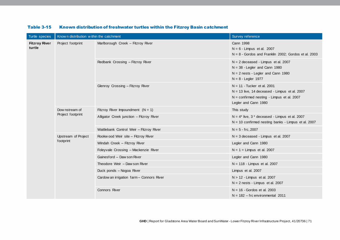
GHD | Report for Gladstone Area Water Board and SunWater - Lower Fitzroy River Infrastructure Project, 41/20736 | 71
Table 3-15 Known distribution of freshwater turtles within the Fitzroy Basin catchment
Turtle species Know n distribution w ithin the catchment Survey reference
Fitzroy River
turtle
Project footprint Marlborough Creek – Fitzroy River Cann 1998
N = 6 - Limpus et al. 2007
N = 8 - Gordos and Franklin 2002; Gordos et al. 2003
Redbank Crossing – Fitzroy River N = 2 deceased - Limpus et al. 2007
N = 38 - Legler and Cann 1980
N = 2 nests - Legler and Cann 1980
N = 8 - Legler 1977
Glenroy Crossing – Fitzroy River N = 11 - Tucker et al. 2001
N = 13 live, 14 deceased - Limpus et al. 2007
N = confirmed nesting - Limpus et al. 2007
Legler and Cann 1980
Dow nstream of
Project footprint
Fitzroy River Impoundment (N = 1) This study
Alligator Creek junction – Fitzroy River
N = 4* live, 3 * deceased - Limpus et al. 2007
N = 10 confirmed nesting banks - Limpus et al. 2007
Wattlebank Control Weir – Fitzroy River N = 5 - frc, 2007
Upstream of Project
footprint
Rookw ood Weir site – Fitzroy River N = 3 deceased - Limpus et al. 2007
Windah Creek – Fitzroy River Legler and Cann 1980
Foleyvale Crossing – Mackenzie River N = 1 = Limpus et al. 2007
Gainesford – Daw son River Legler and Cann 1980
Theodore Weir – Daw son River N = 118 - Limpus et al. 2007
Duck ponds – Nogoa River Limpus et al. 2007
Cardow an irrigation farm – Connors River N > 12 - Limpus et al. 2007
N = 2 nests - Limpus et al. 2007
Connors River N = 16 - Gordos et al. 2003
N = 182 – frc environmental 2011

72 | GHD | Report for Gladstone Area Water Board and SunWater - Lower Fitzroy River Infrastructure Project, 41/20736
Turtle species Know n distribution w ithin the catchment Survey reference
Connors River Dam N = 7 captured, 9 sighted – frc environmental 2010a
Nathan Dam and surrounds N = 1 nest – frc environmental 2010b
Tartus Weir N = 81 – Limpus et al 2011
White-
throated
snapping
turtle
Project footprint Eden Bann Weir – Fitzroy River N = 22 live, 1 deceased - Limpus et al. 2007
N = 1 - This study
Marlborough Creek – Fitzroy River N = 15 - Limpus et al. 2007
Redbank Crossing – Fitzroy River N > 10 - Limpus et al. 2007
Legler and Cann 1980
Glenroy Crossing – Fitzroy River (N = 36 live; 2 deceased) N = 36 live, 2 deceased - Limpus et al. 2007
Dow nstream of
Project footprint
Fitzroy Barrage Impoundment – Fitzroy River N = 5 - frc, 2007
N = 2 - This study
Alligator Creek junction – Fitzroy River
N = 83* live – 2 decreased - Limpus et al. 2007
N = 13 - frc, 2007
N = 56 - Hamann et al. 2007
Alligator Creek to Wattlebank Control Weir – Fitzroy River (N = 11) N = 11 - frc, 2007
Wattlebank Control Weir – Fitzroy River (N = 8) N = 8 - frc, 2007
Upstream of Project
footprint
Rookw ood Weir site N = 2 - Limpus et al. 2007
N = 2 nests - This study
Riverslea Crossing – Fitzroy River N = 1 - Limpus et al. 2007
N = 1 - This study
Foleyvale Crossing – Mackenzie River N = 1 deceased - Limpus et al. 2007
N =1 - This study
Boolburra Crossing – Daw son River N = 1 nest - Limpus et al. 2007
Gainesford – Daw son River Legler and Cann 1980
Theodore Weir – Daw son River N = 20 - Limpus et al. 2007
Glebe Weir – Daw son River N > 4 deceased - Limpus et al. 2007
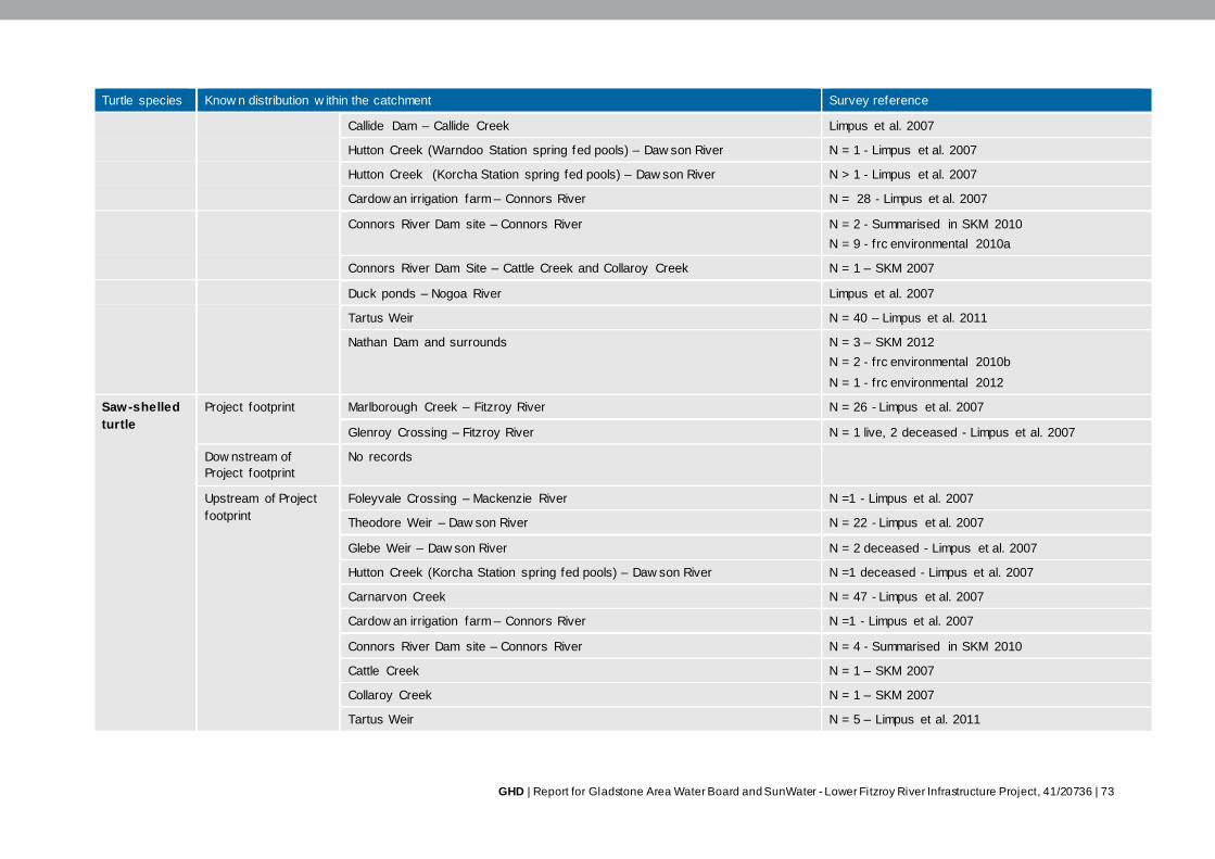
GHD | Report for Gladstone Area Water Board and SunWater - Lower Fitzroy River Infrastructure Project, 41/20736 | 73
Turtle species Know n distribution w ithin the catchment Survey reference
Callide Dam – Callide Creek Limpus et al. 2007
Hutton Creek (Warndoo Station spring fed pools) – Daw son River N = 1 - Limpus et al. 2007
Hutton Creek (Korcha Station spring fed pools) – Daw son River N > 1 - Limpus et al. 2007
Cardow an irrigation farm – Connors River N = 28 - Limpus et al. 2007
Connors River Dam site – Connors River N = 2 - Summarised in SKM 2010
N = 9 - frc environmental 2010a
Connors River Dam Site – Cattle Creek and Collaroy Creek N = 1 – SKM 2007
Duck ponds – Nogoa River Limpus et al. 2007
Tartus Weir N = 40 – Limpus et al. 2011
Nathan Dam and surrounds N = 3 – SKM 2012
N = 2 - frc environmental 2010b
N = 1 - frc environmental 2012
Saw-shelled
turtle
Project footprint Marlborough Creek – Fitzroy River N = 26 - Limpus et al. 2007
Glenroy Crossing – Fitzroy River N = 1 live, 2 deceased - Limpus et al. 2007
Dow nstream of
Project footprint
No records
Upstream of Project
footprint
Foleyvale Crossing – Mackenzie River N =1 - Limpus et al. 2007
Theodore Weir – Daw son River N = 22 - Limpus et al. 2007
Glebe Weir – Daw son River N = 2 deceased - Limpus et al. 2007
Hutton Creek (Korcha Station spring fed pools) – Daw son River N =1 deceased - Limpus et al. 2007
Carnarvon Creek N = 47 - Limpus et al. 2007
Cardow an irrigation farm – Connors River N =1 - Limpus et al. 2007
Connors River Dam site – Connors River N = 4 - Summarised in SKM 2010
Cattle Creek N = 1 – SKM 2007
Collaroy Creek N = 1 – SKM 2007
Tartus Weir N = 5 – Limpus et al. 2011
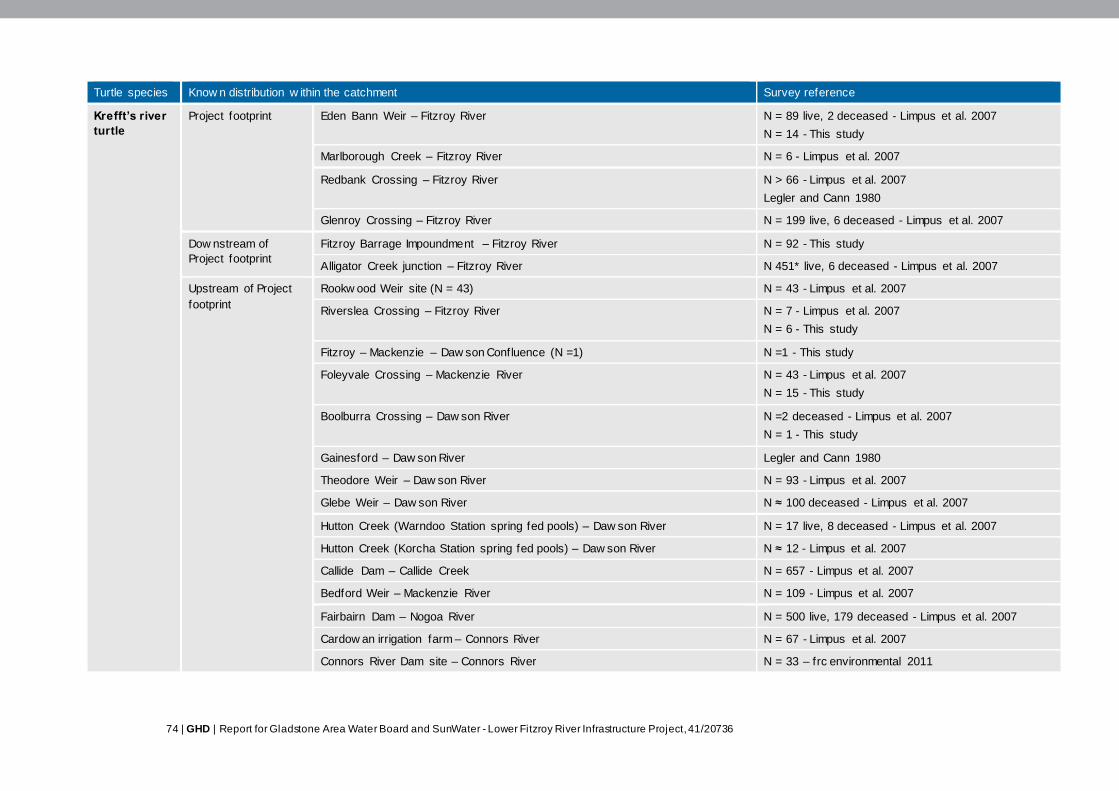
74 | GHD | Report for Gladstone Area Water Board and SunWater - Lower Fitzroy River Infrastructure Project, 41/20736
Turtle species Know n distribution w ithin the catchment Survey reference
Krefft’s river
turtle
Project footprint Eden Bann Weir – Fitzroy River
N = 89 live, 2 deceased - Limpus et al. 2007
N = 14 - This study
Marlborough Creek – Fitzroy River N = 6 - Limpus et al. 2007
Redbank Crossing – Fitzroy River
N > 66 - Limpus et al. 2007
Legler and Cann 1980
Glenroy Crossing – Fitzroy River N = 199 live, 6 deceased - Limpus et al. 2007
Dow nstream of
Project footprint
Fitzroy Barrage Impoundment – Fitzroy River N = 92 - This study
Alligator Creek junction – Fitzroy River N 451* live, 6 deceased - Limpus et al. 2007
Upstream of Project
footprint
Rookw ood Weir site (N = 43) N = 43 - Limpus et al. 2007
Riverslea Crossing – Fitzroy River N = 7 - Limpus et al. 2007
N = 6 - This study
Fitzroy – Mackenzie – Daw son Confluence (N =1) N =1 - This study
Foleyvale Crossing – Mackenzie River N = 43 - Limpus et al. 2007
N = 15 - This study
Boolburra Crossing – Daw son River
N =2 deceased - Limpus et al. 2007
N = 1 - This study
Gainesford – Daw son River Legler and Cann 1980
Theodore Weir – Daw son River N = 93 - Limpus et al. 2007
Glebe Weir – Daw son River N ≈ 100 deceased - Limpus et al. 2007
Hutton Creek (Warndoo Station spring fed pools) – Daw son River N = 17 live, 8 deceased - Limpus et al. 2007
Hutton Creek (Korcha Station spring fed pools) – Daw son River N ≈ 12 - Limpus et al. 2007
Callide Dam – Callide Creek N = 657 - Limpus et al. 2007
Bedford Weir – Mackenzie River N = 109 - Limpus et al. 2007
Fairbairn Dam – Nogoa River N = 500 live, 179 deceased - Limpus et al. 2007
Cardow an irrigation farm – Connors River N = 67 - Limpus et al. 2007
Connors River Dam site – Connors River N = 33 – frc environmental 2011

GHD | Report for Gladstone Area Water Board and SunWater - Lower Fitzroy River Infrastructure Project, 41/20736 | 75
Turtle species Know n distribution w ithin the catchment Survey reference
Funnel Creek – Connors River N = 2 - SKM 2010
Murray Creek N = 6 – SKM 2007
Connors River N = 1 SKM 2007
Cattle Creek N = 8 SKM 2007
Collaroy Creek N = 5 SKM 2007
Sandy Creek N = 9 SKM 2007
Nathan Dam and surrounds N = 32 - SKM 2012
N = 8 – frc environmental 2010 b
N = 12 frc environmental 2012
Tartus Weir N = 235 – Limpus et al. 2011
Broad-shelled
river turtle
Project footprint Eden Bann Weir – Fitzroy River N = 1 - Limpus et al. 2007
Eden Bann Weir – Fitzroy River N = 1 nest - This study
Redbank Crossing – Fitzroy River N = 1 deceased - Limpus et al. 2007
Glenroy Crossing – Fitzroy River N = 3 live, 1 deceased - Limpus et al. 2007
Glenroy Crossing – Fitzroy River Legler and Cann 1980
Dow nstream of
Project footprint
Fitzroy Barrage Impoundment N > 1 - This study
Gavial Creek f loodplain billabong – Fitzroy River N = 24 - Limpus et al. 2007
Alligator Creek junction – Fitzroy River N = 9* live, 1 deceased - Limpus et al. 2007
Upstream of Project
footprint
Boolburra Crossing – Daw son River N =1 deceased - Limpus et al. 2007
Theodore Weir – Daw son River N = 3 - Limpus et al. 2007
Glebe Weir – Daw son River N > 5 deceased - Limpus et al. 2007
Hutton Creek (Warndoo Station spring fed pools) – Daw son River (anecdotal
evidence)
Limpus et al. 2007
Duck ponds – Nogoa River Limpus et al. 2007
Fairbairn Dam – Nogoa River N = 2 live, 5 deceased - Limpus et al. 2007
Nathan Dam and surrounds N = 1 - SKM 2012
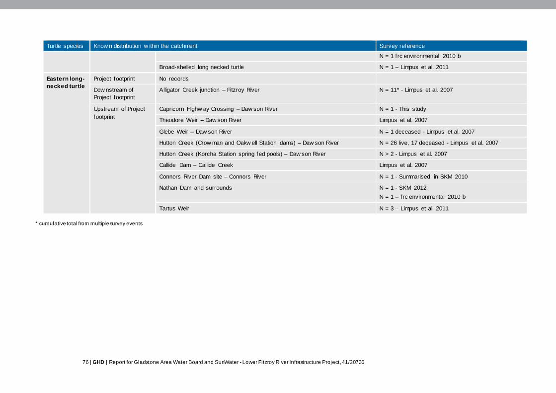
76 | GHD | Report for Gladstone Area Water Board and SunWater - Lower Fitzroy River Infrastructure Project, 41/20736
Turtle species Know n distribution w ithin the catchment Survey reference
N = 1 frc environmental 2010 b
Broad-shelled long necked turtle N = 1 – Limpus et al. 2011
Eastern long-
necked turtle
Project footprint No records
Dow nstream of
Project footprint
Alligator Creek junction – Fitzroy River N = 11* - Limpus et al. 2007
Upstream of Project
footprint
Capricorn Highw ay Crossing – Daw son River N = 1 - This study
Theodore Weir – Daw son River Limpus et al. 2007
Glebe Weir – Daw son River N = 1 deceased - Limpus et al. 2007
Hutton Creek (Crow man and Oakw ell Station dams) – Daw son River N = 26 live, 17 deceased - Limpus et al. 2007
Hutton Creek (Korcha Station spring fed pools) – Daw son River N > 2 - Limpus et al. 2007
Callide Dam – Callide Creek Limpus et al. 2007
Connors River Dam site – Connors River N = 1 - Summarised in SKM 2010
Nathan Dam and surrounds N = 1 - SKM 2012
N = 1 – frc environmental 2010 b
Tartus Weir N = 3 – Limpus et al 2011
* cumulative total from multiple survey events

GHD | Report for Gladstone Area Water Board and SunWater - Lower Fitzroy River Infrastructure Project, 41/20736 | 77
Ecology
A species specific description of the ecology, including habitat preferences, nesting behaviour,
respiratory physiology, dietary requirements, and movement behaviours of the six turtle species
recorded within the Fitzroy Basin catchment is provided in Table 3-16 while a broad summary is
detailed below.
Aquatic habitats
Habitat preferences vary considerably between turtle species and range from ephemeral
waterholes and pools to fast-flowing riffle zones and structurally complex tributaries. The Krefft’s
river turtle is the most generalist species occurring in all freshwater habitats throughout the Fitzroy
Basin catchment excluding isolated farm dams (Limpus et al. 2007). This species was the most
widespread and abundant species encountered within the Project footprint during DERM surveys
(Limpus et al. 2007).
The saw-shelled turtle is thought to occur in low abundance throughout the Fitzroy Basin
catchment with a higher number of individuals occurring in the flowing streams of the upper
catchment than the larger riverine habitats of the lower catchment (Limpus et al. 2007). Within the
Project footprint, this species has been recorded at Marlborough Creek and Glenroy Crossing
(Table 3-15). The broad-shelled river turtle is primarily known to occur in the slow flowing riverine
reaches, impoundments and billabongs of the middle and lower catchment (Limpus et al. 2007). A
small number of individuals have been recorded within the Eden Bann Weir and at Redbank and
Glenroy Crossings (Table 3-15). The eastern snake-necked turtle is known to occur in the Dawson
River Catchment and the lower Fitzroy River Catchment. This species is primarily encountered in
off-stream ephemeral water bodies such as swamps, lagoons, man-made dams and billabongs
(Limpus et al. 2007). To date this species has not been recorded within the Project footprint but it
is considered likely to occur in the off-stream habitats in the area.
The Fitzroy River turtle and the white-throated snapping turtle are specialist species that inhabit
the natural permanent riverine habitats of the Fitzroy Basin catchment. Riffle zones are considered
particularly important habitat for these species, however individuals may also inhabit run, pool,
creek and impounded habitats that support an abundance of undercut banks, submerged roots
and fallen trees (Limpus et al. 2007). The aquatic habitats of these species within the Project
footprint are further discussed below.
Nesting habitats
Nesting by the Krefft’s river turtle, saw-shelled turtle, broad-shelled river turtle and eastern snake-
necked turtle can occur in a variety of river bank substrates from hard clays and grass covered
banks to soft sands (Cann 1998; Limpus et al. 2007). The majority of nesting occurs close to the
waters edge (5 - 50 m), however, the broad-shelled river turtle and eastern snake-necked turtle
have been observed nesting up to 1 km from river banks.
In comparison to these species, the preferred nesting habitat of the Fitzroy River turtle and white-
throated snapping turtle is more specific with nesting primarily occurring in alluvial sand / loam
banks that occur in depositional areas (Plate 3-3) (Limpus et al. 2007; Hamann et al. 2007). These
banks generally form at the river’s edge and extend back into the immediate riparian zone,
however islands are also known to occur in places.
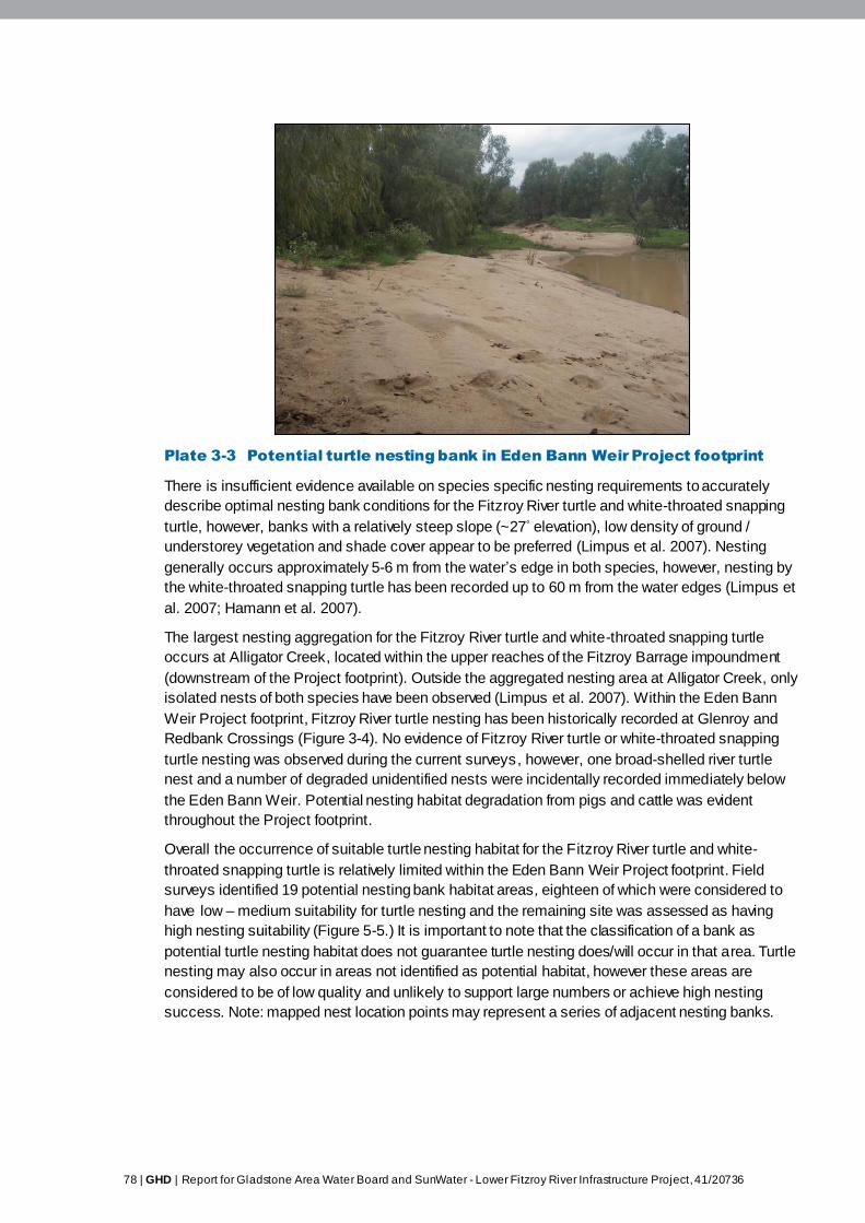
78 | GHD | Report for Gladstone Area Water Board and SunWater - Lower Fitzroy River Infrastructure Project, 41/20736
Plate 3-3 Potential turtle nesting bank in Eden Bann Weir Project footprint
There is insufficient evidence available on species specific nesting requirements to accurately
describe optimal nesting bank conditions for the Fitzroy River turtle and white-throated snapping
turtle, however, banks with a relatively steep slope (~27˚ elevation), low density of ground /
understorey vegetation and shade cover appear to be preferred (Limpus et al. 2007). Nesting
generally occurs approximately 5-6 m from the water’s edge in both species, however, nesting by
the white-throated snapping turtle has been recorded up to 60 m from the water edges (Limpus et
al. 2007; Hamann et al. 2007).
The largest nesting aggregation for the Fitzroy River turtle and white-throated snapping turtle
occurs at Alligator Creek, located within the upper reaches of the Fitzroy Barrage impoundment
(downstream of the Project footprint). Outside the aggregated nesting area at Alligator Creek, only
isolated nests of both species have been observed (Limpus et al. 2007). Within the Eden Bann
Weir Project footprint, Fitzroy River turtle nesting has been historically recorded at Glenroy and
Redbank Crossings (Figure 3-4). No evidence of Fitzroy River turtle or white-throated snapping
turtle nesting was observed during the current surveys, however, one broad-shelled river turtle
nest and a number of degraded unidentified nests were incidentally recorded immediately below
the Eden Bann Weir. Potential nesting habitat degradation from pigs and cattle was evident
throughout the Project footprint.
Overall the occurrence of suitable turtle nesting habitat for the Fitzroy River turtle and white-
throated snapping turtle is relatively limited within the Eden Bann Weir Project footprint. Field
surveys identified 19 potential nesting bank habitat areas , eighteen of which were considered to
have low – medium suitability for turtle nesting and the remaining site was assessed as having
high nesting suitability (Figure 5-5.) It is important to note that the classification of a bank as
potential turtle nesting habitat does not guarantee turtle nesting does/will occur in that area. Turtle
nesting may also occur in areas not identified as potential habitat, however these areas are
considered to be of low quality and unlikely to support large numbers or achieve high nesting
success. Note: mapped nest location points may represent a series of adjacent nesting banks.
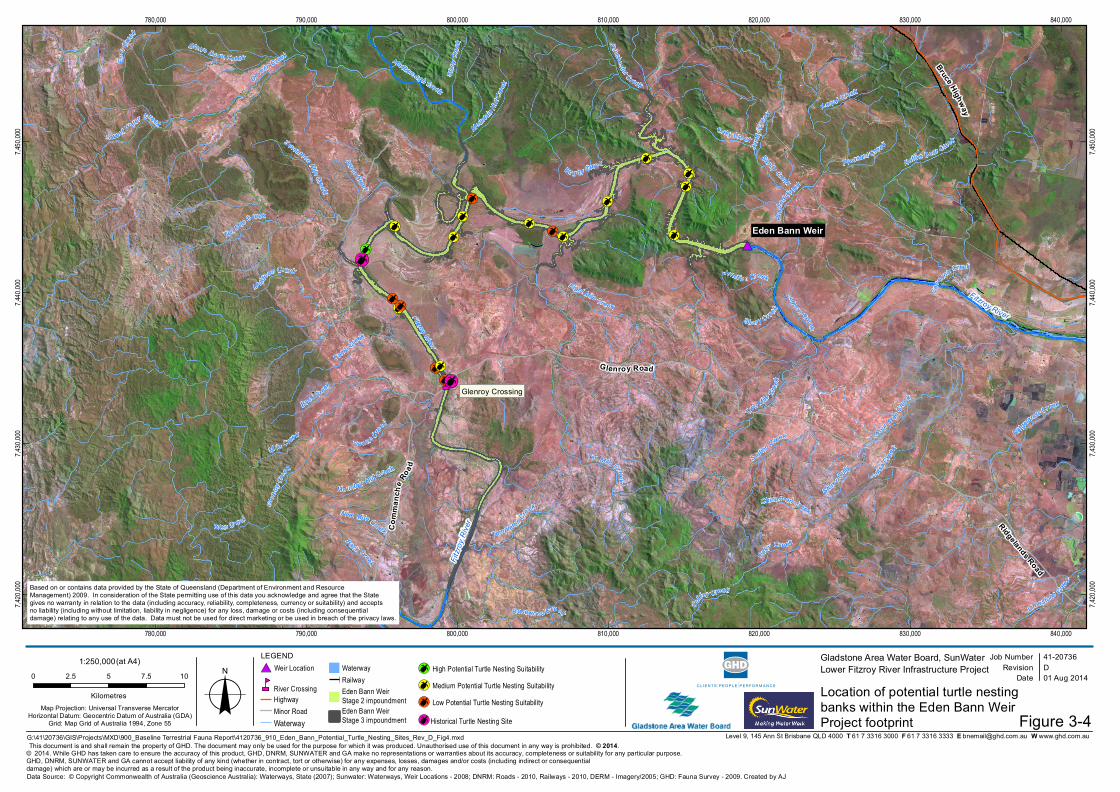
[¶[
[
[
[¶[
[
[
[¶[
[
[
[¶[
[
[
[¶[
[
#*
nm
Fitzro
y Rive
r
Fitzroy River
Bruce Highway
Eden Bann Weir
Fitzroy River
Ten Mile Creek
Develin Creek
Plante
d Creek
Four M ileCre
ek
Lo uisa Cree
k
Glen
royCre
ek
M uldoon Creek
S tationCreek
Marlborough Creek
Two Mile Cre e
k
Do wns C ree
k
Camp Creek
Back Creek
Bo g gy Creek
OakyCre ek
Nine Mile Creek
Cano
ona Creek
Sand
yCree
k
Mi le C reek
Coffey Creek
Sweet WaterCreek
Emu Cre
ek
Native Bear Creek
Gle n Creek
Store r Gully
Stony
Cree
kBlown Down Creek
Mountain Hut Creek
Eight Mile Creek
Templeton Creek
Ridgel
ands Creek
Limestone Creek
Princhester C reek
P leasant Cre ekSeventeen Mile Creek
Green Creek
Junctio n Creek
Lagoon Creek
Kerra l Creek
Chinaman Creek
Rosewood Creek
Ten Mile Creek
Sandy Creek
Oaky Creek
Back Creek
Sto n y Cr eek
Mount
ainHu
t Cree
k
Glenroy Road
Comm
anch
e Road
Ridgelands Road
780,000
780,000
790,000
790,000
800,000
800,000
810,000
810,000
820,000
820,000
830,000
830,000
840,000
840,000
7,420,
000
7,420,
000
7,430,
000
7,430,
000
7,440,
000
7,440,
000
7,450,
000
7,450,
000
Job NumberRevision D
41-20736
G:\41\20736\GIS\Projects\MXD\900_Baseline Terrestrial Fauna Report\4120736_910_Eden_Bann_Potential_Turtle_Nesting_Sites_Rev_D_Fig4.mxd
Map Projection: Universal Transverse MercatorHorizontal Datum: Geocentric Datum of Australia (GDA)
Grid: Map Grid of Australia 1994, Zone 55
0 2.5 5 7.5 10
Kilometres o© 2014. While GHD has taken care to ensure the accuracy of this product, GHD, DNRM, SUNWATER and GA make no representations or warranties about its accuracy, completeness or suitability for any particular purpose. GHD, DNRM, SUNWATER and GA cannot accept liability of any kind (whether in contract, tort or otherwise) for any expenses, losses, damages and/or costs (including indirect or consequentialdamage) which are or may be incurred as a result of the product being inaccurate, incomplete or unsuitable in any way and for any reason.
Date 01 Aug 2014
Gladstone Area Water Board, SunWaterLower Fitzroy River Infrastructure Project
Data Source: © Copyright Commonwealth of Australia (Geoscience Australia): Waterways, State (2007); Sunwater: Waterways, Weir Locations - 2008; DNRM: Roads - 2010, Railways - 2010, DERM - Imagery/2005; GHD: Fauna Survey - 2009. Created by AJ
Level 9, 145 Ann St Brisbane QLD 4000 T 61 7 3316 3000 F 61 7 3316 3333 E [email protected] W www.ghd.com.au
1:250,000(at A4) LEGEND#* Weir Location
nmRiver CrossingHighwayMinor RoadWaterway
WaterwayRailwayEden Bann Weir Stage 2 impoundmentEden Bann Weir Stage 3 impoundment
[¶ High Potential Turtle Nesting Suitability
[¶ Medium Potential Turtle Nesting Suitability
[¶ Low Potential Turtle Nesting Suitability
Based on or contains data provided by the State of Queensland (Department of Environment and Resource Management) 2009. In consideration of the State permitting use of this data you acknowledge and agree that the State gives no warranty in relation to the data (including accuracy, reliability, completeness, currency or suitability) and accepts no liability (including without limitation, liability in negligence) for any loss, damage or costs (including consequential damage) relating to any use of the data. Data must not be used for direct marketing or be used in breach of the privacy laws.
This document is and shall remain the property of GHD. The document may only be used for the purpose for which it was produced. Unauthorised use of this document in any way is prohibited. © 2014.
[
[
Figure 3-4
Glenroy Crossing
Location of potential turtle nestingbanks within the Eden Bann WeirProject footprint[¶Historical Turtle Nesting Site
80 | GHD | Report for Gladstone Area Water Board and SunWater - Lower Fitzroy River Infrastructure Project, 41/20736
Movement behaviour
Very little is known about the long-term movement requirements of freshwater turtles in the Fitzroy
Basin catchment. Home ranges are thought to be generally small, however movements in the
scale of tens of kilometres have been recorded in some species (Limpus et al. 2007; Hamann et
al. 2007). Migrations are generally associated with courtship, nesting, dispersal and repositioning
following flood displacement. The broad-shelled river turtle and eastern snake-necked turtle are
also known to undertake overland migrations in response to nesting and habitat degradation (e.g.
drying of ephemeral pools) (Limpus et al. 2007).
Within the Fitzroy Basin catchment, long-distance movement of turtles is significantly
compromised as a result of eighteen major water infrastructures that occur within the catchment.
These structures can physically inhibit the upstream and downstream movement of turtles
throughout the catchment. Although some of the dams and weirs within the Fitzroy Basin
catchment contain fishways, these structures have not been designed to accommodate freshwater
turtles and as a result, have relatively low, to no, success at facilitating turtle passage (Limpus et
al. 2007).
Conservation significant species
Fitzroy River turtle
The Fitzroy River turtle is endemic to the Fitzroy Basin catchment and is thought to inhabit the
permanent freshwater riverine habitats from the Fitzroy Barrage to the upper reaches of the
Dawson, Nogoa and Connors Rivers (Limpus et al. 2007) (Table 3-15). Within the Project footprint,
the Fitzroy River turtle has been recorded at Marlborough Creek, Redbank Crossing and Glenroy
Crossing. Redbank Crossing and Glenroy Crossing are considered particularly important habitats
as they contain the type localities9 for the species. Detailed information on the Fitzroy River turtle
is provided in Appendix L Fitzroy River turtle (Rheodytes leukops).
White-throated snapping turtle
The white-throated snapping turtle (Plate 3-4) occurs throughout the Fitzroy, Burnett and Mary
River Catchments. Like the Fitzroy River turtle, the white-throated snapping turtle inhabits
permanent waters within flowing streams and is not thought to occur within farm dams, ephemeral
swamplands or brackish waters (Hamann et al. 2007). Within the Project footprint, this species has
been recorded from within the Eden Bann Weir, Marlborough Creek, Redbank Crossing and
Glenroy Crossing (Table 3-15). An individual was opportunistically observed just upstream of Eden
Bann Weir impoundment during wet season surveys for this study.
9 Type locality refers to the place/s where the holotype or type specimen was collected
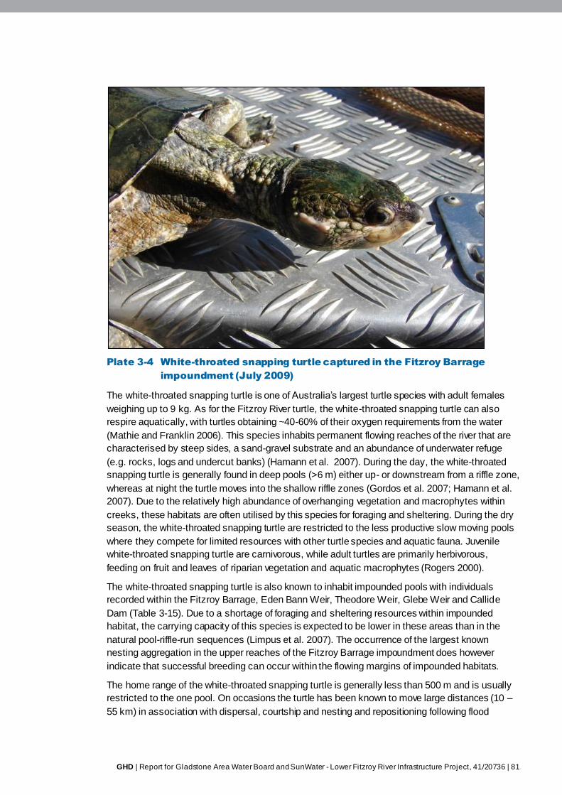
GHD | Report for Gladstone Area Water Board and SunWater - Lower Fitzroy River Infrastructure Project, 41/20736 | 81
Plate 3-4 White-throated snapping turtle captured in the Fitzroy Barrage
impoundment (July 2009)
The white-throated snapping turtle is one of Australia’s largest turtle species with adult females
weighing up to 9 kg. As for the Fitzroy River turtle, the white-throated snapping turtle can also
respire aquatically, with turtles obtaining ~40-60% of their oxygen requirements from the water
(Mathie and Franklin 2006). This species inhabits permanent flowing reaches of the river that are
characterised by steep sides, a sand-gravel substrate and an abundance of underwater refuge
(e.g. rocks, logs and undercut banks) (Hamann et al. 2007). During the day, the white-throated
snapping turtle is generally found in deep pools (>6 m) either up- or downstream from a riffle zone,
whereas at night the turtle moves into the shallow riffle zones (Gordos et al. 2007; Hamann et al.
2007). Due to the relatively high abundance of overhanging vegetation and macrophytes within
creeks, these habitats are often utilised by this species for foraging and sheltering. During the dry
season, the white-throated snapping turtle are restricted to the less productive slow moving pools
where they compete for limited resources with other turtle species and aquatic fauna. Juvenile
white-throated snapping turtle are carnivorous, while adult turtles are primarily herbivorous,
feeding on fruit and leaves of riparian vegetation and aquatic macrophytes (Rogers 2000).
The white-throated snapping turtle is also known to inhabit impounded pools with individuals
recorded within the Fitzroy Barrage, Eden Bann Weir, Theodore Weir, Glebe Weir and Callide
Dam (Table 3-15). Due to a shortage of foraging and sheltering resources within impounded
habitat, the carrying capacity of this species is expected to be lower in these areas than in the
natural pool-riffle-run sequences (Limpus et al. 2007). The occurrence of the largest known
nesting aggregation in the upper reaches of the Fitzroy Barrage impoundment does however
indicate that successful breeding can occur within the flowing margins of impounded habitats.
The home range of the white-throated snapping turtle is generally less than 500 m and is usually
restricted to the one pool. On occasions the turtle has been known to move large distances (10 –
55 km) in association with dispersal, courtship and nesting and repositioning following flood
82 | GHD | Report for Gladstone Area Water Board and SunWater - Lower Fitzroy River Infrastructure Project, 41/20736
displacement (Hamann et al. 2007). Movement over land is generally only known to occur
between adjacent pools. Rainfall is a suggested cue for turtle movement with individuals observed
attempting to move past impoundments during rainfall and small flow events (Hamann et al. 2007;
Limpus et al. 2007). The habitat and movement pattern of hatchling turtles is largely unknown.
The white-throated snapping turtle has an extended breeding season that occurs between March
and September. Once they reach sexual maturity (at least 18 years of age) female turtles are
thought to breed annually. Nesting occurs from autumn through to early spring with hatching
generally occurring in early summer after an embryonic diapause over the winter months (Hamann
et al. 2007). Nesting in the white-throated snapping turtle is generally restricted to sand / loam
alluvial deposits (see nesting habitats above). The location of potential turtle nesting sites within
the Project footprint is shown in Figure 3-4. Predation of nests by foxes, goannas, feral cats, and
water rats is extremely high, indicated by the lack of hatchling and juvenile turtles within the
population which suggests that there has been very little recruitment into the population over the
last decade (<2 per cent) (Hamann et al. 2007).
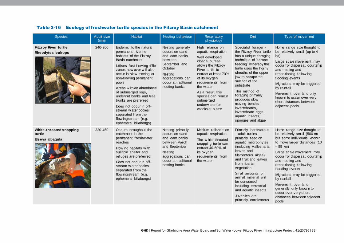
GHD | Report for Gladstone Area Water Board and SunWater - Lower Fitzroy River Infrastructure Project, 41/20736 | 83
Table 3-16 Ecology of freshwater turtle species in the Fitzroy Basin catchment
Species Adult size (mm)
Habitat Nesting behaviour Respiratory physiology
Diet Type of movement
Fitzroy River turtle
Rheodytes leukops
240-260 Endemic to the natural
permanent riverine
habitats of the Fitzroy Basin catchment
Utilises fast-f low ing rif f le zones how ever w ill also
occur in slow moving or
non-flow ing permanent
pools
Areas w ith an abundance
of submerged logs, undercut banks and tree
trunks are preferred
Does not occur in off -stream w ater bodies
separated from the
f low ing stream (e.g.
ephemeral billabongs)
Nesting generally
occurs on sand
and loam banks betw een
September and
October
Nesting aggregations can
occur at traditional
nesting banks
High reliance on
aquatic respiration
Well developed cloacal bursae
allow s the Fitzroy
River turtle to
extract at least 70%
of its oxygen
requirements from
the w ater
As a result, this species can remain
submerged
underw ater for
w eeks at a time
Specialist forager -
the Fitzroy River turtle
has a unique foraging technique of ‘scrape
feeding’ w hereby the
turtle uses the horny
sheaths of the upper
jaw to scrape the
surface of the
substrate
This method of foraging primarily
produces slow
moving benthic
invertebrates, invertebrate eggs,
aquatic insects,
sponges and algae
Home range size thought to
be relatively small (up to 4
ha)
Large scale movement may occur for dispersal, courtship
and nesting and
repositioning follow ing
f looding events
Migrations may be triggered
by rainfall
Movement over land only know n to occur over very
short distances betw een
adjacent pools
White-throated snapping turtle
Elseya albagula
320-450 Occurs throughout the catchment in the
permanent freshw ater
reaches
Flow ing habitats w ith suitable shelter and
refuges are preferred
Does not occur in off -stream w ater bodies
separated from the
f low ing stream (e.g.
ephemeral billabongs)
Nesting primarily occurs on sand
and loam banks
betw een March
and September
Nesting
aggregations can
occur at traditional
nesting banks
Medium reliance on aquatic respiration
The w hite-throated snapping turtle can
extract 40-60% of
its oxygen
requirements from
the w ater
Primarily herbivorous – adult turtles
primarily feed on
aquatic macrophytes
(including Vallesnaria
leaves and
f ilamentous algae)
and fruit and leaves
from riparian
vegetation
Small amounts of animal material w ill
be consumed
including terrestrial
and aquatic insects
Juveniles are primarily carnivorous
Home range size thought to be relatively small (500 m)
but some individuals know n
to move larger distances (10
– 55 km)
Large scale movement may
occur for dispersal, courtship
and nesting and
repositioning follow ing f looding events
Migrations may be triggered by rainfall
Movement over land generally only know n to
occur over very short
distances betw een adjacent
pools
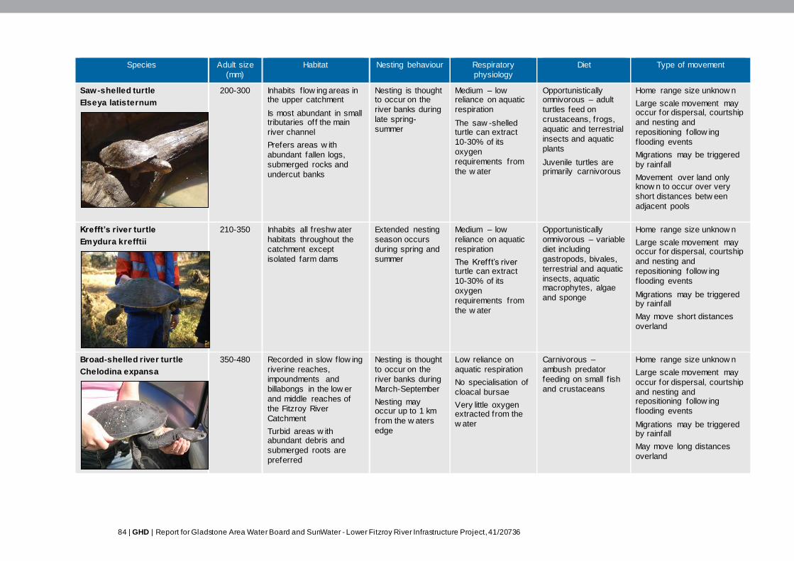
84 | GHD | Report for Gladstone Area Water Board and SunWater - Lower Fitzroy River Infrastructure Project, 41/20736
Species Adult size
(mm)
Habitat Nesting behaviour Respiratory
physiology
Diet Type of movement
Saw-shelled turtle
Elseya latisternum
200-300 Inhabits f low ing areas in the upper catchment
Is most abundant in small tributaries off the main
river channel
Prefers areas w ith
abundant fallen logs,
submerged rocks and
undercut banks
Nesting is thought to occur on the
river banks during
late spring-
summer
Medium – low reliance on aquatic
respiration
The saw -shelled turtle can extract
10-30% of its
oxygen
requirements from
the w ater
Opportunistically omnivorous – adult
turtles feed on
crustaceans, frogs,
aquatic and terrestrial
insects and aquatic
plants
Juvenile turtles are primarily carnivorous
Home range size unknow n
Large scale movement may occur for dispersal, courtship
and nesting and
repositioning follow ing
f looding events
Migrations may be triggered
by rainfall
Movement over land only know n to occur over very
short distances betw een
adjacent pools
Krefft’s river turtle
Emydura krefftii
210-350 Inhabits all freshw ater
habitats throughout the
catchment except
isolated farm dams
Extended nesting
season occurs
during spring and
summer
Medium – low
reliance on aquatic
respiration
The Krefft’s river turtle can extract
10-30% of its
oxygen
requirements from
the w ater
Opportunistically
omnivorous – variable
diet including
gastropods, bivales,
terrestrial and aquatic
insects, aquatic macrophytes, algae
and sponge
Home range size unknow n
Large scale movement may occur for dispersal, courtship
and nesting and
repositioning follow ing
f looding events
Migrations may be triggered by rainfall
May move short distances
overland
Broad-shelled river turtle
Chelodina expansa
350-480 Recorded in slow flow ing
riverine reaches,
impoundments and
billabongs in the low er
and middle reaches of
the Fitzroy River
Catchment
Turbid areas w ith abundant debris and
submerged roots are
preferred
Nesting is thought
to occur on the
river banks during
March-September
Nesting may occur up to 1 km
from the w aters
edge
Low reliance on
aquatic respiration
No specialisation of
cloacal bursae
Very little oxygen extracted from the
w ater
Carnivorous –
ambush predator
feeding on small f ish
and crustaceans
Home range size unknow n
Large scale movement may
occur for dispersal, courtship
and nesting and repositioning follow ing
f looding events
Migrations may be triggered by rainfall
May move long distances
overland

GHD | Report for Gladstone Area Water Board and SunWater - Lower Fitzroy River Infrastructure Project, 41/20736 | 85
Species Adult size
(mm)
Habitat Nesting behaviour Respiratory
physiology
Diet Type of movement
Eastern snake-necked turtle
Chelodina longicollis
190-260 Most abundant in shallow ephemeral w ater bodies
such as sw amps,
lagoons, man-made
dams and billabongs
Within the Fitzroy River Catchment, this species
occurs w ithin the Daw son
Catchment and the low er
Fitzroy River
Nesting is thought to occur in f irm
substrates during
summer
Nesting may occur up to 500 m
from the w aters
edge
Low reliance on aquatic respiration
No specialisation of cloacal bursae
Very little oxygen extracted from the
w ater
Opportunistically carnivorous –thought
to primarily feed on
aquatic insects and
crustaceans how ever
plankton, nekton,
benthic
macroinvertebrates
and carrion may also
be consumed
Home range size unknow n
Large scale movement may occur for dispersal, courtship
and nesting and
repositioning follow ing
f looding events
Migrations may be triggered
by rainfall
Undertake long distance overland migrations for
nesting and dispersal
Ecological information in table sourced from: Preist 1997; Cann 1998; Gordos 2004; Mathie and Franklin 2006; Limpus et al. 2007; Hamann et al. 2007; Rogers 2000
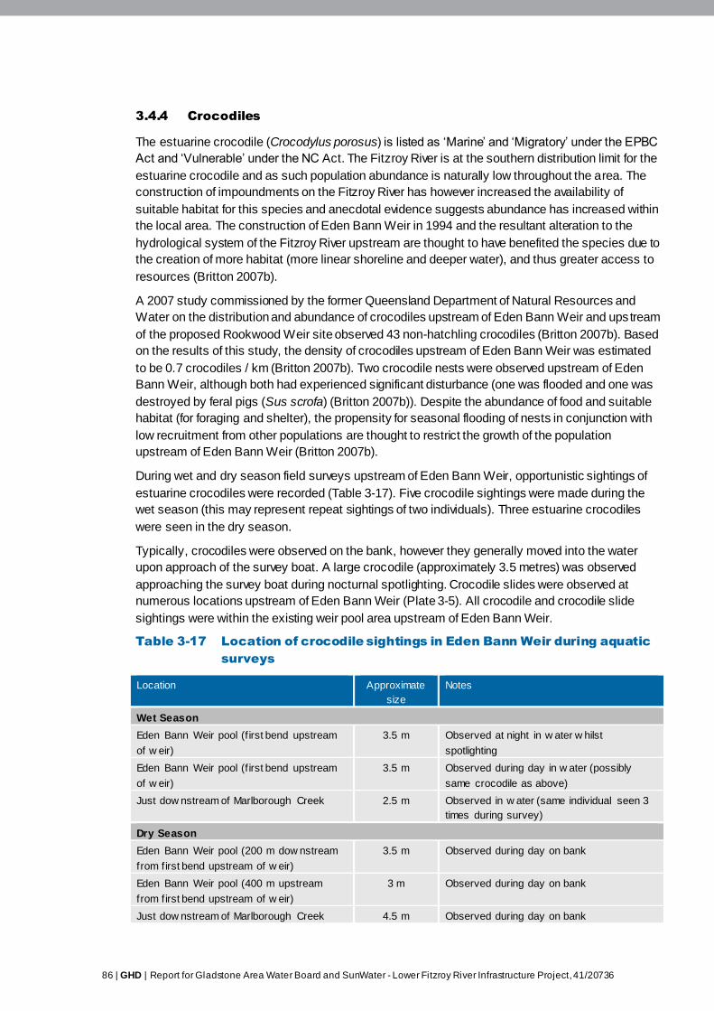
86 | GHD | Report for Gladstone Area Water Board and SunWater - Lower Fitzroy River Infrastructure Project, 41/20736
3.4.4 Crocodiles
The estuarine crocodile (Crocodylus porosus) is listed as ‘Marine’ and ‘Migratory’ under the EPBC
Act and ‘Vulnerable’ under the NC Act. The Fitzroy River is at the southern distribution limit for the
estuarine crocodile and as such population abundance is naturally low throughout the area. The
construction of impoundments on the Fitzroy River has however increased the availability of
suitable habitat for this species and anecdotal evidence suggests abundance has increased within
the local area. The construction of Eden Bann Weir in 1994 and the resultant alteration to the
hydrological system of the Fitzroy River upstream are thought to have benefited the species due to
the creation of more habitat (more linear shoreline and deeper water), and thus greater access to
resources (Britton 2007b).
A 2007 study commissioned by the former Queensland Department of Natural Resources and
Water on the distribution and abundance of crocodiles upstream of Eden Bann Weir and upstream
of the proposed Rookwood Weir site observed 43 non-hatchling crocodiles (Britton 2007b). Based
on the results of this study, the density of crocodiles upstream of Eden Bann Weir was estimated
to be 0.7 crocodiles / km (Britton 2007b). Two crocodile nests were observed upstream of Eden
Bann Weir, although both had experienced significant disturbance (one was flooded and one was
destroyed by feral pigs (Sus scrofa) (Britton 2007b)). Despite the abundance of food and suitable
habitat (for foraging and shelter), the propensity for seasonal flooding of nests in conjunction with
low recruitment from other populations are thought to restrict the growth of the population
upstream of Eden Bann Weir (Britton 2007b).
During wet and dry season field surveys upstream of Eden Bann Weir, opportunistic sightings of
estuarine crocodiles were recorded (Table 3-17). Five crocodile sightings were made during the
wet season (this may represent repeat sightings of two individuals). Three estuarine crocodiles
were seen in the dry season.
Typically, crocodiles were observed on the bank, however they generally moved into the water
upon approach of the survey boat. A large crocodile (approximately 3.5 metres) was observed
approaching the survey boat during nocturnal spotlighting. Crocodile slides were observed at
numerous locations upstream of Eden Bann Weir (Plate 3-5). All crocodile and crocodile slide
sightings were within the existing weir pool area upstream of Eden Bann Weir.
Table 3-17 Location of crocodile sightings in Eden Bann Weir during aquatic
surveys
Location Approximate
size
Notes
Wet Season
Eden Bann Weir pool (f irst bend upstream
of w eir)
3.5 m Observed at night in w ater w hilst
spotlighting
Eden Bann Weir pool (f irst bend upstream
of w eir)
3.5 m Observed during day in w ater (possibly
same crocodile as above)
Just dow nstream of Marlborough Creek 2.5 m Observed in w ater (same individual seen 3
times during survey)
Dry Season
Eden Bann Weir pool (200 m dow nstream
from first bend upstream of w eir)
3.5 m Observed during day on bank
Eden Bann Weir pool (400 m upstream
from first bend upstream of w eir)
3 m Observed during day on bank
Just dow nstream of Marlborough Creek 4.5 m Observed during day on bank
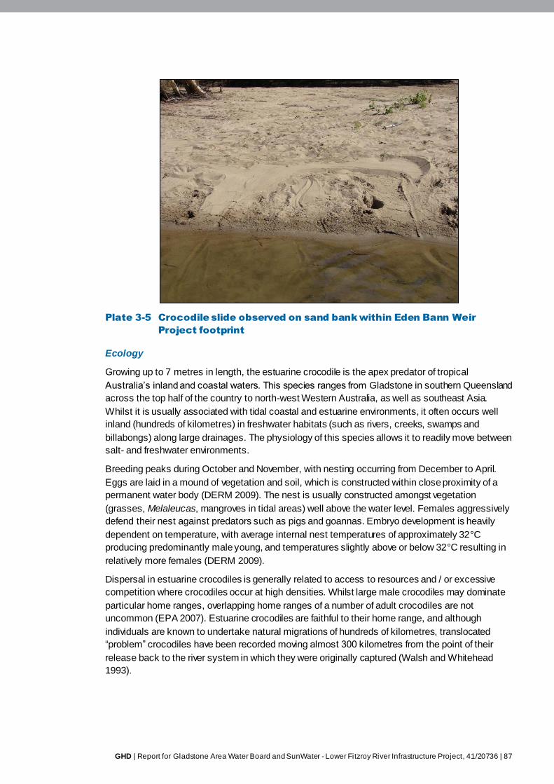
GHD | Report for Gladstone Area Water Board and SunWater - Lower Fitzroy River Infrastructure Project, 41/20736 | 87
Plate 3-5 Crocodile slide observed on sand bank within Eden Bann Weir
Project footprint
Ecology
Growing up to 7 metres in length, the estuarine crocodile is the apex predator of tropical
Australia’s inland and coastal waters. This species ranges from Gladstone in southern Queensland
across the top half of the country to north-west Western Australia, as well as southeast Asia.
Whilst it is usually associated with tidal coastal and estuarine environments, it often occurs well
inland (hundreds of kilometres) in freshwater habitats (such as rivers, creeks, swamps and
billabongs) along large drainages. The physiology of this species allows it to readily move between
salt- and freshwater environments.
Breeding peaks during October and November, with nesting occurring from December to April.
Eggs are laid in a mound of vegetation and soil, which is constructed within close proximity of a
permanent water body (DERM 2009). The nest is usually constructed amongst vegetation
(grasses, Melaleucas, mangroves in tidal areas) well above the water level. Females aggressively
defend their nest against predators such as pigs and goannas. Embryo development is heavily
dependent on temperature, with average internal nest temperatures of approximately 32°C
producing predominantly male young, and temperatures slightly above or below 32°C resulting in
relatively more females (DERM 2009).
Dispersal in estuarine crocodiles is generally related to access to resources and / or excessive
competition where crocodiles occur at high densities. Whilst large male crocodiles may dominate
particular home ranges, overlapping home ranges of a number of adult crocodiles are not
uncommon (EPA 2007). Estuarine crocodiles are faithful to their home range, and although
individuals are known to undertake natural migrations of hundreds of kilometres, translocated
“problem” crocodiles have been recorded moving almost 300 kilometres from the point of their
release back to the river system in which they were originally captured (Walsh and Whitehead
1993).
88 | GHD | Report for Gladstone Area Water Board and SunWater - Lower Fitzroy River Infrastructure Project, 41/20736
Seasonal migrations from lotic habitats to ephemeral swamps and billabongs occur during the wet
season, as these temporary water bodies are generally rich in food resources (EPA 2007).
Estuarine crocodiles are opportunistic ambush predators. Juveniles take insects, crustaceans and
small fish, whilst adult crocodiles consume fish, turtles, birds and mammals (including macropods,
livestock, feral pigs). Adult crocodiles will also readily scavenge carrion.
3.4.5 Platypus
The platypus (Ornithorhynchus anatinus) is listed as ‘Special Least Concern’ wildlife under the NC
Act. ‘Special Least Concern’ wildlife are those species considered as having inherent value and
potential importance for the maintenance of ecosystem processes. ‘Special Least Concern’ fauna
are also considered a source of genetic information integral to an understanding of the evolution of
the Australian biota and a genetic resource of potential benefit to society. These species are also
considered culturally significant. No platypus were observed during wet and dry season field
surveys, however platypus are known to occur in the Fitzroy River system (Grant and Temple-
Smith 1998). Although no records were found in the literature for the species in the Eden Bann
Weir Project footprint, a single record does exist within the study area (DERM Wildlife Online
Database), specifically in the lower Dawson River (recorded in March 2000).
Platypus occupy a wide range of aquatic habitats, are tolerant of degraded systems, and show
notable adaptability (Grant and Temple-Smith 1998). Potentially suitable aquatic habitat for
platypus, as described by Grant and Temple-Smith (1998), occurs throughout the Eden Bann Weir
Project footprint, both within the margins of the impounded pool habitat, and in upstream pool
habitats. However the spatial utilisation of habitat is expected to be restricted to reaches of the
Fitzroy River (and adjoining creeks) that support necessary resources for burrowing (i.e. earthen
banks consolidated by the roots of riparian vegetation, overhanging vegetation, undercut banks
(Grant and Temple-Smith 1998)). As described in Section 3.3, the variability in riparian habitats in
the Project footprint is heavily influenced by adjacent land use, most notably cattle grazing in the
riparian zone.
Based on observations in the Project footprint, it is inferred that where riparian habitats have been
degraded by cattle, suitable platypus burrowing habitat is unlikely to be prevalent, and thus the
species is likely to be limited in abundance or absent. Bank vegetative stability (a measure of the
percentage of bank covered by vegetation and other habitat features such as boulders) was
variable in the impounded pool habitat (see habitat assessments summarised in Section 3.3), with
rankings ranging from fair to excellent. Run habitats received rankings of poor to excellent for bank
vegetative stability (Section 3.3.5), while in the three creek habitats assessed, excellent rankings
were given in five out of six instances (i.e. two banks per site). It is predicted that the lower
reaches of creek habitats may provide potentially suitable burrowing habitat for platypus, based on
these observations.
Ecology
Platypus are distributed along Australia’s east coast (including Tasmania). The species inhabit
lotic and lentic freshwater habitats, with a preference for areas that have steep, well vegetated
banks. Shelter and nesting occur in a burrow constructed in the river bank just above the water
level with an entrance to the burrow usually concealed by overhanging vegetation or an undercut
bank. Burrows used for nesting tend to be longer and more elaborate than those used for shelter
(Van Dyck and Strahan 2008).
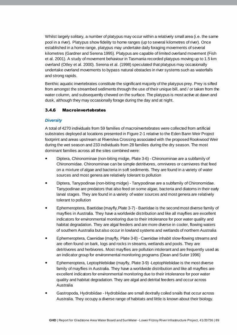
GHD | Report for Gladstone Area Water Board and SunWater - Lower Fitzroy River Infrastructure Project, 41/20736 | 89
Whilst largely solitary, a number of platypus may occur within a relatively small area (i.e. the same
pool in a river). Platypus show fidelity to home ranges (up to several kilometres of river). Once
established in a home range, platypus may undertake daily foraging movements of several
kilometres (Gardner and Serena 1995). Platypus are capable of limited overland movement (Fish
et al. 2001). A study of movement behaviour in Tasmania recorded platypus moving up to 1.5 km
overland (Otley et al. 2000). Serena et al. (1998) speculated that platypus may occasionally
undertake overland movements to bypass natural obstacles in river systems such as waterfalls
and strong rapids.
Benthic aquatic invertebrates constitute the significant majority of the platypus prey. Prey is sifted
from amongst the streambed sediments through the use of their unique bill, and / or taken from the
water column, and subsequently chewed on the surface. The platypus is most active at dawn and
dusk, although they may occasionally forage during the day and at night.
3.4.6 Macroinvertebrates
Diversity
A total of 4270 individuals from 59 families of macroinvertebrates were collected from artificial
substrates deployed at locations presented in Figure 2-1 relative to the Eden Bann Weir Project
footprint and areas upstream at Riverslea Crossing associated with the proposed Rookwood Weir
during the wet season and 233 individuals from 28 families during the dry season. The most
dominant families across all the sites combined were:
Diptera, Chironominae (non-biting midge, Plate 3-6) - Chironominae are a subfamily of
Chironomidae. Chironominae can be simple detritivores, omnivores or carnivores that feed
on a mixture of algae and bacteria in soft sediments. They are found in a variety of water
sources and most genera are relatively tolerant to pollution
Diptera, Tanypodinae (non-biting midge) - Tanypodinae are a subfamily of Chironomidae.
Tanypodinae are predators that also feed on some algae, bacteria and diatoms in their early
larval stages. They are found in a variety of water sources and most genera are relatively
tolerant to pollution
Ephemeroptera, Baetidae (mayfly,Plate 3-7) - Baetidae is the second most diverse family of
mayflies in Australia. They have a worldwide distribution and like all mayflies are excellent
indicators for environmental monitoring due to their intolerance for poor water quality and
habitat degradation. They are algal feeders and are more diverse in cooler, flowing waters
of southern Australia but also occur in lowland systems and wetlands of northern Australia
Ephemeroptera, Caenidae (mayfly, Plate 3-8) - Caenidae inhabit slow-flowing streams and
are often found on bark, logs and rocks in streams, wetlands and pools. They are
detritivores and herbivores. Most mayflies are pollution intolerant and are frequently used as
an indicator group for environmental monitoring programs (Dean and Suter 1996)
Ephemeroptera, Leptophlebiidae (mayfly, Plate 3-9) -Leptophlebiidae is the most diverse
family of mayflies in Australia. They have a worldwide distribution and like all mayflies are
excellent indicators for environmental monitoring due to their intolerance for poor water
quality and habitat degradation. They are algal and detrital feeders and occur across
Australia
Gastropoda, Hydrobiidae - Hydrobiidae are small dextrally coiled snails that occur across
Australia. They occupy a diverse range of habitats and little is known about their biology.

90 | GHD | Report for Gladstone Area Water Board and SunWater - Lower Fitzroy River Infrastructure Project, 41/20736
They can occur in huge quantities but have very restricted habitat tolerances. One genus of
this family is an introduced pest from New Zealand, however this genus was not noted
during this study
Ostracoda (seed shrimps) - Ostracoda look like small freshwater mussels but are in fact
small multi-segmented crustaceans. They are herbivores and detritivores, filter feeding by
generating a current through their shell with their legs. This order is very common and has
11 families that occur in Australia
Gastropoda, Thiaridae (sculptured snails, Plate 3-10) - Thiaridae are ornately sculptured
snails. They are asexual reproducers and as such can rapidly produce large populations
from a single animal
Furthermore, fish trapping (fyke and bait traps) within the Eden Bann Weir Project footprint
revealed the presence of two species belonging to the order Decapoda. Freshwater shrimp
(Paratya australiensis, family: Atyidae) were recorded from two sites in the dry season, and
a freshwater (Macrobrachium spp., family: Palaemonidae) was also recorded at one site in
the wet season.
Several studies have characterised the macroinvertebrate diversity of the Fitzroy Basin catchment.
Data collected by the former Department of Natural Resources and Water and summarised by frc
environmental (2008) from three sites in the lower Fitzroy Basin catchment (Mackenzie River at
Tartrus Weir headwater (1997), Dawson River at Boolburra Crossing (1998, 2001), Fitzroy River at
Wattlebank (1994-1996)) returned 66 macroinvertebrate taxa. The Duivenvoorden and Roberts
(1997) study investigating macroinvertebrate assemblages from the major drainages of the Fitzroy
Basin catchment recorded over 70 families, with the most prevalent taxa including:
Coleopteran (beetles)
Diptera (flies)
Ephemeroptera (mayflies)
Hemiptera (sucking bugs)
Odonata (dragon and damsel flies)
Trichoptera (caddis flies)
Bivalvia (mussels)
Gastropoda (snails)
Decapoda (shrimps and crayfish)
Isopoda (shrimp-like taxa).
As well as sampling riverine habitats, Duivenvoorden and Roberts (1997) investigated
macroinvertebrate assemblages in off-stream wetland habitats and lower order adjoining streams.
The off-stream habitats sampled had relatively high macroinvertebrate diversity (> 30 species),
and relative abundance at these sites was also observed to be higher. The results obtained in
creek habitats were similar to off-stream water bodies, excluding a creek site in a semi-urban
landscape (Duivenvoorden and Roberts 1997).
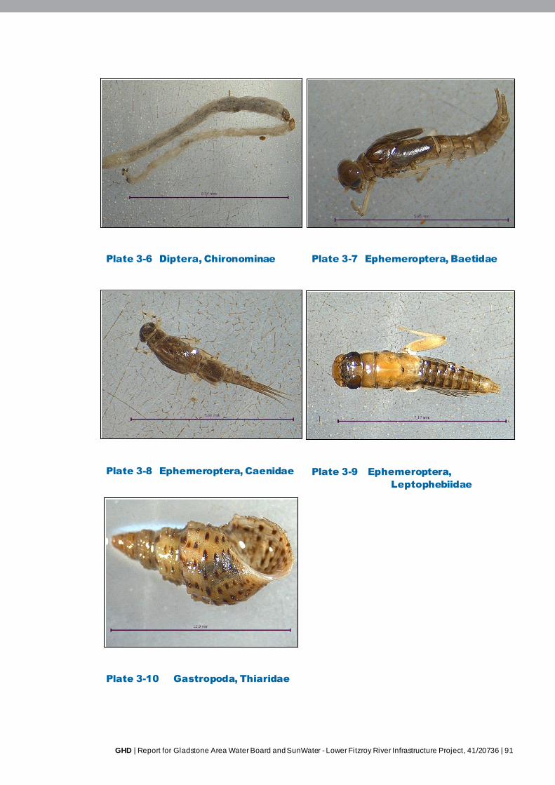
GHD | Report for Gladstone Area Water Board and SunWater - Lower Fitzroy River Infrastructure Project, 41/20736 | 91
Plate 3-6 Diptera, Chironominae Plate 3-7 Ephemeroptera, Baetidae
Plate 3-8 Ephemeroptera, Caenidae Plate 3-9 Ephemeroptera,
Leptophebiidae
Plate 3-10 Gastropoda, Thiaridae
92 | GHD | Report for Gladstone Area Water Board and SunWater - Lower Fitzroy River Infrastructure Project, 41/20736
A study of macroinvertebrate diversity in the Dawson River between 1997 and 1999 returned 86
taxa from four sites (Duivenvoorden et al. 2000). Taxa numbers per site showed statistically
significant temporal variability (Duivenvoorden et al. 2000). Spatial variability was also shown to be
statistically significant – most notably, there was a statistically significant difference in taxa
richness between impounded sites and riverine sites (Duivenvoorden et al. 2000). A major
conclusion of the study was that macroinvertebrate populations at impounded sites had fewer
taxa, appeared to be generally lower in abundance and featured fewer pollution sensitive taxa
when compared with riverine sites (Duivenvoorden et al. 2000). The impacts of rapid water level
fluctuations within weir environments on food and habitat availability were hypothesised as a
potential explanation for this observed spatial trend (Duivenvoorden et al. 2000). The loss of more
specialist taxa, which are less tolerant of sudden habitat changes (i.e. due to water level
fluctuations), was thought to account for observed temporal variability in macroinvertebrate
assemblages, and may have contributed towards the lower taxon richness in weir environments
(Duivenvoorden et al. 2000). The relatively lower numbers of taxa sensitive to poor water quality
(namely Ephemeropteran and Trichopteran) was also speculated to be a reflection of the modified
and highly variable aquatic environment within impounded pool habitats (Duivenvoorden et al.
2000).
As a result of the limitations encountered in assessing macroinvertebrates in the study area (as
described in Section 2.4.2), sampling in this study did not seek to identify temporal and spatial
trends in taxa diversity / abundance, nor did it attempt to quantify differences in macroinvertebrate
habitat utilisation. The studies summarised above provide a snapshot of macroinvertebrate taxa
richness in the Fitzroy Basin catchment, and the results obtained in this investigation provide
additional information about macroinvertebrate diversity in the study area. The prevalence of
Diptera, Ephemeroptera and Gastropoda recorded in this study corresponds with previous studies
which have recorded these taxa from the Fitzroy Basin catchment (i.e. Duivenvoorden and
Roberts 1997; Duivenvoorden et al. 2000). The results of the study undertaken by Duivenvoorden
et al. (2000) provide information about the potential impacts of weirs on macroinvertebrate
assemblages in the Fitzroy Basin catchment, which will contribute towards assessing the impacts
of raising Eden Bann Weir on these animals.
3.4.7 Macrophytes
Diversity
One hundred and five species of macrophytes have been previously recorded in the Fitzroy Basin
catchment (Duivenvoorden 1992). At the time of survey (1989-1991), the most commonly recorded
species were from the genera Persicaria, Cyperus, Juncus and Potamogeton. The diversity of
macrophytes species recorded at each survey site at any one time was relatively low (average two
– five species), however extreme climatic events (e.g. severe flooding followed by drought) were
observed to notably impact temporal macrophyte species diversity (Duivenvoorden 1992). These
results are consistent with localised studies in the Mackenzie and Dawson Rivers which recorded
a maximum of 11 and 10 macrophyte species per site, respectively (Duivenvoorden 1997). The
macophytes species recorded within the Mackenzie River were predominately desiccation-
resistant, emergent species located high on the bank (Duivenvoorden 1997). Common
macrophyte genera recorded on the Dawson River included: Azolla, Cyperus, Lomandra,
Ludwigia, Muelenbecia, Persicaria, Polygonum, Rumex and Spirodela (Duivenvoorden 1995).
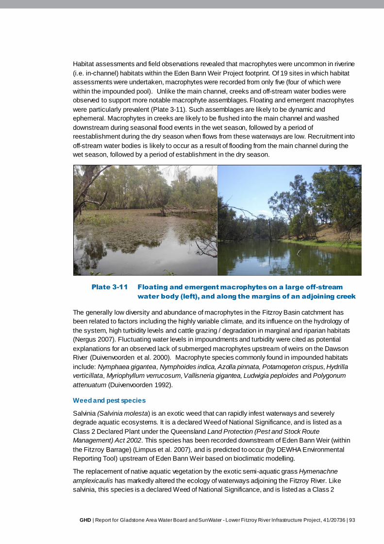
GHD | Report for Gladstone Area Water Board and SunWater - Lower Fitzroy River Infrastructure Project, 41/20736 | 93
Habitat assessments and field observations revealed that macrophytes were uncommon in riverine
(i.e. in-channel) habitats within the Eden Bann Weir Project footprint. Of 19 sites in which habitat
assessments were undertaken, macrophytes were recorded from only five (four of which were
within the impounded pool). Unlike the main channel, creeks and off-stream water bodies were
observed to support more notable macrophyte assemblages. Floating and emergent macrophytes
were particularly prevalent (Plate 3-11). Such assemblages are likely to be dynamic and
ephemeral. Macrophytes in creeks are likely to be flushed into the main channel and washed
downstream during seasonal flood events in the wet season, followed by a period of
reestablishment during the dry season when flows from these waterways are low. Recruitment into
off-stream water bodies is likely to occur as a result of flooding from the main channel during the
wet season, followed by a period of establishment in the dry season.
Plate 3-11 Floating and emergent macrophytes on a large off-stream
water body (left), and along the margins of an adjoining creek
The generally low diversity and abundance of macrophytes in the Fitzroy Basin catchment has
been related to factors including the highly variable climate, and its influence on the hydrology of
the system, high turbidity levels and cattle grazing / degradation in marginal and riparian habitats
(Nergus 2007). Fluctuating water levels in impoundments and turbidity were cited as potential
explanations for an observed lack of submerged macrophytes upstream of weirs on the Dawson
River (Duivenvoorden et al. 2000). Macrophyte species commonly found in impounded habitats
include: Nymphaea gigantea, Nymphoides indica, Azolla pinnata, Potamogeton crispus, Hydrilla
verticillata, Myriophyllum verrucosum, Vallisneria gigantea, Ludwigia peploides and Polygonum
attenuatum (Duivenvoorden 1992).
Weed and pest species
Salvinia (Salvinia molesta) is an exotic weed that can rapidly infest waterways and severely
degrade aquatic ecosystems. It is a declared Weed of National Significance, and is listed as a
Class 2 Declared Plant under the Queensland Land Protection (Pest and Stock Route
Management) Act 2002. This species has been recorded downstream of Eden Bann Weir (within
the Fitzroy Barrage) (Limpus et al. 2007), and is predicted to occur (by DEWHA Environmental
Reporting Tool) upstream of Eden Bann Weir based on bioclimatic modelling.
The replacement of native aquatic vegetation by the exotic semi-aquatic grass Hymenachne
amplexicaulis has markedly altered the ecology of waterways adjoining the Fitzroy River. Like
salvinia, this species is a declared Weed of National Significance, and is listed as a Class 2
94 | GHD | Report for Gladstone Area Water Board and SunWater - Lower Fitzroy River Infrastructure Project, 41/20736
Declared Plant under the Land Protection (Pest and Stock Route Management) Act 2002. Where
this highly invasive species has replaced native aquatic vegetation in quieter backwaters (e.g.
creeks, off-stream water bodies etc.), macroinvertebrate assemblages were found to be different,
with a decline in several orders (Houston and Duivenvoorden 2002).
Algae
Algae diversity is relatively low within the Fitzroy Basin catchment with a total of 52 species
previously recorded (Noble et al. 1997). Potentially toxic blue-green algae blooms are known to
occur throughout the Fitzroy Basin catchment in response to high pH, high nutrients and low flows
(Noble et al. 1997). Since, October 2007, only low levels of blue-green algae have been recorded
from the existing Eden Bann Weir impoundment (frc environmental 2008; Volume 1, Chapter 11
Water quality).
GHD | Report for Gladstone Area Water Board and SunWater - Lower Fitzroy River Infrastructure Project, 41/20736 | 95
4. Summary
Aquatic habitats within and downstream of the Eden Bann Weir Project footprint were assessed
through a combination of field surveys, literature reviews and aerial photograph interpretation.
Upstream of the existing weir, the dominant aquatic habitat type is the impounded pool. The linear
extent of this habitat type varies seasonally, and is also dependent on operation of the storage.
Upstream of the impounded pool habitat, and downstream of Eden Bann Weir to the upper limit of
the Fitzroy Barrage impoundment, in-stream habitats are dominated by seasonally-dynamic
recurring pool-riffle-run sequences. These sequences represent the natural hydrological and
geomorphologic regime of the rivers in the study area.
Through habitat assessments, variable water velocity, depth, bank characteristics, in-stream
habitat features (woody debris, macrophytes) and stream substrate were observed within and
between the in-channel aquatic habitat types of the Project footprint. Seasonal variability markedly
alters the characteristics and linear extent of these habitats – a natural regime to which the aquatic
species of the Fitzroy Basin catchment are adapted. The less variable, more homogenising
influence of the impoundment upstream of Eden Bann Weir somewhat dampens the seasonal
temporal variability in habitat characteristics and extent immediately upstream of the existing weir.
A number of creeks and off-stream water bodies provide further aquatic habitat beyond the main
channel of the Fitzroy River. Creek habitats in the Project footprint were observed to provide a
high abundance of microhabitat resources such as overhanging vegetation and in-stream woody
debris. These habitats potentially provide resources for an array of aquatic species, including small
cryptic fish species, freshwater turtles and juvenile crocodiles. Off-stream water bodies have been
identified as important reservoirs of fish biomass, nursery habitat for juvenile fish, and provide
potential habitat for crocodiles and long-necked turtles.
Desktop and field surveys undertaken to inform this baseline assessment of the aquatic ecology
within and downstream of the Eden Bann Weir Project footprint revealed that 34 fish species,
seven aquatic reptiles (six turtles, one crocodile), one aquatic mammal, 86 macroinvertebrate taxa
and 105 macrophytes have the potential to occur within the Project footprint, based on previous
records from the study area and the results of field surveys. Of particular note are conservation
significant species which were confirmed present during field surveys, or are known / predicted to
occur based on a review of relevant literature. These include:
Fitzroy River turtle - known to occur in within the Eden Bann Weir Project footprint.
Important habitat for this species occurs at Redbank Crossing (type locality), Glenroy
Crossing (type locality and essential habitat) and Marlborough Creek (essential habitat).
Fitzroy River turtle nesting has been historically recorded within the Project footprint.
Alligator Creek, located downstream of the Project footprint, has been identified as an
important nesting habitat for this species
Estuarine crocodile –known to occur within and downstream of the Eden Bann Weir. Eight
sightings of crocodiles were observed during the GHD field surveys. Eden Bann Weir
impoundment is considered important habitat for the species in the Fitzroy River
Southern saratoga – known to occur in the study area and predicted to occur in the Project
footprint due to availability of suitable habitat
Leathery grunter - known to occur in the study area and predicted to occur in the Project
footprint due to availability of suitable habitat
96 | GHD | Report for Gladstone Area Water Board and SunWater - Lower Fitzroy River Infrastructure Project, 41/20736
Golden perch - known to occur in the study area and predicted to occur in the Project
footprint due to availability of suitable habitat
Platypus - known to occur in the study area and predicted to occur in the Project footprint
due to availability of suitable habitat.
Overall the general characteristics of aquatic habitats within the Eden Bann Weir Project footprint,
and the aquatic species they support, appear to represent a continuum of habitats downstream to
the Fitzroy Barrage, and are not unique in the values and resources they provide in the context of
the wider study area. Aquatic habitats (and the species they support) within and downstream of
the Eden Bann Weir Project footprint have been impacted and altered by human processes
occurring at the local to catchment-wide scale. Such impacts include degradation of riparian
habitats by livestock, changes to water quality (agriculture and mining) and disruption to natural
flow regimes and connectivity of aquatic systems. Notably, the aquatic habitats up and
downstream of Eden Bann Weir are influenced by the operations of the existing structure. In this
context, the potential impacts of raising Eden Bann Weir on the baseline aquatic values outlined in
this assessment have been identified.
GHD | Report for Gladstone Area Water Board and SunWater - Lower Fitzroy River Infrastructure Project, 41/20736 | 97
5. References
Allen, GR, Midgley, SH and Allen, M 2003, ‘Field Guide to the Freshwater Fishes of Australia’,
Perth, Western Australian Museum.
Australian Bureau of Meteorology (BoM) 2009, ‘Latest Weather Observations for Rockhampton’,
Australian Bureau of Meteorology, retrieved 21 August, 2009, from
<http://www.bom.gov.au/products/IDQ60801/IDQ60801.94374.shtml>.
Baran, E 2006, ‘Fish migration triggers in the Lower Mekong Basin and other tropical freshwater
systems’, MRC Technical Paper No. 14. Mekong River Commission.
Berghuis, AP & Long, PE 1999, ‘Freshwater fishes of the Fitzroy Catchment, Central Queensland’,
Proceedings of the Royal Society of Queensland, vol. 108, pp. 13-25.
Britton, A 2007a, ‘Impact assessment of modified water infrastructure (Fitzroy Barrage) on the
Fitzroy River saltwater crocodile – Potential implications and proposed mitigation measures for
saltwater crocodiles (Crocodylus porosus)’, Commercial-in-confidence report prepared for the
Department of Natural Resources and Water, Queensland.
Britton, A 2007b, ‘Proposal for raising Eden Bann Weir and construction of Rookwood Weir – An
assessment of the potential implications and proposed mitigation measures for saltwater
crocodiles (Crocodylus porosus)’, Commercial-in-confidence report prepared for the Department of
Natural Resources and Water, Queensland.
Broadfoot, CD, Berghuis AP, and Heidenreich, MJ 2000, Assessment of the Kolan River barrage
vertical-slot fishway. Queensland Department of Primary Industries Report for the Department of
Natural Resources State Water Projects.
Cann, J 1998, ‘Australian freshwater turtles’, Beaumont Publishing Pty Ltd, Singapore.
Clark, NJ 2008, ‘The diving physiological ecology of Australian freshwater turtle hatchlings’, PhD
Thesis, University of Queensland, Brisbane.
Clark, NJ, Gordos, MA & Franklin, CE 2008, ‘Diving behaviour, aquatic respiration, and blood
respiratory properties: a comparison of hatchling and juvenile Australian turtles’, Journal of
Zoology, vol. 275, pp. 399–406.
De Pauw, M, Roels, D & Fontoura, AP 1986, ‘Use of artificial substrates for standardized sampling
of macroinvertebrates in the assessment of water quality by the Belgian Biotic Index’,
Hydrobilogia, vol. 133, pp. 237-258.
Dean, JC and Suter, PJ 1996, ‘Mayfly nymphs of Australia. A guide to genera. No. 7’, Albury:
Cooperative Research Centre for Freshwater Ecology iii 82 pp.
Department of Employment, Economic Development and Innovation (DEEDI) 2009, ‘East Coast
Inshore Fin Fish Fishery, Department of Employment, Economic Development and Innovation’,
retrieved 11 September, 2009, from
<http://www.dpi.qld.gov.au/cps/rde/dpi/hs.xsl/28_14415_ENA_HTML.htm>.
Department of Environment and Resource Management (DERM) 2009, ‘Estuarine Crocodile,’
Department of Environment and Resource Management, retrieved 11 September, 2009, from
<http://www.epa.qld.gov.au/nature_conservation/wildlife/living_with_wildlife/crocodiles/estuarine_c
rocodile.html>.
98 | GHD | Report for Gladstone Area Water Board and SunWater - Lower Fitzroy River Infrastructure Project, 41/20736
Department of Environment and Resource Management (DERM) 2008, ‘Fitzroy NRM Region
‘Back on Track’ Biodiversity Action Plan,’ Department of Environment and Resource Management,
Queensland.
Department of Environment, Water, Heritage and the Arts (DEWHA) 2008, ‘Directory of Important
Wetlands in Australia – Information Sheet: Fitzroy River Floodplain – QLD013,’ Department of
Environment, Water, Heritage and the Arts, retrieved 1 March, 2010, from
<http://www.environment.gov.au/cgi-
bin/wetlands/report.pl?smode=DOIW&doiw_refcodelist=QLD013>.
Department of Natural Resources and Water (DNRW) 2006, ‘Central Queensland Regional Water
Supply Strategy’, Rockhampton, Queensland Government.
Department of Natural Resources and Water (DNRW) 2008, ‘Fitzroy Basin draft water resource
plan information report,’ Department of Natural Resources and Water, Queensland.
Duivenvoorden, LJ, Hamilton, DR, Price, MD & Attard, TB 2000, ‘Temporal Variation of
Macroinvertebrate Communities of impounded and riverine sites in Central Queensland’, in RM
Noble (ed.), River Health in the Fitzroy Catchment: Community Ownership, Department of Natural
Resources, Rockhampton, Queensland.
Duivenvoorden, LJ & Roberts, DT 1997, ‘Aquatic Invertebrates’, in RM Noble, Duivenvoorden, LJ,
Rummenie, SK, Long, PE & Fabbro, LD, Downstream Effects of Land Use in the Fitzroy
Catchment, Department of Natural Resources, Queensland.
Duivenvoorden, L 1995, ‘Biological and ecological data (excluding fisheries) on the Dawson River
system with particular reference to the proposed Nathan Dam,’ Report prepared for Centre for
Land Water and Resource Development.
Duivenvoorden, LJ 1992, ‘Aquatic macrophytes of the Fitzroy River Catchment’, in LJ
Duivenvoorden, Yule, D, Fairweather, L & Lawrie, G (eds), Proceedings of the Fitzroy Catchment
Symposium, University of Central Queensland, Rockhampton, Queensland.
Earth Tech 2007, ‘Assessment of potential implications of modified water infrastructure on Fitzroy
River fish passage & the Fishway’, Report prepared for Fitzroy River Water.
Environmental Protection Agency (EPA) 2007, ‘Draft Management program for Crocodylus
porosus in Queensland 2007-2017’, Environmental Protection Agency, retrieved September, 2009,
from <http://www.epa.qld.gov.au/register/p02075aa.pdf>.
Fish, FE, Frappell, PB, Baudinette, RV & Macfarlane, PM 2001, ‘Energetics of terrestrial
locomotion of the platypus Ornithorhynchus anatinus’, The Journal of Experimental Biology, vol.
204, pp. 797-803.
frc environmental 2008, ‘Lower Fitzroy Weirs Literature Review and Gap Analysis’, report prepared
for SunWater.
frc environmental 2007, ‘Modified Water Infrastructure EIS & Management Plan: Turtles
(Rheodytes leukops & Elseya albagula),’ report prepared for Fitzroy River Water.
frc environmental 2010a, Connors River Dam Fitzroy River Turtle Survey, August 2010, Wellington
Point, pp 27
frc environmental 2010b, Nathan Dam Fitzroy River Turtle Distribution, Reproductive Condition
and Nesting Survey, 2010, Wellington Point, pp 24
GHD | Report for Gladstone Area Water Board and SunWater - Lower Fitzroy River Infrastructure Project, 41/20736 | 99
frc environmental 2012, Nathan Dam and Pipeline Project: Fitzroy River Turtle Survey September
– October 2012, Wellington Point, pp 31
Gardner, JL & Serena, M 1995, ‘Spatial organisation and movement patterns of adult male
platypus, Ornithorhynchus anatinus (Monotremata: Ornithorhynchidae)’, Australian Journal of
Zoology, vol. 43, pp. 91-103.
Gordos, MA, Hamann, M, Schauble, CS, Limpus, CJ, & Franklin, CE 2007, ‘Diving behaviour of
Elseya albagula from a naturally flowing and hydrologically altered habitat’, Journal of Zoology, vol.
272, pp. 458-469.
Gordos, MA 2004, ‘Diving physiological ecology of the bimodally respiring freshwater turtle,
Rheodytes leukops’. PhD Thesis, University of Queensland. Brisbane.
Gordos, MA, Franklin, CE & Limpus, CJ 2003a, ‘Seasonal changes in the diel surfacing behaviour
of the bimodally respiring turtle Rheodytes leukops’. Canadian Journal of Zoology, vol. 81, pp.
1614-1622.
Gordos, MA, Franklin, CE & Limpus, CJ 2003b, ‘Seasonal changes in the diving performance of
the bimodally respiring freshwater turtle Rheodytes leukops in a natural setting’. Canadian Journal
of Zoology. vol. 81, pp. 617-625.
Grant, TR & Temple-Smith, PD 1998, ‘Field biology of the platypus (Ornithorhynchus anatinus):
historical and current perspectives ’, Philosophical Transactions of the Royal Society B: Biological
Sciences, vol. 353, pp. 1081-1091.
Hamann, M, Schauble, CS, Limpus, DJ, Emerick, SP, and Limpus, CJ 2007, ‘Management plan
for the conservation of Elseya sp. (Burnett River) in the Burnett River Catchment ’, Queensland
Environmental Protection Agency.
Hawking, JH 2000, ‘Key to Keys. A guide to keys and zoological information to identify
invertebrates from Australian inland waters’, Identification Guide No. 2 2nd
Edition, Cooperative
Research Centre for Freshwater Ecology.
Heindenreich, M & Broadfoot, C 2001, ‘Migratory Fish Communities and Fish Passage options at
Tartrus Weir, Mackenzie River,’ Department of Primary Industries, Queensland.
Hogan, A, Graham, P, & Vallance, T 1997, ‘Redesign of the Clare Weir Fishway: Identification of
fish movement’ in Proceedings of the Second National Fishway Technical Workshop,
Rockhampton.
Houston, WA & Duivenvoorden, LJ 2002, ‘Replacement of littoral native vegetation with the
ponded pasture grass Hymenachne amplexicalus: Effects on plant, macroinvertebrate and fish
biodiversity in backwaters in the Fitzroy River, Central Queensland, Australia’, Marine and
Freshwater Research, vol. 53, pp. 1235-1244.
Johnston, N, Peck, G, Ford, P, Dougall, C & Carroll, C 2008, ‘Fitzroy Basin Water Quality
Improvement Report,’ Fitzroy Basin Association Inc., December 2008.
Kowarsky, J and Ross, AH 1981, Fish movement upstream through a central Queensland (Fitzroy
River) coastal fishway. Australian Journal of Marine and Freshwater Research, 32, pp 93-109.
Lake JS. 1967. Rearing experiments with five species of Australian freshwater fishes. I.
Inducement to spawning. Australian Journal of Marine and Freshwater Research 18, pp 155–173.
100 | GHD | Report for Gladstone Area Water Board and SunWater - Lower Fitzroy River Infrastructure Project, 41/20736
Langdon, SA and Collins, AL 2000, Quantification of the maximal swimming performance of
Australasian glass eel, Anguilla australis and Anguilla reinhardtii, using hydraulic flume swimming
chambers. New Zealand Journal of Marine and Freshwater Research, 34, pp. 629-636.
Legler, JM & Georges, A 1993, ‘Family Chelidae’ in CJ Glasby, Ross, GJB & Beesley, PL (eds)
Fauna of Australia vol 2A, Australian Government Publishing Service, Canberra.
Legler, JM & Cann, J 1980, ‘A new genus and species of Chelid turtle from Queensland, Australia’,
Contributions to the Science and Natural History Museum Los Angeles County, vol. 324, pp. 1-18.
Legler, JM 1977, ‘Stomach flushing: a technique for chelonian dietary studies’, Herpetologica, vol.
33, pp. 281-284.
Limpus, DJ, Hodge, WJ & Limpus, CJ, 2006, ‘Impacts of dams and weirs on freshwater turtle:
Fairbairn Dam’, Queensland Environmental Protection Agency, Queensland.
Limpus, CJ, Limpus, DJ, Parmenter, CJ, Hodge, J, Forrest, MJ, & McLachlan, J 2007, ‘Proposal
for raising Eden Bann Weir and construction of Rookwood Weir – an assessment of the potential
implications and mitigation measures for Fitzroy Turtles,’ Commercial-in-confidence report
prepared for the Department of Infrastructure, Queensland.
Limpus, CJ., Limpus, DJ., Hollier, C., Savige, M., McAllister, D. 2011, Survey of freshwater turtle
populations and nesting habitat – Tartus Weir Turtle Population Project September – December
2011, Department of Environment and Heritage Protection, Queensland Government, pp 32
Long, P & Meager, M 2000, ‘The assessment of Eden Bann Weir fishlock, Fitzroy River,
Queensland’, Department of Primary Industries, Queensland.
Long, PE 2000, ‘Fish communities in the Dawson River – Weir and Riverine Environments’ in RM
Noble (ed.), River Health in the Fitzroy Catchment: Community Ownership, Department of Natural
Resources, Rockhampton, Queensland.
Mallen-Cooper, M 1992, Swimming Ability of Juvenile Australian Bass, Macquaria novemaculeata
(Steindachner) , and Juvenile Barramundi, Lates calcarifer (Bloch), in an Experimental Vertical-slot
Fishway, Australian Journal of Freshwater Research, 43, pp. 823-34.
Mallen-Cooper, M 1994, Swimming Ability of adult golden perch, Macquaria ambigua
(Percichthyidae), and adult silver perch, Bidyanus bidyanus (Teraponidae) , in an experimental
vertical-slot fishway, Australian Journal of Freshwater Research, 45, pp. 191-198.
Mallen-Cooper, M. & Edwards, E 1991, ‘Fish passage through the main weir at Menindee lakes
during the flood of September 1990,’ NSW Fisheries Research Institute Report.
Marsden, T & Power, T 2007, ‘Proposal for raising Eden Bann Weir and construction of Rookwood
Weir – An assessment of the potential requirements for fish passage’, Commercial-in-confidence
report prepared for the Department of Natural Resources and Water, Queensland.
Mathie, NJ & Franklin, CE 2006, ‘The influence of body size on the diving behaviour and
physiology of the bimodally respiring turtle Elseya albagula’, Journal of Comparative Physiology B,
vol. 176 pp. 739-747.
Nergus, P 2007, ‘National Action Plan for Salinity and Water Quality State-Level Investment
Project Water Quality Information Summary for the Fitzroy Region,’ Report prepared for
Department of Natural Resources and Water, Queensland.
Noble, RM, Duivenvoorden, LJ, Rummenie, SK, Long, PE & Fabbro, LD 1997, ‘Downstream
Effects of Land Use in the Fitzroy Catchment,’ Department of Natural Resources, Queensland.
GHD | Report for Gladstone Area Water Board and SunWater - Lower Fitzroy River Infrastructure Project, 41/20736 | 101
O’Connor, J, O’Mahony, D, and O’Mahony, J 2003, Downstream movements of adult Murray -
Darling fish species, Arthur Rylah Institute of Environmental Research, Heidelberg, Victoria.
Project Report. Agriculture, Fisheries and Forestry Australia, Canberra.
O’Connor, J. P., O’Mahony, D. J., and O’Mahony, J. M. 2005, Movements of Macquaria ambigua,
in the Murray River, south-eastern Australia. Journal of Fish Biology 66, 392-403.
Otley, HM, Munks, SA & Hindell, MA 2000, ‘Activity patterns, movements and burrows of
platypuses (Ornithorhynchus anatinus) in a sub-alpine Tasmanian lake’, Australian Journal of
Zoology, vol. 48, pp. 701-713.
Priest, TE & Franklin, CE 2002, ‘Effects of water temperature and oxygen levels on the diving
behaviour of two freshwater turtles: Rheodytes leukops and Emydura macquarii’, Journal of
Herpetology, vol. 36, pp. 55-561.
Priest, T 1997, ‘Bimodal respiration and diving behaviour of the Fitzroy River turtle Rheodytes
leukops’. BSc Honours Thesis, University of Queensland, Brisbane.
Puckridge, JT & Walker, KF 1990, ‘Reproductive biology and larval development of gizzard shad,
Nematolosa erebi (Gunther) (Dorosomatinae: Teleostei), in the Murray River, South Australia’,
Australian Journal of Marine and Freshwater Research, vol. 41, pp. 695-712.
Pusey, B, Kennard, M & Arthington, A 2004, ‘Freshwater Fishes of North-Eastern Australia’,
CSIRO Publishing, Collingwood.
Queensland Australian River Assessment System (AusRivAS) 2001, ‘Sampling and Processing
Manual’, Report Prepared for Queensland Department of Natural Resources and Mines, August
2001.
Renfree, M & Marsden,T 2006, ‘Clare Weir Fishlock Monitoring, Post-construction Report,’
Queensland Department of Primary Industries – Fisheries Service, Mackay.
Reynolds, LM 1983, ‘Migration patterns of five fish species in the Murray-Darling River system’.
Australian Journal of Marine and Freshwater Research. vol 34, pp. 857- 871.
Roberts, D., Duivenvoorden, L., and Stuart, I. (2009). Factors influencing recruitment patterns of
golden perch (Macquaria ambigua oriens) within a hydrologically variable and regulated Australian
tropical river system. Ecology of Freshwater Fish 17, 577-589.
Rogers, VM 2000, ‘Dietary ecology including dietary resources partitioning of four species of chelid
turtle in a tributary of the Fitzroy River, central Queensland’, BSc Honours Thesis, Central
Queensland University, Rockhampton.
Serena, M, Thomas, JL, Williams, GA & Officer, RCE 1998, ‘Use of stream and river habitats by
the platypus, Ornithorhynchus anatinus, in an urban fringe environment’, Australian Journal of
Zoology, vol. 46: pp. 267-282.
Sheaves, M, Johnston, R, Molony, B & Shepard, G. 2007, ‘The effect of impoundments on the
structure and function of fish fauna in a highly regulated dry tropics estuary’. Estuaries and Coasts,
vol 30, pp. 507-517.
Sinclair Knight Merz (SKM) 2010, ‘Connors River Dam and Pipelines Environmental Impact
Statement’, SunWater.
SKM 2007, Appendix E-6.0 Connors River Dam aquatic flora and fauna dry season field survey
(frc environmental, December 2007), pp 86

102 | GHD | Report for Gladstone Area Water Board and SunWater - Lower Fitzroy River Infrastructure Project, 41/20736
SKM 2012, Nathan Dam and Pipelines Project EIS
Staunton-Smith, J, Robbins JB, Mayer, DG, Sellin, M.J & Halliday, IA 2004, ‘Does the quantity and
timing of fresh water flowing into a dry tropical estuary affect year-class strength of barramundi
(Lates calcarifer)?’. Marine and Freshwater Research, vol. 55, pp. 787.
Stuart, IG 1997, ‘Assessment of a Modified Vertical-Slot Fishway, Fitzroy River, Queensland’,
Department of Primary Industries and Fisheries, Bundaberg, Queensland.
Stuart, IG, & Berghuis, AP 1997, ‘Assessment of Eden Bann Weir Fishlock Fitzroy River,
Queensland,.’ Project Report, Queensland Department of Primary Industries and Fisheries,
Bundaberg.
Stuart, IG & Mallen-Cooper, M 1999, ‘An assessment of the effectiveness of a vertical-slot fishway
for non-salmonid fish at a tidal barrier on a large tropical/subtropical river’, Regulated Rivers
Research and Management, vol.15, pp. 575-590.
Stuart, IG, Berghuis, AP, Long, PE & Mallen-Cooper, M 2007, ‘Do fish locks have potential in
tropical rivers?’, River Research and Applications, vol. 23, pp. 269-286.
SunWater 2008a, ‘Lower Fitzroy weirs discussion paper on fishway facilities for raised Eden Bann
Weir,’ SunWater.
SunWater 2008b, ‘Lower Fitzroy weirs discussion paper on turtle passage facilities for raised Eden
Bann Weir and Rookwood’, SunWater.
Thomson, S, Georges, A, & Limpus, CJ 2006, ‘A new species of freshwater turtle in the Genus
Elseya (Testundines: Chelidae) from Central Coastal Queensland, Australia’, Chelonian
Conservation and Biology, vol. 5, pp. 74-86.
Tucker, AD, Limpus, CJ, Priest, TE, Cay, J, Glen, C & Guarino, F 2001, ‘Home ranges of Fitzroy
River turtles (Rheodytes leukops) overlap riffle zones: potential concerns related to river
regulation’. Biological Conservation, vol 102, pp 171-181.
Tucker, AD 2000, ‘Cumulative effects of dams and weirs on freshwater turtles: Fitzroy, Kolan,
Burnett and Mary Catchments.’ Report prepared for Queensland Department of Natural
Resources.
Van Dyck, S & Strahan, R 2008, ‘The Mammals of Australia.’ 3rd edn, Reed New Holland, Sydney.
Venz, M, Mathieson, M & Schulz, M 2002, ‘Fauna of the Dawson River Floodplain – an
assessment of fauna downstream of the proposed Nathan Dam,’ Queensland Environmental
Protection Agency.
Walsh, B & Whitehead, PJ 1993, ‘Problem crocodiles (Crocodylus porosus) at Nhulunbuy,
Northern Territory, Australia: An assessment of relocation as a management strategy’, Wildlife
Research, vol. 20, pp. 127-135.
Wager, R 1997, Aquatic biota assessment. Comet River proposal. Impact assessment study,
proposed Starlee Dam site Rolleston, Central Queensland.
Wilson, S 2005, ‘A Field Guide to Reptiles of Queensland,’ Reed New Holland, Sydney.
Wilson, S & Swan, G 2008, ‘A Complete Guide to Reptiles of Australia,’ Reed New Holland,
Sydney.

Appendices

Appendix A – Eden Bann Weir aquatic desktop search results
DEWHA Environmental Report Tool
DERM Wildlife Online
Queensland Museum
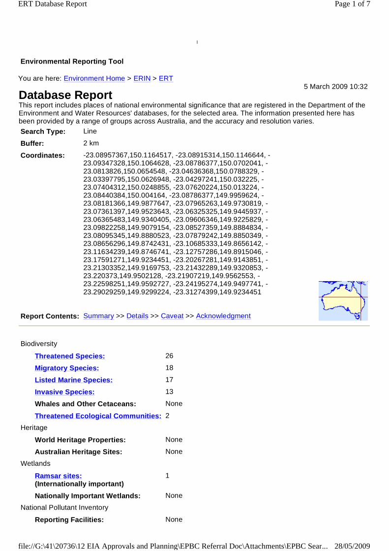
l
Environmental Reporting Tool
You are here: Environment Home > ERIN > ERT
Database Report5 March 2009 10:32
This report includes places of national environmental significance that are registered in the Department of theEnvironment and Water Resources' databases, for the selected area. The information presented here hasbeen provided by a range of groups across Australia, and the accuracy and resolution varies.
Search Type: Line
Buffer: 2 km
Coordinates: -23.08957367,150.1164517, -23.08915314,150.1146644, -23.09347328,150.1064628, -23.08786377,150.0702041, -23.0813826,150.0654548, -23.04636368,150.0788329, -23.03397795,150.0626948, -23.04297241,150.032225, -23.07404312,150.0248855, -23.07620224,150.013224, -23.08440384,150.004164, -23.08786377,149.9959624, -23.08181366,149.9877647, -23.07965263,149.9730819, -23.07361397,149.9523643, -23.06325325,149.9445937, -23.06365483,149.9340405, -23.09606346,149.9225829, -23.09822258,149.9079154, -23.08527359,149.8884834, -23.08095345,149.8880523, -23.07879242,149.8850349, -23.08656296,149.8742431, -23.10685333,149.8656142, -23.11634239,149.8746741, -23.12757286,149.8915046, -23.17591271,149.9234451, -23.20267281,149.9143851, -23.21303352,149.9169753, -23.21432289,149.9320853, -23.220373,149.9502128, -23.21907219,149.9562553, -23.22598251,149.9592727, -23.24195274,149.9497741, -23.29029259,149.9299224, -23.31274399,149.9234451
Report Contents: Summary >> Details >> Caveat >> Acknowledgment
Biodiversity
Threatened Species: 26
Migratory Species: 18
Listed Marine Species: 17
Invasive Species: 13
Whales and Other Cetaceans: None
Threatened Ecological Communities: 2
Heritage
World Heritage Properties: None
Australian Heritage Sites: None
Wetlands
Ramsar sites:(Internationally important)
1
Nationally Important Wetlands: None
National Pollutant Inventory
Reporting Facilities: None
Page 1 of 7ERT Database Report
28/05/2009file://G:\41\20736\12 EIA Approvals and Planning\EPBC Referral Doc\Attachments\EPBC Sear...
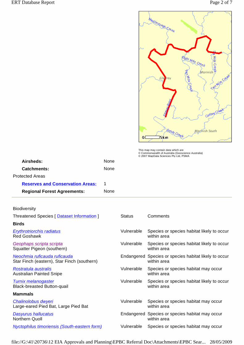
This map may contain data which are© Commonwealth of Australia (Geoscience Australia)© 2007 MapData Sciences Pty Ltd, PSMA
Airsheds: None
Catchments: None
Protected Areas
Reserves and Conservation Areas: 1
Regional Forest Agreements: None
Biodiversity
Threatened Species [ Dataset Information ] Status Comments
Birds
Erythrotriorchis radiatusRed Goshawk
Vulnerable Species or species habitat likely to occurwithin area
Geophaps scripta scriptaSquatter Pigeon (southern)
Vulnerable Species or species habitat likely to occurwithin area
Neochmia ruficauda ruficaudaStar Finch (eastern), Star Finch (southern)
Endangered Species or species habitat likely to occurwithin area
Rostratula australisAustralian Painted Snipe
Vulnerable Species or species habitat may occurwithin area
Turnix melanogasterBlack-breasted Button-quail
Vulnerable Species or species habitat likely to occurwithin area
Mammals
Chalinolobus dwyeriLarge-eared Pied Bat, Large Pied Bat
Vulnerable Species or species habitat may occurwithin area
Dasyurus hallucatusNorthern Quoll
Endangered Species or species habitat may occurwithin area
Nyctophilus timoriensis (South-eastern form) Vulnerable Species or species habitat may occur
Page 2 of 7ERT Database Report
28/05/2009file://G:\41\20736\12 EIA Approvals and Planning\EPBC Referral Doc\Attachments\EPBC Sear...

Eastern Long-eared Bat within area
Reptiles
Denisonia maculataOrnamental Snake
Vulnerable Species or species habitat likely to occurwithin area
Egernia rugosaYakka Skink
Vulnerable Species or species habitat likely to occurwithin area
Furina dunmalliDunmall's Snake
Vulnerable Species or species habitat may occurwithin area
Paradelma orientalisBrigalow Scaly-foot
Vulnerable Species or species habitat likely to occurwithin area
Rheodytes leukopsFitzroy River Turtle, Fitzroy Tortoise, Fitzroy Turtle
Vulnerable Species or species habitat may occurwithin area
Plants
Capparis thozetiana Vulnerable Species or species habitat likely to occurwithin area
Corymbia xanthope Vulnerable Species or species habitat likely to occurwithin area
Cycas megacarpa Endangered Species or species habitat likely to occurwithin area
Cycas ophiolitica Endangered Species or species habitat likely to occurwithin area
Dichanthium queenslandicumKing Blue-grass
Vulnerable Species or species habitat likely to occurwithin area
Digitaria porrectaFinger Panic Grass
Endangered Species or species habitat likely to occurwithin area
Hakea trineuraThree-veined Hakea
Vulnerable Species or species habitat likely to occurwithin area
Leucopogon cuspidatus Vulnerable Species or species habitat likely to occurwithin area
Marsdenia brevifolia Vulnerable Species or species habitat likely to occurwithin area
Neoroepera buxifolia Vulnerable Species or species habitat likely to occurwithin area
Parsonsia larcomensis Vulnerable Species or species habitat likely to occurwithin area
Pimelea leptospermoides Vulnerable Species or species habitat likely to occurwithin area
Pultenaea setulosa Vulnerable Species or species habitat likely to occurwithin area
Migratory Species [ Dataset Information ] Status Comments
Migratory Terrestrial Species
Birds
Haliaeetus leucogasterWhite-bellied Sea-Eagle
Migratory Species or species habitat likely to occurwithin area
Hirundapus caudacutusWhite-throated Needletail
Migratory Species or species habitat may occurwithin area
Hirundo rusticaBarn Swallow
Migratory Species or species habitat may occurwithin area
Merops ornatusRainbow Bee-eater
Migratory Species or species habitat may occurwithin area
Page 3 of 7ERT Database Report
28/05/2009file://G:\41\20736\12 EIA Approvals and Planning\EPBC Referral Doc\Attachments\EPBC Sear...
Monarcha melanopsisBlack-faced Monarch
Migratory Species or species habitat may occurwithin area
Monarcha trivirgatusSpectacled Monarch
Migratory Breeding likely to occur within area
Myiagra cyanoleucaSatin Flycatcher
Migratory Species or species habitat likely to occurwithin area
Rhipidura rufifronsRufous Fantail
Migratory Breeding may occur within area
Migratory Wetland Species
Birds
Ardea albaGreat Egret, White Egret
Migratory Species or species habitat may occurwithin area
Ardea ibisCattle Egret
Migratory Species or species habitat may occurwithin area
Gallinago hardwickiiLatham's Snipe, Japanese Snipe
Migratory Species or species habitat may occurwithin area
Nettapus coromandelianus albipennisAustralian Cotton Pygmy-goose
Migratory Species or species habitat may occurwithin area
Numenius minutusLittle Curlew, Little Whimbrel
Migratory Species or species habitat may occurwithin area
Rostratula benghalensis s. lat.Painted Snipe
Migratory Species or species habitat may occurwithin area
Migratory Marine Birds
Apus pacificusFork-tailed Swift
Migratory Species or species habitat may occurwithin area
Ardea albaGreat Egret, White Egret
Migratory Species or species habitat may occurwithin area
Ardea ibisCattle Egret
Migratory Species or species habitat may occurwithin area
Migratory Marine Species
Reptiles
Crocodylus porosusEstuarine Crocodile, Salt-water Crocodile
Migratory Species or species habitat likely to occurwithin area
Listed Marine Species [ Dataset Information ] Status Comments
Birds
Anseranas semipalmataMagpie Goose
Listed -overflymarine area
Species or species habitat may occurwithin area
Apus pacificusFork-tailed Swift
Listed -overflymarine area
Species or species habitat may occurwithin area
Ardea albaGreat Egret, White Egret
Listed -overflymarine area
Species or species habitat may occurwithin area
Ardea ibisCattle Egret
Listed -overflymarine area
Species or species habitat may occurwithin area
Gallinago hardwickiiLatham's Snipe, Japanese Snipe
Listed -overflymarine area
Species or species habitat may occurwithin area
Page 4 of 7ERT Database Report
28/05/2009file://G:\41\20736\12 EIA Approvals and Planning\EPBC Referral Doc\Attachments\EPBC Sear...

Haliaeetus leucogasterWhite-bellied Sea-Eagle
Listed Species or species habitat likely to occurwithin area
Hirundapus caudacutusWhite-throated Needletail
Listed -overflymarine area
Species or species habitat may occurwithin area
Hirundo rusticaBarn Swallow
Listed -overflymarine area
Species or species habitat may occurwithin area
Merops ornatusRainbow Bee-eater
Listed -overflymarine area
Species or species habitat may occurwithin area
Monarcha melanopsisBlack-faced Monarch
Listed -overflymarine area
Species or species habitat may occurwithin area
Monarcha trivirgatusSpectacled Monarch
Listed -overflymarine area
Breeding likely to occur within area
Myiagra cyanoleucaSatin Flycatcher
Listed -overflymarine area
Species or species habitat likely to occurwithin area
Nettapus coromandelianus albipennisAustralian Cotton Pygmy-goose
Listed -overflymarine area
Species or species habitat may occurwithin area
Numenius minutusLittle Curlew, Little Whimbrel
Listed -overflymarine area
Species or species habitat may occurwithin area
Rhipidura rufifronsRufous Fantail
Listed -overflymarine area
Breeding may occur within area
Rostratula benghalensis s. lat.Painted Snipe
Listed -overflymarine area
Species or species habitat may occurwithin area
Reptiles
Crocodylus porosusEstuarine Crocodile, Salt-water Crocodile
Listed Species or species habitat likely to occurwithin area
Invasive Species [ Dataset Information ] Status Comments
Selected Invasive Species: Weeds reported here are the20 species of national significance (WoNS), along withother introduced plants that are considered by the Statesand Territories to pose a particularly significant threat tobiodiversity. The following feral animals are reported:Goat, Red Fox, Cat, Rabbit, Pig, Water Buffalo and CaneToad. Maps from Landscape Health Project, NationalLand and Water Resouces Audit, 2001.
Mammals
Capra hircusGoat
Feral Species or species habitat may occurwithin area
Felis catusCat, House Cat, Domestic Cat
Feral Species or species habitat likely to occurwithin area
Oryctolagus cuniculusRabbit, European Rabbit
Feral Species or species habitat likely to occurwithin area
Vulpes vulpesRed Fox, Fox
Feral Species or species habitat likely to occurwithin area
Plants
Page 5 of 7ERT Database Report
28/05/2009file://G:\41\20736\12 EIA Approvals and Planning\EPBC Referral Doc\Attachments\EPBC Sear...
CaveatThe information presented here has been drawn from a range of sources, compiled for a variety of purposes.Details of the coverage of each dataset are included in the metadata [Dataset Information] links above.
Acknowledgment
This database has been compiled from a range of data sources. The Department acknowledges the followingcustodians who have contributed valuable data and advice:
l New South Wales National Parks and Wildlife Service
l Department of Sustainability and Environment, Victoria
l Department of Primary Industries, Water and Environment, Tasmania
l Department of Environment and Heritage, South Australia Planning SA
l Parks and Wildlife Commission of the Northern Territory
l Environmental Protection Agency, Queensland
Acacia nilotica subsp. indicaPrickly Acacia
WoNS Species or species habitat may occurwithin area
Alternanthera philoxeroidesAlligator Weed
WoNS Species or species habitat may occurwithin area
Cryptostegia grandifloraRubber Vine, Rubbervine, India Rubber Vine, IndiaRubbervine, Palay Rubbervine, Purple Allamanda
WoNS Species or species habitat likely to occurwithin area
Hymenachne amplexicaulisHymenachne, Olive Hymenachne, Water Stargrass,West Indian Grass, West Indian Marsh Grass
WoNS Species or species habitat likely to occurwithin area
Lantana camaraLantana, Common Lantana, Kamara Lantana,Large-leaf Lantana, Pink Flowered Lantana, RedFlowered Lantana, Red-Flowered Sage, WhiteSage, Wild Sage
WoNS Species or species habitat likely to occurwithin area
Parkinsonia aculeataParkinsonia, Jerusalem Thorn, Jelly Bean Tree,Horse Bean
WoNS Species or species habitat may occurwithin area
Parthenium hysterophorusParthenium Weed, Bitter Weed, Carrot Grass, FalseRagweed
WoNS Species or species habitat likely to occurwithin area
Prosopis spp.Mesquite, Algaroba
WoNS Species or species habitat may occurwithin area
Salvinia molestaSalvinia, Giant Salvinia, Aquarium Watermoss,Kariba Weed
WoNS Species or species habitat may occurwithin area
Threatened Ecological Communities [ DatasetInformation ]
Status Comments
Brigalow (Acacia harpophylla dominant and co-dominant)
Endangered Community known to occur within area
Weeping Myall Woodlands Endangered Community likely to occur within area
Wetlands
Wetlands of International Importance (Ramsar sites) [ Dataset Information ]
SHOALWATER AND CORIO BAYS AREA Within same catchment as Ramsar site
Other
Reserves and Conservation Areas [ Dataset Information ]
Princhester Conservation Park, QLD
Page 6 of 7ERT Database Report
28/05/2009file://G:\41\20736\12 EIA Approvals and Planning\EPBC Referral Doc\Attachments\EPBC Sear...
l Birds Australia
l Australian Bird and Bat Banding Scheme
l Australian National Wildlife Collection
l Natural history museums of Australia
l Queensland Herbarium
l National Herbarium of NSW
l Royal Botanic Gardens and National Herbarium of Victoria
l Tasmanian Herbarium
l State Herbarium of South Australia
l Northern Territory Herbarium
l Western Australian Herbarium
l Australian National Herbarium, Atherton and Canberra
l University of New England
l Other groups and individuals
ANUCliM Version 1.8, Centre for Resource and Environmental Studies, Australian National University wasused extensively for the production of draft maps of species distribution. The Department is extremely gratefulto the many organisations and individuals who provided expert advice and information on numerous draftdistributions.
Page 7 of 7ERT Database Report
28/05/2009file://G:\41\20736\12 EIA Approvals and Planning\EPBC Referral Doc\Attachments\EPBC Sear...
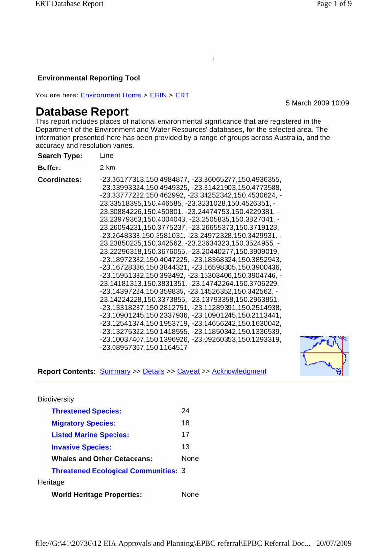
l
Environmental Reporting Tool
You are here: Environment Home > ERIN > ERT
Database Report5 March 2009 10:09
This report includes places of national environmental significance that are registered in theDepartment of the Environment and Water Resources' databases, for the selected area. Theinformation presented here has been provided by a range of groups across Australia, and theaccuracy and resolution varies.
Search Type: Line
Buffer: 2 km
Coordinates: -23.36177313,150.4984877, -23.36065277,150.4936355,-23.33993324,150.4949325, -23.31421903,150.4773588,-23.33777222,150.462992, -23.34252342,150.4530624, -23.33518395,150.446585, -23.3231028,150.4526351, -23.30884226,150.450801, -23.24474753,150.4229381, -23.23979363,150.4004043, -23.2505835,150.3827041, -23.26094231,150.3775237, -23.26655373,150.3719123,-23.2648333,150.3581031, -23.24972328,150.3429931, -23.23850235,150.342562, -23.23634323,150.3524955, -23.22296318,150.3676055, -23.20440277,150.3909019,-23.18972382,150.4047225, -23.18368324,150.3852943,-23.16728386,150.3844321, -23.16598305,150.3900436,-23.15951332,150.393492, -23.15303406,150.3904746, -23.14181313,150.3831351, -23.14742264,150.3706229,-23.14397224,150.359835, -23.14526352,150.342562, -23.14224228,150.3373855, -23.13793358,150.2963851,-23.13318237,150.2812751, -23.11289391,150.2514938,-23.10901245,150.2337936, -23.10901245,150.2113441,-23.12541374,150.1953719, -23.14656242,150.1630042,-23.13275322,150.1418555, -23.11850342,150.1336539,-23.10037407,150.1396926, -23.09260353,150.1293319,-23.08957367,150.1164517
Report Contents: Summary >> Details >> Caveat >> Acknowledgment
Biodiversity
Threatened Species: 24
Migratory Species: 18
Listed Marine Species: 17
Invasive Species: 13
Whales and Other Cetaceans: None
Threatened Ecological Communities: 3
Heritage
World Heritage Properties: None
Page 1 of 9ERT Database Report
20/07/2009file://G:\41\20736\12 EIA Approvals and Planning\EPBC referral\EPBC Referral Doc...

This map may contain data which are© Commonwealth of Australia (Geoscience Australia)© 2007 MapData Sciences Pty Ltd, PSMA
Australian Heritage Sites: 5
Wetlands
Ramsar sites:(Internationally important)
1
Nationally Important Wetlands: 2
National Pollutant Inventory
Reporting Facilities: 14
Airsheds: None
Catchments: None
Protected Areas
Reserves and Conservation Areas: 1
Regional Forest Agreements: None
Biodiversity
Threatened Species [ DatasetInformation ]
Status Comments
Birds
Erythrotriorchis radiatusRed Goshawk
Vulnerable Species or species habitat likelyto occur within area
Geophaps scripta scriptaSquatter Pigeon (southern)
Vulnerable Species or species habitat likelyto occur within area
Page 2 of 9ERT Database Report
20/07/2009file://G:\41\20736\12 EIA Approvals and Planning\EPBC referral\EPBC Referral Doc...
Neochmia ruficauda ruficaudaStar Finch (eastern), Star Finch (southern)
Endangered Species or species habitat likelyto occur within area
Rostratula australisAustralian Painted Snipe
Vulnerable Species or species habitat mayoccur within area
Turnix melanogasterBlack-breasted Button-quail
Vulnerable Species or species habitat likelyto occur within area
Mammals
Chalinolobus dwyeriLarge-eared Pied Bat, Large Pied Bat
Vulnerable Species or species habitat mayoccur within area
Dasyurus hallucatusNorthern Quoll
Endangered Species or species habitat mayoccur within area
Nyctophilus timoriensis (South-easternform)Eastern Long-eared Bat
Vulnerable Species or species habitat mayoccur within area
Reptiles
Denisonia maculataOrnamental Snake
Vulnerable Species or species habitat likelyto occur within area
Egernia rugosaYakka Skink
Vulnerable Species or species habitat likelyto occur within area
Furina dunmalliDunmall's Snake
Vulnerable Species or species habitat mayoccur within area
Rheodytes leukopsFitzroy River Turtle, Fitzroy Tortoise,Fitzroy Turtle
Vulnerable Species or species habitat mayoccur within area
Plants
Capparis thozetiana Vulnerable Species or species habitat likelyto occur within area
Corymbia xanthope Vulnerable Species or species habitat likelyto occur within area
Cycas megacarpa Endangered Species or species habitatknown to occur within area
Cycas ophiolitica Endangered Species or species habitat likelyto occur within area
Eucalyptus raveretianaBlack Ironbox
Vulnerable Species or species habitat likelyto occur within area
Hakea trineuraThree-veined Hakea
Vulnerable Species or species habitat likelyto occur within area
Leucopogon cuspidatus Vulnerable Species or species habitat likelyto occur within area
Marsdenia brevifolia Vulnerable Species or species habitat likelyto occur within area
Neoroepera buxifolia Vulnerable Species or species habitat likelyto occur within area
Parsonsia larcomensis Vulnerable Species or species habitat likelyto occur within area
Pimelea leptospermoides Vulnerable Species or species habitat likelyto occur within area
Page 3 of 9ERT Database Report
20/07/2009file://G:\41\20736\12 EIA Approvals and Planning\EPBC referral\EPBC Referral Doc...
Pultenaea setulosa Vulnerable Species or species habitat likelyto occur within area
Migratory Species [ Dataset Information ] Status Comments
Migratory Terrestrial Species
Birds
Haliaeetus leucogasterWhite-bellied Sea-Eagle
Migratory Species or species habitat likelyto occur within area
Hirundapus caudacutusWhite-throated Needletail
Migratory Species or species habitat mayoccur within area
Hirundo rusticaBarn Swallow
Migratory Species or species habitat mayoccur within area
Merops ornatusRainbow Bee-eater
Migratory Species or species habitat mayoccur within area
Monarcha melanopsisBlack-faced Monarch
Migratory Breeding may occur within area
Monarcha trivirgatusSpectacled Monarch
Migratory Breeding likely to occur withinarea
Myiagra cyanoleucaSatin Flycatcher
Migratory Species or species habitat likelyto occur within area
Rhipidura rufifronsRufous Fantail
Migratory Breeding may occur within area
Migratory Wetland Species
Birds
Ardea albaGreat Egret, White Egret
Migratory Species or species habitat mayoccur within area
Ardea ibisCattle Egret
Migratory Species or species habitat mayoccur within area
Gallinago hardwickiiLatham's Snipe, Japanese Snipe
Migratory Species or species habitat mayoccur within area
Nettapus coromandelianus albipennisAustralian Cotton Pygmy-goose
Migratory Species or species habitat mayoccur within area
Numenius minutusLittle Curlew, Little Whimbrel
Migratory Species or species habitat mayoccur within area
Rostratula benghalensis s. lat.Painted Snipe
Migratory Species or species habitat mayoccur within area
Migratory Marine Birds
Apus pacificusFork-tailed Swift
Migratory Species or species habitat mayoccur within area
Ardea albaGreat Egret, White Egret
Migratory Species or species habitat mayoccur within area
Ardea ibisCattle Egret
Migratory Species or species habitat mayoccur within area
Migratory Marine Species
Reptiles
Crocodylus porosusEstuarine Crocodile, Salt-water Crocodile
Migratory Species or species habitat likelyto occur within area
Page 4 of 9ERT Database Report
20/07/2009file://G:\41\20736\12 EIA Approvals and Planning\EPBC referral\EPBC Referral Doc...
Listed Marine Species [ DatasetInformation ]
Status Comments
Birds
Anseranas semipalmataMagpie Goose
Listed - overflymarine area
Species or species habitat mayoccur within area
Apus pacificusFork-tailed Swift
Listed - overflymarine area
Species or species habitat mayoccur within area
Ardea albaGreat Egret, White Egret
Listed - overflymarine area
Species or species habitat mayoccur within area
Ardea ibisCattle Egret
Listed - overflymarine area
Species or species habitat mayoccur within area
Gallinago hardwickiiLatham's Snipe, Japanese Snipe
Listed - overflymarine area
Species or species habitat mayoccur within area
Haliaeetus leucogasterWhite-bellied Sea-Eagle
Listed Species or species habitat likelyto occur within area
Hirundapus caudacutusWhite-throated Needletail
Listed - overflymarine area
Species or species habitat mayoccur within area
Hirundo rusticaBarn Swallow
Listed - overflymarine area
Species or species habitat mayoccur within area
Merops ornatusRainbow Bee-eater
Listed - overflymarine area
Species or species habitat mayoccur within area
Monarcha melanopsisBlack-faced Monarch
Listed - overflymarine area
Breeding may occur within area
Monarcha trivirgatusSpectacled Monarch
Listed - overflymarine area
Breeding likely to occur withinarea
Myiagra cyanoleucaSatin Flycatcher
Listed - overflymarine area
Species or species habitat likelyto occur within area
Nettapus coromandelianus albipennisAustralian Cotton Pygmy-goose
Listed - overflymarine area
Species or species habitat mayoccur within area
Numenius minutusLittle Curlew, Little Whimbrel
Listed - overflymarine area
Species or species habitat mayoccur within area
Rhipidura rufifronsRufous Fantail
Listed - overflymarine area
Breeding may occur within area
Rostratula benghalensis s. lat.Painted Snipe
Listed - overflymarine area
Species or species habitat mayoccur within area
Reptiles
Crocodylus porosusEstuarine Crocodile, Salt-water Crocodile
Listed Species or species habitat likelyto occur within area
Invasive Species [ Dataset Information ] Status Comments
Selected Invasive Species: Weeds reportedhere are the 20 species of nationalsignificance (WoNS), along with otherintroduced plants that are considered by theStates and Territories to pose a particularlysignificant threat to biodiversity. The followingferal animals are reported: Goat, Red Fox,Cat, Rabbit, Pig, Water Buffalo and CaneToad. Maps from Landscape Health Project,National Land and Water Resouces Audit,
Page 5 of 9ERT Database Report
20/07/2009file://G:\41\20736\12 EIA Approvals and Planning\EPBC referral\EPBC Referral Doc...
2001.
Mammals
Capra hircusGoat
Feral Species or species habitat mayoccur within area
Felis catusCat, House Cat, Domestic Cat
Feral Species or species habitat likelyto occur within area
Oryctolagus cuniculusRabbit, European Rabbit
Feral Species or species habitat likelyto occur within area
Vulpes vulpesRed Fox, Fox
Feral Species or species habitat likelyto occur within area
Plants
Acacia nilotica subsp. indicaPrickly Acacia
WoNS Species or species habitat mayoccur within area
Alternanthera philoxeroidesAlligator Weed
WoNS Species or species habitat mayoccur within area
Cryptostegia grandifloraRubber Vine, Rubbervine, India RubberVine, India Rubbervine, PalayRubbervine, Purple Allamanda
WoNS Species or species habitat likelyto occur within area
Hymenachne amplexicaulisHymenachne, Olive Hymenachne, WaterStargrass, West Indian Grass, WestIndian Marsh Grass
WoNS Species or species habitat likelyto occur within area
Lantana camaraLantana, Common Lantana, KamaraLantana, Large-leaf Lantana, PinkFlowered Lantana, Red FloweredLantana, Red-Flowered Sage, WhiteSage, Wild Sage
WoNS Species or species habitat likelyto occur within area
Parkinsonia aculeataParkinsonia, Jerusalem Thorn, Jelly BeanTree, Horse Bean
WoNS Species or species habitat mayoccur within area
Parthenium hysterophorusParthenium Weed, Bitter Weed, CarrotGrass, False Ragweed
WoNS Species or species habitat likelyto occur within area
Prosopis spp.Mesquite, Algaroba
WoNS Species or species habitat mayoccur within area
Salvinia molestaSalvinia, Giant Salvinia, AquariumWatermoss, Kariba Weed
WoNS Species or species habitat mayoccur within area
Threatened Ecological Communities[ Dataset Information ]
Status Comments
Brigalow (Acacia harpophylla dominantand co-dominant)
Endangered Community known to occurwithin area
Semi-evergreen vine thickets of theBrigalow Belt (North and South) andNandewar Bioregions
Endangered Community likely to occur withinarea
Weeping Myall Woodlands Endangered Community likely to occur withinarea
Page 6 of 9ERT Database Report
20/07/2009file://G:\41\20736\12 EIA Approvals and Planning\EPBC referral\EPBC Referral Doc...

Heritage
Australian Heritage Sites [ Dataset Information ]Note that not all Indigenous sites may be listed.
Historic
Alexandra Bridge QLD
Archer Park Railway Station (former) QLD
Glenmore Homestead Complex (former) QLD
House QLD
Tobruk House QLD
Wetlands
Wetlands of International Importance (Ramsar sites) [ Dataset Information ]
SHOALWATER AND CORIO BAYSAREA
Within same catchment asRamsar site
Nationally Important Wetland Sites [ Dataset Information ]
Fitzroy River Delta, QLD
Fitzroy River Floodplain, QLD
National Pollutant Inventory
Reporting Facility [ Dataset Information ] Top Substance Source
Substance emissions are ranked on a scale of 1-100: 1=lowest; 100=highest. Rankings are shownas: =0-25; =26-50; =51-75; =76-100.
ALINTA ASSET MANAGEMENT P/L( Fitzroy River (1) Valve KP 93.311 (MLV)(Queensland Gas Pipeline),ROCKHAMPTON QLD )
Total VolatileOrganic Compounds
[ Low ]
Main Line Valve
ALINTA ASSET MANAGEMENT P/L( Fitzroy River (2) Valve KP 93.688 (MLV)(Queensland Gas Pipeline),ROCKHAMPTON QLD )
Total VolatileOrganic Compounds
[ Low ]
Main Line Valve
ALINTA ASSET MANAGEMENT P/L( Origin South Offtake Meter Station KP90.625 (Queensland Gas Pipeline),ROCKHAMPTON QLD )
Total VolatileOrganic Compounds
[ Low ]
Natural Gas Metering
BP AUSTRALIA PTY LTD ( AIR BPROCKHAMPTON AIRPORT,ROCKHAMPTON QLD )
Total VolatileOrganic Compounds
[ Low ]
Bulk petroleum storage facility
Central Queensland Petroleum Pty Ltd( Rockhampton Depot, RockhamptonQLD )
Cumene (1-methylethylbenzene)
[ Low ]
Petroleum Product Wholesaling
Country Bake (Regal Bakeries Pty Ltd) -Goodman Fielder Limited ( RockhamptonQLD )
Carbon monoxide
[ Low ]
Plant Bakery
FITZROY RIVER WATER ( GlenmoreWater Treatment Plant, ROCKHAMPTONQLD )
Chlorine
[ Low ]
Treatment and Processing ofpotable water
KALININ INVESTMENTS P/L ( Sungold,ROCKHAMPTON QLD )
Total VolatileOrganic Compounds
Hydrocarbon storage anddistribution
Page 7 of 9ERT Database Report
20/07/2009file://G:\41\20736\12 EIA Approvals and Planning\EPBC referral\EPBC Referral Doc...

CaveatThe information presented here has been drawn from a range of sources, compiled for a variety ofpurposes. Details of the coverage of each dataset are included in the metadata [DatasetInformation] links above.
Acknowledgment
This database has been compiled from a range of data sources. The Department acknowledges thefollowing custodians who have contributed valuable data and advice:
l New South Wales National Parks and Wildlife Service
l Department of Sustainability and Environment, Victoria
l Department of Primary Industries, Water and Environment, Tasmania
l Department of Environment and Heritage, South Australia Planning SA
l Parks and Wildlife Commission of the Northern Territory
l Environmental Protection Agency, Queensland
l Birds Australia
l Australian Bird and Bat Banding Scheme
l Australian National Wildlife Collection
l Natural history museums of Australia
l Queensland Herbarium
l National Herbarium of NSW
l Royal Botanic Gardens and National Herbarium of Victoria
l Tasmanian Herbarium
[ Low ]
ROCKHAMPTON CITY COUNCIL( Jardine Park Landfill (Closed),ROCKHAMPTON QLD )
Chlorine
[ Low ]
Closed Municipal LandfillFacility
ROCKHAMPTON CITY COUNCIL( Jardine Street Landfill (Closed),ROCKHAMPTON QLD )
Chlorine
[ Low ]
Closed Municipal LandfillFacility
ROCKHAMPTON CITY COUNCIL ( SkiGardens Landfill (Closed),ROCKHAMPTON QLD )
Acrylonitrile (2-propenenitrile)
[ Low ]
Closed Municipal LandfillFacility
ROCKHAMPTON CITY COUNCIL( Victoria Park Landfill (Closed),ROCKHAMPTON QLD )
Chlorine
[ Low ]
Closed Municipal LandfillFacility
ROCKHAMPTON CITY COUNCIL ( WestRockhampton Landfill (Closed),ROCKHAMPTON QLD )
Chlorine
[ Low ]
Closed Municipal LandfillFacility
ROCKHAMPTON CITY COUNCIL ( WestRockhampton Sewage Treatment Plant,ROCKHAMPTON QLD )
Total Phosphorus
[ Low ]
Treatment of municipalwastewater. Trickling filter(secondary treatment) servicingsouth west side ofRockhampton
Other
Reserves and Conservation Areas [ Dataset Information ]
Long Island Bend Conservation Park,QLD
Page 8 of 9ERT Database Report
20/07/2009file://G:\41\20736\12 EIA Approvals and Planning\EPBC referral\EPBC Referral Doc...

l State Herbarium of South Australia
l Northern Territory Herbarium
l Western Australian Herbarium
l Australian National Herbarium, Atherton and Canberra
l University of New England
l Other groups and individuals
ANUCliM Version 1.8, Centre for Resource and Environmental Studies, Australian NationalUniversity was used extensively for the production of draft maps of species distribution. TheDepartment is extremely grateful to the many organisations and individuals who provided expertadvice and information on numerous draft distributions.
Page 9 of 9ERT Database Report
20/07/2009file://G:\41\20736\12 EIA Approvals and Planning\EPBC referral\EPBC Referral Doc...
DERM Wildlife Online Database
Scientific Name Common Name NC Act Status EPBC Act Status
Reptiles
Crocodylus porosus estuarine crocodile V Mig
Chelodina longicollis eastern snake-necked turtle
Elseya albagula southern snapping turtle #
Emydura macquarii krefftii Krefft's river turtle
Rheodytes leukops Fitzroy River turtle V V
Fish
Ambassis agassizii Agassiz's glassfish
Amniataba percoides barred grunter
Anguilla reinhardtii longfin eel
Arius graeffei blue catfish
Arius leptaspis boofhead catfish
Arrhamphus sclerolepis snubnose garfish
Craterocephalus marjoriae
silverstreak hardyhead
Craterocephalus stercusmuscarum
flyspecked hardyhead
Glossamia aprion mouth almighty
Hypseleotris galii firetail gudgeon
Hypseleotris species 1 Midgley's carp gudgeon
Leiopotherapon unicolor spangled perch
Macquaria ambigua golden perch
Megalops cyprinoides oxeye herring
Melanotaenia splendida splendida
eastern rainbowfish
Mugil cephalus sea mullet
Nematalosa erebi bony bream
Neosilurus hyrtlii Hyrtl's catfish
Oxyeleotris lineolata sleepy cod
Philypnodon grandiceps flathead gudgeon
Pseudomugil signifer Pacific blue eye
Redigobius bikolanus speckled goby
Scortum hillii leathery grunter
Tandanus tandanus freshwater catfish

GHD | Report for Gladstone Area Water Board and SunWater - Lower Fitzroy River Infrastructure Project, 41/20736
Queensland Museum Database
Scientific Name Common Name NC Act Status EPBC Act Status
Emydura macquarii krefftii Krefft's river turtle
Rheodytes leukops Fitzroy River turtle V V
#Has been recommended for l isting as ‘Endangered’ under NC Act


www.ghd.com