Embed Size (px)
Citation preview

Public Meeting #1July 23rd, 2008MVVA Team
www.waterfrontoronto.ca/lowerdonlands
WelcomeWelcome to the first Public Meeting for the Lower Don LandsMunicipal Class Environmental Assessment (EA) Infrastructure Master Plan and Keating North Precinct Plan
1

Public Meeting #1July 23rd, 2008MVVA Team
www.waterfrontoronto.ca/lowerdonlands
What is a Class EA Master Plan?Master Plans are long range plans that integrate infrastructure requirements for existing and future land use with environmentalassessment planning principles. A Master Plan provides a “road map” for future improvements and sets a framework for planning subsequent projects and/or development.
2

Public Meeting #1July 23rd, 2008MVVA Team
www.waterfrontoronto.ca/lowerdonlands
Lower Don Lands Master PlanThis study will address transportation (road and transit), water, wastewater and stormwater improvements needed in the Lower Don Lands to support revitalization of the area. The Class EA Infrastructure Master Plan is being carried out by Waterfront Toronto, the City of Toronto and Toronto Transit Commission as tri-proponents.
3
Public Meeting #1July 23rd, 2008MVVA Team
www.waterfrontoronto.ca/lowerdonlands
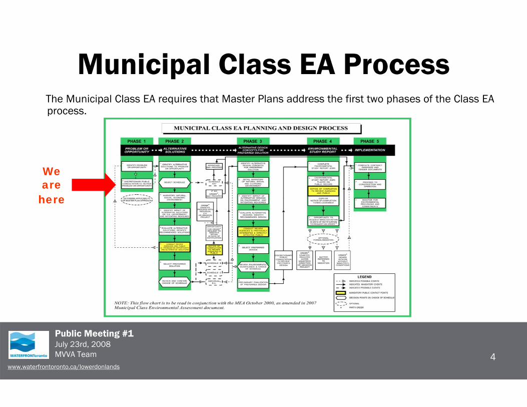
Municipal Class EA ProcessThe Municipal Class EA requires that Master Plans address the first two phases of the Class EA process.
4
We arehere

Public Meeting #1July 23rd, 2008MVVA Team
www.waterfrontoronto.ca/lowerdonlands
Study AreaThe study area for this Master Plan is shown below.
5
LegendStudy Area

Public Meeting #1July 23rd, 2008MVVA Team
www.waterfrontoronto.ca/lowerdonlands
Purpose of Open House
• The main purpose of today’s Class EA Infrastructure Master Plan Open House is to display and seek input on the:– Draft Problem and Opportunity statement;– Infrastructure Planning Alternatives; and– Draft Evaluation Criteria.
A presentation will be made on the revitalization of the Lower Don Lands area.
6

Public Meeting #1July 23rd, 2008MVVA Team
www.waterfrontoronto.ca/lowerdonlands
Site Context
7

Public Meeting #1July 23rd, 2008MVVA Team
www.waterfrontoronto.ca/lowerdonlands
Existing Water Supply
8

Public Meeting #1July 23rd, 2008MVVA Team
www.waterfrontoronto.ca/lowerdonlands
Existing Stormwater Management Features
9

Public Meeting #1July 23rd, 2008MVVA Team
www.waterfrontoronto.ca/lowerdonlands
Existing Wastewater System
10

Public Meeting #1July 23rd, 2008MVVA Team
www.waterfrontoronto.ca/lowerdonlands
Existing Road and Trail System
11
Don
Val
ley
Trai
l
Lakeshore Trail
Mar
tin G
oodm
an T
rail
Polson Street
Mun
ition
Stre
et

Public Meeting #1July 23rd, 2008MVVA Team
www.waterfrontoronto.ca/lowerdonlands
Proposed Waterfront Transit Facilities
12

Public Meeting #1July 23rd, 2008MVVA Team
www.waterfrontoronto.ca/lowerdonlands
Problem/Opportunity Statement Waterfront Toronto, the City of Toronto and the Toronto Transit Commission are developing a plan to revitalize the lands at the northeastern portion of the Toronto Inner Harbour (Keating North and the Northwest Port Lands) to create a vibrant, mixed use, sustainable community that embraces and respects a newly naturalized and flood-protected mouth of the Don River. The new river channel will act as a critical piece of hydrological and ecological infrastructure offering a beautiful and functional natural feature around which diverse new communities are positioned.
The existing infrastructure (water, wastewater, stormwater, roads and transit service) is neither sufficient, nor is it configured appropriately to support the revitalization of the area and the relocation of the mouth of the Don. There is no higher-order transit service to the area, and the area is poorly connected to surrounding existing and planned neighbourhoods.
The Lower Don Lands is a keystone site between the Don River and the Inner Harbour, and between the downtown and future Port Lands development, at the crossroads of numerous transit, cycling and pedestrian routes. There is a significant opportunity with the implementation of the Don River project to improve existing infrastructure, relocate necessary elements, add transit, pedestrian and cycling facilities to serve local, recreational and commuter needs, improve or add new roads where new connections and access are needed, and to provide “green” stormwater facilities, water and sewer service as part of a comprehensive revitalization project that sets new standards for the achievement of sustainable planning and design.
13

Public Meeting #1July 23rd, 2008MVVA Team
www.waterfrontoronto.ca/lowerdonlands
Alternative Infrastructure Planning Solutions – Water Infrastructure
14
Alt # 1 = do nothing
Alt # 2 = reconstruct, rehabilitate existing, construct new and improve connectivity to lands south of Shipping Channel
Alt # 3 = Alt # 2 + water efficiency measures
Alt # 4 = Alt # 3 + Non-Potable Water Supply SystemAlt 4A = Public Operated Non-Potable Water SupplyAlt 4B = Private Operated Non-Potable Water SupplyAlt 4C = Combination of Alt 4A & 4B
Private (Block Development): • Metering practices• High efficiency fixtures / appliance• Low water landscaping• Grey water re-use• Rainwater harvesting• Irrigation of landscape with non-potable water supply
Public Infrastructure:• Irrigation of public parks / trees with non-potable water
supply• Low water landscaping• Rainwater harvesting• Non-potable water supply / fire protection system
Water Infrastructure Opportunities

Public Meeting #1July 23rd, 2008MVVA Team
www.waterfrontoronto.ca/lowerdonlands
Alternative Infrastructure Planning Solutions – Stormwater Infrastructure
15
Alt # 1 = do nothing
Alt # 2 = conventional conveyance and treatment approachAlt # 2A = use oil / grit separators to manage TSSAlt # 2B = use detention pond / sediment trap to manage TSS
Alt # 3 = integrated treatment train approach to manage rate, volume, quality and delivery of hydrograph to receiving water
Stormwater Infrastructure OpportunitiesPublic Infrastructure:• Constructed wetlands• Stormwater quality control facilities• Disinfection• Keating Channel circulation• Stormwater utility for financing of operations• Rain gardens• Rain water harvesting• Spill management plan• BMP’s for control of potential pollutants ( road salts )• Facilitates understanding, appreciation and use of fish and wildlife
resources
Private (Block Development):• Green roofs• Rain gardens• Rain water harvesting• Stormwater quality control facilities• BMP’s for control of potential pollutants

Public Meeting #1July 23rd, 2008MVVA Team
www.waterfrontoronto.ca/lowerdonlands
Alternative Infrastructure Planning Solutions –Wastewater Infrastructure
16
Alt # 1 = do nothingAlt # 2 = reconstruct, rehabilitate existing, construct new gravity sewers and assess need to service lands south of Shipping ChannelAlt # 3A = Alt # 2 + SPS / forcemainAlt # 3B = Alt # 2 + Siphons at River CrossingsAlt # 4 = New vacuum sanitary sewer systemAlt # 5 = Eco-Island for Shipping Channel West Lands
Wastewater Infrastructure OpportunitiesPublic Infrastructure:• Improve operation of LLI• Gravity connection to LLI• Eco Island : Ship Channel West Lands• Vacuum sanitary sewers
Private (Block Development):• Grey water re-use• High efficiency fixtures
Public Meeting #1July 23rd, 2008MVVA Team
www.waterfrontoronto.ca/lowerdonlands
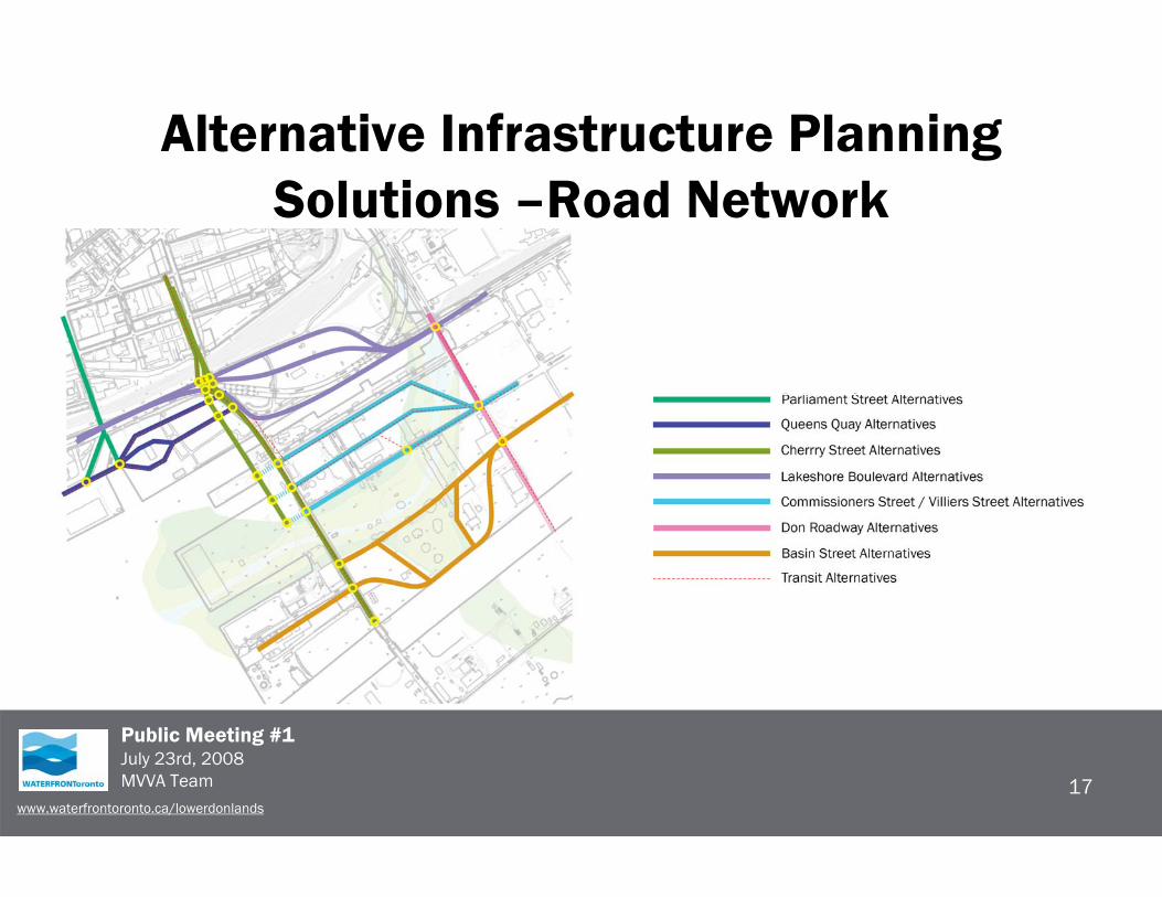
Alternative Infrastructure Planning Solutions –Road Network
17

Public Meeting #1July 23rd, 2008MVVA Team
www.waterfrontoronto.ca/lowerdonlands
Criteria for Evaluation of Infrastructure Planning Solutions
18

Public Meeting #1July 23rd, 2008MVVA Team
www.waterfrontoronto.ca/lowerdonlands
Next StepsAfter Public Meeting #1 the study team will finalize the Problemand Opportunity Statement and evaluate the Planning Alternatives for infrastructure improvements.
A second Public Meeting will be held in December to present and seek input on the Preferred Planning Solutions.
You will be contacted again at that time.
19

Public Meeting #1July 23rd, 2008MVVA Team
www.waterfrontoronto.ca/lowerdonlands
Your Input is Important• Public participation is an important part of the study process.
• Please provide your comments to:Andrea Kelemen, Communications + Marketing Coordinator Waterfront Toronto20 Bay Street, Suite 1310Toronto, ON M5J 2N8Tel: (416) 214-1344 ext 248Email: [email protected]/lowerdonlands
Thank you for attending
20