Embed Size (px)
Citation preview

LONDON WALK NO 42 – GROUP 3 – ROTHERHITHE ORGANISED BY IAN & MARY NICHOLSON – Wednesday 16th May 2012
Meeting up at Tonbridge Station on a chilly but dry May day, we were sorry to hear that Mary was not well, and Ian was having to run this walk on his own. So 20 of us caught the train to London Bridge at 9.32 am. As a teaser before the walk, we had been sent a couple of questions to get us in the mood for the wealth of information Ian had gathered together about Rotherhithe. What is the connection between 'a pink toothbrush', the film 'Zulu', and 'M&S lingerie? Where would you find Russia, Canada, Greenland, Norway, Finland and Amsterdam all in the same place?’ All would be answered during the walk. These questions, scarf tying, and the TV programme on The Shard were all heard being discussed up and down the train carriage.
Pam volunteered to be rear guard for Ian in Mary’s absence, and we set off out of London Bridge station towards Hay’s Galleria for our coffee stop. Ian had found a group of cafés on the main road, and we split up, half going in to Café Nero and half going in to Street Bagel. After a very welcome coffee break (Street Bagel do a wonderful hot chocolate), we gathered together outside the back of More London. Some of the group had been sitting on a concrete slab, until they were warned by the security guard that it
was in fact a fountain! A metal map of the area was also interesting, as well as a carved statue on a wooden pole called “The Couple” by Stephen Balkhenol – but there was only one! The pictures on the web are of the woman only, so perhaps they swap over.
We made our way to the bus stop, and would have waited if somebody hadn’t pointed out that the bus stop was out of use, so we walked up to the next one, where we quickly caught the No.47 bus and all piled upstairs. The journey was interesting, along Jamaica Road, as we passed through streets we had not previously covered on our walks. Alighting at Bermondsey Station, we made the short walk to the River. Rotherhithe lies between Bermondsey and Deptford, and our entire walk would be inside the area of Rotherhithe.

Although still bright, it was very chilly along the Thames Path, and we huddled together as Ian gave us a mountain of information about the area, how it had been called Redriff in Edward I’s era, and was mentioned by Pepys in his diary. The vista was superb, from the newly completed Shard, Tower Bridge, the Gerkin, and past the refurbished wharves, now luxury apartments, and round the bend to Canary Wharf.
Across the road Ian told us about the 14th century Edward III Manor House – used by both Edward III and Henry IV. Two bad fires, one in 1699, and one in 1765, had destroyed many houses and warehouses. Nearby is the Angel pub (not open at the time we arrived). A 15th century inn stood on this site, built by the monks of Bermondsey Priory. Christopher Jones, captain of the Mayflower, is said to have hired crew here and Captain Cook prepared for his voyage to Australia at the old inn. Carole posed in front of the pub with her surname. This is also the pub where Turner painted ‘The Fighting Temeraire’ from its balcony.
When Samuel Pepys visited, he would have had a pleasant country walk from the City, but during the 18th and 19th centuries London sprawled – and its east‐end river banks were developed as docks and wharves. Bermondsey's crowded waterfront became one of the worst slums in London, a haunt for thieves, press gangs and smugglers. In the 20th century, wartime bombing and economic changes left this area a wasteland. Now, regeneration of the waterside has meant the old wharves have become desirable apartments and modern blocks have replaced the tenements (and we were now safe to walk this route.) Ian said there had been 125 pubs in Rotherhithe at its height. William of Orange is said to have landed near here to seize the throne in 1688.

Ian had hoped to show us some bronze statues alongside the river, but thieves had removed the largest, and the other had been taken away for its safety, so perhaps this area is still a haunt for the current day rogues. The statue of Dr. Alfred Salter should have been sat looking towards another statue of his daughter and her cat. Dr. Salter, a physician at Guy’s, was involved in setting up an early‐day health service for Bermondsey in an attempt to improve the atrocious conditions for the poor of the area. Sadly his
daughter died aged only 9 of scarlet fever.
The answer to our first quiz question was given here. Ian told us that Max Bygraves and Michael Caine had both been born in Rotherhithe and Myleene Klass had lived there. (This is where I
showed myself up as although I had given Ian the right answer, during our train journey I had insisted to Diane and Barbara that the answer was Rolph Harris – and everyone knows he was born in Australia!) Following along the side of the river, we learnt about Mudlarks (children who scoured the Thames foreshore for items to sell), the King’s Stairs (allowing watermen and mudlarks to reach the river or shore) and the pirates, the Captain Kidd pub, and Execution Dock. Convicted pirates were left to hang at the gallows by the Thames so that the tide could wash over the body three times.
Another part of the shoreline gave us a view across the river of the Captain Kidd pub, and also the very stark monument to the Queen’s Golden Jubilee (with space on the other side for her Diamond Jubilee). We decided to take our group photo here with the river backdrop and London skyline.
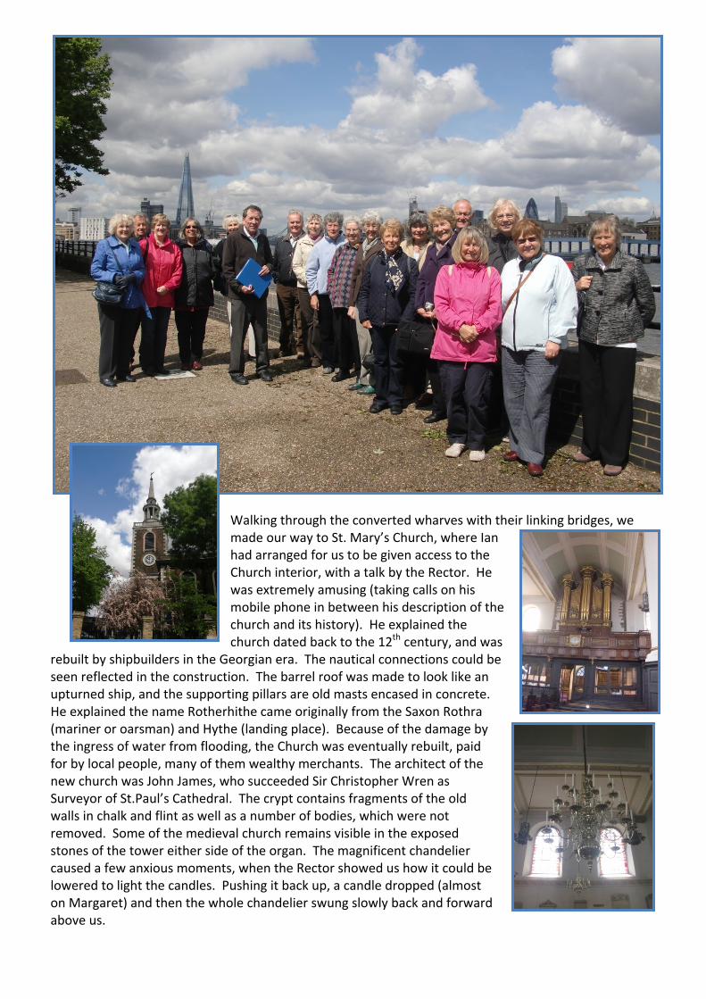
Walking through the converted wharves with their linking bridges, we made our way to St. Mary’s Church, where Ian had arranged for us to be given access to the Church interior, with a talk by the Rector. He was extremely amusing (taking calls on his mobile phone in between his description of the church and its history). He explained the church dated back to the 12th century, and was
rebuilt by shipbuilders in the Georgian era. The nautical connections could be seen reflected in the construction. The barrel roof was made to look like an upturned ship, and the supporting pillars are old masts encased in concrete. He explained the name Rotherhithe came originally from the Saxon Rothra (mariner or oarsman) and Hythe (landing place). Because of the damage by the ingress of water from flooding, the Church was eventually rebuilt, paid for by local people, many of them wealthy merchants. The architect of the new church was John James, who succeeded Sir Christopher Wren as Surveyor of St.Paul’s Cathedral. The crypt contains fragments of the old walls in chalk and flint as well as a number of bodies, which were not removed. Some of the medieval church remains visible in the exposed stones of the tower either side of the organ. The magnificent chandelier caused a few anxious moments, when the Rector showed us how it could be lowered to light the candles. Pushing it back up, a candle dropped (almost on Margaret) and then the whole chandelier swung slowly back and forward above us.

The vast amount of interesting information given by the Rector had us wandering around the Church, seeking the many things we had heard about. He had us smiling when he described the intricate wood carvings behind the altar by Grinling Gibbons, saying that Gibbons signed his carvings with open pea pods. Apparently he carved the pea pods closed, and only when the bill was paid did he finish carving the pods so they
were open with peas exposed. Too much to show here, but a great description of all the interesting items is shown in the Visitor Guide in our walk folder. Similarly outside, where there were memorials, plaques and the tomb of Prince Lee Boo from the Pacific Island of Palau. The story of how a Pacific Island prince came to be buried at St Mary's is interesting – and long – and also in the Visitor Guide. The graveyard holds some interesting stories. Three of the four owners of the Mayflower ship are buried here including Christopher Jones, captain when the ship sailed to America with the Father Pilgrims in 1620. A statue by Jamie Sargeant for Christopher Jones was unveiled on July 2nd 1995
and paid for by The Sons and Daughters of the Pilgrims. Before entering the Church we had walked over the road to St. Mary’s Free School with two statues of schoolchildren wearing uniform from the 18th century. Founded in the 1600s by Peter Hills and Robert Bell, two Elizabethan seafarers, it was originally to teach the sons of seafarers, and is believed to be the oldest elementary school in London. Next to the school is the Watch House, dating 1821. Ian asked what we thought they would be watching for, and eventually told us it was the Bodysnatchers raiding graves to sell the parts to Guy’s Hospital. Sadly there was not
time to visit the Picture Research Library, with its collection of old photographs, postcards and magazines of the local area. It was opened in 1976 and is part of a
major film company called Sands Studios (no relation!). Passing the London Bridge 2 Mile Marker, and the Mayflower pub, we were all getting very hungry and hoped this was our stopping place, but Ian persuaded us that our eventual lunch stop would be worthwhile, as we had to visit the Brunel Museum Thames Tunnel first.

Crowding in to the very small museum area, our guide gave us a rather rushed and concise idea of the Brunel history – both Marc Brunel and his son Isambard Kingdom. The tunnel is the only project they worked on together. It was the first tunnel known successfully to have been constructed underneath a navigable river and was built between 1825 and 1843 using Thomas Cochrane and Marc Isambard Brunel's newly invented tunnelling shield technology. The tunnel was originally designed for, but never used by, horse‐drawn carriages and now forms part of the London Overground railway network. The Thames Tunnel (hailed as the 8th wonder of the world) was fitted out with lighting, roadways and spiral staircases during 1841–1842. An engine house on the Rotherhithe side, which now houses the Brunel Museum, was also constructed to house machinery for draining the tunnel which had become flooded (almost taking Marc Brunel’s life) on several occasions. The tunnel was finally opened to the public on 25 March 1843 and it became a major tourist site, attracting about two million people a year, each paying a penny to pass through. But it was never a viable project, in spite of the many tourist souvenirs sold, and was eventually purchased by the East London Railway Company. The first train ran through the tunnel on 7 December 1869. In 1884, the tunnel's disused entrance shafts in Wapping and Rotherhithe were converted into Wapping and Rotherhithe stations respectively. Ian tried to get us a quick view of the tunnel entrance, but it was not worth us paying for a full tour, as we were all starving by now. Two great seats outside the Museum prompted a picture.
Making our way to our lunch stop, Ian again sneaked in another quick detour to the Thames riverside, where there was a great statue ‐ a further reminder of the connection between Rotherhithe and the early settlers. The statue, “Sunbeam Weekly and the Pilgrim’s Pocket” stands on the walkway at Cumberland Wharf. The work is by Peter McClean, depicting a newsboy in 1930’s attire, reading a copy of the newspaper depicting the story of “The Mayflower” and all that has happened in the USA since those early days. The pilgrim is reading the paper over the boy’s shoulder, looking astonished at how the world has developed since he landed at

Plymouth Rock in 1620. He has an old‐day copy of the A‐Z in his pocket! The boy’s dog also appears to be trying to read the
newspaper, standing on its hind legs. A short walk and we were at our lunch stop – The Old Salt Quay. The site of an old Tea Warehouse, and previously known as Spice Island, it catered well for our numbers. Ian had done his usual great planning, and tables on the top floor had been laid up for us. For most of us, lunch was great, and it was a welcome sit down out of the cold river wind. We did not hurry our meal, and Ian’s
“Shall we allow 45 minutes?” was somewhat optimistic.
On leaving, Ian gathered us together for another history lesson, and I am afraid some of us were less than attentive due to the very cold wind. Our walk back to the bus station took us past and into Lavender Pond Nature Reserve, where a group of Deutsche Bank employees were having a “bonding session”, working on the gardens. The old Fire Station converted into riverside flats still retained the red fire doors, and Nelson House sat tall and proud amidst the wharves and warehouses. Ian continued to feed us snippets of information on everything we passed, including the fact that we were walking along Rotherhithe Street – the longest street in London.

Entering the park and woodland area by walking under a bridge with two mosaic markers, Ian explained his second quiz question. All were related to the Docks. This was a wonderful place, with woodland, housing, water and walkways all beautifully laid out to make a really serene area amidst the bustle of London. Full of wildlife, we crossed the various canals as we made our way through the reclaimed Dock areas. Stopping at Stave Hill, Ian pointed out that there was a great vista from the top if anybody wanted to climb it. The concensus was that we wouldn’t bother, until somebody set off for the stairs, and suddenly we were all at the top! The circular view was magnificent, and the metal map helped us point out the different landmarks.
Ian explained that when the Albion Dock was closed they decided to fill it in, but they wanted an amenity feature. They created the Albion Channel from Surrey Water to Canada Water. It looks a bit like a canal but is shallow and ornamental. They put 'dutch' bridges along it and everyone said it looked just like Amsterdam. (The reason why Amsterdam was included in the quiz question). They used the earth from digging the channel to make Stave Hill.

Our stroll back to the bustop through “Amsterdam” was calm and pleasant, as we watched the baby moorhens and admired the scenery.
Some discussion took place on whether we had time for tea, but eventually we all headed for the Bus Station and the journey back to Waterloo East. Our train was not absolutely packed, so we were glad we had not headed to London Bridge. The usual rush from the train meant we didn’t all get a chance
to say a big “thank you” to Ian and Mary for such an informative and well researched tour of Rotherhithe. We were sorry Mary was not well enough to enjoy it with us.