Embed Size (px)
Citation preview

Eastern Interior Resource Management Plan Mineral Occurrence and Development Potential Report BLM-Alaska State Office
Mineral Occurrence and Development Potential Report
LOCATABLE AND SALABLE MINERALS
Eastern Interior Resource Management Plan
August 2012
BLM Alaska State Office
Branch of Energy and Solid Minerals

Eastern Interior Resource Management Plan Mineral Occurrence and Development Potential Report BLM-Alaska State Office

Eastern Interior Resource Management Plan Mineral Occurrence and Development Potential Report BLM-Alaska State Office
Table of Contents I. INTRODUCTION .................................................................................................................................. 1
A. OVERVIEW .......................................................................................................................................................... 1 B. LANDS INVOLVED AND LAND STATUS ........................................................................................................................ 2 C. SCOPE AND OBJECTIVE .......................................................................................................................................... 2 D. OCCURRENCE AND DEVELOPMENT POTENTIAL ........................................................................................................... 3 E. ORGANIZATION .................................................................................................................................................... 3
II. DESCRIPTION OF GEOLOGY ................................................................................................................ 3
A. PHYSIOGRAPHY .................................................................................................................................................... 3 B. ROCK UNITS–LITHOLOGY AND STRATIGRAPHY ............................................................................................................ 4 C. GEOLOGIC FRAMEWORK–STRUCTURAL GEOLOGY AND TECTONICS ................................................................................. 5 D. GEOPHYSICAL DATA .............................................................................................................................................. 6
1. Alaska Department of Natural Resources (ADNR), Division of Geological & Geophysical Surveys (DGGS) 6 2. U.S. Geological Survey (USGS) .................................................................................................................... 6
E. GEOCHEMICAL DATA............................................................................................................................................. 7 1. USGS National Geochemical Databases ..................................................................................................... 7
NURE: ................................................................................................................................................................................ 7 RASS: ................................................................................................................................................................................. 7 PLUTO: .............................................................................................................................................................................. 7
2. State of Alaska, DGGS and former Alaska Division of Mines and Geology ................................................. 7
III. DESCRIPTION OF MINERAL RESOURCES ......................................................................................... 8
A. LOCATABLE MINERALS........................................................................................................................................... 8 1. Mineral Occurrences ................................................................................................................................... 8 2. Types of Mineral Deposits (Cox and Singer Models) ................................................................................... 9 3. Historic Production ................................................................................................................................... 11
Placer Gold ..................................................................................................................................................................... 12 Low-sulfide Au-quartz veins ........................................................................................................................................... 12 Fort Knox porphyry gold ................................................................................................................................................ 13 Polymetallic Veins .......................................................................................................................................................... 13 Simple Antimony ............................................................................................................................................................ 13 Tungsten (W) Skarns ...................................................................................................................................................... 13 Polymetallic Replacement .............................................................................................................................................. 13 Comstock epithermal veins ............................................................................................................................................ 14 Shear-hosted, plutonic-related mesothermal Au-quartz veins ..................................................................................... 14 Plutonic-related gold ...................................................................................................................................................... 14 Thorium-Rare-Earth veins .............................................................................................................................................. 14
4. Significant Deposits .................................................................................................................................. 16 5. Mining Claims ........................................................................................................................................... 17
Federal Mining Claims .................................................................................................................................................... 17 State Mining Claims ........................................................................................................................................................ 18
6. Mining Operations .................................................................................................................................... 19 7. Mineral Terranes of Alaska and Known Mineral Deposit Areas ............................................................... 19 8. Undiscovered Mineral Occurrence Potential ............................................................................................ 21 9. Mineral Resource Reports ......................................................................................................................... 22
White Mountain Area Mineral Resource Potential ......................................................................................................... 22 Other Mineral Resource Reports .................................................................................................................................... 23
10. Strategic and Critical Minerals ................................................................................................................. 23

Eastern Interior Resource Management Plan Mineral Occurrence and Development Potential Report BLM-Alaska State Office
B. SALABLE MINERALS ............................................................................................................................................ 24
IV. RATIONALE FOR THE DEVELOPMENT OF POTENTIAL RATINGS ............................................ 25
A. LOCATABLE ....................................................................................................................................................... 25 1. Potential Ratings ...................................................................................................................................... 25
High Locatable Mineral Potential [High LMP]. .............................................................................................................. 25 Medium Locatable Minerals Potential [Medium LMP] ................................................................................................. 26 Low Locatable Mineral Potential [Low LMP] ................................................................................................................. 26
2. Application of Potential Ratings ............................................................................................................... 26 3. Confidence Level ....................................................................................................................................... 28
B. SALABLE ........................................................................................................................................................... 28
V. MINERAL OCCURRENCE AND DEVELOPMENT POTENTIAL ..................................................... 28
A. LOCATABLE OCCURRENCE AND DEVELOPMENT POTENTIAL ......................................................................... 28 1. Areas with High LMP Rating ..................................................................................................................... 29
Livengood High LMP Area ............................................................................................................................................... 29 Roy Creek High LMP Area ............................................................................................................................................... 31 Nome Creek High LMP Area ............................................................................................................................................ 31 Faith Creek High LMP Area ............................................................................................................................................. 33 Fairbanks High LMP Area ................................................................................................................................................ 34 Circle High LMP Area ....................................................................................................................................................... 45 Chena River High LMP Area ............................................................................................................................................ 48 Charley River High LMP Area .......................................................................................................................................... 49 Eagle High LMP Area ....................................................................................................................................................... 50 Democrat High LMP Area ................................................................................................................................................ 52 LWM High LMP Area ....................................................................................................................................................... 54 Fortymile High LMP Area ................................................................................................................................................ 55 Pogo High LMP Area........................................................................................................................................................ 60 Taurus High LMP Area ..................................................................................................................................................... 62 Delta District High LMP Area ........................................................................................................................................... 62 McArthur Creek High LMP Area ...................................................................................................................................... 65
2. Areas with Medium Potential Rating ........................................................................................................ 66 Livengood Medium LMP Area ......................................................................................................................................... 66 Cache Mountain Medium LMP Area ............................................................................................................................... 67 Lime Peak Medium LMP Area ......................................................................................................................................... 67 Trail Creek Medium LMP Area ........................................................................................................................................ 67 West Prindle Medium LMP Area ..................................................................................................................................... 68 Birch Creek Medium LMP Area ....................................................................................................................................... 68 Puzzle Gulch Skarns Medium LMP Area .......................................................................................................................... 68 Caribou Creek Medium LMP Area ................................................................................................................................... 68 Three Castle Medium LMP Area ..................................................................................................................................... 69 Slate Creek Medium LMP Area ....................................................................................................................................... 69 Champion Medium LMP Area ......................................................................................................................................... 69 Delta Medium LMP Area ................................................................................................................................................. 70 Fairplay-Peternie Medium LMP Area .............................................................................................................................. 70 Mosquito Medium LMP Area .......................................................................................................................................... 70
VI. STATEMENT OF QUALIFICATION .................................................................................................. 71
VII. SPECIFIC MANDATES AND AUTHORITY ......................................................................................... 71
A. LAWS ............................................................................................................................................................... 71 B. EXECUTIVE ORDERS (EO) ..................................................................................................................................... 72 C. REGULATIONS .................................................................................................................................................... 72 D. POLICY ............................................................................................................................................................. 73
VIII. CURRENT MANAGEMENT AND EXISTING LAND USE PLANS ................................................... 73
FORTYMILE MFP ......................................................................................................................................................... 73 ALL MANAGEMENT UNITS ............................................................................................................................................. 74
Eastern Interior Resource Management Plan Mineral Occurrence and Development Potential Report BLM-Alaska State Office
Locatable Minerals ............................................................................................................................................. 74 Reclamation. ...................................................................................................................................................... 74 Saleable Minerals. .............................................................................................................................................. 74 Primitive Management Unit ............................................................................................................................... 75
EXPLORATION. ................................................................................................................................................................ 75 The Semi-Primitive Motorized Restricted Management Unit ............................................................................ 75 The Semi-Primitive Motorized Special Management Unit ................................................................................. 76 Semi-Primitive Motorized Management Unit .................................................................................................... 77 Research Natural Areas: ..................................................................................................................................... 77
MINERALS ....................................................................................................................................................................... 77 BIRCH CREEK MANAGEMENT PLAN ................................................................................................................................. 78
HISTORY and GEOLOGY ...................................................................................................................................... 78 Management Actions Affecting Locatables ....................................................................................................... 79
WHITE MOUNTAINS NATIONAL RECREATION AREA (WHITE MOUNTAINS NRA) ....................................................................... 79 General Guidance ............................................................................................................................................... 79
LOCATABLE MINERALS-VALID EXISTING CLAIMS ............................................................................................................ 79 LOCATABLE MINERALS-NEW DISPOSALS. ....................................................................................................................... 79 SALEABLE MINERALS ....................................................................................................................................................... 80 EXPLORATION. ................................................................................................................................................................ 80 RECLAMATION ................................................................................................................................................................ 80
Primitive Management Unit ............................................................................................................................... 80 Prescriptions for Semi-Primitive Management Unit ........................................................................................... 80
EXPLORATION. ................................................................................................................................................................ 81
IX. REFERENCES ...................................................................................................................................... 82
Eastern Interior Resource Management Plan Mineral Occurrence and Development Potential Report BLM-Alaska State Office
LIST OF TABLES
Table 1 – Cox and Singer (1986 and 1992) deposit model classifications for the Eastern Interior - Planning Area. .......................... 10 Table 2. Ounces of gold produced in the EI Planning Area by mining district, through 2009............................................................. 12 Table 3 – Historic Lode Producers, Eastern Interior Planning Area .................................................................................................. 14 Table 4 – “Significant Deposits”, Eastern Interior Planning Area ...................................................................................................... 16 Table 5 - Mining Claims and Prospecting Sites, Eastern Interior Planning Area ............................................................................... 18 Table 6 - Mining Claims, Mining Plans of Operations and Notices, and Active ARDF Sites by EIRMP Area Subunit. ....................... 19 Table 7 - Mineral Terranes of Alaska (MTA) Units Eastern Interior Planning Area ........................................................................... 21 Table 8 – Strategic and Critical Mineral Occurrences, EIRMP.......................................................................................................... 23 Table 9 – Significance and Frequency of Deposit Models Eastern Interior Planning Area ................................................................ 27 Table 10a - Livengood High LMP Area: Deposit Model Occurrences ............................................................................................... 30 Table 10b - Livengood LMP Area: Occurrences ............................................................................................................................... 30 Table 11– Roy Creek High LMP Area: Mines, Prospects, and Occurrences .................................................................................... 31 Table 12a – Nome Creek High LMP Area: Deposit Model Occurrences ........................................................................................... 32 Table 12b – Nome Creek High LMP Area: Mines, Prospects, and Occurrences .............................................................................. 32 Table 13a – Faith Creek High LMP Area: Deposit Model Occurrences ............................................................................................ 33 Table 13b – Faith Creek High LMP Area: Mines, Prospects, and Occurrences ................................................................................ 33 Table 14a - Fairbanks High LMP Area: Deposit Model Occurrences ................................................................................................ 36 Table 14b - Fairbanks High LMP Area: Mines, Prospects, and Occurrences ................................................................................... 36 Table 15a - Circle High LMP Area: Deposit Model Occurrences ...................................................................................................... 45 Table 15b - Circle High LMP Area: Significant Deposits, KMDA Deposit Occurrences, and Lode Producers ................................... 46 Table 16a – Chena River High LMP Area: Deposit Model Occurrences ........................................................................................... 48 Table 16b – Chena River High LMP Area: Mines, Prospects, and Occurrences ............................................................................... 48 Table 17a – Charley River High LMP Area: Deposit Model Occurrences ......................................................................................... 49 Table 17b - Charley River High LMP Area: Mines, Prospects, and Occurrences .............................................................................. 49 Table 18a - Eagle High LMP Area: Deposit Model Occurrences ...................................................................................................... 50 Table 18b – Eagle High LMP Area: Mines, Prospects, and Occurrences ......................................................................................... 51 Table 19a – Democrat High LMP Area: Deposit Model Occurrences ............................................................................................... 53 Table 19b - Democrat High LMP Area: Mines, Prospects, and Occurrences .................................................................................... 53 Table 20a -LWM High LMP Area: Deposit Model Occurrences ........................................................................................................ 54 Table 20b – LWM High LMP Area: Mines, Prospects, and Occurrences .......................................................................................... 54 Table 21a – Fortymile High LMP Area: Deposit Model Occurrences ................................................................................................ 55 Table 21b - Fortymile High LMP Area: Mines, Prospects, and Occurrences .................................................................................... 56 Table 22a - Pogo High LMP Area: Deposit Model Occurrences ....................................................................................................... 60 Table 22b - Pogo High LMP Area: Mines, Prospects, and Occurrences ........................................................................................... 61 Table 23a - Taurus High LMP Area: Deposit Model Occurrences .................................................................................................... 62 Table 23b - Taurus High LMP Area: Mines, Prospects, and Occurrences ........................................................................................ 62 Table 24a - Delta District High LMP Area: Deposit Model Occurrences ........................................................................................... 63 Table 24b – Delta District High LMP Area: Mines, Prospects, and Occurrences .............................................................................. 63 Table 25a – McArthur Creek High LMP Area: Deposit Model Occurrences ...................................................................................... 66 Table 25b - McArthur Creek High LMP Area: Mines, Prospects, and Occurrences .......................................................................... 66 Table 26 – Livengood Medium LMP Area: Deposit Model Occurrences ........................................................................................... 67 Table 27 – Lime Peak Medium LMP Area: Deposit Model Occurrences ........................................................................................... 67 Table 28 – Trail Creek Medium LMP Area: Deposit Model Occurrences .......................................................................................... 67 Table 29 – Birch Creek Medium LMP Area: Deposit Model Occurrences ......................................................................................... 68 Table 30 – Puzzle Gulch Skarns Medium LMP Area: Deposit Model Occurrences ........................................................................... 68 Table 31 – Caribou Medium LMP Area: Deposit Model Occurrences ............................................................................................... 69 Table 32 – Three Castle Medium LMP Area: Deposit Model Occurrences ....................................................................................... 69 Table 33 – Slate Creek Medium LMP Area: Deposit Model Occurrences ......................................................................................... 69 Table 34 – Champion Medium LMP Area: Deposit Model Occurrences ........................................................................................... 69 Table 35 – Delta Medium LMP Area: Deposit Model Occurrences ................................................................................................... 70 Table 36 – Fairplay-Peternie Medium LMP Area: Deposit Model Occurrences ................................................................................ 70 Table 37 – Mosquito Medium LMP Area: Deposit Model Occurrences ............................................................................................. 70
LIST OF FIGURES
Figure 1 Mineral Occurrences, Significant Deposits, Past Lode Producers, and Physiography Figure 2 Land Status, Regional Corporations, and Mining Claims Figure 3 Geology and USGS Quadrangle Index Figure 4 Placer Occurrences and Producing Areas Figure 5 Mineral Terranes of Alaska and Known Mineral Deposit Areas (KMDA) Figure 6 Locatable Mineral Potential

Eastern Interior Resource Management Plan Mineral Occurrence and Development Potential Report BLM-Alaska State Office
LIST OF ABBREVIATIONS
AEIDC - Arctic Environmental Information and Data Center
AMIS - Alaska Minerals Information System
AMRAP - Alaska Mineral Resource Assessment Program
ANCSA - Alaska Native Claims Settlement Act of 1971
ANILCA - Alaska National Interest Conservation Act
ARDF - Alaska Resource Data File
BLM - Bureau of Land Management
DGGS - State of Alaska, Division of Geological and Geophysical Surveys
DNR - Alaska Department of Natural Resources
EIRMP - Eastern Interior Resource Management Plan
FLPMA - Federal Land Policy and Management Act of 1976
KMDA - Known Mineral Deposit Areas
LMP - Locatable Mineral Potential
MAS/MILS - Mineral Availability System/Mineral Industry Location
MODPR - Mineral Occurrence and Development Potential Report
Ma - Mega-annum, millions of year ago
MTA - Mineral Terranes of Alaska
NEPA - National Environmental Policy Act
NGDB - National Geochemical Database
NURE - National Uranium Resource Evaluation
RASS - Rock Analysis Storage System
RDI - Research Data Institute
REE - Rare Earth Element
RFD - Reasonably Foreseeable Development Scenario Report
RMP - Resource Management Plan
SEDEX - Sedimentary Exhalative lead-zinc deposit
USBM - U.S. Bureau of Mines
USGS - U.S. Geological Survey

Eastern Interior Resource Management Plan Mineral Occurrence and Development Potential Report BLM-Alaska State Office
VMS - Volcanogenic Massive Sulfide deposit
Mineral Terranes of Alaska (MTA) Mineral Terrane Units
IGA - Alkali Granitic Rocks
IGF - Felsic Granitic Rocks
IGI - Intermediate Granitic Rocks
IGU - Undivided Granitic
IMA - Mafic Intrusive
IUM - Ultramafic Rocks
VFU - Felsic Intrusive Rocks, undivided
VSF - Sedimentary and Felsic Volcanic Rocks, undivided
VSM - Sedimentary and Mafic Volcanic Rocks
VOP - Ophiolitic
SLS - Limestone and Shale
SBS - Black, Carbonaceous Shale and Limestone
Elemental Abbreviations
Ag = silver
Au = gold
Co = cobalt
Cr = chromium
Cu = copper
Mo = molybdenum
Ni = nickel
Pb = lead
PGE = platinum group elements
(e.g., platinum, palladium, iridium)
Pt = platinum
Sn = tin
REE = rare earth elements
(eg, lanthanum, cerium, neodymium)
U = uranium
W = tungsten
Zn = zinc
Eastern Interior Resource Management Plan Mineral Occurrence and Development Potential Report BLM-Alaska State Office
1
I. INTRODUCTION
The Eastern Interior Field Office of the Bureau of Land Management in Alaska (BLM-Alaska) is preparing an Eastern Interior Resource Management Plan (RMP).This plan will provide a comprehensive framework to man-age and allocate uses of public lands and resources in the east-central portion of Alaska (Figure 1). The planning process meets National Environmental Policy (NEPA) requirements through a detailed description of man-agement alternatives and the environmental consequences that can result from each alternative.
Regulatory Authority
The BLM’s authority for land use planning on federally managed public lands is in the Federal Land Policy and Management Act of 1976 (FLPMA), as amended. Sec. 202(a) of FLMPA requires the Secretary of the Interior, with public involvement, to develop, maintain, and (when appropriate) revise land use plans that provide by tracts or areas for the use of those public lands. Procedures and guidance for the planning process are contained in the Code of Federal Regulations Title 43 Section 1610 and in BLM Manuals 1601 (Land Use Planning) and H-1601-1 (Land Use Planning Handbook). This Mineral Occurrence and Development Potential Report for Eastern Interior follows guidance provided in BLM Manual Section 3031 (Energy and Mineral Resource As-sessment).
Mineral Resources – Locatable, Leasable, Salable
Mineral resources on BLM-managed surface and subsurface lands are divided into three categories: locatable, leasable, and salable. These categories are based on provisions of various mining laws.
In the late 1800’s, the U.S. Department of the Interior defined hardrock minerals as “locatable” if they could be found on public lands in quantity and quality sufficient to make the land more valuable by their existence. The General Mining Law of 1872 established the authority for locatable mineral mining claims. That law also provides the basis for subsequent mining laws that, over time, substantially reduced the number of minerals considered locatable.
Two primary laws, the Mineral Leasing Act of 1920 and the Materials Act of 1947, exclude certain mineral types that could only be acquired through a federal leasing program or disposed of by sale.
“Leasable” minerals include oil and gas, coalbed methane, geothermal fluids, and certain solid minerals such as potassium, sodium, phosphate, and oil shale.
“Salable” minerals include common varieties of mineral materials such as construction aggregate (sand and gravel), building stone, pumice, clay, and limestone.
Mineral types remaining in the locatable category following these modifications include metallic and certain nonmetallic industrial minerals generally found in lode or placer deposits. Under certain circumstances, mineral materials can be considered locatable minerals.
A. Overview
The goal of the planning process, with respect to locatable and salable minerals, is to identify areas open or closed to mining, mining laws, and mineral material disposal within the planning area. In open areas, the goal is to identify any area-wide terms, conditions, or other special considerations needed to protect resource values.

Eastern Interior Resource Management Plan Mineral Occurrence and Development Potential Report BLM-Alaska State Office
2
This report provides land use planners with the basic locatable and salable minerals information that BLM-Alaska uses to develop the various alternatives analyzed in NEPA documents. It identifies areas of “high, medium, and low” mineral potential within the Eastern Interior planning area. Leasable minerals and energy resources are beyond the scope of this report.
B. Lands Involved and Land Status
The Eastern Interior planning area encompasses approximately 31.3 million acres in east-central Alaska. BLM-Alaska administers approximately 7.8 million of those acres of the planning area, managed by the Eastern Interior Field Office (Figure 2). A portion of these BLM-managed public lands includes lands selected by, but not yet conveyed, to the State of Alaska and Alaska Natives. These lands are referred to as State-selected and Native-selected lands. Alaska’s state lands came about through the Alaska Statehood Act of 1959 that gave the new state selection rights to federal land to foster development and state independence.
Under the Alaska Statehood Act, federal land conveyance process in Alaska was supposed to end in 1984. However, in the Alaska Native Claims Settlement Act (ANCSA) of 1971 superseded the Alaska Statehood Act. ANCSA designated Native lands and provided for Native claims to traditional lands in Alaska. ANCSA and the Alaska National Interest Conservation Act (ANILCA) of 1980 froze state selection rights to previously open federal lands.
ANILCA granted a 10-year extension to 1994 to complete the state-selection process for land transfers. Due to initial over-selection of by the State and Alaska Native Corporations, at the completion of the conveyance pro-cess the BLM will retain management of some of these selected lands as “unencumbered” public lands. Alaska Native Corporations and the State of Alaska have finalized their prioritized lists for federal land conveyances.
BLM-Alaska is responsible for administering subsurface minerals on 10.2 million acres of federal split estate lands in the Eastern Interior planning area, these lands include 7.6 million acres of U.S. Fish and Wildlife Service (USFWS), 2.6 million acres of National Park Service (NPS), and military land. Mineral development and surface activities on split estate lands are managed by the appropriate surface agency, but BLM-Alaska is responsible for administrative functions such as mining claim filings, adjudications, and record keeping (Cody, 1995 and Nichols, 1999). Thus, the management decisions in the Final Eastern Interior RMP will not include management of subsurface estate under NPS, USFWS, or military lands.
The Eastern Interior planning area is a wedge-shaped area bordered by Canada on the east. The area extends southwest across the Tanana River, and the northwest border follows the course of the Porcupine and then Yukon Rivers. A portion of the extreme western border follows the Dalton and Elliott Highways from Fairbanks to the Yukon River. (Figure 1)
C. Scope and Objective
This report describes known, existing mineral resources, current resource management in the planning area, and identifies areas of High, Medium, and Low mineral potential. This report incorporates a wide variety of available geologic information, including federal and state reports, to present a summary of mineral occurrence and development potential for the entire Eastern Interior planning area, regardless of land status. This as-sessment provides an intermediate level of detail, as required by Manual Section 3031 for all BLM land use plans (BLM, 1985). BLM-Alaska will also use the information in this report to construct a Reasonably Foreseeable
Eastern Interior Resource Management Plan Mineral Occurrence and Development Potential Report BLM-Alaska State Office
3
Development Scenario Report (RFD) detailing the type, location, and manner of potential environmental dis-turbance due to locatable minerals extraction within the Eastern Interior planning area.
D. Occurrence and Development Potential
Mineral potential assessments require understanding two components: (1) the potential for mineral occurrence and (2) the potential for their economic development. The potential for mineral occurrence is a prediction of the likelihood of the presence of these resources. Mineral occurrence potential does not necessarily imply that the mineral can be economically exploitable or that the quality and quantity of the resource is known. When mineral occurrence is known, the current and projected development potential is part of the mineral resource assess-ment. For the Eastern Interior RMP, this report considers development potential as whether or not a mineral occurrence is likely to be explored or developed within the 10- to 15-year lifespan of the RMP area under given geologic and non-geologic assumptions and conditions (BLM, 1985).
E. Organization
This report is organized as follows:
Section I. Introduction: Identifies regulatory justification and guidance for the planning process and presents background information related to locatable and salable minerals;
Section II. Description of Geology: Summarizes a description of planning area geology and an overview of data types and resources that comprise the geologic data for this report;
Section III. Description of Mineral Resources: Describes mineral resources; identifies and summarizes min-erals information for the development of potential ratings; and, identifies how each information type is applied to the determination of mineral potential;
Section IV. Development of Potential Ratings: Rationale for generating potential ratings and explains the level of confidence criteria;
Section V. Potential for the Occurrence of Mineral Resources: Summarizes mineral occurrence and devel-opment potential for the planning area;
Section VI. Statement of Qualification (authors);
Section VII. Specific Mandates and Authority;
Section VIII. Conformance with Existing Land Use Plans; and,
Section IX. References.
II. DESCRIPTION OF GEOLOGY
The following sections summarize Eastern Interior planning area geology, and provide an overview of geo-chemical and geophysical data available for the planning area.
A. Physiography
Eastern Interior Resource Management Plan Mineral Occurrence and Development Potential Report BLM-Alaska State Office
4
The Northern Plateaus Physiographic Province dominates the Eastern Interior planning area. This province consists of a series of uplands and lowlands between Alaska’s two great mountain ranges – the Brooks Range and the Alaska Range (Wahrhaftig, 1965) (See Figure 1). The largest portion of the province is the Yu-kon-Tanana Uplands, typified by an extensive section of rolling hills and broad river valleys bordered by the Yukon River and Tanana River lowlands to the north and south, respectively.
Underlying the Northern Plateau portion of the Eastern Interior planning area is discontinuous permafrost, es-pecially in lowland areas and north-facing slopes. This portion was not extensively glaciated during the Qua-ternary. Elevation ranges from below 300 feet (91.44 meters) on the Yukon and Tanana rivers, to higher than 6,000 feet (1.8 kilometers) in the central Yukon-Tanana Uplands along the Charley River. The area is entirely within the Yukon River drainage.
The Tanana-Kuskokwim section of the Western Alaska Province and the Alaska Range (Alaska-Aleutian Province) occupies a narrow portion of the planning area’s south and west margin. The Tanana-Kuskokwim Section is restricted to the main Tanana River drainage, which flows west-northwest at an elevation of over 450 feet (137 meters). The Alaska Range portion is generally capped by glaciers, some existing at over 10,000 feet (3 kilometers).
B. Rock Units–Lithology and Stratigraphy
The following summarizes Eastern Interior planning area rock units, organized in a loosely chronologic order from oldest to youngest lithologies. Figure 3 is a generalized geologic map for the planning area after Beikman (1980) and an index for the 1:250,000-scale U.S. Geological Survey (USGS) Quadrangles.
1. Precambrian (>550 Ma (mega-annum)) to Triassic (200 Ma) Sedimentary Rocks of the North American Conti-nent
Alaska comprises a diverse assemblage of geologic terranes (units) that were progressively accreted onto the margin of the North American Continent. Rocks interpreted as deposited on the Continental shelf essentially in their current relative position, exist north of the Tintina Fault along the Canadian Border, extending through the eastern portions of the Charley River and Black River Quadrangles, and into the Coleen Quadrangle. The li-thologies represent a Middle Proterozoic to Triassic sequence of marine shelf sedimentary rocks; including limestone, quartzite, shale, and minor basalt, which were subjected to low-grade greenschist metamorphism (Dover, 1992).
2. Precambrian (~550 Ma) through Permian (250 Ma) Metamorphic Rocks
Precambrian to late-Paleozoic metamorphic rocks of the Yukon Tanana Terrane (YTT) underlies the largest portion of the planning area, generally occupying the intervening area between the Tintina and Denali Fault systems. The YTT consists of greenschist and amphibolite-grade regionally metamorphosed meta-sedimentary and meta-igneous rocks (Dusel-Bacon, et. al., 2006). Rock types are generally quartz-rich, dominated by biotite schist and gneiss, phyllite, slate, and augen gneiss. Within the YTT are narrow, fault-bounded slices of ocean crust consisting of ultramafic peridotite, greenstone, limestone and metachert.
3. Paleozoic (~550 Ma) to Mesozoic (65 Ma) Sedimentary Rocks
Eastern Interior Resource Management Plan Mineral Occurrence and Development Potential Report BLM-Alaska State Office
5
Paleozoic and early Mesozoic sedimentary strata are prominent in two portions of the Eastern Interior planning area: (1) the Livengood area north of Fairbanks and (2) in the southern portion of the planning area along the Denali Fault.
The Livengood area consists of lower Paleozoic marine chert, limestone, shale, and quartzite, with a component of continent-derived clastic rocks (Jones, et. al, 1981). Lower Paleozoic mafic volcanic rocks, quartzite, argillite and limestone underlie the White Mountains east of Livengood.
Along the Denali Fault in the southern planning area, Mesozoic chert and conglomerate overlie exposed upper Paleozoic marine sediments, gabbro and pillow basalt.
4. Middle Paleozoic (~350 to 450 Ma) Volcanics
A number of large, extensive areas of exposed extrusive and shallow intrusive volcanic rocks are mapped north of the Tintina Fault. The Woodchopper Volcanics in the northwestern Charley River Quadrangle consists of Devonian basaltic flows and tuffs, with volcano-sediment interbeds. Middle Paleozoic mafic volcanic in the northern Livengood Quadrangle and in the northeastern Circle Quadrangle are correlative. (Foster, et. al., 1983)
5. Intrusive Rocks
A series of Jurassic (144-208 Ma) and Cretaceous-age (65-144 Ma) granitic intrusive suites, generally ranging from granodiorite to monzonite in composition, intrudes the Tanana Uplands (Dusel-Bacon, 2006). These gra-nitic rocks are quite variable in geographic extent, ranging from small plugs and dikes to large batholiths.
6. Cenozoic (younger than 65 Ma) Alluvial Deposits
Young river floodplain; glacial, alluvial, and lake deposits; and local volcanic rocks underlie a large portion of the northern planning area (Beikman, 1980). These young continental sediments generally exist in the lowlands of the Yukon River Basin, but are also present in restricted areas on the Tanana River near Fairbanks and above Delta Junction.
C. Geologic Framework–Structural Geology and Tectonics
Alaska is composed of accreted terranes assembled by the motion of the Pacific Tectonic Plate subducting under ancient North America crust. In other words, various island chains or micro-continents formed during the Precambrian in the Paleozoic Pacific Ocean and, over time, these islands or micro-continents plowed into the ancient North American continent. Thermal currents in the Earth’s mantle drove the denser oceanic crust below the lighter continental crust.
There is a wedge-shaped region of Precambrian North American continental crust in the middle of the Eastern Interior planning area. Subsequent terranes were emplaced upon this sliver of ancient crust subsequent ter-ranes. The Yukon Tanana Terrane (YTT) is the predominant terrane in the planning area. This terrane is a heterogeneous regional metamorphic suite with mafic to felsic intrusives (See Figure 3 inset).
The YTT is bordered on the north by the Tintina Fault, roughly parallel to the Yukon River, and the Denali Fault, which roughly follows the southern border of the Eastern Interior planning area. Since Mesozoic times, the YTT has moved north and west along the Tintina Fault a few hundred miles; again driven by the tectonic forces of the Pacific Plate (Dusel-Bacon and others, 2006). At the northern end of the YTT, identified as the Livengood Ter-
Eastern Interior Resource Management Plan Mineral Occurrence and Development Potential Report BLM-Alaska State Office
6
rane on the Lithologic Terranes inset map in Figure 3, is an area of thin terrane slivers bounded by northeast trending faults that run parallel to the Porcupine Fault. These terranes are Minook, Wickersham, White Mountain, Livengood, and Manley, and include a wide range of lithologies from course- to fine-grained sediments, chert, and various intrusive.
The Porcupine Fault is another bounding fault in the planning area. The Porcupine Fault splays off the Tintina Fault and roughly traces the northeast trending Porcupine River and the northern boundary of the planning area. The Porcupine Fault is also the geologic boundary between the formations of the Brooks Range and the Por-cupine Terrane. Craton,
The formations of the Porcupine Terrane are a complex assemblage of carbonate and fine-grained clastic rocks (Jones and other, 1987), but younger Tertiary sediments cover much of the western portion of the terrane. There are few reported metallic mineral deposits in the Porcupine Terrane.
Between the northern Porcupine Terrane and the wedge of North American Craton is the Kandik River Terrane. This Cretaceous terrane is comprised of weakly-metamorphosed thick sequences of shale and sandstone. Again, there are few reported metallic mineral occurrences in the Kandik River Terrane.
The fused wedge of the North American Craton and the Kandik River, Porcupine, greater Livengood, and Yukon Tanana Terranes constitute the bulk of the Eastern Interior planning area’s regional geologic construction. A sliver of the Pingston Terrane, north of the Denali Fault and south of the YTT, is composed of Paleozoic oceanic crust and sediments that contain numerous base metal occurrences in the Delta District. With the exception of the clusters of mineral occurrences in the Pingston Terrane and a cluster of occurrences in the Livengood Terrane, the greatest density of mineral occurrences is within the YTT and the wedge of the North American Craton.
D. Geophysical Data
The following is an inventory and brief description of the geophysical data readily available for the Eastern Inte-rior planning area. These data sets are routinely used in the identification/interpretation of mineral resources and potential.
1. Alaska Department of Natural Resources (ADNR), Division of Geological & Geophysical Surveys (DGGS)
The DGGS conducts detailed airborne geophysical surveys in areas of Alaska that are prospective for mineral deposits and, in many instances, are spatially associated with state or State-selected lands. Since 1995, the DGGS has completed eight separate surveys that at least partially include lands within the Eastern Interior planning area. Much of this work focused on the Fairbanks, Big Delta, Circle, Eagle, Tanacross, and Mount Hayes Quadrangles. Only limited geophysical coverage exists for the Fort Yukon, Coleen, Black River, and Charley River Quadrangles. A number of additional Eastern Interior areas, mainly along the Alaska Highway in the south planning area, are being considered for future geophysical survey depending on state funding levels.
2. U.S. Geological Survey (USGS)

Eastern Interior Resource Management Plan Mineral Occurrence and Development Potential Report BLM-Alaska State Office
7
The USGS has published a number of small-scale, statewide geophysics data sets. Many of these data sets provide regional context to geologic interpretations and have been applied to mineral resource determinations in a broad context.
E. Geochemical Data
The initial data set considered to assess mineral potential at any scale is geochemical sample surveys. Sample surveys are designed to typify areas of land by analyzing samples of water, vegetation, stream sediment, rock, or soil. Both the State and USGS maintain databases summarize geochemical results of various geologic resource studies. Much of this data is readily available through government web sites.
Mineral resource assessments have extensively used this publicly available geochemical data. Most of the sig-nificant results from these geochemical investigations have been evaluated as site-specific mineral occurrences in available government resource assessments. Much more geochemical data exists as proprietary exploration.
Following is a brief description of geochemical data available for the Eastern Interior planning area. These data sets, along with geophysical surveys as noted above, are used routinely in the identification and interpretation of mineral resources; numerous studies are also available documenting the petrology and chemical composition of various rock types in the planning area.
1. USGS National Geochemical Databases
USGS’s National Geochemical Database (NGDB) is comprised of several online databases. These various databases provide results of approximately elemental geochemical analyses from rock, sediment, soil, water, and vegetative samples collected within the United States.
Data sets include:
NURE: The U.S. Department of Energy’s National Uranium Resource Evaluation (NURE) conducted an ex-tensive regional geochemical evaluation in Alaska between 1974 and 1981. NURE data, mainly stream and lake sediment samples, include analyses of elemental uranium concentrations and numerous other elements (USGS, 1997).
RASS: The USGS’s Rock Analysis Storage System (RASS) provides elemental geochemical data from stream sediments, soils, waters, and organic material that can be downloaded on a quadrangle basis. RASS is intended as a reconnaissance tool used in mineral exploration or environmental baseline studies, for purposes such as identifying the regional geochemical signature of an area. The data set primarily contains analyses generated from assessments and investigations of the non-fuel mineral resources. Stream sediments are the principal sample medium for these regional programs because they represent the weathering products of many rock sources within the larger drainage basin, which allows for lower sample density. (USGS, 1999 and 2000).
PLUTO: PLUTO is a USGS database that provides the results of geochemical analyses on plutonic and vol-canic igneous rock samples. PLUTO contains data generated from many disparate investigations such as ge-ologic mapping, volcanic hazards, and energy resources (Baedecker and others, 1998).
2. State of Alaska, DGGS and former Alaska Division of Mines and Geology

Eastern Interior Resource Management Plan Mineral Occurrence and Development Potential Report BLM-Alaska State Office
8
The State of Alaska has made geochemical data from state projects available through the DGGS web site (http://www.dggs.dnr.state.ak.us/webgeochem/). The State’s “WebGeochem” is a searchable database con-taining the results of about 18,000 separate geochemical analyses. Sample types include rock, soil, stream sediment, pan concentrate, drill core, and other media.
III. DESCRIPTION OF MINERAL RESOURCES
The USGS, U.S. Bureau of Mines (USBM), and the BLM have published a considerable body of Alaska geologic research. Many studies document specific mineral resources or occurrences and describe additional discovery potential. Resource development potential has been an important factor in the selection of federal lands by the State and, with the passage of ANCSA and ANILCA, for the Native Corporations. As a result, many recent State and Native Corporation investigations assess the potential for mineral resource development in selected areas. The following use many of these sources to describe known mineral resources and to provide the basis for mapping mineral potential within the Eastern Interior planning area.
A. Locatable Minerals
Locatable minerals include primarily metallic and certain nonmetallic industrial minerals generally found in lode or placer deposits. Cox and Singer (1987) define “mineral occurrence” as a concentration of a mineral consid-ered to have some value or scientific interest, and “mineral deposit” as an occurrence of sufficient size and grade that it could have economic development potential.
With this in mind, the following present (1) an overview of the information that is used to describe locatable minerals, (2) summarize the existing mineral occurrences and deposits within the planning area, and (3) discuss criteria to determine the level of mineral development potential for the occurrences.
1. Mineral Occurrences
There is an abundance of publicly available information detailing mineral occurrences within the Eastern Interior planning area. Two databases were used to provide site-specific mineral occurrence information on a statewide basis, the USGS’s Alaska Resource Data File (ARDF) and BLM’s Alaska Minerals Information System (AMIS).
The ARDF database was the primary source of site-specific data for this report. The ARDF is an online public database that records locations and descriptions for metallic mineral mines, prospects, occurrences, and certain other high-value industrial mineral commodities (USGS, 2008A). USGS contract geologists compile and review the mineral and geologic information available for individual quadrangles. These geologists generally have local expertise. There are published ARDFs for each quadrangle in the Eastern Interior planning area, save for the Yukon Flats quadrangle that has no ARDF mineral occurrences. Much of the data is based on earlier systematic listings compiled by USGS geologists (e.g., Cobb, 1984 and 1975) and are updated as funding is available.
The Circle quadrangle ARDF published in 1998 has the most dated information. In 2008, the USGS updated its ARDF database with new mineral occurrences, but did not amend existing files (Grybeck, 2008). Within the Eastern Interior planning area, eight properties discovered or developed from 2006 through 2008 were added to the ARDF database.
The AMIS database project was developed to enable mineral occurrence information storage and retrieval for the BLM-Alaska Mineral Assessments program. AMIS is based on the original Mineral Availability Sys-

Eastern Interior Resource Management Plan Mineral Occurrence and Development Potential Report BLM-Alaska State Office
9
tem/Mineral Industry Location (MAS/MILS) database developed by the USBM from 1975 to 1995. BLM’s AMIS database contains spatial and commodity data for documented mineral occurrences, deposits, mines, mining claims, and processing plant sites in Alaska (BLM, 2008). The data is stored and can be accessed through the BLM-Alaska State Office, Division of Resources, Branch of Energy and Solid Minerals. Until the demise of the Alaska Mineral Assessment program in 2007, the data was updated on an area-by-area basis.
The AMIS database has more locally thorough information for specific historical mine production, ownership and claim data. The ARDF data set has more editing in the Eastern Interior planning area and is more concise. After filtering, the AMIS database supplemented the ARDF data when drawing the higher resource potential bound-aries.
For this assessment, the AMIS database was filtered to remove occurrences where there were only references to mining claim locations without further documentation. Within the Eastern Interior planning area, there are currently 685 ARDF sites and 1,113 AMIS sites, filtered to 910 AMIS sites. Many mineral occurrences are clustered around state lands near historic mining districts. This reflects where most mining activity is centered, since most BLM lands have been withdrawn from mining claim locations. See Figure 1 for ARDF site locations.
Table 5 presents the number of ARDFs identified by the USGS as “Active” and is sorted by planning area subunit.
Several online USGS databases contain geochemical analyses of mineral materials, mainly stream sediment samples. These analyses can help to delineate mineral occurrences. However, no comprehensive evaluation of geochemical data was completed for this report, as geochemical anomalies generated are generally docu-mented in various government databases as mineral locations.
2. Types of Mineral Deposits (Cox and Singer Models)
The science of mineral prediction is based partly on classifications derived from mineral deposit models. Mineral deposit models describe the essential attributes of different classes of deposits, including the origin of the min-eral-hosting rocks and their relationship to the commodity types found. Such models have been developed for numerous mineral types by the USGS and other researchers (e.g., Cox and Singer, 1986; Orris and Bliss, 1991; Mosier and Bliss, 1992), and have been refined and expanded for Alaska-specific lode and placer deposits by Nokleberg and others (1987 and 1994). The models presented by Cox and Singer (1986) form the basis for the following discussion.
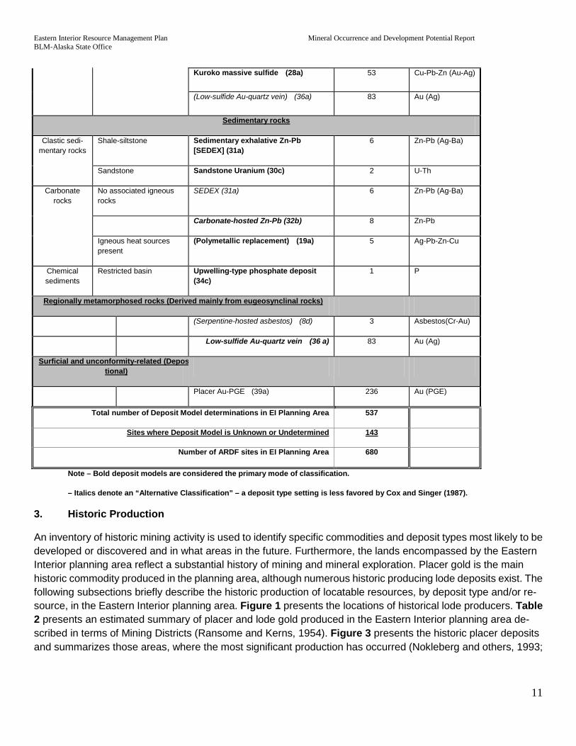
The authors of each ARDF open-file report assigns deposit models to most mineral occurrences where enough evidence is available to make a determination. Approximately 423 mineral sites in the Eastern Interior planning area have been assigned a deposit model in the ARDF database. An additional 113 sites lacking an ARDF-specified deposit model were assigned a practical model by the authors based on an evaluation of sup-plemental information available in the ARDF and other sources. A total of 143 ARDF mineral sites contained no explicit or practical deposit type information. Appendix A contains a copy of the complete descriptive text for each Cox and Singer model type occurring in the planning area. Table 1 presents a summary of the geological setting for those deposit model occurrences in the Planning area. Deposit Model occurrences in the Eastern Interior planning area are presented with the Locatable Mineral Potential Areas in Figure 4.

Eastern Interior Resource Management Plan Mineral Occurrence and Development Potential Report BLM-Alaska State Office
10
Table 1 – Cox and Singer (1986 and 1992) deposit model classifications for the Eastern Interior - Planning Area.
Lithotectonic/Lithologic setting Deposit model occurring in EI Plan-ning Area (see note)
No. of ARDF sites Associated commodities
Mafic and ultramafic intrusions
Tectonically unstable areas
Ophiolites Major podiform chromite (8b) 1 Cr-(Ni)
Listwaenite Au 4 Au
Alaskan PGE (9) 1 Pt (PGE)
(Placer Au-PGE) (39a) 236 Au-PGE
Serpentine Serpentine-hosted asbestos (8d) 3 Asbestos(Cr-Au)
(Low-sulfide Au-quartz vein) (36a) 83 Au (Ag)
Felsic Intrusives
Mainly phanero-crystalline textures
Wallrocks are calcareous W skarn (14a) 22 W
Sn skarn (14b) 1 Sn (U-Be-F)
Other wallrocks Sn greisen (15c) 2 Sn (F-Be)
Porphy-ro-aphanitic intrusions present
Deposits near contact Zn-Pb skarn (18c) 2 Ag-Pb-Zn (Cu)
Fe skarn (18d) 1 Fe, Cu
Cu skarn (18b) 12 Cu (Au)
Deposits far from contact Polymetallic replacement (19a) 5 Ag-Pb-Zn-Cu
Deposits within intrusions Porphyry Cu-Mo (21a) 16 Cu-Mo
Mesothermal Plutonic Related Gold (N/A)
9 Au
Porphyry Cu-Au (20c) 1 Au
Porphyry Mo, low-F (21b) 6 Mo-Pb-Zn
Deposits within wallrocks Polymetallic veins (22c) 39 Au-Ag-Pb-Cu-Zn
(Low-sulfide Au-quartz vein) (36a) 83 Au (Ag)
Extrusive rocks
Felsic-mafic extrusive rocks
Deposits in older clastic sedimentary rocks
Simple Sb (27d) 8 Sb (Au)
Deposits in felsic to intermediate volcantic rocks
Comstock epithermal veins (model 25c)
9 Au (Ag)
Marine Cyprus massive sulfide (24a) 2 Cu-Zn
Eastern Interior Resource Management Plan Mineral Occurrence and Development Potential Report BLM-Alaska State Office
11
Kuroko massive sulfide (28a) 53 Cu-Pb-Zn (Au-Ag)
(Low-sulfide Au-quartz vein) (36a) 83 Au (Ag)
Sedimentary rocks
Clastic sedi-mentary rocks
Shale-siltstone Sedimentary exhalative Zn-Pb [SEDEX] (31a)
6 Zn-Pb (Ag-Ba)
Sandstone Sandstone Uranium (30c) 2 U-Th
Carbonate rocks
No associated igneous rocks
SEDEX (31a) 6 Zn-Pb (Ag-Ba)
Carbonate-hosted Zn-Pb (32b) 8 Zn-Pb
Igneous heat sources present
(Polymetallic replacement) (19a) 5 Ag-Pb-Zn-Cu
Chemical sediments
Restricted basin Upwelling-type phosphate deposit (34c)
1 P
Regionally metamorphosed rocks (Derived mainly from eugeosynclinal rocks)
(Serpentine-hosted asbestos) (8d) 3 Asbestos(Cr-Au)
Low-sulfide Au-quartz vein (36 a) 83 Au (Ag)
Surficial and unconformity-related (Depostional)
Placer Au-PGE (39a) 236 Au (PGE)
Total number of Deposit Model determinations in EI Planning Area 537
Sites where Deposit Model is Unknown or Undetermined 143
Number of ARDF sites in EI Planning Area 680
Note – Bold deposit models are considered the primary mode of classification.
– Italics denote an “Alternative Classification” – a deposit type setting is less favored by Cox and Singer (1987).
3. Historic Production
An inventory of historic mining activity is used to identify specific commodities and deposit types most likely to be developed or discovered and in what areas in the future. Furthermore, the lands encompassed by the Eastern Interior planning area reflect a substantial history of mining and mineral exploration. Placer gold is the main historic commodity produced in the planning area, although numerous historic producing lode deposits exist. The following subsections briefly describe the historic production of locatable resources, by deposit type and/or re-source, in the Eastern Interior planning area. Figure 1 presents the locations of historical lode producers. Table 2 presents an estimated summary of placer and lode gold produced in the Eastern Interior planning area de-scribed in terms of Mining Districts (Ransome and Kerns, 1954). Figure 3 presents the historic placer deposits and summarizes those areas, where the most significant production has occurred (Nokleberg and others, 1993;

Eastern Interior Resource Management Plan Mineral Occurrence and Development Potential Report BLM-Alaska State Office
12
and USGS, 2008A). Table 3 presents a summary of historic lode producers based on a query of the ARDF database (USGS, 2008A).
Placer Gold: The first significant discovery of gold in the planning area and in Alaska was in 1887 on Franklin Creek, a tributary to the Fortymile River. Gold has been mined in the region continually ever since. The ARDF database contains information on 236 placer gold occurrences existing in the Eastern Interior planning area. This report considers all placer occurrences to be at least past producers. In its 2007 Mineral Industry Report, the DGGS lists 101 separate companies or individuals as producing gold in the planning area (Szumigala and oth-ers, 2010).
Table 2. Ounces of gold produced in the EI Planning Area by mining district, through 2009.
District1 Total gold produced in EI Plan-ning Area2 Placer Gold Lode Gold Placer gold
since 20015 Lode gold
since 20015 Rampart3 0 N/A N/A N/A N/A Tolovana 530,233 530,233 0 767 0
Yukon Flats 0 0 0 0 0 Circle 1,097,134 1,097,134 0 38,691 0
Black 2 2 0 2 0 Eagle 52,121 52,121 0 121 0
Fortymile 573,027 573,027 0 26,593 0 Chisana3 0 N/A N/A N/A N/A
Tok 280 280 0 0 0 Goodpaster 1,112,561 2,050 1,110,511 0 1,110,511 Fairbanks4 9,387,708 7,946,562 4,321,592 31,117 2,144,147 Delta River 8,270 8,270 0 0 0
Sheenjak 0 0 0 0 0
Total 11,525,626 10,757,820 4,763,876 195,778 2,517,331 1 District boundaries established by Ransome and Kerns, 1954. 2 Source: Szumigala (2010). 3 Gold produced in the Rampart and Chisana Districts was out of the EI Planning Area. 4 Production includes gold produced in the Richardson Subdistrict of the Fairbanks Mining District. 5 2001 production data from Swainbank and others (2002).
The EI Planning Area includes all or portions or all of the 13 mining districts, as established by Ransome and Kerns (1954). Circle, Tolovana, Eagle, Fortymile and Fairbanks districts are classified as major gold producing districts, with Fairbanks the largest producer in Alaska (Nokleberg, 1993).
The Eastern Interior planning area boundary bisects the Fairbanks mining district, segregating the mining around Ester and half of the dredged areas on Goldstream Creek. The Fairbanks mining district produced a total of 13 million troy ounces of gold from 8.3 million placer and 4.7 million hard rock sources (including the Richardson Subdistrict). About 11.2 million ounces of gold is produced in the planning area, with rough estimates that half of the placer gold produced in the Fairbanks district is within the Eastern Interior planning area boundary and the entire results of lode gold. As of 2007, the Tolovana, Eagle, Fortymile and Circle mining districts contribute a combined total of about 1.7 million ounces of gold.
Low-sulfide Au-quartz veins (model 36a: 83 occurrences): The ARDF database has 29 quartz veins that were past producers of gold in the Eastern Interior planning area. The Cleary Hill/Summit, Henry Ford, and
Eastern Interior Resource Management Plan Mineral Occurrence and Development Potential Report BLM-Alaska State Office
13
McCarty Shaft mines were the largest producers of quartz vein deposit types – all located in the Fairbanks mining district. Cleary Hill (ARDF# LG119) produced an estimated 100,000 fine ounces of gold since the early 1900’s when it was first mined, and may yet contain an additional 100,000 ounces of gold in steeply dipping high-grade quartz veins. The McCarty Shaft (ARDF# LG150) and the Henry Ford Mine (ARDF # LG153) were both mines on the McCarty/American Eagle vein system just east of Cleary Hill. These mines were assigned a Low-Sulfide Au-quartz vein model when one was not listed in the ARDF database, although a polymetallic vein (model 22c) description may be well-suited. The ore from these mines consisted of native gold in quartz and arsenopyrite (FeAsS) veins within a northeast striking shear and vein system.
Fort Knox porphyry gold (1 occurrence): The Fort Knox Mine (ARDF# LG115) has been the largest producer of gold in Alaska since its commissioning in 1996. As of the end of 2006, Fort Knox had produced 2.7 million ounces of gold from a low sulfide granodiorite/quartz monzonite pluton (Szumigala, 2008). An additional 1.3 million ounces of measured and indicated gold reserves remain at the mine, in ore grading 0.018 oz/ton, with mining expected to continue through 2014. There is no Cox and Singer model for the Fort Knox model. The deposit is best described by an excerpt from Quandt and others, 2008):
The Fort Knox gold deposit is hosted by a granitic body that intruded the Fairbanks Schist. The surface exposure of the intrusive body is approximately 1,100 meters in the east-west direction and 600 meters north-south. Gold occurs in and along the margins of pegmatite veins, quartz stockwork veins and veinlets, quartz-veined shear zones, and fractures within the granite. The stockwork veins strike predominantly east and dip randomly. Stockwork vein density decreases with depth. Shear zones generally strike northwest and dip moderately to the southwest. Gold mineralization in the quartz-filled shears is distributed relatively evenly, and individual gold grains are generally less than 100 microns in size. The gold occurrences have a markedly low (less than 0.10%) sulphide content.
Polymetallic Veins (Cox and Singer deposit model #22c: 39 occurrences): There were 14 mines – all in the southeast corner of the Livengood quadrangle northeast of Fairbanks – that produced gold from polymetallic veins. The largest producer was the Hi-Yu (ARDF# LG182) that produced over 22,000 ounces of gold in the 1930’s and an unknown amount of gold earlier in the last century. These historic mines typically exploited narrow (a few inches to a few feet wide) high-grade gold and sulfide-bearing quartz veins.
Simple Antimony (Cox and Singer deposit model #27d: 8 occurrences): Four mines in the Eastern Interior planning area produced antimony (Sb) from small stibnite (Sb2S3) deposits. This includes the Hindenberg mine on what is now the True North deposit. During World War II, 200 tons of stibnite ore was mined at grading 38% Sb. Production from the other mines was small or consisted of bulk samples.
Tungsten (W) Skarns (Cox and Singer deposit model #14a: 22 occurrences): Two mines near Gilmore Dome northeast of Fairbanks produced scheelite (CaWO4) ore from contact of metamorphic rocks. The Yellow Pup mine (ARDF# FB118), a shallow surface mine, produced a small amount of ore from carbonaceous schist. The Stepovich mine (ARDF# FB13) produced about 300 tons of ore from crystalline marble in contact with quartz pegmatite from 1915 through 1956.
Polymetallic Replacement (Cox and Singer model #19a: 5 occurrences): Cheechako No. 1 mine (ARDF# LG107) produced 1,083 ounces of silver and 3.67 tons of lead from 24 tons of galena, chalcopyrite, stibnite, and sphalerite ore. The ore was mined in 1916. In 1980, Cheechako mine produced 186 dry tons of ore of unknown grade and shipped it to a smelter, but there are no current reports of production.

Eastern Interior Resource Management Plan Mineral Occurrence and Development Potential Report BLM-Alaska State Office
14
Comstock epithermal veins (model #25c: 1 occurrence): The only significant lode mine in the Fortymile Mining District was the Purdy mine (ARDF# EA121) a few miles north of Chicken, Alaska. The Purdy deposit was high grade, but small and quickly mined out.
Shear-hosted, plutonic-related mesothermal Au-quartz veins (1 occurrence.) The Pogo mine (ARDF# BD033) consists of several high-grade stacked shallow-dipping low-sulfide free gold bearing quartz veins in gneiss. From 2006 when mining began at Pogo, through 2009, the mine produced 1.1 million ounces of gold (Szumigala and others, 2008). Pogo has 3.7 million ounces still in reserves as mining continues.
Plutonic-related gold [(USGS, 2008a): 8 occurrences]: At the Democrat Lode, Richardson Subdistrict, Fair-banks Mining District, a highly-altered sulfide-bearing rhyolite was mined sporadically, but development ceased in recent years. Discovered in 1913, the site is now an open cut about 900 feet long that has had several phases of mining, including a 100,000 ton bulk sample mined at the Democrat Lode in 1998. It is unknown how much gold was recovered. This deposit type does not have a Cox and Singer model, but McCoy and others describe it well in the Mineral Deposits of Alaska Monograph 9 (1997).
Thorium-Rare-Earth veins [model #11d (USGS, 1991)]: One occurrence. At the Roy Creek intrusive REE, thorium and uranium minerals are in veins within a syenite pluton. It is believed there are smaller syenite intru-sives east of the Roy Creek pluton that are genetically related to the main body. These veins were sampled and drilled in the late 1970’s and early 1980’s. Recent forecasts of world-wide shortages in REE supplies have in-creased industry interest in REE deposits. This deposit model is used as the nearest comparison to the Roy Creek deposit.
Table 3 – Historic Lode Producers, Eastern Interior Planning Area
Name Quadrangle ARDF # Deposit type1 Commodity2 Production3
Blue Lead; Blue Lead Ex-tension Big Delta BD003 Low-sulfide Au-quartz veins (36a) Au Small
Democrat Lode; John Mitchell Lode Big Delta BD014 Plutonic Related Au (USGS, 2008) Au Small
Gray Lead Big Delta BD017 ? Au Small Grizzly Bear; Yellow Jacket Big Delta BD018 Low-sulfide Au-quartz veins (36a) Au Small Michigan Lode; Michigan
Lead Big Delta BD025 Low-sulfide Au-quartz veins (36a) Au Small
Molly Creek; My Creek Eagle EA100 Simple Sb (27d) Sb Small Purdy Eagle EA121 Comstock epithermal veins (25c) Ag, Au, Cu Small
Stepovich Fairbanks FB113 W skarn deposit (14a) W Small
Voght; Melba Creek; Monte Cristo; Granite Hill Fairbanks FB116 ? Au Small
Yellow Pup Fairbanks FB118 W skarn deposit (14a) W Small
American; American Eagle; Perrault; Perrault and
Murphy
Fairbanks FB120 Low-sulfide Au-quartz veins (36a) Au Small
Brumfield Fairbanks FB154 Low-sulfide Au-quartz veins (36a) Au Small Hudson; Sunshine No. 2 Livengood LG015 ? Hg Small
Unnamed (Livengood Creek)
Livengood LG022 Simple Sb (27d) Sb Small
Gilmer Livengood LG046 ? Sb Small Frederich Livengood LG047 ? Au Small

Eastern Interior Resource Management Plan Mineral Occurrence and Development Potential Report BLM-Alaska State Office
15
Name Quadrangle ARDF # Deposit type1 Commodity2 Production3 Soo; Spaulding; Wild Rose; Chief; Waterbury; Waverly;
Inspiration; Carnation
Livengood LG052 Polymetallic veins (22c) Au Small
Hindenburg; Markovich Livengood LG054 Simple Sb (27d) Sb Small
Silver Fox; Silvertone; Busty Belle Livengood LG062 ? Ag Small
Burnet Livengood LG074 Low-sulfide Au-quartz veins (36a) Au Small Independence Livengood LG075 Low-sulfide Au-quartz veins (36a) Au Small
David Livengood LG078 Low-sulfide Au-quartz veins (36a) Au Small North Star Extension Livengood LG081 ? Au Small Whitman & Murray Livengood LG083 Low-sulfide Au-quartz veins (36a) Au Small
Rainbow Livengood LG084 Polymetallic veins (22c) Au Small Hirschberger and Zim-
merman Livengood LG087 Low-sulfide Au-quartz veins (36a) Au Small
White Elephant Livengood LG088 Polymetallic Replacement Depos-its (19a)
Ag Small
Wackwitz; Silver King; Little Jim
Livengood LG090 ? Ag, Pb, Sb Small
Emma; Overgard; Kathrine Livengood LG093 Polymetallic veins (22c) Au Small Robinson; Mohawk; Frank-
lin; Rose; Heilig and Creighton
Livengood LG095 Polymetallic veins (22c) Au Small
Hidden Treasure Livengood LG098 Low-sulfide Au-quartz veins (36a) Au Small Newsboy Livengood LG100 Low-sulfide Au-quartz veins (36a) Au Small
RV Livengood LG101 Low-sulfide Au-quartz veins (36a) Au Small Cheechako No. 1; Eldora-
do; Westonvitch Livengood LG107 Polymetallic Replacement Depos-
its (19a) Au Small
Tolovana Livengood LG110 ? Au Small Stepovich #1 Livengood LG115 Low-sulfide Au-quartz veins (36a) Au Small
Bedrock Creek Livengood LG116 Low-sulfide Au-quartz veins (36a) Au Small Wyoming Livengood LG118 Low-sulfide Au-quartz veins (36a) Au Small
IXL Livengood LG126 Low-sulfide Au-quartz veins (36a) Au Small Scott Reese; Rex Livengood LG127 Low-sulfide Au-quartz veins (36a) Au Small
Blue Moon Mazeppa; Pio-neer; Blue Bell
Livengood LG128 ? Au Small
Foster Hungerford; Empire; Alaska Group
Livengood LG140 Low-sulfide Au-quartz veins (36a) Au Small
Alaska; Gladstone; Jupi-ter-Mars; Grace E#2?
Livengood LG141 Polymetallic veins (22c) Au Small
Empire Livengood LG142 Low-sulfide Au-quartz veins (36a) Au Small Quemboe Bros. Livengood LG144 Low-sulfide Au-quartz veins (36a) Au Small
Harris and Brown; Sky High; Grace E#1
Livengood LG145 Polymetallic veins (22c) Au Small
Christina; Vetter; Shelden Livengood LG146 Low-sulfide Au-quartz veins ( 36a) Au Small
Chatham Livengood LG147 Polymetallic veins (22c) Au Small McCarty Livengood LG152 Polymetallic veins (22c) Au Small Pioneer Livengood LG155 ? Au Small
Pennsylvania Livengood LG156 ? Au Small Rexall Livengood LG159 Low-sulfide Au-quartz veins (36a) Au Small
Ohio; Early Bird; Mayflow-er; Connors and Stevens Livengood LG165 Low-sulfide Au-quartz veins (36a) Au Small
Whitehorse Livengood LG170 Low-sulfide Au-quartz veins (36a) Au Small
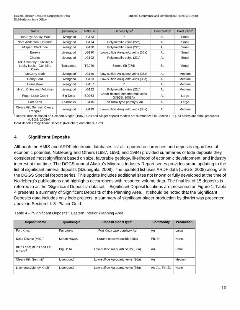
Eastern Interior Resource Management Plan Mineral Occurrence and Development Potential Report BLM-Alaska State Office
16
Name Quadrangle ARDF # Deposit type1 Commodity2 Production3
Rob Roy; Saucy; Wolf Livengood LG173 ? Au Small Nars Anderson; Dorando Livengood LG174 Polymetallic veins (22c) Au Small
Mizpah; Black Joe Livengood LG180 Polymetallic veins (22c) Au Small Eureka Livengood LG190 Low-sulfide Au-quartz veins (36a) Au Small Charles Livengood LG192 Polymetallic veins (22c) Au Small
Tok Antimony; Stibnite; A Lucky Leak; Gamblin;
Caulk Tanacross TC029 Simple Sb (27d) Sb Small
McCarty shaft Livengood LG150 Low-sulfide Au-quartz veins (36a) Au Medium Henry Ford Livengood LG153 Low-sulfide Au-quartz veins (36a) Au Medium Homestake Livengood LG157 ? Au Medium
Hi-Yu; Crites and Feldman Livengood LG182 Polymetallic veins (22c) Au Medium
Pogo; Liese Creek Big Delta BD033 Shear-hosted Mesothermal veins (USGS, 2008A) Au Large
Fort Knox Fairbanks FB115 Fort Knox type porphyry Au Au Large
Cleary Hill; Summit; Cleary; Freegold Livengood LG119 Low-sulfide Au-quartz veins (36a) Au Medium
1 Deposit models based on Cox and Singer, (1987); Cox and Singer deposit models are summarized in Section III.2 ), all others are small producers (USGS, 2008A)
Bold denotes “Significant Deposit” (Nokleberg and others, 1993
4. Significant Deposits
Although the AMIS and ARDF electronic databases list all reported occurrences and deposits regardless of economic potential, Nokleberg and Others (1987, 1993, and 1994) provided summaries of lode deposits they considered most significant based on size, favorable geology, likelihood of economic development, and industry interest at that time. The DGGS annual Alaska’s Minerals Industry Report series provides some updating to the list of significant mineral deposits (Szumigala, 2008). The updated list uses ARDF data (USGS, 2008) along with the DGGS Special Report series. This update includes additional sites not known or fully developed at the time of Nokleberg’s publications and highlights occurrences with resource volume data. The final list of 15 deposits is referred to as the “Significant Deposits” data set. Significant Deposit locations are presented on Figure 1; Table 4 presents a summary of Significant Deposits of the Planning Area. It should be noted that the Significant Deposits data includes only lode projects; a summary of significant placer production by district was presented above in Section III. 3- Placer Gold.
Table 4 – “Significant Deposits”, Eastern Interior Planning Area
Deposit Name Quadrangle Deposit model type1 Commodity Production
Fort Knox2 Fairbanks Fort Knox type porphyry Au Au Large
Delta District (MID)2 Mount Hayes Kuroko massive sulfide (28a) Pb, Zn None
Blue Lead; Blue Lead Ex-tension2 Big Delta Low-sulfide Au-quartz veins (36a) Au Small
Cleary Hill; Summit3 Livengood Low-sulfide Au-quartz veins (36a) Au Medium
Livengood/Money Knob4 Livengood Low-sulfide Au-quartz veins (36a) As, Au, Fe, Sb None

Eastern Interior Resource Management Plan Mineral Occurrence and Development Potential Report BLM-Alaska State Office
17
Democrat; Mitchell Lode2 Big Delta Plutonic Related Au (No Model #) Au Small
Pogo; Liese Creek3 Big Delta Mesothermal Shear hosted Quartz veins Au Large
LWM4 Eagle Polymetallic Replacement Deposits (19a) Ag, Au, Hg, Pb, W, Zn None
Taurus2 Tanacross Porphyry Cu-Mo (21a) Cu, Mo None
Slate Creek Asbestos Eagle Serpentine-hosted asbestos (8d) Asbestos None
LMS4 Big Delta Undetermined Au None
Roy Creek (formerly Mt. Prindle)25 Livengood Thorium-REE veins (11d) REE, U None
True North3 Livengood Undetermined Au Large
Dolphin3 Livengood Undetermined Au None
Gil3 Livengood Undetermined Au None
1 Deposit models based on Cox and Singer (1987). 2 Based on descriptions from Nokleberg et al (1993) 3 Based on descriptions from Szumigala et al, Special Report 62 (2008) 4 Based on descriptions from USGS Open-File Report 2008-1225 (Grybeck, 2008) 5 Located on BLM managed lands Significant Deposit locations are presented on Figure 1 and Table 4 presents a summary of Significant Deposits of the planning area. The Significant Deposits data includes only lode projects (see Section III—Placer Gold for a summary of significant placer production by district).
5. Mining Claims
Statewide mining claim locations are available electronically from BLM-Alaska (federal) and DNR (state). Mining claim activities show industry interest in a region or locality to delineate areas of high-mineral occurrence and development potential. Federal and state claims are shown on Figure 2. Table 5 presents a summary of current claim activity coincident to the Eastern Interior planning area.
Federal Mining Claims
Federal mining claim locations generally indicate a level of mineral potential and exploration known prior to 1971. Due to ANCSA 17(d)(1) and ANILCA land withdrawals, there has been no opportunity to stake federal mining claims on most–if not all–BLM-managed lands within the Eastern Interior planning area since that time.
The BLM has maintained an electronic record of federal mining claim locations since 1999. Before 1999, agen-cies kept the outlines of federal mining claims on paper maps. Many mining claims locations staked before emplacement of withdrawals but closed before 1999 have not been tracked, as they were never converted to electronic formats. Although these mining claims closed for various reasons, they endow some level of mineral development potential because they represent the mining-related activity before the withdrawals. These claims may show areas of activity if withdrawals were lifted.
Closure of mining claims may have resulted from low gold prices, failing to make annual filings, or transfers. Some federal claims converted to state claims when conveyances occurred. Other claims were transferred to

Eastern Interior Resource Management Plan Mineral Occurrence and Development Potential Report BLM-Alaska State Office
18
Native Corporations, by the claim owner through a mineral patent, or declared invalid through a mineral exam-ination.
BLM’s Alaska Land Information System (ALIS) electronic database contains all BLM-Alaska records related to federal lands and all transactions related to them. A query of ALIS from 1979 to 1999 before mining claim loca-tions were tracked on digital maps, show that there were 6,212 placer and 8,866 lode claims within the planning area. ALIS contains the section, township, and range from the Public Land Survey System (PLSS) for each mining claim. All of the closed mining claims from 1979 to 1999 can be mapped to at least the nearest square-mile section, if not the nearest quarter-section, from the recorded PLSS location information.
If federal claims on BLM-managed public lands withdrawn in the 1970’s are isolated, ALIS shows at one time there were 6,713 federal claims on BLM-managed lands. There are now 910 federal mining claims in the plan-ning area, with 797 of those outside of National Park lands. Most BLM lands within the Eastern Interior planning area were closed since the early 1970’s. ALIS closed mining claim records were used to refine mineral potential boundaries.
State Mining Claims
Some federal mining claims are, at least partially, covered (over-staked) by later state mining claim activity on State-selected and dually State- and Native-selected lands. In the final conveyance, some of these dually claimed parcels will not remain under federal ownership if they are converted to State claims.
There are two types of state mining leaseholds generally termed a “claim”: (1) The 40-acre mining claim and (2) the 160-acre prospecting site. A legal mining claim is located (staked) to acquire the locatable mineral rights in an area.
A mining claim necessitates the prior discovery of locatable minerals within the claimed area. A prospecting site grants the owner an exclusive right to explore a parcel up to 160 acres of State land. During a prospecting sites’ two-year term, owners have an exclusive right to record mining claims or leasehold locations within the bound-aries of the site. The main difference between the prospecting site and a mining claim is that no legal “discovery” is necessary for locating a prospecting site.
Table 5 - Mining Claims and Prospecting Sites, Eastern Interior Planning Area
Type Acres claimed1 No. of individual claims2 No. of unique owners3
Federal mining claims (un-patented) outside National
Parks 21,200 797 81 names
State prospecting sites 1,500 14 6 names
State mining leases 12,700 26 14 names
State mining claims 1,250,500 16,062 437 names
State claims Total 1,264,700 16,169 457 names
Grand Total 1,285,900 17,107 538 names
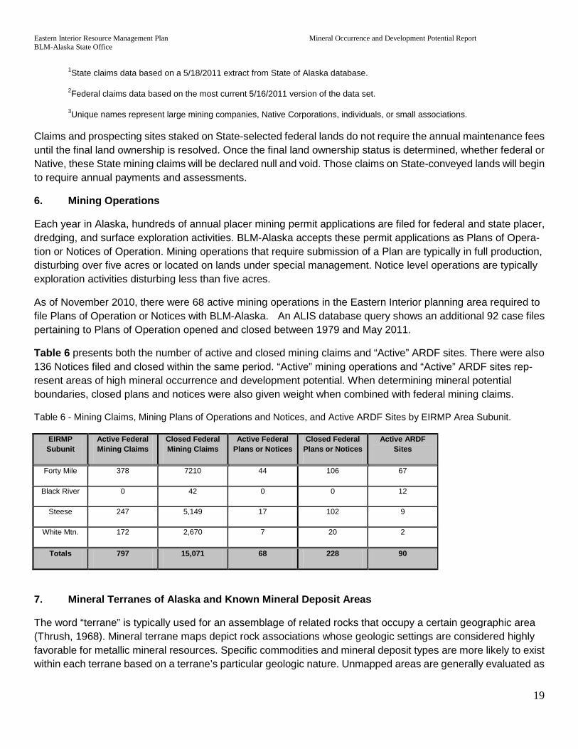
Eastern Interior Resource Management Plan Mineral Occurrence and Development Potential Report BLM-Alaska State Office
19
1State claims data based on a 5/18/2011 extract from State of Alaska database.
2Federal claims data based on the most current 5/16/2011 version of the data set.
3Unique names represent large mining companies, Native Corporations, individuals, or small associations.
Claims and prospecting sites staked on State-selected federal lands do not require the annual maintenance fees until the final land ownership is resolved. Once the final land ownership status is determined, whether federal or Native, these State mining claims will be declared null and void. Those claims on State-conveyed lands will begin to require annual payments and assessments.
6. Mining Operations
Each year in Alaska, hundreds of annual placer mining permit applications are filed for federal and state placer, dredging, and surface exploration activities. BLM-Alaska accepts these permit applications as Plans of Opera-tion or Notices of Operation. Mining operations that require submission of a Plan are typically in full production, disturbing over five acres or located on lands under special management. Notice level operations are typically exploration activities disturbing less than five acres.
As of November 2010, there were 68 active mining operations in the Eastern Interior planning area required to file Plans of Operation or Notices with BLM-Alaska. An ALIS database query shows an additional 92 case files pertaining to Plans of Operation opened and closed between 1979 and May 2011.
Table 6 presents both the number of active and closed mining claims and “Active” ARDF sites. There were also 136 Notices filed and closed within the same period. “Active” mining operations and “Active” ARDF sites rep-resent areas of high mineral occurrence and development potential. When determining mineral potential boundaries, closed plans and notices were also given weight when combined with federal mining claims.
Table 6 - Mining Claims, Mining Plans of Operations and Notices, and Active ARDF Sites by EIRMP Area Subunit.
EIRMP Subunit
Active Federal Mining Claims
Closed Federal Mining Claims
Active Federal Plans or Notices
Closed Federal Plans or Notices
Active ARDF Sites
Forty Mile 378 7210 44 106 67
Black River 0 42 0 0 12
Steese 247 5,149 17 102 9
White Mtn. 172 2,670 7 20 2
Totals 797 15,071 68 228 90
7. Mineral Terranes of Alaska and Known Mineral Deposit Areas
The word “terrane” is typically used for an assemblage of related rocks that occupy a certain geographic area (Thrush, 1968). Mineral terrane maps depict rock associations whose geologic settings are considered highly favorable for metallic mineral resources. Specific commodities and mineral deposit types are more likely to exist within each terrane based on a terrane’s particular geologic nature. Unmapped areas are generally evaluated as

Eastern Interior Resource Management Plan Mineral Occurrence and Development Potential Report BLM-Alaska State Office
20
“poor to only moderate” mineral potential. The USBM originally described and mapped Mineral Terranes of Alaska (MTA), which was subsequently revised and published several times by the Arctic Environmental In-formation and Data Center (AEIDC) (1979); Hawley and AEIDC (1982); Resource Data, Inc. and others, (1995); and Szumigala and others (1999). Table 7 and Figure 5 describe the MTAs identified in the Eastern Interior planning area.
Mineral deposit types are categorized by formation process and rock type. Syngenetic mineral deposits form about the same time as the rocks they are encased in, while epigenetic deposits form by metamorphic or hy-drothermal alteration processes following host rock deposition (AEIDC, 1979). Further subdivisions of mineral terranes into rock types recognize that certain kinds of minerals are associated with certain kinds of host rocks. For example, the metallic elements copper, nickel, chromium, and the nonmetallic mineral asbestos are typically associated with mafic igneous rocks or gabbro; while copper and zinc are typically associated with layered submarine volcanic rocks and sulfide-rich sediments, referred to as volcanogenic massive sulfide (VMS) de-posits (AEIDC, 1979; Hawley and AEIDC, 1982).
Known Mineral Deposit Areas (KMDAs) are described as a management tool to determine the likelihood of future discoveries in a particular area (RDI and others, 1995). These area features are based on a high concentration of historic mines and prospects, mineral occurrences in the AMIS database, and favorable geologic trends de-termined by MTA mapping. KMDAs have a high concentration of mineral occurrences of a single type, sug-gesting an increased likelihood of hosting significant mineral deposits compared to other areas. The KMDA Deposit sites include those labeled as Significant Deposits in this report, except for several newer deposits (see Section 4). The most recent version of KMDA data is electronically available with the MTA (RDI and others, 1995). Figure 5 shows KMDAs in the Eastern Interior planning area.

Eastern Interior Resource Management Plan Mineral Occurrence and Development Potential Report BLM-Alaska State Office
21
Table 7 - Mineral Terranes of Alaska (MTA) Units Eastern Interior Planning Area
Map unit (% of EI Planning Area cov-
ered) Rock type Favorable commodities
SYNGENETIC DEPOSITS Intrusive Terranes
IGA (0.2%) ALKALIC GRANITIC ROCKS – syenite, and locally per-alkaline granite and monzonite.
Favorable for deposits of uranium and REE1.
IGF (2.1%) FELSIC GRANITIC ROCKS – granite and quartz monzo-nite.
Favorable for deposits of tin, tungsten, molybdenum, uranium, and thorium.
IGI (1.1%) INTERMEDIATE GRANITIC ROCKS – granodiorite and quartz diorite.
Favorable for deposits of copper, gold, and molybdenum.
IGU (8.8%) UNDIVIDED GRANITIC ROCKS – granite. Favorable for deposits of the three above groups.
Mafic-ultramafic Rocks
IUM (0.3%) ULTRAMAFIC ROCKS – peridotite and dunite. Favorable for deposits of chromium, nickel, and PGE2, with by-product cobalt.
IMA (0.10.2%) MAFIC INTRUSIVE ROCKS – gabbro, and locally mafic-rich intermediate rocks such as mafic monzonite and diorite.
Favorable for deposits of copper and nickel, with by-product platinum and cobalt.
Volcanic – Sedimentary Terranes
VFU (1.4%) FELSIC VOLCANIC ROCKS, UNDIVIDED – rhyolite and quartz latite.
Favorable for deposits of copper, lead, and zinc, with by-product silver and gold.
VSF (2.8%) SEDIMENTARY AND FELSIC VOLCANIC ROCKS, UN-DIVIDED – rhyolite, quartz latite, and associated sedi-ments.
Favorable for deposits of copper, lead, and zinc, with by-product silver and gold.
Mafic Volcanic Rocks
VSM (3.3%) SEDIMENTARY AND MAFIC VOLCANIC ROCKS, UN-DIVIDED – basalt and associated sediments.
Favorable for deposits of copper and zinc, with by-product silver and gold.
VOP (4.2%) OPHIOLITIC TERRANE – pillow basalt and associated mafic and ultramafic intrusives with minor chert and other pelagic sediments.
Favorable for deposits of copper, nickel, and chromium, with by-product PGE2 and gold.
Sedimentary Terranes- Marine rocks
SLS (4.8%) LIMESTONE AND SHALE – limestone and dolomite with interbedded shale.
Favorable for deposits of copper, lead, and zinc.
SBS (5.4%) BLACK, CARBONACEOUS SHALE AND LIMESTONE – limestone, dolomite, black shale, and chert.
Favorable for deposits of zinc, lead, and barium, with by-product silver.
Sources: AEIDC (1979); Hawley and AEIDC (1982); RDI and others (1995)
1REE = rare earth elements (e.g., lanthanum, cerium, neodymium)
2PGE = platinum group elements (e.g., platinum, palladium, iridium)
The KMDA area information includes two subsets of site-specific data. The first subset shows 149 specific de-posits considered significant in the Eastern Interior planning area -- this set of specific deposits are “KMDA Deposits.” The KMDA Deposits data represents a derivative of the AMIS data. Where AMIS includes all docu-mented mineral occurrences regardless of significance, KMDA Deposits represent sites with noteworthy ex-ploration or development histories and some indications of resource potential. The second subset from the KMDA data is “KMDA Placer Commodities” that highlights the most significant stream courses for placer pro-duction. Forty-three separate stream portions comprise the planning area’s KMDA Placer Commodities subset.
8. Undiscovered Mineral Occurrence Potential

Eastern Interior Resource Management Plan Mineral Occurrence and Development Potential Report BLM-Alaska State Office
22
USGS Circular 1178 discusses Undiscovered Mineral Occurrence Potential, specifically gold, silver, copper, lead, and zinc (USGS, 1998). Summary information from the circular did not affect the mineral potential ranking contained in this report. However, the circular’s list of important mineral deposits was reviewed for consistency with those described in Section III.A.4, Significant Deposits.
9. Mineral Resource Reports
The DGGS, USBM, BLM, and USGS conducted a number of investigations specific to mining districts and specific deposit localities over the past few decades. In the early 1970’s DGGS mapped and described mineral deposits, metalliferous provinces, and mining activity throughout the state (Selkregg, 1974a). The USBM and BLM have conducted mining district and site-specific studies throughout Alaska. The USGS has conducted numerous Alaska Mineral Resource Assessment Program (AMRAP) and other geologic studies throughout Alaska. The following discusses the most significant mineral resource reports.
White Mountain Area Mineral Resource Potential
Of particular interest to this mineral potential assessment are the mineral and geological resource assessments of the White Mountain National Recreation Area ((NRA) after ANILCA mandated the appraisal of minerals before adopting the final management plans for the respective areas in 1980 (Smith and Wiltse, 1987). The DGGS, USGS, and USBM divided up the White Mountains NRA; with each agency studying, sampling, and assessing the mineral potential for their assigned areas. These study results are emphasized because they identify mineral potential in areas closed to mineral development activities for over 30 years.
The USGS sampled and mapped the balance of the White Mountains NRA that the DGGS did not study. The USGS concluded their field studies with probabilistic estimates of undiscovered mineral deposits. Their general conclusion was that undiscovered mineral potential was low with the exception of placer gold (in the Nome Creek drainages), tin-greisen deposits (Cache Mountain pluton), thorium, and rare earth elements (REE) veins (Roy Creek pluton). The USGS identified other mineral deposit models as potential for occurring in the study area, but these four with the highest probability for development were used in this assessment.
In addition to these deposits, the USGS sampled and identified the Tolovana Limestone formation as an enormous potential resource for high-quality limestone. Tolovana Limestone makes up the core of the “White Mountains.” Their random samples of the formation, averaging 98.6 percent calcium carbonate, rank it among the highest quality limestone in the United States. The results infer there is at least 8 billion tons of high-quality limestone in the formation, but its remote location makes it uneconomical to mine.
The USBM investigated the placer resources of the White Mountains area (Fechner and Balen, 1988) and recommended three areas of high mineral development potential, including portions of Nome Creek and the upper portions of Beaver Creek. The DGGS studied Lime Peak and Mt. Prindle areas (Smith et al., 1987) and identified several areas of anomalous mineral potential. Like the USGS, DGGS ranked several tin-greisen bearing granite intrusives in their study area as having high lode deposit potential. Although identified as tin deposits, they may be more valuable for their silver, tantalum, and tungsten content. Much of the tin, silver, and tungsten potential are in six prospect areas in the Lime Peak pluton.The second area identified through proba-bilistic estimates as having potential are the small REE and Uranium bearing syenite intrusive in the southwest corner of their study area. These intrusive are likely related to the larger Roy Creek pluton immediately to the west. In attributing mineral potential in this study, the USGS and the DGGS identified resources are combined.

Eastern Interior Resource Management Plan Mineral Occurrence and Development Potential Report BLM-Alaska State Office
23
These reports all suggest a high probability of small gold bearing quartz veins coincident with the historic placer mining areas. There are many reports of thin gold bearing quartz veins throughout the historic placer districts in the Eastern Interior management area. High mineral potential boundaries are often extended to the headwaters of placer bearing streams and bench gravels to reflect the potential for development of the lode source of the respective placers.
Other Mineral Resource Reports
For more than 20 years as part of its “Special Report” series, DGGS has produced a series of annual reports documenting the status of exploration, development, and production for the Alaska mining industry (Bundtzen and others, 1986 and Szumigala and others, 2008). In addition to documenting significant past activities, these annual reports provide an update of current mineral resource development and production activities. “Selected significant mineral deposits and mineral districts in Alaska” are summarized as an Appendix in the more recent Special Report volumes, with current resource figures provided where available.
Mineral Deposits of Alaska (Goldfarb and Miller, 1997) presents an overview of Alaska’s mineral deposits through a series of 15 separate papers. These papers focus on describing general deposit types or commodity assemblages that occur in the state. Deposit-specific information available for the state’s most significant de-posits is also summarized, often providing resource tonnages and grades complete with citations.
10. Strategic and Critical Minerals
Certain mineral commodities have been termed “strategic” or “critical” by the U.S. Government. Strategic minerals are those that are essential to national defense, for which we are mostly dependent on foreign sources for during war, and for which strict measures controlling conservation and distribution are necessary. Critical minerals are also essential to national defense, but their procurement during war is less serious because they are either produced domestically or can be obtained through more reliable foreign sources (Thrush, 1968).
Bundtzen and others (1980 and 1982) summarize significant sources and reserves of strategic and critical minerals in Alaska. In addition, the AMIS database (through its precursor MAS/MILS) was initially developed as a systematic assessment of strategic and critical minerals. Of the 17 strategic minerals known to occur in Alaska, 10 have been identified within the Eastern Interior planning area; four of the seven critical minerals found in significant concentrations in Alaska also exist within the planning area. Table 8 presents a summary of planning area strategic and critical mineral occurrences, based mainly on primary commodities related to ARDF sites.
Table 8 – Strategic and Critical Mineral Occurrences, EIRMP
Commodity Strategic/ Criti-cal
No. of occur-rences
Major deposits1
Antimony Strategic 18 Molly Creek (EA100), Gilmer (EA046), Hindenberg (LG054)
Asbestos Strategic 3 Slate Creek (EA043)
Chromium Strategic 6 Parker (LG026)
Fluorine Strategic 1 Hope Creek (CI078)
Mercury Strategic 6 Hudson (LG015), near Amy Dome (LG025)

Eastern Interior Resource Management Plan Mineral Occurrence and Development Potential Report BLM-Alaska State Office
24
Nickel Strategic 1 Fox Creek (FB086)
Platinum Group
Strategic 1 American Creek (EA054), Woodchopper Creek (CY038)
Rare Earth Strategic 3 Hot Springs Creek (CI027), Roy Creek REE (No ARDF #)
Tin Strategic 9 Ketchum Dome (CI032), Lime Peak Pluton (CI079)
Tungsten Strategic 37 Stepovich (FB113), Yellow Pup (FB118) Cleary Creek (LG135)
Barium Critical 4 CC Barite (MH348)
Gold Critical 458 Fort Knox (FB115), Pogo (BD033)
Silver Critical 61 Silver Fox (LG062), White Elephant (LG088)
Zinc Critical 61 Hi-Yu (LG182)
1Significant Deposits (Nokleberg and Others, 1993) underlined.
B. Salable Minerals
The local demand in the Eastern Interior planning area for salable minerals, also called mineral materials, is generally met by producers located on private lands. The primary mineral material commodity is sand and gravel used in construction and road maintenance. The ARDF database does not evaluate mineral materials, but the AMIS database lists 20 sites as producing sand and gravel, or stone. The twelve sand and gravel sites are along major highways and provided sites for road construction. The eight sites listed in AMIS as “stone” occurrences are most likely also used for construction material.
Mineral Materials production has gradually decreased since construction of the Trans-Alaska Pipeline System. DGGS surveys sand, gravel, and stone production and reports results in the annual Alaska Mineral Industry reports. From 1967 to 1986, the state produced an average of 40 million tons per year of sand and gravel. From 1987 to 2007, the state producted an average of 14 million tons. The higher production levels in the seventies and eighties are related to the Trans-Alaska Pipeline System construction, with annual production peaking in 1974 at 119 million tons.
Current plans to construct a natural gas pipeline along the Dalton, Richardson, and/or Alaska highways will drive the materials demand higher, but engineering design (buried or above ground) will ultimately drive the level of demand. Because the proposed pipeline routes are mostly on state land, it is foreseeable that most resources for this portion of the proposed gas pipeline route will come from state or private lands in the Eastern Interior plan-ning area.
The Alaska Mineral Industry reports also provide production by region. In 2007, 4.4 million of the reported 14.2 million tons of sand and gravel produced for the entire state came from the DGGS Eastern Interior region (Szumigala and others, 2008). Statewide production of building stone (e.g., crushed stone, D-1, riprap) has averaged about 3 million tons over the last 20 years. Of the 2.2 million tons of building stone reported for 2007, only 105 thousand tons came from the entire DGGS Eastern Interior region (Szumigala and others 2008). The DGGS Eastern Interior region is about twice as large of an area as the BLM’s Eastern Interior planning area for the RMP.

Eastern Interior Resource Management Plan Mineral Occurrence and Development Potential Report BLM-Alaska State Office
25
There are currently 10 active, BLM-managed mineral material sites within the Eastern Interior planning area. The sites have a total production of less than 150,000 cubic yards per year of sand and gravel. Again, these sites are utilized for local consumption and are generally located along the road system.
IV. RATIONALE FOR THE DEVELOPMENT OF POTENTIAL RATINGS
This section provides the rationale for generating potential ratings and explains the level of confidence criteria. The final result of this process is the generation of mineral occurrence and development potential map(s) for locatable and salable mineral resources in the area. This section outlines the how the rationale is used in gen-erating mineral potential ratings and explains the level of confidence criteria for both locatable and salable mineral commodities. Areas of High and Medium Locatable Mineral Potential (LMP) will be tabulated and de-scribed in Section V – Mineral Occurrence and Development Potential.
A. Locatable
As stipulated under the 1872 mining law, locatable minerals include a variety of uncommon minerals such as precious metals (e.g.,Au and Pt) and base metals (e.g.,Cu, Pb, and Zn). Minerals containing these common metals, and the rock they are contained in, are considered locatable. Locatable minerals can also include un-common varieties of rock that are considered rare such as precious stones (e.g., jade and diamonds), industrial stones (e.g., garnet and quartz sand), or building/decorative stones (e.g., marble and high granite) that have building-stone quality.
1. Potential Ratings
Occurrence potential ratings for locatable minerals are based on the following rationale:
High Locatable Mineral Potential [High LMP].
Areas of High LMP delineated based on available data including (in order of priority):
Containing a BLM active Plan or Notice level operation
Containing a past producing mine or mining area, closed BLM Plan or Notice level operation
Location of federal active mining claims
Location of State of Alaska mining claims or leasesConcentration of ARDF sites
Location of historic federal mining claims
Containing a Significant Deposit
Concentration of AMIS sites
Containing a KMDA site
Overlapping with a Known Mineral Deposit Area (KMDA)
Overlapping with a designated Mineral Terrane Area (MTA)
Overlapping with a historically producing placer district
Eastern Interior Resource Management Plan Mineral Occurrence and Development Potential Report BLM-Alaska State Office
26
For example, areas within the Eastern Interior planning area are mapped as High LMP where active mining operations occurred on federal or state mining claims and are coincident with Significant Deposits, KMDAs, or where existing mineral potential investigations have identified areas of high mineral potential. Areas with only one or two overlapping data sets implying high mineral potential are typically assigned a Medium LMP.
Medium Locatable Minerals Potential [Medium LMP]
Areas mapped as Medium LMP include MTAs, placer mining districts, closed mining claims without ARDF sites, KMDAs, and other areas not specifically mapped as areas of high mineral potential by previous authors. The combined High and Medium LMP categories encompass most of the mineral locations and occurrences identi-fied in the AMIS and ARDF databases.
Low Locatable Mineral Potential [Low LMP]
All areas outside of the High and Medium LMP boundaries are interpreted to have Low LMP ranking for locatable mineral occurrences. No areas of the Eastern Interior planning area are considered to have a ‘No’ LMP ranking, since all geologic units have some measure of future mineral potential.
2. Application of Potential Ratings
A rating of High LMP based on the rationale outlined above embodies a specific set of data qualities. The bulk of this designation is based on the data provided in Section II (Description of Geology) and Section III (Description of Mineral Resources) - each information source listed in these two sections plays a role in assigning Potential Rating. Table 9 presents a summary of the most pertinent site specific factors involved with assigning potential. The High LMP rating areas encompass all except one Significant Deposits, most KMDA Deposits, and KMDA Placer Commodity streams; Medium LMP areas contain most remaining KMDA Deposits and Placer Commod-ities, in addition to most production sites and mining claims not included within the High LMP areas. The main attributes influencing the extension of specific LMP outlines from those areas with the highest densities of sig-nificant occurrences are known producing mines, actively claimed areas, areas of recent activity, and areas with mineral potential documented in other studies.

Eastern Interior Resource Management Plan Mineral Occurrence and Development Potential Report BLM-Alaska State Office
27
Table 9 – Significance and Frequency of Deposit Models Eastern Interior Planning Area
Deposit Model1 Commodities1 No. of individual occurrences2
Production Significant Deposit3 Current Past
Placer Au (model 39a) Au (Ag-Sn-W-Pt) 236 Yes Yes Yes
Low-sulfide Au-quartz veins (model 36a) Au (Ag) 83 Yes Yes Yes
Kuroko massive sulfide (model 28a) Cu-Pb-Zn (Au-Ag) 53
Polymetallic veins (model 22c) Au-Ag-Pb-Cu-Zn 39 Yes Yes
W skarn deposit (model 14a) W 22 Yes Yes
Porphyry Cu-Mo (model 21a) Cu-Mo-Au (Pb,Zn) 16 Yes
Cu skarn (model 18b). Cu-Au-Ag 12 Yes
Comstock epithermal veins (model 25c) Au-Ag (Cu, Pb) 9 Yes Yes
Carbonate-hosted Zn-Pb (model 32b) Zn-Pb (Ag) 8
Simple Sb (model 27d) Sb 8 Yes Yes
Pluton related Au Au 8 Yes
Sedimentary exhalative massive sulfide (model 31a) Zn-Pb-Ag (Ba) 6 Yes
Porphyry Mo (model 21b) Mo (Cu, Au, W) 6 Yes
Polymetallic Replacement De-posits (model 19a) Ag-Pb-Zn-Cu 5 Yes Yes
Listwaenite Au (Newberry and others, 1998) Au 4 Yes
Serpentine-hosted asbestos (model 8d) Asbestos
3 Yes
Cyprus massive sulfide (model 24a) Cu-Zn 2 Yes
Sn greisen (model 15c) Sn (F-Be) 2 Yes
Zn-Pb Skarn (model 18c) Ag-Pb-Zn (Cu) 2
Mississippi Valley type lead-zinc deposit (model 32) Pb-Zn-Ag 2
Roll-front uranium (model 30c) U (REE) 2
Fort Knox porphyry Au 1 Yes Yes Yes

Eastern Interior Resource Management Plan Mineral Occurrence and Development Potential Report BLM-Alaska State Office
28
Shear hosted mesothermal pluton related Au Au 1 Yes Yes
Porphyry Cu-Au (model 20c) Cu-Au-Mo 1
Podiform chromite (model 8b) Cr-(Ni) 1
Alaskan PGE (model 9) Cr-PGE-Au 1
Sn skarn (model 14b) Sn, (Zn,Cu) 1
Superior Fe (model 34a) Fe 1
Upwelling-type phosphate de-posit (model 34c) P 1
Iron skarn (model 18d). Fe (Cu,Au,Sn) 1
1Cox and Singer, 1986 and 1992
2ARDF
3Nokleberg and others, 1987 and 1994
3. Confidence Level
The level of certainty with which determinations of mineral potential were made is termed Confidence Level. The Confidence Level for the LMP areas is reflected by the High, Medium, and Low LMP designations. The mere density of data reflects various levels of activity in respective areas, which reflects the level of confidence for the assigned LMP designation. In other words, a high density of mines, prospects and occurrences is usually sur-rounded more mining claims or is more likely to contain a KMDA, or a Producing Placer District designation. The resulting LMP boundary will have a higher level of confidence than a Low LMP with less data to evaluate. A High LMP boundary has a high Confidence Level, a Medium LMP will have a medium Confidence Level and a Low LMP will have a low Confidence Level.
B. Salable
As stated in Section III.B – Salable Mineral Resources, the local demand for mineral materials in the Eastern Interior planning area is generally being met by producers located on private lands. Because these private producers will continue to provide larger portions of future mineral material requirements, there will be less future demand from public lands.
V. MINERAL OCCURRENCE AND DEVELOPMENT POTENTIAL
Areas of High LMP are tabulated and described in the following sections, and graphically presented in Mineral Potential map Figure 6.
A. LOCATABLE OCCURRENCE AND DEVELOPMENT POTENTIAL

Eastern Interior Resource Management Plan Mineral Occurrence and Development Potential Report BLM-Alaska State Office
29
This section describes the delineated High and Medium LMP areas. A tabular summary of specific deposit and occurrence information is provided with each High LMP area discussion. Sources for additional deposit-specific information (resource/reserve grade, tonnage, economics, etc.), are identified where possible.
1. Areas with High LMP Rating
The following section presents the rationale and occurrence information used in the delineation of each High LMP Area presented on map Figure 6 (MODPR Locatable Mineral Potential). It should be noted that only those mineral Deposit Models that are actually documented to occur in a given High LMP area are tabulated and discussed. Additional deposit model occurrences – while possibly based on Mineral Terrane mapping and other strictly geologic characteristics – are not substantiated by any documented exploration or development infor-mation, and are not addressed in this section. Figure 6 contains the High LMP Map outlines.
Livengood High LMP Area
The Livengood High LMP area contains the Tolovana historic placer district that still contains an estimated 1,000,000 ounces of low grade placer resources along Livengood Creek. Just south of Livengood Creek, on Money Knob, over 10,000,000 ounces of gold resources have been indicated from drill results according to In-ternational Tower Hill Inc. (Carew and others, 2010). Besides the larger resources, several smaller placer op-erations are still reported to be in operation (Szumigala and others, 2008).

Eastern Interior Resource Management Plan Mineral Occurrence and Development Potential Report BLM-Alaska State Office
30
Table 10a - Livengood High LMP Area: Deposit Model Occurrences
Deposit Model1 Commodities1 No. of individ-
ual occur-rences2
Production KMDA Deposit4
Significant Deposit5 Active Past
Placer Au (model 39a) Au (Ag-Sn-W-Pt)
13 1 13 1 --
Low-sulfide Au-quartz veins (model 36a) Au (Ag) 2 -- 1 2 X
Simple Sb (model 27d) Sb 1 -- 1 1 --
Table 10b - Livengood LMP Area: Occurrences
Site Name ARDF #
Deposit Mod-el1 Commodities2 Producer3
Deposit Class
KMDA4 Significant5
Myrtle Creek LG007 39a Au Small X --
Livengood Creek LG008 39a Au Large X --
Ruth Creek LG009 39a Au Small X --
Lillian Creek LG010 39a Au Small X --
Lillian Creek LG011 Unknown Au -- X --
Ruth Creek LG012 36a Au -- X --
Griffin LG013 Unknown Au -- X --
Old Smoky LG014 Unknown Au -- X --
Hudson; Sunshine No. 2 LG015 Unknown Hg Small X --
Olive Creek LG016 39a Au Small X --
Glen Gulch LG017 39a Au Small X --
Gertrude Creek LG018 39a Au Small X --
Franklin Creek LG019 39a Au Small X --
Lucille Creek LG020 39a Au -- X --
Amy Creek LG021 39a Au Small X --
Unnamed (upper Livengood Creek)
LG022 27d Sb Small X --
Lucky Creek (also known as Goodluck Creek) LG023 39a Au Small X --
Ester Creek LG024 39a Au Small X --

Eastern Interior Resource Management Plan Mineral Occurrence and Development Potential Report BLM-Alaska State Office
31
Unnamed (near Amy Dome) LG025 Unknown Hg -- X --
Parker LG026 Unknown Cr -- X --
Alabam Creek LG029 39a Au Small X --
Livengood; Old Smoky; Ruth Creek; Lillian Creek LG202 36a As, Au, Fe, Sb -- X Yes
1Cox and Singer, 1986 and 1992
2 ARDF (USGS, 2008A)
3ARDF: Large= >1,000,000 ounces of gold, Medium= 1,000,000 to 2,000 ounces, Small= < 2,000 ounces
3DGGS reports on Alaska’s mineral industry (Bundtzen and others, 1986; Szumigala and others, 2004)
4Site is within KMDA boundary, RDI and others, 1995
5Nokleberg and others, 1993
Roy Creek High LMP Area
The Roy Creek - REE granitic body lies about 15 miles west-northwest of Mount Prindle. A definitive report by Armbrustmacher (1989) shows the mapped boundaries of the REE and Uranium anomalous Syenite Granite at the head waters of Roy Creek. An excerpt from USGS Open File Report 89-146 (Armbrustmacher, 1989) states:
“Interest in the syenite complex stems from the fact that it is genetically and spatially associated with several small deposits that are extremely high in thorium and rare-earth elements (REE).”
The location of REEs in this area was backed up by anomalous geochemical sampling results collected by the USGS (Weber et al. 1988) from trenches and drill core. The DGGS published the results of their Mineral As-sessment of the Lime Peak – Mt. Prindle Area and found additional syenite intrusives to the east of the Roy Creek intrusive (Smith and other, 1987). This area lacks any ARDF sites but does include one Significant Mineral Deposit (Nokleberg and others, 1987) and two AMIS sites related to REEs and the location of lode claims that covered the area in the late 1970’s. Based on the positive occurrence of REE’s and increased industry interest in possible shortages of these elements for use in hybrid automobiles and wind turbine generators the potential for claim location, exploration and development is considered high.
Table 11– Roy Creek High LMP Area: Mines, Prospects, and Occurrences
Site Name ARDF # Deposit Model1 Commodities2 Producer3
Deposit Class
KMDA4 Significant5
Roy Creek -- Unknown REE, U Small -- X
Nome Creek High LMP Area
The Nome Creek area within the WMNRA had a long history of placer mining before the area was withdrawn in the 1970’s. It also contains the two streams considered by the USBM as having high potential to support a profitable mining operation. The Bureau of Mines reported minable resources in the stretch of upper Beaver Creek from its confluence with Nome Creek to its confluence with Bear Creek and Nome Creek upstream from its

Eastern Interior Resource Management Plan Mineral Occurrence and Development Potential Report BLM-Alaska State Office
32
confluence with Moose Creek to its headwaters southwest of Mount Prindle. The USGS (Weber et al., 1988) also delineate anomalous placer gold in the drainages of the area.
The Nome Creek area contained 80 federal mining claims and 9 BLM mining plans of operation that closed prior to this report.
Table 12a – Nome Creek High LMP Area: Deposit Model Occurrences
Deposit Model1 Commodities1 No. of individual occurrences2
Production KMDA Deposit3
Significant Deposit4 Current Past
Placer Au (model 39a) Au (Ag-Sn-W-Pt) 3 1 3 3 --
Table 12b – Nome Creek High LMP Area: Mines, Prospects, and Occurrences
Site Name ARDF # Deposit Model1 Commodities2 Producer3
Deposit Class
KMDA4 Significant5
Nome Creek LG036 39a Au Small X --
Ophir Creek LG035 39a Au Small X --
Nome Creek Area: Sumner Creek CI041 39a Au Small X --
1Cox and Singer, 1986 and 1992
2 ARDF (USGS, 2008A)
3ARDF: Large= >1,000,000 ounces of gold, Medium= 1,000,000 to 2,000 ounces, Small= < 2,000 ounces
3DGGS reports on Alaska’s mineral industry (Bundtzen and others, 1986; Szumigala and others, 2004)
4Site is within KMDA boundary, RDI and others, 1995
5Nokleberg and others, 1993
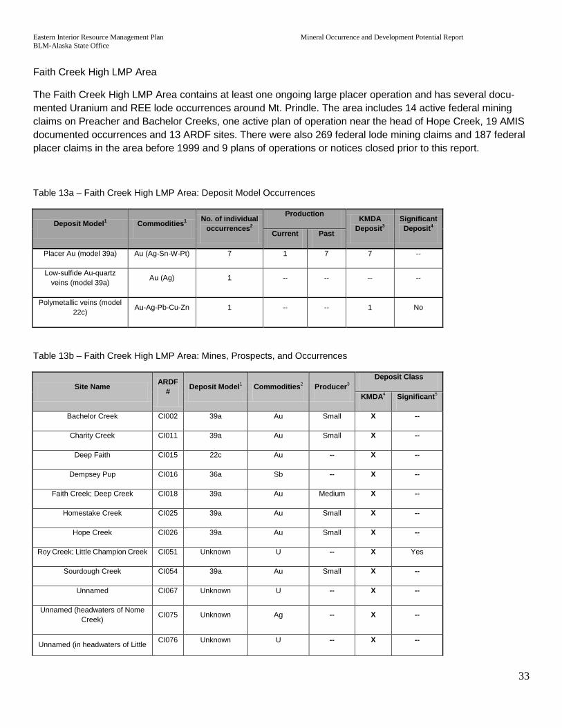
Eastern Interior Resource Management Plan Mineral Occurrence and Development Potential Report BLM-Alaska State Office
33
Faith Creek High LMP Area
The Faith Creek High LMP Area contains at least one ongoing large placer operation and has several docu-mented Uranium and REE lode occurrences around Mt. Prindle. The area includes 14 active federal mining claims on Preacher and Bachelor Creeks, one active plan of operation near the head of Hope Creek, 19 AMIS documented occurrences and 13 ARDF sites. There were also 269 federal lode mining claims and 187 federal placer claims in the area before 1999 and 9 plans of operations or notices closed prior to this report.
Table 13a – Faith Creek High LMP Area: Deposit Model Occurrences
Deposit Model1 Commodities1 No. of individual occurrences2
Production KMDA Deposit3
Significant Deposit4 Current Past
Placer Au (model 39a) Au (Ag-Sn-W-Pt) 7 1 7 7 --
Low-sulfide Au-quartz veins (model 39a) Au (Ag) 1 -- -- -- --
Polymetallic veins (model 22c) Au-Ag-Pb-Cu-Zn 1 -- -- 1 No
Table 13b – Faith Creek High LMP Area: Mines, Prospects, and Occurrences
Site Name ARDF # Deposit Model1 Commodities2 Producer3
Deposit Class
KMDA4 Significant5
Bachelor Creek CI002 39a Au Small X --
Charity Creek CI011 39a Au Small X --
Deep Faith CI015 22c Au -- X --
Dempsey Pup CI016 36a Sb -- X --
Faith Creek; Deep Creek CI018 39a Au Medium X --
Homestake Creek CI025 39a Au Small X --
Hope Creek CI026 39a Au Small X --
Roy Creek; Little Champion Creek CI051 Unknown U -- X Yes
Sourdough Creek CI054 39a Au Small X --
Unnamed CI067 Unknown U -- X --
Unnamed (headwaters of Nome Creek) CI075 Unknown Ag -- X --
Unnamed (in headwaters of Little CI076 Unknown U -- X --

Eastern Interior Resource Management Plan Mineral Occurrence and Development Potential Report BLM-Alaska State Office
34
Champion Creek)
Unnamed (near head of Hope Creek) CI078 Unknown F -- X --
1Cox and Singer, 1986 and 1992
2 ARDF (USGS, 2008A)
3ARDF: Large= >1,000,000 ounces of gold, Medium= 1,000,000 to 2,000 ounces, Small= < 2,000 ounces
3DGGS reports on Alaska’s mineral industry (Bundtzen and others, 1986; Szumigala and others, 2004)
4Site is within KMDA boundary, RDI and others, 1995
5Nokleberg and others, 1993
Fairbanks High LMP Area
The Fairbanks area has very high potential for locatable mineral discovery and development. The High LMP area includes the highest producing placer district although much of the placer resources have been depleted; there are several medium size placer mining operations. The area also includes the Fort Knox deposit, the largest gold producer in Alaska. A new heap-leach facility at Fort Knox, to be commissioned in 2009, will extend the life of mine until 2014.
Excerpts from Alaska’s Mineral Industry 2007 (Szumigala and others, 2008):
Fairbanks mining district—nationally ranked Au-producing district; largest producer in Alaska. Produced about 8,197,458 oz Au from placer deposits (1902–2006). Major lode Au and lode Sb producer; produced more than 4,094,196 oz Au and over 2000 tons Sb from veins and shear zones through 2006. Production of W exceeded 4,000 short ton units since 1915, all derived from skarn near Cretaceous quartz Monzonite.
Fort Knox—Disseminated Au deposit within granodiorite/quartz monzonite pluton near Fairbanks. Proven and proba-ble reserves as of December 31, 2006, open at depth, are 2,705,000 oz of Au in 176.0 million tons of rock at an average Au grade of 0.015 oz/ton. Measured and indicated resources are 70.69 million tons grading 0.018 oz/ton Au containing 1,289,000 ounces of gold, with 1,573,000 ounces of measured and indicated gold resources in the Fort Knox area. Fairbanks Gold Mining Inc. at Fort Knox and True North mines produced 3,676,284 oz of Au from 1996 to 2006
True North—Au occurs in siderite-quartz veins in carbonaceous quartzite and schist within a terrane containing eclo-gitic rocks. An indicated resource of 188,000 oz Au at grade of 0.040 oz/ton Au in 4,665,000 tons of rock as of December 31, 2006. 11.04 million tons of 0.04 oz/ton ore were processed at Fort Knox mill from 2001 through 2004.
Other significant lode occurrences include:
The Dolphin occurrence (ARDF# LG112), which includes a drill hole intercept of 330 ft of 0.049 oz/ton (Szumigala and other 2008).
The Cleary Hill/Golden Summit mine/occurrence, formerly a major lode gold producer with over 100,000 ounces mined in the 1930’s. The area has undergone extensive exploration in recent years.

Eastern Interior Resource Management Plan Mineral Occurrence and Development Potential Report BLM-Alaska State Office
35
The Gil deposit (ARDF# LG200) has a resource of 433,000 ounces of gold. It is being considered as a possible satellite mine to Fort Knox.
The True North (ARDR # LG055), was mined as a satellite of the Fort Knox mine. Although an 188,000 oz gold resource remains in the deposit, mining at True North stopped in 2004.
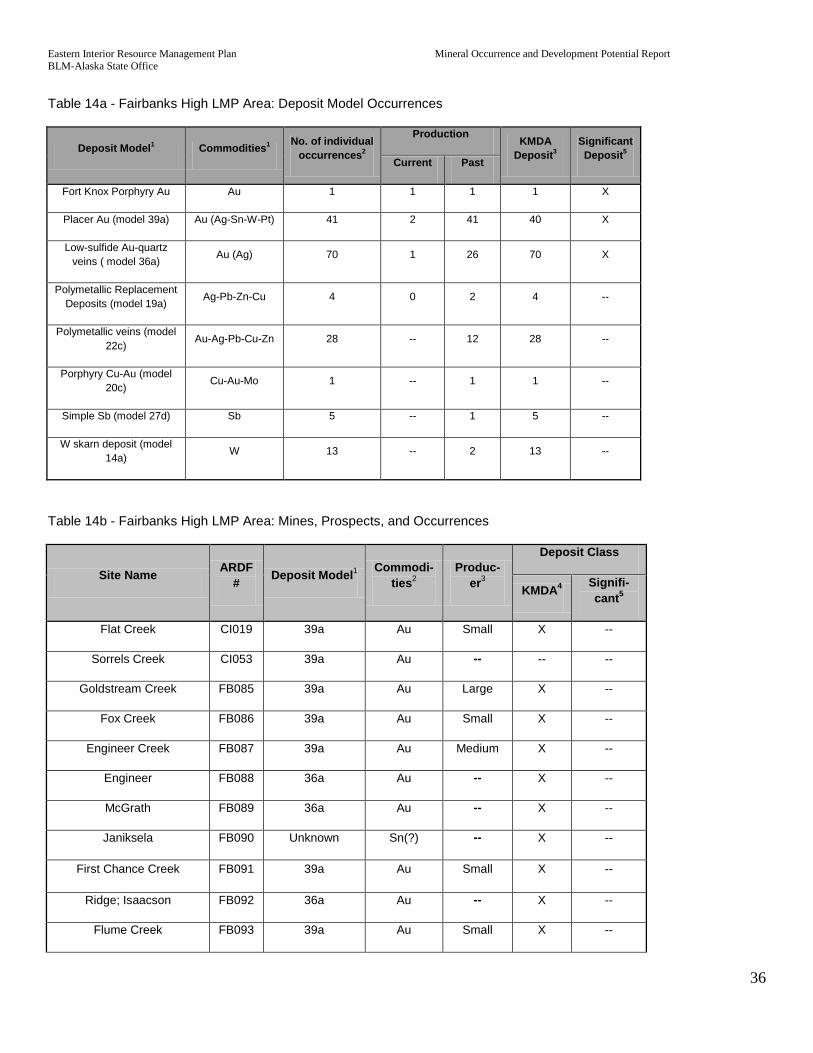
Eastern Interior Resource Management Plan Mineral Occurrence and Development Potential Report BLM-Alaska State Office
36
Table 14a - Fairbanks High LMP Area: Deposit Model Occurrences
Deposit Model1 Commodities1 No. of individual occurrences2
Production KMDA Deposit3
Significant Deposit5 Current Past
Fort Knox Porphyry Au Au 1 1 1 1 X
Placer Au (model 39a) Au (Ag-Sn-W-Pt) 41 2 41 40 X
Low-sulfide Au-quartz veins ( model 36a) Au (Ag) 70 1 26 70 X
Polymetallic Replacement Deposits (model 19a) Ag-Pb-Zn-Cu 4 0 2 4 --
Polymetallic veins (model 22c) Au-Ag-Pb-Cu-Zn 28 -- 12 28 --
Porphyry Cu-Au (model 20c) Cu-Au-Mo 1 -- 1 1 --
Simple Sb (model 27d) Sb 5 -- 1 5 --
W skarn deposit (model 14a) W 13 -- 2 13 --
Table 14b - Fairbanks High LMP Area: Mines, Prospects, and Occurrences
Site Name ARDF # Deposit Model1 Commodi-
ties2 Produc-
er3
Deposit Class
KMDA4 Signifi-cant5
Flat Creek CI019 39a Au Small X --
Sorrels Creek CI053 39a Au -- -- --
Goldstream Creek FB085 39a Au Large X --
Fox Creek FB086 39a Au Small X --
Engineer Creek FB087 39a Au Medium X --
Engineer FB088 36a Au -- X --
McGrath FB089 36a Au -- X --
Janiksela FB090 Unknown Sn(?) -- X --
First Chance Creek FB091 39a Au Small X --
Ridge; Isaacson FB092 36a Au -- X --
Flume Creek FB093 39a Au Small X --

Eastern Interior Resource Management Plan Mineral Occurrence and Development Potential Report BLM-Alaska State Office
37
Site Name ARDF # Deposit Model1 Commodi-
ties2 Produc-
er3
Deposit Class
KMDA4 Signifi-cant5
Pedro Creek FB094 39a Au Small X --
Tanana; Grant; Hirshberger FB095 14a Au -- X --
Anderson FB096 14a W -- X --
Tungsten Hill; Grand Duke Nikolas; Tungsten No. 1;
General Joffre FB097 14a W -- X --
Blossom; Black Bear; Lundbled and Anderson FB098 14a W -- X --
Rose Creek; New Year’s Pup FB099 39a Au Small X --
Gilmore Creek FB100 39a Au Small X --
Spruce Hen FB101 14a W -- X --
Columbia; Meier FB102 14a W -- X --
Green Mountain FB103 36a Au -- X --
Woodpecker FB104 20c Au -- X --
Rose Creek; Ogram FB105 27d Sb -- X --
Steele Creek FB106 39a Au Small X --
Leidy FB107 36a Au(?) -- X --
Unnamed (in the headwa-ters of Steele Creek)
FB108 36a Au -- X --
Hill Creek FB109 39a Au Small X --
Nugget Creek FB110 39a Au Small X --
Schubert FB111 14a W -- X --
Franklin; Ptarmigan; Zim-merman
FB112 14a W -- X --
Stepovich FB113 14a W Small X --
Colbert; Big Chief; Pearl; Triangle
FB114 14a W -- X --
Fort Knox FB115 Fort Knox Au Large X Yes
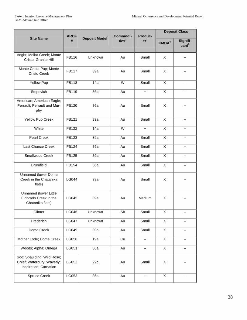
Eastern Interior Resource Management Plan Mineral Occurrence and Development Potential Report BLM-Alaska State Office
38
Site Name ARDF # Deposit Model1 Commodi-
ties2 Produc-
er3
Deposit Class
KMDA4 Signifi-cant5
Voght; Melba Creek; Monte Cristo; Granite Hill FB116 Unknown Au Small X --
Monte Cristo Pup; Monte Cristo Creek FB117 39a Au Small X --
Yellow Pup FB118 14a W Small X --
Stepovich FB119 36a Au -- X --
American; American Eagle; Perrault; Perrault and Mur-
phy FB120 36a Au Small X --
Yellow Pup Creek FB121 39a Au Small X --
White FB122 14a W -- X --
Pearl Creek FB123 39a Au Small X --
Last Chance Creek FB124 39a Au Small X --
Smallwood Creek FB125 39a Au Small X --
Brumfield FB154 36a Au Small X --
Unnamed (lower Dome Creek in the Chatanika
flats) LG044 39a Au Small X --
Unnamed (lower Little Eldorado Creek in the
Chatanika flats) LG045 39a Au Medium X --
Gilmer LG046 Unknown Sb Small X --
Frederich LG047 Unknown Au Small X --
Dome Creek LG049 39a Au Small X --
Mother Lode; Dome Creek LG050 19a Cu -- X --
Woods; Alpha; Omega LG051 36a Au -- X --
Soo; Spaulding; Wild Rose; Chief; Waterbury; Waverly;
Inspiration; Carnation LG052 22c Au Small X --
Spruce Creek LG053 36a Au -- X --

Eastern Interior Resource Management Plan Mineral Occurrence and Development Potential Report BLM-Alaska State Office
39
Site Name ARDF # Deposit Model1 Commodi-
ties2 Produc-
er3
Deposit Class
KMDA4 Signifi-cant5
Hindenburg; Markovich LG054 27d Sb Small X --
True North LG055 Unknown Au Medium X Yes
Little Eldorado Creek LG056 39a Au Small X --
Fran LG057 36a Au -- X --
Alaska Flyer LG058 36a Au -- X --
Old Glory-Seattle Creek; Leslie
LG059 14a W -- X --
Freeman and Scharf LG060 22c Au -- X --
Fox Creek LG061 39a Au Small X --
Silver Fox; Silvertone; Busty Belle LG062 Unknown Ag Small X --
Flume Creek LG063 39a Au Small X --
Pedro Creek LG064 39a Au Small X --
Steamboat Creek LG065 39a Au Small X --
Lundgren-Rowley LG066 Unknown W -- X --
Nightingale LG067 Unknown Ag -- X --
Steamboat Creek LG068 22c Ag -- X --
Hoover LG069 36a Au -- X --
Zimmerman (near junction of Twin and Pedro Creeks) LG070 36a Au -- X --
Steese Highway; Mile 17.5 LG071 Unknown Au -- X --
Eagan; Eagan Twin Creek LG072 Unknown W -- X --
Burnet Galena LG073 22c Ag -- X --
Burnet LG074 36a Au Small X --
Independence LG075 36a Au Small X --
Goepfert LG076 36a Au -- X --
Twin Creek LG077 39a Au Small X --
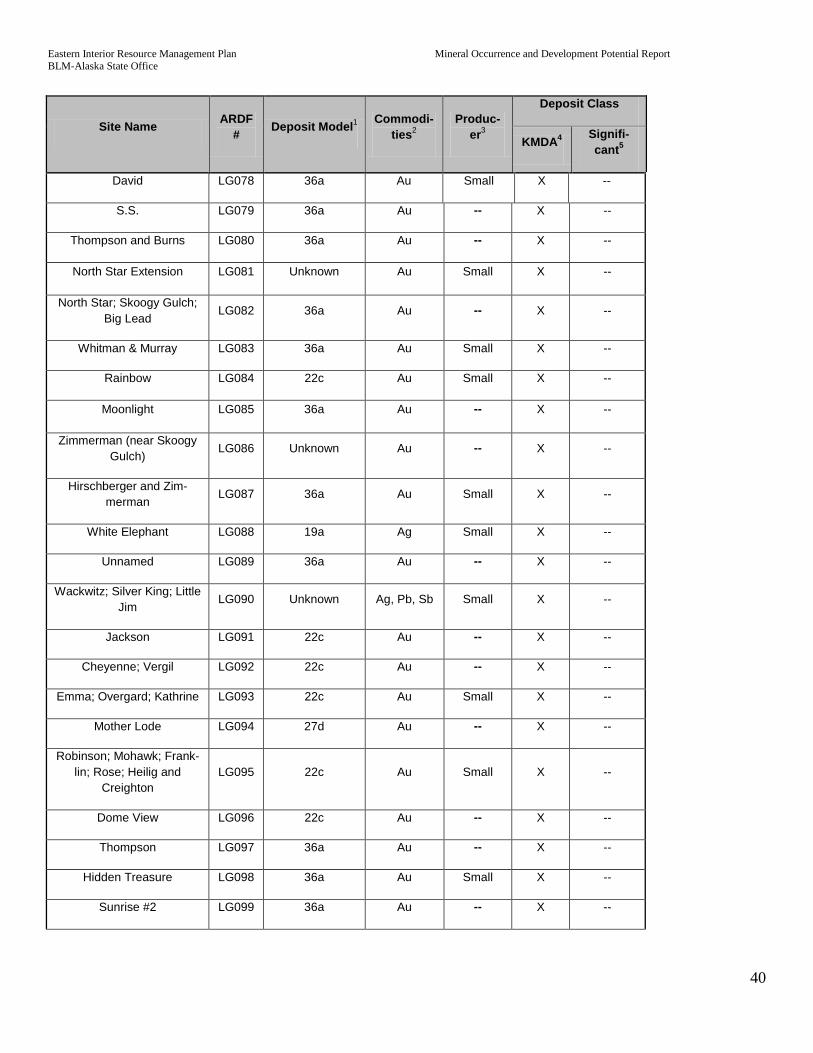
Eastern Interior Resource Management Plan Mineral Occurrence and Development Potential Report BLM-Alaska State Office
40
Site Name ARDF # Deposit Model1 Commodi-
ties2 Produc-
er3
Deposit Class
KMDA4 Signifi-cant5
David LG078 36a Au Small X --
S.S. LG079 36a Au -- X --
Thompson and Burns LG080 36a Au -- X --
North Star Extension LG081 Unknown Au Small X --
North Star; Skoogy Gulch; Big Lead
LG082 36a Au -- X --
Whitman & Murray LG083 36a Au Small X --
Rainbow LG084 22c Au Small X --
Moonlight LG085 36a Au -- X --
Zimmerman (near Skoogy Gulch)
LG086 Unknown Au -- X --
Hirschberger and Zim-merman
LG087 36a Au Small X --
White Elephant LG088 19a Ag Small X --
Unnamed LG089 36a Au -- X --
Wackwitz; Silver King; Little Jim
LG090 Unknown Ag, Pb, Sb Small X --
Jackson LG091 22c Au -- X --
Cheyenne; Vergil LG092 22c Au -- X --
Emma; Overgard; Kathrine LG093 22c Au Small X --
Mother Lode LG094 27d Au -- X --
Robinson; Mohawk; Frank-lin; Rose; Heilig and
Creighton LG095 22c Au Small X --
Dome View LG096 22c Au -- X --
Thompson LG097 36a Au -- X --
Hidden Treasure LG098 36a Au Small X --
Sunrise #2 LG099 36a Au -- X --

Eastern Interior Resource Management Plan Mineral Occurrence and Development Potential Report BLM-Alaska State Office
41
Site Name ARDF # Deposit Model1 Commodi-
ties2 Produc-
er3
Deposit Class
KMDA4 Signifi-cant5
Newsboy LG100 36a Au Small X --
RV LG101 36a Au Small X --
Newsboy Extension LG102 36a Au -- X --
Steil LG103 Unknown Sb -- X --
Moore-Sheldon LG104 19a Sb -- X --
Stibnite LG105 Unknown Ag, Pb, Sb -- X --
Johnson; Johnson and Martin LG106 27d Sb -- X --
Cheechako No. 1; Eldora-do; Westonvitch LG107 19a Au Small X --
Herschberger; Beall; Phipps LG108 36a Au -- X --
Willow Creek LG109 27d Sb -- X --
Tolovana LG110 Unknown Au Small X --
Marshall Dome LG111 Unknown Au -- X --
Dolphin LG112 Unknown Au -- X Yes
Hess and Burnett LG113 Unknown Ag -- X --
Crosscut LG114 22c Sb -- X --
Stepovich #1 LG115 36a Au Small X --
Bedrock Creek LG116 36a Au Small X --
Wyoming LG118 36a Au Small X --
Cleary Hill; Summit; Cleary; Freegold
LG119 36a Au Medium X Yes
Paupers Dream LG120 36a Au -- X --
California LG121 36a Au -- X --
Cunningham LG122 22c Au -- X --
Sunrise #1 LG123 36a Au? -- X --
Butler and Petree LG124 22c Au -- X --
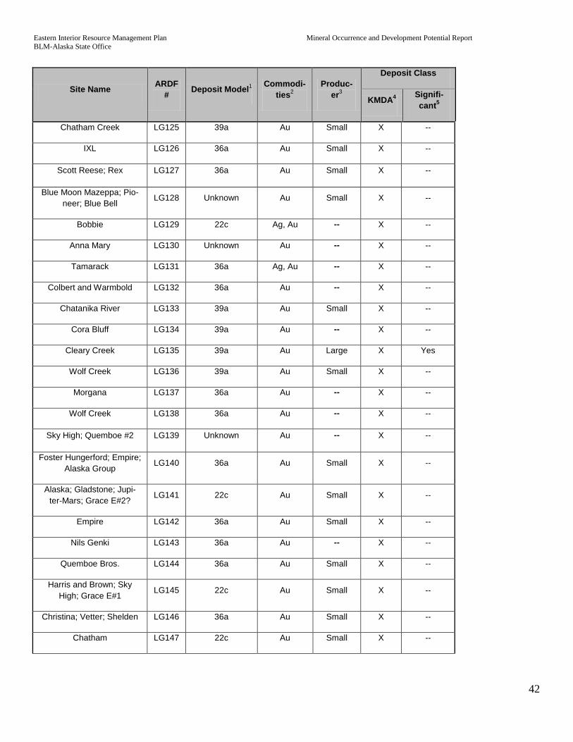
Eastern Interior Resource Management Plan Mineral Occurrence and Development Potential Report BLM-Alaska State Office
42
Site Name ARDF # Deposit Model1 Commodi-
ties2 Produc-
er3
Deposit Class
KMDA4 Signifi-cant5
Chatham Creek LG125 39a Au Small X --
IXL LG126 36a Au Small X --
Scott Reese; Rex LG127 36a Au Small X --
Blue Moon Mazeppa; Pio-neer; Blue Bell
LG128 Unknown Au Small X --
Bobbie LG129 22c Ag, Au -- X --
Anna Mary LG130 Unknown Au -- X --
Tamarack LG131 36a Ag, Au -- X --
Colbert and Warmbold LG132 36a Au -- X --
Chatanika River LG133 39a Au Small X --
Cora Bluff LG134 39a Au -- X --
Cleary Creek LG135 39a Au Large X Yes
Wolf Creek LG136 39a Au Small X --
Morgana LG137 36a Au -- X --
Wolf Creek LG138 36a Au -- X --
Sky High; Quemboe #2 LG139 Unknown Au -- X --
Foster Hungerford; Empire; Alaska Group
LG140 36a Au Small X --
Alaska; Gladstone; Jupi-ter-Mars; Grace E#2?
LG141 22c Au Small X --
Empire LG142 36a Au Small X --
Nils Genki LG143 36a Au -- X --
Quemboe Bros. LG144 36a Au Small X --
Harris and Brown; Sky High; Grace E#1
LG145 22c Au Small X --
Christina; Vetter; Shelden LG146 36a Au Small X --
Chatham LG147 22c Au Small X --

Eastern Interior Resource Management Plan Mineral Occurrence and Development Potential Report BLM-Alaska State Office
43
Site Name ARDF # Deposit Model1 Commodi-
ties2 Produc-
er3
Deposit Class
KMDA4 Signifi-cant5
Bellows Creek LG148 22c Au -- X --
Roughneck LG149 Unknown Au -- X --
McCarty shaft LG150 36a Au Medium X --
Saddle LG151 36a Au -- X --
McCarty LG152 22c Au Small X --
Henry Ford LG153 36a Au Medium X --
Ebbert LG154 22c Au -- X --
Pioneer LG155 Unknown Au Small X --
Pennsylvania LG156 Unknown Au Small X --
Homestake LG157 Unknown Au Medium X --
Banner LG158 36a Au -- X --
Gil LG200 Unknown Au -- X Yes
Fish Creek LG201 39a Au Small X --
Coffee Dome LG204 Unknown Au, Bi, Te -- X --
Rexall LG159 36a Au Small X --
Solomon LG160 Unknown Sb -- X --
Goose Creek LG161 36a Au -- X --
Circle Trail LG162 22c Au -- X --
Kellen LG163 Unknown Au -- X --
Gilmore LG164 36a Au -- X --
Ohio; Early Bird; Mayflower; Connors and Stevens LG165 36a Au Small X --
Schaefer LG166 Unknown Ag -- X --
Unnamed (on Fairbanks Creek)
LG167 36a Au -- X --
Plumbum LG168 Unknown Au -- X --
Too Much Gold Creek LG169 39a Au Small X --

Eastern Interior Resource Management Plan Mineral Occurrence and Development Potential Report BLM-Alaska State Office
44
Site Name ARDF # Deposit Model1 Commodi-
ties2 Produc-
er3
Deposit Class
KMDA4 Signifi-cant5
Whitehorse LG170 36a Au Small X --
Iowa LG171 Unknown Au -- X --
Governor LG172 36a Au -- X --
Rob Roy; Saucy; Wolf LG173 Unknown Au Small X --
Nars Anderson; Dorando LG174 22c Au Small X --
McNeil; Branholm-Jenkins LG175 22c Sb -- X --
Unnamed (on the ridge at the headwaters of Too
Much Gold Creek) LG176 36a Au -- X --
Basham LG177 36a Au -- X --
Too Much Gold LG178 Unknown Au -- X --
Excelsior; Cross Vein LG179 22c Au -- X --
Mizpah; Black Joe LG180 22c Au Small X --
Perrault LG181 36a Au -- X --
Hi-Yu; Crites and Feldman LG182 22c Au Medium X --
Creeks LG183 36a Au -- X --
Crane Creek LG187 39a Au Small X --
Queen LG188 Unknown Au -- X --
Alder Creek LG189 36a Au -- X --
Eureka LG190 36a Au Small X --
Coffee Dome LG191 22c Au -- X --
Charles LG192 22c Au Small X --
Coffee East LG193 36a Au -- X --
Eagan and Eagan LG194 36a Au -- X --
Kokomo Creek LG195 39a Au Small X --
Alder Creek LG196 39a Au Small X --
Walnut Creek LG197 39a Au Small X --

Eastern Interior Resource Management Plan Mineral Occurrence and Development Potential Report BLM-Alaska State Office
45
Site Name ARDF # Deposit Model1 Commodi-
ties2 Produc-
er3
Deposit Class
KMDA4 Signifi-cant5
Fairbanks Creek LG198 39a Au Medium X --
Deep Creek LG199 39a Au Small X --
1Cox and Singer, 1986 and 1992
2 ARDF (USGS, 2008A)
3ARDF: Large= >1,000,000 ounces of gold, Medium= 1,000,000 to 2,000 ounces, Small= < 2,000 ounces
3DGGS reports on Alaska’s mineral industry (Bundtzen and others, 1986; Szumigala and others, 2004)
4Site is within KMDA boundary, RDI and others, 1995
5Nokleberg and others, 1993
Circle High LMP Area
The Circle High LMP Area was assigned primarily due to a history of frequent placer mining activity combined with abundant active placer claims and 22 mine operators listed in the Alaska Mining Industry 2008 report (Szumigala and others, 2008). The boundary surrounds where ARDF sites coincide with active mining claims and extends to the limits of local drainages. A few non-producing lode occurrences also exist within the Circle High LMP Area. There are 183 AMIS occurrences in the area of which 161 were reportedly producing placer occurrences.
There are currently 17 active or pending plans of operation or notices on 232 federal placer claims on land managed by the BLM. Many claims were located in the 1970’s but some date as far back as 1921. Before 1999, there had been at some point as many as 1,132 federal placer claims and 141 lode claims. Prior to this report was 28 plans of operation and 69 notices that have now closed.
Table 15a - Circle High LMP Area: Deposit Model Occurrences
Deposit Model1 Commodities1 No. of individ-
ual occur-rences2
Production KMDA Deposit3
Significant Deposit5 Active Past
Placer Au (model 39a) Au (Ag-Sn-W-Pt) 29 7 29 29 --
Low-sulfide Au-quartz veins (model 36a) Au (Ag) 1 -- -- 1 --
Polymetallic veins (model 22c) Au-Ag-Pb-Cu-Zn 1 -- -- 1 --
Sn greisen (model 15c) Sn (F-Be) 1 -- -- 1 --
W skarn deposit (model 14a) W 1 -- -- 1 --

Eastern Interior Resource Management Plan Mineral Occurrence and Development Potential Report BLM-Alaska State Office
46
Table 15b - Circle High LMP Area: Significant Deposits, KMDA Deposit Occurrences, and Lode Producers
Site Name ARDF # Deposit Model1 Commodities2 Producer3
Deposit Class
KMDA4 Significant5
88 Group CI001 Unknown Au -- X --
Bear claims CI003 Unknown Au -- X --
Bedrock Creek CI004 Unknown U -- X --
Birch Creek CI005 39a Au Medium X --
Bonanza Creek CI006 39a Au Small X --
Bottom Dollar Creek; Nugget Gulch; Greenhorn Creek CI007 39a Au Small X --
Boulder Creek CI008 39a Au, Sn Small X --
Butte Creek CI009 39a Au Small X --
Clums Fork CI012 Unknown Diamond -- X --
Crooked Creek CI013 39a Au Small X --
Deadwood Creek; Forty Three Pup; Twenty Five Pup; Discovery
Gulch; Tommy’s Pup; Switch Creek;
CI014 39a Au Small X --
Eagle Creek; Mastodon Fork; Miller Fork; Cripple Creek
CI017 39a Au Medium X --
Frying Pan Creek CI020 39a Au Small X --
Gold Dust Creek CI022 39a Au Small X --
Greenhorn Gulch CI023 39a Au Small X --
Half Dollar Creek; Two-Bit Gulch CI024 39a Au Small X --
Hot Springs Creek CI027 Unknown U, REE, Th, W -- X --
Yankee Creek CI028 39a Au Small X --
Independence Creek CI029 39a Au Medium X --
Ketchem Creek; Holdem Creek CI031 39a Au Small X --
Ketchem Dome CI032 15c Sn -- X --
Ketchem Dome Area CI033 39a Au Small X --
Mammoth Creek CI036 39a Au Small X --
Mastodon Creek; Forty Two Gulch; Baker Gulch CI037 39a Au Small X --

Eastern Interior Resource Management Plan Mineral Occurrence and Development Potential Report BLM-Alaska State Office
47
Site Name ARDF # Deposit Model1 Commodities2 Producer3
Deposit Class
KMDA4 Significant5
Mastodon Dome Area (includes Mammoth Creek, Miller Creek,
Eagle Creek, and Mastodon Creek)
CI038 39a Au Medium X --
Miller Creek CI039 39a Au Small X --
Miller House CI040 Unknown Au -- X --
North Fork Harrison Creek; South Fork Harrison Creek CI042 39a Au Small X --
Ox Group CI043 Unknown Sb -- X --
Porcupine Creek CI046 39a Au Small X --
Portage Creek CI047 39a Au Medium X --
Ptarmigan Creek (tributary of Birch Creek) CI048 39a Au -- X --
Rebel Creek CI050 39a Au Small X --
Squaw Creek; Squaw Gulch CI055 39a Au Small X --
Switch Creek CI056 39a Au Small X --
Top Dollar CI058 Unknown Au -- X --
Traverse Creek CI059 39a Au -- X --
Unnamed CI061 14a W -- X --
Unnamed CI065 Unknown Au -- X --
Unnamed (between Table and Pinnell Mountains) CI073 Unknown Sn -- X --
Unnamed (headwaters of Inde-pendence Creek) CI074 Unknown Ag -- X --
Unnamed (near Mastodon Dome) CI080 Unknown Au -- X --
Unnamed (near Porcupine Dome) CI081 Unknown Au -- X --
Unnamed (or upper Deadwood Creek) CI084 36a Au -- X --
Wietchy Prospect CI088 22c Au -- X --
Willow Creek CI089 39a Au Small X --
1Cox and Singer, 1986 and 1992
2 ARDF (USGS, 2008A)
3ARDF: Large= >1,000,000 ounces of gold, Medium= 1,000,000 to 2,000 ounces, Small= < 2,000 ounces

Eastern Interior Resource Management Plan Mineral Occurrence and Development Potential Report BLM-Alaska State Office
48
3DGGS reports on Alaska’s mineral industry (Bundtzen and others, 1986; Szumigala and others, 2004)
4Site is within KMDA boundary, RDI and others, 1995
5Nokleberg and others, 1993
Chena River High LMP Area
The overlap of the KMDA, a Mineral Terrane boundary, active mining claims and clusters of ARDF and AMIS sites lends the head waters of the Chena River to be a High LMP area. Although the area is contiguous with the Circle High LMP area the Chena River High LMP was segregated because of the drainage divide. The boundary incorporates the placer occurrences and two sedimentary exhalative occurrences as well as several active mining claim blocks.
Table 16a – Chena River High LMP Area: Deposit Model Occurrences
Deposit Model1 Commodities1 No. of individ-
ual occur-rences2
Production KMDA Deposit3
Significant Deposit5 Current Past
Placer Au (model 39a) Au
(Ag-Sn-W-Pt) 4 -- 3 3 --
Sedimentary exhalative massive sulfide (model
31a) Zn-Pb-Ag (Ba) 2 -- -- -- --
Table 16b – Chena River High LMP Area: Mines, Prospects, and Occurrences
Site Name ARDF #
Deposit Model1 Commodities2 Producer3
Deposit Class
KMDA4 Significant5
Gold Creek BD015 39a Au -- -- --
Unnamed (near Ohio Creek) BD045 Unknown Ag -- -- --
Unnamed (near Wheeler Creek) BD047 Unknown Cu -- -- --
Teuchet Creek; TC BD050 31a Pb, Zn -- -- --
Drone Creek; DC BD051 31a Pb, Zn -- -- --
Unnamed BD052 Unknown Pb, Zn -- -- --
Palmer Creek CI044 39a Au Small X --
Shamrock Creek CI052 39a Au Small X --
Van Curlers Bar (Middle Fork Chena River) CI087 39a Au Small X --
1Cox and Singer, 1986 and 1992
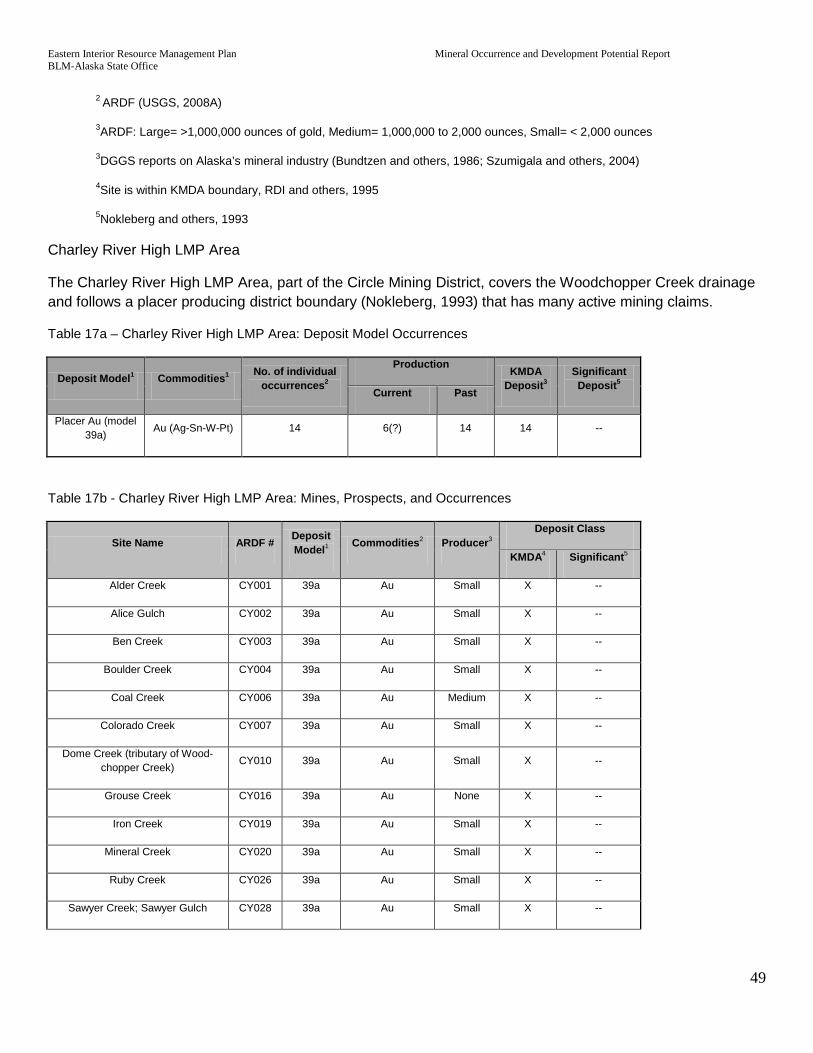
Eastern Interior Resource Management Plan Mineral Occurrence and Development Potential Report BLM-Alaska State Office
49
2 ARDF (USGS, 2008A)
3ARDF: Large= >1,000,000 ounces of gold, Medium= 1,000,000 to 2,000 ounces, Small= < 2,000 ounces
3DGGS reports on Alaska’s mineral industry (Bundtzen and others, 1986; Szumigala and others, 2004)
4Site is within KMDA boundary, RDI and others, 1995
5Nokleberg and others, 1993
Charley River High LMP Area
The Charley River High LMP Area, part of the Circle Mining District, covers the Woodchopper Creek drainage and follows a placer producing district boundary (Nokleberg, 1993) that has many active mining claims.
Table 17a – Charley River High LMP Area: Deposit Model Occurrences
Deposit Model1 Commodities1 No. of individual occurrences2
Production KMDA Deposit3
Significant Deposit5 Current Past
Placer Au (model 39a) Au (Ag-Sn-W-Pt) 14 6(?) 14 14 --
Table 17b - Charley River High LMP Area: Mines, Prospects, and Occurrences
Site Name ARDF # Deposit Model1 Commodities2 Producer3
Deposit Class
KMDA4 Significant5
Alder Creek CY001 39a Au Small X --
Alice Gulch CY002 39a Au Small X --
Ben Creek CY003 39a Au Small X --
Boulder Creek CY004 39a Au Small X --
Coal Creek CY006 39a Au Medium X --
Colorado Creek CY007 39a Au Small X --
Dome Creek (tributary of Wood-chopper Creek) CY010 39a Au Small X --
Grouse Creek CY016 39a Au None X --
Iron Creek CY019 39a Au Small X --
Mineral Creek CY020 39a Au Small X --
Ruby Creek CY026 39a Au Small X --
Sawyer Creek; Sawyer Gulch CY028 39a Au Small X --

Eastern Interior Resource Management Plan Mineral Occurrence and Development Potential Report BLM-Alaska State Office
50
Webber Creek; Weber Creek CY037 39a Au None X --
Woodchopper Creek Area CY038 39a Au Medium X --
1Cox and Singer, 1986 and 1992
2 ARDF (USGS, 2008A)
3ARDF: Large= >1,000,000 ounces of gold, Medium= 1,000,000 to 2,000 ounces, Small= < 2,000 ounces
3DGGS reports on Alaska’s mineral industry (Bundtzen and others, 1986; Szumigala and others, 2004)
4Site is within KMDA boundary, RDI and others, 1995
5Nokleberg and others, 1993
Eagle High LMP Area
The Eagle High LMP Area boundary follows the local KMDA boundary but is expanded to incorporate claims on Dome Creek, Mission Creek and to include the Flume Creek area. The Eagle area has been small but consistent placer gold producer for many years with four occurrences listed by the ARDF as active and listed by the Mineral Industry Report as actively producing gold. The area also contains several small lode occurrences including four gold bearing hydrothermally altered mafic ophiolite occurrences around Flume Creek (USGS, 2008A). The Flume Creek occurrence (ARDF# EA009) is estimated to have 2,500 ounces of gold mined from outcrops and talus. In 1998, an inferred resource of 1,000,000 ounces of gold was estimated based on 0.025 ounces per ton of rock.
Table 18a - Eagle High LMP Area: Deposit Model Occurrences
Deposit Model1 Commodities1 No. of individual occurrences2
Production KMDA Deposit3
Significant Deposit5 Current Past
Comstock epithermal veins (model 25c) Au-Ag (Cu,Pb) 4 -- -- 4 --
Listwaenite Au (Newberry and others, 1998) Au 4 -- 1 4 --
Placer Au (model 39a) Au (Ag-Sn-W-Pt) 29 4 29 27 --
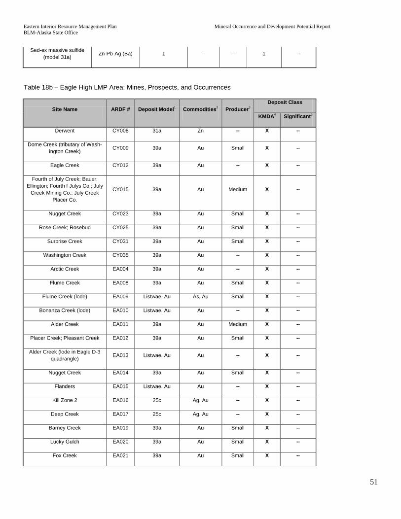
Eastern Interior Resource Management Plan Mineral Occurrence and Development Potential Report BLM-Alaska State Office
51
Sed-ex massive sulfide (model 31a) Zn-Pb-Ag (Ba) 1 -- -- 1 --
Table 18b – Eagle High LMP Area: Mines, Prospects, and Occurrences
Site Name ARDF # Deposit Model1 Commodities2 Producer3 Deposit Class
KMDA4 Significant5
Derwent CY008 31a Zn -- X --
Dome Creek (tributary of Wash-ington Creek) CY009 39a Au Small X --
Eagle Creek CY012 39a Au -- X --
Fourth of July Creek; Bauer; Ellington; Fourth f Julys Co.; July
Creek Mining Co.; July Creek Placer Co.
CY015 39a Au Medium X --
Nugget Creek CY023 39a Au Small X --
Rose Creek; Rosebud CY025 39a Au Small X --
Surprise Creek CY031 39a Au Small X --
Washington Creek CY035 39a Au -- X --
Arctic Creek EA004 39a Au -- X --
Flume Creek EA008 39a Au Small X --
Flume Creek (lode) EA009 Listwae. Au As, Au Small X --
Bonanza Creek (lode) EA010 Listwae. Au Au -- X --
Alder Creek EA011 39a Au Medium X --
Placer Creek; Pleasant Creek EA012 39a Au Small X --
Alder Creek (lode in Eagle D-3 quadrangle) EA013 Listwae. Au Au -- X --
Nugget Creek EA014 39a Au Small X --
Flanders EA015 Listwae. Au Au -- X --
Kill Zone 2 EA016 25c Ag, Au -- X --
Deep Creek EA017 25c Ag, Au -- X --
Barney Creek EA019 39a Au Small X --
Lucky Gulch EA020 39a Au Small X --
Fox Creek EA021 39a Au Small X --
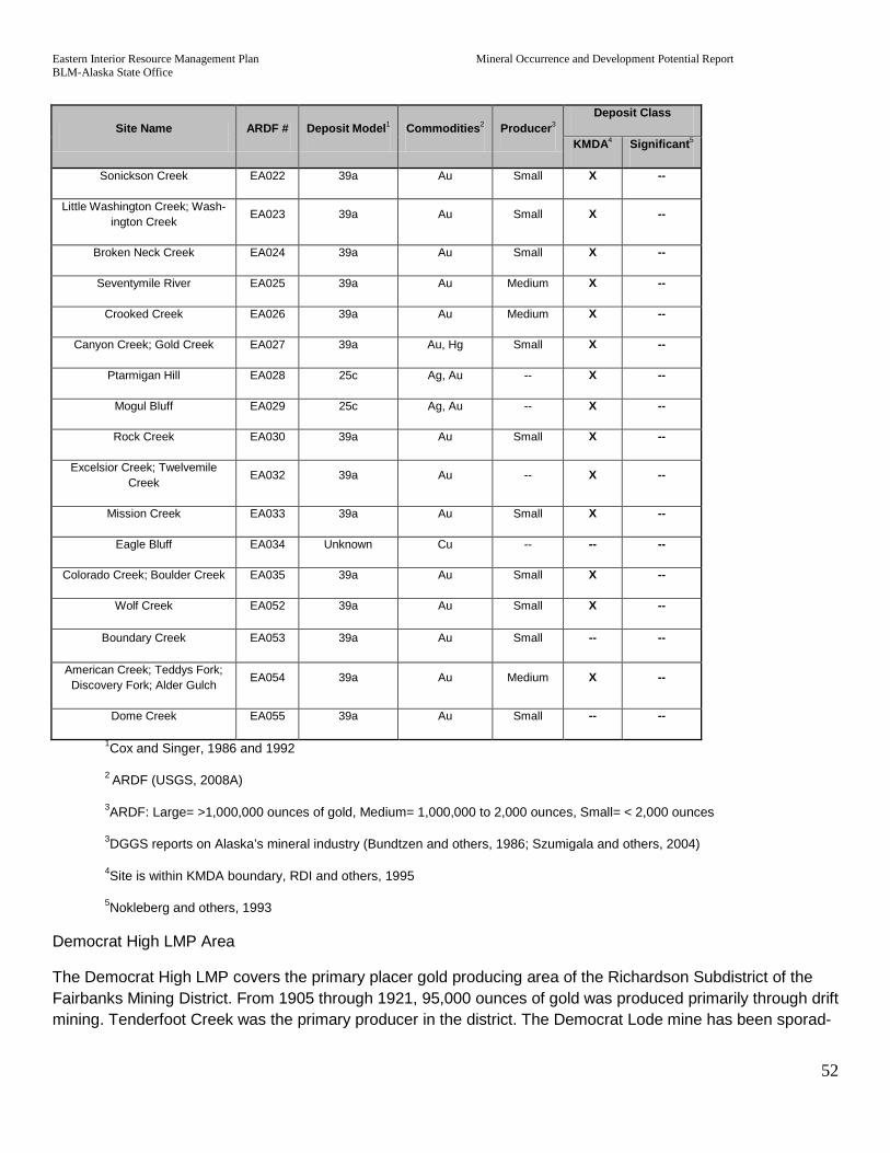
Eastern Interior Resource Management Plan Mineral Occurrence and Development Potential Report BLM-Alaska State Office
52
Site Name ARDF # Deposit Model1 Commodities2 Producer3 Deposit Class
KMDA4 Significant5
Sonickson Creek EA022 39a Au Small X --
Little Washington Creek; Wash-ington Creek EA023 39a Au Small X --
Broken Neck Creek EA024 39a Au Small X --
Seventymile River EA025 39a Au Medium X --
Crooked Creek EA026 39a Au Medium X --
Canyon Creek; Gold Creek EA027 39a Au, Hg Small X --
Ptarmigan Hill EA028 25c Ag, Au -- X --
Mogul Bluff EA029 25c Ag, Au -- X --
Rock Creek EA030 39a Au Small X --
Excelsior Creek; Twelvemile Creek EA032 39a Au -- X --
Mission Creek EA033 39a Au Small X --
Eagle Bluff EA034 Unknown Cu -- -- --
Colorado Creek; Boulder Creek EA035 39a Au Small X --
Wolf Creek EA052 39a Au Small X --
Boundary Creek EA053 39a Au Small -- --
American Creek; Teddys Fork; Discovery Fork; Alder Gulch EA054 39a Au Medium X --
Dome Creek EA055 39a Au Small -- --
1Cox and Singer, 1986 and 1992
2 ARDF (USGS, 2008A)
3ARDF: Large= >1,000,000 ounces of gold, Medium= 1,000,000 to 2,000 ounces, Small= < 2,000 ounces
3DGGS reports on Alaska’s mineral industry (Bundtzen and others, 1986; Szumigala and others, 2004)
4Site is within KMDA boundary, RDI and others, 1995
5Nokleberg and others, 1993
Democrat High LMP Area
The Democrat High LMP covers the primary placer gold producing area of the Richardson Subdistrict of the Fairbanks Mining District. From 1905 through 1921, 95,000 ounces of gold was produced primarily through drift mining. Tenderfoot Creek was the primary producer in the district. The Democrat Lode mine has been sporad-

Eastern Interior Resource Management Plan Mineral Occurrence and Development Potential Report BLM-Alaska State Office
53
ically developed since its discovery in 1913 including a short adit and a 100,000 ton bulk sample in the 1980’s. A resource of 1,000,000 ounces has been estimated at the mine, which is now a 900 foot long open-cut but not currently being mined (USGS, 2008A).
Table 19a – Democrat High LMP Area: Deposit Model Occurrences
Deposit Model1 Commodities1 No. of individual occurrences2
Production KMDA Deposit3
Significant Deposit5 Current Past
Placer Au (model 39a) Au (Ag-Sn-W-Pt) 9 1 9 8 --
Pluton Au Au 4 -- 1 2 X
Table 19b - Democrat High LMP Area: Mines, Prospects, and Occurrences
Site Name ARDF # Deposit Mod-el1 Commodities2 Producer3
Deposit Class
KMDA4 Significant5
Banner Creek BD001 39a Au Small X --
Buckeye Creek; Martha; Moore Creek BD005 39a Au Small X --
Campbell-Monroe; Campbell BD007 39a Au Small X --
Canyon Creek BD008 39a Au Small -- --
Democrat Creek; Democrat Gulch; Democrat Pup BD013 39a Au Small X --
Democrat Lode; John Mitchell Lode BD014 Pluton Au Au Small X Yes
Hinkley Gulch BD019 39a Au Small X --
Junction Creek BD021 39a Au Small X --
Redmond Creek; Mosquito Creek BD035 39a Au -- X --
Shamrock Creek; VABM Buck BD038 Pluton Au Au -- X --
Tenderfoot Creek BD039 39a Au Medium X --
Banner Dike Zone BD046 Pluton Au Au -- X --
Buckeye Zone BD048 Pluton Au Au -- X --
1Cox and Singer, 1986 and 1992
2 ARDF (USGS, 2008A)
3ARDF: Large= >1,000,000 ounces of gold, Medium= 1,000,000 to 2,000 ounces, Small= < 2,000 ounces
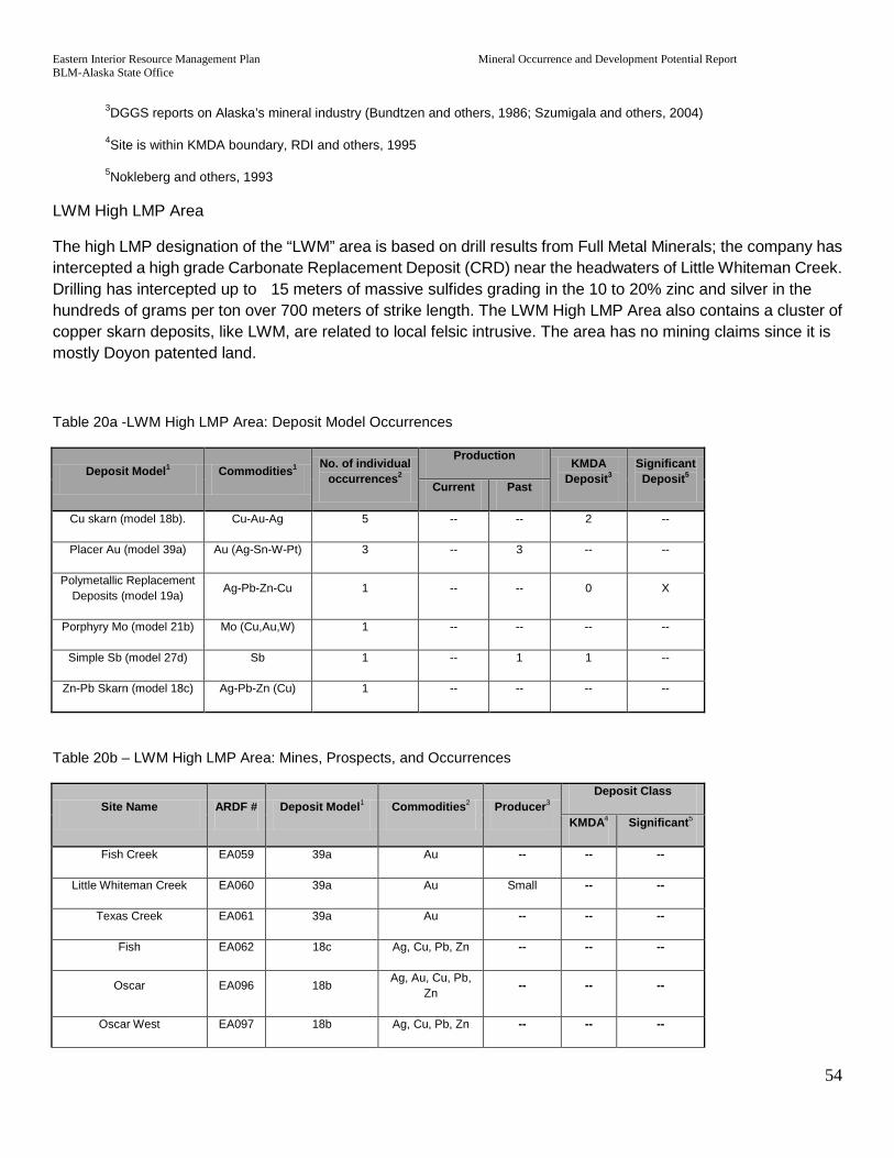
Eastern Interior Resource Management Plan Mineral Occurrence and Development Potential Report BLM-Alaska State Office
54
3DGGS reports on Alaska’s mineral industry (Bundtzen and others, 1986; Szumigala and others, 2004)
4Site is within KMDA boundary, RDI and others, 1995
5Nokleberg and others, 1993
LWM High LMP Area
The high LMP designation of the “LWM” area is based on drill results from Full Metal Minerals; the company has intercepted a high grade Carbonate Replacement Deposit (CRD) near the headwaters of Little Whiteman Creek. Drilling has intercepted up to 15 meters of massive sulfides grading in the 10 to 20% zinc and silver in the hundreds of grams per ton over 700 meters of strike length. The LWM High LMP Area also contains a cluster of copper skarn deposits, like LWM, are related to local felsic intrusive. The area has no mining claims since it is mostly Doyon patented land.
Table 20a -LWM High LMP Area: Deposit Model Occurrences
Deposit Model1 Commodities1 No. of individual occurrences2
Production KMDA Deposit3
Significant Deposit5 Current Past
Cu skarn (model 18b). Cu-Au-Ag 5 -- -- 2 --
Placer Au (model 39a) Au (Ag-Sn-W-Pt) 3 -- 3 -- --
Polymetallic Replacement Deposits (model 19a) Ag-Pb-Zn-Cu 1 -- -- 0 X
Porphyry Mo (model 21b) Mo (Cu,Au,W) 1 -- -- -- --
Simple Sb (model 27d) Sb 1 -- 1 1 --
Zn-Pb Skarn (model 18c) Ag-Pb-Zn (Cu) 1 -- -- -- --
Table 20b – LWM High LMP Area: Mines, Prospects, and Occurrences
Site Name ARDF # Deposit Model1 Commodities2 Producer3 Deposit Class
KMDA4 Significant5
Fish Creek EA059 39a Au -- -- --
Little Whiteman Creek EA060 39a Au Small -- --
Texas Creek EA061 39a Au -- -- --
Fish EA062 18c Ag, Cu, Pb, Zn -- -- --
Oscar EA096 18b Ag, Au, Cu, Pb, Zn
-- -- --
Oscar West EA097 18b Ag, Cu, Pb, Zn -- -- --

Eastern Interior Resource Management Plan Mineral Occurrence and Development Potential Report BLM-Alaska State Office
55
Site Name ARDF # Deposit Model1 Commodities2 Producer3 Deposit Class
KMDA4 Significant5
East Eva EA098 18b Ag, Au, Cu, Pb -- -- --
Eva Creek; Ruby Silver EA099 18b Ag, Cu, Pb, Zn -- X --
Molly Creek; My Creek EA100 27d Sb Small X --
Mitchell; Ketchumstuk EA101 18b Ag, Au, Cu, Zn -- X --
LWM EA102 19a Ag, Au, Hg, Pb, W, Zn
-- -- Yes
Little Enchilada EA103 21b Cu, Mo, Pb -- -- --
1Cox and Singer, 1986 and 1992
2 ARDF (USGS, 2008A)
3ARDF: Large= >1,000,000 ounces of gold, Medium= 1,000,000 to 2,000 ounces, Small= < 2,000 ounces
3DGGS reports on Alaska’s mineral industry (Bundtzen and others, 1986; Szumigala and others, 2004)
4Site is within KMDA boundary, RDI and others, 1995
5Nokleberg and others, 1993
Fortymile High LMP Area
The Fortymile River area, being within the Tintina Mineralized Belt, has several small lode occurrences but the area is known for having been placer mined continually since gold was discovered on Franklin Creek in 1887. There is active placer mining ranging in scale from panning to large mechanized operations with about 3,000 ounces being produced in the Fortymile District in 2006. The ARDF database (USGS, 2008A) lists 16 active placer occurrences and the Alaska Mineral Industry 2007 report (Szumigala, 2008) lists 36 individual people or companies that produced gold in 2007. The LMP boundary is based on ARDF and AMIS occurrences and mining claim locations. As a reinforcement of the mineral potential boundary are thousands of lode claims in the Yukon Territory the lie in trend with the Tintina Mineralized Belt.
There are 89 ARDF sites and 144 AMIS sites, and a majority of these are placer occurrences in the Fortymile High LMP. There are also 34 active or pending plans of operation or notice level operations on 209 federal placer claims on lands managed by the BLM. Between 1979 and 2010 there were 32 plans of operation and 9 notice level operations that are now closed. There had been 1,206 federal placer claims, and 202 lode claims that have now closed due to abandonment, conveyance, or operation of law.
Table 21a – Fortymile High LMP Area: Deposit Model Occurrences
Deposit Model1 Commodities1 No. of individ-ual occurrenc-
es2
Production KMDA Depos-
it3
Significant Deposit5 Cur-
rent Past
Comstock epithermal veins Au-Ag (Cu,Pb) 3 -- 1 1 --

Eastern Interior Resource Management Plan Mineral Occurrence and Development Potential Report BLM-Alaska State Office
56
(model 25c)
Cu skarn (model 18b). Cu-Au-Ag 1 -- -- -- --
Cyprus massive sulfide (model 24a) Cu-Zn 2 -- -- 1 --
Low-sulfide Au-quartz veins ( model 36a) Au (Ag) 1 -- -- -- --
Kuroko massive sulfide (model 28a) Cu-Pb-Zn (Au-Ag) 1 -- -- 1 --
Placer Au (model 39a) Au (Ag-Sn-W-Pt) 48 16 48 43 --
Pluton Au Au 2 -- -- 1 --
Sed-ex massive sulfide (model 31a) Zn-Pb-Ag (Ba) 3 -- -- 3 --
Table 21b - Fortymile High LMP Area: Mines, Prospects, and Occurrences
Site Name ARDF # Deposit Model1 Commodities2 Producer3
Deposit Class
KMDA4 Significant5
Unnamed (north of Montana Creek) EA064 25c Au -- -- --
Unnamed (near Montana Creek) EA065 25c As, Pb, Sn -- -- --
Hutchinson Creek EA066 39a Au Small X --
Montana Creek EA067 39a Au Small X --
Confederate Creek; Coldfoot Creek EA068 39a Au Small X --
Wilson Creek; Joe Wilson Creek EA070 39a Au -- -- --
Fortymile River (from mouth of Franklin Creek to Canadian
border) EA071 39a Au Medium X --
Howard EA072 24a Ag, Au, Cu, Pb, Zn -- X --
South Liberty EA073 24a Ag, Au, Hg, Sb -- X --
Unnamed (near mouth of Co-lumbia Creek) EA074 31a Cu, Pb, Zn -- X --
Unnamed (near O'Brien Creek) EA075 31a Ba, Pb, Zn -- X --
Unnamed (near O'Brien Creek) EA076 31a Ba, Pb, Zn -- X --
Unnamed (at head of King Creek) EA077 Unknown Pb, Zn -- -- --
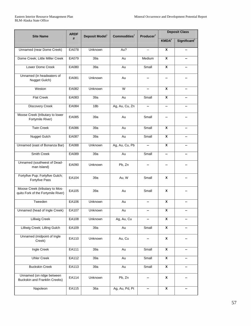
Eastern Interior Resource Management Plan Mineral Occurrence and Development Potential Report BLM-Alaska State Office
57
Site Name ARDF # Deposit Model1 Commodities2 Producer3
Deposit Class
KMDA4 Significant5
Unnamed (near Dome Creek) EA078 Unknown Au? -- X --
Dome Creek; Little Miller Creek EA079 39a Au Medium X --
Lower Dome Creek EA080 39a Au Small X --
Unnamed (in headwaters of Nugget Gulch) EA081 Unknown Au -- -- --
Weston EA082 Unknown W -- X --
Flat Creek EA083 39a Au Small X --
Discovery Creek EA084 18b Ag, Au, Cu, Zn -- -- --
Moose Creek (tributary to lower Fortymile River) EA085 39a Au Small -- --
Twin Creek EA086 39a Au Small X --
Nugget Gulch EA087 39a Au Small X --
Unnamed (east of Bonanza Bar) EA088 Unknown Ag, Au, Cu, Pb -- X --
Smith Creek EA089 39a Au Small -- --
Unnamed (southwest of Dead-man Island) EA090 Unknown Pb, Zn -- -- --
Fortyfive Pup; Fortyfive Gulch; Fortyfive Pass EA104 39a Au, W Small X --
Moose Creek (tributary to Mos-quito Fork of the Fortymile River) EA105 39a Au Small X --
Tweeden EA106 Unknown Au -- X --
Unnamed (head of Ingle Creek) EA107 Unknown Au -- X --
Lilliwig Creek EA108 Unknown Ag, Au, Cu -- X --
Lilliwig Creek; Lilling Gulch EA109 39a Au Small X --
Unnamed (midpoint of Ingle Creek) EA110 Unknown Au, Cu -- X --
Ingle Creek EA111 39a Au Small X --
Uhler Creek EA112 39a Au Small X --
Buckskin Creek EA113 39a Au Small X --
Unnamed (on ridge between Buckskin and Franklin Creeks) EA114 Unknown Pb, Zn -- X --
Napoleon EA115 36a Ag, Au, Pd, Pt -- X --

Eastern Interior Resource Management Plan Mineral Occurrence and Development Potential Report BLM-Alaska State Office
58
Site Name ARDF # Deposit Model1 Commodities2 Producer3
Deposit Class
KMDA4 Significant5
Franklin Creek; Franklin Gulch EA116 39a Au Small X --
Unnamed (east of South Fork) EA117 Unknown Pb, Zn -- X --
Unnamed (north of Napoleon Creek) EA118 Unknown Mo, Pb, W, Zn -- X --
Unnamed (northwest of Purdy Mine) EA119 Pluton Au Au -- X --
Unnamed (northeast of Stonehouse Creek) EA120 Unknown Au -- X --
Purdy EA121 25c Ag, Au, Cu Small X --
Stonehouse Creek; Irene Gulch EA122 39a Au Small X --
Napoleon Creek EA123 39a Au Small X --
Myers Fork EA124 39a Au Small X --
Unnamed (along South Fork of the Fortymile River)
EA125 Unknown Au -- X --
Unnamed (Walker Fork) EA126 Unknown Au -- X --
Unnamed (north of South Fork bridge) EA127 Unknown Au -- X --
Chicken Creek EA128 39a Au Medium X --
Cameron; Chicken West; Opal EA129 Unknown Ag, Au -- X --
Highway Copper; Bruce EA130 Unknown Ag, Au, Cu -- X --
Lost Chicken Creek; Lost Chicken Hill EA131 39a Au Medium X --
Wall Street EA132 Unknown Au? -- X --
Unnamed (northeast of Wall Street Creek) EA133 Unknown Au -- X --
Unnamed (east of Walker Fork) EA134 Unknown Mo, Pb -- X --
Mosquito Fork; South Fork of the Fortymile River; Atwater Bar EA135 39a Au Small X --
Dennison Fork EA136 39a Au -- X --
Atwater Creek EA137 39a Au Small X --
Unnamed (southeast of hill 3560) EA138 Unknown Au -- X --

Eastern Interior Resource Management Plan Mineral Occurrence and Development Potential Report BLM-Alaska State Office
59
Site Name ARDF # Deposit Model1 Commodities2 Producer3
Deposit Class
KMDA4 Significant5
Unnamed (along Wall Street Creek) EA139 Unknown Zn -- X --
Unnamed (head of Steele Creek) EA140 Pluton Au Au -- -- --
Gilliland Creek EA141 39a Au Small X --
Robinson Creek EA142 39a Au Small X --
Canyon Creek EA143 39a Au Small X --
Jack Wade Creek; Wade Creek EA144 39a Au Small X --
Jefferson Creek EA145 39a Au Small X --
Kal Creek; Kalamazoo Creek EA146 39a Au Small X --
Squaw Gulch EA147 39a Au Medium X --
Baby Creek EA148 39a Au Small X --
Unnamed (on ridge south of Kal Creek) EA149 Unknown Au -- X --
Arkansas Creek; Camp Creek EA150 39a Au Small X --
Woods Creek EA151 39a Au Small X --
Boundary EA152 28a Pb, Zn -- X --
Twelvemile Creek EA153 39a Au Small X --
Unnamed (on Davis Dome) EA154 Unknown Au -- X --
Davis Creek EA155 39a Au Small X --
Walker Fork EA156 39a Au Medium X --
Lowery's Ledge EA157 Unknown Au -- X --
Poker Creek EA158 39a Au Small X --
Younger Creek; Walker Fork EA159 39a Au Small X --
Turk Creek EA160 39a Au Small X --
Unnamed (at head of Turk Creek) EA161 Unknown Fe -- X --
Unnamed (along McKinley Creek) EA162 39a Au? Small -- --
No Name Creek EA163 39a Au Small X --
Crow Creek; Owl Creek EA164 39a Au Small X --
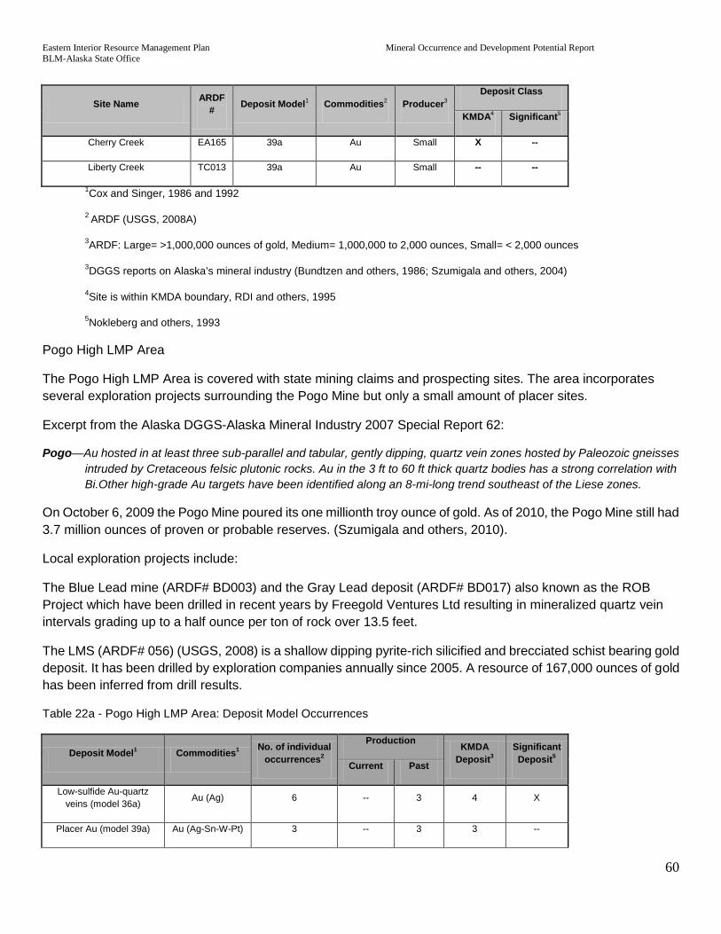
Eastern Interior Resource Management Plan Mineral Occurrence and Development Potential Report BLM-Alaska State Office
60
Site Name ARDF # Deposit Model1 Commodities2 Producer3
Deposit Class
KMDA4 Significant5
Cherry Creek EA165 39a Au Small X --
Liberty Creek TC013 39a Au Small -- --
1Cox and Singer, 1986 and 1992
2 ARDF (USGS, 2008A)
3ARDF: Large= >1,000,000 ounces of gold, Medium= 1,000,000 to 2,000 ounces, Small= < 2,000 ounces
3DGGS reports on Alaska’s mineral industry (Bundtzen and others, 1986; Szumigala and others, 2004)
4Site is within KMDA boundary, RDI and others, 1995
5Nokleberg and others, 1993
Pogo High LMP Area
The Pogo High LMP Area is covered with state mining claims and prospecting sites. The area incorporates several exploration projects surrounding the Pogo Mine but only a small amount of placer sites.
Excerpt from the Alaska DGGS-Alaska Mineral Industry 2007 Special Report 62:
Pogo—Au hosted in at least three sub-parallel and tabular, gently dipping, quartz vein zones hosted by Paleozoic gneisses intruded by Cretaceous felsic plutonic rocks. Au in the 3 ft to 60 ft thick quartz bodies has a strong correlation with Bi.Other high-grade Au targets have been identified along an 8-mi-long trend southeast of the Liese zones.
On October 6, 2009 the Pogo Mine poured its one millionth troy ounce of gold. As of 2010, the Pogo Mine still had 3.7 million ounces of proven or probable reserves. (Szumigala and others, 2010).
Local exploration projects include:
The Blue Lead mine (ARDF# BD003) and the Gray Lead deposit (ARDF# BD017) also known as the ROB Project which have been drilled in recent years by Freegold Ventures Ltd resulting in mineralized quartz vein intervals grading up to a half ounce per ton of rock over 13.5 feet.
The LMS (ARDF# 056) (USGS, 2008) is a shallow dipping pyrite-rich silicified and brecciated schist bearing gold deposit. It has been drilled by exploration companies annually since 2005. A resource of 167,000 ounces of gold has been inferred from drill results.
Table 22a - Pogo High LMP Area: Deposit Model Occurrences
Deposit Model1 Commodities1 No. of individual occurrences2
Production KMDA Deposit3
Significant Deposit5 Current Past
Low-sulfide Au-quartz veins (model 36a) Au (Ag) 6 -- 3 4 X
Placer Au (model 39a) Au (Ag-Sn-W-Pt) 3 -- 3 3 --
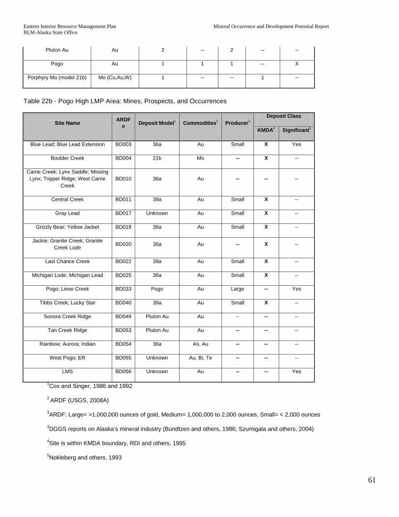
Eastern Interior Resource Management Plan Mineral Occurrence and Development Potential Report BLM-Alaska State Office
61
Pluton Au Au 2 -- 2 -- --
Pogo Au 1 1 1 -- X
Porphyry Mo (model 21b) Mo (Cu,Au,W) 1 -- -- 1 --
Table 22b - Pogo High LMP Area: Mines, Prospects, and Occurrences
Site Name ARDF # Deposit Model1 Commodities2 Producer3
Deposit Class
KMDA4 Significant5
Blue Lead; Blue Lead Extension BD003 36a Au Small X Yes
Boulder Creek BD004 21b Mo -- X --
Carrie Creek; Lynx Saddle; Missing Lynx; Tripper Ridge; West Carrie
Creek BD010 36a Au -- -- --
Central Creek BD011 39a Au Small X --
Gray Lead BD017 Unknown Au Small X --
Grizzly Bear; Yellow Jacket BD018 36a Au Small X --
Jackie; Granite Creek; Granite Creek Lode BD020 36a Au -- X --
Last Chance Creek BD022 39a Au Small X --
Michigan Lode; Michigan Lead BD025 36a Au Small X --
Pogo; Liese Creek BD033 Pogo Au Large -- Yes
Tibbs Creek; Lucky Star BD040 39a Au Small X --
Sonora Creek Ridge BD049 Pluton Au Au -- -- --
Tan Creek Ridge BD053 Pluton Au Au -- -- --
Rainbow; Aurora; Indian BD054 36a As, Au -- -- --
West Pogo; ER BD055 Unknown Au, Bi, Te -- -- --
LMS BD056 Unknown Au -- -- Yes
1Cox and Singer, 1986 and 1992
2 ARDF (USGS, 2008A)
3ARDF: Large= >1,000,000 ounces of gold, Medium= 1,000,000 to 2,000 ounces, Small= < 2,000 ounces
3DGGS reports on Alaska’s mineral industry (Bundtzen and others, 1986; Szumigala and others, 2004)
4Site is within KMDA boundary, RDI and others, 1995
5Nokleberg and others, 1993

Eastern Interior Resource Management Plan Mineral Occurrence and Development Potential Report BLM-Alaska State Office
62
Taurus High LMP Area
The Taurus High LMP are is comprised of the area around the Taurus and Bluff deposits in the east-central Tanacross quadrangle. They are both relatively large but low grade copper-molybdenum porphyry related de-posits. Although claims are maintained around the area little activity has taken place in recent years.
Excerpt from the Alaska DGGS-Alaska Mineral Industry 2007 Special Report 62:
Taurus—Significant major porphyry Cu–Au prospect of Paleocene age. East Taurus Zone contains inferred re-serves of 140 million tons grading about 0.30% Cu and 0.01 oz/ton Au, and 0.03% Mo.
Table 23a - Taurus High LMP Area: Deposit Model Occurrences
Deposit Model1 Commodities1 No. of individual occurrences2
Production KMDA Deposit3
Significant Deposit5 Current Past
Porphyry Cu-Mo (model 21a)
Cu-Mo-Au (Pb,An)
2 -- -- 2 X
Table 23b - Taurus High LMP Area: Mines, Prospects, and Occurrences
Site Name ARDF # Deposit Model1 Commodities2 Producer3
Deposit Class
KMDA4 Significant5
Bluff TC005 21a Pb, Zn -- X --
Taurus; East Taurus; West Taurus TC027 21a Cu, Mo -- X Yes
1Cox and Singer, 1986 and 1992
2 ARDF (USGS, 2008A)
3ARDF: Large= >1,000,000 ounces of gold, Medium= 1,000,000 to 2,000 ounces, Small= < 2,000 ounces
3DGGS reports on Alaska’s mineral industry (Bundtzen and others, 1986; Szumigala and others, 2004)
4Site is within KMDA boundary, RDI and others, 1995
5Nokleberg and others, 1993
Delta District High LMP Area
The Delta District is not a single deposit but a region with a high density of steep dipping massive sulfide deposits up to 40 feet thick offset by strike-slip faulting.
Excerpt from the Alaska DGGS-Alaska Mineral Industry 2007 Special Report 62:
Delta massive sulfide belt—contains at least 30 known volcanogenic massive sulfide deposits and occurrences. Grades from 0.3 to 1.1% Cu, 1.7 to 5.7% Zn, 0.5 to 2.3% Pb, 0.7 to 2.0 oz/ton Ag, and 0.018 to 0.061 oz/ton Au;

Eastern Interior Resource Management Plan Mineral Occurrence and Development Potential Report BLM-Alaska State Office
63
estimated potential reserve of 40 million tons for all deposits. Recent exploration has identified several gold pro-spects associated with silicified structures in the White Gold trend.
Table 24a - Delta District High LMP Area: Deposit Model Occurrences
Deposit Model1 Commodities1 No. of individ-
ual occur-rences2
Production KMDA Deposit3
Significant Deposit5 Current Past
Iron skarn (model 18d). Fe (Cu,Au,Sn) 1 -- -- -- --
Kuroko massive sulfide (model 28a)
Cu-Pb-Zn (Au-Ag) 50 '' -- -- X
Polymetallic veins (model 22c) Au-Ag-Pb-Cu-Zn 6 -- -- -- --
Simple Sb (model 27d) Sb 1 -- 1 1 --
Table 24b – Delta District High LMP Area: Mines, Prospects, and Occurrences
Site Name ARDF # Deposit Model1 Commodities2 Producer3
Deposit Class
KMDA4 Significant5
Unnamed (south side of the West Fork Robertson River valley) MH244 28a Cu, Pb, Zn -- -- --
Unnamed (near the mouth of Rock Candy Creek) MH245 28a Cu, Pb, Zn -- -- --
Lo Goat MH246 28a Fe -- -- --
Zygoat MH247 28a Fe -- -- --
Unnamed (southwest of the head of Snowslide Creek) MH248 22c Ag, Pb, Sb (?),
Zn -- -- --
Unnamed (on Rock Candy Creek) MH249 28a Ag, Cu, Pb, Zn -- -- --
RC West MH250 28a Pb, Zn -- -- --
Goat MH251 28a Fe -- -- --
EEK (southwest of the Kimball Glacier) MH252 28a Fe -- -- --
Unnamed (near peak 7360) MH253 22c Ag, Pb, Sb, Zn -- -- --
RC MH254 22c Ag, Cu, Pb, Zn -- -- --
RC East MH255 22c Pb, Zn -- -- --
Unnamed (north of Kimball Glacier) MH256 22c Cu, Pb, Zn -- -- --
Unnamed (northeast of peak 7360) MH257 22c Ag, Pb, Sb, Zn -- -- --

Eastern Interior Resource Management Plan Mineral Occurrence and Development Potential Report BLM-Alaska State Office
64
Site Name ARDF # Deposit Model1 Commodities2 Producer3
Deposit Class
KMDA4 Significant5
PG West MH258 28a Pb, Zn -- -- --
PG MH259 28a Ag, Au, Cu, Pb, Zn
-- -- --
PGX MH260 28a Ag, Pb, Zn -- -- --
PG Northeast MH261 28a Zn -- -- --
PG East MH262 28a Fe -- -- --
PG Southeast MH263 28a Fe -- -- --
Unnamed (southeast of peak 7057) MH264 28a Cu, Pb, Zn -- -- --
DG MH265 28a Zn -- -- --
Epidote Glacier MH318 Unknown -- -- --
DD North MH319 28a Au, Cu, Zn -- -- --
DDY MH320 28a Cu, Zn -- -- --
DDX MH321 28a Ag, Pb, Zn -- -- --
ED MH322 28a Cu, Zn -- -- --
Tiger Paw MH323 28a Cu, Pb, Zn -- -- --
TA MH324 28a Zn -- -- --
DD South MH325 28a Ag, Au, Cu, Pb, Zn
-- -- --
Big Mac MH326 28a Fe -- -- --
LZ MH327 28a Cu, Pb, Zn -- -- --
LZ East MH328 28a Cu, Pb, Zn -- -- --
SB MH329 28a Pb, Zn -- -- --
MB MH330 28a Pb, Zn -- -- --
Super Cub Ridge MH331 18d Fe -- -- --
SC East; Super Cub East MH332 28a Au, Ag, Cu, Pb, Zn
-- -- --
Trio MH333 28a Ag, Au, Zn -- -- --
Val MH334 28a Zn -- -- --
DW East MH335 28a Pb, Zn -- -- --
Trio West MH336 28a Zn -- -- --

Eastern Interior Resource Management Plan Mineral Occurrence and Development Potential Report BLM-Alaska State Office
65
Site Name ARDF # Deposit Model1 Commodities2 Producer3
Deposit Class
KMDA4 Significant5
Trio East MH337 28a Ag, Pb, Zn -- -- --
DW MH338 28a Pb, Zn -- -- --
Nunatak MH339 28a Pb, Zn -- -- --
MID(Delta District) MH340 28a Pb, Zn -- -- Yes
LP MH341 28a Pb, Zn -- -- --
Rum North MH342 28a Cu, Pb, Zn -- -- --
Rum South MH343 28a Ag, Pb, Zn -- -- --
LBB MH344 28a Ag, Cu, Pb, Zn -- -- --
PP2 MH345 28a Pb, Zn -- -- --
LPH MH346 28a Pb, Zn -- -- --
LPH South MH347 28a Pb, Zn -- -- --
CC Barite MH348 28a Ba -- -- --
CC South MH349 28a Zn -- -- --
Cascade MH350 28a Cu, Zn -- -- --
UPP MH351 28a Cu, Pb, Zn -- -- --
PP MH352 28a Cu, Pb, Zn -- -- --
LPP MH353 28a Cu, Pb, Zn -- -- --
Tok TC028 36a Au -- -- --
Tok Antimony; Stibnite; A Lucky Leak; Gamblin; Caulk TC029 27d Sb Small X --
1Cox and Singer, 1986 and 1992
2 ARDF (USGS, 2008A)
3ARDF: Large= >1,000,000 ounces of gold, Medium= 1,000,000 to 2,000 ounces, Small= < 2,000 ounces
3DGGS reports on Alaska’s mineral industry (Bundtzen and others, 1986; Szumigala and others, 2004)
4Site is within KMDA boundary, RDI and others, 1995
5Nokleberg and others, 1993
McArthur Creek High LMP Area
McArthur Creek is a cluster of mining claims at the head waters of a McArthur Creek, which drains, into Canada. The occurrences have a long history of mining (USGS, 2008A) and include the Move occurrence, which consists

Eastern Interior Resource Management Plan Mineral Occurrence and Development Potential Report BLM-Alaska State Office
66
of gold-bearing quartz veins. There is no current lode gold production reported in the area but there are nu-merous mining claims on the Yukon Territory side of the border.
Table 25a – McArthur Creek High LMP Area: Deposit Model Occurrences
Deposit Model1 Commodities1 No. of individual occurrences2
Production KMDA Deposit3
Significant Deposit5 Current Past
Low-sulfide Au-quartz veins ( model 36a) Au (Ag) 1 -- 1 1 --
Placer Au (model 39a) Au (Ag-Sn-W-Pt) 2 -- 2 1 --
Table 25b - McArthur Creek High LMP Area: Mines, Prospects, and Occurrences
Site Name ARDF # Deposit Model1 Commodities2 Producer3
Deposit Class
KMDA4 Significant5
B.C. TC002 39a Au Small -- --
McArthur Creek TC014 39a Au Small X --
Move TC016 36a Au -- X --
1Cox and Singer, 1986 and 1992
2 ARDF (USGS, 2008A)
3ARDF: Large= >1,000,000 ounces of gold, Medium= 1,000,000 to 2,000 ounces, Small= < 2,000 ounces
3DGGS reports on Alaska’s mineral industry (Bundtzen and others, 1986; Szumigala and others, 2004)
4Site is within KMDA boundary, RDI and others, 1995
5Nokleberg and others, 1993
2. Areas with Medium Potential Rating
In the Eastern Interior planning area, many areas outside of the High LMP area, south of the Yukon River have at least medium locatable mineral potential. Those areas designated in this report as Medium LMP may have active mining claims, portions of KMDA areas, AMIS occurrences, ARDF occurrences, or contain MTAs, although in less density or significance than the High LMP areas.
Livengood Medium LMP Area

Eastern Interior Resource Management Plan Mineral Occurrence and Development Potential Report BLM-Alaska State Office
67
Surrounding the Livengood High LMP, the Livengood Medium LMP has overlapping active mining claims, min-eral terranes, and KMDA placer districts. In addition, there are scattered AMIS occurrences and one past pro-ducing ARDF placer occurrence.
Table 26 – Livengood Medium LMP Area: Deposit Model Occurrences
Deposit Model1 Commodities1 No. of individual occurrences2
Production KMDA Deposit3
Significant Deposit5 Current Past
Placer Au (model 39a) Au (Ag-Sn-W-Pt) 1 -- 1 1 --
Cache Mountain Medium LMP Area
Cache Mountain was identified by the USGS as containing several anomalous mineral samples collected within the 10 square miles of exposed granite. Stream sediment samples indicate the granite is anomalous in tin, silver and tungsten and its location coincides with three AMIS mineral occurrences. The boundary is based on Tract “I” on Plate – V of USGS Open – File Report 88-284 (Weber and others, 1988). The boundary also roughly outlines a large block of federal lode mining claims, which were closed before 1999.
Lime Peak Medium LMP Area
The DGGS identified the Lime Peak/Rocky Mountain area as having potential but with abundant accessory silver, tantalum and tungsten. The outline follows the boundary of the Lime Peak Pluton labeled “LPP” on Figure H-2 of Miscellaneous Publication 29 (Smith and others, 1987). The boundary includes 2 AMIS occurrences and 2 tin-greisen related ARDF sites. The area also includes a block of closed federal lode claims.
Table 27 – Lime Peak Medium LMP Area: Deposit Model Occurrences
Deposit Model1 Commodities1 No. of individual occurrences2
Production KMDA Deposit3
Significant Deposit5 Current Past
Sn skarn deposit (model 15c) Sn (Ag,Ta,W) 2 -- -- -- --
Trail Creek Medium LMP Area
The USGS (Weber and others, 1988) and the USBM (Fechner and Maas, 1988) both recognized that Trail Creek is placer gold bearing. The USGS found anomalous gold in samples and the USBM found it gold bearing but concluded that it had low development potential using 1988 economics. The area also includes some closed federal placer claims on Belle Creek just outside the WMNRA. The Trail Creek ARDF site is included in the area.
Table 28 – Trail Creek Medium LMP Area: Deposit Model Occurrences
Deposit Model1 Commodities1 No. of individual occurrences2
Production KMDA Deposit3
Significant Deposit5 Current Past

Eastern Interior Resource Management Plan Mineral Occurrence and Development Potential Report BLM-Alaska State Office
68
Placer Au (model 39a) Au 1 -- -- -- --
West Prindle Medium LMP Area
The USGS (Weber and others, 1988) and the USBM (Fechner and Maas, 1988) both recognized that the upper Champion Creek draining west from the Prindle Mountain area is placer gold bearing. It also contains portions of closed federal lode claims and 14 closed federal placer claims.
Birch Creek Medium LMP Area
The Birch Creek Medium LMP covers a middle section of Preacher Creek that has multiple closed federal placer claims and a few closed lode claim in the Preacher Creek area. The central portion contains 8 ARDF sites as-sociated with anomalous sample results collected by the USGS sampling program in the Circle Quadrangle (Foster and others, 1984). The ARDF sites are also related to the Table Mountain granite, which has both gold bearing tourmaline-quartz veins and silver and tin bearing dikes surrounding the intrusive. The southern portion of this LMP area contains where 80 federal placer claims had been located prior to 1999. There are also 7 placer related AMIS occurrences.
Table 29 – Birch Creek Medium LMP Area: Deposit Model Occurrences
Deposit Model1 Commodities1 No. of individual occurrences2
Production KMDA Deposit3
Significant Deposit5 Current Past
Unknown Au, Ag, Sn, 8 -- -- -- 1
Puzzle Gulch Skarns Medium LMP Area
Southeast of the Circle High LMP Area, the Puzzle Gulch Skarns Medium LMP Area surrounds six ARDF sites of which there are four tungsten skarns, four Mineral Terrane Areas, and two KMDAs. The area does not contain any active mining claims and only contains one small closed federal Plan level operation however it does contain 9 placer related AMIS occurrences and 3 exploration related AMIS occurrences. The area is about 80 withdrawn BLM lands and 80 percent open State of Alaska land. Despite the mixed land status, this area contains no state or active federal mining claims. Between 1979 and 1999 there were 409 placer mining claims and 2,843 federal lode claims – those are all now closed.
Table 30 – Puzzle Gulch Skarns Medium LMP Area: Deposit Model Occurrences
Deposit Model1 Commodities1 No. of individual occurrences2
Production KMDA Deposit3
Significant Deposit5 Current Past
W skarn deposit (model 14a) W 4 -- -- -- --
Caribou Creek Medium LMP Area
The Caribou Creek Medium LMP Area is designated to capture the juxtaposed but non-overlapping attributes of numerous state mining claims, KMDAs, MTAs, Placer producing areas, one KMDA Placer Producing Stream and a cluster of placer type ARDF occurrences including the Caribou Creek placer. The Caribou Creek placer was historically a moderate sized gold producer.

Eastern Interior Resource Management Plan Mineral Occurrence and Development Potential Report BLM-Alaska State Office
69
Table 31 – Caribou Medium LMP Area: Deposit Model Occurrences
Deposit Model1 Commodities1 No. of individual occurrences2
Production KMDA Deposit3
Significant Deposit5 Current Past
Placer Au (model 39a) Au (Ag-Sn-W-Pt) 5 2 5 4 --
Three Castle Medium LMP Area
Northeast of the Yukon River is a carbonate terrane that constitutes the only area of the North American Craton in Alaska and contains several Zinc and Lead mineral occurrences. There are no mining claims or KMDAs but most of the Medium LMP Area is made of MTAs.
Table 32 – Three Castle Medium LMP Area: Deposit Model Occurrences
Deposit Model1 Commodities1 No. of individual occurrences2
Production KMDA Deposit3
Significant Deposit5 Current Past
Roll-front uranium (model 30c) U 1 -- -- -- --
Carbonate-hosted Zn-Pb Zn, Pb, Ag 6 -- -- -- --
Superior Fe (model 34a) Fe 1 -- -- -- --
Slate Creek Medium LMP Area
The Slate Creek Medium LMP Area was designated to recognize a significant deposit of an insignificant com-modity: asbestos. The Slate Creek Asbestos occurrence has a 60 million ton resource of Serpentine containing 6.4% high quality asbestos (USGS, 2008A).
Table 33 – Slate Creek Medium LMP Area: Deposit Model Occurrences
Deposit Model1 Commodities1 No. of individual occurrences2
Production KMDA Deposit3
Significant Deposit5 Current Past
Serpentine-hosted as-bestos (model 8d) Asbestos 1 -- -- -- X
Champion Medium LMP Area
This area has a cluster of ARDF Copper skarns, a KMDA, all or portions of KMDAs but no mining claims or producing ARDF placers.
Table 34 – Champion Medium LMP Area: Deposit Model Occurrences
Deposit Model1 Commodities1 No. of individual occurrences2
Production KMDA Deposit3
Significant Deposit5 Current Past
Cu skarn (model 18b). Cu-Au-Ag 4 -- -- -- --

Eastern Interior Resource Management Plan Mineral Occurrence and Development Potential Report BLM-Alaska State Office
70
Zn-Pb skarn (model 18c) Ag-Pb-Zn (Cu) 1 -- -- -- --
Delta Medium LMP Area
This area surrounds the Delta District High LMP Area on three sides and contains several scattered ARDF sites that are covered by active mining claims. Most of the mining claims are coincident with MTAs.
Table 35 – Delta Medium LMP Area: Deposit Model Occurrences
Deposit Model1 Commodities1 No. of individual occurrences2
Production KMDA Deposit3
Significant Deposit5 Current Past
Placer Au (model 39a) Au (Ag-Sn-W-Pt) 2 -- -- -- --
Polymetallic veins (model 22c) Au-Ag-Pb-Cu-Zn 1 -- -- -- --
Porphyry Cu-Mo (model 21a)
Cu-Mo-Au (Pb,An) 1 -- -- -- --
Fairplay-Peternie Medium LMP Area
The Fairplay-Peternie Medium LMP covers a large swath of the southern Eastern Interior planning area and incorporates several Porphyry Copper- Molybdenum occurrences that coincide with several KMDA’s, large claim blocks, MTAs and surround the Taurus High LMP Area.
Table 36 – Fairplay-Peternie Medium LMP Area: Deposit Model Occurrences
Deposit Model1 Commodities1 No. of individual occurrences2
Production KMDA Deposit3
Significant Deposit5 Current Past
Porphyry Cu-Mo (model 21a)
Cu-Mo-Au (Pb,An) 11 -- -- 1 No
Mosquito Medium LMP Area
The Mosquito Medium LMP Area like the Fairplay-Peternie covers an area of scattered Porphyry occurrences and coincidental MTAs and KMDAs but with no active mining claims.
Table 37 – Mosquito Medium LMP Area: Deposit Model Occurrences
Deposit Model1 Commodities1 No. of individu-al occurrences2
Production KMDA Deposit3
Significant Deposit5 Current Past
Porphyry Cu-Mo (model 21a)
Cu-Mo-Au (Pb,An) 2 -- -- 1 No
Porphyry Mo (model 21b) Mo (Cu,Au,W) 3 -- -- 0 No

Eastern Interior Resource Management Plan Mineral Occurrence and Development Potential Report BLM-Alaska State Office
71
W skarn deposit (model 14a) W 3 -- -- 0 No
VI. STATEMENT OF QUALIFICATION
Report text and graphics were prepared by John Hoppe (Geologist), Robert M. Ellefson (Geologist), and Robert Brumbaugh (Physical Scientist) for BLM’s Division of Resources, Branch of Energy and Solid Minerals, head-quartered at the Alaska State Office in Anchorage.
VII. Specific Mandates and Authority
A. Laws
1. The Federal Land Policy and Management Act (FLPMA) of 1976, as amended, 43 U.S.C.1701 et seq. provides the authority for BLM land use planning. FLPMA specifically affects locatable minerals by changing withdrawal procedures, requiring recordation of mining claims with BLM, and authorizing regulations for surface protection of the public lands.
a. Section 201 requires the Secretary of the Interior to prepare and maintain an inventory of all BLM ad-ministered lands and their resource and other values, giving priority to Areas of Critical Environmental Concern (ACECs); and, as funding and workforce are available, to determine the boundaries of the public lands, provide signs and maps to the public, and provide inventory data to state and local governments.
b. Section 202 (c) (9) requires that land use plans for BLM administered lands be consistent with tribal plans and, to the maximum extent consistent with applicable federal laws, with state and local plans. The State and most of the Native Corporations have been aggressively promoting mineral development on their lands.
c. Section 204 (c)(1) establishes that a withdrawal from the public land laws is effective for a period of not more than twenty years (also established a procedure for extensions).
d. Section 209 (a & b), establishes rules and procedures for reservation and conveyance of the mineral estate.
e. Section 302 (a) requires the Secretary to manage the BLM administered lands under the principles of multiple use and sustained yield, in accordance with, when available, land use plans developed under Section 202 of FLPMA, except that where a tract of BLM administered lands has been dedicated to specific uses ac-cording to any other provisions of law, it shall be managed in accordance with such laws.
f. Section 302 (b) recognizes the entry and development rights of mining claimants, while directing the Secretary to prevent unnecessary or undue degradation of the public lands.
2. The Recreation and Public Purposes (R&PP) Act of 1926, as amended, 43 U.S.C. 869 et seq., authorizes the Secretary of the Interior to lease or convey BLM administered lands for recreational and public purposes under specified conditions. This includes providing for community free use permits for mineral materials.
3. The General Mining Law of 1872, as amended, 30 U.S.C. 21 et seq., allows the location, use, and pa-tenting of mining claims on sites on public domain lands of the United States. As the 1872 Mining Law estab-lished few details on how to regulate mining on the public lands, rules and regulations have been developed largely in response to extensive mineral case law established through IBLA and the courts.

Eastern Interior Resource Management Plan Mineral Occurrence and Development Potential Report BLM-Alaska State Office
72
4. The Mining and Mineral Policy Act of 1970, 30 U.S.C. 21a, establishes a policy of fostering development of economically stable mining and minerals industries, their orderly and economic development, and studying methods for disposal of waste and reclamation.
5. The Materials Act of July 31, 1947 (61 Stat. 681), authorized the disposal of sand, stone, gravel and common clay through a contract of sale.
6. Act of July 23, 1955; 69 Stat. 934, removed common varieties of sand, gravel, cinders, pumice, pumicite and clay from the category of locatable minerals and placed them under the Materials Act of 1947. This estab-lished mineral materials as salable minerals. The 1955 Act also provides for multiple uses of the lands and surface resources on mining claims (primarily affected public access across mining claims and the use and development of timber resources on mining claims).
7. The Alaska Native Claims Settlement Act (ANCSA), 1971, Public Law (PL) 92-203 (85 Stat. 688). One of the primary selection criteria for the Native Corporations has been to select lands with mineral potential.
Sections 17(d)(1) and 17(d)(2)(A), directed the Secretary to withdraw from all forms of appropriation, including the mining laws, up to but not to exceed eighty million acres.
Section 11(a)(1), 43 USC 1610, provides that certain lands surrounding and adjacent to native villages are withdrawn, subject to valid existing rights, from all forms of appropria-tion, including the mining laws.
Section 22(h), 43 USC 1621, provides that withdrawals made under this Act shall termi-nate within four years of December 18, 1971, provided that lands selected by Natives under section 1611 of the Act shall remain.
Section 17(b)(2), protects the rights of mining claimants for access across Native lands as a valid existing right.
8. The Alaska Statehood Act of July 7, 1958, grants to the State the right to select 102,550,000 acres of vacant, unappropriated and unreserved public lands. One of the primary selection criteria for the State has been to select lands with mineral potential.
9. Alaska National Interest Lands Conservation Act (ANILCA), 1980, PL 96-487, Section 1110(b), assures in holders, including mining claimants, in National Conservation Units or Wilderness Study Areas, adequate and feasible access for economic and other purposes.
B. Executive Orders (EO)
EO 13084 (consultation and Coordination with Indian Tribal Governments) provides, in part, that each federal agency shall establish regular and meaningful consultation and collab-oration with Indian tribal governments in the development of regulatory practices on fed-eral matters that significantly or uniquely affect their communities. This would include the development of mineral resources on the public lands.
C. Regulations

Eastern Interior Resource Management Plan Mineral Occurrence and Development Potential Report BLM-Alaska State Office
73
The 43 CFR 3600 regulations, establish procedures for the exploration, development and disposal of mineral material resources.
D. Policy
IM Memorandum No. 2001-032, December 7, 2000, Mineral Materials Inspection and En-forcement, Production Verification, and Appraisal Policy (expires 9/30/2002).
VIII. Current Management and Existing Land Use Plans
Fortymile MFP
The Fortymile MFP has been in effect since September 1980. There are references to minerals in the plan, most notably the mineral related objectives directed toward locatables and salables. Although the following objectives and decisions indicate that unnecessary withdrawals would be lifted and public lands in the planning area would be reopened to mineral leasing, location, and entry, this decision was never implemented. Most of the land in the Fortymile unit remains closed to locatable mineral entry through a series of public land orders enacted in the early 1970’s. The only ongoing mining on BLM land is on preexisting federal mining claims.
Objectives from the Fortymile MFP (1980):
Provide additional sources of sand and gravel/or aggregate to meet local construction needs and for high-way, railway, airfield, and pipeline construction and maintenance purposes.
By 1990, all land that is public land or reverts to public land, and is closed to mineral entry by unnecessary withdrawals, should be reopened to mineral entry.
All public land should be inventoried for its mineral potential before any action is taken which will prohibit entry.
Some of the Decisions to support these objectives are outlined in the bullets below:
M 2.1: A, five acre community pit should be established in the community of Chicken.
M 2.2: A five acre community pit should be established in Eag1e.
M 2.4: Material sites should be provided for the construction and maintenance of highways, railways, air-fields, and pipelines.
M 3.1: By 1985, all public land, which has been withdrawn by PLO 5250, and has not been recommended to Congress, should be restored to public land, open to mineral entry. The major lands affected are those within the Fortymile River drainage basin (e.g.,Butte Creek, Canyon Creek, Walker Fork, and Slate Creek). This decision has not been implemented.
M 4.1: Conduct inventories as funding permits. Give special emphasis to areas being considered for with-drawal from mineral entry.
Steese National Conservation Area (SNCA)RMP

Eastern Interior Resource Management Plan Mineral Occurrence and Development Potential Report BLM-Alaska State Office
74
The SNCA Record of Decision (ROD) was signed in February 1986. Like the Fortymile MFP, the SNCA ROD indicates that portions of the Steese NCA would be reopened to locatable mineral entry through the revocation of withdrawals. However, this decision has never been implemented and BLM land in the planning area remains closed to locatable mineral entry except on preexisting federal mining claims. The following excerpts are taken from the Steese ROD under the Minerals Management heading.
All Management Units
Locatable Minerals
The following requirements apply to valid existing claims as well as to any new mining claims that might be located in areas opened to entry: (Note: no areas have been reopened to entry at this time.)
Each operator in the SNCA will be required to file a Plan of Operation or Notice of Operation depending on location and acreage disturbed. An operator who disturbs more than five acres per year or who is operating in an area closed to further mineral location is required to file a Plan of Operation. The plan or notice shall include the name and mailing address of the operator (and of the claimant if the two are not one and the same), a map showing existing or proposed access, the name and serial number of the claim(s) to be mined, proposed operation and dates of activity, type and degree of the operation, measures to prevent undue and unnecessary degradation, and a plan to reclaim disturbed lands. A reclamation plan must be included as a part of the Plan of Operation or Notice of Intent.
Within the SNCA, wintertime cross-country moves would be preferred for the transport of equipment onto claims. Any cross-country movement of heavy equipment would have to be approved in advance by the Authorized Officer.
Close coordination with adjacent land owners or managers will be made where the potential exists to affect the lands under their control.
All operators producing water-borne effluent must obtain a National Pollutant Discharge Elimination System permit and meet the requirements of that permit. In cooperation with ADEC and EPA, water quality will be monitored along streams to ensure compliance.
Reclamation. All operations in the SNCA will be reclaimed to the satisfaction of the Authorized Officer.
BLM will develop a program of erosion abatement and satisfactory reclamation on disturbed ground in the headwaters of Birch Creek. This program will involve federal claims outside of the SNCA in order to help improve the water quality of the Birch Creek NWR.
Saleable Minerals. Disposal of sand, gravel, rock, and other saleable minerals will be based on need and on conformance with the RMP.
Decision:
To ensure compliance with approved mining plans of operation or mineral lease requirements, at least three inspections per year should be made of all operations. This will require a, full-time surface protec-tion specialist at a cost of approximately $40,000 per year and approximately $7,500 per year for aircraft use.

Eastern Interior Resource Management Plan Mineral Occurrence and Development Potential Report BLM-Alaska State Office
75
Note: This has been implemented but only two inspections are made yearly.
Rationale: The Area contains mineral resources that are presently of economic value to the Fairbanks community. The mineral potential within the SNCA could provide a base for future economic develop-ment. Regulations are necessary to ensure that development occurs in an environmentally sound manner. Caribou habitat and the Birch Creek NWR must be protected. ANILCA and Bureau policy ad-dress multiple use and allow for development where compatible with other land uses.
There are areas in the SNCA RMP where restrictions are imposed upon locatable minerals. These areas include the Primitive Management Unit, Semi-Primitive Motorized Restricted Special Management Unit, Semi-Primitive Motorized Special Management and Research Natural Areas. As stated above, the decisions to open areas to locatable mineral entry were never implemented.
Primitive Management Unit
Locatable minerals in The Primitive Management Unit (the high country adjacent to the White Mountains National Recreation Area and the Pinnell Mountain Trail Corridor) will remain closed to mineral entry under the 1872 Mining Law and to the leasing of oil and gas, non-energy minerals and geothermal re-sources
\
EXPLORATION. Anyone proposing to explore for minerals within the SNCA must contact the Authorized Officer. Activities which conform to the management prescriptions for this unit and which will not impair the unit’s primitive values will be allowed. Permits will generally not be required for helicopter landings. However, the use of off-road vehicles (except snow machinessnowmachines) will not be permitted.
Rationale: This management unit contains areas of high mineral potential. It also contains important caribou range, which is required by ANILCA to be a special consideration in this plan. The roads, equipment, and structures associated with mineral development are not compatible with primitive rec-reation and the primitive values present in this unit. Section 1010 of ANILCA directs the Secretary to «assess the oil, gas, and other mineral potential on all public lands in the State of Alaska in order to expand the data base with respect to the mineral potential of such lands.» The Secretary is also directed, to allow for access by air for such activities. The BLM is working with the Alaska Division of Geological/ Geophysical Survey, the Bureau of Mines, and the U. S. Geological Survey to develop further mineral assessments of these and other lands in Alaska. Any proposed study will also receive review and comment by the mineral industry, so the best utilization of government and private mineral assessment capabilities can be made. Information gathered through exploration by private companies would also assist the Bureau in meeting this legal requirement. Such information, in combination with information that will be collected on wildlife and other resources, would be very useful in evaluating possible amendments to this plan. In accordance with Section 1010, all exploration will be carried out in an en-vironmentally sound manner, with no appreciable alteration of the natural character or ecological systems of the Area.
The Semi-Primitive Motorized Restricted Management Unit

Eastern Interior Resource Management Plan Mineral Occurrence and Development Potential Report BLM-Alaska State Office
76
The Semi-Primitive Motorized Restricted Management Unit will remain closed to mineral entry under the 1872. Mining Law and to leasing of oil and gas, non-energy minerals, and geothermal resources.
EXPLORATION. Anyone proposing to explore for minerals within the SNCA must contact the Authorized Officer. Activities which conform to the management prescriptions for this unit and which will not impair the unit’s values will be allowable. Permits will generally not be required for helicopter landings.
Rationale: This management unit contains caribou calving grounds, an area of crucial importance to that species. Congress has directed that caribou range be a special consideration in this plan. This man-agement unit also contains important habitat for a small population of Dall sheep in the Big Windy Creek/ Puzzle Gulch area. In view of the possible detrimental effects of mineral development on these two species, the area should remain closed to mineral entry.
Section 1010 of ANILCA directs the Secretary to «assess the oil, gas, and other mineral potential on all public lands in the State of Alaska in order to expand the data base with respect to the mineral potential of such lands.» The Secretary is also directed, to allow for access by air for such activities. The BLM is working with the Alaska Division of Geological/ Geophysical Survey, the Bureau of Mines, and the U. S. Geological Survey on developing further mineral assessments of these and other lands in Alaska. Any proposed study will also receive review and comment by the mineral industry, so the best utilization of government and private mineral assessment capabilities can be made. Information gathered through exploration by private companies would also assist the Bureau in meeting this legal requirement. Such information and data on wildlife and other resources would be very useful in evaluating possible amendments to this plan. In accordance with Section 1010, all exploration will be carried out in an en-vironmentally sound manner, with no appreciable alteration of the natural character or ecological systems of the Area.
The Semi-Primitive Motorized Special Management Unit
The Semi-Primitive Motorized Special Management Unit will be opened under the 1872 Mining Law to mineral entry (43 CFR 3800). It will also be open to oil and gas leasing (43 CFR 3100), geothermal leasing (43 CFR 3200) and to leasing of non-energy minerals (43 CFR 3500). All operations on leases and mining claims are subject to the following special stipulations.
Prior to commencing operations, the operator shall demonstrate that his operation will have no long-term, significant, adverse, effects on caribou habitat or caribou populations.
Seasonal restrictions will be imposed between May 1 and June 15, or between August 15 and September 30, if the operation will interfere with caribou calving or caribou migration.
Note: This decision has not been implemented. The Semi-Primitive Motorized Special Management Unit remains closed to locatable mineral entry.
Rationale: This management unit contains areas of high mineral potential. It also contains important caribou range, which is required by ANILCA to be a special consideration in this plan. Mineral devel-opment can be allowed to occur in this management unit only if such development has no long-term impacts on caribou.

Eastern Interior Resource Management Plan Mineral Occurrence and Development Potential Report BLM-Alaska State Office
77
Semi-Primitive Motorized Management Unit
This management unit will be opened to entry under the 1872 Mining Law. It will also be opened to oil and gas leasing (43 CFR. 3100), geothermal leasing (43 CFR 3200), and the leasing of non-energy minerals (43 CFR 3500). All leasing will be under standard stipulations.
Note: This decision has not been implemented. The Semi-Primitive Motorized Management Unit remains closed to locatable mineral entry.
Rationale: This area contains existing placer gold mines and shows potential for other types of mineral development. Mineral development is compatible with other resource uses proposed for this area, and standard stipulations will be adequate to protect known resource values
Research Natural Areas:
Two Research Natural Areas (RNA) will be designated. One RNA on Mount Prindle includes 2,800 acres in the SNCA, and the other RNA encompasses the 160-acre Big Windy Hot Springs withdrawal.
All Research Natural Areas will remain closed to mineral entry and all types of mineral leasing.
Rationale: The establishment of Research Natural Areas is part of the Ecological Reserve System and an interagency program for establishing areas useful for scientific research. These areas were selected because they contain typical representations of ecosystems or unusual natural features.
The following excerpt from the Steese National Conservation Area Record of Decision evaluates the mineral assessment needs for future monitoring and evaluation of the RMP.
MINERALS
Mineral assessment of all federal lands within the SNCA is needed to expand the data base with respect to the mineral potential of the Area. The mineral assessment program may include, but would not be limited to, such techniques as side-looking radar imagery, airborne magnetometer surveys, and heli-copter-borne core and test drilling. A mineral program consisting of gathering and analyzing rock and chip samples, stream sediment samples, and pan concentrates could be accomplished during a five-year period. The cost of such an effort would be approximately $915,000 ($183,000 per year).
The mineral resource assessment program discussed here is in keeping with the intent of Congress as identified in Section 1010 of ANILCA. All proposals for this assessment, whether conducted by public or private groups, would be accomplished in an environmentally sound manner that would prevent any lasting impacts, which would appreciably alter the natural character of the SNCA, or the biological or ecological systems found in it. Protective restrictions on access and operations during calving, spawning, migration, or other critical periods shall be imposed.
The BLM is working with the Alaska Division of Geological/Geophysical Survey, the Bureau of Mines and the U.S. Geological Survey to further develop mineral assessments of these and other lands in Alaska. Any proposed study will also receive review and comment by the mineral industry so to make the best utilization of government and private mineral assessment capabilities.

Eastern Interior Resource Management Plan Mineral Occurrence and Development Potential Report BLM-Alaska State Office
78
New data generated from the mineral inventory will be incorporated into the three-year evalua-tion/revision process. If new land use decisions are needed, they will be proposed at that time.
The BLM will cooperate fully with the State in a joint commitment to improve placer mining methods and technologies that seek ways to achieve water quality standards and retain an economically viable mineral industry. The BLM will accept the opportunity to participate in the State’s ongoing placer mining studies. The BLM will evaluate and consider the results of such studies and use this data when formulating land management decisions.
Birch Creek Management Plan
ANILCA established the Birch Creek Wild and Scenic River in 1980, and the river has been managed under the Birch Creek Wild and Scenic River Management Plan since 1983. The following excerpt from that plan ad-dresses mineral potential and management actions affecting locatable minerals. At the time of the plan’s pub-lication there were 5,000 placer claims located within the drainages of Birch Creek.
HISTORY and GEOLOGY
Placer gold deposits were first dis-covered on Birch Creek in 1893. This led to the formation of the Circle Mining District, a mining district which has remained active. In terms of known value and production levels, gold is the most important mineral resource within the river corridor. Placer deposits are located on most tributaries of Birch Creek and recent interest has led to exploration into new areas. There is po-tential for future dis-coveries and development, particularly on the south side of Birch Creek. The river corridor lies in a regional belt of mineralization that occupies this portion of interior Alaska. A major tungsten deposit south of the river corridor has been located in the vicinity of Puzzle Gulch, Caribou Creek, and the Upper Salcha River.
The existing mining claims under this river management plan are authorized reasonable access to their claims as consistent with the regulations found in Titles 43 of the Code of Federal Regulations, Subpart 3809 (43 CFR 3809). Inclusion of mining claims within the river corridor boundary of Birch Creek National Wild River should not be construed as being an administrative action challenging the rights of claim holders under the U.S. Mining Laws. Lands within one half mile of the bank of any Alaskan river desig-nated a “wild” river have been withdrawn, subject to valid existing rights, from all forms of appropriation under the mining laws and the mineral leasing laws by Section 606 of ANILCA.
Mining equipment has been driven within the river corridor to access claims located both inside and outside the river corridor. Mining access primarily takes place in winter and early spring, but may occur during other times of the year along the State-maintained Portage Creek and Harrison Creek roads.
Placer mining activity occurs in the headwaters of Birch Creek on Butte, Gold Dust, and Eagle creeks, and on the tributaries to Birch Creek including Harrison, Deadwood, Crooked, Bottom Dollar, and Ketchum creeks. During the last decade, improvements in mining technology and a significant rise in the price of gold has caused an increase in mining activity in the area. Mining activities have caused localized surface disturbances along these creeks. The effluent from these placer mining operations drains into Birch Creek, the only drainage for the Circle Mining District. Placer mining operations provide employ-ment and a base for service industries located in Fairbanks.
Eastern Interior Resource Management Plan Mineral Occurrence and Development Potential Report BLM-Alaska State Office
79
Management Actions Affecting Locatables
Access to mining claims located prior to ANILCA and with acceptable proof of discovery will be managed under existing regulations in 43 CFR 3809.
Discussion: 43 CFR 3809 requires a “Plan of Operations” from all mining claimants planning surface disturbing activities within the Steese NCA or the [Birch] river corridor, regardless of acres disturbed. These plans must include a detailed description of access needs. The Bureau will specify vehicle types, season of use, reclamation, and mining plans to minimize adverse impacts.
Mining claims properly located and maintained prior to inclusion in the Wild and Scenic Rivers System will be managed under the mining laws and 43 CFR 3809. Plans of Operations required under 43 CFR 3809 will address a logical sequence of mineral development and extraction. Changes may be made at any time subject to approval of an amended plan of operations.
Discussion: The Bureau will assess each proposed plan with the intention of achieving an optimum balance between reasonable and necessary operations and their effects on the environment. A plan of operations should present a logical sequence of discrete stages from exploration through development to extraction and ensuing reclamation for a period of five years or mine life, whichever is less. Professional evaluation of the development of a mine, especially operations utilizing mechanized earth moving equipment, necessitates the emphasis on pre- development exploration. Activities to establish and de-lineate mineral reserves will be stressed by the BLM before plans involving large scale mechanical stripping operations within the river corridor will be authorized.
Continued implementation of existing surface management regulations within the river corridor shall be a BLM priority for minerals management. A minimum of one field visit will be made for each operation in the river corridor annually.
Improperly located mining claims will be adjudicated in a timely fashion.
Discussion: The river corridor will be designated as a priority area for mineral adjudication. Adjudication will determine if claims are located in compliance with existing land orders and issue any necessary de-cisions. If any claims improperly located and operating, they will constitute mineral trespass.
White Mountains National recreation area (White mountains NRA)
General Guidance
LOCATABLE MINERALS-VALID EXISTING CLAIMS. There are no longer any valid claims in the White Mountains NRA.
LOCATABLE MINERALS-NEW DISPOSALS. In accordance with ANILCA, new disposals of locatable minerals within the White Mountains NRA can only be made through a leasing process. No lands within the NRA will be opened to the leasing of placer deposits. However, the leasing of lode deposits will be allowed. This decision has never been implemented. Like the Steese National Conservation Area, the White Mountains NRA remains withdrawn from leasing and locatable mineral entry.

Eastern Interior Resource Management Plan Mineral Occurrence and Development Potential Report BLM-Alaska State Office
80
SALEABLE MINERALS. Disposal of sand, gravel, rock, and other saleable minerals under 43 CFR 3600 will be made if such disposals are compatible with the other provisions of this plan.
EXPLORATION. Because of the multiplicity of exploration methods that might be employed, anyone proposing to explore for minerals within the White Mountains NRA must contact the Authorized Officer.
RECLAMATION. All operations in the White Mountains NRA will be reclaimed to the satisfaction of the Authorized Officer.
Rationale: Under the provisions of ANILCA, holders of valid existing rights can develop their claims in accordance with the Surface Management Regulations that provide for the protection of the environment.
In certain areas outside the primitive unit, new mineral development can be permitted under the leasing provisions of ANILCA as long as it does not significantly impair recreational values or use. Note: this decision has never been implemented.
Extensive placer mining on Beaver Creek or its principal tributaries would be in conflict with recreational purposes because of degradation to natural and primitive values of the Beaver Creek NWR corridor and damage to arctic grayling habitat.
Section 1010 of ANILCA directs the Secretary to “assess the oil, gas, and other mineral potential on all public lands in the State of Alaska in order to expand the data base with respect to the minerals potential of such lands.” The Secretary is also directed to allow for access by air for such activities. The BLM is working to develop further mineral assessments with the State Division of Geological/Geophysical Survey, the Bureau of Mines, and the U.S. Geological Survey of these and other lands in Alaska. Any proposed study will also receive review and comment by the mineral industry, so the best utilization of government and private mineral assessment capabilities can be made. Information gathered through exploration by private companies will assist the Bureau in, meeting this legal requirement. Such infor-mation, combined with data collected on wildlife and other resources, will be very useful in evaluating possible amendments to this plan. In accordance with Section 1010, all exploration will be carried out in an environmentally sound manner, with no appreciable alteration of the natural character or ecological systems of the Area.
Primitive Management Unit
The Primitive Management unit will remain closed to all mineral leasing.
Exploration for minerals is subject to the decision of the Authorized Officer. Activities which conform to the management prescriptions for this unit and which will not impair the unit’s primitive values will be allowed. Permits will generally not be required for helicopter landings. However, the use of off-road ve-hicles (except snow machines) will not be permitted.
Rationale: The primary objective in the Primitive Management Unit is to provide opportunities for prim-itive recreation. The roads, structures, and heavy equipment necessary for mineral development are not compatible with the primitive recreational experience.
Prescriptions for Semi-Primitive Management Unit

Eastern Interior Resource Management Plan Mineral Occurrence and Development Potential Report BLM-Alaska State Office
81
In accordance with Section 1312 of ANILCA, new disposals of locatable minerals within the WMNRA may only be accomplished through a leasing program.
Lode deposit leasing will be permitted within the Semi-Primitive Motorized Management Unit. Placer mining, except for those claims with prior rights, will not be permitted. See Proposed Plan map in map pocket. Note: this decision was never implemented.
Under both 43 CFR 3809 and the draft hardrock leasing regulations, special attention is given to all ex-isting and proposed operations within the WMNRA to ensure, that the water quality of Beaver Creek is preserved in its present state. All operations must employ the latest technology to mitigate downstream effects. Terms of the National Pollutant Discharge Elimination System permits must be met or the oper-ations will not be allowed to proceed. Note: there are no longer any valid claims in the White Mountains NRA.
EXPLORATION. Because of the multiplicity of exploration methods which might be employed, anyone proposing to explore for minerals within the White Mountains NRA should contact the Authorized Officer. In this unit, exploration activities that use mechanized equipment, explosives, etc., require an approved plan of operations or a prospecting permit prior to any activity.
Rationale: Lode mining or oil and gas development within the Semi-Primitive Motorized Management Unit is compatible with the recreational objectives for that unit and with the intent of ANILCA. Improved access associated with mineral development will benefit some recreational users. This area includes several geologic zones with mineral potential. The Surface Management Regulations (43 CFR 3809) and the proposed leasing regulations, coupled with the standards set by EPA, provide for sufficient controls on mining operations.
To ensure compliance with existing and anticipated mining plans of operation or mineral lease re-quirements, at least three inspections per year should be made of all operations within the WMNRA. This will require a full-time surface protection specialist at a cost of approximately $40,000 per year, and ap-proximately $9,600 per year for aircraft use.
All Research Natural Areas will remain closed to all types of mineral leasing.

Eastern Interior Resource Management Plan Mineral Occurrence and Development Potential Report BLM-Alaska State Office
82
IX. REFERENCES
Alaska Division of Geological & Geophysical Surveys, 2004, Geophysical data releases: Available at: www.dggs.dnr.state.ak.us/geophys.htm
Arctic Environmental Information and Data Center,1979. University of Alaska. 1979. Mineral terranes of Alaska -- 1979 Series. Published by U.S. Bureau of Mines. 6 map sheets, scale 1:1,000,000.
Arctic Environmental Information and Data Center, 1982, Mineral terranes of Alaska; 1982: Research and display by C.C. Hawley and Associates, prepared and published by Arctic Environmental Information and Data Center, University of Alaska, 6 plates.
Armbrustmacher, Theodore J., 1989. Minor Element content, including radioactive elements and rare-earth elements, in rocks from the syenite complex at Roy Creek, Mount Prindle area, Alaska: U.S. Geological Survey Open File Report 89--146, 11 p.
Baedecker, Philip A., Grossman, Jeffrey N., and Buttleman, Kim P., 1998, National Geochemical data base: PLUTO geo-chemical data base for the United States: U.S. Geological Survey Digital Data Series DDS-47.
Beikman, H.M., compiler, 1980, Geologic map of Alaska: U.S. Geological Survey: Map SG0002-1T and 2T, Scale 1:2,500,000.
Bundtzen, T.K., Eakins, G.R., and Dillon, J.T., 1980, Strategic and selected critical minerals in Alaska, Summarized: Alaska Division of Geological & Geophysical Surveys Mines & Geology Bulletin, vol. XXIX, no. 1, Alaska Division of Geological & Geophysical Surveys Miscellaneous Publication Series MP 16, p. 1--8.
Bundtzen, T.K., Eakins, G.R., and Dillon, J.T., 1982. Review of Alaska’s mineral resources, 1981--82: Alaska Division of Geological & Geophysical Surveys, 52 p., AR 1981
Bundtzen, T.K., Eakins, G.R., Green, C.B., and Lueck, L.L., 1986, Alaska’s mineral industry 1985: Alaska Division of Ge-ological & Geophysical Surveys Special Report 39, 68 p.
Bureau of Land Management, 1985, Manual 3031, Energy and mineral resource assessment: Rel. 3--115. June 19, 1985, 37 p.
Bureau of Land Management, 1986, Steese National Conservation Area Resource Management Plan and Record of De-cision, Fairbanks District Office, Fairbanks, Alaska, February 6, 1986, 37p.
Bureau of Land Management, 1986, White Mountains National Recreation Area Resource Management Plan and Record of Decision, Fairbanks District Office, Fairbanks, Alaska, 40 p.
Bureau of Land Management, 1994a, Manual 3060, Mineral reports, Preparation and review: Rel. 3--284. April 4, 1994.
Bureau of Land Management, 2008, Alaska Minerals Information System (AMIS) database: Available from BLM-Alaska, Alaska State Office, Division of Energy and Solid Minerals, Branch of Solid Minerals, download dated November 4, 2008.
Carew, T., Pennstrom, W., Bell, J., and deKlerk, Q., 2010, November 2010 Summary Report of the Livengood Project, Tolovana District, Alaska. Company Report: International Tower Hill Ltd. Published on the International Tower Hill Website: <http://www.ithmines.com/project/livengood_alaska/>

Eastern Interior Resource Management Plan Mineral Occurrence and Development Potential Report BLM-Alaska State Office
83
Cobb, E.H., 1984, Lode gold and silver occurrences in Alaska: U.S. Geological Survey Mineral Resource Map, MR--84.
Cobb, E.H., 1975, Summary of references to mineral occurrences (other than mineral fuels and construction materials) in northern Alaska: U.S. Geological Survey Open File Report 75--628, 106 p.
Cody, B.A., 1995, Major federal land management agencies: Management of our nation’s lands and resources: Congres-sional Research Service (CRS) Report 95--599ENR, May 15, 35 p. www.ncseonline.org/NLE/CRSreports/Natural/nrgen-3.cfm.
Cox, D.P., 1992, Descriptive model of distal disseminated Ag-Au, in Mosier, D.L. and Bliss, J.D., eds., Developments in mineral deposit modeling (1992): U.S. Geological Survey Bulletin 2004. Deposit model 19c. http://pubs.usgs.gov/bul/b2004/html/bull2004distal_disseminated_agau.htm.
Cox, D.P., and Singer, D.A., 1986, Mineral deposit models: U.S. Geological Survey Bulletin 1693, 379 p.
Dover, J. H., 1992, Geologic Map and Fold and Thrust-beltinterpretation of the Southeastern part of the Charley River Quadrangle, East-Central Alaska. U.S. Geological Survey Miscellaneous Investigations 1942, 14 p., 2 sheets, scale 1:100,000.
Dusel-Bacon, C., Hopkins, M.J., Mortensen, J.K., Dashevsky, S.S., Bressler, J.R., and Day, W.C., 2006, Paleozoic tectonic and metallogenic evolution of the pericratonic rocks of east-central Alaska and adjacent Yukon Territory, in Colpron, M., and Nelson, J.L., eds., Paleozoic Evolution and Metallogeny of Pericratonic Terranes at the Ancient Pacific Margin of North America, Canadian and Alaskan Cordillera: Geological Association of Canada, Special Paper 45.
Fechner, S.A. and Balen, M.D., 1988, Results of 1987 Bureau of Mines Placer Investigations of the White Mountains Study Area, Alaska: U.S. Bureau of Mines Open-File Report 5-88, 163 p.
Foster, H.L., Laird, Jo, Keith, T.E.C., Cushing, G.W., and Menzie, W.D., 1983, Preliminary geologic map of the Circle Quadrangle, Alaska: U.S. Geological Survey Open File Report 83--170--A, 30 p., 1 sheet, scale 1:250,000.
Foster, H.L., O’Leary, R.M., McDougal, C.M., and Menzie, W.D., 1984, Analyses of rock samples from the Circle Quad-rangle, Alaska, 128 p., 1 sheet, scale 1:250,000.
Goldfarb, R.J., 1997. Metallogenic evolution of Alaska, in Goldfarb, R.J. and Miller L.D., eds., 1997, Economic Geology Monograph 9, Mineral deposits of Alaska: p 4--34.
Goldfarb, R.J. and Miller, L.D., 1997, eds., Mineral deposits of Alaska: Economic Geology Monograph 9, Stanford, 482 p.
Grybeck, D.J. 2008, Alaska Resource Data File, New and Revised Records No. 1, U.S. Geological Survey Open File Report 2008--1225, 450 p.
Hawley, C.C., 1982, Mineral terranes of Alaska; 1982: Research and display by C.C. Hawley and Associates, prepared and published by Arctic Environmental Information and Data Center, University of Alaska, 6 plates.
Jones, D.L., Silbering, N.J., Berg, H.C., and Plafker, George, 1981, Map showing tectonostratigraphic terranes of Alaska, columnar sections, and summary description of terranes: U.S. Geological Survey Open File Report 81--792, 20 p., 2 sheets, scale 1:2,500,000.
Jones, D.L., Silbering, N.J., Coney, P.J., and Plafker, George, 1987, Lithotectonic Terrane Map of Alaska (West of the 141st Meridian): U.S. Geologic Survey Miscellaneous Field Studies Map-1874-A, 1 sheet, scale 1:2,500,000.
Klipfel, Paul and Giroux, Gary, 2008, Summary report on the Livengood Project, Tolovana District, Alaska. International Tower Hill Mines Inc., Company Report. 62 p.

Eastern Interior Resource Management Plan Mineral Occurrence and Development Potential Report BLM-Alaska State Office
84
Maley, T.S., 1977, Mineral Law: Mineral Law Publications, Boise, ID, Sixth Edition.
McCoy, Dan, Newberry, R.J., Layer, Paul, DiMarchi, J.J., Bakke, Arne, Masterman, J. S., and Minehan, D.L., 1997, Plu-tonic-Related Gold Deposits of Interior Alaska, in Goldfarb, R.J., and Miller, L.D., eds., Mineral deposits of Alaska: Economic Geology Monograph 9, p. 120--150.
Mosier, D.L., and Bliss, J.D., 1992, Introduction and overview of mineral deposit modeling, in Bliss, J.D., ed., Developments in mineral deposit modeling: U.S. Geological Survey Bulletin 2004, p. 1--5.
Newberry, R.J., Allegro, G.L., Cutler, S.E., Hagen-Leveille, J.H., Adams, D.D., Nicholson, L.C., Weglarz, T.B., Bakke, A.A., Clautice, K.H., Coulter, G.A., Ford, M.J., Myers, G.L., and Szumigala, D.J., 1996, Skarn deposits of Alaska, in Goldfarb, R.J. (ed.), Ore deposits of Alaska: Economic Geology Monograph 9, p. 355--395.
Newberry, R.J., Crafford, T.C., Newkirk, S.R., Young, L.E., Nelson, S.W., and Duke, N.A., 1997, Volcanogenic massive sulfide deposits of Alaska, in Goldfarb, R.J., and Miller, L.D., eds., Mineral deposits of Alaska: Economic Geology Mono-graph 9, p. 120--150.
Nichols, J.C., 1999, Minerals activities procedures: Ouachita National Forest. www.fs.fed.us/oonf/minerals/welcome.htm.
Nokleberg, W.J., Bundtzen, T.K., Berg, H.C., Brew, D.A., Grybeck, D., Robinson, M.S., Smith, T.E., and Yeend, W., 1994, Metallogenic map of significant metalliferous lode deposits and placer districts in Alaska, in Plafker, G. and Berg, H.C., eds., The geology of north America --The geology of Alaska: The Geological Society of America, Boulder, CO., vol. G--1, plate 11, scale 1:2,500,000.
Nokleberg, W.J., Bundtzen, T.K., Berg, H.C., Brew, D.A., Grybeck, D., Robinson, M.S., Smith, T.E., and Yeend, W., 1987, Significant metalliferous lode deposits and placer districts of Alaska: U.S. Geological Survey Bulletin 1786, 104 p., 2 plates, map scale 1:5,000,000.
Nokleberg, W.J. Bundtzen, T.K., Grybeck, and Koch, R.D., 1993, Explanation for map showing significant lode deposits and placer districts for the mainland Alaska and the Russian Northeast: U.S. Geological Survey Open File Report 93--339, 244 p.
Nokleberg, W.J., Parfenov, L.M., Monger, J.W.H., Fujita, K., Khanchuk, A.I., Stone, D.B., Scholl, D.W., and Scotese, C.R., 2000, Phanerozoic tectonic evolution of the circum-north pacific: U.S. Geological Survey Professional Paper 1626, 133 p.
Nokleberg, W.J., West, T.D., Dawson, K.M., Shpikerman, V.I., Bundtzen, T.K., Parfenov, L.M., Monger, J.W.H., Ratkin, V.V., Baranov, B.V., Byalobzhesky, S.G., Diggles, M.F., Eremin, R.A., Fujita, K., Gordey, S.P., Gorodinskiy, M.E., Goryachev, N.A., Feeney, T.D., Frolov, Y.F., Grantz, A., Khanchuk, A.I., Koch, R.D., Natal’in, B.A., Natapov, L.M., Norton, I.O., Patton, W.W., Jr., Plafker, G., Pozdeev, A.I., Rozenblum, I.S., Scholl, D.W., Sokolov, S.D., Sosunov, G.M., Stone, D.B., Tabor, R.W., Tsukanov, N.V., and Vallier, T.L., 1998, Summary terrane, mineral deposit, and metallogenic belt maps of the Russian Far East, Alaska, and the Canadian Cordillera: U.S. Geological Survey Open File Report 98--136, CD-ROM.
Orris, G.J., and Bliss. J.D., 1991, Some industrial mineral deposit models -- Descriptive deposit models: U.S. Geological Survey Open File Report 91--0011--A, 73 p.
Quandt, David, Ekstrom, Chris, and Triebel, Klaus., 2008, Technical Report for the Fort Knox Mine, prepared for Fairbanks Gold Mining Incorporated, Company Report, 79 p.
Ransome, A.L., and Kerns, W.H., 1954, Names and definitions of regions, districts, and subdistricts in Alaska: U.S. Bureau of Mines Information Circular 7679, 91 p.

Eastern Interior Resource Management Plan Mineral Occurrence and Development Potential Report BLM-Alaska State Office
85
Resource Data, Inc. (RDI), Alaska Earth Sciences, Inc. (AES), and U.S. Bureau of Mines (USBM), 1995, Mineral terranes and Known Mineral Deposit Areas: Published by U.S. Bureau of Mines, metadata 5 p., plus Arc/INFO database.
Schmidt, J.M., 1997a, Shale-hosted Zn-Pb-Ag and barite deposits of Alaska, in Goldfarb, R.J., and Miller, L.D., eds., Mineral deposits of Alaska, p. 35--65.
Schmidt, J.M., 1997b, Strata-bound carbonate-hosted Zn-Pb and Cu deposits of Alaska, in Goldfarb, R.J. and Miller, L.D., eds., Mineral deposits of Alaska, p. 90--119.
Smith, T.E., Pessel, G.H., and Wiltse, M.A., eds., 1987, Mineral assessment of the Lime Peak-Mt. Prindle area, Alaska, Miscellaneous Publication 29, Alaska Division of Geology and Geophysical Surveys. 712 p., 13 sheets, scale 1:63,360.
Szumigala, D.J., Hughes, R.A., and Harbo, L.A.., 2008, Alaska’s mineral industry, 2007: Alaska Division of Geological and Geophysical Surveys Special Report 62, 89 p.
Szumigala, D.J., Hughes, R.A., and Harbo, L.A.., 2009, Alaska’s mineral industry, 2010: Alaska Division of Geological and Geophysical Surveys Special Report 64, 81 p.
Thrush, P.W., ed., 1968, A dictionary of mining, mineral, and related terms: U.S. Bureau of Mines, 1269 p.
U.S. Geological Survey, 2008a, Alaska Resource Data Files (ARDF): available at http://ardf.wr.usgs.gov.
U.S. Geological Survey, 2008b, Geophysical data compilations for the State of Alaska: available at: http://crustal.usgs.gov/geophysics/state.html.
U.S. Geological Survey, 2000, RASS (Rock Analysis Storage System), Geochemical data for Alaska national geochemical database. Results of samples collected during the 1970’s and 1980’s: U.S. Geological Survey Open File Report 99--433, available through: http://wrgis.wr.usgs.gov/open-file/of99-433 (Version 2.0, 2000).
U.S. Geological Survey, 1999, U.S. Geological Survey RASS geochemical data for Alaska: U.S. Geological Survey Open File Report 99--433.
U.S. Geological Survey, 1998, Assessment of undiscovered deposits of gold, silver, copper, lead, and zinc in the United States: U.S. Geological Survey Circular 1178, available through: http://pubs.usgs.gov/circular/c1178/.
U.S. Geological Survey, 1997, Geochemistry of Alaska, National Uranium Resource Evaluation, hydrogeochemical and stream sediment reconnaissance program, national geochemical database. Results of samples collected between 1974 and 1981: U.S. Geological Survey Open File Report 97-492, available through: http://pubs.usgs.gov/of/1997/ofr-97-0492/state/nure_ak.htm.
Weber, F.R., McCammon, R.B., Rinehart, C.D., Light, T.D., and Wheeler, K.L., 1988, Geology and mineral resources of the White Mountains National Recreation Area, east-central Alaska: U.S. Geological Survey Open File Report 88--284, 234 p., 31 sheets, scale 1:63,360.
Wahrhaftig, C., 1965, Physiographic divisions of Alaska: U.S. Geological Survey Professional Paper 482, 52 pp., 6 sheets.

Eastern Interior Resource Management Plan Mineral Occurrence and Development Potential Report BLM-Alaska State Office
86

Eastern Interior Resource Management Plan Mineral Occurrence and Development Potential Report BLM-Alaska State Office
87
Appendix A
EAST INTERIOR PLANNING AREA
DOCUMENTED MINERAL DEPOSIT MODELS
[COX AND SINGER (1986) AND COX (1992)]