Embed Size (px)
Citation preview
LOCALLY PREFERRED ALTERNATIVE REPORT
for the
TRANSBAY TERMINAL / CALTRAIN DOWNTOWN EXTENSION /
REDEVELOPMENT PROJECT
Prepared for
Transbay Joint Powers Authority
Prepared by
City and County of San Francisco Peninsula Corridor Joint Powers Board San Francisco Redevelopment Agency
March 2003

Locally Preferred Alternative Report Page i Transbay Terminal/Caltrain Downtown Extension/Redevelopment Project
Table of Contents
Introduction and Purpose of the Report ................................................................................. 1 Background ......................................................................................................................... 2 Purpose and Need for the Project .......................................................................................... 4
Purpose........................................................................................................................... 4 Needs ............................................................................................................................. 4
Description and Evaluation of Project Alternatives ................................................................... 7
Components of the Proposed Project ................................................................................. 7 No-Project Alternative....................................................................................................... 8 Transbay Terminal Alternatives ......................................................................................... 8
West Ramp Alternative ................................................................................................. 8 Loop Ramp Alternative.................................................................................................. 9
Caltrain Downtown Extension Alternatives ........................................................................ 10
Cut-and-Cover versus Tunneling Option ....................................................................... 11 Caltrain Platform Tail Track Alternatives ....................................................................... 12 Pedestrian Tunnel Design Option ................................................................................. 15
Proposed Transbay Redevelopment Plan Area................................................................... 15
Full-Build Alternative................................................................................................... 15 Reduced-Scope Alternative.......................................................................................... 17 Reduced-Scope Alternative.......................................................................................... 18
Summary of Public Comments............................................................................................. 19 Engineering Refinements to Caltrain Downtown Extension Subsequent to the Draft EIS/EIR ..... 20 Additional Caltrain Downtown Extension Alternatives Suggested in Public Comments ............... 24
List of Figures
Figure 1: Caltrain Downtown Extension Alternatives in Draft EIS/EIR..................................... 13 Figure 2: Development Levels Assumed for Full Build & Reduced Scope Redevelopment Alternatives & Proposed Redevelopment Area Boundary................................. 17 Figure 3: Refined 2nd-to-Mission Alternative for the Caltrain Downtown Extension .......................................................................................................................... 21 Figure 4: Refined 2nd-to-Main Alternative for the Caltrain Downtown Extension .......................................................................................................................... 22
Locally Preferred Alternative Report Page ii Transbay Terminal/Caltrain Downtown Extension/Redevelopment Project
List of Tables Table 1: Transbay Terminal Capital Cost Estimates .............................................................. 10 Table 2: Levels of Redevelopment – Full Build and Reduced Scope........................................ 16 Table 3: Comparison of Alternatives for Locally Preferred Alternative..................................... 18 Table 4: Comparison of Refined Caltrain Downtown Extension Alternatives ............................ 23
Locally Preferred Alternative Report Page 1 Transbay Terminal/Caltrain Downtown Extension/Redevelopment Project
Transbay Terminal / Caltrain Downtown Extension / Redevelopment Project
Locally Preferred Alternative Report
Introduction and Purpose of the Report The Transbay Terminal/Caltrain Downtown Extension/Redevelopment Project Draft Environmental Impact Statement/Environmental Impact Report (Draft EIS/EIR) was circulated for public comment from October 4 to December 20, 2002. The Draft EIS/EIR was prepared by the City and County of San Francisco, the Peninsula Corridor Joint Powers Board, and the San Francisco Redevelopment Agency, as co-lead agencies. The following report includes summaries and excerpts of information contained in the Draft EIS/EIS. Fifty-two public comments letters were received on the Draft EIS/EIR. Three public hearings were held during public circulation at which 35 people provided comments. Public hearing locations and dates included: • San Francisco Redevelopment Agency – November 12, 2002 • Peninsula Corridor Joint Powers Board (Caltrain) – November 13, 2002 • San Francisco Planning Commission – November 26, 2002 During circulation, presentations were also made to ten public agencies and organizations, including SPUR, the Transbay Citizens Advisory Committee, the Caltrain Citizens Advisory Committee, the Transbay Joint Powers Authority, the San Francisco Landmarks Board, San Francisco Municipal Railroad (Muni), and the San Francisco departments of Fire, Police, Public Works, and Parking and Traffic. This report presents the alternatives for each of the three components of the proposed project: • New Transbay Terminal, • Caltrain Downtown Extension • Redevelopment Project Area. Advantages and disadvantages of each, as measured against the purpose and need of the project, are provided. Recent engineering refinements to the Caltrain Downtown Extension alternatives, developed in response to public comments, are also described and discussed. This report focuses these issues to enable the Transbay Joint Powers Authority to consider the appropriateness and feasibility of each alternative. Five questions are central to the decision-making process:
Locally Preferred Alternative Report Page 2 Transbay Terminal/Caltrain Downtown Extension/Redevelopment Project
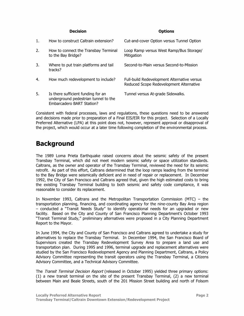
Decision
Options
1. How to construct Caltrain extension? Cut-and-cover Option versus Tunnel Option
2. How to connect the Transbay Terminal to the Bay Bridge?
Loop Ramp versus West Ramp/Bus Storage/ Mitigation
3. Where to put train platforms and tail tracks?
Second-to-Main versus Second-to-Mission
4. How much redevelopment to include? Full-build Redevelopment Alternative versus Reduced Scope Redevelopment Alternative
5. Is there sufficient funding for an
underground pedestrian tunnel to the Embarcadero BART Station?
Tunnel versus At-grade Sidewalks.
Consistent with federal processes, laws and regulations, these questions need to be answered and decisions made prior to preparation of a Final EIS/EIR for this project. Selection of a Locally Preferred Alternative (LPA) at this point does not, however, represent approval or disapproval of the project, which would occur at a later time following completion of the environmental process.
Background The 1989 Loma Prieta Earthquake raised concerns about the seismic safety of the present Transbay Terminal, which did not meet modern seismic safety or space utilization standards. Caltrans, as the owner and operator of the Transbay Terminal, reviewed the need for its seismic retrofit. As part of this effort, Caltrans determined that the loop ramps leading from the terminal to the Bay Bridge were seismically deficient and in need of repair or replacement. In December 1992, the City of San Francisco and Caltrans agreed that, given the high estimated costs to bring the existing Transbay Terminal building to both seismic and safety code compliance, it was reasonable to consider its replacement. In November 1993, Caltrans and the Metropolitan Transportation Commission (MTC) – the transportation planning, financing, and coordinating agency for the nine-county Bay Area region – conducted a “Transit Needs Study” to identify operational needs for an upgraded or new facility. Based on the City and County of San Francisco Planning Department’s October 1993 “Transit Terminal Study,” preliminary alternatives were proposed in a City Planning Department Report to the Mayor. In June 1994, the City and County of San Francisco and Caltrans agreed to undertake a study for alternatives to replace the Transbay Terminal. In December 1994, the San Francisco Board of Supervisors created the Transbay Redevelopment Survey Area to prepare a land use and transportation plan. During 1995 and 1996, terminal upgrade and replacement alternatives were studied by the San Francisco Redevelopment Agency and Planning Department, Caltrans, a Policy Advisory Committee representing the transit operators using the Transbay Terminal, a Citizens Advisory Committee, and a Technical Advisory Committee. The Transit Terminal Decision Report (released in October 1995) yielded three primary options: (1) a new transit terminal on the site of the present Transbay Terminal, (2) a new terminal between Main and Beale Streets, south of the 201 Mission Street building and north of Folsom
Locally Preferred Alternative Report Page 3 Transbay Terminal/Caltrain Downtown Extension/Redevelopment Project
Street, and (3) a surface terminal at the Main/Beale site. On March 4, 1996, the San Francisco Board of Supervisors recommended the Main/Beale site (identified as Main/Beale North) as the City’s preferred bus terminal alternative and recommended locating the proposed new Caltrain terminal underground at the site of the existing Transbay Terminal. The Board of Supervisors subsequently reversed this action as discussed below. The September 1995 Transbay Terminal Reconfiguration Structural Analysis Report was prepared for the Peninsula Corridor Joint Powers Board (JPB) in support of the 1997 Caltrain San Francisco Downtown Extension Project Draft Environmental Impact Statement / Environmental Impact Report (EIS/EIR). The Structural Analysis Report considered whether the existing Transbay Terminal, retrofitted to withstand a maximum credible earthquake event, could accommodate a Caltrain Extension above-ground, which would avoid having to demolish the Terminal to construct the train box below ground level on the existing site. The analysis showed that the structure could be strengthened to take a new bus deck plus a train station and conform to the seismic provisions of the latest Uniform Building Code. Such a strengthening would further limit space utilization within the Terminal, however, which would render the building impractical for multiple uses, including retail or commercial space. Following such a retrofit, commercial and passenger uses of the levels above the parking structure would be severely limited because the new shear walls would occupy substantial amounts of space, reducing the maximum size of the remaining rentable units and compromising pedestrian and customer flows. Given the costs and construction impacts of seismic retrofit, these limitations weighed against retrofit in comparison with the advantages of a new and more functional structure. Viewed from the perspective of the present study, seismic retrofit of the existing Terminal would not address the project purposes to modernize the Transbay Terminal, improve services, and revitalize the Terminal area. To protect public safety, Caltrans has seismically reinforced the existing terminal building and the western ramps in the last several years. However, the eastern loop ramp remains seismically deficient, and its upgrade cost is estimated at about $20 million. The terminal building still does not meet modern building code requirements – most specifically for disabled access. In addition, seismic reinforcements completed for the terminal building resulted in large areas of the terminal becoming unattractive and unusable to potential retail or commercial tenants. In 1997, the City prepared a Draft Environmental Impact Report (Draft EIR) for the Transbay Terminal Redevelopment Area Plan and construction of a new Transbay Terminal at the Main/Beale site. This project was terminated before the Draft EIR was circulated. On January 1, 1998, the Metropolitan Transportation Commission (MTC) began operations as the Bay Area Toll Authority (BATA), created by the California Legislature to administer toll revenues on the Bay Area’s seven state-owned toll bridges. In December of that year, BATA entered into a consultant contract to conduct the “Transbay Terminal Improvement Plan” study. A Transbay Panel working group was formed, consisting of public and private agencies and organizations that would be affected by the project. An Executive Committee was also formed, consisting of executive staff representatives and policy board members from Alameda Contra Costa Transit District (AC Transit), the City and County of San Francisco, the Peninsula Corridor Joint Powers Board (JPB), the State Department of Transportation (Caltrans), and MTC. In February 1999, the San Francisco Board of Supervisors passed a resolution repealing its former endorsement of the Main/Beale site for a new terminal. The new policy directed the “City and County of San Francisco to work expeditiously with AC Transit, the MTC and Caltrans to retain AC Transit regional bus service at the current Transbay Terminal site.” This was closely followed by a public vote endorsing this policy restatement. In November 1999, San Francisco voters approved Proposition H, an initiative ordinance that provides that the San Francisco Mayor, Board of Supervisors, and all city officers and agencies, including the Redevelopment

Locally Preferred Alternative Report Page 4 Transbay Terminal/Caltrain Downtown Extension/Redevelopment Project
Agency, “shall adopt such further ordinances and resolutions and take all other actions as necessary to effectuate the prompt extension of Caltrain downtown to said station.” Proposition H also calls for no conflicting use or development of the Transbay Terminal site or of the proposed Caltrain extension right-of-way. The Transbay Terminal Improvement Plan study proceeded in two phases. Phase 1 identified terminal components and functional requirements to guide the development of design concepts for the new facility. This phase was completed in 1999. Phase 2 evaluated three terminal design concepts – named after Dickens novels – and BATA selected a concept called “Great Expectations” to be carried forward for additional analysis. During 2000, refinements were made to the design concept to meet the needs of the transit operators that would use the new terminal, and project cost estimates and an implementation plan were developed. The “Great Expectations” concept is the basis for the Transbay Terminal West Ramp Alternative component of the proposed project. Another alternative evaluated by the Transbay Terminal Improvement Plan study, called “Our Mutual Friend,” is the basis for the Transbay Terminal Loop Ramp Alternative component of the proposed project. A Transbay Joint Powers Authority (TJPA) was created in April 2001. The TJPA was formed to develop, construct, and operate a new transit terminal and related facilities on and adjacent to the existing Transbay Terminal Site (pg. 1, Joint Powers Agreement creating the TJPA). The five-member Authority governing board includes one representative each from the JPB, AC Transit, the Mayor of the City and County of San Francisco, Muni, and the San Francisco Board of Supervisors. The Joint Powers Agreement was approved and singed by each of the member agencies.
Purpose and Need for the Project PURPOSE The purpose of the Transbay Terminal/Caltrain Downtown Extension/Redevelopment Project is as follows: • Improve public access to bus and rail services • Modernize the Transbay Terminal and improve service • Reduce non-transit vehicle usage • Alleviate blight and revitalize the Transbay Terminal area NEEDS The project components are conceived to address the needs of the project as follows:
• Provide a multi-modal transit facility that meets future transit needs.
This statement focuses on Year 2020 circulation, storage, loading, and passenger space requirements for AC Transit, Muni, Golden Gate, Greyhound, and paratransit services as well as a Caltrain and high-speed train station in downtown San Francisco. Current MTC Transit projections (based on several studies including MTC’s Transbay Terminal and Bay Crossing studies) indicate that the existing building will not have enough capacity for AC transit buses in the year 2020. Improved circulation patterns could greatly facilitate current and future Muni service and improve intermodal connections. Golden Gate Transit requires storage for buses. Greyhound requires added space to provide passenger amenities such as ticketing,
Locally Preferred Alternative Report Page 5 Transbay Terminal/Caltrain Downtown Extension/Redevelopment Project
waiting, and retail areas. SamTrans provides local connections from the circular driveway at the front of the Transbay Terminal. Regional Paratransit anticipates substantial increase in ridership that would require them to increase services to the Transbay Terminal, and the current facility is not fully accessible. A modern multi-modal transit facility that meets Americans with Disability Act (ADA) accessibility requirements in providing accessible pathways for connections between paratransit and fixed-route services would address this need. • Alleviate the conditions of blight in the Transbay Terminal area.
The existing Transbay Terminal is large and deteriorating; it blocks views and makes underlying sidewalks and streets dark where it crosses above Fremont and First Streets. Development is stunted in adjacent land areas where the terminal reduces attractiveness of the area. • Revitalize the Transbay Terminal area with a more vibrant mix of land uses that includes
both market-rate and affordable housing, and
• Facilitate transit use by developing housing next to a major transit hub.
The terminal and its related loading areas and loop ramps occupy a large site covering an underused area. The redevelopment component of the project focuses on the right mix of uses to revitalize the area, support the transit program, and add significant amounts of housing to the South of Market area. • Improve Caltrain service by providing direct access to downtown San Francisco, and
• Enhance connectivity between Caltrain and other major transit systems.
The topic of passenger train service directly into downtown San Francisco has been the subject of public scrutiny and debate for more than a century and is related and relevant to the transit goals incorporated by a new Transbay Terminal. Currently, Caltrain’s San Francisco service terminates at Fourth and Townsend Streets – more than one mile from the downtown core activity and employment centers. The distance between the Fourth and Townsend and most downtown San Francisco job destinations is beyond walking distance for the majority of train riders and requires a transfer to the San Francisco Muni Metro light rail line or Muni bus service to complete the journey. In 1987, MTC identified an underground Caltrain extension to a station near the current Transbay Terminal site as “the single most important improvement that can be made to the Peninsula commuter line.…”1 A 1997 proposed extension of Caltrain commuter rail to the present Transbay Terminal building was terminated during its environmental review process for lack of sufficient funding. • Enable direct access to downtown San Francisco for future intercity and/or high-speed
rail service.
In June 2000, the California High Speed Rail Commission issued its Final Business Plan for Building a High-Speed Train System for California with recommendations that the Governor and state legislature initiate a state-level program EIR and federal-level EIS for a statewide high-speed train network. The Business Plan states that terminating the high-speed trains at the Transbay Terminal in San Francisco should be included in environmental studies. Senate Bill 1856 was passed by a 2/3 vote of both houses of the California State Legislature and was signed by the Governor in 2002. This law places on the November 2004 California ballot a
1 Metropolitan Transportation Commission / Joint Powers Board Interim Upgrade Study, 1987.
Locally Preferred Alternative Report Page 6 Transbay Terminal/Caltrain Downtown Extension/Redevelopment Project
vote for issuance of $9.95 billion in state bonds to construct the first phase of a California High Speed Rail project. As stated in the law, the first phase is to be “between San Francisco Transbay Terminal and Los Angeles Union Station.” • Reduce traffic congestion on US 101 and I-280 between San Jose and San Francisco and
other routes,
• Reduce vehicle hours of delay on major freeways in the Peninsula Corridor, and
• Accommodate projected growth in travel demand in the San-Jose-San Francisco corridor.
Within the Peninsula Corridor, without future major roadway improvements, congestion on corridor freeways is bound to worsen to the point where travel is diverted and the peak periods is spread into the midday and to later in the evening. Bottlenecks will constrain movement through the corridor. MTC's travel projections for the Peninsula corridor, based on the planned future transit (no Caltrain extension) and highway capacities for the year 2005 indicate that northbound morning peak-hour vehicle demand at the U.S. 101/I-280 interchange in San Francisco would be approximately 220,000 vehicles, exceeding the existing interchange capacity by 57 percent. These high levels of congestion will take a toll on economic development by constraining the movement of people and goods.
Opportunities to improve highway capacity are constrained by a number of factors, including the need for extensive and costly right-of-way acquisitions and potentially significant environmental impacts, such as displacements of residences, businesses, and natural resources. For these reasons, substantial capacity improvements to U.S. 101 and I-280 cannot be assumed to address long-term travel demands in the corridor, and Caltrain provides a vital transportation alternative to costly highway capacity expansion. By increasing transit ridership, the Caltrain Downtown Extension would ease congestion on Peninsula freeways. • Improve regional air quality by reducing auto emissions.
The San Francisco Bay Area's air quality has improved in recent years, largely in response to technological improvements in motor vehicles and less polluting fuels. According to the Bay Area Air Quality Management District (BAAQMD), the Bay Area Air Basin (BAAB) is in attainment with national standards for carbon monoxide (CO), nitrogen oxides (NOx), sulfur dioxide (SOx), and annual particulate matter (PM10), but designated non-attainment for ozone (O3) and unclassified for PM2.5 and 24-hour PM10. With respect to California standards, the BAAB has attainment status for CO, NOx, and SOx. It is designated non-attainment for O3 and PM10. Because transportation is the major contributor to O3, increasing auto travel threatens the area's improvement in air quality. Growing congestion will add to the potential problems because of increased emissions of vehicles operating in stop-and-go traffic. Shifting commuters and other travelers to higher occupancy modes is highly desirable to restrain the growth in auto travel. A new multi-modal transit facility in the heart of San Francisco’s employment center would serve this goal. Developing a transit-oriented mix of land uses in the vicinity of that multi-modal facility also supports this objective. Improved Caltrain service offers the greatest potential for increased high occupancy travel along the San Francisco Peninsula, particularly in southern San Mateo and Santa Clara counties, the areas with the most severe air quality problems in the corridor. Based upon projections of potential Caltrain use in 2020, more than 8,000 daily auto trips would be removed from corridor roadways as a result of extending Caltrain service to a downtown San Francisco terminal. Additional auto
Locally Preferred Alternative Report Page 7 Transbay Terminal/Caltrain Downtown Extension/Redevelopment Project
and air transportation trip reductions would occur should a high speed rail system be developed for the State of California, including a station in downtown San Francisco. • Support local economic development goals,
• Enhance accessibility to employment, retail, and entertainment opportunities, and
• Create housing including affordable units.
The Transbay Terminal/Caltrain Downtown Extension/Redevelopment Project includes the conversion of adjacent underused land areas to reflect city urban design goals and provide for development of some of the surrounding properties to better uses. The multi-modal transit hub would concentrate a large transit user population into a confined area, thereby focusing potential economic and joint development opportunities. Another major objective of the redevelopment component of the project is to generate sufficient revenue, by way of tax increment financing, to substantially offset the costs of the new terminal.
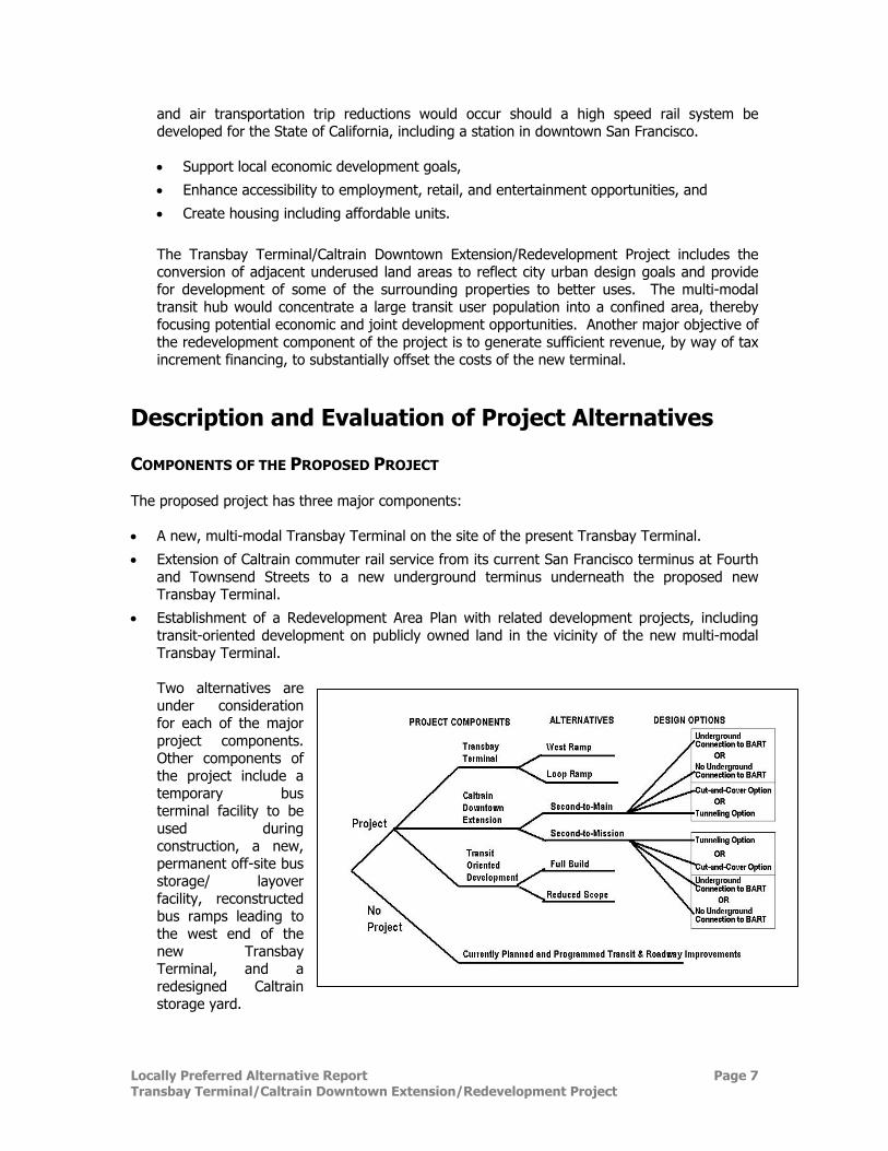
Description and Evaluation of Project Alternatives COMPONENTS OF THE PROPOSED PROJECT The proposed project has three major components: • A new, multi-modal Transbay Terminal on the site of the present Transbay Terminal.
• Extension of Caltrain commuter rail service from its current San Francisco terminus at Fourth and Townsend Streets to a new underground terminus underneath the proposed new Transbay Terminal.
• Establishment of a Redevelopment Area Plan with related development projects, including transit-oriented development on publicly owned land in the vicinity of the new multi-modal Transbay Terminal.
Two alternatives are under consideration for each of the major project components. Other components of the project include a temporary bus terminal facility to be used during construction, a new, permanent off-site bus storage/ layover facility, reconstructed bus ramps leading to the west end of the new Transbay Terminal, and a redesigned Caltrain storage yard.
Locally Preferred Alternative Report Page 8 Transbay Terminal/Caltrain Downtown Extension/Redevelopment Project
NO-PROJECT ALTERNATIVE The No-Project Alternative consists of existing Caltrain service with funded improvements, other committed bus, rail, and roadway improvements, a BART extension to the San Francisco International Airport, and proposed development in downtown San Francisco in the 2020 horizon year. An advantage to the No-Project Alternative is that there is no expenditure of funds beyond those committed to current programs. The primary disadvantage is that the No-Project Alternative fails to fulfill and meet the Purpose and Needs of the proposed project.
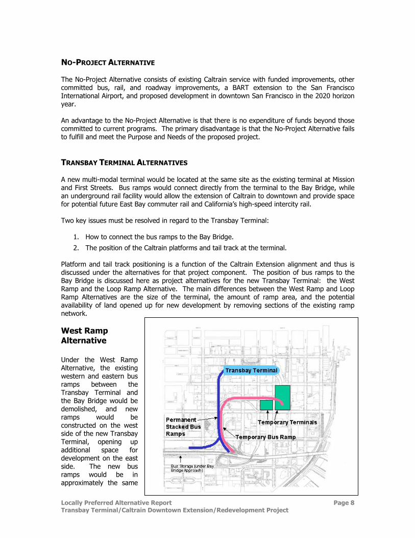
TRANSBAY TERMINAL ALTERNATIVES A new multi-modal terminal would be located at the same site as the existing terminal at Mission and First Streets. Bus ramps would connect directly from the terminal to the Bay Bridge, while an underground rail facility would allow the extension of Caltrain to downtown and provide space for potential future East Bay commuter rail and California’s high-speed intercity rail. Two key issues must be resolved in regard to the Transbay Terminal:
1. How to connect the bus ramps to the Bay Bridge.
2. The position of the Caltrain platforms and tail track at the terminal. Platform and tail track positioning is a function of the Caltrain Extension alignment and thus is discussed under the alternatives for that project component. The position of bus ramps to the Bay Bridge is discussed here as project alternatives for the new Transbay Terminal: the West Ramp and the Loop Ramp Alternative. The main differences between the West Ramp and Loop Ramp Alternatives are the size of the terminal, the amount of ramp area, and the potential availability of land opened up for new development by removing sections of the existing ramp network.
West Ramp Alternative Under the West Ramp Alternative, the existing western and eastern bus ramps between the Transbay Terminal and the Bay Bridge would be demolished, and new ramps would be constructed on the west side of the new Transbay Terminal, opening up additional space for development on the east side. The new bus ramps would be in approximately the same
Locally Preferred Alternative Report Page 9 Transbay Terminal/Caltrain Downtown Extension/Redevelopment Project
position as the existing ramps on the west side of the terminal and paralleling Essex Street. Bus turnaround loops would be provided at the east end of the terminal. As the ramps approach the Bay Bridge, they would be stacked in a double-deck configuration. This alternative includes a terminal one block (165 feet) wide by three blocks (1,300 feet) long. It would include six levels, with four levels above ground and two below. These levels are structured as follows, from lowest to highest:
1. Train Level for passenger rail platforms. 2. Train Mezzanine Level for train passenger ticketing services. 3. Street Level for Muni vehicles and Golden Gate Transit buses, with SamTrans operations
on the street adjacent to the Terminal. 4. Concourse Level for pedestrian circulation and substantial areas for joint development. 5. Central AC Transit platforms for passengers and operational convenience and 30
AC Transit bus bays. 6. Upper Bus Level for other bus service (Muni service to Treasure Island, paratransit,
Greyhound, and private operators) – up to 15 bus bays. Advantages to the West Ramp Alternative include the following:
• Blocks south and east of the terminal at Beale and Howard Streets and Folsom at Beale and Main Streets open for development.
• Eastward views open up along Howard Street toward the bay and the East Bay hills.
• Southward views open up along Beale, Fremont, and First Streets toward Rincon Hill.
• Lower capital costs. Disadvantages to the West Ramp Alternative include the following:
• Fewer bus bays.
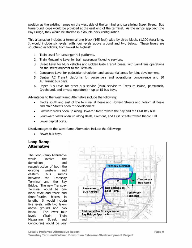
Loop Ramp Alternative The Loop Ramp Alternative would involve the demolition and reconstruction of both the existing western and eastern bus ramps between the Transbay Terminal and the Bay Bridge. The new Transbay Terminal would be one block wide and three and three-fourths blocks in length. It would include five levels, with two levels above ground and two below. The lower four levels (Train, Train Mezzanine, Street, and Concourse) would be very
Locally Preferred Alternative Report Page 10 Transbay Terminal/Caltrain Downtown Extension/Redevelopment Project
similar to the West Ramp Alternative, although there would be less area available for joint development. The fifth level would be the Bus Level, which would accommodate AC Transit and all other bus operators. Advantages of the Loop Ramp Alternative include the following:
• More bus bays. • Limited bus storage capacity on ramps – but off-site storage facility still required.
Disadvantages of the Loop Ramp Alternative include the following:
• Less available area for joint development. • Multiple platforms inconvenience passengers and operations. • East ramp continues to obstruct views. • Greater capital costs.
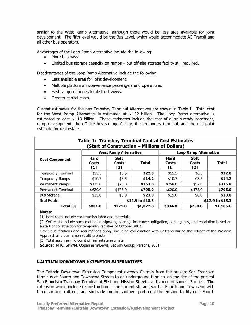
Current estimates for the two Transbay Terminal Alternatives are shown in Table 1. Total cost for the West Ramp Alternative is estimated at $1.02 billion. The Loop Ramp alternative is estimated to cost $1.19 billion. These estimates include the cost of a train-ready basement, ramp development, the off-site bus storage facility, the temporary terminal, and the mid-point estimate for real estate.
Table 1: Transbay Terminal Capital Cost Estimates (Start of Construction – Millions of Dollars)
West Ramp Alternative Loop Ramp Alternative
Cost Component Hard Costs
[1]
Soft Costs
[2] Total
Hard Costs
[1]
Soft Costs
[2] Total
Temporary Terminal $15.5 $6.5 $22.0 $15.5 $6.5 $22.0 Temporary Ramps $10.7 $3.5 $14.2 $10.7 $3.5 $14.2 Permanent Ramps $125.0 $28.0 $153.0 $258.0 $57.8 $315.8 Permanent Terminal $620.0 $175.0 $795.0 $620.0 $175.0 $795.0 Bus Storage $15.0 $8.0 $23.0 $15.0 $8.0 $23.0 Real Estate $12.9 to $18.3 $12.9 to $18.3
Total [3] $801.8 $221.0 $1,022.8 $934.8 $250.8 $1,185.6
Notes: [1] Hard costs include construction labor and materials. [2] Soft costs include such costs as design/engineering, insurance, mitigation, contingency, and escalation based on a start of construction for temporary facilities of October 2002. Other qualifications and assumptions apply, including coordination with Caltrans during the retrofit of the Western Approach and bus ramp retrofit projects. [3] Total assumes mid-point of real estate estimate Source: MTC, SMWM, Oppenheim/Lewis, Sedway Group, Parsons, 2001
CALTRAIN DOWNTOWN EXTENSION ALTERNATIVES The Caltrain Downtown Extension Component extends Caltrain from the present San Francisco terminus at Fourth and Townsend Streets to an underground terminal on the site of the present San Francisco Transbay Terminal at First and Mission Streets, a distance of some 1.3 miles. The extension would include reconstruction of the current storage yard at Fourth and Townsend with three surface platforms and six tracks on the southern portion of the existing facility near Fourth
Locally Preferred Alternative Report Page 11 Transbay Terminal/Caltrain Downtown Extension/Redevelopment Project
and King Streets and the addition of a new underground Caltrain station on the northern portion near Townsend and Fourth Streets. The Caltrain Downtown Extension includes a design option for an 800-foot-long pedestrian connection underneath Fremont Street to the BART Embarcadero Station. Key issues concerning the Caltrain Downtown Extension include the following:
1. How to construct the extension from Townsend to Folsom – i.e., cut-and-cover versus the Tunnel Option.
2. Where to put the train platforms and tail tracks at the terminal. 3. Funding for the pedestrian tunnel to BART Embarcadero Station.
Cut-and-Cover versus Tunneling Option Caltrain Downtown Extension tracks would begin to descend into a tunnel at about Berry Street and then curve east to a new underground station with a center platform near Fourth and Townsend Streets. From there, the tracks would continue under Townsend Street near Fourth Street, then east under Townsend Street in a cut-and-cover tunnel configuration that would curve north at about Clarence Place just east of Third Street and continue under Second Street to Howard Street. Nine buildings would need to be acquired and demolished to accommodate cut-and-cover construction of the curve from Townsend to Second and Brannan Streets. A tunneling option is proposed for the underground alignment segment from Townsend Street just east of Third Street to Second and Folsom Streets. This optional construction technique would involve underpinning (adding support to) the buildings on the curve between Townsend and Second Streets. Geology for this portion of the alignments is characterized as fractured rock, which is not well suited for standard tunnel boring machines, so a highly specialized tunneling technique known as the “stacked drift” approach was evaluated. This approach, although more costly than most tunneling approaches, was selected to virtually eliminate the risk of tunnel collapse. Given that the proposed construction technique for tunneling has an extremely low likelihood of collapse or tunnel failure and given that buildings would be underpinned prior to construction, the buildings under which the tunnel would pass would need to be vacated only during the underpinning phase of the construction period. Advantages of employing the Tunneling Option include the following:
• Fewer historic buildings lost (3 compared to 13) • Lower capital cost
Cut-and-cover is easier to construct because it is less complicated to work from the surface. The impact on historic buildings alone, however, would require that the tunneling option be chosen over the cut-and-cover construction for this segment of the alignment. Under Section 4(f) of the Department of Transportation Act of 1966, no federal project may be approved that “requires the use of any land from a … historic site unless (1) there is no feasible and prudent alternative to the use of such land, and (2) such program includes all possible planning to minimize harm to such … historic site resulting from such use.” The tunneling option appears to qualify as a “feasible and prudent alternative” to the demolition of ten of the historic sites.
Locally Preferred Alternative Report Page 12 Transbay Terminal/Caltrain Downtown Extension/Redevelopment Project
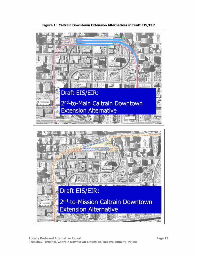
Caltrain Platform Tail Track Alternatives
Two alternatives are under consideration for continuing the Caltrain alignment north from Howard Street (see Figure 1): Second-to-Main Caltrain Extension Alternative As the Second-to-Main Caltrain Extension Alternative approaches Howard Street along Second Street, it would curve 90 degrees northeasterly, along an approximately 970-foot-long curve with track curve radii of 498 to 545 feet into the basement of the new Transbay Terminal. Under current plans, eighteen parcels of land with eleven buildings would need to be acquired and demolished for this curve into the Terminal. The terminal station would have six tracks and three platforms and would include approximately 2,000 feet of additional tracks (called tail tracks) in a cut-and-cover section leading from the east end of the new Terminal. These tracks would curve 90 degrees south along 498-foot to 521-foot radius curves to Main Street and continue underneath Main Street to south of Folsom Street. An underground easement would be required for the tail tracks beneath the current surface parking lots bracketed by Main, Beale and Howard Streets (Block 3718, lots 028 and 027). The tracks would be used for temporary train storage and light servicing/housekeeping, improving the operating efficiency of Caltrain and possible HSR service. Trains would not be required to be stored at Fourth and Townsend, but rather could be staged near the terminal to be brought quickly into service. The proposed track configuration would also allow for one 1,300-foot platform between the two center tracks. This platform length is the current design standard for high-speed trains under consideration in California. The tracks could also be extended as a separate, independent project at some time in the future, to a San Francisco-to-Oakland cross-bay alignment for commuter rail and/or high-speed trains. Advantages of the Second-to-Main Caltrain Extension Alternative include the following:
• Trains could be staged near the terminal to be brought quickly into service.
• A platform could be built to standard length (1,300 feet) for high-speed trains.
• Platforms and tail track principally use public right-of-way.
• Lower capital cost.
The cross-bay alignment for commuter rail/and or high-speed trains under a future independent project would have a selection of possible departure points from an extended tail track. Disadvantages of the Second-to-Main Caltrain Extension Alternative include the following:
• A curved Caltrain/High Speed Rail (HSR) shared platform is not ideal, but could function adequately with design adaptations to bridge the gap between the train and platform.
See page 20 for a discussion of additional refinements that have been made to this alternative. Second-to-Mission Caltrain Extension Alternative The Second-to-Mission Alternative would follow the same alignment as the Second-to-Main Alternative up to Second and Howard Streets. At that point, it would provide a different configuration for the underground station in the Transbay Terminal and for the tail tracks leading out of the terminal.
Locally Preferred Alternative Report Page 13 Transbay Terminal/Caltrain Downtown Extension/Redevelopment Project
Figure 1: Caltrain Downtown Extension Alternatives in Draft EIS/EIR
Locally Preferred Alternative Report Page 14 Transbay Terminal/Caltrain Downtown Extension/Redevelopment Project
As this alignment approaches Howard Street, rather than running parallel to the Terminal’s long axis, this alignment would curve northeasterly at about Tehama Street, along a 1,432-foot radius curve for approximately 700 feet, cutting diagonally under the new terminal and exiting out under Mission Street headed towards The Embarcadero. The southernmost track would branch into four tracks leading to and serving two center platforms directly under the Transbay Terminal. These four tracks would terminate at the eastern end of the Terminal. The two northernmost tracks would continue on an angle to Mission Boulevard and would serve two 600-foot side platforms to the north of the Transbay Terminal. These two tracks would continue to two 1,400-foot tail tracks under Mission Street ending just east of The Embarcadero. Under current plan with cut-and-cover, twenty parcels of land and thirteen historic buildings would need to be acquired and demolished for this alternative. Tunneling would reduce the loss of historic buildings to three, as in the Second-to-Main Alternative The tail tracks for this alignment would be used in a manner similar to the uses described above for the Second-to-Main Alternative, and could be extended as a separate, independent project at some time in the future to a San Francisco-to-Oakland cross-bay alignment for commuter rail and/or high-speed trains. One major development proposal has the potential to conflict with the Second-to-Mission Caltrain Extension Alternative. A 605-foot tall, 1,068,400 gross square foot mixed-use development is proposed at 301 Mission Street. This proposal requires environmental review (in progress) and various approvals from the Planning Commission. The proposed configuration of the foundation piling and underground parking for 301 Mission would occupy a portion of the area needed for the tracks to proceed from the basement of the proposed terminal to Mission Street. Advantages of the Second-to-Mission Caltrain Extension Alternative include the following:
• The length of track from the terminal to the San Francisco Bay for a possible future train extension across the Bay (as a separate, independent project), would be less for this alternative.
Disadvantages of the Second-to-Mission Caltrain Extension Alternative include the following:
• Platforms for northernmost tracks are skewed under Mission Street and do not allow direct passenger entry into the Transbay Terminal.
• Conflicts with development proposal at 301 Mission.
• Fifty percent more displacement of employees—60 businesses with 960 employees compared with 50 businesses with 625 employees for the Second-to-Main Alternative.
• Shorter platform lengths (700 feet) that would not be adequate for a double HSR train set of approximately 1,300 feet or 400 meters.
• Less train storage area on the tail track—there is room for only four five-car trains compared with seven for the Second-to-Main Alternative.
• Only one possible point of departure for the East Bay, in the case of extension, with difficult and costly construction required to tunnel under the Muni Turnaround.
• Alignment would be pointed at the historic Agriculture Building. An East Bay extension would need to tunnel under this historic structure.
See page 20 for a discussion of additional refinements that have been made to this alternative.
Locally Preferred Alternative Report Page 15 Transbay Terminal/Caltrain Downtown Extension/Redevelopment Project
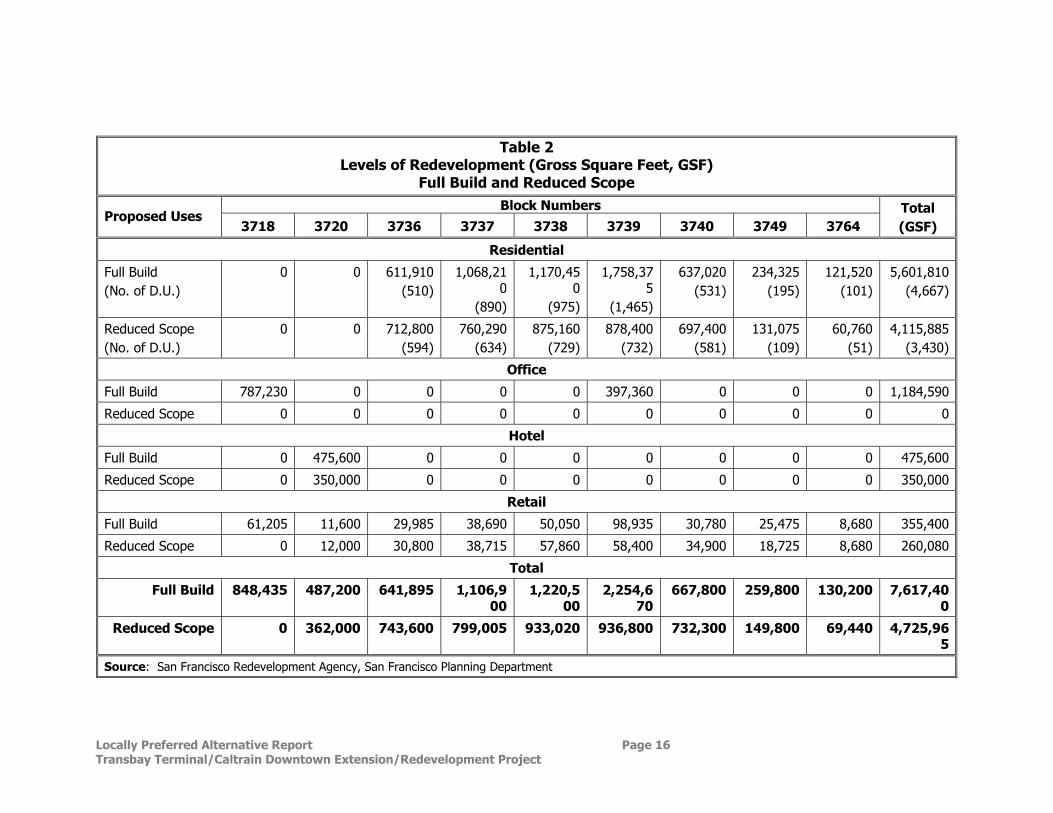
Pedestrian Tunnel Design Option Both alternatives for the Caltrain Downtown Extension include a design option for a pedestrian connection from the train mezzanine underneath Fremont Street to the BART Embarcadero Station. The pedestrian connection would be below grade level and approximately 800 feet long and is estimated to cost $45.3 million. The decision for this connection versus sidewalks depends in part on available project funding. PROPOSED TRANSBAY REDEVELOPMENT PLAN AREA The Redevelopment Component includes two alternatives: the Full Build Alternative and the Reduced Scope Alternative. The alternatives are not actual proposals, but a representation of the range of reasonable development that could occur. Within the overall redevelopment plan, actual development proposals would be defined and evaluated in subsequent steps of the redevelopment process. Assumed development levels for the Full Build and Reduced Scope Alternatives are shown in Table 2 and Figure 2. Transit-oriented development in the vicinity of the Transbay Terminal would provide a mix of residential and commercial development adjoining a major multi-modal transportation facility. Revenues from the sale or lease of the parcels currently owned by Caltrans plus proceeds from tax-increment from development of those parcels would be used to defray a portion of the costs for the new Transbay Terminal and Caltrain Downtown Extension. Publicly-owned properties proposed for possible development, including parcels currently owned by Caltrans, are shown in Figure 2.
Full-Build Alternative The Full-Build Alternative assumes that, in addition to the Terminal and Caltrain projects, about 7.6 million square feet (sq. ft.) of residential, office, and retail/hotel development would be built. This includes approximately 5.6 million sq. ft. of residential development (4,700 residential units including affordable housing), 1.2 million sq. ft. of office development, 475,000 sq. ft. of hotel development, and 355,000 sq. ft. of retail development. The primary advantages of the Full-Build Alternative are the following:
• It would provide more intensive land use around the transit hub. • More tax increment revenue and land proceeds would be generated from the parcels
currently owned by Caltrans to fund the new terminal and Caltrain Downtown Extension. The potential disadvantage of this alternative may be additional visual and traffic impacts in the area, as compared to the Reduced-Scope Alternative.
Locally Preferred Alternative Report Page 16 Transbay Terminal/Caltrain Downtown Extension/Redevelopment Project
Table 2
Levels of Redevelopment (Gross Square Feet, GSF) Full Build and Reduced Scope
Block Numbers Proposed Uses
3718 3720 3736 3737 3738 3739 3740 3749 3764 Total (GSF)
Residential
Full Build (No. of D.U.)
0 0 611,910(510)
1,068,210
(890)
1,170,450
(975)
1,758,375
(1,465)
637,020(531)
234,325(195)
121,520(101)
5,601,810(4,667)
Reduced Scope (No. of D.U.)
0 0 712,800(594)
760,290(634)
875,160(729)
878,400 (732)
697,400(581)
131,075(109)
60,760(51)
4,115,885(3,430)
Office
Full Build 787,230 0 0 0 0 397,360 0 0 0 1,184,590
Reduced Scope 0 0 0 0 0 0 0 0 0 0
Hotel
Full Build 0 475,600 0 0 0 0 0 0 0 475,600
Reduced Scope 0 350,000 0 0 0 0 0 0 0 350,000
Retail
Full Build 61,205 11,600 29,985 38,690 50,050 98,935 30,780 25,475 8,680 355,400
Reduced Scope 0 12,000 30,800 38,715 57,860 58,400 34,900 18,725 8,680 260,080
Total
Full Build 848,435 487,200 641,895 1,106,900
1,220,500
2,254,670
667,800 259,800 130,200 7,617,400
Reduced Scope 0 362,000 743,600 799,005 933,020 936,800 732,300 149,800 69,440 4,725,965
Source: San Francisco Redevelopment Agency, San Francisco Planning Department
Locally Preferred Alternative Report Page 17 Transbay Terminal/Caltrain Downtown Extension/Redevelopment Project
Figure 2: Development Levels Assumed for Full Build & Reduced Scope Redevelopment Alternatives & Proposed Redevelopment Area Boundary
Locally Preferred Alternative Report Page 18 Transbay Terminal/Caltrain Downtown Extension/Redevelopment Project
Reduced-Scope Alternative The Reduced Scope Alternative assumes the same Terminal and Caltrain alternatives, but it would result in a lesser amount of commercial and retail development and is weighted more toward housing. It assumes approximately 4.8 million sq. ft. of residential/office/ retail/hotel development, including 4.0 million sq. ft. of residential (about 3,400 dwelling units), 198,000 sq. ft. of office space, 350,000 sq. ft. of hotel development, and 235,000 sq. ft. of retail development. This alternative would entail less intense development in the South of Market area. It therefore would result in reduced visual and traffic impacts but would generate less tax increment and land proceeds revenue for the project from the parcels currently owned by Caltrans. Table 3 compares the three components and each of their alternatives.
Table 3: Comparison of Alternatives for Locally Preferred Alternative (with Full-Build Redevelopment Alternative1)
Transbay Terminal West Ramp Loop Ramp
Second-to-Main Second-to-Mission Second-to-Main Second-to-Mission
Caltrain Extension Alternative Cut-
and-Cover
Tunnel Option
Cut-and-
Cover
Tunnel Option
Cut-and-
Cover
Tunnel Option
Cut-and-
Cover
Tunnel Option
Long-Term Costs and Impacts Total Cost (millions 2001 $) $2,736.5 $2,668.6 $2,784.0 $2,714.3 $2,973.5 $2,905.6 $3,021.0 $2,951.4
Loss of Historic Buildings 13 3 13 3 13 3 13 3
Displacements Residential Units 60 23 60 23 60 23 60 23
Residents 120 46 120 46 120 46 120 46 No. of Businesses 58 50 68 60 50 42 60 52
Employees 1,284 625 1,622 963 1,284 625 1,622 963 Net Real Estate Costs (M) $71.6 $73.9 $73.3 $75.4 $71.6 $73.9 $73.3 $75.4 Utilities2 -- - -- - -- - -- - TBT Capacity 34 bus bays, off-site bus storage 51 bus bays, on-site bus storage HSR Platform Length 1,300 ft 700 ft 1,300 ft 700 ft Tail Track Capacity 7 trains 4 trains 7 trains 4 trains Rail Platform Arrangement Under TBT Skewed under Mission Under TBT Skewed under Mission
Notes: 1 Reduced Scope Redevelopment Alternative includes 5.4 million sq. ft. of development instead of 7.6 million sq. ft.
Costs and impacts would be similar to Full Build, although reduced tax increment revenues would increase need for other funding sources.
2. Qualitative rating of impacts is from negative (--), slightly negative (-), neutral (0), slightly positive (+), positive (++)
Locally Preferred Alternative Report Page 19 Transbay Terminal/Caltrain Downtown Extension/Redevelopment Project
Summary of Public Comments The 52 public comments letters and 35 public hearing speakers made a number of recommendations and raised a number of key issues regarding the project. Public agency comments were received from the U.S. Environmental Protection Agency (EPA), the Bay Area Air Quality Management District, the State Clearinghouse, Caltrans, the State Department of Toxic Substances Control, the Bay Area Rapid Transit (BART) District, the San Francisco County Transportation Authority, AC Transit, Golden Gate Transit, Muni, the Santa Clara Valley Transportation Authority, and the San Francisco Department of Parking and Traffic. Responses will be provided to all relevant public comments in the Final EIS/EIR. A brief summary of recommendations and issues is provided here to aid in the selection of the LPA. Commentors favored the West Ramp Transbay Terminal Alternative, particularly given that it would provide more opportunities for area redevelopment. Commentors noted that this alternative would not have an eastern bus ramp interfering with potential development sites. One commentor suggested that the terminal should be rehabilitated rather than replaced. A number of commentors express concerns regarding impacts on their neighborhood from the proposed bus storage facility under the West Approach Ramp to the Bay Bridge between Second and Fourth streets. Particular issues were expressed regarding possible impacts of air emissions and noise emanating from buses idling in and going to and from the bus storage site Commentors favored the “Full Build” redevelopment alternative which would produce more tax increment funding to help pay costs for the proposed transportation improvements. There were suggestions to provide more current ridership projections. Some commentors proposed that the project financial plan be updated and expanded and that value engineering be performed in an effort to reduce overall project costs. For the Caltrain Downtown Extension, there was a preference for tunneling rather than cut-and-cover construction. Commentors noted that the tunneling option, as compared to the cut-and-cover option, would allow for retention of 13 historic buildings in the Second and Townsend Street area, which would be consistent with federal law. Suggestions were made to reduce the amount of curved train platforms and increase platform lengths in the new Caltrain/high speed train station loading areas. Commentors also suggest that grade separations should be included as part of the project for both the Common Street and 16th Street at-grade crossings. Different positions were expressed regarding the Second-to-Main compared with Second-to-Mission alternatives. A number of commentors favored the Second-to-Mission Street Alternative. Developers for the proposed 301 Mission Street site provided their technical analysis of the impacts that the Second-to-Mission Street Alternative would have on their proposed development. Several alternative alignments were presented. These are discussed below.
Locally Preferred Alternative Report Page 20 Transbay Terminal/Caltrain Downtown Extension/Redevelopment Project
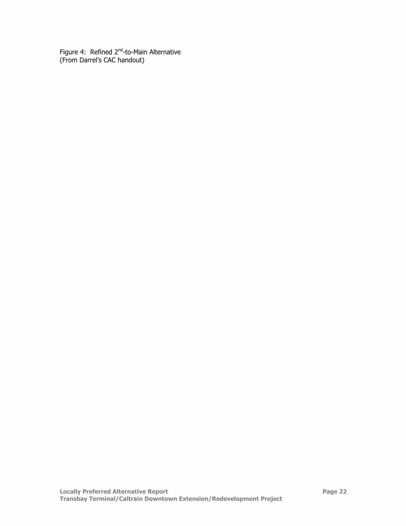
Engineering Refinements to Caltrain Downtown Extension Subsequent to the Draft EIS/EIR The JPB, working with the City and County of San Francisco and Redevelopment Agency, has developed engineering refinements to the 2nd-to-Mission and 2nd-to-Main Alternatives Caltrain Extension Alternatives in response to public comments received on the Draft EIS/EIR. Refinements have included changes to the track, platform, and tail track layouts. The primary purposes of these refinements were to:
• Respond to public comments and suggestions. • Apply engineering criteria to general layouts that were proposed by the public.
• Improve the operational characteristics of the train track/platform layouts, and
• Provide for improved train operational efficiency and provide for maximum flexibility for
future train design and operations. The refinements focused on:
o Maintaining adequate or improving (flattening) the track curves to better serve Caltrain and high speed trains – improved speeds and reduced track maintenance.
o Lengthening the amount of tangent (straight platforms) thus reducing the amount of curved train platform length requiring specialized equipment (train bridge plates) or specialized train operations (e.g., locking of certain train doors).
o Increasing the number and/or length of train storage and service tail tracks. o Increasing the number of tracks leading to the train storage and service tail
tracks. Figures 3 and 4 show the refined 2nd-to-Mission and 2nd-to-Main Alternatives. These options were presented and discussed at a public workshop sponsored by the Transbay Citizens Advisory Committee on March 6, 2003. The meeting was open to the general public. As shown in Table 4, platform lengths and the length of straight (tangent) platforms have been increased for both refined alternatives, and additional through tracks have been added to both. The lengths and number of tail tracks have also been increased under both alternatives. The refined alignments include three tracks from the 4th and Townsend station through to the terminal. The Draft EIS/EIR included only two tracks for the tunnel portion between Townsend and 2nd streets. The refined option includes a third track in this segment to improve rail operations and capacity. Additional train storage capacity is also provided by the refined tail track layouts for both alternatives. The 2nd-to-Main Alternative would provide the greatest train storage capacity, as was the case for the Draft EIS/EIR Alternatives. As noted on the table, the possible future extension of train tracks across the Bay from the Transbay Terminal would require lowering of the tracks some 40-50 feet so that the tunnel would enter the Bay below the bottom of the Bay, thus not affecting or interfering with navigable waters. Additional study would be required, as part of the new Bay crossing project by others, to determine the appropriate location of the tunnel under the Bay and to review the techniques and alignments that could be used to lower the rail alignment and tunnel so that it would enter the Bay below water level.
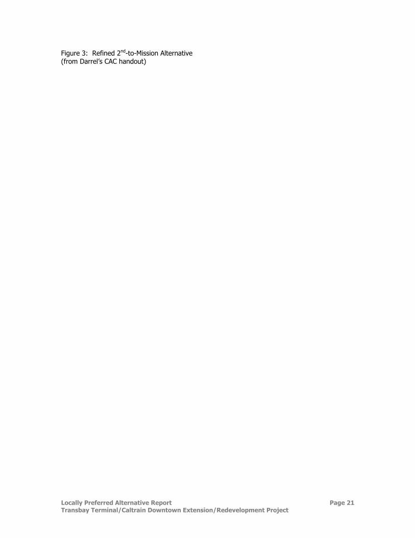
Locally Preferred Alternative Report Page 21 Transbay Terminal/Caltrain Downtown Extension/Redevelopment Project
Figure 3: Refined 2nd-to-Mission Alternative (from Darrel’s CAC handout)
Locally Preferred Alternative Report Page 22 Transbay Terminal/Caltrain Downtown Extension/Redevelopment Project
Figure 4: Refined 2nd-to-Main Alternative (From Darrel’s CAC handout)
Locally Preferred Alternative Report Page 23 Transbay Terminal/Caltrain Downtown Extension/Redevelopment Project
At this point, it appears that the 2nd-to-Main Alternative would allow greater flexibility to accomplish this objective. The bottom of the Bay increases in elevation further south of Mission Street; there is more flexibility for optional alignments and greater distances to the Bay for the 2nd-to-Main Alternative, and; more public rights-of-way (streets) are available providing for more track alignment/configuration options, both vertically and horizontally. Critical obstacles are also associated with the 2nd-to-Mission Alternative, including the need to tunnel under (support in place) the Muni Turnaround structure, as well as the need to tunnel under (and underpin) the historic Agriculture Building. The refined 2nd-to-Mission Alternative provides greater platform lengths and more platforms, as compared to the Draft EIS/EIR Alternative. It also provides one additional side platform compared to the 2nd-to-Main refined alternative. The refined 2nd-to-Mission Alternative clearly provides an efficient train platform layout. This refined alternative, however, would, have greater impacts on the proposed 301 Mission development and would also affect the subsurface portion of the joint development hotel proposed north of the new terminal. The passenger flows within the terminal would also be diminished, given that the train platforms would be offset from the Terminal building itself. Table 4 provides a comparison of key characteristics of these refined alternatives.
Table 4: Comparison of Refined Caltrain Downtown Extension Alternatives
2nd-to-Main Refined from Draft EIS/EIR
2nd-to-Mission Refined from the Draft EIS/EIR
CAPACITY Rail line (from 4th &
Townsend to terminal) • 3 Tracks to terminal • 3 Tracks to terminal
Terminal • 6 tracks • 7 tracks
Platforms • 3 center platforms • 3 center platforms • 1 side platform
Platform lengths • 3 center platforms at 1,300 ft. • 2 center platforms - 1,300 ft. • 1 side platform at 1,300 ft. • 1 center platform – 740 ft.
Length of straight (tangent) platforms sides
• 2 platform sides - 1,220 ft. • 2 platform sides - 910 ft. • 2 platform sides - 855 ft.
• 2 platform sides - 1,000 ft. • 4 platform sides – 950 ft. • 1 platform side – 600 ft.
Thru tracks • 5 tracks • 5 tracks
Tail tracks
• 5 tail tracks serving 5 terminal tracks
• Storage for seven 5-car trains. (Encroachment into Main Street redevelopment parcels allows additional tail track)
• 2 tail tracks serving 5 terminal tracks
• Storage for four 5-car trains
EAST BAY CONNECTION Additional depth needed at
platforms [1] • 40 – 50 ft. • 40 - 50 ft.
Points of departure/ alignments to bay
• Various possible points of departure/alignments to the bay
• Only one possible point of departure/alignment to the bay
Additional tunneling to reach bay
• 1,000 ft. or more, depending on selected alignment • 500 ft.
Obstacles • Possibly Pier 32
• Muni turnaround (Less severe issue with deeper 40 – 50 ft. depth change)
• Historic Agricultural Build. (Tunneling under historic bldg. accomplished by BART for the San Francisco Ferry Bldg.)
Locally Preferred Alternative Report Page 24 Transbay Terminal/Caltrain Downtown Extension/Redevelopment Project
Table 4: Comparison of Refined Caltrain Downtown Extension Alternatives
2nd-to-Main Refined from Draft EIS/EIR
2nd-to-Mission Refined from the Draft EIS/EIR
TAKINGS/EASEMENTS
Additional to Draft EIS/EIR • Within Draft EIS/EIR footprint
• Greater impacts to proposed 301 Mission development subsurface structures compared to Draft EIS/EIR Alternative
TERMINAL Passenger circulation in
Terminal • Good • Diminished due to offset platforms
Impacts on new hotel (part of proposed Terminal
Joint Development) • None • Would affect hotel service
space/parking below ground
GEOTECHNICAL Reliability of current
knowledge • Reliable given the stage of the
design • Reliable given the stage of the
design
Construction risks • Mainly at Townsend/2nd Street
Curve (additional geotechnical testing/ analysis proposed)
• Mainly at Townsend/2nd Street
Curve (additional geotechnical testing/ analysis proposed)
PROBABLE TUNNELING TECHNIQUES
At Townsend/ 2nd curve
• Mined (stacked drifts) with underpinning of buildings as needed
• Mined (stacked drifts) with underpinning of buildings as needed
Along 2nd Street to Folsom • Mined or cut-and-cover • Mined or cut-and-cover From Folsom & 2nd into
terminal • Cut-and-cover • Cut-and-cover
Tail tracks • Cut-and-cover • Cut-and-cover ENVIRONMENTAL PROCESS
Recirculation of environmental document? • Not anticipated • Not anticipated
Conflicts with proposed developments
• Minor impact on 301 Mission • Impact same as described in
Draft EIS/EIR
• Major impact on 301 Mission beyond previously identified impacts in Draft EIS/EIR
[1] Connection to the East Bay requires dropping all train boxes at the terminal to drop below the Bay shipping channel. Consideration should be included in the design of all alternatives for through rail to be constructed below the initial train box.
Additional Caltrain Downtown Extension Alternatives Suggested in Public Comments Three Caltrain Downtown Extension alternatives were recommended in the public comments that deviated from the alternatives presented in the Draft EIS/EIR:
• An alignment leading to a new terminal at the site bounded by Main, Beale, Howard, and Folsom, southeast of the current Terminal site (called the Main/Beale Site Option in this report).
• An alignment coming up Second Street but with platforms under Second Street between
Folsom and Market streets (called the Second/Market Street Option in this report).
Locally Preferred Alternative Report Page 25 Transbay Terminal/Caltrain Downtown Extension/Redevelopment Project
• An alignment located approximately 150 feet to the west of Second Street but with tracks and platforms at the Transbay Terminal site (called the 150 Feet West Option in this report).
The Main/Beale Site and Second/Market options both appear to offer some advantages as noted in the comment letters and attachments. However, both would be inconsistent with Proposition H passed by the voters of San Francisco in November 1999. Section 2 of Proposition H states that: “As part of the extension of Caltrain downtown, a new or rebuilt terminal shall be constructed on the present site of the Transbay Terminal…” Neither of the proposed options would be on the site of the current Transbay Terminal. The Main/Beale Site option would also be inconsistent with Resolution 169-99 passed by the San Francisco Board of Supervisors in February 1999, which repeals the Board’s prior action in support of the Main/Beale site and urges that regional bus service be “… at the current Transbay Terminal site.” This Board action was one of many reasons underlying the ultimate selection of and consensus for a new terminal design on the site of the current terminal. This consensus emanated from the MTC Study completed in 2001. The Second/Market option would not provide the number of platforms offered by either the Second-to-Main or Second-to-Mission alternative, it would require that the platforms and tracks be stacked, and the flow of passengers from the bus terminal to the train platforms would be less convenient and efficient, when compared to the refined 2nd-to-Mission or 2nd-to-Main Alternatives. As noted by its proponent, the 150 Feet West Option offers the advantages of tunneling under fewer historic buildings in the Second and Townsend area, but rather would be under several parcels that are currently undeveloped. This alignment would pass under the South Park Neighborhood, a mixed commercial, residential, and open space area. New transit tunnel or cut-and-cover alignments have typically been placed under public right-of-way (e.g., under streets) to minimize the number of private subsurface easements or potential surface disruptions and impacts, e.g., from cut-and-cover construction or from tunnel ventilation shafts. Risks of community impacts are also reduced relative to the highly unlikely (given the proposed highly conservative “stacked drift” construction technique) potential for tunnel failure or collapse. Given the geology of the area, cut-and-cover techniques will need to be used north of Folsom Street for 150 Feet West Option (as well as the 2nd-to-Mission and 2nd-to-Main Alternatives). The 150 Feet West Option would therefore pose a risk and probable high cost for cut-and-cover construction between a new condominium building on 2nd Street and the Hawthorne Plaza Office Building. Finally, it should be noted that future consideration of this option would require recirculation of a Draft EIS/EIR given that this option would introduce new significant adverse impacts heretofore not disclosed or discussed in the current Draft EIS/EIR.