Embed Size (px)
Citation preview

Allocated Employment Sites
Information Booklet
Local Plan

Foreword
The purpose of this document is to present an easy-to-use guide for each of the employment sites
identified on the published Allocations Plan Proposals Map.
For the sites, various pieces of background information are provided such as:
Site ownership
Current use
Planning history
Site size and location
Impact on the local area
Access issues.
Similar documents have also been prepared for housing sites and mixed use development sites.
To find out more, please contact
The Planning Strategy Team, Bolton Council, Town Hall, Bolton, BL1 1RU 01204 333218
[email protected] www.bolton.gov.uk/LDF

Page 2
Site Location as displayed on the Published Allo-
cations Plan Proposal Map.
2P1.1 Barrs Fold Close
Ownership: Single private ownership: Rijo42, Samba House, Mango Park, Wingates Industrial Estate,
Westhoughton, Bolton, BL5 3XU
Current Use: No current use
Planning History: 55570/99 and 62621/02: Erection of a 1450 m² industrial unit and creation of an overspill car park for 62 cars. Siting and means of access only. Approved with conditions.
72856/05: Outline application for the erection of an industrial unit together with car park for 62 cars (siting and means of access only). Approved with conditions.
81576/09: Outline application for industrial and office development of 1480m² with 19 dedicat-ed car parking spaces and a 48 space car park (access and layout details only). Approved with conditions.
Core Strategy Area: M61 Corridor
Site size (ha): 0.47

External Comments:
None
Internal Comments:
None
Page 3
Proximity to Sensitive
Designations (Physical
or Environmental).
Adjacent to Green Belt.
Environment agency maps suggest area at no risk from flooding
Impact on Local Area
(Character, Appear-
ance and Regenera-
tion).
Amenity of adjacent occupiers unaffected/improved.
Development would support the Strategic Objective of taking advantage of the economic
opportunities presented by the M61 Corridor and will assist in job creation and regenera-
tion.
Impact on pond need to be considered, for example, wildlife.
Impact on the path/track running across the south of the site needs to be considered.
No land remediation required.
Greenfield/brownfield split roughly 50/50
Access and Highway
Capacity Issues
Highways infrastructure constraints i.e. road junction improvements required, very low.
Existing access to the site is good.
No bus stop or railway station within 800 metres.
Road access immediately adjacent
Moderate number of basic pedestrian/cycle routes linking site to centres of residence.
Existing congestion on surrounding road network is high/moderate.

Page 4
Site Location as displayed on the Published Alloca-
tions Plan Proposal Map.
5P1.1 Cutacre
Ownership: Single private ownership: Harworth Estates
Current Use: Coal extraction and restoration
Planning History: 48800/96: Winning and working of coal by opencast methods. 2. Extraction and recovery of
coal by washing methods from Cutacre and Wharton Hall Colliery tips. 3. The reclamation
and restoration of the land for a mixture of amenity (ecology), agriculture and afforestation.
Approved following appeal.
49527/96 and 68465/04: Erection of industrial buildings (Classes B1, B2 & B8).
80987/08: Erection of employment buildings (B1, B2 & B8) (All matters reserved). Approved
with conditions.
78494/08: Employments buildings B1, B2, B8 (access details).
Core Strategy Area: M61 Corridor
Site Size (ha): 80 (net developable area)

External Comments:
Concern that the developer will not pursue employment use and press for housing development instead.
Council Response: The adopted Core Strategy and Published Allocations Plan allocate the site for employment
development. Development of the site for housing would be contrary to the Core Strategy.
Cutacre should be restored to farmland and a park
Council Response: The need for a broad location for employment development at Cutacre has been established
through the adopted Core Strategy.
Green belt boundaries shouldn't be changed
Council Response: The adopted Core Strategy states that a site at Cutacre is required for employment develop-
ment with a net developable area of 80ha. It allows for Green Belt boundary changes. In the Allocations Plan it is
the boundary of the site, rather than the principle of development that needs to be considered.
Nature should be protected
Council Response: The need for a broad location for employment development at Cutacre has been established
through the adopted Core Strategy.
Traffic will get unbearable
Council Response: The need for a broad location for employment development at Cutacre has been established
through the adopted Core Strategy.
Support Core Strategy Policy M3 “Broad Location for Employment Development” and the allocation of land as de-
scribed in para 3.13, however, it should be reiterated in the Allocations Plan that “the 80ha should be construed as
being the net development area, not the overall extent of the site”. In addition, consideration may be given to the
inclusion in the Allocations Plan of further details or a policy relating specifically to the Cutacre site. This would com-
prise details of the acceptable range of uses and guidance on further assessment, delivery, phasing etc.
Council Response: Support noted
On-site renewable energy generation should be encouraged.
Council Response: The Core Strategy provides policies for renewable and low carbon energy generation through
policies CG1 and CG2. Support for the identification of Cutacre as a location for the generation of low and zero car-
bon energy development is noted; to provide improved clarity and flexibility on this issue, the policy approach and
proposals map have been amended.
The proposal is too ambitious
Council Response: The adopted Core Strategy states that a site at Cutacre is required for employment develop-
ment with a net developable area of 80ha. It allows for Green Belt boundary changes. In the Allocations Plan it is
the boundary of the site, rather than the principle of development that needs to be considered.
At preset there are three major occupier interests in the Cutacre site. The nature of these requirements is regular
shaped development parcels of c.14ha. This necessitates two alterations to the boundary proposed to date. First, at
the SE corner it is proposed to extend the boundary outwards to regularise the development parcel and create a 28
ha parcel. Second, at the central north part of the site to form a regular corner and rectilinear plot. This is a com-
ments summary—the full comment is available in the consultation spreadsheet.
Council Response:
The suggested changes to the boundaries of the Cutacre site would allow for regularly shaped development sites,
which in turn can help to meet Bolton's investment needs. Land outside the development site would continue to
meet Green Belt primary purposes.
Page 5

Page 6
5P1.1 Cutacre
External comments
continued
The draft proposals map still includes Cutacre within a wider "minerals area of search -
open cast coal". Any such designation is now redundant therefore we suggest that this
designation is removed from the site.
Council Response: Changes to minerals areas of search are addressed in the GM Miner-
als Plan, and the Allocations Plan does not consider minerals.
The SBI designation at Cutacre should be removed or substantially amended as it is inac-
curate and largely redundant.
Council Response: The Greater Manchester Ecological Unit is responsible for the desig-
nation of Sites of Biological Interest, and the Proposals Map reflects this designation.
Internal Comments None
Proximity to Sensitive
Designations (Physical
or Environmental).
Requires a Green Belt amendment, the need for which was established through the
adopted Core Strategy.
Incorporates part of SBI (ponds near Lomax Brow).
Located within an area of search for opencast coal (remediation required).
River running along eastern site boundary.
Environment agency maps suggest area at no risk from flooding
Impact on Local Area
(Character, Appear-
ance and Regenera-
tion).
Slight land remediation required.
Amenity of adjacent occupiers unaffected/improved.
The site is within a 10 minute walk of bottom 15% deprived LSOA IMD2007, thus provid-
ing jobs for people in deprived areas.
Will assist in the regeneration of areas along the M61 corridor and will create jobs.
Brownfield site
Access and Highway
Capacity Issues
Highways infrastructure constraints i.e. road junction improvements required, very low.
New access road to site will be required.
Less than 250m from a low frequency bus stop.
Road access immediately adjacent with direct access to an A road, which leads straight
onto the motorway network.
Moderate number of basic pedestrian / cycle routes linking site to centres of residence.
Existing congestion on surrounding road network is high.

Page 7

Page 8
Site Location as displayed on the Pub-
lished Allocations Plan Proposal Map.
6P1.1 The Linkway, Middlebrook
Ownership: Orbit Developments, The Emerson Group, Emerson House, Heyes Lane, Cheshire,
SK9 7LF
Current Use: Car parking
Planning History: 54520/99: Erection of a two storey mixed development comprising factory outlet centre, herit-
age and tourism centre, leisure unit and restaurant.
59068/01: Details of siting, means of access, design and external appearance in respect of
motor car dealership, heritage centre and family entertainment centre.
61984/02 and 77798/07: Erection of a four storey office building together with the formation of
317 car parking spaces and new vehicular access to The Linkway. Approved with conditions.
76160/06: Erection of a five storey office (class B1) building and associated multi-storey car
park, access and landscaping. Approved with conditions.
Core Strategy Area: M61 Corridor
Site Size (ha): 0.94

External Comments:
This area was previously ‘white land’ on the adopted UDP map and should stay as such. There is no reason why
the designation of this land should change. There are other ‘employment generating’ uses which would be appropri-
ate in this area which could help diversify the offer at Middlebrook and help re-let vacant units. Designating the land
as protected employment land is overly restrictive and unnecessary and we object to this.
Council response: The councils approach to protected employment land is outlined in the explanatory statement
We note the change of the Linkway House site at Middlebrook, from protected employment to employment commit-
ment, but ask the Council to consider that this site could potentially accommodate a much broader mix of uses (and
potentially retailing) in the future.
Council response:
The identification of this site for retailing would be both contrary to the NPPF's policies on promoting town centres
and to Core Strategy policy OA2 which states that there should be no substantial increase in retail floorspace at
Middlebrook. It is unclear what other uses are being put forward.
Internal Comments:
None
Page 9
Proximity to Sensitive
Designations (Physical
or Environmental).
Located close to Red Moss SBI, SSSI and Other Protected Open Land designations
Located within area of search for opencast coal
Watercourse running close to site
Within 250m buffer of historic landfill
Adjacent to area with annual probability of 0.1% or greater of flooding
Impact on Local Area
(Character, Appear-
ance and Regenera-
tion).
This undeveloped site is part of the Middlebrook development meaning that commercial
development is well established in the surrounding area. Development would support the
Strategic Objective of taking advantage of the economic opportunities presented by the
M61 Corridor and will assist in job creation and regeneration.
Access and Highway
Capacity Issues
Highways infrastructure requirements i.e. road junction improvements required, very low.
Existing site access is good.
Less than 800m from a railway station and less than 250m from a low frequency bus stop.
Road access immediately adjacent with direct access to a “B” road, which has good links
to the motorway network.
Existing congestion on surrounding road network is moderate.

Page 10
Site Location as dis-
played on the Published
Allocations Plan Pro-
7P1.1 St. Peters Business Park A
Ownership: Single private ownership: Orbit Developments, The Emerson Group, Emerson House, Heyes
Lane, Cheshire, SK9 7LF
Current Use: No current use
Planning History: 61422/02: Erection of 3 storey office building and associated car parking. Approved with con-
ditions.
52472/98: Erection of 4 units for business use (Class B1) and a restaurant (Class A3) (All
matters reserved).
Core Strategy Area: Renewal Area (Inner Bolton)
Site Size (ha): 0.94

Page 11
External Comments:
None
None
Internal Comments:
Proximity to Sensitive
Designations (Physical
or Environmental).
Site within 250 metre buffer of historic landfill.
Environment agency maps suggest area at no risk from flooding
Impact on Local Area
(Character, Appearance
and Regeneration).
Slight adverse effects for adjacent occupiers.
Appropriate development would assist in the regeneration of the Inner Bolton Renewal
Area and will create jobs. The site is within a 5 minute walk of the bottom 15% deprived
LSOA IMD 2007.
The area is overgrown and unsightly so the appearance of the area would be improved by
appropriate development.
No land remediation required.
Site predominantly brownfield.
Access and Highway
Capacity Issues
Highways infrastructure constraints i.e. road junction improvements required, very low.
Existing site access is good.
Less than 400m from a high frequency bus stop.
Road access is immediately adjacent with direct access to a Trunk Road.
Moderate number of basic pedestrian / cycle routes linking site to centres of residence.
Existing congestion on surrounding road network is high/moderate.
Page 12
Site Location as displayed on the Published Allocations Plan Proposal Map.
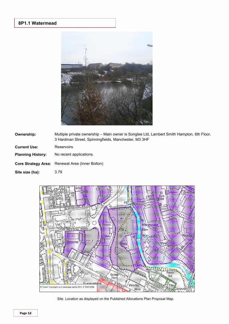
8P1.1 Watermead
Ownership: Multiple private ownership – Main owner is Songlee Ltd, Lambert Smith Hampton, 6th Floor,
3 Hardman Street, Spinningfields, Manchester, M3 3HF
Current Use: Reservoirs
Planning History: No recent applications.
Core Strategy Area: Renewal Area (Inner Bolton)
Site size (ha): 3.79

Page 13
External Comments:
None
Internal comments:
None
Proximity to Sensitive
Designations (Physical
or Environmental).
Green corridor running through the site
Watercourse running alongside the site
Environment Agency maps suggest less than half of site at remote risk from extreme
flooding (1 in 1000).
Within 250 metre buffer of current/authorised landfill site.
Impact on Local Area
(Character, Appearance
and Regeneration).
Severe land contamination issues to be considered.
Any development would require remediation work.
The impact of the loss of reservoirs would need to be considered in any potential devel-
opment.
Appropriate development would assist in the regeneration of the Inner Bolton Renewal
Area and will create jobs. The site is within a 5 minute walk of the bottom 15% deprived
LSOA IMD 2007.
Slight adverse effects for adjacent occupiers. Housing overlooks the site. This needs to be
considered when developing the land for employment use, however, there are trees
providing a natural barrier/screening.
Site predominantly brownfield
Access and Highway
Capacity Issues
Highways infrastructure constraints i.e. road junction improvements required, low. Im-
proved access may be required.
No bus stop or railway station within 800 metres.
Road access immediately adjacent with direct access to a B road.
Moderate number of basic pedestrian / cycle routes linking site to centres of residence.
Existing congestion on surrounding road network is high/moderate.

Page 14
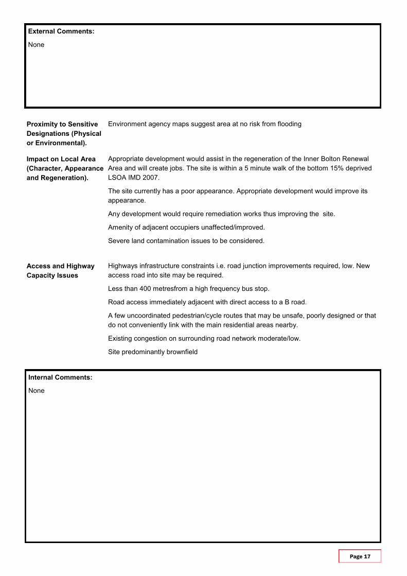
Site Location as displayed on the Published Allocations Plan Proposal Map.
9P1.1 Mill Street
Ownership: Multiple owners: Bolton Council, Smith Knight Fay Limited and Shokatali Suleman Patel.
Current Use: Lorry Yard and Heavy Goods Vehicle Training Centre
Planning History: 58462/01: Change of use of vacant land to lorry park.
Core Strategy Area: Renewal Area (Inner Bolton)
Site Size (ha): 0.53

Page 15
External Comments:
None
Internal Comments:
None
Proximity to Sensitive
Designations (Physical
or Environmental).
Environment agency maps suggest area at no risk from flooding
Impact on Local Area
(Character, Appearance
and Regeneration).
Appropriate development would assist in the regeneration of the Inner Bolton Renewal
Area and will create jobs. The site is within a 5 minute walk of the bottom 15% deprived
LSOA IMD 2007.
The site has a poor appearance overall, appropriate development would improve its ap-
pearance.
Any development would require remediation works thus improving the site.
Any potential development would need to consider the impact on the travelling showpeo-
ple community.
Amenity of adjacent occupiers unaffected/improved.
Severe land contamination issues to be considered.
100% previously developed land
Access and Highway
Capacity Issues
Highways infrastructure constraints i.e. road junction improvements required, very low.
Existing access is good.
Less than 400 metres from a high frequency bus stop.
Road access immediately adjacent with direct access to a B road.
A few uncoordinated cycle /pedestrian routes that may be unsafe, poorly designed or that
do not conveniently link with the main residential areas nearby.
Existing congestion on surrounding road network moderate/low.

Page 16
Site Location as displayed on the Published Allocations Plan Proposal Map.
10P1.1 Mill Street/Mule Street
Ownership: Single private ownership: Harry Peers Construction LTD
Current Use: No current use
Planning History: 70077/05: Erection of 6 industrial units (Use Classes B1, B2 & B8 excluding offices). Ap-
proved with conditions.
Core Strategy Ares: Renewal Area (Inner Bolton)
Site Size (ha): 0.74
Page 17
External Comments:
None
Internal Comments:
None
Proximity to Sensitive
Designations (Physical
or Environmental).
Environment agency maps suggest area at no risk from flooding
Impact on Local Area
(Character, Appearance
and Regeneration).
Appropriate development would assist in the regeneration of the Inner Bolton Renewal
Area and will create jobs. The site is within a 5 minute walk of the bottom 15% deprived
LSOA IMD 2007.
The site currently has a poor appearance. Appropriate development would improve its
appearance.
Any development would require remediation works thus improving the site.
Amenity of adjacent occupiers unaffected/improved.
Severe land contamination issues to be considered.
Access and Highway
Capacity Issues
Highways infrastructure constraints i.e. road junction improvements required, low. New
access road into site may be required.
Less than 400 metresfrom a high frequency bus stop.
Road access immediately adjacent with direct access to a B road.
A few uncoordinated pedestrian/cycle routes that may be unsafe, poorly designed or that
do not conveniently link with the main residential areas nearby.
Existing congestion on surrounding road network moderate/low.
Site predominantly brownfield

Page 18
Site Location as displayed on the Published Allocations Plan Proposal Map.
11P1.1 Stone Hill Road
Ownership: LB Developments North West Limited
Current Use: No current use
Planning History: 57102/00: Erection of industrial unit with service yard and parking area. Approved with condi-
tions.
70714/05: Renewal of application 57102/00. Erection of industrial unit with service yard and
parking area. Approved with conditions.
75235/06: Outline application for the erection of 25 commercial starter units (layout and ac-
cess details only). Approved with conditions.
Core Strategy Area: Renewal Area (Farnworth)
Site Size (ha): 0.60

Page 19
External Comments:
None
Internal Comments:
None
Proximity to Sensitive
Designations (Physical
or Environmental).
Adjacent to Mabels Brow recreational site.
Site within 250 Metre buffer of historic landfill.
Watercourse adjacent to southern boundary
Environment agency maps suggest area at no risk from flooding
Impact on Local Area
(Character, Appearance
and Regeneration).
Appropriate development would assist in the regeneration of the Farnworth Renewal area
and will create jobs. The site is within a 5 minute walk of the bottom 15% deprived LSOA
IMD 2007.
Amenity of adjacent occupiers unaffected/improved.
There are trees forming a natural barrier/screening between the site and residential areas.
No land remediation required.
100% brownfield land
Access and Highway
Capacity Issues
Highways infrastructure constraints i.e. road junction improvements required, very low.
Existing access is good.
No bus stop or railway station within 800 metres
Road access immediately adjacent with direct access to a B road.
Moderate number of basic pedestrian / cycle routes linking site to centres of residence.
Existing congestion on surrounding road network high/moderate.

Page 20
Site Location as displayed on the Published Allocations Plan Proposal Map.
12P1.1 Express Industrial Estate B
Ownership: Multiple owners: Secretary of State for Transport, JJ Mullins (Civil Engineering) Limited, and
G.R. Morris Construction Limited.
Current Use: Storage and temporary office for civil engineering company.
Planning History: No recent applications
Core Strategy Area: Renewal Area (Farnworth)
Site size (ha): 0.77

Page 21
External Comments:
None
Internal Comments:
None
Proximity to Sensitive
Designations (Physical
or Environmental).
Site adjacent to 250 metre buffer from historic landfill
Watercourse running to north of site
Environment agency maps suggest area at no risk from flooding
Impact on Local Area
(Character, Appearance
and Regeneration).
This site is currently under utilised. More appropriate economic development would assist
in the regeneration of the Farnworth Renewal Area, create jobs and improve the overall
appearance of the site. The site is within a 5 minute walk of the bottom 15% deprived
LSOA IMD 2007.
Amenity of adjacent occupiers unaffected/improved.
Some land remediation required
100% brownfield land
Access and Highway
Capacity Issues
Highways infrastructure constraints i.e. road junction improvements required, very low.
Existing site access is good.
No bus stop or railway station within 800 metres.
Road access immediately adjacent with direct access to a B road.
Moderate number of basic pedestrian / cycle routes linking site to centres of residence.
Existing congestion on surrounding road network is high/moderate.

Page 22
Site Location as displayed on the Published Allocations Plan Proposal Map.
13P1.1 Undershore Works
Ownership: Multiple owners: Lisa Ann Horrocks and John Hilton, and John Joseph Martin O’Brien and
Susan Dawn Teresa O'Brien
Current Use: Industrial units
Planning History: 71417/05: Demolition of existing industrial premises (part) and erection of a new industrial
unit (Classes B1 & B8). Approved with conditions.
Core Strategy Area: Renewal Area (Breightmet)
Site size (ha): 0.81

Page 23
External Comments:
None
Internal comments:
Redevelopment would only be appropriate of existing employment is protected.
Proximity to Sensitive
Designations (Physical
or Environmental).
Watercourse (Bradshaw Brook) adjacent to site
Reservoir adjacent to site
Across road from Stanley Park Walk recreational area
Located within Croal/Irwell Valley
Located within wooded/rural valleys landscape character area
Located within Green Belt
Located within flood risk area
Located adjacent to Seven Acres Country Park and Local Nature Reserve
Site within 250 metre buffer zone of historic landfill
Impact on Local Area
(Character, Appearance
and Regeneration).
Appropriate development would support the regeneration of the Breightmet Renewal Area
and create jobs.
Trees form a partial natural barrier/screening, however, economic development needs to
be compatible with nearby housing.
Access and Highway
Capacity Issues
Highways infrastructure constraints i.e. road junction improvements required, low. Im-
proved access may be required.
Less than 400 metres from a high frequency bus stop.
Road access immediately adjacent with direct access to an A road
Existing congestion on surrounding road network is moderate