Embed Size (px)
Citation preview

3/27/2019
1
1
Local Highway Inventory
(LHI)

3/27/2019
2
2
The Local Highway Inventory (LHI) is an annually updated list drawn from the RIS database of more than 96,000 miles of public roadways owned or maintained by non-state local governments, including cities, towns, villages, and counties in New York State.
Local Highway Inventory
3/27/2019
3
3
Its primary purpose is to provide and catalog road identification, administrative, and physical roadway data that are used for a variety of public, planning, funding, and legislative purposes at both state and federal levels.
Local Highway Inventory

3/27/2019
4
4
LHI by the Numbers:R1 166 Municipalities* 10,110 CL Miles 10.5%R2 155 Municipalities 6,665 CL Miles 6.9%R3 156 Municipalities 8,097 CL Miles 8.4%R4 171 Municipalities 9,063 CL Miles 9.4%R5 154 Municipalities 9,127 CL Miles 9.5%R6 134 Municipalities 6,661 CL Miles 6.9%R7 160 Municipalities 7,783 CL Miles 8.1%R8 200 Municipalities 11,892 CL Miles 12.3%R9 182 Municipalities 10,517 CL Miles 10.9%R10 111 Municipalities 10,735 CL Miles 11.1%R11 5 Counties = NYC 5,713 CL Miles 5.9%**
2018 Data• Does not reflect dissolved villages.• Region 11 does not update LHI in the same process.
Local Highway Inventory

3/27/2019
5
5
The Local Highway Inventory forms an integralpart of New York State’s annual data submissions to the Federal Highway Administration (FHWA), primarily certified public road mileage and the Highway Performance Monitoring System (HPMS).
Used as input to Consolidated Local Street and Highway Improvement Program (CHIPS) funding distribution formulas
Local Highway Inventory

3/27/2019
6
6
Highway Law, Article 5, Section 102Powers and Duties of County Superintendents
7. Report to the department of transportation annually…in relation to the highways and bridges in his county, containing such matter and in such form as may be prescribed by the department of transportation...
Laws and the LHI

3/27/2019
7
7
Highway Law, Article 7, Section 140Powers and Duties of Town Superintendents12. As often as the department of transportation shall direct, the town … shall measure all town highways … report in triplicate on forms…furnished by the department of transportation, the total mileage of all town highways…
Laws and the LHI

3/27/2019
8
8
Process
•Print & distribute listings to Regions•Usually follows our HPMS submittal in June
•Regions distribute to counties & municipalities•Regions are more up to date on contactinformation for municipalities and functionsperformed (Does the county take care ofthe LHI?)
Local Highway Inventory

3/27/2019
9
9
Process•Counties and municipalities update and returnto Regions•Regions review
•Accuracy•Process Documents Included
•Main Office review•Validates•Edits RIS Data•Builds routes in GIS
Local Highway Inventory

3/27/2019
10
10
3/27/2019
11
11
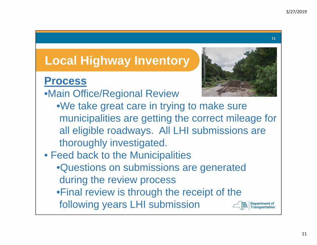
Process•Main Office/Regional Review
•We take great care in trying to make suremunicipalities are getting the correct mileage forall eligible roadways. All LHI submissions arethoroughly investigated.
• Feed back to the Municipalities•Questions on submissions are generatedduring the review process
•Final review is through the receipt of thefollowing years LHI submission
Local Highway Inventory

3/27/2019
12
12
Local Highway Inventory
This road was submitted in 2017 with a number of other roads. We were assured by the municipality that they were all open! This is the beginning of the road, not the end.

3/27/2019
13
13
Local Highway Inventory
In this example the mileage for CR 61 was increased by .12 miles. Looking at our length in GIS seems pretty straight forward – 2.12 miles. After reviewing a county map, this small stub was noticed. But why would this be part of CR 61? Additional research that included the construction plans for I 87 revealed that CR 61 originally traversed the area that is now I 87 but was removed for the highway.

3/27/2019
14
14
Eligible RoadwaysFor inclusion on the LHI, roads must meet the following criteria:
• Travel lane mileage is dedicated to motorized through traffic
• The roadway is full open to the public without restrictions except during scheduled periods for maintenance, special events, extreme weather or emergency conditions
• A county or local government accepts full legal liability and maintenance responsibility
• Easily passable by a standard car
Local Highway Inventory

3/27/2019
15
15
Ineligible RoadwaysRoadway types ineligible for CHIPS funding and therefore excluded from the LHI are:
• Private roads• Closed or abandoned roads• Paper streets• Restricted public roads (e.g. “Closed at Dusk” or
“No Trespassing” etc.)• Roadways providing access exclusively to
employee-restricted or time-restricted municipal facilities (e.g. offices, municipal garages, transfer stations, landfills, water towers, etc.)
Local Highway Inventory

3/27/2019
16
16
Complete the Annual Certification of Local Highway Mileage•Complete Center Line and LaneMile Calculations
•Denote “No Changes”, “MinorChanges” or “Mileage Changes”•Have responsible official signand enter their title•Enter name, phone number,and e-mail address of person tocontact for questions•Return Originals to Region/MO
Submission Requirements

3/27/2019
17
17
Submission RequirementsResolutions – The purpose of a resolution is to formally acknowledge a local government’s “acceptance” of a road as a public road. It is that formal acceptance that makes a road eligible for the LHI.
Local Highway Inventory
A resolution that simply states that a road should be on the inventory is not acceptable. Stating that NYSDOT incorrectly removed the road from the LHI and this resolution is to get it back on the LHI is also no good.

3/27/2019
18
18
Resolutions•Required to:
•Accept new roads•Add old roads not in inventory•Accept more than minor length changes•Abandon a roadway•Transfer a roadway
Local Highway Inventory

3/27/2019
19
19
Resolutions•Must include local governing body (TownBoard) acceptance of all legal, maintenance& repair responsibility for the roadway
•Must include an indication that the resolutionhas been voted upon and passed
•Must mention each road specifically (may doso in an official attachment to theresolution)
Local Highway Inventory

3/27/2019
20
20
Resolutions•May issue a new resolution for an old road
•Original resolutions when the roads werefirst accepted are not necessary
•Deeds do not replace resolutions. Deedsestablish ownership of real property (i.e.right-of-way), but do not designate theroadway as a public road nor do theyconstitute a formal acceptance of the roadas a public road
Local Highway Inventory

3/27/2019
21
21
Submission RequirementsMaps - Don’t have to be fancy, just helpful
Local Highway Inventory

3/27/2019
22
22
Submission RequirementsNew and Extended Road Template•Similar Data Items as Submission Forms
•Geo-code – Found on the submission forms,unique for each municipality.
•DOT ID – Leave blank for new roads. Usefor roadway extensions or abandonments.
•Submit Resolution for all Roadways onthe template
Local Highway Inventory

3/27/2019
23
23

3/27/2019
24
24
Submission Definitions•DOTID
•The DOT ID or NYSDOT Road ID is a system-generated, 6-digit Department of Transportationidentification number assigned to each roadway inNew York State. Under this classification system,roadways consist of assembled segment data.Each section of continuous roadway is assignedthe same DOT ID as a unique and constantreference number, regardless of formal or informal naming or numbering changes along the route.
Local Highway Inventory

3/27/2019
25
25
Submission Definitions•Start of Section/End of Section
•A roadway section in the LHI is defined as anentire or constituent length of roadwaycorresponding to a single DOT ID. For thepurposes of the LHI, it is useful to provide verbaldescriptions of the physical start and end points ofthese measured sections. These points aregenerally defined by significant changes in thephysical or administrative characteristics of theroadway, typically at intersections or political boundaries.
Local Highway Inventory

3/27/2019
26
26
Submission Definitions•Length
•Length represents the linear measurement of aroadway segment, expressed as the differencebetween the beginning and ending Milepoint*values. All roadway segments in the Local HighwayInventory are measured to the nearest hundredthof a statute mile.
*Length shown in submission is not to be confusedwith the overall length of the roadway
Local Highway Inventory

3/27/2019
27
27
Submission Definitions•Length
•Length represents the linear measurement of aroadway segment, expressed as the differencebetween the beginning and ending Milepoint*values. All roadway segments in the Local HighwayInventory are measured to the nearest hundredthof a statute mile.
*Length shown in submission is not to be confusedwith the overall length of the roadway
Local Highway Inventory

3/27/2019
28
28
Local Highway Inventory
Since the local roads projectback in 2014 we’ve beentelling you that we will beusing GIS Ortho imagery toproduce a length for theroadway.
What happens when there isnone? We try to give you alength as submitted and thencorrect as the imagery comesin.
We recognize that ortho takeslonger to receive thenroadways take to built.
2018 had about 90 additionsto the LHI without Ortho
NYSDOT Ortho

3/27/2019
29
29
Local Highway Inventory

3/27/2019
30
30
Local Highway Inventory
Bing

3/27/2019
31
31
Submission Definitions•Start of Section/End of Section
Local Highway Inventory
Five segments of roadway make up the whole of Stevens Lane from 0.0 to 0.51 miles

3/27/2019
32
32
Local Highway Inventory

3/27/2019
33
33
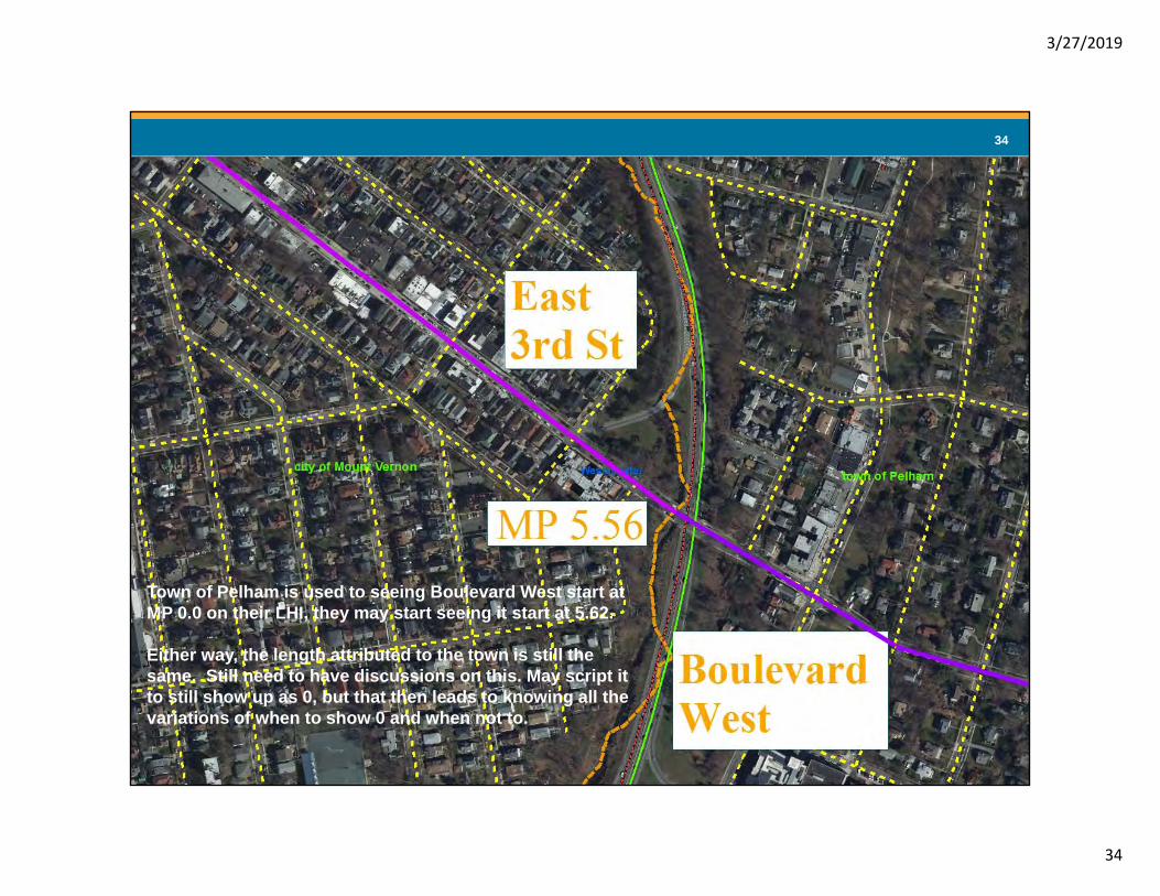
Highway Data Section
Possible Changes in the way lengths have been for years in the LHI
Minor Arterials – Named East 3rd Street in the City of Mount Vernon becomes Boulevard West in the Town of PelhamTreated as 2 GIS ID
Why not make it one and get rid of the admirative break?
3/27/2019
34
34
Highway Data Section
Town of Pelham is used to seeing Boulevard West start at MP 0.0 on their LHI, they may start seeing it start at 5.62.
Either way, the length attributed to the town is still the same. Still need to have discussions on this. May script it to still show up as 0, but that then leads to knowing all the variations of when to show 0 and when not to.

3/27/2019
35
35
Submission Definitions•No. of Lanes (Number of Lanes)
•A travel lane is defined as part of a roadway designated foruse by a single line of vehicles. The Local HighwayInventory counts the total number of travel lanes for alleligible roadways, including both directions of dividedhighways. •Total lane numbers are essential in the calculation of totalroadway mileage for CHIPS and other state and federalhighway funding, safety, and maintenance programs.
•The minimum width to be considered a two-lane road is 16feet.
Local Highway Inventory

3/27/2019
36
36
Submission Definitions•No. of Lanes (Number of Lanes)
•Lanes Excluded from the LHI•Truck Climbing Lanes•Toll Collection Lanes•Parking Lanes•Acceleration/Deceleration Lanes•Weaving Lanes•Turning Lanes•Continuous Center Turn Lanes •All other lanes prohibited from LHI inclusion
Local Highway Inventory

3/27/2019
37
37
Submission Definitions•Administrative Data
•Func Class (Functional Class)•Class or group of roads to which a facilitybelongs, according to the degree ofaccess and mobility offered, as definedby the Federal Highway Administration
Local Highway Inventory

3/27/2019
38
38
Don’t get confused about Functional Class
The LHI includes roads from all Functional Classes –Remember LHI is determined by ownership and maintenance
Local Highway Inventory

3/27/2019
39
39
Submission Definitions•Administrative Data
•Functional Classification and NHSdesignation can not be changed through theLHI process•Provided for informational knowledge intothe roadways use and importance
Local Highway Inventory

3/27/2019
40
40
Time Frame•Last year’s July distribution went well, so wewill look to repeat that this year.
•The HDSB accepts LHI submissions on acontinuous basis. However, to ensure thatupdates are processed in time to receiveCHIPS funding they must be received byDecember 15.
Local Highway Inventory

3/27/2019
41
41
Local Highway Inventory
Do we start taking a proactive approach?
If we are going to be “required” to report some of these roads for ARNOLD should we build them during some type of annual review?

3/27/2019
42
42
Local Highway Inventory
Aerial view screams of “open to the public” roadway

3/27/2019
43
43
Local Highway Inventory
Fowler Lane is old school city planning with frontage on the main road and garage access from the back ally
Persimmon is a “new” road with construction still possible. Has the city “accepted” it yet.
We have a submission rate of about 90% state wide
But some muni’s are ghosts to our office. One of the capital district cities has not returned an LHI since 2013.

3/27/2019
44
44
Why did my LHI change when no changes were submitted?
Answer: Selected data reviews occur year-round at the NYSDOT Main Office Highway Data Services Bureau (HDSB). Internal Databases and mapping are updated to reflect reported changes. Updated ortho imagery becomes available that wasn’t available during the initial review.
Common Questions

3/27/2019
45
45
There have been inaccuracies in my LHI for years, why haven’t you corrected them?
Answer: NYSDOT strives to maintain the LHI as an accurate and complete public depository of local roads data. Maintaining an up-to-date and accurate inventory of such a vast system requires extensive coordination and cooperation. We need your input!
Common Questions

3/27/2019
46
46
Is the LHI a legal document or an indicator of road ownership?
Answer: No, it is not. The LHI is a listing of roads in response to a requirement under State Highway Law for the purpose of implementing CHIPS. While it does imply ownership (or maintenance responsibility) of a road by a particular jurisdiction, the LHI is not a survey, title or other legal rights document. However, it is often used in legal proceedings.
Common Questions

3/27/2019
47
47
Common Questions
See notes on the next page.

3/27/2019
48
48
To illustrate the point, here is a road that was submitted back in December. This road appears to be a driveway for a lodge/café located at the end. It is entirely on private property (no ROW) and only provides access to a private business. Given these circumstances the road was rejected.
This prompted the Highway Superintendent to notify the property owner and the town board that he would no longer be maintaining the road because this was a “DOT ruling.”
This represents a misunderstanding of the legal status of the LHI. Removing this road from the LHI simply means it doesn’t meet our definition of a public road and is therefore not eligible for CHIPS funding. This fact has no bearing on the legal status of this road. As it turns out…
Garnet Hill Road last appeared in the LHI for the Town of Johnsburg in 1999 at a length of 0.43 miles. In 2000 it appears that Garnett Hill Road was renamed in the inventory to Big Shanty Road. During the NYSDOT Local Roads Project, all roadways appearing to be on private property were removed from all municipalities LHI’s. This meant the 0.43 miles of Big Shanty Road was removed from the inventory. In December 2015 the Town of Johnsburg passed resolution 150-15 to add Big Shanty Road back into the inventory. Big Shanty Road was added back into the LHI at its actual length of 0.23 miles and has appeared this way for the past three years. This is where the 0.2 miles was no longer accounted for in the LHI as it did not have a roadway assigned to it. This investigation has concluded that Big Shanty Road and Garnet Hill Road account for the original 0.43 miles that had historically been in the LHI and that Garnet Hill Road will be added back into the LHI at the requested 0.16 miles.

3/27/2019
49
49
How do I remove a road from the LHI?Answer: Discontinued or abandoned roads are
removed from the LHI with a resolution. A road can also be removed if its status has changed (e.g. no longer passable by a standard four-wheel passenger car, access restrictions have been put in place, etc.).
Common Questions
This road had been closed for anumber of years, but never reportedto us. Once discovered it wasremoved. We also remove disputedroads.

3/27/2019
50
50
Local Highway Inventory ManualRegional Representative
MO RepresentativeCopies of the Local Highway Inventory listings (pdf and/or excel formats)
www.dot.ny.gov/highway-data-servicesPast LHI files are available on the P drive at:P:\Office of Engineering\Technical Services\Highway Data Services Bureau
\Annual Data Files\Highway Inventories - 1981 to present
Cornell Local Roads Programwww.clrp.cornell.edu
LHI Resources