Embed Size (px)
Citation preview

Afghanistan Civil Aviation Authority
LOCAL AERODROME INFORMATION
REPUBLIC OF AFGHANISTAN
Afghanistan Civil Aviation Authority
UPDATED: 03 JULY 2019
ISSUE 0119 REV 02
Aeronautical Information Publication
Kabul International Airport
Primary email: [email protected]
Secondary email: [email protected]
Mobile : +93 (0) 799849388
Mobile : +93 (0) 786291243

Afghanistan Civil Aviation Authority
LOCAL AERODROME INFORMATION (LAI)
1. Publishing Authority
1.1. The Aeronautical Information Services of Afghanistan Civil Aviation Authority (ACAA) is the publishing authority for this Local Aerodrome Information (LAI) or Uncontrolled aerodrome information documents.
2. Applicable Documents
Refer to Afghanistan AIP uncontrolled airfield information are published as per information received from airfield authority. This document is non-ICAO documents operators required to reconfirm with respective aerodrome administration; contact details are listed for each aerodrome.
Data and Information must be verified with Aerodrome before any operation. The aerodrome published in this document is non-certified as per ACAA standards.
3. Regular Amendment Interval
Documents published with Issue and Revision number (e.g., Issue 0119 Rev 02). Issue number is updated yearly (0119, 0219) and Revision number is from 01 for each year with date and year of updated.
3.1 Operators must check ACAA website www.acaa.gov.af AIP section for recent documents is updated with the publication date. LAI is updated regularly with updated information received from aerodrome administration. The LAI distributed as a complete document via electronic format from the ACAA website only. Users are cautioned to ensure that printed or saved electronic copies are checked each publication ensure their regency against the ACAA website.
4. Service to Contact
4.1. In the compilation of the AIP, care has been taken to ensure that the information contained therein is accurate and complete. Smaller/less used airfields have not validated all their data. Any errors and omissions, which may nevertheless be detected, as well as any correspondence concerning the publications mentioned in this preface, should be referred in writing or emailed. AIP: [email protected] and [email protected] Mobile: +93 (0) 799849388
NOTAM: [email protected] and [email protected] Mobile: +93 (0) 799854734
4.2. Local aerodrome Information available at ACAA website: http://acaa.gov.af/aip-aeronautical-information-publication/

Afghanistan Civil Aviation Authority
RECORD OF AMENDMENTS
AIRPORT CODE
DATE ISSUE REV SECTION REMARKS
N/A 03 JUL 2019
0119 COVER PAGE
ACAA LOGO

Afghanistan Civil Aviation Authority
LAI PAGE 1
Afghanistan Civil Aviation Authority
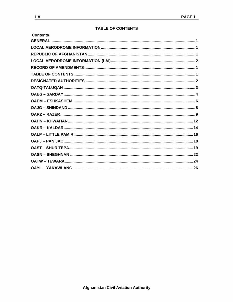
TABLE OF CONTENTS
Contents
GENERAL .................................................................................................................................... 1
LOCAL AERODROME INFORMATION ...................................................................................... 1
REPUBLIC OF AFGHANISTAN .................................................................................................. 1
LOCAL AERODROME INFORMATION (LAI) ............................................................................. 2
RECORD OF AMENDMENTS ..................................................................................................... 1
TABLE OF CONTENTS ............................................................................................................... 1
DESIGNATED AUTHORITIES .................................................................................................... 2
OATQ-TALUQAN ........................................................................................................................ 3
OABS – SARDAY ........................................................................................................................ 4
OAEM – ESHKASHEM ................................................................................................................ 6
OAJG – SHINDAND .................................................................................................................... 8
OARZ – RAZER ........................................................................................................................... 9
OAHN – KHWAHAN .................................................................................................................. 12
OAKR – KALDAR ...................................................................................................................... 14
OALP – LITTLE PAMIR ............................................................................................................. 16
OAPJ – PAN JAO ...................................................................................................................... 18
OAST – SHUR TEPA ................................................................................................................. 19
OASN – SHEGHNAN ................................................................................................................ 22
OATW – TEWARA ..................................................................................................................... 24
OAYL – YAKAWLANG .............................................................................................................. 26

LAI PAGE 2
Afghanistan Civil Aviation Authority
DESIGNATED AUTHORITIES
The addresses of the designated authorities concerned with the facilitation of international air navigation are as follows:
Head of Afghanistan Civil Aviation Authority Dr. Mohammad Qasim Wafyezada Mobile Phone: +93 (0) 799308641 Mobile Phone: +93 (0) 22311954 Email: [email protected] [email protected]
Deputy Head of Operations
Capt. Ghulam Jailani Wafa Mobile: +93 (0) 700304828 Email: [email protected] [email protected] Acting ATM Director Mr. Ghulam masoom Masoomi Mobile: +93 (0) 786308480 Email: [email protected] Afghanistan AIP office:
Mobile Phone: +93 (0) 799849388 Email: [email protected] [email protected]
Afghanistan NOTAM Office:
Mobile Phone: +93 (0) 799854734 Email: [email protected] [email protected] AFTN: OAKBYNYX NOTAM Link: http://acaa.gov.af/en/page/notame https://www.afgais.com/
Aircraft Accident Investigations:
Mr. Alireza Saifi Mobile: +93 (0) 799410037 Email: [email protected]

LAI PAGE 3
Afghanistan Civil Aviation Authority
OATQ-TALUQAN
Audit & Data verification / discrepancies must be completed by respective airport
1. Aerodrome Reference Point Coordinates and its site
364614.9N0693201.5E The geographic centre of the airfield
2. Distance and direction from the city
6 km far from city in the north side
3. Elevation and Reference Temperature
816m MSL
4. Geoids Undulation Not Determined
5. Magnetic Variation / Annual Change
Not Determined / Not Determined
6. Aerodrome Administration Telephone Email
MR: Gholam Maheddin“Rahemi” Supervisor of Taluqan airport department +93 (0) 700598788,748807952 [email protected] [email protected]
7. Types of Traffic Permitted VFR only
8. Remarks Taluqan airport currently equipped with HF& VHF transceivers (Taluqan common VHF capable advisory Frequency is 118)
9. Aerodrome Administration 12 H
10. Security ANP (Afghan National Police)
11. Hotels There are more than 80 hotels in the city
12. Restaurant Multiple restaurants in the city
13. Bank and Post Office In the city available
14. Surface, Strength and Size of Aprons
No asphalt apron there is a land 60 x 60 meters use an apron.
15. RWY and TWY Markings and Lights
No asphalt RWY and no Markings
16. Associated MET Office Meteorological Director retired. For the moment. NAME: Enayatullah Supervisor of Taluqan
Meteorological Station. Phone: +93 (0) 700749651 Email adds: [email protected]
17. Hours of Operation Sunset to sunrise
18. Type of Landing Forecast Interval of Issuance
Maximum Thermometer and Minimum Thermometer
19. Flight Documentation Language(s) used
English ,Dari and Pashto
20. RWY Dimensions 12/30 1800m x 35m no asphalt
21. PCN GRAVEL

LAI PAGE 4
Afghanistan Civil Aviation Authority
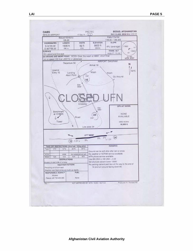
OABS – SARDAY / BESUD
Audit & Data verification/discrepancies must be completed by the respective airport
1 Aerodrome Reference Point coordinates and its site
342006N0675533E
The geographic centre of the RWY
2 Elevation 9800ft
3 Rwy 16/34 Length 1935ft
4 Rwy 16/34 Width 82ft
5 Slope of RWY 4%
6 Surface Dirt, gravel and fine dust
7 Obstructions Houses on the east side of the runway
8 Weather pattern Prevailing wind from west weather over Gazni area build up rapidly
9 Remark The ground can be soft after rain or snow no weather or notam service
Available MTN phone service available
Use BN QNH or KB QNH 0,05
Set altitude a beam tower10880
No parking cement pad (taxi to the end of 16 and turn around facing downhill)
LAI PAGE 5
Afghanistan Civil Aviation Authority

LAI PAGE 6
Afghanistan Civil Aviation Authority
OAEM – ESHKASHEM
Audit & Data verification/discrepancies must be completed by the respective airport
1 Aerodrome Reference Point coordinates and its site
364272N0713683E
The geographic centre of the RWY
2 Elevation 8240ft
3 Rwy 14/32 Length 2625ft
4 Rwy 14/32 Width 55ft
5 Slope of RWY None
6 Surface Hard packed sand, dust, softer when dry
7 Obstructions Power line APPCH RWY 14(height 18 AGL)
8 Weather pattern Rapidly changing weather in the mountains Downdrafts can be strong and sudden
Remark The low approach should be RWY 14 due to the power line
surface harder after rain ‘ soft when dry
Old tires marking 25%,50% and 75% points
CAUTION: if landing RWY 14, must have a power line in sight before 50 AGL (co-located with windsock)
Power line located 810’(250m) from the approach end of RWY 14 and is 14-18 AGL (not rollable underneath)
i.e. T/O RWY 32 has 3435ft (1050m) until powerline use 5’ approach for RWY 32 to avoid downdrafts
AWCC and MTN phone service available
Wafai cell: +93797798504

LAI PAGE 7
Afghanistan Civil Aviation Authority

LAI PAGE 8
Afghanistan Civil Aviation Authority
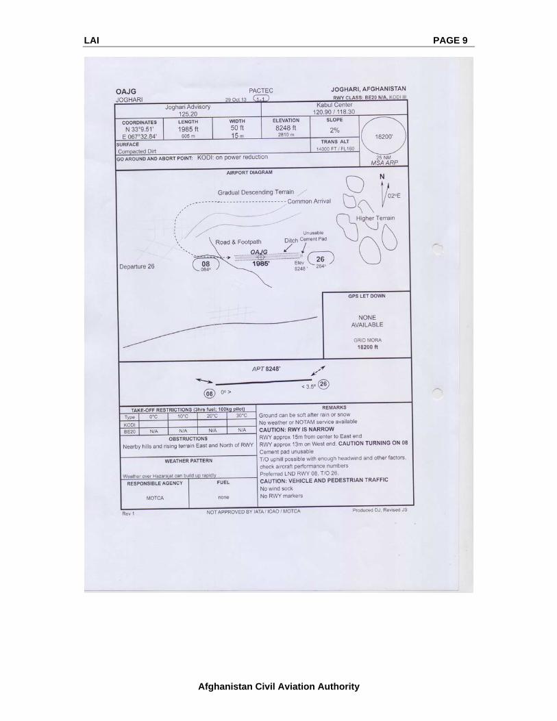
OAJG – JOGHARI
Audit & Data verification/discrepancies must be completed by the respective airport
1 Aerodrome Reference Point coordinates and its site
33951N0673984E
The geographic centre of the RWY
2 Elevation 8248ft
3 Rwy 08/26 Length 1985ft
4 Rwy 08/26 Width 50ft
5 Slope of RWY 2%
6 Surface Compacted Dirt
7 Obstructions Nearby hills and rising terrain east and north of RWY
8 Weather pattern The weather over hazarajat can build up rapidly
9 Remark The ground can be soft after rain or Snow
No weather or NOTAM service available
LAI PAGE 9
Afghanistan Civil Aviation Authority

LAI PAGE 10
Afghanistan Civil Aviation Authority
OARZ – RAZER
Audit & Data verification/discrepancies must be completed by the respective airport
1 Aerodrome Reference Point coordinates and its site
360105N0704573E
The geographic centre of the RWY
2 Elevation 8500ft
3 Rwy 08/26 Length 2755ft
4 Rwy 08/26 Width 65ft
5 Slope of RWY 2-4%
6 Surface Dirt, gravel and large stones-very rocky drainage unknown
7 Obstructions High terrain all quadrants-light pattern
8 Weather pattern Rapidly changing weather in the mountains generally winds from the west
9 Remark A Steep grey-green rock face on the opposite side make a good benchmark for 1000 ft pattern
Airstrip very rarely used and can be hard to detect people new flight operations undulating In Centre of the strip, better on the north side
Rocks cleared more on the north side of strip
Due to wind later in the day, standard pattern not always possible, make modified 80/260 from overhead

LAI PAGE 11
Afghanistan Civil Aviation Authority

LAI PAGE 12
Afghanistan Civil Aviation Authority
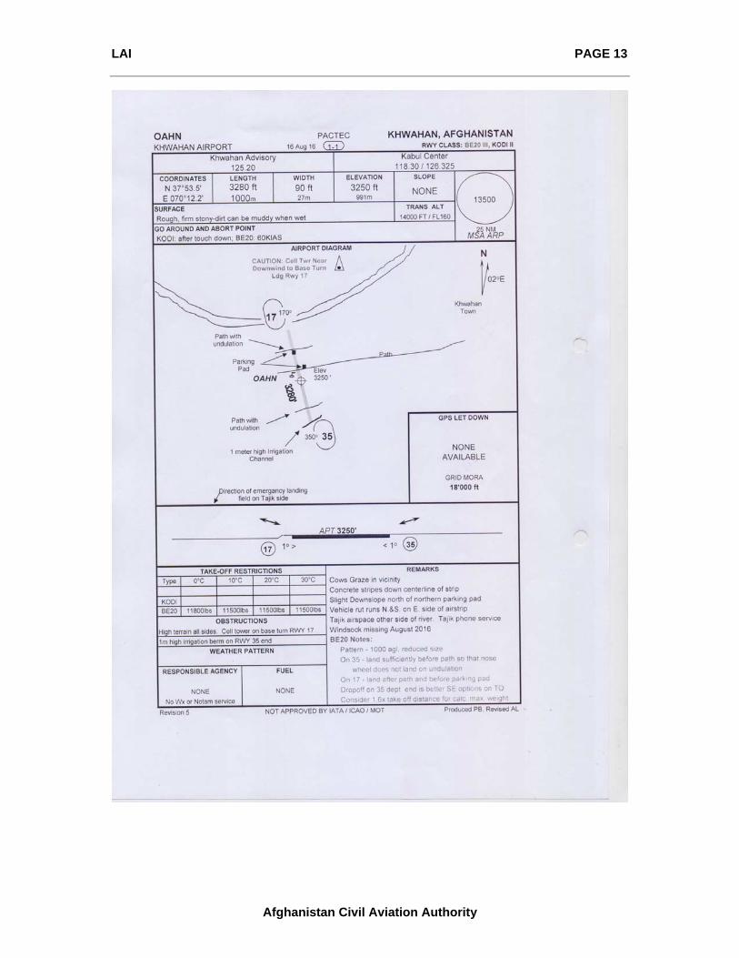
OAHN – KHWAHAN
Audit & Data verification/discrepancies must be completed by the respective airport
1 Aerodrome Reference Point coordinates and its site
37535N070122E
The geographic centre of the RWY
2 Elevation 3250ft
3 Rwy 17/35 Length 3280ft
4 Rwy 17/35 Width 90ft
5 Slope of RWY None
6 Surface Rough, firm stony dirt can be muddy when wet
7 Obstructions High terrain all sides- cell tower on base turn RWY 17
8 Remark Cows graze in a vicinity
Concrete strips down the centerline of the strip
Slight downslope north of northern parking pad
Vehicle rut runs N.& S.on E. side of airstrip Tajik airspace another side of river Tajik phone service
Windsock missing August 2016
BE20 Notes:
Pattern- 1000 AGL reduced the size
On 35 – land sufficiently before path so that nose
The wheel does not a land undulation
On 17- land after path and before parking pad
Dropoff on 35 depts. The end is better SE options on TO Consider 1.68x takeoff distance for calc.max.weight
LAI PAGE 13
Afghanistan Civil Aviation Authority

LAI PAGE 14
Afghanistan Civil Aviation Authority
OAKR – KALDAR / KRET
Audit & Data verification/discrepancies must be completed by the respective airport
1 Aerodrome Reference Point coordinates and its site
3657054N07258338E
The geographic centre of the RWY
2 Elevation 9800ft
3 Rwy 09/27 Length 2268ft
4 Rwy 09/27 Width 50ft
5 Slope of RWY 2%
6 Surface Rocky dirt and hard packed sand: new runway: soft when dry
7 Obstructions The terrain on approach and takeoff
8 Weather pattern Rapidly changing weather in the mountains generally wind (strong )from the west
9 Remark VERY REMOTE: Crew to carry suitable survival equipment
NEW RUNWAY: people not used to airport operations Open grazing area, expect animals on and near the strip
Preferred landing RWY 09, take off RWY 27
Barrels are marking 25%. 50% and 75% points Uphill Take-off possible with enough headwind
Surface herder after rain, soft when dry.
good amount of grass summer 2010
Very narrow at west end 10m between the barrels

LAI PAGE 15
Afghanistan Civil Aviation Authority

LAI PAGE 16
Afghanistan Civil Aviation Authority
OALP – LITTLE PAMIR
Audit & Data verification/discrepancies must be completed by the respective airport
1 Aerodrome Reference Point coordinates and its site
31466N0741512E
The geographic centre of the RWY
2 Elevation 13340ft
3 Rwy 07/25 Length 3858ft
4 Rwy 07/25 Width 72ft
5 Slope of RWY 0.5%
6 Surface Gravel, compacted dirt ( runway new Sep 2012). Softer on East 1/4
7 Obstructions Slightly rising terrain on East side
8 Weather pattern Weather can build rapidly in the mountains wind predominately from the west
9 Remark VERY REMOTE: crew must carry suitable survival
Equipment: WX can be cold even in the summer
Snow is possible any day of the year
ISA @ field elevation is -12c
Expect high QNH; due to high alt 1040h pa not unusual Runway edges outlined with stones
25%, 50% & 75% & RWY ends marked with barrels expect high low idle N1 ( 65% due to altitude )
Low pass mandatory to check for marmot holes Expect rotation attitude higher ( due to high alt )
Consider rotating at higher Vr to be able to rotate better positively

LAI PAGE 17
Afghanistan Civil Aviation Authority

LAI PAGE 18
Afghanistan Civil Aviation Authority
OAPJ – PAN JAO
Audit & Data verification/discrepancies must be completed by the respective airport
1 Aerodrome Reference Point coordinates and its site
342120N0670110E
The geographic centre of the RWY
2 Elevation 8800ft
3 Rwy 03/21 Length 2250ft
4 Rwy 03/21 Width 68ft
5 Slope of RWY Some
6 Surface Dirt and gravel, some large stones
7 Obstructions Trees in the schoolyard , goal posts close to RWY
8 Weather pattern WX generally better in OAPJ the OALL when marginal weather over hazarajat can build up rapidly
9 Remarks The ground can be soft after rain or snow
No weather or NOTAM Service available
Only Ariba phone service available ( summer 2011)
Parking pad slopes about 6% to the east – consider turning nose wheel slightly West for take-off on TO.
Add partial power before brake release so as not get pulled too much left ( due to torque)
Overfly to verify stones, and soccer posts are clear
People have very little respect for aircraft operations purported landowner can be challenging to deal with a parking pad
Turn clockwise for ease

LAI PAGE 19
Afghanistan Civil Aviation Authority

LAI PAGE 20
Afghanistan Civil Aviation Authority
OAST – SHUR TEPA
Audit & Data verification/discrepancies must be completed by the respective airport
1 Aerodrome Reference Point coordinates and its site
334132N0663339E
The geographic centre of the RWY
2 Elevation 6780ft
3 Rwy 07/25 Length 1640ft
4 Rwy 07/25 Width 65ft
5 Slope of RWY 12%
6 Surface Loose sand and gravel, rutted and uneven
7 Obstructions Trees and house on the east side
8 Weather pattern Watch for tailwind (check GS on GPS on final)
The weather over hazarajat can build up rapidly
9 Remarks Do not arrive before Sunrise + 2hrs ( due to blackout)
Trail/path is running across the strip. Beware of vehicles ( cars, motorcycles ). Animals & people
Landing Abort: area, house on the right – shot final
Take – off Abort: brake release
Obtain local Alt. setting (see page 1-2) 7600ft abeam rock over the village on Northside
Use aileron to aid on turn ( take-off) while on the ground

LAI PAGE 21
Afghanistan Civil Aviation Authority
LAI PAGE 22
Afghanistan Civil Aviation Authority
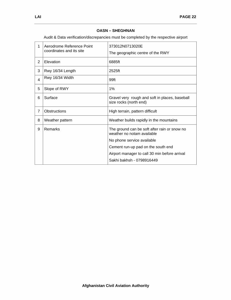
OASN – SHEGHNAN
Audit & Data verification/discrepancies must be completed by the respective airport
1 Aerodrome Reference Point coordinates and its site
373012N0713020E
The geographic centre of the RWY
2 Elevation 6885ft
3 Rwy 16/34 Length 2525ft
4 Rwy 16/34 Width 99ft
5 Slope of RWY 1%
6 Surface Gravel very rough and soft in places, baseball size rocks (north end)
7 Obstructions High terrain, pattern difficult
8 Weather pattern Weather builds rapidly in the mountains
9 Remarks The ground can be soft after rain or snow no weather no notam available
No phone service available
Cement run-up pad on the south end
Airport manager to call 30 min before arrival
Sakhi bakhsh - 0798916449

LAI PAGE 23
Afghanistan Civil Aviation Authority
LAI PAGE 24
Afghanistan Civil Aviation Authority
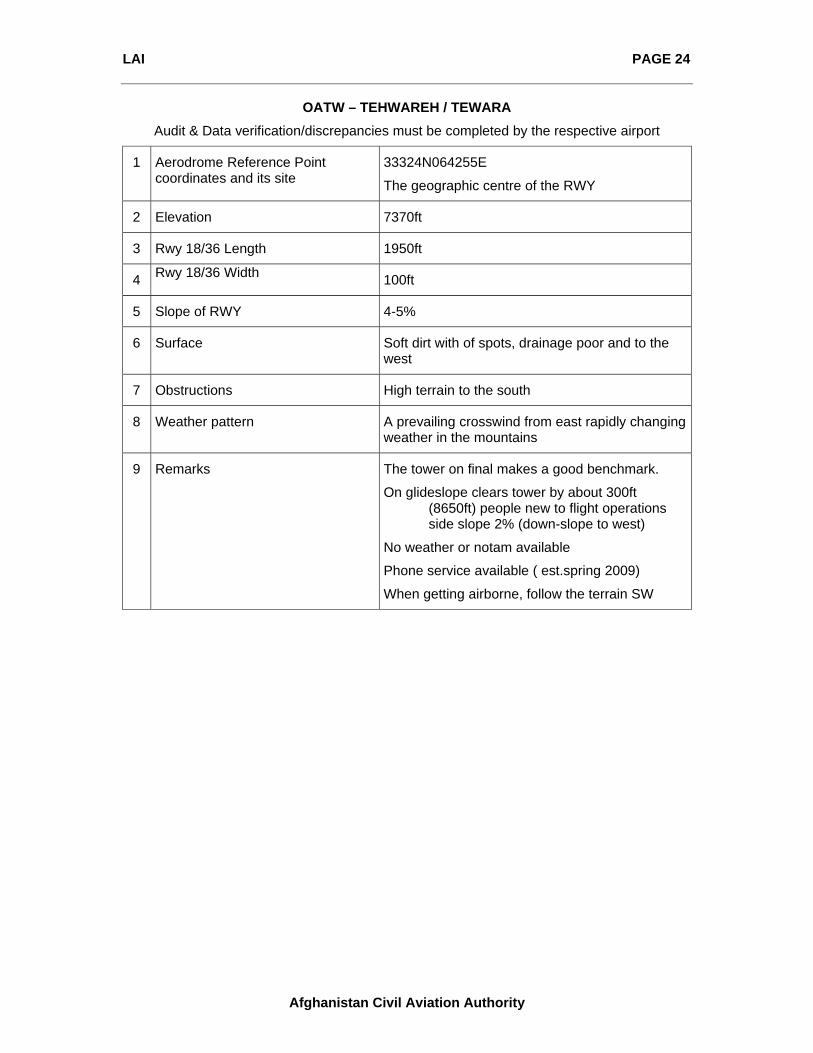
OATW – TEHWAREH / TEWARA
Audit & Data verification/discrepancies must be completed by the respective airport
1 Aerodrome Reference Point coordinates and its site
33324N064255E
The geographic centre of the RWY
2 Elevation 7370ft
3 Rwy 18/36 Length 1950ft
4 Rwy 18/36 Width 100ft
5 Slope of RWY 4-5%
6 Surface Soft dirt with of spots, drainage poor and to the west
7 Obstructions High terrain to the south
8 Weather pattern A prevailing crosswind from east rapidly changing weather in the mountains
9 Remarks The tower on final makes a good benchmark.
On glideslope clears tower by about 300ft (8650ft) people new to flight operations side slope 2% (down-slope to west)
No weather or notam available
Phone service available ( est.spring 2009)
When getting airborne, follow the terrain SW

LAI PAGE 25
Afghanistan Civil Aviation Authority
LAI PAGE 26
Afghanistan Civil Aviation Authority
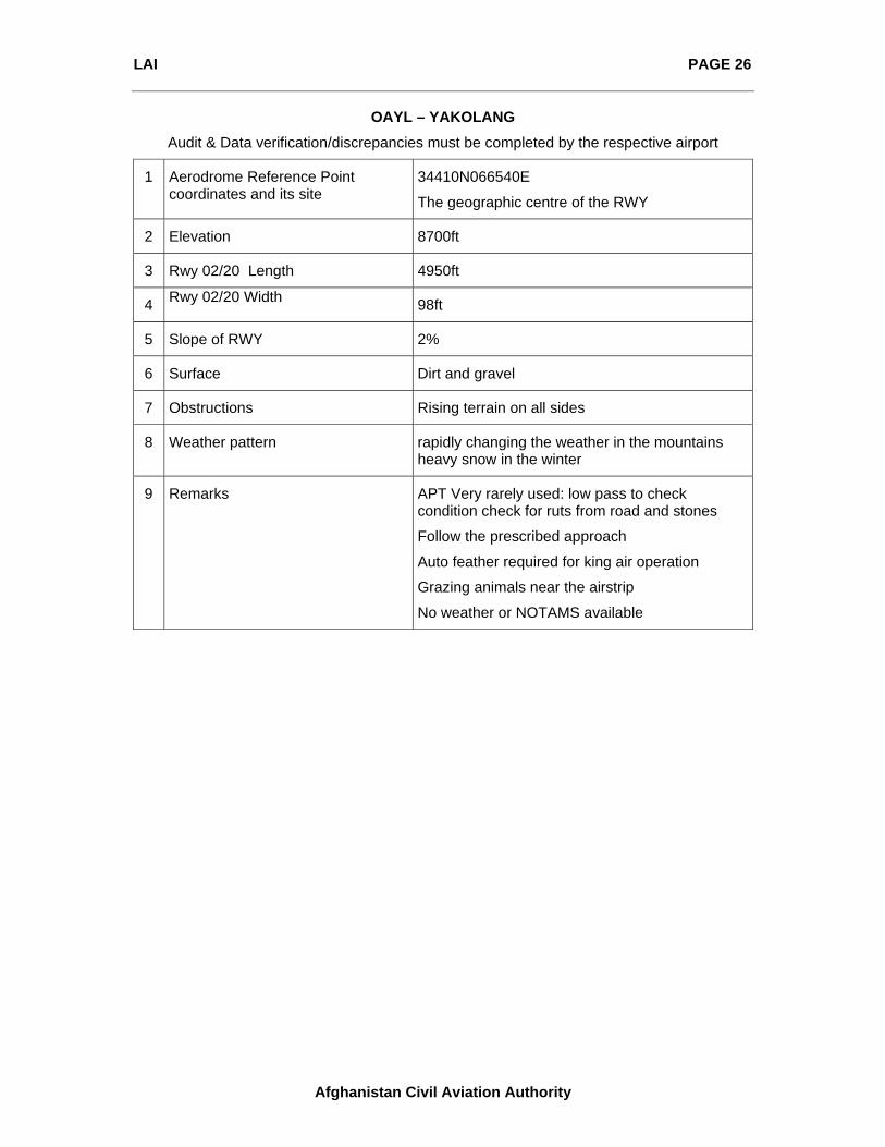
OAYL – YAKOLANG
Audit & Data verification/discrepancies must be completed by the respective airport
1 Aerodrome Reference Point coordinates and its site
34410N066540E
The geographic centre of the RWY
2 Elevation 8700ft
3 Rwy 02/20 Length 4950ft
4 Rwy 02/20 Width 98ft
5 Slope of RWY 2%
6 Surface Dirt and gravel
7 Obstructions Rising terrain on all sides
8 Weather pattern rapidly changing the weather in the mountains heavy snow in the winter
9 Remarks APT Very rarely used: low pass to check condition check for ruts from road and stones
Follow the prescribed approach
Auto feather required for king air operation
Grazing animals near the airstrip
No weather or NOTAMS available

LAI PAGE 27
Afghanistan Civil Aviation Authority