Embed Size (px)
Citation preview

LJLA Masterplan 2050 EL041


to 2050Master Plan
March 2018
Liverpool John Lennon Airport

Contents
Foreword 5
1 Introduction 7
2 Vision and Objectives 11
3 Liverpool John Lennon Airport Today 13
4 National and Local Policy Context 23
5 Forecasts for Future Growth to 2030 and 2050 29
6 Master Plan - Preferred Option 2030 and 2050 35
7 Surface Access 43
8 Economic and Social Considerations 47
9 Environmental Considerations 53
10 Climate Change and Sustainability 67
11 Safeguarding, Risk Assessment and Compensation 71
12 Monitoring 75
14 Glossary 77
15 Abbreviations 81
Appendix 1 Master Plan Area 84
Appendix 2 Eastern Access Transport Corridor Opportunity 86
Appendix 3 Environmental Designations 88
Appendix 4 Master Plan 2030 92
Appendix 5 Master Plan 2050 94
Appendix 6 Noise Contour Modelling 96
Liverpool John Lennon Airport
www.liverpoolairport.com
To 2050Liverpool John Lennon Airport Master Plan
Liverpool John Lennon Airport Master Plan
3Liverpool John Lennon Airport Master Plan
2

Robert Hough CBEChairman, Liverpool John Lennon Airport
ForewordLiverpool is an international city. It was built on commerce
and retains a proud trading heritage and outward focus.
Liverpool John Lennon Airport (LJLA) plays an important role
both as an international gateway to the Liverpool City Region
(LCR) and as a major driver of the local economy. It supports
around 6,000 jobs across the region and contributes
£250 million in GVA to the economy of the LCR. The presence
of a dynamic and growing airport has also been a catalyst to
the reinvention of South Liverpool.
The Airport has the potential to do much more and we are
keen to realise this potential for the benefit of the Liverpool
City Region and beyond.
This Master Plan confirms a long term vision for the future
of LJLA and describes further investment proposals for
the Airport and its surrounding landholdings. It considers
proposals for the Airport to 2030 in detail and provides
a broad indication of potential development to 2050.
It also sets out proposals for further growth and
development of the Airport as a key transport and strategic
economic asset. These proposals include expanding the
range of destinations served, adding long haul services to
key business and leisure destinations, and developing the
Airport and its landholdings as a strategic economic asset
by maximising its potential to create jobs and support
ongoing regeneration across the LCR.
We would like to thank all the local communities, airport
users, businesses, tourism and regeneration agencies and
representatives of Local Government who have responded
to the consultation on the draft Master Plan. All comments
received have been considered carefully and taken into
account in the final version of the Master Plan.
4 Liverpool John Lennon Airport Master Plan
Liverpool John Lennon Airport Master Plan
4 5

1: IntroductionLiverpool John Lennon Airport (LJLA) is one of the UK’s largest regional airports and a significant economic driver and transport asset. It is of strategic importance to the economy and connectivity of the Liverpool City Region (LCR).
The Airport is a major local employer in its own right and in its supply chain. It also enhances the competitiveness of other businesses by providing access to markets for businesses across the City Region. It delivers convenient direct access to a range of destinations for both business and leisure travel and it offers a sustainable local air service to key tourism destinations for residents of Merseyside, Cheshire, Lancashire and North Wales. It supports inbound tourism and the visitor economy of the City Region.
Recent analysis1 confirms that LJLA supports (directly and through the catalytic impact it has on other businesses) around 6,000 jobs and contributes £250 million (GVA) to the Liverpool City Region economy.
The presence of a dynamic airport and availability of high quality business premises have helped stimulate the economic reinvention of South Liverpool. This has contributed to Liverpool becoming one of the fastest growing cities in the UK. The proximity of a number of growing clusters of businesses involved in growth sectors in combination with easy access by air and sea offers significant benefits through agglomeration effects. All of this is of even greater significance as, despite recent growth and success, Liverpool remains one of the most deprived local authority areas in the UK.
The Airport is planning for further growth and has prepared an updated Master Plan. The vision of the Master Plan is for LJLA to make its optimum contribution to the ongoing regeneration and development of the Liverpool City Region.
The updated Master Plan covers the period to 2050. The area to which the Master Plan applies is shown at Appendix 1. It sets out the anticipated growth of the Airport over this period in relation to expected passenger numbers, other aviation related services, and related opportunities to optimise the Airport’s contribution to the economy of the Liverpool City Region. It considers proposed development to 2030 in detail, and to 2050 in more general land use terms.
This Master Plan is not an application for planning permission and will not of itself grant approval for any works. Development at LJLA will remain subject to the normal requirements for planning permission2.
This Master Plan provides a framework for setting out the Airport’s longer term aspirations within which proposals can be considered and planning applications made as and when necessary, including informing the emerging Liverpool Local Plan. It is the intention of the Airport, to submit a planning application(s) to the relevant councils when the commercial circumstances are right. This will be subject to full and detailed assessments having regard to (among other things) the Town and Country Planning (Environmental Impact Assessment) Regulations 2017.
The Need for this Master Plan
Market and policy changes
This is an important time for the Airport as it seeks a sustainable business model in response to market changes. The first LJLA Master Plan was adopted in 2007. It projected significant passenger and cargo growth. The financial crash and subsequent recession created a very different economic outlook.
Initially passenger numbers at LJLA fell but have since recovered. In 2016 the Airport handled 4.8 million passengers. Current projections are for further growth to levels close to those provided for in the 2007 Master Plan but over a longer time period.
Liverpool City Region has secured significant growth since the recession. In 2015 Liverpool was noted as having the fastest growing economy in the UK3. This increased economic activity affects demand for services at LJLA. These are reflected in updated projections.
The Mayor of Liverpool has identified a number of Mayoral Development Zones (MDZ) where particular focus will be placed on securing growth and regeneration. LJLA is situated within the South Liverpool MDZ.
1 Liverpool John Lennon Airport and the City Region. York Aviation. 2016
2 The Airport (in common with other airport operators) is able to undertake certain types of development without the need for planning permission following consultation with the local planning authority. These types of development are known as ‘permitted development’. The scope of permitted development is set out in Part 8 of Schedule 2 to the Town and Country Planning (General Permitted Development) Order 2015.
3 Source: Office of National Statistics. 2015
Liverpool John Lennon Airport Master Plan
76 Liverpool John Lennon Airport Master Plan
6
BIRKENHEAD
WARRINGTON
LIVERPOOL
MANCHESTER
CHESTER
CREWE
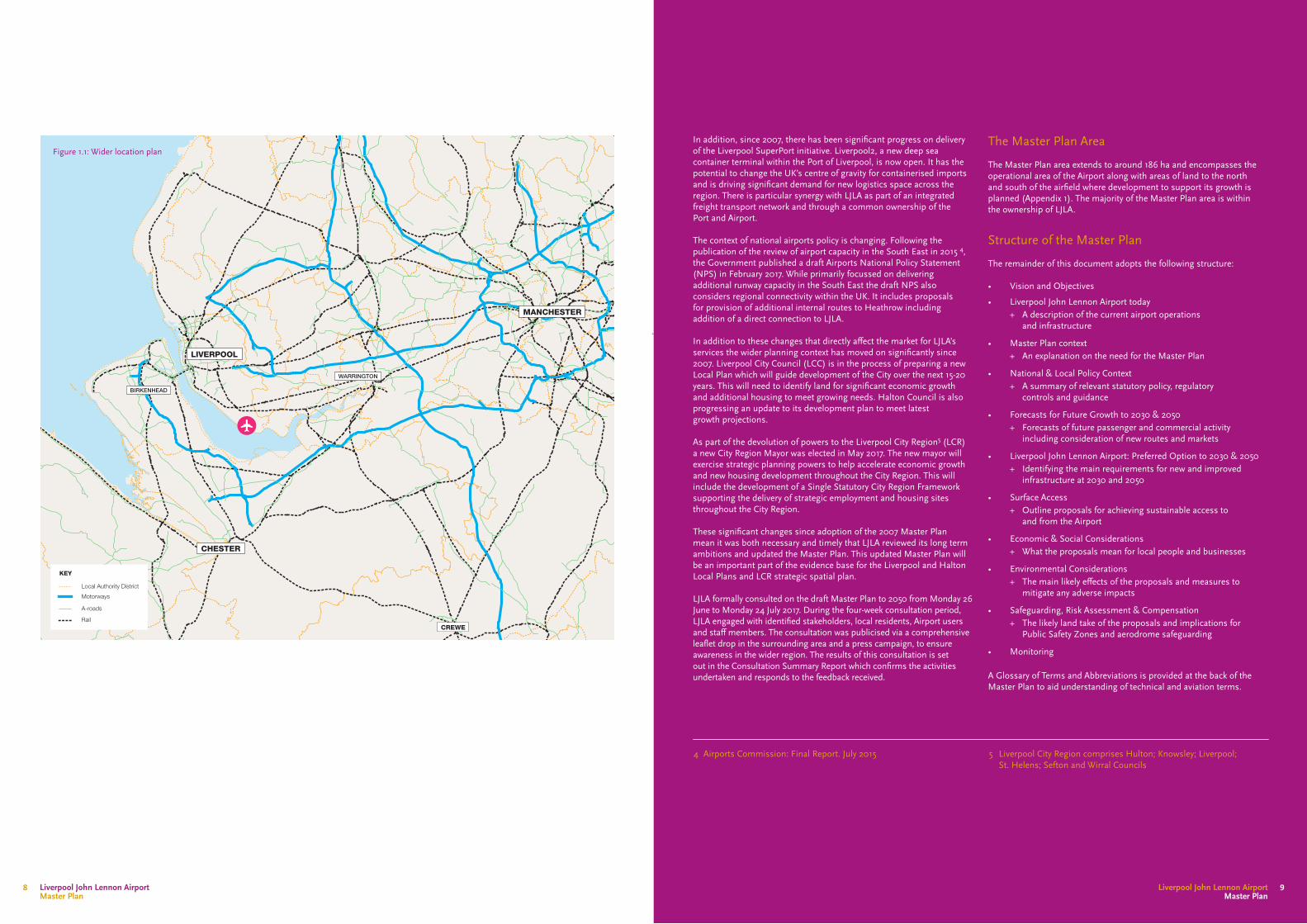
Figure 1.1: Wider location plan
KEY
Local Authority District
Motorways
A-roads
Rail
The Master Plan Area
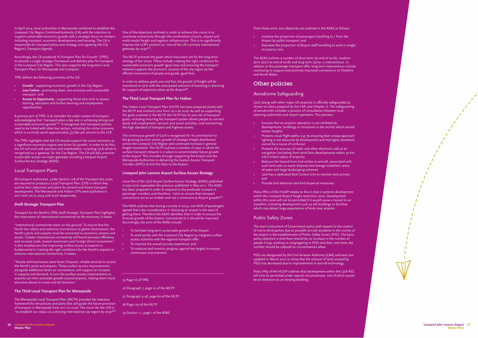
The Master Plan area extends to around 186 ha and encompasses the operational area of the Airport along with areas of land to the north and south of the airfield where development to support its growth is planned (Appendix 1). The majority of the Master Plan area is within the ownership of LJLA.
Structure of the Master Plan
The remainder of this document adopts the following structure:
• Vision and Objectives
• Liverpool John Lennon Airport today + A description of the current airport operations
and infrastructure
• Master Plan context + An explanation on the need for the Master Plan
• National & Local Policy Context + A summary of relevant statutory policy, regulatory
controls and guidance
• Forecasts for Future Growth to 2030 & 2050 + Forecasts of future passenger and commercial activity
including consideration of new routes and markets
• Liverpool John Lennon Airport: Preferred Option to 2030 & 2050 + Identifying the main requirements for new and improved
infrastructure at 2030 and 2050
• Surface Access + Outline proposals for achieving sustainable access to
and from the Airport
• Economic & Social Considerations + What the proposals mean for local people and businesses
• Environmental Considerations + The main likely effects of the proposals and measures to
mitigate any adverse impacts
• Safeguarding, Risk Assessment & Compensation + The likely land take of the proposals and implications for
Public Safety Zones and aerodrome safeguarding
• Monitoring
A Glossary of Terms and Abbreviations is provided at the back of the Master Plan to aid understanding of technical and aviation terms.
In addition, since 2007, there has been significant progress on delivery of the Liverpool SuperPort initiative. Liverpool2, a new deep sea container terminal within the Port of Liverpool, is now open. It has the potential to change the UK’s centre of gravity for containerised imports and is driving significant demand for new logistics space across the region. There is particular synergy with LJLA as part of an integrated freight transport network and through a common ownership of the Port and Airport.
The context of national airports policy is changing. Following the publication of the review of airport capacity in the South East in 2015 4, the Government published a draft Airports National Policy Statement (NPS) in February 2017. While primarily focussed on delivering additional runway capacity in the South East the draft NPS also considers regional connectivity within the UK. It includes proposals for provision of additional internal routes to Heathrow including addition of a direct connection to LJLA.
In addition to these changes that directly affect the market for LJLA’s services the wider planning context has moved on significantly since 2007. Liverpool City Council (LCC) is in the process of preparing a new Local Plan which will guide development of the City over the next 15-20 years. This will need to identify land for significant economic growth and additional housing to meet growing needs. Halton Council is also progressing an update to its development plan to meet latest growth projections.
As part of the devolution of powers to the Liverpool City Region5 (LCR) a new City Region Mayor was elected in May 2017. The new mayor will exercise strategic planning powers to help accelerate economic growth and new housing development throughout the City Region. This will include the development of a Single Statutory City Region Framework supporting the delivery of strategic employment and housing sites throughout the City Region.
These significant changes since adoption of the 2007 Master Plan mean it was both necessary and timely that LJLA reviewed its long term ambitions and updated the Master Plan. This updated Master Plan will be an important part of the evidence base for the Liverpool and Halton Local Plans and LCR strategic spatial plan.
LJLA formally consulted on the draft Master Plan to 2050 from Monday 26 June to Monday 24 July 2017. During the four-week consultation period, LJLA engaged with identified stakeholders, local residents, Airport users and staff members. The consultation was publicised via a comprehensive leaflet drop in the surrounding area and a press campaign, to ensure awareness in the wider region. The results of this consultation is set out in the Consultation Summary Report which confirms the activities undertaken and responds to the feedback received.
4 Airports Commission: Final Report. July 2015 5 Liverpool City Region comprises Hulton; Knowsley; Liverpool; St. Helens; Sefton and Wirral Councils
Liverpool John Lennon Airport Master Plan
9Liverpool John Lennon Airport Master Plan
8

VisionLJLA is one of Europe’s leading regional airports. Its 2030 Vision is ‘to be the Airport our Region Loves’ To achieve this, the Airport will focus its activities on three key priorities: Passenger Experience – delivering an exceptional passenger experience by:• continuing to be faster, easier, friendlier• providing choice and value for all our passengers• building loyalty and pride towards the Airport People – investing in and valuing our colleagues and partners across the Airport and within our community• we will be an Employer of choice• we are passionate about our community and our
environment • we will be a trusted partner of choice Performance – setting the standard for best in class, market leading performance• Deliver continued passenger growth• Lead the industry in our operational performance• Deliver a sustainable business that maximises the
opportunity for the Region
Objectives In pursuit of this Vision, the Objectives for the Master Plan are to:
• meet projected growth in demand for passenger services • capture opportunities to serve additional routes• develop connections to global long haul markets • proactively develop cargo and other commercial
aviation services• grow business and general aviation services• extend the runway to improve LJLA’s competitive position
relative to other airports and to facilitate aircraft flying intercontinental long haul routes
• further develop and grow the Airport as a strategic economic growth location; and
• deliver good quality design and attractive spaces.
Environmental SustainabilityThe Airport is committed to achieving sustainable growth. It has adopted an Environmental Management Strategy (EMS) that includes a range of policies and operating procedures that address issues such as noise, air quality, waste minimisation, and energy saving (see Chapter 4).
The objectives of the EMS seek to:
• minimise noise disturbance locally• reduce emissions from aircraft and related uses• increase the use of public transport by passengers and staff• minimise the volume of waste created• develop conservation practices that do not conflict with
security or safety practices; and• promote regeneration for the local community.
Environmental impacts are also controlled via a legal agreement with Liverpool City Council related to a previous planning permission6 to extend facilities at LJLA. This agreement sets out a series of obligations on the Airport covering air and ground noise, water quality, air quality, waste management, landscape management and conservation.
2: Vision and Objectives
6 Liverpool City Council ref. 01F/2860 dated 5 February 2003.
Liverpool John Lennon Airport Master Plan
Liverpool John Lennon Airport Master Plan
1110

3: Liverpool John Lennon Airport Today LocationLiverpool is strategically located on the North West coast within the North European Trade Axis (NETA) which links northern Europe, northern England, Wales and Ireland, and the south to north corridor from London and Birmingham to the West of Scotland. LJLA provides the city with connectivity to a wide range of UK and European cities and regions. Figure 3.2 shows Liverpool’s strategic connections with the rest of Europe (overleaf).
LJLA is located 11 km (7 miles) to the south east of the City Centre. It lies on the northern coast of the Mersey Estuary. The Airport is predominantly within the City of Liverpool but parts of it, including some of the Master Plan proposals, are within the administrative area of Halton.
LJLA is accessible to other modes of transport. It has dual carriageway access to the national motorway network, including the M56, M57, M62 and M6 (Junction 6 of the M62 is approximately 10 km (6.2 miles) to the north east of LJLA). It is served by rail via Liverpool South Parkway transport interchange, and Runcorn station on the West Coast line. It is within 20 km (12.4 miles) of Seaforth Deep-sea Container Terminal and two major freight ferry terminals to Ireland.
Road access from Cheshire and North Wales has been significantly improved following the opening of the Mersey Gateway - a second river crossing near Runcorn that links to the M56.
Frequent bus services provide connections to Liverpool South Parkway transport interchange which connects with mainline and local rail services, including Liverpool and Manchester city centres, neighbouring towns and residential areas.
The principal access to LJLA is by road from Speke Boulevard (A561) via Speke Hall Avenue – a dual carriageway. Access to the business and general aviation centre and the Airport’s administration offices is via Hale Road.
LJLA lies approximately 10 km (6.2 miles) to the south east of Liverpool City Centre on the northern bank of the Mersey Estuary (see Figure 1.1). Its neighbours include the residential communities of Speke to the north and Hale Village, within the Borough of Halton, to the east. To the west, LJLA borders Liverpool International Business Park and the grounds of Speke Hall with the communities of Garston and Allerton beyond.
To the south, between the runway and the Estuary, is agricultural land known as the Oglet. The control tower and radar installation are situated within the Oglet and are accessed separately off Dungeon Lane, which passes close to the eastern end of the runway.
There are several environmentally sensitive sites in the vicinity of LJLA (see Appendix 3). The Mersey Estuary, consisting of large areas of saltmarsh, intertidal sand and mudflats, is an internationally important site for wildfowl and Liverpool’s pre-eminent environmental asset (see Chapter 9). It is designated as a Site of Special Scientific Interest (SSSI) and Special Protection Area (SPA) and as a Wetland of International Importance under the Ramsar Convention7 due to its importance to passage and wintering wildfowl and waders. The birds feed on the rich invertebrate fauna of the intertidal sediments as well as plants and seeds from the salt-marsh and agricultural land. The Estuary is also a valuable staging post for migrating birds in spring and autumn.
Speke Hall is a Grade 1 listed building set within a historic park and gardens of regional importance, owned and managed by the National Trust. There are six listed buildings on the wider Speke Hall site, including Home Farm. A planted mound to the east of the Speke Hall visitor car park provides visual and physical enclosure along this boundary with LJLA.
Hale Village contains several listed buildings and two Conservation Areas.
The Speke Estate is home to around 16,000 residents . The Estate has seen around £100 million of investment in improving its housing stock and enhancing living conditions. The Airport supports ongoing regeneration; e.g. by working with local agencies such as Liverpool In Work to provide opportunities for local people to take jobs at LJLA.
Speke Hall
7 These designations confer protection of the Mersey Estuary in European and UK law on account of its ornithological value.
Liverpool John Lennon Airport Master Plan
13Liverpool John Lennon Airport Master Plan
12
Salzburg
So�a
Larnaca
Prague
Paris
Berlin
Rhodes
Zakynthos
Dublin
Budapest
Rome
Venice
Vilnius
Malta
Marrakech
Warsaw
Lisbon
Bucharest
Madrid
Ibiza
LanzaroteFuerteventura
Las PalmasTenerife
Geneva
Bodrum
Belfast
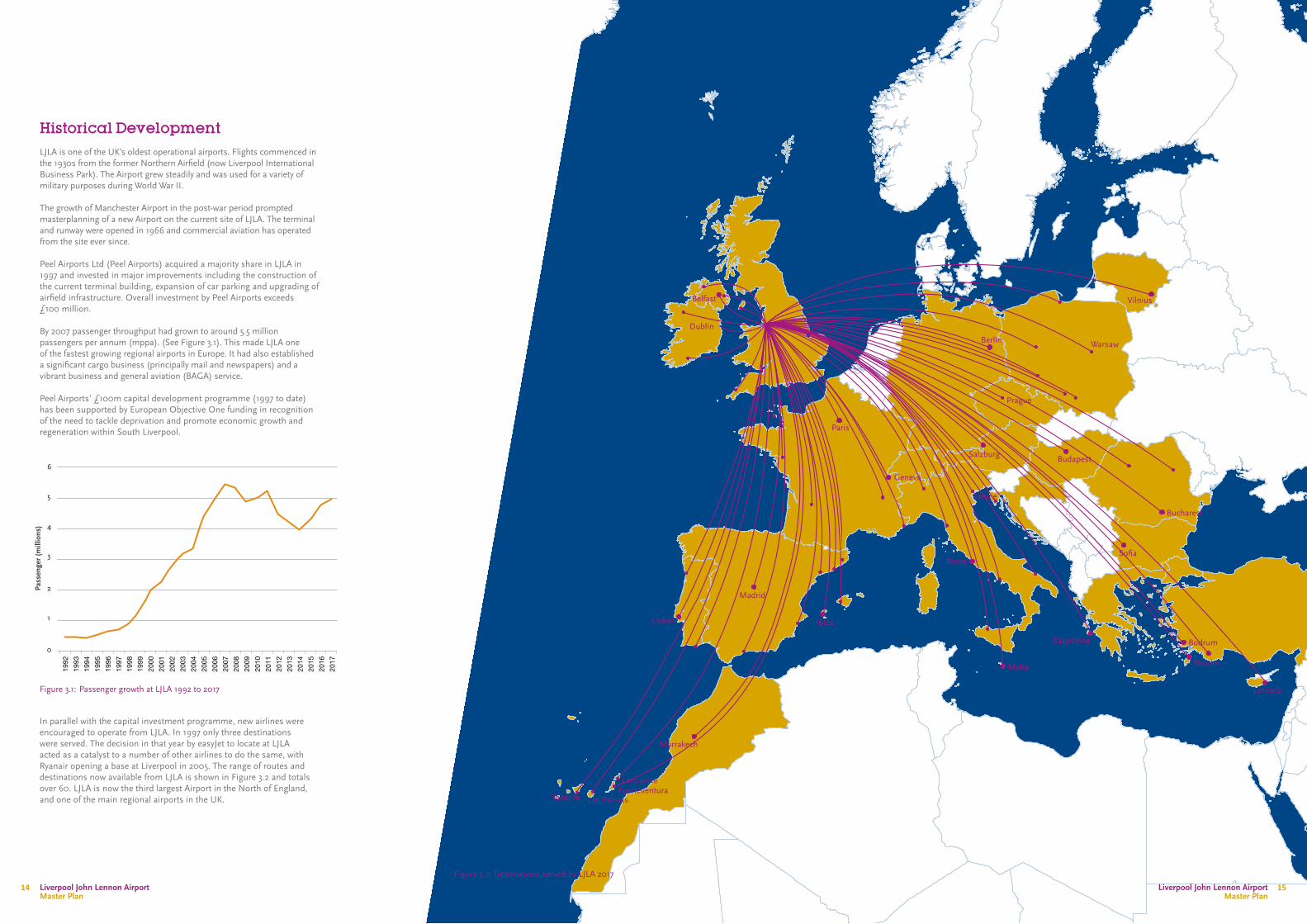
Historical DevelopmentLJLA is one of the UK’s oldest operational airports. Flights commenced in the 1930s from the former Northern Airfield (now Liverpool International Business Park). The Airport grew steadily and was used for a variety of military purposes during World War II.
The growth of Manchester Airport in the post-war period prompted masterplanning of a new Airport on the current site of LJLA. The terminal and runway were opened in 1966 and commercial aviation has operated from the site ever since.
Peel Airports Ltd (Peel Airports) acquired a majority share in LJLA in 1997 and invested in major improvements including the construction of the current terminal building, expansion of car parking and upgrading of airfield infrastructure. Overall investment by Peel Airports exceeds £100 million.
By 2007 passenger throughput had grown to around 5.5 million passengers per annum (mppa). (See Figure 3.1). This made LJLA one of the fastest growing regional airports in Europe. It had also established a significant cargo business (principally mail and newspapers) and a vibrant business and general aviation (BAGA) service.
Peel Airports’ £100m capital development programme (1997 to date) has been supported by European Objective One funding in recognition of the need to tackle deprivation and promote economic growth and regeneration within South Liverpool.
Figure 3.1: Passenger growth at LJLA 1992 to 2017
In parallel with the capital investment programme, new airlines were encouraged to operate from LJLA. In 1997 only three destinations were served. The decision in that year by easyJet to locate at LJLA acted as a catalyst to a number of other airlines to do the same, with Ryanair opening a base at Liverpool in 2005. The range of routes and destinations now available from LJLA is shown in Figure 3.2 and totals over 60. LJLA is now the third largest Airport in the North of England, and one of the main regional airports in the UK.
Pass
enge
r (m
illio
ns)
0
1
2
3
4
5
6
Figure 3.2: Destinations served by LJLA 2017
1992
1993
1994
1995
1996
1997
1998
1999
2000
2001
2002
2003
2004
2005
2006
2007
2008
2009
2010
2011
2012
2013
2014
2015
2016
2017
Liverpool John Lennon Airport Master Plan
Liverpool John Lennon Airport Master Plan
1514

Current Services
Scheduled Services
LJLA is presently served by six airlines, the largest of which inpassengers carried is easyJet, followed by Ryanair. Ryanair currently offers flights to 32 destinations and easyJet to 31.
In March 2017 the Bucharest based airline Blue Air made LJLA their eighth European base and located a single B737 aircraft at the airport which now serves eight destinations from LJLA.
Wizz Air, the largest Eastern European low cost carrier also operates from Liverpool and currently serves four destinations in Poland and Hungary.
Flybe operates four daily flights to the Isle of Man, alongside daily services to Belfast City and a summer operation to Newquay.
LJLA has previously had a large tour business operation, however in 2017 only TUI operates dedicated summer holiday flights, serving Palma and Ibiza. A broad range of tour operators, both small and large, offer holidays from Liverpool but using existing carriers, primarily easyJet.
Role of LJLA in the Social Fabric of the CityLJLA brings a number of wider benefits not only to South Liverpool, but to Merseyside and the North West as a whole. The economic benefits can be measured in terms of job creation at LJLA and the ‘catalytic’ or ‘spin off’ benefits it generates that facilitate growth in the local economy; and the commitment the Airport has to working with local communities and regeneration organisations; e.g. in developing training initiatives. Also important are the social benefits outlined below that arise through the diversity of airport services available.
• The continued success of the three universities on Merseyside attracts significant numbers of students from overseas, particularly from Northern Ireland and the Republic of Ireland. Access to affordable and convenient air travel via LJLA adds to this attraction helping to boost student numbers in Liverpool.
• The specialist health care available at hospitals on Merseyside such as Clatterbridge and Alder Hey means that LJLA is often used by air ambulance flights or by passengers travelling on scheduled services courtesy of health authorities to minimise journey times. In particular, LJLA is regularly used by passengers travelling to local hospitals from the Isle of Man.
• LJLA has been integral to the success of the mass movement of football supporters travelling to and from high profile matches/ tournaments, bringing travel cost savings and ease of access benefits in particular to local supporters.
• Sport and culture play an important role in the region’s sense of well-being and LJLA plays an important role in attracting visitors to a host of national and international events. Liverpool and Everton Football Clubs, the Liverpool Echo Arena and high profile sporting events such as the Grand National at Aintree and the international golf tournaments at Royal Liverpool will bring spectators and participants to the region via LJLA.
• The tourism benefits of an airport to a region are well recognised, and LJLA has been particularly successful in supporting growth of the visitor economy of LCR.
Existing Site and FacilitiesThe operational site of LJLA, which is edged red at Appendix 1, extends to around 186 ha (460 acres). The runway and its associated taxiway is aligned east-west across the site. All terminal, aprons, cargo buildings and airside facilities are currently situated on land to the north of the runway and south of Hale Road. The ATC tower and radar installation are situated to the south of the runway in the Oglet (See Figure 3.3).
Runway, Taxiway and Aprons
The current runway (bearing 09/27) is 2,286m long. A full length parallel taxiway to the north of the runway serves all airside facilities. The main aircraft stands provide capacity for 28 aircraft and are situated towards the north western part of the site.
A landing light gantry extends into the River Mersey at the western end of the runway. To the east, landing lights are situated on land to the east of Dungeon Lane. Both of these lighting installations are outside the operational site boundary.
Main Passenger Facilities
The terminal and main passenger car parks (see Figure 3.3 ) are accessed directly from Speke Hall Avenue. The three storey terminal is visible from both the eastern and western approaches, which ensures that passengers are able to find their way to the building conveniently.
The terminal is sited parallel to the runway for reasons of operational efficiency and ease of access to airfield facilities. It was constructed in 2001 and planning permission was granted for an extension of the terminal to the west shortly after9. Additional floor space has since been constructed to provide more gate lounges and improved internal flexibility and scope exists under that consent to provide further floor space.
It is essentially a clear span building within which the various elements of passenger processing, security and retail operate. The departure hall houses 44 check-in desks and can handle over 1,000 passengers at busy times (usually 6.00 to 9.00 am). There are 14 gates to the east and west of the departure lounge.
Bus stops, taxi ranks and car parks are immediately adjacent to the terminal building. The arrivals hall also includes booking desks for car hire, a public transport information point run jointly with Merseytravel and tourism information facilities.
The main passenger terminal car parking areas (around 8,000 spaces) are situated to the north, north-west and north-east of the terminal. Car hire and staff parking facilities are located to the west of the terminal. A Hampton by Hilton Hotel is also immediately adjacent to the terminal building, with a Premier Inn, Holiday Inn Express and Crowne Plaza in close proximity.
LJLA recognises that it operates in a highly competitive environment and competes for customers across the Region with other UK airports. Over the past three years, LJLA has focussed its investments and activity on enhancing the customer experience and the product offer at the Airport. LJLA has recently invested £2m on refurbishing the departure hall, replacing airport toilets, and providing a new car park offer. A further £4m is currently being invested to provide a broader and improved retail and food and beverage offer in the departures area.
Site planto be created
Multi-storey car park
Passenger Terminal
Training Facility
Car Parking
Cargo
Business and General Aviation
Car Parking
Control Tower
Hotel
Runway
Fuel Farm
Oglet
Apron
Figure 3.3: Liverpool John Lennon Airport8 Liverpool City Council ref. 01F/2860, dated 5 February 2003
9 Liverpool City Council ref. 01F/2860 dated 5 February 2003
Liverpool John Lennon Airport Master Plan
Liverpool John Lennon Airport Master Plan
1716

Cargo Handling Facilities
Cargo handling and distribution facilities are located to both the east and west of the terminal building. TNT has a well-established operation at LJLA having been based there since 1988. It expanded its operation by opening a new state of the art freight distribution facility to the east of the terminal. There is one bonded transit shed at LJLA; (i.e. a building with both land-side and air-side access, which are approved by HM Customs and Excise for the control and distribution of import and export cargo) and this shed is operated and managed by Wynne Aviation a Liverpool based freight and trucking company that took over the shed in March 2017. Wynne is actively looking to develop the cargo throughput both by road and air at LJLA.
Business Aviation & General Aviation
Business and general aviation (BAGA) facilities are situated to the east of the terminal complex between the runway and Hale Road. Lead tenant, Ravenair, operates two purpose built hangars having a combined footprint of 4,750 sq m (51,000 sq ft), with a third facility planned. Ravenair offers maintenance and storage of aircraft, flight training, and business charter services.
Keenair operates a CAA approved maintenance facility from a 1,670 sq m (18,000 sq ft) hangar to the west of Ravenair’s hangars in association with the Liverpool Flying School which offers flight training services from the same facilities. The Cheshire Air Training Service and Helicentre offer flight training and charter services on aeroplanes and helicopters, respectively.
LJLA is an important destination for executive and business visitors to the region; e.g. VIP visits to local companies and for sporting and cultural events. Liverpool Aviation Services (LAS), a subsidiary of Ravenair, provide the Fixed Based Operator (FBO) services to visiting aircraft using their facility on the General Aviation apron, with larger aircraft accommodated on the main apron as required.
Military, Police and Aid Flights
LJLA caters for a variety of flights organised by the military services, Police, Government and by aid and refugee agencies for humanitarian purposes.
Aircraft Maintenance
easyTech undertakes around the clock maintenance services from Hangar 2 on easyJet A319/A320 aircraft. Both Ryanair and Blue Air employ their own engineers to provide basic maintenance for their B737 fleets. When necessary, aircraft engine tests are performed on a section of taxiway to the west of the airfield.
Air Traffic Control
A new control tower was constructed in the Oglet to the south of the runway in 2002 to comply with CAA regulations, which require air traffic controllers to have clear unobstructed views of the airport movement area, including all parking aprons. The location of the tower was selected as being future proofed for all further development both north and south of the runway. It is 41 m high above ground level with a concrete column and pre- formed viewing cab.
Fire Station and Training Rig
The current fire station is located east of the terminal building, adjacent to the old control tower. The station has five bays for Rescue and Fire Fighting Service (RFFS) vehicles, in addition to space for offices, training, equipment support, and staff accommodation.
The fire training rig is situated on a disused section of the taxiway on the west of the airfield and is fitted with a steel replica Boeing 767 fuselage and a breathing apparatus heat and smoke chamber. These use pressurized hydrocarbon fuel to simulate various emergency conditions during training exercises.
18 Liverpool John Lennon Airport Master Plan
Liverpool John Lennon Airport Master Plan
18 19
Site Opportunities LJLA is an established regional airport with excellent domestic and international connectivity; serving passengers, business and general aviation, and cargo operations.
It is simple and convenient for its customers; being served by public transport services, accessible to the local and national highway network, and having ample on-site parking facilities – within easy walking distance of the terminal building. The Airport seeks to build on these strengths to enhance its customer experience.
The Master Plan area includes land which is available and suitable to support further aviation related and mixed use development. In particular the availability of land to the south side of the runway provides the Airport with an immediate advantage over a number of airports in offering a wholly new site, that provides long term expansion opportunities for aviation and non-aviation related development.
Site Constraints
Runway
As the economy of Liverpool continues to grow, links to the main emerging markets, particularly China and India, will become increasingly important from both a business and leisure perspective. At present the main cities in China and India would be beyond the limits of the aircraft range from Liverpool, and therefore to ensure Liverpool is linked effectively with these markets from both a passenger and cargo perspective, an extension to the runway is required.
The growth in the long haul low cost market has also created a current trend for airlines to operate smaller capacity aircraft such as the B737 and A320 families of aircraft on longer range routes. These aircraft which would traditionally have been operated solely on short haul services, but with new technologies, particularly engines, the range of these aircraft has increased and this has opened up some smaller markets for services to the US east coast and the Middle East. For LJLA to be a viable option for these airlines, the runway will need to be lengthened as it limits the range of these smaller capacity aircraft when they are at maximum payload, and if the airline has to limit the payload this would place LJLA at a disadvantage to the competition.
Terminal Capacity
The airport has invested significantly in its existing terminal facilities in recent years to improve the experience for its loyal customer base. The investment has unlocked residual capacity in the terminal and this will support the short-term growth of the Airport through to 6mppa. However, to accommodate longer term growth there will need to be continued investment to develop and expand the footprint of the terminal building; this will ensure the airport can continue to deliver on its customer promise to be "Faster, Easier, Friendlier."
In the shorter term the main processing areas within the terminal such as the central security search area and the arrivals immigration, will need to be expanded or reconfigured to better facilitate passenger growth. However as both passenger numbers and aircraft movements increase, this will result in the need to expand the terminal footprint both east and west to provide additional boarding gates to service the increased number of aircraft stand. The focus will also need to be on providing contact stands wherever possible to minimise the amount of passengers being transported to remote stands.
Apron
The existing apron currently has 28 stands able to accommodate a range of aircraft sizes. The CAA publishes stand standards based on aircraft design codes that are derived from a variety of criteria unique to every aircraft series. The apron currently comprises 21 code C, 5 code C+ (< B767), 1 code D, and 1 code E stand. The need for more contact stands and existing ramp congestion, indicates that it is likely that only three additional passenger aircraft could be accommodated before the maximum operational capacity of the apron is reached.
This emphasises the need to reconfigure the apron to meet the demands of the longer term forecasted traffic.
Services Infrastructure
As LJLA grows and the regeneration of South Liverpool continues, existing services and utilities infrastructure will require significant investment. Improvements to infrastructure are ongoing but it remains, in some cases, outmoded. The Airport will continue to ensure that there is adequate capacity in its services and utilities, and that there is development of additional capacity; e.g. through selective reinforcement in line with the proposals in the Master Plan. In addition, appropriate facilities will be safeguarded for key operational functions such as stand-by electricity generators and water supply and storage for fire-fighting. The Airport aims to develop a network of services corridors, where practical, to provide an efficient service and utility distribution system throughout LJLA.
Liverpool John Lennon Airport Master Plan
21Liverpool John Lennon Airport Master Plan
20
4: National and Local Policy Context
IntroductionThis Chapter describes the prevailing national and local planning and economic policy that has a bearing on the future growth of LJLA. This policy context has been considered carefully throughout the preparation of this Master Plan.
National Aviation Policy
National Infrastructure Plan
The Government published the National Infrastructure Plan (NIP) in October 2010, outlining its vision for the future of UK economic infrastructure. The NIP was updated in 2014 and reinforces the Government’s commitment to investing in infrastructure and improving its quality and performance.
In relation to Aviation, the Government seeks to ensure that the UK:
• has sufficient airport capacity to meet current and forecast need• remains one of the best connected countries in the world via its
air links; and• maintains its aviation hub capability.
The NIP highlights that “air transport has a key role in supporting long-term economic growth, with the aviation sector contributing to around £18 billion per annum of economic output to the economy and employing 220,000 people directly”.10
National Aviation Policy
The Aviation Policy Framework (APF) (UK Government, 2013) set out the government’s policy to allow the aviation sector to continue to make a significant contribution to economic growth across the country.
In the short to medium term, a key priority is to work with the aviation industry and other stakeholders to make better use of existing runway capacity at all UK airports. The approach includes pursuing a suite of measures to improve performance, resilience and the passenger experience; encourage new routes and services; support airports in Northern Ireland, Scotland, Wales and across England; and ensure that airports are better integrated into our wider transport network.
The Government announced in February 201711 that it is developing a new strategy for UK aviation, and a call for evidence was published in July 2017 which closed in October 2017. This new strategy will also explore how the UK can maximise the positive role that the world class aviation sector plays in developing global trade links, providing vital connections to both the world’s growing economies and more established trading partners, and the importance of connectivity at Regional Airports to the wider UK economy. This strategy will be prepared alongside a strategic review of UK airspace. Consultations on the key objectives of the new Strategy will take place in early 2018 with a final Aviation Strategy produced in early 2019.
Draft Airport National Policy Statement
In October 2016, the Government announced that the need for additional airport capacity in the south-east of England would be best met by a new north-west runway at Heathrow Airport. Following this announcement, a draft national policy statement (NPS) was published in February 2017 for consultation. If designated, the NPS will provide the primary basis for making decisions on any Development Consent Order (DCO) application for a new north-west runway at Heathrow Airport. Despite being focused on the future expansion of Heathrow, the NPS recognises that regional airports make a vital contribution to the economic wellbeing of the UK. Moreover, the NPS states that without the expansion of Heathrow, there is a risk that airlines could react to the existing limited capacity by prioritising routes away from domestic UK connections. The Government therefore sees expansion at Heathrow Airport as an opportunity to not only protect and strengthen the frequency of existing domestic routes, but to secure new domestic routes to the benefit of passengers and businesses across the UK. This specifically includes addition of a direct link between Heathrow and LJLA.
Department for Transport UK Aviation Forecasts
The Department for Transport (DfT) 2013 forecasts for aviation were produced to inform long-term strategic aviation policy at that time, including the Government’s Aviation Policy Framework. The document set out forecasts for air passengers, aircraft movements and CO2 emissions at UK airports. The key findings include the following:
• demand for air travel was forecast to increase within the range of 1% – 3% a year up to 2050; and
• the central forecast was for passenger numbers at UK airports to increase from 219 million in 2011 to 315 million in 2030 and 445 million by 2050. This is an increase of 225 million passengers over the next 40 years.
The DfT central forecast from 2013 projected passenger traffic at LJLA at 5.3 – 6.7 million ppa by 2030 growing to 6.8 – 15.4 million ppa by 2050.This Master Plan includes proposals to enhance services and meet the levels of passenger traffic envisaged within these national forecasts. Forecasts are presented as ranges to reflect the inherent uncertainty in forecasting over relatively long periods. LJLA has undertaken its own detailed forecasts based on its knowledge of the market and trends in aviation and utilising the DfTs long term growth rates for the UK. These forecasts have been peer reviewed by York Aviation and form the basis of the Master Plan proposals.
In October 2017, the DfT issued a revised set of aviation forecasts with the primary purpose of informing longer term strategic policy, rather than providing detailed forecasts at individual airports. These forecasts superseded the 2013 forecasts; however the longer term growth rates for airports outside of London continued to be within the 1% to 3% range as in the 2013 forecasts.
Given that there is minimal change in long term growth rate, and the recognition by the DfT that forecasts at individual airports will differ from their own, there is no change to the forecasts utilised within the Master Plan.
10 Paragraph 6.2, page 55 of the NIP
11 Written statement to Parliament - Airport capacity and airspace policy, February 2017
Liverpool John Lennon Airport Master Plan
23Liverpool John Lennon Airport Master Plan
22

Economic PolicyInvestment at LJLA demonstrates a good strategic fit with the Liverpool City Region Growth Strategy’s vision and objectives. The Liverpool City Region Growth Strategy, prepared by the Local Enterprise Partnership, provides a 25 year vision for realising economic growth and capitalising on the opportunities presented by Devolution. The Growth Strategy sets a vision for the Liverpool City Region to be “the Global Logistics Hub for the North UK and Ireland”12.
The Growth Strategy’s vision is to build on core economic strengths, as well as capacity for innovation to create a truly global and competitive City Region at the heart of the Northern Powerhouse. The “Mission” of the Growth Strategy includes:
• Starting, attracting and developing more businesses;• Enhancing and protecting distinctive quality of place; and• Creating more sustainable employment and high value jobs13.
An expanded airport and the associated creation of new business locations and floorspace would create favourable conditions for job creation and support growth in a number of core business sectors, including freight and logistics.
Improved access to international and domestic visitor markets would support further growth of the visitor economy and enhance the connectivity of the City Region for both business and leisure visitors, with associated investment in the terminal providing a high quality arrival point to the City Region. Support for LJLA’s growth and development is also provided by:
• The Northern Powerhouse Independent Economic Review where LJLA is identified as an international gateway to the North of England14. Accordingly it is seen as being of strategic importance to the continued competitiveness of the North.
• The Northern Freight and Logistics Report15 which highlights the opportunities that exist to reduce the cost of freight transport and to create new facilities, which in turn will help to boost the North’s share of the UK logistics market.
• The Liverpool Visitor Economy Network’s Growth Strategy16 , which amongst other priorities, places emphasis on improving the visitor experience and the potential to grow international and domestic visitor markets.
• The Liverpool City Region Visitor Economy Investment Plan17 which specifically references the “fundamental importance” of LJLA’s plan for long-term development to facilitating economic growth in the City Region.
• The Independent International Connectivity Commission Report18 which provides the Commission’s assessment of the current role of the North’s airports and ports in providing the required global connectivity for passengers and freight. It recommends that TfN should support the LEP to pursue better surface access to LJLA through improved rail and road connectivity. The report also highlights the importance of recognising the role of airports such as LJLA as regional centres and growth clusters and that infrastructure supporting surface access to them also plays a wider role in supporting the growth of business and services around the airports.
National Planning Policy The National Planning Policy Framework (“the Framework”) sets out the Government’s planning policies for England and how these are expected to be applied. The Framework does not form part of the statutory development plan but is a material consideration for local authorities and others in plan making and decision-taking and represents an up-to-date and comprehensive expression of national planning policy.
Section 4 of the Framework relates to promoting sustainable transport. Specifically, paragraph 31 outlines that “local authorities should work with neighbouring authorities and transport providers to support sustainable development” including through “transport investment necessary to support strategies for the growth of ports, airports or other major generators of travel demand in their areas”. Paragraph 33 states that where airports are not subject to a separate national policy statement, “plans should take into account their growth and role in serving business, leisure, training and emergency service needs”.
Local Development PlansLJLA falls within the local authority boundaries of Liverpool City Council (LCC) and Halton Borough Council (HBC). Each has its own adopted Development Plan which sets out the planning policies for that local authority.
Liverpool Development Plan
The Development Plan for LCC comprises the saved policies of the Liverpool Unitary Development Plan (LUDP) which was adopted in November 2002. The majority of the LUDP policies have been saved until replaced by the emerging Liverpool Local Plan.
Liverpool UDP
Policy E4 of the LUDP is clear that the City Council will support the expansion of Liverpool Airport as a major catalyst for substantial economic development activity in the city as a whole.
The policy includes a number of criteria which must be considered when proposing to expand the Airport. These include impact on the Green Belt and the special and ecological and landscape value of the Mersey Estuary and coast.
The Master Plan boundary extends into the Green Belt to the east and south of the existing airport boundary. The principle of a Green Belt release was established in the now revoked Regional Spatial Strategy19. However, exceptional circumstances will again need to be demonstrated to justify a review of current Green Belt boundaries through the Liverpool Local Plan.
Land to the south in the Oglet, is designated in the LUDP as Undeveloped Coast, covered by Policy OE4. This states that development unrelated to the coast, or its use for recreation, would not be permitted unless it could not realistically be located anywhere else in the city.
The LUDP acknowledges that as the expansion of LJLA could make a vital contribution to the regeneration of the Merseyside economy. Any development proposals would need to include mitigation and compensatory measures in relation to the value of the coast for recreation, agriculture, amenity, nature conservation and ecology20.
Pre-Submission Draft Liverpool Local Plan (LLP)
The Draft LLP acknowledges that Liverpool "acts as the transport hub and key gateway for trade and people into the North West, North Wales and North of England” 21. LJLA is identified as a key transport gateway and key economic asset for job creation and economic growth within Liverpool.
The Draft LLP outlines a number of spatial priorities for the sustainable growth of Liverpool. The first of which (STP1) states that one of the factors that will help to create a robust and regionally significant competitive economy is to support the sustainable growth of Liverpool Airport22. Such physical expansion will be required to minimise adverse environmental impacts23.
Draft Policy EC7 (Delivering Economic Growth) recognises airport and aviation-related activity as a business sector with strong growth potential in Liverpool and the City Region.
Draft Policy EC6 (Liverpool John Lennon Airport) states that the operation and expansion of LJLA will be supported in principle, subject to compliance with measures to address potential environmental impacts, these include:
• Impact on the adjacent natural and built environment, including protected sites (e.g. the Mersey Estuary SPA)
• Impact on adjacent residents and others in the vicinity of flightpaths, of any increases in traffic, noise and air pollution, including those generated by construction activity
• Impact on the local and regional transport network, through the implementation of a sustainable access strategy.
Subject to the above, the draft policy confirms that planning permission will be granted at the Airport for the expansion of the operational airport to accommodate growth in passenger, cargo, business and general aviation; and maintenance repair and overhaul; and employment uses which support its role as a key driver of the City Region economy.
These will include aviation related-uses, aerospace businesses, logistics, advanced manufacturing and offices that seek proximity to an Airport and the international connectivity that this supports.
The supporting text to the draft policy explains that the operational area of the Airport needs to expand to accommodate the proposals in the Master Plan. To achieve this an area of farmland, known as the Oglet, which lies to the south of the runway and adjacent to the River Mersey will be removed from the Green Belt (as shown on the draft Policies Map).
Halton Borough Council Development Plan
The Development Plan for HBC comprises the saved policies of the Halton Unitary Development Plan (HUDP) and the Core Strategy local plan (CS). The HUDP was adopted by the Council on 7 April 2005; however, a number of policies have lapsed or been superseded by policies in the CS. The remaining ‘saved’ policies continue as part of the current Development Plan; however, they will be replaced in due course.
Halton Core Strategy
The Halton Core Strategy (HCS) recognises LJLA as providing “national and international connectivity for the Borough whilst also bringing economic benefits including job creation”.24 LJLA is also identified as an ‘Area of Search for Green Belt Release’ (to facilitate airport expansion), which is supported by Policy CS17 (Liverpool John Lennon Airport).
Policy CS17 outlines that the operation and expansion of LJLA will be supported in principle, including the proposals for an extension to the runway and the new Eastern Access Transport Corridor (EATC). Where there are negative environmental and social impacts associated with such development, appropriate mitigation measures to reduce or alleviate impacts will be required.
The extent of the runway extension to the east is in the early stages of preparation. Any amendment to the Green Belt boundary will only be permitted for the purpose of the runway extension.
Policy CS17 of the HCS states that the provision of sustainable surface access to the airport, in accordance with the Airport Surface Access Strategy, will be supported. The route of the proposed EATC will be determined through the standard approvals process.
Halton UDP
The HUDP recognises that LJLA is a key transport facility for the Borough and plays an important role in the local economy by promoting investment, regeneration and by providing employment opportunities. Policy TP20 outlines that proposals that would improve surface access to and from LJLA will be permitted, in line with the Local Transport Plan.
Transport Plans
12 Liverpool City Region Local Enterprise Partnership and Liverpool City Region Combined Authority (2016) ‘Building our Future: Liverpool City Region Growth Strategy’
13 Ibid
16 Liverpool Visitor Economy Network (2016) ‘Growth Strategy Summary 2020’
17 Liverpool City Region Visitor Economy Board (July 2016) – “Visitor Economy Investment Plan for Growth 2016-2025”
18 Independent International Connectivity Report (2017) – “Transport for the North”
19 North West Regional Spatial Strategy (2008)
20 Paragraph 8.52 of the LUDP
14 SQW and Cambridge Econometrics (2016) ‘Northern Powerhouse Independent Economic Review’
15 Transport for the North (2016) ‘Northern Freight and Logistics Report’
21 Paragraph 3.6, page 17 of the Draft LLP
22 Part (f) of STP1, page 35 of the Draft LLP
23 Paragraph 5.8, page 35 of the Draft LLP
24 Paragraph 2.48, page 22 of the Halton CS
Liverpool John Lennon Airport Master Plan
2524 Liverpool John Lennon Airport Master Plan
24
In April 2014, local authorities in Merseyside combined to establish the Liverpool City Region Combined Authority (CA) with the intention to support sustainable economic growth with a strategic focus on matters including transport, economic development and housing. The CA is responsible for transport policy and strategy, and agreeing the City Region’s Transport Agenda.
Accordingly, the CA produced ‘A Transport Plan for Growth’ (TPfG) to provide a single strategic framework and delivery plan for transport in the Liverpool City Region. This also supports the long-term Local Transport Plans for Merseyside and Liverpool.
TPfG defines the following priorities of the CA:
• Growth - supporting economic growth in the City Region• Low Carbon - promoting clean, low emission and sustainable
transport ; and• Access to Opportunity - supporting those who wish to access
training, education and further learning and employment opportunities.
A primary aim of TPfG is to consider the wider context of transport, acknowledging that “transport plays a key role in achieving strong and sustainable economic growth”25. It recognises that transport policies need to be linked with other key sectors, including the visitor economy which is currently worth approximately £3.6bn per annum to the LCR.
The TPfG highlights that the CA should support the visitor economy as a significant economic engine and driver for growth. In order to do this, the CA will work with partners and stakeholders, including LJLA which is recognised as a ‘gateway’ for the City Region. The CA will also promote sustainable access via major gateways including Liverpool Airport Surface Access Strategy (ASAS).
Local Transport Plans
All transport authorities, under Section 108 of the Transport Act 2000, are required to produce a Local Transport Plan (LTP) in which they outline their objectives and plans for present and future transport development. The Merseyside and Halton LTPs were published in 2011 and run to 2024 and 2026 respectively.
Draft Strategic Transport Plan
Transport for the North’s (TfN) draft Strategic Transport Plan highlights the importance of international connectivity to the economy. It states:
“International connectivity starts on the ground. To ensure that the North has robust and extensive connections to global destinations, the North’s ports and airports must be connected to economic centres and assets. Greater international connectivity will boost business efficiency and increase trade, inward investment and Foreign Direct Investment.” It also emphasises that improving surface access at airports is fundamental to creating the right conditions for the North’s airports to enhance international connectivity. It states:
“People and businesses want faster, frequent, reliable services to access the North’s ports and airports. These surface access improvements, alongside additional direct air connections, will support an increase in capacity and demand. In turn the surface access improvements to airports can then stimulate growth around airports, making them more attractive places to invest and do business.”
The Third Local Transport Plan for Merseyside
The Merseyside Local Transport Plan (MLTP) provides the statutory framework for the policies and plans that will guide the future provision of transport in Merseyside from 2011 to 2026. The vision for the LCR is “to establish our status as a thriving international city region by 203026”.
One of the objectives outlined in order to achieve this vision is to maximise connectivity through the combination of ports, airport and multi-modal freight and logistics infrastructure. This is to significantly improve the LCR’s position as “one of the UK’s primary international gateways by 203027”.
The MLTP presents the goals which have been set for the long-term strategy of the vision. These include creating the right conditions for sustainable economic growth (goal one) and ensuring the transport network supports the economic success of the city region by the efficient movement of people and goods (goal five).
In order to address goals one and five, the growth of freight will be monitored at LJLA with the anticipated outcome of assisting in planning for support of expansion plans at the Airport28.
The Third Local Transport Plan for Halton
The Halton Local Transport Plan (HLTP) has been prepared jointly with the MLTP and similarly runs from 2011 to 2026. As well as supporting the goals outlined in the MLTP, the HLTP has its own set of transport goals, including ensuring the transport system allows people to connect easily with employment, services and social activities, and maintaining the high standard of transport and highway assets.
The continuous growth of LJLA is recognised for its contribution to the growing tourism sector, growth of strategic freight distribution across the Liverpool City Region and continued increase in general freight movement. The HLTP outlines a number of ways in which the surface transport network is in place to accommodate future growth at the airport. This includes through supporting the Airport and the Merseyside Authorities in delivering the Eastern Access Transport Corridor (EATC) to link the A562 to the Airport.
Liverpool John Lennon Airport Surface Access Strategy
Issue five of the LJLA Airport Surface Access Strategy (ASAS) published in July 2016 supersedes the previous published in May 2011. The ASAS has been prepared in order to respond to the predicted increase in passenger numbers and therefore, “aims to ensure that transport connections act as an enabler and not a constraint to Airport growth29”.
The ASAS outlines that during a survey in 2014, over 80% of passengers agreed that a key consideration in choosing an airport is the ease of getting there. Therefore the ASAS identifies that in order to ensure the forecast growth of the Airport, connectivity to it should be improved. Accordingly, the aims of the ASAS include:
• To facilitate long-term sustainable growth of the Airport• To work jointly with the Liverpool City Region to integrate surface
access activities with the regional transport offer• To improve the overall journey experience; and• To measure and monitor progress against key targets to ensure
continuous improvement.
From these aims, two objectives are outlined in the ASAS as follows:
• Increase the proportion of passengers travelling to / from the Airport by public transport; and
• Decrease the proportion of Airport staff travelling to work in single occupancy cars.
The ASAS outlines a number of short term (to end of 2016), medium term (2017 to end of 2018) and long term (2019 +) interventions. In relation to the passenger transport offer, long term interventions include continuing to support and promote improved connections to Cheshire and North Wales.
Other policies
Aerodrome Safeguarding
LJLA (along with other major UK airports) is officially safeguarded as shown on plans prepared by the CAA (see Chapter 1). The safeguarding of aerodromes includes a process of consultation between local planning authorities and airport operators. This process:
• Ensures that an airport’s operation is not inhibited by developments, buildings or structures in the vicinity which exceed certain heights
• Protects visual flight paths; e.g. by ensuring that runway approach lighting is not obscured by development and that lights elsewhere cannot be a cause of confusion
• Protects the accuracy of radar and other electronic aids to air navigation (including from wind farm developments within 30 km (18.6 miles) radius of airports)
• Reduces the hazard from bird strikes to aircraft, associated with such land uses as waste disposal and sewage treatment, areas of water and large landscaping schemes
• LJLA has a dedicated Bird Control Unit to monitor bird activity; and
• Provide bird detection and bird dispersal measures.
Policy PR10 of the HUDP relates to this in that it controls development within the Liverpool Airport height restriction zone. Development within this zone will not be permitted if it would cause a hazard to air travellers; including development such as tall buildings or facilities which may attract large populations of birds near airports.
Public Safety Zones
The main instrument of Government policy with respect to the control of risk to third parties due to possible aircraft accidents in the vicinity of the airport is the establishment of Public Safety Zones (PSZ). The basic policy objective is that there should be no increase in the number of people living, working or congregating in PSZs and that, over time, the number should be reduced as circumstances allow.
PSZs are designated by the Civil Aviation Authority (CAA) and were last updated in March 2010 to show that the amount of land covered by PSZs has decreased due to improvements in aircraft technology.
Policy PR9 of the HUDP outlines that development within the LJLA PSZ will only be permitted under special circumstances, one of which would be an extension to an existing dwelling.25 Page 16 of TPfG
26 Paragraph 7, page 10 of the MLTP
27 Paragraph 4.2d, page 60 of the MLTP
28 Page 129 of the MLTP
29 Section 1.1, page 1 of the ASAS
Liverpool John Lennon Airport Master Plan
27Liverpool John Lennon Airport Master Plan
26

5: Future Growth to 2030 and 2050
Context to Growth LJLA is a key asset to the economy and transport infrastructure of Merseyside and the North West. It is a significant employer and provides vital international connectivity and services which are of importance to local residents, businesses, and both local and regional economies. The Airport underpins competitiveness and growth in the region.
The Airport has experienced considerable passenger growth between 1995 and 2014, with a 694% increase in passengers compared to a UK increase of 84%.
LJLA handled a peak of 5.5 million passengers per annum (mppa) in 2007. This fell back to 4 mppa by 2014 reflecting the wider decline in air passengers during the recession combined with changes in airline strategy and competitive interactions with neighbouring airports, particularly Manchester Airport. While passenger numbers did fall during the recession, there has been steady and continued passenger growth at the Airport since 2014.
LJLA is committed to continued growth and to improving the Airport to increase revenue streams; enhance passenger services to provide enhanced international connectivity to longer haul destinations; maximise the opportunity of existing land, buildings and facilities at the Airport over the long term; and facilitate the delivery of major new employment development, including on the Oglet.
Forecasts for GrowthLJLA has undertaken long term business planning based on projections of future passenger demand and potential for cargo and other services to be developed. The Airport’s commercial team prepared forecasts of passenger demand informed by the Department for Transport’s latest national projections, LJLA’s position in the market relative to competitors, engagement with airlines, and a review of demand for air travel from within LJLA’s prime ‘catchment’.
LJLA’s forecasts have been peer reviewed by York Aviation (YA). YA is an experienced consultant and analyst in the aviation market. It has advised many UK and international airports on growth forecasts and airport Master Plans. YA has confirmed that the forecasts prepared by LJLA are an appropriate basis for the masterplanning of the Airport.
The forecasts are presented in Figure 5.1.
Figure 5.1: LJLA Passenger forecasts to 2050
Figure 5.1: LJLA passenger forecasts chart
Actual Passengers
Forecast Passengers
12.00
10.00
8.00
6.00
4.00
2.00
0.00
2006
2008
2010
2012
2014
2016
2018
2020
2022
2024
2026
2028
2030
2032
2034
2036
2038
2040
2042
2044
2046
2048
2050
YEAR
PASS
ENG
ERS
(mill
ions
)
Liverpool John Lennon Airport Master Plan
29Liverpool John Lennon Airport Master Plan
28

New air freight servicesThe YA work demonstrates, there is potential for LJLA to grow its cargo offer from current levels. LJLA’s location in the centre of the UK makes it an attractive point of entry. Synergy with the Port of Liverpool and proximity to the motorway network for onward shipment by road to regional and national markets are further potential advantages. YA concluded that LJLA can grow its share of the air freight market in four parts of the market, as outlined below.
Bellyhold freight on long haul flights
The passenger forecasts for LJLA include long haul passenger services, equating to around two services per day at 2030. Up to 20% of revenue on a long haul service can be generated from air freight and this is an important consideration when services are launched and will be important to delivering sustainable long haul services. It would be anticipated that some long haul destinations could be operated without the runway extension (such as New York), whilst others may require the extension to be complete. YA believes that each route could generate between 2,000 and 3,000 tonnes of freight annually. This is based on the performance of the Emirates service at Newcastle, where bellyhold freight climbed from less than 50 tonnes before the launch of the Emirates service to around 3,000 tonnes in 2015. A third or fourth daily service over time, as visible in the passenger forecasts (by 2050), could add similar throughputs.
Services to the Isle of Man
LJLA is actively working to develop the cargo facility with new and existing partners. One of the propositions being considered, and being discussed with relevant parties, is the reinstatement of freight services to the Isle of Man. When services were previously suspended this led to the freight having to be carried in different ways, with most moving to the sea ferries, generating a significant time penalty on some freight (although air services continue to carry mail).
One business sector expected to benefit from this would be the fishing industry as this would allow fish to arrive in the core UK market more
quickly, with obvious benefits in quality. Similar freight services continue to operate from LJLA to Jersey and in 2015 there was 2,400 tonnes of dedicated freight to this island. Whilst mail services do still operate from LJLA to the Isle of Man (2,500 tonnes in 2015), the ability to consolidate this on to dedicated freighters at Liverpool would reduce costs for both freight segments. In 1999 there were 1,900 tonnes of freight (non-mail) to/from the Isle of Man. If this level of freight was reinstated, along with the 2,500 tonnes of freight, then this service has the potential to generate c.4,500 tonnes of freight annually at Liverpool.
Ad hoc freight services
A runway extension would facilitate access for larger aircraft. This would include those typically used in adhoc freight services, a niche being developed and exploited by Doncaster Sheffield Airport, where tonnage has grown from 800 in 2014 up to 9,500 in 2017. At LJLA this is likely to be dependent on the runway extension to maximise the carriers that could operate. Improved cargo facilities available on the Oglet site may act as a competitive attractor when compared to the alternatives at Manchester.
Integrators
There is a longer–term opportunity for a major integrator30 to use the Airport as a base for a limited number of air services to feed a European hub, which would bypass typical integrator hubs in the UK. Five daily services could generate around 5,000 tonnes per annum. This would also be likely to lead to a broader level of freight activity and floorspace requirements at the Airport as non-air packages could also be handled in a suitable facility for sorting and distribution.
YA considers that these sources offer the potential for LJLA to grow cargo throughput by 20,000 – 25,000 tonnes per annum over the period of the Master Plan. This would require an additional building(s) to accommodate this requirement.
This requirement would need direct airside access and as Northside becomes developed for passenger services will only be able to be accommodated south of the runway within The Oglet.
Synergies with Liverpool2 and Liverpool SuperportFurther potential growth in cargo traffic at LJLA could arise as a spin-off from the increase in freight traffic through Liverpool as a result of the opening of Liverpool2 at the Port of Liverpool and consequent spin-off requirements in supply chain and logistics developments.
Although typically air freight and sea freight are very separate entities, there are potential synergies between the Port of Liverpool, through Peel Groups’ ownership of the Liverpool2 facility, and the carriage of certain types of freight by air.
A pertinent existing example elsewhere in the world is the transport of freight part of the way from the Far East by ship to the Middle East which it is then put onto aircraft in Dubai for onward transport to Europe. This obtains the optimum balance of time and cost where an item is not so time-crucial that the cost of flying it all the way from the Far East can be justified, but nevertheless needs to arrive sooner than if it were carried by ship the whole distance.
A similar model could be employed at Liverpool, with the unique benefit that both the Port facility and the Airport are under common ownership which would be crucial to making such an integrated solution work. Although the extent of this potential is currently difficult to quantify, it is possible that some sea freight coming across the Atlantic, either from the Eastern Seaboard or through the Panama Canal, could replicate this
model and require onward shipment by air to Europe or the Middle East. Whilst LJLA would not be in a position to fulfil this market at present, with suitable available land there may well be a future opportunity over the period of the Master Plan.
There is also potential for the Airport to attract dedicated scheduled freight services to long haul points. In most cases, these flights do not fly direct to their final destination, but instead operate like ‘tramp ships’ stopping at a number of airports along the way, and thus requiring shorter runway lengths due to shorter flying distances than may be expected. In particular these could be linked to the integrated sea/air freight opportunity above.
Over the timeframe of the Master Plan, it is possible that a combination of these opportunities could generate a throughput of around 40,000 tonnes of freight per annum at the Airport, particularly if the new site allowed high-calibre dedicated freight facilities on the south side area which were highly competitive compared to the quality on offer at other airports.
Maintenance, repair and overhaul (MRO)The growth of aviation globally and the ageing of the aircraft fleet means that the demand for MRO services is growing.
As the YA work confirms MRO represents a significant part of the UK aerospace sector. In 2010 it was estimated to comprise 30% of UK aerospace revenues and be worth over £6 billion per annum.
The geographical clusters of MRO activity in the UK have traditionally been focused around Prestwick Airport in Scotland, South Wales, and the East and South East of England (e.g. at Southend Airport). However, the MRO market is relatively mobile and could locate at any airport where suitable facilities can be provided and local skills are available.
The Liverpool City Region already has a strong skills base in automotive manufacturing which could be partially transferable into the aviation sector. In addition, there are strong aerospace and aircraft maintenance skill sets in the wider North West (NW) of England, including at Airbus near Chester, BAe near Preston, Boeing in Lancashire and significant numbers of supporting suppliers in the region, including on the Wirral. A further advantage offered by the NW region is the wide array of aerospace companies providing support and components to the maintenance sector, thus putting Liverpool at an advantage over other regions of the UK, particularly if Manchester Airport is unable to accept significant growth in this sector. The Northwest Aerospace Alliance, representing the sector in the region, has 220 members and highlights that 25% of the UK’s Aerospace sector is based locally, with a combined turnover of around £7 billion.
Most aircraft maintenance needs to take place within a hangar that also has direct access to the apron and taxiways. The scale of these facilities would mean that they could not realistically be attracted to the Northside due to the requirements of future expansion of passenger activity in this area.
Passenger forecastsLJLA’s forecasts of passenger growth indicate potential to accommodate 7.8 mppa by 2030 and 11 mppa by 2050. The forecasts represent over 50% growth from current activity by 2030 and 120% growth by 2050. This growth will bring significant benefits and require reconfiguration of the many operational aspects and facilities of the Airport.
Busy Day Schedules have been formulated by LJLA in conjunction with independent aviation consultants. These schedules have enabled LJLA to establish the spatial requirements at peak times to ensure key facilities such as passenger terminal, car parks, aircraft stands and aircraft aprons are able to accommodate the forecast passenger numbers.
The Masterplan drawings (Appendix 3 & 4) show the extent of facilities needed to ensure that the forecast growth can be accommodated. These demonstrate that with the exception of an additional hangar plot to the west of existing business and general aviation facilities and land reserved for a solar project, all other land north of the runway will be needed to accommodate the forecast passenger numbers. This will mean that certain non-passenger facilities currently to the west of the passenger terminal, such as transit shed and Business and General Aviation buildings will need to be relocated to make way for expansion of passenger aircraft stands and terminal facilities.
The forecasts include the commencement of long haul services from Liverpool which will open up significant potential for new routes and airlines and enable LJLA to compete with other larger airports outside the City Region. The Master Plan will make provision for extension of the runway to facilitate these long haul routes (see figure 5.2).
Over the Master Plan period the Airport is also likely to experience new demand for non-passenger services, including air freight, aerospace, Maintenance, Repair and Overhaul, (MRO) general aviation and other non-aviation activities that find clustering and associated agglomeration benefits attractive. LJLA commissioned from YA an analysis of the market for such activities and the findings are presented within a report titled ‘Market Potential And Economic Impact Of Growth Opportunities At Liverpool John Lennon Airport’. This is considered below.
Berlin Warsaw
Rome
Dublin
Reykjavík
Belfast
Lisbon
Madrid
Rhodes
Bodrum
Larnaca
Zakynthos
Malta
Paris
Geneva
Salzburg
Venice
Prague
Amsterdam
Marrakech
LanzaroteFuerteventura
Las PalmasTenerife
Ibiza
Sofia
Bucharest
Vilnius
Riga
Rovaniemi
Liverpool
Budapest
Stockholm
AsiaDelhi / Mumbai
ChinaHong Kong
Middle EastDubai / Abu Dhabi
USAChicago / New York /Philadelphia / Boston
CanadaToronto
Europe
LJLA
Oslo
Helsinki
Figure 5.2: Future routes
30 Integrators are package delivery firms that offer door-to-door collection and delivery of packages across the globe, all through their own integrated network. Examples include DHL, Fedex, UPS, TNT and others.
Liverpool John Lennon Airport Master Plan
Liverpool John Lennon Airport Master Plan
3130

As things stand, it is unlikely that the Airport could attract a suitable operator into the Northside area because of the uncertainties of building facilities which then would need to be relocated in order to make way for other facilities needed for future passenger growth. This would involve abortive construction costs. Consequently the only option would be for this sector to be accommodated to the south of the runway. The Airport could not compete for any requirements which come forward unless and until its expansion land is free of restriction and available for development.
Subject to the land to the south of the runway being available, there is the potential for the Airport to attract MRO activities, possibly even in the short term as commercial requirements do come into the market and most operational airports are short of land (which is why other airports such as Newcastle and Manchester have succeeded in achieving removal of land from Green Belt).
Growth of General and Business Aviation (BAGA)Business aviation including air taxi services have been growing over recent years. Users are attracted by the easy access and fast transfer times that regional airports can offer compared to larger airports.
As the YA work confirms, although there has been a decline in private and leisure flying activity in the UK General Aviation (GA) sector in recent years, business aviation and air taxis have experienced growth in movements of around 7% since 2005. Significant wider economic impacts arise from the use of aircraft for business purposes such as air taxis and the additional connectivity this offers over either commercial air transport or surface transport modes. Business aviation in particular offers major benefits to users in facilitating inward investment or supporting export markets. This can take the form of corporately owned aircraft, fractional ownership, chartered air taxis, or the use of private aircraft for business purposes.
LJLA has established BAGA operations. This includes Liverpool Aviation Services which is a Fixed Base Operator and Ravenair which has an approved engineering workshop at the airport. There is market interest from other operators. but the only location available at LJLA at present is a single hangar plot immediately west of the existing BAGA facilities. The release of The Oglet from its Green Belt designation is essential if LJLA is to further develop these kind of facilities, including a dedicated business aviation centre south of the runway.
Aerospace industriesThe aerospace industry encompasses a wide range of activities. It is thekind of high skills and high value added sector which the NW seeks toattract. The YA work confirms that the industry is well represented inthe North West and has overlaps with other prominent sectors such asthe automobile industry, advanced engineering and green technology.Some supply chain companies provide services across a range ofsectors of which aerospace is one. The sector has potential to grow.According to the UK Aerospace, Defence, Security & Space industries
trade association (ADSS) the UK aerospace (civil & defence) industryemploys 109,000 people and has a turnover of £27.8 billion. The NorthWest is home to a cluster of around 750 aerospace companies whichserve the two major companies in the region: BAe (design, manufacture and support for some of the world's most advanced military aircraft at Warton and Samlesbury) and Rolls Royce (fan blade manufacture at Barnoldswick). The North West aerospace sector has a turnover of some £7 billion per annum.
The ADSS’ Aerospace Industry Outlook, published in 2016 reported that 56% of aerospace firms surveyed anticipated growth of greater than 10% over the next year.
Some aerospace firms may not necessarily rely on an airport site location or access to a runway, though in a more limited, but important number of cases they do, particularly where final aircraft construction takes place or where components are transported by air from a facility (such as the Airbus operations at Hawarden). Furthermore, some aerospace companies regard an airport location as important in terms of perception and opportunities for growth. In many cases, the desire to be located at or close to an airport can also be driven by a number of other factors, including:
• The direct relationships with the MRO segment, providing components and component support to the MRO operators
• Joint facilities offering both aerospace services and MRO/aviation activity; and
• Skills and agglomeration benefits associated with aviation activity, particularly related to the MRO sector.
A number of airports in the UK have built up a cluster of aerospace activity on their sites, notably Glasgow Prestwick in Scotland and Newquay Cornwall in the South West. Liverpool would have significant competitive advantages over some of these because the aerospace sector in the North West is very strong and would be likely to lead to supply chain synergies for new operators.
A current opportunity exists in the UK Aerospace market requiring a significant airport location, accounting for 50,000 sq m of floorspace, bringing a major aircraft manufacturer to the UK. The requirement for an airport location is because a large part of the facility would be to provide a European Service Centre bringing aircraft in for maintenance. Clearly LJLA is not in a position to compete for this business at present because it does not have a long term site available and deliverable of sufficient scale.
This represents the kind of significant opportunity which may present itself in the future. Such large inward investment opportunities come along less frequently than others, but deliver significant very high value commercial and economic benefits when available. Given the extensive amount of land required for such facilities, the Airport would only be able to attract such business if land at The Oglet could be demonstrated to be available.
Displacement of activity from other airportsA further source of opportunity for growth at LJLA which will arise is from displacement of uses from other airports which prioritise passenger growth over other uses and/or do not have sufficient land to accommodate both.
Over the timeframe of the Master Plan, it is anticipated that other airports in the UK (and across Europe) will continue to grow, particularly in the passenger elements of their business which often take priority over other activities. As they grow some of these airports are likely to face land and/or infrastructure constraints (for example their runways may be increasingly full) which will require them to re-consider how they handle the non-passenger activity in the future. At the extremes this could see these airports ‘squeeze out’ certain market segments and there are already examples of this around the UK historically, particularly from London Heathrow and Manchester:
• Runway constraints at Heathrow led to almost all business and general aviation being excluded from the Airport in the late 1990s, whilst in the early 1990s, British Airways’ requirements for new maintenance facilities for wide-bodied aircraft led to these being located in Cardiff due in part to site constraints at Heathrow.
• Manchester Airport has similarly seen changes in operators over time as a result of growth and constraints. Virtually all general aviation, with the exception of high value business aviation, has now been excluded, and indeed in 1998, the construction of the second runway meant that Ravenair, the major flying school at the Airport, was displaced. Ravenair relocated to LJLA where it continues to be based.
Work by YA highlights examples of constraints at Manchester, East Midlands, London Luton and London Heathrow Airports.
Liverpool John Lennon Airport Master Plan
3332 Liverpool John Lennon Airport Master Plan
32

6: Master Plan – Preferred Option 2030 and 2050
Introduction The Chapter describes the additional infrastructure and facilities required to support planned growth of LJLA. It is based on the Airport’s projections of passenger growth, which have been peer reviewed by York Aviation, and a review of the market potential to optimise other aviation activities at the Airport.
The Development Framework (see Figure 6.1) shows the strategic development opportunities at the Airport. This is supplemented by the master plan drawings (see Appendix 4 and 5) which show the phasing of development at 2030 and 2050.
Improved Passenger Facilities
Terminal Expansion
Additional terminal capacity will be essential to handle the forecast increase in passenger numbers whilst maintaining comfort and convenience levels. Planning permission exists for an extension at the western end of the existing building which would meet short term needs. By the mid-2020s it is likely that further significant extension of the terminal will be required once passenger numbers exceeds 6 mppa. However, the exact timescales will be dependent on future agreements with airline operators.
Based on current standards, it is estimated that the terminal will need to be extended to provide a total floor space across all levels of around 60,000 sq m by 2030 and 90,000 sq m by 2050. This additional accommodation will have to be of a higher standard of quality to reflect the modern expectations of passengers and airlines, particularly those serving long haul destinations, and the prominent role of LJLA as an international gateway to the North West.
In accordance with International Air Transport Association (IATA) standards, the existing terminal is a C - D grade. These Master Plan proposals seek to upgrade it to C - B. This will require an increase in the overall pro-rata floor space per passenger. To achieve this, by 2030 the terminal will be extended to the west and to the east and in addition two new piers will be added, to increase the number of contact stands available and make the airfield operations more efficient. By 2050 a further two piers will be required, one at each end, and the terminal will be extended further still to the west.
As part of the terminal expansion, provision will also be made to improve the facilities for public transport through the provision of an integrated Public Transport Interchange.
Car Parking
Additional short and long stay parking will be required as LJLA grows. The overall parking provision will continue to be managed to support sustainable transport targets in accordance with the ASAS and under the auspices of the Air Transport Forum (ATF). However, it is estimated that around 9,500 spaces for passengers, staff and business visitors will be needed by 2030 and a further 2,700 by 2050 (see Chapter 7 for details). There will also be a car hire parking requirement of 250 spaces in 2030 and a further 150 spaces in 2050. To achieve this, at-grade car parking will be extended to the west and to the east and additional multi-storey parking will be provided in front of the terminal by 2030. By 2050 availability of land for at-grade expansion is limited and most of the additional provision will need to be in additional multi-storey car parking.
Hotel Provision
A Hampton by Hilton Hotel was constructed above the multi-storey car park (MSCP) in front of the terminal. There is also a small hotel to the north of the proposed residential development on the site of the former Dunlop playing fields. Further hotels would be accommodated adjacent to the Hilton Hotel (most likely in a similar form built over MSCP provision) and/or within the proposed mixed retail and commercial zone to the west alongside the main access to the terminal.
Runway Extension
The Airport has undertaken a detailed appraisal of its capacity. The existing runway is 2,286m long. It has assessed the economic benefits that serving new long haul markets could bring and the operational and environmental implications of a longer runway.
As set out in Chapter 5, the ability to serve long haul destinations from LJLA offers significant commercial opportunities for air passenger and cargo operators that would secure substantial economic and social benefits for the LCR and the wider economy. The length of the existing runway is insufficient to accommodate the larger aircraft which operate on these long haul routes. It is therefore proposed to roll forward the proposal within the previous Master Plan to increase the length of runway to 2,600m at full width (an extension of 314m, which would require realignment of Dungeon Lane and relocation of existing landing lights to the east). In addition, narrower ‘starter strips’ of 150m in length will be provided at each end (starter strips are parts of the runway only needed in take-off). This would give a total effective runway length of 2,750m in both directions. It is anticipated that these upgrades will be required before 2030.
It is proposed that the new runway ends be connected to the terminal and apron by extension of the existing parallel taxiway, offering greater operational flexibility and maximising runway capacity. Concurrent with the runway works, new rapid access/exit points would be required between the runway and existing taxiway system, minimising turn-around times for the low cost carriers. In addition a second parallel taxiway will be provided to the south, to further improve runway efficiency and facilitate airside access for development in the Oglet.
Improved Surface Access
The Airport recognises that maintaining safe, convenient and sustainable access is key to securing growth and has considered a range of measures to achieve this, as discussed further in Section 7. The road network in front of the terminal will be upgraded and changed to a one-way system. A new roundabout to the north-west of the terminal will enable a link with the proposed EATC and also allow separation of airport service traffic via a new control point and link road to the west.
The roundabout also facilitates access to a potential new area for mixed retail and commercial development on the approach to the Airport. This could include facilities such as hotels, a filling station, drive through restaurants and convenience retail serving passenger needs.
Liverpool John Lennon Airport Master Plan
Liverpool John Lennon Airport Master Plan
3534

Eastern Access Transport Corridor
The Airport has worked in partnership with Knowsley, Halton and Liverpool Councils to explore ways to maximise the capacity of the existing transport network around LJLA and to increase the capacity of the Speke Boulevard Corridor. This work includes investigating potential sources of funding to support the delivery of a new EATC which would improve transport connections in the area and release land to help meet the economic and housing needs of the area.
Consideration is being given to a means to create additional capacity on Speke Boulevard. The Airport has developed its own preferred route option which is shown at Appendix 2. This route would relieve Speke Road/Speke Boulevard, re-route traffic approaching the Airport away from Speke Hall Avenue and provide the opportunity for development to the east of Speke. LJLA will work collaboratively with other partners to explore other route options and to access funding in support of its aspirations.
In addition to the land required for the route of the EATC, land may also be required for landscaping and/or as a potential site for habitat creation to compensate for other land lost to development closer to the operational area of LJLA. An initial feasibility study of the scheme is underway and more detailed design work will be carried out once a final route is confirmed.
The Oglet
Business and General Aviation Centre
Business and General Aviation (BAGA) are important parts of the aviation services provided at LJLA. Demand is expected to continue to grow over the Master Plan period. Long before 2030 the remaining BAGA plot on the north side will be developed and all remaining land on the north side will be needed for passenger car parking and the proposed airport solar power project. This means that any further demand for BAGA, such as, hangars and a small terminal and maintenance facility, will need to be located on the south side. This would be further extended by 2050 with the addition of a further GA hangar and additional apron.
Cargo Development
Historically, cargo has been a significant part of the business of LJLA. This Master Plan maintains the current provision, but due to the terminal and apron expansion needed on the north side requires relocation of the facilities to a dedicated area in the western part of the Oglet site. By 2030 both the old Royal Mail facility and the existing TNT facility will need to be relocated to make way for passenger growth.
Over the period of the Master Plan there is potential for further cargo development. This will be boosted by the introduction of long haul services and the associated “bellyhold” 31 cargo. The development of logistics services associated with the growth of the Port of Liverpool offers further potential for dedicated freight services.
Maintenance Repair & Overhaul (MRO) facilities
The Airport has considered the market potential to optimise the use of the Airport as a base for maintenance, repair and overhaul (MRO) of aircraft. It has also considered the scale of infrastructure required to accommodate these to the south of the runway at LJLA. Based on assessment of the market potential provision has been made by 2030 to accommodate two MRO facilities for up to Code F aircraft. By 2050 provision has been made for a further MRO facility and an aircraft paint facility.
Other Employment Development
Provision has been made to accommodate a range of B2/B8 development in the central section of the Oglet site, where the overall depth of site is at its largest, to facilitate large distribution or warehousing facilities, which could not be accommodated on the north side due to the height restrictions created by the obstacle limitation surfaces.
Other Airport-Related Infrastructure
Engine Testing
Engine testing currently takes place on a taxiway to the west of the terminal. Whilst this location remains suitable in the short term, as the Airport grows this activity would need to be relocated. The most appropriate location for a new facility is considered to be south of the runway adjacent at the west end of the development. This is furthest from residential areas and as such would minimise noise impacts. It would also be close to the longer term cargo and maintenance facilities south of the runway and would therefore be operationally convenient.
Radar Installation
A replacement radar comprising the latest technology has been installed on a site to the south of the runway and west of the control tower. This would be relocated to the west by 2030 to allow for the new MRO apron.
Fuel Farm
The existing fuel farm location is capable of being extended to cater for the fuel needs arising from the proposed growth of LJLA up to 2030, however provision has been made to relocate it to the north by 2050 once the pier has been extended.
A small fuel facility would also be required to serve the General and Business Aviation Centre.
Office and Commercial Accommodation
The Airport’s offices and those of airlines and other businesses based at LJLA are accommodated mainly in a variety of temporary modular buildings to the east of the terminal. Permanent accommodation is required as part of the expansion proposals. In order to maximise the employment generating potential of LJLA, it is intended to provide accommodation for a wide variety of businesses that will need to be located in close proximity to the terminal and other landside and airside facilities. An area has therefore been allocated immediately to the east of the terminal.
Renewable Energy Generation
There is an opportunity to use an area of land to the north of the extended runway to deliver a solar farm which will generate renewable energy to support the operation of the Airport and adjacent uses.
The Coastal ReserveExpansion of LJLA presents an opportunity to establish an extension to the Speke Garston Coastal Reserve over a 3.5 km (2.2 mile) stretch of coast. This would more than double the extent of the existing reserve, and create a nature conservation, heritage and recreational resource of regional significance that would be retained in perpetuity.
The Coastal Reserve project has delivered a unique, attractive, wild and naturalistic landscape setting for the Mersey Way footpath that runs along the cliff top to the south of Liverpool International Business Park and adjacent to the Estuary on the old Northern Airfield. It provides a wide range of habitats for wildlife and is a key part of a coordinated programme to regenerate the coastal areas all around Liverpool as part of the Mersey Waterfront Park. The project is managed by a group of stakeholders including Peel, Liverpool City Council and the National Trust. A Management Company has been established by Peel to ensure the long-term management and development of the landscape.
A key principle of the landscape of the existing Coastal Reserve is the establishment of a strong and defensible boundary between commercial areas and the Reserve alongside the Estuary. To the west of LJLA, this has been achieved by raising ground levels within the Liverpool International Business Park, which lies alongside the Coastal Reserve, placing the secure boundary fencing in a ditch to reduce its visual impact, and widening the ditch to create new damp scrape habitats for amphibians.
At Oglet, it is proposed that a similar bold approach is taken, but in this case, due to the operational levels of the airfield, it would not be possible to raise land within this area. Levels would, therefore, be raised within the area of the Coastal Reserve itself, to enhance the natural slope inland from the cliff top, and create a screen behind which the airport boundary fence would be concealed from within the Reserve. The existing wooded cloughs, which are the characteristic feature of the Oglet area, would be protected and integrated into the new landscape.
Following the establishment of the boundary, the Reserve at Oglet will be laid out in full consultation with key stakeholders. These works could re-create a former pattern of small fields and hedgerows, which can accommodate a variety of farmland birds and would discourage the use of the land by large groups of larger birds which are a hazard to aircraft. Insects and amphibians would be encouraged by the creation of species rich grasslands, beetle banks and hedge banks, and damp scrapes.
The Mersey Way footpath would be properly surfaced to increase the enjoyment of its use by walkers and cyclists and the route carefully laid out to minimise disturbance to wading birds resting on the shore from people on the cliff-top. Vehicular access to the area would be controlled to reduce the problem of fly tipping and environmentally damaging motor sports that currently affect the area.
Yew Tree Farm, which is a listed building, would be incorporated into the project and may be suitable for use as a warden’s residential accommodation. To the east, a small visitor centre/aircraft viewing area would be created providing views north over the airfield and south across the Reserve to the Estuary.
A long-term habitat creation and landscape management scheme would be developed, which would incorporate management measures to be undertaken within the new Reserve area, around the EATC along Hale Road, and within the Airport complex to ensure the long term sustainability of the landscape and ecological mitigation works. LJLA will develop this habitat creation and management plan in corroboration with local stakeholders and other interested parties. Delivery would enable the extension to the Reserve to provide an established landscape context for the development of commercial uses in the Oglet.
Speke/Garston Coastal Reserve
31 Bellyhold comprises cargo deliveries arriving on passenger flights.
Liverpool John Lennon Airport Master Plan
37Liverpool John Lennon Airport Master Plan
36

AirspaceThe Airport maintains the highest possible safety standards at LJLA in accordance with CAA requirements. It has responsibilities for safeguarding the airspace capacity of LJLA necessary to make maximum use of the existing runway and its proposed extension.
LJLA supports work by Government and the CAA to modernise the UK’s airspace system and in doing so to minimise aircraft emissions and air traffic delays. Whilst airspace regulation is formally the CAA’s responsibility, any potential local airspace change will be led by LJLA and approved by the CAA.
The CAA’s process for approving changes to airspace and routes is set out in CAA Publication CAP 725 ‘Airspace Change Process Guidance’, which includes a public consultation stage.
Airspace RoutesThe aviation industry relies on airspace to give all passengers, businesses, the military and leisure fliers the potential to access and enjoy the many benefits that aviation brings. The basic structure of the UK’s airspace was developed over forty years ago. Since then there have been increased demand for the use of airspace and huge technological changes.
Across the UK and Europe the aviation industry is seeking to modernise airspace systems, this is strongly supported by UK Government’s aviation policy. This means over the next few years aircraft navigation is aiming to switch from a reliance on land based navigation aids to more precise satellite based navigation.
Like the majority of other UK airports, LJLA will be seeking to modernise its airspace. This will involve a formal airspace change through the new CAA Airspace Change Process (ACP) that requires a higher level of stakeholder engagement and consultation to facilitate the systemisation of the airspace. In doing this LJLA will be aiming to maximise the benefits for the widest number of people and the make use of the airspace as efficient as possible. To do this, there will have to be a holistic review of the routes that aircraft currently use to and from the Airport.
The potential benefits are:· a reduction in CO2 emissions by reducing aircraft fuel burn· aircraft noise reduction by improved climb and approach processes· better use of airport resources by maintaining and developing
airspace capacity· more accurate flight planning and fewer delays by having more
precise and accurate information.
Local Airspace CapacityThe UK has a complex airspace structure to support an extensive network of arrival and departure routes, with the interaction of various airports having an impact on capacity in the surrounding airspace.
The regulated airspace around LJLA is designated as Class D Controlled Airspace. Aviation legislation requires all aircraft wishing to enter, or fly, within this Controlled Airspace to make radio contact with LJLA Air Traffic Control(ATC) and obtain clearance to operate. LJLA ATC controls the airspace using a combination of radio instructions and radar surveillance to manage the prevailing air traffic situation.
The airspace above and abutting LJLA Controlled Airspace is part of the Manchester Terminal Movement Area (TMA) Class A airspace and is operated under the control of NATS at Manchester Airport.
Manchester Airport is located approximately 37 km (23 miles) east of LJLA and Chester Hawarden Airport is located approximately 19 km (12 miles) south east of LJLA. Such close proximity, combined with the differing alignment of the runways creates a complex interface between the traffic patterns of the three airports. All activity at LJLA has to be safely integrated with traffic for Manchester, Warton, and Chester Hawarden Airports to avoid conflicts in demand for access to the same airspace. This can result in delays to some air traffic in peak periods.
Given the Government’s support for the growth of LJLA (including a possible runway extension), it is important that adequate airspace capacity is protected so that the existing runway, including its extension, can be effectively utilised. Planning and transport bodies will need to take into account the need to provide the necessary airspace to enable the APF policies to be implemented. 33
A full review of TMA and the LJLA airspace is currently underway by NATS in conjunction with airport airspace users, including the airlines. The aim is to increase overall regional capacity whilst seeking to minimise noise from arriving and departing aircraft. The review will include the use of Continuous Descent Approach (CDA) and continuous climb procedures, where practical, to minimise the need for level aircraft flight around LJLA. This has the benefits of maximising the efficiency of aircraft; e.g. by reducing fuel burn and by maximising the vertical distance between aircraft and the ground thereby minimising noise impact.
Green Belt and Exceptional Circumstances The land within the Oglet and at the eastern end of the runway is designated as Green Belt. In accordance with national planning policy, release of land from the Green Belt should only be undertaken in “exceptional circumstances” 32.
The principle of release of land from the Green Belt to meet the growth needs of LJLA has previously been established on the basis of the provisions of the 2007 Master Plan and was reflected in the former Regional Spatial Strategy and the draft Liverpool Local Plan. As circumstances have changed it is necessary to consider whether exceptional circumstances still apply.
The drivers of growth at LJLA are described in detail in Sections 4 and 5 of the Master Plan. These demonstrate the significant economic and social role LJLA plays in the Liverpool City Region; policy support for the growth and development of aviation in the UK; and the particular drivers of expansion of the Airport.
The expansion of passenger routes and development of cargo and MRO activities have implications for the size of aircraft using LJLA. Larger aircraft which can carry larger payloads and access long haul destinations will require extension of the runway. Since to the west, the runway is constrained by the proximity of the Mersey, extension to the east is the only feasible option. A modest extension can be delivered with managed impacts on adjacent land uses and communities and would facilitate significant growth and economic benefits.
The Oglet is the only suitable location to meet the need for growth of aviation uses and associated commercial and employment development at the Airport. Other locations are constrained by existing development (to the north), heritage assets (to the west), and public safety zone to the (east). The Oglet benefits from direct airside access to the runway and it contains a limited number of buildings and is free of insurmountable constraints to its development. There is scope to incorporate a parallel taxiway and apron to facilitate direct aviation access. As a consequence, the land could accommodate a variety of size and type of employment requirements including large footprint buildings such as MRO hangars, air freight transit sheds, and logistics facilities.
Importantly the Oglet comprises a narrow parcel of Green Belt that sits between the runway and the Mersey estuary. As a result of these characteristics, this segment of Green Belt does not make a significant contribution to its strategic purposes. For instance, this land is not required to prevent neighbouring settlements from merging together, it does not check the unrestricted sprawl of large built-up areas, and it is not needed to preserve the setting and special character of historic towns.
The socio-economic benefits of expansion of LJLA for the City Region are huge. The proposals within the emerging LJLA Master Plan could deliver around 6,000 additional jobs and add £375 million GVA per annum to the City Region economy. This represents a major boost to the economic strategy of Liverpool and is given additional significance in light of Liverpool being the fourth most deprived local authority area in England and parts of the adjacent community of Speke being in among the 5% most deprived areas in the country.
Taken together:
• the strategic significance of LJLA to the growth and regeneration of the City Region;
• the drivers of growth at LJLA as set out in section 4;• the significant social and economic benefits that this growth
would deliver; • the absence of alternative sites capable of meeting this need; and• the limited contribution that the land makes to the strategic
purposes of the Green Belt.
Comprise compelling exceptional circumstances which justify release of the land at The Oglet and the eastern end of the runway for development necessary to achieve the optimal expansion of LJLA.
33 Ibid, Executive Summary, page 1532 National Planning Policy Framework. Communities and Local Government. March 2012. Paragraph 83
Liverpool John Lennon Airport Master Plan
39Liverpool John Lennon Airport Master Plan
38
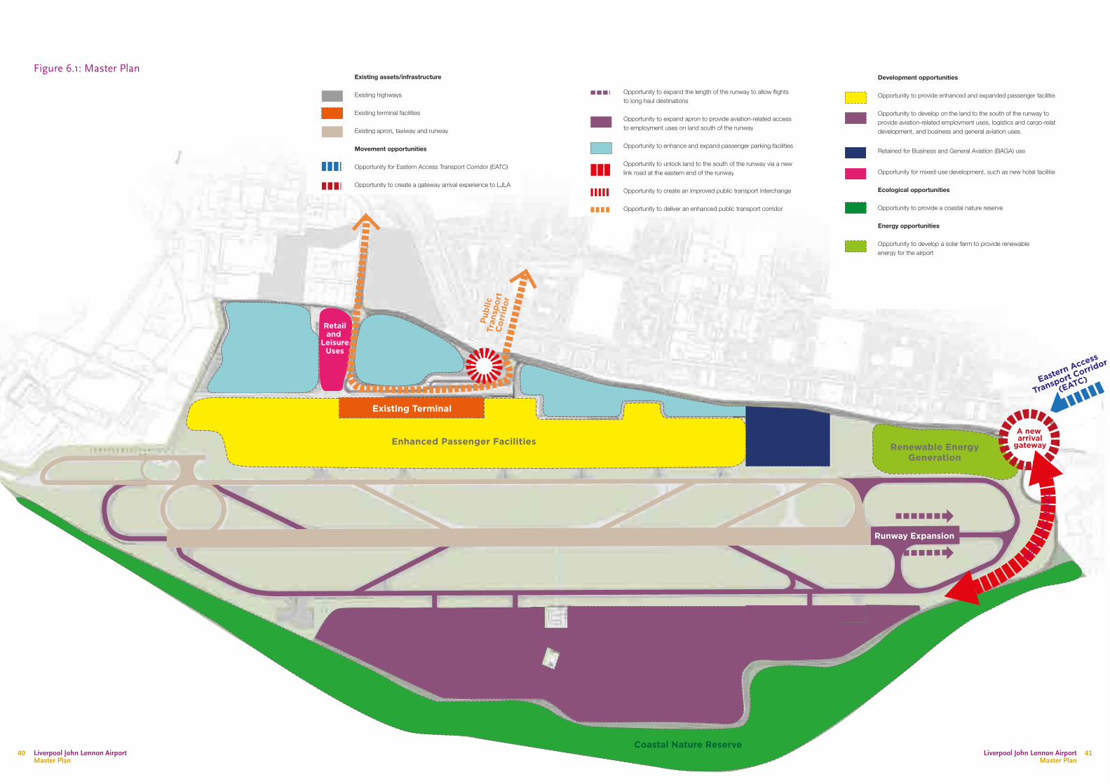
Publ
ic
Tran
spor
tC
orri
dor
Existing assets/infrastructure
Existing highways
Existing terminal facilities
Existing apron, taxiway and runway
Movement opportunities
Opportunity for Eastern Access Transport Corridor (EATC)
Opportunity to create a gateway arrival experience to LJLA
Opportunity to expand the length of the runway to allow flights to long haul destinations
Opportunity to expand apron to provide aviation-related access to employment uses on land south of the runway
Opportunity to enhance and expand passenger parking facilities
Opportunity to unlock land to the south of the runway via a new link road at the eastern end of the runway
Opportunity to create an improved public transport interchange
Opportunity to deliver an enhanced public transport corridor
Development opportunities
Opportunity to provide enhanced and expanded passenger facilities
Opportunity to develop on the land to the south of the runway to provide aviation-related employment uses, logistics and cargo-related development, and business and general aviation uses.
Opportunity for mixed-use development, such as new hotel facilities
Retained for Business and General Aviation (BAGA) use
Ecological opportunities
Opportunity to provide a coastal nature reserve
Energy opportunities
Opportunity to develop a solar farm to provide renewable energy for the airport
KEY
Employment and aviation-related uses
Coastal Nature Reserve
Enhanced Passenger Facilities Renewable EnergyGeneration
Runway Expansion
NEW L
INK
RO
AD
Eastern Access
Transport Corrid
or
(EATC)
A new arrival
gateway
Existing Terminal
Retailand
LeisureUses
Figure 6.1: Master Plan
Liverpool John Lennon Airport Master Plan
Liverpool John Lennon Airport Master Plan
4140
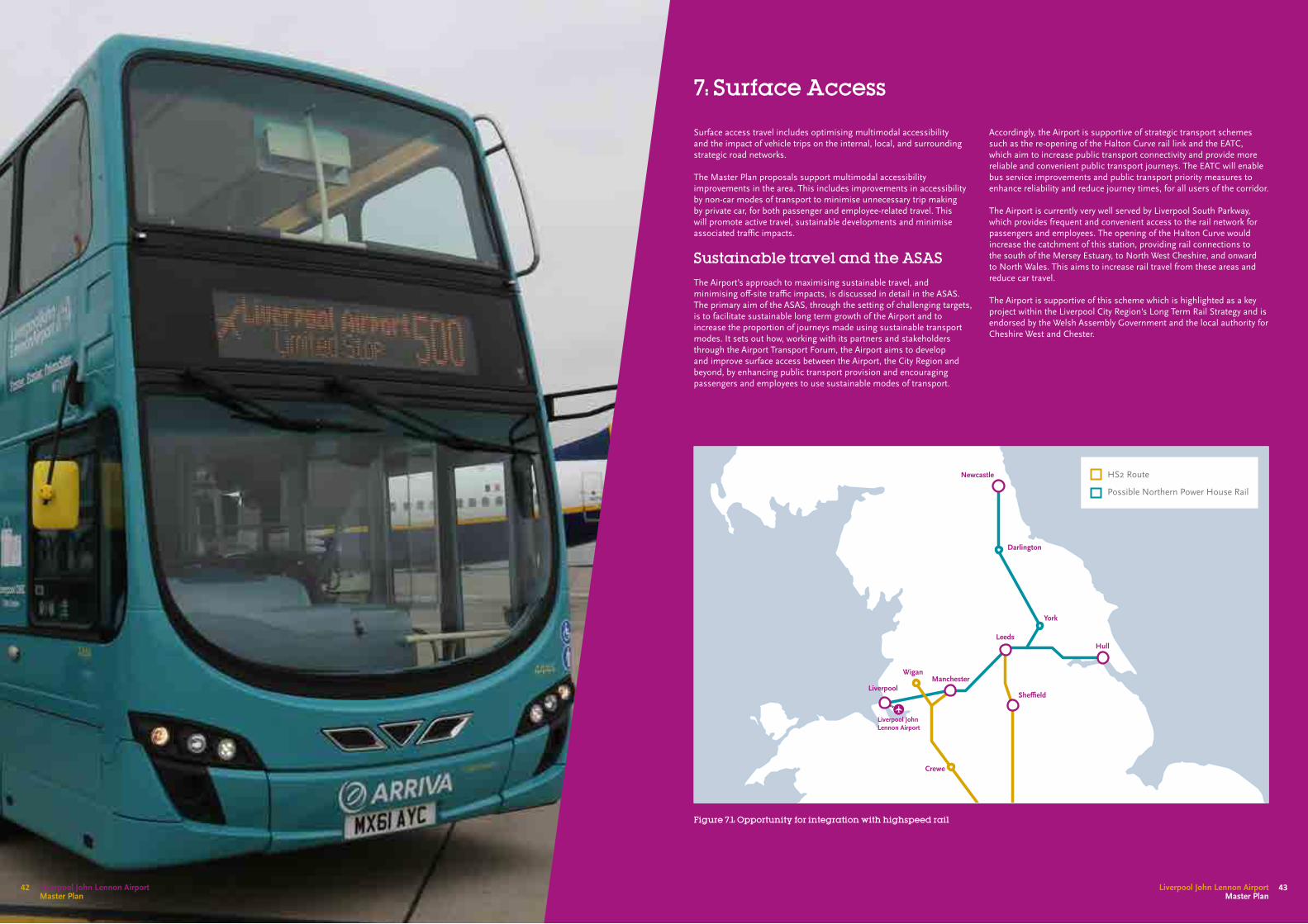
7: Surface Access
Surface access travel includes optimising multimodal accessibility and the impact of vehicle trips on the internal, local, and surrounding strategic road networks.
The Master Plan proposals support multimodal accessibility improvements in the area. This includes improvements in accessibility by non-car modes of transport to minimise unnecessary trip making by private car, for both passenger and employee-related travel. This will promote active travel, sustainable developments and minimise associated traffic impacts.
Sustainable travel and the ASASThe Airport’s approach to maximising sustainable travel, and minimising off-site traffic impacts, is discussed in detail in the ASAS. The primary aim of the ASAS, through the setting of challenging targets, is to facilitate sustainable long term growth of the Airport and to increase the proportion of journeys made using sustainable transport modes. It sets out how, working with its partners and stakeholders through the Airport Transport Forum, the Airport aims to develop and improve surface access between the Airport, the City Region and beyond, by enhancing public transport provision and encouraging passengers and employees to use sustainable modes of transport.
Accordingly, the Airport is supportive of strategic transport schemes such as the re-opening of the Halton Curve rail link and the EATC, which aim to increase public transport connectivity and provide more reliable and convenient public transport journeys. The EATC will enable bus service improvements and public transport priority measures to enhance reliability and reduce journey times, for all users of the corridor.
The Airport is currently very well served by Liverpool South Parkway, which provides frequent and convenient access to the rail network for passengers and employees. The opening of the Halton Curve would increase the catchment of this station, providing rail connections to the south of the Mersey Estuary, to North West Cheshire, and onward to North Wales. This aims to increase rail travel from these areas and reduce car travel.
The Airport is supportive of this scheme which is highlighted as a key project within the Liverpool City Region's Long Term Rail Strategy and is endorsed by the Welsh Assembly Government and the local authority for Cheshire West and Chester.
Figure 7.1: Opportunity for integration with highspeed rail
Liverpool
Crewe
Liverpool John Lennon Airport
WiganManchester
She�eld
Leeds
Darlington
York
Newcastle
Hull
HS2 Route
Possible Northern Power House Rail
Liverpool John Lennon Airport Master Plan
43Liverpool John Lennon Airport Master Plan
42

Northern Powerhouse Rail
Northern Powerhouse Rail (NPR) is a major strategic rail programme to provide faster and more frequent rail connectivity to transform rail connectivity between the key economic centres.
Transport for the North claim that NPR will bring more than 40% of the North’s prime businesses within 90 minutes rail travel of four or more of the North’s largest economic centres, compared with only 12% today.Liverpool South Parkway will play a pivotal role in enhancing rail connectivity in Merseyside as part of NPR. It has the potential to make it easier, cheaper, and faster to travel to LJLA. The Airport therefore strongly supports the delivery of NPR and future investment to enhance the surface transport connections between Liverpool South Parkway and the Airport (see Figure 7.1).
Better connectivity between the Airport and NPR will better integrate the Airport with the pan-Northern strategic rail network. This will extend the Airport’s catchment area, make more routes and services viable, and will ensure LJLA plays a key role in increasing international connectivity across the North.
Highways connectivity The capacity and operation of the surrounding highway network was extensively researched as part of the previous Master Plan process and subsequent planning consents.
The Airport is located within the Liverpool ‘Southern Corridor’, for which Speke Boulevard is the main distributor road. Speke Boulevard is a main route into central Liverpool and is an important corridor for existing, proposed and potential development. These developments cover a wide variety of land uses including; employment, residential, leisure, as well as the Airport and aviation-related business.
The Speke Boulevard corridor has significant latent development potential, which will need to be supported by appropriate highway infrastructure improvements. Localised junction improvements have already been agreed with the local authorities to provide additional medium-term capacity as new developments along the corridor are delivered.
Longer term traffic demands from ‘Southern Corridor’ developments may be supported by the EATC scheme, a new road link connecting to the A561 Speke Boulevard, which is being pursued by the local authorities. The EATC will ‘free up’ road capacity in the Speke Boulevard/Speke Hall Avenue corridors west of the new EATC/A561 junction. This will provide additional traffic capacity and also enable bus service improvements and public transport priority measures to enhance reliability and reduce journey times, for all users of the corridor.
The Airport has developed a preferred route for the EATC (see Appendix 2) and will continue to work in partnership with other parties to support delivery of this or another suitable alternative.
Traffic ImpactsWithin the framework set out above, the Airport will assess the public transport accessibility and traffic impacts of expansion of the Airport as proposals are delivered. The Airport will continue to work with partners to encourage increased use of accessible modes of travel, minimise traffic impact, particularly at highway network peak times and mitigate adverse impacts whenever possible
Parking
Table 7.1: Master Plan Car Parking
The control of parking provision is an important ‘tool’ for managing the Airport's sustainable travel objectives.
The Airport’s parking strategy is linked to the aims and targets set out in the ASAS. The strategy aims to minimise single occupancy car trip making, by staff and employees, and to minimise passenger ‘Pick Up/Drop off’ trips, as these generate two car trips for every airport passenger movement.
The provision of new car parking will be required as the Airport’s passenger throughput increases, however, this new supply will be based on a reducing ratio of car parking spaces to passengers, to reflect the expected increase in travel to the Airport by sustainable modes. Challenging targets for future year sustainable travel, and the mechanisms that seek to achieve these, are set out in the ASAS.
Passenger convenience is an important aspect of LJLA’s attractiveness to passengers. The close proximity of car parks to the terminal is one aspect of this. In order to minimise distances to the terminal and make efficient use of land, the Airport will endeavour, subject to financial viability considerations, to deliver multi-storey parking as close to the terminal as possible.
Table 7.1 sets out the likely car parking requirements during the Master Plan period.
Year Forecast Passengers (mppa)
Car Parking Spaces
2022 6.1 7,733
2030 7.9 9,504
2050 11.2 12,198
Liverpool John Lennon Airport Master Plan
Liverpool John Lennon Airport Master Plan
4544
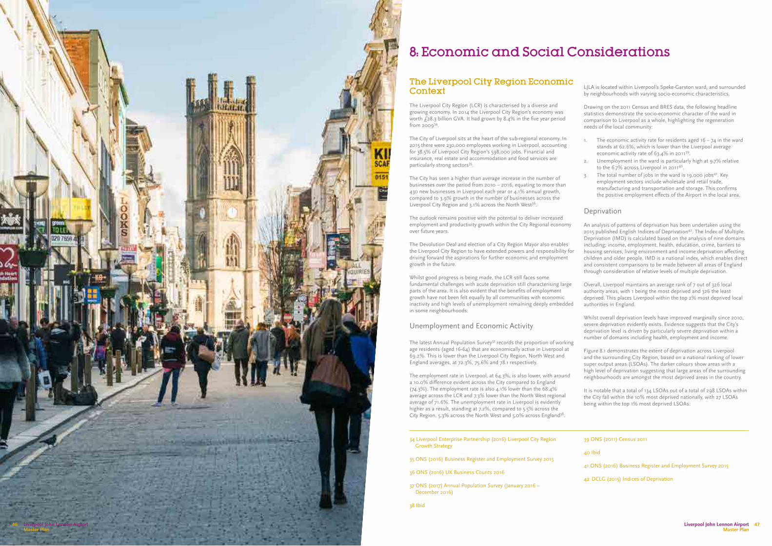
8: Economic and Social Considerations
The Liverpool City Region Economic ContextThe Liverpool City Region (LCR) is characterised by a diverse and growing economy. In 2014 the Liverpool City Region’s economy was worth £28.3 billion GVA. It had grown by 8.4% in the five year period from 200934.
The City of Liverpool sits at the heart of the sub-regional economy. In 2015 there were 230,000 employees working in Liverpool, accounting for 38.5% of Liverpool City Region’s 598,000 jobs. Financial and insurance, real estate and accommodation and food services are particularly strong sectors35.
The City has seen a higher than average increase in the number of businesses over the period from 2010 – 2016, equating to more than 430 new businesses in Liverpool each year or 4.1% annual growth, compared to 3.9% growth in the number of businesses across the Liverpool City Region and 3.1% across the North West36.
The outlook remains positive with the potential to deliver increased employment and productivity growth within the City Regional economy over future years.
The Devolution Deal and election of a City Region Mayor also enables the Liverpool City Region to have extended powers and responsibility for driving forward the aspirations for further economic and employment growth in the future.
Whilst good progress is being made, the LCR still faces some fundamental challenges with acute deprivation still characterising large parts of the area. It is also evident that the benefits of employment growth have not been felt equally by all communities with economic inactivity and high levels of unemployment remaining deeply embedded in some neighbourhoods.
Unemployment and Economic Activity
The latest Annual Population Survey37 records the proportion of working age residents (aged 16-64) that are economically active in Liverpool at 69.2%. This is lower than the Liverpool City Region, North West and England averages, at 72.3%, 75.6% and 78.1 respectively.
The employment rate in Liverpool, at 64.3%, is also lower, with around a 10.0% difference evident across the City compared to England (74.3%). The employment rate is also 4.1% lower than the 68.4% average across the LCR and 7.3% lower than the North West regional average of 71.6%. The unemployment rate in Liverpool is evidently higher as a result, standing at 7.2%, compared to 5.5% across the City Region, 5.3% across the North West and 5.0% across England38.
LJLA is located within Liverpool’s Speke-Garston ward, and surrounded by neighbourhoods with varying socio-economic characteristics.
Drawing on the 2011 Census and BRES data, the following headline statistics demonstrate the socio-economic character of the ward in comparison to Liverpool as a whole, highlighting the regeneration needs of the local community:
1. The economic activity rate for residents aged 16 – 74 in the ward stands at 62.6%, which is lower than the Liverpool average economic activity rate of 63.4% in 201139.
2. Unemployment in the ward is particularly high at 9.7% relative to the 6.7% across Liverpool in 201140.
3. The total number of jobs in the ward is 19,000 jobs41. Key employment sectors include wholesale and retail trade, manufacturing and transportation and storage. This confirms the positive employment effects of the Airport in the local area.
Deprivation
An analysis of patterns of deprivation has been undertaken using the 2015 published English Indices of Deprivation42. The Index of Multiple Deprivation (IMD) is calculated based on the analysis of nine domains including; income, employment, health, education, crime, barriers to housing services, living environment and income deprivation affecting children and older people. IMD is a national index, which enables direct and consistent comparisons to be made between all areas of England through consideration of relative levels of multiple deprivation.
Overall, Liverpool maintains an average rank of 7 out of 326 local authority areas, with 1 being the most deprived and 326 the least deprived. This places Liverpool within the top 2% most deprived local authorities in England.
Whilst overall deprivation levels have improved marginally since 2010, severe deprivation evidently exists. Evidence suggests that the City’s deprivation level is driven by particularly severe deprivation within a number of domains including health, employment and income.
Figure 8.1 demonstrates the extent of deprivation across Liverpool and the surrounding City Region, based on a national ranking of lower super output areas (LSOAs). The darker colours show areas with a high level of deprivation suggesting that large areas of the surrounding neighbourhoods are amongst the most deprived areas in the country.
It is notable that a total of 134 LSOAs out of a total of 298 LSOAs within the City fall within the 10% most deprived nationally, with 27 LSOAs being within the top 1% most deprived LSOAs.
34 Liverpool Enterprise Partnership (2016) Liverpool City Region Growth Strategy
35 ONS (2016) Business Register and Employment Survey 2015
36 ONS (2016) UK Business Counts 2016
37 ONS (2017) Annual Population Survey (January 2016 – December 2016)
38 Ibid
39 ONS (2011) Census 2011
40 Ibid 41 ONS (2016) Business Register and Employment Survey 2015
42 DCLG (2015) Indices of Deprivation
Liverpool John Lennon Airport Master Plan
Liverpool John Lennon Airport Master Plan
4746
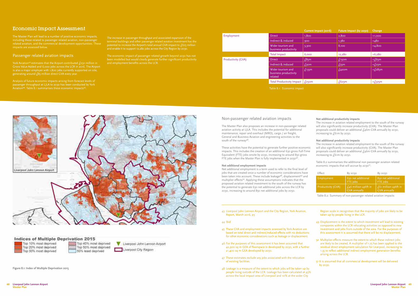
Figure 8.1: Index of Multiple Deprivation 2015
Economic Impact AssessmentThe Master Plan will lead to a number of positive economic impacts, including those related to passenger related aviation, non-passenger related aviation, and the commercial development opportunities. These impacts are assessed below.
Passenger related aviation impacts
York Aviation43 estimates that the Airport contributed £250 million in Gross Value Added and 6,000 jobs across the LCR in 2016. The Airport is also a major employer with 1,800 jobs currently supported on site, generating around £85 million direct GVA every year.
Analysis of future economic impacts arising from forecast levels of passenger throughput at LJLA to 2030 has been conducted by York Aviation44. Table 8.1 summarises these economic impacts45.
The increase in passenger throughput and associated expansion of the terminal buildings and other passenger related aviation investment has the potential to increase the Airport’s total annual GVA impact to £625 million and enable it to support 12,280 jobs across the City Region by 2030.
The economic impact of passenger related growth beyond 2030 has not been modelled but would clearly generate further significant productivity and employment benefits across the LCR.
Non-passenger related aviation impacts
The Master Plan also proposes an increase in non-passenger related aviation activity at LJLA. This includes the potential for additional maintenance, repair and overhaul (MRO), cargo / air freight, General and Business Aviation and engineering activities to the south of the runway46.
These activities have the potential to generate further positive economic impacts. This includes the creation of an additional 630 gross Full-Time Equivalent (FTE) jobs onsite by 2030, increasing to around 850 gross FTE jobs when the Master Plan is fully implemented in 205047.
Net additional employment impactsNet additional employment is a term used to refer to the final level of jobs that are created once a number of economic considerations have been taken into account. These include leakage48, displacement49 and multiplier effects50. Applying these assumptions indicates that the proposed aviation related investment to the south of the runway has the potential to generate 630 net additional jobs across the LCR by 2030, increasing to around 850 net additional jobs by 2050.
Net additional productivity impactsThe increase in aviation related employment to the south of the runway will also significantly increase productivity (GVA). The Master Plan proposals could deliver an additional £46m GVA annually by 2030, increasing to £61m by 2050.
Net additional productivity impactsThe increase in aviation related employment to the south of the runway will also significantly increase productivity (GVA). The Master Plan proposals could deliver an additional £46m GVA annually by 2030, increasing to £61m by 2050.
Table 8.2 summarises the additional non passenger aviation related economic impacts that will accrue by 203051:
43 Liverpool John Lennon Airport and the City Region, York Aviation, Report, March 2016, p3
44 Ibid
45 These GVA and employment impacts assessed by York Aviation are based on total direct and indirect/induced effects with no deductions for other economic considerations such as leakage or displacement.
46 For the purposes of this assessment it has been assumed that 42,900 sq m GEA of floorspace is developed by 2030, with a further 21,400 sq m GEA developed by 2050.
47 These estimates exclude any jobs associated with the relocation
of existing facilities.
48 Leakage is a measure of the extent to which jobs will be taken up by people living outside of the LCR. Leakage has been calculated at 45% across the local impact area of Liverpool and 10% at the wider City
Current impact (2016) Future Impact (by 2030) Change
Employment Direct 1,800 2,800 +1,000
Indirect & induced 900 1,380 +480
Wider tourism and business productivity
3,300 8,100 +4,800
Total Impact 6,000 12,280 +6,280
Productivity (GVA) Direct £85m £150m +£65m
Indirect & induced £30m £55m +£25m
Wider tourism and business productivity related
£135m £420m +£285m
Total Productivity Impact £250m £625m +£375m
Effect By 2030 By 2050
Employment 630 net additional FTE jobs
850 net additional FTE jobs
Productivity (GVA) £46 million uplift in GVA annually
£61 million uplift in GVA annually
Table 8.2: Summary of non-passenger related aviation impacts
Region scale in recognition that the majority of jobs are likely to be taken up by people living in the LCR.
49 Displacement is the extent to which investment will lead to existing companies within the LCR relocating activities as opposed to new investment and jobs from outside of the area. For the purposes of this assessment it is assumed that there will be no displacement.
50 Multiplier effects measure the extent to which these indirect jobs are likely to be created. A multiplier of 1.25 has been applied to the residual direct employment calculation for Liverpool, increasing to 1.35 to reflect additional indirect employment generation benefits arising across the LCR.
51 It is assumed that all commercial development will be delivered by 2030.
Table 8.1: Economic impact
Liverpool John Lennon Airport Master Plan
Liverpool John Lennon Airport Master Plan
4948
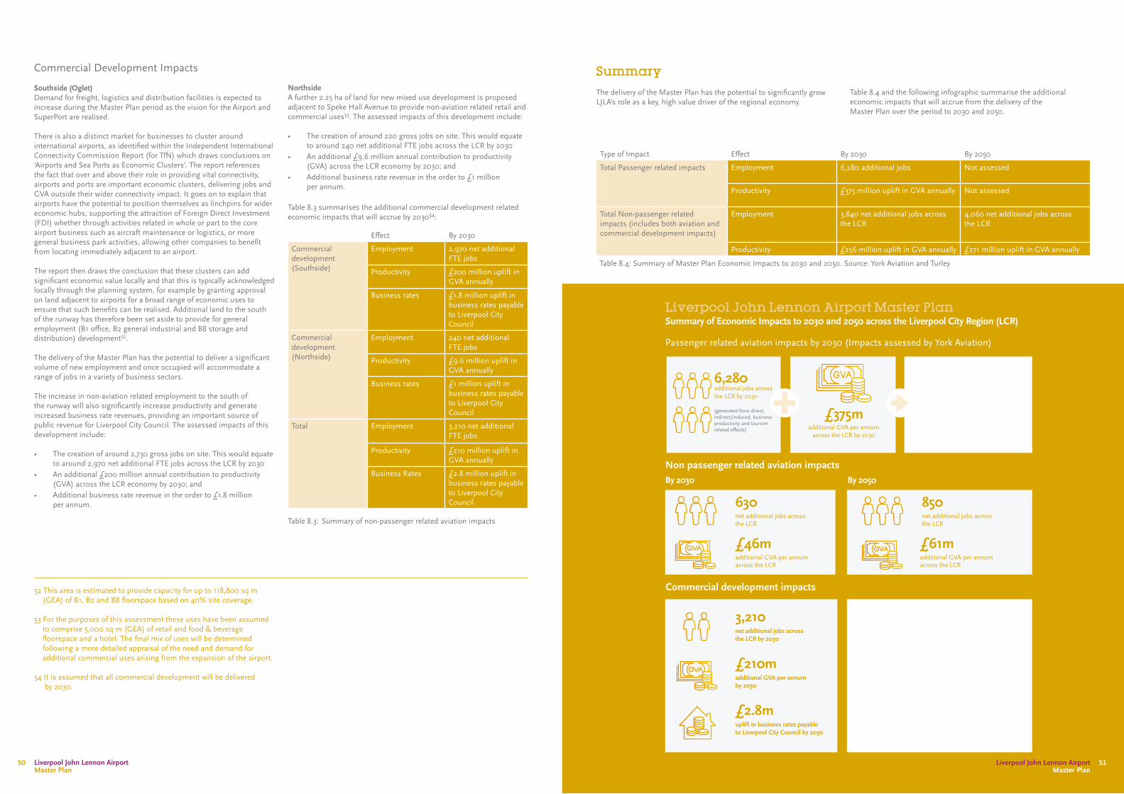
Commercial Development Impacts
Southside (Oglet)Demand for freight, logistics and distribution facilities is expected to increase during the Master Plan period as the vision for the Airport and SuperPort are realised.
There is also a distinct market for businesses to cluster around international airports, as identified within the Independent International Connectivity Commission Report (for TfN) which draws conclusions on ‘Airports and Sea Ports as Economic Clusters’. The report references the fact that over and above their role in providing vital connectivity, airports and ports are important economic clusters, delivering jobs and GVA outside their wider connectivity impact. It goes on to explain that airports have the potential to position themselves as linchpins for wider economic hubs, supporting the attraction of Foreign Direct Investment (FDI) whether through activities related in whole or part to the core airport business such as aircraft maintenance or logistics, or more general business park activities, allowing other companies to benefit from locating immediately adjacent to an airport.
The report then draws the conclusion that these clusters can add significant economic value locally and that this is typically acknowledged locally through the planning system, for example by granting approval on land adjacent to airports for a broad range of economic uses to ensure that such benefits can be realised. Additional land to the south of the runway has therefore been set aside to provide for general employment (B1 office, B2 general industrial and B8 storage and distribution) development52.
The delivery of the Master Plan has the potential to deliver a significant volume of new employment and once occupied will accommodate a range of jobs in a variety of business sectors.
The increase in non-aviation related employment to the south of the runway will also significantly increase productivity and generate increased business rate revenues, providing an important source of public revenue for Liverpool City Council. The assessed impacts of this development include:
• The creation of around 2,730 gross jobs on site. This would equate to around 2,970 net additional FTE jobs across the LCR by 2030
• An additional £200 million annual contribution to productivity (GVA) across the LCR economy by 2030; and
• Additional business rate revenue in the order to £1.8 million per annum.
NorthsideA further 2.25 ha of land for new mixed use development is proposed adjacent to Speke Hall Avenue to provide non-aviation related retail and commercial uses53. The assessed impacts of this development include:
• The creation of around 220 gross jobs on site. This would equate to around 240 net additional FTE jobs across the LCR by 2030
• An additional £9.6 million annual contribution to productivity (GVA) across the LCR economy by 2030; and
• Additional business rate revenue in the order to £1 million per annum.
Table 8.3 summarises the additional commercial development related economic impacts that will accrue by 203054:
SummaryThe delivery of the Master Plan has the potential to significantly grow LJLA’s role as a key, high value driver of the regional economy.
Table 8.4 and the following infographic summarise the additional economic impacts that will accrue from the delivery of the Master Plan over the period to 2030 and 2050.
Effect By 2030
Commercial development (Southside)
Employment 2,970 net additional FTE jobs
Productivity £200 million uplift in GVA annually
Business rates £1.8 million uplift in business rates payable to Liverpool City Council
Commercial development (Northside)
Employment 240 net additional FTE jobs
Productivity £9.6 million uplift in GVA annually
Business rates £1 million uplift in business rates payable to Liverpool City Council
Total Employment 3,210 net additional FTE jobs
Productivity £210 million uplift in GVA annually
Business Rates £2.8 million uplift in business rates payable to Liverpool City Council
Table 8.3: Summary of non-passenger related aviation impacts
52 This area is estimated to provide capacity for up to 118,800 sq m (GEA) of B1, B2 and B8 floorspace based on 40% site coverage.
53 For the purposes of this assessment these uses have been assumed to comprise 5,000 sq m (GEA) of retail and food & beverage floorspace and a hotel. The final mix of uses will be determined following a more detailed appraisal of the need and demand for additional commercial uses arising from the expansion of the airport.
54 It is assumed that all commercial development will be delivered by 2030.
Type of Impact Effect By 2030 By 2050
Total Passenger related impacts Employment
6,280 additional jobs Not assessed
Productivity £375 million uplift in GVA annually Not assessed
Total Non-passenger related impacts (includes both aviation and commercial development impacts)
Employment 3,840 net additional jobs across the LCR
4,060 net additional jobs across the LCR
Productivity £256 million uplift in GVA annually £271 million uplift in GVA annually
Table 8.4: Summary of Master Plan Economic Impacts to 2030 and 2050. Source: York Aviation and Turley
Passenger related aviation impacts by 2030 (Impacts assessed by York Aviation)
Non passenger related aviation impactsBy 2030 By 2050
Liverpool John Lennon Airport Master PlanSummary of Economic Impacts to 2030 and 2050 across the Liverpool City Region (LCR)
6,280 additional jobs across the LCR by 2030
630net additional jobs across the LCR
£46madditional GVA per annum across the LCR
£375madditional GVA per annum
across the LCR by 2030
850net additional jobs across the LCR
£61madditional GVA per annum across the LCR
3,210 net additional jobs across the LCR by 2030
£210m additional GVA per annum by 2030
£2.8m
uplift in business rates payable to Liverpool City Council by 2030
Total economic impact of non-passenger related development by 2050
+4,000 net additional jobs across the LCR
£270madditional GVA across the LCR
Total Airport impact by 2030
12,280 jobs supported across the LCR
£625m GVA per annum generated across the LCR
(generated from direct, indirect/induced, business productivity and tourism related effects)
Commercial development impacts
Liverpool John Lennon Airport Master Plan
51Liverpool John Lennon Airport Master Plan
50

9: Environmental Considerations
IntroductionThis chapter of the Master Plan addresses the likely direct and indirect effects of the planned expansion of LJLA on its local communities and the environment. It is important that this is seen in the context of actions being taken on a wider scale in the UK and Europe to address the effect of air travel on noise, air quality and climate change.
NoiseThis part of the updated Master Plan provides a summary of the noise implications of the development to 2030, with the main attention on noise from airborne aircraft, initial appraisal of aircraft on the ground, and access road traffic. An initial consideration of the noise implications of the development to 2050 is also given.
Noise Considerations in 2030
Future Airborne Aircraft Noise (Daytime)During the last ten years passenger numbers at LJLA have fluctuated, the peak occurred in 2007 when activity of 5.5 million passengers per annum (mppa) occurred. In 2011, passenger numbers were less at 5.2 mppa, currently numbers have slightly reduced to just below 5 mppa. During this period the Airport has continued to operate a range of measures to minimise and mitigate the resulting noise, see LJLA Noise Action Plan55.
The airborne aircraft noise was assessed in 2013 as part of the pan EU noise mapping project. That produced annual noise contours for 2011 (Appendix 6), when the Airport was serving 5.2 mppa. As current activity is very similar, those 2011 contours have been used above to represent current 2016 conditions.
The Master Plan anticipates that activity at the Airport will increase to exceed that in 2011 such that in 2030 activity will reach 7.9 mppa. The general nature of operations at LJLA are forecast to remain similar. Three of the main airlines operating at LJLA, easyJet, Ryanair, and Wizz Air, have placed large orders for quieter aircraft. It is expected that all will acquire the aircraft ordered well before 2030. easyJet received its first Airbus A320neo in June 2017.
On an initial assessment of noise in 2030, the increased number of air transport movements compared to 2011 (i.e. a 23% increase) would on its own normally suggest a 1 dB increase. However, the expected use of re-engined aircraft currently on order (each at least 3 dB quieter) will actually result in noise exposure contours slightly less in extent, (by around 1dB) than those already computed for 2011 and given in the current Noise Action Plan.
The forecast approximate contours for 2030 shown in Appendix 6 are similar in shape to those for 2016, but cover a smaller area. This is not unexpected as although they assume an increased level of activity, there will be significant use of the quieter re-engined aircraft. The noise contour representing high levels of community annoyance in 2030, 69 dB LAeq,16h, is almost completely contained within the proposed expanded LJLA site.
The contour representing moderate levels of community annoyance, 63 dB LAeq,16h, in 2030 extends from Hale to Eastham Sands to the west of LJLA. In doing so, it includes a number of properties, which fall within Hale, Hale Heath or Speke.
The contour representing the onset of low community annoyance, 57 dB LAeq,16h, in 2030 extends to the north bank of the Mersey to the east, and remains limited to the Mersey Estuary to the west, specifically to Eastham Sands and, therefore, does not extend as far as the Wirral peninsular. It includes less than 1,100 properties, all of which are in Hale Heath, Hale, and Speke.
It should be noted that the contours for 2030 contain properties that are already exposed to aircraft noise.
The 57 dB LAeq,16h contours for 2016 and 2030 are compared graphically at Appendix 6. This shows little change. The change in noise is not likely to be perceptible, as a change of 3 dB is normally taken as the minimum perceptible. The area of the noise exposure contour reduces from 2016 to 2030, and so less properties are contained within the noise contour area.
In addition to residential properties, noise can also potentially have effects on hospitals or schools. The closest medical facility (South Liverpool NHS Treatment Centre) is in Garston over 3.28 km (2 miles) to the north west. Due to this separation and the routes used by the aircraft it is well outside the contours produced for 2016 and 2030. The predicted level in 2030 with the Master Plan proposals is much less than 57 dB LAeq,16h at this location. The Government only expects airport operators to offer acoustic insulation to hospitals and schools exposed to medium to high levels of noise (63 dB LAeq,16h or more). The noise levels with the Master Plan proposals are far below this level such that no significant impact is expected for hospitals.
The closest schools are in Speke to the north and Hale to the east. The schools in Speke are well outside the contours produced for 2016 and remain so in 2030 with predicted levels with the Master Plan proposals less than 57dB LAeq,16h. No significant impact is therefore expected for the schools in Speke.
The school in Hale under the final approach to runway 27 is within the 57 dB LAeq,16h contour produced for 2030, but is outside the corresponding 63 dB LAeq,16h contour. One of the Airport’s Noise Monitoring Terminals (NMTs) is permanently fixed to the school building and the Airport will continue to monitor noise levels and offer the school suitable acoustic insulation, if appropriate.
In essence, the development proposed in the Master Plan would cause noise levels comparable with those currently occurring. This assumes that the thresholds of the runway are retained. The development would not cause perceptible increases in overall noise assuming the effect from future improving aircraft technology, and would lead to a small decrease in the population exposed to 57 dB LAeq,16h. No significant impact is predicted on either local schools or hospitals with the exception of the school in Hale for which mitigation measures would be developed and implemented, if found necessary as a result of the on-going pro-active monitoring.
55 ps://www.liverpoolairport.com/about-lLJLA/aircraft-noise/
52 Liverpool John Lennon Airport Master Plan
Liverpool John Lennon Airport Master Plan
52 53
Future Airborne Aircraft Noise (Night time)The Airport operates over a 24 hour period with passenger and cargo services. Night noise regulation is a current feature of the Airport's Quiet Operations Policy and this is described in the Annual Noise Report. The key features controlling night noise are the quota count system (QCS) with corresponding noise budget, and the ban on operation of the noisiest aircraft at night.
In the night period, 23.30-06.00, annual aircraft movements have reduced, e.g. 19,555 in 2002, 4,696 in 2005, 1,887 in 2011, and recently only 1,445 in 2016.
The activity at night is constrained as at a few other major UK airports by a noise budget expressed as the summation of the quota count for each aircraft movement at night. The Airport is constrained by an agreed noise budget set originally in 2002. Since this budget was set, due to the reduction in freight activity, and in particular reduced usage of certain older cargo aircraft types, the quota count usage has been comfortably within the limit. The expected growth in night-time activity will be carefully monitored. It is not expected that the quota count usage will exceed the agreed noise budget.
In a similar manner to daytime noise assessment, night-time aircraft noise has been evaluated using noise contours:
• Noise contours for 2016 have been prepared for LJLA by interpolation from the noise contours given in the Noise Action Plan using the same rationale as given earlier for daytime noise.
• Contours for 2030 are expected to have a similar shape to those for 2016 and cover a slightly smaller area. When details of future night activity become available new contours can be produced. This contours would be included as part of any future planning application.
In comparison with other airports with regular activity at night the populations exposed to 54 dB LAeq,8h are lower at LJLA. LJLA has the significant physical advantage that departures on runway 27 and arrivals on runway 09 pass over the unpopulated estuary.
Access Traffic NoiseBy 2030 passenger throughput is forecast to increase to 7.9 mppa from 4.8 mppa in 2016. On the assumption that the modes these passengers use to reach LJLA remain unchanged, such an increase in throughput would equate to an increase of 2.2 dB(A) in access traffic noise. The overall increase in noise from the roads is likely to be less than this as the non-airport access traffic using them is not expected to increase by the same amount. Depending on the proportion of LJLA related traffic on the roads, the overall increase in noise may be just perceptible at those properties sufficiently close. Therefore, a marginal impact is a possibility. In the longer term most of the access traffic to LJLA would use the new access road, the EATC, for which various route options have been considered and LJLA has put forward its preferred route. All options link Hale Road, which runs along the northern boundary of LJLA, and is to be improved, with the A561. The junction of the new access road with Hale Road would be in the form of a roundabout near the south east comer of Speke Estate.
Although an overall increase in traffic noise is predicted due to the additional traffic, the introduction of the EATC means that for some existing roads a reduction in noise is possible. This is particularly the case for the roads to the west of Speke which are currently used by the large majority of traffic to LLJLA. Under this Master Plan, much of the future traffic would not use these roads, and, therefore, although there would be more traffic overall, the numbers of vehicles using these roads may actually decrease.
Conversely the construction of the EATC, and the consequential improved road along the northern boundary of the airport, is expected to lead to an increase in noise levels for sensitive receptors along the southern edge of Speke due to their proximity, in particular to the southern end of the EATC. These would be assessed prior to any future developments and mitigation measures introduced where appropriate.
The current use of Speke Hall Avenue as the main route to the airport from the A561 Speke Boulevard will continue until the EATC is implemented. The future airport access traffic will therefore pass as now along Speke Hall Avenue which generally abuts non-noise sensitive buildings, with a small number of residential dwellings near Speke Church Road. There are also proposals for more residential units near Speke Hall Avenue. Current traffic flows, typically 14,000 vehicles per day, will cause significant traffic noise, which will increase by a small amount, 2 dB or so, in the future. This will not cause much greater noise than now, and so will not significantly worsen conditions for existing occupants of noise sensitive properties near the road. The proposed new housing can be designed easily to deal with the higher forecast traffic.
The Master Plan drawings give a broad picture of the possible scale and location of future land uses. At this stage only general points with respect to noise can be identified. More detailed assessments will follow as specific proposals come forward. In the period to 2030 there will be phased extensions of the terminal, and mixed use commercial development adjacent to Speke Hall Avenue. These will increase the acoustic shielding of airport activities from the large residential Speke Estate. The developments on the Oglet will locate some possibly noisy operations to more distant locations than they occur at now. The proposed structural landscaping around site boundaries can also reduce noise in local areas. The proposed extension of the runway and laying out of new Runway End safety areas will be designed to minimize
Liverpool John Lennon Airport Master Plan
55Liverpool John Lennon Airport Master Plan
54

noise increases locally in Hale.
Ground OperationsThe main sources of airport ground noise include taxiing aircraft, aircraft auxiliary power units, testing (ground running) of aircraft engines, mobile ground equipment such as Ground Power Units, and construction.
Airport ground noise is heard in the context of off-airport noise sources, termed background noise. The most dominant contributor to the noise climate in the residential areas is road traffic. Airport ground noise will be audible for locations close to the airport boundary. Taxiing is by far the most significant airport ground noise source. The rare occurrence of engine testing at high power settings after an aircraft has had significant maintenance can generate higher noise levels than taxiing, but it is of limited duration and frequency.
The Airport has developed and implemented measures to ensure that ground operations are carried out as quietly as practicable to minimise impact and these include:
• Encouraging the minimum use of reverse thrust by aircraft on landing consistent with safety constraints, particularly between 23.00 and 06.00
• Except in emergencies, engine testing shall be restricted to areas designated for that purpose
• Except in emergencies, restrictions are imposed on the ground running of engines between 23.00 and 07.00; and
• Investigating measures to reduce use of ground power units on the frequently used stands. (e.g. the phased installation of Fixed Electrical Ground Power focusing on the frequently used stands first).
The growth of activity at LJLA will produce greater ground noise by 2030. In 2016, the total air transport movements at LJLA were 38,286. By 2030 this number is projected to increase to 56,900. On the assumption that the mix of aircraft remains constant, such an increase in throughput would equate to an increase of 1.7 dB(A) in ground noise, however the variants of the key aircraft in use in 2030 will be quieter such that any increase will be less. Any increase in noise is therefore likely to be barely perceptible at those properties along the southern edge of Speke, especially when the possible effect of new building screening is taken into consideration.
The proposed development also includes an extension to the runway at the eastern end, and the introduction of starter strips (sections of pavement at the ends of runways used by departing aircraft only) at both ends. These changes necessitate extensions to the parallel taxiway at both ends to provide access to the ends of the extended runway. In addition, new aprons are proposed. The effect of the development could lead to increased noise levels at the closest receptors to these changes. However there are few properties close to the area where the western starter strip would be located and the current perception is that most activity will take place as now, with the extension at the eastern end only used for the small amount of long haul and large freighter traffic.
During the construction phase of the proposed development it is expected that any potential noise impact would be mitigated primarily by the significant separation distance between the sites and the nearest noise sensitive properties and the possible introduction of operational controls in the form of a Construction Management Plan that addresses matters such as hours of work and piling methods.
In essence, although no significant increase is predicted in ground noise as a result of the Master Plan proposals, if any does arise in 2030 suitable measures will be introduced during the development to mitigate any impact.
Noise Considerations in 2050
It is envisaged that the passenger traffic at LJLA will increase from 7.9 to 11.2 mppa between 2030 and 2050. The cargo traffic is expected to increase to around 40,000 tonnes per annum. The noise implications of the Master Plan proposals to 2050 concentrate on the much more significant passenger traffic which will determine the general level of future noise.
With reference to air noise, typical passenger aircraft size in 2050 is expected to be broadly similar to that in 2030. The extensive EU / USA research to reduce aircraft noise by 10 dB, and the obvious pressure on aircraft manufacturers to do likewise now, is expected to lead to a reduction in noise from the typical passenger aircraft. Due to the general practice of using converted passenger aircraft to carry cargo, no reduction in their individual noise levels is expected. In practice, as the cargo fleet in the future may include some larger aircraft than at present, the noise from some individual cargo aircraft may increase. The forecast amount of pure freighter activity is modest, much less than previously envisaged in the earlier Master Plan.
In overall terms; i.e. expressed using the LAeq,T index usually adopted for contours, no significant increase in the extent of the contours is foreseen in light of the expected reduction in the noise from individual passenger aircraft. That applies to both daytime and night time.
As a consequence of the increased aircraft movements ground noise would also be affected. Ground noise associated with passenger aircraft is likely to arise from similar locations to those which are applicable in 2030, but with the increased movements, an overall small increase might arise. This, however, assumes no reduction in noise from individual aircraft types which could reduce any increase. Although the creation of an enlarged cargo centre to the south of the runway would create a new source of ground noise, this would be generally distant from residential properties. Therefore the combined ground noise will increase by less than 2 dB.
Road traffic levels would also be affected by the increases in passenger and cargo movements. Taking the passenger traffic, the overall effect on the local road network would be an increase just less than 2 dB, assuming no increase in the use of public transport (contrary to the ASAS), and no reduction in the noise from individual road vehicles. Road traffic to the cargo centre would use a new road to reach the EATC and from there link to the national road network. As such, the traffic associated with the cargo centre would be generally kept away from residential properties.
Conclusion
The proposals in this Master Plan would cause noise levels comparable with those occurring today. No significant impact is predicted on either local schools or hospitals with the exception of the primary school in Hale for which mitigation measures would be developed and implemented, if found necessary following detailed assessment.
No significant increase can be expected in ground noise from the Master Plan proposals, although if any did arise suitable measures would be introduced to reduce any impact.
An overall increase can be expected in road traffic noise by 2050, but the change should be small and assisted by the take-up of electric vehicles. For the existing access route to LJLA, if the EATC is delivered, traffic flows and the consequential levels of noise may reduce, but even without the EATC, the level of increase in noise is likely to be small. The EATC would be generally located well away from existing residential properties. Due to their proximity to the southern end of the EATC, and the improved road along the northern boundary, sensitive receptors along the southern edge of Speke would be expected to be exposed to increased noise levels. These would be assessed prior to any future developments and mitigation measures introduced where appropriate.
Liverpool John Lennon Airport Master Plan
57Liverpool John Lennon Airport Master Plan
56

Air QualityA variety of sources within and around an airport can affect local air quality. These include airside vehicles, and airborne and ground level aircraft activity, as well as vehicles travelling to and from the Airport.
Existing Baseline Air Quality
Liverpool City Council has investigated air quality in its area as part of its responsibilities under the local air quality management regime. In 2009, the Council declared an Air Quality Management Area (AQMA) covering the whole City of Liverpool for exceedances of the annual mean nitrogen dioxide objective, and the Airport lies within this area.
Nitrogen dioxide concentrations have been measured on a monthly basis by the Airport in partnership with Liverpool City Council, at nine sites near to LJLA, using diffusion tubes. In addition, nitrogen dioxide and PM10 concentrations are measured using an automatic monitor at a background location in Speke. Monitoring results for 2016 indicate that pollutant concentrations are below the air quality objectives across the study area, including at roadside locations.
New vehicles registered in the UK have had to meet progressively tighter European type approval emissions categories, referred to as "Euro" standards. While previous standards had limited on-road success, the ‘Euro VI’ and ‘Euro 6’ standards that new vehicles have had to comply with from 2013/16 are delivering real on-road improvements. Nitrogen dioxide and PM10 concentrations from road traffic are therefore expected to reduce in future years due to improved vehicle emission abatement technologies, as well as increased uptake of low emission and electric vehicles.
Emissions from aircraft engines are regulated by the Committee on Aviation Environmental Protection (CAEP). Much of the international focus has been on reducing emissions of NOx; the NOx limits are referred to by the CAEP meeting number at which they were agreed (e.g. CAEP/2, CAEP/4, CAEP/6 and CAEP/8). From 2013, all in-production engines have been required to comply with the CAEP/6 standard. In addition, CAEP has developed medium and long-term NOx emission technology goals which are intended to deliver a 45% reduction of CAEP/6 by 2016 and a 60% reduction of CAEP/6 by 2026. In the short term it is expected that the aircraft fleet mix will be broadly similar to the existing situation. Nevertheless, by 2030, it is expected that new aircraft will be introduced with new technology that reduces emissions.
Estimated future background nitrogen dioxide concentrations in 2030, taken from Department of Environment, Food and Rural Affairs’ background maps, are predicted to be around 13 µg/m3 in the vicinity of the Airport. These are based on nationally predicted trends, with concentrations steadily reducing. Estimates of concentrations in 2050 are more uncertain, although it is reasonable to assume that they are likely to be similar to, or below, 2030 levels.
The DEFRA national maps of roadside annual mean nitrogen dioxide concentrations, used to report exceedences of the limit value to the EU, identify exceedences of the limit value in 2015 along the A561, approximately 1 km north of the Airport. The mapping for 2030, which takes account of the measures contained in DEFRA’s 2015 Air Quality Plan, does not identify any exceedences within 1 km of the airport. It is reasonable to assume that the limit value will not be exceeded in 2050 either.
Air Quality Impact in 2030
The 2030 proposals involve the expansion of existing terminal facilities and extension of the runway, as well as a new fire station and cargo handling facilities, along with commercial development and additional car-parking.
By 2030, passenger numbers are expected to have increased by 68% compared to 2016 levels, and road traffic and aircraft movements are expected to increase accordingly. However, due to the expected reduction in background concentrations combined with improvements in vehicle and aircraft emissions technologies, this increase is not expected to have a significant adverse impact on air quality.
Air Quality Impact in 2050
The 2050 proposals involve further expansion of the terminal building, expansion and relocation of the fuel farm, and a new cargo unit and hangar space, as well as increased car parking provision and completion of the Speke Garston Coastal Reserve.
By 2050, passenger numbers are expected to have increased by 138% compared to 2016 levels, and road traffic and aircraft movements are expected to increase accordingly. However, due to the expected reduction in background concentrations combined with improvements in vehicle and aircraft emissions technologies, this increase is not expected to have a significant adverse impact on air quality.
Summary of Air Quality Considerations
Monitoring of nitrogen dioxide and PM10 concentrations carried out by Liverpool City Council at locations near to LJLA has confirmed that the UK objectives are expected to be achieved near to LJLA under existing conditions. The anticipated growth in air and ground traffic, as a result of the proposals in the Master Plan, may lead to an increase in concentrations of nitrogen dioxide and PM10 at locations near to these sources. However, the increase in air and ground movements would be offset by improvements in vehicle and aircraft technologies that reduce the emissions per movement. It is unlikely that the proposals would lead to exceedences of the objectives in future years.
Liverpool John Lennon Airport Master Plan
59Liverpool John Lennon Airport Master Plan
58

Ecology and Biodiversity
Existing conditions
At its western end, LJLA lies immediately adjacent to the Mersey Estuary. The approach lighting gantry at the western end of the runway extends into the Estuary. Part of the Estuary is designated as a Site of Special Scientific Interest (SSSI) under the Wildlife and Countryside Act 1981, a Special Protection Area (SPA) under the Birds Directive (79/409/EEC) and a Site of International Importance, especially for waterfowl, under the Ramsar Convention. The Estuary has large areas of saltmarsh, extensive intertidal sand and mud-flats, and limited areas of brackish marsh, rocky shoreline and boulder clay cliffs. The intertidal flats and saltmarshes provide feeding and roosting sites for large numbers of waterbirds. The site is of importance for wintering wildfowl and waders and has also historically been important during the spring and autumn migration periods, particularly for wader populations moving along the west coast of Britain.
Adjacent habitats to the west and north-west comprise the Speke Garston Coastal Reserve, with grassland managed for wintering waders and breeding farmland birds, and the Speke Hall estate. Habitats here include grassland, mature trees, plantation, scrub and open water, together with Stockton’s Wood, which is important for invertebrates, birds and bats. Habitats to the north are largely urban, while to the north-east, the proposed EATC would pass through mainly arable farmland, and close to Mill Wood and Hopyard Wood, both locally important sites for biodiversity.
Between LJLA and the Estuary lies the Oglet farmland, currently mainly arable, but comprising a diverse mosaic of different crops, field ponds of different sizes and depths, hedges, scrub and tree belts (the cloughs), together with farm buildings, cottages and gardens. Much of the cliff between the farmland and foreshore is more or less densely vegetated by rough grassland, gorse, thorn scrub and patches of reeds, but with open areas caused by slumping. At the foot of the cliffs areas of raised saltmarsh provide an important roost and feeding area for wading birds at high water.
Extensive surveys were carried out to inform the preparation of the 2007 Master Plan. These covered all the areas to be developed under the Master Plan, identified existing ecological information, identified and mapped plant communities, examined hedgerows, and assessed the value of all the habitats, and their potential for use by protected species.
Field surveys confirmed that no great crested newts, reptiles, or signs of use by either badgers or water voles were present at that time. Surveys of the buildings were carried out to identify bat roosts, and transect surveys were carried out to identify important bat foraging areas. Breeding bird surveys identified the presence of a number of species now identified as of Principal Importance for Biodiversity, as defined by Section 41 of the NERC Act 2006, and/or of local importance. High and low water surveys for waterfowl and waders, covering the same areas together with the adjacent Mersey shore have been carried out for six consecutive winters since 2005/06.
All of this information was used to determine whether and how the important species, communities and habitats identified would be affected by the development. Where potential impacts were identified, means were considered to determine whether and how such impacts could be avoided, and if not, whether and how they could be reduced, mitigated or compensated for. With the benefit of six full winters of surveys, particular importance was placed on ensuring that there would be no adverse effect on the integrity of the internationally important Mersey Estuary SPA/Ramsar Site.
Impacts of Master Plan proposals
Previous ecological surveys confirm that all areas to the north of LJLA likely to be affected by the Master Plan proposals have a low value for biodiversity; the species using these areas are largely typical of the surrounding urban environments. These surveys will need to be updated to ensure the conclusions remain appropriate when proposals within this Master Plan are brought forward.
The proposed development to the south of the runway would result in the loss of a significant part of the Oglet. Previous investigations indicate that the ecological importance of the land is local only. It is relatively intensively farmed, and previous surveys have shown no nationally rare or scarce plant species, communities or habitats and no statutorily protected species within the farmland, although bats have been known to use buildings at Yew Tree Farm. In terms of local biodiversity, however, the mosaic of open land is likely to provide an area of high value for farmland birds. This includes a number of species, such as skylark, linnet and reed bunting. These species include a number for which national and local Biodiversity Action Plans have been prepared.
Proposals within the Oglet area include a 50ha (124 acres) coastal nature reserve, retaining Yew Tree Farm as a potential Visitor Centre, and including creation and management of habitats to maintain and improve the Estuary’s ecological and ornithological value.
For example, the possibility of enhancing the remaining farmland in this area for biodiversity could include, where most suitable, creating a pattern of smaller fields with wider and more species-rich hedges. Close to the Estuary, the possibility of providing new grassland for nesting lapwings and feeding curlew could also be considered. This enhancement and enrichment would provide potential for compensation for the loss of habitat within the Oglet.
Whilst the densely vegetated cliff along the shore of the Estuary is of significant value, it is not expected to be significantly affected by the development south of the runway. Nevertheless, the cliff would be managed to retain its high value within the new stretch of Coastal Reserve. The management plan for the coastal nature reserve, would ensure that increased numbers of visitors are properly controlled to minimise the potential for disturbance to feeding shorebirds.
Aircraft currently take off or land over the adjacent mudflats. Since previous surveys have shown that these flats are used by a proportion of the passing and wintering waterfowl for which the Estuary is of international importance, there is a potential for an increase in such traffic to impact on the integrity of the SPA/Ramsar site. For the same reason there is potential for a concomitant increase in the risk of collision between birds and aircraft. Potential disturbance effects on both feeding and roosting waterfowl under the flight path were, therefore, investigated as part of regular wintering bird studies. It was observed and noted that the birds were not disturbed by aircraft flying overhead. Further such surveys will need to be undertaken to ensure a full and accurate baseline to assess the potential impacts of the Master Plan proposals and the scope for mitigation and compensation measures to be delivered.
Liverpool John Lennon Airport Master Plan
61Liverpool John Lennon Airport Master Plan
60

Sporadic disturbance of roosting waterfowl by aircraft has been observed at the eastern (Hale) end of the survey area. Most waterfowl movements recorded were, again, of flocks travelling along the shoreline at all tide states, but occasional inshore movement has also been observed. This primarily consists of individuals, and small flocks of curlews which have been observed feeding on the farmland between Hale Heath and Rabbit Hey at all tide states, but more abundantly during the high tide periods. Curlew is not a qualifying species for the SPA/Ramsar site, other than as part of the total assemblage, and at most, tens of birds have been recorded feeding in this area. Further detailed assessment to assess any impacts will be undertaken as the Master Plan proposals come forward.
There is a specific process for assessing the impact on species and habitats known as Habitats Regulation Assessment which derives from the European Habitats Directive56. It applies to plans or projects affecting Natura 2000 sites which are special protection areas, special areas of conservation and Ramsar sites. This directive and its associated regulations require that a Habitats Regulation Assessment (HRA) be completed for any plan or project likely to have a significant effect on these sites either individually or in combination with other plans or projects.
The statutory planning process as embodied by the emerging Liverpool Local Plan will address the Master Plan proposals and ensure that these are considered in light of the requirements of the Habitats Directive. Realising these requirements is an iterative process involving a number of stages and the Airport is in dialogue with the City Council, Natural England and other stakeholders on fulfilling the requirements of the Directive during the Local Plan and subsequent planning application processes.
Flood RiskThe southern boundary of LJLA is adjacent to the River Mersey but is several metres above the highest flood level. LJLA is within Flood Zone 1. Flood Zone 1 is the zone of lowest flood risk and presents no constraint to the principle of development.
LJLA falls outside the extent of an extreme flood, at the time of The Environment Agency’s assessment of the likelihood of flooding. Generally this means that the chance of flooding each year from rivers or the sea is 0.1% (1 in 1000) or less.
Given the proximity of LJLA to the River Mersey any predicted changes in sea levels and the potential requirement for flood defence measures will be considered at the detailed planning stage This will include consideration of the Environment Agency’s guidance on Climate Change Allowance (published February 2016) and guidance on calculating Residual Uncertainty Allowance (2017).
A site specific Flood Risk Assessment (FRA) will be required at the detailed design stage in order to demonstrate that the proposed works will be safe from flooding for the lifetime of the development and that the expansion of LJLA and associated infrastructure will not increase the risk of flooding elsewhere
Heritage The landscape of the Master Plan area retains historic elements and sites despite erosion from 20th century development and landscape alterations. To the east and southeast are the conservation areas of Hale Bank, Hale Road and Hale Village which encompass a number of Grade II and Grade II* listed buildings. Several scheduled monuments lie on the periphery of the Master Plan area.
Adjacent to the west side of LJLA is Speke Hall, gardens and estate. Speke Hall is Grade I listed, set within an historic park and garden (the park and garden is now de-listed). The present Hall dates from the 15th and 16th century and has a number of associated listed farm buildings and a scheduled medieval moated site within its estate. LJLA and the present hall and gardens have been associated since the 1930s, with expansion of the airport in the 1960s surrounding the hall.
The landscape has been broadly divided into two historic character areas. The first encompasses Speke Hall, LJLA, Speke Village and the Speke Estate. Extensive 20th century development in this area means that only Speke Hall and its garden remain to reflect historic land use. The second takes in the areas of Oglet and Dungeon. Here the amalgamation of fields for modern agriculture has removed the greater part of the historic field systems, leaving only isolated roads, a stream and Oglet and Yew Tree Farm.
There is some archaeological evidence for prehistoric and Roman activity within Oglet and finds hint at the potential for a medieval settlement straddling Oglet Lane. A medieval land boundary known as the ‘Ditch of Spek’ may once have surrounded Oglet, and Dungeon Lane may partly follow its alignment.
The development of LJLA will take an approach in line with planning policy and heritage guidance. In consultation with the archaeologist for LCC, field evaluation will be used to identify the character of any buried archaeological remains encountered. Where impacts to heritage assets cannot be avoided by or preserved within the Master Plan, mitigation will be undertaken. At Oglet Farm (a building of local historic significance), demolition will be preceded by a programme of historic building recording. Minor impacts to the setting of some historic buildings at Speke Hall, Lennox Farm, Haughton Towers, Ramsbrook Farm and Hale Village Conservation Area may occur and measures to reduce these through landscape screening will be introduced where appropriate.
The historic landscape pattern would be enhanced by planting new hedgerows to tie in with existing historic field boundaries. Historic tracks would be diverted. The proposed coastal nature reserve and the retention of Yew Tree Farm and the Mersey Coastal Path would retain some elements of the historic landscape of Oglet, and a potential for a visitor centre at Yew Tree Farm could provide a focal point for presenting the landscape’s heritage.
LandscapeLJLA is located within National Character Area NE492: NCA Profile: 60 Mersey Valley, on the north bank of the Mersey Estuary. The main Liverpool conurbation forms a patchwork of developed and undeveloped land on the north bank of the Estuary around LJLA, typical of urban edge locations, with a wooded ridge to the north west running through it, framing lower land adjacent to the Estuary. On the south bank of the Estuary, within a more industrialised but similarly mixed landscape, land rises from oil refineries at Stanlow in the south to the chemical works at Runcorn in the east.
The A561/Speke Boulevard is the primary approach road to LJLA and forms the northern boundary to Speke Estate, a residential area which abuts LJLA to the north. Large scale industry lies beyond the approach road to the north. To the east, Hale Village retains an attractive rural character within agricultural land. To the south, the Oglet comprises agricultural land on a plateau adjacent to the Estuary. To the west the National Trust owned Speke Hall, its grounds and agricultural estate adjoin LJLA. A planted mound screens this area from the adjacent airfield. Woods within the Estate provide a visual and physical buffer to the surrounding areas.
The Mersey Way footpath runs alongside the Estuary from Garston through the Speke Garston Coastal Reserve, to the south of the Liverpool International Business Park and broadly continues along the River Mersey eastwards. The Trans-Pennine Trail long distance coast to coast footpath and cycle route passes close to the eastern end of the runway.
Effects of the Master Plan Proposals at 2030
Existing views of the buildings and structures associated with LJLA are available from many locations in the vicinity. Visual sensitivity from the north of LJLA is low due to the low visual quality in this area. Existing boundary mounding and fencing would be upgraded with increased planting alongside Hale Road. These would mitigate the adverse visual effect of proposed parking adjacent to the road corridor. The proposed layout, massing, scale and roofscape of buildings within LJLA would maintain the visual qualities of existing buildings and is unlikely to significantly affect their visual effect from the north.
To the east, Hale Village is an attractive residential area. The proposed extension to the eastern edge of the runway will include localised screening and structural landscaping, mitigating views from Hale. Landscape features lost due to the proposed EATC would be replaced by new landscape components.
To the south, the agricultural character of the Oglet would be changed due to the introduction of new buildings associated with the proposed development to the south of the runway. Careful consideration during detailed design would ensure that where possible, important landscape features are retained. No significant impacts are envisaged on the shore and the adjacent cliffs. Key residual impacts would be addressed by the proposed creation of a coastal nature reserve to the south of LJLA and would be minimised through extensive mitigation planting and earth works to screen and enclose development to the southern boundary, safeguarding the visual amenity of the Mersey Way coastal path.
To the west, the Speke Hall Estate has high visual sensitivity but due to existing mounding and planting views are largely screened to and from LJLA. The potential for changes to views from within the Estate have been carefully assessed, and potential visual or landscape issues would be appropriately mitigated by additional structural landscape proposals and bunding. The impact of any new structural landscape mitigation planting will carefully consider visual impacts on the Estate, in particular the flora and fauna of Stockton’s Wood.
Land associated with the proposed coastal nature reserve would be enhanced to screen impacts of the proposed development as development on the Oglet would introduce built forms which would require mitigative measures to decrease their visual effect. A long term habitat creation and landscape management scheme would promote habitat and biodiversity, including screening opportunities to be in place prior to finalising the 2050 Master Plan proposals. A new Viewing Area and Visitor Centre to the east of the Oglet development would compensate for the loss of the existing informal spotting area on Dungeon Lane. The extensive enhancements to the coastal nature reserve and new landscape mitigation proposals implemented as part of the EATC would safeguard and preserve the amenity of the Mersey Way coastal path and Trans Pennine Trail.
Effects of the Master Plan Proposals at 2050
The proposed terminal piers would reflect the visual appearance of existing buildings and is unlikely to significantly affect visual amenity from the north. From the east, mature mitigation planting will obscure views of the proposed development from Hale, maintaining the existing landscape character.
To the south, the modest number of proposed additions would have negligible visual effect on the landscape due to maturing vegetation within the coastal reserve. From the west, proposed buildings of similar scale and layout to existing buildings would be obscured by existing and improved screening features. Maturing habitats within the coastal reserve along with further structural landscape planting and bunding would obscure the proposed development from the south bank of the Estuary, with resulting visual effects likely to be negligible.
56 See Article 6(3) of the EC Directive 92/43/EEC, dated 21 May1992, transposed by the UK Government into the Conservation(Natural Habitats etc) Regulations 1994.
Liverpool John Lennon Airport Master Plan
63Liverpool John Lennon Airport Master Plan
62

Water QualityThe hydrogeology of LJLA has been established through a review of the relevant Groundwater Vulnerability 1:100 000 Map Series. The shallow deposits under the site are classified as minor aquifer, while the underlying clays are non-aquifer. The base sandstone is a major aquifer containing high quality water and is situated within a Total Source Protection Zone. Although there has been localised saline intrusion in this area, there are no licensed abstractions within 2km (1.2 miles) of the site.
Surface Water
The main surface water resource in the vicinity of LJLA is the River Mersey, an internationally designated site for nature conservation. There have been programmes to clean up the Estuary and the Liverpool City Council UDP specifies that development proposals will need to include mitigation measures designed to minimise any impact on to the coast. There are no other rivers within 500m of LJLA, although there are several drainage ditches in and around the site. At present, surface water drainage from LJLA passes through various interceptor tanks before discharging into the River Mersey. There are five existing discharge points.
During construction, excavations and other activities could alter natural drainage patterns. There will be changes to impermeable and permeable surface areas. This will result in an increase in surface water flows from new car parks, highways and access roads, extended runway and aprons. There will also be an increase in roof drainage from the terminal extension and increase to the number of hangars and cargo developments. The existing drainage infrastructure will be used where appropriate with new drainage infrastructure constructed as necessary to accommodate the increased flows from the proposed developments. Interceptors will be located upstream of all outfalls where the surface water could be contaminated.
A Sewerage Condition CCTV Survey has been undertaken of all the airside drainage and a large proportion of it has been replaced in the last few years. Whilst some local attenuation may be required, particularly for the EATC, it is envisaged that the existing large diameter outfalls direct to the River Mersey will obviate the need for significant attenuation.
Any future drainage systems will be designed in accordance with the criteria set out by the local regulatory authorities. This will include the use of Sustainable Drainage Systems (SuDS) where appropriate.
Foul Water
Foul water drainage from the site passes through the Mersey Estuary Pollution Alleviation Scheme (MEPAS) interceptor and is pumped to the waste water treatment works (WwTW) on Ramsbrook Lane. Under storm condition the interceptors may overflow, resulting in the combined foul and storm water outfalling to the River Mersey. However United Utilities has confirmed that this now only occurs in very extreme events. Assuming available capacity, foul water will discharge into the existing WwTW. Further foul drainage infrastructure will be required to accommodate the additional foul flows from the new developments.
The surface water from the additional pavement and hard standing areas for the Master Plan proposals for 2030 and 2050 will be drained via new main carrier drains installed for the 2030 proposals. The main outfalls are to the River Mersey, which is tidal and does not present any limits on run-off flows. The drainage design proposed allows for localised flooding in certain storm conditions which will be contained within the boundary of LJLA and will ensure the safe operation of the airfield is not compromised.
Potential sources of ground water contamination, particularly during the construction phase, have been considered, together with appropriate working procedures to mitigate / avoid potential impacts. Appropriate measures will be incorporated to prevent the creation of a pathway between any contaminants and sensitive hydro-geological receptors.
The potential impacts of the development and the construction methods to be utilised in relation to the sub-surface geological conditions and the presence of ground water have been assessed. Specific consideration has also been given to proposed excavations in relation to ground stability and geological conditions.
Liverpool John Lennon Airport Master Plan
65Liverpool John Lennon Airport Master Plan
64

10: Climate Change and Sustainability
IntroductionThis chapter describes the sustainability measures that will be put in place by the Master Plan to encourage sustainable development and minimise any negative effects on climate change from the expansion and operation of the airport whilst capturing the substantial social and economic benefits.
Context
The Aviation Industry’s commitment to Sustainable Growth
Sustainable Aviation is the organisation that works on behalf of the aviation industry to ensure that the growth of the sector is undertaken in a sustainable manner without compromising our national commitments to climate change mitigation.
Working with and on behalf of the sector, Sustainable Aviation has established seven targets to guide the growth of the sector in a sustainable manner. These are:
(i) Social and Economic(ii) Tackling Climate Change by reducing carbon emissions associated
with airport infrastructure and aircraft(iii) Reducing noise by working with the industry, manufacturers and
Air Traffic Control to ensure the use of more efficient, quieter aircraft
(iv) Local Air Quality(v) Surface Access(vi) Natural Resources; and(vii) Implementation
LJLA is a member of Sustainable Aviation and is committed to work with them to reduce the emissions from aircraft and support global agreements on aviation emissions.
National Policy
The APF and draft Airports NPS recognise that the contribution to climate change of greenhouse gas emissions from aircraft is a cause for concern. It acknowledges that this is a matter that can only be tackled effectively on an international basis.
The UK Government is committed to seeking to develop new solutions and stronger actions on the causes of climate change through European and International bodies. The Government undertook to use international forums to press for new international regimes that can address the issue and, in particular, to ensure that over time, aviation meets its external costs, including through a system of emissions trading.
By doing so, it is the Government’s intention to pursue a balanced approach whereby it can fulfil its commitments on climate change whilst meeting increased demand for air travel.
The Government believes that the best way of ensuring a reduction in carbon dioxide emissions is through a well-designed international emissions trading regime implemented through the International Civil Aviation Organisation57. In the short-term, however, the Government is seeking the inclusion of intra-EU air services in the forthcoming EU emissions trading scheme from 2008, or as soon as possible thereafter.
The UK Climate Projections (UKCP09) provide climate information designed to help those needing to plan how they will adapt to a changing climate. Qualitatively the future climate for the UK will likely include:
• An increase in annual average temperature• More very hot days particularly in long term operation• More intense downpours of rain• Increase in winter rainfall; and• An increase in dry spells particularly in summer months.
The Airport supports the Government’s approach to climate change and is committed to playing its part in minimising the environmental impact of LJLA in terms of mitigating and adapting to climate change through a range of measures as summarised below.
Adaptation
As recommended in the draft Airports NPS, during the development of the expansion proposals and associated planning application and Environmental Statement (ES), the future impacts of climate change will be considered with a range of mitigation measures identified to ensure the proposals are resilient to the future climate.
The UK Climate Projections (UKCP09) provides climate information designed to help those needing to plan how they will adapt to a changing climate. Qualitatively the future climate for the UK will likely include:
• An increase in annual average temperature• More very hot days particularly in long term operation• More intense downpours of rain• Higher wind velocities• Increase in winter rainfall; and• An increase in dry spells particularly in summer months.
Examples of the types of measures that will be considered are listed below:
• Use of green infrastructure and shading where possible to provide cooling for passengers and workers during the warmer months
• Measures to capture and use water more efficiently in the buildings such as rainwater harvesting to ensure that demands for potable water are reduced relative to our growth
• Ensuring additional rainfall likely to occur through a warmer wetter climate is managed; and
• Design of buildings and infrastructure to ensure it is resilient to higher ambient temperatures, prioritising natural ventilation where possible whilst ensuring that sufficient cooling load is available where necessary.
57 Ibid, Annex B
Liverpool John Lennon Airport Master Plan
Liverpool John Lennon Airport Master Plan
6766

Mitigation
As part of its continued Environmental Management Strategy, the Airport has implemented a range of energy saving measures which have resulted in significant on-going carbon savings on an annual basis.
The Airport recognises the need to review and update its approach to reducing carbon emissions in light of the development proposals and evolution of national and local policy and has established an annual carbon reduction target of 3% of emissions.
Prior to commencement of the design of the Airport expansion, LJLA will develop a comprehensive strategy to reduce carbon emissions associated with the additional construction and operation of the expanded Airport with the aim of significant further reductions relative to the proposed expansion.
One of the outputs of this carbon emission reduction strategy will be a site wide energy strategy that identifies a range of measures to reduce energy consumption across the Airport by addressing the following issues in order of priority;
• Energy Conservation• Energy Control• Energy Efficiency• Renewables Investment which includes on-going feasibility studies
for the deployment of significant quantums of Photovoltaic cells on buildings and land around the airport.
In addition the Airport will also work with airlines and operators to examine a range of measures to reduce fuel and carbon emissions from the vehicles and aircraft that use LJLA which include:
• Use of zero or low-emission hybrid or electric vehicles.• Reduced engine taxiing; and• Measures to encourage passengers to use public transportation to
and from the Airport.
In addition to measures implemented by the Airport it is also anticipated that the aircraft that use LJLA will become more efficient in terms of fuel consumption and emissions during the period of the Master Plan
Sustainable Design and Construction
The proposals will result in a significant increase in the quantum of commercial and terminal floorspace in order to meet projected demands and create the required number of jobs.
The Airport recognises the importance of ensuring any new buildings are designed and constructed in a sustainable manner as set out in Policy SPT2 of the draft Local Plan and positively address a range of issues which include;
• The use of recognised sustainable building design metrics such as BREEAM where appropriate to the building type
• The management and reduction of construction and operational waste from the commercial and terminal buildings through the creation of an Airport Waste Management Strategy
• Measures to improve biodiversity on site where appropriate and through the proposed coastal nature reserve
• The use of sustainable materials, procured locally where possible; and
• Efficient use of resources such as water and energy.
LJLA will develop and implement a comprehensive sustainability strategy that addresses any environmental impact resulting from the expansion of LJLA and delivers a world class, sustainable airport expansion.
Liverpool John Lennon Airport Master Plan
69Liverpool John Lennon Airport Master Plan
68

11: Safeguarding, Risk Assessment and Compensation Issues
Safeguarding IssuesThe safe operation of LJLA and aircraft is the single most important consideration. Safety is at the heart of all decision making associated with all operations and the Airport and its development. The Airport regularly reviews safeguarding measures which seek to protect flight paths and airspace around LJLA from potential hazards. It undertakes ongoing risk assessment of all operational aspects and maintains a Public Safety Zone in accordance with prevailing regulatory requirements. The future safe operation of the Airport has been taken into consideration as part of the formulation of this Master Plan.LJLA is a safeguarded airport which means that it must be consulted on proposals that may lead to an increased chance of aircraft flying into a flock of birds (bird hazard) or involve tall structures that could affect aircraft movements. The Joint DfT/ODPM Circular 1/2003 (2003) identifies the arrangements for safeguarding aerodromes.
“Certain civil airports, selected on the basis of their importance to the national air transport system, are therefore officially safeguarded, in order to ensure that their operation and development are not inhibited by buildings, structures, erections or works which infringe protected surfaces, obscure runway approach lights or have the potential to impair the performance of aerodrome navigation aids, radio aids or telecommunication systems; by lighting which has the potential to distract pilots, or by developments which have the potential to increase the number of birds or the bird hazard risk”58
The Airport works with adjacent local planning authorities to ensure that LJLA is properly safeguarded. Safeguarded areas for bird hazard extend for a 13 km (8 miles) radius of an airport. A 30 km (18.6 miles) radius applies for wind turbine development. LJLA’s safeguarding maps include parts of Liverpool, Wirral, Halton, Cheshire West and Chester and Knowsley. The Circular identifies the requirement for local planning authorities to consult an airport operator for development that may affect aerodrome safeguarding. It identifies at paragraph 28 that development plans should, “include a policy stating that officially safeguarded areas have been established for a particular airport, that certain planning applications will be the subject of consultation with the operator of that aerodrome and that there may be restrictions on the height or detailed design of buildings or on development which might create a bird hazard.”
The Circular further advises local planning authorities that the outer boundaries of the safeguarded areas should also be shown on their proposals maps.
The Airport considers wind farm development in the vicinity in line with CAP 764: CAA Policy and Guidelines on Wind Turbines, and will respond to consultations on such schemes according to the likely effect on site operations.
Risk Assessment and Public Safety ZonesPreliminary risk assessment shows that the planned expansion of LJLA, as provided for in this Master Plan, can be accommodated without exceeding established measures of risk. The Airport has considered the implications for risk to third parties due to possible aircraft accidents in the vicinity of LJLA arising from implementing the Master Plan proposals to 2030 using the schedules of aircraft types and movements together with historical crash rates for particular aircraft types to produce contours of individual risk, dependent on position relative to the runway.
The main instrument of Government policy with respect to the control of this risk is the establishment of Public Safety Zones (PSZ) extending from each runway end. The basic policy objective is that there should be no increase in the number of people living, working or congregating in PSZs and that, over time, the number should be reduced as circumstances allow. In addition to the control of risk by means of PSZs, the Secretary of State wishes to see the emptying of all occupied residential properties, and of all commercial and industrial properties occupied as normal all-day workplaces, within the area in which the individual risk is greater than 1-in-10,000 per annum. No additional houses beyond those the Airport has already sought to acquire are expected to fall within the revised 1-in-10,000 per annum risk contour following the runway extension.
The risk posed to hazardous installations in the vicinity of LJLA due to aircraft accidents will also be fully considered with reference to detailed scheduling information, and compared to the existing level of risk and relevant Health and Safety Executive criteria.
Consideration will also be given to the occurrence of damage to property caused by wake vortex effects of aircraft using LJLA through the Vortex Damage Rectification Scheme.
Land Acquisition and Land
58 Circular 1/2003: Aerodrome Safeguarding, Annex 2, para 3.
Liverpool John Lennon Airport Master Plan
Liverpool John Lennon Airport Master Plan
7170

Acquisition and Compulsory Purchase
The need for land outside the Airport’s current ownership
The proposals outlined in this Master Plan cannot be realised exclusively on land currently owned by the Airport, albeit much of that which could be required is already within the ownership of the Airport, including the farmland of the Oglet and some of the land required for the EATC. A relatively small amount of land and property owned by other individuals and organisations could be needed.
If such third party owned land were to be needed, it would be the Airport’s hope to purchase the necessary property by agreement with the owners, as has been the case in the past. If potential acquisition by agreement is not practicable, or cannot be reached on acceptable terms, the Airport and the relevant Highways Authority would have powers of compulsory acquisition. However there are set procedures that must be followed and compulsory purchase is always subject to Ministerial confirmation.
For property needed exclusively for airport facilities other than roads, the Airport would be responsible for the compulsory purchase procedures. However, at this stage it has not been determined whether the Airport, or the Highways Authority, would promote a Compulsory Purchase Order for the property needed exclusively for road access. This will be discussed with the relevant authorities at an appropriate later stage.
Compensation
Property owners would not be prejudiced by selling by agreement rather than by through compulsory purchase. Owners selling by agreement would be entitled to the market value of their property. For tenants of properties being sold, the Airport would offer assistance with relocation. Property now in the Airport’s ownership, or land purchased in the future, would be retained in existing use where possible until required for airport development.
Owners, lessees, tenants and those with an existing interest in land which would be affected need take no action at present, although it would be useful to notify the Airport of their existing interest.
Properties Severely Affected by Noise
The Government’s expectations
In its White Paper, ‘The Future of Air Transport’59, a previous Government set out certain measures which it wished to see adopted by all relevant airports to address existing aircraft noise and the impacts of future growth. These measures were retained in the latest Government guidance and address both acoustic insulation schemes and assistance with relocation or offers to purchase.
The Airport already has in place a Sound Insulation Grant Scheme (SIGS), which is periodically reviewed in consultation with Liverpool City Council and the Noise Monitoring Sub-Committee of the Airport Consultative Committee.
The Government recommends mitigation measures for properties exposed to 63 dB LAeq,16h. The Airport initially operated a SIGS based on a comparable 62 dB LAeq,24h noise contour. That scheme has now been developed and improved in the light of comments and opinions expressed by organisations and individuals during the consultation exercise on the previous draft Master Plan.
In the new scheme, eligibility for a grant continues to be defined using noise exposure criteria. The previous single daily average criteria of 62 dB(A) has been replaced with a daytime parameter of 63 dB LAeq,16h and a night-time criteria, initially of 59 dB LAeq,8h, and then gradually reducing to 55 dB LAeq,8h in the future. A property exposed to either of these levels will be eligible for a grant. The value of the grant will be increased in line with the level of inflation in the future and continue to be reviewed every two years in the light of best practice at other airports. If the airborne aircraft noise increases in the future this will be reflected in the extent of the geographical area covered by the noise exposure contours that determine eligibility.
The impact of future airport growth
In respect of future airport growth, the Government also expects consideration to be given towards people who suffer a large increase in noise due to major airport development, such increases are not forecast at LJLA. The existing mitigation scheme will be kept under review, so ensuring, where appropriate, mitigation measures are taken.
59 The Future of Air Transport’, Department for Transport, (2003), Chapter 3
Liverpool John Lennon Airport Master Plan
73Liverpool John Lennon Airport Master Plan
72

12: Monitoring
This Master Plan sets out the Airport’s vision and objectives to 2050. It will guide future decision making and investment at the Airport. The implementation of the Master Plan will be monitored and the need for future review will be considered in the light of the effectiveness of the Master Plan proposals, changes in the policy and legislative framework and developments in the aviation market.
A copy of this Master Plan is also available to view on the Airport's website.
www.liverpoolairport.com
Liverpool John Lennon Airport Master Plan
75Liverpool John Lennon Airport Master Plan
74
13: Glossary
Aero-Club Movements
Movements operated by aero-club members for instruction or pleasure. Touch and go operations are counted as two movements.
Aircraft Movement
An aircraft taking off or landing at an airport. For aircraft traffic purposes one arrival and one departure are counted as two movements.
Aircraft Stand A position on the apron at which aircraft can be located where all normal servicing activities are carried out, including the enplaning and deplaning of passengers. Stands may be remote or adjacent to the terminal building.
Airside The restricted area of the Airport to which the public do not have general access and which includes the Customs Examination Area.
Air Gate Bridge Pedestrian bridge over airport access road providing passenger access between terminal building and aircraft stands.
Air Quality Standards
A nationally defined set of concentrations for nine pollutants below which health effects do not occur or are minimal.
Air Quality Objectives
A nationally defined set of health-based concentrations for nine pollutants, seven of which are incorporated in Regulations, setting out the extent to which the standards should be achieved by a defined date, taking into account costs, benefits, feasibility and practicality. There are also vegetation-based objectives for sulphur dioxide and nitrogen oxides.
Air Taxi Movement
Movement by an aircraft of less than 15 tonnes MTWA operating on a non-scheduled service. These are predominantly sole-use charter operations.
Air Transport Movement
Landing or take-offs of aircraft engaged on the transport of passengers, cargo or mail on commercial terms. All scheduled movements, including those operated empty, loaded charter and air taxi movements are included.
Ambient Noise The totally encompassing sound in a given situation at a given time usually composed of sound from many sources near and far. This is usually represented by the equivalent continuous sound level (LAeq(T)).
Annual Passenger Throughput
Refers to total 2-way passengers passing through the Airport in a year.
Apron A defined area on the aerodrome provided for the stationing of aircraft for the embarkation of passengers, the loading and unloading of baggage and cargo and for parking.
"A" Weighted Decibel (dB(A))
Internationally accepted unit for most noise measurement and represents the sound pressure level weighted to correspond to the frequency response of the human ear. A difference of 3dB(A) may just be noticeable and a difference of 10dB(A) represents a doubling or halving of subjective loudness.
BI Development Buildings to be occupied by land uses within Class BI of the 1987 Use Classes Order - defined as offices (except financial and professional services), research and development of products and processes and any industrial process being a use which can be carried out in any residential area without detriment to the amenity of that area by reason of noise, vibration, smell, fumes, smoke, soot, ash dust or grit.
B8 Development Buildings to be occupied by land uses within Class B8 of the 1987 Use Classes Order - defined as storage and distribution including, wholesale warehouses, distribution centres and repositories.
Background Noise
The underlying sound in a given situation at a given time usually composed of sound from many distant sources. This is usually represented by the sound level exceeded for 10% the time (LA90,T).
Bund An embankment which acts as a visual and/ or noise screen.
Busy Day Schedule
Schedule of movements of passengers and cargo traffic by hour over a 24 hour period separating out arrivals and departures during the busy summer period (mid-June to mid-September)..
Business Aviation Movements
Non-commercial movements operated on aircraft of 2730kgs MTWA or greater (with no upper weight limit) conducting business operations (e.g. aircraft owned and operated by Shell or Ford).
Carbon Sequestration Scheme
A scheme of payments to support measures such as off-site tree planting which off-set carbon emissions associated with aircraft.
Cargo Movement
Cargo Movement is a flight carrying solely freight and/or mail and associated cargo attendants.
Conservation Area
Designation given by the Local Authority in accordance with Planning Conservation and Listed Buildings Act 1990 to areas of settlements, the character or appearance of which it is considered desirable to preserve and enhance.
Decibel (dB) Logarithmic ration used to relate a sound pressure level to a standard reference level.
Development Plan
A plan prepared by a Local Planning Authority to guide development and land use. (Previously comprising a structure plans / local plans or unitary development plans in metropolitan districts, recently replaced by a new system consisting of Regional Spatial Strategies prepared by regional assemblies and development plan documents as part of a Local Development Framework prepared by local councils).
Domestic Services
Are services flown entirely within the United Kingdom, Isle of Man and Channel Islands.
Liverpool John Lennon Airport Master Plan
77Liverpool John Lennon Airport Master Plan
76

Nitrogen Dioxide A common atmospheric pollutant covered by the Air Quality Regulations.
Objective One Objective One is one of three programmes set up to help reduce differences in social and economic conditions within the European Union. (These three funding programmes are the biggest area of European spending after the Common Agricultural Policy). Of the three, Objective One is the highest priority designation for European aid and is targeted at areas where prosperity, measured in Gross Value Added (GVA) per head of population, is 75% or less of the European average. The European money has to be matched, across the programme as a whole, with the same amount of UK money. This match funding will come through investment from various public bodies. Other funds will also be provided from the private sector. (Levels of investment and the amount of match funding will vary, however, for individual projects).
Official Movements
Movements for official purposes (excluding Air transport Movements) by British or foreign civil Government Departments; e.g. movements by aircraft of the Civil Aviation Authority's Flight Calibration Services, the Queen's Flight and flights performed under a Police Air Operators Certificate.
Other Non-Commercial Movements
Non-revenue earning movements by air transport operations or manufacturers for the sole purpose of moving their own personnel or stores from one place to another, for delivery, refuelling or maintenance of empty aircraft and air transport flights forced to return to base by bad weather, engine failure or other causes.
Pick Up/Drop Off
Passengers dropped-off and picked-up at an airport by family or friends.
PM10 Particulate matter less than 10 micrometers aerodynamic diameter.
Positioning movements
Movements by aircraft moving into position for scheduled or charter transport flights or returning to base after such flights, including empty Air Taxi Movements.
Private Movements
Movements for purely non-commercial purposes by private owners or other private aircraft operations, excluding aero-clubs movements.
Public Safety Zone
Areas of land at the end of runways in which development is restricted in order to minimise the number of people on the ground at risk of death or injury in the event of an aircraft crash in take-off or landing.
Quiet Operations Policy
The Airport's operating procedures to minimise noise generated by aircraft.
Ramsar Site A site of special ornithological interest protected under the provisions of the Ramsar Convention.
Scheduled Ancient Monument
A monument considered to be of national importance and which is listed on a statutory schedule. Permission must be sought from English Heritage before any excavation or development work is carried out on, or around a Scheduled Ancient Monument.
Scheduled Services
Are those performed according to a published timetable, including those supplementary thereto, available for use by members of the public.
SEL - Sound Exposure Level
The Sound Exposure Level is a measure of noise from a single event which takes account of duration as well as intensity. It is the level which if maintained constant for a period of one second, would deliver the same A- weighted sound energy as a given noise event.
Sites and Monuments Record
The record of archaeological sites, features, find spots and other items of note, which is maintained by every county council as a statutory requirement.
Sites of Special Scientific Interest
An area designated under the provisions of the 1981 Wildlife and Countryside Act or National Parks and Access to the Countryside Act 1949, as being of special importance by reason of its flora and fauna, geological or physiological features which affect the sites.
Special Protection Area
A Special Protection Area or SPA is a designation under the European Union Directive on the Conservation of Wild Birds (79/409/CEE). Member States of the EU have a duty to safeguard the habitats of migratory birds and certain particularly threatened birds.
Surface Water Run-Off
Water which travels across the ground, rather than seeping into the soil.
Taxiway A defined path on an aerodrome established for the taxiing of aircraft and intended to provide a link between one part of the aerodrome and another.
Emission Trading Scheme
The EU Emission Trading Scheme is the largest multi- national, greenhouse gas emissions trading scheme in the world and is a main pillar of EU climate policy. Under the scheme, each participating country has a National Allocation Plan (NAP) specifying caps on greenhouse gas emissions for individual power plants and other large point sources. Each facility gets a maximum amount of emission "allowances" for a particular period (e.g. 2006-2008). To comply, facilities can either reduce their emissions or purchase allowances from facilities with an excess of allowances. Progressively tightening caps are foreseen for each new period, forcing overall reductions in emissions.
Environmental Impact Assessment (EIA)
A process for identifying and evaluating the likely effects of a proposed development on the environment in accordance with the Town and Country Planning (Environmental Assessment Regulations) 1999.
Environmental Statement
A statement prepared under the above EIA Regulations including a description of the project; the measures envisaged to avoid, reduce and, if possible, remedy significant adverse effects; the data required to identify and assess the main effects which the project is likely to have on the environment; an outline of the main alternatives studied and an indication of the main reason for the option taken forward (taking into account the environmental effects); and a non-technical summary of the information.
Freight Is the weight of property carried on an aircraft including; e.g. the weight of vehicles, excess baggage and diplomatic bags, but excluding mail and passengers' and crews' permitted baggage. Freight in transit through the airport on the same aircraft is excluded.
General Aviation Movements
Commercial movements including Air-Taxis, positioning and local movements and all non-commercial movements including private aircraft operations and aero-club instructional flights.
Gross Value Added
Estimated annual financial contribution to the economy arising from the development.
Individual Risk The possibility per annum that an unprotected person at a given location would be killed by an aircraft impact.
Instrument Landing System
A precise navigation system for aircraft used under instrument flight rules.
LAeq(T) - Equivalent Continuous Sound Level
LAeq,16h - Equivalent Continuous Sound Level is a notional steady sound level which would cause the same A-weighted sound energy to be received as that due to the actual and possibly fluctuating sound from 07.00 to 23.00 (day-time). It can also be used to relate periods of exposure and noise level. Thus, for example, a halving or doubling of the period of exposure is equivalent in sound energy to a decrease or increase respectively of 3dB(A) in the sound level for the original period.
LAmax - Maximum Sound Level
The maximum sound level measured on the A-weighted scale occurring during an (aircraft) event.
Landside That area of the Airport to which the public have general access.
Listed Building A building or structure included on the Statutory List of Buildings of Special Architectural or Historic Interest compiled by the Department of Culture, Media and Sport. Graded I, II* and II.
Local Movements
Commercial flights undertaken for press, survey, agricultural and fisheries flying, or public entertainment purposes, and flights performed under a Police Air Operators Certificate.
Maximum Take-off Weight Allowed (MTWA)
A specified weight limit at take-off for commercial aircraft.
Mersey Maritime Mersey Maritime represents the Maritime cluster of more than 500 businesses, employing 6000 people in Merseyside with a turnover of £1.3 billion per annum. It exists to promote and develop excellence in all maritime related activities in Merseyside and to represent the interests of existing and new cluster members.
The Mersey Partnership
The Mersey Partnership is responsible for the regeneration and economic growth of Merseyside. It acts as a catalyst for change advocating Merseyside as a location for inward investment, tourism and as a conference destination; and co-ordinates Merseyside's economic development activity through the Action Plan for the City Region 2002-05. It represents over 400 businesses across the Liverpool City Region including manufacturing and trading companies, such as Jaguar and Littlewoods, six local authorities, government agencies, universities, media organisations, professional agencies, tourism and conference businesses.
Military Movements
Movements exclusively for military purposes using military aircraft.
Mitigation Measures
Actions proposed to reduce or avoid adverse impacts and to enhance the beneficial impacts arising from a development.
National Monuments Record
A computerised national database of archaeological remains, historic buildings and other sites of interest, held at English Heritage's National Monuments Record Centre in Swindon. Incorporates the former National Archaeological Record.
Liverpool John Lennon Airport Master Plan
Liverpool John Lennon Airport Master Plan
7978
14: Abbreviations
ADSS Aerospace, Defence, Security & Space industries trade association
APF Aviation Policy Framework
AQMA Air Quality Management Area
ASAS Airport Surface Access Strategy
ATC Air Traffic Control
ATF Airport Transport Forum
BAGA Business and General Aviation
BRE Building Research Establishment
BREEAM Building Research Establishment Environmental Assessment Method
Ca Circa
CAA Civil Aviation Authority
CAEP Committee on Aviation Environmental Protection
CDA Continuous Descent Approach
dB Decibel
DEFRA Department of the Environment, Food and Rural Affairs
DfT Department for Transport
EATC Eastern Access Transport Corridor
EIA Environmental Impact Assessment
EMS Environmental Management Strategy
ES Environmental Statement
ETS Emissions Trading Scheme
FBO Fixed Based Operator
FTE Full-time Equivalent
GA General Aviation
GPU Ground Power Units
GVA Gross Value Added
HBC Halton Borough Council
HLTP Halton Local Transport Plan
HRA Habitats Regulation Assessment
HSE Health and Safety Executive
IATA International Air Transport Association
IMD Index of Multiple Deprivation
IR Individual Risk
LAeq,T Equivalent "A" weighted Continuous Sound Pressure Level over specified time T
LAmax Maximum "A" Weighted Sound Pressure Level
LAS Liverpool Aviation Services
LCC Liverpool City Council
LCR Liverpool City Region
LDF Local Development Framework
LJLA Liverpool John Lennon Airport
LPA Local Planning Authority
LTP Local Transport Plan
LSOAs Lower Super Output Areas (are areas of small population (c. 1,600) smaller than ward areas)
MDZ Mayoral Development Zones
MEPAS Mersey Estuary Pollution Alleviation Scheme
MPPA Million Passengers Per Annum
MRO Maintenance Repair and Overhaul
MSCP Multi-Storey Car Park
MTWA Maximum Take-off Weight Allowed
NATS National Air Traffic Services
NCA National Character Area
NERC Natural Environment and Rural Communities Act (2006)
NETA North European Trade Axis
NMTs Noise Monitoring Terminals
NOx Nitrogen Oxides
NO2 Nitrogen Dioxide
NPS National Policy Statement
ODPM Office of the Deputy Prime Minister
PM10 Particulate Matter
P-RNAV Precision Area Navigation
PSZ Public Safety Zone
PU/DO Pick Up/Drop Off
Liverpool John Lennon Airport Master Plan
81Liverpool John Lennon Airport Master Plan
80

QCS Quota Count System
RFFS Rescue and Fire Fighting Service
RSS Regional Spatial Strategy
SAM Scheduled Ancient Monument
SPC Speke Boulevard Corridor
SEL Sound Exposure Level
SIDS Standard Instrument Departures
SIGS Sound Insulation Grant Scheme
SO2 Sulphur Dioxide
SPA Special Protection Area
SSSI Site of Special Scientific Interest
STAR Standard Arrival Routes
TMA Terminal Movement Area
TPfG Transport Plan for Growth
µg/m3 Microgrammes Per Cubic Meter
WwTW Waste Water Treatment Works
YA York Aviation
Liverpool John Lennon Airport Master Plan
83Liverpool John Lennon Airport Master Plan
82

Document prepared by
Liverpool John Lennon Airport Liverpool L24 1YD
www.liverpoolairport.com