Embed Size (px)
Citation preview

#
#
#
#
#
#
#
#
#
#
#
#
#
#
#
#
#
#
#
#
#
#
#
#
#
## # #
#
#
#
#
#
#
#
#
#
#
#
#
##
#
#
¬«3
¬«238
¬«27
¬
6
«9
¬«86
¬«240
£¤71
£¤71
£
¤18
¤18
¬«175
¬«31
£¤20
£¤20
"
¬«10
¬10«
£
£
¤
¤59
59
£¤59
¬«7
"
!!
!!
Minnesota
!
!
!!
!
!
!
!
!
!!
!! !
!
!
!
!
!!!
!
!!
!
!
!
!
!
!!
!
!!
!
!
!!
!
!
!
!
!
!
!
!
!l
!l
!|!l
!|
!| !|
!l
!l!l
!l
!|!l
!|
!l
!|
!l!|
!|
!|
!|
!|
!|
!|
!|
!|
!|!|
!|
!l!|
!|
!|
!l
!9
!9
!9
!9
!9
!9
!9
!y
!y
!y
!y
!y
!y
!y
!²
!²
!²
!_
!_
!_
!_
Smithland Access
Inkpaduta Access
!|
County Bridge Access
Stahl Park
Little Sioux Copeland Park
Walling Access
Washta Access
Ranney Knob Ritts Access
Stieneke Access
Quimby Bridge
Pearse Area
Silver Sioux Recreation Area
Spring Lake
Westcott Park
Sue Jordahl
Barnes Access
Martin Access
Nelson Area
Soo Access
!|
Hannibal
Burned Out Bridge
Riverside Access
Linn Grove ParkBluebird
Sioux Rapids City Park
High Bridge Wildlife Area
Little Sioux Wildlife Area
Hawk Valley
Stouffer Memorial Wildlife Refuge !|
Oneota Little Sioux AccessWest Leach Park !y !9
Bob Howe/Thunder Bridge
Stolleys Pit Reiter Wildlife Area
Yellow Throat
Judd Canoe AccessHorseshoe Bend
Spooky Hollow
Cayler Prairie Preserve
Diamond Lake
Twin Forks Canoe Access
Twin Forks Wildlife Area
!| Redtail Ridge Area
Kindlespire Park
"
!nLinn Grove
!m
#
#
#
!
!|Mill Creek Bridge Access
#
!_
!l
!y
!²!_
!9!²!_
!9!²!_
!m
Wildlife Area
Waterman Wildlife Area
Mill Dam
Canoe Access
Park Access
Access
!!
Wildlife Area
Canoe Access
N2 mi.
1 mi.
(no portage)
!y
!y !l
!
Wanata Park Access!_
!m!y Little Sioux Access
!m
!l
(2)
!_!²
(no portage)5
10
15
20
25
30
35
40
45
50
55
60
65
7075
80
85
90
95
100
105
110
115120
125
130135 140
145150
155
165
170
175180
185
190195
200205
210215
220
225
230
160
!n Old Little Sioux Dam
140
Missour
i Ri
ver
Littl
e Si
oux
Riv
erMap
le Ri
ver
Wes
t For
k Litt
le Si
oux
Riv
er
Little Sioux River
Mill Creek
Ocheyedan River
Little Sioux River
LITTLE SIOUX
ONAWA
BLENCOE
SMITHLAND
ANTHON
CORRECTIONVILLE
WASHTA
QIUMBY
CHEROKEE
PETERSON
SIOUX RAPIDS
GILLETT GROVE
SPENCER
EVERLY
FOSTORIA
MILFORD
OKOBOJI
SPIRIT LAKE
ORLEANS
LAKE PARK
LYON
OSCEOLA
DICKINSON EMMET
PALO ALTO
CLAY
O’BRIEN
SIOUX
PLYMOUTHCHEROKEE
BUENA VISTA
POCAHONTAS
SACIDAWOODBURY
MONONACRAWFORD CARROLL
HARRISONSHELBY AUDUBON
Storm Lake
Alta
Channel Catfish
Northern Pike
Walleye
The yellow-headed black-bird is found
in wetlands and prairie marshes of northwestern
Iowa
Photo by Clay Smith
Little Sioux River in Dickinson County
Little Sioux RiverMap #1 The
dickcissel is a sparrow-like bird found throughout
Iowa in prairie grasslands
The Little Sioux River is an Iowa prairie stream. It begins its journey in the swampy area of southwestern Minnesota and flows for approximately 220 miles, emptying into the Missouri River almost midway between Sioux City and Omaha. The Little Sioux may not offer consistent paddling opportunities in Dickinson and Clay Counties, but it does flow by scenic prairie remnants and public areas. On its southwesterly course past Spencer, its flow increases as it is joined by the Ocheyedan River. This is western Iowa’s largest interior stream; the Little Sioux’s watershed is nearly equal to the watersheds of the Wapsipinicon and Maquoketa Rivers combined.
Because of its scenic beauty, the area from Spencer to Linn Grove was designated as a Protected Water Area. Visitors will enjoy remote areas of prairie and woodlands, making this a wild and interesting segment to paddle. But there is beauty above and below this stretch, too. Scenic, high wooded ridges and bluffs rise from the banks of the Little Sioux south of Spencer through a narrow valley. Wildlife can be viewed everywhere along the Little Sioux, but O’Brien County, because of its public lands and wildlife areas, offers some of the best viewing. The Prairie Heritage Cen-ter, overlooking the river near Hannibal Waterman Wildlife Area, offers information about prehistoric cultures of the area (712-295-7200).
Remnant prairies, wooded ridges, and high bluffs with a slowly moving stream are the common features in this scenic river system. Fast-moving water and riffles between Martin and Barnes accesses are a change of pace, and other more rapid areas exist downstream of the Washta Access, and downstream of Correctionville. Most of the lower Little Sioux was channel-ized throughout the Loess Hills area, detracting from the experience in this geologically unique part of the state.
The Little Sioux is one of the to-pnotch catfishing streams in the state. Walleye and northern pike concentrate below rock riffles and the Linn Grove Dam during spring movements.
Legend
²nm
|y
9
Hard-surface boat ramp
Carry down access
Campground
Rapids or rock dam
Dam (danger!)Drinking water near river
!_ Restroom
5-mile markers, from mouth
Watercraft campsite
Federal or state highway
City or town
Paved & unpaved roads
Public lands
!l Fishing access| Unmaintained access
There are two low-head dams on the Little Sioux indi-cated with the dam icon: n. Paddlers need to avoid these dams, landing well above and launching far below them. Dangerous currents below these dams are capable of trapping and holding you un-derwater for extended periods of time.
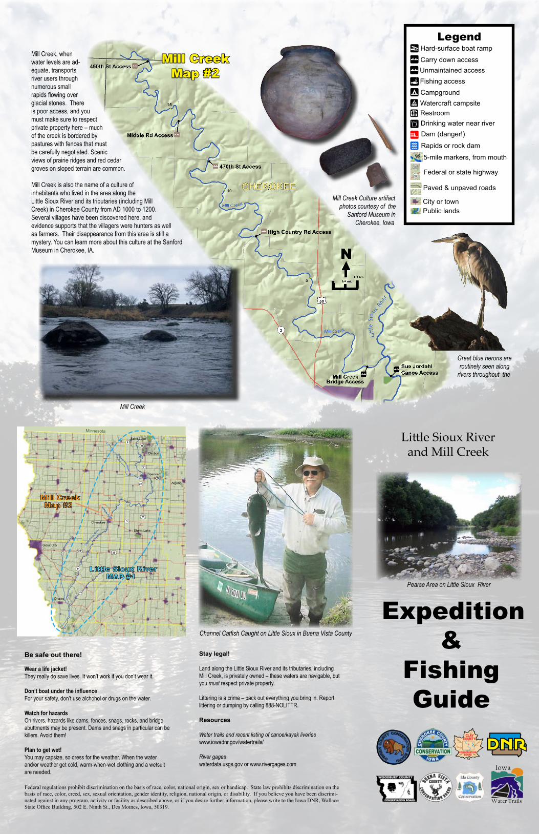
Expedition &
Fishing Guide
Water Trails
Iowa
!
Little Sioux Riverand Mill Creek
!
!
#*
#*
#*
r
¬«3
£¤59
!
CHEROKEE
5
10
15
!
!
!
!|!|
!|
Mill Creek
Middle Rd Access
Sue JordahlCanoe Access
470th St Access
High Country Rd Access
450th St Access
Bridge Access
!|
!|
!|
Mill Creek
Mill Creek
CHEROKEE
Litt
le S
ioux
River
N1/2 mi.
1/4 mi.
Pearse Area on Little Sioux River
Mill Creek
Great blue herons are routinely seen along
rivers throughout the
Mill CreekMap #2
Channel Catfish Caught on Little Sioux in Buena Vista County
#
#
#
#
#
#
#
#
#
#
#
#
#
#
#
#
#
#
#
#
#
#
#
#
#
## # #
#
#
#
#
#
#
#
#
#
#
#
#
##
#
#
¬«3
¬«9¬«86
¬«240
£¤71
£¤71
£
¤18
¤18
¬«175
¬«31
£¤ £¤20
"
Minnesota
20
Little Sioux River MAP #1
Mill Creek Map #2
Ocheyedan River
Little
Siou
x Rive
r
Cherokee
Sioux City
Spencer
Storm Lake
Spirit Lake
Okoboji
Algona
Onawa
Be safe out there!
Wear a life jacket!They really do save lives. It won’t work if you don’t wear it.
Don’t boat under the influenceFor your safety, don’t use alchohol or drugs on the water.
Watch for hazardsOn rivers, hazards like dams, fences, snags, rocks, and bridge abuttments may be present. Dams and snags in particular can be killers. Avoid them!
Plan to get wet!You may capsize, so dress for the weather. When the water and/or weather get cold, warm-when-wet clothing and a wetsuit are needed.
Stay legal!
Land along the Little Sioux River and its tributaries, including Mill Creek, is privately owned – these waters are navigable, but you must respect private property.
Littering is a crime – pack out everything you bring in. Report littering or dumping by calling 888-NOLITTR.
Resources
Water trails and recent listing of canoe/kayak liverieswww.iowadnr.gov/watertrails/
River gageswaterdata.usgs.gov or www.rivergages.com
Federal regulations prohibit discrimination on the basis of race, color, national origin, sex or handicap. State law prohibits discrimination on the basis of race, color, creed, sex, sexual orientation, gender identity, religion, national origin, or disability. If you believe you have been discrimi-nated against in any program, activity or facility as described above, or if you desire further information, please write to the Iowa DNR, Wallace State Office Building, 502 E. Ninth St., Des Moines, Iowa, 50319.
Mill Creek, when water levels are ad-equate, transports river users through numerous small rapids flowing over glacial stones. There is poor access, and you must make sure to respect private property here – much of the creek is bordered by pastures with fences that must be carefully negotiated. Scenic views of prairie ridges and red cedar groves on sloped terrain are common.
Mill Creek is also the name of a culture of inhabitants who lived in the area along the Little Sioux River and its tributaries (including Mill Creek) in Cherokee County from AD 1000 to 1200. Several villages have been discovered here, and evidence supports that the villagers were hunters as well as farmers. Their disappearance from this area is still a mystery. You can learn more about this culture at the Sanford Museum in Cherokee, IA.
Mill Creek Culture artifact photos courtesy of the
Sanford Museum in Cherokee, Iowa
Legend
²nm
|y
9
Hard-surface boat ramp
Carry down access
Campground
Rapids or rock dam
Dam (danger!)Drinking water near river
!_ Restroom
5-mile markers, from mouth
Watercraft campsite
Federal or state highway
City or town
Paved & unpaved roads
Public lands
!l Fishing access| Unmaintained access