Embed Size (px)
Citation preview


MDOT RWIS Deployment Strategy Memorandum
Table of Contents 1.0 Executive summary ....................................................................................................................................... 1-1 2.0 Project overview ............................................................................................................................................ 2-1
2.1 MDOT’s RWIS System ............................................................................................................................. 2-1 2.1.1 Fixed ESS ............................................................................................................................................ 2-1 2.1.2 Connected Vehicle ............................................................................................................................... 2-2
2.2 Goals of RWIS Evaluation ........................................................................................................................ 2-3 2.2.1 Literature/Best Practice Review ........................................................................................................... 2-3 2.2.2 Existing System Evaluation .................................................................................................................. 2-4 2.2.3 Technology Evaluation ......................................................................................................................... 2-5
2.3 Objective of Deployment Strategy Evaluation .......................................................................................... 2-5 3.0 Vision for MDOT’s RWIS Program ................................................................................................................ 3-1
3.1 Delineate Stakeholders ............................................................................................................................ 3-1 3.2 Specify Needs per Stakeholder ................................................................................................................ 3-2 3.3 Define Necessary RWIS Modifications/Programs to Meet Needs ............................................................ 3-5 3.4 Set Key Priorities on MDOT Requirements to Meet Needs ...................................................................... 3-9 3.5 RWIS Program Vision ............................................................................................................................. 3-11
3.5.1 MDOT Management Organizational Structure ................................................................................... 3-11 3.5.2 RWIS Champions ............................................................................................................................... 3-12 3.5.3 RWIS Data Source Vision .................................................................................................................. 3-13
4.0 Strategy......................................................................................................................................................... 4-1 4.1 Statewide Importance ............................................................................................................................... 4-1 4.2 Rural Strategy ........................................................................................................................................... 4-4 4.3 Urban Strategy ......................................................................................................................................... 4-5 4.4 Strategy Summary .................................................................................................................................... 4-7
5.0 Implementation and Innovative Contracting Options .................................................................................... 5-1 5.1 Innovative Contracting Options & Procurement ........................................................................................ 5-1 5.2 Service Plan ............................................................................................................................................. 5-2 5.3 Management of Weather-Related Data .................................................................................................... 5-3 5.4 Training Program ...................................................................................................................................... 5-3 5.5 Data Sharing Agreements ........................................................................................................................ 5-4 5.6 Funding Options ....................................................................................................................................... 5-4
5.6.1 Congestion, Mitigation, and Air Quality (CMAQ) Funds ....................................................................... 5-4 5.6.2 Maintenance Funds .............................................................................................................................. 5-4 5.6.3 ITS Template Funds ............................................................................................................................. 5-5 5.6.4 Roadway Capital Improvement Funds ................................................................................................. 5-5 5.6.5 Federal or Pooled Funds ...................................................................................................................... 5-5
Appendix A Notable Trends Summary ..................................................................................................................... i Appendix B User needs from Existing System Evaluation Report ............................................................................ Appendix C Functional value and costs related to MDOT-specified needs ...............................................................
C.1. BETTER INFORMATION FOR LAKE EFFECT SNOW LOCATIONS ............................................................. C.2. IMPROVED INFORMATION ON CONDITIONS IN OUTLYING AREAS ...................................................... ii C.3. INTEGRATE RWIS DATA WITH ATMS ....................................................................................................... iv C.4. DETERMINE FROST DEPTH MEASUREMENT SENSOR LOCATIONS.................................................... vi C.5. PERFORMANCE MEASURES AND THE BEGINNING AND ENDING OF STORMS ................................ vii C.6. SELECTION OF HIGH PRIORITY DATA COLLECTION SITES .................................................................. ix C.7. UNDERSTAND THE IMPLICATION OF GRIP VALUES AND ROAD CONDITION PARAMETERS ............ x C.9. IMPROVED MOBILE OBSERVATIONS ..................................................................................................... xiv C.11. PROVISION OF RWIS INFORMATION ON SMART PHONES AND TABLETS ..................................... xviii
MDOT RWIS Deployment Strategy Memorandum
List of Figures
Figure 1: MDOT Existing ESS Assets ........................................................................................................................ 2-4Figure 2: RWIS Stakeholders ..................................................................................................................................... 3-1Figure 3: The relationship between stakeholder needs and RWIS information sources ............................................ 3-2Figure 4: MDOT Organizational Structure ................................................................................................................ 3-11Figure 5: Functional Relationship of RWIS Champions within Operations and Maintenance Group in Each
Region .............................................................................................................................................................. 3-13
List of Tables
Table 1: Summary of potential approaches to meet specified MDOT needs ............................................................. 1-2Table 2: Summary of Strategy Recommendations ..................................................................................................... 1-0Table 3: Likert scaling for level of importance values ................................................................................................. 3-3Table 4: Importance of RWIS Parameters in Meeting Stakeholder Needs ................................................................ 3-4Table 5: Example of the primary resources and solutions to meet the specified MDOT needs. ................................ 3-6Table 6: Summary of the primary resources and solutions to meet the specified MDOT needs. ............................... 3-7Table 7: Vision for Road Weather Resources .......................................................................................................... 3-16Table 8: Summary of Recommended RWIS Strategies ............................................................................................. 4-8Table 9: Notable Trends Summary ................................................................................................................................. iTable 10: Best Practices Summary ................................................................................................................................. i

MDOT RWIS Deployment Strategy Memorandum
1-1
1.0 EXECUTIVE SUMMARY Introduction The Road Weather Information System (RWIS) program began in the form of a relatively simple system implemented to measure road and weather conditions on highways and communicate this information to a user in a maintenance facility. The system had a singular function manifested by a well-defined physical data collection, transfer, and display infrastructure. This infrastructure and the data transfer it facilitated clearly defined RWIS. But as the program and its data became accepted, the type of information at the user interface increased and the number of stakeholders who found value in the RWIS data increased significantly. The information derived from the simple RWIS solution melded with data from systems designed to meet totally different transportation requirements creating a new integrated weather-related transportation resource. Each of the systems fed upon the data from the other systems and often became dependent upon the data from the associated systems. In 2007, the Michigan Department of Transportation (MDOT) began widespread deployment of a Road Weather Information System (RWIS) comprised of Environmental Sensor Stations (ESS). The Michigan Department of Transportation (MDOT) now has a sizeable ESS network in place primarily in the Superior Region and North Region, but also in the University and Metro Regions. In addition to the existing system that is in place, MDOT has embarked on several initiatives that are on the cutting edge of technology. These include several Connected Vehicle deployment activities with fleet vehicles including:
• Testing connected vehicle applications in the integrated mobile observation (IMO) arena on various state vehicles in the I-94 corridor;
• Mobile data collection (MDC) and automatic vehicle locator (AVL) deployment on snow plows and state vehicles across the entire state;
• An enhanced Maintenance Decision Support System (MDSS) that encompasses MDC/AVL and connected vehicle data; and
• A weather responsive management project to target weather traveler advisories. MDOT is currently evaluating several approaches for the collection and uses of RWIS data from all existing and new resources. If found valuable, MDOT intends to extend this network to encompass the entire state. MDOT’s RWIS program is no longer a simple system approach but a “system of systems” solution that encompasses a broad spectrum of capabilities that have their own unique development and support requirements. Road weather information now encompasses mobile data sources, camera imagery, traffic data, safety applications such as curve warning systems (CWS), and weather information from the meteorological community. The original RWIS delivery system designed to meet the needs of DOT maintenance must now deliver RWIS data to support the needs of weather support providers, travelers, transportation operations and emergency services, and industries dependent upon weather information for operational guidance. Further, the delivery systems themselves have distinctly impacted the growth of the RWIS program through the continual change in communications technologies and computing solutions. Wireless communications and mobile devices such as smart phones and tablets are introducing a totally new way to gather and communicate road weather data. The MDOT strategy toward RWIS going forward must address all of these aspects of road weather data needs and information exchange. Vision The vision of the MDOT RWIS program is to have a robust system that provides stakeholders useful information about road weather conditions around the entire state of Michigan using an array of existing and next generation technologies. The RWIS will centralize all road weather data and forecasts from all available sources and share the data with all complementary applications (internal and external) to enhance the use of road weather information for the end-users. The RWIS program will require statewide and regional based champions to ensure the various road weather initiatives consider the needs of each region and the state as a whole. MDOT’s RWIS will be efficiently deployed to maximize the tradeoffs between various technologies and complementary products between fixed and mobile assets (when possible).

MDOT RWIS Deployment Strategy Memorandum
1-2
One of the steps in developing the vision for RWIS matched user needs, identified through a series of workshops, with potential approaches to meet those needs. During the MDOT workshops participants presented a number of unmet needs that MDOT users would like addressed or improved as part of the RWIS program. The needs were synthesized into a list of 12 predominant MDOT technical needs and they were explored more thoroughly in the MDOT RWIS Evaluation of Technology Memorandum. (There were also 3 management related needs that were not included in this analysis.) The analysis looked at these needs and determined which RWIS resource provided the greatest value in addressing those needs. Potential approaches to meet the needs were matched with each need. Table 1 below shows that matching. Table 1: Summary of potential approaches to meet specified MDOT needs
MDOT NEED POTENTIAL APPROACHES Better Information for Lake Effect Snow Patterns and Timing
• Denser ESS network • High resolution forecast model • Collage of camera images • Mobile & crowd sourcing data
Improved Information on Conditions in Outlying Areas
• Fixed and virtual locations to fill voids • Integration of Connected Vehicle program options into fixed
observation network • Trade-offs between camera imagery and full ESS configuration
Integrate RWIS Data with ATMS • Development of a single database to store data from all RWIS systems • Process data from all existing sources and plan for integration of future
sources (especially Connected Vehicle) Determine Frost Depth Measurement Sensor Locations
• Installed temperature profile columns • Sub-pavement temperature and moisture model
Performance Measures and the Beginning and Ending of Storms
• Integration of all precipitation and visibility information from all sources • Composite of data to determine start and end of precipitation • Use of traffic speed data to estimate level of service
Selection of High Priority Data Collection Sites
• Fill voids in current road weather data fields • Fill voids in pavement condition data field • Consider data resource based upon Connected Vehicle vision
Understand the Implication of Grip Values and Road Condition Parameters
• Plan training to improve understanding of grip and road condition parameters
Better Storm Forecasting • MDOT effort must be to provide more data to initialize the weather forecast
• Plan ESS expansion to support forecasting requirements • Push MDOT’s requirements for improved forecast accuracy and
reliability Improved Mobile Observations • Designate the MDOT vision for the Connected Vehicle program
• Establish a quality control (QC) plan that assures that the Connected Vehicle program will provide quality data
Improved Road Weather Related Conditions for Travelers
• Plan to deliver nearly all RWIS data to end users • Establish a plan to assure that MDOT outputs accurate, timely, and
reliable data to travelers Provision of RWIS Information on Smart Phones and Tablets
• Create display formats for all data types to fit the possible device options

MDOT RWIS Deployment Strategy Memorandum
1-3
The potential approaches shown were combined into high value options that could be pursued to meet MDOT needs. The highest priority options were (no specific order is intended in this listing): • Data Management Program and Contract Option
Develop a management plan that follows the current performance-based contracting approach established for the collection, processing, quality checking, dissemination, and display of ESS data. Performance-based contracts that require the successful delivery of valid information with penalties for non-performance have engendered the most reliable ESS networks and RWIS support services. This concept can be applied to other areas within the RWIS program as well. In addition, it makes sense to establish a single repository system for MDOT’s RWIS program including both ESS and Connected Vehicle data for efficiency and more effective management.
• RWIS ESS Expansion A continuous source of base road weather information will support several diverse programs that benefit MDOT and its obligations to its constituents. Currently this can only be achieved by deploying new ESS sites to eventually establish a network of observation points.
• Network of Present Weather Sensors The most critical parameter for MDOT winter maintenance requirements is a good determination of the presence, type, and rate of precipitation at each of the ESS sites. The current precipitation information from the NWS hourly reports is not very reliable, especially during snow events. Therefore one of the most beneficial choices for the RWIS program is the establishment of a network of accurate and reliable precipitation reporting sites.
• Integration of all CCTV Cameras Maintenance personnel have found camera imagery an important resource in evaluating remote conditions without the requirement to drive to the remote location. MDOT has a substantial number of cameras on their freeway network and a significant number of cameras on ESS sites. Integrating all of these camera images in a single resource would help both MDOT staff and the traveling public.
• The Connected Vehicle Network MDOT’s Connected Vehicle program provides an important information resource to augment the road weather information data set before, after, and during a winter maintenance event. Data from vehicles offers the potential to integrate observations from a sequence of locations along a highway into the network of data observations from stationary sites. Work is underway in the MDSS applications to integrate Connected Vehicle data into the road weather data set derived from stationary reporting sites. MDOT’s vehicle based data acquisition system (VIDAS) has the potential to collect more information than what has been traditionally considered to be part of current Connected Vehicle programs.
• System of Systems RWIS has become an integration of what had previously been separate systems, each developed to meet different DOT support requirements. MDOT has had active involvement in all of the transportation support programs, but each system evolved independently of the others and was typically managed by different divisions within MDOT. One of the key steps MDOT has taken to support data use for alternate applications such enhancing traveler information, is the integration of weather related advisories from DUAP. This is a huge step towards an efficient exchange of information needed to serve the variety of current DOT operational requirements and lays the foundation for future programs and the development of a cohesive exchange of data that can be shared to more effectively solve transportation issues for all stakeholders.

MDOT RWIS Deployment Strategy Memorandum
1-4
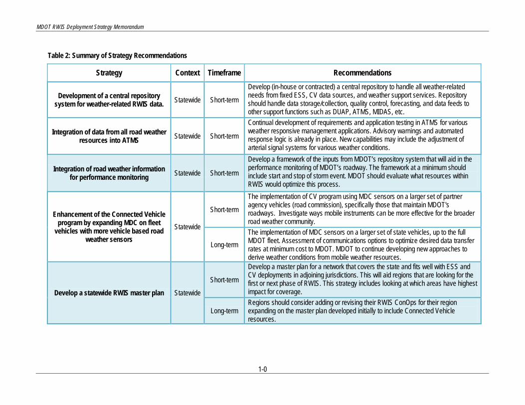
Strategy The vision lays the groundwork for developing a cohesive strategic plan for the future of MDOT’s RWIS program. The RWIS program in Michigan can vary based on the conditions, issues faced, and geography that is found in Michigan. Some of the trends in new technologies may be more suitable in urban setting as compared to rural. Conversely, some of the solutions for rural road weather applications may not be as beneficial in an urban environment given the transportation environment. Nonetheless, in order for MDOT to have a robust RWIS network, there should be some statewide strategies in place that will benefit both the rural and urban environments. Additionally, there are specific urban and rural strategies that are better suited for their respective areas. The specific strategies are shown in Table 2 on the next page.
MDOT RWIS Deployment Strategy Memorandum
1-0
Table 2: Summary of Strategy Recommendations
Strategy Context Timeframe Recommendations
Development of a central repository system for weather-related RWIS data. Statewide Short-term
Develop (in-house or contracted) a central repository to handle all weather-related needs from fixed ESS, CV data sources, and weather support services. Repository should handle data storage/collection, quality control, forecasting, and data feeds to other support functions such as DUAP, ATMS, MIDAS, etc.
Integration of data from all road weather resources into ATMS Statewide Short-term
Continual development of requirements and application testing in ATMS for various weather responsive management applications. Advisory warnings and automated response logic is already in place. New capabilities may include the adjustment of arterial signal systems for various weather conditions.
Integration of road weather information for performance monitoring Statewide Short-term
Develop a framework of the inputs from MDOT’s repository system that will aid in the performance monitoring of MDOT’s roadway. The framework at a minimum should include start and stop of storm event. MDOT should evaluate what resources within RWIS would optimize this process.
Enhancement of the Connected Vehicle program by expanding MDC on fleet
vehicles with more vehicle based road weather sensors
Statewide
Short-term
The implementation of CV program using MDC sensors on a larger set of partner agency vehicles (road commission), specifically those that maintain MDOT's roadways. Investigate ways mobile instruments can be more effective for the broader road weather community.
Long-term The implementation of MDC sensors on a larger set of state vehicles, up to the full MDOT fleet. Assessment of communications options to optimize desired data transfer rates at minimum cost to MDOT. MDOT to continue developing new approaches to derive weather conditions from mobile weather resources.
Develop a statewide RWIS master plan Statewide
Short-term
Develop a master plan for a network that covers the state and fits well with ESS and CV deployments in adjoining jurisdictions. This will aid regions that are looking for the first or next phase of RWIS. This strategy includes looking at which areas have highest impact for coverage.
Long-term Regions should consider adding or revising their RWIS ConOps for their region expanding on the master plan developed initially to include Connected Vehicle resources.

MDOT RWIS Deployment Strategy Memorandum
1-1
Strategy Context Timeframe Recommendations
Enhance RWIS Network to collect most representative data for operational
support Rural Short-term
Utilize statewide master plan to develop a refined regional strategy for collection of representative data from a comprehensive RWIS network (ESS and CV). Development of master plan and regional strategy could be completed at the same time depending on timing of deployment
Enhance traveler information in a rural setting Rural Short-term
Enhance traveler information program by utilizing all available weather resources (ESS, CV, Crowd Sourcing) to provide detailed traveler information in a format provided by existing sources such as Wx-TINFO or through ATMS.
Deploy vehicle detection systems at ESS locations to enhance reporting of information not available from crowd
sourcing data. Rural
Short-term Backfill ESS locations with Microwave Vehicle Detection System (MVDS) units on existing infrastructure in the form of a gap project. Can be included as a maintenance task or with future design projects.
Long-term Include vehicle detection systems as part of standard configuration for future ESS deployments
Establish or enhance urban ESS network to collect representative road
weather data Urban Short-term
Consider deployment of ESS as part of master plan for consistent weather data to support the RWIS program
Deploy fixed ESS with existing ITS infrastructure where performance
measures are highly impacted Urban
Short-term
Consider backfill of fixed ESS instrumentation at traffic detection locations in the form of a gap project. Can be included as a maintenance task or with future design projects. Instrumentation should be driven by user needs at target locations and should consider how CV data can meet this need.
Long-term Consider institutionalizing weather sensors with future ITS deployments for development of an adequately dense RWIS network.
Prepare infrastructure and systems for Connected Vehicle integration Urban
Short-term Identify areas where contiguous communication is not readily available and prepare arterial networks with infrastructure (signal controllers) that will likely support mobility applications related to road weather.
Short-term Align with MDOT's CV goals for Southeast Michigan (500 Road Side Equipment (RSE) deployment over 8 years) to identify which locations/corridors for RSE deployment would provide highest benefit for the weather stakeholders.
Short-term All urban areas should identify which locations/corridors for RSE deployment would provide highest benefit for the weather stakeholders.

MDOT RWIS Deployment Strategy Memorandum
2-1
2.0 PROJECT OVERVIEW The Road Weather Information System (RWIS) program began in the form of a relatively simple system implemented to measure road and weather conditions on highways and communicate this information to a user in a maintenance facility. The system had a singular function manifested by a well-defined physical data collection, transfer, and display infrastructure. This infrastructure and the data transfer it facilitated clearly defined RWIS. But as the program and its data became accepted, the type of information at the user interface increased and the number of stakeholders who found value in the RWIS data increased significantly. The information derived from the simple RWIS solution melded with data from systems designed to meet totally different transportation requirements creating a new integrated weather-related transportation resource. Each of the systems fed upon the data from the other systems and often became dependent upon the data from the associated systems. The RWIS program is no longer a simple singular system approach but a “system of systems” solution that encompasses a broad spectrum of capabilities that have their own unique development and support requirements. Road weather information now encompasses mobile data sources, camera imagery, traffic data, safety applications such as curve warning systems (CWS), and weather information from the meteorological community. The original RWIS delivery system designed to meet the needs of DOT maintenance must now deliver RWIS data to support the needs of weather support providers, travelers, transportation operations and emergency services, and industries dependent upon road weather information for operational guidance. And the delivery systems themselves have distinctly impacted the growth of the RWIS program through the continual change in communications technologies and computing solutions. Wireless communications and mobile devices such as smart phones and tablets are introducing a totally new way to gather and communicate road weather data. The MDOT strategy for RWIS going forward must address all of these aspects of road weather data needs and information exchange.
2.1 MDOT’s RWIS System
In 2007, the Michigan Department of Transportation (MDOT) began widespread deployment of a Road Weather Information System (RWIS), beginning in the Upper Peninsula. As technology has advanced, MDOT’s RWIS program has expanded to encompass both fixed Environmental Sensor Stations (ESS) and Connected Vehicle elements to support the weather stakeholders. These programs for MDOT are defined below.
2.1.1 Through a series of strategically placed Environmental Sensor Stations (ESSs), the RWIS was intended to help better identify inclement weather and adverse road conditions at critical locations in order to more efficiently deploy and prioritize maintenance needs and provide improved information to motorists. Since 2007, both the Superior and North Regions have made significant investments in the road weather program. With the rapid availability of funding in 2008/2009, the state was able to expedite the deployment of additional ESS’s to serve the needs of the region. These deployments represent a strategic development of a large system of ESSs throughout Northern Michigan and the Upper Peninsula, as envisioned in the RWIS Concepts of Operations (ConOps) developed for each region.
Fixed ESS
Other MDOT regions have also planned and deployed ESS sites with a limited array of sensors to meet specific needs to support the collection of weather data. For example, in Metro Region, MDOT has deployed an array of sensors to be used for a Curve Warning System at key interchanges and exit ramps across the region.
2.1.1.1 MDOT’S Environmental Sensor Stations An ESS site can consist of all or some the following devices depending on whether it is a full or partial site:
• Visibility Sensor - measures atmospheric visibility by determining the amount of light scattered within an optical sample volume by particles (e.g., smoke, dust, haze, fog, rain, and snow) in the air,
• Air Temperature/Relative Humidity Sensor – provides air temperature and relative humidity from which the dew point temperature is derived by the processing unit

MDOT RWIS Deployment Strategy Memorandum
2-2
• Barometric Pressure Sensor – provides the atmospheric pressure at the site; called the altimeter reading or station pressure,
• Wind Sensor – measures horizontal wind speed, wind direction, and gusts, • Precipitation Sensor – measures the precipitation type (rain, snow, sleet, freezing rain, hail), quantity, and
intensity, • Surface Sensor – provides a reading of pavement temperature, salinity and surface conditions, including
water, ice, and snow, • Subsurface Sensor – measures temperatures below the pavement; may measure temperature at one or
multiple depths, • Processing unit – routinely polls RWIS sensors, converts sensor output to digital values, and communicates
the data to a central server, • IP Surveillance System (CCTV) – used to visually monitor the site, road condition, and traffic, • Traffic Sensor (MVDS) – provides an accurate reading of traffic speed, vehicle type (cars or trucks), and
traffic volumes per configured lane.
MDOT had a total of 33 existing fixed ESS sites at the end of 2012 (24 full and 9 limited sensor stations). In addition to these existing sites, MDOT is in the process of installing 34 additional stationary ESS sites (25 full and 9 limited sensor stations), in the North, Superior, and University Regions. All of the planned locations are slated to be online by the end of 2013. MDOT existing/planned assets are shown in Figure 1.
2.1.2 Connected Vehicle is a suite of technologies and applications that use wireless communications to provide connectivity that can deliver transformational safety, mobility, and environmental improvements in surface transportation. Traditionally, Connected Vehicle technology involved the ability to share basic information about vehicles that are inherently available from the controller area network (CAN) bus such as position, speed, and direction of travel with infrastructure or other vehicles. This technology involves two methods of communication; Vehicle to Vehicle Communication (V2V) and Vehicle to Infrastructure Communication (V2I). V2V involves the ability to wirelessly communicate safety information with surrounding vehicles about forward crash warnings, intersection collision avoidance, stopped traffic/traffic queuing, and inclement weather conditions. Information related to weather conditions can be derived from values in the vehicle including wiper status, wiper rate, sun data, rain data, air temperature, air pressure, precipitation situation, tire friction, traction control enable/disable, position, and speed.
Connected Vehicle
However, as technology for vehicles and communications has evolved, MDOT has framed the concept of Connected Vehicles to include an array of information that can be obtained from vehicle assets on the roadway. These assets can provide sources of information via externally mounted devices/ sensors on the vehicle in addition to the traditional CAN bus data. All of the combined information from the mobile asset can be used to improve safety and mobility on MDOT’s roadway. MDOT’s Connected Vehicle program can be broken down in to the following categories. 2.1.2.1 Mobile Data Collection (MDC) on Fleet Vehicles Mobile Data Collection (MDC) and Automatic Vehicle Location (AVL) are key capabilities of the mobile road weather data acquisition program. Traditionally, most MDC units typically record air temperature, pavement temperature, material application rates (solid and liquid), and plow position by using externally mounted sensors on the vehicle. Many MDC/AVL units can include an in-cab display that permits entry of lane of operation, road conditions, type and rate of material being applied, and various weather conditions. The unit may also interface to an in-vehicle camera and capture images at a routine interval. This information is collected at short intervals and communicated wirelessly to a central processing site, or is stored on the vehicle for later download. MDOT’s program for MDC/AVL information on fleet vehicles combines the concept of traditional MDC/AVL with the capability to obtain CAN bus parameters such as wiper status, position of light switch, speed, ABS parameters, and

MDOT RWIS Deployment Strategy Memorandum
2-3
wheel traction. These fleet vehicles can be connected to MDOT’s system via various backhaul methods including DSRC and non-DSRC communication mediums to provide information to a centralized system to collect, store, process, and disseminate critical information about the roadway. MDOT is continuously looking at new information that can be obtained via this Connected Vehicle strategy. The following are key initiatives that fall under this category of their Connected Vehicle Program.
• Integrated Mobile Observation (IMO) 2.0 Project - deploy sensor technology on MDOT fleet vehicles that collect near real-time vehicle data to support winter weather maintenance decision support systems and other Connected Vehicle initiatives.
• FHWA Weather Responsive Traveler Information System (WxTINFO). The system will collect environmental/weather and traffic related data from both fixed environmental and mobile sensors; process this information into advisories, alerts, or traveler information; and disseminate the traveler information for pre-trip applications using MDOT’s ATMS.
• MDC/AVL Deployment - outfitting 200 snowplows with MDC/AVL units and 2500 fleet vehicles in Michigan with AVL. MDC deployment will include a combination of external mounted sensors and CAN bus parameters.
2.1.2.2 Connected Vehicle Data for Consumer Vehicles The US Department of Transportation (USDOT) is currently testing various Connected Vehicle technologies and applications to support future National Highway Traffic Safety Administration (NHTSA) rules to be used as standards to support communications from vehicles equipped with on-board diagnostic units to the CV infrastructure or other vehicles. This area of Connected Vehicles assumes that no external sensors will be equipped on the vehicle. All information will be extracted from the vehicle using the on-board diagnostic (OBD) module that will be available either from the original equipment manufacturer (OEM) through new equipment installed at the factory or by the addition of an after-market device to be installed in the vehicle. The communication options for this information can include DSRC and non-DSRC technologies, but is highly dependent on the communication platform available in the vehicle.
2.2 Goals of RWIS Evaluation The MDOT ITS Program Office has acknowledged the need to assess the current statewide road weather management program. The goal of this evaluation is to analyze the system presently in place in Michigan and derive user needs for continued use and collection of road weather information. The information presented in this evaluation will not replace existing Concept of Operations documents previously completed in several of MDOT’s regions, but rather augment the documents with a fresh look at how MDOT uses road weather data in their activities and assess if any of the new and emerging technologies or existing systems could be leveraged to support the program.
2.2.1 The functionality of the RWIS program has evolved considerably over its 40-year existence. With this evolution, there are lessons learned, techniques that worked, and those that didn’t, yielding a set of “best practices”. These items are critical to reflect upon and understand so that as the system is expanded the program can be adjusted accordingly to utilize the successes from previous experience. A Literature/Best Practices Review Memorandum was written that consisted of literature reviews, web searches, and interviews with staff from 18 states and 2 Canadian provinces that have program elements or program needs similar to those identified for Michigan. The information obtained from these reviews, searches, and interviews were compiled into a comprehensive spreadsheet that helped to create a baseline for the current direction of RWIS. The baseline spreadsheet brought to light several ‘notable trends’ that were similar across all states/provinces. These were presented in the Literature/Best Practices Review Memorandum and can be seen in Appendix A (Notable Trends Summary).
Literature/Best Practice Review
It is important to note that these trends are the product of the evolving RWIS technology and the lessons learned by the 20 agencies represented in the interviews. A list of best practices for RWIS deployments were derived from the

MDOT RWIS Deployment Strategy Memorandum
2-4
‘notable trends’ and the literature/web research, and are provided in the Literature/Best Practices Review Memorandum. These can also be seen in Appendix A of this document. These best practices served as a baseline for the development of this Deployment Strategy memorandum.
2.2.2
Existing System Evaluation
An Existing System Evaluation Memorandum was written to document the history of RWIS in Michigan and the current status of the MDOT RWIS program. MDOT began a widespread deployment of RWIS ESS sites in 2007 and the prevalent deployments were installed in the Superior and North Regions. Other regions have deployed ESS sites, but on a much smaller scale and most are equipped with a limited array of sensors aimed at collecting specific data needed to support a critical operational need at or near that particular site. A map of the current and some proposed ESS deployments can be seen in Figure 1. All of the existing sites, whether they contain a partial or full set of ESS sensors, are fixed stations. In addition to the proposed sites on the map in Figure 1 there are several other RWIS projects currently in construction and programmed deployments across the rest of the state over the next several years.
Figure 1: MDOT Existing ESS Assets MDOT currently holds a contract with a third party provider to collect and consolidate all ESS information and perform all the maintenance on the RWIS equipment to achieve a required level of accuracy and reliability. The same provider hosts the central repository and provides MDOT with an interface to the ESS data, NWS data, and road weather forecasts. However, there have been recent discussions to determine the effectiveness of this method and what alternatives may be available. Additionally, MDOT has a contract to collect Connected Vehicle data from fleet vehicles and apply that data to different application areas including maintenance, operations, and traveler information. MDOT plans to utilize fixed ESS and connected vehicle data to provide weather responsive traveler information through MDOT’s ATMS. In addition to investigating the existing infrastructure, consideration was given to what MDOT and associated stakeholders would like to see deployed in the near future and what ways the existing infrastructure could be

MDOT RWIS Deployment Strategy Memorandum
2-5
improved. Several User Needs were recognized and gaps in the existing system were noted for future improvement. These are listed in Appendix B of this document.
2.2.3 A Technology Evaluation Memorandum identified existing and emerging technologies that could potentially be used as components of a comprehensive RWIS program for MDOT. The technologies evaluated in the memorandum were identified as having the potential to meet documented needs and then were matched to specified system needs. It included an assessment of how well the technologies would meet MDOT’s RWIS needs. The Technology Evaluation solidified the idea that the best path forward for MDOT includes implementing a variety of different technologies and integrating them within the RWIS program.
Technology Evaluation
2.3 Objective of Deployment Strategy Evaluation This report, the Deployment Strategy Evaluation Memorandum, recommends the most effective approach for MDOT to take in the continuing development and improvement of their RWIS program. Various deployment options, including advances in support technologies (next generation technologies) and new RWIS program techniques, are compared against institutional trends and the ability of the potential program elements to meet user’s expectations and needs. The Deployment Strategy Evaluation Memorandum specifically looks to maximize benefits while leveraging shared infrastructure for mixed sensor deployments, communication alternatives that are cost effective, and procurement options that provide MDOT the most value while minimizing pressures from traditional delivery methods and timeframes. In addition, the report discusses various contracting methods and funding options that have been used successfully in Michigan and around North America to increase efficiency of the RWIS and reduce overall deployment cost to the Department. The consideration of alternatives leads to a recommended phased deployment strategy. This memorandum provides deployment scenarios that are comprised of different phases that address the most effective timeframe in which to implement the technologies and techniques identified. It also recommends timelines for the development of each of the phases within each scenario. The components of this analysis and the thought process involved in developing the scenarios are incorporated into the memorandum.
MDOT RWIS Deployment Strategy Memorandum
3-1
3.0 VISION FOR MDOT’S RWIS PROGRAM The vision for the MDOT RWIS program is to have a robust weather information system that provides stakeholders with valuable information about road weather conditions around the entire state of Michigan using an array of existing and next generation technologies. The RWIS program will centralize all road weather and forecasting data from all available sources and share the data with all internal complementary applications to enhance the use of the information for the end-users. The RWIS program will require statewide and regional based champions to ensure the various road weather initiatives reflect the needs of each region and the state as a whole. MDOT’s RWIS program will be efficiently deployed to maximize the tradeoffs between various technologies and complementary products between fixed and mobile assets (when possible). The initial subsections discuss how the needs of stakeholders align with the technologies that can satisfy those needs and what technologies are best suited for needs defined in the MDOT workshops. Subsequently, these solutions are prioritized so MDOT has a clear understanding of which solutions are most critical to the program. Following this prioritization, a discussion of management structure and approach for the future of the program is discussed.
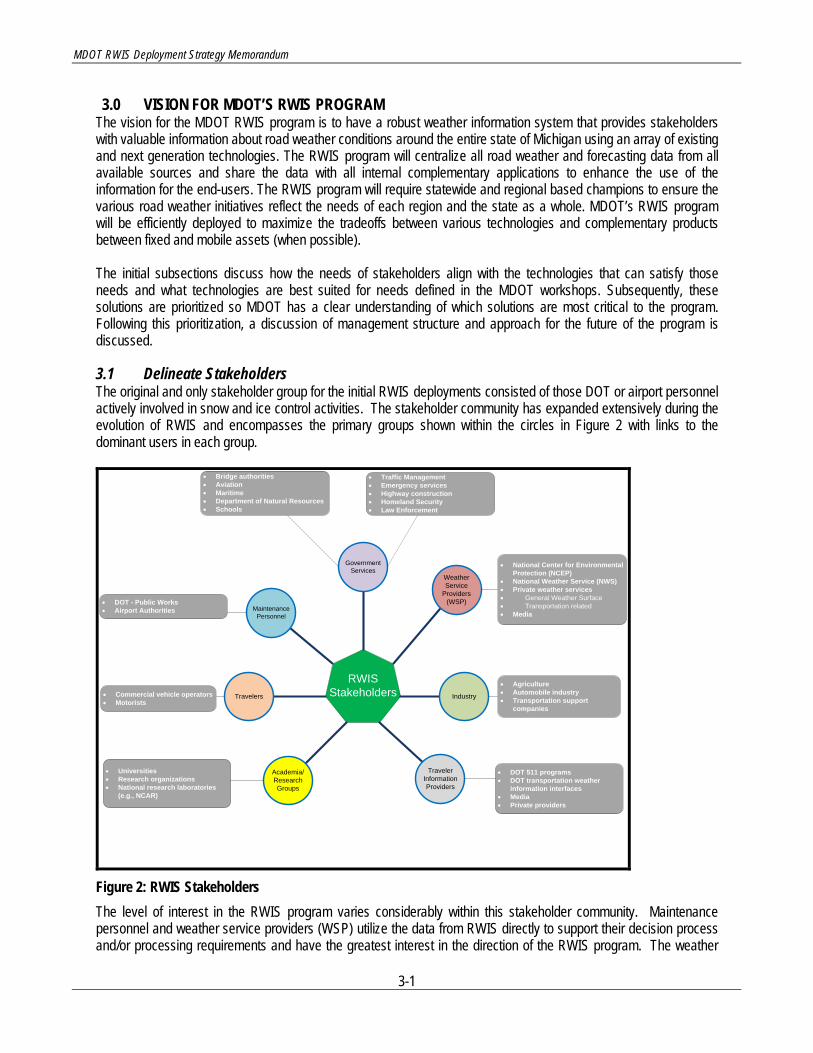
3.1 Delineate Stakeholders The original and only stakeholder group for the initial RWIS deployments consisted of those DOT or airport personnel actively involved in snow and ice control activities. The stakeholder community has expanded extensively during the evolution of RWIS and encompasses the primary groups shown within the circles in Figure 2 with links to the dominant users in each group.
RWIS Stakeholders
Weather Service
Providers (WSP)
Industry
• National Center for Environmental Protection (NCEP)
• National Weather Service (NWS)• Private weather services• General Weather Surface• Transportation related• Media
• Agriculture• Automobile industry• Transportation support
companies
Traveler Information Providers
Academia/Research Groups
Travelers
Maintenance Personnel
Government Services
DOT - Public WorksAiport Authorities
Traffic ManagementEmergency servicesHighway construction
Bridge authoritiesAviationMaritime
Department of Natural ResourcesSchools
DOT 511 programsDOT transportation weather information interfaces
MediaPrivate providers
Commercial vehicle operatorsMotorists
UniversitiesResearch organizations
National research laboratories (e.g., NCAR)
• DOT 511 programs• DOT transportation weather
information interfaces• Media• Private providers
• Commercial vehicle operators• Motorists
• Universities• Research organizations• National research laboratories
(e.g., NCAR)
• DOT - Public Works• Airport Authorities
• Traffic Management• Emergency services• Highway construction• Homeland Security• Law Enforcement
• Bridge authorities• Aviation• Maritime• Department of Natural Resources• Schools
Figure 2: RWIS Stakeholders The level of interest in the RWIS program varies considerably within this stakeholder community. Maintenance personnel and weather service providers (WSP) utilize the data from RWIS directly to support their decision process and/or processing requirements and have the greatest interest in the direction of the RWIS program. The weather

MDOT RWIS Deployment Strategy Memorandum
3-2
service providers and traveler information providers repackage the raw RWIS information into more usable formats for most users and create value added products designed to meet unique user requirements. The largest portion of the stakeholders use repackaged RWIS formats and may not be aware that RWIS information is a component of their road weather information resource. Nevertheless, many of these users recognize the value of the packaged data they receive and have significant influence on the parties that integrate the RWIS information. For example, travelers who come to depend upon traveler information services react very quickly when the camera images or road condition guidance they use regularly is not available.
3.2 Specify Needs per Stakeholder The RWIS stakeholders listed in section 3.1 have an interest in direct RWIS output or products derived from RWIS program elements. They have well defined needs for specific types of road or weather information that can help make better operational or personal decisions. A simplification of the relationship between stakeholder needs and RWIS information is shown in Figure 3. For each stakeholder need on the right in Figure 3, the stakeholder would turn to one or more RWIS information resources on the left. The stakeholder would learn to place a level of value or importance on each of the available resources.
Figure 3: The relationship between stakeholder needs and RWIS information sources For example, a maintenance supervisor monitoring a pending snow event needs the best information available regarding the location of the event, the start of the snowfall, its intensity during the event, and the pavement temperature during the storm. What the supervisor wants is a forecast of specific weather and road conditions during the period of the snowfall event. Within the RWIS program there are a number of potential sources that could provide this information and the supervisor learns which of the available information sources are of the most important resources to aid his/her decisions. The investigations performed in the Best Practices, MDOT workshops, and Technical Review tasks provided a good understanding of the relationships between stakeholder needs and the primary information resource components within the RWIS program. A key relationship was the importance of each resource component as seen in meeting the needs of each stakeholder. To facilitate a comparison of the importance values of the various RWIS components

MDOT RWIS Deployment Strategy Memorandum
3-3
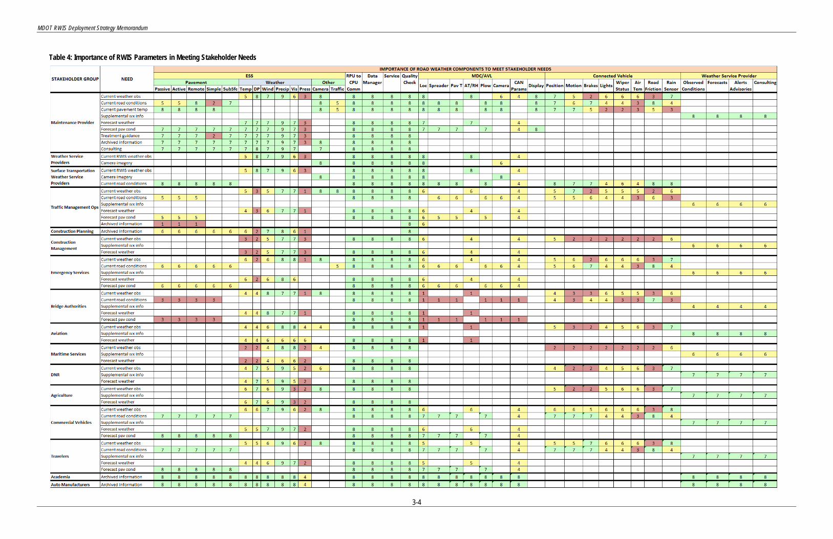
a value scale was established using a 9 value Likert scaling metric, which represent the levels of importance indicated in Table 3. If a parameter had little or no relevance to the need, the cell was left blank. Table 3: Likert scaling for level of importance values
IMPORTANCE VALUE
LEVEL OF IMPORTANCE
1 Extremely low 2 Very low 3 Low 4 Medium low 5 Medium 6 Medium high 7 High 8 Very high 9 Extremely high
The research team used the input from the earlier tasks in the study to establish estimates of the importance of each RWIS component in meeting each of the specific stakeholder needs, and the importance values were organized into Table 4. The level of importance of each relationship was displayed in its Likert scale value. To facilitate easier visual interpretation of the importance values in Table 4, cells with Likert scores of 7, 8, and 9 were filled with a green color; those with 4, 5, and 6 a yellow color; and those with a 1, 2, or 3 with a red color. This technique makes it easier to see the important and unimportant areas at a glance and isolate definite patterns of importance in the table. Importance was assessed for the components within each of the primary RWIS sources of the information that are eventually delivered to the stakeholders through some interface or organized package of information. Thus ESS, MDC/AVL, Connected Vehicle, and traveler information are indicated as sources of RWIS information even though the stakeholder probably received the information in a package format through a DOT or weather service provider interface. The weather service provider source (public or private) in the tables only refers to resource information that comes solely from the weather service provider. This may include meteorological information from NWS sources, forecasts, advisories, consulting services, and other sources of weather information not generated by RWIS services.
MDOT RWIS Deployment Strategy Memorandum
3-4
Table 4: Importance of RWIS Parameters in Meeting Stakeholder Needs

MDOT RWIS Deployment Strategy Memorandum
3-5
The table highlights the level of importance of all of the RWIS components or services as viewed by specific stakeholder groups or across all stakeholders. The four columns in Table 4 for RPU to CPU Communication, Data Manager, Service, and Quality Check with consistent high importance scores suggest a universal desire for accurate, reliable, and timely data. Although the Data Manager and Service headings reside in the tables primarily dedicated to ESS parameters, they also cover the management, processing, and delivery of all forms of data from the broader set of RWIS systems. Of the ESS parameters pavement temperature, precipitation type and intensity, and camera imagery are considered the most important decision support resources. Road condition information is also recognized as an important resource where stakeholders have gained confidence in the accuracy of the assessed road condition. The non-invasive pavement condition sensors appear to meet user expectations better than invasive sensors. Invasive sensors can have performance issues measuring road condition and chemical concentration, particularly when thin films of snow, ice, and/or water exist on the pavement. Sensors on mobile platforms (DOT fleet, commercial, and private vehicles have a significantly variable level of importance in meeting stakeholder needs. Lower levels of importance typically merely indicate that the specified component of source information does not relate to the stated user need. For example, brake information from the vehicle CAN bus has limited value in providing good guidance on the current weather conditions, although the braking information could indirectly imply a change from no precipitation to the presence of precipitation. The general lower level of importance for parameters from mobile sources reflects the fact that the observed parameters are indirect measures rather than direct assessment of road weather conditions. The value of many of the parameters measured from mobile sources will come from integrating their output with observed parameters from fixed sources. For example, rain sensors, wiper blade speed, and light switch position can aid assessment of present weather conditions that are already defined based upon direct observations from RWIS or NWS sites. These sensors respond to a number of conditions, several of which are not related to weather events at all. In addition, the integration of MDC/AVL data and CAN bus parameters into the road weather data stream is a new technology that will undoubtedly mature with time and gradually garner an increased level of importance in satisfying user needs. Understanding the importance of the various RWIS components in meeting stakeholder needs provides a foundation for evaluating what components of RWIS are most relevant to the user community and an indication of how the relevance may change if the RWIS program is modified to address the needs of a different segment within the stakeholder community.
3.3 Define Necessary RWIS Modifications/Programs to Meet Needs Section 3.2 considered the importance of the various RWIS resources in providing specific types of road weather information to support the operational needs of different stakeholder groups. The section highlights how different stakeholders view the information resources considered part of the RWIS program. This section evaluates the RWIS resources from a somewhat different perspective. During the MDOT workshops participants presented a number of unmet needs that MDOT users would like addressed or improved as part of the RWIS program. The needs were synthesized into a list of 15 predominant MDOT needs and they were explored more thoroughly in the MDOT RWIS Evaluation of Technology Memorandum (Table 4). The 15 needs indicate what pressing decision support needs users feel RWIS could resolve if modifications were made in the RWIS infrastructure or services provided via the RWIS program.

MDOT RWIS Deployment Strategy Memorandum
3-6
Table 5: Example of the primary resources and solutions to meet the specified MDOT needs.
Since these needs represented the expectations of the MDOT users, the needs became the basis for an evaluation of potential modifications to the MDOT RWIS program. The approach was to look at each of the defined needs individually and determine which RWIS resources provided the greatest value in meeting the desired change. But, value was not the only consideration. The addition of any resource to address a specific need comes at a cost; therefore, the analysis had to also present the implementation cost for each resource. Table 5 is the format selected to perform the assessment of value and cost for each of the MDOT needs. The cost assessment includes the fixed and recurring costs for each component with the recurring costs based upon the accrued cost over 20 years.
Fixed Recurring INDEXRPU 8 6 6 0
Pav Sensor Inv 6 6 9 1Pav Sensor Non-Inv 6 6 6 2
Subsurface 3 1 2 3Temp 5 1 3 4
RH/Dew Point 7 1 3 5Wind 7 1 6 6
Precip 9 2 9 7Visibility 9 2 9 8
Bar. Press 2 1 3 9Camera 9 1 9MVDS 6 1 6
Loc 6 1 1Spreader 6 1 1 INDEXPav Temp 7 1 1 0 $0 $0 $0 $0
AT/RH 6 1 1 1 $0 $4,000 $0 $6,000Plow 6 1 1 2 $4,000 $8,000 $6,000 $12,000
Camera 8 1 1 3 $8,000 $12,000 $12,000 $18,000CAN Params 5 1 1 4 $12,000 $16,000 $18,000 $24,000
Display 6 1 1 5 $16,000 $20,000 $24,000 $30,000VIN 5 0 1 6 $20,000 $24,000 $30,000 $36,000
RPM 2 0 1 7 $24,000 $28,000 $36,000 $42,000Throttle Position 2 0 1 8 $28,000 $32,000 $42,000 $48,000
ABS 8 0 1 9 $32,000 $36,000 $48,000 $54,000Tract Cntr/Grip 8 0 1
AT 6 0 1Wiper Status/Activation 8 0 1
Bar. Press 2 0 1Thermal IR 6 2 4
MVDS w Camera 5 2 4Mobile Camera/ESS (LV) 6 3 4
Doppler Radar Precip 8 1 4vRWIS 7 1 5
Automated Road Condition Assessment
4 1 9Road Condition Assessment 6 1 2
Use of DMS 5 1 2511/MiDRIVE Integration 6 1 4
Current Weather 7 1 8Forecast Weather 8 1 8
Recommendations 3 1 8Mobile Interface 7 1 8
Weather Support Service
MDOT NEED: Specific MDOT-designated need
Source Technology Functional Value
Cost
Fixed ESS
MDC/AVL
Connected Vehicle
New Technologies/
Methods
Traveler Information
Very High
Cost RangesFixed Recurring
Functional ValueValueNone
Very LowLow
Low-MediumMedium - Low
MediumMedium - HighHigh-Medium
High

MDOT RWIS Deployment Strategy Memorandum
3-7
The table provides Likert scores to indicate the relative ratings of the functional value and the cost ranges of each component of the primary RWIS resources as that component relates to the designated need at the top of the table. The Likert score range is from 0 to 9. The number 0 is reserved for no perceived value or no cost. The relationship of the Likert score to the descriptive functional value rating or the cost ranges is included in the legend at the bottom of the table, but in all cases increasing Likert scores relate to increasing value or cost. Since it is difficult to see patterns in lists of integers, each of the Likert score numbers is also related to a specific color and the color is used as a fill in the cell containing the Likert score. The analysis was done on twelve of the fifteen MDOT needs. Three of the needs are primarily management decisions that have very limited impact from the RWIS components. The three MDOT needs that are not included in this analysis are:
1. Define region MDOT RWIS champion 2. Provide training and awareness 3. Sharing weather information with other organizations
Each of the remaining twelve needs is evaluated in detail and the content of the analysis is presented as separate sections in Appendix C. The analyses in Appendix C address the reasoning for the value scores entered in the table associated with each need. The assessment of value and sometimes cost often relates to operational factors and historical performance character of the source instrumentation or value added process that provides the resource received by the end user. These considerations require considerable experience with the performance of the resource and feedback from DOT personnel who use the RWIS component routinely. The detailed discussions were placed in Appendix C due to their length. The key results from the analyses in Appendix C are summarized in Table 6. The primary resources represent those information resources within the broad scale RWIS program that have the highest functional value in meeting the specified need. The Potential Approaches column contains steps MDOT needs to consider to achieve the value expected from the primary resources. Entries in the Potential Approaches columns of the table placed in brackets contain references to more detailed information regarding that topic in the specified section of Appendix C. Table 6: Summary of the primary resources and solutions to meet the specified MDOT needs.
MDOT NEED PRIMARY RESOURCE POTENTIAL APPROACHES Better Information for Lake Effect Snow Patterns and Timing
• ESS (winds, precipitation, visibility)
• ESS cameras • MDC/AVL camera • Doppler radar • NWS observations • High resolution forecasts
• Denser ESS network [C.1.2} • High resolution forecast model [C.1.1] • Collage of camera images [C.1.3] • Mobile & crowd sourcing data [C.1.2]
Improved Information on Conditions in Outlying Areas
• ESS (Pavement Condition, precipitation, visibility)
• ESS cameras • Mobile road weather data • New camera technologies • Virtual RWIS locations • Use of weather service
provider products
• Fixed and virtual locations to fill voids [C.2.1 & C.2.3]
• Integration of Connected Vehicle program options into fixed observation network [C.2.2]
• Trade-offs between camera imagery and full ESS configuration [C.2.4]
Integrate RWIS Data with ATMS • All ESS data • ESS camera imagery • ESS MVDS
• Development of a single database to store data from all RWIS systems
• Process data from all existing

MDOT RWIS Deployment Strategy Memorandum
3-8
MDOT NEED PRIMARY RESOURCE POTENTIAL APPROACHES • All Connected Vehicle data • Use of DMS for info delivery • ATIS requirements
sources and plan for integration of future sources (especially Connected Vehicle)
Determine Frost Depth Measurement Sensor Locations
• Subsurface temperature • All ESS data • Current NWS data • Numerical model output
• Installed temperature profile columns [C.4.1]
• Sub-pavement temperature and moisture model [C.4.2]
Performance Measures and the Beginning and Ending of Storms
• ESS precipitation and visibility
• ESS camera imagery • MDC/AVL camera imagery • Other camera images of the
roadway surface
• Integration of all precipitation and visibility information from all sources
• Composite of data to determine start and end of precipitation
• Use of traffic speed data to estimate level of service
Selection of High Priority Data Collection Sites
• All ESS data with emphasis on precipitation
• Plan for the MDC/AVL program and data types
• Expected Connected Vehicle data resource
• Fill voids in current road weather data fields [C.6.1 & C.6.2]
• Fill voids in pavement condition data field [C.6.1 & C.6.2]
• Consider data resource based upon Connected Vehicle vision [C.6.2]
Understand the Implication of Grip Values and Road Condition Parameters
• ESS pavement condition – noninvasive sensor
• ESS camera • Other camera options • MDSS forecast conditions
• Plan training to improve understanding of grip and road condition parameters
Better Storm Forecasting • All ESS parameters (esp., precipitation, AT/RH, winds)
• Vision of MDC/AVL resource information and implementation schedule
• MDOT effort must be to provide more data to initialize the weather forecast [C.8]
• Plan ESS expansion to support forecasting requirements [C.8]
• Push MDOT’s requirements for improved forecast accuracy and reliability
Improved Mobile Observations • All Connected Vehicle parameters
• Designate the MDOT vision for the Connected Vehicle program
• Establish a QC plan that assures that the Connected Vehicle program will provide quality data [C.9]
Improved Road Weather Related Conditions for Travelers
• ESS pavement condition • ESS precipitation • ESS camera imagery • MDC/AVL pavement temp • Connected Vehicle data • NWS current weather data • Forecasted road conditions
• Plan to deliver nearly all RWIS data to end users
• Establish a plan to assure that MDOT outputs accurate, timely, and reliable data to travelers
Provision of RWIS Information on Smart Phones and Tablets
• All ESS data • All MDC/AVL data • Anticipated road weather
• Create display formats for all data types to fit the possible device options

MDOT RWIS Deployment Strategy Memorandum
3-9
MDOT NEED PRIMARY RESOURCE POTENTIAL APPROACHES parameters from the Connected Vehicle data
• Camera imagery from all sources
3.4 Set Key Priorities on MDOT Requirements to Meet Needs Sections 3.2 and 3.3 highlight the road weather components that have the greatest potential to meet the needs of MDOT and the stakeholder community interested in MDOT’s road weather resources. The synthesis of the two sections provides the actions MDOT should consider to most effectively meet the stakeholder needs defined in the internal review of the MDOT RWIS program. These items are at the top of the list of options (but in no specific order); the actual priority is best established by MDOT based upon the internal priorities and overall vision for road weather information in Michigan. • Data Management Program and Contract Option
MDOT will benefit considerably from developing a management plan that follows the current performance-based contractual approach established for the collection, processing, quality checking, dissemination, and display of ESS data. Performance-based contracts that require the successful delivery of valid information with penalties for non-performance have engendered the most reliable ESS networks and RWIS support services. A similar contractual requirement eventually needs to be established for the Connected Vehicle program. Logically, it makes sense to establish a single repository system for MDOT’s RWIS program including both ESS and Connected Vehicle data for efficiency and more effective management. Combining data has become an evolving trend that recognizes the value of exchanging information from previously disparate programs. However, until communication standards for Connected Vehicle data (specifically MDC) is well defined, the processing of data from end-points to a processing system will likely need to be separate. The processing system for Connected Vehicle data can be leveraged using an MDOT central repository for MDOT stakeholder decision-making. The performance assessment can be done based upon delivery statistics but MDOT needs to consider a third party evaluator to validate that the data achieves both reliability and accuracy.
• RWIS ESS Expansion MDOT requires a continuous source of base road weather information to support several diverse programs that benefit MDOT and its obligations to its constituents. Currently this can only be achieved by deploying new ESS sites to eventually meet a network of observation points with a grid spacing of roughly 60 kilometers (37 – 38 miles) or less in rural and semi-rural areas. A denser network of ESS may be required in urban areas utilizing a grid spacing in the 20-30 km range. The network may be a combination of ESS sites and NWS sites. If MDOT determines that pavement-specific information is necessary at a location where NWS data is available, MDOT may opt to install a partial ESS site to collect pavement information and possibly camera imagery.
• Network of Present Weather Sensors The most critical parameter for MDOT winter maintenance requirements is a good determination of the presence, type, and rate of precipitation at each of the ESS sites. The current precipitation information from the NWS hourly reports is not very reliable, especially during snow events. Therefore one of the most beneficial choices for the RWIS program is the establishment of a network of accurate and reliable precipitation reporting sites. Precipitation information is invaluable to support MDOT maintenance requirements year round as well as a resource to support the computational algorithms in the newly established performance measures requirement. Although precipitation information is valuable for direct use by MDOT, its transfer to the weather service provider community improves the initialization of the precipitation analysis field that translates into improved precipitation forecast accuracy in the short term. Since the short-term forecast (out to 3 to 6 hours) represents the period in

MDOT RWIS Deployment Strategy Memorandum
3-10
which the most critical tactical maintenance decisions are made, MDOT benefits from improved forecast derived from the denser and more reliable source of good precipitation information.
• Integration of all CCTV Cameras Maintenance personnel have found camera imagery a significant resource in evaluating remote conditions without the requirement to necessarily drive to the remote location. This is particularly the case where cameras use infrared light sources or low light technology to provide usable images at night. Travelers also assimilate camera images more effectively than digital data and as MDOT moves to provide greater services to the traveler, cameras become an important program element. MDOT has a substantial number of cameras on their freeway network, with most of these cameras in urban areas with high traffic volumes. In recent years, MDOT has aimed at providing camera coverage between major urban centers and on main tourism routes such as I-94, I-75 and I-96. Additionally, MDOT has a significant number of cameras on ESS sites that provide a distributed network of imagery that fits the needs of commercial vehicle operators and travelers in rural areas. Technological advances in cameras are occurring rapidly and new solutions in image acuity and data transmission techniques continue to improve the facility of camera imagery as a decision support tool. Mobile camera options from fleet vehicles are now available and can also be used to supplement fixed camera imagery. However, mobile cameras require a greater degree of interpretation since the user has to confirm the location and time of each image.
• The Connected Vehicle Network MDOT’s Connected Vehicle program provides an important information resource to augment the road weather information data set before, after, and during a winter maintenance event. Connected Vehicle data on fleet vehicles that have traditional MDC instrumentation provides an opportunity to bolster the maintenance management requirement and facilitate the logging of equipment, material, and personnel use to deal with adverse weather and road conditions. Data from vehicles offers the potential to provide observations from a sequence of locations along a highway into the network of data observations from stationary sites. Currently the only weather parameter routinely reported from traditional MDC units is air temperature. A few MDC installations have air temperature/relative humidity sensors that permit computation of dew point temperatures. The primary value of MDC information from fleet vehicles is about pavement temperature and treatment applications. The data sets from the ESS/NWS sources and the Connected Vehicle sources contain considerably different parameters and the intersection of mutual parameters is limited. This is a critical consideration in deciding how ESS and Connected Vehicle will work together. Work is underway in the MDSS applications to integrate Connected Vehicle data into the road weather data set derived from stationary reporting sites. MDOT’s vehicle based data acquisition system (VIDAS) has the potential to collect more information than what is being collected as part of current Connected Vehicle testing for MDOT’s IMO project. This development effort will be an important predecessor step to future integration of data from the Connected Vehicle program and possibly data from crowd sourcing applications. The IMO projects have permitted the development of MDC/AVL software to handle CAN bus data; the integration of this software into the MDC controllers on existing DOT fleet vehicles will permit testing of Connected Vehicle concepts from a broader vehicle base. The IMO projects are also demonstrating the use of MDC/AVL techniques to deal with non-winter maintenance issues.
• System of Systems RWIS has become an integration of what had previously been separate systems, each developed to meet different DOT support requirements. MDOT has had active involvement in all of the transportation support programs, but each system evolved independently of the others and was typically managed by different divisions within MDOT. The realization that each system had data that would benefit support requirements in the others has provided the impetus to share the data for the mutual benefit of each transportation support program. The road weather support program that had been mostly limited to Maintenance Operations and the ESS resource implemented to support Maintenance now finds camera imagery, traffic data, and data from Connected Vehicle sources an integral part of its resource repertoire. One of the key steps MDOT has taken to support data use for alternate applications such as enhancing traveler information, is the integration of weather related advisories

MDOT RWIS Deployment Strategy Memorandum
3-11
from DUAP. This is a huge step towards an efficient exchange of information needed to serve the variety of current DOT operational requirements and lays the foundation for future programs and the development of a cohesive exchange of data that can be shared to more effectively solve transportation issues for all stakeholders.
3.5 RWIS Program Vision A sound management strategy for MDOT’s road weather program will likely ensure all future strategies are considered with all parties in mind. This section discusses the current organizational structure that MDOT has in place and how road weather champions operate within the structure. Additionally, this section discusses the need for a centralized structure or virtual team that supports the road weather program at MDOT. This recommendation will be conducive to a successful program in which all statewide policies and deployments are aligned to meet the needs of every stakeholder.
3.5.1 MDOT is made up of seven geographic regions across the state. While there are many similarities in the organizational structure among the regions, each has its own unique management organization structure to accommodate the distinctive challenges the region faces. In general, however, the basic management organizational structure for a particular region follows the hierarchy shown in
MDOT Management Organizational Structure
Figure 4.
Figure 4: MDOT Organizational Structure Each region has a Region Engineer who oversees the business of that region. Some regions may have a Deputy Region Engineer who reports directly to the Region Engineer. The primary responsibility of the Deputy Region Engineer, in these instances, is to ensure that the day-to-day business is being completed satisfactorily so that the Region Engineer can focus on the more pressing political and regional issues. Under the guidance of the Region Engineer (or Deputy Engineer) each region has engineers who oversee the region’s Development, Construction, Operations, and Maintenance groups. The tasks encompassed under the respective groups are discussed below. The Development group is chiefly responsible for the planning, design and scoping of the region’s future projects. Commonly, the planning and scoping begins 5-10 years prior to the project being let for construction. It is at this time, as well, when funding is itemized for the project. This is a critical time when RWIS based initiatives at a regional level should be discussed and brought up for scoping. It is possible that parties that are most interested in projects for RWIS are not at the table for scoping to discuss priorities, but rather are discussed with their respective departmental leads.
PLANNING
DEVELOPMENT ENGINEER
CONSTRUCTION ENGINEER
REGION ENGINEER
OPERATIONS ENGINEER
SAFETY
MAINTENANCE ENGINEER
SCOPING MOBILITY
TRAVELER INFORMATION
PAVEMENT CONDITIONS
WEATHER FORECASTING

MDOT RWIS Deployment Strategy Memorandum
3-12
The Construction group takes ownership of the project after it has been let and awarded to the winning contractor. They oversee building the project, working closely with the awarded contractor to see the designed project becomes a reality. Geotechnical services and material testing duties fall under the responsibility of the Construction group as they deal directly with these items on a daily basis in the field, troubleshooting and testing materials as needed. Often road weather information is valuable to this group in determining the schedule of a project and accounting for potential delays due to weather. It is also important to be able to analyze the effect weather has on concrete curing times and the effectiveness of certain construction materials. Upon completion of all fieldwork, the Operations or Maintenance group will take over the daily up-keep and management. The Operations group is interested in those projects which directly affect the safety of the roadways, the movement of people, goods, and services, and the dissemination of information to the motoring public. This is predominantly done through the use of traffic signage, pavement markings, traffic signals, and ITS devices such as cameras and dynamic message signs. The Maintenance group takes a vested interest in projects that include pavement resurfacing, shoulder and slope modifications, and rest area/visitor center upgrades. In most regions, the Maintenance group is responsible for mowing the grass in freeway rights-of-way, treating icy roads and plowing snow, and performing as-needed maintenance items to keep the state-owned infrastructure in proper working order. RWIS can help both the Operations and Maintenance group in their daily tasks in numerous ways. If the Operations group has advance notice of weather events entering a particular area, they can notify the motoring public giving them the knowledge to choose an alternative route or modify their driving routine. RWIS can help the Maintenance group with scheduling crews for mowing/plowing based on weather patterns and can help them deploy crews effectively where the need is the greatest. MDOT personnel from Development, Construction, and Maintenance/Operations have a vested interest (at some level) in having access to current weather and road condition information and forecasts of future road weather conditions. The ITS Program Office is responsible for providing guidance for ITS technology deployments, while the regional ITS coordinator (falls under operations) focus on the need to coordinate ITS efforts related to weather within their respective regions. The ITS coordinator takes on the responsibility to develop an internal system to make this information available to all interested parties. To bring awareness to the need for each region to have a functional road weather information system a group of representatives needs to be recognized and somehow involved in all levels of each of the groups. Further involvement of Development, Construction and Maintenance groups will ensure all needs of the groups are being voiced through the process.
3.5.2 Since 2007, MDOT has been deploying RWIS statewide. For the most part, the majority of the deployments have been ESS located in the Superior and North Regions to better identify inclement weather and adverse road conditions at critical locations in order to more efficiently deploy and prioritize maintenance needs and provide improved information to motorists. Smaller, limited deployments have been utilized in the southern part of the Lower Peninsula to obtain specific data at ramps and bridges. MDOT’s ITS Program Office project selection process has been the conduit to allow regions to identify the needs and applications for ITS within the various regions. Additionally, MDOT has completed regional concepts of operations for RWIS (regionally dependent) and ITS architecture deployment plans that encompass road weather activities. MDOT will want to ensure that all road weather activities are coordinated in the state and that a standard strategy for planning these deployments is set in place.
RWIS Champions
The state needs to build a team of individuals who has the responsibility to coordinate the expansion of those systems within the RWIS program that have the greatest potential to benefit MDOT operations or support the travel needs of MDOT’s constituents. It is recommended that each region identify a dedicated RWIS coordinator who has a strong desire and interest in seeing RWIS expand and grow throughout his/her region as part of a statewide initiative. This may or may not be the ITS Regional coordinator since they have been fulfilling the task. Ideally, the RWIS coordinators would be staff from the groups that would find the most added benefit from the information obtained by

MDOT RWIS Deployment Strategy Memorandum
3-13
RWIS, specifically a representative from the Operations and Maintenance group (see Figure 5). The coordinators would act as RWIS champions who understand the necessity of the RWIS program and how the information obtained from the various RWIS subsystems will help in making determinations in congestion and mobility, pavement treatment, and traveler information. The selected coordinators need to function as a statewide team to define the direction of the RWIS program and facilitate its implementation within each Region. Regional coordinators need to serve as champions for the various facets of the RWIS program and work with the engineers indicated in Figure 5 to promote the capabilities of RWIS solutions and determine those needs within the region that would gain the greatest benefit from the RWIS programs. The regional coordinators should serve as conduits for these regional needs into the statewide RWIS management team and participate in the determination of the allocation of state or region funds to enhance the RWIS program.
Figure 5: Functional Relationship of RWIS Champions within Operations and Maintenance Group in Each Region RWIS coordinators (existing or newly appointed) in each region will need to remain active in the planning and scoping of projects in their region from their inception. If the RWIS deployments can be packaged and scoped into larger road projects, it may be found that new sources of funding open up allowing the funds used previously (i.e. CMAQ, ITS Template, etc.) to be obligated for other projects or even further RWIS deployments.
3.5.3
RWIS Data Source Vision
The rapid changes in technology require MDOT to adjust the strategy of how road weather information is deployed and managed across the state. This is particularly important in light of the recent developments around mobile data collection and the direction of the Connected Vehicle research. These new sources can supplement the data that is available from fixed ESS. To determine what strategy MDOT management should take for deploying road weather resources in the future, it is important to assess how the various sources of data compare for a specific need. The stakeholder needs summary table in Appendix B describes how the various road weather resources meet each individual need identified by MDOT during the existing system evaluation. The following areas are key road weather resources that will continue to shape the RWIS program in Michigan. 3.5.3.1 Fixed ESS Fixed ESS is currently in use across the North and Superior regions following the Concept of Operations studies completed within these regions. ESS installations have not been deployed extensively elsewhere within MDOT either because regional concepts of operations for RWIS have not been completed or RWIS deployments are scoped for projects projected for implementation in the next 5-7 years. Fixed stations provide a continuous feed of road weather data and specific data elements that mobile sources do not or cannot provide, such as precipitation, visibility, wind parameters, subsurface temperatures, traffic data, and point specific camera imagery. These parameters are critical for better weather and road condition forecasting as well as reports of current conditions. A significant value of individual ESS sites is the provision of guidance for nearby maintenance operations; however, a more extensive value comes from the regional or statewide composite of data from a network of ESS sites distributed in a grid pattern. Thus, the distribution of ESS sites needs to be evaluated from a statewide perspective and the location of
RWIS CHAMPIONS
SAFETY ENGINEER MOBILITY ENGINEER ITS ENGINEER/REPRESENTATIVE
MAINTENANCE ENGINEER

MDOT RWIS Deployment Strategy Memorandum
3-14
potential ESS sites needs to consider the distribution of sites in adjacent regions to assure the statewide network provides an optimal source of information. Each region should identify how many stations and what locations would provide adequate coverage and meet specific operations and maintenance needs. The selection of ESS sites should also consider other sources of data. The NWS or other weather sources provide reliable weather information that may be combined with pavement related parameters from a nearby ESS installation that only measures road conditions to produce ESS guidance for a point in the ESS network. Mobile data sources have the potential to create a source of data to supplement and possibly replace the need for some of the ESS data parameters, but programs such as MDC and Connected Vehicle need to establish a high level of deployment or market penetration before they become viable resources that can integrate into ESS networks or modify the required parameters from an ESS site. MDOT needs to view the deployment of ESS technology as a resource that provides multiple networks of gridded information (e.g., air temperature, precipitation, winds, pavement temperature, road condition, subsurface temperatures, traffic data) each as independent resources. Some of these parameters require a dense network of observation points and some can be determined from a less dense network or acquired from other sources. This type of analysis can be used to establish sensor suites for individual ESS sites that are adequate to meet the needs of the ESS network configuration. 3.5.3.2 Portable ESS MDOT may consider using a Portable ESS platform that relies on portable/temporary ESS installations to support unique requirements or minimize the cost of installation. Portable ESS solutions come in two separate forms: an ESS structure on a trailer base and a set of instruments and a support structure that can be installed and removed with minimal effort. The fully portable ESS solution may be used to verify the adequacy for a projected permanent ESS site, obtain coverage where siting was not previously possible, or serve as a short-term source of information for a special event or backup for a damaged ESS site. The ESS configuration placed on a temporary structure is better suited for site where a construction project would require a permanent site to be moved or impacted during construction. The portable ESS solution is not recommended as a widespread strategy, but may be effective where the cost of supporting infrastructure hinders the ability for ESS deployment. A future MDOT RWIS system may consider a combination of Fixed and portable ESS in the short term and various vehicle based strategies in the long term. 3.5.3.3 Connected Vehicle MDOT’s Connected Vehicle program is based on two distinct focus areas in relation to RWIS activities. The ability to capture mobile information from both fleet and consumer vehicles will aid the department in their on-going weather program. Regardless of the communication medium, these connected vehicle data will provide MDOT a new resource for real-time information about MDOT’s roadways. 3.5.3.3.1 Fleet Vehicle Data With the recent MDC/AVL contract that was just awarded in Michigan, fleet vehicle data from DOT fleet vehicles are already being collected. Information about the state of plowing and treatment activities, pavement temperature, and air temperature will provide some value in meeting stakeholder needs as indicated by the tables in Appendix C. Camera imagery will also serve as a valuable resource. The deployment currently under way will be looking to get the information uploaded to Michigan’s central road weather reporting system. These data points are expected to provide MDOT’s weather service provider near real-time information about vehicles across the state. The one limitation associated with data received from snowplows and other instrumented DOT vehicles is the data is available only when the vehicles are on the roadway and a number of parameters measured are relevant only during snow and ice control activities. Thus, this resource currently has limitations as a road weather resource for year round information, although IMO research is evaluating new data sets that may assist with non-winter activities. The second part of MDOT’s MDC/AVL contract will provide a grid of vehicles within the state network with the ability to track physical location via AVL only. Future integration of MDC capabilities with these AVL-only vehicles can be investigated to determine the value of making this conversion. The MDC data source will complement fixed stations by providing a more comprehensive view of road conditions concurrent with ESS sources, especially in winter months.

MDOT RWIS Deployment Strategy Memorandum
3-15
3.5.3.3.2 Consumer Vehicle Data The availability of Connected Vehicle data from consumer’s vehicles will be based on the information that can be obtained from vehicle itself. While a decision has not yet been made by the NHTSA for mandating on-board units, connected vehicle data offers a new possibility to obtain real-time road weather information from a broad base of vehicles. Much of the data being collected from Connected Vehicle research is still being studied; however, there is a great potential to capture critical information that could provide significant support to the RWIS program. Current expectations are that air temperature and possibly station pressure will be the only parameters that represent direct measurements or averages of direct measurements. The remaining parameters of value to RWIS will be inferred values derived from other measurements. Nevertheless, critical factors such as the presence or absence of precipitation (and possibly an estimate of intensity) and an indication of pavement traction have the potential of providing much higher resolution for an assessment of the areas of precipitation and location of slippery conditions. When Connected Vehicle technology is implemented and available on the majority of vehicles, the stream of data would deliver a nearly continuous source of data from most highway segments. It is also likely that the Connected Vehicle program will induce the auto industry to integrate additional sensors, such as pavement temperature sensors. MDOT may view this resource as critical if NHTSA makes a final decision to deploy on-board equipment (OBE) and the Connected Vehicle infrastructure is implemented. The road weather information from the Connected Vehicle program will supplement road weather data from fixed and other mobile data collection sources but will require new software techniques to merge data from fixed and mobile contributors. Regardless of the communication strategy of backhauling data from vehicles, the vision is that MDOT will have the opportunity to supplement data provided from other RWIS assets with data collected from non-fleet consumers’ vehicles. Back-end systems to collect, house, process, and disseminate the information into applications like ATMS is also under study and will shape the interactions that are expected between the Connected Vehicle road weather resource, processing infrastructure, and the various end users. 3.5.3.4 CCTV The widespread availability of camera images and video across the state, particularly on the freeway system in the state, provides a visual resource to all stakeholders for monitoring roadway conditions. The expansion of camera resources in Michigan will be largely dependent on gaps in roadway coverage on state trunk lines, key bridge crossings, lakeshore areas prone to inclement weather, and county borders on edges of responsibility. Camera imagery is a key way of obtaining road conditions in more rural settings. However, MDOT may look to start incorporating streaming video to provide a more enhanced view of road condition reporting. Technology advancements in the cellular industry have allowed streaming video to become a viable option. Fixed or traffic cameras across the state may make use of video to provide an enhanced resource to the stakeholders. 3.5.3.5 Vehicle Detection The movement of vehicles across the state is a key element for tracking performance measures such as user delay costs for MDOT. Vehicle detection data needs to be readily available to stakeholders who are measuring performance and to planners, managers, operations and maintenance personnel who are interested in understanding how incidents are managed during inclement weather and how mobility is impacted. The ability to collect traffic data across the state is limited by the infrastructure available to install the sensors and upload the data. MDOT has completed a significant deployment of state owned traffic detection devices, even at fixed ESS sites. The vision is that MDOT will include MVDS at all future fixed stations to provide a baseline of motorist speed, volume and occupancy as compared to road weather conditions. 3.5.3.6 Vision Summary Management personnel at a statewide level, with input from key stakeholders, should review the vision for the road weather sources discussed above. MDC/AVL and Connected Vehicle for example are resources that will be planned statewide because of the possibility of collecting data from vehicles crossing jurisdictional boundaries for the region. However, other sources of weather information and priorities should be looked at regionally to determine how to best

MDOT RWIS Deployment Strategy Memorandum
3-16
leverage the road weather resource for maximum benefit. Table 7 identifies the vision for MDOT’s road weather resources. Section 4.0 discusses strategies and dependencies and prerequisites that should be met prior to deployment.
Table 7: Vision for Road Weather Resources
Source Information Vision
Fixed Environmental Sensor Station (ESS)
View ESS technology resource as providing network of "gridded" information on a continuous 7X24 basis, specifically for parameters that require dense observation points that are not achievable today from new technology deployments (MDC/AVL, CV)
Portable ESS A platform that relies on portable/temporary ESS installations to address unique challenges/requirements and to address short-term problems where other resources deployed in the future may adequately solve the problem.
Connected Vehicle – Fleet Vehicle Data Further expansion of connected vehicle resources on fleet vehicles (MDOT and partner agency) to complement ESS by providing comprehensive near real-time road conditions concurrently with ESS sources and provide a MDOT asset/resource management capability not available from ESS sources.
Connected Vehicle – Consumer Vehicle Data
Statewide resource to provide near real-time roadway conditions to augment data collected from fleet vehicles and fixed/portable ESS. Connected Vehicle resource from Consumer’s vehicles to be leveraged with various traffic management strategies for safety, mobility, and awareness.
CCTV Camera resource to cover all state trunk lines, critical state routes and at key signalized interchanges for providing operations and public real-time road weather conditions and traffic information.
Vehicle Detection Vehicle detection resource to provide volume and speed information on all state trunk lines and state routes to enhance reporting of information internally and externally, especially for data sets that not available from other crowd sourcing assets. Detection to be achieved using all available infrastructure when possible.
MDOT RWIS Deployment Strategy Memorandum
4-1
4.0 STRATEGY The vision and source emphasis sections in section 3.0 lay the groundwork for developing a cohesive strategic plan for the future of MDOT’s RWIS program. This section presents a strategic approach to managing and expanding the program.
4.1 Statewide Importance Based on all of the feedback obtained throughout the evaluation project, it is apparent that there are overarching themes that are relevant to users regardless of geographic location. These items that are of statewide importance should be developed further to ensure MDOT’s system remains robust and meets the expectations of end-users and stakeholders. The following areas are identified as strategic focus areas for statewide importance. Development of a central repository system for weather-related RWIS data.
Although RWIS started as a simple system designed to collect ESS data, it now integrates raw weather data, value-added road weather products, MDC/AVL data, camera imagery, traffic data, and the initial trickle of Connected Vehicle data. All of this data comes from distinctly different sources. The effectiveness of the RWIS program today and into the future depends upon the ability to efficiently share data between applications and users. Therefore, it is essential that MDOT develop a central database that incorporates as much of the data important to RWIS as possible. The logical first step is to establish a database that handles ESS and Connected Vehicle data (including MDC/AVL) as well as weather information and value-added products needed to support operational decisions within the DOT and traveler information requirements. By consolidating fixed and mobile data sources, all users regardless of geographic location will have access to the fullest set of information available from a single system. The development of a comprehensive set of requirements will be critical to obtain optimal benefit from the data processing center. Currently an outside contractor manages the ESS data processing and database of road weather and value-added products. One viable option is to transfer the data from the MDC/AVL program into the vendor’s database and explore the steps necessary to integrate Connected Vehicle data using the exchange protocols that develop with the Connected Vehicle program. The other approach is the development of an MDOT-managed data management solution that would ingest data from all existing weather-related RWIS sources and serve as a data exchange and data dissemination clearinghouse. The interim step of collecting data from Connected Vehicle sources may still need to reside with a vendor that is capable of communicating with mobile devices. The industry standards for Connected Vehicle data sets are not yet ready and will require the intermediate step for consolidating all weather data. The MDOT data management approach has the advantage of establishing the infrastructure to eventually integrate other data resources such as camera imagery, traffic data, other advisory and control messages, and data from any other source that becomes an integral part of the RWIS program. Implementation Strategy - Short-term;
Develop (in-house or contracted) a central repository to handle all weather-related needs from fixed ESS, CV data sources, and weather support services. Repository should handle data storage/collection, quality control, forecasting, and data feeds to other support functions such as DUAP, ATMS, MIDAS, etc. The design of the processing system needs to handle large data sets, operate with 7X24 reliability, store and transfer data efficiently, and the database needs to be extensible to permit easy expansion of the repository.
Integration of data from all road weather resources into ATMS.
This effort has implications across the entire state of Michigan. As all regions are highly vested in their ITS system, the integration of road weather resources will only enhance the ITS system. The development of an integrated system that brings road weather information from a central repository to an ATMS platform will create opportunities for maintenance, operations staff, and the traveling public to see how road weather will impact mobility around the state. While weather data is currently being integrated between MDOT’s systems today, further enhancement in ATMS would be needed to leverage new applications for weather responsive

MDOT RWIS Deployment Strategy Memorandum
4-2
management. MDOT’s current Wx-TINFO project is a key example of how weather data can be processed externally (by DUAP) and be fed to ATMS for improved weather responsive management. While the ATMS has the capabilities to perform automated response logic and trigger warnings based pre-defined weather parameters, further enhancement will be needed as new applications for weather management are utilized. For example, new capabilities in ATMS may include the adjustment of the signal system for various conditions (manually or automatically). Implementation Strategy – Short-term & Long-term;
MDOT should invest in continual development of requirements and application testing in ATMS for various weather responsive management applications. Advisory warnings and automated response logic is already in place. New capabilities may include the adjustment of arterial signal systems for various weather conditions.
Integration of road weather information for performance monitoring
MDOT’s statewide goal of reducing user delay costs (UDC) is a key area that can be easily impacted as a result of inclement weather. The ability of MDOT operations to measure and monitor roadway conditions during a storm can enhance how responsive they are in maintaining progression on the roadway during the peak morning traffic. MDOT should consider finding ways to include overall road weather condition information in their performance system (currently the Regional Integrated Traffic Information System (RITIS)). Currently, performance related to inclement weather is determined using external road weather resources, which do not provide the depth of information or detail about the roadway that is available through MDOT’s central repository system. MDOT will want to assess what resources are available within existing data structure to provide the best information for performance monitoring. Implementation Strategy - Short-term;
MDOT should develop a framework of the inputs from MDOT’s repository system that will aid in the performance monitoring of MDOT’s roadway. The framework at a minimum should include start and stop of storm event. MDOT should evaluate what resources within RWIS would optimize this process.
Enhancement of the Connected Vehicle program by expanding MDC on fleet vehicles with
more vehicle based road weather sensors MDC is not a new area for RWIS, but a recent undertaking by the state of Michigan. A recent project that equips 250 snowplows with MDC equipment will be the baseline for the collection of near-real-time road weather information. The primary purpose of the MDC program has been to support MDSS and DOT resource management. MDC-equipped vehicles transmit location information in both space and time and a continuous sequence of treatment application data. In addition, each transmission includes a number of road weather parameters including pavement temperature, road condition, air temperature and humidity. Recent IMO research has also demonstrated that MDC units can also read the CAN bus data on the vehicle and add this data to the transmission packet. Once collected, the data can be transferred to a central repository system. The MDC project is a stepping block for developing a road weather resource that augments the data set necessary in decision-making done by maintainers, operations staff, and end-users of the data. A next step in furthering the MDC program will be to equip other fleet vehicles with road weather sensors. These fleet vehicles may include partner agency vehicles since the counties maintain much of MDOT’s roadway network. MDC vehicles have the potential to create a network of mobile road weather data sources on Michigan roadways. The current limitation of the mobile data set for road weather use is the lack of observations of present weather conditions and complete road condition information. MDOT will need to work with their MDC contractor and other states for the implementation of techniques to incorporate a mechanism that provides this information. While the current MDC/AVL contract will only equip a portion of the state fleet vehicles with AVL sensors, the option for collecting more data becomes a real possibility MDOT may consider enhancing the MDC platform with vehicle-based weather sensors.

MDOT RWIS Deployment Strategy Memorandum
4-3
Implementation Strategy - Short-term; MDOT should expand the CV program by integrating MDC sensors on a larger set of partner agency vehicles (road commission), specifically those that maintain MDOT's roadways. Investigate ways mobile instruments can be more effective for the broader road weather community. This strategy depends on partnership and agreements that must be in place between MDOT and partner agencies to outfit vehicles, collect the information, and process it on MDOT’s systems. Agreement must include who will own the devices, who will maintain them, how the agencies will view the data, and who has ownership rights to the data.
Implementation Strategy - Long-term; MDOT should consider the implementation of MDC sensors on a larger set of state vehicles, up to the full MDOT fleet. The State should assess communications options to optimize desired data transfer rates at minimum cost to MDOT. MDOT should continue to develop its approach to identity weather conditions from weather resources. This strategy depends on the evaluation of the existing MDC deployment to determine its benefits, limitations, and desired modifications/enhancements for future deployment.
Develop a statewide RWIS master plan.
Several Regions within the state have completed a concept of operations (ConOps) for RWIS and have deployed fixed ESS stations within the region. The regional evaluation approach is a good distributive approach to RWIS, but the real benefit of an RWIS network is the ability to create an effective mesh of data points to support the entire spectrum of stakeholders impacted by weather and road conditions across the state. MDOT should consider a statewide evaluation of RWIS requirements and develop a master plan for a complete RWIS network, leveraging ESS and Connected Vehicle technologies that meet the predominant expectations of the stakeholder community. This has the potential to highlight areas where density of installations in the network may be adjusted to address unique issues (e.g., lake effect snows). Section 3.2 pointed out the importance of ESS data for internal use as well as an excellent resource for weather service providers. Decisions regarding weather’s impact on transportation typically deal with conditions in the next 0 to 6 hours; therefore, the greatest benefit from ESS accrues from integration of the ESS data into NWS or weather service provider products. This statewide requirement needs to be an important decision in any RWIS expansion given the advancements in technology around connected vehicle. Where ESS networks exist, MDOT should consider conducting a study to identify gaps in coverage. The study could identify high impact locations that are not adequately covered and identify where to plan subsurface deployments for frost depth monitoring. Users identified a need for grip value information. Since assessment of grip will require the use of different road condition sensors, the study could identify high priority locations and establish a plan for future deployment programs. The evaluation could draw attention to locations where ESS coverage is needed at a minimum to support the weather stakeholders while considering how CV data will benefit user needs. Alternatively, MDOT may consider a project that deploys a non-invasive sensor and camera uses vRWIS techniques for assessment of weather conditions to study if locations are adequately represented by the information from this partial installation versus a full-scale ESS deployment. Implementation Strategy - Short-term;
Develop a master plan for a network that covers the state and fits well with ESS and CV deployments in adjoining jurisdictions. This will aid regions that are looking for the first or next phase of RWIS. This strategy includes looking at which areas have highest impact for coverage. This plan would benefit from the development of an RWIS committee composed of central office and regional representatives.
Implementation Strategy – Long-term; MDOT Regions should consider adding or revising the RWIS ConOps for their region to include Connected Vehicle resources. This strategy also depends on the coordination of an RWIS committee to assist regions in the development and implementation of their expansion plans.
MDOT RWIS Deployment Strategy Memorandum
4-4
4.2 Rural Strategy Significant portions of roadways in the state of Michigan are in rural areas. Rural deployments for road weather resources can be vastly different than those in urban areas. Large distances between city centers create lengthier route configurations and maintenance challenges in monitoring roadway conditions. Thus far, MDOT has addressed these challenges in North and Superior regions by deploying fixed ESS stations to provide a representative view of the locations in and between city centers. However, other MDOT regions have not yet deployed ESS in their rural areas and are currently using public resources for weather management in these areas. The following strategies are recommended for rural areas of the state: Enhance RWIS network to collect the most representative data for operational support
Where existing road weather resources are not currently present, MDOT may consider expanding their fixed ESS sites to fit a grid scheme that provides representative road weather data. If a statewide RWIS network recommendation is established at the state level, the Region should use the guideline to plan the program within their jurisdiction. Deployment of all road weather assets in the expanded network should consider the technology strengths available from the various sources identified in Appendix C. Based on this, a suite of sensors can be picked for each location that best meets the needs of the stakeholders in the rural setting. The highest priority should be on the integration of a precipitation or present weather sensor at all or most sites and the use of a noninvasive road condition sensor. The data available from connected vehicles, specifically fleet vehicles, should be considered as a primary or supplementary resource to the ESS network and should have direct traceability to meet user/stakeholder needs. Implementation Strategy - Short-term
MDOT should utilize the statewide master plan to develop a refined regional strategy for collection of representative data from a comprehensive RWIS network (ESS and CV). Development of a statewide master plan and regional strategies could be completed concurrently if necessary to meet regional deployment requirements.
Enhance traveler information in a rural setting With limited ITS infrastructure currently in place on rural roadways across the state, MDOT should focus on existing road weather infrastructure and application-based notifications such as MiDRIVE to provide better traveler information to motorists along these roadways. Traveler advisories or warnings regarding road conditions are critical for motorists who are traveling between large cities. MDOT’s Wx-TINFO will take a major step for providing motorist advisory warnings in an automated fashion using DUAP and ATMS. A graphical interface of this information will support users of the data. However, further traveler information could be generated from these programs to provide denser road condition mapping based on information received from all sources. Traveler information services will be highly dependent upon a good road weather information source; therefore, a well planned RWIS network and the instrumentation of a majority of MDOT’s and their partner agency fleets with MDC configurations are an essential resource for the enhancement of traveler information service in rural areas.
Implementation Strategy - Short-Term; MDOT should enhance its traveler information program by utilizing all available weather resources (e.g., ESS, CV, crowd sourcing) to provide detailed traveler information in a format provided by existing sources such as Wx-TINFO or through ATMS.
Deploy vehicle detection systems at ESS locations to enhance reporting of information not available from crowd sourcing data Various MDOT departments across the state use vehicle detection systems for a number of purposes, such as performance monitoring, traffic volume monitoring, and traveler information. To date, not many vehicle detection systems have been deployed in rural areas of the state. However, in an effort to enhance reporting of information not available from crowd sourcing data such as Navteq, parameters such as volume, classification by lane will help various departments with decision making in their respective area.

MDOT RWIS Deployment Strategy Memorandum
4-5
Additionally, the speed data provides maintenance personnel information about speeds that can be correlated to a weather event. It is recommended that MDOT consider deploying a network of vehicle detection systems in conjunction with ESS locations. MDOT has already started this deployment in certain areas, but co-location of MVDS and ESS could serve a common purpose to meet the needs of stakeholders. Implementation Strategy – Short-term;
MDOT should consider adding a gap project to backfill ESS locations that don’t currently have vehicle detection data. Additionally, in the long term, MDOT should consider including vehicle detection systems as part of the standard configuration package for future ESS deployments. This strategy is contingent on the assumption that new crowd sourced data or technology shifts with CV won’t meet this objective.
Implementation Strategy – Long-term; MDOT should consider including vehicle detection systems as part of standard configuration for future ESS deployments.
4.3 Urban Strategy MDOT’s freeway and arterial network is very robust with significant ITS and traffic signal infrastructure in all of the major regions across the state. This infrastructure is used for traveler information, operations, planning, and performance monitoring. A missing element in the urban setting is the ability to detect road weather conditions. As information through Connected Vehicles trickle in from existing MDOT deployments, these resources will likely become a significant resource in the next few years. CV will provide a valuable resource to MDOT as long as the data is presented for the users in a meaningful way. Current MDOT programs are looking at ways to provide value to stakeholder groups such as operations and traveling public. However, for CV to be a meaningful resource to maintenance, some key advancements in sensor technology will be needed to foster this evolution. To continue to meet MDOT’s needs, there are several strategies that should be considered to enhance road weather information in the short-term. Since there is a limited number of ESS in the urban environment, MDOT will need to consider the tradeoff for making investments in fixed infrastructure in light of next generation methods for obtaining the information. The following strategies are recommended for MDOT’s urban environment in the short-term and long-term: Establish or enhance ESS network to collect representative road weather data
MDOT should consider deployment of ESS sites as part of master data acquisition plan. ESS sites provide detailed precipitation, air temperature, dew point temperature, and pavement condition information in the highway environment that are needed to support maintenance activities and generate accurate traveler information guidance. Mobile sources of road weather data do offer a huge potential to meet a number of the needs of the RWIS program in an urban environment; however, the current data set available from mobile sources cannot provide the consistent, accurate, and reliable data needed to provide the full value to the RWIS program. Since the impact of weather on the transportation system is higher in urban areas, MDOT should consider a denser grid spacing than in rural areas. The selection of sensors for urban ESS sites will require considerable thought. Parameters such as air temperature, relative humidity, winds, and pavement temperature may not be needed at all sites since these data may be acquired from meteorological sites, interpolation, or other data sources. Installations costs can also be limited by installing ESS equipment on DOT infrastructure present in cramped right-of-way. Implementation Strategy - Short-term & Long-Term;
The base RWIS program in urban areas needs to be the establishment of a network of full or partial ESS sites that can provide accurate, reliable road weather information to support nearly all RWIS programs. The distribution of sites should fit into a master statewide plan if at all possible.

MDOT RWIS Deployment Strategy Memorandum
4-6
Although MDC and Connected Vehicle will become substantial resources, an ESS network provides the consistent source of data needed to effectively support most RWIS programs.
Deploy ESS with traffic monitoring devices where performance measures are highly impacted MDOT may consider adding ESS to traditional ITS locations in urban settings where performance monitoring is a critical component to the operations. The critical ESS parameters to support performance measures are precipitation and pavement condition; therefore, partial ESS sites can be used at some sites. The ability to correlate road weather conditions to traffic conditions in near-real time is a key strength of a composite installation. This approach is not currently being done across the urban areas. The addition of road weather information will serve the needs of maintenance and the operations staff for incident management on key roadways in urban locations. MDOT may consider institutionalizing the use of road weather sensors as an additive component for future ITS enhancements within the urban environment or finding opportunities to retrofit existing ITS device locations with road weather sensors. ITS infrastructure is readily available in the urban areas and limited enhancements would be needed to add road weather sensors at strategic locations within an urban setting (freeway or arterial). Implementation Strategy - Short-term
MDOT should consider a backfill of fixed ESS instrumentation at traffic detection locations in the form of a gap project. This strategy can be included as a maintenance task or with future design projects. Instrumentation should be driven by user needs at target locations and should consider how CV data can augment this need.
Implementation Strategy - Long-term Consider institutionalizing weather sensors with future ITS deployments for development of a denser RWIS network. If CV data becomes usable for additional road weather parameters, a refinement of this strategy will likely be required.
Prepare infrastructure and systems for Connected Vehicle integration MDOT’s RWIS program in the urban areas must be well developed to support applications from both fleet and consumer vehicles, With the potential to have significant vehicle penetration in the consumer market, MDOT will need to begin taking steps to align RWIS goals with statewide Connected Vehicle goals for increased mobility, increase in safety, and dissemination of information to the traveling public. MDOT will also need to consider how road weather information from fleet vehicles will affect management of the weather program, specifically from IMO, VIDAS, and Wx-TINFO. Road weather is one key aspect of the connected vehicle arena that must be coordinated with other statewide decisions to prepare for full-scale connected vehicle deployments. One key strategy MDOT should undertake is preparing infrastructure and systems to be compatible with features that are critical to the operation of the connected vehicle program. These strategies include contiguous communications, primarily on arterial networks and freeway segments. This strategy should also include integration of signals with back-end systems to prepare for the use of weather-based applications impacting mobility on arterial networks. Implementation Strategy - Short-term
MDOT should identify areas where contiguous communication is not readily available and prepare arterial networks with infrastructure that will likely support mobility applications related to road weather.
Implementation Strategy - Short-term MDOT should align with MDOT's CV goals for Southeast Michigan (500 RSE deployment over 8 years) to identify which locations/corridors for RSE deployment would provide highest benefit for the weather stakeholders.
Implementation Strategy - Long-term

MDOT RWIS Deployment Strategy Memorandum
4-7
All urban areas should identify which locations/corridors for RSE deployment would provide highest benefit for the weather stakeholders
4.4 Strategy Summary The overall strategies discussed in Sections 4.1, 4.2, and 4.3 are summarized in Table 8 below.

MDOT RWIS Deployment Strategy Memorandum
4-8
Table 8: Summary of Recommended RWIS Strategies
Strategy Context Timeframe Prerequisites, Dependencies, and Influencers Recommendations
Development of a central repository system for weather-related RWIS
data. Statewide Short-term
MDOT or contractor must be capable of integrating ESS, CV data sources (Fleet and Non-Fleet sources), and weather support services resources.
Develop (in-house or contracted) a central repository to handle all weather-related needs from fixed ESS, CV data sources, and weather support services. Repository should handle data storage/collection, quality control, forecasting, and data feeds to other support functions such as DUAP, ATMS, MIDAS, etc.
Integration of data from all road weather resources
into ATMS Statewide Short-term
Logic processing for weather-based warnings should be in place by DUAP or similar application. Acquisition of data formats and communication protocols for existing resources
Continual development of requirements and application testing in ATMS for various weather responsive management applications. Advisory warnings and automated response logic is already in place. New capabilities may include the adjustment of arterial signal systems for various weather conditions.
Integration of road weather information for performance monitoring
Statewide Short-term
Capability to output data feed from central system to performance system for ideal autonomy Ability to collect high-resolution precipitation data for key decision making for start/end of a storm.
Develop a framework of the inputs from MDOT’s repository system that will aid in the performance monitoring of MDOT’s roadway. The framework at a minimum should include start and stop of storm event. MDOT should evaluate what resources within RWIS would optimize this process.
Enhancement of the Connected Vehicle
program by expanding MDC on fleet vehicles with more vehicle-based road
weather sensors
Statewide
Short-term
Partnership and agreement must be in place between MDOT and partner agencies to outfit vehicles, collect information, and process the data by MDOT systems. Agreement must include who will own and maintain devices, how agencies will be able to view data, and who has ownership rights to the data
The implementation of CV program using MDC sensors on a larger set of partner agency vehicles (road commission), specifically those that maintain MDOT's roadways. Investigate ways mobile instruments can be more effective for the broader road weather community.
Long-term
Evaluation of the existing MDC deployment to determine its benefits, limitations, and desired modifications/enhancements for future deployment
The implementation of MDC sensors on a larger set of state vehicles, up to the full MDOT fleet. Assessment of communications options to optimize desired data transfer rates at minimum cost to MDOT. MDOT to continue the development of an approach to identity appropriate sources of weather conditions from the various weather resources.
Develop a statewide RWIS master plan Statewide
Short-term Development of an RWIS committee composed of central office and regional representatives.
Develop a master plan for a network that covers the state and fits well with ESS and CV deployments in adjoining jurisdictions. This will aid regions that are looking for the first or next phase of RWIS. This strategy includes looking at which areas have highest impact for coverage.
Long-term Coordination of RWIS committee to assist regions in the development and implementation of their expansion plans
Regions should consider adding or revising their RWIS ConOps for their region expanding on the master plan developed initially includes Connected Vehicle resources.
Enhance RWIS Network to collect most
representative data for operational support
Rural Short-term
Development of a statewide master plan. Utilize statewide master plan to develop a refined regional strategy for collection of representative data from a comprehensive RWIS network (ESS and CV). Development of master plan and regional strategy could be completed at the same time depending on timing of deployment opportunities.
Enhance traveler information in a rural
setting Rural Short-term
Dependent on good fixed road weather information resource (NWS, ESS), dense MDC coverage, enhanced instrumentation for MDC applications, back-end logic processing for traveler warnings. Need a sophisticated, rapidly updating data consolidation and integration system.
Enhance traveler information program by utilizing all available weather resources (ESS, CV, crowd sourcing) to provide detailed traveler information in a format provided by existing sources such as Wx-TINFO or through ATMS.
Deploy vehicle detection systems at ESS locations to enhance reporting of
information not available from crowd sourcing data.
Rural Short-term
Availability of Ethernet communications must be available. Contingent that crowd source or CV applications can't provide volume, occupancy, and classification details.
Backfill ESS locations with MVDS on existing infrastructure in the form of a gap project. Can be included as a maintenance task or with future design projects.
Long-term None. Include vehicle detection systems as part of standard configuration for future ESS deployments

MDOT RWIS Deployment Strategy Memorandum
4-9
Strategy Context Timeframe Prerequisites, Dependencies, and Influencers Recommendations
Establish or enhance urban ESS network to
collect representative road weather data
Urban Short-term
Development of a statewide master plan, regional master plan and/or regional ConOps
Consider deployment of ESS as part of master plan for consistent weather data to support RWIS program
Deploy fixed ESS with existing ITS infrastructure
where performance measures are highly
impacted
Urban Short-term
Development of a statewide master plan and/or evaluation of high target locations to obtain greatest benefit from road weather information
Consider backfill of fixed ESS instrumentation at traffic detection locations in the form of a gap project. Can be included as a maintenance task or with future design projects. Instrumentation should be driven by user needs at target locations and should consider how CV data can meet this need.
Long-term If CV data becomes readily available, a refinement of this strategy will likely be required.
Consider institutionalizing weather sensors with future ITS deployments for development of a dense RWIS network.
Prepare infrastructure and systems for Connected
Vehicle integration Urban
Short-term NHTSA decision will impact whether this strategy is implemented and in what form.
Identify areas where contiguous communication is not readily available and prepare arterial networks with infrastructure (signal controllers) that will likely support mobility applications related to road weather.
Short-term Development of a statewide master plan and/or evaluation of high target locations to obtain greatest benefit from road weather information
Align with MDOT's CV goals for Southeast Michigan (500 RSE deployment over 8 years) to identify which locations/corridors for RSE deployment would provide highest benefit for the weather stakeholders.
Short-term Development of a statewide master plan and/or evaluation of high target locations to obtain greatest benefit from road weather information
All urban areas should identify which locations/corridors for RSE deployment would provide highest benefit for the weather stakeholders.

MDOT RWIS Deployment Strategy Memorandum
5-1
5.0 IMPLEMENTATION AND INNOVATIVE CONTRACTING OPTIONS The requirements to meet MDOT needs outlined in Section 3.4 and the RWIS visions discussed up to this point in Section 3.5.3 lay out the most reasonable pathways for the future MDOT RWIS program. Each of the programs could be pursued independently; however, there are distinct advantages to implementing the development of each program concurrently in phases. The relative emphasis of each program needs to fit into MDOT’s master vision for road weather support and what programs offer the potential for the greatest return on investment. The vision should reflect a mutual agreement of MDOT management tasked to direct the various RWIS programs. This vision should guide the procurement of new assets. However, at any point in time the availability of funds and where they may be applied may dictate modifications in which program is funded. Nevertheless, the management team should reevaluate the direction of the program on a routine basis and adjust the allocation of funds for the next phase as needed. As with any technology procurement, care must be given to how these systems and elements should be selected. Once technology has stabilized and multiple vendors provide interchangeable devices, procurements based on low bid or best value with a high score placed on cost are appropriate. However, when technologies are changing and several approaches are possible, more consideration should be placed on non-cost items in the procurement process. Best value procurement with little scoring value given to cost is appropriate for emerging technology procurements, especially where there are several competing approaches possible.
5.1 Innovative Contracting Options & Procurement As MDOT looks to invest and reinvest in their ITS and RWIS infrastructure they must consider all options when it comes to contracting. Various contracting mechanisms can provide MDOT strategic value such a lowering cost for implementation, reduced time for completion, and minimizing impact to traveling public. There are some traditional and non-traditional methods for delivery that MDOT should consider, these include: Design-Bid-Build (DBB) – This traditional project delivery approach involves separating the design and construction activities in different contracts. This approach has been a traditional approach by MDOT for most construction projects. It is typically well suited for uncomplicated projects with straightforward goals and appropriate time. The process ensures that the design team is impartial and looks out for the interests of the state. Additionally the design-bid-build process can drive high competitive bidding but that may result in a weakness in the delivery. A low bid process selection insinuates lower quality for lower price. Another significant challenge is that inexperienced contractors may win the work, which may result in significant project delays. Ultimately the owner is liable for any design changes that arise during construction. Cost Plus Time Bidding – Often referred to as A+B bidding, where A is the sum bid for the contract items and is the dollar amount for all work to be performed under the contract. B is a bid item, expressed as time (calendar days) required to complete the project. The time component is multiplied by the daily road user cost. The lowest combined bid will win the project, however the B component will not be a dollar value provided to the Contractor. This process is commonly used to motivate the Contractor through contract incentive to minimize delivery times on high volume or high target roadways. This approach should also be used if there is a significant impact to the community in which timing is a critical factor the Contract. Design-Build (DB) – This project delivery method is becoming more prevalent in the construction industry and for MDOT. The delivery method involves an agency contracting a single entity responsible for the design and construction of the project. This approach allows the agency to reduce risk in construction, overall project costs, and time to complete. This process is good for complex projects that are fast tracked. By bringing the Contractor in the process early on, they are able to provide their creativity in the process to ensure a more efficient design. Some issues with this method include: the owner must accept a level of uncertainty during the process; the process can be more expensive than traditional design bid build because the timeline is shorter; and it requires extensive

MDOT RWIS Deployment Strategy Memorandum
5-2
coordination and communication between multiple parties and owners which can often lead to problems. The design-build contracting can be handled in multiple fashions.
• Low Bid – process by which design-builder is selected based solely on cost. However, the design-builders may be required to be short-listed through a qualification process.
• Best Value –process by which design-builder is selected based upon various parameters set by the client. This may include cost, time, experience, and/or technical approach.
Public Private Partnerships (PPP or P3) – A method in which the government transfers all responsibilities, risks, and rewards for service delivery to the private sector. The PPP arrangement involves a partnership with the private sector to design, build, operate, maintain, and finance an initiative. In some cases these responsibilities may be combined as it best serves the agency. Below is a common example of P3:
• Design-Build-Finance-Operate – This process is similar to the design-build process, but involves the
Contractor to assume the risk of financing the project until the end of the contract period. The owner would then assume responsibility for maintenance and operation. This method is primarily used for infrastructure deployments such as tolling since there is a cash flow generation from the project to repay the investment and reward shareholders.
Construction Manager General Contractor (CMGC) – This project delivery method engages a construction manager during the design process to provide constructability input. The construction manager is selected based on qualifications or a best-value basis. This method allows for input on scheduling, pricing, and phasing to the designer to ensure a successful project. At the 60-90% design phase the Construction Manager and Design agree on the guaranteed maximum price. The Construction manager at that point then becomes the general contractor. Program Manager or Construction Manager at Risk – This method selects an overall project management contractor who will contract with vendors and other contractors to deliver the project. This method is often used when the agency does not have the staffing or the expertise to manage the deployment project themselves. The contract is for a turnkey system. A key to a successful project is to thoughtfully define performance requirements.
5.2 Service Plan MDOT currently has a single contract for hosting road weather data from fixed stations and maintenance of all of the State’s ESS sites. This combined contract provides synergies with entities that host data and those that maintain and perform quality verification of the field equipment. MDOT should continue performance-based maintenance contracts for data acquisition from its ESS network, because it affords MDOT the most cost effective maintenance strategy. When the system is functioning well, a vendor is compensated for good performance, and when performance deficiencies exceed a specified level, the vendor incurs a reduction in payment. This type of system incentivizes the maintainer to resolve problems quickly.
A service plan for mobile data sources is not as clear-cut; in fact, for Connected Vehicle data the service and quality checking approach is still only partially defined. The MDC/AVL program has developed as solutions offered by a number of independent providers, each with a unique system to collect the vehicle information, transfer it to a central site, consolidate and store, and deliver to the user. The mechanisms and data formats are all different and several deemed proprietary. Nearly all providers perform the end-to-end transfer of MDC/AVL data for their systems themselves. Thus, the service of the MDC/AVL equipment and assurance of reliable data transfer becomes the responsibility of the MDC/AVL provider. Most vendors have not developed a formal service plan thus far; rather they have addressed performance issues as time permits and/or trained DOT personnel to address issues in the field and repair problems that are not related to the controller electronics. Automated data quality checking has not been addressed as part of the developing MDC/AVL program. The quality checking routines used for ESS data are not applicable for the majority of the parameters output from MDC/AVL units and it is difficult to validate the reliability of data delivery since there is no way to absolutely know if the vehicle that houses the MDC/AVL unit is active. MDOT should assure that the current MDC/AVL contract specifies the servicing requirements MDOT desires, particularly the

MDOT RWIS Deployment Strategy Memorandum
5-3
response time and the time to resolution. In addition, MDOT should actively participate in the Plug-and-Play initiative within the Clear Roads pooled fund study in its development of a standard MDC/AVL data format and communication protocol.
5.3 Management of Weather-Related Data The RWIS program has evolved from a narrowly focused road weather data acquisition system to encompass a composite system that integrates road weather, camera, traffic, maintenance treatment, and vehicle-specific data. From a classic perspective RWIS included road conditions and the weather parameters that affected the road conditions. During the first stage of the RWIS program, fixed ESS data made up the entire central database of RWIS. Michigan’s RWIS program started in 2007 with this format. MDOT expanded the RWIS program by contracting with a weather service provider to handle the ESS data collection process and provide an interface to the ESS data and a broad array of weather information and forecasts. Concurrently, MDOT became involved in a research effort with several other states to evaluate an MDSS solution. This program provides an extensive display of road weather information along with route-specific treatment recommendations. The program ingests and integrates data from MDOT’s MDC/AVL units. The MDC/AVL data is handled by a third organization with its own user interface. Thus, for management purposes these road weather resources represent three separate data sources: ESS, MDC/AVL, and value-added weather support services. It is anticipated that data from the Connected Vehicle program will become the fourth data source or that the CV and MDC/AVL programs will merge into a single resource. Camera imagery and traffic data are integrated into some ESS sites but in large part remain separate systems, as well. It is envisioned that stakeholders will desire a central location for all existing road weather data and the projected data sets from evolving vehicle based sources that incorporate road weather parameters. A central system would allow stakeholders within the state to efficient access to all road weather data needed to support weather-impacted operational decisions. Additionally, integration with internal MDOT systems such as ATMS and external systems such as the National Oceanic and Atmospheric Administration (NOAA) Meteorological Assimilation Data Ingest System (MADIS) and Federal Highway Administration (FHWA) Weather Data Environment (WxDE) program will be easier to manage from a uniform system. Requirements development for a central system should consider needs of all stakeholders to ensure all features currently available in the system are carried over to the next generation data management system.
5.4 Training Program Training will be a necessity as new programs and new equipment are introduced across the state. During the workshops the Maintenance and Operations participants raised the need for more guidance on: the concept of grip; the use of terms to describe the character of the physical components that make up the layer of snow, ice, water, chemical, and abrasives that are used in MDSS; and the displays provided by MDOT’s weather support service. These are complex concepts and training sessions need to explain these terms using examples that are more familiar to individuals who deal with the conditions on the roadway. Training techniques would benefit from the use of camera imagery or video clips showing how the numbers presented to the user relate to actual situations the user can see on the highway. The MDC/AVL program introduces a new piece of hardware that field personnel will need to monitor and potentially repair. The unit generates output that goes into a number of applications that the operator needs to understand. Several of these programs will reduce the manual logging process done at the end of a run or a shift. These applications have the potential to reduce the user’s workload but the user needs to learn how to initiate the module and direct it to create a summary and send the data to the appropriate location. Introduction of these new programs needs to occur in phases to limit training overload. MDOT will need to work with the vendors to establish a reasonable training program to walk MDOT personnel through these new programs. The training should consider classroom approaches, computer based training, and group training sessions such as

MDOT RWIS Deployment Strategy Memorandum
5-4
webinars. It may be advantageous to establish a curriculum to support programs such as MDC/AVL and implement a training, testing, and accreditation process to permit DOT personnel to step through increasingly complex topics.
5.5 Data Sharing Agreements MDOT’s weather service provider currently manages the ESS data collection process and shares the MDOT ESS data with a wide variety of stakeholders. This includes MADIS, WxDE, private service providers, and research institutions that are working on forecasting or various initiatives that support the national weather program. Data availability for data sharing partners within the state is just as important as stakeholders outside the state of Michigan. MDOT may consider developing internal sharing agreements with DOT departments and other government organizations that require or depend on weather resources for decision-making such as planning, management, mobility, and performance management. These agreements may be in the form of a data feed, a data dump (ftp link or similar), or read/export access from MDOT’s central road weather repository system. Similar arrangements can be made with other entities that can leverage the data to enhance weather forecasting methods, traveler information updates, or public notification through NOAA.
5.6 Funding Options Several different funding sources are available in Michigan that could be employed for the purposes of RWIS deployments. Each source has its own requirements and conditions and may not be available for all regions in the state. Careful consideration should be given to the available sources and when the funds should be requested or applied for so as not to miss out on the opportunity to leverage these resources.
5.6.1
Congestion, Mitigation, and Air Quality (CMAQ) Funds
Michigan is allotted a certain percentage of Congestion, Mitigation, and Air Quality (CMAQ) funds from the Federal Highway Administration on an annual basis. The percentage is based on a formula using factors such as population and the Environmental Protection Agency’s (EPA) severity classification for air pollution. Often, this dictates in what regions/areas CMAQ funds can be utilized. In Michigan, these funds can definitely be used in the Metro Region and some Areas of University and Grand Region. CMAQ funds do require a state or local match – typically the split is the standard 80% federal and 20% state and/or local match. MDOT Project Managers that wish to apply for these funds need to contact the appropriate representative in the Lansing Planning group to determine the call for projects schedule and application deadline. To apply for CMAQ funds, an application must be completed providing project details including the location, project limits, and funding amount requested. In addition, a worksheet (Excel spreadsheet) needs to be filled out using specified air quality reduction values to demonstrate that the project will reduce congestion, vehicle emissions, and improve overall air quality. A separate application and worksheet must be submitted for both the design phase (C phase) and construction phase (A phase). In essence, the project will need to demonstrate that it will improve air quality or reduce traffic congestion in order to qualify for CMAQ funding. It must also be proposed for a non-attainment area and must generally improve one of the emissions that are causing the non-attainment. As mentioned before, there is only a prearranged amount of funds available for the entire state and not all projects that apply for CMAQ funding are selected. Therefore, it is very competitive and should be known when pursued that it is not guaranteed.
5.6.2
Maintenance Funds

MDOT RWIS Deployment Strategy Memorandum
5-5
Each region in the state of Michigan is given a Maintenance budget on an annual basis. This budget covers many different items ranging from pavement repair, traffic signal bulb replacement, snow/ice treatment and removal, to various other maintenance responsibilities. If the RWIS provides a benefit to the Maintenance group, it may be possible to allocate some of the Maintenance budget to deploying or constructing those sites. It is often the case with these funds, however, that they won’t be able to be obligated until the end of the fiscal year due to the need of keeping the funds available for emergency repairs throughout the year. Therefore, it is prudent to have the design of the RWIS sites completed and ready to go so that they can be let quickly before the funding lapses. MDOT Project Managers that wish to use Maintenance funds to deploy RWIS should work directly with their Maintenance Engineer.
5.6.3
ITS Template Funds
The ITS Program Office is apportioned a set ITS Template budget on an annual basis to be divided statewide on ITS related projects. The ITS Template funds are not as restrictive as CMAQ or Maintenance funds, and can often be obtained easily by requesting the funds from the ITS Program Office Manager, if funds are not already spoken for. There is a caveat with these funds; the apportioned budget is comparatively small matched to other funding sources and that split amongst the entire state does not go very far. If a MDOT Project Manager wishes to request the use of ITS Template funds to design or construct an ITS related project, the funds should be requested early and included in the 5-year plan. Typically, the funds are rotated equally among regions. So if one region uses a majority of the funds one year, it will be a few years before they can count on similar quantities again.
5.6.4 One source of funding that is likely not leveraged as much as it could be to design and deploy RWIS-ESS is the Roadway Capital Improvement funds. These funds are those that design and build a majority of the major road projects throughout the state. These funds are provided on an annual basis to each region Development group.
Roadway Capital Improvement Funds
Projects that are funded using Roadway Capital Improvement funds are scoped up to 10 years (sometimes more) prior to the commencement of the design phase. This is because the funds are allotted based on the work that is scoped to be included a particular project and the scope of work needs to be determined based on conversations with all parties and stakeholders involved and affected. It is crucial that the RWIS Champions are included and actively participate in the scoping meetings for these projects to have the opportunity to request that RWIS-ESS be included. This will ensure that they will be designed and constructed as part of the larger road job, thus freeing up other funding sources for further deployments. It is prudent to note, however, that sometimes items are omitted from the design/construction of projects even if they are requested during the scoping. This may be the result of numerous factors. MDOT Project Managers that wish to benefit from the availability of Roadway Capital Improvement funds should work directly with their region’s Development Engineer. They should request that the RWIS Champions be included as a stakeholder in the scoping of all major road projects. The RWIS Champions need to take an active role in the investment of expanding the RWIS system and battle for its inclusion.
5.6.5 There may be a variety of Federal research, pilot project, field operational test, or other ITS projects (like the MDSS project and the connected vehicle projects) that may surface from time to time. MDOT should be positioned to pursue those projects when they are released if they involve weather-related topics and if they are complementary to MDOT’s objectives.
Federal or Pooled Funds

MDOT RWIS Deployment Strategy Memorandum
5-6
Another possible way to investigate or develop RWIS concepts would be to organize a pooled fund study with other states. A pooled fund study allows states to pool their funds to pursue projects of mutual interest. This approach would not provide for overall deployment of RWIS resources, but could investigate types of emerging RWIS concepts or integrating a variety of RWIS sources.

MDOT RWIS Deployment Strategy Memorandum
i
APPENDIX A NOTABLE TRENDS SUMMARY Table 9: Notable Trends Summary
1. DOTs are moving toward ESS field controller configurations that fit into non-proprietary, open architecture designs.
2. Many DOTs are deploying or testing non-invasive sensors in their ESS instrument suite. 3. Most agencies are integrating present weather sensors into their atmospheric instrument package as
part of new ESS sites or replacement of aging Y/N precipitation sensors. 4. Camera imagery has become a highly desired RWIS resource for many stakeholders and is
particularly requested by travelers. 5. Historically, RWIS supported DOT personnel tasked with winter maintenance; currently there is more
emphasis on resource considerations to support traveler information requirements. 6. Technological advances in data communications have played a significant role in improving data
transfer from ESS field sites to central processing locations. This factor is key to the acceptance of RWIS as a tool to support maintenance decision-making and in meeting traveler information requirements.
7. Performance based contracts and the demand for accurate information to support traveler information have increased the need for a dedicated quality-checking program.
8. Service contracts are gravitating toward performance–based agreements and often as part or all of an end-to-end data management arrangement.
9. Mobile data collection and automated vehicle location technologies have been integrated into a growing portion of the DOTs and agencies are finding novel ways to use information from these systems to support operations and management.
10. DOTs are moving towards more effective sharing of maintenance and traffic operations functions and the exchange of camera and traffic information.
11. Interactive weather support has become more prevalent in recent years through direct phone support and social media forms of communication. The UDOT program puts weather support at the intersection of maintenance and traffic-weather support needs and may serve as a model for future weather support of a state’s transportation needs.
12. RWIS information and road condition reports are displayed through nearly all 511 programs or from links available on the 511 web site.
13. Performance measures to assess level of service, degree of maintenance performance, or time to return roadways to ‘normal’ winter driving conditions are adding value to RWIS data and affecting the instrumentation requirements at ESS sites.
Table 10: Best Practices Summary
1. The optimal design of an ESS network is an open system architecture design. 2. The most accurate and cost effective solution to measure pavement conditions is a combination of a
non-invasive pavement condition sensor and an implanted pavement temperature device. 3. The majority of sites should be sited to provide representative road weather conditions.

MDOT RWIS Deployment Strategy Memorandum
ii
4. ESS sites should be situated as far from the roadway as possible at a location that fits into the local environment more so than the conditions in the highway right-of-way. However, certain sensors, such as the non-invasive pavement sensor, may need to be located closer to the highway to work properly.
5. The weather instrumentation package should include sensing devices to measure air temperature/RH, horizontal wind information, precipitation type and rate, and visibility. The sensors can be individual instruments or a combination sold as a single package. The sensors may be mounted on a fold-over tower, pole designed to support the sensors and provide easy access for servicing, or an existing rigid structure that does not significantly impact airflow. The individual sensing elements must meet the performance specifications in the RWIS ESS Siting Guidelines.
6. Measurement of conditions at locations considered maintenance trouble spots needs careful consideration. If local weather conditions are representative of the broader area, then approach the ESS site as a representative weather
7.
location. If not, consider monitoring only the road conditions at the site unless it would be helpful to know the unrepresentative weather conditions that are impacting this particular ESS site. Each ESS site should preferentially include a camera with multiple views and with at least one being a close-up view of the highway surface. Cameras should be able to present usable images under low intensity light.
8. The utilization of performance-based contracts improves the quality of the system output and performance of the system.
9. The use of third party data management contracts consolidates the supervision of all aspects within one organization, which optimizes quality control, quick response to data processing issues, rapid restoration of accurate data flow, and assured delivery of RWIS data to end users. This arrangement is especially effective under a performance-based support contractual agreement.
10. Mobile data collection has become an adjunct road weather data collection service that augments RWIS information and weather support services such as MDSS; MDC has also become a significant resource to monitor the use of materials and equipment.
11. DOTs have commenced integrating traffic monitoring devices into RWIS to evaluate the level of service status of their maintenance practice or determine post-storm performance metrics.

MDOT RWIS Deployment Strategy Memorandum
APPENDIX B USER NEEDS FROM EXISTING SYSTEM EVALUATION REPORT Maintenance and Operations User Needs
USER NEEDS Region*
Overall Priority (High,
Medium, Low)
How Existing System
Performs (Very Good,
Average, Poor)
Comments
Maintenance personnel need improved visibility on conditions near the edge of their area of responsibility to help in allocating resources efficiently.
Superior, North,
Southwest, Metro
High Average This is done well in Metro region and other areas down state, but is not done so well in some areas of North and Superior that do not currently have ESS.
General need for real-time RWIS reporting from the hosted web application. All High Very Good Real-time reporting available statewide.
General need for clear camera images to support decision-making. Images must include clear night images.
All High Very Good Camera images are generally covered pretty well in the state. More is always better, increased need for nighttime illumination at camera locations where there is low ambient light.
MDOT personnel need to receive forecasts to determine when and where a storm will take place.
All High Average System does this well, but users in Southern portions of the state are not using the data yet and the forecasts often do not pick up localized storm cells, like lake effect snow.
General need for information to determine if maintenance should treat the roadway, how they should treat, and whether the treatment was accurate.
Metro, North, Superior
High Average This is done well in North and Superior since the system is being used for this purpose. Limited RWIS assets and access to road weather forecast services in other areas prevent users from obtaining this detail.
Maintenance personnel need better forecast and/or detection of lake effect snow bands, and snow squalls.
All High Poor Expanded, enhanced, or improved RWIS data made available to weather forecasters will lead to improved forecasts. Ongoing research of fine scale modeling techniques may improve analyses and forecasts but current computing costs limit acceptance.
MDOT need for traveler information to be disseminated to motorists Superior, North Medium Average This is done well down state in urban

MDOT RWIS Deployment Strategy Memorandum
i
regarding recommendations about safe travel during inclement conditions. (e.g. don’t use cruise control).
environments and moderately well in the North and Superior Regions. The biggest challenge in rural areas is the scarcity of dynamic message signs.
MDOT maintenance personnel need to have access to RWIS data on a smart phone or mobile application for in-field reporting to maintenance crews.
Superior, North Medium Average This is done moderately well for the North/Superior crews.
MDOT maintenance personnel need frost depth data for non-freeway corridors to better manage road restrictions at the end of the winter season.
Grand, Bay, Southwest, University
Medium Poor Frost tubes are currently used, reading of which requires a trip to the field and accessing the tube from the traveled roadway.
MDOT maintenance personnel need specialized road weather information at locations that may not require a full ESS site. They need to have site-specific data such as surface conditions (or “grip” values) on bridges that tend to ice up and create problems for motorists or flood gauges in areas prone to flooding.
All Medium Average This is done moderately well in pockets across the state. Each region is actively looking to address site-specific concerns, but need for additional site-specific conditions still exists.
* Only the regions listed expressed concern for any of the given user needs. Management and Planning User Needs
User Needs Region*
Overall Priority (High,
Medium, Low)
How Existing System
Performs (Well, Good,
Poor)
Comments
MDOT personnel need historical weather data included in MDOT”s RITIS program for performance monitoring.
Grand, Bay, University, Southwest,
Metro
High Poor Historical road weather data are available in the database of MDOT’s RWIS data collection contractor from the beginning of the current contract. MDOT needs to establish an agreement to access this data.
MDOT personnel need start/end time of a storm for performance measurement activities such as monitoring for regain time related to MDOT’s goals.
Grand, Bay, University, Southwest,
Metro
High Poor MDOT has access to the information necessary to determine a best estimate of the start and stop time at any location in Michigan. MDOT needs to work with a weather service provider to integrate all available information (RWIS, NWS, MDC/AVL, Connected Vehicle, camera imagery,

MDOT RWIS Deployment Strategy Memorandum
ii
and supplemental weather observations) to create decision logic to make a best estimate of the start and end times of a winter event.
MDOT personnel need to be able to provide the public information about road weather conditions on the roadway and where snow plows are working
Metro, North High Poor MDOT needs to work with its current MDC/AVL provider or a third party developer to develop an interface to provide this type of information to the public.
MDOT personnel need to have RWIS data integrated with the statewide Advanced Traveler Management System (ATMS) to enhance ability for providing real-time road weather conditions.
All Medium Average The RWIS ESS data source exists; what is needed is an ATMS program that can access the information and store it in the ATMS database for subsequent use.
* Only the regions listed expressed concern for any of the given user needs. Road Weather Sharing User Needs
User Needs Region*
Overall Priority (High,
Medium, Low)
How Existing System
Performs (Very Good,
Average, Poor)
Comments
MDOT personnel need to make RWIS data available to NOAA through RWIS data processing contractor.
All High Very Good NOAA currently has access to MDOT RWIS data.
MDOT personnel need to make RWIS data available to emergency, fire and first responders.
Metro Medium Average Existing options include access from the collection server, MADIS, or MDOT’s weather service provider website. The best option for MDOT would be to negotiate with the weather service provider to permit all EMO’s to access the MDOT website.
MDOT personnel need to make RWIS data available to bridge crossings such as Mackinac Bridge Authority, International Bridge Authority, and Blue Water Bridge.
Superior, North, Metro
Medium Average Portions of the RWIS data are available from public sources; however, access to the full data set needs to be done as indicated for Emergency Management concerns above.
MDOT personnel need to have a single RWIS interface that can display data feeds from mobile and connected vehicle platforms as well as ESS
Southwest and Metro
Medium Poor The current weather service provider could accept data from existing or planned mobile

MDOT RWIS Deployment Strategy Memorandum
iii
data sources and display the information via the MDOT website. This would require a modification to the weather services contract
MDOT personnel need to make RWIS data available to private sector industries and research institutions that are interested in road weather data.
Metro Low Poor MDOT can make the data available to any interested party by allowing MADIS to share the information without constraint or by MDOT giving the weather data collector permission to share the data from the server to any designated user.
MDOT personnel need to make RWIS data available to State of Michigan departments such as Michigan Department of Natural Resources, and Michigan State Police.
All Low Average The data are available; when a request is made, MDOT can make the RWIS data available to private sector, research institutions, and State departments through the Data Sharing Contract. The forecasting is not available to parties outside of MDOT
* Only the regions listed expressed concern for any of the given user needs.

MDOT RWIS Deployment Strategy Memorandum
APPENDIX C FUNCTIONAL VALUE AND COSTS RELATED TO MDOT-SPECIFIED NEEDS
Participants in the MDOT Maintenance & Operations workshops indicated that lake effect snow creates conditions that are difficult to monitor and anticipate. Representatives from nearly every MDOT Region stated that although forecasts provide a general indication of the potential for lake effect precipitation, they do not provide adequate detail on the exact location, timing, and intensity of the snow. And once a lake effect snow event started, it was tough finding where the heavier snows were occurring and snow was accumulation on the roadways.
C.1. BETTER INFORMATION FOR LAKE EFFECT SNOW LOCATIONS
Table C.1: Assessment of value and cost of RWIS resources to provide better information to deal with lake effect snows situations.
Fixed Recurring INDEXRPU 9 6 6 0
Pav Sensor Inv 2 6 9 1Pav Sensor Non-Inv 2 6 6 2
Subsurface 1 1 2 3Temp 6 1 3 4
RH/Dew Point 6 1 3 5Wind 9 1 6 6
Precip 9 2 9 7Visibility 9 2 9 8
Bar. Press 2 1 3 9Camera 9 1 9MVDS 5 1 6
Loc 8 1 1Spreader 2 1 1 INDEXPav Temp 6 1 1 0 $0 $0 $0 $0
AT/RH 6 1 1 1 $0 $4,000 $0 $6,000Plow 6 1 1 2 $4,000 $8,000 $6,000 $12,000
Camera 8 1 1 3 $8,000 $12,000 $12,000 $18,000CAN Params 6 1 1 4 $12,000 $16,000 $18,000 $24,000
Display 7 1 1 5 $16,000 $20,000 $24,000 $30,000VIN 5 0 1 6 $20,000 $24,000 $30,000 $36,000
RPM 2 0 1 7 $24,000 $28,000 $36,000 $42,000Throttle Position 2 0 1 8 $28,000 $32,000 $42,000 $48,000
ABS 8 0 1 9 $32,000 $36,000 $48,000 $54,000Tract Cntr/Grip 8 0 1
AT 6 0 1Wiper Status/Activation 8 0 1
Bar. Press 2 0 1Thermal IR 5 2 4
MVDS w Camera 5 2 4Mobile Camera/ESS (LV) 7 3 4
Doppler Radar Precip 9 1 4vRWIS 7 1 5
Automated Road Condition Assessment
2 1 9Road Condition Assessment 5 1 2
Use of DMS 6 1 2511/MiDRIVE Integration 6 1 4
Current Weather 9 1 8Forecast Weather 9 1 8
Recommendations 2 1 8Mobile Interface 4 1 8
Very Low
MDC/AVL
Weather Support Service
MDOT NEED: Better Information for lake effect snow locations
Source Technology Functional Value
Cost
Connected Vehicle
Traveler Information
New Technologies/
Methods
Fixed ESS
Functional ValueValueNone
LowLow-MediumMedium - Low
MediumMedium - HighHigh-Medium
HighVery High
Cost RangesFixed Recurring

MDOT RWIS Deployment Strategy Memorandum
i
The needs statement suggests that MDOT personnel would like to see better information from both the forecasts and the assessment of current or recently observed or reported conditions. The RWIS program supports both of these requirements in considerably different ways; therefore, it is necessary to look at each separately. C.1.1. Forecasts Forecasts of lake effect precipitation are actually one of the source technologies in Table C.1. Forecast weather conditions provided by weather service providers have an extremely high functional value in deciding appropriate maintenance actions, but MDOT workshop participants desire a greater degree of accuracy in both timing and projected locations. MDOT does not have direct influence on the forecast accuracy since most of the improvement in the forecast requires the integration of improved numerical forecasting techniques that influence the way forecasts are generated for lake effect snow situations. The MDSS PFS is performing research to evaluate higher resolution numerical models to handle lake effect snow patterns and continued involvement in this program could demonstrate techniques that will improve forecasts in areas in southwest Michigan. C.1.2. Observed conditions But the real potential of the RWIS program to enhance forecasts comes not from an improved forecasting technique but the provision of observed conditions to initialize the forecasts. Because of the local effects of lake effect snows and their rapid change in pattern and intensity, there is significant value in establishing a denser network of ESS sites in lake effect areas. The RWIS components with the greatest value are the wind, precipitation, and visibility parameters The improved NWS Doppler radar technique also has the potential to improve the assessment of conditions that would improve the short term forecast, and MDOT would benefit considerably if the NWS would position a radar in or near the primary lake effect area to capture the moisture flow that remains at low levels of the atmosphere. Data from mobile platforms also has the potential to improve the analysis of initial conditions to support forecasting. MDOT drivers may have the ability to enter weather reports via MDC/AVL setups with touch screen monitors. And the integration of CAN bus information that is taking place in the IMO projects can be used to supplement the Connected Vehicle information that is projected to provide indicators of precipitation intensity. And a rapidly evolving source of detailed information accrues from smart phone apps designed to share weather and road conditions from the public. All of this information funneled to weather service providers has the potential to considerably improve the high-resolution forecasts needed for lake effect snow scenarios. The source information to support a better understanding of the current conditions includes all of the information needed to improve the initialization state for short-term forecasts. C.1.3. Camera imagery Camera imagery from ESS sites, in-vehicle cabs, traffic cameras, and other cameras may also be integrated to create an excellent collage of images throughout the lake effect snow area. Camera imagery is a relatively inexpensive method to assess current conditions and the development of an effective interface to display images over an area of responsibility would provide a presentation of field conditions that is easily understood. C.1.4. Costs Although the parameters derived from ESS sites have a high functional value, the cost of installation and maintenance serves as a drawback to deploying an extensive network of sites to support snow effect situations. Precipitation and visibility sensors are key factors in the support of lake effect requirements when ESS is considered as the resource to support this need; however, their amortized cost must be considered as an offset to their value. A camera with multiple views that provides good images in daylight and low light conditions may provide much of the same information less expensively. Crowd sourcing should also be considered as a technique to aid in acquiring information for lake effect scenarios. The cost is limited to the development of an interface or app and the upside potential is considerable.

MDOT RWIS Deployment Strategy Memorandum
ii
Workshop participants from Superior, North, and Southwest Regions all highlighted the need for more information from outlying areas and particularly from locations near the boundary of their area of responsibility. Many of the maintenance routes in these areas are fairly long and the expected time to return to some remote locations during a routine maintenance cycle can allow conditions in these areas to deteriorate without the supervisor or driver being aware. Maintenance & Operations personnel desire a resource that will allow them to more effectively respond when conditions in remote areas require adjustments in the treatment plan.
C.2. IMPROVED INFORMATION ON CONDITIONS IN OUTLYING AREAS
Table C.2: Assessment of value and cost of RWIS resources to provide better information in remote areas
Fixed Recurring INDEXRPU 8 6 6 0
Pav Sensor Inv 7 6 9 1Pav Sensor Non-Inv 8 6 6 2
Subsurface 6 1 2 3Temp 8 1 3 4
RH/Dew Point 8 1 3 5Wind 8 1 6 6
Precip 8 2 9 7Visibility 8 2 9 8
Bar. Press 8 1 3 9Camera 9 1 9MVDS 7 1 6
Loc 7 1 1Spreader 2 1 1 INDEXPav Temp 7 1 1 0 $0 $0 $0 $0
AT/RH 6 1 1 1 $0 $4,000 $0 $6,000Plow 6 1 1 2 $4,000 $8,000 $6,000 $12,000
Camera 7 1 1 3 $8,000 $12,000 $12,000 $18,000CAN Params 4 1 1 4 $12,000 $16,000 $18,000 $24,000
Display 8 1 1 5 $16,000 $20,000 $24,000 $30,000VIN 5 0 1 6 $20,000 $24,000 $30,000 $36,000
RPM 2 0 1 7 $24,000 $28,000 $36,000 $42,000Throttle Position 2 0 1 8 $28,000 $32,000 $42,000 $48,000
ABS 7 0 1 9 $32,000 $36,000 $48,000 $54,000Tract Cntr/Grip 7 0 1
AT 7 0 1Wiper Status/Activation 7 0 1
Bar. Press 6 0 1Thermal IR 7 2 4
MVDS w Camera 9 2 4Mobile Camera/ESS (LV) 9 3 4
Doppler Radar Precip 7 1 4vRWIS 9 1 5
Automated Road Condition Assessment
7 1 9Road Condition Assessment 5 1 2
Use of DMS 6 1 2511/MiDRIVE Integration 8 1 4
Current Weather 9 1 8Forecast Weather 9 1 8
Recommendations 2 1 8Mobile Interface 8 1 8
Medium
Source Technology Functional Value
Cost
MDOT NEED: Improved information on conditions in outlying areas
Functional ValueValueNone
Very LowLow
Low-MediumMedium - Low
Fixed ESS
MDC/AVL
Weather Support Service
Connected Vehicle
New Technologies/
Methods
Traveler Information
Fixed Recurring
Medium - HighHigh-Medium
HighVery High
Cost Ranges

MDOT RWIS Deployment Strategy Memorandum
iii
The analysis presented in Table C.2 suggests that all of the RWIS information resources have considerable value in providing the necessary road weather information that the MDOT Maintenance & Operations personnel need to assess conditions at remote locations. However, there are subtle differences that need consideration in evaluating the numbers. C.2.1. ESS data A standard fixed ESS solution provides a continuous flow of road weather data. This is invaluable in assessing changing conditions and the advent of adverse conditions. The pavement condition, precipitation, visibility, and camera imagery are of particular importance in meeting the specific needs of a supervisor or driver requiring an assessment of conditions at a remote site. The other parameters are necessary to support an analysis scheme run by a weather support provider to aid in forecasting or the generation of three-dimensional analysis fields that can support virtual RWIS solutions. C.2.2. Connected Vehicle data Road and weather conditions received from MDC/AVL units on maintenance vehicles has as much innate value as data from the fixed ESS sites; however, the information must be integrated into a data network of fixed observation sites in a time-frame that matches the fixed observations. Further, the data is available only when the vehicle is mobile. This source of sporadic data decreases the actual value of the data as a resource for regional analysis. However, when MDC/AVL data is available the trace of values along a route provides insight into changes in the weather and road conditions that cannot necessarily be deduced from fixed sites. Connected Vehicle solutions based upon CAN bus data from the entire population of instrumented vehicles (public, private, and commercial) offer the potential to provide a more consistent report of conditions in remote areas than MDC/AVL and provide data from sections of highway where no fixed sources exist. Current installed solutions provide direct measurements of air temperature and station pressure, but other road weather parameters must be derived from indirect observations. Key road weather parameters such as road condition, present weather, winds, and traction are partially defined. Considerable research is still needed to improve the inference logic that translates the observed CAN bus parameters to the fundamental road weather parameters commonly used. Moving platforms make it difficult to measure or infer parameters such as wind, precipitation type, precipitation accumulation, and road condition. What the evolving inferred road weather parameters can do is provide variable conditions within an observation set from a fixed observation network. C.2.3. Virtual ESS The most viable solution must take into account both value and cost. ESS appears to offer the most value with the least operational limitations; however, the cost to place ESS sites at several remote sites to monitor for adverse conditions constrains this approach. In an area or Region of the state with an established ESS network, the use of virtual RWIS sites becomes a relatively inexpensive way to provide an estimate of conditions at remote locations away from existing sites. This works especially well for air temperature, dew point, and pressure, but less so for visibility, precipitation, pavement temperature, pavement conditions, and winds. C.2.4. Costs Two requirements that must be satisfied to meet this specific need are a good assessment of the weather conditions (specifically the type and rate of precipitation) and the road condition (temperature and state of the road surface) at a remote site. If a selection of a resource is based upon cost and especially amortized recurring costs, then the lowest cost solution will likely be Connected Vehicle or crowd sourcing information. Since the road weather data parameters are still not well defined and may require several years to achieve an adequate density of observations to support road weather needs, the next choice is the installation of a camera with multiple views. The focal points should at least cover a close up view of the roadway, a medium view along or across the right-of-way with a dark object in the background, and view towards the horizon that includes obvious objects at different distances from the camera. Streaming video should be used if a reasonable solution is available. The roadway view provides road condition; the mid-range image may be used to pick up precipitation type; and the view toward the horizon can be used to determine weather conditions, visibility, and rate of snowfall. To acquire directly measured data at a remote location,

MDOT RWIS Deployment Strategy Memorandum
iv
the solution should include a pavement sensor and a present weather sensor in addition to the camera. The preferred pavement sensor is the non-invasive sensor since it provides a better estimate of the road condition than the sensors installed in the pavement. The present weather sensor package can either be a combined optical precipitation/visibility sensor or a combination of a radar-based precipitation sensor and a separate visibility sensor. This sensor combination provides the key parameters necessary to assess adverse conditions. This solution is very close to that of a standard ESS option and the expense to add a wind sensor and air temperature/RH sensor changes the overall cost minimally. The options in this section appear to be the best solutions ordered from least to highest in overall cost.
Participants in the Management and Planning workshop sessions from all Regions indicated the need to have RWIS data integrated into the statewide ATMS to enhance the traveler information services and traffic management requirements.
C.3. INTEGRATE RWIS DATA WITH ATMS

MDOT RWIS Deployment Strategy Memorandum
v
Table C.3: Assessment of value and cost to integrate RWIS data into ATMS
The sources of data are generally valued equivalently across all of the different sources in Table C.3. The exception is camera data that received the maximum functional value. The requirement to meet this need is to assure that the data in each of the separate systems is consolidated into the ATMS. This single database and data storage location will not only support the operational requirements of traveler information services and traffic management, but also serve as a resource for research efforts dealing with road weather information.
Fixed Recurring INDEXRPU 9 6 6 0
Pav Sensor Inv 7 6 9 1Pav Sensor Non-Inv 7 6 6 2
Subsurface 7 1 2 3Temp 7 1 3 4
RH/Dew Point 7 1 3 5Wind 7 1 6 6
Precip 7 2 9 7Visibility 7 2 9 8
Bar. Press 7 1 3 9Camera 9 1 9MVDS 9 1 6
Loc 8 1 1Spreader 8 1 1 INDEXPav Temp 7 1 1 0 $0 $0 $0 $0
AT/RH 7 1 1 1 $0 $4,000 $0 $6,000Plow 5 1 1 2 $4,000 $8,000 $6,000 $12,000
Camera 9 1 1 3 $8,000 $12,000 $12,000 $18,000CAN Params 9 1 1 4 $12,000 $16,000 $18,000 $24,000
Display 8 1 1 5 $16,000 $20,000 $24,000 $30,000VIN 2 0 1 6 $20,000 $24,000 $30,000 $36,000
RPM 2 0 1 7 $24,000 $28,000 $36,000 $42,000Throttle Position 2 0 1 8 $28,000 $32,000 $42,000 $48,000
ABS 8 0 1 9 $32,000 $36,000 $48,000 $54,000Tract Cntr/Grip 8 0 1
AT 6 0 1Wiper Status/Activation 6 0 1
Bar. Press 6 0 1Thermal IR 1 2 4
MVDS w Camera 7 2 4Mobile Camera/ESS (LV) 7 3 4
Doppler Radar Precip 6 1 4vRWIS 6 1 5
Automated Road Condition Assessment
6 1 9Road Condition Assessment 6 1 2
Use of DMS 9 1 2511/MiDRIVE Integration 9 1 4
Current Weather 8 1 8Forecast Weather 5 1 8
Recommendations 2 1 8Mobile Interface 8 1 8
Source Technology Functional Value
Cost
MDOT NEED: Integrate with ATMS (especially to provide historical data)
Functional ValueValue
Weather Support Service
New Technologies/
Methods
Traveler Information
Connected Vehicle
Fixed ESS
MDC/AVL
NoneVery Low
LowLow-MediumMedium - Low
Cost RangesFixed Recurring
MediumMedium - HighHigh-Medium
HighVery High

MDOT RWIS Deployment Strategy Memorandum
vi
Workshop participants in the Maintenance & Operations sessions from the Bay, Grand, Southwest, and University Regions stated a need for a coordinated program to better manage road restrictions on non-freeway roads at the end of the winter season.
C.4. DETERMINE FROST DEPTH MEASUREMENT SENSOR LOCATIONS
C.4.1. Fixed site installations Two approaches exist to meet this need: direct measurement and the use of subsurface modeling techniques. The direct measurement approach requires at least one subsurface probe and a field controller to capture and communicate the data. The optimal solution is the installation of a temperature column with multiple temperature sensors at different depths extending to a depth of at least 72 inches. This configuration has an extremely high functional value (see Table C.4) and the cost for a field controller and necessary temperature probes is fairly low. The controller can be mounted on any solid structure in the right-of-way and connected to the sensor arrangement by buried cable. It is possible to minimize the installation costs by placing the sensor or sensor column near the edge of the pavement, reducing or eliminating the need for cutting a saw curb in the pavement itself. The locations where frost monitoring is needed to guide load restrictions are typically not the roadways considered in the selection of ESS sites, thus a site limited to just measuring subpavement conditions may be all that is needed. However, MDOT may want to consider the value of putting a present weather, air temperature/RH, wind sensor, and pavement temperature thermistor at the site to fill any gaps in the RWIS network or create an expanded representative source of weather and pavement temperature readings. C.4.2. Modeled frost conditions The alternative approach to frost depth monitoring is to create a virtual assessment of subpavement conditions using an energy and soil moisture model for evaluation of the thermal and moisture profiles beneath an impermeable pavement layer. The value of this type of model is not included in Table C.4 but it represents a viable way to estimate the subsurface conditions without investment in equipment. The process uses virtual information for the site derived from NWS and RWIS observations in the region. The critical weather parameters for the model are air temperature, precipitation, wind, and radiation balance. Although there are some limitations in the accuracy of these at an interpolated site, the balance of heat and moisture in the subpavement is a slow process that tends to damp or mask short-term inaccuracies. The models are more susceptible to ongoing biases in the input data fields. There are a couple of significant advantages to the modeling approach. First, since the subpavement temperature and moisture conditions are modeled, the system can derive a number of parameters important to the freeze thaw process such as the amount of water in the pore space, the amount of water that has changed to ice, the pore pressure, and the resilient modulus. Second, the process can use numerical weather prediction output out to a couple of weeks to project the changes in the subpavement conditions over time. All of the subpavement conditions based upon previous observed weather and the forecasted weather can be displayed as a function of depth. This tool provides an excellent means to visualize the freeze thaw process and assists in assessing when conditions will meet criteria for establishing or removing load restrictions. The modeling process can be performed on multiple sites without deployment of instrumentation. However, it might be advantageous to install a couple of measurement sites to use as quality control checks for the model.

MDOT RWIS Deployment Strategy Memorandum
vii
Table C.4: Assessment of value and cost to establish frost depth measurement sites
Workshop participants in the Management & Planning sessions placed a high priority on the development of an effective means to measure the performance of maintenance activities. RWIS becomes an important resource in the determination of a performance measure because there is a need to ascertain when an event adversely affects travel and when the event is over. Participants indicated that there is a definite need for an effective way to determine the start and end times of precipitation.
C.5. PERFORMANCE MEASURES AND THE BEGINNING AND ENDING OF STORMS
Table C.5: Assessment of value and cost to support performance measurement assessments
Fixed Recurring INDEXRPU 9 6 6 0
Pav Sensor Inv 5 6 9 1Pav Sensor Non-Inv 5 6 6 2
SubSurface 9 1 2 3Temp 8 1 3 4
RH/Dew Point 2 1 3 5Wind 7 1 6 6
Precip 8 2 9 7Visibility 6 2 9 8
Bar. Press 2 1 3 9Camera 5 1 9MVDS 3 1 6
Loc 5 1 1Spreader 2 1 1 INDEXPav Temp 5 1 1 0 $0 $0 $0 $0
AT/RH 2 1 1 1 $0 $4,000 $0 $6,000Plow 2 1 1 2 $4,000 $8,000 $6,000 $12,000
Camera 5 1 1 3 $8,000 $12,000 $12,000 $18,000CAN Params 3 1 1 4 $12,000 $16,000 $18,000 $24,000
Display 5 1 1 5 $16,000 $20,000 $24,000 $30,000VIN 5 0 1 6 $20,000 $24,000 $30,000 $36,000
RPM 2 0 1 7 $24,000 $28,000 $36,000 $42,000Throttle Position 2 0 1 8 $28,000 $32,000 $42,000 $48,000
ABS 2 0 1 9 $32,000 $36,000 $48,000 $54,000Tract Cntr/Grip 2 0 1
AT 6 0 1Wiper Status/Activation 2 0 1
Bar. Press 2 0 1Thermal IR 5 2 4
MVDS w Camera 4 2 4Mobile Camera/ESS (LV) 5 3 4
Doppler Radar Precip 1 1 4vRWIS 4 1 5
Automated Road Condition Assessment
4 1 9Road Condition Assessment 4 1 2
Use of DMS 7 1 2511/MiDRIVE Integration 7 1 4
Current Weather 7 1 8Forecast Weather 7 1 8
Recommendations 1 1 8Mobile Interface 2 1 8
Source Technology Functional Value
Cost
Traveler Information
Weather Support Service
Functional ValueValueNone
Very LowLow
MDOT NEED: Determine frost-depth-measurement sensor locations
Fixed ESS
MDC/AVL
Connected Vehicle
New Technologies/
Methods
Low-MediumMedium - Low
MediumMedium - HighHigh-Medium
HighVery High
Cost RangesFixed Recurring

MDOT RWIS Deployment Strategy Memorandum
viii
Data from fixed ESS sites, mobile devices, cameras, and traffic monitoring devices have high value in providing the necessary information to support the computation of performance metrics (see Table C.5). It should be noted though that the value from the mobile devices and connected vehicle sources accrue from integrating these observations into a composite representation of the weather and road conditions over a region. Camera imagery also has a high functional value in assessing start and end of a storm event but the images need to be converted to digital representations or be archived and available for a sequential or better yet looped presentation. Traffic speed is also one of the components of performance metric determination, thus MVDS has an extremely high value for this need. If the algorithm MDOT chooses to compute performance requires directly observed parameters, then the ESS observations have the most relevance in supporting the computation. However, it appears that MDOT could benefit
Fixed Recurring INDEXRPU 9 6 6 0
Pav Sensor Inv 8 6 9 1Pav Sensor Non-Inv 8 6 6 2
SubSurface 4 1 2 3Temp 7 1 3 4
RH/Dew Point 7 1 3 5Wind 7 1 6 6
Precip 9 2 9 7Visibility 9 2 9 8
Bar. Press 4 1 3 9Camera 9 1 9MVDS 9 1 6
Loc 7 1 1Spreader 7 1 1 INDEXPav Temp 8 1 1 0 $0 $0 $0 $0
AT/RH 7 1 1 1 $0 $4,000 $0 $6,000Plow 7 1 1 2 $4,000 $8,000 $6,000 $12,000
Camera 9 1 1 3 $8,000 $12,000 $12,000 $18,000CAN Params 7 1 1 4 $12,000 $16,000 $18,000 $24,000
Display 2 1 1 5 $16,000 $20,000 $24,000 $30,000VIN 1 0 1 6 $20,000 $24,000 $30,000 $36,000
RPM 1 0 1 7 $24,000 $28,000 $36,000 $42,000Throttle Position 1 0 1 8 $28,000 $32,000 $42,000 $48,000
ABS 6 0 1 9 $32,000 $36,000 $48,000 $54,000Tract Cntr/Grip 7 0 1
AT 7 0 1Wiper Status/Activation 7 0 1
Bar. Press 4 0 1Thermal IR 7 2 4
MVDS w Camera 9 2 4Mobile Camera/ESS (LV) 9 3 4
Doppler Radar Precip 9 1 4vRWIS 7 1 5
Automated Road Condition Assessment
8 1 9Road Condition Assessment 8 1 2
Use of DMS 7 1 2511/MiDRIVE Integration 7 1 4
Current Weather 7 1 8Forecast Weather 7 1 8
Recommendations 1 1 8Mobile Interface 7 1 8
MDOT NEED: Define performance measurement criteria
Source Technology Functional Value
Cost Functional ValueValue
Weather Support Service
NoneVery Low
LowLow-MediumMedium - Low
MediumFixed ESS
MDC/AVL
Connected Vehicle
New Technologies/
Methods
Traveler Information
Fixed Recurring
Medium - HighHigh-Medium
HighVery High
Cost Ranges

MDOT RWIS Deployment Strategy Memorandum
ix
from the integration of all potential observations and the synthesis of the information to derive the best estimate of the beginning and end of a storm event. Data from mobile sources and other non-RWIS weather observation sites could be used to refine the start and stop times needed for the computation. MDOT should explore with its weather service provider or an outside contractor methods and cost to integrate data from as many sources as possible to generate the best estimate of the start and stop times to support the performance computations.
There was a universal desire amongst all workshop stakeholders to increase the number of sites that provide road weather information. The interest was the addition of sites to provide information to meet operational requirements at a desired location or fill a regional data gap. The predominant perspective was that the information resource needed to be physically located at a specific site and provide a continuous stream of data. Minimal emphasis was placed on collecting multiple observations from a number of mobile observation platforms to provide a reasonable composite representation of information for a given physical location without using a permanent set of instrumentation. One perspective on site selection for stationary reporting sites was that the data should be representative of the road weather conditions within the region and should serve to facilitate the broader perspective of the weather environment. But there was a second point of view that argued that sites should be selected to provide information from sites with atypical weather conditions that negatively impact maintenance operations and create safety hazards.
C.6. SELECTION OF HIGH PRIORITY DATA COLLECTION SITES
C.6.1. ESS factors The functional value of most of the source components of RWIS is high for nearly all items listed in Table C.6. The high value across the board does not derive from a single reason but comes from a number of factors. The Fixed ESS functional value marks reflect the importance of all of the ESS data elements in determining the location of future ESS sites but with particular emphasis on precipitation, camera imagery, and pavement sensors. The non-invasive sensor has a slightly higher value than the in-pavement sensors because of its ability to provide a better indication of road conditions in typical situations. C.6.2. Connected vehicle factors The value attributed to MDC/AVL and Connected Vehicles was based upon their value once these programs achieve a high level of deployment or penetration into the market. The number of DOT vehicles with operational MDC/AVL sensors and the type of sensors that are integrated on the vehicles has the potential to impact the density of the Fixed ESS deployment. As CAN bus information becomes a more widespread resource and algorithms improve to convert the raw CAN bus data to inferred weather conditions it too may impact the requirements of the fixed ESS network. C.6.3. Other data sources An additional resource that is not included in Table C.6 is the large number of commercial and private weather stations that exist but do not report to any collection network. The successful implementation of integrated processing for mobile applications opens the potential to integrate these reporting sites and perform the necessary quality checking to make them part of the road weather data set. C.6.4. Weather service products The value of weather service provider source information actually represents a feedback loop since the addition of more ESS data sources that likely fill existing data voids in the MDOT RWIS network will improve the analyses and forecasts and improve the products generated by the providers.

MDOT RWIS Deployment Strategy Memorandum
x
Table C.6: Assessment of value and cost to select future data reporting sites
Pavement sensors provide a number of ways to try to indicate the condition of the mixture of snow, ice, water, and chemical on the road surface and its impact on travel. Reported parameters include depth of the snow, ice, and liquid components; percent ice; freeze point temperature; chemical concentration; chemical factor; and the grip value. Participants in the MDOT workshops indicated a strong desire to gain an understanding of these factors and how to use them more effectively to support operational decisions.
C.7. UNDERSTAND THE IMPLICATION OF GRIP VALUES AND ROAD CONDITION PARAMETERS
Table C.7: Assessment of value and cost of RWIS resources in the understanding of road conditions and grip values
Fixed Recurring INDEXRPU 8 6 6 0
Pav Sensor Inv 7 6 9 1Pav Sensor Non-Inv 8 6 6 2
SubSurface 7 1 2 3Temp 7 1 3 4
RH/Dew Point 8 1 3 5Wind 7 1 6 6
Precip 9 2 9 7Visibility 7 2 9 8
Bar. Press 5 1 3 9Camera 9 1 9MVDS 7 1 6
Loc 8 1 1Spreader 8 1 1 INDEXPav Temp 8 1 1 0 $0 $0 $0 $0
AT/RH 5 1 1 1 $0 $4,000 $0 $6,000Plow 8 1 1 2 $4,000 $8,000 $6,000 $12,000
Camera 6 1 1 3 $8,000 $12,000 $12,000 $18,000CAN Params 8 1 1 4 $12,000 $16,000 $18,000 $24,000
Display 8 1 1 5 $16,000 $20,000 $24,000 $30,000VIN 5 0 1 6 $20,000 $24,000 $30,000 $36,000
RPM 2 0 1 7 $24,000 $28,000 $36,000 $42,000Throttle Position 2 0 1 8 $28,000 $32,000 $42,000 $48,000
ABS 8 0 1 9 $32,000 $36,000 $48,000 $54,000Tract Cntr/Grip 8 0 1
AT 5 0 1Wiper Status/Activation 6 0 1
Bar. Press 2 0 1Thermal IR 5 2 4
MVDS w Camera 7 2 4Mobile Camera/ESS 7 3 4Doppler Radar Precip 6 1 4
vRWIS 0 1 5Automated Road Condition
Assessment5 1 9
Road Condition Assessment 6 1 2Use of DMS 6 1 2
511/MiDRIVE Integration 8 1 4Current Weather 7 1 8
Forecast Weather 7 1 8Recommendations 5 1 8
Mobile Interface 7 1 8
Very High
Cost Ranges
Medium - LowMedium
Medium - HighHigh-Medium
High
Source Technology Functional Value
Cost
Low-Medium
Fixed Recurring
Weather Support Service
MDOT NEED: Define high priority future ESS locations
Fixed ESS
MDC/AVL
Connected Vehicle
New Technologies/
Methods
Traveler Information
Functional ValueValueNone
Very LowLow

MDOT RWIS Deployment Strategy Memorandum
xi
This MDOT need is primarily a training issue that must address the situations that maintenance personnel see in the field. Nearly all of the parameters listed above are physical representations of routine road conditions that maintenance personnel deal with daily during the winter. The grip values represent an empirical relationship between the road condition parameters measured by a non-invasive sensor and the measure of grip associated with those conditions. Non-invasive sensor manufacturers have correlated grip values for various depths of snow, ice, frost, slush, and water through extensive testing. What is needed in the training is a full description of the parameters tied to images of conditions that maintenance personnel see during winter maintenance operations. Table C.7 provides an indication of the functional value of the RWIS resources to support this requirement. Since the requirement is an understanding of road conditions nearly all of the sensors in a fixed ESS and all mobile resources have a relatively high value as a source for the characterization of the road condition. Camera imagery has a high
Fixed Recurring INDEXRPU 8 6 6 0
Pav Sensor Inv 6 6 9 1Pav Sensor Non-Inv 9 6 6 2
SubSurface 1 1 2 3Temp 7 1 3 4
RH/Dew Point 7 1 3 5Wind 3 1 6 6
Precip 9 2 9 7Visibility 7 2 9 8
Bar. Press 1 1 3 9Camera 8 1 9MVDS 2 1 6
Loc 8 1 1Spreader 6 1 1 INDEXPav Temp 7 1 1 0 $0 $0 $0 $0
AT/RH 6 1 1 1 $0 $4,000 $0 $6,000Plow 6 1 1 2 $4,000 $8,000 $6,000 $12,000
Camera 8 1 1 3 $8,000 $12,000 $12,000 $18,000CAN Params 2 1 1 4 $12,000 $16,000 $18,000 $24,000
Display 7 1 1 5 $16,000 $20,000 $24,000 $30,000VIN 5 0 1 6 $20,000 $24,000 $30,000 $36,000
RPM 2 0 1 7 $24,000 $28,000 $36,000 $42,000Throttle Position 2 0 1 8 $28,000 $32,000 $42,000 $48,000
ABS 6 0 1 9 $32,000 $36,000 $48,000 $54,000Tract Cntr/Grip 6 0 1
AT 6 0 1Wiper Status/Activation 2 0 1
Bar. Press 1 0 1Thermal IR 8 2 4
MVDS w Camera 7 2 4Mobile Camera/ESS 6 3 4Doppler Radar Precip 6 1 4
vRWIS 3 1 5Automated Road Condition
Assessment1 1 9
Road Condition Assessment 6 1 2Use of DMS 6 1 2
511/MiDRIVE Integration 7 1 4Current Weather 7 1 8
Forecast Weather 7 1 8Recommendations 7 1 8
Mobile Interface 7 1 8
Fixed ESS
MDC/AVL
Connected Vehicle
NoneVery Low
LowLow-MediumMedium - Low
MediumMedium - HighHigh-Medium
HighVery High
Cost Ranges
MDOT NEED: Understand grip value numbers and their implication
Source Technology Functional Value
Cost Functional ValueValue
Fixed Recurring
New Technologies/
Methods
Traveler Information
Weather Support Service

MDOT RWIS Deployment Strategy Memorandum
xii
value since it serves as a visual form of verification of the road conditions and the impact of known road conditions on the degree of slipperiness. Road condition models and specifically the MDSS output provides an estimate of the road condition and depth of the snow, ice, and water components derived from measurement of the various ESS parameters, input of maintenance actions, and incorporation of traffic volumes. Road temperature and precipitation type and amount are critical in this computation. The model output becomes an effective resource in relating existing road conditions to grip numbers. The grip information is only available from non-invasive sensors; therefore, the non-invasive sensor has an extremely high value and invasive sensors have limited value in directly supporting an understanding of grip.
Participants in all of the workshops indicated that improved weather forecasts would assist MDOT in meeting a number of their operational obligations. MDOT personnel made specific reference to a need for more accurate start and end times of precipitation events, better definition of lake effect snow patterns in both space and time, and improved projection of adverse conditions that affect decisions on snow and ice control.
C.8. BETTER STORM FORECASTING
Weather service providers have the greatest potential to make adjustments to their forecasting methods to meet the MDOT needs (Table C.8) and MDOT can only indirectly influence the desired improvements. MDOT needs to continue to put pressure on their weather service provider (current or future) to provide more accurate forecasts to meet MDOT’s specific weather requirements. Weather forecasting is in the process of transitioning from forecasts on a more regional basis to forecasts for specific routes or locations. Historically, MDOT received forecasts for zones or regions that were somewhat generalized in nature and MDOT personnel had to extrapolate the needed guidance to meet local needs. Weather service providers developed techniques to create forecasts of all weather parameters (precipitation, temperature, dew point, winds, cloud cover, visibility, etc.) as a two-dimensional representation on a map background. The actual information was generated at grid points in a mesh. Computers could easily compute a value for any geographic point using interpolation techniques from the grid values. Thus, weather service providers can provide a forecast for any specific point or route by pulling the forecast values from all parameter fields for that location. This process moves forecasting to point specific forecasts and theoretically improves the forecast for a local user because the user does not need to interpolate the regional forecast to fit a local spot in the region. But this grid-based technique did not necessarily improve the forecasts available to local interests. There are three primary reasons why. First, the grid spacing used in numerical modeling techniques cause the process to provide smoothed forecast conditions that limit the ability to project local events (e.g., snow squalls). Second, the future conditions at any point on the earth’s surface is a response to conditions throughout the atmosphere and not just what is going on at the surface. Third, forecasts are based upon information from the available observation network and the location and spacing of these observation systems. If local effects don’t get into the initialization of the forecast they tend to get lost in the forecasting process. The meteorological community continues to address the first and second reasons. The addition of new reporting locations, such as additional ESS sites or the routine availability of mobile data will improve the ability to the grid-based forecasts. However, the forecast approach itself needs modification to meet the specific needs of the short-term maintenance requirements. The grid-based forecasting technique needs to incorporate the projection of small-scale weather events within the broader pattern and accommodate the effects of local land-surface features. To some extent this process is accomplished through consultation between the maintenance staff and weather service providers, but the process of integrating local meteorological understanding of pending events needs to be integrated into the automated forecasting process. MDOT needs to apply pressure to see that this technique is refined with its current vendor or search for a weather service provider that will support this approach. Table C.8: Assessment of value and cost of RWIS resources in support of better forecasting services

MDOT RWIS Deployment Strategy Memorandum
xiii
The expansion of the MDOT sources of weather information to improve forecasting will gain from the integration of sources that provide all weather parameters, but especially from accurate and reliable present weather conditions (precipitation and visibility). Currently, the expansion of the ESS network offers the greatest potential to provide the routine information to improve the forecast process. MDC/AVL information from MDOT’s fleet has potential value to augment the ESS resource, but the fact that vehicles are not always on the road and the weather support community is just beginning to develop techniques to integrate the mobile data limits its potential to significantly improve the level of forecast performance. Connected vehicle information has the potential to establish a more consistent source of data in the long term; however, its value to influence the performance of road weather forecasting will be proportional to the level of implementation of Connected Vehicle capabilities within private, commercial, and public sector vehicles and advances in transforming CAN bus information into road weather information parameters that can effectively augment the primary weather parameters used by the meteorological forecast services.
Fixed Recurring INDEXRPU 8 6 6 0
Pav Sensor Inv 1 6 9 1Pav Sensor Non-Inv 1 6 6 2
SubSurface 1 1 2 3Temp 7 1 3 4
RH/Dew Point 8 1 3 5Wind 7 1 6 6
Precip 9 2 9 7Visibility 7 2 9 8
Bar. Press 5 1 3 9Camera 9 1 9MVDS 1 1 6
Loc 8 1 1Spreader 1 1 1 INDEXPav Temp 1 1 1 0 $0 $0 $0 $0
AT/RH 7 1 1 1 $0 $4,000 $0 $6,000Plow 1 1 1 2 $4,000 $8,000 $6,000 $12,000
Camera 8 1 1 3 $8,000 $12,000 $12,000 $18,000CAN Params 5 1 1 4 $12,000 $16,000 $18,000 $24,000
Display 1 1 1 5 $16,000 $20,000 $24,000 $30,000VIN 5 0 1 6 $20,000 $24,000 $30,000 $36,000
RPM 2 0 1 7 $24,000 $28,000 $36,000 $42,000Throttle Position 2 0 1 8 $28,000 $32,000 $42,000 $48,000
ABS 1 0 1 9 $32,000 $36,000 $48,000 $54,000Tract Cntr/Grip 1 0 1
AT 7 0 1Wiper Status/Activation 7 0 1
Bar. Press 5 0 1Thermal IR 8 2 4
MVDS w Camera 7 2 4Mobile Camera/ESS 7 3 4Doppler Radar Precip 8 1 4
vRWIS 6 1 5Automated Road Condition
Assessment1 1 9
Road Condition Assessment 1 1 2Use of DMS 1 1 2
511/MiDRIVE Integration 2 1 4Current Weather 8 1 8
Forecast Weather 9 1 8Recommendations 1 1 8
Mobile Interface 8 1 8
Fixed ESS
MDC/AVL
Connected Vehicle
NoneVery Low
LowLow-MediumMedium - Low
MediumMedium - HighHigh-Medium
HighVery High
Cost Ranges
MDOT NEED: Better storm forecasting
Source Technology Functional Value
Cost Functional ValueValue
Fixed Recurring
New Technologies/
Methods
Traveler Information
Weather Support Service

MDOT RWIS Deployment Strategy Memorandum
xiv
MDOT sees the implementation of a MDC/AVL program as a resource to support the needs of several requirements: a road weather information resource, an assessment of the status of the ongoing treatment program during an event, a means to manage and assess asset utilization, and a resource to provide the public with updates on the location of MDOT’s winter maintenance fleet. When the workshop discussions occurred, the stated need addressed the anticipated function of the classic MDC/AVL solutions that transferred vehicle location, treatment actions, and output from sensors that measure air temperature and pavement temperature. MDOT has been actively involved in the Connected Vehicle research effort and has demonstrated the ability to integrate CAN bus information into the MDC/AVL data set. Although the need was defined based upon the original MDC/AVL capabilities the value is assessed in this section both with the inclusion of CAN bus information and the program is now specified as the Connected Vehicle program.
C.9. IMPROVED MOBILE OBSERVATIONS
The functional value to support the various facets of this MDOT need is highly dependent upon the sensors that comprise the classic MDC/AVL resource and the road weather-related data elements from the CAN bus. The performance of the mobile sensors and the hardware and software to collect and transfer this data into the dissemination stream from mobile platforms is critical to the success of the program as a key system within the RWIS program. Currently, the Connected Vehicle program is still an evolving technology and vendors and system developers are working to resolve issues with these new systems and enhance the capabilities of the program as states implement extensive networks of instrumented vehicles. In most existing MDC/AVL implementations, the specific MDC/AVL vendor not only provides the equipment that is installed in the fleet vehicles but manages the data collection and servicing of the equipment. The focus in most agencies has been on the introduction of the Connected Vehicle concept to the operational personnel and in training DOT users regarding its capabilities and use. DOT field personnel have also had to work with vendors to resolve a number of operational issues, typically dealing with the inability of installed equipment to work consistently in the harsh environment present in snowplow cabs or the intermittent loss or disruption of data flow due to intermittent cellular communications. As Connected Vehicle installations mature and the program reaches a fully operational status, the functional value will depend primarily upon an accurate and reliable flow of information from the vehicle to the central repository. Breaks or significant delays in the MDC/AVL data have the potential to become major detriments to programs and processing schemes that depend upon a consistent stream of data from these mobile sources. Reliable delivery of Connected Vehicle data will be essential for MDSS and MDOT’s traveler information interfaces that provide timely information of the location of snowplows and their current treatment activity. Therefore, MDOT must consider how the Connected Vehicle program best fits into the MDOT road weather program and what data management and servicing arrangements will assure the desired data quality from the MDC/AVL program. As indicated in the first paragraph, the output from Connected Vehicle units can support several distinctly different operational requirements. The classic MDC/AVL solution was designed to monitor treatment actions and the location of vehicles as a function of time. Its primary function was a resource management tool used to monitor winter maintenance activities and the use of resources to accomplish snow and ice control. Since the MDC/AVL unit had an integrated GPS system, the data stream contained a continuous indication of the vehicle location as a function of time. The MDC/AVL vendors created displays that permitted maintenance supervisors to monitor the location of all vehicles with MDC/AVL units and review the location and treatment activity at any point in time. The location of snowplows and their current treatment action could easily be distributed to the public; however, agencies have been cautious to provide this information. The treatment information became a key input parameter into the MDSS program to support the pavement condition models. Since most snowplows had been instrumented with air and pavement temperature sensors, this information was also sent routinely in the data packets. The pavement temperature information was used to verify MDSS analyses but the air temperature information has not been used thus far by weather support services, because these services have not devised a good way to integrate the mobile data into the existing spatial analysis system. Since the integration of mobile data into a data set from a network from stationary sites must provide an observation point at a specified observation time, a decision is needed whether to

MDOT RWIS Deployment Strategy Memorandum
xv
take an average of the readings from a multiple set of points along a trajectory over a designated period or to display all of the observations along the trajectory within a set time window. This is similar to the data integration issue being evaluated in the Connected Vehicle program and for the CAN bus data being integrated into the classic MDC/AVL solutions. It is likely that research efforts will introduce several different approaches before the community establishes a standard processing method to assure consistently in shared mobile data. One of the most significant unmet needs so far with Connected Vehicle data is an adequate mechanism to perform quality assessment of the mobile data. For road weather parameters, observations derived from stationary observation sites form the first order quality checking resource. This includes parameters such as air temperature, road temperature, traction levels, precipitation intensity, station pressure, and the presence/absence of precipitation. An entire set of algorithms must be developed and refined to validate mobile data. Thus far, there are no mechanisms to cross check MDC/AVL elements such as treatment lane, type of material being dispensed, and type of plow(s) in use. It is anticipated that solutions will arise to gradually assess the quality of these operational parameters.

MDOT RWIS Deployment Strategy Memorandum
xvi
Table C.9: Assessment of value and cost of improved mobile observations
C.10. IMPROVED WEATHER RELATED CONDITIONS FOR TRAVELERS Members from all three MDOT workshop groups indicated a need to make RWIS data available to travelers. The best summary of the need to supply information to travelers was made by the Management & Planning group who indicated that MDOT personnel need to be able to provide the public information about weather conditions on the roadway and where snow plows are working. Participants in the workshop felt that information collected as part of the RWIS program should be transferred to the MDOT ATMS and then to the appropriate program or group for dissemination to the public via DMS, MiDrive, the media, and other outlets or interfaces. Table C.10: Assessment of value and cost of providing improved weather information for travelers
Fixed Recurring INDEXRPU 5 6 6 0
Pav Sensor Inv 5 6 9 1Pav Sensor Non-Inv 5 6 6 2
SubSurface 1 1 2 3Temp 5 1 3 4
RH/Dew Point 5 1 3 5Wind 5 1 6 6
Precip 5 2 9 7Visibility 5 2 9 8
Bar. Press 5 1 3 9Camera 5 1 9MVDS 1 1 6
Loc 9 1 1Spreader 9 1 1 INDEXPav Temp 9 1 1 0 $0 $0 $0 $0
AT/RH 9 1 1 1 $0 $4,000 $0 $6,000Plow 9 1 1 2 $4,000 $8,000 $6,000 $12,000
Camera 9 1 1 3 $8,000 $12,000 $12,000 $18,000CAN Params 9 1 1 4 $12,000 $16,000 $18,000 $24,000
Display 9 1 1 5 $16,000 $20,000 $24,000 $30,000VIN 5 0 1 6 $20,000 $24,000 $30,000 $36,000
RPM 2 0 1 7 $24,000 $28,000 $36,000 $42,000Throttle Position 2 0 1 8 $28,000 $32,000 $42,000 $48,000
ABS 5 0 1 9 $32,000 $36,000 $48,000 $54,000Tract Cntr/Grip 5 0 1
AT 5 0 1Wiper Status/Activation 0 1
Bar. Press 5 0 1Thermal IR 5 2 4
MVDS w Camera 5 2 4Mobile Camera/ESS 3 3 4Doppler Radar Precip 5 1 4
vRWIS 0 1 5Automated Road Condition
Assessment1 1 9
Road Condition Assessment 1 1 2Use of DMS 1 1 2
511/MiDRIVE Integration 1 1 4Current Weather 5 1 8
Forecast Weather 1 1 8Recommendations 1 1 8
Mobile Interface 7 1 8
Weather Support Service
MDOT NEED: Improve mobile observations
Source Technology Functional Value
Cost
Connected Vehicle
New Technologies/
Methods
Fixed ESS
MDC/AVL
Traveler Information
Functional ValueValueNone
Very LowLow
Low-MediumMedium - Low
MediumMedium - HighHigh-Medium
HighVery High
Cost RangesFixed Recurring

MDOT RWIS Deployment Strategy Memorandum
xvii
Table C.10 suggests that nearly all sources of information provide important elements of the data set that should be transferred to travelers. The most important elements include pavement conditions (temperature and state of the road surface), precipitation, an indicator of traction or grip, and current images of the road and weather conditions. Streaming video is becoming a growing preference for many users. Output from MVDS units is another valued piece of information that can be integrated into travel speeds in defined road segments or corridors. Traffic speed from fixed observation sites are now augmented by cellular phone positioning data from cellular networks. This use of cellular data to track vehicle speeds is defined as floating car data and its use is expanding as more cellular networks are installed. ESS sites offer the opportunity to serve as traffic monitoring locations at sites that are not necessarily high volume traffic areas and the integration of MVDS could be used to fill large areas with no live traffic data. The
Fixed Recurring INDEXRPU 8 6 6 0
Pav Sensor Inv 7 6 9 1Pav Sensor Non-Inv 8 6 6 2
SubSurface 5 1 2 3Temp 7 1 3 4
RH/Dew Point 8 1 3 5Wind 7 1 6 6
Precip 9 2 9 7Visibility 8 2 9 8
Bar. Press 3 1 3 9Camera 9 1 9MVDS 8 1 6
Loc 8 1 1Spreader 8 1 1 INDEXPav Temp 8 1 1 0 $0 $0 $0 $0
AT/RH 5 1 1 1 $0 $4,000 $0 $6,000Plow 8 1 1 2 $4,000 $8,000 $6,000 $12,000
Camera 6 1 1 3 $8,000 $12,000 $12,000 $18,000CAN Params 8 1 1 4 $12,000 $16,000 $18,000 $24,000
Display 2 1 1 5 $16,000 $20,000 $24,000 $30,000VIN 1 0 1 6 $20,000 $24,000 $30,000 $36,000
RPM 1 0 1 7 $24,000 $28,000 $36,000 $42,000Throttle Position 1 0 1 8 $28,000 $32,000 $42,000 $48,000
ABS 8 0 1 9 $32,000 $36,000 $48,000 $54,000Tract Cntr/Grip 8 0 1
AT 5 0 1Wiper Status/Activation 7 0 1
Bar. Press 5 0 1Thermal IR 8 2 4
MVDS w Camera 8 2 4Mobile Camera/ESS 8 3 4Doppler Radar Precip 7 1 4
vRWIS 8 1 5Automated Road Condition
Assessment7 1 9
Road Condition Assessment 9 1 2Use of DMS 9 1 2
511/MiDRIVE Integration 9 1 4Current Weather 7 1 8
Forecast Weather 7 1 8Recommendations 1 1 8
Mobile Interface 8 1 8
Traveler Information
Weather Support Service
New Technologies/
Methods
MDOT NEED: Improve traveler information resources
Source Technology Functional Value
Cost
Fixed ESS
MDC/AVL
Connected Vehicle
Functional ValueValueNone
Very LowLow
Low-MediumMedium - Low
MediumMedium - HighHigh-Medium
HighVery High
Cost RangesFixed Recurring

MDOT RWIS Deployment Strategy Memorandum
xviii
infrastructure to handle MVDS data within the RWIS data stream is defined in the RWIS data standards and is being implemented in the processing code by vendors. MDOT must place considerable emphasis on the quality of the source data that gets sent to travelers and CVOs. Motorists and the public in general have a low tolerance for inaccurate and unreliable data and it is wise to assure data quality prior to automating the transfer of all RWIS data to an interface available to the general public.
MDOT maintenance personnel in the North and Superior Regions desire to have access to RWIS data on a smart phone or mobile application rather than being limited to access to the information through a web interface at a maintenance facility. The use of phones, smart phones, and tablets was a topic of discussion related to several MDOT programs and a growing requirement for the transfer of resource information. Field personnel find phones a more personal and efficient way to handle person-to-person communications and have discovered that their smart phones allow them to access all kinds of information. They are now looking for apps to get them the road weather information they need to make decisions in the field. Their interest is access to any of the resources that are available via a browser on a desktop or laptop computer in a format that fits on their smart phone.
C.11. PROVISION OF RWIS INFORMATION ON SMART PHONES AND TABLETS
The resources of value that may be delivered to a smart phone or tablet include all of the resources currently available to MDOT or resources anticipated over the next several years. The immediate need in the North and Superior Regions is the ESS data and products provided by the current weather service. For those involved in the MDSS program, there is functional value in having access to MDSS guidance on a mobile, handheld device. It is anticipated that once the Connected Vehicle program is established in Michigan that MDOT users will seek to gain access to the information from the Connected Vehicle units within their vehicles via an associated monitor or through a smart phone or tablet. Other agencies that already have a widespread deployment of MDC/AVL units have requested apps that indicate the location of other snowplows in the region surrounding the users’ current location and information on the maintenance actions being employed by these vehicles. There is also a request to integrate current information for specific parameters such as pavement temperature into existing displays of ESS data to create a more complete regional picture of pavement temperatures. Once the Connected Vehicle program actively integrates information from private and commercial vehicles, it is highly probable that users will request that the information from the Connected Vehicle data stream also be integrated into the display and made available for use on handheld display devices. Although there is a very limited push for the delivery of camera imagery from ESS or MDC/AVL units on smart phones or tablets, the rapid improvement in the technical solutions to move images efficiently will create a demand to see the actual road and weather conditions at other image source locations within a user’s area of responsibility. Finally, crowd sourcing has become the medium to gather information from motorists, CVOs, and interested individuals in transportation-related businesses to provide observations of weather, road conditions, incidents, and other factors that impact travel as they occur. The apps that support the sharing of this information are almost exclusively the result of private sector development, but the apps flourish because of the free exchange of data via the Internet. Wyoming has implemented an app to exchange reports from travelers along I-80 and in remote areas to provide other travelers with current information along routes or route segments where the return time of DOT vehicles may be an extended time. MDOT needs to monitor crowd sourcing and determine if the State should become an active partner in the sharing of information related to its highway infrastructure in a public forum atmosphere with limited MDOT oversight.

MDOT RWIS Deployment Strategy Memorandum
xix
Table C.11: Assessment of value and cost to provide RWIS information on mobile devices
Fixed Recurring INDEXRPU 8 6 6 0
Pav Sensor Inv 7 6 9 1Pav Sensor Non-Inv 8 6 6 2
SubSurface 5 1 2 3Temp 7 1 3 4
RH/Dew Point 8 1 3 5Wind 7 1 6 6
Precip 9 2 9 7Visibility 8 2 9 8
Bar. Press 3 1 3 9Camera 9 1 9MVDS 8 1 6
Loc 8 1 1Spreader 8 1 1 INDEXPav Temp 8 1 1 0 $0 $0 $0 $0
AT/RH 5 1 1 1 $0 $4,000 $0 $6,000Plow 8 1 1 2 $4,000 $8,000 $6,000 $12,000
Camera 6 1 1 3 $8,000 $12,000 $12,000 $18,000CAN Params 8 1 1 4 $12,000 $16,000 $18,000 $24,000
Display 2 1 1 5 $16,000 $20,000 $24,000 $30,000VIN 1 0 1 6 $20,000 $24,000 $30,000 $36,000
RPM 1 0 1 7 $24,000 $28,000 $36,000 $42,000Throttle Position 1 0 1 8 $28,000 $32,000 $42,000 $48,000
ABS 7 0 1 9 $32,000 $36,000 $48,000 $54,000Tract Cntr/Grip 7 0 1
AT 5 0 1Wiper Status/Activation 7 0 1
Bar. Press 5 0 1Thermal IR 8 2 4
MVDS w Camera 7 2 4Mobile Camera/ESS 7 3 4Doppler Radar Precip 7 1 4
vRWIS 7 1 5Automated Road Condition
Assessment7 1 9
Road Condition Assessment 8 1 2Use of DMS 1 1 2
511/MiDRIVE Integration 1 1 4Current Weather 7 1 8
Forecast Weather 7 1 8Recommendations 7 1 8
Mobile Interface 9 1 8
Traveler Information
Weather Support Service
New Technologies/
Methods
MDOT NEED: Enhance display capabilty on mobile devices
Source Technology Functional Value
Cost
Fixed ESS
MDC/AVL
Connected Vehicle
Functional ValueValueNone
Very LowLow
Low-MediumMedium - Low
MediumMedium - HighHigh-Medium
HighVery High
Cost RangesFixed Recurring