Embed Size (px)
Citation preview
1
Linkage between sediment transport and supply in mountain rivers
Mikaël Attal
School of GeoSciences, University of Edinburgh, Drummond Street, Edinburgh, EH8 9XP,
UK. Correspondence: [email protected]
Abstract
In this chapter, the issue of sediment supply and availability and its impact on sediment
transport in mountain rivers is discussed, with some emphasis on high-magnitude low-
frequency flood events. A review of field observations and modelling studies show that the
amount and grain size of sediment transported by a flood of a given magnitude depend on
flow competence and transport capacity but also on the characteristics of the sediment
available for transport. The latter vary in space and time due to the episodic nature of the
processes associated with sediment supply to channels and to variations in the nature of the
sources (e.g., glacigenic sediment, soil or landslide; lithology of source rock). Change in the
nature of sources can be driven by tectonics and climate through landscape steepness, the
impact of glaciation and deglaciation, precipitation and storm intensity and/or the stabilising
effect of vegetation. In steep landscapes, boulders up to a few meters in size are commonly
supplied to channels and can inhibit sediment transport and bedrock erosion when abundant.
Extreme flood events are crucial in mobilising the whole grain population, including boulders
that can be considered stable over centennial to millennial time scales. Extreme floods can
have either a depositing or a cleaning effect: the former occurs when substantial amount of
excess sediment is supplied simultaneously to the event, leading to net aggradation; in the
latter, the flood may flush all sediment available out of a given reach, leading to bedrock
exposure and a sediment flux limited by sediment availability. The nature of the sediment
exported from a reach or basin during extreme events will also depend on the time between
events and on the time needed for in–channel sediment replenishment. These observations
stress the need for integrating the sources of sediment and the episodic processes that lead
to sediment supply to channels and sediment transport in channels when modelling sediment
dynamics or bedrock erosion in mountain catchments, or the development of stratigraphy in
sedimentary basins.
Keywords: sediment, erosion, transport, sediment sources, extreme floods, boulders,
mountain rivers.
2
1.1 Introduction
Sediment transport in rivers occurs episodically during floods. In an ideal “transport
limited” world (Willgoose et al. 1991) where the whole landscape would be made of loose
sediment, sediment would always be available so the magnitude of a given flood would
control sediment calibre (as a function of flow competence) and sediment flux (as a function
of transport capacity), where sediment flux represents the amount of sediment transported by
the river through a given reach per unit time. Such situation may arise in alluvial rivers but is
not necessarily applicable to mountainous areas, where rivers tend to start their journey and
where most of the clastic sediment is produced. Sediment in mountain rivers is supplied from
hillslopes and rivers typically exhibit a mixed bedrock–alluvial morphology (Bathurst et al.
1986a, b; Howard et al. 1994; Turowski et al. 2008a). In such circumstances, sediment
availability becomes crucial in controlling the amount of sediment that is transported during a
given flow event, in particular for the most extreme events during which transport capacity
may exceed sediment flux due to limited sediment availability (Howard et al. 1994; Wohl
2008; Morche and Schmidt 2012; Yager et al. 2012; Bennett et al. 2014). In this contribution,
the issue of sediment supply and availability and its impact on sediment transport will be
discussed, in particular with respect to high-magnitude low-frequency events.
Firstly, I review the evidence for the influence of sediment sources on the characteristics
of the sediment available for transport in mountain rivers, in terms of grain size and
lithological content. Field and modelling studies are used to illustrate the effect of spatial
changes in source characteristics as well as episodic sediment supply to channels on the
characteristics of the sediment available for transport. In section 3, I then discuss the impact
of variable grain size and amount of sediment available in the channel (at the reach scale
rather than at the bedform scale) on the characteristics of the sediment mobilised during
floods of varying magnitude, with particular emphasis on the effect of boulders on sediment
mobility and on the impact of extreme flood events.
1.2 Sediment supply to mountain rivers and its influence on the characteristics of the
sediment available for fluvial transport
Shear stress applied on the river bed during a given flood event will control the transport
capacity (e.g., Meyer–Peter and Müller 1948) and flow competence (e.g., Buffington and
Montgomery 1997) at a given location. Total or partial sediment entrainment will occur
depending on the grain size of sediment available in the river at the considered location; the
amount of transportable sediment available will control whether the river will be “at capacity”
or “under capacity” (Fig. 1). The grain size and volume of sediment available within the
channel thus exert a key control on the grain size and volume of sediment exported during a
flood event of a given magnitude (e.g., Yager et al. 2012; Bennett et al. 2014). These
3
characteristics will vary both in space and time under the effect of abrasion and transport
processes, but also in relation to the distribution of sources of sediment along the river. The
relative importance of source characteristics (distribution of sources along the river, flux of
sediment from sources, grain size, lithological content), abrasion and selective transport and
deposition depends on the location along the river. In particular, a distinction can be made
between upland areas (“mountains”) and sedimentary basins (Fig. 2). In sedimentary basins,
the supply of new fresh material to rivers is restricted to tributaries that may bring less
“mature” sediment to the main stem river. The importance of sediment sources thus
becomes negligible compared with the abrasion of sediment particles during transport events
(floods) and selective transport and deposition that the predominantly depositional
environment will promote (Paola et al. 1992; Fedele and Paola 2007). In the mountains,
rivers primarily incise into bedrock and lower the base–level for hillslope erosion processes
(Burbank et al., 1996). In such context, selective transport and deposition in the river are
inoperative on the long term, since all the sediment supplied to the river is eventually
evacuated from the mountain range (Attal and Lavé 2006). The characteristics and
distribution of the sources of sediment and the abrasion of sediment particles during
transport are thus the main control on fluvial sediment characteristics in upland areas. In the
following sections, I review theoretical and field evidence for the influence of sources of
sediment on spatial and temporal variations in the characteristics of the sediment available
for transport in mountain (upland) rivers.
FIGURE 1
FIGURE 2
1.2.1 Spatial variations
Sources of sediment tend to be distributed along the course of rivers actively incising
into bedrock (Fig. 2). Grains transported by rivers are reduced in size by abrasion, yet
downstream fining is not necessarily observed, due to the sustained supply of fresh material
(Heller et al. 2001; Attal and Lavé 2006; Sklar et al. 2006; Chatanantavet et al. 2010). For
example, Attal and Lavé (2006) and Sklar et al. (2006) modelled the evolution of the grain
size of fluvial sediment along a river flowing through a uniformly uplifted/eroded landscape in
which hillslopes supply the same type of sediment: sediment supply was considered spatially
uniform and the models assumed no net deposition. Both studies showed that the fluvial
sediment grain size initially decreased before reaching an asymptote when the quantity lost
by abrasion was counterbalanced by the supply of fresh material from the hillslopes. This
phenomenon was documented along the Hoh River, Olympic peninsula, Washington, where
no downstream fining was observed despite the high erodibility of the clasts which tend to
4
develop thick, easily abraded, weathering rinds (Heller et al. 2001). Heller et al. (2001)
concluded that “the continuous resupply of grains strongly attenuates the rate of downstream
fining, despite the fact that these weathered grains abrade relatively rapidly”.
Wolcott (1984) was one of the first to demonstrate the importance of the grain size
distribution of sediment sources in setting the grain size distribution of the sediment
transported by rivers. Wolcott compared the grain size of fluvial sediment in two catchments
in Oregon with the grain size of the sources of sediment for the rivers (hillslopes, bars and
channel banks). He showed that the grain size of the sources of sediment was influenced by
the lithology of the underlying rocks: the weathering of sandstones and siltstones produced
sediment with a bimodal grain size distribution, in contrast to basalt–derived sediment which
exhibited a unimodal grain size distribution. The grain size distribution of the sediment
transported by rivers was found to be bimodal in the basin underlain by sandstones and
siltstones and unimodal in the basin underlain by basalt (Wolcott 1984). Attal and Lavé
(2006) also found that rock type influences the characteristics of the sediment at the source
along the Marsyandi River (Himalayas): landslides in quartzite and gneiss supply coarser
sediment than landslides in schist, with median grain size D50 in the ranges 18–74 mm and
3–23 mm, respectively. Marshall and Sklar (2012) further found a relationship between
abundance of rock fragment in soils and climate. In particular, higher precipitation rate was
found to correlate with lower rock fragment abundance and reduced occurrence of bimodal
size distributions across sites spanning a range of environmental conditions in the Hawaiian
islands, the Sierra Nevada (California) and Cascade Mountains (Washington) (Marshall and
Sklar 2012).
The type of rock supplied to the fluvial system also influences fluvial sediment
characteristics through differences in rock resistance to abrasion, which govern how quickly
each sediment particle is reduced in size. In areas where rocks of different lithologies are
supplied to rivers, the most resistant lithologies (e.g., granite, quartzite, volcanics) end up
being overrepresented in the bedload compared with the least resistant lithologies (e.g.,
schist, sandstone) which are rapidly reduced in size (e.g., Mezaki and Yabiku 1984; Parker
1991; Attal and Lavé 2006, 2009). The grain size and amount of sediment available for
transport is therefore strongly controlled by the relative contribution of the different rock types
within the catchment, with the most resistant lithologies such as quartzite likely to dominate
the coarser fraction (cobble, boulders) whereas the least resistant lithologies will contribute
essentially to the finest fractions (gravel, sand and suspended load) (Attal and Lavé 2006,
2009).
The introduction in the river of sediment with distinct characteristics from a point source
tends to have a local effect on fluvial sediment that dissipates downstream (Sklar et al.
2006). On the other hand, when the change in sediment supplied to the river is sustained,
5
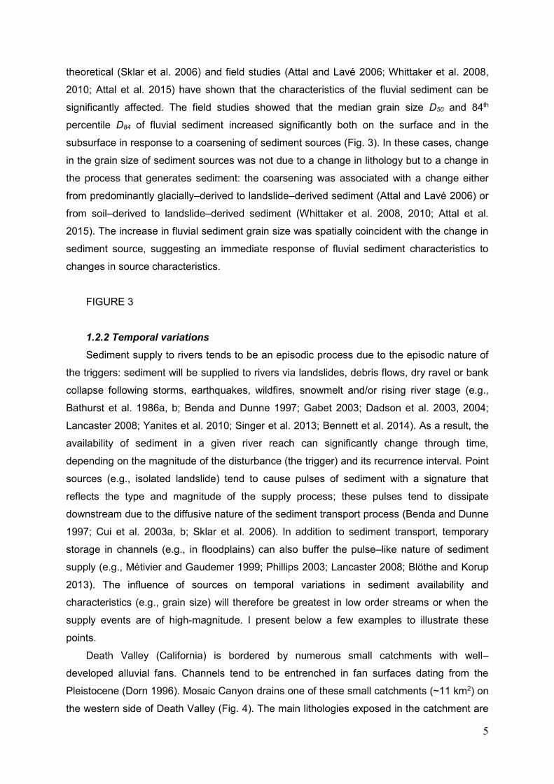
theoretical (Sklar et al. 2006) and field studies (Attal and Lavé 2006; Whittaker et al. 2008,
2010; Attal et al. 2015) have shown that the characteristics of the fluvial sediment can be
significantly affected. The field studies showed that the median grain size D50 and 84th
percentile D84 of fluvial sediment increased significantly both on the surface and in the
subsurface in response to a coarsening of sediment sources (Fig. 3). In these cases, change
in the grain size of sediment sources was not due to a change in lithology but to a change in
the process that generates sediment: the coarsening was associated with a change either
from predominantly glacially–derived to landslide–derived sediment (Attal and Lavé 2006) or
from soil–derived to landslide–derived sediment (Whittaker et al. 2008, 2010; Attal et al.
2015). The increase in fluvial sediment grain size was spatially coincident with the change in
sediment source, suggesting an immediate response of fluvial sediment characteristics to
changes in source characteristics.
FIGURE 3
1.2.2 Temporal variations
Sediment supply to rivers tends to be an episodic process due to the episodic nature of
the triggers: sediment will be supplied to rivers via landslides, debris flows, dry ravel or bank
collapse following storms, earthquakes, wildfires, snowmelt and/or rising river stage (e.g.,
Bathurst et al. 1986a, b; Benda and Dunne 1997; Gabet 2003; Dadson et al. 2003, 2004;
Lancaster 2008; Yanites et al. 2010; Singer et al. 2013; Bennett et al. 2014). As a result, the
availability of sediment in a given river reach can significantly change through time,
depending on the magnitude of the disturbance (the trigger) and its recurrence interval. Point
sources (e.g., isolated landslide) tend to cause pulses of sediment with a signature that
reflects the type and magnitude of the supply process; these pulses tend to dissipate
downstream due to the diffusive nature of the sediment transport process (Benda and Dunne
1997; Cui et al. 2003a, b; Sklar et al. 2006). In addition to sediment transport, temporary
storage in channels (e.g., in floodplains) can also buffer the pulse–like nature of sediment
supply (e.g., Métivier and Gaudemer 1999; Phillips 2003; Lancaster 2008; Blöthe and Korup
2013). The influence of sources on temporal variations in sediment availability and
characteristics (e.g., grain size) will therefore be greatest in low order streams or when the
supply events are of high-magnitude. I present below a few examples to illustrate these
points.
Death Valley (California) is bordered by numerous small catchments with well–
developed alluvial fans. Channels tend to be entrenched in fan surfaces dating from the
Pleistocene (Dorn 1996). Mosaic Canyon drains one of these small catchments (~11 km2) on
the western side of Death Valley (Fig. 4). The main lithologies exposed in the catchment are
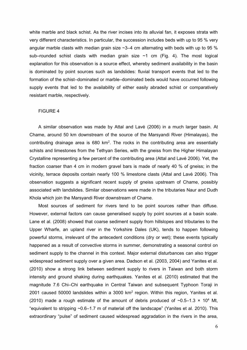
6
white marble and black schist. As the river incises into its alluvial fan, it exposes strata with
very different characteristics. In particular, the succession includes beds with up to 95 % very
angular marble clasts with median grain size ~3–4 cm alternating with beds with up to 95 %
sub–rounded schist clasts with median grain size ~1 cm (Fig. 4). The most logical
explanation for this observation is a source effect, whereby sediment availability in the basin
is dominated by point sources such as landslides: fluvial transport events that led to the
formation of the schist–dominated or marble–dominated beds would have occurred following
supply events that led to the availability of either easily abraded schist or comparatively
resistant marble, respectively.
FIGURE 4
A similar observation was made by Attal and Lavé (2006) in a much larger basin. At
Chame, around 50 km downstream of the source of the Marsyandi River (Himalayas), the
contributing drainage area is 680 km2. The rocks in the contributing area are essentially
schists and limestones from the Tethyan Series, with the gneiss from the Higher Himalayan
Crystalline representing a few percent of the contributing area (Attal and Lavé 2006). Yet, the
fraction coarser than 4 cm in modern gravel bars is made of nearly 40 % of gneiss; in the
vicinity, terrace deposits contain nearly 100 % limestone clasts (Attal and Lavé 2006). This
observation suggests a significant recent supply of gneiss upstream of Chame, possibly
associated with landslides. Similar observations were made in the tributaries Naur and Dudh
Khola which join the Marsyandi River downstream of Chame.
Most sources of sediment for rivers tend to be point sources rather than diffuse.
However, external factors can cause generalised supply by point sources at a basin scale.
Lane et al. (2008) showed that coarse sediment supply from hillslopes and tributaries to the
Upper Wharfe, an upland river in the Yorkshire Dales (UK), tends to happen following
powerful storms, irrelevant of the antecedent conditions (dry or wet); these events typically
happened as a result of convective storms in summer, demonstrating a seasonal control on
sediment supply to the channel in this context. Major external disturbances can also trigger
widespread sediment supply over a given area. Dadson et al. (2003, 2004) and Yanites et al.
(2010) show a strong link between sediment supply to rivers in Taiwan and both storm
intensity and ground shaking during earthquakes. Yanites et al. (2010) estimated that the
magnitude 7.6 Chi–Chi earthquake in Central Taiwan and subsequent Typhoon Toraji in
2001 caused 50000 landslides within a 3000 km2 region. Within this region, Yanites et al.
(2010) made a rough estimate of the amount of debris produced of ~0.5–1.3 × 10⁴ Mt,
“equivalent to stripping ~0.6–1.7 m of material off the landscape” (Yanites et al. 2010). This
extraordinary “pulse” of sediment caused widespread aggradation in the rivers in the area,
7
with up to 18 m vertical aggradation in places. On a larger scale, Pratt–Sitaula et al. (2004)
document widespread aggradation in excess of 100 m in the Marsyandi Valley, Himalayas.
They date two aggradation phases at 50–35 ky and ~8 ky BP, that they interpret as resulting
from monsoon intensification. The shift to wetter conditions would have caused widespread
hillslope destabilisation, supplying a considerable amount of sediment that takes thousands
of year to be evacuated.
1.3 Influence of varying sediment availability on sediment transport and export during
floods
In section 2, I reviewed evidence for the influence of sources on the availability and
characteristics (grain size, amount, lithological content) of sediment in mountain rivers. In this
section, I discuss the influence of spatial and temporal variations in sediment availability and
characteristics on sediment transport during flood events of varied magnitude, including
extreme events.
1.3.1 Geomorphic work as a result of the interplay between flood magnitude and
sediment supply
Because sediment availability can be limited in mixed bedrock–alluvial mountain rivers,
the largest floods are not necessarily associated with the greatest amount of sediment
transported. Instead, floods of different magnitudes will do different type of geomorphic work
depending on whether sediment is readily available and whether threshold for entrainment is
overcome (Bathurst et al. 1986a, b; Costa and O’Connor 1995; Wohl 2008; Yager et al.
2012; Bennett et al. 2014). Lane et al. (2008) observed for example a dichotomy in the
effects of short–lived, high intensity storm events and longer–lived, moderate storm events
on sediment dynamics in the Upper Wharfe catchment (Yorkshire Dales, UK). They found
that sediment supply to tributaries and main channel tends to occur as a result of short
periods of intense rainfall, typically in summer. During such events, they documented limited
sediment transport in the main channel that they link to the short duration of the events;
sediment transport in the main channel was essentially happening in winter, following
moderate events that were able to sustain sediment transport for longer.
In mountain rivers, sediment aggradation can lead to the development of alluvial
planform patterns (such as braiding or meandering) within a system constrained by bedrock.
This “alluvial overprint” (Carling 2009; Meshkova and Carling 2012; Meshkova et al. 2012;
Turowski et al. 2013) can influence sediment dynamics in response to floods of different
magnitude. Turowski et al. (2013) document two contrasted behaviour that they call “flood–
depositing” and “flood–cleaning”, which may be conceptualised by a model in which

8
sediment supply to a given reach Qs is a power function of water discharge Q (Turowski
2012):
Qs = cQλ (1),
where c and λ are constants. The “flood-depositing” case corresponds to λ > 1; in this
case, low–frequency high–magnitude floods supply more sediment than they can evacuate,
leading to significant sediment deposition within the reach in question. Sediment is
subsequently progressively evacuated through time during small and moderate floods. In the
“flood-cleaning” case (λ < 1), sediment progressively builds up in the channel following high–
frequency low–magnitude events; an extreme event then flushes a significant part or all of
the sediment out of the reach. Turowski et al. (2013) review evidence from the literature and
report that both behaviours are observed in both bedrock and alluvial rivers. They also show
that the dominant behaviour can change spatially and potentially in time within a single basin,
with some large basins (Clyde River, Australia (Nanson 1986) and Sabie River, South Africa
(Heritage et al. 2004)) exhibiting alternating flood–cleaning and flood–depositing reaches. In
fact, they link the two behaviours to channel–hillslope coupling, inferring that sediment must
be supplied from hillslopes during aggrading phases, that is, during high-magnitude events in
flood–depositing streams and during small and moderate floods in flood–cleaning streams.
The relative timing of floods and sediment supply to the channel is therefore crucial in
controlling the amount of sediment transported in a given reach and exported from a basin
during floods of varying magnitudes (Bathurst et al. 1986a, b).
It is notable that following major disturbances such as the ones documented in Taiwan
(Dadson et al. 2003, 2004; Yanites et al. 2010) or along the Marsyandi River in the
Himalayas (Pratt–Sitaula et al. 2004) (section 2.2), sediment availability will not limit
sediment transport even for extreme events for a significant amount of time, due to the
colossal nature of vertical sediment aggradation within the valleys, from tens to in excess of
a hundred meters. Pratt–Sitaula et al. (2004) and Yanites et al. (2010) estimate the time for
evacuation of sediment to be in the order of hundreds to thousands of years. During this
period, rivers are likely to be “at capacity” during floods, the main constraint on sediment
entrainment being the need to overcome the threshold for incipient sediment motion. These
basin–scale alluviation events are typically associated with generalised slope instability and
landsliding (Dadson et al. 2003, 2004; Pratt–Sitaula et al. 2004; Yanites et al. 2010), leading
to a wide range of sediment grain sizes being supplied to the river, up to boulders a few
meters in size (Attal and Lavé 2006; Whittaker et al. 2008, 2010; Attal et al. 2015) that may
be mobilised only during the most extreme events. The coarseness of sediment present in
the channel may therefore act as the main inhibitor of sediment transport (e.g., Wohl 1992;
Jansen 2006), which will be discussed in the following section. The generalised
destabilisation of hillslopes may temporarily exhaust the sources of sediment; regeneration of
9
sediment on hillslopes (e.g., soil development) would be possible during the hundreds to
thousands of years that the river will need to evacuate the valley fill.
1.3.2 Grain size and sediment mobility: the boulder issue
As mentioned in section 2 (Fig. 1), the maximum grain size of the sediment entrained
during a flood will be limited either by the grain size of the sediment available for transport (if
sediment available is relatively fine–grained with respect to flow competence) or by flow
competence (if a wide range of grain sizes is available, up to boulder size). The coarseness
of the sediment supplied to rivers can therefore exert an important control on the grain size of
the sediment transported during a given flood: a very powerful flood will not be able to
transport coarse sediment if no coarse sediment is available for transport. Such a situation
may arise in low relief, soil–mantled landscapes (Fig. 3b, c, e) (Whittaker et al. 2008, 2010;
Attal et al. 2015) or where large amounts of sediment lacking large clasts is available within a
catchment (e.g., badlands or conglomeratic bedrock, e.g., Mather and Hartley (2005)). In
other types of mountainous landscapes, sediment available for transport is likely to include
large clasts up to boulder size supplied by landslides, debris flows or rock falls, or left behind
by glaciers (e.g., Chatanantavet et al. 2010; Attal et al. 2015).
In mountain rivers, boulders can contribute to the development of bedforms that tend to
limit the mobility of the sediment as a whole. Many studies have documented the formation of
step-pool morphology in the presence of boulders, in particular where the size of bed
materials is large relative to the channel size (see reviews on the topic by Chin and Wohl
2005; Church and Zimmermann 2007; Comiti and Mao 2012). The formation of steps is
associated with the largest clasts acting as anchor points against which other clasts become
imbricated and stop moving. The steps are therefore made of a variety of clast sizes, with the
boulders acting as keystones. Moderate floods tend to maintain this morphology by
contributing to the scouring of the pools upstream of steps, whereas high-magnitude low-
frequency events are able to destroy the steps and mobilise the sediment “frozen” in the
steps and between them (e.g., Gintz et al. 1996; Lenzi et al. 2004, 2006; Church and
Zimmermann 2007; Wohl 2008; Turowski et al. 2009, 2013; Morche and Schmidt 2012;
Yager et al. 2012). In the case of isolated boulders, a series of approaches have been
proposed to estimate the magnitude of the flood capable of setting a clast of a given size in
motion (e.g., Clarke 1996; Carling and Tinkler 1998; Carling et al. 2002a, b; Stokes et al.
2012). The different methods have been shown to produce significantly different results (see
discussion in Stokes et al. 2012) but they can be used nevertheless to give a rough estimate
of the flow depth required to mobilise a boulder of a given size. Using the equation described
in Stokes et al. (2012) with the same values of fluid and boulder density and the same values
of lift, drag and sliding coefficients, the following flow depths for incipient motion were found:
10
in a channel with a slope ranging between 0.1 and 0.01 (which is typical of mountain rivers),
the flood that would entrain 0.5 and 1 m diameter boulders would have a minimum depth
ranging between 0.9 and 1.8 and between 1.5 and 3.0 m, respectively. Abundant and/or
large boulders may therefore be considered as a potentially significant hindrance to sediment
entrainment during floods (e.g., Wohl 1992; Yager et al. 2007), in particular in the least steep
reaches of mountain rivers.
Beyond the bedform scale, a few studies have provided evidence for the influence of
boulders on channel geometry, that were linked to reduced sediment mobility and bed
armouring. Howard et al. (1994) argue that boulders sourced locally from the walls of the
Grand Canyon (Colorado) reduce alluvium mobility and therefore river incision, causing a
negative feedback: rapid incision generates deep narrow gorges from the walls of which
boulders will be produced, which will then inhibit river incision. Brocard and van der Beek
(2006) and Johnson et al. (2009) both document significant channel steepening in response
to local supply of boulders along actively incising rivers. Johnson et al. (2009) document
differences in the geometry of channels incising into similar sandstones in the Henry
Mountains (Utah): channels that have abundant large diorite clasts (cobbles, boulders)
sourced from localised exposures in the headwaters are less incised and steeper than
channels with no diorite clasts. They propose that the cover effect provided by the not very
mobile coarse sediment inhibits incision and that the steepening would represent a long–
term response of the channel to transport the sediment load (evidence for the transport of the
diorite clasts exist in the form of imbrication and boulder jams). Brocard and van der Beek
(2006) show that the local supply of large boulders from limestone cliffs causes a steepening
of rivers incising into marls in the Western Alps (SE France) (their Fig. 5). They argue that
the boulders are too large to be transported by the river and that the armouring caused by
abundant boulders would effectively be equivalent to limestone bedrock. Clarke and Hansen
(1996) made similar observation of “extremely stable boulders” that are unlikely to be
entrained under the current climatic regime in small basins in an arid environment in
California (Anza Borrego Desert). This effect could literally be called “bedrock aggradation”:
the river will need to abrade or break the boulders into fragments of smaller size before
entrainment could happen and the river could incise into the underlying bedrock. As in
Johnson et al. (2009), Brocard and van der Beek interpret the local steepening as a long–
term response of the channel to provide the extra work required to deal with the boulders.
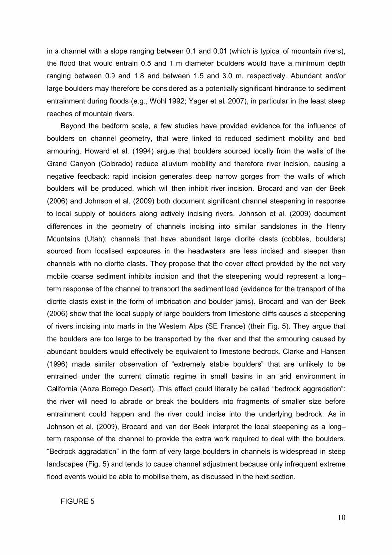
“Bedrock aggradation” in the form of very large boulders in channels is widespread in steep
landscapes (Fig. 5) and tends to cause channel adjustment because only infrequent extreme
flood events would be able to mobilise them, as discussed in the next section.
FIGURE 5
11
1.3.3 Sediment transport during extreme flood events
Extreme floods are exceptional events with recurrence intervals typically exceeding a
century, that are capable of transporting very coarse sediment in colossal quantities, cause
significant bedrock erosion and therefore produce major landscape change (e.g., Baker
1978; Wohl 1992; Baker and Kale 1998; Montgomery et al. 2004; Gupta et al. 2007; Garcia–
Castellanos et al. 2009; Warner et al. 2010; Baynes et al. 2015). Such events can be caused
by powerful storms or typhoons, landslide dam break, glacial lake outburst or subglacial
volcanic eruptions; whereas some of these causes will be restricted to some area (e.g.,
subglacial volcanic eruptions), others will be common over geological time scales in
mountainous landscapes (e.g., landslide dam breaks).
Extreme events may have the ability of mobilising the entire grain population, leading to
full mobility even in the presence of very large boulders. Evidence for transport of boulders
up to a few meters in size during extreme floods abounds in the literature (e.g., Williams
1983; Beaty 1989; Baker and Kale 1998; Wohl 1992; Carrivick et al. 2004; Mather and
Hartley 2005; Lamb et al. 2008; Carling et al. 2009, 2013; Marren et al. 2009; Russell et al.
2010; Stokes et al. 2012), although hyperconcentrated or debris-flow processes rather than
fluvial processes may have been involved in some of these cases (e.g., Mather and Hartley
2005). Extreme floods therefore play a crucial role in transporting sediment that could be
considered stable over centennial to millennial time scales, due to their coarseness and/or
the development of resistant bedforms such as armoured layers or pools and riffles (e.g.;
Wohl 1992, 2008; Lisle and Church 2002; Jansen 2006; Yager et al. 2007; Turowski et al.
2009, 2013; Baggs Sargood et al. 2015). The size of the largest clasts transported during
such events may be limited by the coarseness of sediment available for transport (Mather
and Hartley 2005).
In terms of sediment flux, such extreme events are likely to result in net sediment export
from the mountain area to areas downstream where transport capacity is significantly
reduced, typically as a result of slope reduction and/or channel/valley widening (e.g.,
sedimentary basin, Fig., 2) (e.g., Carling 2013). At the reach scale, the flood will not
necessarily have a “cleansing” effect in the mountainous reaches in the sense that bedrock
will not necessarily be subsequently exposed. Figure 6 schematically represents different
scenarios based on the initial amount of sediment present in the channel and whether the
reach considered behaves in a “flood–depositing” or “flood–cleaning” way (Turowski et al.
2013). The volume of sediment exported from the reach will be limited by transport capacity if
considerable amounts of sediment are present in the channel before the flood (e.g., following
a phase of generalised aggradation – Fig. 6a) (e.g., Pratt–Sitaula et al. 2004) and/or if the
reach is behaving in a flood–depositing way (Fig. 6). Turowski et al. (2013) give examples of
12
flood–depositing reaches where low–frequency high–magnitude floods lead to aggradation,
which they interpret as a result of synchronous excess sediment supply from hillslopes; the
Taiwan example discussed in previous sections exemplifies this behaviour. Note that in this
discussion I focus on the net effect of given flood: it is interesting to note that during an
event, a flood may be depositing at low discharge, eroding at high discharge, and depositing
again at low discharge. Whether this results in net aggradation or erosion depends on the
dependence of the transport capacity on discharge, sediment availability and the shape of
the hydrograph (e.g., Rickenmann 1997).
FIGURE 6
Sediment flux will be limited by sediment availability if the reach is behaving in a flood–
cleaning way and the initial volume of sediment in the channel is limited (Fig. 6b, c). In such
situations, the extreme flood will have a cleansing effect, flushing out sediment and exposing
bedrock (see example in Fig. 7) (e.g., Wohl 1992; Jansen 2006; Turowski et al. 2013; Baggs
Sargood et al. 2015). Subsequent floods of any magnitude are likely to have limited sediment
flux for the time needed to replenish the stock of sediment available for transport within the
channel. The time between floods is therefore crucial in controlling the geomorphic response
and amount of sediment that will be exported by a flood of a given magnitude (Harvey 1984;
Cenderelli and Wohl 2003; Wohl 2008). Regarding extreme floods, the effect of this
“replenishment time” may be considerable both for the amount and type of sediment that will
be exported from a catchment, due to the fact that extreme flood events can also lead to
significant bedrock erosion. I present a simple model in Figure 8 that illustrates the potential
effect of sediment exhaustion and recurrence time of extreme floods on the flux and type of
sediment exported. The model describes the origin and volume of sediment exported from a
given river section during extreme events as a function of the time between events (relative
to the time needed for sediment replenishment in the channel). The model stresses that
sediment exported during two extreme events of similar magnitude may represent very
different volumes and include very different proportions of material sourced from bedrock,
depending on the time between events, bedrock resistance to erosion and the necessity for
tools to detach bedrock. As a result, the two events of similar magnitude may export
sediment with very contrasted characteristics (volume, lithological content, roundness of
clasts, grain size distribution), with bedrock constituting a local source of likely angular
sediment lacking fines (< sand size). This behaviour exemplifies the need to understand the
internal dynamics of river basins before interpreting changes in sedimentary successions in
terms of tectonics or climatic signals, as autogenic processes and bed reorganisation can
13
lead to the shredding of environmental signals (e.g., van de Wiel and Coulthard 2010;
Jerolmack and Paola 2010).
FIGURE 7
FIGURE 8
Hartshorn et al. (2002) document a possible feedback mechanism between extreme
events and sediment replenishment. They show that an extreme flood event along the Liwu
River in Taiwan during the powerful typhoon Billis in 2000 (maximum flow depth = 12 m)
caused considerable bedrock erosion. However, erosion peaked on the banks of the
channel, a few meters above the mean low–flow level. They concluded that in the studied
channel, bed lowering is driven by moderate flood events whereas extreme events tend to
widen the channel and therefore transmit the erosion signal to the hillslopes. The
undercutting of the hillslopes by an extreme flood may cause widespread destabilisation and
generalised mass movement and therefore increased sediment supply and replenishment to
the channel (see also Hovius and Stark 2006; Turowski et al. 2008b; Turowski 2012).
Morche and Schmidt (2012) provide evidence for such an effect: following a landslide dam
break along the Partnach River (Bavarian Alps), field observations and monitoring of water
and sediment transport along the river show a sustained increase in the bedload contribution,
that the authors interpret as partly resulting from the re–coupling of the channel with
hillslopes downstream of the dam. They observed that the outburst flood cut the feet of
several talus cones and measured elevated transport rates, in particular for bedload, that
were sustained for four years after the event (see also Gintz et al. 1996; Lenzi et al. 2004;
Turowski et al. 2009).
An extreme flood is likely to cause considerable sediment transport and therefore
considerable sediment deposition at the end of the flood (e.g., Carling 2013). Sediment will
be deposited where the flow loses power, for example where the valley widens such as at
the transition from the confined channel to the sedimentary basin (Fig. 2) or at the coast
(e.g., Russell et al. 2010). Widespread deposition will also happen at the end of the flood. At
a local scale, flow constrictions, valley widening, slope reduction, plunge pools at cataracts
and bends may reduce stream power (e.g., backwater effect) and cause sediment
deposition, even within the mountainous realm (e.g., Wohl 1992; Meshkova and Carling
2012). The extreme event may have opposing effects on the mobility of in–channel sediment
for subsequent, potentially smaller floods. Mobility may be increased through the destruction
of resistant bedforms and displacement or removal of boulders (Lenzi et al. 2004, 2006;
Wohl 2008; Turowski et al. 2009, 2013; Morche and Schmidt 2012); for example, Lenzi et al.
(2004) document increased bedload transport for floods of a given magnitude following a
14
large flood in an Alpine catchment. However, the event may also result in the formation of
boulder bars that will be stable until the next extreme event or until the blocks are reduced in
size by abrasion (e.g., Wohl 1992; Jansen 2006; Baggs Sargood et al. 2015).
1.4 Concluding remarks
In mountain rivers, the amount and grain size of sediment transported by a flood of a
given magnitude depend on flow competence and transport capacity but also on the
characteristics of the sediment available for transport. The latter vary in space and time due
to the episodic nature of the sediment supply processes and to variations in the nature of the
sources (e.g., glacigenic sediment, soil or landslide; lithology of source rock). Change in the
nature of sources can be driven by tectonics and climate through landscape steepness, the
impact of glaciation and deglaciation, precipitation and storm intensity and/or the stabilising
effect of vegetation. A spatial or temporal change in tectonics or climate may therefore
influence the type and amount of sediment supplied to mountain rivers, which should be
reflected in the characteristics of the sediment transported by rivers and exported to
sedimentary basins.
In steep landscapes, boulders up to a few meters in size are commonly supplied to
channels and can inhibit sediment transport and bedrock erosion when abundant. Extreme
flood events are crucial in mobilising the whole grain population, including boulders that can
be considered stable over centennial to millennial time scales. Extreme floods can have
either a depositing or a cleaning effect (Turowski et al. 2013): the former occurs when
substantial amount of excess sediment are supplied simultaneously to the event, leading to
net aggradation; in the latter, the flood may flush all sediment available out of a given reach,
leading to bedrock exposure and a sediment flux limited by sediment availability. The nature
of the sediment exported from a reach or basin during extreme events will also depend on
the time between events and on the time needed for in–channel sediment replenishment.
Because extreme events can flush sediment out of a reach, transport (and deposit) large
boulders and erode bedrock, they can have a long–lasting legacy on sediment storage and
mobility in a given reach. These observations stress the need for integrating the sources of
sediment and the episodic processes that lead to sediment supply to channels and sediment
transport in channels when modelling sediment dynamics or bedrock erosion in mountain
catchments, or the development of stratigraphy in sedimentary basins (Walling 1983; Yager
et al. 2012; Turowski et al. 2013; Bennett et al. 2014).
1.5 Acknowledgements
15
I am very grateful to Jens Turowski and Paul Carling for constructive comments that
helped improve the manuscript.
1.6 References
Attal, M & Lavé, J 2006, ‘Changes of bedload characteristics along the Marsyandi River
(central Nepal): Implications for understanding hillslope sediment supply, sediment load
evolution along fluvial networks, and denudation in active orogenic belts’, Geological
Society of America Special Paper 398, 143–171, doi: 10.1130/2006.2398(09).
Attal, M & Lavé, J 2009, ‘Pebble abrasion during fluvial transport: Experimental results and
implications for the evolution of the sediment load along rivers’, Journal of Geophysical
Research, 114, F04023, doi:10.1029/2009JF001328.
Attal, M, Mudd, SM, Hurst, MD, Weinmann, B, Yoo, K & Naylor, M 2015, ‘Impact of change in
erosion rate and landscape steepness on hillslope and fluvial sediments grain size in the
Feather River basin (Sierra Nevada, California)’, Earth Surface Dynamics, 3, 201-222,
doi:10.5194/esurf-3-201-2015.
Baggs Sargood, M, Cohen, TJ, Thompson, CJ & Croke, J 2015, ‘Hitting rock bottom:
morphological responses of bedrock–confined streams to a catastrophic flood’, Earth
Surface Dynamics, 3, 265-279, doi:10.5194/esurf–3–265–2015.
Baker, VR 1978, ‘Large–scale erosional and depositional features of the Channeled
Scabland’, In: Baker, VR & Nummedal, D (Eds), The Channeled Scabland, NASA,
Washington, DC, pp. 81–115.
Baker, VR & Kale, VS 1998, ‘The role of extreme floods in shaping bedrock channels’, In:
Tinkler, KJ & Wohl, EE (Eds), Rivers Over Rock: Fluvial Processes in Bedrock
Channels, American Geophysical Union Press, Washington, DC, pp. 153–165,
Geophysical Monograph 107.
Bathurst, JC, Leeks, GJL & Newson, MD 1986a, ‘Field measurements for hydraulic and
geomorphological studies of sediment transport-the special problems of mountain
streams’, In: Wessels, ACE (Ed.), Measuring Techniques in Hydraulic Research, AA
Balkema, Rotterdam, Netherlands, pp. 137-151.
Bathurst, JC, Leeks, GJL & Newson, MD 1986b, ‘Relationship between sediment supply and
sediment transport for the Roaring River, Colorado, USA’, In: Hadley, RF (Ed.), Drainage
Basin Sediment Delivery, IAHS Publ. 159, Centre for Ecology and Hydrology,
Wallingford, UK, pp. 105-117.
Baynes, ERC, Attal, M, Niedermann, S, Kirstein, LA, Dugmore, AJ & Naylor, M 2015,
‘Erosion during extreme flood events dominates Holocene canyon evolution in North–
East Iceland’, Proceedings of the National Academy of Sciences, 112, 8, 2355–2360,
doi: 10.1073/pnas.1415443112.
16
Beaty, CB 1989, ‘Great Big Boulders I have known’, Geology, 17, 349-352, doi:
10.1130/0091-7613(1989)017<0349:GBBIHK>2.3.CO;2.
Benda, L & Dunne, T 1997, ‘Stochastic forcing of sediment supply to channel networks from
landsliding and debris flow’, Water Resources Research, 33 (12), 2849–2863.
Bennett, GL, Molnar, P, McArdell, BW & Burlando, P 2014, ‘A probabilistic sediment cascade
model of sediment transfer in the Illgraben’, Water Resources Research, 50,
doi:10.1002/2013WR013806.
Blöthe, JH & Korup, O 2013, ‘Millennial lag times in the Himalayan sediment routing system’,
Earth and Planetary Science Letters, 382, 38–46, doi:10.1016/j.epsl.2013.08.044.
Brocard, GY & van der Beek, PA 2006, ‘Influence of incision rate, rock strength, and bedload
supply on bedrock river gradients and valley–flat widths: Field–based evidence and
calibrations from western Alpine rivers (southeast France)’, Geological Society of
America Special Paper 398, 101–126, doi: 10.1130/2006.2398(07).
Buffington, JM & Montgomery, DR 1997, ‘A systematic analysis of eight decades of incipient
motion studies, with special reference to gravel–bedded rivers’, Water Resources
Research, 33, 1993–2029.
Burbank, DW, Leland, J, Fielding, E, Anderson, RS, Brozovic, N, Reid, MR & Duncan, C
1996, ‘Bedrock incision, rock uplift and threshold hillslopes in the northwestern
Himalayas’, Nature, 379, 505–510.
Carling, PA & Tinkler, KJ 1998, ‘Conditions for entrainment of cuboid boulders in bedrock
streams: An historical review of literature with respect to recent investigations’, In:
Tinkler, KJ & Wohl, EE (Eds), Rivers Over Rock: Fluvial Processes in Bedrock
Channels, American Geophysical Union Press, Washington, DC, pp. 19–34,
Geophysical Monograph 107.
Carling, PA, Hoffmann, M & Blatter, AS 2002a, ‘Initial Motion of Boulders in Bedrock
Channels’, In: House, PK, Webb, RH, Baker, VR & Levish, DR (Eds), Ancient Floods,
Modern Hazards, American Geophysical Union, Washington, D.C., pp. 147-160, doi:
10.1029/WS005p0147Carling.
Carling, PA, Hoffmann, M, Blatter, AS & Dittrich, A 2002b, ‘Drag of emergent and submerged
regular obstacles in turbulent flow above bedrock surface’, In: Schleiss, AJ & Bollaert, E
(Eds), Rock Scour due to Falling High-Velocity Jets, Swets and Zeitlinger/Balkema,
Lausanne, pp. 83-94.
Carling, PA 2009, ‘Geomorphology and sedimentology of the Lower Mekong River’, In:
Campbell, IC (Ed.), The Mekong: Biophysical Environment of an International River
Basin, Academic Press, New York, chapter 5, pp. 77–111.
Carling, PA, Herget, J, Lanz, JK, Richardson, K & Pacifici, A 2009, ‘Channel–scale erosional
bedforms in bedrock and in loose granular material: character, processes and
17
implications’, In: Burr, DM, Carling, PA & Baker, VR (Eds), Megaflooding on Earth and
Mars, Cambridge University Press, Cambridge, pp. 13–32.
Carling, PA 2013, ‘Freshwater megaflood sedimentation: What can we learn about generic
processes?’, Earth Science Reviews, 125, 87–113, doi:10.1016/j.earscirev.2013.06.002.
Carrivick, JL, Russell, AJ & Tweed, FS 2004, ‘Geomorphological evidence for jökulhlaups
from Kverkfjöll volcano, Iceland’, Geomorphology, 63, 81–102.
Cenderelli, DA & Wohl, EE 2003, ‘Flow hydraulics and geomorphic effects of glacial–lake
outburst floods in the Mount Everest region, Nepal’, Earth Surface Processes and
Landforms, 28, 385–407.
Chatanantavet, P, Lajeunesse, E, Parker, G, Malverti, L & Meunier P 2010, ‘Physically based
model of downstream fining in bedrock streams with lateral input’, Water Resources
Research, 46, W02518, doi:10.1029/2008WR007208.
Chin, A & Wohl, E 2005, ‘Towards a theory for step pools in stream channels’, Progress in
Physical Geography, 29, 275–296, doi: 10.1191/0309133305pp449ra.
Church, M & Zimmermann, A 2007, ‘Form and stability of step-pool channels: research
progress’, Water Resources Research, 43, doi:10.1029/2006WR005037.
Clarke, AO 1996, ‘Estimating probable maximum floods in the Upper Santa Ana Basin,
Southern California, from stream boulder size’, Environmental and Engineering
Geoscience, 2, 165–182.
Clarke, AO & Hansen, CL 1996, ‘The Recurrence of Large Boulder Movement in Small
Watersheds of the Anza Borrego Desert, California’, Yearbook of the Association of
Pacific Coast Geographers, 58, 28–61, DOI: 10.1353/pcg.1996.0007.
Comiti, F & Mao, L 2012, ‘Recent advances in the dynamics of steep channels’, In: Church,
M, Biron, P & Roy, A (Eds), Gravel Bed Rivers: Processes, Tools, Environments, John
Wiley & Sons, Chichester, pp. 353–374, doi: 10.1002/9781119952497.ch26.
Costa, JE & O’Connor, JE 1995, ‘Geomorphically effective floods’, In: Costa, JE, Miller, AJ,
Potter, KW & Wilcock, PR (Eds), Natural and Anthropogenic Influences in Fluvial
Geomorphology, American Geophysical Union Press, Washington, DC, pp. 45–56,
Geophysical Monograph 89.
Cui, Y, Parker, G, Lisle, TE, Gott, J, Hansler–Ball, ME, Pizzuto, JE, Allmendinger, NE &
Reed, JM 2003a, ‘Sediment pulses in mountain rivers: 1. Experiments’, Water
Resources Research, 39 (9), 1239, doi:10.1029/2002WR001803.
Cui, Y, Parker, G, Pizzuto, J & Lisle, TE 2003b, ‘Sediment pulses in mountain rivers: 2.
Comparison between experiments and numerical predictions’, Water Resources
Research, 39 (9), 1240, doi:10.1029/2002WR001805.
18
Dadson, SJ, Hovius, N, Chen, HG, Dade, WB, Hsieh, ML, Willett, SD, Hu, JC, Horng, MJ,
Chen, MC, Stark, CP, Lague, D & Lin, JC 2003, ‘Links between erosion, runoff variability
and seismicity in the Taiwan orogen’, Nature, 426, 648–651, doi: 10.1038/nature02150.
Dadson, SJ, Hovius, N, Chen, H, Dade, WB, Lin, JC, Hsu, ML, Lin, CW, Horng, MJ, Chen,
TC, Milliman, J & Stark, CP 2004, ‘Earthquake–triggered increase in sediment delivery
from an active mountain belt’, Geology, 32, 733–736, doi: 10.1130/G20639.1.
Dorn, RI 1996, ‘Climatic hypotheses of alluvial–fan evolution in Death Valley are not
testable’, In: Rhoads, BL & Thorn CE (Eds), The Scientific Nature of Geomorphology,
Wiley, Chichester, pp. 191–220.
Fedele, JJ & Paola, C 2007, ‘Similarity solutions for fluvial sediment fining by selective
deposition’, Journal of Geophysical Research, 112, F02038, doi:10.1029/2005JF000409.
Gabet, EJ 2003, ‘Sediment transport by dry ravel’, Journal of Geophysical Research,
108(B1), 2049, doi:10.1029/2001JB001686.
Garcia–Castellanos, D, Estrada, F, Jimenez–Munt, I, Gorini, C, Fernandez, M, Verges, J &
De Vicente, R 2009, ‘Catastrophic flood of the Mediterranean after the Messinian salinity
crisis’, Nature, 462, 778–781, doi:10.1038/nature08555.
Gintz, D, Hassan, MA & Schmidt, K-H 1996, ‘Frequency and magnitude of bedload transport
in a mountain river’, Earth Surface Processes and Landforms, 21, 433–445, doi:
10.1002/(SICI)1096-9837(199605)21:5<433::AID-ESP580>3.0.CO;2-P.
Gupta, S, Collier, JS, Palmer–Felgate, A & Potter, G 2007, ‘Catastrophic flooding origin of
shelf valley systems in the English Channel’, Nature, 448, 342–345,
doi:10.1038/nature06018.
Hartshorn, K, Hovius, N, Dade, WB & Slingerland, RL 2002, ‘Climate–driven bedrock incision
in an active mountain belt’, Science, 297, 2036–2038, doi:10.1126/science.1075078.
Harvey, AM 1984, ‘Geomorphological response to an extreme flood: A case from southeast
Spain’, Earth Surface Processes and Landforms, 9, 267–279.
Heller, PL, Beland, PE, Humphrey, NF, Konrad, SK, Lynds, RM, McMillan, ME, Valentine,
KE, Widman, YA & Furbish, DJ 2001, ‘Paradox of downstream fining and weathering–
rind formation in the lower Hoh River, Olympic Peninsula, Washington’, Geology, 29,
971–974.
Heritage, GL, Large, ARG, Moon, BP & Jewitt, G 2004, ‘Channel hydraulics and geomorphic
effects of an extreme flood event on the Sabie River, South Africa’, Catena, 58, 151–
181, DOI. 10.1016/j.catena.2004.03.004.
Hovius, N & Stark, CP 2006, ‘Landslide-driven erosion and topographic evolution of active
mountain belts’, In: Evans, SG, Scarascia Mugnozza G, Strom, A & Hermanns, RL
(Eds.), Landslides from Massive Rock Slope Failure, Springer, Dordrecht, Netherlands,
pp. 573–590.
19
Howard, AD, Dietrich, WE & Seidl, M 1994, ‘Modeling fluvial erosion on regional to
continental scales’, Journal of Geophysical Research, 99 (B7), 13,971–13,986.
Jansen, JD 2006, ‘Flood magnitude–frequency and lithologic controls on bedrock river
incision in post–orogenic terrain’, Geomorphology, 82, 39–57, doi: 10.1016/j.geomorph.
2005.08.018.
Jerolmack, DJ & Paola, C 2010, ‘Shredding of environmental signals by sediment transport’,
Geophysical Research Letters, 37, L19401, doi:10.1029/2010GL044638.
Johnson, JPL, Whipple, KX, Sklar, LS & Hanks, TC 2009, ‘Transport slopes, sediment cover,
and bedrock channel incision in the Henry Mountains, Utah’, Journal of Geophysical
Research, 114, F02014, doi:10.1029/2007JF000862.
Lamb, MP, Dietrich, WE, Aciego, SM, DePaolo, DJ & Manga, M 2008, ‘Formation of Box
Canyon, Idaho, by Megaflood: Implications for Seepage Erosion on Earth and Mars’,
Science, 320, 1067–1070, doi: 10.1126/science.1156630.
Lancaster, ST 2008, ‘Evolution of sediment accommodation space in steady state bedrock–
incising valleys subject to episodic aggradation’, Journal of Geophysical Research, 113,
F04002, doi:10.1029/2007JF000938.
Lane, SN, Reid, SC, Tayefi, V, Yu, D & Hardy, RJ 2008, ‘Reconceptualising coarse sediment
delivery problems in rivers as catchment–scale and diffuse’, Geomorphology, 98, 227–
249, DOI. 10.1016/j.geomorph.2006.12.028.
Lenzi, MA, Mao, L & Comiti, F 2004, ‘Magnitude–frequency analysis of bed load data in an
Alpine boulder bed stream’, Water Resources Research, 40, WR002961.
Lenzi, MA, Mao, L & Comiti, F 2006, ‘Effective discharge for sediment transport in a
mountain river: Computational approaches and geomorphic effectiveness’, Journal of
Hydrology, 326, 257–276, doi:10.1016/j.hydrol.2005.10.031.
Lisle, TE & Church, M 2002, ‘Sediment transport–storage relations for degrading, gravel bed
channels’, Water Resources Research, 38 (11), 1219, doi:10.1029/2001WR001086.
Marshall, JA & Sklar, LS 2012, ‘Mining soil databases for landscape-scale patterns in the
abundance and size distribution of hillslope rock fragments’, Earth Surface Processes
and Landforms, 37, 287-300, doi: 10.1002/esp.2241.
Mather, AE & Hartley, A 2005, ‘Flow events on a hyper–arid alluvial fan: Quebrada
Tambores, Salar de Atacama, northern Chile’, In: Harvey, AM, Mather, AE & Stokes, M
(Eds.), Alluvial Fans: Geomorphology, Sedimentology, Dynamics, Geological Society,
London, Special Publications, 251, 9–24.
Marren, PM, Russell, AJ & Rushmer, EL, 2009, ‘Sedimentology of a sandur formed by
multiple jökulhlaups, Kverkfjöll, Iceland’, Sedimentary Geology, 213, 77–88.
20
Meshkova, LV & Carling, P 2012, ‘The geomorphological characteristics of the Mekong River
in northern Cambodia: a mixed bedrock–alluvial multi–channel network’,
Geomorphology, 147–148, 2–17, DOI.10.1016/j.geomorph.2011.06.041.
Meshkova, LV, Carling, P & Buffin–Bélanger, T 2012, ‘Nomenclature, complexity, semi–
alluvial channels and sediment–flux–driven bedrock erosion’, In: Church, M, Biron, P &
Roy, A (Eds), Gravel Bed Rivers: Processes, Tools, Environments, John Wiley & Sons,
Chichester, chapter 31, pp. 424–431.
Métivier, F & Gaudemer, Y 1999, ‘Stability of output fluxes of large rivers in south and east
Asia during the last 2 million years: implications on floodplain processes’, Basin
Research, 11, 293–303.
Meyer–Peter, E & Müller, R 1948, ‘Formulas for bed–load transport’, in Proceedings of the
2nd Meeting of the International Association for Hydraulic Structures Research, 39–64,
Int. Assoc. Hydraul. Res., Delft, Netherlands.
Mezaki, S & Yabiku, M 1984, ‘Channel morphology of the Kali Gandaki and the Narayani
Rivers in central Nepal’, Journal of Nepal Geological Society, 4, 161–176.
Montgomery, DR, Hallet, B, Yuping, L, Finnegan, NJ, Anders, AM, Gillespie, A & Greenberg,
HM 2004, ‘Evidence for Holocene megafloods down the Tsangpo River gorge,
southeastern Tibet’, Quaternary Research, 62, 201–207,
doi:10.1016/j.yqres.2004.06.008.
Morche, D & Schmidt, K–H 2012, ‘Sediment transport in an alpine river before and after a
dambreak flood event’, Earth Surface Processes and Landforms, 37, 347–353, DOI:
10.1002/esp.2263.
Nanson, GC 1986, ‘Episodes of vertical accretion and catastrophic stripping – a model of
disequilibrium flood–plain development’, Geological Society of America Bulletin, 97,
1467–1475.
Paola, C, Parker, G, Seal, G, Sinha, R, Southard, S & Wilcock, JB 1992, ‘Downstream fining
by selective deposition in a laboratory flume’, Science, 258, 1757–1760.
Parker, G 1991, ‘Selective sorting and abrasion of river gravel. II: Applications’, Journal of
Hydraulic Engineering–ASCE, 117 (2), 150–171.
Phillips, J 2003, ‘Alluvial storage and the long–term stability of sediment yields’, Basin
Research, 15, 153–163.
Pratt–Sitaula, B, Burbank, DW, Heimsath, A & Ojha, T 2004, ‘Landscape disequilibrium on
1,000–10,000 year scales, Marsyandi River, Nepal, central Himalaya’, Geomorphology,
58, 223–241, doi: 10.1016/j.geomorph.2003.07.002.
Rickenmann, D 1997, ‘Sediment transport in Swiss torrents’, Earth Surface Processes and
Landforms, 22, 937-951, doi: 10.1002/(SICI)1096-9837(199710)22:10<937::AID-
ESP786>3.0.CO;2-R.
21
Russell, AJ, Duller, R & Mountney, NP 2010, ‘Volcanogenic jökulhlaups (glacier outburst
floods) from Mýrdalsjökull: Impacts on proglacial environments’, In: Krüger, J & Kjær, KH
(Eds), The Mýrdalsjökull Ice Cap, Iceland: Glacial Processes, Sediments and Landforms
on an Active Volcano, Elsevier, Amsterdam, Netherlands, pp. 181–207.
Singer, MB, James, LA, Aalto, R, Kilham, NE, Higson, JL & Ghoshal, S 2013, ‘Enduring
legacy of toxic fans via episodic redistribution of California gold mining debris’,
Proceedings of the National Academy of Sciences, 110 (46), 18436–18441,
doi:10.1073/pnas.1302295110.
Sklar, LS & Dietrich, WE 2001, ‚Sediment and rock strength controls on river incision into
bedrock’, Geological Society of America Bulletin, 29, 1087–1090.
Sklar, LS, Dietrich, WE, Foufoula–Georgiou, E, Lashermes, B & Bellugi, D 2006, ‘Do gravel
bed river size distributions record channel network structure?’, Water Resources
Research, 42, W06D18, doi:10.1029/2006WR005035, 2006.
Stokes, M, Griffiths, JS & Mather, A 2012, ‘Palaeoflood estimates of Pleistocene coarse
grained river terrace landforms (Río Almanzora, SE Spain)’, Geomorphology, 149–150,
11–26, doi:10.1016/j.geomorph.2012.01.007.
Turowski, JM, Lague, D & Hovius, N 2007, ‘Cover effect in bedrock abrasion: A new
derivation and its implications for the modeling of bedrock channel morphology’, Journal
of Geophysical Research, 112, F04006, doi:10.1029/2006JF000697.
Turowski, JM, Hovius, N, Wilson, A & Horng, M–J 2008a, ‘Hydraulic geometry, river
sediment and the definition of bedrock channels’, Geomorphology, 99, 26–38,
doi:10.1016/j.geomorph.2007.10.001.
Turowski, JM, Hovius, N, Hsieh, M, Lague, D & Chen, M 2008b, ‘Distribution of erosion
across bedrock channels’, Earth Surface Processes and Landforms, 33, 353-363, doi:
10.1002/esp.1559.
Turowski, JM, Yager, EW, Badoux, A, Rickenmann, D & Molnar, P 2009, ‘The impact of
exceptional events on erosion, bedload transport and channel stability in a step–pool
channel’, Earth Surface Processes and Landforms, 34, 1661–1673, DOI:
10.1002/esp.1855.
Turowski, JM 2012, ‘Semi-alluvial channels and sediment-flux-driven bedrock erosion’, In:
Church, M, Biron, P & Roy, A (Eds), Gravel Bed Rivers: Processes, Tools,
Environments, John Wiley & Sons, Chichester, pp. 401–416, DOI:
10.1002/9781119952497.ch29.
Turowski, JM, Badoux, A, Leuzinger, J & Hegglin, R 2013, ‘Large floods, alluvial overprint,
and bedrock erosion’, Earth Surface Processes and Landforms, 38 (9), 947–958, DOI:
10.1002/esp.3341.
22
Van de Wiel, MJ & Coulthard, TJ 2010, ‘Self-organized criticality in river basins: Challenging
sedimentary records of environmental change’, Geology, 38, 87-90, doi:
10.1130/G30490.1.
Walling, DE 1983, ‘The sediment delivery problem’, Journal of Hydrology, 65, 209–237.
Warner, NH, Gupta, S, Kim, J–R, Lin, S–Y & Muller, J–P 2010, ‘Retreat of a giant cataract in
a long–lived (3.7–2.6 Ga) Martian outflow channel’, Geology, 38 (9), 791–794, doi:
10.1130/G31268.1.
Whipple, KX, Hancock, GS & Anderson, RS 2000, ‘River incision into bedrock: mechanics
and relative efficacy of plucking, abrasion and cavitation’, Geological Society of America
Bulletin, 112, 490–503.
Whittaker, AC, Attal, M, Cowie, PA, Tucker, GE & Roberts, GP 2008, ‘Decoding temporal
and spatial patterns of fault uplift using transient river long profiles’, Geomorphology,
100, 506–526, doi:10.1016/j.geomorph.2008.01.018.
Whittaker, AC, Attal, M & Allen, PA 2010, ‘Characterizing the origin, nature and fate of
sediment exported from catchments perturbed by active tectonics’, Basin Research, 22,
809–828, doi:10.1111/j.1365–2117.2009.00447.x.
Wilcock, PR & McArdell, BW 1997, ‘Partial transport of a sand/gravel sediment’, Water
Resources Research, 33 (1), 235–245, doi: 10.1029/96WR02672.
Willgoose, G, Bras, RL & Rodriguez–Iturbe, J 1991, ‘A coupled channel network growth and
hillslope evolution model, 1, Theory’, Water Resources Research, 27, 1671–1684.
Williams, GP 1983, ‘Paleohydrological methods and some examples from Swedish fluvial
environments. I. Cobble and boulder deposits’, Geografiska Annaler, 65A (3–4): 227–
243.
Wohl, EE 1992, ‘Gradient irregularity in the Herbert Gorge of northeastern Australia’, Earth
Surface Processes and Landforms, 17, 69–84.
Wohl, EE 2008, ‘Review of effects of large floods in resistant–boundary channels’, In:
Habersack, HP & Massimo, R (Eds), Developments in Earth Surface Processes, pp.
181–211, doi:10.1016/S0928–2025(07)11125–1.
Wolcott, J 1988, ‘Nonfluvial control of bimodal grain–size distributions in river–bed gravels’,
Journal of Sedimentary Petrology, 58, 979–984.
Yager, EM, Dietrich, WE & Kirchner, JW 2007, ‚Calculating bed load transport in steep
boulder bed channels’, Water Resources Research, 43, W07418. DOI.
10.1029/2006WR005432.
Yager, EM, Turowski, JM, Rickenmann, D & McArdell, BW 2012, ‘Sediment supply, grain
protrusion, and bedload transport in mountain streams’, Geophysical Research Letters,
39, L10402, doi: 10.1029/2012GL051654.
23
Yanites, BJ, Tucker, GE, Mueller, KJ & Chen, Y–G 2010, ‘How rivers react to large
earthquakes: Evidence from central Taiwan’, Geology, 38 (7), 639–642; doi:
10.1130/G30883.1.
Figure caption
Figure 1: Schematic illustration of the interplay between flow competence, transport
capacity, amount and grain size of sediment available for transport, and the properties of the
sediment exported from a given mixed bedrock–alluvial reach during a flood event. Grey box
at the top is a schematic representation of the amount of sediment the river can transport out
of the reach at the time considered (transport capacity – black rectangle is a size guide in all
diagrams); the maximum grain size entrained at that time is shown in the box (flow
competence). The four diagrams show the reach considered (delineated by the bold dashed
lines) in different situations. In the left diagrams, the sediment available is finer than what the
river can transport, leading to full mobility. In the right diagrams, some grains are larger than
what the river can transport (dark grains), leading to partial transport (e.g., Wilcock and
McArdell 1997). Top and bottom panels illustrate “at capacity” and “under–capacity”
scenarios, respectively, resulting from (im)balance between the amount of sediment
available for transport and transport capacity. Note that this figure is based on a very
simplistic model where the river transports all the grains that are smaller than a given size; it
ignores factors that can decrease the mobility of the sediment mixture as a whole, such as
the armouring effect, clast interlocking and/or a large proportion of large clasts (e.g., Lisle
and Church 2002).
Figure 2: Schematic depicting the fate of sediment particles from upland areas to
sedimentary basins. Note that this diagram presents a situation that typically arises in
tectonically active areas, with a sharp transition from (uplifted) mountainous area to
(subsiding) sedimentary basins; the transition will be more subdued in tectonically quiescent
areas. Upstream of the mountain front, sediment particles are progressively reduced in size
by abrasion as they are transported downstream; selective transport and deposition are
inoperative on the long–term since all sediment supplied to the river is eventually evacuated
from the mountain range; supply of fresh material from hillslopes (e.g., landslides “L”) and
tributaries all along the river course can prevent downstream fining. Downstream of the
mountain front, the depositional environment and the absence of fresh sediment supply leads
24
to downstream fining under the combined effects of selective transport and deposition and
sediment particle abrasion during fluvial transport.
Figure 3: (a), (b) and (c): fluvial sediment grain size as a function of distance downstream
along three rivers exhibiting prominent changes in source type (note change in scale on x
and y axes). (a): the increase in grain size along the Marsyandi River coincides with a
change in source type from glacial till (D50 = 6–24 mm) to landslide–derived sediment (D50 =
3–74 mm) (adapted from Attal and Lavé 2006). (b): in response to an increase in fault throw
rate, the landscape steepened upstream of the Fucino fault (Celano Gorge). Increase in
fluvial sediment grain size coincides with the transition from low–relief landscape (source of
sediment = soil) to steepened landscape (source of sediment = scree cones and landslides)
(adapted from Whittaker et al. 2010). (c): the situation in Adams Creek is very similar to (b),
except that the steepening is caused by rapid incision of the Feather River of which Adams
Creek is a tributary. Fluvial sediment coarsening is observed at the transition from low–relief
landscape (source of sediment = soil, D50 = 0.1–1.2 mm) to steepened landscape (source of
sediment = scree cones and landslides, D50 = 35–66 mm) (adapted from Attal et al. 2015).
(d), (e) and (f): pictures illustrating the different domains. (d): Marsyandi River tapping into
glacial sediment. (e): soil–mantled hillslopes in low–relief landscape in the Apennines. (f):
Steepened landscape along the Feather River, Sierra Nevada.
Figure 4: Mosaic Canyon, Death Valley, California. (a): location of Mosaic Canyon (Imagery
©2015 DigitalGlobe, Landsat, USDA Farm Service Agency, Map data ©2015 Google). (b)
and (c): Quaternary fan sedimentary succession exposed near the mouth of the catchment
following entrenchment, looking upstream and downstream, respectively. The succession
includes beds with contrasted grain size, grain angularity and lithological content. (d): detail
of two successive beds: the lower bed has around 95 % sub–rounded schist clasts with
median grain size ~1 cm, whereas the upper bed has around 95 % very angular marble
clasts with median grain size ~3–4 cm.
Figure 5: Examples of large boulder concentrations inhibiting bedrock erosion along actively
incising rivers. Where concentration of boulders a few meters in size is high, their effect may
be compared with “bedrock aggradation”. Boulders typically exhibit fluting and potholing,
testifying to their low mobility; only extreme floods may move them. (a) and (b): general view
and close up of the Feather River, California, where it incises into the Bald Rock granitic
pluton (adapted from Attal et al. 2015). River is ~30 m wide; it flows towards bottom right
corner of picture in (a) and towards camera in (b). Person is circled in (b) for scale. (c):
Marsyandi River, Himalayas, where it incises into the silicified Annapurna limestone
25
downstream of Pisang (Nepal); channel is ~20 m wide and river flows towards camera. (d):
large gneiss boulder in Marsyandi River showing intense fluting and potholing on its lee side
(picture taken from above, arrow indicates flow direction). Abrasion by suspended and
bedload is effective during floods, when the boulder is submerged. Over time, abrasion can
efficiently reduce the size of boulders, potentially to a size that may be mobilised during a
moderate flood.
Figure 6: Schematic evolution of valley fill following an extreme flood, considering three
different initial conditions and depending on whether the reach is “flood–depositing” or
“flood–cleaning” according to Turowski et al.’s (2013) model. In (a), the flood is not powerful
enough to mobilise all sediment in the reach and bedrock is not exposed. In (b) and (c), all
sediment is mobilised in the reach; little or no sediment is preserved in the channel following
the flood in the flood–cleaning scenario. Note that bedrock erosion is likely to happen in all
(b) and (c) scenarios and may therefore contribute to the sediment load; in the flood–
depositing case in (b), bedrock is not exposed before or after the flood but sediment moves
and interacts with the bedrock during the flood (“dynamic cover effect” (Turowski et al.
2007)), likely leading to significant bedrock erosion. Dashed line on the diagrams to the right
represents pre–flood sediment level. Changes in channel shape due to bedrock erosion are
not represented.
Figure 7: Evidence for the impact of extreme floods along the Jökulsá a Fjöllum, NE Iceland.
(a): satellite image (Imagery ©2015 Cnes/Spot Image, DigitalGlobe, Map data ©2015
Google) showing the scablands around the Dettifoss waterfall. B and C show the location of
the pictures (b) and (c), respectively. Dashed lines delineate thick glacial sediment deposits.
One or more extreme flood event(s) cleared the glacial sediment along the path illustrated by
the large arrows during the Holocene, exposing basalt bedrock (Baynes et al. 2015). (b):
glacial sediment, palaeo–flood channel and sediment “island” in the background. (c):
exposed bedrock in the path of the palaeo–flood. If a new extreme flood follows the same
flow path, sediment in this area will be essentially sourced from bedrock erosion.
Figure 8: Simple model of sediment transport and bedrock erosion during extreme events.
Here, two large single events of similar magnitude occur during the time considered. These
events have the capacity to flush sediment out of the considered river section and cause
bedrock erosion. In (a), the second flood occurs after sediment has replenished in the
channel and the amount and type of sediment exported is similar to during the first flood. In
(b), the second flood occurs very shortly after the first one and the sediment is essentially
sourced from bedrock erosion. Different scenarios can be envisaged: (1) bedrock is highly

26
erodible and the amount eroded is limited by transport capacity; (2) bedrock erosion is limited
by the availability of material that can be detached, e.g., blocks that can be plucked from
bedrock due to open joints and cracks in the near subsurface (e.g., Whipple et al. 2000); (3)
bedrock erosion is inhibited by the lack of tools for erosion by abrasion and/or plucking
(Whipple et al. 2000; Sklar and Dietrich 2001). Note that this model does not make any
assumption regarding the mechanisms that lead to sediment replenishment and whether
replenishment is progressive or episodic. It just assumes that a given amount of time is
needed for sediment availability in the channel to equate sediment availability before the first
flood.


![Lake sediment evidence for long-range transported atmospheric pollutants on the Tibetan Plateau [Neil Rose]](https://img.dokumen.tips/doc/110x75/555564ccb4c9052b208b56b2/lake-sediment-evidence-for-long-range-transported-atmospheric-pollutants-on-the-tibetan-plateau-neil-rose.jpg)